The Harmed Success Stories Concepts How To What Is Commentary
Fayette County Marcellus Shale Permits 12/28/20 - 1/10/21
Contents
Pennsylvania Bulletin Listings
Fayette Thermal steam generating facility synthetic minor operating permiteFACTS Listings
F NUTT 1 Well Plugging Notice Alternate Method (New)
F NUTT 1 Well Plugging Notice Intent to Plug Single Well (New)
EDENBORN/RGGS B ESCGP ESX18-051-0003 Expedited E&S Stormwater General Permit 1 [Termination?] Notification
YODER WATERLINE ESCGP ESX18-051-0006 Expedited E&S Stormwater General Permit 1 [Termination?] Notification
CERULLO PAD A ESCGP ESX18-051-0004 Expedited E&S Stormwater General Permit 1 [Termination?] Notification
KOVACH B WELL SITE AND TANK SITE ESCGP ESX17-051-0003 Expedited E&S Stormwater General Permit 1 Notification
SIEGEL WATERLINE ESCGP ESX18-051-0005 Expedited E&S Stormwater General Permit 1 [Termination?] Notification (New)
DOGBONE WATER LINE Erosion and Sediment Control GP-2 [Termination?] Notification
SIEGEL WELL PAD Expedited E&S Stormwater General Permit 1 [Termination?] Notification
RONCO RW General Permit Renewal, Fac Issued 1/4/2021
DOGBONE CENTRALIZED WATER FACILITY RW General Permit Renewal,Issued 1/4/2021
Inspection Issues
Price of Natural GasZELENAK 2 failure to plug Violation(s) Noted
RELL CORPORATION 2 failure to erect a permanent marker after plugging Violation(s) Noted
RELL CORPORATION 1 failure to erect a permanent marker after plugging Violation(s) Noted
J FREY 5 wellhead rusting, has leaked Violation(s) Noted
CONFER 4 significant bubbling from the casing side of the well, wellhead rusting, has leaked Violation(s) Noted
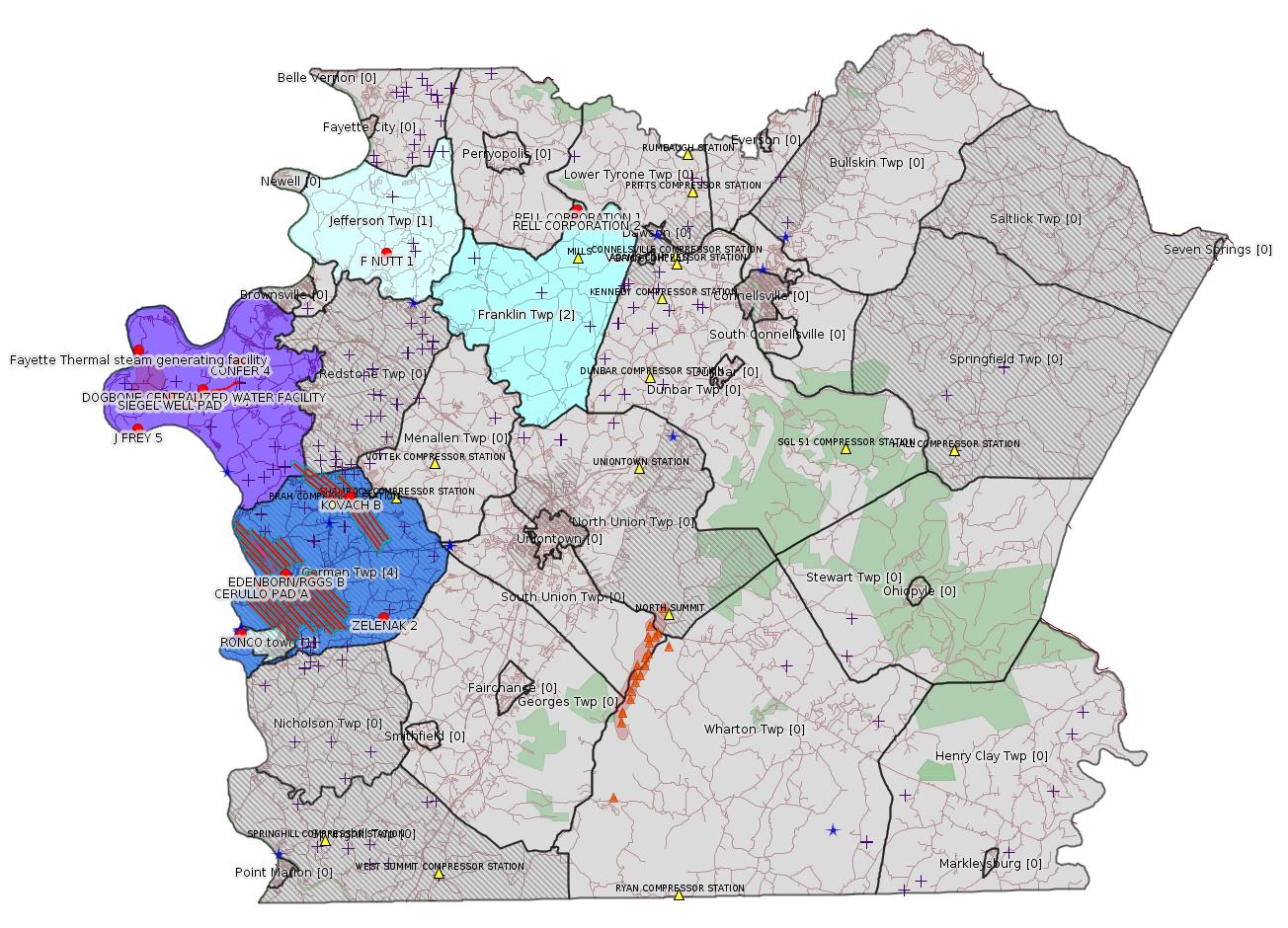
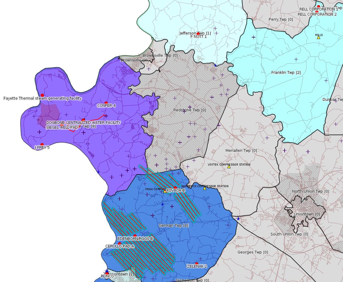
Map
Key
Red dots: items in this permit list with an exact location.
Blue stars: Marcellus Gas Well Water Sources.
Where well laterals are mapped they show in red; a 400-foot buffer surrounding the lateral shows in blue (lavender where it overlaps a mapped mineral tract).
Where mineral tracts are mapped, they show in pink. Mineral tracts can overlap; the overlap will show in red. The precise meaning of "mineral tract" is not clear.
Municipality shading: number of "facilities", with each well counting separately
(includes the red dots):
gray: 0
pale turquoise: 1
turquoise: 2
pale blue: 3
middle blue: 4
dark blue: 5
dark purple: 6
purple: 18
(Color coding may differ from one issue to the next.)
(Note if a project spans multiple municipalities -- e.g. a pipeline -- it will show in the count for each municipality.)
The number of facilities also follows the municipality name in brackets.
Municipality counts are based on the way the permit is listed by DEP; DEP has been known to get a municipality wrong.
Locations in brackets identify a precise location used to locate a surrogate for the actual site being permitted (e.g. locating a well pad or pipeline by the known location of a well.) Locations labeled beginning with "~" and ending in "[?]" are approximate and speculative based on inferences using on-line property and lease records. These are marked in the text as "[Approximate, Speculative]
Cross-hatching: Environmental Justice Areas
Yellow triangles: Compressor Stations
Orange triangles: Storage Field Wells (currently Dominion North Summit Storage Field)
Crosses: SPUD Unconventional well permits
Green: "Natural areas", e.g. state game lands, state forests
Yellow triangles: Compressor Stations
Orange triangles: Storage Field Wells (currently Dominion North Summit Storage Field)
Crosses: SPUD Unconventional well permits
Green: "Natural areas", e.g. state game lands, state forests
More Maps
 |
Source: Pennsylvania Bulletin
26-00534: Fayette Thermal, LLC (755 Opossum Lake Rd., Carlisle, PA 17015-8923) synthetic minor operat- ing permit for the steam generating facility located in Luzerne Township, Fayette County. Sources of emissions at the facility include two (2) identical 20.7 MMBtu/hr Spinheat ICFB-15,000 circulating fluidized bed (CFB) boilers and three (3) backup 9.9 MMBtu/hr Miura boilers. Miscellaneous sources include three storage silos and material handling equipment. The facility will be prohibited from burning solid fuels and will be limited to only burning natural gas. As such, the facility will be designated as a synthetic minor. The facility's potential-to-emit is estimated to be following: 2.4 TPY TSP; 2.4 TPY PM-10; 0.2 TPY SOx; 25.7 TPY CO; 12.1 TPY NOx; 1.7 TPY VOC; 0.6 TPY total HAP; 0.6 TPY single HAP; and 36,715 TPY CO2e. This facility is subject to the applicable requirements of 25 Pa. Code Chapters 121—145. The proposed State-Only Operating Permit includes emission restrictions, monitoring, recordkeeping, reporting, and work practice standards requirements for the site.
Those who wish to provide the Department with additional written information that they believe should be considered prior to the issuance of the State-Only Operating Permit may submit the information to Tom Joseph, Facilities Permit Chief, Department of Environmental Protection, Southwest Regional Office, 400 Waterfront Drive, Pittsburgh, PA 15222. Written comments must contain the name, address and telephone number of the person submitting the comments, identification of the proposed Operating Permit (26-00534) and concise statements regarding the relevancy of the information or objections to issuance of the Operating Permit.
A public hearing may be held, if the Department, in its discretion, decides that such a hearing is warranted based on the information received. All persons submitting comments or requesting a hearing will be notified of the decision to hold a hearing by publication in the newspaper or by the Pennsylvania Bulletin, or by telephone, where the Department determines such notification by telephone is sufficient. Written comments or requests for a public hearing should be directed to Tom Joseph, Facilities Permit Chief, at the previously listed address.
All comments must be received prior to the close of business 30 days after the date of this publication.
The application, DEP's Review Memorandum, and the proposed permit are available for public review during normal business hours at DEP's Southwest Regional Office, 400 Waterfront Drive, Pittsburgh, PA 15222. A file review can be scheduled through the DEP's website at https://www.dep.pa.gov/Citizens/PublicRecords/Pages/Informal-File-Review.aspx or by contacting Tom Joseph, Facilities Permitting Chief, directly.
<http://www.pacodeandbulletin.gov/Display/pabull?file=/secure/pabulletin/data/vol51/51-2/49.html>
Location: 39.992222,-79.988056
<https://www.openstreetmap.org/?mlat=39.992222&mlon=-79.988056#map=15/39.9922/-79.9881>
Presumed Parcel Id: 19020013
-------------------------
Source: eNOTICE
(+ PA
Oil and Gas Mapping, Well
Pad Report.) Well Details via Data
Portal Services: Oil and Gas Wells All (ID: 3).
Please see the Disclaimer below regarding Parcel Id data.
Authorization ID: 1338080
Permit number: 051-24067
Site: F NUTT 1 OG WELL
Client: BURKLAND WILLIAM S
Authorization type: Well Plugging Notice Alternate Method
Application type: New
Authorization is for: FACILITY
Date received: 12/21/2020
Status: Pending
Permit Decision Guarantee Applies: No
Sub-Facilities for Authorization:
Sub-Facility ID Sub-Facility Name Description
975113 F NUTT 1 Well
Permit Review Notes:
Date Review Note
1/7/2021 The technical review and decision review are complete and either the permit decision and/or permit issuance are forthcoming.
1/5/2021 The permit application package is complete, has been accepted, and is undergoing technical review.
<https://www.ahs.dep.pa.gov/eFACTSWeb/searchResults_singleAuth.aspx?AuthID=1338080>
Site Programs:
Oil & Gas
Site Municipalities:
Jefferson Twp, Fayette County
Well Details:
Permit Number: 051-24067
Well Name: F NUTT 1
Unconventional Well: N
Well Configuration: Vertical Well
Well Type: GAS
Well Status: Regulatory Inactive Status
Coal Association: NonCoal
Conservation Well: N
Primary Facility ID: 710063
Site ID: 710268
Site Name: F NUTT 1 OG WELL
Well Pad ID: 0
Well Pad Name:
Storage Field:
Operator: THE PRODUCTION CO LLC
Operator Number: OGO-39567
Permit Date: 2008-08-29
Permit Date Expires: 2009-08-29
SPUD Date: 2008-09-06
Date Plugged:
UIC ID:
UIC Type:
Surface Elevation: 1161
County: Fayette
Municipality: Jefferson Twp
Location: 40.038428,-79.829389
Map URL: <http://www.openstreetmap.org/?mlat=40.038428&mlon=-79.829389#map=15/40.038428/-79.829389>
OG WELLS PERMIT DOCS:
2021-01-07: Other Permit Documents, Name: 051-24067_William Burkland_F. Nutt_Alt Method_12-21-20 (for Authorization: 1338080):
<http://www.depgis.state.pa.us/pdfHandler/pdFHandler.ashx?Doc=MTY0NDUyNg==&ext=PDF>
Presumed Parcel Id: 1710000508
---
Authorization ID: 1338078
Permit number: 051-24067
Site: F NUTT 1 OG WELL
Client: BURKLAND WILLIAM S
Authorization type: Well Plugging Notice Intent to Plug Single Well
Application type: New
Authorization is for: FACILITY
Date received: 12/21/2020
Status: Pending
Permit Decision Guarantee Applies: No
Sub-Facilities for Authorization:
Sub-Facility ID Sub-Facility Name Description
975113 F NUTT 1 Well
Permit Review Notes:
Date Review Note
1/5/2021 The permit application package is complete, has been accepted, and is undergoing technical review.
<https://www.ahs.dep.pa.gov/eFACTSWeb/searchResults_singleAuth.aspx?AuthID=1338078>
Site Programs:
Oil & Gas
Site Municipalities:
Jefferson Twp, Fayette County
Well Details above
---
Authorization ID: 1335461
Permit number: ESX18-051-0003
Site: EDENBORN/RGGS B ESCGP ESX18-051-0003
Client: CHEVRON APPALACHIA LLC
Authorization type: Expedited E&S Stormwater General Permit 1
Application type: Notification
Authorization is for: SITE
Date received: 11/24/2020
Status: Pending
Permit Decision Guarantee Applies: No
Permit Review Notes:
Date Review Note
11/24/2020 The permit application package is complete, has been accepted, and is undergoing technical review.
<https://www.ahs.dep.pa.gov/eFACTSWeb/searchResults_singleAuth.aspx?AuthID=1335461>
Site Programs:
Oil & Gas
Site Municipalities:
German Twp, Fayette County
Authorization ID: 1335460
Permit number: ESX18-051-0006
Site: YODER WATERLINE ESCGP ESX18-051-0006
Client: CHEVRON APPALACHIA LLC
Authorization type: Expedited E&S Stormwater General Permit 1
Application type: Notification
Authorization is for: SITE
Date received: 11/24/2020
Status: Pending
Permit Decision Guarantee Applies: No
Permit Review Notes:
Date Review Note
11/24/2020 The permit application package is complete, has been accepted, and is undergoing technical review.
<https://www.ahs.dep.pa.gov/eFACTSWeb/searchResults_singleAuth.aspx?AuthID=1335460>
Site Programs:
Site Municipalities:
Luzerne Twp, Fayette County
---
Authorization ID: 1334873
Permit number: ESX18-051-0004
Site: CERULLO PAD A ESCGP ESX18-051-0004
Client: CHEVRON APPALACHIA LLC
Authorization type: Expedited E&S Stormwater General Permit 1
Application type: Notification
Authorization is for: SITE
Date received: 12/01/2020
Status: Pending
Permit Decision Guarantee Applies: No
Permit Review Notes:
Date Review Note
12/1/2020 The permit application package is complete, has been accepted, and is undergoing technical review.
<https://www.ahs.dep.pa.gov/eFACTSWeb/searchResults_singleAuth.aspx?AuthID=1334873>
Site Programs:
Oil & Gas
Site Municipalities:
German Twp, Fayette County
Well Pad Details:
Map URL;
<http://www.openstreetmap.org/?mlat=39.875992&mlon=-79.911644#map=15/39.875992/-79.911644>
Presumed Parcel Id: 15190070
---
Authorization ID: 1334861
Permit number: ESX17-051-0003
Site: KOVACH B WELL SITE AND TANK SITE ESCGP ESX17-051-0003
Client: CHEVRON APPALACHIA LLC
Authorization type: Expedited E&S Stormwater General Permit 1
Application type: Notification
Authorization is for: SITE
Date received: 11/30/2020
Status: Pending
Permit Decision Guarantee Applies: No
Permit Review Notes:
Date Review Note
11/30/2020 The permit application package is complete, has been accepted, and is undergoing technical review.
<https://www.ahs.dep.pa.gov/eFACTSWeb/searchResults_singleAuth.aspx?AuthID=1334861>
Site Programs:
Oil & Gas
Site Municipalities:
German Twp, Fayette County
---
Authorization ID: 1334586
Permit number: ESX18-051-0005
Site: SIEGEL WATERLINE ESCGP ESX18-051-0005
Client: CHEVRON APPALACHIA LLC
Authorization type: Expedited E&S Stormwater General Permit 1
Application type: Notification
Authorization is for: SITE
Date received: 11/25/2020
Status: Pending
Permit Decision Guarantee Applies: No
Permit Review Notes:
Date Review Note
11/25/2020 The permit application package is complete, has been accepted, and is undergoing technical review.
<https://www.ahs.dep.pa.gov/eFACTSWeb/searchResults_singleAuth.aspx?AuthID=1334586>
Site Programs:
Clean Water
Site Municipalities:
Luzerne Twp, Fayette County
---
Authorization ID: 1334546
Permit number: ESG18-051-0001
Site: DOGBONE WATER LINE ESCGP ESG18-051-0001
Client: CHEVRON APPALACHIA LLC
Authorization type: Erosion and Sediment Control GP-2
Application type: Notification
Authorization is for: SITE
Date received: 11/24/2020
Status: Pending
Permit Decision Guarantee Applies: No
Permit Review Notes:
Date Review Note
11/24/2020 The permit application package is complete, has been accepted, and is undergoing technical review.
<https://www.ahs.dep.pa.gov/eFACTSWeb/searchResults_singleAuth.aspx?AuthID=1334546>
Site Programs:
Site Municipalities:
Luzerne Twp, Fayette County
---
Authorization ID: 1334261
Permit number: ESX15-051-0005
Site: SIEGEL WELL PAD ESCGP-2 EXPEDITED
Client: CHEVRON APPALACHIA LLC
Authorization type: Expedited E&S Stormwater General Permit 1
Application type: Notification
Authorization is for: SITE
Date received: 11/23/2020
Status: Pending
Permit Decision Guarantee Applies: No
Permit Review Notes:
Date Review Note
11/23/2020 The permit application package is complete, has been accepted, and is undergoing technical review.
<https://www.ahs.dep.pa.gov/eFACTSWeb/searchResults_singleAuth.aspx?AuthID=1334261>
Site Programs:
Environmental Cleanup & Brownfields
Oil & Gas
Site Municipalities:
Luzerne Twp, Fayette County
---
Authorization ID: 1322280
Permit number: WMGR123SW001
Site: RONCO
Client: SHALLENBERGER CONST INC
Authorization type: RW General Permit Renewal, Fac
Application type: Renewal
Authorization is for: FACILITY
Date received: 08/04/2020
Status: Issued on 1/4/2021
Permit Decision Guarantee Applies: Yes
Permit Decision Guarantee status: VOID
Permit Review Notes:
Date Review Note
12/29/2020 The technical review and decision review are complete and either the permit decision and/or permit issuance are forthcoming.
8/31/2020 Applicant has been issued a deficiency letter. If applicable, this application no longer qualifies for the Permit Decision Guarantee.
<https://www.ahs.dep.pa.gov/eFACTSWeb/searchResults_singleAuth.aspx?AuthID=1322280>
Site Programs:
Radiation Protection
Waste Management
Site Municipalities:
Masontown Boro, Fayette County
---
Authorization ID: 1313955
Permit number: WMGR123SW025
Site: DOGBONE CENTRALIZED WATER FACILITY
Client: CHEVRON APPALACHIA LLC
Authorization type: RW General Permit Renewal, Fac
Application type: Renewal
Authorization is for: FACILITY
Date received: 05/08/2020
Status: Issued on 1/4/2021
Permit Decision Guarantee Applies: Yes
Permit Decision Guarantee status: VOID
Sub-Facilities for Authorization:
Sub-Facility ID Sub-Facility Name Description
1232831 DOGBONE CENTRALIZED WATER FACILITY Processing Facility
Location: 39.9725,-79.946944
Map URL: <http://www.openstreetmap.org/?mlat=39.9725&mlon=-79.946944#map=15/39.9725/-79.946944>
Permit Review Notes:
Date Review Note
12/29/2020 The technical review and decision review are complete and either the permit decision and/or permit issuance are forthcoming.
8/19/2020 Applicant has been issued a deficiency letter. If applicable, this application no longer qualifies for the Permit Decision Guarantee.
<https://www.ahs.dep.pa.gov/eFACTSWeb/searchResults_singleAuth.aspx?AuthID=1313955>
Site Programs:
Waste Management
Site Municipalities:
Luzerne Twp, Fayette County
OPERATOR: THE PRODUCTION CO LLC
INSPECTION_ID: 3121787
INSPECTION_DATE: 12/15/2020
INSPECTION_TYPE: Routine/Complete Inspection
API_PERMIT: 051-00222
FARM_NAME: ZELENAK 2
UNCONVENTIONAL: No
SITE_ID: 40900
SITE_NAME: ZELENAK 2 WELL
FACILITY_TYPE: Oil & Gas Location
INSPECTION_CATEGORY: Primary Facility
REGION: EP DOGO SWDO Dstr Off
COUNTY: Fayette
MUNICIPALITY: German Twp
INSPECTOR: WOODS, MATTHEW
INSPECTION_SOURCE: SUBSAIR
INSPECTION_RESULT_DESCRIPTION: Violation(s) Noted
INSPECTION_COMMENT: "Well has been abandoned.
No MIA or APR on file with dept."
VIOLATION_ID: 904057
VIOLATION_DATE: 12/15/2020
VIOLATION_CODE: 78.91(a) - PLUGGING - GENERAL PROVISIONS - Upon abandoning a well, the owner or operator failed to plug the well to stop the vertical flow of fluids or gas within the well bore under 25 Pa. Code §§ 78.92—78.98 or an approved alternate method.
VIOLATION_TYPE: Environmental Health & Safety
VIOLATION_COMMENT:
RESOLVED_DATE:
RESOLUTION_REASON_CODE_DESC:
CONTINUING_VIOLATION:
ENFORCEMENT_ID:
ENFORCEMENT_CODE_DESCRIPTION:
DATE_EXECUTED:
ENFORCEMENT_FINAL_DATE:
ENFORCEMENT_FINAL_STATUS:
PENALTY_FINAL_DATE:
PENALTY_FINAL_STATUS_CODE_DESC:
PENALTY_AMOUNT:
TOTAL_AMOUNT_COLLECTED:
VIOLATION_ID: 904056
VIOLATION_DATE: 12/15/2020
VIOLATION_CODE: OGA3220(A) - PLUGGING REQUIREMENTS - Failure to plug the well upon abandoning it.
VIOLATION_TYPE: Environmental Health & Safety
VIOLATION_COMMENT:
RESOLVED_DATE:
RESOLUTION_REASON_CODE_DESC:
CONTINUING_VIOLATION:
ENFORCEMENT_ID:
ENFORCEMENT_CODE_DESCRIPTION:
DATE_EXECUTED:
ENFORCEMENT_FINAL_DATE:
ENFORCEMENT_FINAL_STATUS:
PENALTY_FINAL_DATE:
PENALTY_FINAL_STATUS_CODE_DESC:
PENALTY_AMOUNT:
TOTAL_AMOUNT_COLLECTED:
Well Details:
Permit Number: 051-00222
Well Name: ZELENAK 2
Unconventional Well: N
Well Configuration: Vertical Well
Well Type: GAS
Well Status: Active
Coal Association: Coal
Conservation Well: N
Primary Facility ID: 42652
Site ID: 40900
Site Name: ZELENAK 2 WELL
Well Pad ID: 0
Well Pad Name:
Storage Field:
Operator: THE PRODUCTION CO LLC
Operator Number: OGO-39567
Permit Date: 1989-06-21
Permit Date Expires:
SPUD Date: 1800-01-01
Date Plugged:
UIC ID:
UIC Type:
Surface Elevation: 0
County: Fayette
Municipality: German Twp
Location: 39.859721,-79.834085
Map URL: <http://www.openstreetmap.org/?mlat=39.859721&mlon=-79.834085#map=15/39.859721/-79.834085>
Presumed Parcel Id: 15360022
---
OPERATOR: THE PRODUCTION CO LLC
INSPECTION_ID: 3123626
INSPECTION_DATE: 12/18/2020
INSPECTION_TYPE: Routine/Complete Inspection
API_PERMIT: 051-20142
FARM_NAME: RELL CORPORATION 2
UNCONVENTIONAL: No
SITE_ID: 41040
SITE_NAME: RELL CORPORATION 2 WELL
FACILITY_TYPE: Oil & Gas Location
INSPECTION_CATEGORY: Primary Facility
REGION: EP DOGO SWDO Dstr Off
COUNTY: Fayette
MUNICIPALITY: Franklin Twp
INSPECTOR: WOODS, MATTHEW
INSPECTION_SOURCE: SUBSAIR
INSPECTION_RESULT_DESCRIPTION: Violation(s) Noted
INSPECTION_COMMENT: "Well is listed as active but has been plugged.
Last APR submitted to the dept for 2016.
Spoke with Mark Kenny from TPC , he told me both Rell #1 and #2 were both plugged approx 5 years ago.
Intent to plug was never turned into the DEP."
VIOLATION_ID: 904045
VIOLATION_DATE: 12/18/2020
VIOLATION_CODE: 78.96 - PLUGGING – MARKING THE LOCATION OF A PLUGGED WELL – Upon completion of plugging or replugging a well, the operator failed to erect a permanent marker with permit or registration number.
VIOLATION_TYPE: Environmental Health & Safety
VIOLATION_COMMENT:
RESOLVED_DATE:
RESOLUTION_REASON_CODE_DESC:
CONTINUING_VIOLATION:
ENFORCEMENT_ID:
ENFORCEMENT_CODE_DESCRIPTION:
DATE_EXECUTED:
ENFORCEMENT_FINAL_DATE:
ENFORCEMENT_FINAL_STATUS:
PENALTY_FINAL_DATE:
PENALTY_FINAL_STATUS_CODE_DESC:
PENALTY_AMOUNT:
TOTAL_AMOUNT_COLLECTED:
Well Details:
Permit Number: 051-20142
Well Name: RELL CORPORATION 2
Unconventional Well: N
Well Configuration: Vertical Well
Well Type: GAS
Well Status: Active
Coal Association: Coal
Conservation Well: N
Primary Facility ID: 42792
Site ID: 41040
Site Name: RELL CORPORATION 2 WELL
Well Pad ID: 0
Well Pad Name:
Storage Field:
Operator: THE PRODUCTION CO LLC
Operator Number: OGO-39567
Permit Date: 1974-04-30
Permit Date Expires: 1975-04-30
SPUD Date: 1974-05-21
Date Plugged:
UIC ID:
UIC Type:
Surface Elevation: 1335
County: Fayette
Municipality: Franklin Twp
Location: 40.054516,-79.708844
Map URL: <http://www.openstreetmap.org/?mlat=40.054516&mlon=-79.708844#map=15/40.054516/-79.708844>
Presumed Parcel Id: 13020001
---
OPERATOR: THE PRODUCTION CO LLC
INSPECTION_ID: 3123628
INSPECTION_DATE: 12/18/2020
INSPECTION_TYPE: Administrative/File Review
API_PERMIT: 051-20128
FARM_NAME: RELL CORPORATION 1
UNCONVENTIONAL: No
SITE_ID: 41026
SITE_NAME: RELL CORPORATION 1 WELL
FACILITY_TYPE: Oil & Gas Location
INSPECTION_CATEGORY: Primary Facility
REGION: EP DOGO SWDO Dstr Off
COUNTY: Fayette
MUNICIPALITY: Franklin Twp
INSPECTOR: WOODS, MATTHEW
INSPECTION_SOURCE: SUBSAIR
INSPECTION_RESULT_DESCRIPTION: Violation(s) Noted
INSPECTION_COMMENT: "Well is listed as active but has been plugged.
Last APR submitted to the dept for 2017
Spoke with Mark Kenny from TPC , he told me both Rell #1 and #2 were both plugged approx 5 years ago.
Well was plugged without paperwork being filed with DEP."
VIOLATION_ID: 904048
VIOLATION_DATE: 12/18/2020
VIOLATION_CODE: 78.96 - PLUGGING – MARKING THE LOCATION OF A PLUGGED WELL – Upon completion of plugging or replugging a well, the operator failed to erect a permanent marker with permit or registration number.
VIOLATION_TYPE: Environmental Health & Safety
VIOLATION_COMMENT:
RESOLVED_DATE:
RESOLUTION_REASON_CODE_DESC:
CONTINUING_VIOLATION:
ENFORCEMENT_ID:
ENFORCEMENT_CODE_DESCRIPTION:
DATE_EXECUTED:
ENFORCEMENT_FINAL_DATE:
ENFORCEMENT_FINAL_STATUS:
PENALTY_FINAL_DATE:
PENALTY_FINAL_STATUS_CODE_DESC:
PENALTY_AMOUNT:
TOTAL_AMOUNT_COLLECTED:
Well Details:
Permit Number: 051-20128
Well Name: RELL CORPORATION 1
Unconventional Well: N
Well Configuration: Vertical Well
Well Type: GAS
Well Status: Active
Coal Association: Coal
Conservation Well: N
Primary Facility ID: 42778
Site ID: 41026
Site Name: RELL CORPORATION 1 WELL
Well Pad ID: 0
Well Pad Name:
Storage Field:
Operator: THE PRODUCTION CO LLC
Operator Number: OGO-39567
Permit Date: 1972-06-23
Permit Date Expires: 1973-06-23
SPUD Date: 1972-08-16
Date Plugged:
UIC ID:
UIC Type:
Surface Elevation: 1218
County: Fayette
Municipality: Franklin Twp
Location: 40.058444,-79.707111
Map URL: <http://www.openstreetmap.org/?mlat=40.058444&mlon=-79.707111#map=15/40.058444/-79.707111>
Presumed Parcel Id: 13020001
---
OPERATOR: THE PRODUCTION CO LLC
INSPECTION_ID: 3125855
INSPECTION_DATE: 12/23/2020
INSPECTION_TYPE: Routine/Complete Inspection
API_PERMIT: 051-23455
FARM_NAME: J FREY 5
UNCONVENTIONAL: No
SITE_ID: 674959
SITE_NAME: J FREY 5 OG WELL
FACILITY_TYPE: Oil & Gas Location
INSPECTION_CATEGORY: Primary Facility
REGION: EP DOGO SWDO Dstr Off
COUNTY: Fayette
MUNICIPALITY: Luzerne Twp
INSPECTOR: VIRRUET, IVAN
INSPECTION_SOURCE: SUBSAIR
INSPECTION_RESULT_DESCRIPTION: Violation(s) Noted
INSPECTION_COMMENT: On 12/23/2020 at 11:22am I arrived on location to conduct a routine inspection of the well site The wellhead was tagged and showed signs of rusting as seen in picture 3. Picture 6 shows a leak that has caused staining on the ground under it. The leak is an oil/ grease substance. The Department request that this is investigated and corrected. An MIA for this well hasn't been submitted to the Department since 2015 and an APR hasn't been submitted since 2017.
VIOLATION_ID: 904137
VIOLATION_DATE: 12/23/2020
VIOLATION_CODE: 78.73(a) - GENERAL PROVISION FOR WELL CONSTRUCTION AND OPERATION - Operator failed to construct and operate the well in accordance with 25 Pa. Code Chapter 78 and ensure that the integrity of the well is maintained and health, safety, environment and property are protected.
VIOLATION_TYPE: Environmental Health & Safety
VIOLATION_COMMENT:
RESOLVED_DATE:
RESOLUTION_REASON_CODE_DESC:
CONTINUING_VIOLATION:
ENFORCEMENT_ID:
ENFORCEMENT_CODE_DESCRIPTION:
DATE_EXECUTED:
ENFORCEMENT_FINAL_DATE:
ENFORCEMENT_FINAL_STATUS:
PENALTY_FINAL_DATE:
PENALTY_FINAL_STATUS_CODE_DESC:
PENALTY_AMOUNT:
TOTAL_AMOUNT_COLLECTED:
Well Details:
Permit Number: 051-23455
Well Name: J FREY 5
Unconventional Well: N
Well Configuration: Vertical Well
Well Type: GAS
Well Status: Active
Coal Association: NonCoal
Conservation Well: N
Primary Facility ID: 682508
Site ID: 674959
Site Name: J FREY 5 OG WELL
Well Pad ID: 0
Well Pad Name:
Storage Field:
Operator: THE PRODUCTION CO LLC
Operator Number: OGO-39567
Permit Date: 2006-09-13
Permit Date Expires: 2007-09-13
SPUD Date: 2006-10-18
Date Plugged:
UIC ID:
UIC Type:
Surface Elevation: 1010
County: Fayette
Municipality: Luzerne Twp
Location: 39.95388,-79.988885
Map URL: <http://www.openstreetmap.org/?mlat=39.95388&mlon=-79.988885#map=15/39.95388/-79.988885>
Presumed Parcel Id: 19240010
---
OPERATOR: THE PRODUCTION CO LLC
INSPECTION_ID: 3125870
INSPECTION_DATE: 12/23/2020
INSPECTION_TYPE: Routine/Complete Inspection
API_PERMIT: 051-23341
FARM_NAME: CONFER 4
UNCONVENTIONAL: No
SITE_ID: 673889
SITE_NAME: CONFER 4 OG WELL
FACILITY_TYPE: Oil & Gas Location
INSPECTION_CATEGORY: Primary Facility
REGION: EP DOGO SWDO Dstr Off
COUNTY: Fayette
MUNICIPALITY: Luzerne Twp
INSPECTOR: VIRRUET, IVAN
INSPECTION_SOURCE: SUBSAIR
INSPECTION_RESULT_DESCRIPTION: Violation(s) Noted
INSPECTION_COMMENT: On 12/23/2020 at 12:56pm I arrived on location to conduct a routine inspection of the well. There was no tag on the wellhead. Rust was seen on the wellhead and on line to separator. Picture 3 shows significant bubbling from the casing side of the well. Picture 4 shows a rust line running from the fitting on the bottom of the brine tank and staining on the ground, looks to be a possible leak. The Department request that these issues be investigated and a written report with the findings be submitted to The Department. An MIA hasn't been submitted since 2015 and an APR hasn't been submitted since 2017.
VIOLATION_ID: 904142
VIOLATION_DATE: 12/23/2020
VIOLATION_CODE: 78.73(a) - GENERAL PROVISION FOR WELL CONSTRUCTION AND OPERATION - Operator failed to construct and operate the well in accordance with 25 Pa. Code Chapter 78 and ensure that the integrity of the well is maintained and health, safety, environment and property are protected.
VIOLATION_TYPE: Environmental Health & Safety
VIOLATION_COMMENT:
RESOLVED_DATE:
RESOLUTION_REASON_CODE_DESC:
CONTINUING_VIOLATION:
ENFORCEMENT_ID:
ENFORCEMENT_CODE_DESCRIPTION:
DATE_EXECUTED:
ENFORCEMENT_FINAL_DATE:
ENFORCEMENT_FINAL_STATUS:
PENALTY_FINAL_DATE:
PENALTY_FINAL_STATUS_CODE_DESC:
PENALTY_AMOUNT:
TOTAL_AMOUNT_COLLECTED:
Well Details:
Permit Number: 051-23341
Well Name: CONFER 4
Unconventional Well: N
Well Configuration: Vertical Well
Well Type: GAS
Well Status: Active
Coal Association: NonCoal
Conservation Well: N
Primary Facility ID: 681739
Site ID: 673889
Site Name: CONFER 4 OG WELL
Well Pad ID: 0
Well Pad Name:
Storage Field:
Operator: THE PRODUCTION CO LLC
Operator Number: OGO-39567
Permit Date: 2006-07-03
Permit Date Expires: 2007-07-03
SPUD Date: 2007-07-02
Date Plugged:
UIC ID:
UIC Type:
Surface Elevation: 1066
County: Fayette
Municipality: Luzerne Twp
Location: 39.985544,-79.923525
Map URL: <http://www.openstreetmap.org/?mlat=39.985544&mlon=-79.923525#map=15/39.985544/-79.923525>
Presumed Parcel Id: 19160013
-------------------------
Please see the Disclaimer below regarding Parcel Id data.
Authorization ID: 1338080
Permit number: 051-24067
Site: F NUTT 1 OG WELL
Client: BURKLAND WILLIAM S
Authorization type: Well Plugging Notice Alternate Method
Application type: New
Authorization is for: FACILITY
Date received: 12/21/2020
Status: Pending
Permit Decision Guarantee Applies: No
Sub-Facilities for Authorization:
Sub-Facility ID Sub-Facility Name Description
975113 F NUTT 1 Well
Permit Review Notes:
Date Review Note
1/7/2021 The technical review and decision review are complete and either the permit decision and/or permit issuance are forthcoming.
1/5/2021 The permit application package is complete, has been accepted, and is undergoing technical review.
<https://www.ahs.dep.pa.gov/eFACTSWeb/searchResults_singleAuth.aspx?AuthID=1338080>
Site Programs:
Oil & Gas
Site Municipalities:
Jefferson Twp, Fayette County
Well Details:
Permit Number: 051-24067
Well Name: F NUTT 1
Unconventional Well: N
Well Configuration: Vertical Well
Well Type: GAS
Well Status: Regulatory Inactive Status
Coal Association: NonCoal
Conservation Well: N
Primary Facility ID: 710063
Site ID: 710268
Site Name: F NUTT 1 OG WELL
Well Pad ID: 0
Well Pad Name:
Storage Field:
Operator: THE PRODUCTION CO LLC
Operator Number: OGO-39567
Permit Date: 2008-08-29
Permit Date Expires: 2009-08-29
SPUD Date: 2008-09-06
Date Plugged:
UIC ID:
UIC Type:
Surface Elevation: 1161
County: Fayette
Municipality: Jefferson Twp
Location: 40.038428,-79.829389
Map URL: <http://www.openstreetmap.org/?mlat=40.038428&mlon=-79.829389#map=15/40.038428/-79.829389>
OG WELLS PERMIT DOCS:
2021-01-07: Other Permit Documents, Name: 051-24067_William Burkland_F. Nutt_Alt Method_12-21-20 (for Authorization: 1338080):
<http://www.depgis.state.pa.us/pdfHandler/pdFHandler.ashx?Doc=MTY0NDUyNg==&ext=PDF>
Presumed Parcel Id: 1710000508
---
Authorization ID: 1338078
Permit number: 051-24067
Site: F NUTT 1 OG WELL
Client: BURKLAND WILLIAM S
Authorization type: Well Plugging Notice Intent to Plug Single Well
Application type: New
Authorization is for: FACILITY
Date received: 12/21/2020
Status: Pending
Permit Decision Guarantee Applies: No
Sub-Facilities for Authorization:
Sub-Facility ID Sub-Facility Name Description
975113 F NUTT 1 Well
Permit Review Notes:
Date Review Note
1/5/2021 The permit application package is complete, has been accepted, and is undergoing technical review.
<https://www.ahs.dep.pa.gov/eFACTSWeb/searchResults_singleAuth.aspx?AuthID=1338078>
Site Programs:
Oil & Gas
Site Municipalities:
Jefferson Twp, Fayette County
Well Details above
---
Authorization ID: 1335461
Permit number: ESX18-051-0003
Site: EDENBORN/RGGS B ESCGP ESX18-051-0003
Client: CHEVRON APPALACHIA LLC
Authorization type: Expedited E&S Stormwater General Permit 1
Application type: Notification
Authorization is for: SITE
Date received: 11/24/2020
Status: Pending
Permit Decision Guarantee Applies: No
Permit Review Notes:
Date Review Note
11/24/2020 The permit application package is complete, has been accepted, and is undergoing technical review.
<https://www.ahs.dep.pa.gov/eFACTSWeb/searchResults_singleAuth.aspx?AuthID=1335461>
Site Programs:
Oil & Gas
Site Municipalities:
German Twp, Fayette County
Well
Pad Details:
Presumed Parcel Id: 15220014
[See Notes.]
---OPERATOR: CHEVRON APPALACHIA LLCWells on this pad:
OGO: OGO-39307
CLIENT_ID: 279986
WELL_PAD: EDENBORN/RGGS B
WELL_PAD_ID: 155083
SITE_NAME: EDENBORN/RGGS B ESCGP ESX18-051-0003
SITE_ID: 829418
ADDRESS_TYPE: 911WL
ADDRESS1: 392 GATES ROAD
ADDRESS2:
CITY: ADAH
STATE: PA
ZIP: 15410
WELL_PAD_REFERENCE_POINT: WSGPS
WELL_PAD_LATITUDE: 39.881931
WELL_PAD_LONGITUDE: -79.896106
WELL_PAD_DATUM: NAD83
WELL_PAD_COLLECTION_METHOD: GPS
ACCESS_ROAD_REFERENCE_POINT: LACRD
ACCESS_ROAD_LATITUDE: 39.877033
ACCESS_ROAD_LONGITUDE: -79.89575
ACCESS_ROAD_DATUM: NAD83
ACCESS_ROAD_COLLECTION_METHOD: GPS
REGION: EP DOGO SWDO Dstr Off
COUNTY: Fayette
MUNICIPALITY: German Twp
CHAPTER_93_WATER_QUALITY:
051-24675 EDENBORN/RGGS B M01H
051-24676 EDENBORN/RGGS B M03H
051-24678 EDENBORN/RGGS B M02H
051-24681 EDENBORN/RGGS B M04H
051-24682 EDENBORN/RGGS B M05H
051-24688 EDENBORN/RGGS B M14H
051-24689 EDENBORN/RGGS B M15H
Presumed Parcel Id: 15220014
[See Notes.]
Authorization ID: 1335460
Permit number: ESX18-051-0006
Site: YODER WATERLINE ESCGP ESX18-051-0006
Client: CHEVRON APPALACHIA LLC
Authorization type: Expedited E&S Stormwater General Permit 1
Application type: Notification
Authorization is for: SITE
Date received: 11/24/2020
Status: Pending
Permit Decision Guarantee Applies: No
Permit Review Notes:
Date Review Note
11/24/2020 The permit application package is complete, has been accepted, and is undergoing technical review.
<https://www.ahs.dep.pa.gov/eFACTSWeb/searchResults_singleAuth.aspx?AuthID=1335460>
Site Programs:
Site Municipalities:
Luzerne Twp, Fayette County
---
Authorization ID: 1334873
Permit number: ESX18-051-0004
Site: CERULLO PAD A ESCGP ESX18-051-0004
Client: CHEVRON APPALACHIA LLC
Authorization type: Expedited E&S Stormwater General Permit 1
Application type: Notification
Authorization is for: SITE
Date received: 12/01/2020
Status: Pending
Permit Decision Guarantee Applies: No
Permit Review Notes:
Date Review Note
12/1/2020 The permit application package is complete, has been accepted, and is undergoing technical review.
<https://www.ahs.dep.pa.gov/eFACTSWeb/searchResults_singleAuth.aspx?AuthID=1334873>
Site Programs:
Oil & Gas
Site Municipalities:
German Twp, Fayette County
Well Pad Details:
OPERATOR: CHEVRON APPALACHIA LLCWells on this pad:
OGO: OGO-39307
CLIENT_ID: 279986
WELL_PAD: CERULLO
WELL_PAD_ID: 155068
SITE_NAME: CERULLO PAD A ESCGP ESX18-051-0004
SITE_ID: 829618
ADDRESS_TYPE: 911WL
ADDRESS1: 297 GATES ROAD
ADDRESS2:
CITY: ADAH
STATE: PA
ZIP: 15410
WELL_PAD_REFERENCE_POINT: WSGPS
WELL_PAD_LATITUDE: 39.875992
WELL_PAD_LONGITUDE: -79.911644
WELL_PAD_DATUM: NAD83
WELL_PAD_COLLECTION_METHOD: GPS
ACCESS_ROAD_REFERENCE_POINT: LACRD
ACCESS_ROAD_LATITUDE: 39.876317
ACCESS_ROAD_LONGITUDE: -79.911278
ACCESS_ROAD_DATUM: NAD83
ACCESS_ROAD_COLLECTION_METHOD: GPS
REGION: EP DOGO SWDO Dstr Off
COUNTY: Fayette
MUNICIPALITY: German Twp
CHAPTER_93_WATER_QUALITY:
051-24690 CERULLO M09HLocation: 39.875992,-79.911644
051-24691 CERULLO M10H
051-24692 CERULLO M03H
051-24693 CERULLO M01H
051-24694 CERULLO M04H
051-24695 CERULLO M02H
051-24696 CERULLO M11H
051-24697 CERULLO M12H
Map URL;
Presumed Parcel Id: 15190070
---
Authorization ID: 1334861
Permit number: ESX17-051-0003
Site: KOVACH B WELL SITE AND TANK SITE ESCGP ESX17-051-0003
Client: CHEVRON APPALACHIA LLC
Authorization type: Expedited E&S Stormwater General Permit 1
Application type: Notification
Authorization is for: SITE
Date received: 11/30/2020
Status: Pending
Permit Decision Guarantee Applies: No
Permit Review Notes:
Date Review Note
11/30/2020 The permit application package is complete, has been accepted, and is undergoing technical review.
<https://www.ahs.dep.pa.gov/eFACTSWeb/searchResults_singleAuth.aspx?AuthID=1334861>
Site Programs:
Oil & Gas
Site Municipalities:
German Twp, Fayette County
Well
Pad Details:
OPERATOR: CHEVRON APPALACHIA LLCWells on this pad:
OGO: OGO-39307
CLIENT_ID: 279986
WELL_PAD: KOVACH B
WELL_PAD_ID: 155005
SITE_NAME: KOVACH B WELL SITE AND TANK SITE ESCGP ESX17-051-0003
SITE_ID: 826949
ADDRESS_TYPE: 911WL
ADDRESS1: 206 MARY HALL ROAD
ADDRESS2:
CITY: MCCLELLANDTOWN
STATE: PA
ZIP: 15458
WELL_PAD_REFERENCE_POINT: WSGPS
WELL_PAD_LATITUDE: 39.918939
WELL_PAD_LONGITUDE: -79.854611
WELL_PAD_DATUM: NAD83
WELL_PAD_COLLECTION_METHOD: GPS
ACCESS_ROAD_REFERENCE_POINT: LACRD
ACCESS_ROAD_LATITUDE: 39.918058
ACCESS_ROAD_LONGITUDE: -79.856572
ACCESS_ROAD_DATUM: NAD83
ACCESS_ROAD_COLLECTION_METHOD: GPS
REGION: EP DOGO SWDO Dstr Off
COUNTY: Fayette
MUNICIPALITY: German Twp
CHAPTER_93_WATER_QUALITY:
051-24666 KOVACH B M04H
051-24667 KOVACH B M05H
051-24668 KOVACH B M07H
051-24669 KOVACH B M08H
051-24670 KOVACH B M09H
051-24671 KOVACH B M01H
051-24672 KOVACH B M02H
051-24673 KOVACH B M06H
051-24674 KOVACH B M03H
---
Authorization ID: 1334586
Permit number: ESX18-051-0005
Site: SIEGEL WATERLINE ESCGP ESX18-051-0005
Client: CHEVRON APPALACHIA LLC
Authorization type: Expedited E&S Stormwater General Permit 1
Application type: Notification
Authorization is for: SITE
Date received: 11/25/2020
Status: Pending
Permit Decision Guarantee Applies: No
Permit Review Notes:
Date Review Note
11/25/2020 The permit application package is complete, has been accepted, and is undergoing technical review.
<https://www.ahs.dep.pa.gov/eFACTSWeb/searchResults_singleAuth.aspx?AuthID=1334586>
Site Programs:
Clean Water
Site Municipalities:
Luzerne Twp, Fayette County
---
Authorization ID: 1334546
Permit number: ESG18-051-0001
Site: DOGBONE WATER LINE ESCGP ESG18-051-0001
Client: CHEVRON APPALACHIA LLC
Authorization type: Erosion and Sediment Control GP-2
Application type: Notification
Authorization is for: SITE
Date received: 11/24/2020
Status: Pending
Permit Decision Guarantee Applies: No
Permit Review Notes:
Date Review Note
11/24/2020 The permit application package is complete, has been accepted, and is undergoing technical review.
<https://www.ahs.dep.pa.gov/eFACTSWeb/searchResults_singleAuth.aspx?AuthID=1334546>
Site Programs:
Site Municipalities:
Luzerne Twp, Fayette County
---
Authorization ID: 1334261
Permit number: ESX15-051-0005
Site: SIEGEL WELL PAD ESCGP-2 EXPEDITED
Client: CHEVRON APPALACHIA LLC
Authorization type: Expedited E&S Stormwater General Permit 1
Application type: Notification
Authorization is for: SITE
Date received: 11/23/2020
Status: Pending
Permit Decision Guarantee Applies: No
Permit Review Notes:
Date Review Note
11/23/2020 The permit application package is complete, has been accepted, and is undergoing technical review.
<https://www.ahs.dep.pa.gov/eFACTSWeb/searchResults_singleAuth.aspx?AuthID=1334261>
Site Programs:
Environmental Cleanup & Brownfields
Oil & Gas
Site Municipalities:
Luzerne Twp, Fayette County
Well
Pad Details:
Presumed Property Id: 19240018
OPERATOR: CHEVRON APPALACHIA LLCWells on this Pad:
OGO: OGO-39307
CLIENT_ID: 279986
WELL_PAD: SIEGEL 1
WELL_PAD_ID: 152926
SITE_NAME: SIEGEL WELL PAD ESCGP-2 EXPEDITED
SITE_ID: 790384
ADDRESS_TYPE: 911WL
ADDRESS1: 244 HEISTERBURG ROAD
ADDRESS2:
CITY: EAST MILLSBORO
STATE: PA
ZIP: 15433
WELL_PAD_REFERENCE_POINT: WSGPS
WELL_PAD_LATITUDE: 39.968972
WELL_PAD_LONGITUDE: -79.968794
WELL_PAD_DATUM: NAD83
WELL_PAD_COLLECTION_METHOD: GPS
ACCESS_ROAD_REFERENCE_POINT: LACRD
ACCESS_ROAD_LATITUDE: 39.97199
ACCESS_ROAD_LONGITUDE: -79.96972
ACCESS_ROAD_DATUM: NAD83
ACCESS_ROAD_COLLECTION_METHOD: GPS
REGION: EP DOGO SWDO Dstr Off
COUNTY: Fayette
MUNICIPALITY: Luzerne Twp
CHAPTER_93_WATER_QUALITY: Warm Water Fishes
051-24633 SIEGEL 1
051-24641 SIEGEL 2H
051-24642 SIEGEL 4H
051-24643 SIEGEL 3H
051-24644 SIEGEL 5H
051-24645 SIEGEL 6H
051-24646 SIEGEL 7H
051-24647 SIEGEL 8H
051-24648 SIEGEL 9H
Presumed Property Id: 19240018
---
Authorization ID: 1322280
Permit number: WMGR123SW001
Site: RONCO
Client: SHALLENBERGER CONST INC
Authorization type: RW General Permit Renewal, Fac
Application type: Renewal
Authorization is for: FACILITY
Date received: 08/04/2020
Status: Issued on 1/4/2021
Permit Decision Guarantee Applies: Yes
Permit Decision Guarantee status: VOID
Permit Review Notes:
Date Review Note
12/29/2020 The technical review and decision review are complete and either the permit decision and/or permit issuance are forthcoming.
8/31/2020 Applicant has been issued a deficiency letter. If applicable, this application no longer qualifies for the Permit Decision Guarantee.
<https://www.ahs.dep.pa.gov/eFACTSWeb/searchResults_singleAuth.aspx?AuthID=1322280>
Site Programs:
Radiation Protection
Waste Management
Site Municipalities:
Masontown Boro, Fayette County
Authorization ID: 1313955
Permit number: WMGR123SW025
Site: DOGBONE CENTRALIZED WATER FACILITY
Client: CHEVRON APPALACHIA LLC
Authorization type: RW General Permit Renewal, Fac
Application type: Renewal
Authorization is for: FACILITY
Date received: 05/08/2020
Status: Issued on 1/4/2021
Permit Decision Guarantee Applies: Yes
Permit Decision Guarantee status: VOID
Sub-Facilities for Authorization:
Sub-Facility ID Sub-Facility Name Description
1232831 DOGBONE CENTRALIZED WATER FACILITY Processing Facility
Location: 39.9725,-79.946944
Map URL: <http://www.openstreetmap.org/?mlat=39.9725&mlon=-79.946944#map=15/39.9725/-79.946944>
Permit Review Notes:
Date Review Note
12/29/2020 The technical review and decision review are complete and either the permit decision and/or permit issuance are forthcoming.
8/19/2020 Applicant has been issued a deficiency letter. If applicable, this application no longer qualifies for the Permit Decision Guarantee.
<https://www.ahs.dep.pa.gov/eFACTSWeb/searchResults_singleAuth.aspx?AuthID=1313955>
Site Programs:
Waste Management
Site Municipalities:
Luzerne Twp, Fayette County
Location:
39.972496,-79.946939 <http://osm.org/go/ZWpZaULM--?m=>
Presumed Parcel Id: 19160040
Fayette County Act 14 Notification: <http://faymarwatch.org/documents/SKM_554e17050309530.pdf>
Chevron Topographic Map Including "Proposed" Pipelines: <http://faymarwatch.org/documents/ZHB_17-41_121317_topo.pdf>
-------------------------Presumed Parcel Id: 19160040
Fayette County Act 14 Notification: <http://faymarwatch.org/documents/SKM_554e17050309530.pdf>
Chevron Topographic Map Including "Proposed" Pipelines: <http://faymarwatch.org/documents/ZHB_17-41_121317_topo.pdf>
OPERATOR: THE PRODUCTION CO LLC
INSPECTION_ID: 3121787
INSPECTION_DATE: 12/15/2020
INSPECTION_TYPE: Routine/Complete Inspection
API_PERMIT: 051-00222
FARM_NAME: ZELENAK 2
UNCONVENTIONAL: No
SITE_ID: 40900
SITE_NAME: ZELENAK 2 WELL
FACILITY_TYPE: Oil & Gas Location
INSPECTION_CATEGORY: Primary Facility
REGION: EP DOGO SWDO Dstr Off
COUNTY: Fayette
MUNICIPALITY: German Twp
INSPECTOR: WOODS, MATTHEW
INSPECTION_SOURCE: SUBSAIR
INSPECTION_RESULT_DESCRIPTION: Violation(s) Noted
INSPECTION_COMMENT: "Well has been abandoned.
No MIA or APR on file with dept."
VIOLATION_ID: 904057
VIOLATION_DATE: 12/15/2020
VIOLATION_CODE: 78.91(a) - PLUGGING - GENERAL PROVISIONS - Upon abandoning a well, the owner or operator failed to plug the well to stop the vertical flow of fluids or gas within the well bore under 25 Pa. Code §§ 78.92—78.98 or an approved alternate method.
VIOLATION_TYPE: Environmental Health & Safety
VIOLATION_COMMENT:
RESOLVED_DATE:
RESOLUTION_REASON_CODE_DESC:
CONTINUING_VIOLATION:
ENFORCEMENT_ID:
ENFORCEMENT_CODE_DESCRIPTION:
DATE_EXECUTED:
ENFORCEMENT_FINAL_DATE:
ENFORCEMENT_FINAL_STATUS:
PENALTY_FINAL_DATE:
PENALTY_FINAL_STATUS_CODE_DESC:
PENALTY_AMOUNT:
TOTAL_AMOUNT_COLLECTED:
VIOLATION_ID: 904056
VIOLATION_DATE: 12/15/2020
VIOLATION_CODE: OGA3220(A) - PLUGGING REQUIREMENTS - Failure to plug the well upon abandoning it.
VIOLATION_TYPE: Environmental Health & Safety
VIOLATION_COMMENT:
RESOLVED_DATE:
RESOLUTION_REASON_CODE_DESC:
CONTINUING_VIOLATION:
ENFORCEMENT_ID:
ENFORCEMENT_CODE_DESCRIPTION:
DATE_EXECUTED:
ENFORCEMENT_FINAL_DATE:
ENFORCEMENT_FINAL_STATUS:
PENALTY_FINAL_DATE:
PENALTY_FINAL_STATUS_CODE_DESC:
PENALTY_AMOUNT:
TOTAL_AMOUNT_COLLECTED:
Well Details:
Permit Number: 051-00222
Well Name: ZELENAK 2
Unconventional Well: N
Well Configuration: Vertical Well
Well Type: GAS
Well Status: Active
Coal Association: Coal
Conservation Well: N
Primary Facility ID: 42652
Site ID: 40900
Site Name: ZELENAK 2 WELL
Well Pad ID: 0
Well Pad Name:
Storage Field:
Operator: THE PRODUCTION CO LLC
Operator Number: OGO-39567
Permit Date: 1989-06-21
Permit Date Expires:
SPUD Date: 1800-01-01
Date Plugged:
UIC ID:
UIC Type:
Surface Elevation: 0
County: Fayette
Municipality: German Twp
Location: 39.859721,-79.834085
Map URL: <http://www.openstreetmap.org/?mlat=39.859721&mlon=-79.834085#map=15/39.859721/-79.834085>
Presumed Parcel Id: 15360022
---
OPERATOR: THE PRODUCTION CO LLC
INSPECTION_ID: 3123626
INSPECTION_DATE: 12/18/2020
INSPECTION_TYPE: Routine/Complete Inspection
API_PERMIT: 051-20142
FARM_NAME: RELL CORPORATION 2
UNCONVENTIONAL: No
SITE_ID: 41040
SITE_NAME: RELL CORPORATION 2 WELL
FACILITY_TYPE: Oil & Gas Location
INSPECTION_CATEGORY: Primary Facility
REGION: EP DOGO SWDO Dstr Off
COUNTY: Fayette
MUNICIPALITY: Franklin Twp
INSPECTOR: WOODS, MATTHEW
INSPECTION_SOURCE: SUBSAIR
INSPECTION_RESULT_DESCRIPTION: Violation(s) Noted
INSPECTION_COMMENT: "Well is listed as active but has been plugged.
Last APR submitted to the dept for 2016.
Spoke with Mark Kenny from TPC , he told me both Rell #1 and #2 were both plugged approx 5 years ago.
Intent to plug was never turned into the DEP."
VIOLATION_ID: 904045
VIOLATION_DATE: 12/18/2020
VIOLATION_CODE: 78.96 - PLUGGING – MARKING THE LOCATION OF A PLUGGED WELL – Upon completion of plugging or replugging a well, the operator failed to erect a permanent marker with permit or registration number.
VIOLATION_TYPE: Environmental Health & Safety
VIOLATION_COMMENT:
RESOLVED_DATE:
RESOLUTION_REASON_CODE_DESC:
CONTINUING_VIOLATION:
ENFORCEMENT_ID:
ENFORCEMENT_CODE_DESCRIPTION:
DATE_EXECUTED:
ENFORCEMENT_FINAL_DATE:
ENFORCEMENT_FINAL_STATUS:
PENALTY_FINAL_DATE:
PENALTY_FINAL_STATUS_CODE_DESC:
PENALTY_AMOUNT:
TOTAL_AMOUNT_COLLECTED:
Well Details:
Permit Number: 051-20142
Well Name: RELL CORPORATION 2
Unconventional Well: N
Well Configuration: Vertical Well
Well Type: GAS
Well Status: Active
Coal Association: Coal
Conservation Well: N
Primary Facility ID: 42792
Site ID: 41040
Site Name: RELL CORPORATION 2 WELL
Well Pad ID: 0
Well Pad Name:
Storage Field:
Operator: THE PRODUCTION CO LLC
Operator Number: OGO-39567
Permit Date: 1974-04-30
Permit Date Expires: 1975-04-30
SPUD Date: 1974-05-21
Date Plugged:
UIC ID:
UIC Type:
Surface Elevation: 1335
County: Fayette
Municipality: Franklin Twp
Location: 40.054516,-79.708844
Map URL: <http://www.openstreetmap.org/?mlat=40.054516&mlon=-79.708844#map=15/40.054516/-79.708844>
Presumed Parcel Id: 13020001
---
OPERATOR: THE PRODUCTION CO LLC
INSPECTION_ID: 3123628
INSPECTION_DATE: 12/18/2020
INSPECTION_TYPE: Administrative/File Review
API_PERMIT: 051-20128
FARM_NAME: RELL CORPORATION 1
UNCONVENTIONAL: No
SITE_ID: 41026
SITE_NAME: RELL CORPORATION 1 WELL
FACILITY_TYPE: Oil & Gas Location
INSPECTION_CATEGORY: Primary Facility
REGION: EP DOGO SWDO Dstr Off
COUNTY: Fayette
MUNICIPALITY: Franklin Twp
INSPECTOR: WOODS, MATTHEW
INSPECTION_SOURCE: SUBSAIR
INSPECTION_RESULT_DESCRIPTION: Violation(s) Noted
INSPECTION_COMMENT: "Well is listed as active but has been plugged.
Last APR submitted to the dept for 2017
Spoke with Mark Kenny from TPC , he told me both Rell #1 and #2 were both plugged approx 5 years ago.
Well was plugged without paperwork being filed with DEP."
VIOLATION_ID: 904048
VIOLATION_DATE: 12/18/2020
VIOLATION_CODE: 78.96 - PLUGGING – MARKING THE LOCATION OF A PLUGGED WELL – Upon completion of plugging or replugging a well, the operator failed to erect a permanent marker with permit or registration number.
VIOLATION_TYPE: Environmental Health & Safety
VIOLATION_COMMENT:
RESOLVED_DATE:
RESOLUTION_REASON_CODE_DESC:
CONTINUING_VIOLATION:
ENFORCEMENT_ID:
ENFORCEMENT_CODE_DESCRIPTION:
DATE_EXECUTED:
ENFORCEMENT_FINAL_DATE:
ENFORCEMENT_FINAL_STATUS:
PENALTY_FINAL_DATE:
PENALTY_FINAL_STATUS_CODE_DESC:
PENALTY_AMOUNT:
TOTAL_AMOUNT_COLLECTED:
Well Details:
Permit Number: 051-20128
Well Name: RELL CORPORATION 1
Unconventional Well: N
Well Configuration: Vertical Well
Well Type: GAS
Well Status: Active
Coal Association: Coal
Conservation Well: N
Primary Facility ID: 42778
Site ID: 41026
Site Name: RELL CORPORATION 1 WELL
Well Pad ID: 0
Well Pad Name:
Storage Field:
Operator: THE PRODUCTION CO LLC
Operator Number: OGO-39567
Permit Date: 1972-06-23
Permit Date Expires: 1973-06-23
SPUD Date: 1972-08-16
Date Plugged:
UIC ID:
UIC Type:
Surface Elevation: 1218
County: Fayette
Municipality: Franklin Twp
Location: 40.058444,-79.707111
Map URL: <http://www.openstreetmap.org/?mlat=40.058444&mlon=-79.707111#map=15/40.058444/-79.707111>
Presumed Parcel Id: 13020001
---
OPERATOR: THE PRODUCTION CO LLC
INSPECTION_ID: 3125855
INSPECTION_DATE: 12/23/2020
INSPECTION_TYPE: Routine/Complete Inspection
API_PERMIT: 051-23455
FARM_NAME: J FREY 5
UNCONVENTIONAL: No
SITE_ID: 674959
SITE_NAME: J FREY 5 OG WELL
FACILITY_TYPE: Oil & Gas Location
INSPECTION_CATEGORY: Primary Facility
REGION: EP DOGO SWDO Dstr Off
COUNTY: Fayette
MUNICIPALITY: Luzerne Twp
INSPECTOR: VIRRUET, IVAN
INSPECTION_SOURCE: SUBSAIR
INSPECTION_RESULT_DESCRIPTION: Violation(s) Noted
INSPECTION_COMMENT: On 12/23/2020 at 11:22am I arrived on location to conduct a routine inspection of the well site The wellhead was tagged and showed signs of rusting as seen in picture 3. Picture 6 shows a leak that has caused staining on the ground under it. The leak is an oil/ grease substance. The Department request that this is investigated and corrected. An MIA for this well hasn't been submitted to the Department since 2015 and an APR hasn't been submitted since 2017.
VIOLATION_ID: 904137
VIOLATION_DATE: 12/23/2020
VIOLATION_CODE: 78.73(a) - GENERAL PROVISION FOR WELL CONSTRUCTION AND OPERATION - Operator failed to construct and operate the well in accordance with 25 Pa. Code Chapter 78 and ensure that the integrity of the well is maintained and health, safety, environment and property are protected.
VIOLATION_TYPE: Environmental Health & Safety
VIOLATION_COMMENT:
RESOLVED_DATE:
RESOLUTION_REASON_CODE_DESC:
CONTINUING_VIOLATION:
ENFORCEMENT_ID:
ENFORCEMENT_CODE_DESCRIPTION:
DATE_EXECUTED:
ENFORCEMENT_FINAL_DATE:
ENFORCEMENT_FINAL_STATUS:
PENALTY_FINAL_DATE:
PENALTY_FINAL_STATUS_CODE_DESC:
PENALTY_AMOUNT:
TOTAL_AMOUNT_COLLECTED:
Well Details:
Permit Number: 051-23455
Well Name: J FREY 5
Unconventional Well: N
Well Configuration: Vertical Well
Well Type: GAS
Well Status: Active
Coal Association: NonCoal
Conservation Well: N
Primary Facility ID: 682508
Site ID: 674959
Site Name: J FREY 5 OG WELL
Well Pad ID: 0
Well Pad Name:
Storage Field:
Operator: THE PRODUCTION CO LLC
Operator Number: OGO-39567
Permit Date: 2006-09-13
Permit Date Expires: 2007-09-13
SPUD Date: 2006-10-18
Date Plugged:
UIC ID:
UIC Type:
Surface Elevation: 1010
County: Fayette
Municipality: Luzerne Twp
Location: 39.95388,-79.988885
Map URL: <http://www.openstreetmap.org/?mlat=39.95388&mlon=-79.988885#map=15/39.95388/-79.988885>
Presumed Parcel Id: 19240010
---
OPERATOR: THE PRODUCTION CO LLC
INSPECTION_ID: 3125870
INSPECTION_DATE: 12/23/2020
INSPECTION_TYPE: Routine/Complete Inspection
API_PERMIT: 051-23341
FARM_NAME: CONFER 4
UNCONVENTIONAL: No
SITE_ID: 673889
SITE_NAME: CONFER 4 OG WELL
FACILITY_TYPE: Oil & Gas Location
INSPECTION_CATEGORY: Primary Facility
REGION: EP DOGO SWDO Dstr Off
COUNTY: Fayette
MUNICIPALITY: Luzerne Twp
INSPECTOR: VIRRUET, IVAN
INSPECTION_SOURCE: SUBSAIR
INSPECTION_RESULT_DESCRIPTION: Violation(s) Noted
INSPECTION_COMMENT: On 12/23/2020 at 12:56pm I arrived on location to conduct a routine inspection of the well. There was no tag on the wellhead. Rust was seen on the wellhead and on line to separator. Picture 3 shows significant bubbling from the casing side of the well. Picture 4 shows a rust line running from the fitting on the bottom of the brine tank and staining on the ground, looks to be a possible leak. The Department request that these issues be investigated and a written report with the findings be submitted to The Department. An MIA hasn't been submitted since 2015 and an APR hasn't been submitted since 2017.
VIOLATION_ID: 904142
VIOLATION_DATE: 12/23/2020
VIOLATION_CODE: 78.73(a) - GENERAL PROVISION FOR WELL CONSTRUCTION AND OPERATION - Operator failed to construct and operate the well in accordance with 25 Pa. Code Chapter 78 and ensure that the integrity of the well is maintained and health, safety, environment and property are protected.
VIOLATION_TYPE: Environmental Health & Safety
VIOLATION_COMMENT:
RESOLVED_DATE:
RESOLUTION_REASON_CODE_DESC:
CONTINUING_VIOLATION:
ENFORCEMENT_ID:
ENFORCEMENT_CODE_DESCRIPTION:
DATE_EXECUTED:
ENFORCEMENT_FINAL_DATE:
ENFORCEMENT_FINAL_STATUS:
PENALTY_FINAL_DATE:
PENALTY_FINAL_STATUS_CODE_DESC:
PENALTY_AMOUNT:
TOTAL_AMOUNT_COLLECTED:
Well Details:
Permit Number: 051-23341
Well Name: CONFER 4
Unconventional Well: N
Well Configuration: Vertical Well
Well Type: GAS
Well Status: Active
Coal Association: NonCoal
Conservation Well: N
Primary Facility ID: 681739
Site ID: 673889
Site Name: CONFER 4 OG WELL
Well Pad ID: 0
Well Pad Name:
Storage Field:
Operator: THE PRODUCTION CO LLC
Operator Number: OGO-39567
Permit Date: 2006-07-03
Permit Date Expires: 2007-07-03
SPUD Date: 2007-07-02
Date Plugged:
UIC ID:
UIC Type:
Surface Elevation: 1066
County: Fayette
Municipality: Luzerne Twp
Location: 39.985544,-79.923525
Map URL: <http://www.openstreetmap.org/?mlat=39.985544&mlon=-79.923525#map=15/39.985544/-79.923525>
Presumed Parcel Id: 19160013
-------------------------
Not
listed in the wells showing above in the Well Pads Report for
EDENBORN/RGGS B:
051-24708 EDENBORN/RGGS B U16H
This well was never SPUD, and its permit has evidently expired; as far as we know it is the only Utica well permit applied for in Fayette County.
---051-24708 EDENBORN/RGGS B U16H
This well was never SPUD, and its permit has evidently expired; as far as we know it is the only Utica well permit applied for in Fayette County.
The inspections showing in the DEP Oil & Gas Compliance Report for this period include many "Administrative" violations for fialure to submit Annual Production Report or Mechanical Integrity Report. These are not listed above (or mapped).
------------------------
<https://www.dep.pa.gov/PublicParticipation/OfficeofEnvironmentalJustice/Pages/default.aspx>). There are supposed to be enhanced public participation requirements for permits in environmental justice areas, but news of this actually ever happening is scarce. In Fayette County, the entirety of Redstone, Springhill, Nicholson, and German Townships are environmental justice areas, as well as a large part of Dunbar Township. DEP's policy document on public participation guidelines for environmental justice areas is located here:
<https://www.elibrary.dep.state.pa.us/dsweb/Get/Version-48671/012-0501-002.pdf>
eNOTICE records are likely to list the same permit multiple times, as that permit moves through the DEP process.
Oil & Gas Wells designated with a site a number and the letter H typically designate horizontal wells.
-------------------------
Resources:
Pennsylvania Bulletin: <https://www.pabulletin.com/>
eNOTICE: <https://www.ahs2.dep.state.pa.
DEP Oil and Gas Reports: <https://www.dep.pa.gov/DataandTools/Reports/Oil%20and%20Gas%20Reports/Pages/default.aspx>
DEP Permits Issued Detail Report:
<http://cedatareporting.pa.gov/Reportserver/Pages/ReportViewer.aspx?/Public/DEP/OG/SSRS/Permits_Issued_Detail>
DEP SPUD (drilling started) Report:
<http://cedatareporting.pa.gov/Reportserver/Pages/ReportViewer.aspx?/Public/DEP/OG/SSRS/Spud_External_Data>
DEP Oil and Gas Compliance Report:
<http://cedatareporting.pa.gov/Reportserver/Pages/ReportViewer.aspx?/Public/DEP/OG/SSRS/OG_Compliance>
DEP PA Oil & Gas Mapping:
<https://www.depgis.state.pa.us/PaOilAndGasMapping>
Data Portal Services Directory [Technical]
<https://www.depgis.state.pa.us/arcgis/rest/services>
Query: Oil and Gas Wells All (ID: 3) [Technical]:
<https://www.depgis.state.pa.us/arcgis/rest/services/OilGas/OilGasAllStrayGasEGSP/MapServer/3/query?where=&text=&objectIds=&time=&geometry=&geometryType=esriGeometryEnvelope&inSR=&spatialRel=esriSpatialRelIntersects&relationParam=&outFields=*&returnGeometry=true&returnTrueCurves=false&maxAllowableOffset=&geometryPrecision=&outSR=&returnIdsOnly=false&returnCountOnly=false&orderByFields=&groupByFieldsForStatistics=&outStatistics=&returnZ=false&returnM=false&gdbVersion=&returnDistinctValues=false&resultOffset=&resultRecordCount=&f=html>
(Be sure to enter a Where clause in SQL format. Dates are in milliseconds since midnight 1/1/1970).
DEP Oil and Gas Electronic Submissions
<https://www.ahs.dep.pa.gov/eSubmissionPublicSearch>
DEP Air Quality Air Emission Plants Facilities Report
<http://cedatareporting.pa.gov/Reportserver/Pages/ReportViewer.aspx?/Public/DEP/AQ/SSRS/AQ_AEP_Facilities>
DEP Oil and Gas Electronic Notifications
<http://cedatareporting.pa.gov/Reportserver/Pages/ReportViewer.aspx?/Public/DEP/OG/SSRS/OG_Notifications>
DEP Oil and Gas Well Pad Report
<http://cedatareporting.pa.gov/Reportserver/Pages/ReportViewer.aspx?/Public/DEP/OG/SSRS/Well_Pads>
Fayette County Assessment Office Search For Tax Records:
<http://property.co.fayette.pa.us/search.aspx>
Pennsylvania Spatial Data Access:
<https://www.pasda.psu.edu/default.asp>
DEP Spatial Data Repository:
<ftp://www.pasda.psu.edu/pub/pasda/dep/>
National Response Center:
<https://www.nrc.uscg.mil/>
EPA-Echo: <https://www.epa-echo.gov/echo/
FERC citizen involvement: <https://www.ferc.gov/for-citiz
To receive E-mail notification of
all documents filed in a FERC docket, see:
<https://www.ferc.gov/docs-filing/esubscription.asp >
<https://www.ferc.gov/docs-fili
Follow the directions and enter the docket number to subscribe to.
Township Supervisors receive information regarding Erosion & Sedimentation permits, and these records may be reviewable at township municipal offices.
DEP permits are reviewable through the File Review process, for application to do file review see: <https://www.portal.state.pa.us/portal/server.pt/community/southwest_regional_office/13775/file_review/593164>
Environmental Hearing Board: <https://ehb.courtapps.com/publ
PA DEP Environmental Policy Comment System:
<https://www.ahs.dep.pa.gov/eComment/>
Federal Register Environment: <https://www.federalregister.g
Browsing of recent comment
opportunities for federal agencies, e.g. EPA. Click "sign up" to
subscribe to daily E-mails of new document listings.
SkyTruth Fayette County Drilling Alerts: <https://frack.skytruth.org/pen
U.S. Army Corps of Engineers, Pittsburgh District, Public Notices:
<https://www.lrp.usace.army.mil/Missions/Regulatory/Public-Notices/>
EPA Pennsylvania Public Notices: <https://www2.epa.gov/aboutepa/epa-pennsylvania#notice>
Marcellus Shale waste disposal
injection wells in Pennsylvania are regulated directly by EPA, not
DEP. Notice of any new permit applications will appear at the
above web address. I'm not aware of any subscription service
to be notified of such applications. I'm not aware of any
Marcellus Shale waste disposal injection wells in Fayette County
(yet ...) but we need to monitor this page for future
applications.
Energy Assurance Daily: <https://www.oe.netl.doe.gov/ead.aspx>
Daily newsletter from the US
Department of Energy about events relating to energy. The Natural
Gas section has information about pipelines.
-------------------------
Disclaimers:
This compilation from the above sources was done in part by hand using copy and paste and in part using automated methods; it may omit relevant permits.
Parcel data is provided via the tax records search web page offered by the Fayette County Assessment Office (http://property.co.fayette.pa.us/). Presumed Parcel Id links are subject to availability provided by that agency and associated web sites. Presumed Parcel Ids are determined as the mapped parcel containing a given latitude and longitude, are a best effort determination which is subject to error, and are not official. In cases where a facility is leased and there is a separate parcel id for the lease, if this parcel id is not separately mapped, the parcel id shown will be the id for the enclosing parcel. Parcel owners may be surface owners only and may or may not have any relationship to oil & gas facilities.
Does not currently include water supply permits. Does not include landfill permits even though many such are for Marcellus Shale waste. (It is not possible at this time to distinguish which landfill permits are for Marcellus Shale waste and which are not without doing File Review for each permit.)
Erosion & Sedimentation permit records do not currently include latitude and longitude. Where I am publishing latitude and longitude with E&S permits it is by inferring an associated well permit and using published latitude and longitude for the well. It is possible I may be inferring the wrong well site.
Municipalities are shown from eFACTS records on the DEP web site. The DEP has been known to list a municipality incorrectly.