The Harmed Success Stories Concepts How To What Is Commentary
Fayette County Marcellus Shale Permits 12/31/18 - 1/13/19
Contents
Pennsylvania Bulletin Listings
No ActivityeFACTS Listings
KOVACH B M03H Alt Method of Equipping, Casing, or Venting Well Issued 1/7/2019 (New)Electronic Notifications
KOVACH B M06H Alt Method of Equipping, Casing, or Venting Well (New)
KOVACH B M02H Alt Method of Equipping, Casing, or Venting Well Issued 1/7/2019 (New)
KOVACH B M01H Alt Method of Equipping, Casing, or Venting Well [Duplicate??? -jr] (New)
KOVACH B M01H Alt Method of Equipping, Casing, or Venting Well Issued 1/7/2019 (New)
KOVACH B M09H Alt Method of Equipping, Casing, or Venting Well Issued 1/7/2019 (New)
KOVACH B M08H Alt Method of Equipping, Casing, or Venting Well (New)
KOVACH B M07H Alt Method of Equipping, Casing, or Venting Well (New)
KOVACH B M05H Alt Method of Equipping, Casing, or Venting Well (New)
KOVACH B M04H Alt Method of Equipping, Casing, or Venting Well (New)
SNAPP TESLOVICH WELL PAD A Erosion and Sediment Control General Permit 3 (New)
HARTLEY UNIT WELL SITES Expedited E&S Stormwater [Termination??] Notification (Chevron) (New)
HARTLEY UNIT WELL SITES Expedited E&S Stormwater [Termination??] Notification (Atlas) (New)
CHRISTOFEL WELL PAD A Erosion and Sediment Control
CERULLO M12H Drill & Operate Well Permit (Unconventional) Permit Date: 2019-01-11 [See Notes.]
CERULLO M11H Drill & Operate Well Permit (Unconventional) Permit Date: 2019-01-11
CERULLO M02H Drill & Operate Well Permit (Unconventional) Permit Date: 2019-01-11
CERULLO M04H Drill & Operate Well Permit (Unconventional) Permit Date: 2019-01-11
CERULLO M01H Drill & Operate Well Permit (Unconventional) Permit Date: 2019-01-11
CERULLO M03H Drill & Operate Well Permit (Unconventional) Permit Date: 2019-01-11
CERULLO M10H Drill & Operate Well Permit (Unconventional) Permit Date: 2019-01-11
CERULLO M09H Drill & Operate Well Permit (Unconventional) Permit Date: 2019-01-11
USX-524 1 Well Plugging Notice Intent to Plug Single Well Withdrawn 12/27/2018
GUYNN UNIT 1 Well Plugging Notice Intent to Plug Single Well Withdrawn 12/27/2018
MAWC 7020 3H Drill & Operate Well Permit Inactive Status
KOVACH B M03H Drilling resumption After Break of 30 days or more 01/01/2019Inspection Anomalies (Oil & Gas Compliance Report)
KOVACH B M03H Casing cementing notification Surface: 1/2/2019
KOVACH B M03H Casing cementing notification Intermediate: 1/3/2019 [Replaced, see below]
YODER 6H Drilling resumption After Break of 30 days or more 01/01/2019
YODER 6H Casing cementing notification Intermediate: 1/1/2019
KOVACH B M02H Drilling resumption After Break of 30 days or more 01/03/2019
KOVACH B M02H Casing cementing notification Surface: 1/3/2019
KOVACH B M02H Casing cementing notification Intermediate: 1/4/2019
KOVACH B M01H Drilling resumption After Break of 30 days or more 01/05/2019
KOVACH B M01H Casing cementing notification Surface: 1/5/2019
KOVACH B M01H Casing cementing notification Intermediate: 1/6/2019
POLK UNIT 4H Notification of return of regulatory inactive well to active status SENT_DATE: 1/3/2019
YODER 5H Drilling resumption After Break of 30 days or more 01/05/2019
YODER 5H Casing cementing notification Intermediate: 1/6/2019
YODER 4H Drilling resumption After Break of 30 days or more 01/11/2019
YODER 4H Casing cementing notification Intermediate: 1/13/2019
STEWART 2H Casing cementing notification Production Casing: 1/15/2019
STEWART 1H Drilling resumption After Break of 30 days or more 01/15/2019
KOVACH B M03H Casing cementing notification Intermediate: 1/11/2019
KOVACH B M02H Casing cementing notification Surface: 1/12/2019
KOVACH B M02H Casing cementing notification Intermediate: 1/13/2019
KOVACH B M01H Casing cementing notification Intermediate: 1/14/2019
KOVACH B M03H a loss of indicated casing weight suggests a potential malfunctionPrice of Natural Gas
NEWCOMER 1 Well continues to vent. Violation(s) Noted
R.E. STEVENS 1 pitting and corrosion Violation(s) Noted
R E AND J A STEVENS 3 Failure to plug Violation(s) Noted
Notes
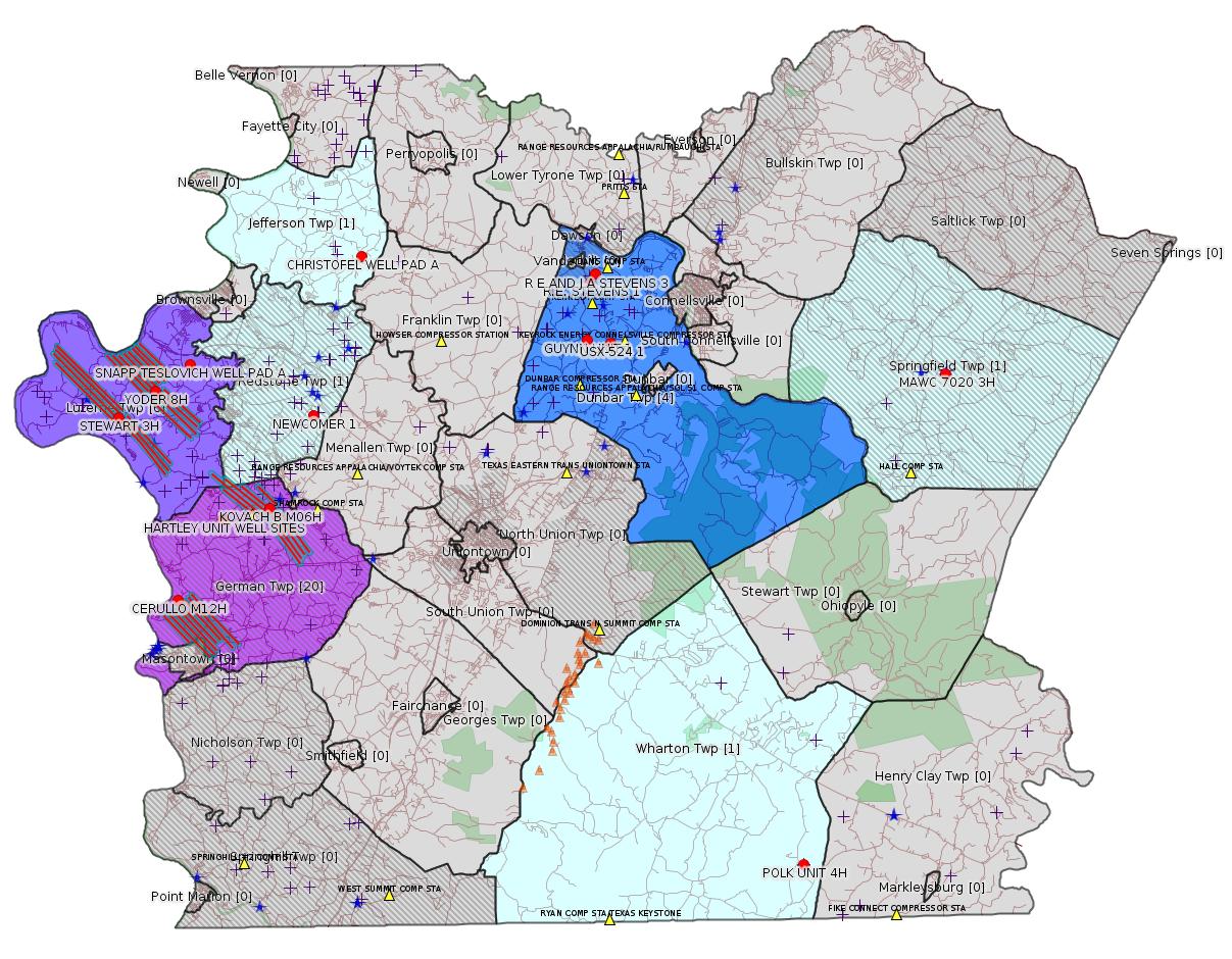
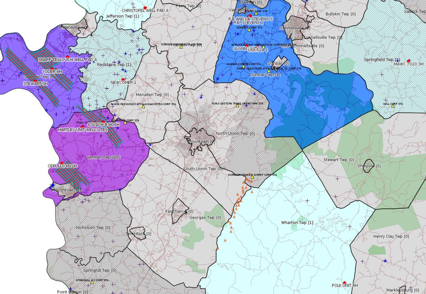
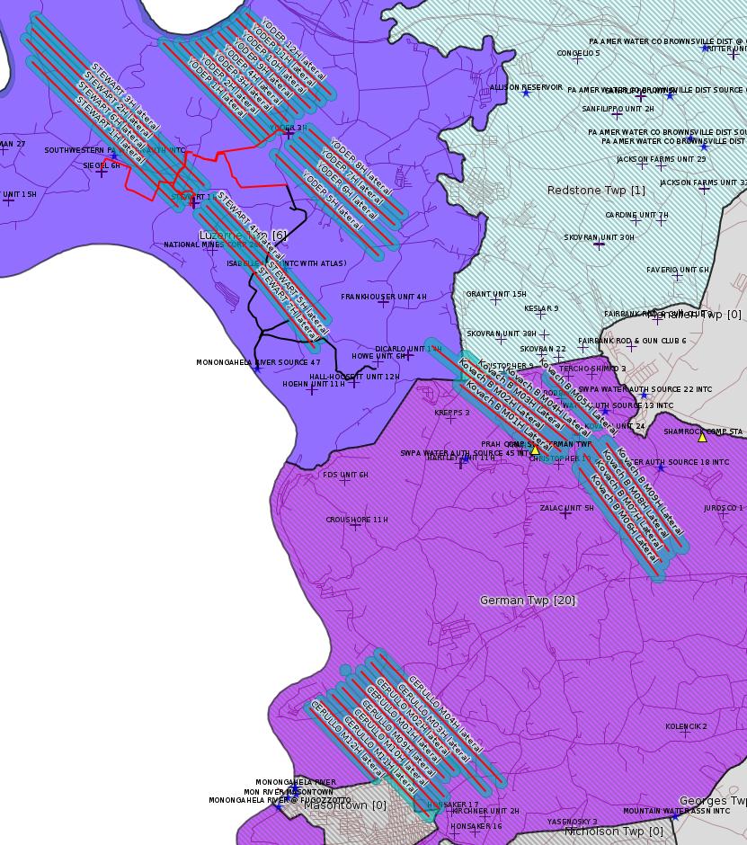
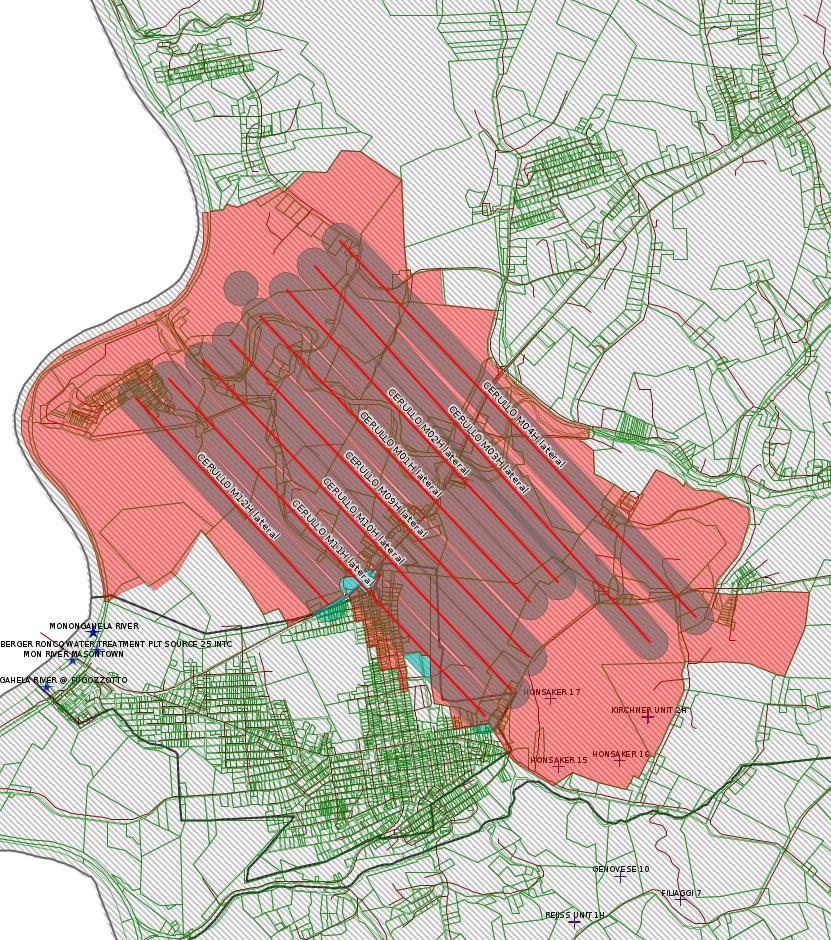
Map
Key
Red dots: items in this permit list with an exact location.
Blue stars: Marcellus Gas Well Water Sources.
Where well laterals are mapped they show in red; a 400-foot buffer surrounding the lateral shows in blue (lavender where it overlaps a mapped mineral tract).
Where mineral tracts are mapped, they show in pink. Mineral tracts can overlap; the overlap will show in red. The precise meaning of "mineral tract" is not clear.
Municipality shading: number of "facilities", with each well counting separately
(includes the red dots):
gray: 0
pale turquoise: 1
turquoise: 2
pale blue: 3
middle blue: 4
dark blue: 5
dark purple: 8
purple: 19
(Color coding may differ from one issue to the next.)
(Note if a project spans multiple municipalities -- e.g. a pipeline -- it will show in the count for each municipality.)
The number of facilities also follows the municipality name in brackets.
Municipality counts are based on the way the permit is listed by DEP; DEP has been known to get a municipality wrong.
Locations in brackets identify a precise location used to locate a surrogate for the actual site being permitted (e.g. locating a well pad or pipeline by the known location of a well.) Locations labeled beginning with "~" and ending in "[?]" are approximate and speculative based on inferences using on-line property and lease records. These are marked in the text as "[Approximate, Speculative]
Cross-hatching: Environmental Justice Areas
Yellow triangles: Compressor Stations
Orange triangles: Storage Field Wells (currently Dominion North Summit Storage Field)
Crosses: SPUD Unconventional well permits
Green: "Natural areas", e.g. state game lands, state forests
Yellow triangles: Compressor Stations
Orange triangles: Storage Field Wells (currently Dominion North Summit Storage Field)
Crosses: SPUD Unconventional well permits
Green: "Natural areas", e.g. state game lands, state forests
More Maps
 |
 |
 |
Source: Pennsylvania Bulletin
[No Activity]
-------------------------
Source: eNOTICE (+ PA Oil and Gas Mapping, Well Pad Report.) Well Details via Data Portal Services: Oil and Gas Wells All (ID: 3).
Please see the Disclaimer below regarding Parcel Id data.
New:
Authorization ID: 1256836
Permit number: 051-24674
Site: KOVACH B WELL SITE AND TANK SITE ESCGP ESX17-051-0003
Client: CHEVRON APPALACHIA LLC
Authorization type: Alt Method of Equipping, Casing, or Venting Well
Application type: New
Authorization is for: FACILITY
Date received: 12/21/2018
Status: Issued on 1/7/2019
Permit Decision Guarantee Applies?: Yes
Permit Decision Guarantee status: ACTIVE
Sub-Facilities for Authorization:
Sub-Facility ID Sub-Facility Name Description
1263132 WELLBORE SURFACE HOLE LOCATION Well
Permit Review Notes:
Date Review Note
1/7/2019 The technical review and decision review are complete and either the permit decision and/or permit issuance are forthcoming.
1/2/2019 The permit application package is complete, has been accepted, and is undergoing technical review.
<https://www.ahs.dep.pa.gov/eFACTSWeb/searchResults_singleAuth.aspx?AuthID=1256836>
Site Programs:
Oil & Gas
Site Municipalities:
German Twp [an Environmental Justice Area], Fayette County
Well Details:
Permit Number: 051-24674
Well Name: KOVACH B M03H
Unconventional Well: Y
Well Configuration: Horizontal Well
Well Type: GAS
Well Status: Active
Coal Association: Coal
Conservation Well: N
Primary Facility ID: 828040
Site ID: 826949
Site Name: KOVACH B WELL SITE AND TANK SITE ESCGP ESX17-051-0003
Well Pad ID: 155005
Well Pad Name: KOVACH B
Storage Field:
Operator: CHEVRON APPALACHIA LLC
Operator Number: OGO-39307
Permit Date: 2018-08-08
Permit Date Expires: 2019-08-08
SPUD Date: 2018-10-23
Date Plugged:
UIC ID:
UIC Type:
Surface Elevation: 1278
County: Fayette
Municipality: German Twp
Location: 39.919008,-79.854764
Map URL: <http://www.openstreetmap.org/?mlat=39.919008&mlon=-79.854764#map=15/39.919008/-79.854764>
OG WELLS PERMIT DOCS:
2018-08-08: Final Permit Documents, Name: 1237730 (for Authorization: 1237730):
<http://www.depgis.state.pa.us/pdfHandler/pdFHandler.ashx?Doc=NjQ2Nzgz&ext=PDF>
2019-01-07: Other Permit Documents, Name: 051-24674 (for Authorization: 1256836):
<http://www.depgis.state.pa.us/pdfHandler/pdFHandler.ashx?Doc=NzI3OTc0&ext=PDF>
Electronically Submitted Records:
2018-08-08: Submission for Authorization 1237730
Interested Party Notification: Kovach B Affidavit of Non-Delivery Venere.pdf
<http://www.depgis.state.pa.us/eWellDocHandler/pdFHandler.ashx?Doc=NjAxOTgy&ext=PDF>
Pennsylvania Natural Diversity Inventory Form: Kovach B PNDI.pdf
<http://www.depgis.state.pa.us/eWellDocHandler/pdFHandler.ashx?Doc=NjAyMDAy&ext=PDF>
Location Plat: Kovach B M03H Plat.dwg
<http://www.depgis.state.pa.us/eWellDocHandler/pdFHandler.ashx?Doc=NjAyMDAz&ext=PDF>
Coal and Gas Resource Coord Act - Section 7 Exception: Kovach B Horizontals Section 7 Exception.pdf
<http://www.depgis.state.pa.us/eWellDocHandler/pdFHandler.ashx?Doc=NjAyMDA0&ext=PDF>
Well Cross-Section Diagram: Kovach B M03H Page 4.pdf
<http://www.depgis.state.pa.us/eWellDocHandler/pdFHandler.ashx?Doc=NjAyMDA1&ext=PDF>
Permit Application to Drill and Operate a Well: 1753252.pdf
<http://www.depgis.state.pa.us/eWellDocHandler/pdFHandler.ashx?Doc=NjAzODM4&ext=PDF>
Authorization ID: 1256831
Permit number: 051-24673
Site: KOVACH B WELL SITE AND TANK SITE ESCGP ESX17-051-0003
Client: CHEVRON APPALACHIA LLC
Authorization type: Alt Method of Equipping, Casing, or Venting Well
Application type: New
Authorization is for: FACILITY
Date received: 12/21/2018
Status: Pending
Permit Decision Guarantee Applies?: Yes
Permit Decision Guarantee status: ACTIVE
Sub-Facilities for Authorization:
Sub-Facility ID Sub-Facility Name Description
1263131 WELLBORE SURFACE HOLE LOCATION Well
Permit Review Notes:
Date Review Note
1/9/2019 The technical review and decision review are complete and either the permit decision and/or permit issuance are forthcoming.
1/2/2019 The permit application package is complete, has been accepted, and is undergoing technical review.
<https://www.ahs.dep.pa.gov/eFACTSWeb/searchResults_singleAuth.aspx?AuthID=1256831>
Site Programs:
Oil & Gas
Site Municipalities:
German Twp [an Environmental Justice Area], Fayette County
Well Details:
Permit Number: 051-24673
Well Name: KOVACH B M06H
Unconventional Well: Y
Well Configuration: Horizontal Well
Well Type: GAS
Well Status: Active
Coal Association: Coal
Conservation Well: N
Primary Facility ID: 828039
Site ID: 826949
Site Name: KOVACH B WELL SITE AND TANK SITE ESCGP ESX17-051-0003
Well Pad ID: 155005
Well Pad Name: KOVACH B
Storage Field:
Operator: CHEVRON APPALACHIA LLC
Operator Number: OGO-39307
Permit Date: 2018-08-08
Permit Date Expires: 2019-08-08
SPUD Date: 2018-10-23
Date Plugged:
UIC ID:
UIC Type:
Surface Elevation: 1278
County: Fayette
Municipality: German Twp
Location: 39.919122,-79.8547
Map URL: <http://www.openstreetmap.org/?mlat=39.919122&mlon=-79.8547#map=15/39.919122/-79.8547>
OG WELLS PERMIT DOCS:
2018-08-08: Final Permit Documents, Name: 1237729 (for Authorization: 1237729):
<http://www.depgis.state.pa.us/pdfHandler/pdFHandler.ashx?Doc=NjQ2Nzgx&ext=PDF>
2019-01-09: Other Permit Documents, Name: 051-24673 (for Authorization: 1256831):
<http://www.depgis.state.pa.us/pdfHandler/pdFHandler.ashx?Doc=NzI5MDE3&ext=PDF>
Electronically Submitted Records:
2018-08-08: Submission for Authorization 1237729
Interested Party Notification: Kovach B Affidavit of Non-Delivery Venere.pdf
<http://www.depgis.state.pa.us/eWellDocHandler/pdFHandler.ashx?Doc=NjAyNTE3&ext=PDF>
Pennsylvania Natural Diversity Inventory Form: Kovach B PNDI.pdf
<http://www.depgis.state.pa.us/eWellDocHandler/pdFHandler.ashx?Doc=NjAyNTI1&ext=PDF>
Location Plat: Kovach B M06H Plat.dwg
<http://www.depgis.state.pa.us/eWellDocHandler/pdFHandler.ashx?Doc=NjAyNTI2&ext=PDF>
Coal and Gas Resource Coord Act - Section 7 Exception: Kovach B Horizontals Section 7 Exception.pdf
<http://www.depgis.state.pa.us/eWellDocHandler/pdFHandler.ashx?Doc=NjAyNTI3&ext=PDF>
Well Cross-Section Diagram: Kovach B M06H Page 4.pdf
<http://www.depgis.state.pa.us/eWellDocHandler/pdFHandler.ashx?Doc=NjAyNTI4&ext=PDF>
Permit Application to Drill and Operate a Well: 1753541.pdf
<http://www.depgis.state.pa.us/eWellDocHandler/pdFHandler.ashx?Doc=NjAzODY5&ext=PDF>
---
New:
Authorization ID: 1256826
Permit number: 051-24672
Site: KOVACH B WELL SITE AND TANK SITE ESCGP ESX17-051-0003
Client: CHEVRON APPALACHIA LLC
Authorization type: Alt Method of Equipping, Casing, or Venting Well
Application type: New
Authorization is for: FACILITY
Date received: 12/21/2018
Status: Issued on 1/7/2019
Permit Decision Guarantee Applies?: Yes
Permit Decision Guarantee status: ACTIVE
Sub-Facilities for Authorization:
Sub-Facility ID Sub-Facility Name Description
1263130 WELLBORE SURFACE HOLE LOCATION Well
Permit Review Notes:
Date Review Note
1/7/2019 The technical review and decision review are complete and either the permit decision and/or permit issuance are forthcoming.
1/2/2019 The permit application package is complete, has been accepted, and is undergoing technical review.
<https://www.ahs.dep.pa.gov/eFACTSWeb/searchResults_singleAuth.aspx?AuthID=1256826>
Site Programs:
Oil & Gas
Site Municipalities:
German Twp [an Environmental Justice Area], Fayette County
Well Details:
Permit Number: 051-24672
Well Name: KOVACH B M02H
Unconventional Well: Y
Well Configuration: Horizontal Well
Well Type: GAS
Well Status: Active
Coal Association: Coal
Conservation Well: N
Primary Facility ID: 828038
Site ID: 826949
Site Name: KOVACH B WELL SITE AND TANK SITE ESCGP ESX17-051-0003
Well Pad ID: 155005
Well Pad Name: KOVACH B
Storage Field:
Operator: CHEVRON APPALACHIA LLC
Operator Number: OGO-39307
Permit Date: 2018-08-08
Permit Date Expires: 2019-08-08
SPUD Date: 2018-10-23
Date Plugged:
UIC ID:
UIC Type:
Surface Elevation: 1278
County: Fayette
Municipality: German Twp
Location: 39.918972,-79.854786
Map URL: <http://www.openstreetmap.org/?mlat=39.918972&mlon=-79.854786#map=15/39.918972/-79.854786>
OG WELLS PERMIT DOCS:
2018-08-08: Final Permit Documents, Name: 1237728 (for Authorization: 1237728):
<http://www.depgis.state.pa.us/pdfHandler/pdFHandler.ashx?Doc=NjQ2Nzc4&ext=PDF>
2019-01-07: Other Permit Documents, Name: 051-24672 (for Authorization: 1256826):
<http://www.depgis.state.pa.us/pdfHandler/pdFHandler.ashx?Doc=NzI3ODUz&ext=PDF>
Electronically Submitted Records:
2018-08-08: Submission for Authorization 1237728
Interested Party Notification: Kovach B Affidavit of Non-Delivery Venere.pdf
<http://www.depgis.state.pa.us/eWellDocHandler/pdFHandler.ashx?Doc=NjAxODc1&ext=PDF>
Pennsylvania Natural Diversity Inventory Form: Kovach B PNDI.pdf
<http://www.depgis.state.pa.us/eWellDocHandler/pdFHandler.ashx?Doc=NjAxODc5&ext=PDF>
Location Plat: Kovach B M02H Plat.dwg
<http://www.depgis.state.pa.us/eWellDocHandler/pdFHandler.ashx?Doc=NjAxODgw&ext=PDF>
Well Cross-Section Diagram: Kovach B M02H Page 4.pdf
<http://www.depgis.state.pa.us/eWellDocHandler/pdFHandler.ashx?Doc=NjAxODgy&ext=PDF>
Coal and Gas Resource Coord Act - Section 7 Exception: Kovach B Horizontals Section 7 Exception.pdf
<http://www.depgis.state.pa.us/eWellDocHandler/pdFHandler.ashx?Doc=NjAxODkz&ext=PDF>
Permit Application to Drill and Operate a Well: 1753234.pdf
<http://www.depgis.state.pa.us/eWellDocHandler/pdFHandler.ashx?Doc=NjAzODI3&ext=PDF>
---
New:
Authorization ID: 1256822
Permit number: 051-24671
Site: KOVACH B WELL SITE AND TANK SITE ESCGP ESX17-051-0003
Client: CHEVRON APPALACHIA LLC
Authorization type: Alt Method of Equipping, Casing, or Venting Well
Application type: New
Authorization is for: FACILITY
Date received: 12/21/2018
Status: Pending
Permit Decision Guarantee Applies?: Yes
Permit Decision Guarantee status: ACTIVE
<https://www.ahs.dep.pa.gov/eFACTSWeb/searchResults_singleAuth.aspx?AuthID=1256822>
Site Programs:
Oil & Gas
Site Municipalities:
German Twp [an Environmental Justice Area], Fayette County
Well Details:
Permit Number: 051-24671
Well Name: KOVACH B M01H
Unconventional Well: Y
Well Configuration: Horizontal Well
Well Type: GAS
Well Status: Active
Coal Association: Coal
Conservation Well: N
Primary Facility ID: 828037
Site ID: 826949
Site Name: KOVACH B WELL SITE AND TANK SITE ESCGP ESX17-051-0003
Well Pad ID: 155005
Well Pad Name: KOVACH B
Storage Field:
Operator: CHEVRON APPALACHIA LLC
Operator Number: OGO-39307
Permit Date: 2018-08-08
Permit Date Expires: 2019-08-08
SPUD Date: 2018-10-23
Date Plugged:
UIC ID:
UIC Type:
Surface Elevation: 1278
County: Fayette
Municipality: German Twp
Location: 39.918933,-79.854808
Map URL: <http://www.openstreetmap.org/?mlat=39.918933&mlon=-79.854808#map=15/39.918933/-79.854808>
OG WELLS PERMIT DOCS:
2018-08-08: Final Permit Documents, Name: 1237727 (for Authorization: 1237727):
<http://www.depgis.state.pa.us/pdfHandler/pdFHandler.ashx?Doc=NjQ2Nzc2&ext=PDF>
2019-01-07: Other Permit Documents, Name: 051-24671 (for Authorization: 1256817):
<http://www.depgis.state.pa.us/pdfHandler/pdFHandler.ashx?Doc=NzI3OTEy&ext=PDF>
Electronically Submitted Records:
2018-08-08: Submission for Authorization 1237727
Pennsylvania Natural Diversity Inventory Form: Kovach B PNDI.pdf
<http://www.depgis.state.pa.us/eWellDocHandler/pdFHandler.ashx?Doc=NjAxNjky&ext=PDF>
Coal and Gas Resource Coord Act - Section 7 Exception: Kovach B Horizontals Section 7 Exception.pdf
<http://www.depgis.state.pa.us/eWellDocHandler/pdFHandler.ashx?Doc=NjAxNjkz&ext=PDF>
Well Cross-Section Diagram: Kovach B M01H Page 4.pdf
<http://www.depgis.state.pa.us/eWellDocHandler/pdFHandler.ashx?Doc=NjAxODA2&ext=PDF>
Interested Party Notification: Kovach B Affidavit of Non-Delivery Venere.pdf
<http://www.depgis.state.pa.us/eWellDocHandler/pdFHandler.ashx?Doc=NjAxODE4&ext=PDF>
Location Plat: Kovach B M01H Plat.dwg
<http://www.depgis.state.pa.us/eWellDocHandler/pdFHandler.ashx?Doc=NjAxODI5&ext=PDF>
Permit Application to Drill and Operate a Well: 1747807.pdf
<http://www.depgis.state.pa.us/eWellDocHandler/pdFHandler.ashx?Doc=NjAzODE3&ext=PDF>
---
New:
Authorization ID: 1256817
Permit number: 051-24671
Site: KOVACH B WELL SITE AND TANK SITE ESCGP ESX17-051-0003
Client: CHEVRON APPALACHIA LLC
Authorization type: Alt Method of Equipping, Casing, or Venting Well
Application type: New
Authorization is for: FACILITY
Date received: 12/21/2018
Status: Issued on 1/7/2019
Permit Decision Guarantee Applies?: Yes
Permit Decision Guarantee status: ACTIVE
Sub-Facilities for Authorization:
Sub-Facility ID Sub-Facility Name Description
1263129 WELLBORE SURFACE HOLE LOCATION Well
Permit Review Notes:
Date Review Note
1/7/2019 The technical review and decision review are complete and either the permit decision and/or permit issuance are forthcoming.
1/2/2019 The permit application package is complete, has been accepted, and is undergoing technical review.
<https://www.ahs.dep.pa.gov/eFACTSWeb/searchResults_singleAuth.aspx?AuthID=1256817>
Site Programs:
Oil & Gas
Site Municipalities:
German Twp [an Environmental Justice Area], Fayette County
Well Details:
Permit Number: 051-24671
Well Name: KOVACH B M01H
Unconventional Well: Y
Well Configuration: Horizontal Well
Well Type: GAS
Well Status: Active
Coal Association: Coal
Conservation Well: N
Primary Facility ID: 828037
Site ID: 826949
Site Name: KOVACH B WELL SITE AND TANK SITE ESCGP ESX17-051-0003
Well Pad ID: 155005
Well Pad Name: KOVACH B
Storage Field:
Operator: CHEVRON APPALACHIA LLC
Operator Number: OGO-39307
Permit Date: 2018-08-08
Permit Date Expires: 2019-08-08
SPUD Date: 2018-10-23
Date Plugged:
UIC ID:
UIC Type:
Surface Elevation: 1278
County: Fayette
Municipality: German Twp
Location: 39.918933,-79.854808
Map URL: <http://www.openstreetmap.org/?mlat=39.918933&mlon=-79.854808#map=15/39.918933/-79.854808>
OG WELLS PERMIT DOCS:
2018-08-08: Final Permit Documents, Name: 1237727 (for Authorization: 1237727):
<http://www.depgis.state.pa.us/pdfHandler/pdFHandler.ashx?Doc=NjQ2Nzc2&ext=PDF>
2019-01-07: Other Permit Documents, Name: 051-24671 (for Authorization: 1256817):
<http://www.depgis.state.pa.us/pdfHandler/pdFHandler.ashx?Doc=NzI3OTEy&ext=PDF>
Electronically Submitted Records:
2018-08-08: Submission for Authorization 1237727
Pennsylvania Natural Diversity Inventory Form: Kovach B PNDI.pdf
<http://www.depgis.state.pa.us/eWellDocHandler/pdFHandler.ashx?Doc=NjAxNjky&ext=PDF>
Coal and Gas Resource Coord Act - Section 7 Exception: Kovach B Horizontals Section 7 Exception.pdf
<http://www.depgis.state.pa.us/eWellDocHandler/pdFHandler.ashx?Doc=NjAxNjkz&ext=PDF>
Well Cross-Section Diagram: Kovach B M01H Page 4.pdf
<http://www.depgis.state.pa.us/eWellDocHandler/pdFHandler.ashx?Doc=NjAxODA2&ext=PDF>
Interested Party Notification: Kovach B Affidavit of Non-Delivery Venere.pdf
<http://www.depgis.state.pa.us/eWellDocHandler/pdFHandler.ashx?Doc=NjAxODE4&ext=PDF>
Location Plat: Kovach B M01H Plat.dwg
<http://www.depgis.state.pa.us/eWellDocHandler/pdFHandler.ashx?Doc=NjAxODI5&ext=PDF>
Permit Application to Drill and Operate a Well: 1747807.pdf
<http://www.depgis.state.pa.us/eWellDocHandler/pdFHandler.ashx?Doc=NjAzODE3&ext=PDF>
---
New:
Authorization ID: 1256805
Permit number: 051-24670
Site: KOVACH B WELL SITE AND TANK SITE ESCGP ESX17-051-0003
Client: CHEVRON APPALACHIA LLC
Authorization type: Alt Method of Equipping, Casing, or Venting Well
Application type: New
Authorization is for: FACILITY
Date received: 12/21/2018
Status: Issued on 1/7/2019
Permit Decision Guarantee Applies?: Yes
Permit Decision Guarantee status: ACTIVE
Sub-Facilities for Authorization:
Sub-Facility ID Sub-Facility Name Description
1263128 WELLBORE SURFACE HOLE LOCATION Well
Permit Review Notes:
Date Review Note
1/7/2019 The technical review and decision review are complete and either the permit decision and/or permit issuance are forthcoming.
1/7/2019 The permit application package is complete, has been accepted, and is undergoing technical review.
<https://www.ahs.dep.pa.gov/eFACTSWeb/searchResults_singleAuth.aspx?AuthID=1256805>
Site Programs:
Oil & Gas
Site Municipalities:
German Twp [an Environmental Justice Area], Fayette County
Well Details:
Permit Number: 051-24670
Well Name: KOVACH B M09H
Unconventional Well: Y
Well Configuration: Horizontal Well
Well Type: GAS
Well Status: Active
Coal Association: Coal
Conservation Well: N
Primary Facility ID: 828036
Site ID: 826949
Site Name: KOVACH B WELL SITE AND TANK SITE ESCGP ESX17-051-0003
Well Pad ID: 155005
Well Pad Name: KOVACH B
Storage Field:
Operator: CHEVRON APPALACHIA LLC
Operator Number: OGO-39307
Permit Date: 2018-08-08
Permit Date Expires: 2019-08-08
SPUD Date: 2018-10-23
Date Plugged:
UIC ID:
UIC Type:
Surface Elevation: 1278
County: Fayette
Municipality: German Twp
Location: 39.919231,-79.854758
Map URL: <http://www.openstreetmap.org/?mlat=39.919231&mlon=-79.854758#map=15/39.919231/-79.854758>
OG WELLS PERMIT DOCS:
2018-08-08: Final Permit Documents, Name: 1237726 (for Authorization: 1237726):
<http://www.depgis.state.pa.us/pdfHandler/pdFHandler.ashx?Doc=NjQ2Nzc1&ext=PDF>
2019-01-07: Other Permit Documents, Name: 051-24670 (for Authorization: 1256805):
<http://www.depgis.state.pa.us/pdfHandler/pdFHandler.ashx?Doc=NzI3OTkx&ext=PDF>
Electronically Submitted Records:
2018-08-08: Submission for Authorization 1237726
Interested Party Notification: Kovach B Affidavit of Non-Delivery Venere.pdf
<http://www.depgis.state.pa.us/eWellDocHandler/pdFHandler.ashx?Doc=NjAyNjM1&ext=PDF>
Coal and Gas Resource Coord Act - Section 7 Exception: Kovach B Horizontals Section 7 Exception.pdf
<http://www.depgis.state.pa.us/eWellDocHandler/pdFHandler.ashx?Doc=NjAyNjQw&ext=PDF>
Pennsylvania Natural Diversity Inventory Form: Kovach B PNDI.pdf
<http://www.depgis.state.pa.us/eWellDocHandler/pdFHandler.ashx?Doc=NjAyNjQx&ext=PDF>
Location Plat: Kovach B M09H Plat.dwg
<http://www.depgis.state.pa.us/eWellDocHandler/pdFHandler.ashx?Doc=NjAyNjQy&ext=PDF>
Well Cross-Section Diagram: Kovach B M09H Page 4.pdf
<http://www.depgis.state.pa.us/eWellDocHandler/pdFHandler.ashx?Doc=NjAyNjQz&ext=PDF>
Permit Application to Drill and Operate a Well: 1753557.pdf
<http://www.depgis.state.pa.us/eWellDocHandler/pdFHandler.ashx?Doc=NjAzODg3&ext=PDF>
---
New:
Authorization ID: 1256801
Permit number: 051-24669
Site: KOVACH B WELL SITE AND TANK SITE ESCGP ESX17-051-0003
Client: CHEVRON APPALACHIA LLC
Authorization type: Alt Method of Equipping, Casing, or Venting Well
Application type: New
Authorization is for: FACILITY
Date received: 12/21/2018
Status: Pending
Permit Decision Guarantee Applies?: Yes
Permit Decision Guarantee status: ACTIVE
Sub-Facilities for Authorization:
Sub-Facility ID Sub-Facility Name Description
1263127 WELLBORE SURFACE HOLE LOCATION Well
Permit Review Notes:
Date Review Note
1/9/2019 The technical review and decision review are complete and either the permit decision and/or permit issuance are forthcoming.
1/2/2019 The permit application package is complete, has been accepted, and is undergoing technical review.
<https://www.ahs.dep.pa.gov/eFACTSWeb/searchResults_singleAuth.aspx?AuthID=1256801>
Site Programs:
Oil & Gas
Site Municipalities:
German Twp [an Environmental Justice Area], Fayette County
Well Details:
Permit Number: 051-24669
Well Name: KOVACH B M08H
Unconventional Well: Y
Well Configuration: Horizontal Well
Well Type: GAS
Well Status: Active
Coal Association: Coal
Conservation Well: N
Primary Facility ID: 828035
Site ID: 826949
Site Name: KOVACH B WELL SITE AND TANK SITE ESCGP ESX17-051-0003
Well Pad ID: 155005
Well Pad Name: KOVACH B
Storage Field:
Operator: CHEVRON APPALACHIA LLC
Operator Number: OGO-39307
Permit Date: 2018-08-08
Permit Date Expires: 2019-08-08
SPUD Date: 2018-10-23
Date Plugged:
UIC ID:
UIC Type:
Surface Elevation: 1278
County: Fayette
Municipality: German Twp
Location: 39.919197,-79.854658
Map URL: <http://www.openstreetmap.org/?mlat=39.919197&mlon=-79.854658#map=15/39.919197/-79.854658>
OG WELLS PERMIT DOCS:
2018-08-08: Final Permit Documents, Name: 1237725 (for Authorization: 1237725):
<http://www.depgis.state.pa.us/pdfHandler/pdFHandler.ashx?Doc=NjQ2Nzc0&ext=PDF>
2019-01-09: Other Permit Documents, Name: 051-24669 (for Authorization: 1256801):
<http://www.depgis.state.pa.us/pdfHandler/pdFHandler.ashx?Doc=NzI5MDIz&ext=PDF>
Electronically Submitted Records:
2018-08-08: Submission for Authorization 1237725
Interested Party Notification: Kovach B Affidavit of Non-Delivery Venere.pdf
<http://www.depgis.state.pa.us/eWellDocHandler/pdFHandler.ashx?Doc=NjAyNjA5&ext=PDF>
Coal and Gas Resource Coord Act - Section 7 Exception: Kovach B Horizontals Section 7 Exception.pdf
<http://www.depgis.state.pa.us/eWellDocHandler/pdFHandler.ashx?Doc=NjAyNjE1&ext=PDF>
Pennsylvania Natural Diversity Inventory Form: Kovach B PNDI.pdf
<http://www.depgis.state.pa.us/eWellDocHandler/pdFHandler.ashx?Doc=NjAyNjE2&ext=PDF>
Location Plat: Kovach B M08H Plat.dwg
<http://www.depgis.state.pa.us/eWellDocHandler/pdFHandler.ashx?Doc=NjAyNjE3&ext=PDF>
Well Cross-Section Diagram: Kovach B M08H Page 4.pdf
<http://www.depgis.state.pa.us/eWellDocHandler/pdFHandler.ashx?Doc=NjAyNjE4&ext=PDF>
Permit Application to Drill and Operate a Well: 1753555.pdf
<http://www.depgis.state.pa.us/eWellDocHandler/pdFHandler.ashx?Doc=NjAzODgz&ext=PDF>
---
New:
Authorization ID: 1256785
Permit number: 051-24668
Site: KOVACH B WELL SITE AND TANK SITE ESCGP ESX17-051-0003
Client: CHEVRON APPALACHIA LLC
Authorization type: Alt Method of Equipping, Casing, or Venting Well
Application type: New
Authorization is for: FACILITY
Date received: 12/21/2018
Status: Pending
Permit Decision Guarantee Applies?: Yes
Permit Decision Guarantee status: ACTIVE
Sub-Facilities for Authorization:
Sub-Facility ID Sub-Facility Name Description
1263126 WELLBORE SURFACE HOLE LOCATION Well
Permit Review Notes:
Date Review Note
1/9/2019 The technical review and decision review are complete and either the permit decision and/or permit issuance are forthcoming.
1/2/2019 The permit application package is complete, has been accepted, and is undergoing technical review.
<https://www.ahs.dep.pa.gov/eFACTSWeb/searchResults_singleAuth.aspx?AuthID=1256785>
Site Programs:
Oil & Gas
Site Municipalities:
German Twp [an Environmental Justice Area], Fayette County
Well Details:
Permit Number: 051-24668
Well Name: KOVACH B M07H
Unconventional Well: Y
Well Configuration: Horizontal Well
Well Type: GAS
Well Status: Active
Coal Association: Coal
Conservation Well: N
Primary Facility ID: 828034
Site ID: 826949
Site Name: KOVACH B WELL SITE AND TANK SITE ESCGP ESX17-051-0003
Well Pad ID: 155005
Well Pad Name: KOVACH B
Storage Field:
Operator: CHEVRON APPALACHIA LLC
Operator Number: OGO-39307
Permit Date: 2018-08-08
Permit Date Expires: 2019-08-08
SPUD Date: 2018-10-23
Date Plugged:
UIC ID:
UIC Type:
Surface Elevation: 1278
County: Fayette
Municipality: German Twp
Location: 39.919161,-79.854681
Map URL: <http://www.openstreetmap.org/?mlat=39.919161&mlon=-79.854681#map=15/39.919161/-79.854681>
OG WELLS PERMIT DOCS:
2018-08-08: Final Permit Documents, Name: 1237724 (for Authorization: 1237724):
<http://www.depgis.state.pa.us/pdfHandler/pdFHandler.ashx?Doc=NjQ2Nzcz&ext=PDF>
2019-01-09: Other Permit Documents, Name: 051-24668 (for Authorization: 1256785):
<http://www.depgis.state.pa.us/pdfHandler/pdFHandler.ashx?Doc=NzI5MDgy&ext=PDF>
Electronically Submitted Records:
2018-08-08: Submission for Authorization 1237724
Interested Party Notification: Kovach B Affidavit of Non-Delivery Venere.pdf
<http://www.depgis.state.pa.us/eWellDocHandler/pdFHandler.ashx?Doc=NjAyNTUw&ext=PDF>
Coal and Gas Resource Coord Act - Section 7 Exception: Kovach B Horizontals Section 7 Exception.pdf
<http://www.depgis.state.pa.us/eWellDocHandler/pdFHandler.ashx?Doc=NjAyNTY1&ext=PDF>
Pennsylvania Natural Diversity Inventory Form: Kovach B PNDI.pdf
<http://www.depgis.state.pa.us/eWellDocHandler/pdFHandler.ashx?Doc=NjAyNTY2&ext=PDF>
Location Plat: Kovach B M07H Plat.dwg
<http://www.depgis.state.pa.us/eWellDocHandler/pdFHandler.ashx?Doc=NjAyNTY3&ext=PDF>
Well Cross-Section Diagram: Kovach B M07H Page 4.pdf
<http://www.depgis.state.pa.us/eWellDocHandler/pdFHandler.ashx?Doc=NjAyNTY4&ext=PDF>
Permit Application to Drill and Operate a Well: 1753553.pdf
<http://www.depgis.state.pa.us/eWellDocHandler/pdFHandler.ashx?Doc=NjAzODcy&ext=PDF>
---
New:
Authorization ID: 1256748
Permit number: 051-24667
Site: KOVACH B WELL SITE AND TANK SITE ESCGP ESX17-051-0003
Client: CHEVRON APPALACHIA LLC
Authorization type: Alt Method of Equipping, Casing, or Venting Well
Application type: New
Authorization is for: FACILITY
Date received: 12/21/2018
Status: Pending
Permit Decision Guarantee Applies?: Yes
Permit Decision Guarantee status: ACTIVE
Sub-Facilities for Authorization:
Sub-Facility ID Sub-Facility Name Description
1263125 WELLBORE SURFACE HOLE LOCATION Well
Permit Review Notes:
Date Review Note
1/9/2019 The technical review and decision review are complete and either the permit decision and/or permit issuance are forthcoming.
1/2/2019 The permit application package is complete, has been accepted, and is undergoing technical review.
<https://www.ahs.dep.pa.gov/eFACTSWeb/searchResults_singleAuth.aspx?AuthID=1256748>
Site Programs:
Oil & Gas
Site Municipalities:
German Twp [an Environmental Justice Area], Fayette County
Well Details:
Permit Number: 051-24667
Well Name: KOVACH B M05H
Unconventional Well: Y
Well Configuration: Horizontal Well
Well Type: GAS
Well Status: Active
Coal Association: Coal
Conservation Well: N
Primary Facility ID: 828033
Site ID: 826949
Site Name: KOVACH B WELL SITE AND TANK SITE ESCGP ESX17-051-0003
Well Pad ID: 155005
Well Pad Name: KOVACH B
Storage Field:
Operator: CHEVRON APPALACHIA LLC
Operator Number: OGO-39307
Permit Date: 2018-08-08
Permit Date Expires: 2019-08-08
SPUD Date: 2018-10-23
Date Plugged:
UIC ID:
UIC Type:
Surface Elevation: 1278
County: Fayette
Municipality: German Twp
Location: 39.919086,-79.854722
Map URL: <http://www.openstreetmap.org/?mlat=39.919086&mlon=-79.854722#map=15/39.919086/-79.854722>
OG WELLS PERMIT DOCS:
2018-08-08: Final Permit Documents, Name: 1237723 (for Authorization: 1237723):
<http://www.depgis.state.pa.us/pdfHandler/pdFHandler.ashx?Doc=NjQ2Nzcw&ext=PDF>
2019-01-09: Other Permit Documents, Name: 051-24667 (for Authorization: 1256748):
<http://www.depgis.state.pa.us/pdfHandler/pdFHandler.ashx?Doc=NzI5MDg4&ext=PDF>
Electronically Submitted Records:
2018-08-08: Submission for Authorization 1237723
Interested Party Notification: Kovach B Affidavit of Non-Delivery Venere.pdf
<http://www.depgis.state.pa.us/eWellDocHandler/pdFHandler.ashx?Doc=NjAyNDYz&ext=PDF>
Pennsylvania Natural Diversity Inventory Form: Kovach B PNDI.pdf
<http://www.depgis.state.pa.us/eWellDocHandler/pdFHandler.ashx?Doc=NjAyNDY5&ext=PDF>
Location Plat: Kovach B M05H Plat.dwg
<http://www.depgis.state.pa.us/eWellDocHandler/pdFHandler.ashx?Doc=NjAyNDcw&ext=PDF>
Coal and Gas Resource Coord Act - Section 7 Exception: Kovach B Horizontals Section 7 Exception.pdf
<http://www.depgis.state.pa.us/eWellDocHandler/pdFHandler.ashx?Doc=NjAyNDcx&ext=PDF>
Well Cross-Section Diagram: Kovach B M05H Page 4.pdf
<http://www.depgis.state.pa.us/eWellDocHandler/pdFHandler.ashx?Doc=NjAyNDcy&ext=PDF>
Permit Application to Drill and Operate a Well: 1753273.pdf
<http://www.depgis.state.pa.us/eWellDocHandler/pdFHandler.ashx?Doc=NjAzODYx&ext=PDF>
---
New:
Authorization ID: 1256724
Permit number: 051-24666
Site: KOVACH B WELL SITE AND TANK SITE ESCGP ESX17-051-0003
Client: CHEVRON APPALACHIA LLC
Authorization type: Alt Method of Equipping, Casing, or Venting Well
Application type: New
Authorization is for: FACILITY
Date received: 12/21/2018
Status: Pending
Permit Decision Guarantee Applies?: Yes
Permit Decision Guarantee status: ACTIVE
Sub-Facilities for Authorization:
Sub-Facility ID Sub-Facility Name Description
1263124 WELLBORE SURFACE HOLE LOCATION Well
Permit Review Notes:
Date Review Note
1/9/2019 The technical review and decision review are complete and either the permit decision and/or permit issuance are forthcoming.
1/2/2019 The permit application package is complete, has been accepted, and is undergoing technical review.
<https://www.ahs.dep.pa.gov/eFACTSWeb/searchResults_singleAuth.aspx?AuthID=1256724>
Site Programs:
Oil & Gas
Site Municipalities:
German Twp [an Environmental Justice Area], Fayette County
Well Details:
Permit Number: 051-24666
Well Name: KOVACH B M04H
Unconventional Well: Y
Well Configuration: Horizontal Well
Well Type: GAS
Well Status: Active
Coal Association: Coal
Conservation Well: N
Primary Facility ID: 828032
Site ID: 826949
Site Name: KOVACH B WELL SITE AND TANK SITE ESCGP ESX17-051-0003
Well Pad ID: 155005
Well Pad Name: KOVACH B
Storage Field:
Operator: CHEVRON APPALACHIA LLC
Operator Number: OGO-39307
Permit Date: 2018-08-08
Permit Date Expires: 2019-08-08
SPUD Date: 2018-10-23
Date Plugged:
UIC ID:
UIC Type:
Surface Elevation: 1278
County: Fayette
Municipality: German Twp
Location: 39.919047,-79.854742
Map URL: <http://www.openstreetmap.org/?mlat=39.919047&mlon=-79.854742#map=15/39.919047/-79.854742>
OG WELLS PERMIT DOCS:
2018-08-08: Final Permit Documents, Name: 1237722 (for Authorization: 1237722):
<http://www.depgis.state.pa.us/pdfHandler/pdFHandler.ashx?Doc=NjQ2NzY1&ext=PDF>
2019-01-09: Other Permit Documents, Name: 051-24666 (for Authorization: 1256724):
<http://www.depgis.state.pa.us/pdfHandler/pdFHandler.ashx?Doc=NzI5MTE0&ext=PDF>
Electronically Submitted Records:
2018-08-08: Submission for Authorization 1237722
Interested Party Notification: Kovach B Affidavit of Non-Delivery Venere.pdf
<http://www.depgis.state.pa.us/eWellDocHandler/pdFHandler.ashx?Doc=NjAyMDMz&ext=PDF>
Coal and Gas Resource Coord Act - Section 7 Exception: Kovach B Horizontals Section 7 Exception.pdf
<http://www.depgis.state.pa.us/eWellDocHandler/pdFHandler.ashx?Doc=NjAyMDQx&ext=PDF>
Pennsylvania Natural Diversity Inventory Form: Kovach B PNDI.pdf
<http://www.depgis.state.pa.us/eWellDocHandler/pdFHandler.ashx?Doc=NjAyMDQy&ext=PDF>
Location Plat: Kovach B M04H Plat.dwg
<http://www.depgis.state.pa.us/eWellDocHandler/pdFHandler.ashx?Doc=NjAyMDQz&ext=PDF>
Well Cross-Section Diagram: Kovach B M04H Page 4.pdf
<http://www.depgis.state.pa.us/eWellDocHandler/pdFHandler.ashx?Doc=NjAyMDQ0&ext=PDF>
Permit Application to Drill and Operate a Well: 1753263.pdf
<http://www.depgis.state.pa.us/eWellDocHandler/pdFHandler.ashx?Doc=NjAzODU0&ext=PDF>
---
New:
Authorization ID: 1256620
Permit number: ESG30705118-002
Site: SNAPP TESLOVICH WELL PAD A ESCGP3 ESG30705118-002
Client: CHEVRON APPALACHIA LLC
Authorization type: Erosion and Sediment Control General Permit 3
Application type: New
Authorization is for: SITE
Date received: 12/20/2018
Status: Pending
Permit Decision Guarantee Applies?: Yes
Permit Decision Guarantee status: VOID
<https://www.ahs.dep.pa.gov/eFACTSWeb/searchResults_singleAuth.aspx?AuthID=1256620>
Site Programs:
Site Municipalities:
Luzerne Twp, Fayette County
Location: 39.9877,-79.9023 <https://osm.org/go/ZWpZ~QrU--?m=>
Presumed Parcel Id: 19160028
Act 14 Notification: <https://www.faymarwatch.org/documents/SNAPP_TESLOVICH_WELL_PAD_A_NOI.pdf>
---
New:
Authorization ID: 1256610
Permit number: ESX10-051-0040
Site: HARTLEY UNIT WELL SITES ESCGP-EXPEDITED
Client: CHEVRON APPALACHIA LLC
Authorization type: Expedited E&S Stormwater General Permit 1
Application type: Notification
Authorization is for: SITE
Date received: 12/28/2018
Status: Pending
Permit Decision Guarantee Applies?: No
Permit Review Notes:
Date Review Note
12/31/2018 The permit application package is complete, has been accepted, and is undergoing technical review.
<https://www.ahs.dep.pa.gov/eFACTSWeb/searchResults_singleAuth.aspx?AuthID=1256610>
Site Programs:
Site Municipalities:
German Twp [an Environmental Justice Area], Fayette County
Well Pad ID: 148486
Location: 39.914019,-79.883219 <https://osm.org/go/ZWpaEpog--?m=>
Wells on this pad:
051-24452 HARTLEY UNIT 6H
051-24453 HARTLEY UNIT 7H
051-24454 HARTLEY UNIT 8H
051-24455 HARTLEY UNIT 9H
051-24456 HARTLEY UNIT 10H
051-24457 HARTLEY UNIT 11H
Presumed Parcel Id: 15110004
---
New:
Authorization ID: 1256609
Permit number: ESX10-051-0040
Site: HARTLEY UNIT WELL SITES ESCGP-EXPEDITED
Client: ATLAS RESOURCES LLC
Authorization type: Expedited E&S Stormwater General Permit 1
Application type: Notification
Authorization is for: SITE
Date received: 12/28/2018
Status: Pending
Permit Decision Guarantee Applies?: No
<https://www.ahs.dep.pa.gov/eFACTSWeb/searchResults_singleAuth.aspx?AuthID=1256609>
Site Programs:
Site Municipalities:
German Twp [an Environmental Justice Area], Fayette County
---
Authorization ID: 1256580
Permit number: ESG30705118-001
Site: CHRISTOFEL WELL PAD A PROJECT ESG30705118-001
Client: CHEVRON APPALACHIA LLC
Authorization type: Erosion and Sediment Control General Permit 3
Application type: New
Authorization is for: SITE
Date received: 12/20/2018
Status: Pending
Permit Decision Guarantee Applies?: Yes
Permit Decision Guarantee status: ACTIVE
<https://www.ahs.dep.pa.gov/eFACTSWeb/searchResults_singleAuth.aspx?AuthID=1256580>
Site Programs:
Site Municipalities:
Jefferson Twp, Fayette County
Location: 40.0380,-79.7956
Presumed Parcel Id: 17130025
Act 14 Notification:
<https://www.faymarwatch.org/documents/Christofel_Well_Pad_A_Act_14_NOI.pdf>
[See Notes.]
---Presumed Parcel Id: 17130025
Act 14 Notification:
<https://www.faymarwatch.org/documents/Christofel_Well_Pad_A_Act_14_NOI.pdf>
[See Notes.]
Authorization ID: 1254004
Permit number: 051-24697
Site: CERULLO PAD A ESCGP ESX18-051-0004
Client: CHEVRON APPALACHIA LLC
Authorization type: Drill & Operate Well Permit (Unconventional)
Application type: New
Authorization is for: FACILITY
Date received: 12/04/2018
Status: Pending
Permit Decision Guarantee Applies?: No
Sub-Facilities for Authorization:
Sub-Facility ID Sub-Facility Name Description
1276244 WELLBORE SURFACE HOLE LOCATION Well
Permit Review Notes:
Date Review Note
1/3/2019 The technical review and decision review are complete and either the permit decision and/or permit issuance are forthcoming.
12/14/2018 Applicant has been issued a deficiency letter. If applicable, this application no longer qualifies for the Permit Decision Guarantee.
12/5/2018 The permit application package is complete, has been accepted, and is undergoing technical review.
<https://www.ahs.dep.pa.gov/eFACTSWeb/searchResults_singleAuth.aspx?AuthID=1254004>
Site Programs:
Oil & Gas
Site Municipalities:
German Twp [an Environmental Justice Area], Fayette County
Well Details:
Permit Number: 051-24697
Well Name: CERULLO M12H
Unconventional Well: Y
Well Configuration: Horizontal Well
Well Type: GAS
Well Status: Active
Coal Association: Coal
Conservation Well: N
Primary Facility ID: 830840
Site ID: 829618
Site Name: CERULLO PAD A ESCGP ESX18-051-0004
Well Pad ID: 155068
Well Pad Name: CERULLO
Storage Field:
Operator: CHEVRON APPALACHIA LLC
Operator Number: OGO-39307
Permit Date: 2019-01-11
Permit Date Expires: 2020-01-11
SPUD Date:
Date Plugged:
UIC ID:
UIC Type:
Surface Elevation: 1063
County: Fayette
Municipality: German Twp
Location: 39.876292,-79.9115
Map URL: <http://www.openstreetmap.org/?mlat=39.876292&mlon=-79.9115#map=15/39.876292/-79.9115>
OG WELLS PERMIT DOCS:
2019-01-11: Other Permit Documents, Name: CerulloPad_Notification_of_unlocked_authorization_request-AuthorizationID1254004 (for Authorization: 1254004):
<http://www.depgis.state.pa.us/pdfHandler/pdFHandler.ashx?Doc=NzI2MjY1&ext=PDF>
2019-01-11: Final Permit Documents, Name: 051-24697 (for Authorization: 1254004):
<http://www.depgis.state.pa.us/pdfHandler/pdFHandler.ashx?Doc=NzMwNTYx&ext=PDF>
Electronically Submitted Records:
2019-01-11: Submission for Authorization 1254004
Pennsylvania Natural Diversity Inventory Form: Cerullo PNDI.pdf
<http://www.depgis.state.pa.us/eWellDocHandler/pdFHandler.ashx?Doc=NzAzNDg5&ext=PDF>
Well Cross-Section Diagram: Cerullo M12H Page 4.pdf
<http://www.depgis.state.pa.us/eWellDocHandler/pdFHandler.ashx?Doc=NzAzNDkw&ext=PDF>
Location Plat: CERULLO Well Plat M12H.dwg
<http://www.depgis.state.pa.us/eWellDocHandler/pdFHandler.ashx?Doc=NzI4MjQ0&ext=PDF>
Permit Application to Drill and Operate a Well: 1842690.pdf
<http://www.depgis.state.pa.us/eWellDocHandler/pdFHandler.ashx?Doc=NzI4NTk0&ext=PDF>
Presumed Parcel Id: 15190070
---
Authorization ID: 1254003
Permit number: 051-24696
Site: CERULLO PAD A ESCGP ESX18-051-0004
Client: CHEVRON APPALACHIA LLC
Authorization type: Drill & Operate Well Permit (Unconventional)
Application type: New
Authorization is for: FACILITY
Date received: 12/04/2018
Status: Pending
Permit Decision Guarantee Applies?: No
Sub-Facilities for Authorization:
Sub-Facility ID Sub-Facility Name Description
1276243 WELLBORE SURFACE HOLE LOCATION Well
Permit Review Notes:
Date Review Note
1/3/2019 The technical review and decision review are complete and either the permit decision and/or permit issuance are forthcoming.
12/14/2018 Applicant has been issued a deficiency letter. If applicable, this application no longer qualifies for the Permit Decision Guarantee.
12/5/2018 The permit application package is complete, has been accepted, and is undergoing technical review.
<https://www.ahs.dep.pa.gov/eFACTSWeb/searchResults_singleAuth.aspx?AuthID=1254003>
Site Programs:
Oil & Gas
Site Municipalities:
German Twp [an Environmental Justice Area], Fayette County
Well Details:
Permit Number: 051-24696
Well Name: CERULLO M11H
Unconventional Well: Y
Well Configuration: Horizontal Well
Well Type: GAS
Well Status: Active
Coal Association: Coal
Conservation Well: N
Primary Facility ID: 830839
Site ID: 829618
Site Name: CERULLO PAD A ESCGP ESX18-051-0004
Well Pad ID: 155068
Well Pad Name: CERULLO
Storage Field:
Operator: CHEVRON APPALACHIA LLC
Operator Number: OGO-39307
Permit Date: 2019-01-11
Permit Date Expires: 2020-01-11
SPUD Date:
Date Plugged:
UIC ID:
UIC Type:
Surface Elevation: 1063
County: Fayette
Municipality: German Twp
Location: 39.876258,-79.911469
Map URL: <http://www.openstreetmap.org/?mlat=39.876258&mlon=-79.911469#map=15/39.876258/-79.911469>
OG WELLS PERMIT DOCS:
2019-01-11: Other Permit Documents, Name: CerulloPad_Notification_of_unlocked_authorization_request-AuthorizationID1254003 (for Authorization: 1254003):
<http://www.depgis.state.pa.us/pdfHandler/pdFHandler.ashx?Doc=NzI2MjYw&ext=PDF>
2019-01-11: Final Permit Documents, Name: 051-24696 (for Authorization: 1254003):
<http://www.depgis.state.pa.us/pdfHandler/pdFHandler.ashx?Doc=NzMwNTYw&ext=PDF>
Electronically Submitted Records:
2019-01-11: Submission for Authorization 1254003
Pennsylvania Natural Diversity Inventory Form: Cerullo PNDI.pdf
<http://www.depgis.state.pa.us/eWellDocHandler/pdFHandler.ashx?Doc=NzAzNDgx&ext=PDF>
Well Cross-Section Diagram: Cerullo M11H Page 4.pdf
<http://www.depgis.state.pa.us/eWellDocHandler/pdFHandler.ashx?Doc=NzAzNDgz&ext=PDF>
Location Plat: CERULLO Well Plat M11H.dwg
<http://www.depgis.state.pa.us/eWellDocHandler/pdFHandler.ashx?Doc=NzI4MjM5&ext=PDF>
Permit Application to Drill and Operate a Well: 1842688.pdf
<http://www.depgis.state.pa.us/eWellDocHandler/pdFHandler.ashx?Doc=NzI4NTkw&ext=PDF>
---
Authorization ID: 1253996
Permit number: 051-24695
Site: CERULLO PAD A ESCGP ESX18-051-0004
Client: CHEVRON APPALACHIA LLC
Authorization type: Drill & Operate Well Permit (Unconventional)
Application type: New
Authorization is for: FACILITY
Date received: 12/04/2018
Status: Pending
Permit Decision Guarantee Applies?: No
Sub-Facilities for Authorization:
Sub-Facility ID Sub-Facility Name Description
1276240 WELLBORE SURFACE HOLE LOCATION Well
Permit Review Notes:
Date Review Note
1/3/2019 The technical review and decision review are complete and either the permit decision and/or permit issuance are forthcoming.
12/14/2018 Applicant has been issued a deficiency letter. If applicable, this application no longer qualifies for the Permit Decision Guarantee.
12/5/2018 The permit application package is complete, has been accepted, and is undergoing technical review.
<https://www.ahs.dep.pa.gov/eFACTSWeb/searchResults_singleAuth.aspx?AuthID=1253996>
Site Programs:
Oil & Gas
Site Municipalities:
German Twp [an Environmental Justice Area], Fayette County
Well Details:
Permit Number: 051-24695
Well Name: CERULLO M02H
Unconventional Well: Y
Well Configuration: Horizontal Well
Well Type: GAS
Well Status: Active
Coal Association: Coal
Conservation Well: N
Primary Facility ID: 830837
Site ID: 829618
Site Name: CERULLO PAD A ESCGP ESX18-051-0004
Well Pad ID: 155068
Well Pad Name: CERULLO
Storage Field:
Operator: CHEVRON APPALACHIA LLC
Operator Number: OGO-39307
Permit Date: 2019-01-11
Permit Date Expires: 2020-01-11
SPUD Date:
Date Plugged:
UIC ID:
UIC Type:
Surface Elevation: 1063
County: Fayette
Municipality: German Twp
Location: 39.876275,-79.91135
Map URL: <http://www.openstreetmap.org/?mlat=39.876275&mlon=-79.91135#map=15/39.876275/-79.91135>
OG WELLS PERMIT DOCS:
2019-01-11: Other Permit Documents, Name: CerulloPad_Notification_of_unlocked_authorization_request-AuthorizationID1253996 (for Authorization: 1253996):
<http://www.depgis.state.pa.us/pdfHandler/pdFHandler.ashx?Doc=NzI2MjE0&ext=PDF>
2019-01-11: Final Permit Documents, Name: 051-24695 (for Authorization: 1253996):
<http://www.depgis.state.pa.us/pdfHandler/pdFHandler.ashx?Doc=NzMwNTUw&ext=PDF>
Electronically Submitted Records:
2019-01-11: Submission for Authorization 1253996
Pennsylvania Natural Diversity Inventory Form: Cerullo PNDI.pdf
<http://www.depgis.state.pa.us/eWellDocHandler/pdFHandler.ashx?Doc=NzAzNDIy&ext=PDF>
Well Cross-Section Diagram: Cerullo M02H Page 4.pdf
<http://www.depgis.state.pa.us/eWellDocHandler/pdFHandler.ashx?Doc=NzAzNDIz&ext=PDF>
Location Plat: CERULLO Well Plat M02H.dwg
<http://www.depgis.state.pa.us/eWellDocHandler/pdFHandler.ashx?Doc=NzI4MjI3&ext=PDF>
Permit Application to Drill and Operate a Well: 1842505.pdf
<http://www.depgis.state.pa.us/eWellDocHandler/pdFHandler.ashx?Doc=NzI4NTU3&ext=PDF>
---
Authorization ID: 1253995
Permit number: 051-24694
Site: CERULLO PAD A ESCGP ESX18-051-0004
Client: CHEVRON APPALACHIA LLC
Authorization type: Drill & Operate Well Permit (Unconventional)
Application type: New
Authorization is for: FACILITY
Date received: 12/04/2018
Status: Pending
Permit Decision Guarantee Applies?: No
Sub-Facilities for Authorization:
Sub-Facility ID Sub-Facility Name Description
1276239 WELLBORE SURFACE HOLE LOCATION Well
Permit Review Notes:
Date Review Note
1/3/2019 The technical review and decision review are complete and either the permit decision and/or permit issuance are forthcoming.
12/14/2018 Applicant has been issued a deficiency letter. If applicable, this application no longer qualifies for the Permit Decision Guarantee.
12/5/2018 The permit application package is complete, has been accepted, and is undergoing technical review.
<https://www.ahs.dep.pa.gov/eFACTSWeb/searchResults_singleAuth.aspx?AuthID=1253995>
Site Programs:
Oil & Gas
Site Municipalities:
German Twp [an Environmental Justice Area], Fayette County
Well Details:
Permit Number: 051-24694
Well Name: CERULLO M04H
Unconventional Well: Y
Well Configuration: Horizontal Well
Well Type: GAS
Well Status: Active
Coal Association: Coal
Conservation Well: N
Primary Facility ID: 830836
Site ID: 829618
Site Name: CERULLO PAD A ESCGP ESX18-051-0004
Well Pad ID: 155068
Well Pad Name: CERULLO
Storage Field:
Operator: CHEVRON APPALACHIA LLC
Operator Number: OGO-39307
Permit Date: 2019-01-11
Permit Date Expires: 2020-01-11
SPUD Date:
Date Plugged:
UIC ID:
UIC Type:
Surface Elevation: 1063
County: Fayette
Municipality: German Twp
Location: 39.876342,-79.911414
Map URL: <http://www.openstreetmap.org/?mlat=39.876342&mlon=-79.911414#map=15/39.876342/-79.911414>
OG WELLS PERMIT DOCS:
2019-01-11: Final Permit Documents, Name: 051-24694 (for Authorization: 1253995):
<http://www.depgis.state.pa.us/pdfHandler/pdFHandler.ashx?Doc=NzMwNTUy&ext=PDF>
2019-01-11: Other Permit Documents, Name: CerulloPad_Notification_of_unlocked_authorization_request-AuthorizationID1253995 (for Authorization: 1253995):
<http://www.depgis.state.pa.us/pdfHandler/pdFHandler.ashx?Doc=NzI2MjQ1&ext=PDF>
Electronically Submitted Records:
2019-01-11: Submission for Authorization 1253995
Pennsylvania Natural Diversity Inventory Form: Cerullo PNDI.pdf
<http://www.depgis.state.pa.us/eWellDocHandler/pdFHandler.ashx?Doc=NzAzNDUw&ext=PDF>
Well Cross-Section Diagram: Cerullo M04H Page 4.pdf
<http://www.depgis.state.pa.us/eWellDocHandler/pdFHandler.ashx?Doc=NzAzNDUy&ext=PDF>
Location Plat: CERULLO Well Plat M04H.dwg
<http://www.depgis.state.pa.us/eWellDocHandler/pdFHandler.ashx?Doc=NzI4MjMy&ext=PDF>
Permit Application to Drill and Operate a Well: 1842531.pdf
<http://www.depgis.state.pa.us/eWellDocHandler/pdFHandler.ashx?Doc=NzI4NTY4&ext=PDF>
---
Authorization ID: 1253994
Permit number: 051-24693
Site: CERULLO PAD A ESCGP ESX18-051-0004
Client: CHEVRON APPALACHIA LLC
Authorization type: Drill & Operate Well Permit (Unconventional)
Application type: New
Authorization is for: FACILITY
Date received: 12/04/2018
Status: Pending
Permit Decision Guarantee Applies?: No
Sub-Facilities for Authorization:
Sub-Facility ID Sub-Facility Name Description
1276238 WELLBORE SURFACE HOLE LOCATION Well
Permit Review Notes:
Date Review Note
1/3/2019 The technical review and decision review are complete and either the permit decision and/or permit issuance are forthcoming.
12/14/2018 Applicant has been issued a deficiency letter. If applicable, this application no longer qualifies for the Permit Decision Guarantee.
12/5/2018 The permit application package is complete, has been accepted, and is undergoing technical review.
<https://www.ahs.dep.pa.gov/eFACTSWeb/searchResults_singleAuth.aspx?AuthID=1253994>
Site Programs:
Oil & Gas
Site Municipalities:
German Twp [an Environmental Justice Area], Fayette County
Well Details:
Permit Number: 051-24693
Well Name: CERULLO M01H
Unconventional Well: Y
Well Configuration: Horizontal Well
Well Type: GAS
Well Status: Active
Coal Association: Coal
Conservation Well: N
Primary Facility ID: 830835
Site ID: 829618
Site Name: CERULLO PAD A ESCGP ESX18-051-0004
Well Pad ID: 155068
Well Pad Name: CERULLO
Storage Field:
Operator: CHEVRON APPALACHIA LLC
Operator Number: OGO-39307
Permit Date: 2019-01-11
Permit Date Expires: 2020-01-11
SPUD Date:
Date Plugged:
UIC ID:
UIC Type:
Surface Elevation: 1063
County: Fayette
Municipality: German Twp
Location: 39.876242,-79.911319
Map URL: <http://www.openstreetmap.org/?mlat=39.876242&mlon=-79.911319#map=15/39.876242/-79.911319>
OG WELLS PERMIT DOCS:
2019-01-11: Final Permit Documents, Name: 051-24693 (for Authorization: 1253994):
<http://www.depgis.state.pa.us/pdfHandler/pdFHandler.ashx?Doc=NzMwNTQ3&ext=PDF>
2019-01-11: Other Permit Documents, Name: CerulloPad_Notification_of_unlocked_authorization_request-AuthorizationID1253994 (for Authorization: 1253994):
<http://www.depgis.state.pa.us/pdfHandler/pdFHandler.ashx?Doc=NzI2MjA3&ext=PDF>
Electronically Submitted Records:
2019-01-11: Submission for Authorization 1253994
Pennsylvania Natural Diversity Inventory Form: Cerullo PNDI.pdf
<http://www.depgis.state.pa.us/eWellDocHandler/pdFHandler.ashx?Doc=NzAzNDEz&ext=PDF>
Well Cross-Section Diagram: Cerullo M01H Page 4.pdf
<http://www.depgis.state.pa.us/eWellDocHandler/pdFHandler.ashx?Doc=NzAzNDE1&ext=PDF>
Location Plat: CERULLO Well Plat M01H.dwg
<http://www.depgis.state.pa.us/eWellDocHandler/pdFHandler.ashx?Doc=NzI4MjI2&ext=PDF>
Permit Application to Drill and Operate a Well: 1842469.pdf
<http://www.depgis.state.pa.us/eWellDocHandler/pdFHandler.ashx?Doc=NzI4NTQ5&ext=PDF>
---
Authorization ID: 1253993
Permit number: 051-24692
Site: CERULLO PAD A ESCGP ESX18-051-0004
Client: CHEVRON APPALACHIA LLC
Authorization type: Drill & Operate Well Permit (Unconventional)
Application type: New
Authorization is for: FACILITY
Date received: 12/04/2018
Status: Pending
Permit Decision Guarantee Applies?: No
Sub-Facilities for Authorization:
Sub-Facility ID Sub-Facility Name Description
1276237 WELLBORE SURFACE HOLE LOCATION Well
Permit Review Notes:
Date Review Note
1/3/2019 The technical review and decision review are complete and either the permit decision and/or permit issuance are forthcoming.
12/14/2018 Applicant has been issued a deficiency letter. If applicable, this application no longer qualifies for the Permit Decision Guarantee.
12/5/2018 The permit application package is complete, has been accepted, and is undergoing technical review.
<https://www.ahs.dep.pa.gov/eFACTSWeb/searchResults_singleAuth.aspx?AuthID=1253993>
Site Programs:
Oil & Gas
Site Municipalities:
German Twp [an Environmental Justice Area], Fayette County
Well Details:
Permit Number: 051-24692
Well Name: CERULLO M03H
Unconventional Well: Y
Well Configuration: Horizontal Well
Well Type: GAS
Well Status: Active
Coal Association: Coal
Conservation Well: N
Primary Facility ID: 830834
Site ID: 829618
Site Name: CERULLO PAD A ESCGP ESX18-051-0004
Well Pad ID: 155068
Well Pad Name: CERULLO
Storage Field:
Operator: CHEVRON APPALACHIA LLC
Operator Number: OGO-39307
Permit Date: 2019-01-11
Permit Date Expires: 2020-01-11
SPUD Date:
Date Plugged:
UIC ID:
UIC Type:
Surface Elevation: 1063
County: Fayette
Municipality: German Twp
Location: 39.876308,-79.911383
Map URL: <http://www.openstreetmap.org/?mlat=39.876308&mlon=-79.911383#map=15/39.876308/-79.911383>
OG WELLS PERMIT DOCS:
2019-01-11: Other Permit Documents, Name: CerulloPad_Notification_of_unlocked_authorization_request-AuthorizationID1253993 (for Authorization: 1253993):
<http://www.depgis.state.pa.us/pdfHandler/pdFHandler.ashx?Doc=NzI2MjI0&ext=PDF>
2019-01-11: Final Permit Documents, Name: 051-24692 (for Authorization: 1253993):
<http://www.depgis.state.pa.us/pdfHandler/pdFHandler.ashx?Doc=NzMwNTU4&ext=PDF>
Electronically Submitted Records:
2019-01-11: Submission for Authorization 1253993
Pennsylvania Natural Diversity Inventory Form: Cerullo PNDI.pdf
<http://www.depgis.state.pa.us/eWellDocHandler/pdFHandler.ashx?Doc=NzAzNDQw&ext=PDF>
Well Cross-Section Diagram: Cerullo M03H Page 4.pdf
<http://www.depgis.state.pa.us/eWellDocHandler/pdFHandler.ashx?Doc=NzAzNDQx&ext=PDF>
Location Plat: CERULLO Well Plat M03H.dwg
<http://www.depgis.state.pa.us/eWellDocHandler/pdFHandler.ashx?Doc=NzI4MjI4&ext=PDF>
Permit Application to Drill and Operate a Well: 1842522.pdf
<http://www.depgis.state.pa.us/eWellDocHandler/pdFHandler.ashx?Doc=NzI4NTYw&ext=PDF>
---
Authorization ID: 1253992
Permit number: 051-24691
Site: CERULLO PAD A ESCGP ESX18-051-0004
Client: CHEVRON APPALACHIA LLC
Authorization type: Drill & Operate Well Permit (Unconventional)
Application type: New
Authorization is for: FACILITY
Date received: 12/04/2018
Status: Pending
Permit Decision Guarantee Applies?: No
Sub-Facilities for Authorization:
Sub-Facility ID Sub-Facility Name Description
1276236 WELLBORE SURFACE HOLE LOCATION Well
Permit Review Notes:
Date Review Note
1/3/2019 The technical review and decision review are complete and either the permit decision and/or permit issuance are forthcoming.
12/14/2018 Applicant has been issued a deficiency letter. If applicable, this application no longer qualifies for the Permit Decision Guarantee.
12/5/2018 The permit application package is complete, has been accepted, and is undergoing technical review.
<https://www.ahs.dep.pa.gov/eFACTSWeb/searchResults_singleAuth.aspx?AuthID=1253992>
Site Programs:
Oil & Gas
Site Municipalities:
German Twp [an Environmental Justice Area], Fayette County
Well Details:
Permit Number: 051-24691
Well Name: CERULLO M10H
Unconventional Well: Y
Well Configuration: Horizontal Well
Well Type: GAS
Well Status: Active
Coal Association: Coal
Conservation Well: N
Primary Facility ID: 830833
Site ID: 829618
Site Name: CERULLO PAD A ESCGP ESX18-051-0004
Well Pad ID: 155068
Well Pad Name: CERULLO
Storage Field:
Operator: CHEVRON APPALACHIA LLC
Operator Number: OGO-39307
Permit Date: 2019-01-11
Permit Date Expires: 2020-01-11
SPUD Date:
Date Plugged:
UIC ID:
UIC Type:
Surface Elevation: 1063
County: Fayette
Municipality: German Twp
Location: 39.876225,-79.911436
Map URL: <http://www.openstreetmap.org/?mlat=39.876225&mlon=-79.911436#map=15/39.876225/-79.911436>
OG WELLS PERMIT DOCS:
2019-01-11: Final Permit Documents, Name: 051-24691 (for Authorization: 1253992):
<http://www.depgis.state.pa.us/pdfHandler/pdFHandler.ashx?Doc=NzMwNTYy&ext=PDF>
2019-01-11: Other Permit Documents, Name: CerulloPad_Notification_of_unlocked_authorization_request-AuthorizationID1253992 (for Authorization: 1253992):
<http://www.depgis.state.pa.us/pdfHandler/pdFHandler.ashx?Doc=NzI2MjU1&ext=PDF>
Electronically Submitted Records:
2019-01-11: Submission for Authorization 1253992
Pennsylvania Natural Diversity Inventory Form: Cerullo PNDI.pdf
<http://www.depgis.state.pa.us/eWellDocHandler/pdFHandler.ashx?Doc=NzAzNDY5&ext=PDF>
Well Cross-Section Diagram: Cerullo M10H Page 4.pdf
<http://www.depgis.state.pa.us/eWellDocHandler/pdFHandler.ashx?Doc=NzAzNDcx&ext=PDF>
Location Plat: CERULLO Well Plat M10H.dwg
<http://www.depgis.state.pa.us/eWellDocHandler/pdFHandler.ashx?Doc=NzI4MjM3&ext=PDF>
Permit Application to Drill and Operate a Well: 1842680.pdf
<http://www.depgis.state.pa.us/eWellDocHandler/pdFHandler.ashx?Doc=NzI4NTc4&ext=PDF>
Authorization ID: 1253991
Permit number: 051-24690
Site: CERULLO PAD A ESCGP ESX18-051-0004
Client: CHEVRON APPALACHIA LLC
Authorization type: Drill & Operate Well Permit (Unconventional)
Application type: New
Authorization is for: FACILITY
Date received: 12/04/2018
Status: Pending
Permit Decision Guarantee Applies?: No
Sub-Facilities for Authorization:
Sub-Facility ID Sub-Facility Name Description
1276235 WELLBORE SURFACE HOLE LOCATION Well
Permit Review Notes:
Date Review Note
1/3/2019 The technical review and decision review are complete and either the permit decision and/or permit issuance are forthcoming.
12/14/2018 Applicant has been issued a deficiency letter. If applicable, this application no longer qualifies for the Permit Decision Guarantee.
12/5/2018 The permit application package is complete, has been accepted, and is undergoing technical review.
<https://www.ahs.dep.pa.gov/eFACTSWeb/searchResults_singleAuth.aspx?AuthID=1253991>
Site Programs:
Oil & Gas
Site Municipalities:
German Twp [an Environmental Justice Area], Fayette County
Well Details:
Permit Number: 051-24690
Well Name: CERULLO M09H
Unconventional Well: Y
Well Configuration: Horizontal Well
Well Type: GAS
Well Status: Active
Coal Association: Coal
Conservation Well: N
Primary Facility ID: 830832
Site ID: 829618
Site Name: CERULLO PAD A ESCGP ESX18-051-0004
Well Pad ID: 155068
Well Pad Name: CERULLO
Storage Field:
Operator: CHEVRON APPALACHIA LLC
Operator Number: OGO-39307
Permit Date: 2019-01-11
Permit Date Expires: 2020-01-11
SPUD Date:
Date Plugged:
UIC ID:
UIC Type:
Surface Elevation: 1063
County: Fayette
Municipality: German Twp
Location: 39.876192,-79.911406
Map URL: <http://www.openstreetmap.org/?mlat=39.876192&mlon=-79.911406#map=15/39.876192/-79.911406>
OG WELLS PERMIT DOCS:
2019-01-11: Other Permit Documents, Name: CerulloPad_Notification_of_unlocked_authorization_request-AuthorizationID1253991 (for Authorization: 1253991):
<http://www.depgis.state.pa.us/pdfHandler/pdFHandler.ashx?Doc=NzI2MjUy&ext=PDF>
2019-01-11: Final Permit Documents, Name: 051-24690 (for Authorization: 1253991):
<http://www.depgis.state.pa.us/pdfHandler/pdFHandler.ashx?Doc=NzMwNTUz&ext=PDF>
Electronically Submitted Records:
2019-01-11: Submission for Authorization 1253991
Pennsylvania Natural Diversity Inventory Form: Cerullo PNDI.pdf
<http://www.depgis.state.pa.us/eWellDocHandler/pdFHandler.ashx?Doc=NzAzNDU5&ext=PDF>
Well Cross-Section Diagram: Cerullo M09H Page 4.pdf
<http://www.depgis.state.pa.us/eWellDocHandler/pdFHandler.ashx?Doc=NzAzNDYx&ext=PDF>
Location Plat: CERULLO Well Plat M09H.dwg
<http://www.depgis.state.pa.us/eWellDocHandler/pdFHandler.ashx?Doc=NzI4MjM0&ext=PDF>
Permit Application to Drill and Operate a Well: 1842671.pdf
<http://www.depgis.state.pa.us/eWellDocHandler/pdFHandler.ashx?Doc=NzI4NTc0&ext=PDF>
---
Authorization ID: 1252231
Permit number: 051-20785
Site: USX-524 1 WELL
Client: AMER EXPLORATION CO
Authorization type: Well Plugging Notice Intent to Plug Single Well
Application type: New
Authorization is for: FACILITY
Date received: 11/09/2018
Status: Withdrawn on 12/27/2018
Permit Decision Guarantee Applies?: No
Sub-Facilities for Authorization:
Sub-Facility ID Sub-Facility Name Description
56962 USX-524 1 Well
Permit Review Notes:
Date Review Note
11/14/2018 The permit application package is complete, has been accepted, and is undergoing technical review.
<https://www.ahs.dep.pa.gov/eFACTSWeb/searchResults_singleAuth.aspx?AuthID=1252231>
Site Programs:
Oil & Gas
Site Municipalities:
Dunbar Twp, Fayette County
Well Details:
Permit Number: 051-20785
Well Name: USX-524 1
Unconventional Well: N
Well Configuration: Vertical Well
Well Type: GAS
Well Status: Active
Coal Association: NonCoal
Conservation Well: N
Primary Facility ID: 43432
Site ID: 41680
Site Name: USX-524 1 WELL
Well Pad ID: 0
Well Pad Name:
Storage Field:
Operator: AMER EXPLORATION CO
Operator Number: OGO-49725
Permit Date: 1995-07-07
Permit Date Expires: 1996-07-07
SPUD Date: 1995-07-10
Date Plugged:
UIC ID:
UIC Type:
Surface Elevation: 1060
County: Fayette
Municipality: Dunbar Twp
Location: 39.995084,-79.643142
Map URL: <http://www.openstreetmap.org/?mlat=39.995084&mlon=-79.643142#map=15/39.995084/-79.643142>
---
Authorization ID: 1252224
Permit number: 051-20842
Site: GUYNN UNIT 1 Well
Client: AMER EXPLORATION CO
Authorization type: Well Plugging Notice Intent to Plug Single Well
Application type: New
Authorization is for: FACILITY
Date received: 11/09/2018
Status: Withdrawn on 12/27/2018
Permit Decision Guarantee Applies?: No
Sub-Facilities for Authorization:
Sub-Facility ID Sub-Facility Name Description
313107 GUYNN UNIT 1 Well
Permit Review Notes:
Date Review Note
11/14/2018 The permit application package is complete, has been accepted, and is undergoing technical review.
<https://www.ahs.dep.pa.gov/eFACTSWeb/searchResults_singleAuth.aspx?AuthID=1252224>
Site Programs:
Oil & Gas
Site Municipalities:
Dunbar Twp, Fayette County
Well Details:
Permit Number: 051-20842
Well Name: GUYNN UNIT 1
Unconventional Well: N
Well Configuration: Vertical Well
Well Type: GAS
Well Status: Active
Coal Association: Coal
Conservation Well: N
Primary Facility ID: 332166
Site ID: 308946
Site Name: GUYNN UNIT 1 Well
Well Pad ID: 0
Well Pad Name:
Storage Field:
Operator: AMER EXPLORATION CO
Operator Number: OGO-49725
Permit Date: 1996-07-22
Permit Date Expires: 1997-07-22
SPUD Date: 1996-07-24
Date Plugged:
UIC ID:
UIC Type:
Surface Elevation: 1145
County: Fayette
Municipality: Dunbar Twp
Location: 39.996731,-79.657603
Map URL: <http://www.openstreetmap.org/?mlat=39.996731&mlon=-79.657603#map=15/39.996731/-79.657603>
Presumed Parcel Id: 09240001
---
Authorization ID: 1249721
Permit number: 051-24464
Site: FAYETTE COUNTY PROJECT ESCGP-EXPEDITED MAWC 7020 PAD
Client: TRIANA ENERGY LLC
Authorization type: Drill & Operate Well Permit Inactive Status
Application type: New
Authorization is for: FACILITY
Date received: 10/04/2018
Status: Pending
Permit Decision Guarantee Applies?: No
Sub-Facilities for Authorization:
Sub-Facility ID Sub-Facility Name Description
1049231 MAWC 7020 3H Well
Permit Review Notes:
Date Review Note
11/20/2018 The permit application package is complete, has been accepted, and is undergoing technical review.
<https://www.ahs.dep.pa.gov/eFACTSWeb/searchResults_singleAuth.aspx?AuthID=1249721>
Site Programs:
Oil & Gas
Site Municipalities:
Dunbar Twp, Fayette County
North Union Twp, Fayette County
Springfield Twp, Fayette County
Stewart Twp, Fayette County
Wharton Twp, Fayette County
Well Details:
Permit Number: 051-24464
Well Name: MAWC 7020 3H
Unconventional Well: Y
Well Configuration: Horizontal Well
Well Type: GAS
Well Status: Regulatory Inactive Status
Coal Association: NonCoal
Conservation Well: N
Primary Facility ID: 744754
Site ID: 721520
Site Name: FAYETTE COUNTY PROJECT ESCGP-EXPEDITED MAWC 7020 PAD
Well Pad ID: 148846
Well Pad Name: MAWC 7020
Storage Field:
Operator: TRIANA ENERGY LLC
Operator Number: OGO-67530
Permit Date: 2011-09-23
Permit Date Expires: 2012-09-23
SPUD Date: 2011-10-03
Date Plugged:
UIC ID:
UIC Type:
Surface Elevation: 1427
County: Fayette
Municipality: Springfield Twp
Location: 39.977814,-79.437242
Map URL: <http://www.openstreetmap.org/?mlat=39.977814&mlon=-79.437242#map=15/39.977814/-79.437242>
OG WELLS PERMIT DOCS:
2018-10-11: Other Permit Documents, Name: 1245074 (for Authorization: 1245074):
<http://www.depgis.state.pa.us/pdfHandler/pdFHandler.ashx?Doc=NjkxMDU1&ext=PDF>
Presumed Parcel Id: 35130001
-------------------------
Source: DEP Oil and Gas Electronic Notifications
NOTIFICATION_ID: 45337
OGO: 39307
OPERATOR: CHEVRON APPALACHIA LLC
API_PERMIT: 051-24674
SPUD_DATE: 10/23/2018
COUNTY: Fayette
MUNICIPALITY: German
LATITUDE: 39.919008
LONGITUDE: -79.854764
SUBJECT: [NOTIFICATION]: Drilling resumption After Break of 30 days or more notification 58 Pa. C.S. 3211(f)(1) for well API 37-051-24674-00-00
QUESTION: Date and approximate time action is to occur
ANSWER: Date: 01/01/2019 Time: 12:00am
SENT_DATE: 12/30/2018 9:25:32 PM
SENT_SUCCESS: Yes
LAST_RESENT_DATE:
RESENT_SUCCESS:
Well Details:
Permit Number: 051-24674
Well Name: KOVACH B M03H
Unconventional Well: Y
Well Configuration: Horizontal Well
Well Type: GAS
Well Status: Active
Coal Association: Coal
Conservation Well: N
Primary Facility ID: 828040
Site ID: 826949
Site Name: KOVACH B WELL SITE AND TANK SITE ESCGP ESX17-051-0003
Well Pad ID: 155005
Well Pad Name: KOVACH B
Storage Field:
Operator: CHEVRON APPALACHIA LLC
Operator Number: OGO-39307
Permit Date: 2018-08-08
Permit Date Expires: 2019-08-08
SPUD Date: 2018-10-23
Date Plugged:
UIC ID:
UIC Type:
Surface Elevation: 1278
County: Fayette
Municipality: German Twp
Location: 39.919008,-79.854764
Map URL: <http://www.openstreetmap.org/?mlat=39.919008&mlon=-79.854764#map=15/39.919008/-79.854764>
OG WELLS PERMIT DOCS:
2018-08-08: Final Permit Documents, Name: 1237730 (for Authorization: 1237730):
<http://www.depgis.state.pa.us/pdfHandler/pdFHandler.ashx?Doc=NjQ2Nzgz&ext=PDF>
2019-01-07: Other Permit Documents, Name: 051-24674 (for Authorization: 1256836):
<http://www.depgis.state.pa.us/pdfHandler/pdFHandler.ashx?Doc=NzI3OTc0&ext=PDF>
Electronically Submitted Records:
2018-08-08: Submission for Authorization 1237730
Interested Party Notification: Kovach B Affidavit of Non-Delivery Venere.pdf
<http://www.depgis.state.pa.us/eWellDocHandler/pdFHandler.ashx?Doc=NjAxOTgy&ext=PDF>
Pennsylvania Natural Diversity Inventory Form: Kovach B PNDI.pdf
<http://www.depgis.state.pa.us/eWellDocHandler/pdFHandler.ashx?Doc=NjAyMDAy&ext=PDF>
Location Plat: Kovach B M03H Plat.dwg
<http://www.depgis.state.pa.us/eWellDocHandler/pdFHandler.ashx?Doc=NjAyMDAz&ext=PDF>
Coal and Gas Resource Coord Act - Section 7 Exception: Kovach B Horizontals Section 7 Exception.pdf
<http://www.depgis.state.pa.us/eWellDocHandler/pdFHandler.ashx?Doc=NjAyMDA0&ext=PDF>
Well Cross-Section Diagram: Kovach B M03H Page 4.pdf
<http://www.depgis.state.pa.us/eWellDocHandler/pdFHandler.ashx?Doc=NjAyMDA1&ext=PDF>
Permit Application to Drill and Operate a Well: 1753252.pdf
<http://www.depgis.state.pa.us/eWellDocHandler/pdFHandler.ashx?Doc=NjAzODM4&ext=PDF>
---
NOTIFICATION_ID: 45338
OGO: 39307
OPERATOR: CHEVRON APPALACHIA LLC
API_PERMIT: 051-24674
SPUD_DATE: 10/23/2018
COUNTY: Fayette
MUNICIPALITY: German
LATITUDE: 39.919008
LONGITUDE: -79.854764
SUBJECT: [NOTIFICATION]: Casing cementing notification 58 Pa. C.S. 3211(f)(2) for well API 37-051-24674-00-00
QUESTION: Enter the Date and Time for the applicable Casing Types
ANSWER: Surface: 1/2/2019 12:00:00 AM
SENT_DATE: 12/30/2018 9:27:00 PM
SENT_SUCCESS: Yes
LAST_RESENT_DATE:
RESENT_SUCCESS:
Well Details above
Well Name: KOVACH B M03H
---
NOTIFICATION_ID: 45339
OGO: 39307
OPERATOR: CHEVRON APPALACHIA LLC
API_PERMIT: 051-24674
SPUD_DATE: 10/23/2018
COUNTY: Fayette
MUNICIPALITY: German
LATITUDE: 39.919008
LONGITUDE: -79.854764
SUBJECT: [NOTIFICATION]: Casing cementing notification 58 Pa. C.S. 3211(f)(2) for well API 37-051-24674-00-00
QUESTION: Enter the Date and Time for the applicable Casing Types
ANSWER: Intermediate: 1/3/2019 12:00:00 AM
SENT_DATE: 12/30/2018 9:28:08 PM
SENT_SUCCESS: Yes
LAST_RESENT_DATE:
RESENT_SUCCESS:
Well Details above
Well Name: KOVACH B M03H
---
NOTIFICATION_ID: 45340
OGO: 39307
OPERATOR: CHEVRON APPALACHIA LLC
API_PERMIT: 051-24657
SPUD_DATE: 05/07/2018
COUNTY: Fayette
MUNICIPALITY: Luzerne
LATITUDE: 39.975481
LONGITUDE: -79.923881
SUBJECT: [NOTIFICATION]: Drilling resumption After Break of 30 days or more notification 58 Pa. C.S. 3211(f)(1) for well API 37-051-24657-00-00
QUESTION: Date and approximate time action is to occur
ANSWER: Date: 01/01/2019 Time: 3:00am
SENT_DATE: 12/30/2018 9:38:59 PM
SENT_SUCCESS: Yes
LAST_RESENT_DATE:
RESENT_SUCCESS:
Well Details:
Permit Number: 051-24657
Well Name: YODER 6H
Unconventional Well: Y
Well Configuration: Horizontal Well
Well Type: GAS
Well Status: Active
Coal Association: NonCoal
Conservation Well: N
Primary Facility ID: 824631
Site ID: 790607
Site Name: YODER WELL PAD ESCGP-2 EXPEDITED
Well Pad ID: 153100
Well Pad Name: YODER
Storage Field:
Operator: CHEVRON APPALACHIA LLC
Operator Number: OGO-39307
Permit Date: 2018-03-06
Permit Date Expires: 2019-03-06
SPUD Date: 2018-05-07
Date Plugged:
UIC ID:
UIC Type:
Surface Elevation: 1118
County: Fayette
Municipality: Luzerne Twp
Location: 39.975481,-79.923881
Map URL: <http://www.openstreetmap.org/?mlat=39.975481&mlon=-79.923881#map=15/39.975481/-79.923881>
OG WELLS PERMIT DOCS:
2018-03-08: Other Permit Documents, Name: Non-Coal Determination 051-24657 (for Authorization: 1217025):
<http://www.depgis.state.pa.us/pdfHandler/pdFHandler.ashx?Doc=NTY3ODE4&ext=PDF>
2018-03-08: Final Permit Documents, Name: 1217025 (for Authorization: 1217025):
<http://www.depgis.state.pa.us/pdfHandler/pdFHandler.ashx?Doc=NTY5ODg2&ext=PDF>
Electronically Submitted Records:
2018-03-08: Submission for Authorization 1217025
Pennsylvania Natural Diversity Inventory Form: Yoder PNDI.PDF
<http://www.depgis.state.pa.us/eWellDocHandler/pdFHandler.ashx?Doc=NDgyNjM3&ext=PDF>
Location Plat: Yoder Well Plat 6H.dwg
<http://www.depgis.state.pa.us/eWellDocHandler/pdFHandler.ashx?Doc=NDgyNjM4&ext=PDF>
Justification for Non-Coal Well: Yoder Non Coal Packet.pdf
<http://www.depgis.state.pa.us/eWellDocHandler/pdFHandler.ashx?Doc=NDgyNjM5&ext=PDF>
Well Cross-Section Diagram: Yoder 6H_Page 4.pdf
<http://www.depgis.state.pa.us/eWellDocHandler/pdFHandler.ashx?Doc=NDgyNjQw&ext=PDF>
Permit Application to Drill and Operate a Well: 1679547.pdf
<http://www.depgis.state.pa.us/eWellDocHandler/pdFHandler.ashx?Doc=NDgzMjgz&ext=PDF>
---
NOTIFICATION_ID: 45341
OGO: 39307
OPERATOR: CHEVRON APPALACHIA LLC
API_PERMIT: 051-24657
SPUD_DATE: 05/07/2018
COUNTY: Fayette
MUNICIPALITY: Luzerne
LATITUDE: 39.975481
LONGITUDE: -79.923881
SUBJECT: [NOTIFICATION]: Casing cementing notification 58 Pa. C.S. 3211(f)(2) for well API 37-051-24657-00-00
QUESTION: Enter the Date and Time for the applicable Casing Types
ANSWER: Intermediate: 1/1/2019 12:00:00 PM
SENT_DATE: 12/30/2018 9:40:57 PM
SENT_SUCCESS: Yes
LAST_RESENT_DATE:
RESENT_SUCCESS:
Well Details above
Well Name: YODER 6H
---
NOTIFICATION_ID: 45347
OGO: 39307
OPERATOR: CHEVRON APPALACHIA LLC
API_PERMIT: 051-24672
SPUD_DATE: 10/23/2018
COUNTY: Fayette
MUNICIPALITY: German
LATITUDE: 39.918972
LONGITUDE: -79.854786
SUBJECT: [NOTIFICATION]: Drilling resumption After Break of 30 days or more notification 58 Pa. C.S. 3211(f)(1) for well API 37-051-24672-00-00
QUESTION: Date and approximate time action is to occur
ANSWER: Date: 01/03/2019 Time: 12:00am
SENT_DATE: 12/31/2018 10:06:31 AM
SENT_SUCCESS: Yes
LAST_RESENT_DATE:
RESENT_SUCCESS:
Well Details:
Permit Number: 051-24672
Well Name: KOVACH B M02H
Unconventional Well: Y
Well Configuration: Horizontal Well
Well Type: GAS
Well Status: Active
Coal Association: Coal
Conservation Well: N
Primary Facility ID: 828038
Site ID: 826949
Site Name: KOVACH B WELL SITE AND TANK SITE ESCGP ESX17-051-0003
Well Pad ID: 155005
Well Pad Name: KOVACH B
Storage Field:
Operator: CHEVRON APPALACHIA LLC
Operator Number: OGO-39307
Permit Date: 2018-08-08
Permit Date Expires: 2019-08-08
SPUD Date: 2018-10-23
Date Plugged:
UIC ID:
UIC Type:
Surface Elevation: 1278
County: Fayette
Municipality: German Twp
Location: 39.918972,-79.854786
Map URL: <http://www.openstreetmap.org/?mlat=39.918972&mlon=-79.854786#map=15/39.918972/-79.854786>
OG WELLS PERMIT DOCS:
2018-08-08: Final Permit Documents, Name: 1237728 (for Authorization: 1237728):
<http://www.depgis.state.pa.us/pdfHandler/pdFHandler.ashx?Doc=NjQ2Nzc4&ext=PDF>
2019-01-07: Other Permit Documents, Name: 051-24672 (for Authorization: 1256826):
<http://www.depgis.state.pa.us/pdfHandler/pdFHandler.ashx?Doc=NzI3ODUz&ext=PDF>
Electronically Submitted Records:
2018-08-08: Submission for Authorization 1237728
Interested Party Notification: Kovach B Affidavit of Non-Delivery Venere.pdf
<http://www.depgis.state.pa.us/eWellDocHandler/pdFHandler.ashx?Doc=NjAxODc1&ext=PDF>
Pennsylvania Natural Diversity Inventory Form: Kovach B PNDI.pdf
<http://www.depgis.state.pa.us/eWellDocHandler/pdFHandler.ashx?Doc=NjAxODc5&ext=PDF>
Location Plat: Kovach B M02H Plat.dwg
<http://www.depgis.state.pa.us/eWellDocHandler/pdFHandler.ashx?Doc=NjAxODgw&ext=PDF>
Well Cross-Section Diagram: Kovach B M02H Page 4.pdf
<http://www.depgis.state.pa.us/eWellDocHandler/pdFHandler.ashx?Doc=NjAxODgy&ext=PDF>
Coal and Gas Resource Coord Act - Section 7 Exception: Kovach B Horizontals Section 7 Exception.pdf
<http://www.depgis.state.pa.us/eWellDocHandler/pdFHandler.ashx?Doc=NjAxODkz&ext=PDF>
Permit Application to Drill and Operate a Well: 1753234.pdf
<http://www.depgis.state.pa.us/eWellDocHandler/pdFHandler.ashx?Doc=NjAzODI3&ext=PDF>
---
NOTIFICATION_ID: 45348
OGO: 39307
OPERATOR: CHEVRON APPALACHIA LLC
API_PERMIT: 051-24672
SPUD_DATE: 10/23/2018
COUNTY: Fayette
MUNICIPALITY: German
LATITUDE: 39.918972
LONGITUDE: -79.854786
SUBJECT: [NOTIFICATION]: Casing cementing notification 58 Pa. C.S. 3211(f)(2) for well API 37-051-24672-00-00
QUESTION: Enter the Date and Time for the applicable Casing Types
ANSWER: Surface: 1/3/2019 12:00:00 PM
SENT_DATE: 12/31/2018 10:07:53 AM
SENT_SUCCESS: Yes
LAST_RESENT_DATE:
RESENT_SUCCESS:
Well Details above
Well Name: KOVACH B M02H
---
NOTIFICATION_ID: 45349
OGO: 39307
OPERATOR: CHEVRON APPALACHIA LLC
API_PERMIT: 051-24672
SPUD_DATE: 10/23/2018
COUNTY: Fayette
MUNICIPALITY: German
LATITUDE: 39.918972
LONGITUDE: -79.854786
SUBJECT: [NOTIFICATION]: Casing cementing notification 58 Pa. C.S. 3211(f)(2) for well API 37-051-24672-00-00
QUESTION: Enter the Date and Time for the applicable Casing Types
ANSWER: Intermediate: 1/4/2019 12:00:00 AM
SENT_DATE: 12/31/2018 10:08:54 AM
SENT_SUCCESS: Yes
LAST_RESENT_DATE:
RESENT_SUCCESS:
Well Details above
Well Name: KOVACH B M02H
---
NOTIFICATION_ID: 45381
OGO: 39307
OPERATOR: CHEVRON APPALACHIA LLC
API_PERMIT: 051-24671
SPUD_DATE: 10/23/2018
COUNTY: Fayette
MUNICIPALITY: German
LATITUDE: 39.918933
LONGITUDE: -79.854808
SUBJECT: [NOTIFICATION]: Drilling resumption After Break of 30 days or more notification 58 Pa. C.S. 3211(f)(1) for well API 37-051-24671-00-00
QUESTION: Date and approximate time action is to occur
ANSWER: Date: 01/05/2019 Time: 12:00am
SENT_DATE: 1/3/2019 5:31:57 AM
SENT_SUCCESS: Yes
LAST_RESENT_DATE:
RESENT_SUCCESS:
Well Details:
Permit Number: 051-24671
Well Name: KOVACH B M01H
Unconventional Well: Y
Well Configuration: Horizontal Well
Well Type: GAS
Well Status: Active
Coal Association: Coal
Conservation Well: N
Primary Facility ID: 828037
Site ID: 826949
Site Name: KOVACH B WELL SITE AND TANK SITE ESCGP ESX17-051-0003
Well Pad ID: 155005
Well Pad Name: KOVACH B
Storage Field:
Operator: CHEVRON APPALACHIA LLC
Operator Number: OGO-39307
Permit Date: 2018-08-08
Permit Date Expires: 2019-08-08
SPUD Date: 2018-10-23
Date Plugged:
UIC ID:
UIC Type:
Surface Elevation: 1278
County: Fayette
Municipality: German Twp
Location: 39.918933,-79.854808
Map URL: <http://www.openstreetmap.org/?mlat=39.918933&mlon=-79.854808#map=15/39.918933/-79.854808>
OG WELLS PERMIT DOCS:
2018-08-08: Final Permit Documents, Name: 1237727 (for Authorization: 1237727):
<http://www.depgis.state.pa.us/pdfHandler/pdFHandler.ashx?Doc=NjQ2Nzc2&ext=PDF>
2019-01-07: Other Permit Documents, Name: 051-24671 (for Authorization: 1256817):
<http://www.depgis.state.pa.us/pdfHandler/pdFHandler.ashx?Doc=NzI3OTEy&ext=PDF>
Electronically Submitted Records:
2018-08-08: Submission for Authorization 1237727
Pennsylvania Natural Diversity Inventory Form: Kovach B PNDI.pdf
<http://www.depgis.state.pa.us/eWellDocHandler/pdFHandler.ashx?Doc=NjAxNjky&ext=PDF>
Coal and Gas Resource Coord Act - Section 7 Exception: Kovach B Horizontals Section 7 Exception.pdf
<http://www.depgis.state.pa.us/eWellDocHandler/pdFHandler.ashx?Doc=NjAxNjkz&ext=PDF>
Well Cross-Section Diagram: Kovach B M01H Page 4.pdf
<http://www.depgis.state.pa.us/eWellDocHandler/pdFHandler.ashx?Doc=NjAxODA2&ext=PDF>
Interested Party Notification: Kovach B Affidavit of Non-Delivery Venere.pdf
<http://www.depgis.state.pa.us/eWellDocHandler/pdFHandler.ashx?Doc=NjAxODE4&ext=PDF>
Location Plat: Kovach B M01H Plat.dwg
<http://www.depgis.state.pa.us/eWellDocHandler/pdFHandler.ashx?Doc=NjAxODI5&ext=PDF>
Permit Application to Drill and Operate a Well: 1747807.pdf
<http://www.depgis.state.pa.us/eWellDocHandler/pdFHandler.ashx?Doc=NjAzODE3&ext=PDF>
---
NOTIFICATION_ID: 45385
OGO: 39307
OPERATOR: CHEVRON APPALACHIA LLC
API_PERMIT: 051-24671
SPUD_DATE: 10/23/2018
COUNTY: Fayette
MUNICIPALITY: German
LATITUDE: 39.918933
LONGITUDE: -79.854808
SUBJECT: [NOTIFICATION]: Casing cementing notification 58 Pa. C.S. 3211(f)(2) for well API 37-051-24671-00-00
QUESTION: Enter the Date and Time for the applicable Casing Types
ANSWER: Surface: 1/5/2019 12:00:00 PM
SENT_DATE: 1/3/2019 5:34:48 AM
SENT_SUCCESS: Yes
LAST_RESENT_DATE:
RESENT_SUCCESS:
Well Details above
Well Name: KOVACH B M01H
---
NOTIFICATION_ID: 45386
OGO: 39307
OPERATOR: CHEVRON APPALACHIA LLC
API_PERMIT: 051-24671
SPUD_DATE: 10/23/2018
COUNTY: Fayette
MUNICIPALITY: German
LATITUDE: 39.918933
LONGITUDE: -79.854808
SUBJECT: [NOTIFICATION]: Casing cementing notification 58 Pa. C.S. 3211(f)(2) for well API 37-051-24671-00-00
QUESTION: Enter the Date and Time for the applicable Casing Types
ANSWER: Intermediate: 1/6/2019 12:00:00 AM
SENT_DATE: 1/3/2019 5:35:37 AM
SENT_SUCCESS: Yes
LAST_RESENT_DATE:
RESENT_SUCCESS:
Well Details above
Well Name: KOVACH B M01H
---
NOTIFICATION_ID: 45401
OGO: 68579
OPERATOR: LPR ENERGY LLC
API_PERMIT: 051-24431
SPUD_DATE: 12/03/2011
COUNTY: Fayette
MUNICIPALITY: Wharton
LATITUDE: 39.746531
LONGITUDE: -79.529544
SUBJECT: [NOTIFICATION]: Notification of return of regulatory inactive well to active status 3214(d) for well API 37-051-24431-00-00
QUESTION: Select from wells that are Regulatory Inactive and have been SPUD
ANSWER: 051-24431
SENT_DATE: 1/3/2019 2:06:08 PM
SENT_SUCCESS: Yes
LAST_RESENT_DATE:
RESENT_SUCCESS:
Well Details:
Permit Number: 051-24431
Well Name: POLK UNIT 4H
Unconventional Well: Y
Well Configuration: Horizontal Well
Well Type: GAS
Well Status: Active
Coal Association: NonCoal
Conservation Well: N
Primary Facility ID: 738667
Site ID: 739411
Site Name: POLK 1H OG WELL
Well Pad ID: 149075
Well Pad Name: POLK UNIT 1H
Storage Field:
Operator: LPR ENERGY LLC
Operator Number: OGO-68579
Permit Date: 2011-02-28
Permit Date Expires: 2012-02-28
SPUD Date: 2011-12-03
Date Plugged:
UIC ID:
UIC Type:
Surface Elevation: 2310
County: Fayette
Municipality: Wharton Twp
Location: 39.746531,-79.529544
Map URL: <http://www.openstreetmap.org/?mlat=39.746531&mlon=-79.529544#map=15/39.746531/-79.529544>
---
NOTIFICATION_ID: 45407
OGO: 39307
OPERATOR: CHEVRON APPALACHIA LLC
API_PERMIT: 051-24656
SPUD_DATE: 05/07/2018
COUNTY: Fayette
MUNICIPALITY: Luzerne
LATITUDE: 39.975522
LONGITUDE: -79.923878
SUBJECT: [NOTIFICATION]: Drilling resumption After Break of 30 days or more notification 58 Pa. C.S. 3211(f)(1) for well API 37-051-24656-00-00
QUESTION: Date and approximate time action is to occur
ANSWER: Date: 01/05/2019 Time: 6:00am
SENT_DATE: 1/4/2019 5:30:02 AM
SENT_SUCCESS: Yes
LAST_RESENT_DATE:
RESENT_SUCCESS:
Well Details:
Permit Number: 051-24656
Well Name: YODER 5H
Unconventional Well: Y
Well Configuration: Horizontal Well
Well Type: GAS
Well Status: Active
Coal Association: NonCoal
Conservation Well: N
Primary Facility ID: 824630
Site ID: 790607
Site Name: YODER WELL PAD ESCGP-2 EXPEDITED
Well Pad ID: 153100
Well Pad Name: YODER
Storage Field:
Operator: CHEVRON APPALACHIA LLC
Operator Number: OGO-39307
Permit Date: 2018-03-06
Permit Date Expires: 2019-03-06
SPUD Date: 2018-05-07
Date Plugged:
UIC ID:
UIC Type:
Surface Elevation: 1118
County: Fayette
Municipality: Luzerne Twp
Location: 39.975522,-79.923878
Map URL: <http://www.openstreetmap.org/?mlat=39.975522&mlon=-79.923878#map=15/39.975522/-79.923878>
OG WELLS PERMIT DOCS:
2018-03-08: Final Permit Documents, Name: 1217024 (for Authorization: 1217024):
<http://www.depgis.state.pa.us/pdfHandler/pdFHandler.ashx?Doc=NTY5Nzgx&ext=PDF>
2018-03-08: Other Permit Documents, Name: Non-Coal Determination 051-24656 (for Authorization: 1217024):
<http://www.depgis.state.pa.us/pdfHandler/pdFHandler.ashx?Doc=NTY3ODA3&ext=PDF>
Electronically Submitted Records:
2018-03-08: Submission for Authorization 1217024
Pennsylvania Natural Diversity Inventory Form: Yoder PNDI.PDF
<http://www.depgis.state.pa.us/eWellDocHandler/pdFHandler.ashx?Doc=NDgyNjE2&ext=PDF>
Location Plat: Yoder Well Plat 5H.dwg
<http://www.depgis.state.pa.us/eWellDocHandler/pdFHandler.ashx?Doc=NDgyNjE3&ext=PDF>
Justification for Non-Coal Well: Yoder Non Coal Packet.pdf
<http://www.depgis.state.pa.us/eWellDocHandler/pdFHandler.ashx?Doc=NDgyNjE4&ext=PDF>
Well Cross-Section Diagram: Yoder 5H_Page 4.pdf
<http://www.depgis.state.pa.us/eWellDocHandler/pdFHandler.ashx?Doc=NDgyNjE5&ext=PDF>
Permit Application to Drill and Operate a Well: 1679421.pdf
<http://www.depgis.state.pa.us/eWellDocHandler/pdFHandler.ashx?Doc=NDgzMjgw&ext=PDF>
---
NOTIFICATION_ID: 45408
OGO: 39307
OPERATOR: CHEVRON APPALACHIA LLC
API_PERMIT: 051-24656
SPUD_DATE: 05/07/2018
COUNTY: Fayette
MUNICIPALITY: Luzerne
LATITUDE: 39.975522
LONGITUDE: -79.923878
SUBJECT: [NOTIFICATION]: Casing cementing notification 58 Pa. C.S. 3211(f)(2) for well API 37-051-24656-00-00
QUESTION: Enter the Date and Time for the applicable Casing Types
ANSWER: Intermediate: 1/6/2019 6:00:00 AM
SENT_DATE: 1/4/2019 5:31:03 AM
SENT_SUCCESS: Yes
LAST_RESENT_DATE:
RESENT_SUCCESS:
Well Details above
Well Name: YODER 5H
---
NOTIFICATION_ID: 45506
OGO: 39307
OPERATOR: CHEVRON APPALACHIA LLC
API_PERMIT: 051-24655
SPUD_DATE: 05/07/2018
COUNTY: Fayette
MUNICIPALITY: Luzerne
LATITUDE: 39.975564
LONGITUDE: -79.923878
SUBJECT: [NOTIFICATION]: Drilling resumption After Break of 30 days or more notification 58 Pa. C.S. 3211(f)(1) for well API 37-051-24655-00-00
QUESTION: Date and approximate time action is to occur
ANSWER: Date: 01/11/2019 Time: 12:00pm
SENT_DATE: 1/10/2019 5:58:12 AM
SENT_SUCCESS: Yes
LAST_RESENT_DATE:
RESENT_SUCCESS:
Well Details:
Permit Number: 051-24655
Well Name: YODER 4H
Unconventional Well: Y
Well Configuration: Horizontal Well
Well Type: GAS
Well Status: Active
Coal Association: NonCoal
Conservation Well: N
Primary Facility ID: 824629
Site ID: 790607
Site Name: YODER WELL PAD ESCGP-2 EXPEDITED
Well Pad ID: 153100
Well Pad Name: YODER
Storage Field:
Operator: CHEVRON APPALACHIA LLC
Operator Number: OGO-39307
Permit Date: 2018-03-06
Permit Date Expires: 2019-03-06
SPUD Date: 2018-05-07
Date Plugged:
UIC ID:
UIC Type:
Surface Elevation: 1118
County: Fayette
Municipality: Luzerne Twp
Location: 39.975564,-79.923878
Map URL: <http://www.openstreetmap.org/?mlat=39.975564&mlon=-79.923878#map=15/39.975564/-79.923878>
OG WELLS PERMIT DOCS:
2018-03-08: Final Permit Documents, Name: 1217023 (for Authorization: 1217023):
<http://www.depgis.state.pa.us/pdfHandler/pdFHandler.ashx?Doc=NTY5Nzg1&ext=PDF>
2018-03-08: Other Permit Documents, Name: Non-Coal Determination 051-24655 (for Authorization: 1217023):
<http://www.depgis.state.pa.us/pdfHandler/pdFHandler.ashx?Doc=NTY3ODAw&ext=PDF>
Electronically Submitted Records:
2018-03-08: Submission for Authorization 1217023
Pennsylvania Natural Diversity Inventory Form: Yoder PNDI.PDF
<http://www.depgis.state.pa.us/eWellDocHandler/pdFHandler.ashx?Doc=NDgyNTg4&ext=PDF>
Location Plat: Yoder Well Plat 4H.dwg
<http://www.depgis.state.pa.us/eWellDocHandler/pdFHandler.ashx?Doc=NDgyNTg5&ext=PDF>
Justification for Non-Coal Well: Yoder Non Coal Packet.pdf
<http://www.depgis.state.pa.us/eWellDocHandler/pdFHandler.ashx?Doc=NDgyNTkw&ext=PDF>
Well Cross-Section Diagram: Yoder 4H_Page 4.pdf
<http://www.depgis.state.pa.us/eWellDocHandler/pdFHandler.ashx?Doc=NDgyNTkx&ext=PDF>
Permit Application to Drill and Operate a Well: 1679408.pdf
<http://www.depgis.state.pa.us/eWellDocHandler/pdFHandler.ashx?Doc=NDgzMjc3&ext=PDF>
---
NOTIFICATION_ID: 45507
OGO: 39307
OPERATOR: CHEVRON APPALACHIA LLC
API_PERMIT: 051-24655
SPUD_DATE: 05/07/2018
COUNTY: Fayette
MUNICIPALITY: Luzerne
LATITUDE: 39.975564
LONGITUDE: -79.923878
SUBJECT: [NOTIFICATION]: Casing cementing notification 58 Pa. C.S. 3211(f)(2) for well API 37-051-24655-00-00
QUESTION: Enter the Date and Time for the applicable Casing Types
ANSWER: Intermediate: 1/13/2019 6:00:00 AM
SENT_DATE: 1/10/2019 5:59:34 AM
SENT_SUCCESS: Yes
LAST_RESENT_DATE:
RESENT_SUCCESS:
Well Details above
Well Name: YODER 4H
---
NOTIFICATION_ID: 45527
OGO: 39307
OPERATOR: CHEVRON APPALACHIA LLC
API_PERMIT: 051-24628
SPUD_DATE: 09/02/2015
COUNTY: Fayette
MUNICIPALITY: Luzerne
LATITUDE: 39.962947
LONGITUDE: -79.946842
SUBJECT: [NOTIFICATION]: Casing cementing notification 58 Pa. C.S. 3211(f)(2) for well API 37-051-24628-00-00
QUESTION: Enter the Date and Time for the applicable Casing Types
ANSWER: Production Casing: 1/15/2019 3:00:00 PM
SENT_DATE: 1/10/2019 12:19:08 PM
SENT_SUCCESS: Yes
LAST_RESENT_DATE:
RESENT_SUCCESS:
Well Details:
Permit Number: 051-24628
Well Name: STEWART 2H
Unconventional Well: Y
Well Configuration: Horizontal Well
Well Type: GAS
Well Status: Active
Coal Association: Coal
Conservation Well: N
Primary Facility ID: 794410
Site ID: 788124
Site Name: STEWART WELL SITE ESCGP-2 EXPEDITED
Well Pad ID: 152396
Well Pad Name: STEWART
Storage Field:
Operator: CHEVRON APPALACHIA LLC
Operator Number: OGO-39307
Permit Date: 2015-07-17
Permit Date Expires: 2019-01-26
SPUD Date: 2015-09-02
Date Plugged:
UIC ID:
UIC Type:
Surface Elevation: 1145
County: Fayette
Municipality: Luzerne Twp
Location: 39.962947,-79.946842
Map URL: <http://www.openstreetmap.org/?mlat=39.962947&mlon=-79.946842#map=15/39.962947/-79.946842>
OG WELLS PERMIT DOCS:
2015-07-17: Final Permit Documents, Name: 051-24628-00-00 1077193 (for Authorization: 1077193):
<http://www.depgis.state.pa.us/pdfHandler/pdFHandler.ashx?Doc=MjExNjA5&ext=PDF>
2018-01-26: Final Permit Documents, Name: 1203098 (for Authorization: 1203098):
<http://www.depgis.state.pa.us/pdfHandler/pdFHandler.ashx?Doc=NTUxMTIx&ext=PDF>
2018-01-26: Other Permit Documents, Name: Approval of Surface Locations by Landowners (for Authorization: 1203098):
<http://www.depgis.state.pa.us/pdfHandler/pdFHandler.ashx?Doc=NTQ5NzA3&ext=PDF>
Electronically Submitted Records:
2018-01-26: Submission for Authorization 1203098
Pennsylvania Natural Diversity Inventory Form: Stewart Pad A PNDI 8-22-17.pdf
<http://www.depgis.state.pa.us/eWellDocHandler/pdFHandler.ashx?Doc=MzkwODUy&ext=PDF>
Permit Application to Drill and Operate a Well: Stewart 2H Mod Application 2017.pdf
<http://www.depgis.state.pa.us/eWellDocHandler/pdFHandler.ashx?Doc=MzkwODUz&ext=PDF>
Location Plat: Stewart Well Plats 2H.dwg
<http://www.depgis.state.pa.us/eWellDocHandler/pdFHandler.ashx?Doc=MzkwODU0&ext=PDF>
Coal and Gas Resource Coord Act - Section 7 Exception: Stewart 1H-7H Waiver Request Section 7.pdf
<http://www.depgis.state.pa.us/eWellDocHandler/pdFHandler.ashx?Doc=MzkwODU1&ext=PDF>
Well Cross-Section Diagram: Stewart 2H Page 4.pdf
<http://www.depgis.state.pa.us/eWellDocHandler/pdFHandler.ashx?Doc=MzkwODU2&ext=PDF>
Record of Notification to Interested Parties: Stewart 2H Notification of Interested Parties.pdf
<http://www.depgis.state.pa.us/eWellDocHandler/pdFHandler.ashx?Doc=MzkwODU3&ext=PDF>
Well Permit Application - Coal Module: Stewart 1H-7H 2017 Coal Module.pdf
<http://www.depgis.state.pa.us/eWellDocHandler/pdFHandler.ashx?Doc=MzkwODU4&ext=PDF>
Electronic Submission Docket: 1628602.pdf
<http://www.depgis.state.pa.us/eWellDocHandler/pdFHandler.ashx?Doc=MzkyNzY1&ext=PDF>
---
NOTIFICATION_ID: 45528
OGO: 39307
OPERATOR: CHEVRON APPALACHIA LLC
API_PERMIT: 051-24621
SPUD_DATE: 09/02/2015
COUNTY: Fayette
MUNICIPALITY: Luzerne
LATITUDE: 39.962961
LONGITUDE: -79.946956
SUBJECT: [NOTIFICATION]: Drilling resumption After Break of 30 days or more notification 58 Pa. C.S. 3211(f)(1) for well API 37-051-24621-00-00
QUESTION: Date and approximate time action is to occur
ANSWER: Date: 01/15/2019 Time: 12:00pm
SENT_DATE: 1/10/2019 12:19:50 PM
SENT_SUCCESS: Yes
LAST_RESENT_DATE:
RESENT_SUCCESS:
Well Details:
Permit Number: 051-24621
Well Name: STEWART 1H
Unconventional Well: Y
Well Configuration: Horizontal Well
Well Type: GAS
Well Status: Active
Coal Association: Coal
Conservation Well: N
Primary Facility ID: 783859
Site ID: 788124
Site Name: STEWART WELL SITE ESCGP-2 EXPEDITED
Well Pad ID: 152396
Well Pad Name: STEWART
Storage Field:
Operator: CHEVRON APPALACHIA LLC
Operator Number: OGO-39307
Permit Date: 2015-04-23
Permit Date Expires: 2019-01-26
SPUD Date: 2015-09-02
Date Plugged:
UIC ID:
UIC Type:
Surface Elevation: 1140
County: Fayette
Municipality: Luzerne Twp
Location: 39.962961,-79.946956
Map URL: <http://www.openstreetmap.org/?mlat=39.962961&mlon=-79.946956#map=15/39.962961/-79.946956>
OG WELLS PERMIT DOCS:
2015-08-31: Final Permit Documents, Name: 051-24621-00-00 (for Authorization: 1063357):
<http://www.depgis.state.pa.us/pdfHandler/pdFHandler.ashx?Doc=MjA0NDM0&ext=PDF>
2016-05-27: Final Permit Documents, Name: 1136282 (for Authorization: 1136282):
<http://www.depgis.state.pa.us/pdfHandler/pdFHandler.ashx?Doc=MzYzMTMy&ext=PDF>
2017-08-18: Final Permit Documents, Name: 1172766 (for Authorization: 1172766):
<http://www.depgis.state.pa.us/pdfHandler/pdFHandler.ashx?Doc=NDg2MDY0&ext=PDF>
2018-01-26: Final Permit Documents, Name: 1203097 (for Authorization: 1203097):
<http://www.depgis.state.pa.us/pdfHandler/pdFHandler.ashx?Doc=NTUxMTE4&ext=PDF>
2018-01-26: Other Permit Documents, Name: Approval of Surface Locations by Landowners (for Authorization: 1203097):
<http://www.depgis.state.pa.us/pdfHandler/pdFHandler.ashx?Doc=NTQ5NzA1&ext=PDF>
Electronically Submitted Records:
2017-08-18: Submission for Authorization 1172766
Pennsylvania Natural Diversity Inventory Form: Stewart PNDI.pdf
<http://www.depgis.state.pa.us/eWellDocHandler/pdFHandler.ashx?Doc=MjQ1NDQx&ext=PDF>
Permit Application to Drill and Operate a Well: Stewart 1H Re-Permit 2017 Application.pdf
<http://www.depgis.state.pa.us/eWellDocHandler/pdFHandler.ashx?Doc=MjQ1NDQy&ext=PDF>
Operator Ownership and Control Information: Commonwealth 8000-FM-OOGM0118.pdf
<http://www.depgis.state.pa.us/eWellDocHandler/pdFHandler.ashx?Doc=MjQ1NDQz&ext=PDF>
Record of Notification to Interested Parties: Stewart 1H Re-Permit 2017 Record of Notification.pdf
<http://www.depgis.state.pa.us/eWellDocHandler/pdFHandler.ashx?Doc=MjQ1NDQ0&ext=PDF>
Well Permit Application - Coal Module: Stewart 1H Re-Permit 2017 Coal Module.pdf
<http://www.depgis.state.pa.us/eWellDocHandler/pdFHandler.ashx?Doc=MjQ1NDQ1&ext=PDF>
Coal and Gas Resource Coord Act - Section 7 Exception: Stewart 1H Waiver Request Section 7.pdf
<http://www.depgis.state.pa.us/eWellDocHandler/pdFHandler.ashx?Doc=MjQ1NDcy&ext=PDF>
Well Cross-Section Diagram: Stewart 1H Page 4.pdf
<http://www.depgis.state.pa.us/eWellDocHandler/pdFHandler.ashx?Doc=MjUwMDQz&ext=PDF>
Location Plat: STEWART-1H WELL PLAT.dwg
<http://www.depgis.state.pa.us/eWellDocHandler/pdFHandler.ashx?Doc=MzUzODE1&ext=PDF>
Electronic Submission Docket: 1405650.pdf
<http://www.depgis.state.pa.us/eWellDocHandler/pdFHandler.ashx?Doc=MzUzODE3&ext=PDF>
2018-01-26: Submission for Authorization 1203097
Pennsylvania Natural Diversity Inventory Form: Stewart Pad A PNDI 8-22-17.pdf
<http://www.depgis.state.pa.us/eWellDocHandler/pdFHandler.ashx?Doc=Mzg4Mzk2&ext=PDF>
Permit Application to Drill and Operate a Well: Stewart 1H Mod Application 2017.pdf
<http://www.depgis.state.pa.us/eWellDocHandler/pdFHandler.ashx?Doc=Mzg4Mzk3&ext=PDF>
Location Plat: Stewart Well Plats 1H.dwg
<http://www.depgis.state.pa.us/eWellDocHandler/pdFHandler.ashx?Doc=Mzg4Mzk4&ext=PDF>
Well Cross-Section Diagram: Stewart 1H Page 4.pdf
<http://www.depgis.state.pa.us/eWellDocHandler/pdFHandler.ashx?Doc=Mzg4Mzk5&ext=PDF>
Well Permit Application - Coal Module: Stewart 1H-7H 2017 Coal Module.pdf
<http://www.depgis.state.pa.us/eWellDocHandler/pdFHandler.ashx?Doc=Mzg5MzQy&ext=PDF>
Coal and Gas Resource Coord Act - Section 7 Exception: Stewart 1H-7H Waiver Request Section 7.pdf
<http://www.depgis.state.pa.us/eWellDocHandler/pdFHandler.ashx?Doc=Mzg5NTg3&ext=PDF>
Record of Notification to Interested Parties: Stewart 1H Notification of Interested Parties.pdf
<http://www.depgis.state.pa.us/eWellDocHandler/pdFHandler.ashx?Doc=Mzg5NTg4&ext=PDF>
Electronic Submission Docket: 1615787.pdf
<http://www.depgis.state.pa.us/eWellDocHandler/pdFHandler.ashx?Doc=MzkyNzYy&ext=PDF>
---
NOTIFICATION_ID: 45529
OGO: 39307
OPERATOR: CHEVRON APPALACHIA LLC
API_PERMIT: 051-24674
SPUD_DATE: 10/23/2018
COUNTY: Fayette
MUNICIPALITY: German
LATITUDE: 39.919008
LONGITUDE: -79.854764
SUBJECT: [NOTIFICATION]: Casing cementing notification 58 Pa. C.S. 3211(f)(2) for well API 37-051-24674-00-00
QUESTION: Enter the Date and Time for the applicable Casing Types
ANSWER: Intermediate: 1/11/2019 1:00:00 PM
SENT_DATE: 1/10/2019 12:30:10 PM
SENT_SUCCESS: Yes
LAST_RESENT_DATE:
RESENT_SUCCESS:
Well Details above
Well Name: KOVACH B M03H
---
NOTIFICATION_ID: 45530
OGO: 39307
OPERATOR: CHEVRON APPALACHIA LLC
API_PERMIT: 051-24672
SPUD_DATE: 10/23/2018
COUNTY: Fayette
MUNICIPALITY: German
LATITUDE: 39.918972
LONGITUDE: -79.854786
SUBJECT: [NOTIFICATION]: Casing cementing notification 58 Pa. C.S. 3211(f)(2) for well API 37-051-24672-00-00
QUESTION: Enter the Date and Time for the applicable Casing Types
ANSWER: Surface: 1/12/2019 12:00:00 AM
SENT_DATE: 1/10/2019 12:52:37 PM
SENT_SUCCESS: Yes
LAST_RESENT_DATE:
RESENT_SUCCESS:
Well Details above
Well Name: KOVACH B M02H
---
NOTIFICATION_ID: 45531
OGO: 39307
OPERATOR: CHEVRON APPALACHIA LLC
API_PERMIT: 051-24672
SPUD_DATE: 10/23/2018
COUNTY: Fayette
MUNICIPALITY: German
LATITUDE: 39.918972
LONGITUDE: -79.854786
SUBJECT: [NOTIFICATION]: Casing cementing notification 58 Pa. C.S. 3211(f)(2) for well API 37-051-24672-00-00
QUESTION: Enter the Date and Time for the applicable Casing Types
ANSWER: Intermediate: 1/13/2019 12:00:00 AM
SENT_DATE: 1/10/2019 1:04:15 PM
SENT_SUCCESS: Yes
LAST_RESENT_DATE:
RESENT_SUCCESS:
Well Details above
Well Name: KOVACH B M02H
---
NOTIFICATION_ID: 45613
OGO: 39307
OPERATOR: CHEVRON APPALACHIA LLC
API_PERMIT: 051-24671
SPUD_DATE: 10/23/2018
COUNTY: Fayette
MUNICIPALITY: German
LATITUDE: 39.918933
LONGITUDE: -79.854808
SUBJECT: [NOTIFICATION]: Casing cementing notification 58 Pa. C.S. 3211(f)(2) for well API 37-051-24671-00-00
QUESTION: Enter the Date and Time for the applicable Casing Types
ANSWER: Intermediate: 1/14/2019 1:30:00 PM
SENT_DATE: 1/13/2019 1:29:04 PM
SENT_SUCCESS: Yes
LAST_RESENT_DATE:
RESENT_SUCCESS:
---
Well Details above
Well Name: KOVACH B M01H
-------------------------
Source: Oil and Gas Compliance Report
OPERATOR: CHEVRON APPALACHIA LLC
INSPECTION_ID: 2821888
INSPECTION_DATE: 01/03/2019
INSPECTION_TYPE: Drilling/Alteration
API_PERMIT: 051-24674
FARM_NAME: KOVACH B M03H
UNCONVENTIONAL: Yes
SITE_ID: 826949
SITE_NAME: KOVACH B WELL SITE AND TANK SITE ESCGP ESX17-051-0003
FACILITY_TYPE: Oil & Gas Location
INSPECTION_CATEGORY: Primary Facility
REGION: EP DOGO SWDO Dstr Off
COUNTY: Fayette
MUNICIPALITY: German Twp
INSPECTOR: PETERSON, ERIC
INSPECTION_SOURCE: SUBSAIR
INSPECTION_RESULT_DESCRIPTION: No Violations Noted
INSPECTION_COMMENT: "Highlands rig #14 was running 20"" csg to TD AT 643'. BJ Services pumping as pipe is RIH while prepping to cement surface casing. When casing was just off bottom a loss of indicated casing weight suggests a potential malfunction. Operator currently in discussion with company personnel as to corrective actions. Operator will send email with details as they become available.
On site inspection showed no apparent violations. NOVIO"
Well Details above
---
OPERATOR: DIVERSIFIED OIL & GAS LLC
INSPECTION_ID: 2824358
INSPECTION_DATE: 01/09/2019
INSPECTION_TYPE: Follow-up Inspection
API_PERMIT: 051-21401
FARM_NAME: NEWCOMER 1
UNCONVENTIONAL: No
SITE_ID: 553518
SITE_NAME: NEWCOMER 1 OG WELL
FACILITY_TYPE: Oil & Gas Location
INSPECTION_CATEGORY: Primary Facility
REGION: EP DOGO SWDO Dstr Off
COUNTY: Fayette
MUNICIPALITY: Redstone Twp
INSPECTOR: PETERSON, ERIC
INSPECTION_SOURCE: SUBSAIR
INSPECTION_RESULT_DESCRIPTION: Violation(s) Noted
INSPECTION_COMMENT: Follow up inspection to Water Quality Specialist inspection dated 11/6/18, inspection record # 2801643. On site inspection shows gas venting uncontrolled. WQS filed report on 11/6/18 noting that the gas leak in brine tank pit needs addressed. Well continues to vent. Natural gas confirmed with Altair 5X multi-gas detector. VIOL
VIOLATION_ID: 838462
VIOLATION_DATE: 01/09/2019
VIOLATION_CODE: 78.74 - VENTING OF GAS - Operator vented gas to the atmosphere that produced a hazard to the public health and safety.
VIOLATION_TYPE: Environmental Health & Safety
VIOLATION_COMMENT:
RESOLVED_DATE:
RESOLUTION_REASON_CODE_DESCRIPTION:
CONTINUING_VIOLATION:
ENFORCEMENT_ID: 368673
ENFORCEMENT_CODE_DESCRIPTION: NOV - Notice of Violation
DATE_EXECUTED: 10/22/2018
ENFORCEMENT_FINAL_DATE:
ENFORCEMENT_FINAL_STATUS:
PENALTY_FINAL_DATE:
PENALTY_FINAL_STATUS_CODE_DESCRIPTION:
PENALTY_AMOUNT:
TOTAL_AMOUNT_COLLECTED:
Well
Details:
Permit Number: 051-21401
Well Name: NEWCOMER 1
Unconventional Well: N
Well Configuration: Vertical Well
Well Type: GAS
Well Status: Active
Coal Association: Coal
Conservation Well: N
Primary Facility ID: 569903
Site ID: 553518
Site Name: NEWCOMER 1 OG WELL
Well Pad ID: 0
Well Pad Name:
Storage Field:
Operator: DIVERSIFIED OIL & GAS LLC
Operator Number: OGO-68792
Permit Date: 2001-12-31
Permit Date Expires: 2002-12-31
SPUD Date: 2002-01-14
Date Plugged:
UIC ID:
UIC Type:
Surface Elevation: 1160
County: Fayette
Municipality: Redstone Twp
Location: 39.962887,-79.826984
Map URL: <http://www.openstreetmap.org/?mlat=39.962887&mlon=-79.826984#map=15/39.962887/-79.826984>
Presumed Parcel Id: 30310068
---
OPERATOR: DIVERSIFIED OIL & GAS LLC
INSPECTION_ID: 2824899
INSPECTION_DATE: 01/10/2019
INSPECTION_TYPE: Routine/Complete Inspection
API_PERMIT: 051-20570
FARM_NAME: R.E. STEVENS 1
UNCONVENTIONAL: No
SITE_ID: 41468
SITE_NAME: RE STEVENS 1 WELL
FACILITY_TYPE: Oil & Gas Location
INSPECTION_CATEGORY: Primary Facility
REGION: EP DOGO SWDO Dstr Off
COUNTY: Fayette
MUNICIPALITY: Dunbar Twp
INSPECTOR: BRAUNNS, JAMES
INSPECTION_SOURCE: SUBSAIR
INSPECTION_RESULT_DESCRIPTION: Violation(s) Noted
INSPECTION_COMMENT: "This well is tagged, shut in and is in violation of section 3220(a) failure to plug a well upon abandoning it.
The 4 1/2"" production is badly pitted and corroded where it exits the well head and is in need of some attention in order to prevent it from leaking. The rest of the piping, equipment and the 100 bbl fiberglass fluid collection tank looks ok.
A written response is requested by 2/10/2019.
Add what you will do to correct the situation and achieve compliance.
Include the schedule or anticipated time frame for compliance activities you intend to carry out."
VIOLATION_ID: 838630
VIOLATION_DATE: 01/10/2019
VIOLATION_CODE: OGA3220(A) - PLUGGING REQUIREMENTS - Failure to plug the well upon abandoning it.
VIOLATION_TYPE: Environmental Health & Safety
VIOLATION_COMMENT:
RESOLVED_DATE:
RESOLUTION_REASON_CODE_DESCRIPTION:
CONTINUING_VIOLATION:
ENFORCEMENT_ID: 370190
ENFORCEMENT_CODE_DESCRIPTION: NOV - Notice of Violation
DATE_EXECUTED: 12/07/2018
ENFORCEMENT_FINAL_DATE:
ENFORCEMENT_FINAL_STATUS:
PENALTY_FINAL_DATE:
PENALTY_FINAL_STATUS_CODE_DESCRIPTION:
PENALTY_AMOUNT:
TOTAL_AMOUNT_COLLECTED:
Well
Details:
Permit Number: 051-20570
Well Name: R.E. STEVENS 1
Unconventional Well: N
Well Configuration: Vertical Well
Well Type: GAS
Well Status: Active
Coal Association: Coal
Conservation Well: N
Primary Facility ID: 43220
Site ID: 41468
Site Name: RE STEVENS 1 WELL
Well Pad ID: 0
Well Pad Name:
Storage Field:
Operator: DIVERSIFIED OIL & GAS LLC
Operator Number: OGO-68792
Permit Date: 1991-06-14
Permit Date Expires: 1992-06-14
SPUD Date: 1991-06-28
Date Plugged:
UIC ID:
UIC Type:
Surface Elevation: 1020
County: Fayette
Municipality: Dunbar Twp
Location: 40.02405,-79.655373 [an Environmental Justice Area]
Map URL: <http://www.openstreetmap.org/?mlat=40.02405&mlon=-79.655373#map=15/40.02405/-79.655373>
Presumed Parcel Id: 09050277
---
OPERATOR: DIVERSIFIED OIL & GAS LLC
INSPECTION_ID: 2824913
INSPECTION_DATE: 01/10/2019
INSPECTION_TYPE: Routine/Complete Inspection
API_PERMIT: 051-20922
FARM_NAME: R E AND J A STEVENS 3
UNCONVENTIONAL: No
SITE_ID: 463887
SITE_NAME: RE & JA STEVENS 3 OG WELL
FACILITY_TYPE: Oil & Gas Location
INSPECTION_CATEGORY: Primary Facility
REGION: EP DOGO SWDO Dstr Off
COUNTY: Fayette
MUNICIPALITY: Dunbar Twp
INSPECTOR: BRAUNNS, JAMES
INSPECTION_SOURCE: SUBSAIR
INSPECTION_RESULT_DESCRIPTION: Violation(s) Noted
INSPECTION_COMMENT: "This well is tagged, shut in and in violation of section 3220(a) failure to plug a well upon abandoning it.
The well head casing and piping looks ok.
A written response is requested by 2/10/2019.
Add what you will do to correct the situation and achieve compliance.
Include the schedule or anticipated time frame for compliance activities you intend to carry out."
VIOLATION_ID: 838631
VIOLATION_DATE: 01/10/2019
VIOLATION_CODE: OGA3220(A) - PLUGGING REQUIREMENTS - Failure to plug the well upon abandoning it.
VIOLATION_TYPE: Environmental Health & Safety
VIOLATION_COMMENT:
RESOLVED_DATE:
RESOLUTION_REASON_CODE_DESCRIPTION:
CONTINUING_VIOLATION:
ENFORCEMENT_ID: 371364
ENFORCEMENT_CODE_DESCRIPTION: NOV - Notice of Violation
DATE_EXECUTED: 01/14/2019
ENFORCEMENT_FINAL_DATE:
ENFORCEMENT_FINAL_STATUS:
PENALTY_FINAL_DATE:
PENALTY_FINAL_STATUS_CODE_DESCRIPTION:
PENALTY_AMOUNT:
TOTAL_AMOUNT_COLLECTED:
Well Details:
Permit Number: 051-20922
Well Name: R E AND J A STEVENS 3
Unconventional Well: N
Well Configuration: Vertical Well
Well Type: GAS
Well Status: Active
Coal Association: Coal
Conservation Well: N
Primary Facility ID: 493276
Site ID: 463887
Site Name: RE & JA STEVENS 3 OG WELL
Well Pad ID: 0
Well Pad Name:
Storage Field:
Operator: DIVERSIFIED OIL & GAS LLC
Operator Number: OGO-68792
Permit Date: 1997-08-14
Permit Date Expires: 1998-08-14
SPUD Date: 1997-09-25
Date Plugged:
UIC ID:
UIC Type:
Surface Elevation: 1165
County: Fayette
Municipality: Dunbar Twp
Location: 40.028237,-79.652253
Map URL: <http://www.openstreetmap.org/?mlat=40.028237&mlon=-79.652253#map=15/40.028237/-79.652253>
Presumed Parcel Id: 09050277
------------------------
Source: Reuters
Commodities: EnergyPermit Number: 051-20570
Well Name: R.E. STEVENS 1
Unconventional Well: N
Well Configuration: Vertical Well
Well Type: GAS
Well Status: Active
Coal Association: Coal
Conservation Well: N
Primary Facility ID: 43220
Site ID: 41468
Site Name: RE STEVENS 1 WELL
Well Pad ID: 0
Well Pad Name:
Storage Field:
Operator: DIVERSIFIED OIL & GAS LLC
Operator Number: OGO-68792
Permit Date: 1991-06-14
Permit Date Expires: 1992-06-14
SPUD Date: 1991-06-28
Date Plugged:
UIC ID:
UIC Type:
Surface Elevation: 1020
County: Fayette
Municipality: Dunbar Twp
Location: 40.02405,-79.655373 [an Environmental Justice Area]
Map URL: <http://www.openstreetmap.org/?mlat=40.02405&mlon=-79.655373#map=15/40.02405/-79.655373>
Presumed Parcel Id: 09050277
---
OPERATOR: DIVERSIFIED OIL & GAS LLC
INSPECTION_ID: 2824913
INSPECTION_DATE: 01/10/2019
INSPECTION_TYPE: Routine/Complete Inspection
API_PERMIT: 051-20922
FARM_NAME: R E AND J A STEVENS 3
UNCONVENTIONAL: No
SITE_ID: 463887
SITE_NAME: RE & JA STEVENS 3 OG WELL
FACILITY_TYPE: Oil & Gas Location
INSPECTION_CATEGORY: Primary Facility
REGION: EP DOGO SWDO Dstr Off
COUNTY: Fayette
MUNICIPALITY: Dunbar Twp
INSPECTOR: BRAUNNS, JAMES
INSPECTION_SOURCE: SUBSAIR
INSPECTION_RESULT_DESCRIPTION: Violation(s) Noted
INSPECTION_COMMENT: "This well is tagged, shut in and in violation of section 3220(a) failure to plug a well upon abandoning it.
The well head casing and piping looks ok.
A written response is requested by 2/10/2019.
Add what you will do to correct the situation and achieve compliance.
Include the schedule or anticipated time frame for compliance activities you intend to carry out."
VIOLATION_ID: 838631
VIOLATION_DATE: 01/10/2019
VIOLATION_CODE: OGA3220(A) - PLUGGING REQUIREMENTS - Failure to plug the well upon abandoning it.
VIOLATION_TYPE: Environmental Health & Safety
VIOLATION_COMMENT:
RESOLVED_DATE:
RESOLUTION_REASON_CODE_DESCRIPTION:
CONTINUING_VIOLATION:
ENFORCEMENT_ID: 371364
ENFORCEMENT_CODE_DESCRIPTION: NOV - Notice of Violation
DATE_EXECUTED: 01/14/2019
ENFORCEMENT_FINAL_DATE:
ENFORCEMENT_FINAL_STATUS:
PENALTY_FINAL_DATE:
PENALTY_FINAL_STATUS_CODE_DESCRIPTION:
PENALTY_AMOUNT:
TOTAL_AMOUNT_COLLECTED:
Well Details:
Permit Number: 051-20922
Well Name: R E AND J A STEVENS 3
Unconventional Well: N
Well Configuration: Vertical Well
Well Type: GAS
Well Status: Active
Coal Association: Coal
Conservation Well: N
Primary Facility ID: 493276
Site ID: 463887
Site Name: RE & JA STEVENS 3 OG WELL
Well Pad ID: 0
Well Pad Name:
Storage Field:
Operator: DIVERSIFIED OIL & GAS LLC
Operator Number: OGO-68792
Permit Date: 1997-08-14
Permit Date Expires: 1998-08-14
SPUD Date: 1997-09-25
Date Plugged:
UIC ID:
UIC Type:
Surface Elevation: 1165
County: Fayette
Municipality: Dunbar Twp
Location: 40.028237,-79.652253
Map URL: <http://www.openstreetmap.org/?mlat=40.028237&mlon=-79.652253#map=15/40.028237/-79.652253>
Presumed Parcel Id: 09050277
------------------------
| Commodity | Exchange | Currency | Expire | Last Trade | Trade Time | Change | Open | Day's High | Day's Low |
|---|---|---|---|---|---|---|---|---|---|
| NATURAL
GAS CON1 Jan19 |
NYM | USD | 01/29 | 3.43 | 01/16 20:59 | +0.05 | 3.41 | 3.45 | 3.39 |
-------------------------
Notes:
25 PA Code Section 78a.85(c) prohibits activities within the well bore during an 8 hour period in which cementing is allowed to cure -- with exceptions given providing certain conditions are met. The applications for Alt Method of Equipping, Casing, or Venting Well at Kovach B above are evidently to do BOP (Blowout Preventer) testing within the 8 hour curing period, and assert Chevron will meet the conditions for the exception. This information was provided in the application, an example of which you can find here:
<http://www.depgis.state.pa.us/pdfHandler/pdFHandler.ashx?Doc=NzI3OTc0&ext=PDF>
(This link is included under "Other Permit Documents" above.
---
The Act 14 Notification for the CHRISTOFEL WELL PAD A is the first we've seen under the new E&S (Erosion & Sedimentation) permit ESCGP 3. This notification is extremely extensive, and includes actual engineering drawings. Those drawings reveal Chevron's plans for 12 wells on this pad. The Fayette County Tax Assessment Office Property search web site shows parcel # 17130025 is currently owned by Chevron.
---
The Status for the authorization for CERULLO M12H above still shows pending, but the "Well Details" shows Permit Date: 2019-01-11. This means that eFACTS has not quite caught up to the data layer behind what DEP refers to as its "Open Data Portal". The issued date for this authorization should show the same date as the Permit Date once they get caught up. This shows there is no automatic sync between the "Open Data Repository" and the database behind eFACTS.
------------------------
DEP defines an environmental justice area as "any census tract where 20 percent or more individuals live in poverty, and/or 30 percent or more of the population is minority". (See:
<http://www.dep.pa.gov/PublicParticipation/OfficeofEnvironmentalJustice/Pages/default.aspx>). There are supposed to be enhanced public participation requirements for permits in environmental justice areas, but news of this actually ever happening is scarce. In Fayette County, the entirety of Redstone, Springhill, Nicholson, and German Townships are environmental justice areas, as well as a large part of Dunbar Township. DEP's policy document on public participation guidelines for environmental justice areas is located here:
<http://www.elibrary.dep.state.pa.us/dsweb/Get/Version-48671/012-0501-002.pdf>
eNOTICE records are likely to list the same permit multiple times, as that permit moves through the DEP process.
Oil & Gas Wells designated with a site a number and the letter H typically designate horizontal wells.
-------------------------
Resources:
Pennsylvania Bulletin: <http://www.pabulletin.com/>
eNOTICE: <http://www.ahs2.dep.state.pa.
DEP Oil and Gas Reports: <http://www.dep.pa.gov/DataandTools/Reports/Oil%20and%20Gas%20Reports/Pages/default.aspx>
DEP Permits Issued Detail Report:
<http://www.depreportingservic
DEP SPUD (drilling started) Report:
<http://www.depreportingservices.state.pa.us/ReportServer/Pages/ReportViewer.aspx?/Oil_Gas/Spud_External_Data>
DEP Oil and Gas Compliance Report:
<http://www.depreportingservices.state.pa.us/ReportServer/Pages/ReportViewer.aspx?/Oil_Gas/OG_Compliance>
DEP PA Oil & Gas Mapping:
<http://www.depgis.state.pa.us/PaOilAndGasMapping>
Data Portal Services Directory [Technical]
<http://www.depgis.state.pa.us/arcgis/rest/services>
Query: Oil and Gas Wells All (ID: 3) [Technical]:
<http://www.depgis.state.pa.us/arcgis/rest/services/OilGas/OilGasAllStrayGasEGSP/MapServer/3/query?where=&text=&objectIds=&time=&geometry=&geometryType=esriGeometryEnvelope&inSR=&spatialRel=esriSpatialRelIntersects&relationParam=&outFields=*&returnGeometry=true&returnTrueCurves=false&maxAllowableOffset=&geometryPrecision=&outSR=&returnIdsOnly=false&returnCountOnly=false&orderByFields=&groupByFieldsForStatistics=&outStatistics=&returnZ=false&returnM=false&gdbVersion=&returnDistinctValues=false&resultOffset=&resultRecordCount=&f=html>
(Be sure to enter a Where clause in SQL format. Dates are in milliseconds since midnight 1/1/1970).
New:
DEP Oil and Gas Electronic Submissions
<http://www.ahs.dep.pa.gov/eSubmissionPublicSearch>
DEP Oil and Gas Electronic Notifications
<http://www.depreportingservices.state.pa.us/ReportServer?/Oil_Gas/OG_Notifications>
DEP Oil and Gas Well Pad Report
<http://www.depreportingservices.state.pa.us/ReportServer?/Oil_Gas/Well_Pads>
Fayette County Assessment Office Search For Tax Records:
<http://property.co.fayette.pa.us/search.aspx>
Pennsylvania Spatial Data Access:
<http://www.pasda.psu.edu/default.asp>
DEP Spatial Data Repository:
<ftp://www.pasda.psu.edu/pub/pasda/dep/>
National Response Center:
<http://www.nrc.uscg.mil/>
EPA-Echo: <http://www.epa-echo.gov/echo/
FERC citizen involvement: <http://www.ferc.gov/for-citiz
To receive E-mail notification of
all documents filed in a FERC docket, see:
<http://www.ferc.gov/docs-filing/esubscription.asp >
<http://www.ferc.gov/docs-fili
Follow the directions and enter the docket number to subscribe to.
Township Supervisors receive information regarding Erosion & Sedimentation permits, and these records may be reviewable at township municipal offices.
DEP permits are reviewable through the File Review process, for application to do file review see: <http://www.portal.state.pa.us/portal/server.pt/community/southwest_regional_office/13775/file_review/593164>
Environmental Hearing Board: <http://ehb.courtapps.com/publ
PA DEP Environmental Policy Comment System:
<http://www.ahs.dep.pa.gov/eComment/>
Federal Register Environment: <https://www.federalregister.g
Browsing of recent comment
opportunities for federal agencies, e.g. EPA. Click "sign up" to
subscribe to daily E-mails of new document listings.
SkyTruth Fayette County Drilling Alerts: <http://frack.skytruth.org/pen
U.S. Army Corps of Engineers, Pittsburgh District, Public Notices:
<http://www.lrp.usace.army.mil/Missions/Regulatory/Public-Notices/>
EPA Pennsylvania Public Notices: <http://www2.epa.gov/aboutepa/epa-pennsylvania#notice>
Marcellus Shale waste disposal
injection wells in Pennsylvania are regulated directly by EPA, not
DEP. Notice of any new permit applications will appear at the
above web address. I'm not aware of any subscription service
to be notified of such applications. I'm not aware of any
Marcellus Shale waste disposal injection wells in Fayette County
(yet ...) but we need to monitor this page for future
applications.
Energy Assurance Daily: <http://www.oe.netl.doe.gov/ead.aspx>
Daily newsletter from the US
Department of Energy about events relating to energy. The Natural
Gas section has information about pipelines.
-------------------------
Disclaimers:
This compilation from the above sources was done in part by hand using copy and paste and in part using automated methods; it may omit relevant permits.
Parcel data is provided via the tax records search web page offered by the Fayette County Assessment Office (http://property.co.fayette.pa.us/). Presumed Parcel Id links are subject to availability provided by that agency and associated web sites. Presumed Parcel Ids are determined as the mapped parcel containing a given latitude and longitude, are a best effort determination which is subject to error, and are not official. In cases where a facility is leased and there is a separate parcel id for the lease, if this parcel id is not separately mapped, the parcel id shown will be the id for the enclosing parcel. Parcel owners may be surface owners only and may or may not have any relationship to oil & gas facilities.
Does not currently include water supply permits. Does not include landfill permits even though many such are for Marcellus Shale waste. (It is not possible at this time to distinguish which landfill permits are for Marcellus Shale waste and which are not without doing File Review for each permit.)
Erosion & Sedimentation permit records do not currently include latitude and longitude. Where I am publishing latitude and longitude with E&S permits it is by inferring an associated well permit and using published latitude and longitude for the well. It is possible I may be inferring the wrong well site.
Municipalities are shown from eFACTS records on the DEP web site. The DEP has been known to list a municipality incorrectly.