The Harmed Success Stories Concepts How To What Is Commentary
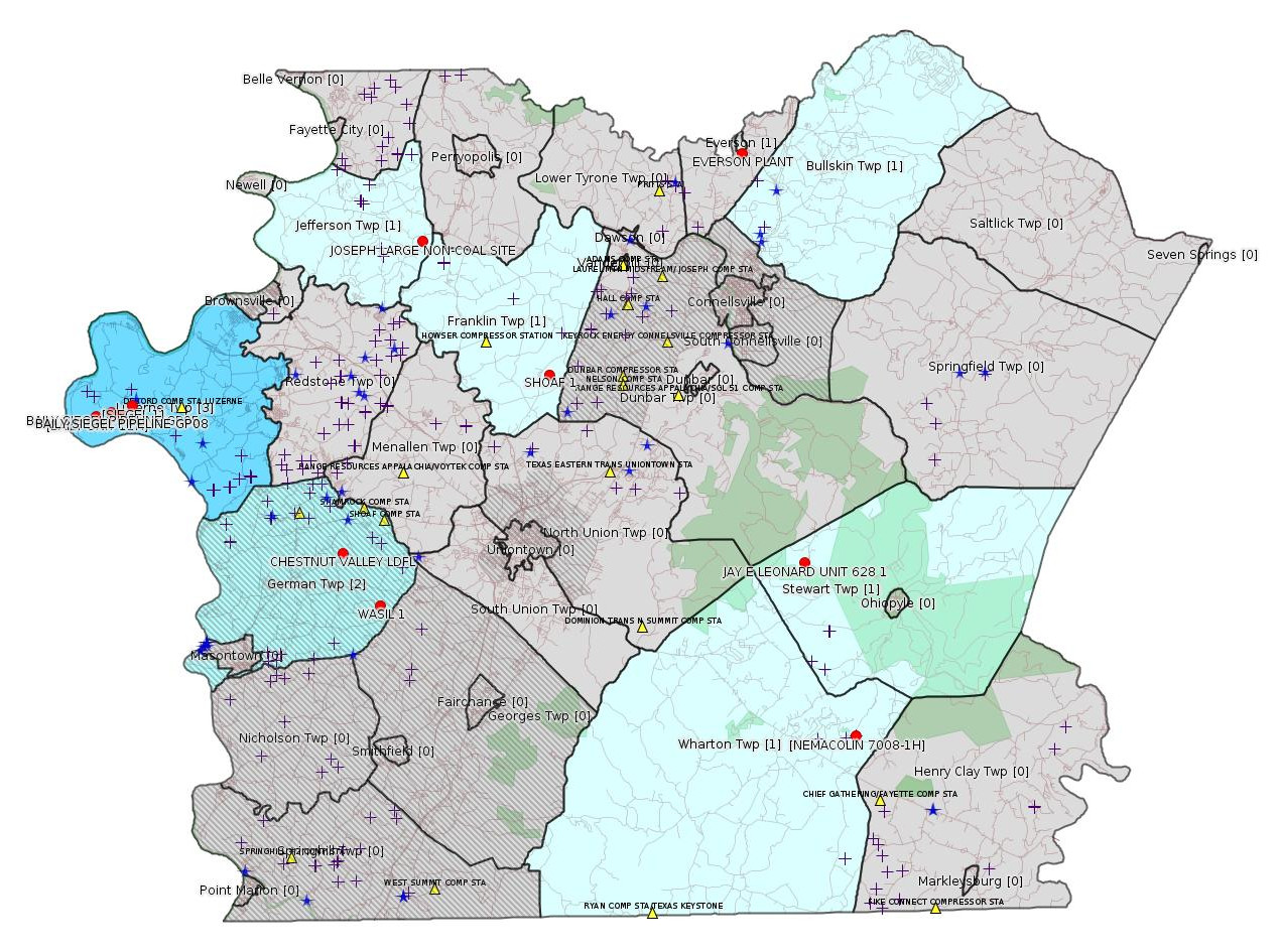
Fayette County Marcellus Shale Permits 1/11/16 - 1/24/16
Click the map to enlarge
Map
Key
Red dots: items in this permit list with an exact location.
Blue stars: Marcellus Gas Well Water Sources.
Municipality shading: number of "facilities", with each well counting separately
(includes the red dots):
Red dots: items in this permit list with an exact location.
Blue stars: Marcellus Gas Well Water Sources.
Municipality shading: number of "facilities", with each well counting separately
(includes the red dots):
gray: 0
pale turquoise: 1
turquoise: 2
pale blue: 3
middle blue: 4
dark blue: 6
dark purple: 11
purple: 19
(Color coding may differ from one issue to the next.)
(Note if a project spans multiple municipalities -- e.g. a pipeline -- it will show in the count for each municipality.)
The number of facilities also follows the municipality name in brackets.
Municipality counts are based on the way the permit is listed by DEP; DEP has been known to get a municipality wrong.
Locations in brackets identify a precise location used to locate a surrogate for the actual site being permitted (e.g. locating a well pad or pipeline by the known location of a well.) Locations labeled beginning with "~" and ending in "[?]" are approximate and speculative based on inferences using on-line property and lease records. These are marked in the text as "[Approximate, Speculative]
Cross-hatching: Environmental Justice Areas
Yellow triangles: Compressor Stations
Crosses: Unconventional well permits (may not have been drilled)
Green: "Natural areas", e.g. state game lands, state forests
Yellow triangles: Compressor Stations
Crosses: Unconventional well permits (may not have been drilled)
Green: "Natural areas", e.g. state game lands, state forests
More Maps
 |
 |
Source: Pennsylvania Bulletin
[No activity.]
-------------------------
Source: eNOTICE (+ PA Oil and Gas Mapping)
[Otherwise off-topic, but colocated with a Marcellus Shale improper waste disposal case:]
Authorization ID: 1079600
Permit number: 26060605
Site: JOSEPH LARGE NON-COAL SITE
Client: JOHN JOSEPH
Authorization type: NPDES Industrial Mineral Mine
Application type: Renewal
Authorization is for: FACILITY
Date received: 06/29/2015
Status: Pending
Sub-Facility ID Sub-Facility Name Description
924792 JOSEPH LARGE NON-COAL SITE NPDES Discharge Point
<http://www.ahs.dep.pa.gov/eFACTSWeb/searchResults_singleAuth.aspx?AuthID=1079600>
Location: 40.046128,-79.786154 <http://osm.org/go/ZWp1GjPr--?m=>
Municipalities: Jefferson Twp
[See Notes.]
Authorization ID: 1084207
Permit number: ESG15-051-0011
Site: NEMACOLIN 7008 WELL PROJECT ESGP-2
Client: T & F EXPLORATION LP
Authorization type: Erosion and Sediment Control GP-2
Application type: New
Authorization is for: SITE
Date received: 08/07/2015
Status: Pending
Permit Review Notes:
Date Review Note
1/13/2016 Response to the deficiency letter did not satisfy information request. Permit application now subject to the Elevated Review Process.
12/24/2015 Response to the deficiency letter did not satisfy information request. Permit application now subject to the Elevated Review Process.
10/21/2015 Applicant has been issued a deficiency letter. If applicable, this application no longer qualifies for the Permit Decision Guarantee.
8/24/2015 The permit application package is complete, has been accepted, and is undergoing technical review.
<http://www.ahs.dep.pa.gov/eFACTSWeb/searchResults_singleAuth.aspx?AuthID=1084207>
Location [of NEMACOLIN 7008-1H]: 39.805666,-79.520969 <http://osm.org/go/ZWprWth4--?m=>
Municipalities: Wharton Twp
Authorization ID: 1101428
Permit number: ESX15-051-0013
Site: BAILY SIEGEL PIPELINE ESCGP-2 EXPEDITED
Client: LAUREL MTN MIDSTREAM OPR LLC
Authorization type: Expedited E&S Stormwater General Permit 1
Application type: New
Authorization is for: SITE
Date received: 12/17/2015
Status: Pending
<http://www.ahs.dep.pa.gov/eFACTSWeb/searchResults_singleAuth.aspx?AuthID=1101428>
Location [of BAILY UNIT 11H]: 39.963831,-79.991464 <http://osm.org/go/ZWpTtrvs-?m=>
Location [of SIEGEL 1]: 39.968972,-79.968794 <http://osm.org/go/ZWpZSBiu--?m=>
Municipalities: Luzerne Twp
Authorization ID: 1103641
Permit number: GP05260715-007
Site: BAILY SIEGEL PIPELINE
Client: LAUREL MTN MIDSTREAM OPR LLC
Authorization type: GP-05 Utility Line Stream Crossings
Application type: New
Authorization is for: FACILITY
Date received: 12/17/2015
Status: Pending
Sub-Facility ID Sub-Facility Name Description
1203656 BAILY SIEGEL PIPELINE GP05260715-007 Pipeline or Conduit
<http://www.ahs.dep.pa.gov/eFACTSWeb/searchResults_singleAuth.aspx?AuthID=1103641>
Location: 39.965672,-79.981735 <http://osm.org/go/ZWpTv6B0--?m=>
Municipalities: Luzerne Twp
Authorization ID: 1103642
Permit number: GP08620715006
Site: BAILY SIEGEL PIPELINE
Client: LAUREL MTN MIDSTREAM OPR LLC
Authorization type: GP-08 Temporary Road Crossings
Application type: New
Authorization is for: FACILITY
Date received: 12/17/2015
Status: Pending
Sub-Facility ID Sub-Facility Name Description
1203657 BAILY SIEGEL PIPELINE GP08260715-006 Culvert
<http://www.ahs.dep.pa.gov/eFACTSWeb/searchResults_singleAuth.aspx?AuthID=1103642>
Location: 39.964305,-79.976179 <http://osm.org/go/ZWpZFMrr--?m=>
Municipalities: Luzerne Twp
[Conventional Well:]
Authorization ID: 1104422
Permit number: 051-20051
Site: JAY E LEONARD UNIT 628 1 OG WELL
Client: XTO ENERGY INC
Authorization type: Well Plugging Notice Intent to Plug Single Well
Application type: New
Authorization is for: FACILITY
Date received: 01/11/2016
Status: Pending
Sub-Facility ID Sub-Facility Name Description
56258 JAY E LEONARD UNIT 628 1 Well
<http://www.ahs.dep.pa.gov/eFACTSWeb/searchResults_singleAuth.aspx?AuthID=1104422>
Location: 39.889047,-79.551017 <http://osm.org/go/ZWpt7Qzi--?m=>
Municipalities: Stewart Twp
Authorization ID: 1104423
Permit number: 051-20051
Site: JAY E LEONARD UNIT 628 1 OG WELL
Client: XTO ENERGY INC
Authorization type: Well Plugging Notice Alternate Method
Application type: New
Authorization is for: FACILITY
Date received: 01/11/2016
Status: Pending
Sub-Facility ID Sub-Facility Name Description
56258 JAY E LEONARD UNIT 628 1 Well
<http://www.ahs.dep.pa.gov/eFACTSWeb/searchResults_singleAuth.aspx?AuthID=1104423>
Authorization ID: 1063056
Permit number: ESX15-051-0005
Site: SIEGEL WELL PAD ESCGP-2 EXPEDITED
Client: CHEVRON APPALACHIA LLC
Authorization type: Expedited E&S Stormwater General Permit 1
Application type: New
Authorization is for: SITE
Date received: 02/25/2015
Status: Issued on 1/19/2016
<http://www.ahs.dep.pa.gov/eFACTSWeb/searchResults_singleAuth.aspx?AuthID=1063056>
Location [of SIEGEL 1]: 39.968972,-79.968794 <http://osm.org/go/ZWpZSBiu--?m=>
Municipalities: Luzerne Twp
Authorization ID: 1104658
Permit number: PAR236137
Site: EVERSON PLANT
Client: UNIVAR USA INC
Authorization type: PAG-03 Discharge of Stormwater Assoc w Industrial Activities
Application type: Transfer
Authorization is for: FACILITY
Date received: 01/04/2016
Status: Pending
<http://www.ahs.dep.pa.gov/eFACTSWeb/searchResults_singleAuth.aspx?AuthID=1104658>
Location: 40.085961,-79.585893 <http://osm.org/go/ZWsoLvNk--?m=>
Municipalities: Bullskin Twp, Everson Boro
Authorization ID: 1105322
Permit number: 26-00402
Site: CHESTNUT VALLEY LDFL
Client: ADVANCED DSPL SVC CHESTNUT VALLEY LDFL INC
Authorization type: Major Facility Operating Permit
Application type: Renewal
Authorization is for: FACILITY
Date received: 01/14/2016
Status: Pending
<http://www.ahs.dep.pa.gov/eFACTSWeb/searchResults_singleAuth.aspx?AuthID=1105322>
Location: 39.896765,-79.838766 <http://osm.org/go/ZWpP0~XK--?m=>
Municipalities: German Twp [an Environmental Justice Area]
-------------------------
Source: DEP Oil and Gas Compliance Report
[Conventional Well:]
OPERATOR: AMER EXPLORATION CO
INSPECTION_ID: 2440940
INSPECTION_DATE: 01/14/2016
INSPECTION_TYPE: Follow-up Inspection
API_PERMIT: 051-20884
FARM_NAME: SHOAF 1
UNCONVENTIONAL: N
SITE_ID: 459907
SITE_NAME: SHOAF 1 Well
FACILITY_TYPE: Oil & Gas Location
INSPECTION_CATEGORY: Primary Facility
REGION: EP DOGO SWDO Dstr Off
COUNTY: Fayette
MUNICIPALITY: Franklin Twp
INSPECTION_RESULT_DESCRIPTION: Outstanding Violations - Viols Req'd
INSPECTION_COMMENT: Follow-Up inspection will include (ORDER TO PLUG) sent by (BOI).
Location: 39.981138,-79.708448 <http://osm.org/go/ZWpzUsTv--?m=>
---
[Conventional Well:]
OPERATOR: BURNETT OIL CO INC
INSPECTION_ID: 2439712
INSPECTION_DATE: 01/12/2016
INSPECTION_TYPE: Administrative/File Review
API_PERMIT: 051-24448
FARM_NAME: WASIL 1
UNCONVENTIONAL: N
SITE_ID: 750446
SITE_NAME: WASIL 1 OG WELL
FACILITY_TYPE: Oil & Gas Location
INSPECTION_CATEGORY: Primary Facility
REGION: EP DOGO SWDO Dstr Off
COUNTY: Fayette
MUNICIPALITY: German Twp [an Environmental Justice Area]
INSPECTION_RESULT_DESCRIPTION: Violation(s) Noted
INSPECTION_COMMENT:
VIOLATION_ID: 743023
VIOLATION_DATE: 01/12/2016
VIOLATION_CODE: OGA 3216(C) - Failure to fill all pits used to contain produced fluids or industrial wastes and remove unnecessary drilling supplies/equipment not needed for production within 9 months from completion of drilling of well.
VIOLATION_TYPE: Environmental Health & Safety
VIOLATION_COMMENT:
RESOLVED_DATE:
RESOLUTION_REASON_CODE_DESCRIPTION:
ENFORCEMENT_ID:
ENFORCEMENT_CODE_DESCRIPTION:
DATE_EXECUTED:
ENFORCEMENT_FINAL_DATE:
ENFORCEMENT_FINAL_STATUS:
PENALTY_FINAL_DATE:
PENALTY_FINAL_STATUS_CODE_DESCRIPTION:
PENALTY_AMOUNT:
TOTAL_AMOUNT_COLLECTED:
Location: 39.871472,-79.815522 <http://osm.org/go/ZWpPuEW6--?m=>
-------------------------
Source: Reuters Commodities: Energy
Natural Gas
| Commodity | Exchange | Currency | Expire | Last Trade | Trade Time | Change | Open | Day's High | Day's Low |
|---|---|---|---|---|---|---|---|---|---|
| NATURAL
GAS CON1 Jan16 |
NYM | USD | 01/27 | 2.13 | 01/25 00:42 | -0.01 | 2.16 | 2.16 | 2.12 |
-------------------------
Notes:
As a non-coal surface mine NPDES permit, the authorization above for the JOSEPH LARGE NON-COAL SITE would normally be off-topic for this bulletin. However this location was the subject of a DEP citation for improper disposal of oil and gas drilling waste; an appeal of that citation is before the Environmental Hearing Board. See the 8/23/15 issue of this bulletin at <http://www.faymarwatch.org/happening/permits/082315.shtml#Joseph> and the 10/4/15 issue of this bulletin at <http://www.faymarwatch.org/happening/permits/100415.shtml#Joseph>. Altogether Joseph contracting appealed 5 actions of the DEP; these have all been consolidated into one EHB case, Case # 2015046. Documents in this case are available on-line at:
<http://ehb.courtapps.com/public/document_shower_pub.php?docketNumber=2015046>
The case is in discovery, and unless there is a settlement will presumably go to trial at the EHB office in Pittsburgh, where the public will be allowed to attend.
It is not clear whether there will be a public comment opportunity on the NPDES permit renewal for the JOSEPH LARGE NON-COAL SITE; if so we will need to make sure the office of DEP reviewing this permit application is aware of the events in the EHB case.
------------------------
DEP defines an environmental justice area as "any census tract where 20 percent or more individuals live in poverty, and/or 30 percent or more of the population is minority". (See:
<http://www.portal.state.pa.us/portal/server.pt/community/pa_environmental_justice_areas/20991>
<http://www.portal.state.pa.us/portal/server.pt/community/dep_enhanced_public_participation_policy/20988>
). There are supposed to be enhanced public participation requirements for permits in environmental justice areas, but news of this actually ever happening is scarce. In Fayette County, the entirety of Springhill, Nicholson, German, and Georges Townships are environmental justice areas, as well as a large part of Dunbar Township. DEP's policy document on public participation guidelines for environmental justice areas is located here:
<http://www.elibrary.dep.state.pa.us/dsweb/Get/Version-48671/012-0501-002.pdf>
eNOTICE records are likely to list the same permit multiple times, as that permit moves through the DEP process.
Oil & Gas Wells designated with a site a number and the letter H typically designate horizontal wells.
-------------------------
Resources:
Pennsylvania Bulletin: <http://www.pabulletin.com/>
eNOTICE: <http://www.ahs2.dep.state.pa.
DEP Well Details Report: <https://www.paoilandgasreport
Well Details may not show any
information for new permits and will not show permits which have
not yet been issued. Lookup for Well Details is by permit number.
DEP Permits Issued Detail Report:
<http://www.depreportingservic
DEP SPUD (drilling started) Report:
<http://www.depreportingservices.state.pa.us/ReportServer/Pages/ReportViewer.aspx?/Oil_Gas/Spud_External_Data>
DEP Oil and Gas Compliance Report:
<http://www.depreportingservices.state.pa.us/ReportServer/Pages/ReportViewer.aspx?/Oil_Gas/OG_Compliance>
DEP PA Oil & Gas Mapping:
<http://www.depgis.state.pa.us/PaOilAndGasMapping>
Pennsylvania Spatial Data Access:
<http://www.pasda.psu.edu/default.asp>
DEP Spatial Data Repository:
<ftp://www.pasda.psu.edu/pub/pasda/dep/>
National Response Center:
<http://www.nrc.uscg.mil/>
EPA-Echo: <http://www.epa-echo.gov/echo/
FERC citizen involvement: <http://www.ferc.gov/for-citiz
To receive E-mail notification of
all documents filed in a FERC docket, see:
<http://www.ferc.gov/docs-filing/esubscription.asp >
<http://www.ferc.gov/docs-fili
Follow the directions and enter the docket number to subscribe to.
Township Supervisors receive information regarding Erosion & Sedimentation permits, and these records may be reviewable at township municipal offices.
DEP permits are reviewable through the File Review process, for application to do file review see: <http://www.portal.state.pa.us/portal/server.pt/community/southwest_regional_office/13775/file_review/593164>
Environmental Hearing Board: <http://ehb.courtapps.com/publ
PA DEP Environmental Policy Comment System:
<http://www.ahs.dep.pa.gov/eComment/>
Federal Register Environment: <https://www.federalregister.g
Browsing of recent comment
opportunities for federal agencies, e.g. EPA. Click "sign up" to
subscribe to daily E-mails of new document listings.
SkyTruth Fayette County Drilling Alerts: <http://frack.skytruth.org/pen
EPA Pennsylvania Public Notices: <http://www2.epa.gov/aboutepa/epa-pennsylvania#notice>
Marcellus Shale waste disposal
injection wells in Pennsylvania are regulated directly by EPA, not
DEP. Notice of any new permit applications will appear at the
above web address. I'm not aware of any subscription service
to be notified of such applications. I'm not aware of any
Marcellus Shale waste disposal injection wells in Fayette County
(yet ...) but we need to monitor this page for future
applications.
Energy Assurance Daily: <http://www.oe.netl.doe.gov/ead.aspx>
Daily newsletter from the US
Department of Energy about events relating to energy. The Natural
Gas section has information about pipelines.
-------------------------
Disclaimers:
This compilation from the above sources was done by hand using copy and paste and may omit relevant permits.
Does not currently include water supply permits. Does not include landfill permits even though many such are for Marcellus Shale waste. (It is not possible at this time to distinguish which landfill permits are for Marcellus Shale waste and which are not without doing File Review for each permit.)
Erosion & Sedimentation permit records do not currently include latitude and longitude. Where I am publishing latitude and longitude with E&S permits it is by inferring an associated well permit and using published latitude and longitude for the well. It is possible I may be inferring the wrong well site.
Municipalities are shown from eFACTS records on the DEP web site. The DEP has been known to list a municipality incorrectly.