The Harmed Success Stories Concepts How To What Is Commentary
Fayette County Marcellus Shale Permits 1/28/19 - 2/10/19
Contents
Pennsylvania Bulletin Listings
[No Activity]eFACTS Listings
SHAMROCK COMP STA Major Facility Plan Approval New Facility Review Prevention of Significant Deterioration Extension (New)Electronic Notifications
SHAMROCK COMP STA Minor Facility Plan Approval New Source Performance Std Extension (New)
SOUTHERN PA GATHERING SYSTEM ABANDONMENT PPL 7894 PROJECT GP-08 Temporary Road Crossings
SICKLE PIPELINE Expedited E&S Stormwater [Termination??] Notification (Issued 1/30/2019)
SOUTHERN PA GATHERING SYSTEM ABANDONMENT PPL 8605 GP8 & GP11 BWM-GP-11 Maintenance, Testing, Repair, Rehabilitation or Replacement
SOUTHERN PA GATHERING SYSTEM ABANDONMENT PPL 8605 GP8 & GP11 GP-08 Temporary Road Crossings
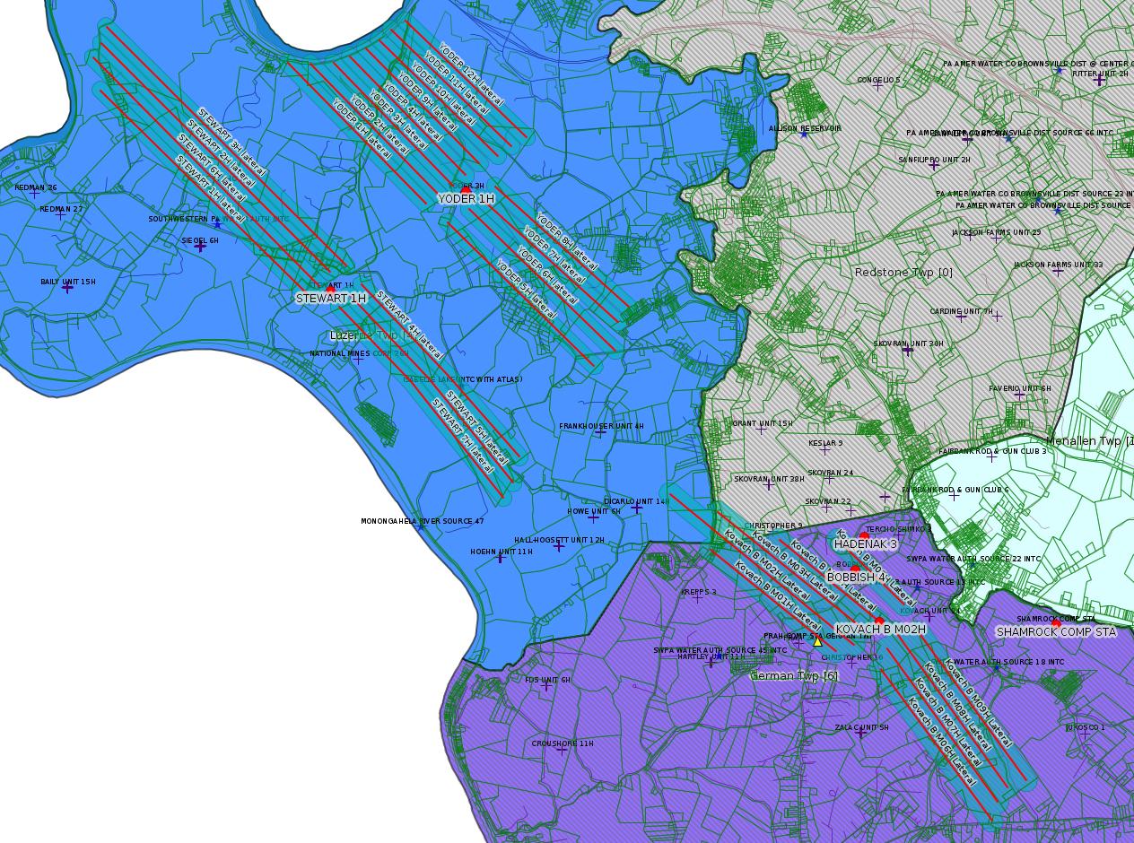
STEWART 1H Casing cementing notification Production Casing: 2/2/2019
YODER 1H Drilling resumption After Break of 30 days or more 02/01/2019
YODER 1H Casing cementing notification Intermediate: 2/3/2019
KOVACH B M02H Casing cementing notification Coal Protected Casing 1: 2/2/2019
STEWART 6H Abandonment or plugging notification 02/05/2019
KOVACH B M03H Drilling resumption After Break of 30 days or more 02/07/2019
KOVACH B M03H Casing cementing notification Coal Protected Casing 1: 2/8/2019
YODER 12H Drilling resumption After Break of 30 days or more 02/10/2019
Inspection Anomalies (Oil & Gas
Compliance Report)
Price of Natural GasBOBBISH 4 tanks seriously corroded, one tank top rusted away and caved in
HADENAK 3 tank is severely corroded with numerous holes in it
Notes
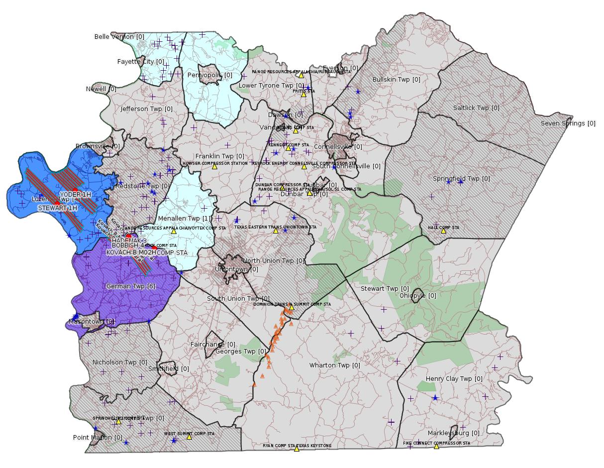
Map
Key
Red dots: items in this permit list with an exact location.
Blue stars: Marcellus Gas Well Water Sources.
Where well laterals are mapped they show in red; a 400-foot buffer surrounding the lateral shows in blue (lavender where it overlaps a mapped mineral tract).
Where mineral tracts are mapped, they show in pink. Mineral tracts can overlap; the overlap will show in red. The precise meaning of "mineral tract" is not clear.
Municipality shading: number of "facilities", with each well counting separately
(includes the red dots):
gray: 0
pale turquoise: 1
turquoise: 2
pale blue: 3
middle blue: 4
dark blue: 5
dark purple: 8
purple: 19
(Color coding may differ from one issue to the next.)
(Note if a project spans multiple municipalities -- e.g. a pipeline -- it will show in the count for each municipality.)
The number of facilities also follows the municipality name in brackets.
Municipality counts are based on the way the permit is listed by DEP; DEP has been known to get a municipality wrong.
Locations in brackets identify a precise location used to locate a surrogate for the actual site being permitted (e.g. locating a well pad or pipeline by the known location of a well.) Locations labeled beginning with "~" and ending in "[?]" are approximate and speculative based on inferences using on-line property and lease records. These are marked in the text as "[Approximate, Speculative]
Cross-hatching: Environmental Justice Areas
Yellow triangles: Compressor Stations
Orange triangles: Storage Field Wells (currently Dominion North Summit Storage Field)
Crosses: SPUD Unconventional well permits
Green: "Natural areas", e.g. state game lands, state forests
Yellow triangles: Compressor Stations
Orange triangles: Storage Field Wells (currently Dominion North Summit Storage Field)
Crosses: SPUD Unconventional well permits
Green: "Natural areas", e.g. state game lands, state forests
More Maps
 |
Source: Pennsylvania Bulletin
[No Activity]
-------------------------
Source: eNOTICE (+ PA Oil and Gas Mapping, Well Pad Report.) Well Details via Data Portal Services: Oil and Gas Wells All (ID: 3).
Please see the Disclaimer below regarding Parcel Id data.
New:
Authorization ID: 1259755
Permit number: 26-00588A
Site: SHAMROCK COMP STA
Client: LAUREL MTN MIDSTREAM OPR LLC
Authorization type: Major Facility Plan Approval New Facility Review Prevention of Significant Deterioration
Application type: Extension
Authorization is for: FACILITY
Date received: 01/29/2019
Status: Pending
Permit Decision Guarantee Applies?: No
<https://www.ahs.dep.pa.gov/eFACTSWeb/searchResults_singleAuth.aspx?AuthID=1259755>
Site Programs:
Air Quality
Site Municipalities:
German Twp [an Environmental Justice Area], Fayette County
Location: 39.918333,-79.825
Map URL: <http://www.openstreetmap.org/?mlat=39.918333&mlon=-79.825#map=15/39.918333/-79.825>
Parcel ID: 15140026
Map URL: <http://www.openstreetmap.org/?mlat=39.918333&mlon=-79.825#map=15/39.918333/-79.825>
Parcel ID: 15140026
---
New:
Authorization ID: 1259751
Permit number: 26-00588
Site: SHAMROCK COMP STA
Client: LAUREL MTN MIDSTREAM OPR LLC
Authorization type: Minor Facility Plan Approval New Source Performance Std
Application type: Extension
Authorization is for: FACILITY
Date received: 01/29/2019
Status: Pending
Permit Decision Guarantee Applies?: No
<https://www.ahs.dep.pa.gov/eFACTSWeb/searchResults_singleAuth.aspx?AuthID=1259751>
Site Programs:
Air Quality
Site Municipalities:
German Twp [an Environmental Justice Area], Fayette County
Authorization ID: 1255021
Permit number: GP082607218505
Site: SOUTHERN PA GATHERING SYSTEM ABANDONMENT PPL 7894 PROJECTGP 08
Client: COLUMBIA GAS TRANS LLC
Authorization type: GP-08 Temporary Road Crossings
Application type: New
Authorization is for: FACILITY
Date received: 12/11/2018
Status: Pending
Permit Decision Guarantee Applies?: No
Sub-Facilities for Authorization:
Sub-Facility ID Sub-Facility Name Description
1276753 S PA GATHERING SYSTEM ABANDONMENT PPL 7894 PROJECT GP08 Bridge
<https://www.ahs.dep.pa.gov/eFACTSWeb/searchResults_singleAuth.aspx?AuthID=1255021>
Site Programs:
Water Planning and Conservation
Site Municipalities:
Menallen Twp, Fayette County
---
Authorization ID: 1253269
Permit number: ESX15-051-0004
Site: SICKLE PIPELINE ESCGP-2 EXPEDITED
Client: CHEVRON APPALACHIA LLC
Authorization type: Expedited E&S Stormwater General Permit 1
Application type: Notification
Authorization is for: SITE
Date received: 11/26/2018
Status: Issued on 1/30/2019
Permit Decision Guarantee Applies?: No
Permit Review Notes:
Date Review Note
1/30/2019 The technical review and decision review are complete and either the permit decision and/or permit issuance are forthcoming.
11/27/2018 The permit application package is complete, has been accepted, and is undergoing technical review.
<https://www.ahs.dep.pa.gov/eFACTSWeb/searchResults_singleAuth.aspx?AuthID=1253269>
Site Programs:
Site Municipalities:
Perry Twp, Fayette County
Washington Twp, Fayette County
---
Authorization ID: 1249637
Permit number: GP11260718-001
Site: SOUTHERN PA GATHERING SYSTEM ABANDONMENT PPL 8605 GP8 & GP11
Client: COLUMBIA GAS TRANS LLC
Authorization type: BWM-GP-11 Maintenance, Testing, Repair, Rehabilitation or Replacement General Pmt
Application type: New
Authorization is for: FACILITY
Date received: 10/19/2018
Status: Pending
Permit Decision Guarantee Applies?: Yes
Permit Decision Guarantee status: VOID
Sub-Facilities for Authorization:
Sub-Facility ID Sub-Facility Name Description
1274075 SOUTHERN PA GATH SYS ABANDONMENT PPL 8605 GP11260718-001 Other Activities
Permit Review Notes:
Date Review Note
12/12/2018 Applicant has been issued a deficiency letter. If applicable, this application no longer qualifies for the Permit Decision Guarantee.
11/7/2018 The permit application package is complete, has been accepted, and is undergoing technical review.
<https://www.ahs.dep.pa.gov/eFACTSWeb/searchResults_singleAuth.aspx?AuthID=1249637>
Site Programs:
Water Planning and Conservation
Site Municipalities:
German Twp [an Environmental Justice Area], Fayette County
---
Authorization ID: 1249636
Permit number: GP08260718-001
Site: SOUTHERN PA GATHERING SYSTEM ABANDONMENT PPL 8605 GP8 & GP11
Client: COLUMBIA GAS TRANS LLC
Authorization type: GP-08 Temporary Road Crossings
Application type: New
Authorization is for: FACILITY
Date received: 10/19/2018
Status: Pending
Permit Decision Guarantee Applies?: No
Sub-Facilities for Authorization:
Sub-Facility ID Sub-Facility Name Description
1274074 SOUTHERN PA GATH SYS ABANDONMENT PPL 8605 GP08260718-003 Bridge
Permit Review Notes:
Date Review Note
12/12/2018 Applicant has been issued a deficiency letter. If applicable, this application no longer qualifies for the Permit Decision Guarantee.
11/7/2018 The permit application package is complete, has been accepted, and is undergoing technical review.
<https://www.ahs.dep.pa.gov/eFACTSWeb/searchResults_singleAuth.aspx?AuthID=1249636>
Site Programs:
Water Planning and Conservation
Site Municipalities:
German Twp [an Environmental Justice Area], Fayette County
-------------------------
Source: DEP Oil and Gas Electronic Notifications
NOTIFICATION_ID: 45869
OGO: 39307
OPERATOR: CHEVRON APPALACHIA LLC
API_PERMIT: 051-24621
SPUD_DATE: 09/02/2015
COUNTY: Fayette
MUNICIPALITY: Luzerne
LATITUDE: 39.962961
LONGITUDE: -79.946956
SUBJECT: [NOTIFICATION]: Casing cementing notification 58 Pa. C.S. 3211(f)(2) for well API 37-051-24621-00-00
QUESTION: Enter the Date and Time for the applicable Casing Types
ANSWER: Production Casing: 2/2/2019 3:00:00 PM
SENT_DATE: 1/30/2019 7:20:50 AM
SENT_SUCCESS: Yes
LAST_RESENT_DATE:
RESENT_SUCCESS:
Well Details:
Permit Number: 051-24621
Well Name: STEWART 1H
Unconventional Well: Y
Well Configuration: Horizontal Well
Well Type: GAS
Well Status: Active
Coal Association: Coal
Conservation Well: N
Primary Facility ID: 783859
Site ID: 788124
Site Name: STEWART WELL SITE ESCGP-2 EXPEDITED
Well Pad ID: 152396
Well Pad Name: STEWART
Storage Field:
Operator: CHEVRON APPALACHIA LLC
Operator Number: OGO-39307
Permit Date: 2015-04-23
Permit Date Expires: 2019-01-26
SPUD Date: 2015-09-02
Date Plugged:
UIC ID:
UIC Type:
Surface Elevation: 1140
County: Fayette
Municipality: Luzerne Twp
Location: 39.962961,-79.946956
Map URL: <http://www.openstreetmap.org/?mlat=39.962961&mlon=-79.946956#map=15/39.962961/-79.946956>
OG WELLS PERMIT DOCS:
2015-08-31: Final Permit Documents, Name: 051-24621-00-00 (for Authorization: 1063357):
<http://www.depgis.state.pa.us/pdfHandler/pdFHandler.ashx?Doc=MjA0NDM0&ext=PDF>
2016-05-27: Final Permit Documents, Name: 1136282 (for Authorization: 1136282):
<http://www.depgis.state.pa.us/pdfHandler/pdFHandler.ashx?Doc=MzYzMTMy&ext=PDF>
2017-08-18: Final Permit Documents, Name: 1172766 (for Authorization: 1172766):
<http://www.depgis.state.pa.us/pdfHandler/pdFHandler.ashx?Doc=NDg2MDY0&ext=PDF>
2018-01-26: Final Permit Documents, Name: 1203097 (for Authorization: 1203097):
<http://www.depgis.state.pa.us/pdfHandler/pdFHandler.ashx?Doc=NTUxMTE4&ext=PDF>
2018-01-26: Other Permit Documents, Name: Approval of Surface Locations by Landowners (for Authorization: 1203097):
<http://www.depgis.state.pa.us/pdfHandler/pdFHandler.ashx?Doc=NTQ5NzA1&ext=PDF>
Electronically Submitted Records:
2017-08-18: Submission for Authorization 1172766
Pennsylvania Natural Diversity Inventory Form: Stewart PNDI.pdf
<http://www.depgis.state.pa.us/eWellDocHandler/pdFHandler.ashx?Doc=MjQ1NDQx&ext=PDF>
Permit Application to Drill and Operate a Well: Stewart 1H Re-Permit 2017 Application.pdf
<http://www.depgis.state.pa.us/eWellDocHandler/pdFHandler.ashx?Doc=MjQ1NDQy&ext=PDF>
Operator Ownership and Control Information: Commonwealth 8000-FM-OOGM0118.pdf
<http://www.depgis.state.pa.us/eWellDocHandler/pdFHandler.ashx?Doc=MjQ1NDQz&ext=PDF>
Record of Notification to Interested Parties: Stewart 1H Re-Permit 2017 Record of Notification.pdf
<http://www.depgis.state.pa.us/eWellDocHandler/pdFHandler.ashx?Doc=MjQ1NDQ0&ext=PDF>
Well Permit Application - Coal Module: Stewart 1H Re-Permit 2017 Coal Module.pdf
<http://www.depgis.state.pa.us/eWellDocHandler/pdFHandler.ashx?Doc=MjQ1NDQ1&ext=PDF>
Coal and Gas Resource Coord Act - Section 7 Exception: Stewart 1H Waiver Request Section 7.pdf
<http://www.depgis.state.pa.us/eWellDocHandler/pdFHandler.ashx?Doc=MjQ1NDcy&ext=PDF>
Well Cross-Section Diagram: Stewart 1H Page 4.pdf
<http://www.depgis.state.pa.us/eWellDocHandler/pdFHandler.ashx?Doc=MjUwMDQz&ext=PDF>
Location Plat: STEWART-1H WELL PLAT.dwg
<http://www.depgis.state.pa.us/eWellDocHandler/pdFHandler.ashx?Doc=MzUzODE1&ext=PDF>
Electronic Submission Docket: 1405650.pdf
<http://www.depgis.state.pa.us/eWellDocHandler/pdFHandler.ashx?Doc=MzUzODE3&ext=PDF>
2018-01-26: Submission for Authorization 1203097
Pennsylvania Natural Diversity Inventory Form: Stewart Pad A PNDI 8-22-17.pdf
<http://www.depgis.state.pa.us/eWellDocHandler/pdFHandler.ashx?Doc=Mzg4Mzk2&ext=PDF>
Permit Application to Drill and Operate a Well: Stewart 1H Mod Application 2017.pdf
<http://www.depgis.state.pa.us/eWellDocHandler/pdFHandler.ashx?Doc=Mzg4Mzk3&ext=PDF>
Location Plat: Stewart Well Plats 1H.dwg
<http://www.depgis.state.pa.us/eWellDocHandler/pdFHandler.ashx?Doc=Mzg4Mzk4&ext=PDF>
Well Cross-Section Diagram: Stewart 1H Page 4.pdf
<http://www.depgis.state.pa.us/eWellDocHandler/pdFHandler.ashx?Doc=Mzg4Mzk5&ext=PDF>
Well Permit Application - Coal Module: Stewart 1H-7H 2017 Coal Module.pdf
<http://www.depgis.state.pa.us/eWellDocHandler/pdFHandler.ashx?Doc=Mzg5MzQy&ext=PDF>
Coal and Gas Resource Coord Act - Section 7 Exception: Stewart 1H-7H Waiver Request Section 7.pdf
<http://www.depgis.state.pa.us/eWellDocHandler/pdFHandler.ashx?Doc=Mzg5NTg3&ext=PDF>
Record of Notification to Interested Parties: Stewart 1H Notification of Interested Parties.pdf
<http://www.depgis.state.pa.us/eWellDocHandler/pdFHandler.ashx?Doc=Mzg5NTg4&ext=PDF>
Electronic Submission Docket: 1615787.pdf
<http://www.depgis.state.pa.us/eWellDocHandler/pdFHandler.ashx?Doc=MzkyNzYy&ext=PDF>
Presumed Parcel Id: 19250010
---
NOTIFICATION_ID: 45881
OGO: 39307
OPERATOR: CHEVRON APPALACHIA LLC
API_PERMIT: 051-24652
SPUD_DATE: 05/07/2018
COUNTY: Fayette
MUNICIPALITY: Luzerne
LATITUDE: 39.975686
LONGITUDE: -79.923872
SUBJECT: [NOTIFICATION]: Drilling resumption After Break of 30 days or more notification 58 Pa. C.S. 3211(f)(1) for well API 37-051-24652-00-00
QUESTION: Date and approximate time action is to occur
ANSWER: Date: 02/01/2019 Time: 10:00pm
SENT_DATE: 1/31/2019 5:33:32 AM
SENT_SUCCESS: Yes
LAST_RESENT_DATE:
RESENT_SUCCESS:
Well Details:
Permit Number: 051-24652
Well Name: YODER 1H
Unconventional Well: Y
Well Configuration: Horizontal Well
Well Type: GAS
Well Status: Active
Coal Association: NonCoal
Conservation Well: N
Primary Facility ID: 824625
Site ID: 790607
Site Name: YODER WELL PAD ESCGP-2 EXPEDITED
Well Pad ID: 153100
Well Pad Name: YODER
Storage Field:
Operator: CHEVRON APPALACHIA LLC
Operator Number: OGO-39307
Permit Date: 2018-03-06
Permit Date Expires: 2019-03-06
SPUD Date: 2018-05-07
Date Plugged:
UIC ID:
UIC Type:
Surface Elevation: 1118
County: Fayette
Municipality: Luzerne Twp
Location: 39.975686,-79.923872
Map URL: <http://www.openstreetmap.org/?mlat=39.975686&mlon=-79.923872#map=15/39.975686/-79.923872>
OG WELLS PERMIT DOCS:
2018-03-08: Other Permit Documents, Name: Non-Coal Determination 051-24652 (for Authorization: 1217018):
<http://www.depgis.state.pa.us/pdfHandler/pdFHandler.ashx?Doc=NTY3ODA5&ext=PDF>
2018-03-08: Final Permit Documents, Name: 1217018 (for Authorization: 1217018):
<http://www.depgis.state.pa.us/pdfHandler/pdFHandler.ashx?Doc=NTY5Nzkw&ext=PDF>
Electronically Submitted Records:
2018-03-08: Submission for Authorization 1217018
Pennsylvania Natural Diversity Inventory Form: Yoder PNDI.PDF
<http://www.depgis.state.pa.us/eWellDocHandler/pdFHandler.ashx?Doc=NDgyNDk3&ext=PDF>
Location Plat: Yoder Well Plat 1H.dwg
<http://www.depgis.state.pa.us/eWellDocHandler/pdFHandler.ashx?Doc=NDgyNDk4&ext=PDF>
Justification for Non-Coal Well: Yoder Non Coal Packet.pdf
<http://www.depgis.state.pa.us/eWellDocHandler/pdFHandler.ashx?Doc=NDgyNDk5&ext=PDF>
Well Cross-Section Diagram: Yoder 1H_Page 4.pdf
<http://www.depgis.state.pa.us/eWellDocHandler/pdFHandler.ashx?Doc=NDgyNTAw&ext=PDF>
Permit Application to Drill and Operate a Well: 1679361.pdf
<http://www.depgis.state.pa.us/eWellDocHandler/pdFHandler.ashx?Doc=NDgzMjY1&ext=PDF>
Presumed Parcel Id: 19160034
---
NOTIFICATION_ID: 45882
OGO: 39307
OPERATOR: CHEVRON APPALACHIA LLC
API_PERMIT: 051-24652
SPUD_DATE: 05/07/2018
COUNTY: Fayette
MUNICIPALITY: Luzerne
LATITUDE: 39.975686
LONGITUDE: -79.923872
SUBJECT: [NOTIFICATION]: Casing cementing notification 58 Pa. C.S. 3211(f)(2) for well API 37-051-24652-00-00
QUESTION: Enter the Date and Time for the applicable Casing Types
ANSWER: Intermediate: 2/3/2019 12:00:00 AM
SENT_DATE: 1/31/2019 5:34:26 AM
SENT_SUCCESS: Yes
LAST_RESENT_DATE:
RESENT_SUCCESS:
Well Details above
Well Name: YODER 1H
------
NOTIFICATION_ID: 45882
OGO: 39307
OPERATOR: CHEVRON APPALACHIA LLC
API_PERMIT: 051-24652
SPUD_DATE: 05/07/2018
COUNTY: Fayette
MUNICIPALITY: Luzerne
LATITUDE: 39.975686
LONGITUDE: -79.923872
SUBJECT: [NOTIFICATION]: Casing cementing notification 58 Pa. C.S. 3211(f)(2) for well API 37-051-24652-00-00
QUESTION: Enter the Date and Time for the applicable Casing Types
ANSWER: Intermediate: 2/3/2019 12:00:00 AM
SENT_DATE: 1/31/2019 5:34:26 AM
SENT_SUCCESS: Yes
LAST_RESENT_DATE:
RESENT_SUCCESS:
Well Details above
Well Name: YODER 1H
NOTIFICATION_ID: 45912
OGO: 39307
OPERATOR: CHEVRON APPALACHIA LLC
API_PERMIT: 051-24672
SPUD_DATE: 10/23/2018
COUNTY: Fayette
MUNICIPALITY: German [an Environmental Justice Area]
LATITUDE: 39.918972
LONGITUDE: -79.854786
SUBJECT: [NOTIFICATION]: Casing cementing notification 58 Pa. C.S. 3211(f)(2) for well API 37-051-24672-00-00
QUESTION: Enter the Date and Time for the applicable Casing Types
ANSWER: Coal Protected Casing 1: 2/2/2019 10:00:00 PM
SENT_DATE: 2/1/2019 7:25:40 PM
SENT_SUCCESS: Yes
LAST_RESENT_DATE:
RESENT_SUCCESS:
Well Details:
Permit Number: 051-24672
Well Name: KOVACH B M02H
Unconventional Well: Y
Well Configuration: Horizontal Well
Well Type: GAS
Well Status: Active
Coal Association: Coal
Conservation Well: N
Primary Facility ID: 828038
Site ID: 826949
Site Name: KOVACH B WELL SITE AND TANK SITE ESCGP ESX17-051-0003
Well Pad ID: 155005
Well Pad Name: KOVACH B
Storage Field:
Operator: CHEVRON APPALACHIA LLC
Operator Number: OGO-39307
Permit Date: 2018-08-08
Permit Date Expires: 2019-08-08
SPUD Date: 2018-10-23
Date Plugged:
UIC ID:
UIC Type:
Surface Elevation: 1278
County: Fayette
Municipality: German Twp
Location: 39.918972,-79.854786
Map URL: <http://www.openstreetmap.org/?mlat=39.918972&mlon=-79.854786#map=15/39.918972/-79.854786>
OG WELLS PERMIT DOCS:
2018-08-08: Final Permit Documents, Name: 1237728 (for Authorization: 1237728):
<http://www.depgis.state.pa.us/pdfHandler/pdFHandler.ashx?Doc=NjQ2Nzc4&ext=PDF>
2019-01-07: Other Permit Documents, Name: 051-24672 (for Authorization: 1256826):
<http://www.depgis.state.pa.us/pdfHandler/pdFHandler.ashx?Doc=NzI3ODUz&ext=PDF>
Electronically Submitted Records:
2018-08-08: Submission for Authorization 1237728
Interested Party Notification: Kovach B Affidavit of Non-Delivery Venere.pdf
<http://www.depgis.state.pa.us/eWellDocHandler/pdFHandler.ashx?Doc=NjAxODc1&ext=PDF>
Pennsylvania Natural Diversity Inventory Form: Kovach B PNDI.pdf
<http://www.depgis.state.pa.us/eWellDocHandler/pdFHandler.ashx?Doc=NjAxODc5&ext=PDF>
Location Plat: Kovach B M02H Plat.dwg
<http://www.depgis.state.pa.us/eWellDocHandler/pdFHandler.ashx?Doc=NjAxODgw&ext=PDF>
Well Cross-Section Diagram: Kovach B M02H Page 4.pdf
<http://www.depgis.state.pa.us/eWellDocHandler/pdFHandler.ashx?Doc=NjAxODgy&ext=PDF>
Coal and Gas Resource Coord Act - Section 7 Exception: Kovach B Horizontals Section 7 Exception.pdf
<http://www.depgis.state.pa.us/eWellDocHandler/pdFHandler.ashx?Doc=NjAxODkz&ext=PDF>
Permit Application to Drill and Operate a Well: 1753234.pdf
<http://www.depgis.state.pa.us/eWellDocHandler/pdFHandler.ashx?Doc=NjAzODI3&ext=PDF>
Presumed Parcel Id: 1511002301
---
NOTIFICATION_ID: 45932
OGO: 39307
OPERATOR: CHEVRON APPALACHIA LLC
API_PERMIT: 051-24632
SPUD_DATE: 09/01/2015
COUNTY: Fayette
MUNICIPALITY: Luzerne
LATITUDE: 39.962881
LONGITUDE: -79.946972
SUBJECT: [NOTIFICATION]: Abandonment or plugging notification 58 Pa. C.S. 3211(f)(2) for well API 37-051-24632-00-00
QUESTION: Date and approximate time action is to occur
ANSWER: Date: 02/05/2019 Time: 10:00pm
SENT_DATE: 2/4/2019 9:44:41 AM
SENT_SUCCESS: Yes
LAST_RESENT_DATE:
RESENT_SUCCESS:
Well Details:
Permit Number: 051-24632
Well Name: STEWART 6H
Unconventional Well: Y
Well Configuration: Horizontal Well
Well Type: GAS
Well Status: Active
Coal Association: Coal
Conservation Well: N
Primary Facility ID: 794420
Site ID: 788124
Site Name: STEWART WELL SITE ESCGP-2 EXPEDITED
Well Pad ID: 152396
Well Pad Name: STEWART
Storage Field:
Operator: CHEVRON APPALACHIA LLC
Operator Number: OGO-39307
Permit Date: 2015-07-17
Permit Date Expires: 2019-01-26
SPUD Date: 2015-09-01
Date Plugged:
UIC ID:
UIC Type:
Surface Elevation: 1145
County: Fayette
Municipality: Luzerne Twp
Location: 39.962881,-79.946972
Map URL: <http://www.openstreetmap.org/?mlat=39.962881&mlon=-79.946972#map=15/39.962881/-79.946972>
OG WELLS PERMIT DOCS:
2015-07-17: Final Permit Documents, Name: 051-24632-00-00 1077205 (for Authorization: 1077205):
<http://www.depgis.state.pa.us/pdfHandler/pdFHandler.ashx?Doc=MjExNjEw&ext=PDF>
2018-01-26: Final Permit Documents, Name: 1203104 (for Authorization: 1203104):
<http://www.depgis.state.pa.us/pdfHandler/pdFHandler.ashx?Doc=NTUxMTMx&ext=PDF>
2018-01-26: Other Permit Documents, Name: Approval of Surface Locations by Landowners (for Authorization: 1203104):
<http://www.depgis.state.pa.us/pdfHandler/pdFHandler.ashx?Doc=NTQ5NzEy&ext=PDF>
Electronically Submitted Records:
2018-01-26: Submission for Authorization 1203104
Pennsylvania Natural Diversity Inventory Form: Stewart Pad A PNDI 8-22-17.pdf
<http://www.depgis.state.pa.us/eWellDocHandler/pdFHandler.ashx?Doc=MzkwOTUw&ext=PDF>
Permit Application to Drill and Operate a Well: Stewart 6H Mod Application 2017.pdf
<http://www.depgis.state.pa.us/eWellDocHandler/pdFHandler.ashx?Doc=MzkwOTUx&ext=PDF>
Location Plat: Stewart Well Plats 6H.dwg
<http://www.depgis.state.pa.us/eWellDocHandler/pdFHandler.ashx?Doc=MzkwOTUy&ext=PDF>
Coal and Gas Resource Coord Act - Section 7 Exception: Stewart 1H-7H Waiver Request Section 7.pdf
<http://www.depgis.state.pa.us/eWellDocHandler/pdFHandler.ashx?Doc=MzkwOTUz&ext=PDF>
Well Cross-Section Diagram: Stewart 6H Page 4.pdf
<http://www.depgis.state.pa.us/eWellDocHandler/pdFHandler.ashx?Doc=MzkwOTU0&ext=PDF>
Record of Notification to Interested Parties: Stewart 6H Notification of Interested Parties.pdf
<http://www.depgis.state.pa.us/eWellDocHandler/pdFHandler.ashx?Doc=MzkwOTU1&ext=PDF>
Well Permit Application - Coal Module: Stewart 1H-7H 2017 Coal Module.pdf
<http://www.depgis.state.pa.us/eWellDocHandler/pdFHandler.ashx?Doc=MzkwOTU2&ext=PDF>
Electronic Submission Docket: 1628616.pdf
<http://www.depgis.state.pa.us/eWellDocHandler/pdFHandler.ashx?Doc=MzkyNzk2&ext=PDF>
---
NOTIFICATION_ID: 45977
OGO: 39307
OPERATOR: CHEVRON APPALACHIA LLC
API_PERMIT: 051-24674
SPUD_DATE: 10/23/2018
COUNTY: Fayette
MUNICIPALITY: German [an Environmental Justice Area]
LATITUDE: 39.919008
LONGITUDE: -79.854764
SUBJECT: [NOTIFICATION]: Drilling resumption After Break of 30 days or more notification 58 Pa. C.S. 3211(f)(1) for well API 37-051-24674-00-00
QUESTION: Date and approximate time action is to occur
ANSWER: Date: 02/07/2019 Time: 6:00pm
SENT_DATE: 2/6/2019 5:31:35 AM
SENT_SUCCESS: Yes
LAST_RESENT_DATE:
RESENT_SUCCESS:
Well Details:
Permit Number: 051-24674
Well Name: KOVACH B M03H
Unconventional Well: Y
Well Configuration: Horizontal Well
Well Type: GAS
Well Status: Active
Coal Association: Coal
Conservation Well: N
Primary Facility ID: 828040
Site ID: 826949
Site Name: KOVACH B WELL SITE AND TANK SITE ESCGP ESX17-051-0003
Well Pad ID: 155005
Well Pad Name: KOVACH B
Storage Field:
Operator: CHEVRON APPALACHIA LLC
Operator Number: OGO-39307
Permit Date: 2018-08-08
Permit Date Expires: 2019-08-08
SPUD Date: 2018-10-23
Date Plugged:
UIC ID:
UIC Type:
Surface Elevation: 1278
County: Fayette
Municipality: German Twp
Location: 39.919008,-79.854764
Map URL: <http://www.openstreetmap.org/?mlat=39.919008&mlon=-79.854764#map=15/39.919008/-79.854764>
OG WELLS PERMIT DOCS:
2018-08-08: Final Permit Documents, Name: 1237730 (for Authorization: 1237730):
<http://www.depgis.state.pa.us/pdfHandler/pdFHandler.ashx?Doc=NjQ2Nzgz&ext=PDF>
2019-01-07: Other Permit Documents, Name: 051-24674 (for Authorization: 1256836):
<http://www.depgis.state.pa.us/pdfHandler/pdFHandler.ashx?Doc=NzI3OTc0&ext=PDF>
Electronically Submitted Records:
2018-08-08: Submission for Authorization 1237730
Interested Party Notification: Kovach B Affidavit of Non-Delivery Venere.pdf
<http://www.depgis.state.pa.us/eWellDocHandler/pdFHandler.ashx?Doc=NjAxOTgy&ext=PDF>
Pennsylvania Natural Diversity Inventory Form: Kovach B PNDI.pdf
<http://www.depgis.state.pa.us/eWellDocHandler/pdFHandler.ashx?Doc=NjAyMDAy&ext=PDF>
Location Plat: Kovach B M03H Plat.dwg
<http://www.depgis.state.pa.us/eWellDocHandler/pdFHandler.ashx?Doc=NjAyMDAz&ext=PDF>
Coal and Gas Resource Coord Act - Section 7 Exception: Kovach B Horizontals Section 7 Exception.pdf
<http://www.depgis.state.pa.us/eWellDocHandler/pdFHandler.ashx?Doc=NjAyMDA0&ext=PDF>
Well Cross-Section Diagram: Kovach B M03H Page 4.pdf
<http://www.depgis.state.pa.us/eWellDocHandler/pdFHandler.ashx?Doc=NjAyMDA1&ext=PDF>
Permit Application to Drill and Operate a Well: 1753252.pdf
<http://www.depgis.state.pa.us/eWellDocHandler/pdFHandler.ashx?Doc=NjAzODM4&ext=PDF>
---
NOTIFICATION_ID: 45978
OGO: 39307
OPERATOR: CHEVRON APPALACHIA LLC
API_PERMIT: 051-24674
SPUD_DATE: 10/23/2018
COUNTY: Fayette
MUNICIPALITY: German [an Environmental Justice Area]
LATITUDE: 39.919008
LONGITUDE: -79.854764
SUBJECT: [NOTIFICATION]: Casing cementing notification 58 Pa. C.S. 3211(f)(2) for well API 37-051-24674-00-00
QUESTION: Enter the Date and Time for the applicable Casing Types
ANSWER: Coal Protected Casing 1: 2/8/2019 12:00:00 AM
SENT_DATE: 2/6/2019 5:32:18 AM
SENT_SUCCESS: Yes
LAST_RESENT_DATE:
RESENT_SUCCESS:
Well Details above
Well Name: KOVACH B M03H
---
NOTIFICATION_ID: 46000
OGO: 39307
OPERATOR: CHEVRON APPALACHIA LLC
API_PERMIT: 051-24663
SPUD_DATE: 05/07/2018
COUNTY: Fayette
MUNICIPALITY: Luzerne
LATITUDE: 39.975561
LONGITUDE: -79.923769
SUBJECT: [NOTIFICATION]: Drilling resumption After Break of 30 days or more notification 58 Pa. C.S. 3211(f)(1) for well API 37-051-24663-00-00
QUESTION: Date and approximate time action is to occur
ANSWER: Date: 02/10/2019 Time: 12:00am
SENT_DATE: 2/7/2019 6:58:33 AM
SENT_SUCCESS: Yes
LAST_RESENT_DATE:
RESENT_SUCCESS:
Well Details:
Permit Number: 051-24663
Well Name: YODER 12H
Unconventional Well: Y
Well Configuration: Horizontal Well
Well Type: GAS
Well Status: Active
Coal Association: NonCoal
Conservation Well: N
Primary Facility ID: 824637
Site ID: 790607
Site Name: YODER WELL PAD ESCGP-2 EXPEDITED
Well Pad ID: 153100
Well Pad Name: YODER
Storage Field:
Operator: CHEVRON APPALACHIA LLC
Operator Number: OGO-39307
Permit Date: 2018-03-06
Permit Date Expires: 2019-03-06
SPUD Date: 2018-05-07
Date Plugged:
UIC ID:
UIC Type:
Surface Elevation: 1118
County: Fayette
Municipality: Luzerne Twp
Location: 39.975561,-79.923769
Map URL: <http://www.openstreetmap.org/?mlat=39.975561&mlon=-79.923769#map=15/39.975561/-79.923769>
OG WELLS PERMIT DOCS:
2018-03-08: Final Permit Documents, Name: 1217031 (for Authorization: 1217031):
<http://www.depgis.state.pa.us/pdfHandler/pdFHandler.ashx?Doc=NTY5ODAz&ext=PDF>
2018-03-08: Other Permit Documents, Name: Non-Coal Determination 051-24663 (for Authorization: 1217031):
<http://www.depgis.state.pa.us/pdfHandler/pdFHandler.ashx?Doc=NTY4MjIx&ext=PDF>
Electronically Submitted Records:
2018-03-08: Submission for Authorization 1217031
Justification for Non-Coal Well: Yoder Non Coal Packet.pdf
<http://www.depgis.state.pa.us/eWellDocHandler/pdFHandler.ashx?Doc=NDgyNzg1&ext=PDF>
Location Plat: Yoder Well Plat 12H.dwg
<http://www.depgis.state.pa.us/eWellDocHandler/pdFHandler.ashx?Doc=NDgyNzg2&ext=PDF>
Pennsylvania Natural Diversity Inventory Form: Yoder PNDI.PDF
<http://www.depgis.state.pa.us/eWellDocHandler/pdFHandler.ashx?Doc=NDgyNzg3&ext=PDF>
Well Cross-Section Diagram: Yoder 12H_Page 4.pdf
<http://www.depgis.state.pa.us/eWellDocHandler/pdFHandler.ashx?Doc=NDgyNzg4&ext=PDF>
Permit Application to Drill and Operate a Well: 1679589.pdf
<http://www.depgis.state.pa.us/eWellDocHandler/pdFHandler.ashx?Doc=NDgzMzEz&ext=PDF>
-------------------------
Source: Oil and Gas Compliance Report
OPERATOR: DIVERSIFIED OIL & GAS LLC
INSPECTION_ID: 2837068
INSPECTION_DATE: 02/07/2019
INSPECTION_TYPE: Routine/Complete Inspection
API_PERMIT: 051-24190
FARM_NAME: BOBBISH 4
UNCONVENTIONAL: Yes
SITE_ID: 717403
SITE_NAME: BOBBISH 4 OG WELL
FACILITY_TYPE: Oil & Gas Location
INSPECTION_CATEGORY: Primary Facility
REGION: EP DOGO SWDO Dstr Off
COUNTY: Fayette
MUNICIPALITY: German Twp [an Environmental Justice Area]
INSPECTOR: BRAUNNS, JAMES
INSPECTION_SOURCE: SUBSAIR
INSPECTION_RESULT_DESCRIPTION: No Violations Noted
INSPECTION_COMMENT: "This well is tagged and in production with the annulus open. The well head casing, piping and equipment look ok.
NOTE: The two 210 steel fluid collection tanks are seriously corroded and the one tank has had the top rust away and cave in. These tanks need to be evaluated for replacement before they deteriorate any further and leak waste fluid to the ground."
Well Details:
Permit Number: 051-24190
Well Name: BOBBISH 4
Unconventional Well: Y
Well Configuration: Vertical Well
Well Type: GAS
Well Status: Active
Coal Association: Coal
Conservation Well: Y
Primary Facility ID: 716161
Site ID: 717403
Site Name: BOBBISH 4 OG WELL
Well Pad ID: 147161
Well Pad Name: BOBBISH 4
Storage Field:
Operator: DIVERSIFIED OIL & GAS LLC
Operator Number: OGO-68792
Permit Date: 2009-03-04
Permit Date Expires: 2010-03-04
SPUD Date: 2009-04-28
Date Plugged:
UIC ID:
UIC Type:
Surface Elevation: 1096
County: Fayette
Municipality: German Twp
Location: 39.925732,-79.858826
Map URL: <http://www.openstreetmap.org/?mlat=39.925732&mlon=-79.858826#map=15/39.925732/-79.858826>
Presumed Parcel Id: 1501004401
---
OPERATOR: DIVERSIFIED OIL & GAS LLC
INSPECTION_ID: 2837117
INSPECTION_DATE: 02/07/2019
INSPECTION_TYPE: Routine/Complete Inspection
API_PERMIT: 051-24023
FARM_NAME: HADENAK 3
UNCONVENTIONAL: Yes
SITE_ID: 707018
SITE_NAME: HADENAK 3 OG WELL
FACILITY_TYPE: Oil & Gas Location
INSPECTION_CATEGORY: Primary Facility
REGION: EP DOGO SWDO Dstr Off
COUNTY: Fayette
MUNICIPALITY: German Twp [an Environmental Justice Area]
INSPECTOR: BRAUNNS, JAMES
INSPECTION_SOURCE: SUBSAIR
INSPECTION_RESULT_DESCRIPTION: No Violations Noted
INSPECTION_COMMENT: "This well is tagged and in production with the annulus open. The well head casing, piping and equipment look ok.
NOTE: The 210 bbl steel fluid collection tank is severely corroded with numerous holes in it and it is my recommendation that this tank be changed out. It is also my recommendation that the operator inspect the other fluid collection tanks throughout this region for integrity and change out if necessary as this is the second well within 1/2 a mile with severely corroded fluid collection tanks."
Well Details:
Permit Number: 051-24023
Well Name: HADENAK 3
Unconventional Well: Y
Well Configuration: Vertical Well
Well Type: GAS
Well Status: Active
Coal Association: Coal
Conservation Well: Y
Primary Facility ID: 707380
Site ID: 707018
Site Name: HADENAK 3 OG WELL
Well Pad ID: 146182
Well Pad Name: HADENAK 3
Storage Field:
Operator: DIVERSIFIED OIL & GAS LLC
Operator Number: OGO-68792
Permit Date: 2008-06-24
Permit Date Expires: 2009-06-24
SPUD Date: 2008-07-11
Date Plugged:
UIC ID:
UIC Type:
Surface Elevation: 1075
County: Fayette
Municipality: German Twp
Location: 39.930009,-79.857149
Map URL: <http://www.openstreetmap.org/?mlat=39.930009&mlon=-79.857149#map=15/39.930009/-79.857149>
Presumed Parcel Id: 15010044
------------------------
Source: Reuters Commodities: Energy
| Commodity | Exchange | Currency | Expire | Last Trade | Trade Time | Change | Open | Day's High | Day's Low |
|---|---|---|---|---|---|---|---|---|---|
| NATURAL
GAS CON1 Feb19 |
NYM | USD | 02/26 | 2.65 | 02/12 01:15 | +0.01 | 2.65 | 2.67 | 2.65 |
-------------------------
[None]
------------------------
DEP defines an environmental justice area as "any census tract where 20 percent or more individuals live in poverty, and/or 30 percent or more of the population is minority". (See:
<http://www.dep.pa.gov/PublicParticipation/OfficeofEnvironmentalJustice/Pages/default.aspx>). There are supposed to be enhanced public participation requirements for permits in environmental justice areas, but news of this actually ever happening is scarce. In Fayette County, the entirety of Redstone, Springhill, Nicholson, and German Townships are environmental justice areas, as well as a large part of Dunbar Township. DEP's policy document on public participation guidelines for environmental justice areas is located here:
<http://www.elibrary.dep.state.pa.us/dsweb/Get/Version-48671/012-0501-002.pdf>
eNOTICE records are likely to list the same permit multiple times, as that permit moves through the DEP process.
Oil & Gas Wells designated with a site a number and the letter H typically designate horizontal wells.
-------------------------
Resources:
Pennsylvania Bulletin: <http://www.pabulletin.com/>
eNOTICE: <http://www.ahs2.dep.state.pa.
DEP Oil and Gas Reports: <http://www.dep.pa.gov/DataandTools/Reports/Oil%20and%20Gas%20Reports/Pages/default.aspx>
DEP Permits Issued Detail Report:
<http://www.depreportingservic
DEP SPUD (drilling started) Report:
<http://www.depreportingservices.state.pa.us/ReportServer/Pages/ReportViewer.aspx?/Oil_Gas/Spud_External_Data>
DEP Oil and Gas Compliance Report:
<http://www.depreportingservices.state.pa.us/ReportServer/Pages/ReportViewer.aspx?/Oil_Gas/OG_Compliance>
DEP PA Oil & Gas Mapping:
<http://www.depgis.state.pa.us/PaOilAndGasMapping>
Data Portal Services Directory [Technical]
<http://www.depgis.state.pa.us/arcgis/rest/services>
Query: Oil and Gas Wells All (ID: 3) [Technical]:
<http://www.depgis.state.pa.us/arcgis/rest/services/OilGas/OilGasAllStrayGasEGSP/MapServer/3/query?where=&text=&objectIds=&time=&geometry=&geometryType=esriGeometryEnvelope&inSR=&spatialRel=esriSpatialRelIntersects&relationParam=&outFields=*&returnGeometry=true&returnTrueCurves=false&maxAllowableOffset=&geometryPrecision=&outSR=&returnIdsOnly=false&returnCountOnly=false&orderByFields=&groupByFieldsForStatistics=&outStatistics=&returnZ=false&returnM=false&gdbVersion=&returnDistinctValues=false&resultOffset=&resultRecordCount=&f=html>
(Be sure to enter a Where clause in SQL format. Dates are in milliseconds since midnight 1/1/1970).
New:
DEP Oil and Gas Electronic Submissions
<http://www.ahs.dep.pa.gov/eSubmissionPublicSearch>
DEP Oil and Gas Electronic Notifications
<http://www.depreportingservices.state.pa.us/ReportServer?/Oil_Gas/OG_Notifications>
DEP Oil and Gas Well Pad Report
<http://www.depreportingservices.state.pa.us/ReportServer?/Oil_Gas/Well_Pads>
Fayette County Assessment Office Search For Tax Records:
<http://property.co.fayette.pa.us/search.aspx>
Pennsylvania Spatial Data Access:
<http://www.pasda.psu.edu/default.asp>
DEP Spatial Data Repository:
<ftp://www.pasda.psu.edu/pub/pasda/dep/>
National Response Center:
<http://www.nrc.uscg.mil/>
EPA-Echo: <http://www.epa-echo.gov/echo/
FERC citizen involvement: <http://www.ferc.gov/for-citiz
To receive E-mail notification of
all documents filed in a FERC docket, see:
<http://www.ferc.gov/docs-filing/esubscription.asp >
<http://www.ferc.gov/docs-fili
Follow the directions and enter the docket number to subscribe to.
Township Supervisors receive information regarding Erosion & Sedimentation permits, and these records may be reviewable at township municipal offices.
DEP permits are reviewable through the File Review process, for application to do file review see: <http://www.portal.state.pa.us/portal/server.pt/community/southwest_regional_office/13775/file_review/593164>
Environmental Hearing Board: <http://ehb.courtapps.com/publ
PA DEP Environmental Policy Comment System:
<http://www.ahs.dep.pa.gov/eComment/>
Federal Register Environment: <https://www.federalregister.g
Browsing of recent comment
opportunities for federal agencies, e.g. EPA. Click "sign up" to
subscribe to daily E-mails of new document listings.
SkyTruth Fayette County Drilling Alerts: <http://frack.skytruth.org/pen
U.S. Army Corps of Engineers, Pittsburgh District, Public Notices:
<http://www.lrp.usace.army.mil/Missions/Regulatory/Public-Notices/>
EPA Pennsylvania Public Notices: <http://www2.epa.gov/aboutepa/epa-pennsylvania#notice>
Marcellus Shale waste disposal
injection wells in Pennsylvania are regulated directly by EPA, not
DEP. Notice of any new permit applications will appear at the
above web address. I'm not aware of any subscription service
to be notified of such applications. I'm not aware of any
Marcellus Shale waste disposal injection wells in Fayette County
(yet ...) but we need to monitor this page for future
applications.
Energy Assurance Daily: <http://www.oe.netl.doe.gov/ead.aspx>
Daily newsletter from the US
Department of Energy about events relating to energy. The Natural
Gas section has information about pipelines.
-------------------------
Disclaimers:
This compilation from the above sources was done in part by hand using copy and paste and in part using automated methods; it may omit relevant permits.
Parcel data is provided via the tax records search web page offered by the Fayette County Assessment Office (http://property.co.fayette.pa.us/). Presumed Parcel Id links are subject to availability provided by that agency and associated web sites. Presumed Parcel Ids are determined as the mapped parcel containing a given latitude and longitude, are a best effort determination which is subject to error, and are not official. In cases where a facility is leased and there is a separate parcel id for the lease, if this parcel id is not separately mapped, the parcel id shown will be the id for the enclosing parcel. Parcel owners may be surface owners only and may or may not have any relationship to oil & gas facilities.
Does not currently include water supply permits. Does not include landfill permits even though many such are for Marcellus Shale waste. (It is not possible at this time to distinguish which landfill permits are for Marcellus Shale waste and which are not without doing File Review for each permit.)
Erosion & Sedimentation permit records do not currently include latitude and longitude. Where I am publishing latitude and longitude with E&S permits it is by inferring an associated well permit and using published latitude and longitude for the well. It is possible I may be inferring the wrong well site.
Municipalities are shown from eFACTS records on the DEP web site. The DEP has been known to list a municipality incorrectly.