The Harmed Success Stories Concepts How To What Is Commentary
Fayette County Marcellus Shale Permits 2/10/20 - 2/23/20
Contents
Pennsylvania Bulletin Listings
Reorganization of the Department of Environmental ProtectioneFACTS Listings
SOUTHERN PA GATHERING SYSTEM ABANDONMENT PIPELINES 7709 7844 BWM-GP-11 Maintenance, Testing, Repair, Rehabilitation or Replacement General Pmt (New)
DYNEGY FAYETTE II LLC Major Facility Plan Approval New Source Performance Std Extension (New)
COLUMBIA GAS TRANS FAYETTE CNTY GP-08 Temporary Road Crossings (New)
COLUMBIA GAS TRANS BWM-GP-11 Maintenance, Testing, Repair, Rehabilitation or Replacement General Pmt (New)
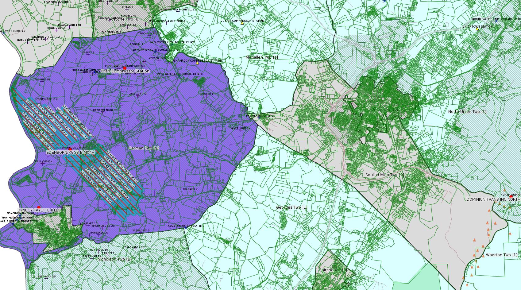
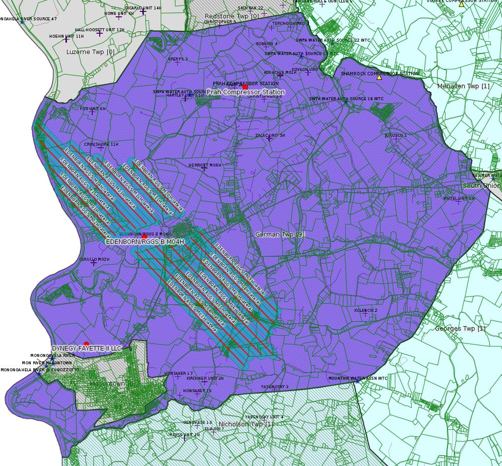
EDENBORN/RGGS B M04H Drill & Operate Well Permit (Unconventional) Modification [of Schedule] (New)
EDENBORN/RGGS B M15H Drill & Operate Well Permit (Unconventional) Modification [of Schedule] (New)
EDENBORN/RGGS B M14H Drill & Operate Well Permit (Unconventional) Modification [of Schedule] (New)
EDENBORN/RGGS B M05H Drill & Operate Well Permit (Unconventional) Modification [of Schedule] (New)
EDENBORN/RGGS B M03H Drill & Operate Well Permit (Unconventional) Modification [of Schedule] (New)
EDENBORN/RGGS B M02H Drill & Operate Well Permit (Unconventional) Modification [of Schedule] (New)
EDENBORN/RGGS B M01H Drill & Operate Well Permit (Unconventional) Modification [of Schedule] (New)
FRAZEE LUMBER COMPANY 6 WELL PLUGGING 592197 GP-07 Minor Road Crossings Withdrawn 2/19/2020 (New)
PRAH COMP STA AQ GP 5 - Natural Gas Compression and/or Processing Facilities
DOMINION ENERGY TRANS INC NORTH SUMMIT COMP STA Major Facility Operating Permit Modification Replaced 2/12/2020
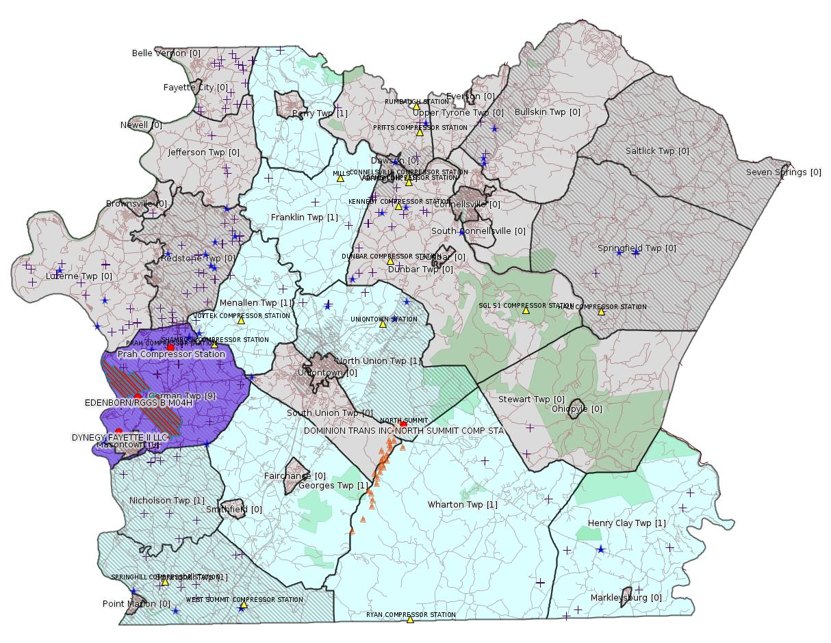
Map
Key
Red dots: items in this permit list with an exact location.
Blue stars: Marcellus Gas Well Water Sources.
Where well laterals are mapped they show in red; a 400-foot buffer surrounding the lateral shows in blue (lavender where it overlaps a mapped mineral tract).
Where mineral tracts are mapped, they show in pink. Mineral tracts can overlap; the overlap will show in red. The precise meaning of "mineral tract" is not clear.
Municipality shading: number of "facilities", with each well counting separately
(includes the red dots):
gray: 0
pale turquoise: 1
turquoise: 2
pale blue: 3
middle blue: 4
dark blue: 5
dark purple: 6
purple: 9
(Color coding may differ from one issue to the next.)
(Note if a project spans multiple municipalities -- e.g. a pipeline -- it will show in the count for each municipality.)
The number of facilities also follows the municipality name in brackets.
Municipality counts are based on the way the permit is listed by DEP; DEP has been known to get a municipality wrong.
Locations in brackets identify a precise location used to locate a surrogate for the actual site being permitted (e.g. locating a well pad or pipeline by the known location of a well.) Locations labeled beginning with "~" and ending in "[?]" are approximate and speculative based on inferences using on-line property and lease records. These are marked in the text as "[Approximate, Speculative]
Cross-hatching: Environmental Justice Areas
Yellow triangles: Compressor Stations
Orange triangles: Storage Field Wells (currently Dominion North Summit Storage Field)
Crosses: SPUD Unconventional well permits
Green: "Natural areas", e.g. state game lands, state forests
Yellow triangles: Compressor Stations
Orange triangles: Storage Field Wells (currently Dominion North Summit Storage Field)
Crosses: SPUD Unconventional well permits
Green: "Natural areas", e.g. state game lands, state forests
More Maps
 |
 |
Source: Pennsylvania Bulletin
STATEMENTS OF POLICY
Title 4—ADMINISTRATION
PART II. EXECUTIVE BOARD
[ 4 PA. CODE CH. 9 ]
Reorganization of the Department of Environmental Protection
[50 Pa.B. 1118]
[Saturday, February 22, 2020]
The Executive Board approved a reorganization of the Department of Environmental Protection effective January 31, 2020.
The organization chart at 50 Pa.B. 1119 (February 22, 2020) is published at the request of the Joint Committee on Documents under 1 Pa. Code § 3.1(a)(9) (relating to contents of Code).
(Editor's Note: The Joint Committee on Documents has found organization charts to be general and permanent in nature. This document meets the criteria of 45 Pa.C.S. § 702(7) (relating to contents of Pennsylvania Code) as a document general and permanent in nature which shall be codified in the Pennsylvania Code.)

-------------------------
Source: eNOTICE
(+ PA
Oil and Gas Mapping, Well
Pad Report.) Well Details via Data
Portal Services: Oil and Gas Wells All (ID: 3).
Please see the Disclaimer below regarding Parcel Id data.
Authorization ID: 1305480
Permit number: GP112607220-002
Site: SOUTHERN PA GATHERING SYSTEM ABANDONMENT PIPELINES 7709 7844
Client: COLUMBIA GAS TRANS
Authorization type: BWM-GP-11 Maintenance, Testing, Repair, Rehabilitation or Replacement General Pmt
Application type: New
Authorization is for: FACILITY
Date received: 02/18/2020
Status: Pending
Permit Decision Guarantee Applies?: Yes
Permit Decision Guarantee status: ACTIVE
Sub-Facilities for Authorization:
Sub-Facility ID Sub-Facility Name Description
1303591 S PA GATHERING SYSTEM ABANDONMENT PIPELINES 7709 7844 GP11 Other Activities
<https://www.ahs.dep.pa.gov/eFACTSWeb/searchResults_singleAuth.aspx?AuthID=1305480>
Site Programs:
Water Planning and Conservation
Site Municipalities:
Perry Twp, Fayette County
---
Authorization ID: 1305345
Permit number: 26-00535B
Site: DYNEGY FAYETTE II LLC
Client: DYNEGY FAYETTE II LLC
Authorization type: Major Facility Plan Approval New Source Performance Std
Application type: Extension
Authorization is for: FACILITY
Date received: 02/13/2020
Status: Issued on 2/18/2020
Permit Decision Guarantee Applies?: No
Sub-Facilities for Authorization:
Sub-Facility ID Sub-Facility Name Description
805961 CGT STACK 1 Point of Air Emission
805962 CGT STACK 2 Point of Air Emission
805954 CGT TRAIN 1 COMBINED CYCLE TURBINE Process
805959 CGT TRAIN 2 COMBINED CYCLE TURBINE Process
1095705 OXIDATION CATALYST UNIT 1 Air Pollution Control Device
Location: 39.857408,-79.913878
Map URL: <https://www.openstreetmap.org/?mlat=39.857408&mlon=-79.913878#map=15/39.857408/-79.913878>
1095706 OXIDATION CATALYST UNIT 2 Air Pollution Control Device
Location: 39.857408,-79.913878
Map URL: <https://www.openstreetmap.org/?mlat=39.857408&mlon=-79.913878#map=15/39.857408/-79.913878>
1095701 SCR UNIT 1 Air Pollution Control Device
Location: 39.857408,-79.913878
Map URL: <https://www.openstreetmap.org/?mlat=39.857408&mlon=-79.913878#map=15/39.857408/-79.913878>
1095702 SCR UNIT 2 Air Pollution Control Device
Location: 39.857408,-79.913878
Map URL: <https://www.openstreetmap.org/?mlat=39.857408&mlon=-79.913878#map=15/39.857408/-79.913878>
Permit Review Notes:
Date Review Note
2/18/2020 The technical review and decision review are complete and either the permit decision and/or permit issuance are forthcoming.
2/14/2020 The permit application package is complete, has been accepted, and is undergoing technical review.
<https://www.ahs.dep.pa.gov/eFACTSWeb/searchResults_singleAuth.aspx?AuthID=1305345>
Site Programs:
Air Quality
Waste Management
Water Planning and Conservation
Site Municipalities:
German Twp, Fayette County
Masontown Boro [apparently incorrect -jr], Fayette County
---
Authorization ID: 1305321
Permit number: GP082605220-001
Site: COLUMBIA GAS TRANS FAYETTE CNTY
Client: COLUMBIA GAS TRANS
Authorization type: GP-08 Temporary Road Crossings
Application type: New
Authorization is for: FACILITY
Date received: 02/13/2020
Status: Pending
Permit Decision Guarantee Applies?: No
<https://www.ahs.dep.pa.gov/eFACTSWeb/searchResults_singleAuth.aspx?AuthID=1305321>
Site Programs:
Water Planning and Conservation
Site Municipalities:
Franklin Twp, Fayette County
Henry Clay Twp, Fayette County
Menallen Twp, Fayette County
Nicholson Twp, Fayette County
Springhill Twp, Fayette County
Wharton Twp, Fayette County
---
Authorization ID: 1305319
Permit number: GP112605220-005
Site: COLUMBIA GAS TRANS FAYETTE CNTY
Client: COLUMBIA GAS TRANS
Authorization type: BWM-GP-11 Maintenance, Testing, Repair, Rehabilitation or Replacement General Pmt
Application type: New
Authorization is for: FACILITY
Date received: 02/13/2020
Status: Pending
Permit Decision Guarantee Applies?: Yes
Permit Decision Guarantee status: ACTIVE
<https://www.ahs.dep.pa.gov/eFACTSWeb/searchResults_singleAuth.aspx?AuthID=1305319>
Site Programs:
Water Planning and Conservation
Site Municipalities:
Franklin Twp, Fayette County
Henry Clay Twp, Fayette County
Menallen Twp, Fayette County
Nicholson Twp, Fayette County
Springhill Twp, Fayette County
Wharton Twp, Fayette County
---
Authorization ID: 1305007
Permit number: 051-24681
Site: EDENBORN/RGGS B ESCGP ESX18-051-0003
Client: CHEVRON APPALACHIA LLC
Authorization type: Drill & Operate Well Permit (Unconventional)
Application type: Modification
Authorization is for: FACILITY
Date received: 02/12/2020
Status: Pending
Permit Decision Guarantee Applies?: Yes
Permit Decision Guarantee status: VOID
Sub-Facilities for Authorization:
Sub-Facility ID Sub-Facility Name Description
1274748 WELLBORE SURFACE HOLE LOCATION Well
Permit Review Notes:
Date Review Note
2/13/2020 The permit application package is complete, has been accepted, and is undergoing technical review.
<https://www.ahs.dep.pa.gov/eFACTSWeb/searchResults_singleAuth.aspx?AuthID=1305007>
Site Programs:
Oil & Gas
Site Municipalities:
German Twp, Fayette County
Well Details:
Permit Number: 051-24681
Well Name: EDENBORN/RGGS B M04H
Unconventional Well: Y
Well Configuration: Horizontal Well
Well Type: GAS
Well Status: Active
Coal Association: Coal
Conservation Well: N
Primary Facility ID: 830206
Site ID: 829418
Site Name: EDENBORN/RGGS B ESCGP ESX18-051-0003
Well Pad ID: 155083
Well Pad Name: EDENBORN/RGGS B
Storage Field:
Operator: CHEVRON APPALACHIA LLC
Operator Number: OGO-39307
Permit Date: 2018-12-06
Permit Date Expires: 2019-12-06
SPUD Date: 2019-05-10
Date Plugged:
UIC ID:
UIC Type:
Surface Elevation: 1167
County: Fayette
Municipality: German Twp
Location: 39.881994,-79.896072
Map URL: <https://www.openstreetmap.org/?mlat=39.881994&mlon=-79.896072#map=15/39.881994/-79.896072>
OG WELLS PERMIT DOCS:
2020-02-13: Final Permit Documents, Name: Authorization ID 1251224 (for Authorization: 1251224):
<https://www.depgis.state.pa.us/pdfHandler/pdFHandler.ashx?Doc=NzEwNDk5&ext=PDF>
2019-04-16: Other Permit Documents, Name: Alternate Method (for Authorization: 1263992):
<https://www.depgis.state.pa.us/pdfHandler/pdFHandler.ashx?Doc=Nzg5NDU0&ext=PDF>
2019-12-31: Other Permit Documents, Name: Inactive Well Status (for Authorization: 1299309):
<https://www.depgis.state.pa.us/pdfHandler/pdFHandler.ashx?Doc=MTAxMDk2Mg==&ext=PDF>
Electronically Submitted Records:
2020-02-21: Submission for Authorization 1305007
Pennsylvania Natural Diversity Inventory Form: project_receipt_edenborn_pad_b_701266_FINAL_1.pdf
<https://www.depgis.state.pa.us/eWellDocHandler/pdFHandler.ashx?Doc=MTA4OTY5NQ==&ext=PDF>
Permit Application to Drill and Operate a Well: Edenborn M04H RePermit Application.pdf
<https://www.depgis.state.pa.us/eWellDocHandler/pdFHandler.ashx?Doc=MTA4OTY5Ng==&ext=PDF>
Location Plat: Edenborn Well Plat M4H.dwg
<https://www.depgis.state.pa.us/eWellDocHandler/pdFHandler.ashx?Doc=MTA4OTY5Nw==&ext=PDF>
Interested Party Notification: Edenborn 4H Interested Parties.pdf
<https://www.depgis.state.pa.us/eWellDocHandler/pdFHandler.ashx?Doc=MTA4OTY5OA==&ext=PDF>
Coordination of Well Location with Public Resources: Edenborn M04H OG-76.pdf
<https://www.depgis.state.pa.us/eWellDocHandler/pdFHandler.ashx?Doc=MTA4OTY5OQ==&ext=PDF>
Well Cross-Section Diagram: Edenborn RGGS M04H Page 4.pdf
<https://www.depgis.state.pa.us/eWellDocHandler/pdFHandler.ashx?Doc=MTA4OTcwMA==&ext=PDF>
Well Permit Application - Coal Module: Edenborn Coal Module.pdf
<https://www.depgis.state.pa.us/eWellDocHandler/pdFHandler.ashx?Doc=MTA4OTcwMQ==&ext=PDF>
Coal and Gas Resource Coord Act - Section 7 Exception: Edenborn RGGS Section 7 Exception.pdf
<https://www.depgis.state.pa.us/eWellDocHandler/pdFHandler.ashx?Doc=MTA4OTcwNA==&ext=PDF>
Electronic Submission Docket: 2083234.pdf
<https://www.depgis.state.pa.us/eWellDocHandler/pdFHandler.ashx?Doc=MTA5MDAxMg==&ext=PDF>
2020-02-13: Submission for Authorization 1251224
Pennsylvania Natural Diversity Inventory Form: EdenbornRGGS PNDI.pdf
<https://www.depgis.state.pa.us/eWellDocHandler/pdFHandler.ashx?Doc=NjgyMjE5&ext=PDF>
Location Plat: Edenborn Well Plat M4H.dwg
<https://www.depgis.state.pa.us/eWellDocHandler/pdFHandler.ashx?Doc=NjgyMjIw&ext=PDF>
Coordination of Well Location with Public Resources: Edenborn M04H OG-76.pdf
<https://www.depgis.state.pa.us/eWellDocHandler/pdFHandler.ashx?Doc=NjgyMjIx&ext=PDF>
Well Cross-Section Diagram: Edenborn RGGS M04H Page 4.pdf
<https://www.depgis.state.pa.us/eWellDocHandler/pdFHandler.ashx?Doc=NjgyMjIy&ext=PDF>
Permit Application to Drill and Operate a Well: 1811952.pdf
<https://www.depgis.state.pa.us/eWellDocHandler/pdFHandler.ashx?Doc=NjgyODYy&ext=PDF>
---
Authorization ID: 1305006
Permit number: 051-24689
Site: EDENBORN/RGGS B ESCGP ESX18-051-0003
Client: CHEVRON APPALACHIA LLC
Authorization type: Drill & Operate Well Permit (Unconventional)
Application type: Modification
Authorization is for: FACILITY
Date received: 02/12/2020
Status: Pending
Permit Decision Guarantee Applies?: Yes
Permit Decision Guarantee status: VOID
Sub-Facilities for Authorization:
Sub-Facility ID Sub-Facility Name Description
1274762 WELLBORE SURFACE HOLE LOCATION Well
Permit Review Notes:
Date Review Note
2/13/2020 The permit application package is complete, has been accepted, and is undergoing technical review.
<https://www.ahs.dep.pa.gov/eFACTSWeb/searchResults_singleAuth.aspx?AuthID=1305006>
Site Programs:
Oil & Gas
Site Municipalities:
German Twp, Fayette County
Well Details:
Permit Number: 051-24689
Well Name: EDENBORN/RGGS B M15H
Unconventional Well: Y
Well Configuration: Horizontal Well
Well Type: GAS
Well Status: Active
Coal Association: Coal
Conservation Well: N
Primary Facility ID: 830215
Site ID: 829418
Site Name: EDENBORN/RGGS B ESCGP ESX18-051-0003
Well Pad ID: 155083
Well Pad Name: EDENBORN/RGGS B
Storage Field:
Operator: CHEVRON APPALACHIA LLC
Operator Number: OGO-39307
Permit Date: 2018-12-13
Permit Date Expires: 2019-12-13
SPUD Date: 2019-05-13
Date Plugged:
UIC ID:
UIC Type:
Surface Elevation: 1167
County: Fayette
Municipality: German Twp
Location: 39.882061,-79.896197
Map URL: <https://www.openstreetmap.org/?mlat=39.882061&mlon=-79.896197#map=15/39.882061/-79.896197>
OG WELLS PERMIT DOCS:
2020-02-13: Other Permit Documents, Name: Povlik Deficiency Letter (for Authorization: 1251236):
<https://www.depgis.state.pa.us/pdfHandler/pdFHandler.ashx?Doc=NzEwMTE3&ext=PDF>
2020-02-13: Final Permit Documents, Name: Authorization ID 1251236 (for Authorization: 1251236):
<https://www.depgis.state.pa.us/pdfHandler/pdFHandler.ashx?Doc=NzE1NDM0&ext=PDF>
2020-02-13: Final Permit Documents, Name: 033-27257 Permit (11-30-18) (for Authorization: 1251236):
<https://www.depgis.state.pa.us/pdfHandler/pdFHandler.ashx?Doc=NzEwMTEw&ext=PDF>
2020-02-13: Final Permit Documents, Name: Povlik Record of Decision (11-30-18) (for Authorization: 1251236):
<https://www.depgis.state.pa.us/pdfHandler/pdFHandler.ashx?Doc=NzEwMTEy&ext=PDF>
2020-02-13: Other Permit Documents, Name: E&S-C&D email (for Authorization: 1251236):
<https://www.depgis.state.pa.us/pdfHandler/pdFHandler.ashx?Doc=NzEwMTU1&ext=PDF>
2020-02-13: Initial Submitted Documents, Name: Povlik 2018 application - approved (for Authorization: 1251236):
<https://www.depgis.state.pa.us/pdfHandler/pdFHandler.ashx?Doc=NzEwMTU3&ext=PDF>
2019-04-16: Other Permit Documents, Name: Alternate Method (for Authorization: 1264023):
<https://www.depgis.state.pa.us/pdfHandler/pdFHandler.ashx?Doc=Nzg5NTA0&ext=PDF>
2019-12-31: Other Permit Documents, Name: Inactive Well Status (for Authorization: 1299312):
<https://www.depgis.state.pa.us/pdfHandler/pdFHandler.ashx?Doc=MTAxMDk1OQ==&ext=PDF>
Electronically Submitted Records:
2020-02-13: Submission for Authorization 1251236
Pennsylvania Natural Diversity Inventory Form: EdenbornRGGS PNDI.pdf
<https://www.depgis.state.pa.us/eWellDocHandler/pdFHandler.ashx?Doc=NjgyMzQx&ext=PDF>
Location Plat: Edenborn Well Plat M15H.dwg
<https://www.depgis.state.pa.us/eWellDocHandler/pdFHandler.ashx?Doc=NjgyMzQy&ext=PDF>
Coordination of Well Location with Public Resources: Edenborn M15H OG-76.pdf
<https://www.depgis.state.pa.us/eWellDocHandler/pdFHandler.ashx?Doc=NjgyMzQz&ext=PDF>
Well Cross-Section Diagram: Edenborn RGGS M15H Page 4.pdf
<https://www.depgis.state.pa.us/eWellDocHandler/pdFHandler.ashx?Doc=NjgyMzQ0&ext=PDF>
Permit Application to Drill and Operate a Well: 1812304.pdf
<https://www.depgis.state.pa.us/eWellDocHandler/pdFHandler.ashx?Doc=NjgyOTI4&ext=PDF>
2020-02-21: Submission for Authorization 1305006
Pennsylvania Natural Diversity Inventory Form: project_receipt_edenborn_pad_b_701266_FINAL_1.pdf
<https://www.depgis.state.pa.us/eWellDocHandler/pdFHandler.ashx?Doc=MTA4OTc0Mw==&ext=PDF>
Permit Application to Drill and Operate a Well: Edenborn M15H RePermit Application.pdf
<https://www.depgis.state.pa.us/eWellDocHandler/pdFHandler.ashx?Doc=MTA4OTc0NA==&ext=PDF>
Location Plat: Edenborn Well Plat M15H.dwg
<https://www.depgis.state.pa.us/eWellDocHandler/pdFHandler.ashx?Doc=MTA4OTc0NQ==&ext=PDF>
Interested Party Notification: Edenborn 15H Interested Parties.pdf
<https://www.depgis.state.pa.us/eWellDocHandler/pdFHandler.ashx?Doc=MTA4OTc0Ng==&ext=PDF>
Coordination of Well Location with Public Resources: Edenborn M15H OG-76.pdf
<https://www.depgis.state.pa.us/eWellDocHandler/pdFHandler.ashx?Doc=MTA4OTc0Nw==&ext=PDF>
Coal and Gas Resource Coord Act - Section 7 Exception: Edenborn RGGS Section 7 Exception.pdf
<https://www.depgis.state.pa.us/eWellDocHandler/pdFHandler.ashx?Doc=MTA4OTc0OA==&ext=PDF>
Well Cross-Section Diagram: Edenborn RGGS M15H Page 4.pdf
<https://www.depgis.state.pa.us/eWellDocHandler/pdFHandler.ashx?Doc=MTA4OTc0OQ==&ext=PDF>
Well Permit Application - Coal Module: Edenborn Coal Module.pdf
<https://www.depgis.state.pa.us/eWellDocHandler/pdFHandler.ashx?Doc=MTA4OTc1MA==&ext=PDF>
Electronic Submission Docket: 2083237.pdf
<https://www.depgis.state.pa.us/eWellDocHandler/pdFHandler.ashx?Doc=MTA5MDA0NQ==&ext=PDF>
---
Authorization ID: 1305005
Permit number: 051-24688
Site: EDENBORN/RGGS B ESCGP ESX18-051-0003
Client: CHEVRON APPALACHIA LLC
Authorization type: Drill & Operate Well Permit (Unconventional)
Application type: Modification
Authorization is for: FACILITY
Date received: 02/12/2020
Status: Pending
Permit Decision Guarantee Applies?: Yes
Permit Decision Guarantee status: VOID
Sub-Facilities for Authorization:
Sub-Facility ID Sub-Facility Name Description
1274760 WELLBORE SURFACE HOLE LOCATION Well
Permit Review Notes:
Date Review Note
2/13/2020 The permit application package is complete, has been accepted, and is undergoing technical review.
<https://www.ahs.dep.pa.gov/eFACTSWeb/searchResults_singleAuth.aspx?AuthID=1305005>
Site Programs:
Oil & Gas
Site Municipalities:
German Twp, Fayette County
Well Details:
Permit Number: 051-24688
Well Name: EDENBORN/RGGS B M14H
Unconventional Well: Y
Well Configuration: Horizontal Well
Well Type: GAS
Well Status: Active
Coal Association: Coal
Conservation Well: N
Primary Facility ID: 830214
Site ID: 829418
Site Name: EDENBORN/RGGS B ESCGP ESX18-051-0003
Well Pad ID: 155083
Well Pad Name: EDENBORN/RGGS B
Storage Field:
Operator: CHEVRON APPALACHIA LLC
Operator Number: OGO-39307
Permit Date: 2018-12-13
Permit Date Expires: 2019-12-13
SPUD Date: 2019-05-14
Date Plugged:
UIC ID:
UIC Type:
Surface Elevation: 1167
County: Fayette
Municipality: German Twp
Location: 39.882069,-79.896144
Map URL: <https://www.openstreetmap.org/?mlat=39.882069&mlon=-79.896144#map=15/39.882069/-79.896144>
OG WELLS PERMIT DOCS:
2020-02-13: Final Permit Documents, Name: Authorization ID 1251234 (for Authorization: 1251234):
<https://www.depgis.state.pa.us/pdfHandler/pdFHandler.ashx?Doc=NzE1NDM3&ext=PDF>
2019-04-16: Other Permit Documents, Name: Alternate Method (for Authorization: 1264019):
<https://www.depgis.state.pa.us/pdfHandler/pdFHandler.ashx?Doc=Nzg5NDk5&ext=PDF>
2019-12-31: Other Permit Documents, Name: Inactive Well Status (for Authorization: 1299316):
<https://www.depgis.state.pa.us/pdfHandler/pdFHandler.ashx?Doc=MTAxMDk1Ng==&ext=PDF>
Electronically Submitted Records:
2020-02-13: Submission for Authorization 1251234
Pennsylvania Natural Diversity Inventory Form: EdenbornRGGS PNDI.pdf
<https://www.depgis.state.pa.us/eWellDocHandler/pdFHandler.ashx?Doc=NjgyMzMz&ext=PDF>
Location Plat: Edenborn Well Plat M14H.dwg
<https://www.depgis.state.pa.us/eWellDocHandler/pdFHandler.ashx?Doc=NjgyMzM0&ext=PDF>
Coordination of Well Location with Public Resources: Edenborn M14H OG-76.pdf
<https://www.depgis.state.pa.us/eWellDocHandler/pdFHandler.ashx?Doc=NjgyMzM1&ext=PDF>
Well Cross-Section Diagram: Edenborn RGGS M14H Page 4.pdf
<https://www.depgis.state.pa.us/eWellDocHandler/pdFHandler.ashx?Doc=NjgyMzM2&ext=PDF>
Permit Application to Drill and Operate a Well: 1812295.pdf
<https://www.depgis.state.pa.us/eWellDocHandler/pdFHandler.ashx?Doc=NjgyOTIz&ext=PDF>
2020-02-21: Submission for Authorization 1305005
Pennsylvania Natural Diversity Inventory Form: project_receipt_edenborn_pad_b_701266_FINAL_1.pdf
<https://www.depgis.state.pa.us/eWellDocHandler/pdFHandler.ashx?Doc=MTA4OTcyNw==&ext=PDF>
Permit Application to Drill and Operate a Well: Edenborn M14H RePermit Application.pdf
<https://www.depgis.state.pa.us/eWellDocHandler/pdFHandler.ashx?Doc=MTA4OTcyOA==&ext=PDF>
Location Plat: Edenborn Well Plat M14H.dwg
<https://www.depgis.state.pa.us/eWellDocHandler/pdFHandler.ashx?Doc=MTA4OTcyOQ==&ext=PDF>
Interested Party Notification: Edenborn 14H Interested Parties.pdf
<https://www.depgis.state.pa.us/eWellDocHandler/pdFHandler.ashx?Doc=MTA4OTczMA==&ext=PDF>
Coordination of Well Location with Public Resources: Edenborn M14H OG-76.pdf
<https://www.depgis.state.pa.us/eWellDocHandler/pdFHandler.ashx?Doc=MTA4OTczMQ==&ext=PDF>
Well Cross-Section Diagram: Edenborn RGGS M14H Page 4.pdf
<https://www.depgis.state.pa.us/eWellDocHandler/pdFHandler.ashx?Doc=MTA4OTczMg==&ext=PDF>
Well Permit Application - Coal Module: Edenborn Coal Module.pdf
<https://www.depgis.state.pa.us/eWellDocHandler/pdFHandler.ashx?Doc=MTA4OTczMw==&ext=PDF>
Coal and Gas Resource Coord Act - Section 7 Exception: Edenborn RGGS Section 7 Exception.pdf
<https://www.depgis.state.pa.us/eWellDocHandler/pdFHandler.ashx?Doc=MTA4OTczNA==&ext=PDF>
Electronic Submission Docket: 2083236.pdf
<https://www.depgis.state.pa.us/eWellDocHandler/pdFHandler.ashx?Doc=MTA5MDAzMw==&ext=PDF>
---
Authorization ID: 1305004
Permit number: 051-24682
Site: EDENBORN/RGGS B ESCGP ESX18-051-0003
Client: CHEVRON APPALACHIA LLC
Authorization type: Drill & Operate Well Permit (Unconventional)
Application type: Modification
Authorization is for: FACILITY
Date received: 02/12/2020
Status: Pending
Permit Decision Guarantee Applies?: Yes
Permit Decision Guarantee status: VOID
Sub-Facilities for Authorization:
Sub-Facility ID Sub-Facility Name Description
1274749 WELLBORE SURFACE HOLE LOCATION Well
Permit Review Notes:
Date Review Note
2/13/2020 The permit application package is complete, has been accepted, and is undergoing technical review.
<https://www.ahs.dep.pa.gov/eFACTSWeb/searchResults_singleAuth.aspx?AuthID=1305004>
Site Programs:
Oil & Gas
Site Municipalities:
German Twp, Fayette County
Well Details:
Permit Number: 051-24682
Well Name: EDENBORN/RGGS B M05H
Unconventional Well: Y
Well Configuration: Horizontal Well
Well Type: GAS
Well Status: Active
Coal Association: Coal
Conservation Well: N
Primary Facility ID: 830207
Site ID: 829418
Site Name: EDENBORN/RGGS B ESCGP ESX18-051-0003
Well Pad ID: 155083
Well Pad Name: EDENBORN/RGGS B
Storage Field:
Operator: CHEVRON APPALACHIA LLC
Operator Number: OGO-39307
Permit Date: 2018-12-10
Permit Date Expires: 2019-12-10
SPUD Date: 2019-05-11
Date Plugged:
UIC ID:
UIC Type:
Surface Elevation: 1167
County: Fayette
Municipality: German Twp
Location: 39.882,-79.896019
Map URL: <https://www.openstreetmap.org/?mlat=39.882&mlon=-79.896019#map=15/39.882/-79.896019>
OG WELLS PERMIT DOCS:
2020-02-13: Final Permit Documents, Name: Authorization ID 1251225 (for Authorization: 1251225):
<https://www.depgis.state.pa.us/pdfHandler/pdFHandler.ashx?Doc=NzEyNDM1&ext=PDF>
2019-04-16: Other Permit Documents, Name: Alternate Method (for Authorization: 1263993):
<https://www.depgis.state.pa.us/pdfHandler/pdFHandler.ashx?Doc=Nzg5NDU1&ext=PDF>
2019-12-31: Other Permit Documents, Name: Inactive Well Status (for Authorization: 1299308):
<https://www.depgis.state.pa.us/pdfHandler/pdFHandler.ashx?Doc=MTAxMDk2OQ==&ext=PDF>
Electronically Submitted Records:
2020-02-21: Submission for Authorization 1305004
Permit Application to Drill and Operate a Well: Edenborn M05H RePermit Application.pdf
<https://www.depgis.state.pa.us/eWellDocHandler/pdFHandler.ashx?Doc=MTA4OTcxMw==&ext=PDF>
Pennsylvania Natural Diversity Inventory Form: project_receipt_edenborn_pad_b_701266_FINAL_1.pdf
<https://www.depgis.state.pa.us/eWellDocHandler/pdFHandler.ashx?Doc=MTA4OTcxNA==&ext=PDF>
Location Plat: Edenborn Well Plat M5H.dwg
<https://www.depgis.state.pa.us/eWellDocHandler/pdFHandler.ashx?Doc=MTA4OTcxNQ==&ext=PDF>
Interested Party Notification: Edenborn 5H Interested Parties.pdf
<https://www.depgis.state.pa.us/eWellDocHandler/pdFHandler.ashx?Doc=MTA4OTcxNg==&ext=PDF>
Coordination of Well Location with Public Resources: Edenborn M05H OG-76.pdf
<https://www.depgis.state.pa.us/eWellDocHandler/pdFHandler.ashx?Doc=MTA4OTcxNw==&ext=PDF>
Coal and Gas Resource Coord Act - Section 7 Exception: Edenborn RGGS Section 7 Exception.pdf
<https://www.depgis.state.pa.us/eWellDocHandler/pdFHandler.ashx?Doc=MTA4OTcxOA==&ext=PDF>
Well Permit Application - Coal Module: Edenborn Coal Module.pdf
<https://www.depgis.state.pa.us/eWellDocHandler/pdFHandler.ashx?Doc=MTA4OTcxOQ==&ext=PDF>
Well Cross-Section Diagram: Edenborn RGGS M05H Page 4.pdf
<https://www.depgis.state.pa.us/eWellDocHandler/pdFHandler.ashx?Doc=MTA4OTcyMQ==&ext=PDF>
Electronic Submission Docket: 2083235.pdf
<https://www.depgis.state.pa.us/eWellDocHandler/pdFHandler.ashx?Doc=MTA5MDAyMg==&ext=PDF>
2020-02-13: Submission for Authorization 1251225
Pennsylvania Natural Diversity Inventory Form: EdenbornRGGS PNDI.pdf
<https://www.depgis.state.pa.us/eWellDocHandler/pdFHandler.ashx?Doc=NjgyMjM5&ext=PDF>
Location Plat: Edenborn Well Plat M5H.dwg
<https://www.depgis.state.pa.us/eWellDocHandler/pdFHandler.ashx?Doc=NjgyMjQw&ext=PDF>
Coordination of Well Location with Public Resources: Edenborn M05H OG-76.pdf
<https://www.depgis.state.pa.us/eWellDocHandler/pdFHandler.ashx?Doc=NjgyMjQx&ext=PDF>
Well Cross-Section Diagram: Edenborn RGGS M05H Page 4.pdf
<https://www.depgis.state.pa.us/eWellDocHandler/pdFHandler.ashx?Doc=NjgyMjQy&ext=PDF>
Permit Application to Drill and Operate a Well: 1811964.pdf
<https://www.depgis.state.pa.us/eWellDocHandler/pdFHandler.ashx?Doc=NjgyODY1&ext=PDF>
---
Authorization ID: 1304997
Permit number: 051-24676
Site: EDENBORN/RGGS B ESCGP ESX18-051-0003
Client: CHEVRON APPALACHIA LLC
Authorization type: Drill & Operate Well Permit (Unconventional)
Application type: Modification
Authorization is for: FACILITY
Date received: 02/12/2020
Status: Pending
Permit Decision Guarantee Applies?: Yes
Permit Decision Guarantee status: VOID
Sub-Facilities for Authorization:
Sub-Facility ID Sub-Facility Name Description
1274743 WELLBORE SURFACE HOLE LOCATION Well
Permit Review Notes:
Date Review Note
2/13/2020 The permit application package is complete, has been accepted, and is undergoing technical review.
<https://www.ahs.dep.pa.gov/eFACTSWeb/searchResults_singleAuth.aspx?AuthID=1304997>
Site Programs:
Oil & Gas
Site Municipalities:
German Twp, Fayette County
Well Details:
Permit Number: 051-24676
Well Name: EDENBORN/RGGS B M03H
Unconventional Well: Y
Well Configuration: Horizontal Well
Well Type: GAS
Well Status: Active
Coal Association: Coal
Conservation Well: N
Primary Facility ID: 830201
Site ID: 829418
Site Name: EDENBORN/RGGS B ESCGP ESX18-051-0003
Well Pad ID: 155083
Well Pad Name: EDENBORN/RGGS B
Storage Field:
Operator: CHEVRON APPALACHIA LLC
Operator Number: OGO-39307
Permit Date: 2018-12-06
Permit Date Expires: 2019-12-06
SPUD Date: 2019-05-10
Date Plugged:
UIC ID:
UIC Type:
Surface Elevation: 1167
County: Fayette
Municipality: German Twp
Location: 39.881986,-79.896125
Map URL: <https://www.openstreetmap.org/?mlat=39.881986&mlon=-79.896125#map=15/39.881986/-79.896125>
OG WELLS PERMIT DOCS:
2020-02-13: Final Permit Documents, Name: Authorization ID 1251219 (for Authorization: 1251219):
<https://www.depgis.state.pa.us/pdfHandler/pdFHandler.ashx?Doc=NzEwNDc5&ext=PDF>
2019-04-16: Other Permit Documents, Name: Alternate Method (for Authorization: 1263989):
<https://www.depgis.state.pa.us/pdfHandler/pdFHandler.ashx?Doc=Nzg5NDM4&ext=PDF>
2019-12-31: Other Permit Documents, Name: Inactive Well Status (for Authorization: 1299317):
<https://www.depgis.state.pa.us/pdfHandler/pdFHandler.ashx?Doc=MTAxMDk1Nw==&ext=PDF>
Electronically Submitted Records:
2020-02-21: Submission for Authorization 1304997
Pennsylvania Natural Diversity Inventory Form: project_receipt_edenborn_pad_b_701266_FINAL_1.pdf
<https://www.depgis.state.pa.us/eWellDocHandler/pdFHandler.ashx?Doc=MTA4OTY2OA==&ext=PDF>
Permit Application to Drill and Operate a Well: Edenborn M03H RePermit Application.pdf
<https://www.depgis.state.pa.us/eWellDocHandler/pdFHandler.ashx?Doc=MTA4OTY2OQ==&ext=PDF>
Location Plat: Edenborn Well Plat M3H.dwg
<https://www.depgis.state.pa.us/eWellDocHandler/pdFHandler.ashx?Doc=MTA4OTY3MA==&ext=PDF>
Interested Party Notification: Edenborn 3H Interested Parties.pdf
<https://www.depgis.state.pa.us/eWellDocHandler/pdFHandler.ashx?Doc=MTA4OTY3MQ==&ext=PDF>
Coordination of Well Location with Public Resources: Edenborn M03H OG-76.pdf
<https://www.depgis.state.pa.us/eWellDocHandler/pdFHandler.ashx?Doc=MTA4OTY3Mg==&ext=PDF>
Coal and Gas Resource Coord Act - Section 7 Exception: Edenborn RGGS Section 7 Exception.pdf
<https://www.depgis.state.pa.us/eWellDocHandler/pdFHandler.ashx?Doc=MTA4OTY3Mw==&ext=PDF>
Well Cross-Section Diagram: Edenborn RGGS M03H Page 4.pdf
<https://www.depgis.state.pa.us/eWellDocHandler/pdFHandler.ashx?Doc=MTA4OTY3NA==&ext=PDF>
Well Permit Application - Coal Module: Edenborn Coal Module.pdf
<https://www.depgis.state.pa.us/eWellDocHandler/pdFHandler.ashx?Doc=MTA4OTY3NQ==&ext=PDF>
Electronic Submission Docket: 2083232.pdf
<https://www.depgis.state.pa.us/eWellDocHandler/pdFHandler.ashx?Doc=MTA5MDAwNw==&ext=PDF>
2020-02-13: Submission for Authorization 1251219
Coordination of Well Location with Public Resources: Edenborn M03H OG-76.pdf
<https://www.depgis.state.pa.us/eWellDocHandler/pdFHandler.ashx?Doc=NjgyMjEx&ext=PDF>
Pennsylvania Natural Diversity Inventory Form: EdenbornRGGS PNDI.pdf
<https://www.depgis.state.pa.us/eWellDocHandler/pdFHandler.ashx?Doc=NjgyMjEy&ext=PDF>
Location Plat: Edenborn Well Plat M3H.dwg
<https://www.depgis.state.pa.us/eWellDocHandler/pdFHandler.ashx?Doc=NjgyMjE0&ext=PDF>
Well Cross-Section Diagram: Edenborn RGGS M03H Page 4.pdf
<https://www.depgis.state.pa.us/eWellDocHandler/pdFHandler.ashx?Doc=NjgyMjE1&ext=PDF>
Permit Application to Drill and Operate a Well: 1811938.pdf
<https://www.depgis.state.pa.us/eWellDocHandler/pdFHandler.ashx?Doc=NjgyODU2&ext=PDF>
---
Authorization ID: 1304995
Permit number: 051-24678
Site: EDENBORN/RGGS B ESCGP ESX18-051-0003
Client: CHEVRON APPALACHIA LLC
Authorization type: Drill & Operate Well Permit (Unconventional)
Application type: Modification
Authorization is for: FACILITY
Date received: 02/12/2020
Status: Pending
Permit Decision Guarantee Applies?: Yes
Permit Decision Guarantee status: VOID
Sub-Facilities for Authorization:
Sub-Facility ID Sub-Facility Name Description
1274745 WELLBORE SURFACE HOLE LOCATION Well
Permit Review Notes:
Date Review Note
2/13/2020 The permit application package is complete, has been accepted, and is undergoing technical review.
<https://www.ahs.dep.pa.gov/eFACTSWeb/searchResults_singleAuth.aspx?AuthID=1304995>
Site Programs:
Oil & Gas
Site Municipalities:
German Twp, Fayette County
Well Details:
Permit Number: 051-24678
Well Name: EDENBORN/RGGS B M02H
Unconventional Well: Y
Well Configuration: Horizontal Well
Well Type: GAS
Well Status: Active
Coal Association: Coal
Conservation Well: N
Primary Facility ID: 830203
Site ID: 829418
Site Name: EDENBORN/RGGS B ESCGP ESX18-051-0003
Well Pad ID: 155083
Well Pad Name: EDENBORN/RGGS B
Storage Field:
Operator: CHEVRON APPALACHIA LLC
Operator Number: OGO-39307
Permit Date: 2018-12-06
Permit Date Expires: 2019-12-06
SPUD Date: 2019-05-09
Date Plugged:
UIC ID:
UIC Type:
Surface Elevation: 1167
County: Fayette
Municipality: German Twp
Location: 39.881981,-79.896178
Map URL: <https://www.openstreetmap.org/?mlat=39.881981&mlon=-79.896178#map=15/39.881981/-79.896178>
OG WELLS PERMIT DOCS:
2020-02-13: Final Permit Documents, Name: Authorization ID 1251221 (for Authorization: 1251221):
<https://www.depgis.state.pa.us/pdfHandler/pdFHandler.ashx?Doc=NzEwNDc2&ext=PDF>
2019-04-16: Other Permit Documents, Name: Alternate Method (for Authorization: 1263988):
<https://www.depgis.state.pa.us/pdfHandler/pdFHandler.ashx?Doc=Nzg5NDQ2&ext=PDF>
2019-12-31: Other Permit Documents, Name: Inactive Well Status (for Authorization: 1299306):
<https://www.depgis.state.pa.us/pdfHandler/pdFHandler.ashx?Doc=MTAxMDk3Ng==&ext=PDF>
Electronically Submitted Records:
2020-02-13: Submission for Authorization 1251221
Coordination of Well Location with Public Resources: Edenborn M02H OG-76.pdf
<https://www.depgis.state.pa.us/eWellDocHandler/pdFHandler.ashx?Doc=NjgyMTcy&ext=PDF>
Pennsylvania Natural Diversity Inventory Form: EdenbornRGGS PNDI.pdf
<https://www.depgis.state.pa.us/eWellDocHandler/pdFHandler.ashx?Doc=NjgyMTcz&ext=PDF>
Location Plat: Edenborn Well Plat M2H.dwg
<https://www.depgis.state.pa.us/eWellDocHandler/pdFHandler.ashx?Doc=NjgyMTc0&ext=PDF>
Well Cross-Section Diagram: Edenborn RGGS M02H Page 4.pdf
<https://www.depgis.state.pa.us/eWellDocHandler/pdFHandler.ashx?Doc=NjgyMTc1&ext=PDF>
Permit Application to Drill and Operate a Well: 1811579.pdf
<https://www.depgis.state.pa.us/eWellDocHandler/pdFHandler.ashx?Doc=NjgyODUy&ext=PDF>
2020-02-21: Submission for Authorization 1304995
Permit Application to Drill and Operate a Well: Edenborn M02H RePermit Application.pdf
<https://www.depgis.state.pa.us/eWellDocHandler/pdFHandler.ashx?Doc=MTA4OTYzOA==&ext=PDF>
Pennsylvania Natural Diversity Inventory Form: project_receipt_edenborn_pad_b_701266_FINAL_1.pdf
<https://www.depgis.state.pa.us/eWellDocHandler/pdFHandler.ashx?Doc=MTA4OTYzOQ==&ext=PDF>
Location Plat: Edenborn Well Plat M2H.dwg
<https://www.depgis.state.pa.us/eWellDocHandler/pdFHandler.ashx?Doc=MTA4OTY0MA==&ext=PDF>
Interested Party Notification: Edenborn 2H Interested Parties.pdf
<https://www.depgis.state.pa.us/eWellDocHandler/pdFHandler.ashx?Doc=MTA4OTY0Mg==&ext=PDF>
Coordination of Well Location with Public Resources: Edenborn M02H OG-76.pdf
<https://www.depgis.state.pa.us/eWellDocHandler/pdFHandler.ashx?Doc=MTA4OTY0Mw==&ext=PDF>
Coal and Gas Resource Coord Act - Section 7 Exception: Edenborn RGGS Section 7 Exception.pdf
<https://www.depgis.state.pa.us/eWellDocHandler/pdFHandler.ashx?Doc=MTA4OTY0NA==&ext=PDF>
Well Cross-Section Diagram: Edenborn RGGS M02H Page 4.pdf
<https://www.depgis.state.pa.us/eWellDocHandler/pdFHandler.ashx?Doc=MTA4OTY0NQ==&ext=PDF>
Well Permit Application - Coal Module: Edenborn Coal Module.pdf
<https://www.depgis.state.pa.us/eWellDocHandler/pdFHandler.ashx?Doc=MTA4OTY0Ng==&ext=PDF>
Electronic Submission Docket: 2083223.pdf
<https://www.depgis.state.pa.us/eWellDocHandler/pdFHandler.ashx?Doc=MTA4OTk5OQ==&ext=PDF>
---
Authorization ID: 1304994
Permit number: 051-24675
Site: EDENBORN/RGGS B ESCGP ESX18-051-0003
Client: CHEVRON APPALACHIA LLC
Authorization type: Drill & Operate Well Permit (Unconventional)
Application type: Modification
Authorization is for: FACILITY
Date received: 02/12/2020
Status: Pending
Permit Decision Guarantee Applies?: Yes
Permit Decision Guarantee status: VOID
Sub-Facilities for Authorization:
Sub-Facility ID Sub-Facility Name Description
1274737 WELLBORE SURFACE HOLE LOCATION Well
Permit Review Notes:
Date Review Note
2/13/2020 The permit application package is complete, has been accepted, and is undergoing technical review.
<https://www.ahs.dep.pa.gov/eFACTSWeb/searchResults_singleAuth.aspx?AuthID=1304994>
Site Programs:
Oil & Gas
Site Municipalities:
German Twp, Fayette County
Well Details:
Permit Number: 051-24675
Well Name: EDENBORN/RGGS B M01H
Unconventional Well: Y
Well Configuration: Horizontal Well
Well Type: GAS
Well Status: Active
Coal Association: Coal
Conservation Well: N
Primary Facility ID: 830199
Site ID: 829418
Site Name: EDENBORN/RGGS B ESCGP ESX18-051-0003
Well Pad ID: 155083
Well Pad Name: EDENBORN/RGGS B
Storage Field:
Operator: CHEVRON APPALACHIA LLC
Operator Number: OGO-39307
Permit Date: 2018-12-06
Permit Date Expires: 2019-12-06
SPUD Date: 2019-05-13
Date Plugged:
UIC ID:
UIC Type:
Surface Elevation: 1167
County: Fayette
Municipality: German Twp
Location: 39.881975,-79.896231
Map URL: <https://www.openstreetmap.org/?mlat=39.881975&mlon=-79.896231#map=15/39.881975/-79.896231>
OG WELLS PERMIT DOCS:
2020-02-13: Final Permit Documents, Name: Authorization ID 1251216 (for Authorization: 1251216):
<https://www.depgis.state.pa.us/pdfHandler/pdFHandler.ashx?Doc=NzEwNTA0&ext=PDF>
2019-04-16: Other Permit Documents, Name: Alternate Method (for Authorization: 1263985):
<https://www.depgis.state.pa.us/pdfHandler/pdFHandler.ashx?Doc=Nzg5NDM1&ext=PDF>
2019-12-31: Other Permit Documents, Name: Inactive Well Status (for Authorization: 1299307):
<https://www.depgis.state.pa.us/pdfHandler/pdFHandler.ashx?Doc=MTAxMDk3Mw==&ext=PDF>
Electronically Submitted Records:
2020-02-13: Submission for Authorization 1251216
Pennsylvania Natural Diversity Inventory Form: EdenbornRGGS PNDI.pdf
<https://www.depgis.state.pa.us/eWellDocHandler/pdFHandler.ashx?Doc=Njc0NTI3&ext=PDF>
Coordination of Well Location with Public Resources: Edenborn M01H OG-76.pdf
<https://www.depgis.state.pa.us/eWellDocHandler/pdFHandler.ashx?Doc=Njc0NTI4&ext=PDF>
Location Plat: Edenborn Well Plat M1H.dwg
<https://www.depgis.state.pa.us/eWellDocHandler/pdFHandler.ashx?Doc=NjgyMTU5&ext=PDF>
Well Cross-Section Diagram: Edenborn RGGS M01H Page 4.pdf
<https://www.depgis.state.pa.us/eWellDocHandler/pdFHandler.ashx?Doc=NjgyMTYw&ext=PDF>
Permit Application to Drill and Operate a Well: 1811517.pdf
<https://www.depgis.state.pa.us/eWellDocHandler/pdFHandler.ashx?Doc=NjgyODQ4&ext=PDF>
2020-02-21: Submission for Authorization 1304994
Pennsylvania Natural Diversity Inventory Form: project_receipt_edenborn_pad_b_701266_FINAL_1.pdf
<https://www.depgis.state.pa.us/eWellDocHandler/pdFHandler.ashx?Doc=MTA4OTU5MQ==&ext=PDF>
Permit Application to Drill and Operate a Well: Edenborn M01H RePermit Application.pdf
<https://www.depgis.state.pa.us/eWellDocHandler/pdFHandler.ashx?Doc=MTA4OTU5Mg==&ext=PDF>
Location Plat: Edenborn Well Plat M1H.dwg
<https://www.depgis.state.pa.us/eWellDocHandler/pdFHandler.ashx?Doc=MTA4OTU5Mw==&ext=PDF>
Interested Party Notification: Edenborn 1H Interested Parties.pdf
<https://www.depgis.state.pa.us/eWellDocHandler/pdFHandler.ashx?Doc=MTA4OTU5NA==&ext=PDF>
Coordination of Well Location with Public Resources: Edenborn M01H OG-76.pdf
<https://www.depgis.state.pa.us/eWellDocHandler/pdFHandler.ashx?Doc=MTA4OTU5NQ==&ext=PDF>
Coal and Gas Resource Coord Act - Section 7 Exception: Edenborn RGGS Section 7 Exception.pdf
<https://www.depgis.state.pa.us/eWellDocHandler/pdFHandler.ashx?Doc=MTA4OTU5Ng==&ext=PDF>
Well Cross-Section Diagram: Edenborn RGGS M01H Page 4.pdf
<https://www.depgis.state.pa.us/eWellDocHandler/pdFHandler.ashx?Doc=MTA4OTU5Nw==&ext=PDF>
Well Permit Application - Coal Module: Edenborn Coal Module.pdf
<https://www.depgis.state.pa.us/eWellDocHandler/pdFHandler.ashx?Doc=MTA4OTYwNg==&ext=PDF>
Electronic Submission Docket: 2083218.pdf
<https://www.depgis.state.pa.us/eWellDocHandler/pdFHandler.ashx?Doc=MTA4OTk4Ng==&ext=PDF>
---
Authorization ID: 1304615
Permit number: GP072607220-001
Site: FRAZEE LUMBER COMPANY 6 WELL PLUGGING 592197
Client: EQT PROD CO
Authorization type: GP-07 Minor Road Crossings
Application type: New
Authorization is for: FACILITY
Date received: 02/07/2020
Status: Withdrawn on 2/19/2020
Permit Decision Guarantee Applies?: No
Sub-Facilities for Authorization:
Sub-Facility ID Sub-Facility Name Description
1303181 FRAZEE LUMBER COMPANY 6 WELL PLUGGING 592197 Culvert
Permit Review Notes:
Date Review Note
2/14/2020 The permit application package is complete, has been accepted, and is undergoing technical review.
<https://www.ahs.dep.pa.gov/eFACTSWeb/searchResults_singleAuth.aspx?AuthID=1304615>
Site Programs:
Water Planning and Conservation
Site Municipalities:
Georges Twp, Fayette County
---
Authorization ID: 1302004
Permit number: AG5-26-00002A
Site: PRAH COMP STA GERMAN TWP
Client: LAUREL MTN MIDSTREAM OPR LLC
Authorization type: AQ GP 5 - Natural Gas Compression and/or Processing Facilities
Application type: New
Authorization is for: FACILITY
Date received: 01/09/2020
Status: Pending
Permit Decision Guarantee Applies?: No
Sub-Facilities for Authorization:
Sub-Facility ID Sub-Facility Name Description
943514 CATERPILLAR G3516TALE 1,340 BHP ENGINE 1 Process
943546 CATERPILLAR G3516TALE 1,340 BHP ENGINE 2 Process
1182919 FUGITIVES Process
Location: 39.916422,-79.865258
Map URL: <https://www.openstreetmap.org/?mlat=39.916422&mlon=-79.865258#map=15/39.916422/-79.865258>
1182910 PNEUMATIC DEVICES Process
Location: 39.916422,-79.865258
Map URL: <https://www.openstreetmap.org/?mlat=39.916422&mlon=-79.865258#map=15/39.916422/-79.865258>
1182902 TANKS/VESSELS Process
Location: 39.916422,-79.865258
Map URL: <https://www.openstreetmap.org/?mlat=39.916422&mlon=-79.865258#map=15/39.916422/-79.865258>
1182914 VENTING/BLOWDOWNS Process
Location: 39.916422,-79.865258
Map URL: <https://www.openstreetmap.org/?mlat=39.916422&mlon=-79.865258#map=15/39.916422/-79.865258>
Permit Review Notes:
Date Review Note
1/16/2020 The permit application package is complete, has been accepted, and is undergoing technical review.
<https://www.ahs.dep.pa.gov/eFACTSWeb/searchResults_singleAuth.aspx?AuthID=1302004>
Site Programs:
Air Quality
Site Municipalities:
German Twp, Fayette County
---
Authorization ID: 1277843
Permit number: 26-00405
Site: DOMINION ENERGY TRANS INC NORTH SUMMIT COMP STA
Client: DOMINION ENERGY TRANS INC
Authorization type: Major Facility Operating Permit
Application type: Modification
Authorization is for: FACILITY
Date received: 10/24/2016
Status: Replaced on 2/12/2020
Permit Decision Guarantee Applies?: No
Permit Review Notes:
Date Review Note
6/24/2019 The permit application package is complete, has been accepted, and is undergoing technical review.
<https://www.ahs.dep.pa.gov/eFACTSWeb/searchResults_singleAuth.aspx?AuthID=1277843>
Site Programs:
Air Quality
Clean Water
Waste Management
Site Municipalities:
North Union Twp, Fayette County
-------------------------
Please see the Disclaimer below regarding Parcel Id data.
Authorization ID: 1305480
Permit number: GP112607220-002
Site: SOUTHERN PA GATHERING SYSTEM ABANDONMENT PIPELINES 7709 7844
Client: COLUMBIA GAS TRANS
Authorization type: BWM-GP-11 Maintenance, Testing, Repair, Rehabilitation or Replacement General Pmt
Application type: New
Authorization is for: FACILITY
Date received: 02/18/2020
Status: Pending
Permit Decision Guarantee Applies?: Yes
Permit Decision Guarantee status: ACTIVE
Sub-Facilities for Authorization:
Sub-Facility ID Sub-Facility Name Description
1303591 S PA GATHERING SYSTEM ABANDONMENT PIPELINES 7709 7844 GP11 Other Activities
<https://www.ahs.dep.pa.gov/eFACTSWeb/searchResults_singleAuth.aspx?AuthID=1305480>
Site Programs:
Water Planning and Conservation
Site Municipalities:
Perry Twp, Fayette County
---
Authorization ID: 1305345
Permit number: 26-00535B
Site: DYNEGY FAYETTE II LLC
Client: DYNEGY FAYETTE II LLC
Authorization type: Major Facility Plan Approval New Source Performance Std
Application type: Extension
Authorization is for: FACILITY
Date received: 02/13/2020
Status: Issued on 2/18/2020
Permit Decision Guarantee Applies?: No
Sub-Facilities for Authorization:
Sub-Facility ID Sub-Facility Name Description
805961 CGT STACK 1 Point of Air Emission
805962 CGT STACK 2 Point of Air Emission
805954 CGT TRAIN 1 COMBINED CYCLE TURBINE Process
805959 CGT TRAIN 2 COMBINED CYCLE TURBINE Process
1095705 OXIDATION CATALYST UNIT 1 Air Pollution Control Device
Location: 39.857408,-79.913878
Map URL: <https://www.openstreetmap.org/?mlat=39.857408&mlon=-79.913878#map=15/39.857408/-79.913878>
1095706 OXIDATION CATALYST UNIT 2 Air Pollution Control Device
Location: 39.857408,-79.913878
Map URL: <https://www.openstreetmap.org/?mlat=39.857408&mlon=-79.913878#map=15/39.857408/-79.913878>
1095701 SCR UNIT 1 Air Pollution Control Device
Location: 39.857408,-79.913878
Map URL: <https://www.openstreetmap.org/?mlat=39.857408&mlon=-79.913878#map=15/39.857408/-79.913878>
1095702 SCR UNIT 2 Air Pollution Control Device
Location: 39.857408,-79.913878
Map URL: <https://www.openstreetmap.org/?mlat=39.857408&mlon=-79.913878#map=15/39.857408/-79.913878>
Permit Review Notes:
Date Review Note
2/18/2020 The technical review and decision review are complete and either the permit decision and/or permit issuance are forthcoming.
2/14/2020 The permit application package is complete, has been accepted, and is undergoing technical review.
<https://www.ahs.dep.pa.gov/eFACTSWeb/searchResults_singleAuth.aspx?AuthID=1305345>
Site Programs:
Air Quality
Waste Management
Water Planning and Conservation
Site Municipalities:
German Twp, Fayette County
Masontown Boro [apparently incorrect -jr], Fayette County
---
Authorization ID: 1305321
Permit number: GP082605220-001
Site: COLUMBIA GAS TRANS FAYETTE CNTY
Client: COLUMBIA GAS TRANS
Authorization type: GP-08 Temporary Road Crossings
Application type: New
Authorization is for: FACILITY
Date received: 02/13/2020
Status: Pending
Permit Decision Guarantee Applies?: No
<https://www.ahs.dep.pa.gov/eFACTSWeb/searchResults_singleAuth.aspx?AuthID=1305321>
Site Programs:
Water Planning and Conservation
Site Municipalities:
Franklin Twp, Fayette County
Henry Clay Twp, Fayette County
Menallen Twp, Fayette County
Nicholson Twp, Fayette County
Springhill Twp, Fayette County
Wharton Twp, Fayette County
---
Authorization ID: 1305319
Permit number: GP112605220-005
Site: COLUMBIA GAS TRANS FAYETTE CNTY
Client: COLUMBIA GAS TRANS
Authorization type: BWM-GP-11 Maintenance, Testing, Repair, Rehabilitation or Replacement General Pmt
Application type: New
Authorization is for: FACILITY
Date received: 02/13/2020
Status: Pending
Permit Decision Guarantee Applies?: Yes
Permit Decision Guarantee status: ACTIVE
<https://www.ahs.dep.pa.gov/eFACTSWeb/searchResults_singleAuth.aspx?AuthID=1305319>
Site Programs:
Water Planning and Conservation
Site Municipalities:
Franklin Twp, Fayette County
Henry Clay Twp, Fayette County
Menallen Twp, Fayette County
Nicholson Twp, Fayette County
Springhill Twp, Fayette County
Wharton Twp, Fayette County
---
Authorization ID: 1305007
Permit number: 051-24681
Site: EDENBORN/RGGS B ESCGP ESX18-051-0003
Client: CHEVRON APPALACHIA LLC
Authorization type: Drill & Operate Well Permit (Unconventional)
Application type: Modification
Authorization is for: FACILITY
Date received: 02/12/2020
Status: Pending
Permit Decision Guarantee Applies?: Yes
Permit Decision Guarantee status: VOID
Sub-Facilities for Authorization:
Sub-Facility ID Sub-Facility Name Description
1274748 WELLBORE SURFACE HOLE LOCATION Well
Permit Review Notes:
Date Review Note
2/13/2020 The permit application package is complete, has been accepted, and is undergoing technical review.
<https://www.ahs.dep.pa.gov/eFACTSWeb/searchResults_singleAuth.aspx?AuthID=1305007>
Site Programs:
Oil & Gas
Site Municipalities:
German Twp, Fayette County
Well Details:
Permit Number: 051-24681
Well Name: EDENBORN/RGGS B M04H
Unconventional Well: Y
Well Configuration: Horizontal Well
Well Type: GAS
Well Status: Active
Coal Association: Coal
Conservation Well: N
Primary Facility ID: 830206
Site ID: 829418
Site Name: EDENBORN/RGGS B ESCGP ESX18-051-0003
Well Pad ID: 155083
Well Pad Name: EDENBORN/RGGS B
Storage Field:
Operator: CHEVRON APPALACHIA LLC
Operator Number: OGO-39307
Permit Date: 2018-12-06
Permit Date Expires: 2019-12-06
SPUD Date: 2019-05-10
Date Plugged:
UIC ID:
UIC Type:
Surface Elevation: 1167
County: Fayette
Municipality: German Twp
Location: 39.881994,-79.896072
Map URL: <https://www.openstreetmap.org/?mlat=39.881994&mlon=-79.896072#map=15/39.881994/-79.896072>
OG WELLS PERMIT DOCS:
2020-02-13: Final Permit Documents, Name: Authorization ID 1251224 (for Authorization: 1251224):
<https://www.depgis.state.pa.us/pdfHandler/pdFHandler.ashx?Doc=NzEwNDk5&ext=PDF>
2019-04-16: Other Permit Documents, Name: Alternate Method (for Authorization: 1263992):
<https://www.depgis.state.pa.us/pdfHandler/pdFHandler.ashx?Doc=Nzg5NDU0&ext=PDF>
2019-12-31: Other Permit Documents, Name: Inactive Well Status (for Authorization: 1299309):
<https://www.depgis.state.pa.us/pdfHandler/pdFHandler.ashx?Doc=MTAxMDk2Mg==&ext=PDF>
Electronically Submitted Records:
2020-02-21: Submission for Authorization 1305007
Pennsylvania Natural Diversity Inventory Form: project_receipt_edenborn_pad_b_701266_FINAL_1.pdf
<https://www.depgis.state.pa.us/eWellDocHandler/pdFHandler.ashx?Doc=MTA4OTY5NQ==&ext=PDF>
Permit Application to Drill and Operate a Well: Edenborn M04H RePermit Application.pdf
<https://www.depgis.state.pa.us/eWellDocHandler/pdFHandler.ashx?Doc=MTA4OTY5Ng==&ext=PDF>
Location Plat: Edenborn Well Plat M4H.dwg
<https://www.depgis.state.pa.us/eWellDocHandler/pdFHandler.ashx?Doc=MTA4OTY5Nw==&ext=PDF>
Interested Party Notification: Edenborn 4H Interested Parties.pdf
<https://www.depgis.state.pa.us/eWellDocHandler/pdFHandler.ashx?Doc=MTA4OTY5OA==&ext=PDF>
Coordination of Well Location with Public Resources: Edenborn M04H OG-76.pdf
<https://www.depgis.state.pa.us/eWellDocHandler/pdFHandler.ashx?Doc=MTA4OTY5OQ==&ext=PDF>
Well Cross-Section Diagram: Edenborn RGGS M04H Page 4.pdf
<https://www.depgis.state.pa.us/eWellDocHandler/pdFHandler.ashx?Doc=MTA4OTcwMA==&ext=PDF>
Well Permit Application - Coal Module: Edenborn Coal Module.pdf
<https://www.depgis.state.pa.us/eWellDocHandler/pdFHandler.ashx?Doc=MTA4OTcwMQ==&ext=PDF>
Coal and Gas Resource Coord Act - Section 7 Exception: Edenborn RGGS Section 7 Exception.pdf
<https://www.depgis.state.pa.us/eWellDocHandler/pdFHandler.ashx?Doc=MTA4OTcwNA==&ext=PDF>
Electronic Submission Docket: 2083234.pdf
<https://www.depgis.state.pa.us/eWellDocHandler/pdFHandler.ashx?Doc=MTA5MDAxMg==&ext=PDF>
2020-02-13: Submission for Authorization 1251224
Pennsylvania Natural Diversity Inventory Form: EdenbornRGGS PNDI.pdf
<https://www.depgis.state.pa.us/eWellDocHandler/pdFHandler.ashx?Doc=NjgyMjE5&ext=PDF>
Location Plat: Edenborn Well Plat M4H.dwg
<https://www.depgis.state.pa.us/eWellDocHandler/pdFHandler.ashx?Doc=NjgyMjIw&ext=PDF>
Coordination of Well Location with Public Resources: Edenborn M04H OG-76.pdf
<https://www.depgis.state.pa.us/eWellDocHandler/pdFHandler.ashx?Doc=NjgyMjIx&ext=PDF>
Well Cross-Section Diagram: Edenborn RGGS M04H Page 4.pdf
<https://www.depgis.state.pa.us/eWellDocHandler/pdFHandler.ashx?Doc=NjgyMjIy&ext=PDF>
Permit Application to Drill and Operate a Well: 1811952.pdf
<https://www.depgis.state.pa.us/eWellDocHandler/pdFHandler.ashx?Doc=NjgyODYy&ext=PDF>
Presumed Parcel Id: 15220014
[See Notes.]---
Authorization ID: 1305006
Permit number: 051-24689
Site: EDENBORN/RGGS B ESCGP ESX18-051-0003
Client: CHEVRON APPALACHIA LLC
Authorization type: Drill & Operate Well Permit (Unconventional)
Application type: Modification
Authorization is for: FACILITY
Date received: 02/12/2020
Status: Pending
Permit Decision Guarantee Applies?: Yes
Permit Decision Guarantee status: VOID
Sub-Facilities for Authorization:
Sub-Facility ID Sub-Facility Name Description
1274762 WELLBORE SURFACE HOLE LOCATION Well
Permit Review Notes:
Date Review Note
2/13/2020 The permit application package is complete, has been accepted, and is undergoing technical review.
<https://www.ahs.dep.pa.gov/eFACTSWeb/searchResults_singleAuth.aspx?AuthID=1305006>
Site Programs:
Oil & Gas
Site Municipalities:
German Twp, Fayette County
Well Details:
Permit Number: 051-24689
Well Name: EDENBORN/RGGS B M15H
Unconventional Well: Y
Well Configuration: Horizontal Well
Well Type: GAS
Well Status: Active
Coal Association: Coal
Conservation Well: N
Primary Facility ID: 830215
Site ID: 829418
Site Name: EDENBORN/RGGS B ESCGP ESX18-051-0003
Well Pad ID: 155083
Well Pad Name: EDENBORN/RGGS B
Storage Field:
Operator: CHEVRON APPALACHIA LLC
Operator Number: OGO-39307
Permit Date: 2018-12-13
Permit Date Expires: 2019-12-13
SPUD Date: 2019-05-13
Date Plugged:
UIC ID:
UIC Type:
Surface Elevation: 1167
County: Fayette
Municipality: German Twp
Location: 39.882061,-79.896197
Map URL: <https://www.openstreetmap.org/?mlat=39.882061&mlon=-79.896197#map=15/39.882061/-79.896197>
OG WELLS PERMIT DOCS:
2020-02-13: Other Permit Documents, Name: Povlik Deficiency Letter (for Authorization: 1251236):
<https://www.depgis.state.pa.us/pdfHandler/pdFHandler.ashx?Doc=NzEwMTE3&ext=PDF>
2020-02-13: Final Permit Documents, Name: Authorization ID 1251236 (for Authorization: 1251236):
<https://www.depgis.state.pa.us/pdfHandler/pdFHandler.ashx?Doc=NzE1NDM0&ext=PDF>
2020-02-13: Final Permit Documents, Name: 033-27257 Permit (11-30-18) (for Authorization: 1251236):
<https://www.depgis.state.pa.us/pdfHandler/pdFHandler.ashx?Doc=NzEwMTEw&ext=PDF>
2020-02-13: Final Permit Documents, Name: Povlik Record of Decision (11-30-18) (for Authorization: 1251236):
<https://www.depgis.state.pa.us/pdfHandler/pdFHandler.ashx?Doc=NzEwMTEy&ext=PDF>
2020-02-13: Other Permit Documents, Name: E&S-C&D email (for Authorization: 1251236):
<https://www.depgis.state.pa.us/pdfHandler/pdFHandler.ashx?Doc=NzEwMTU1&ext=PDF>
2020-02-13: Initial Submitted Documents, Name: Povlik 2018 application - approved (for Authorization: 1251236):
<https://www.depgis.state.pa.us/pdfHandler/pdFHandler.ashx?Doc=NzEwMTU3&ext=PDF>
2019-04-16: Other Permit Documents, Name: Alternate Method (for Authorization: 1264023):
<https://www.depgis.state.pa.us/pdfHandler/pdFHandler.ashx?Doc=Nzg5NTA0&ext=PDF>
2019-12-31: Other Permit Documents, Name: Inactive Well Status (for Authorization: 1299312):
<https://www.depgis.state.pa.us/pdfHandler/pdFHandler.ashx?Doc=MTAxMDk1OQ==&ext=PDF>
Electronically Submitted Records:
2020-02-13: Submission for Authorization 1251236
Pennsylvania Natural Diversity Inventory Form: EdenbornRGGS PNDI.pdf
<https://www.depgis.state.pa.us/eWellDocHandler/pdFHandler.ashx?Doc=NjgyMzQx&ext=PDF>
Location Plat: Edenborn Well Plat M15H.dwg
<https://www.depgis.state.pa.us/eWellDocHandler/pdFHandler.ashx?Doc=NjgyMzQy&ext=PDF>
Coordination of Well Location with Public Resources: Edenborn M15H OG-76.pdf
<https://www.depgis.state.pa.us/eWellDocHandler/pdFHandler.ashx?Doc=NjgyMzQz&ext=PDF>
Well Cross-Section Diagram: Edenborn RGGS M15H Page 4.pdf
<https://www.depgis.state.pa.us/eWellDocHandler/pdFHandler.ashx?Doc=NjgyMzQ0&ext=PDF>
Permit Application to Drill and Operate a Well: 1812304.pdf
<https://www.depgis.state.pa.us/eWellDocHandler/pdFHandler.ashx?Doc=NjgyOTI4&ext=PDF>
2020-02-21: Submission for Authorization 1305006
Pennsylvania Natural Diversity Inventory Form: project_receipt_edenborn_pad_b_701266_FINAL_1.pdf
<https://www.depgis.state.pa.us/eWellDocHandler/pdFHandler.ashx?Doc=MTA4OTc0Mw==&ext=PDF>
Permit Application to Drill and Operate a Well: Edenborn M15H RePermit Application.pdf
<https://www.depgis.state.pa.us/eWellDocHandler/pdFHandler.ashx?Doc=MTA4OTc0NA==&ext=PDF>
Location Plat: Edenborn Well Plat M15H.dwg
<https://www.depgis.state.pa.us/eWellDocHandler/pdFHandler.ashx?Doc=MTA4OTc0NQ==&ext=PDF>
Interested Party Notification: Edenborn 15H Interested Parties.pdf
<https://www.depgis.state.pa.us/eWellDocHandler/pdFHandler.ashx?Doc=MTA4OTc0Ng==&ext=PDF>
Coordination of Well Location with Public Resources: Edenborn M15H OG-76.pdf
<https://www.depgis.state.pa.us/eWellDocHandler/pdFHandler.ashx?Doc=MTA4OTc0Nw==&ext=PDF>
Coal and Gas Resource Coord Act - Section 7 Exception: Edenborn RGGS Section 7 Exception.pdf
<https://www.depgis.state.pa.us/eWellDocHandler/pdFHandler.ashx?Doc=MTA4OTc0OA==&ext=PDF>
Well Cross-Section Diagram: Edenborn RGGS M15H Page 4.pdf
<https://www.depgis.state.pa.us/eWellDocHandler/pdFHandler.ashx?Doc=MTA4OTc0OQ==&ext=PDF>
Well Permit Application - Coal Module: Edenborn Coal Module.pdf
<https://www.depgis.state.pa.us/eWellDocHandler/pdFHandler.ashx?Doc=MTA4OTc1MA==&ext=PDF>
Electronic Submission Docket: 2083237.pdf
<https://www.depgis.state.pa.us/eWellDocHandler/pdFHandler.ashx?Doc=MTA5MDA0NQ==&ext=PDF>
---
Authorization ID: 1305005
Permit number: 051-24688
Site: EDENBORN/RGGS B ESCGP ESX18-051-0003
Client: CHEVRON APPALACHIA LLC
Authorization type: Drill & Operate Well Permit (Unconventional)
Application type: Modification
Authorization is for: FACILITY
Date received: 02/12/2020
Status: Pending
Permit Decision Guarantee Applies?: Yes
Permit Decision Guarantee status: VOID
Sub-Facilities for Authorization:
Sub-Facility ID Sub-Facility Name Description
1274760 WELLBORE SURFACE HOLE LOCATION Well
Permit Review Notes:
Date Review Note
2/13/2020 The permit application package is complete, has been accepted, and is undergoing technical review.
<https://www.ahs.dep.pa.gov/eFACTSWeb/searchResults_singleAuth.aspx?AuthID=1305005>
Site Programs:
Oil & Gas
Site Municipalities:
German Twp, Fayette County
Well Details:
Permit Number: 051-24688
Well Name: EDENBORN/RGGS B M14H
Unconventional Well: Y
Well Configuration: Horizontal Well
Well Type: GAS
Well Status: Active
Coal Association: Coal
Conservation Well: N
Primary Facility ID: 830214
Site ID: 829418
Site Name: EDENBORN/RGGS B ESCGP ESX18-051-0003
Well Pad ID: 155083
Well Pad Name: EDENBORN/RGGS B
Storage Field:
Operator: CHEVRON APPALACHIA LLC
Operator Number: OGO-39307
Permit Date: 2018-12-13
Permit Date Expires: 2019-12-13
SPUD Date: 2019-05-14
Date Plugged:
UIC ID:
UIC Type:
Surface Elevation: 1167
County: Fayette
Municipality: German Twp
Location: 39.882069,-79.896144
Map URL: <https://www.openstreetmap.org/?mlat=39.882069&mlon=-79.896144#map=15/39.882069/-79.896144>
OG WELLS PERMIT DOCS:
2020-02-13: Final Permit Documents, Name: Authorization ID 1251234 (for Authorization: 1251234):
<https://www.depgis.state.pa.us/pdfHandler/pdFHandler.ashx?Doc=NzE1NDM3&ext=PDF>
2019-04-16: Other Permit Documents, Name: Alternate Method (for Authorization: 1264019):
<https://www.depgis.state.pa.us/pdfHandler/pdFHandler.ashx?Doc=Nzg5NDk5&ext=PDF>
2019-12-31: Other Permit Documents, Name: Inactive Well Status (for Authorization: 1299316):
<https://www.depgis.state.pa.us/pdfHandler/pdFHandler.ashx?Doc=MTAxMDk1Ng==&ext=PDF>
Electronically Submitted Records:
2020-02-13: Submission for Authorization 1251234
Pennsylvania Natural Diversity Inventory Form: EdenbornRGGS PNDI.pdf
<https://www.depgis.state.pa.us/eWellDocHandler/pdFHandler.ashx?Doc=NjgyMzMz&ext=PDF>
Location Plat: Edenborn Well Plat M14H.dwg
<https://www.depgis.state.pa.us/eWellDocHandler/pdFHandler.ashx?Doc=NjgyMzM0&ext=PDF>
Coordination of Well Location with Public Resources: Edenborn M14H OG-76.pdf
<https://www.depgis.state.pa.us/eWellDocHandler/pdFHandler.ashx?Doc=NjgyMzM1&ext=PDF>
Well Cross-Section Diagram: Edenborn RGGS M14H Page 4.pdf
<https://www.depgis.state.pa.us/eWellDocHandler/pdFHandler.ashx?Doc=NjgyMzM2&ext=PDF>
Permit Application to Drill and Operate a Well: 1812295.pdf
<https://www.depgis.state.pa.us/eWellDocHandler/pdFHandler.ashx?Doc=NjgyOTIz&ext=PDF>
2020-02-21: Submission for Authorization 1305005
Pennsylvania Natural Diversity Inventory Form: project_receipt_edenborn_pad_b_701266_FINAL_1.pdf
<https://www.depgis.state.pa.us/eWellDocHandler/pdFHandler.ashx?Doc=MTA4OTcyNw==&ext=PDF>
Permit Application to Drill and Operate a Well: Edenborn M14H RePermit Application.pdf
<https://www.depgis.state.pa.us/eWellDocHandler/pdFHandler.ashx?Doc=MTA4OTcyOA==&ext=PDF>
Location Plat: Edenborn Well Plat M14H.dwg
<https://www.depgis.state.pa.us/eWellDocHandler/pdFHandler.ashx?Doc=MTA4OTcyOQ==&ext=PDF>
Interested Party Notification: Edenborn 14H Interested Parties.pdf
<https://www.depgis.state.pa.us/eWellDocHandler/pdFHandler.ashx?Doc=MTA4OTczMA==&ext=PDF>
Coordination of Well Location with Public Resources: Edenborn M14H OG-76.pdf
<https://www.depgis.state.pa.us/eWellDocHandler/pdFHandler.ashx?Doc=MTA4OTczMQ==&ext=PDF>
Well Cross-Section Diagram: Edenborn RGGS M14H Page 4.pdf
<https://www.depgis.state.pa.us/eWellDocHandler/pdFHandler.ashx?Doc=MTA4OTczMg==&ext=PDF>
Well Permit Application - Coal Module: Edenborn Coal Module.pdf
<https://www.depgis.state.pa.us/eWellDocHandler/pdFHandler.ashx?Doc=MTA4OTczMw==&ext=PDF>
Coal and Gas Resource Coord Act - Section 7 Exception: Edenborn RGGS Section 7 Exception.pdf
<https://www.depgis.state.pa.us/eWellDocHandler/pdFHandler.ashx?Doc=MTA4OTczNA==&ext=PDF>
Electronic Submission Docket: 2083236.pdf
<https://www.depgis.state.pa.us/eWellDocHandler/pdFHandler.ashx?Doc=MTA5MDAzMw==&ext=PDF>
---
Authorization ID: 1305004
Permit number: 051-24682
Site: EDENBORN/RGGS B ESCGP ESX18-051-0003
Client: CHEVRON APPALACHIA LLC
Authorization type: Drill & Operate Well Permit (Unconventional)
Application type: Modification
Authorization is for: FACILITY
Date received: 02/12/2020
Status: Pending
Permit Decision Guarantee Applies?: Yes
Permit Decision Guarantee status: VOID
Sub-Facilities for Authorization:
Sub-Facility ID Sub-Facility Name Description
1274749 WELLBORE SURFACE HOLE LOCATION Well
Permit Review Notes:
Date Review Note
2/13/2020 The permit application package is complete, has been accepted, and is undergoing technical review.
<https://www.ahs.dep.pa.gov/eFACTSWeb/searchResults_singleAuth.aspx?AuthID=1305004>
Site Programs:
Oil & Gas
Site Municipalities:
German Twp, Fayette County
Well Details:
Permit Number: 051-24682
Well Name: EDENBORN/RGGS B M05H
Unconventional Well: Y
Well Configuration: Horizontal Well
Well Type: GAS
Well Status: Active
Coal Association: Coal
Conservation Well: N
Primary Facility ID: 830207
Site ID: 829418
Site Name: EDENBORN/RGGS B ESCGP ESX18-051-0003
Well Pad ID: 155083
Well Pad Name: EDENBORN/RGGS B
Storage Field:
Operator: CHEVRON APPALACHIA LLC
Operator Number: OGO-39307
Permit Date: 2018-12-10
Permit Date Expires: 2019-12-10
SPUD Date: 2019-05-11
Date Plugged:
UIC ID:
UIC Type:
Surface Elevation: 1167
County: Fayette
Municipality: German Twp
Location: 39.882,-79.896019
Map URL: <https://www.openstreetmap.org/?mlat=39.882&mlon=-79.896019#map=15/39.882/-79.896019>
OG WELLS PERMIT DOCS:
2020-02-13: Final Permit Documents, Name: Authorization ID 1251225 (for Authorization: 1251225):
<https://www.depgis.state.pa.us/pdfHandler/pdFHandler.ashx?Doc=NzEyNDM1&ext=PDF>
2019-04-16: Other Permit Documents, Name: Alternate Method (for Authorization: 1263993):
<https://www.depgis.state.pa.us/pdfHandler/pdFHandler.ashx?Doc=Nzg5NDU1&ext=PDF>
2019-12-31: Other Permit Documents, Name: Inactive Well Status (for Authorization: 1299308):
<https://www.depgis.state.pa.us/pdfHandler/pdFHandler.ashx?Doc=MTAxMDk2OQ==&ext=PDF>
Electronically Submitted Records:
2020-02-21: Submission for Authorization 1305004
Permit Application to Drill and Operate a Well: Edenborn M05H RePermit Application.pdf
<https://www.depgis.state.pa.us/eWellDocHandler/pdFHandler.ashx?Doc=MTA4OTcxMw==&ext=PDF>
Pennsylvania Natural Diversity Inventory Form: project_receipt_edenborn_pad_b_701266_FINAL_1.pdf
<https://www.depgis.state.pa.us/eWellDocHandler/pdFHandler.ashx?Doc=MTA4OTcxNA==&ext=PDF>
Location Plat: Edenborn Well Plat M5H.dwg
<https://www.depgis.state.pa.us/eWellDocHandler/pdFHandler.ashx?Doc=MTA4OTcxNQ==&ext=PDF>
Interested Party Notification: Edenborn 5H Interested Parties.pdf
<https://www.depgis.state.pa.us/eWellDocHandler/pdFHandler.ashx?Doc=MTA4OTcxNg==&ext=PDF>
Coordination of Well Location with Public Resources: Edenborn M05H OG-76.pdf
<https://www.depgis.state.pa.us/eWellDocHandler/pdFHandler.ashx?Doc=MTA4OTcxNw==&ext=PDF>
Coal and Gas Resource Coord Act - Section 7 Exception: Edenborn RGGS Section 7 Exception.pdf
<https://www.depgis.state.pa.us/eWellDocHandler/pdFHandler.ashx?Doc=MTA4OTcxOA==&ext=PDF>
Well Permit Application - Coal Module: Edenborn Coal Module.pdf
<https://www.depgis.state.pa.us/eWellDocHandler/pdFHandler.ashx?Doc=MTA4OTcxOQ==&ext=PDF>
Well Cross-Section Diagram: Edenborn RGGS M05H Page 4.pdf
<https://www.depgis.state.pa.us/eWellDocHandler/pdFHandler.ashx?Doc=MTA4OTcyMQ==&ext=PDF>
Electronic Submission Docket: 2083235.pdf
<https://www.depgis.state.pa.us/eWellDocHandler/pdFHandler.ashx?Doc=MTA5MDAyMg==&ext=PDF>
2020-02-13: Submission for Authorization 1251225
Pennsylvania Natural Diversity Inventory Form: EdenbornRGGS PNDI.pdf
<https://www.depgis.state.pa.us/eWellDocHandler/pdFHandler.ashx?Doc=NjgyMjM5&ext=PDF>
Location Plat: Edenborn Well Plat M5H.dwg
<https://www.depgis.state.pa.us/eWellDocHandler/pdFHandler.ashx?Doc=NjgyMjQw&ext=PDF>
Coordination of Well Location with Public Resources: Edenborn M05H OG-76.pdf
<https://www.depgis.state.pa.us/eWellDocHandler/pdFHandler.ashx?Doc=NjgyMjQx&ext=PDF>
Well Cross-Section Diagram: Edenborn RGGS M05H Page 4.pdf
<https://www.depgis.state.pa.us/eWellDocHandler/pdFHandler.ashx?Doc=NjgyMjQy&ext=PDF>
Permit Application to Drill and Operate a Well: 1811964.pdf
<https://www.depgis.state.pa.us/eWellDocHandler/pdFHandler.ashx?Doc=NjgyODY1&ext=PDF>
---
Authorization ID: 1304997
Permit number: 051-24676
Site: EDENBORN/RGGS B ESCGP ESX18-051-0003
Client: CHEVRON APPALACHIA LLC
Authorization type: Drill & Operate Well Permit (Unconventional)
Application type: Modification
Authorization is for: FACILITY
Date received: 02/12/2020
Status: Pending
Permit Decision Guarantee Applies?: Yes
Permit Decision Guarantee status: VOID
Sub-Facilities for Authorization:
Sub-Facility ID Sub-Facility Name Description
1274743 WELLBORE SURFACE HOLE LOCATION Well
Permit Review Notes:
Date Review Note
2/13/2020 The permit application package is complete, has been accepted, and is undergoing technical review.
<https://www.ahs.dep.pa.gov/eFACTSWeb/searchResults_singleAuth.aspx?AuthID=1304997>
Site Programs:
Oil & Gas
Site Municipalities:
German Twp, Fayette County
Well Details:
Permit Number: 051-24676
Well Name: EDENBORN/RGGS B M03H
Unconventional Well: Y
Well Configuration: Horizontal Well
Well Type: GAS
Well Status: Active
Coal Association: Coal
Conservation Well: N
Primary Facility ID: 830201
Site ID: 829418
Site Name: EDENBORN/RGGS B ESCGP ESX18-051-0003
Well Pad ID: 155083
Well Pad Name: EDENBORN/RGGS B
Storage Field:
Operator: CHEVRON APPALACHIA LLC
Operator Number: OGO-39307
Permit Date: 2018-12-06
Permit Date Expires: 2019-12-06
SPUD Date: 2019-05-10
Date Plugged:
UIC ID:
UIC Type:
Surface Elevation: 1167
County: Fayette
Municipality: German Twp
Location: 39.881986,-79.896125
Map URL: <https://www.openstreetmap.org/?mlat=39.881986&mlon=-79.896125#map=15/39.881986/-79.896125>
OG WELLS PERMIT DOCS:
2020-02-13: Final Permit Documents, Name: Authorization ID 1251219 (for Authorization: 1251219):
<https://www.depgis.state.pa.us/pdfHandler/pdFHandler.ashx?Doc=NzEwNDc5&ext=PDF>
2019-04-16: Other Permit Documents, Name: Alternate Method (for Authorization: 1263989):
<https://www.depgis.state.pa.us/pdfHandler/pdFHandler.ashx?Doc=Nzg5NDM4&ext=PDF>
2019-12-31: Other Permit Documents, Name: Inactive Well Status (for Authorization: 1299317):
<https://www.depgis.state.pa.us/pdfHandler/pdFHandler.ashx?Doc=MTAxMDk1Nw==&ext=PDF>
Electronically Submitted Records:
2020-02-21: Submission for Authorization 1304997
Pennsylvania Natural Diversity Inventory Form: project_receipt_edenborn_pad_b_701266_FINAL_1.pdf
<https://www.depgis.state.pa.us/eWellDocHandler/pdFHandler.ashx?Doc=MTA4OTY2OA==&ext=PDF>
Permit Application to Drill and Operate a Well: Edenborn M03H RePermit Application.pdf
<https://www.depgis.state.pa.us/eWellDocHandler/pdFHandler.ashx?Doc=MTA4OTY2OQ==&ext=PDF>
Location Plat: Edenborn Well Plat M3H.dwg
<https://www.depgis.state.pa.us/eWellDocHandler/pdFHandler.ashx?Doc=MTA4OTY3MA==&ext=PDF>
Interested Party Notification: Edenborn 3H Interested Parties.pdf
<https://www.depgis.state.pa.us/eWellDocHandler/pdFHandler.ashx?Doc=MTA4OTY3MQ==&ext=PDF>
Coordination of Well Location with Public Resources: Edenborn M03H OG-76.pdf
<https://www.depgis.state.pa.us/eWellDocHandler/pdFHandler.ashx?Doc=MTA4OTY3Mg==&ext=PDF>
Coal and Gas Resource Coord Act - Section 7 Exception: Edenborn RGGS Section 7 Exception.pdf
<https://www.depgis.state.pa.us/eWellDocHandler/pdFHandler.ashx?Doc=MTA4OTY3Mw==&ext=PDF>
Well Cross-Section Diagram: Edenborn RGGS M03H Page 4.pdf
<https://www.depgis.state.pa.us/eWellDocHandler/pdFHandler.ashx?Doc=MTA4OTY3NA==&ext=PDF>
Well Permit Application - Coal Module: Edenborn Coal Module.pdf
<https://www.depgis.state.pa.us/eWellDocHandler/pdFHandler.ashx?Doc=MTA4OTY3NQ==&ext=PDF>
Electronic Submission Docket: 2083232.pdf
<https://www.depgis.state.pa.us/eWellDocHandler/pdFHandler.ashx?Doc=MTA5MDAwNw==&ext=PDF>
2020-02-13: Submission for Authorization 1251219
Coordination of Well Location with Public Resources: Edenborn M03H OG-76.pdf
<https://www.depgis.state.pa.us/eWellDocHandler/pdFHandler.ashx?Doc=NjgyMjEx&ext=PDF>
Pennsylvania Natural Diversity Inventory Form: EdenbornRGGS PNDI.pdf
<https://www.depgis.state.pa.us/eWellDocHandler/pdFHandler.ashx?Doc=NjgyMjEy&ext=PDF>
Location Plat: Edenborn Well Plat M3H.dwg
<https://www.depgis.state.pa.us/eWellDocHandler/pdFHandler.ashx?Doc=NjgyMjE0&ext=PDF>
Well Cross-Section Diagram: Edenborn RGGS M03H Page 4.pdf
<https://www.depgis.state.pa.us/eWellDocHandler/pdFHandler.ashx?Doc=NjgyMjE1&ext=PDF>
Permit Application to Drill and Operate a Well: 1811938.pdf
<https://www.depgis.state.pa.us/eWellDocHandler/pdFHandler.ashx?Doc=NjgyODU2&ext=PDF>
---
Authorization ID: 1304995
Permit number: 051-24678
Site: EDENBORN/RGGS B ESCGP ESX18-051-0003
Client: CHEVRON APPALACHIA LLC
Authorization type: Drill & Operate Well Permit (Unconventional)
Application type: Modification
Authorization is for: FACILITY
Date received: 02/12/2020
Status: Pending
Permit Decision Guarantee Applies?: Yes
Permit Decision Guarantee status: VOID
Sub-Facilities for Authorization:
Sub-Facility ID Sub-Facility Name Description
1274745 WELLBORE SURFACE HOLE LOCATION Well
Permit Review Notes:
Date Review Note
2/13/2020 The permit application package is complete, has been accepted, and is undergoing technical review.
<https://www.ahs.dep.pa.gov/eFACTSWeb/searchResults_singleAuth.aspx?AuthID=1304995>
Site Programs:
Oil & Gas
Site Municipalities:
German Twp, Fayette County
Well Details:
Permit Number: 051-24678
Well Name: EDENBORN/RGGS B M02H
Unconventional Well: Y
Well Configuration: Horizontal Well
Well Type: GAS
Well Status: Active
Coal Association: Coal
Conservation Well: N
Primary Facility ID: 830203
Site ID: 829418
Site Name: EDENBORN/RGGS B ESCGP ESX18-051-0003
Well Pad ID: 155083
Well Pad Name: EDENBORN/RGGS B
Storage Field:
Operator: CHEVRON APPALACHIA LLC
Operator Number: OGO-39307
Permit Date: 2018-12-06
Permit Date Expires: 2019-12-06
SPUD Date: 2019-05-09
Date Plugged:
UIC ID:
UIC Type:
Surface Elevation: 1167
County: Fayette
Municipality: German Twp
Location: 39.881981,-79.896178
Map URL: <https://www.openstreetmap.org/?mlat=39.881981&mlon=-79.896178#map=15/39.881981/-79.896178>
OG WELLS PERMIT DOCS:
2020-02-13: Final Permit Documents, Name: Authorization ID 1251221 (for Authorization: 1251221):
<https://www.depgis.state.pa.us/pdfHandler/pdFHandler.ashx?Doc=NzEwNDc2&ext=PDF>
2019-04-16: Other Permit Documents, Name: Alternate Method (for Authorization: 1263988):
<https://www.depgis.state.pa.us/pdfHandler/pdFHandler.ashx?Doc=Nzg5NDQ2&ext=PDF>
2019-12-31: Other Permit Documents, Name: Inactive Well Status (for Authorization: 1299306):
<https://www.depgis.state.pa.us/pdfHandler/pdFHandler.ashx?Doc=MTAxMDk3Ng==&ext=PDF>
Electronically Submitted Records:
2020-02-13: Submission for Authorization 1251221
Coordination of Well Location with Public Resources: Edenborn M02H OG-76.pdf
<https://www.depgis.state.pa.us/eWellDocHandler/pdFHandler.ashx?Doc=NjgyMTcy&ext=PDF>
Pennsylvania Natural Diversity Inventory Form: EdenbornRGGS PNDI.pdf
<https://www.depgis.state.pa.us/eWellDocHandler/pdFHandler.ashx?Doc=NjgyMTcz&ext=PDF>
Location Plat: Edenborn Well Plat M2H.dwg
<https://www.depgis.state.pa.us/eWellDocHandler/pdFHandler.ashx?Doc=NjgyMTc0&ext=PDF>
Well Cross-Section Diagram: Edenborn RGGS M02H Page 4.pdf
<https://www.depgis.state.pa.us/eWellDocHandler/pdFHandler.ashx?Doc=NjgyMTc1&ext=PDF>
Permit Application to Drill and Operate a Well: 1811579.pdf
<https://www.depgis.state.pa.us/eWellDocHandler/pdFHandler.ashx?Doc=NjgyODUy&ext=PDF>
2020-02-21: Submission for Authorization 1304995
Permit Application to Drill and Operate a Well: Edenborn M02H RePermit Application.pdf
<https://www.depgis.state.pa.us/eWellDocHandler/pdFHandler.ashx?Doc=MTA4OTYzOA==&ext=PDF>
Pennsylvania Natural Diversity Inventory Form: project_receipt_edenborn_pad_b_701266_FINAL_1.pdf
<https://www.depgis.state.pa.us/eWellDocHandler/pdFHandler.ashx?Doc=MTA4OTYzOQ==&ext=PDF>
Location Plat: Edenborn Well Plat M2H.dwg
<https://www.depgis.state.pa.us/eWellDocHandler/pdFHandler.ashx?Doc=MTA4OTY0MA==&ext=PDF>
Interested Party Notification: Edenborn 2H Interested Parties.pdf
<https://www.depgis.state.pa.us/eWellDocHandler/pdFHandler.ashx?Doc=MTA4OTY0Mg==&ext=PDF>
Coordination of Well Location with Public Resources: Edenborn M02H OG-76.pdf
<https://www.depgis.state.pa.us/eWellDocHandler/pdFHandler.ashx?Doc=MTA4OTY0Mw==&ext=PDF>
Coal and Gas Resource Coord Act - Section 7 Exception: Edenborn RGGS Section 7 Exception.pdf
<https://www.depgis.state.pa.us/eWellDocHandler/pdFHandler.ashx?Doc=MTA4OTY0NA==&ext=PDF>
Well Cross-Section Diagram: Edenborn RGGS M02H Page 4.pdf
<https://www.depgis.state.pa.us/eWellDocHandler/pdFHandler.ashx?Doc=MTA4OTY0NQ==&ext=PDF>
Well Permit Application - Coal Module: Edenborn Coal Module.pdf
<https://www.depgis.state.pa.us/eWellDocHandler/pdFHandler.ashx?Doc=MTA4OTY0Ng==&ext=PDF>
Electronic Submission Docket: 2083223.pdf
<https://www.depgis.state.pa.us/eWellDocHandler/pdFHandler.ashx?Doc=MTA4OTk5OQ==&ext=PDF>
---
Authorization ID: 1304994
Permit number: 051-24675
Site: EDENBORN/RGGS B ESCGP ESX18-051-0003
Client: CHEVRON APPALACHIA LLC
Authorization type: Drill & Operate Well Permit (Unconventional)
Application type: Modification
Authorization is for: FACILITY
Date received: 02/12/2020
Status: Pending
Permit Decision Guarantee Applies?: Yes
Permit Decision Guarantee status: VOID
Sub-Facilities for Authorization:
Sub-Facility ID Sub-Facility Name Description
1274737 WELLBORE SURFACE HOLE LOCATION Well
Permit Review Notes:
Date Review Note
2/13/2020 The permit application package is complete, has been accepted, and is undergoing technical review.
<https://www.ahs.dep.pa.gov/eFACTSWeb/searchResults_singleAuth.aspx?AuthID=1304994>
Site Programs:
Oil & Gas
Site Municipalities:
German Twp, Fayette County
Well Details:
Permit Number: 051-24675
Well Name: EDENBORN/RGGS B M01H
Unconventional Well: Y
Well Configuration: Horizontal Well
Well Type: GAS
Well Status: Active
Coal Association: Coal
Conservation Well: N
Primary Facility ID: 830199
Site ID: 829418
Site Name: EDENBORN/RGGS B ESCGP ESX18-051-0003
Well Pad ID: 155083
Well Pad Name: EDENBORN/RGGS B
Storage Field:
Operator: CHEVRON APPALACHIA LLC
Operator Number: OGO-39307
Permit Date: 2018-12-06
Permit Date Expires: 2019-12-06
SPUD Date: 2019-05-13
Date Plugged:
UIC ID:
UIC Type:
Surface Elevation: 1167
County: Fayette
Municipality: German Twp
Location: 39.881975,-79.896231
Map URL: <https://www.openstreetmap.org/?mlat=39.881975&mlon=-79.896231#map=15/39.881975/-79.896231>
OG WELLS PERMIT DOCS:
2020-02-13: Final Permit Documents, Name: Authorization ID 1251216 (for Authorization: 1251216):
<https://www.depgis.state.pa.us/pdfHandler/pdFHandler.ashx?Doc=NzEwNTA0&ext=PDF>
2019-04-16: Other Permit Documents, Name: Alternate Method (for Authorization: 1263985):
<https://www.depgis.state.pa.us/pdfHandler/pdFHandler.ashx?Doc=Nzg5NDM1&ext=PDF>
2019-12-31: Other Permit Documents, Name: Inactive Well Status (for Authorization: 1299307):
<https://www.depgis.state.pa.us/pdfHandler/pdFHandler.ashx?Doc=MTAxMDk3Mw==&ext=PDF>
Electronically Submitted Records:
2020-02-13: Submission for Authorization 1251216
Pennsylvania Natural Diversity Inventory Form: EdenbornRGGS PNDI.pdf
<https://www.depgis.state.pa.us/eWellDocHandler/pdFHandler.ashx?Doc=Njc0NTI3&ext=PDF>
Coordination of Well Location with Public Resources: Edenborn M01H OG-76.pdf
<https://www.depgis.state.pa.us/eWellDocHandler/pdFHandler.ashx?Doc=Njc0NTI4&ext=PDF>
Location Plat: Edenborn Well Plat M1H.dwg
<https://www.depgis.state.pa.us/eWellDocHandler/pdFHandler.ashx?Doc=NjgyMTU5&ext=PDF>
Well Cross-Section Diagram: Edenborn RGGS M01H Page 4.pdf
<https://www.depgis.state.pa.us/eWellDocHandler/pdFHandler.ashx?Doc=NjgyMTYw&ext=PDF>
Permit Application to Drill and Operate a Well: 1811517.pdf
<https://www.depgis.state.pa.us/eWellDocHandler/pdFHandler.ashx?Doc=NjgyODQ4&ext=PDF>
2020-02-21: Submission for Authorization 1304994
Pennsylvania Natural Diversity Inventory Form: project_receipt_edenborn_pad_b_701266_FINAL_1.pdf
<https://www.depgis.state.pa.us/eWellDocHandler/pdFHandler.ashx?Doc=MTA4OTU5MQ==&ext=PDF>
Permit Application to Drill and Operate a Well: Edenborn M01H RePermit Application.pdf
<https://www.depgis.state.pa.us/eWellDocHandler/pdFHandler.ashx?Doc=MTA4OTU5Mg==&ext=PDF>
Location Plat: Edenborn Well Plat M1H.dwg
<https://www.depgis.state.pa.us/eWellDocHandler/pdFHandler.ashx?Doc=MTA4OTU5Mw==&ext=PDF>
Interested Party Notification: Edenborn 1H Interested Parties.pdf
<https://www.depgis.state.pa.us/eWellDocHandler/pdFHandler.ashx?Doc=MTA4OTU5NA==&ext=PDF>
Coordination of Well Location with Public Resources: Edenborn M01H OG-76.pdf
<https://www.depgis.state.pa.us/eWellDocHandler/pdFHandler.ashx?Doc=MTA4OTU5NQ==&ext=PDF>
Coal and Gas Resource Coord Act - Section 7 Exception: Edenborn RGGS Section 7 Exception.pdf
<https://www.depgis.state.pa.us/eWellDocHandler/pdFHandler.ashx?Doc=MTA4OTU5Ng==&ext=PDF>
Well Cross-Section Diagram: Edenborn RGGS M01H Page 4.pdf
<https://www.depgis.state.pa.us/eWellDocHandler/pdFHandler.ashx?Doc=MTA4OTU5Nw==&ext=PDF>
Well Permit Application - Coal Module: Edenborn Coal Module.pdf
<https://www.depgis.state.pa.us/eWellDocHandler/pdFHandler.ashx?Doc=MTA4OTYwNg==&ext=PDF>
Electronic Submission Docket: 2083218.pdf
<https://www.depgis.state.pa.us/eWellDocHandler/pdFHandler.ashx?Doc=MTA4OTk4Ng==&ext=PDF>
---
Authorization ID: 1304615
Permit number: GP072607220-001
Site: FRAZEE LUMBER COMPANY 6 WELL PLUGGING 592197
Client: EQT PROD CO
Authorization type: GP-07 Minor Road Crossings
Application type: New
Authorization is for: FACILITY
Date received: 02/07/2020
Status: Withdrawn on 2/19/2020
Permit Decision Guarantee Applies?: No
Sub-Facilities for Authorization:
Sub-Facility ID Sub-Facility Name Description
1303181 FRAZEE LUMBER COMPANY 6 WELL PLUGGING 592197 Culvert
Permit Review Notes:
Date Review Note
2/14/2020 The permit application package is complete, has been accepted, and is undergoing technical review.
<https://www.ahs.dep.pa.gov/eFACTSWeb/searchResults_singleAuth.aspx?AuthID=1304615>
Site Programs:
Water Planning and Conservation
Site Municipalities:
Georges Twp, Fayette County
---
Authorization ID: 1302004
Permit number: AG5-26-00002A
Site: PRAH COMP STA GERMAN TWP
Client: LAUREL MTN MIDSTREAM OPR LLC
Authorization type: AQ GP 5 - Natural Gas Compression and/or Processing Facilities
Application type: New
Authorization is for: FACILITY
Date received: 01/09/2020
Status: Pending
Permit Decision Guarantee Applies?: No
Sub-Facilities for Authorization:
Sub-Facility ID Sub-Facility Name Description
943514 CATERPILLAR G3516TALE 1,340 BHP ENGINE 1 Process
943546 CATERPILLAR G3516TALE 1,340 BHP ENGINE 2 Process
1182919 FUGITIVES Process
Location: 39.916422,-79.865258
Map URL: <https://www.openstreetmap.org/?mlat=39.916422&mlon=-79.865258#map=15/39.916422/-79.865258>
1182910 PNEUMATIC DEVICES Process
Location: 39.916422,-79.865258
Map URL: <https://www.openstreetmap.org/?mlat=39.916422&mlon=-79.865258#map=15/39.916422/-79.865258>
1182902 TANKS/VESSELS Process
Location: 39.916422,-79.865258
Map URL: <https://www.openstreetmap.org/?mlat=39.916422&mlon=-79.865258#map=15/39.916422/-79.865258>
1182914 VENTING/BLOWDOWNS Process
Location: 39.916422,-79.865258
Map URL: <https://www.openstreetmap.org/?mlat=39.916422&mlon=-79.865258#map=15/39.916422/-79.865258>
Permit Review Notes:
Date Review Note
1/16/2020 The permit application package is complete, has been accepted, and is undergoing technical review.
<https://www.ahs.dep.pa.gov/eFACTSWeb/searchResults_singleAuth.aspx?AuthID=1302004>
Site Programs:
Air Quality
Site Municipalities:
German Twp, Fayette County
---
Authorization ID: 1277843
Permit number: 26-00405
Site: DOMINION ENERGY TRANS INC NORTH SUMMIT COMP STA
Client: DOMINION ENERGY TRANS INC
Authorization type: Major Facility Operating Permit
Application type: Modification
Authorization is for: FACILITY
Date received: 10/24/2016
Status: Replaced on 2/12/2020
Permit Decision Guarantee Applies?: No
Permit Review Notes:
Date Review Note
6/24/2019 The permit application package is complete, has been accepted, and is undergoing technical review.
<https://www.ahs.dep.pa.gov/eFACTSWeb/searchResults_singleAuth.aspx?AuthID=1277843>
Site Programs:
Air Quality
Clean Water
Waste Management
Site Municipalities:
North Union Twp, Fayette County
Location: 39.859276,-79.6526 <https://osm.org/go/ZWpnipjq--?m=>
Municipalities: North Union Twp
Parcel ID: 25550029U00
Municipalities: North Union Twp
Parcel ID: 25550029U00
-------------------------
The "RePermit Application" for modifications to the Edenborn/RGGS B wells above includes a letter from Chevron stating: "The purpose of this application is to modify the existing permits for the Edenborn/RGGS B well listed above. There are no modifications to these permits. We are re-permitting due to drilling schedule changes." This follows on Denial of all of the applications for Regulatory Inactive Status.
------------------------
DEP defines an environmental justice area as "any census tract where 20 percent or more individuals live in poverty, and/or 30 percent or more of the population is minority". (See:
<https://www.dep.pa.gov/PublicParticipation/OfficeofEnvironmentalJustice/Pages/default.aspx>). There are supposed to be enhanced public participation requirements for permits in environmental justice areas, but news of this actually ever happening is scarce. In Fayette County, the entirety of Redstone, Springhill, Nicholson, and German Townships are environmental justice areas, as well as a large part of Dunbar Township. DEP's policy document on public participation guidelines for environmental justice areas is located here:
<https://www.elibrary.dep.state.pa.us/dsweb/Get/Version-48671/012-0501-002.pdf>
eNOTICE records are likely to list the same permit multiple times, as that permit moves through the DEP process.
Oil & Gas Wells designated with a site a number and the letter H typically designate horizontal wells.
-------------------------
Resources:
Pennsylvania Bulletin: <https://www.pabulletin.com/>
eNOTICE: <https://www.ahs2.dep.state.pa.
DEP Oil and Gas Reports: <https://www.dep.pa.gov/DataandTools/Reports/Oil%20and%20Gas%20Reports/Pages/default.aspx>
DEP Permits Issued Detail Report:
<https://www.depreportingservic
DEP SPUD (drilling started) Report:
<https://www.depreportingservices.state.pa.us/ReportServer/Pages/ReportViewer.aspx?/Oil_Gas/Spud_External_Data>
DEP Oil and Gas Compliance Report:
<https://www.depreportingservices.state.pa.us/ReportServer/Pages/ReportViewer.aspx?/Oil_Gas/OG_Compliance>
DEP PA Oil & Gas Mapping:
<https://www.depgis.state.pa.us/PaOilAndGasMapping>
Data Portal Services Directory [Technical]
<https://www.depgis.state.pa.us/arcgis/rest/services>
Query: Oil and Gas Wells All (ID: 3) [Technical]:
<https://www.depgis.state.pa.us/arcgis/rest/services/OilGas/OilGasAllStrayGasEGSP/MapServer/3/query?where=&text=&objectIds=&time=&geometry=&geometryType=esriGeometryEnvelope&inSR=&spatialRel=esriSpatialRelIntersects&relationParam=&outFields=*&returnGeometry=true&returnTrueCurves=false&maxAllowableOffset=&geometryPrecision=&outSR=&returnIdsOnly=false&returnCountOnly=false&orderByFields=&groupByFieldsForStatistics=&outStatistics=&returnZ=false&returnM=false&gdbVersion=&returnDistinctValues=false&resultOffset=&resultRecordCount=&f=html>
(Be sure to enter a Where clause in SQL format. Dates are in milliseconds since midnight 1/1/1970).
DEP Oil and Gas Electronic Submissions
<https://www.ahs.dep.pa.gov/eSubmissionPublicSearch>
DEP Oil and Gas Electronic Notifications
<https://www.depreportingservices.state.pa.us/ReportServer?/Oil_Gas/OG_Notifications>
DEP Oil and Gas Well Pad Report
<https://www.depreportingservices.state.pa.us/ReportServer?/Oil_Gas/Well_Pads>
Fayette County Assessment Office Search For Tax Records:
<http://property.co.fayette.pa.us/search.aspx>
Pennsylvania Spatial Data Access:
<https://www.pasda.psu.edu/default.asp>
DEP Spatial Data Repository:
<ftp://www.pasda.psu.edu/pub/pasda/dep/>
National Response Center:
<https://www.nrc.uscg.mil/>
EPA-Echo: <https://www.epa-echo.gov/echo/
FERC citizen involvement: <https://www.ferc.gov/for-citiz
To receive E-mail notification of
all documents filed in a FERC docket, see:
<https://www.ferc.gov/docs-filing/esubscription.asp >
<https://www.ferc.gov/docs-fili
Follow the directions and enter the docket number to subscribe to.
Township Supervisors receive information regarding Erosion & Sedimentation permits, and these records may be reviewable at township municipal offices.
DEP permits are reviewable through the File Review process, for application to do file review see: <https://www.portal.state.pa.us/portal/server.pt/community/southwest_regional_office/13775/file_review/593164>
Environmental Hearing Board: <https://ehb.courtapps.com/publ
PA DEP Environmental Policy Comment System:
<https://www.ahs.dep.pa.gov/eComment/>
Federal Register Environment: <https://www.federalregister.g
Browsing of recent comment
opportunities for federal agencies, e.g. EPA. Click "sign up" to
subscribe to daily E-mails of new document listings.
SkyTruth Fayette County Drilling Alerts: <https://frack.skytruth.org/pen
U.S. Army Corps of Engineers, Pittsburgh District, Public Notices:
<https://www.lrp.usace.army.mil/Missions/Regulatory/Public-Notices/>
EPA Pennsylvania Public Notices: <https://www2.epa.gov/aboutepa/epa-pennsylvania#notice>
Marcellus Shale waste disposal
injection wells in Pennsylvania are regulated directly by EPA, not
DEP. Notice of any new permit applications will appear at the
above web address. I'm not aware of any subscription service
to be notified of such applications. I'm not aware of any
Marcellus Shale waste disposal injection wells in Fayette County
(yet ...) but we need to monitor this page for future
applications.
Energy Assurance Daily: <https://www.oe.netl.doe.gov/ead.aspx>
Daily newsletter from the US
Department of Energy about events relating to energy. The Natural
Gas section has information about pipelines.
-------------------------
Disclaimers:
This compilation from the above sources was done in part by hand using copy and paste and in part using automated methods; it may omit relevant permits.
Parcel data is provided via the tax records search web page offered by the Fayette County Assessment Office (http://property.co.fayette.pa.us/). Presumed Parcel Id links are subject to availability provided by that agency and associated web sites. Presumed Parcel Ids are determined as the mapped parcel containing a given latitude and longitude, are a best effort determination which is subject to error, and are not official. In cases where a facility is leased and there is a separate parcel id for the lease, if this parcel id is not separately mapped, the parcel id shown will be the id for the enclosing parcel. Parcel owners may be surface owners only and may or may not have any relationship to oil & gas facilities.
Does not currently include water supply permits. Does not include landfill permits even though many such are for Marcellus Shale waste. (It is not possible at this time to distinguish which landfill permits are for Marcellus Shale waste and which are not without doing File Review for each permit.)
Erosion & Sedimentation permit records do not currently include latitude and longitude. Where I am publishing latitude and longitude with E&S permits it is by inferring an associated well permit and using published latitude and longitude for the well. It is possible I may be inferring the wrong well site.
Municipalities are shown from eFACTS records on the DEP web site. The DEP has been known to list a municipality incorrectly.