The Harmed Success Stories Concepts How To What Is Commentary
Fayette County Marcellus Shale Permits 2/22/21 - 3/7/21
Contents
Pennsylvania Bulletin Listings
Fayette Energy Center plan approval extensioneFACTS Listings
Fayette Thermal Steam Generating Facility renewed synthetic minor State-Only Operating Permit
[See Notes regarding DEP data problems.]
STEVE P. BUNCIC & EDITH BUNCIC 1 Well Plugging Notice Alternate Method Issued 3/1/2021 (New)
STEVE P. BUNCIC & EDITH BUNCIC 1 Well Plugging Notice Intent to Plug Single Well (New)
BOBAK 1 Well Plugging Notice Alternate Method (New)
COASTAL 1H FLOW BACK PIT FRESHWATER PITS ESCGP-EXPEDITED Erosion and Sediment Control GP-2 Amendment (New)
BOBAK 1 Well Plugging Notice Intent to Plug Single Well (New)
CHESTNUT VALLEY LDFL Landfill Permit Reissue (New)
ZAZADO 1 Well Plugging Notice Alternate Method
ZAZADO 1 Well Plugging Notice Intent to Plug Single Well Issued 2/22/2021
[See Notes regarding EQT CHAP applications for Siegel wells.]
SIEGEL 8H Drill & Operate Well Permit (Unconventional) Modification (Catch-up to MISSING eNOTICE data)
SIEGEL 7H Drill & Operate Well Permit (Unconventional) Modification (Catch-up to MISSING eNOTICE data)
SIEGEL 6H Drill & Operate Well Permit (Unconventional) Modification (Catch-up to MISSING eNOTICE data)
SIEGEL 4H Drill & Operate Well Permit (Unconventional) Modification (Catch-up to MISSING eNOTICE data)
SIEGEL 3H Drill & Operate Well Permit (Unconventional) Modification (Catch-up to MISSING eNOTICE data)
SIEGEL 2H Drill & Operate Well Permit (Unconventional) Modification (Catch-up to MISSING eNOTICE data)
STEWART WELL SITE ESCGP-2 EXPEDITED Expedited E&S Stormwater General Permit 1 [Termination?] Notification (Catch-up to MISSING eNOTICE data)
HALL UNIT 2H Drill & Operate Well Permit Inactive Status (Catch-up to MISSING eNOTICE data)
HALL UNIT 3H Drill & Operate Well Permit Inactive Status (Catch-up to MISSING eNOTICE data)
BURNWORTH WEST UNIT 1H Drill & Operate Well Permit Inactive Status (Catch-up to MISSING eNOTICE data)
JOHN HOLT 1H Drill & Operate Well Permit Inactive Status (Catch-up to MISSING eNOTICE data)
BURNWORTH UNIT 1H Drill & Operate Well Permit Inactive Status (Catch-up to MISSING eNOTICE data)
POLK UNIT 1H Drill & Operate Well Permit Inactive Status (Catch-up to MISSING eNOTICE data)
POLK UNIT 2H Drill & Operate Well Permit Inactive Status (Catch-up to MISSING eNOTICE data)
HUMBERSTON UNIT 1H Drill & Operate Well Permit Inactive Status (Catch-up to MISSING eNOTICE data)
HALL UNIT 1H Drill & Operate Well Permit Inactive Status (Catch-up to MISSING eNOTICE data)
TEXAS EASTERN TRANS FAYETTE CNTY GP-05 Utility Line Stream Crossings
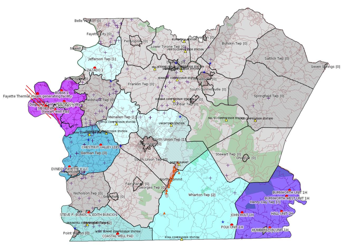
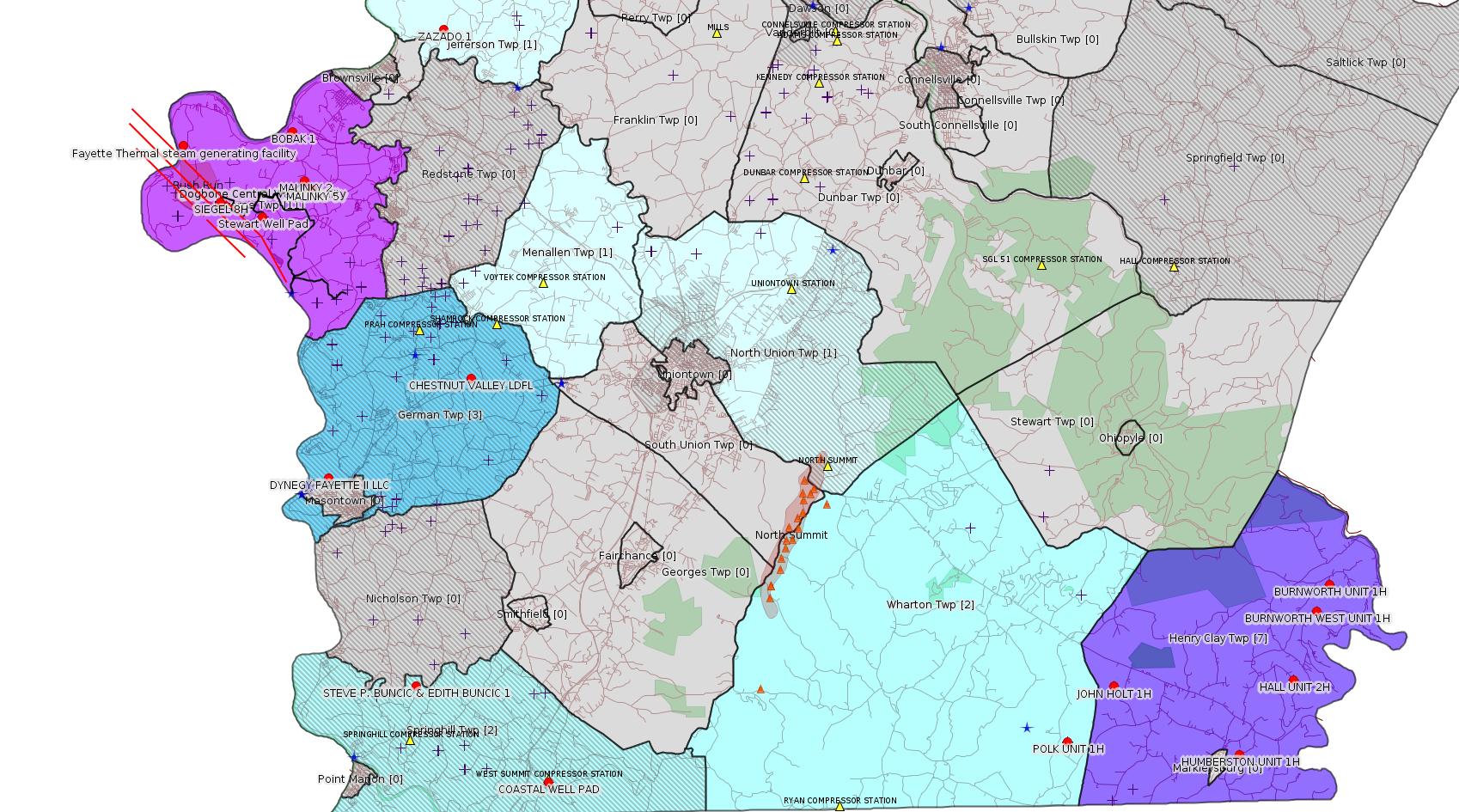
Map
Key
Red dots: items in this permit list with an exact location.
Blue stars: Marcellus Gas Well Water Sources.
Where well laterals are mapped they show in red; a 400-foot buffer surrounding the lateral shows in blue (lavender where it overlaps a mapped mineral tract).
Where mineral tracts are mapped, they show in pink. Mineral tracts can overlap; the overlap will show in red. The precise meaning of "mineral tract" is not clear.
Municipality shading: number of "facilities", with each well counting separately
(includes the red dots):
gray: 0
pale turquoise: 1
turquoise: 2
pale blue: 3
middle blue: 4
dark blue: 5
dark purple: 7
purple: 11
(Color coding may differ from one issue to the next.)
(Note if a project spans multiple municipalities -- e.g. a pipeline -- it will show in the count for each municipality.)
The number of facilities also follows the municipality name in brackets.
Municipality counts are based on the way the permit is listed by DEP; DEP has been known to get a municipality wrong.
Locations in brackets identify a precise location used to locate a surrogate for the actual site being permitted (e.g. locating a well pad or pipeline by the known location of a well.) Locations labeled beginning with "~" and ending in "[?]" are approximate and speculative based on inferences using on-line property and lease records. These are marked in the text as "[Approximate, Speculative]
Cross-hatching: Environmental Justice Areas
Yellow triangles: Compressor Stations
Orange triangles: Storage Field Wells (currently Dominion North Summit Storage Field)
Crosses: SPUD Unconventional well permits
Green: "Natural areas", e.g. state game lands, state forests
Yellow triangles: Compressor Stations
Orange triangles: Storage Field Wells (currently Dominion North Summit Storage Field)
Crosses: SPUD Unconventional well permits
Green: "Natural areas", e.g. state game lands, state forests
More Maps
 |
 |
 |
Source: Pennsylvania Bulletin
26-00535B: Dynegy Fayette II, LLC (100 Energy Drive, Masontown, PA 15461-2588) plan approval extension effective February 28, 2021, with expiration on August 28, 2021, to extend the period of temporary operation of the modified combustion gas turbines (''CGT'') at Fayette Energy Center located in German Township, Fayette County.
<http://www.pacodeandbulletin.gov/Display/pabull?file=/secure/pabulletin/data/vol51/51-9/290c.html&continued=http://www.pacodeandbulletin.gov/Display/pabull?file=/secure/pabulletin/data/vol51/51-9/290.html&d=reduce>
Location: 39.857408,-79.913878
Map URL: <http://www.openstreetmap.org/?mlat=39.857408&mlon=-79.913878#map=15/39.857408/-79.913878>
Map URL: <http://www.openstreetmap.org/?mlat=39.857408&mlon=-79.913878#map=15/39.857408/-79.913878>
Presumed Parcel Id: 1530006703
---
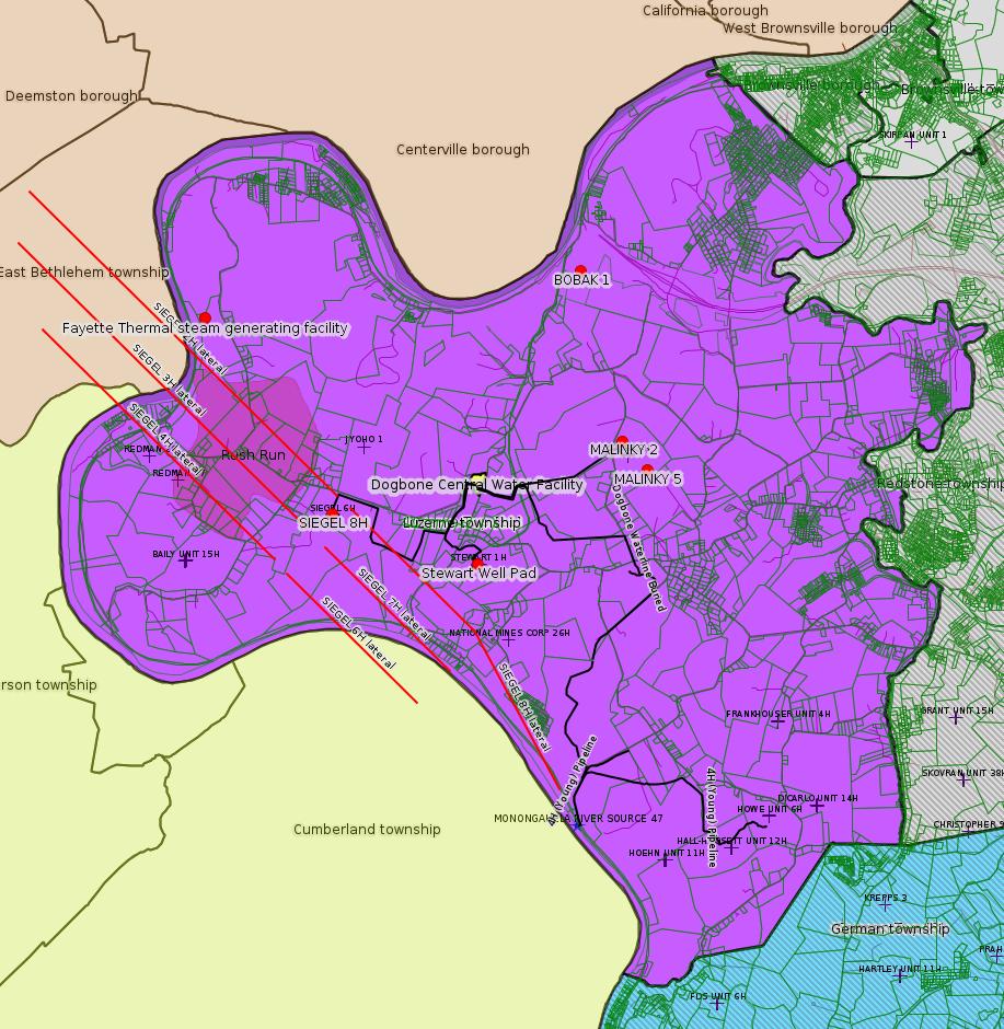
26-00534: Fayette Thermal, LLC (399 LaBelle Road, East Millsboro, PA 15433-1139) on February 11, 2021, the Department of Environmental Protection issued a renewed synthetic minor State-Only Operating Permit for the continued operation of a steam generating facility located in Luzerne Township, Fayette County. This facility is subject to the applicable requirements of 25 Pa. Code Chapters 121—145 and the applicable provisions of 40 CFR Part 60 Subpart Dc. The permit includes emission restrictions, operating requirements, monitoring requirements, work practice standards, and recordkeeping requirements for the site.
<http://www.pacodeandbulletin.gov/Display/pabull?file=/secure/pabulletin/data/vol51/51-9/290c.html&continued=http://www.pacodeandbulletin.gov/Display/pabull?file=/secure/pabulletin/data/vol51/51-9/290.html&d=reduce>
---
26-00534: Fayette Thermal, LLC (399 LaBelle Road, East Millsboro, PA 15433-1139) on February 11, 2021, the Department of Environmental Protection issued a renewed synthetic minor State-Only Operating Permit for the continued operation of a steam generating facility located in Luzerne Township, Fayette County. This facility is subject to the applicable requirements of 25 Pa. Code Chapters 121—145 and the applicable provisions of 40 CFR Part 60 Subpart Dc. The permit includes emission restrictions, operating requirements, monitoring requirements, work practice standards, and recordkeeping requirements for the site.
<http://www.pacodeandbulletin.gov/Display/pabull?file=/secure/pabulletin/data/vol51/51-9/290c.html&continued=http://www.pacodeandbulletin.gov/Display/pabull?file=/secure/pabulletin/data/vol51/51-9/290.html&d=reduce>
Location: 39.992222,-79.988056
<https://www.openstreetmap.org/?mlat=39.992222&mlon=-79.988056#map=15/39.9922/-79.9881>
Presumed Parcel Id: 19020013
<https://www.openstreetmap.org/?mlat=39.992222&mlon=-79.988056#map=15/39.9922/-79.9881>
Presumed Parcel Id: 19020013
-------------------------
Source: eNOTICE
(+ PA
Oil and Gas Mapping, Well
Pad Report.) Well Details via Data
Portal Services: Oil and Gas Wells All (ID: 3).
Please see the Disclaimer below regarding Parcel Id data.
Authorization ID: 1343977
Permit number: 051-20810
Site: EDITH & STEVE P BUNCIC 1 WELL
Client: BURKLAND WILLIAM S
Authorization type: Well Plugging Notice Alternate Method
Application type: New
Authorization is for: FACILITY
Date received: 02/26/2021
Status: Issued on 3/1/2021
Permit Decision Guarantee Applies: No
Sub-Facilities for Authorization:
Sub-Facility ID Sub-Facility Name Description
56987 STEVE P. BUNCIC & EDITH BUNCIC 1 Well
Permit Review Notes:
Date Review Note
3/1/2021 The technical review and decision review are complete and either the permit decision and/or permit issuance are forthcoming.
2/26/2021 The permit application package is complete, has been accepted, and is undergoing technical review.
<https://www.ahs.dep.pa.gov/eFACTSWeb/searchResults_singleAuth.aspx?AuthID=1343977>
Site Programs:
Oil & Gas
Site Municipalities:
Springhill Twp, Fayette County
Well Details:
Permit Number: 051-20810
Well Name: STEVE P. BUNCIC & EDITH BUNCIC 1
Unconventional Well: N
Well Configuration: Vertical Well
Well Type: GAS
Well Status: Active
Coal Association: Coal
Conservation Well: N
Primary Facility ID: 43457
Site ID: 41705
Site Name: EDITH & STEVE P BUNCIC 1 WELL
Well Pad ID: 0
Well Pad Name:
Storage Field:
Operator: THE PRODUCTION CO LLC
Operator Number: OGO-39567
Permit Date: 1996-02-21
Permit Date Expires: 1997-02-21
SPUD Date: 1996-03-09
Date Plugged:
UIC ID:
UIC Type:
Surface Elevation: 1100
County: Fayette
Municipality: Springhill Twp
Location: 39.773047,-79.869606
Map URL: <http://www.openstreetmap.org/?mlat=39.773047&mlon=-79.869606#map=15/39.773047/-79.869606>
OG WELLS PERMIT DOCS:
2021-03-04: Final Permit Documents, Name: 051-20810 - Notice of Intent to Plug (for Authorization: 1343970.0):
<http://www.depgis.state.pa.us/pdfHandler/pdFHandler.ashx?Doc=MTY5NzE3Ni4w&ext=PDF>
2021-03-01: Final Permit Documents, Name: 051-20810 - Alternate Method (for Authorization: 1343977.0):
<http://www.depgis.state.pa.us/pdfHandler/pdFHandler.ashx?Doc=MTY5MzM2Ni4w&ext=PDF>
Presumed Parcel Id: 36070045
---
Authorization ID: 1343970
Permit number: 051-20810
Site: EDITH & STEVE P BUNCIC 1 WELL
Client: BURKLAND WILLIAM S
Authorization type: Well Plugging Notice Intent to Plug Single Well
Application type: New
Authorization is for: FACILITY
Date received: 02/26/2021
Status: Pending
Permit Decision Guarantee Applies: No
Sub-Facilities for Authorization:
Sub-Facility ID Sub-Facility Name Description
56987 STEVE P. BUNCIC & EDITH BUNCIC 1 Well
Permit Review Notes:
Date Review Note
3/4/2021 The technical review and decision review are complete and either the permit decision and/or permit issuance are forthcoming.
2/26/2021 The permit application package is complete, has been accepted, and is undergoing technical review.
<https://www.ahs.dep.pa.gov/eFACTSWeb/searchResults_singleAuth.aspx?AuthID=1343970>
Site Programs:
Oil & Gas
Site Municipalities:
Springhill Twp, Fayette County
Well Details:
Permit Number: 051-20810
Well Name: STEVE P. BUNCIC & EDITH BUNCIC 1
Unconventional Well: N
Well Configuration: Vertical Well
Well Type: GAS
Well Status: Active
Coal Association: Coal
Conservation Well: N
Primary Facility ID: 43457
Site ID: 41705
Site Name: EDITH & STEVE P BUNCIC 1 WELL
Well Pad ID: 0
Well Pad Name:
Storage Field:
Operator: THE PRODUCTION CO LLC
Operator Number: OGO-39567
Permit Date: 1996-02-21
Permit Date Expires: 1997-02-21
SPUD Date: 1996-03-09
Date Plugged:
UIC ID:
UIC Type:
Surface Elevation: 1100
County: Fayette
Municipality: Springhill Twp
Location: 39.773047,-79.869606
Map URL: <http://www.openstreetmap.org/?mlat=39.773047&mlon=-79.869606#map=15/39.773047/-79.869606>
OG WELLS PERMIT DOCS:
2021-03-04: Final Permit Documents, Name: 051-20810 - Notice of Intent to Plug (for Authorization: 1343970.0):
<http://www.depgis.state.pa.us/pdfHandler/pdFHandler.ashx?Doc=MTY5NzE3Ni4w&ext=PDF>
2021-03-01: Final Permit Documents, Name: 051-20810 - Alternate Method (for Authorization: 1343977.0):
<http://www.depgis.state.pa.us/pdfHandler/pdFHandler.ashx?Doc=MTY5MzM2Ni4w&ext=PDF>
---
Authorization ID: 1343884
Permit number: 051-22541
Site: BOBAK 1 OG WELL
Client: BURKLAND WILLIAM S
Authorization type: Well Plugging Notice Alternate Method
Application type: New
Authorization is for: FACILITY
Date received: 02/12/2021
Status: Pending
Permit Decision Guarantee Applies: No
Sub-Facilities for Authorization:
Sub-Facility ID Sub-Facility Name Description
842494 BOBAK 1 Well
Permit Review Notes:
Date Review Note
2/25/2021 The permit application package is complete, has been accepted, and is undergoing technical review.
<https://www.ahs.dep.pa.gov/eFACTSWeb/searchResults_singleAuth.aspx?AuthID=1343884>
Site Programs:
Oil & Gas
Site Municipalities:
Luzerne Twp, Fayette County
Well Details:
Permit Number: 051-22541
Well Name: BOBAK 1
Unconventional Well: N
Well Configuration: Vertical Well
Well Type: GAS
Well Status: Active
Coal Association: NonCoal
Conservation Well: N
Primary Facility ID: 662605
Site ID: 648552
Site Name: BOBAK 1 OG WELL
Well Pad ID: 0
Well Pad Name:
Storage Field:
Operator: THE PRODUCTION CO LLC
Operator Number: OGO-39567
Permit Date: 2005-03-16
Permit Date Expires: 2006-03-16
SPUD Date: 2005-10-21
Date Plugged:
UIC ID:
UIC Type:
Surface Elevation: 1022
County: Fayette
Municipality: Luzerne Twp
Location: 39.99718,-79.930647
Map URL: <http://www.openstreetmap.org/?mlat=39.99718&mlon=-79.930647#map=15/39.99718/-79.930647>
OG WELLS PERMIT DOCS:
2021-03-04: Other Permit Documents, Name: 051-22541_William Burkland_G Bobak_NOI_2-12-21_noncoal_signed_sa (for Authorization: 1343860.0):
<http://www.depgis.state.pa.us/pdfHandler/pdFHandler.ashx?Doc=MTY5NzE1My4w&ext=PDF>
---
Authorization ID: 1343873
Permit number: ESX10-051-0035
Site: COASTAL 1H FLOW BACK PIT FRESHWATER PITS ESCGP-EXPEDITED
Client: INR OPR LLC
Authorization type: Erosion and Sediment Control GP-2
Application type: Amendment
Authorization is for: SITE
Date received: 02/19/2021
Status: Pending
Permit Decision Guarantee Applies: Yes
Permit Decision Guarantee status: ACTIVE
<https://www.ahs.dep.pa.gov/eFACTSWeb/searchResults_singleAuth.aspx?AuthID=1343873>
Site Programs:
Oil & Gas
Site Municipalities:
Springhill Twp, Fayette County
Impoundment Registration Application:
<https://www.ahs.dep.pa.gov/eSubmissionsDocs/DownloadESubmissionDocument.ashx?enc=MOpmV6IzBtmToVjqF07C9WdKYxRCgcjmE1buypYBlyw%3d>
Coastal Well Pad Expansion Geotechnical Report 02.26.2021:
<https://www.ahs.dep.pa.gov/eSubmissionsDocs/DownloadESubmissionDocument.ashx?enc=MOpmV6IzBtmToVjqF07C9ZdGBDJ3Pkup1CNdrCFixHQ%3d>
Well Pad ID: 147971
Well Pad Name: COASTAL WELL PAD
Primary Facility ID: 726470
Wells on this Pad:
Location: 39.733294,-79.801028
Presumed Parcel Id: 36210048
---
Authorization ID: 1343860
Permit number: 051-22541
Site: BOBAK 1 OG WELL
Client: BURKLAND WILLIAM S
Authorization type: Well Plugging Notice Intent to Plug Single Well
Application type: New
Authorization is for: FACILITY
Date received: 02/12/2021
Status: Pending
Permit Decision Guarantee Applies: No
Sub-Facilities for Authorization:
Sub-Facility ID Sub-Facility Name Description
842494 BOBAK 1 Well
Permit Review Notes:
Date Review Note
3/4/2021 The technical review and decision review are complete and either the permit decision and/or permit issuance are forthcoming.
2/25/2021 The permit application package is complete, has been accepted, and is undergoing technical review.
<https://www.ahs.dep.pa.gov/eFACTSWeb/searchResults_singleAuth.aspx?AuthID=1343860>
Site Programs:
Oil & Gas
Site Municipalities:
Luzerne Twp, Fayette County
Well Details:
Permit Number: 051-22541
Well Name: BOBAK 1
Unconventional Well: N
Well Configuration: Vertical Well
Well Type: GAS
Well Status: Active
Coal Association: NonCoal
Conservation Well: N
Primary Facility ID: 662605
Site ID: 648552
Site Name: BOBAK 1 OG WELL
Well Pad ID: 0
Well Pad Name:
Storage Field:
Operator: THE PRODUCTION CO LLC
Operator Number: OGO-39567
Permit Date: 2005-03-16
Permit Date Expires: 2006-03-16
SPUD Date: 2005-10-21
Date Plugged:
UIC ID:
UIC Type:
Surface Elevation: 1022
County: Fayette
Municipality: Luzerne Twp
Location: 39.99718,-79.930647
Map URL: <http://www.openstreetmap.org/?mlat=39.99718&mlon=-79.930647#map=15/39.99718/-79.930647>
OG WELLS PERMIT DOCS:
2021-03-04: Other Permit Documents, Name: 051-22541_William Burkland_G Bobak_NOI_2-12-21_noncoal_signed_sa (for Authorization: 1343860.0):
<http://www.depgis.state.pa.us/pdfHandler/pdFHandler.ashx?Doc=MTY5NzE1My4w&ext=PDF>
---
Authorization ID: 1343740
Permit number: 100419
Site: CHESTNUT VALLEY LDFL
Client: ADVANCED DSPL SVC CHESTNUT VALLEY LDFL INC
Authorization type: Landfill Permit
Application type: Reissue
Authorization is for: FACILITY
Date received: 02/23/2021
Status: Pending
Permit Decision Guarantee Applies: No
Sub-Facilities for Authorization:
Sub-Facility ID Sub-Facility Name Description
212043 J&J LANDFILL Landfill
Location: 39.896749,-79.838809
Map URL: <http://www.openstreetmap.org/?mlat=39.896749&mlon=-79.838809#map=15/39.896749/-79.838809>
<https://www.ahs.dep.pa.gov/eFACTSWeb/searchResults_singleAuth.aspx?AuthID=1343740>
Site Programs:
Air Quality
Clean Water
Environmental Cleanup & Brownfields
Mining
Radiation Protection
Waste Management
Water Planning and Conservation
Site Municipalities:
German Twp, Fayette County
---
Authorization ID: 1343083
Permit number: 051-22954
Site: ZAZADO 1 OG WELL
Client: BURKLAND WILLIAM S
Authorization type: Well Plugging Notice Alternate Method
Application type: New
Authorization is for: FACILITY
Date received: 02/17/2021
Status: Pending
Permit Decision Guarantee Applies: No
Sub-Facilities for Authorization:
Sub-Facility ID Sub-Facility Name Description
903992 ZAZADO 1 Well
Permit Review Notes:
Date Review Note
3/3/2021 The technical review and decision review are complete and either the permit decision and/or permit issuance are forthcoming.
2/18/2021 The permit application package is complete, has been accepted, and is undergoing technical review.
<https://www.ahs.dep.pa.gov/eFACTSWeb/searchResults_singleAuth.aspx?AuthID=1343083>
Site Programs:
Oil & Gas
Site Municipalities:
Jefferson Twp, Fayette County
Well Details:
Permit Number: 051-22954
Well Name: ZAZADO 1
Unconventional Well: N
Well Configuration: Vertical Well
Well Type: GAS
Well Status: Active
Coal Association: NonCoal
Conservation Well: N
Primary Facility ID: 671706
Site ID: 660426
Site Name: ZAZADO 1 OG WELL
Well Pad ID: 0
Well Pad Name:
Storage Field:
Operator: THE PRODUCTION CO LLC
Operator Number: OGO-39567
Permit Date: 2005-09-26
Permit Date Expires: 2006-09-26
SPUD Date: 2006-01-19
Date Plugged:
UIC ID:
UIC Type:
Surface Elevation: 1185
County: Fayette
Municipality: Jefferson Twp
Location: 40.037788,-79.850585
Map URL: <http://www.openstreetmap.org/?mlat=40.037788&mlon=-79.850585#map=15/40.037788/-79.850585>
---
Authorization ID: 1343082
Permit number: 051-22954
Site: ZAZADO 1 OG WELL
Client: BURKLAND WILLIAM S
Authorization type: Well Plugging Notice Intent to Plug Single Well
Application type: New
Authorization is for: FACILITY
Date received: 02/17/2021
Status: Issued on 2/22/2021
Permit Decision Guarantee Applies: No
Sub-Facilities for Authorization:
Sub-Facility ID Sub-Facility Name Description
903992 ZAZADO 1 Well
Permit Review Notes:
Date Review Note
2/22/2021 The technical review and decision review are complete and either the permit decision and/or permit issuance are forthcoming.
2/18/2021 The permit application package is complete, has been accepted, and is undergoing technical review.
<https://www.ahs.dep.pa.gov/eFACTSWeb/searchResults_singleAuth.aspx?AuthID=1343082>
Site Programs:
Oil & Gas
Site Municipalities:
Jefferson Twp, Fayette County
Well Details:
Permit Number: 051-22954
Well Name: ZAZADO 1
Unconventional Well: N
Well Configuration: Vertical Well
Well Type: GAS
Well Status: Active
Coal Association: NonCoal
Conservation Well: N
Primary Facility ID: 671706
Site ID: 660426
Site Name: ZAZADO 1 OG WELL
Well Pad ID: 0
Well Pad Name:
Storage Field:
Operator: THE PRODUCTION CO LLC
Operator Number: OGO-39567
Permit Date: 2005-09-26
Permit Date Expires: 2006-09-26
SPUD Date: 2006-01-19
Date Plugged:
UIC ID:
UIC Type:
Surface Elevation: 1185
County: Fayette
Municipality: Jefferson Twp
Location: 40.037788,-79.850585
Map URL: <http://www.openstreetmap.org/?mlat=40.037788&mlon=-79.850585#map=15/40.037788/-79.850585>
---
Authorization ID: 1341972
Permit number: 051-24647
Site: SIEGEL WELL PAD ESCGP-2 EXPEDITED
Client: EQT CHAP LLC
Authorization type: Drill & Operate Well Permit (Unconventional)
Application type: Modification
Authorization is for: FACILITY
Date received: 02/08/2021
Status: Pending
Public_Permit_Review:
<http://www.ahs.dep.pa.gov/ePermitPublicAccess/Public/PublicAuthOverview?q=p3NJa1yi7M1Daddph4KBSZPHxxKmkDTy8lcAPGnUkas%3d>
Plat:
<https://www.ahs.dep.pa.gov/ePermitPublicAccess/Public/DownloadFileFromWebServer/58749?onBaseDocId=3534747>
Permit Decision Guarantee status: ACTIVE
Permit Review Notes:
Date Review Note
2/10/2021 The permit application package is complete, has been accepted, and is undergoing technical review.
<https://www.ahs.dep.pa.gov/eFACTSWeb/searchResults_singleAuth.aspx?AuthID=1341972>
Site Programs:
Environmental Cleanup & Brownfields
Oil & Gas
Site Municipalities:
Luzerne Twp, Fayette County
Well Details:
Permit Number: 051-24647
Well Name: SIEGEL 8H
Unconventional Well: Y
Well Configuration: Horizontal Well
Well Type: GAS
Well Status: Active
Coal Association: Coal
Conservation Well: N
Primary Facility ID: 823795
Site ID: 790384
Site Name: SIEGEL WELL PAD ESCGP-2 EXPEDITED
Well Pad ID: 152926
Well Pad Name: SIEGEL 1
Storage Field:
Operator: EQT CHAP LLC
Operator Number: OGO-39307
Permit Date: 2018-02-23
Permit Date Expires: 2021-05-14
SPUD Date: 2018-04-02
Date Plugged:
UIC ID:
UIC Type:
Surface Elevation: 1173
County: Fayette
Municipality: Luzerne Twp
Location: 39.968997,-79.968928
Map URL: <http://www.openstreetmap.org/?mlat=39.968997&mlon=-79.968928#map=15/39.968997/-79.968928>
OG WELLS PERMIT DOCS:
2020-02-13: Final Permit Documents, Name: 1212441 (for Authorization: 1212441.0):
<http://www.depgis.state.pa.us/pdfHandler/pdFHandler.ashx?Doc=NTY0ODc0LjA=&ext=PDF>
2020-02-13: Final Permit Documents, Name: Auth No. 1270807 (for Authorization: 1270807.0):
<http://www.depgis.state.pa.us/pdfHandler/pdFHandler.ashx?Doc=ODM4MDA3LjA=&ext=PDF>
2020-02-13: Final Permit Documents, Name: Auth No. 1285217 (for Authorization: 1285217.0):
<http://www.depgis.state.pa.us/pdfHandler/pdFHandler.ashx?Doc=OTI1ODA3LjA=&ext=PDF>
2021-02-08: Final Permit Documents, Name: Auth 1311295 051-24647-00-01 (for Authorization: 1311295.0):
<http://www.depgis.state.pa.us/pdfHandler/pdFHandler.ashx?Doc=MTIyODIzNi4w&ext=PDF>
Electronically Submitted Records:
2021-02-08: Submission for Authorization 1311295.0
Pennsylvania Natural Diversity Inventory Form: Siegel PNDI 3.26.20.pdf
<http://www.depgis.state.pa.us/eWellDocHandler/pdFHandler.ashx?Doc=MTE0Njc5MS4w&ext=PDF>
Permit Application to Drill and Operate a Well: Siegel 8H_Drill Permit Application_4.2020.pdf
<http://www.depgis.state.pa.us/eWellDocHandler/pdFHandler.ashx?Doc=MTE0Njc5Mi4w&ext=PDF>
Interested Party Notification: Siegel 8H Int Party 4.14.20.pdf
<http://www.depgis.state.pa.us/eWellDocHandler/pdFHandler.ashx?Doc=MTE0NzA4OC4w&ext=PDF>
Coal and Gas Resource Coord Act - Section 7 Exception: Siegel Waiver Request Section 7.pdf
<http://www.depgis.state.pa.us/eWellDocHandler/pdFHandler.ashx?Doc=MTE0NzI4NS4w&ext=PDF>
Well Cross-Section Diagram: Siegel Pad A_08H_Page 4.pdf
<http://www.depgis.state.pa.us/eWellDocHandler/pdFHandler.ashx?Doc=MTE0NzI4Ni4w&ext=PDF>
Location Plat: 143-781-Well Plat 8H-pages1-2-3_3702.dwg
<http://www.depgis.state.pa.us/eWellDocHandler/pdFHandler.ashx?Doc=MTE0NzI5Ny4w&ext=PDF>
Well Permit Application - Coal Module: Siegel Coal Module_4.15.20.pdf
<http://www.depgis.state.pa.us/eWellDocHandler/pdFHandler.ashx?Doc=MTE0Nzc5MC4w&ext=PDF>
Electronic Submission Docket: 2108825.pdf
<http://www.depgis.state.pa.us/eWellDocHandler/pdFHandler.ashx?Doc=MTE0ODUxNS4w&ext=PDF>
2020-02-13: Submission for Authorization 1285217.0
Location Plat: 143-781-Well Plat 8H-pages1-2-3_3702.dwg
<http://www.depgis.state.pa.us/eWellDocHandler/pdFHandler.ashx?Doc=OTI0MDgxLjA=&ext=PDF>
Pennsylvania Natural Diversity Inventory Form: Siegel PNDI.pdf
<http://www.depgis.state.pa.us/eWellDocHandler/pdFHandler.ashx?Doc=OTI0MDg3LjA=&ext=PDF>
Permit Application to Drill and Operate a Well: Siegel 8H_Signed application.pdf
<http://www.depgis.state.pa.us/eWellDocHandler/pdFHandler.ashx?Doc=OTI3NDM5LjA=&ext=PDF>
Well Cross-Section Diagram: Siegel Pad A_08H_Page 4.pdf
<http://www.depgis.state.pa.us/eWellDocHandler/pdFHandler.ashx?Doc=OTI3NDQxLjA=&ext=PDF>
Coal and Gas Resource Coord Act - Section 7 Exception: Siegel Waiver Request Section 7.pdf
<http://www.depgis.state.pa.us/eWellDocHandler/pdFHandler.ashx?Doc=OTI4NTEzLjA=&ext=PDF>
Well Permit Application - Coal Module: Siegel Coal Module_Modification.pdf
<http://www.depgis.state.pa.us/eWellDocHandler/pdFHandler.ashx?Doc=OTI4NTE0LjA=&ext=PDF>
Interested Party Notification: Siegel 8H_Interested Party_Mod.pdf
<http://www.depgis.state.pa.us/eWellDocHandler/pdFHandler.ashx?Doc=OTMwMjU5LjA=&ext=PDF>
Electronic Submission Docket: 1998323.pdf
<http://www.depgis.state.pa.us/eWellDocHandler/pdFHandler.ashx?Doc=OTMxMDU0LjA=&ext=PDF>
2020-02-13: Submission for Authorization 1270807.0
Pennsylvania Natural Diversity Inventory Form: Siegel PNDI.pdf
<http://www.depgis.state.pa.us/eWellDocHandler/pdFHandler.ashx?Doc=ODIwNzM4LjA=&ext=PDF>
Well Cross-Section Diagram: Siegel 8H Page 4.pdf
<http://www.depgis.state.pa.us/eWellDocHandler/pdFHandler.ashx?Doc=ODIwNzQyLjA=&ext=PDF>
Well Permit Application - Coal Module: Siegel Coal Module.pdf
<http://www.depgis.state.pa.us/eWellDocHandler/pdFHandler.ashx?Doc=ODIwNzQzLjA=&ext=PDF>
Coal and Gas Resource Coord Act - Section 7 Exception: Siegel Waiver Request Section 7.pdf
<http://www.depgis.state.pa.us/eWellDocHandler/pdFHandler.ashx?Doc=ODI0MzQwLjA=&ext=PDF>
Permit Application to Drill and Operate a Well: Siegel 8H_Drill Permit Application.pdf
<http://www.depgis.state.pa.us/eWellDocHandler/pdFHandler.ashx?Doc=ODI0NzczLjA=&ext=PDF>
Interested Party Notification: Siegel 8H_Record of Notification.pdf
<http://www.depgis.state.pa.us/eWellDocHandler/pdFHandler.ashx?Doc=ODQwNDgyLjA=&ext=PDF>
Location Plat: 143-781-Well Plat 8H-pages1-2-3_3702.dwg
<http://www.depgis.state.pa.us/eWellDocHandler/pdFHandler.ashx?Doc=ODU2MzY5LjA=&ext=PDF>
Electronic Submission Docket: 1929166.pdf
<http://www.depgis.state.pa.us/eWellDocHandler/pdFHandler.ashx?Doc=ODU2Mzc0LjA=&ext=PDF>
2020-02-13: Submission for Authorization 1212441.0
Interested Party Notification: Siegel Affidavit of Non-Delivery Foster.pdf
<http://www.depgis.state.pa.us/eWellDocHandler/pdFHandler.ashx?Doc=NDQ5MDQ0LjA=&ext=PDF>
Interested Party Notification: Siegel Affidavit of Non-Delivery Foster.pdf
<http://www.depgis.state.pa.us/eWellDocHandler/pdFHandler.ashx?Doc=NDQ5MDQ1LjA=&ext=PDF>
Interested Party Notification: Siegel Affidavit of Non-Delivery Foster.pdf
<http://www.depgis.state.pa.us/eWellDocHandler/pdFHandler.ashx?Doc=NDQ5MDQ2LjA=&ext=PDF>
Interested Party Notification: Siegel Affidavit of Non-Delivery Foster.pdf
<http://www.depgis.state.pa.us/eWellDocHandler/pdFHandler.ashx?Doc=NDQ5MDUwLjA=&ext=PDF>
Interested Party Notification: Siegel Affidavit of Non-Delivery Foster.pdf
<http://www.depgis.state.pa.us/eWellDocHandler/pdFHandler.ashx?Doc=NDQ5MDUxLjA=&ext=PDF>
Interested Party Notification: Siegel Affidavit of Non-Delivery Foster.pdf
<http://www.depgis.state.pa.us/eWellDocHandler/pdFHandler.ashx?Doc=NDQ5MDUyLjA=&ext=PDF>
Interested Party Notification: Siegel Affidavit of Non-Delivery Foster.pdf
<http://www.depgis.state.pa.us/eWellDocHandler/pdFHandler.ashx?Doc=NDQ5MDUzLjA=&ext=PDF>
Interested Party Notification: Siegel Affidavit of Non-Delivery Franks.pdf
<http://www.depgis.state.pa.us/eWellDocHandler/pdFHandler.ashx?Doc=NDQ5MDU0LjA=&ext=PDF>
Interested Party Notification: Siegel Affidavit of Non-Delivery Franks.pdf
<http://www.depgis.state.pa.us/eWellDocHandler/pdFHandler.ashx?Doc=NDQ5MDU1LjA=&ext=PDF>
Pennsylvania Natural Diversity Inventory Form: Siegel PNDI.pdf
<http://www.depgis.state.pa.us/eWellDocHandler/pdFHandler.ashx?Doc=NDQ5MDU2LjA=&ext=PDF>
Location Plat: 143-781-Well Plat 8H-pages1-2-3_3702.dwg
<http://www.depgis.state.pa.us/eWellDocHandler/pdFHandler.ashx?Doc=NDQ5MDU3LjA=&ext=PDF>
Coal and Gas Resource Coord Act - Section 7 Exception: Siegel 1H-9H Waiver Request Section 7.pdf
<http://www.depgis.state.pa.us/eWellDocHandler/pdFHandler.ashx?Doc=NDQ5MDU4LjA=&ext=PDF>
Well Cross-Section Diagram: Siegel 8H Page 4.pdf
<http://www.depgis.state.pa.us/eWellDocHandler/pdFHandler.ashx?Doc=NDQ5MDU5LjA=&ext=PDF>
Permit Application to Drill and Operate a Well: 1640184.pdf
<http://www.depgis.state.pa.us/eWellDocHandler/pdFHandler.ashx?Doc=NDQ5ODMwLjA=&ext=PDF>
Presumed Parcel Id: 19240018
---
Authorization ID: 1341962
Permit number: 051-24646
Site: SIEGEL WELL PAD ESCGP-2 EXPEDITED
Client: EQT CHAP LLC
Authorization type: Drill & Operate Well Permit (Unconventional)
Application type: Modification
Authorization is for: FACILITY
Date received: 02/08/2021
Status: Pending
Public_Permit_Review:
<http://www.ahs.dep.pa.gov/ePermitPublicAccess/Public/PublicAuthOverview?q=8s6eLrfemv6m3pnnB2nbN%2bMRgLTNGRIMGBcsmcpFCak%3d>
Plat:
<https://www.ahs.dep.pa.gov/ePermitPublicAccess/Public/DownloadFileFromWebServer/58711?onBaseDocId=3534624>
Permit Decision Guarantee status: ACTIVE
Permit Review Notes:
Date Review Note
2/10/2021 The permit application package is complete, has been accepted, and is undergoing technical review.
<https://www.ahs.dep.pa.gov/eFACTSWeb/searchResults_singleAuth.aspx?AuthID=1341962>
Site Programs:
Environmental Cleanup & Brownfields
Oil & Gas
Site Municipalities:
Luzerne Twp, Fayette County
Well Details:
Permit Number: 051-24646
Well Name: SIEGEL 7H
Unconventional Well: Y
Well Configuration: Horizontal Well
Well Type: GAS
Well Status: Active
Coal Association: Coal
Conservation Well: N
Primary Facility ID: 823794
Site ID: 790384
Site Name: SIEGEL WELL PAD ESCGP-2 EXPEDITED
Well Pad ID: 152926
Well Pad Name: SIEGEL 1
Storage Field:
Operator: EQT CHAP LLC
Operator Number: OGO-39307
Permit Date: 2018-02-23
Permit Date Expires: 2021-05-14
SPUD Date: 2018-04-02
Date Plugged:
UIC ID:
UIC Type:
Surface Elevation: 1173
County: Fayette
Municipality: Luzerne Twp
Location: 39.968956,-79.968994
Map URL: <http://www.openstreetmap.org/?mlat=39.968956&mlon=-79.968994#map=15/39.968956/-79.968994>
OG WELLS PERMIT DOCS:
2020-02-13: Final Permit Documents, Name: 1212440 (for Authorization: 1212440.0):
<http://www.depgis.state.pa.us/pdfHandler/pdFHandler.ashx?Doc=NTYzOTU3LjA=&ext=PDF>
2020-02-13: Final Permit Documents, Name: Auth No. 1270809 (for Authorization: 1270809.0):
<http://www.depgis.state.pa.us/pdfHandler/pdFHandler.ashx?Doc=ODM4MDUyLjA=&ext=PDF>
2020-02-13: Final Permit Documents, Name: Auth No. 1285220 (for Authorization: 1285220.0):
<http://www.depgis.state.pa.us/pdfHandler/pdFHandler.ashx?Doc=OTI1ODAxLjA=&ext=PDF>
2021-02-08: Final Permit Documents, Name: Auth 1311290_051-24646-00-01 (for Authorization: 1311290.0):
<http://www.depgis.state.pa.us/pdfHandler/pdFHandler.ashx?Doc=MTIyODIzNC4w&ext=PDF>
Electronically Submitted Records:
2021-02-08: Submission for Authorization 1311290.0
Pennsylvania Natural Diversity Inventory Form: Siegel PNDI 3.26.20.pdf
<http://www.depgis.state.pa.us/eWellDocHandler/pdFHandler.ashx?Doc=MTE0Njc3Ny4w&ext=PDF>
Permit Application to Drill and Operate a Well: Siegel 7H_Drill Permit Application_4.2020.pdf
<http://www.depgis.state.pa.us/eWellDocHandler/pdFHandler.ashx?Doc=MTE0Njc3OC4w&ext=PDF>
Interested Party Notification: Siegel 7H Int Party 4.14.20.pdf
<http://www.depgis.state.pa.us/eWellDocHandler/pdFHandler.ashx?Doc=MTE0NzA4Ny4w&ext=PDF>
Location Plat: 143-781-Well Plat 7H-pages1-2-3_3702.dwg
<http://www.depgis.state.pa.us/eWellDocHandler/pdFHandler.ashx?Doc=MTE0NzI2Ny4w&ext=PDF>
Coal and Gas Resource Coord Act - Section 7 Exception: Siegel Waiver Request Section 7.pdf
<http://www.depgis.state.pa.us/eWellDocHandler/pdFHandler.ashx?Doc=MTE0NzI2OC4w&ext=PDF>
Well Cross-Section Diagram: Siegel Pad A_07H_Page 4.pdf
<http://www.depgis.state.pa.us/eWellDocHandler/pdFHandler.ashx?Doc=MTE0NzI2OS4w&ext=PDF>
Well Permit Application - Coal Module: Siegel Coal Module_4.15.20.pdf
<http://www.depgis.state.pa.us/eWellDocHandler/pdFHandler.ashx?Doc=MTE0Nzc4OS4w&ext=PDF>
Electronic Submission Docket: 2108816.pdf
<http://www.depgis.state.pa.us/eWellDocHandler/pdFHandler.ashx?Doc=MTE0ODUwMy4w&ext=PDF>
2020-02-13: Submission for Authorization 1270809.0
Pennsylvania Natural Diversity Inventory Form: Siegel PNDI.pdf
<http://www.depgis.state.pa.us/eWellDocHandler/pdFHandler.ashx?Doc=ODIwNzI4LjA=&ext=PDF>
Well Cross-Section Diagram: Siegel 7H Page 4.pdf
<http://www.depgis.state.pa.us/eWellDocHandler/pdFHandler.ashx?Doc=ODIwNzMyLjA=&ext=PDF>
Well Permit Application - Coal Module: Siegel Coal Module.pdf
<http://www.depgis.state.pa.us/eWellDocHandler/pdFHandler.ashx?Doc=ODIwNzMzLjA=&ext=PDF>
Coal and Gas Resource Coord Act - Section 7 Exception: Siegel Waiver Request Section 7.pdf
<http://www.depgis.state.pa.us/eWellDocHandler/pdFHandler.ashx?Doc=ODI0MzMxLjA=&ext=PDF>
Permit Application to Drill and Operate a Well: Siegel 7H_Drill Permit Application.pdf
<http://www.depgis.state.pa.us/eWellDocHandler/pdFHandler.ashx?Doc=ODI0NzY4LjA=&ext=PDF>
Interested Party Notification: Siegel 7H_Record of Notification.pdf
<http://www.depgis.state.pa.us/eWellDocHandler/pdFHandler.ashx?Doc=ODQwNDcyLjA=&ext=PDF>
Location Plat: 143-781-Well Plat 7H-pages1-2-3_3702.dwg
<http://www.depgis.state.pa.us/eWellDocHandler/pdFHandler.ashx?Doc=ODU2MzY1LjA=&ext=PDF>
Electronic Submission Docket: 1929165.pdf
<http://www.depgis.state.pa.us/eWellDocHandler/pdFHandler.ashx?Doc=ODU2MzY3LjA=&ext=PDF>
2020-02-13: Submission for Authorization 1285220.0
Pennsylvania Natural Diversity Inventory Form: Siegel PNDI.pdf
<http://www.depgis.state.pa.us/eWellDocHandler/pdFHandler.ashx?Doc=OTI4NTkyLjA=&ext=PDF>
Permit Application to Drill and Operate a Well: Siegel 7H_Signed application.pdf
<http://www.depgis.state.pa.us/eWellDocHandler/pdFHandler.ashx?Doc=OTI4NTkzLjA=&ext=PDF>
Location Plat: 143-781-Well Plat 7H-pages1-2-3_3702.dwg
<http://www.depgis.state.pa.us/eWellDocHandler/pdFHandler.ashx?Doc=OTI4NTk0LjA=&ext=PDF>
Coal and Gas Resource Coord Act - Section 7 Exception: Siegel Waiver Request Section 7.pdf
<http://www.depgis.state.pa.us/eWellDocHandler/pdFHandler.ashx?Doc=OTI4NTk2LjA=&ext=PDF>
Well Cross-Section Diagram: Siegel Pad A_07H_Page 4.pdf
<http://www.depgis.state.pa.us/eWellDocHandler/pdFHandler.ashx?Doc=OTI4NTk3LjA=&ext=PDF>
Well Permit Application - Coal Module: Siegel Coal Module_Modification.pdf
<http://www.depgis.state.pa.us/eWellDocHandler/pdFHandler.ashx?Doc=OTI4NTk4LjA=&ext=PDF>
Interested Party Notification: Siegel 7H_Interested Party_Mod.pdf
<http://www.depgis.state.pa.us/eWellDocHandler/pdFHandler.ashx?Doc=OTMwMjUxLjA=&ext=PDF>
Electronic Submission Docket: 1999340.pdf
<http://www.depgis.state.pa.us/eWellDocHandler/pdFHandler.ashx?Doc=OTMxMDM5LjA=&ext=PDF>
2020-02-13: Submission for Authorization 1212440.0
Interested Party Notification: Siegel Affidavit of Non-Delivery Foster.pdf
<http://www.depgis.state.pa.us/eWellDocHandler/pdFHandler.ashx?Doc=NDQ5MDI4LjA=&ext=PDF>
Interested Party Notification: Siegel Affidavit of Non-Delivery Foster.pdf
<http://www.depgis.state.pa.us/eWellDocHandler/pdFHandler.ashx?Doc=NDQ5MDI5LjA=&ext=PDF>
Interested Party Notification: Siegel Affidavit of Non-Delivery Foster.pdf
<http://www.depgis.state.pa.us/eWellDocHandler/pdFHandler.ashx?Doc=NDQ5MDMwLjA=&ext=PDF>
Interested Party Notification: Siegel Affidavit of Non-Delivery Foster.pdf
<http://www.depgis.state.pa.us/eWellDocHandler/pdFHandler.ashx?Doc=NDQ5MDMxLjA=&ext=PDF>
Interested Party Notification: Siegel Affidavit of Non-Delivery Foster.pdf
<http://www.depgis.state.pa.us/eWellDocHandler/pdFHandler.ashx?Doc=NDQ5MDMyLjA=&ext=PDF>
Interested Party Notification: Siegel Affidavit of Non-Delivery Foster.pdf
<http://www.depgis.state.pa.us/eWellDocHandler/pdFHandler.ashx?Doc=NDQ5MDMzLjA=&ext=PDF>
Interested Party Notification: Siegel Affidavit of Non-Delivery Foster.pdf
<http://www.depgis.state.pa.us/eWellDocHandler/pdFHandler.ashx?Doc=NDQ5MDM0LjA=&ext=PDF>
Interested Party Notification: Siegel Affidavit of Non-Delivery Franks.pdf
<http://www.depgis.state.pa.us/eWellDocHandler/pdFHandler.ashx?Doc=NDQ5MDM1LjA=&ext=PDF>
Interested Party Notification: Siegel Affidavit of Non-Delivery Franks.pdf
<http://www.depgis.state.pa.us/eWellDocHandler/pdFHandler.ashx?Doc=NDQ5MDM2LjA=&ext=PDF>
Location Plat: 143-781-Well Plat 7H-pages1-2-3_3702.dwg
<http://www.depgis.state.pa.us/eWellDocHandler/pdFHandler.ashx?Doc=NDQ5MDM3LjA=&ext=PDF>
Pennsylvania Natural Diversity Inventory Form: Siegel PNDI.pdf
<http://www.depgis.state.pa.us/eWellDocHandler/pdFHandler.ashx?Doc=NDQ5MDM4LjA=&ext=PDF>
Coal and Gas Resource Coord Act - Section 7 Exception: Siegel 1H-9H Waiver Request Section 7.pdf
<http://www.depgis.state.pa.us/eWellDocHandler/pdFHandler.ashx?Doc=NDQ5MDM5LjA=&ext=PDF>
Well Cross-Section Diagram: Siegel 7H Page 4.pdf
<http://www.depgis.state.pa.us/eWellDocHandler/pdFHandler.ashx?Doc=NDQ5MDQwLjA=&ext=PDF>
Permit Application to Drill and Operate a Well: 1640181.pdf
<http://www.depgis.state.pa.us/eWellDocHandler/pdFHandler.ashx?Doc=NDQ5ODIxLjA=&ext=PDF>
---
Authorization ID: 1341941
Permit number: 051-24645
Site: SIEGEL WELL PAD ESCGP-2 EXPEDITED
Client: EQT CHAP LLC
Authorization type: Drill & Operate Well Permit (Unconventional)
Application type: Modification
Authorization is for: FACILITY
Date received: 02/08/2021
Status: Pending
Public_Permit_Review:
<http://www.ahs.dep.pa.gov/ePermitPublicAccess/Public/PublicAuthOverview?q=ASmR1zqnXpZkS5d%2f8GuLs7ilYOJxuLWwnY2RDr6ljIM%3d>
Plat:
<https://www.ahs.dep.pa.gov/ePermitPublicAccess/Public/DownloadFileFromWebServer/58659?onBaseDocId=3534393>
Permit Decision Guarantee status: ACTIVE
Permit Review Notes:
Date Review Note
2/10/2021 The permit application package is complete, has been accepted, and is undergoing technical review.
<https://www.ahs.dep.pa.gov/eFACTSWeb/searchResults_singleAuth.aspx?AuthID=1341941>
Site Programs:
Environmental Cleanup & Brownfields
Oil & Gas
Site Municipalities:
Luzerne Twp, Fayette County
Well Details:
Permit Number: 051-24645
Well Name: SIEGEL 6H
Unconventional Well: Y
Well Configuration: Horizontal Well
Well Type: GAS
Well Status: Active
Coal Association: Coal
Conservation Well: N
Primary Facility ID: 823793
Site ID: 790384
Site Name: SIEGEL WELL PAD ESCGP-2 EXPEDITED
Well Pad ID: 152926
Well Pad Name: SIEGEL 1
Storage Field:
Operator: EQT CHAP LLC
Operator Number: OGO-39307
Permit Date: 2018-02-20
Permit Date Expires: 2021-05-14
SPUD Date: 2018-04-02
Date Plugged:
UIC ID:
UIC Type:
Surface Elevation: 1173
County: Fayette
Municipality: Luzerne Twp
Location: 39.968914,-79.969061
Map URL: <http://www.openstreetmap.org/?mlat=39.968914&mlon=-79.969061#map=15/39.968914/-79.969061>
OG WELLS PERMIT DOCS:
2020-02-13: Final Permit Documents, Name: 1212439 (for Authorization: 1212439.0):
<http://www.depgis.state.pa.us/pdfHandler/pdFHandler.ashx?Doc=NTY1ODUwLjA=&ext=PDF>
2020-02-13: Final Permit Documents, Name: Auth No. 1270803 (for Authorization: 1270803.0):
<http://www.depgis.state.pa.us/pdfHandler/pdFHandler.ashx?Doc=ODM4MDE1LjA=&ext=PDF>
2020-02-13: Final Permit Documents, Name: Auth No. 1285219 (for Authorization: 1285219.0):
<http://www.depgis.state.pa.us/pdfHandler/pdFHandler.ashx?Doc=OTI1ODE4LjA=&ext=PDF>
2021-02-08: Final Permit Documents, Name: Auth 1311287_051-24645-00-01 (for Authorization: 1311287.0):
<http://www.depgis.state.pa.us/pdfHandler/pdFHandler.ashx?Doc=MTIyODIzMi4w&ext=PDF>
Electronically Submitted Records:
2020-02-13: Submission for Authorization 1270803.0
Pennsylvania Natural Diversity Inventory Form: Siegel PNDI.pdf
<http://www.depgis.state.pa.us/eWellDocHandler/pdFHandler.ashx?Doc=ODIwNzEwLjA=&ext=PDF>
Well Cross-Section Diagram: Siegel 6H Page 4.pdf
<http://www.depgis.state.pa.us/eWellDocHandler/pdFHandler.ashx?Doc=ODIwNzE0LjA=&ext=PDF>
Well Permit Application - Coal Module: Siegel Coal Module.pdf
<http://www.depgis.state.pa.us/eWellDocHandler/pdFHandler.ashx?Doc=ODIwNzE1LjA=&ext=PDF>
Coal and Gas Resource Coord Act - Section 7 Exception: Siegel Waiver Request Section 7.pdf
<http://www.depgis.state.pa.us/eWellDocHandler/pdFHandler.ashx?Doc=ODI0MzE1LjA=&ext=PDF>
Permit Application to Drill and Operate a Well: Siegel 6H_Drill Permit Application.pdf
<http://www.depgis.state.pa.us/eWellDocHandler/pdFHandler.ashx?Doc=ODI0NzY0LjA=&ext=PDF>
Interested Party Notification: Siegel 6H_Record of Notification.pdf
<http://www.depgis.state.pa.us/eWellDocHandler/pdFHandler.ashx?Doc=ODQwNDY1LjA=&ext=PDF>
Location Plat: 143-781-Well Plat 6H-pages1-2-3_3702.dwg
<http://www.depgis.state.pa.us/eWellDocHandler/pdFHandler.ashx?Doc=ODU2MzYxLjA=&ext=PDF>
Electronic Submission Docket: 1929159.pdf
<http://www.depgis.state.pa.us/eWellDocHandler/pdFHandler.ashx?Doc=ODU2MzYzLjA=&ext=PDF>
2021-02-08: Submission for Authorization 1311287.0
Pennsylvania Natural Diversity Inventory Form: Siegel PNDI 3.26.20.pdf
<http://www.depgis.state.pa.us/eWellDocHandler/pdFHandler.ashx?Doc=MTE0Njc1Ny4w&ext=PDF>
Permit Application to Drill and Operate a Well: Siegel 6H_Drill Permit Application_4.2020.pdf
<http://www.depgis.state.pa.us/eWellDocHandler/pdFHandler.ashx?Doc=MTE0Njc1OC4w&ext=PDF>
Interested Party Notification: Siegel 6H Int Party 4.14.20.pdf
<http://www.depgis.state.pa.us/eWellDocHandler/pdFHandler.ashx?Doc=MTE0NzA3OS4w&ext=PDF>
Location Plat: 143-781-Well Plat 6H-pages1-2-3_3702.dwg
<http://www.depgis.state.pa.us/eWellDocHandler/pdFHandler.ashx?Doc=MTE0NzI0OS4w&ext=PDF>
Coal and Gas Resource Coord Act - Section 7 Exception: Siegel Waiver Request Section 7.pdf
<http://www.depgis.state.pa.us/eWellDocHandler/pdFHandler.ashx?Doc=MTE0NzI1MC4w&ext=PDF>
Well Cross-Section Diagram: Siegel Pad A_06H_Page 4.pdf
<http://www.depgis.state.pa.us/eWellDocHandler/pdFHandler.ashx?Doc=MTE0NzI1MS4w&ext=PDF>
Well Permit Application - Coal Module: Siegel Coal Module_4.15.20.pdf
<http://www.depgis.state.pa.us/eWellDocHandler/pdFHandler.ashx?Doc=MTE0Nzc4OC4w&ext=PDF>
Electronic Submission Docket: 2108808.pdf
<http://www.depgis.state.pa.us/eWellDocHandler/pdFHandler.ashx?Doc=MTE0ODQ5Mi4w&ext=PDF>
2020-02-13: Submission for Authorization 1285219.0
Pennsylvania Natural Diversity Inventory Form: Siegel PNDI.pdf
<http://www.depgis.state.pa.us/eWellDocHandler/pdFHandler.ashx?Doc=OTI0MDY3LjA=&ext=PDF>
Well Permit Application - Coal Module: Siegel Coal Module_Modification.pdf
<http://www.depgis.state.pa.us/eWellDocHandler/pdFHandler.ashx?Doc=OTI4NDk0LjA=&ext=PDF>
Coal and Gas Resource Coord Act - Section 7 Exception: Siegel Waiver Request Section 7.pdf
<http://www.depgis.state.pa.us/eWellDocHandler/pdFHandler.ashx?Doc=OTI4NTA2LjA=&ext=PDF>
Permit Application to Drill and Operate a Well: Siegel 6H_Signed application.pdf
<http://www.depgis.state.pa.us/eWellDocHandler/pdFHandler.ashx?Doc=OTMwMjk4LjA=&ext=PDF>
Interested Party Notification: Siegel 6H_Interested Party_Mod.pdf
<http://www.depgis.state.pa.us/eWellDocHandler/pdFHandler.ashx?Doc=OTMwMjk5LjA=&ext=PDF>
Well Cross-Section Diagram: Siegel Pad A_06H_Page 4.pdf
<http://www.depgis.state.pa.us/eWellDocHandler/pdFHandler.ashx?Doc=OTMwMzAwLjA=&ext=PDF>
Location Plat: 143-781-Well Plat 6H-pages1-2-3_3702.dwg
<http://www.depgis.state.pa.us/eWellDocHandler/pdFHandler.ashx?Doc=OTMwMzAxLjA=&ext=PDF>
Electronic Submission Docket: 1998318.pdf
<http://www.depgis.state.pa.us/eWellDocHandler/pdFHandler.ashx?Doc=OTMxMDM0LjA=&ext=PDF>
2020-02-13: Submission for Authorization 1212439.0
Interested Party Notification: Siegel Affidavit of Non-Delivery Foster.pdf
<http://www.depgis.state.pa.us/eWellDocHandler/pdFHandler.ashx?Doc=NDQ5MDA5LjA=&ext=PDF>
Interested Party Notification: Siegel Affidavit of Non-Delivery Foster.pdf
<http://www.depgis.state.pa.us/eWellDocHandler/pdFHandler.ashx?Doc=NDQ5MDEwLjA=&ext=PDF>
Interested Party Notification: Siegel Affidavit of Non-Delivery Foster.pdf
<http://www.depgis.state.pa.us/eWellDocHandler/pdFHandler.ashx?Doc=NDQ5MDExLjA=&ext=PDF>
Interested Party Notification: Siegel Affidavit of Non-Delivery Foster.pdf
<http://www.depgis.state.pa.us/eWellDocHandler/pdFHandler.ashx?Doc=NDQ5MDEyLjA=&ext=PDF>
Interested Party Notification: Siegel Affidavit of Non-Delivery Foster.pdf
<http://www.depgis.state.pa.us/eWellDocHandler/pdFHandler.ashx?Doc=NDQ5MDEzLjA=&ext=PDF>
Interested Party Notification: Siegel Affidavit of Non-Delivery Foster.pdf
<http://www.depgis.state.pa.us/eWellDocHandler/pdFHandler.ashx?Doc=NDQ5MDE0LjA=&ext=PDF>
Interested Party Notification: Siegel Affidavit of Non-Delivery Foster.pdf
<http://www.depgis.state.pa.us/eWellDocHandler/pdFHandler.ashx?Doc=NDQ5MDE1LjA=&ext=PDF>
Interested Party Notification: Siegel Affidavit of Non-Delivery Franks.pdf
<http://www.depgis.state.pa.us/eWellDocHandler/pdFHandler.ashx?Doc=NDQ5MDE2LjA=&ext=PDF>
Interested Party Notification: Siegel Affidavit of Non-Delivery Franks.pdf
<http://www.depgis.state.pa.us/eWellDocHandler/pdFHandler.ashx?Doc=NDQ5MDE3LjA=&ext=PDF>
Pennsylvania Natural Diversity Inventory Form: Siegel PNDI.pdf
<http://www.depgis.state.pa.us/eWellDocHandler/pdFHandler.ashx?Doc=NDQ5MDIwLjA=&ext=PDF>
Location Plat: 143-781-Well Plat 6H-pages1-2-3_3702.dwg
<http://www.depgis.state.pa.us/eWellDocHandler/pdFHandler.ashx?Doc=NDQ5MDIxLjA=&ext=PDF>
Coal and Gas Resource Coord Act - Section 7 Exception: Siegel 1H-9H Waiver Request Section 7.pdf
<http://www.depgis.state.pa.us/eWellDocHandler/pdFHandler.ashx?Doc=NDQ5MDIyLjA=&ext=PDF>
Well Cross-Section Diagram: Siegel 6H Page 4.pdf
<http://www.depgis.state.pa.us/eWellDocHandler/pdFHandler.ashx?Doc=NDQ5MDIzLjA=&ext=PDF>
Permit Application to Drill and Operate a Well: 1640174.pdf
<http://www.depgis.state.pa.us/eWellDocHandler/pdFHandler.ashx?Doc=NDQ5ODE4LjA=&ext=PDF>
---
Authorization ID: 1341914
Permit number: 051-24642
Site: SIEGEL WELL PAD ESCGP-2 EXPEDITED
Client: EQT CHAP LLC
Authorization type: Drill & Operate Well Permit (Unconventional)
Application type: Modification
Authorization is for: FACILITY
Date received: 02/08/2021
Status: Pending
Public_Permit_Review:
<http://www.ahs.dep.pa.gov/ePermitPublicAccess/Public/PublicAuthOverview?q=vS5XNXQvNjDMgV%2fPcSyHReHNmMnnoWM8MzTzLnhim0Y%3d>
Plat:
<https://www.ahs.dep.pa.gov/ePermitPublicAccess/Public/DownloadFileFromWebServer/58537?onBaseDocId=3534113>
Permit Decision Guarantee status: ACTIVE
Permit Review Notes:
Date Review Note
2/10/2021 The permit application package is complete, has been accepted, and is undergoing technical review.
<https://www.ahs.dep.pa.gov/eFACTSWeb/searchResults_singleAuth.aspx?AuthID=1341914>
Site Programs:
Environmental Cleanup & Brownfields
Oil & Gas
Site Municipalities:
Luzerne Twp, Fayette County
Well Details:
Permit Number: 051-24642
Well Name: SIEGEL 4H
Unconventional Well: Y
Well Configuration: Horizontal Well
Well Type: GAS
Well Status: Active
Coal Association: Coal
Conservation Well: N
Primary Facility ID: 823790
Site ID: 790384
Site Name: SIEGEL WELL PAD ESCGP-2 EXPEDITED
Well Pad ID: 152926
Well Pad Name: SIEGEL 1
Storage Field:
Operator: EQT CHAP LLC
Operator Number: OGO-39307
Permit Date: 2018-02-15
Permit Date Expires: 2021-05-14
SPUD Date: 2018-04-02
Date Plugged:
UIC ID:
UIC Type:
Surface Elevation: 1173
County: Fayette
Municipality: Luzerne Twp
Location: 39.96885,-79.968994
Map URL: <http://www.openstreetmap.org/?mlat=39.96885&mlon=-79.968994#map=15/39.96885/-79.968994>
OG WELLS PERMIT DOCS:
2020-02-13: Final Permit Documents, Name: 1212436 (for Authorization: 1212436.0):
<http://www.depgis.state.pa.us/pdfHandler/pdFHandler.ashx?Doc=NTY1ODQ3LjA=&ext=PDF>
2020-02-13: Final Permit Documents, Name: Auth ID 1257928 (for Authorization: 1257928.0):
<http://www.depgis.state.pa.us/pdfHandler/pdFHandler.ashx?Doc=NzM5MzExLjA=&ext=PDF>
2020-02-13: Final Permit Documents, Name: Auth No. 1285216 (for Authorization: 1285216.0):
<http://www.depgis.state.pa.us/pdfHandler/pdFHandler.ashx?Doc=OTI1Nzk3LjA=&ext=PDF>
2021-02-05: Final Permit Documents, Name: Auth 1311288_051-24642-00-02 (for Authorization: 1311288.0):
<http://www.depgis.state.pa.us/pdfHandler/pdFHandler.ashx?Doc=MTIyODI1MC4w&ext=PDF>
Electronically Submitted Records:
2020-02-13: Submission for Authorization 1212436.0
Interested Party Notification: Siegel Affidavit of Non-Delivery Foster.pdf
<http://www.depgis.state.pa.us/eWellDocHandler/pdFHandler.ashx?Doc=NDQ4OTQ4LjA=&ext=PDF>
Interested Party Notification: Siegel Affidavit of Non-Delivery Foster.pdf
<http://www.depgis.state.pa.us/eWellDocHandler/pdFHandler.ashx?Doc=NDQ4OTUzLjA=&ext=PDF>
Interested Party Notification: Siegel Affidavit of Non-Delivery Foster.pdf
<http://www.depgis.state.pa.us/eWellDocHandler/pdFHandler.ashx?Doc=NDQ4OTU0LjA=&ext=PDF>
Interested Party Notification: Siegel Affidavit of Non-Delivery Foster.pdf
<http://www.depgis.state.pa.us/eWellDocHandler/pdFHandler.ashx?Doc=NDQ4OTU1LjA=&ext=PDF>
Interested Party Notification: Siegel Affidavit of Non-Delivery Foster.pdf
<http://www.depgis.state.pa.us/eWellDocHandler/pdFHandler.ashx?Doc=NDQ4OTU2LjA=&ext=PDF>
Interested Party Notification: Siegel Affidavit of Non-Delivery Foster.pdf
<http://www.depgis.state.pa.us/eWellDocHandler/pdFHandler.ashx?Doc=NDQ4OTU3LjA=&ext=PDF>
Interested Party Notification: Siegel Affidavit of Non-Delivery Foster.pdf
<http://www.depgis.state.pa.us/eWellDocHandler/pdFHandler.ashx?Doc=NDQ4OTU4LjA=&ext=PDF>
Interested Party Notification: Siegel Affidavit of Non-Delivery Franks.pdf
<http://www.depgis.state.pa.us/eWellDocHandler/pdFHandler.ashx?Doc=NDQ4OTYzLjA=&ext=PDF>
Interested Party Notification: Siegel Affidavit of Non-Delivery Franks.pdf
<http://www.depgis.state.pa.us/eWellDocHandler/pdFHandler.ashx?Doc=NDQ4OTY3LjA=&ext=PDF>
Location Plat: 143-781-Well Plat 4H-pages1-2-3_3702.dwg
<http://www.depgis.state.pa.us/eWellDocHandler/pdFHandler.ashx?Doc=NDQ4OTc2LjA=&ext=PDF>
Pennsylvania Natural Diversity Inventory Form: Siegel PNDI.pdf
<http://www.depgis.state.pa.us/eWellDocHandler/pdFHandler.ashx?Doc=NDQ4OTc3LjA=&ext=PDF>
Coal and Gas Resource Coord Act - Section 7 Exception: Siegel 1H-9H Waiver Request Section 7.pdf
<http://www.depgis.state.pa.us/eWellDocHandler/pdFHandler.ashx?Doc=NDQ4OTc4LjA=&ext=PDF>
Well Cross-Section Diagram: Siegel 4H Page 4.pdf
<http://www.depgis.state.pa.us/eWellDocHandler/pdFHandler.ashx?Doc=NDQ4OTc5LjA=&ext=PDF>
Permit Application to Drill and Operate a Well: 1640040.pdf
<http://www.depgis.state.pa.us/eWellDocHandler/pdFHandler.ashx?Doc=NDQ5ODEyLjA=&ext=PDF>
2021-02-05: Submission for Authorization 1311288.0
Pennsylvania Natural Diversity Inventory Form: Siegel PNDI 3.26.20.pdf
<http://www.depgis.state.pa.us/eWellDocHandler/pdFHandler.ashx?Doc=MTE0NjY5Ni4w&ext=PDF>
Permit Application to Drill and Operate a Well: Siegel 4H_Drill Permit Application_4.2020.pdf
<http://www.depgis.state.pa.us/eWellDocHandler/pdFHandler.ashx?Doc=MTE0NjY5Ny4w&ext=PDF>
Interested Party Notification: Siegel 4H Interested Parties_4.2020.pdf
<http://www.depgis.state.pa.us/eWellDocHandler/pdFHandler.ashx?Doc=MTE0NjY5OS4w&ext=PDF>
Coal and Gas Resource Coord Act - Section 7 Exception: Siegel Waiver Request Section 7.pdf
<http://www.depgis.state.pa.us/eWellDocHandler/pdFHandler.ashx?Doc=MTE0NzE4MC4w&ext=PDF>
Location Plat: 143-781-Well Plat 4H-pages1-2-3_3702.dwg
<http://www.depgis.state.pa.us/eWellDocHandler/pdFHandler.ashx?Doc=MTE0NzE4Mi4w&ext=PDF>
Well Cross-Section Diagram: Siegel Pad A_04H_Page 4.pdf
<http://www.depgis.state.pa.us/eWellDocHandler/pdFHandler.ashx?Doc=MTE0NzE4My4w&ext=PDF>
Well Permit Application - Coal Module: Siegel Coal Module_4.15.20.pdf
<http://www.depgis.state.pa.us/eWellDocHandler/pdFHandler.ashx?Doc=MTE0Nzc4MS4w&ext=PDF>
Electronic Submission Docket: 2108797.pdf
<http://www.depgis.state.pa.us/eWellDocHandler/pdFHandler.ashx?Doc=MTE0ODQ4Ni4w&ext=PDF>
2020-02-13: Submission for Authorization 1257928.0
Pennsylvania Natural Diversity Inventory Form: Siegel PNDI.pdf
<http://www.depgis.state.pa.us/eWellDocHandler/pdFHandler.ashx?Doc=NzM1NDQzLjA=&ext=PDF>
Location Plat: 143-781-Well Plat Revised 4H-pages1-2-3_3702.dwg
<http://www.depgis.state.pa.us/eWellDocHandler/pdFHandler.ashx?Doc=NzM1NDQ1LjA=&ext=PDF>
Permit Application to Drill and Operate a Well: Siegel 4H Application.pdf
<http://www.depgis.state.pa.us/eWellDocHandler/pdFHandler.ashx?Doc=NzM1NjA4LjA=&ext=PDF>
Coal and Gas Resource Coord Act - Section 7 Exception: Siegel 4H Waiver Request Section 7.pdf
<http://www.depgis.state.pa.us/eWellDocHandler/pdFHandler.ashx?Doc=NzM1NjEwLjA=&ext=PDF>
Well Cross-Section Diagram: Siegel 4H Page 4.pdf
<http://www.depgis.state.pa.us/eWellDocHandler/pdFHandler.ashx?Doc=NzM1NjExLjA=&ext=PDF>
Interested Party Notification: Siegel 4H Interested Parties.pdf
<http://www.depgis.state.pa.us/eWellDocHandler/pdFHandler.ashx?Doc=NzM1NzE1LjA=&ext=PDF>
Well Permit Application - Coal Module: Siegel 4H Coal Module.pdf
<http://www.depgis.state.pa.us/eWellDocHandler/pdFHandler.ashx?Doc=NzM1NzE2LjA=&ext=PDF>
Electronic Submission Docket: 1870726.pdf
<http://www.depgis.state.pa.us/eWellDocHandler/pdFHandler.ashx?Doc=NzM1NzY0LjA=&ext=PDF>
2020-02-13: Submission for Authorization 1285216.0
Pennsylvania Natural Diversity Inventory Form: Siegel PNDI.pdf
<http://www.depgis.state.pa.us/eWellDocHandler/pdFHandler.ashx?Doc=OTI0MDE4LjA=&ext=PDF>
Coal and Gas Resource Coord Act - Section 7 Exception: Siegel Waiver Request Section 7.pdf
<http://www.depgis.state.pa.us/eWellDocHandler/pdFHandler.ashx?Doc=OTI0MDE5LjA=&ext=PDF>
Location Plat: 143-781-Well Plat 4H-pages1-2-3_3702.dwg
<http://www.depgis.state.pa.us/eWellDocHandler/pdFHandler.ashx?Doc=OTI0MDQ4LjA=&ext=PDF>
Permit Application to Drill and Operate a Well: Siegel 4H_Signed application.pdf
<http://www.depgis.state.pa.us/eWellDocHandler/pdFHandler.ashx?Doc=OTI3MzMzLjA=&ext=PDF>
Well Cross-Section Diagram: Siegel Pad A_04H_Page 4.pdf
<http://www.depgis.state.pa.us/eWellDocHandler/pdFHandler.ashx?Doc=OTI3MzQ5LjA=&ext=PDF>
Well Permit Application - Coal Module: Siegel Coal Module_Modification.pdf
<http://www.depgis.state.pa.us/eWellDocHandler/pdFHandler.ashx?Doc=OTI4NDU2LjA=&ext=PDF>
Interested Party Notification: Siegel 4H_Interested Party_Mod.pdf
<http://www.depgis.state.pa.us/eWellDocHandler/pdFHandler.ashx?Doc=OTMwMjIwLjA=&ext=PDF>
Electronic Submission Docket: 1998308.pdf
<http://www.depgis.state.pa.us/eWellDocHandler/pdFHandler.ashx?Doc=OTMxMDE3LjA=&ext=PDF>
---
Authorization ID: 1341486
Permit number: 051-24643
Site: SIEGEL WELL PAD ESCGP-2 EXPEDITED
Client: EQT CHAP LLC
Authorization type: Drill & Operate Well Permit (Unconventional)
Application type: Modification
Authorization is for: FACILITY
Date received: 02/03/2021
Status: Pending
Public_Permit_Review:
<http://www.ahs.dep.pa.gov/ePermitPublicAccess/Public/PublicAuthOverview?q=u1b7ZqbDMWpY8zgkN1XdRse4E1c%2fQcnqOHw5tHgBf6I%3d>
Plat:
<https://www.ahs.dep.pa.gov/ePermitPublicAccess/Public/DownloadFileFromWebServer/58061?onBaseDocId=3530258>
Permit Decision Guarantee status: ACTIVE
Permit Review Notes:
Date Review Note
2/9/2021 The permit application package is complete, has been accepted, and is undergoing technical review.
<https://www.ahs.dep.pa.gov/eFACTSWeb/searchResults_singleAuth.aspx?AuthID=1341486>
Site Programs:
Environmental Cleanup & Brownfields
Oil & Gas
Site Municipalities:
Luzerne Twp, Fayette County
Well Details:
Permit Number: 051-24643
Well Name: SIEGEL 3H
Unconventional Well: Y
Well Configuration: Horizontal Well
Well Type: GAS
Well Status: Active
Coal Association: Coal
Conservation Well: N
Primary Facility ID: 823791
Site ID: 790384
Site Name: SIEGEL WELL PAD ESCGP-2 EXPEDITED
Well Pad ID: 152926
Well Pad Name: SIEGEL 1
Storage Field:
Operator: EQT CHAP LLC
Operator Number: OGO-39307
Permit Date: 2018-02-13
Permit Date Expires: 2021-05-14
SPUD Date: 2018-04-02
Date Plugged:
UIC ID:
UIC Type:
Surface Elevation: 1173
County: Fayette
Municipality: Luzerne Twp
Location: 39.968892,-79.968928
Map URL: <http://www.openstreetmap.org/?mlat=39.968892&mlon=-79.968928#map=15/39.968892/-79.968928>
OG WELLS PERMIT DOCS:
2020-02-13: Final Permit Documents, Name: 1212437 (for Authorization: 1212437.0):
<http://www.depgis.state.pa.us/pdfHandler/pdFHandler.ashx?Doc=NTU5MjE5LjA=&ext=PDF>
2020-02-13: Final Permit Documents, Name: Auth No. 1270800 (for Authorization: 1270800.0):
<http://www.depgis.state.pa.us/pdfHandler/pdFHandler.ashx?Doc=ODM4MDQ2LjA=&ext=PDF>
2020-05-15: Final Permit Documents, Name: Auth 1311289_051-24643 (for Authorization: 1311289.0):
<http://www.depgis.state.pa.us/pdfHandler/pdFHandler.ashx?Doc=MTIyODIzNS4w&ext=PDF>
Electronically Submitted Records:
2020-02-13: Submission for Authorization 1270800.0
Pennsylvania Natural Diversity Inventory Form: Siegel PNDI.pdf
<http://www.depgis.state.pa.us/eWellDocHandler/pdFHandler.ashx?Doc=ODIwNjQzLjA=&ext=PDF>
Well Cross-Section Diagram: Siegel 3H Page 4.pdf
<http://www.depgis.state.pa.us/eWellDocHandler/pdFHandler.ashx?Doc=ODIwNjQ3LjA=&ext=PDF>
Well Permit Application - Coal Module: Siegel Coal Module.pdf
<http://www.depgis.state.pa.us/eWellDocHandler/pdFHandler.ashx?Doc=ODIwNjQ4LjA=&ext=PDF>
Coal and Gas Resource Coord Act - Section 7 Exception: Siegel Waiver Request Section 7.pdf
<http://www.depgis.state.pa.us/eWellDocHandler/pdFHandler.ashx?Doc=ODI0Mjk0LjA=&ext=PDF>
Permit Application to Drill and Operate a Well: Siegel 3H_Drill Permit Application.pdf
<http://www.depgis.state.pa.us/eWellDocHandler/pdFHandler.ashx?Doc=ODI0NzUyLjA=&ext=PDF>
Interested Party Notification: Siegel 3H_Record of Notification.pdf
<http://www.depgis.state.pa.us/eWellDocHandler/pdFHandler.ashx?Doc=ODQwNDQ1LjA=&ext=PDF>
Location Plat: 143-781-Well Plat 3H-pages1-2-3_3702.dwg
<http://www.depgis.state.pa.us/eWellDocHandler/pdFHandler.ashx?Doc=ODU2MzQ5LjA=&ext=PDF>
Electronic Submission Docket: 1929153.pdf
<http://www.depgis.state.pa.us/eWellDocHandler/pdFHandler.ashx?Doc=ODU2MzUxLjA=&ext=PDF>
2020-02-13: Submission for Authorization 1212437.0
Interested Party Notification: Siegel Affidavit of Non-Delivery Foster.pdf
<http://www.depgis.state.pa.us/eWellDocHandler/pdFHandler.ashx?Doc=NDQ4OTE1LjA=&ext=PDF>
Interested Party Notification: Siegel Affidavit of Non-Delivery Franks.pdf
<http://www.depgis.state.pa.us/eWellDocHandler/pdFHandler.ashx?Doc=NDQ4OTIxLjA=&ext=PDF>
Interested Party Notification: Siegel Affidavit of Non-Delivery Franks.pdf
<http://www.depgis.state.pa.us/eWellDocHandler/pdFHandler.ashx?Doc=NDQ4OTIyLjA=&ext=PDF>
Pennsylvania Natural Diversity Inventory Form: Siegel PNDI.pdf
<http://www.depgis.state.pa.us/eWellDocHandler/pdFHandler.ashx?Doc=NDQ4OTIzLjA=&ext=PDF>
Location Plat: 143-781-Well Plat 3H-pages1-2-3_3702.dwg
<http://www.depgis.state.pa.us/eWellDocHandler/pdFHandler.ashx?Doc=NDQ4OTI0LjA=&ext=PDF>
Coal and Gas Resource Coord Act - Section 7 Exception: Siegel 1H-9H Waiver Request Section 7.pdf
<http://www.depgis.state.pa.us/eWellDocHandler/pdFHandler.ashx?Doc=NDQ4OTI1LjA=&ext=PDF>
Well Cross-Section Diagram: Siegel 3H Page 4.pdf
<http://www.depgis.state.pa.us/eWellDocHandler/pdFHandler.ashx?Doc=NDQ4OTI2LjA=&ext=PDF>
Permit Application to Drill and Operate a Well: 1640037.pdf
<http://www.depgis.state.pa.us/eWellDocHandler/pdFHandler.ashx?Doc=NDQ5ODAzLjA=&ext=PDF>
2020-05-15: Submission for Authorization 1311289.0
Pennsylvania Natural Diversity Inventory Form: Siegel PNDI 3.26.20.pdf
<http://www.depgis.state.pa.us/eWellDocHandler/pdFHandler.ashx?Doc=MTE0NjYzNi4w&ext=PDF>
Permit Application to Drill and Operate a Well: Siegel 3H_Drill Permit Application_4.2020.pdf
<http://www.depgis.state.pa.us/eWellDocHandler/pdFHandler.ashx?Doc=MTE0NjYzNy4w&ext=PDF>
Location Plat: 143-781-Well Plat 3H-pages1-2-3_3702.dwg
<http://www.depgis.state.pa.us/eWellDocHandler/pdFHandler.ashx?Doc=MTE0NjYzOC4w&ext=PDF>
Well Cross-Section Diagram: Siegel 3H Page 4.pdf
<http://www.depgis.state.pa.us/eWellDocHandler/pdFHandler.ashx?Doc=MTE0NjYzOS4w&ext=PDF>
Interested Party Notification: Siegel 3H Int Party 4.14.20.pdf
<http://www.depgis.state.pa.us/eWellDocHandler/pdFHandler.ashx?Doc=MTE0NzA3MS4w&ext=PDF>
Coal and Gas Resource Coord Act - Section 7 Exception: Siegel Waiver Request Section 7.pdf
<http://www.depgis.state.pa.us/eWellDocHandler/pdFHandler.ashx?Doc=MTE0NzE3OC4w&ext=PDF>
Well Permit Application - Coal Module: Siegel Coal Module_4.15.20.pdf
<http://www.depgis.state.pa.us/eWellDocHandler/pdFHandler.ashx?Doc=MTE0Nzc4MC4w&ext=PDF>
Electronic Submission Docket: 2108794.pdf
<http://www.depgis.state.pa.us/eWellDocHandler/pdFHandler.ashx?Doc=MTE0ODQyOS4w&ext=PDF>
---
Authorization ID: 1341485
Permit number: 051-24641
Site: SIEGEL WELL PAD ESCGP-2 EXPEDITED
Client: EQT CHAP LLC
Authorization type: Drill & Operate Well Permit (Unconventional)
Application type: Modification
Authorization is for: FACILITY
Date received: 02/03/2021
Status: Pending
Public_Permit_Review:
<http://www.ahs.dep.pa.gov/ePermitPublicAccess/Public/PublicAuthOverview?q=3TXFNJPkNHigSxBuFZN0bcwOr4U1FJuxbiHsY9Hc3U4%3d>
Plat:
<https://www.ahs.dep.pa.gov/ePermitPublicAccess/Public/DownloadFileFromWebServer/57704?onBaseDocId=3530348>
Permit Decision Guarantee status: ACTIVE
Permit Review Notes:
Date Review Note
2/9/2021 The permit application package is complete, has been accepted, and is undergoing technical review.
<https://www.ahs.dep.pa.gov/eFACTSWeb/searchResults_singleAuth.aspx?AuthID=1341485>
Site Programs:
Environmental Cleanup & Brownfields
Oil & Gas
Site Municipalities:
Luzerne Twp, Fayette County
Well Details:
Permit Number: 051-24641
Well Name: SIEGEL 2H
Unconventional Well: Y
Well Configuration: Horizontal Well
Well Type: GAS
Well Status: Active
Coal Association: Coal
Conservation Well: N
Primary Facility ID: 823789
Site ID: 790384
Site Name: SIEGEL WELL PAD ESCGP-2 EXPEDITED
Well Pad ID: 152926
Well Pad Name: SIEGEL 1
Storage Field:
Operator: EQT CHAP LLC
Operator Number: OGO-39307
Permit Date: 2018-02-13
Permit Date Expires: 2021-05-14
SPUD Date: 2018-04-02
Date Plugged:
UIC ID:
UIC Type:
Surface Elevation: 1173
County: Fayette
Municipality: Luzerne Twp
Location: 39.968931,-79.968861
Map URL: <http://www.openstreetmap.org/?mlat=39.968931&mlon=-79.968861#map=15/39.968931/-79.968861>
OG WELLS PERMIT DOCS:
2020-02-13: Final Permit Documents, Name: 1212435 (for Authorization: 1212435.0):
<http://www.depgis.state.pa.us/pdfHandler/pdFHandler.ashx?Doc=NTU5MjIwLjA=&ext=PDF>
2020-02-13: Final Permit Documents, Name: Auth No. 1270799 (for Authorization: 1270799.0):
<http://www.depgis.state.pa.us/pdfHandler/pdFHandler.ashx?Doc=ODM4MDMyLjA=&ext=PDF>
2020-05-15: Final Permit Documents, Name: Auth 1311283_051-24641 (for Authorization: 1311283.0):
<http://www.depgis.state.pa.us/pdfHandler/pdFHandler.ashx?Doc=MTIyODI0Ni4w&ext=PDF>
Electronically Submitted Records:
2020-05-15: Submission for Authorization 1311283.0
Pennsylvania Natural Diversity Inventory Form: Siegel PNDI 3.26.20.pdf
<http://www.depgis.state.pa.us/eWellDocHandler/pdFHandler.ashx?Doc=MTE0NjYwNi4w&ext=PDF>
Permit Application to Drill and Operate a Well: Siegel 2H_Drill Permit Application_4.2020.pdf
<http://www.depgis.state.pa.us/eWellDocHandler/pdFHandler.ashx?Doc=MTE0NjYwNy4w&ext=PDF>
Location Plat: 143-781-Well Plat 2H-pages1-2-3_3702.dwg
<http://www.depgis.state.pa.us/eWellDocHandler/pdFHandler.ashx?Doc=MTE0NjYwOC4w&ext=PDF>
Well Cross-Section Diagram: Siegel 2H Page 4.pdf
<http://www.depgis.state.pa.us/eWellDocHandler/pdFHandler.ashx?Doc=MTE0NjYwOS4w&ext=PDF>
Interested Party Notification: Siegel 2H Interested Parties_4.2020.pdf
<http://www.depgis.state.pa.us/eWellDocHandler/pdFHandler.ashx?Doc=MTE0NzA2OS4w&ext=PDF>
Coal and Gas Resource Coord Act - Section 7 Exception: Siegel Waiver Request Section 7.pdf
<http://www.depgis.state.pa.us/eWellDocHandler/pdFHandler.ashx?Doc=MTE0NzE3My4w&ext=PDF>
Well Permit Application - Coal Module: Siegel Coal Module_4.15.20.pdf
<http://www.depgis.state.pa.us/eWellDocHandler/pdFHandler.ashx?Doc=MTE0Nzc3MC4w&ext=PDF>
Electronic Submission Docket: 2108699.pdf
<http://www.depgis.state.pa.us/eWellDocHandler/pdFHandler.ashx?Doc=MTE0ODQxOS4w&ext=PDF>
2020-02-13: Submission for Authorization 1270799.0
Pennsylvania Natural Diversity Inventory Form: Siegel PNDI.pdf
<http://www.depgis.state.pa.us/eWellDocHandler/pdFHandler.ashx?Doc=ODIwNjE1LjA=&ext=PDF>
Well Cross-Section Diagram: Siegel 2H Page 4.pdf
<http://www.depgis.state.pa.us/eWellDocHandler/pdFHandler.ashx?Doc=ODIwNjE5LjA=&ext=PDF>
Well Permit Application - Coal Module: Siegel Coal Module.pdf
<http://www.depgis.state.pa.us/eWellDocHandler/pdFHandler.ashx?Doc=ODIwNjIwLjA=&ext=PDF>
Coal and Gas Resource Coord Act - Section 7 Exception: Siegel Waiver Request Section 7.pdf
<http://www.depgis.state.pa.us/eWellDocHandler/pdFHandler.ashx?Doc=ODI0MjYwLjA=&ext=PDF>
Permit Application to Drill and Operate a Well: Siegel 2H_Drill Permit Application.pdf
<http://www.depgis.state.pa.us/eWellDocHandler/pdFHandler.ashx?Doc=ODI0NzEyLjA=&ext=PDF>
Interested Party Notification: Siegel 2H_Record of Notification.pdf
<http://www.depgis.state.pa.us/eWellDocHandler/pdFHandler.ashx?Doc=ODQwNDM3LjA=&ext=PDF>
Location Plat: 143-781-Well Plat 2H-pages1-2-3_3702.dwg
<http://www.depgis.state.pa.us/eWellDocHandler/pdFHandler.ashx?Doc=ODU2MzQ1LjA=&ext=PDF>
Electronic Submission Docket: 1929152.pdf
<http://www.depgis.state.pa.us/eWellDocHandler/pdFHandler.ashx?Doc=ODU2MzQ3LjA=&ext=PDF>
2020-02-13: Submission for Authorization 1212435.0
Pennsylvania Natural Diversity Inventory Form: Siegel PNDI.pdf
<http://www.depgis.state.pa.us/eWellDocHandler/pdFHandler.ashx?Doc=NDQ4NjQ4LjA=&ext=PDF>
Location Plat: 143-781-Well Plat 2H-pages1-2-3_3702.dwg
<http://www.depgis.state.pa.us/eWellDocHandler/pdFHandler.ashx?Doc=NDQ4NjQ5LjA=&ext=PDF>
Well Cross-Section Diagram: Siegel 2H Page 4.pdf
<http://www.depgis.state.pa.us/eWellDocHandler/pdFHandler.ashx?Doc=NDQ4NjUwLjA=&ext=PDF>
Interested Party Notification: Siegel Affidavit of Non-Delivery Foster.pdf
<http://www.depgis.state.pa.us/eWellDocHandler/pdFHandler.ashx?Doc=NDQ4ODgwLjA=&ext=PDF>
Interested Party Notification: Siegel Affidavit of Non-Delivery Foster.pdf
<http://www.depgis.state.pa.us/eWellDocHandler/pdFHandler.ashx?Doc=NDQ4ODg0LjA=&ext=PDF>
Interested Party Notification: Siegel Affidavit of Non-Delivery Foster.pdf
<http://www.depgis.state.pa.us/eWellDocHandler/pdFHandler.ashx?Doc=NDQ4ODg1LjA=&ext=PDF>
Interested Party Notification: Siegel Affidavit of Non-Delivery Foster.pdf
<http://www.depgis.state.pa.us/eWellDocHandler/pdFHandler.ashx?Doc=NDQ4ODg2LjA=&ext=PDF>
Interested Party Notification: Siegel Affidavit of Non-Delivery Foster.pdf
<http://www.depgis.state.pa.us/eWellDocHandler/pdFHandler.ashx?Doc=NDQ4ODg3LjA=&ext=PDF>
Interested Party Notification: Siegel Affidavit of Non-Delivery Foster.pdf
<http://www.depgis.state.pa.us/eWellDocHandler/pdFHandler.ashx?Doc=NDQ4ODg4LjA=&ext=PDF>
Interested Party Notification: Siegel Affidavit of Non-Delivery Foster.pdf
<http://www.depgis.state.pa.us/eWellDocHandler/pdFHandler.ashx?Doc=NDQ4ODg5LjA=&ext=PDF>
Interested Party Notification: Siegel Affidavit of Non-Delivery Franks.pdf
<http://www.depgis.state.pa.us/eWellDocHandler/pdFHandler.ashx?Doc=NDQ4ODkwLjA=&ext=PDF>
Interested Party Notification: Siegel Affidavit of Non-Delivery Franks.pdf
<http://www.depgis.state.pa.us/eWellDocHandler/pdFHandler.ashx?Doc=NDQ4ODkxLjA=&ext=PDF>
Coal and Gas Resource Coord Act - Section 7 Exception: Siegel 1H-9H Waiver Request Section 7.pdf
<http://www.depgis.state.pa.us/eWellDocHandler/pdFHandler.ashx?Doc=NDQ4ODkyLjA=&ext=PDF>
Permit Application to Drill and Operate a Well: 1634165.pdf
<http://www.depgis.state.pa.us/eWellDocHandler/pdFHandler.ashx?Doc=NDQ5Nzk5LjA=&ext=PDF>
---
Authorization ID: 1340951
Permit number: ESX14-051-0016
Site: STEWART WELL SITE ESCGP-2 EXPEDITED
Client: EQT CHAP LLC
Authorization type: Expedited E&S Stormwater General Permit 1
Application type: Notification
Authorization is for: SITE
Date received: 11/19/2020
Status: Pending
Permit Decision Guarantee Applies: No
Permit Review Notes:
Date Review Note
11/19/2020 The permit application package is complete, has been accepted, and is undergoing technical review.
<https://www.ahs.dep.pa.gov/eFACTSWeb/searchResults_singleAuth.aspx?AuthID=1340951>
Site Programs:
Environmental Cleanup & Brownfields
Oil & Gas
Site Municipalities:
Luzerne Twp, Fayette County
Well Pad ID: 152396
Location: 39.962961,-79.946956
Map URL: <http://www.openstreetmap.org/?mlat=39.962961&mlon=-79.946956#map=15/39.962961/-79.946956>
Primary Facility ID 783859
Wells on this Pad:
051-24621 STEWART 1H
051-24628 STEWART 2H
051-24629 STEWART 3H
051-24630 STEWART 4H
051-24631 STEWART 5H
051-24632 STEWART 6H
051-24639 STEWART 7H
Presumed Parcel Id: 19250010
---
Authorization ID: 1339513
Permit number: 051-24441
Site: HALL UNIT 1H OG WELL
Client: LPR ENERGY LLC
Authorization type: Drill & Operate Well Permit Inactive Status
Application type: New
Authorization is for: FACILITY
Date received: 12/21/2020
Status: Pending
Permit Decision Guarantee Applies: No
Sub-Facilities for Authorization:
Sub-Facility ID Sub-Facility Name Description
1041976 HALL UNIT 2H Well
Permit Review Notes:
Date Review Note
1/19/2021 The permit application package is complete, has been accepted, and is undergoing technical review.
<https://www.ahs.dep.pa.gov/eFACTSWeb/searchResults_singleAuth.aspx?AuthID=1339513>
Site Programs:
Oil & Gas
Site Municipalities:
Henry Clay Twp, Fayette County
Well Details:
Permit Number: 051-24441
Well Name: HALL UNIT 2H
Unconventional Well: Y
Well Configuration: Horizontal Well
Well Type: GAS
Well Status: Regulatory Inactive Status
Coal Association: NonCoal
Conservation Well: N
Primary Facility ID: 741438
Site ID: 741195
Site Name: HALL UNIT 1H OG WELL
Well Pad ID: 148468
Well Pad Name: HALL UNIT 1H
Storage Field:
Operator: LPR ENERGY LLC
Operator Number: OGO-68579
Permit Date: 2011-06-10
Permit Date Expires: 2012-06-10
SPUD Date: 2011-06-22
Date Plugged:
UIC ID:
UIC Type:
Surface Elevation: 1965
County: Fayette
Municipality: Henry Clay Twp
Location: 39.769931,-79.410864
Map URL: <http://www.openstreetmap.org/?mlat=39.769931&mlon=-79.410864#map=15/39.769931/-79.410864>
---
Authorization ID: 1339509
Permit number: 051-24442
Site: HALL UNIT 1H OG WELL
Client: LPR ENERGY LLC
Authorization type: Drill & Operate Well Permit Inactive Status
Application type: New
Authorization is for: FACILITY
Date received: 12/21/2020
Status: Pending
Permit Decision Guarantee Applies: No
Sub-Facilities for Authorization:
Sub-Facility ID Sub-Facility Name Description
1041985 HALL UNIT 3H Well
Permit Review Notes:
Date Review Note
1/19/2021 The permit application package is complete, has been accepted, and is undergoing technical review.
<https://www.ahs.dep.pa.gov/eFACTSWeb/searchResults_singleAuth.aspx?AuthID=1339509>
Site Programs:
Oil & Gas
Site Municipalities:
Henry Clay Twp, Fayette County
Well Details:
Permit Number: 051-24442
Well Name: HALL UNIT 3H
Unconventional Well: Y
Well Configuration: Horizontal Well
Well Type: GAS
Well Status: Regulatory Inactive Status
Coal Association: NonCoal
Conservation Well: N
Primary Facility ID: 741446
Site ID: 741195
Site Name: HALL UNIT 1H OG WELL
Well Pad ID: 148468
Well Pad Name: HALL UNIT 1H
Storage Field:
Operator: LPR ENERGY LLC
Operator Number: OGO-68579
Permit Date: 2011-06-10
Permit Date Expires: 2012-06-10
SPUD Date: 2011-07-04
Date Plugged:
UIC ID:
UIC Type:
Surface Elevation: 1965
County: Fayette
Municipality: Henry Clay Twp
Location: 39.769969,-79.410847
Map URL: <http://www.openstreetmap.org/?mlat=39.769969&mlon=-79.410847#map=15/39.769969/-79.410847>
OG WELLS PERMIT DOCS:
2018-09-27: Other Permit Documents, Name: 1237071 (for Authorization: 1237071.0):
<http://www.depgis.state.pa.us/pdfHandler/pdFHandler.ashx?Doc=NjkwOTg0LjA=&ext=PDF>
2019-12-17: Other Permit Documents, Name: Inactive Well Status (for Authorization: 1298513.0):
<http://www.depgis.state.pa.us/pdfHandler/pdFHandler.ashx?Doc=OTk3MjA3LjA=&ext=PDF>
---
Authorization ID: 1339506
Permit number: 051-24400
Site: BURNWORTH WEST UNIT 1H OG WELL
Client: LPR ENERGY LLC
Authorization type: Drill & Operate Well Permit Inactive Status
Application type: New
Authorization is for: FACILITY
Date received: 12/21/2020
Status: Pending
Permit Decision Guarantee Applies: No
Sub-Facilities for Authorization:
Sub-Facility ID Sub-Facility Name Description
1023091 BURNWORTH WEST UNIT 1H Well
Permit Review Notes:
Date Review Note
1/19/2021 The permit application package is complete, has been accepted, and is undergoing technical review.
<https://www.ahs.dep.pa.gov/eFACTSWeb/searchResults_singleAuth.aspx?AuthID=1339506>
Site Programs:
Oil & Gas
Site Municipalities:
Henry Clay Twp, Fayette County
Well Details:
Permit Number: 051-24400
Well Name: BURNWORTH WEST UNIT 1H
Unconventional Well: Y
Well Configuration: Horizontal Well
Well Type: GAS
Well Status: Regulatory Inactive Status
Coal Association: NonCoal
Conservation Well: N
Primary Facility ID: 735586
Site ID: 740856
Site Name: BURNWORTH WEST UNIT 1H OG WELL
Well Pad ID: 147087
Well Pad Name: BURNWORTH WEST UNIT 1H
Storage Field:
Operator: LPR ENERGY LLC
Operator Number: OGO-68579
Permit Date: 2010-11-24
Permit Date Expires: 2011-11-24
SPUD Date: 2011-03-01
Date Plugged:
UIC ID:
UIC Type:
Surface Elevation: 1950
County: Fayette
Municipality: Henry Clay Twp
Location: 39.797535,-79.398047
Map URL: <http://www.openstreetmap.org/?mlat=39.797535&mlon=-79.398047#map=15/39.797535/-79.398047>
OG WELLS PERMIT DOCS:
2018-10-11: Other Permit Documents, Name: 1245063 (for Authorization: 1245063.0):
<http://www.depgis.state.pa.us/pdfHandler/pdFHandler.ashx?Doc=NjkxMDQ3LjA=&ext=PDF>
2019-12-17: Other Permit Documents, Name: Inactive Well Status (for Authorization: 1298514.0):
<http://www.depgis.state.pa.us/pdfHandler/pdFHandler.ashx?Doc=OTk3MjAwLjA=&ext=PDF>
---
Authorization ID: 1339504
Permit number: 051-24140
Site: JOHN HOLT 1H OG WEL
Client: LPR ENERGY LLC
Authorization type: Drill & Operate Well Permit Inactive Status
Application type: New
Authorization is for: FACILITY
Date received: 12/21/2020
Status: Pending
Permit Decision Guarantee Applies: No
Sub-Facilities for Authorization:
Sub-Facility ID Sub-Facility Name Description
981790 JOHN HOLT 1H Well
Permit Review Notes:
Date Review Note
1/19/2021 The permit application package is complete, has been accepted, and is undergoing technical review.
<https://www.ahs.dep.pa.gov/eFACTSWeb/searchResults_singleAuth.aspx?AuthID=1339504>
Site Programs:
Oil & Gas
Site Municipalities:
Henry Clay Twp, Fayette County
Well Details:
Permit Number: 051-24140
Well Name: JOHN HOLT 1H
Unconventional Well: Y
Well Configuration: Vertical Well
Well Type: GAS
Well Status: Regulatory Inactive Status
Coal Association: NonCoal
Conservation Well: Y
Primary Facility ID: 713811
Site ID: 714731
Site Name: JOHN HOLT 1H OG WEL
Well Pad ID: 146975
Well Pad Name: JOHN HOLT 1H
Storage Field:
Operator: LPR ENERGY LLC
Operator Number: OGO-68579
Permit Date: 2008-12-24
Permit Date Expires: 2009-12-24
SPUD Date: 2009-04-02
Date Plugged:
UIC ID:
UIC Type:
Surface Elevation: 2325
County: Fayette
Municipality: Henry Clay Twp
Location: 39.768936,-79.504661
Map URL: <http://www.openstreetmap.org/?mlat=39.768936&mlon=-79.504661#map=15/39.768936/-79.504661>
OG WELLS PERMIT DOCS:
2016-06-13: Other Permit Documents, Name: PAG106153_3-1-2016_M3 APPALACHIA (for Authorization: 753980.0):
<http://www.depgis.state.pa.us/pdfHandler/pdFHandler.ashx?Doc=ODY1OTk4LjA=&ext=PDF>
2018-10-11: Other Permit Documents, Name: 1245068 (for Authorization: 1245068.0):
<http://www.depgis.state.pa.us/pdfHandler/pdFHandler.ashx?Doc=NjkxMDUxLjA=&ext=PDF>
2019-12-17: Other Permit Documents, Name: Inactive Well Status (for Authorization: 1298511.0):
<http://www.depgis.state.pa.us/pdfHandler/pdFHandler.ashx?Doc=OTk3MTk1LjA=&ext=PDF>
---
Authorization ID: 1339503
Permit number: 051-24325
Site: BURNWORTH UNIT 1H OG WELL
Client: LPR ENERGY LLC
Authorization type: Drill & Operate Well Permit Inactive Status
Application type: New
Authorization is for: FACILITY
Date received: 12/21/2020
Status: Pending
Permit Decision Guarantee Applies: No
Sub-Facilities for Authorization:
Sub-Facility ID Sub-Facility Name Description
1008212 BURNWORTH UNIT 1H Well
Permit Review Notes:
Date Review Note
1/19/2021 The permit application package is complete, has been accepted, and is undergoing technical review.
<https://www.ahs.dep.pa.gov/eFACTSWeb/searchResults_singleAuth.aspx?AuthID=1339503>
Site Programs:
Oil & Gas
Site Municipalities:
Henry Clay Twp, Fayette County
Well Details:
Permit Number: 051-24325
Well Name: BURNWORTH UNIT 1H
Unconventional Well: Y
Well Configuration: Horizontal Well
Well Type: GAS
Well Status: Regulatory Inactive Status
Coal Association: NonCoal
Conservation Well: N
Primary Facility ID: 727542
Site ID: 730706
Site Name: BURNWORTH UNIT 1H OG WELL
Well Pad ID: 146187
Well Pad Name: BURNWORTH UNIT 1H
Storage Field:
Operator: LPR ENERGY LLC
Operator Number: OGO-68579
Permit Date: 2010-03-05
Permit Date Expires: 2011-03-05
SPUD Date: 2010-05-10
Date Plugged:
UIC ID:
UIC Type:
Surface Elevation: 1890
County: Fayette
Municipality: Henry Clay Twp
Location: 39.808139,-79.390917
Map URL: <http://www.openstreetmap.org/?mlat=39.808139&mlon=-79.390917#map=15/39.808139/-79.390917>
OG WELLS PERMIT DOCS:
2018-09-27: Other Permit Documents, Name: 1237070 (for Authorization: 1237070.0):
<http://www.depgis.state.pa.us/pdfHandler/pdFHandler.ashx?Doc=NjkwOTgzLjA=&ext=PDF>
2019-12-17: Other Permit Documents, Name: Inactive Well Status (for Authorization: 1298517.0):
<http://www.depgis.state.pa.us/pdfHandler/pdFHandler.ashx?Doc=OTk3MTk2LjA=&ext=PDF>
---
Authorization ID: 1339500
Permit number: 051-24428
Site: POLK 1H OG WELL
Client: LPR ENERGY LLC
Authorization type: Drill & Operate Well Permit Inactive Status
Application type: New
Authorization is for: FACILITY
Date received: 12/21/2020
Status: Pending
Permit Decision Guarantee Applies: No
Sub-Facilities for Authorization:
Sub-Facility ID Sub-Facility Name Description
1035648 POLK UNIT 1H Well
1035649 POLK UNIT 1H Well
Permit Review Notes:
Date Review Note
1/19/2021 The permit application package is complete, has been accepted, and is undergoing technical review.
<https://www.ahs.dep.pa.gov/eFACTSWeb/searchResults_singleAuth.aspx?AuthID=1339500>
Site Programs:
Oil & Gas
Site Municipalities:
Wharton Twp, Fayette County
Well Details:
Permit Number: 051-24428
Well Name: POLK UNIT 1H
Unconventional Well: Y
Well Configuration: Horizontal Well
Well Type: GAS
Well Status: Regulatory Inactive Status
Coal Association: NonCoal
Conservation Well: N
Primary Facility ID: 738671
Site ID: 739411
Site Name: POLK 1H OG WELL
Well Pad ID: 149075
Well Pad Name: POLK UNIT 1H
Storage Field:
Operator: LPR ENERGY LLC
Operator Number: OGO-68579
Permit Date: 2011-02-28
Permit Date Expires: 2012-02-28
SPUD Date: 2011-03-24
Date Plugged:
UIC ID:
UIC Type:
Surface Elevation: 2310
County: Fayette
Municipality: Wharton Twp
Location: 39.746494,-79.529567
Map URL: <http://www.openstreetmap.org/?mlat=39.746494&mlon=-79.529567#map=15/39.746494/-79.529567>
OG WELLS PERMIT DOCS:
2018-10-11: Other Permit Documents, Name: 1245067 (for Authorization: 1245067.0):
<http://www.depgis.state.pa.us/pdfHandler/pdFHandler.ashx?Doc=NjkxMDUwLjA=&ext=PDF>
2019-12-17: Other Permit Documents, Name: Inactive Well Status (for Authorization: 1298509.0):
<http://www.depgis.state.pa.us/pdfHandler/pdFHandler.ashx?Doc=OTk3MjAxLjA=&ext=PDF>
---
Authorization ID: 1339498
Permit number: 051-24429
Site: POLK 1H OG WELL
Client: LPR ENERGY LLC
Authorization type: Drill & Operate Well Permit Inactive Status
Application type: New
Authorization is for: FACILITY
Date received: 12/21/2020
Status: Pending
Permit Decision Guarantee Applies: No
Sub-Facilities for Authorization:
Sub-Facility ID Sub-Facility Name Description
1035637 POLK UNIT 2H Well
1035636 POLK UNIT 2H Well
Permit Review Notes:
Date Review Note
1/19/2021 The permit application package is complete, has been accepted, and is undergoing technical review.
<https://www.ahs.dep.pa.gov/eFACTSWeb/searchResults_singleAuth.aspx?AuthID=1339498>
Site Programs:
Oil & Gas
Site Municipalities:
Wharton Twp, Fayette County
Well Details:
Permit Number: 051-24429
Well Name: POLK UNIT 2H
Unconventional Well: Y
Well Configuration: Horizontal Well
Well Type: GAS
Well Status: Regulatory Inactive Status
Coal Association: NonCoal
Conservation Well: N
Primary Facility ID: 738664
Site ID: 739411
Site Name: POLK 1H OG WELL
Well Pad ID: 149075
Well Pad Name: POLK UNIT 1H
Storage Field:
Operator: LPR ENERGY LLC
Operator Number: OGO-68579
Permit Date: 2011-02-28
Permit Date Expires: 2012-02-28
SPUD Date: 2011-08-26
Date Plugged:
UIC ID:
UIC Type:
Surface Elevation: 2310
County: Fayette
Municipality: Wharton Twp
Location: 39.746419,-79.529614
Map URL: <http://www.openstreetmap.org/?mlat=39.746419&mlon=-79.529614#map=15/39.746419/-79.529614>
OG WELLS PERMIT DOCS:
2017-11-30: Other Permit Documents, Name: Inactive 051-24429 (for Authorization: 1206221.0):
<http://www.depgis.state.pa.us/pdfHandler/pdFHandler.ashx?Doc=NTI2NDI1LjA=&ext=PDF>
2019-04-02: Other Permit Documents, Name: Inactive Well Status (for Authorization: 1267460.0):
<http://www.depgis.state.pa.us/pdfHandler/pdFHandler.ashx?Doc=Nzc5NzkyLjA=&ext=PDF>
2019-12-17: Other Permit Documents, Name: Inactive Well Status (for Authorization: 1298508.0):
<http://www.depgis.state.pa.us/pdfHandler/pdFHandler.ashx?Doc=OTk3MjA2LjA=&ext=PDF>
---
Authorization ID: 1339494
Permit number: 051-24367
Site: HUMBERSTON UNIT 1H OG WELL
Client: LPR ENERGY LLC
Authorization type: Drill & Operate Well Permit Inactive Status
Application type: New
Authorization is for: FACILITY
Date received: 12/21/2020
Status: Pending
Permit Decision Guarantee Applies: No
Sub-Facilities for Authorization:
Sub-Facility ID Sub-Facility Name Description
1015955 HUMBERSTON UNIT 1H Well
Permit Review Notes:
Date Review Note
1/19/2021 The permit application package is complete, has been accepted, and is undergoing technical review.
<https://www.ahs.dep.pa.gov/eFACTSWeb/searchResults_singleAuth.aspx?AuthID=1339494>
Site Programs:
Oil & Gas
Site Municipalities:
Henry Clay Twp, Fayette County
Well Details:
Permit Number: 051-24367
Well Name: HUMBERSTON UNIT 1H
Unconventional Well: Y
Well Configuration: Horizontal Well
Well Type: GAS
Well Status: Regulatory Inactive Status
Coal Association: Coal
Conservation Well: N
Primary Facility ID: 731775
Site ID: 735895
Site Name: HUMBERSTON UNIT 1H OG WELL
Well Pad ID: 146309
Well Pad Name: HUMBERSTON UNIT 1H
Storage Field:
Operator: LPR ENERGY LLC
Operator Number: OGO-68579
Permit Date: 2010-07-13
Permit Date Expires: 2011-07-13
SPUD Date: 2011-01-28
Date Plugged:
UIC ID:
UIC Type:
Surface Elevation: 2000
County: Fayette
Municipality: Henry Clay Twp
Location: 39.740383,-79.439622
Map URL: <http://www.openstreetmap.org/?mlat=39.740383&mlon=-79.439622#map=15/39.740383/-79.439622>
OG WELLS PERMIT DOCS:
2018-10-11: Other Permit Documents, Name: 1244257 (for Authorization: 1244257.0):
<http://www.depgis.state.pa.us/pdfHandler/pdFHandler.ashx?Doc=NjkxMDQ1LjA=&ext=PDF>
2019-12-17: Other Permit Documents, Name: Inactive Well Status (for Authorization: 1298510.0):
<http://www.depgis.state.pa.us/pdfHandler/pdFHandler.ashx?Doc=OTk3MTk4LjA=&ext=PDF>
---
Authorization ID: 1339490
Permit number: 051-24403
Site: HALL UNIT 1H OG WELL
Client: LPR ENERGY LLC
Authorization type: Drill & Operate Well Permit Inactive Status
Application type: New
Authorization is for: FACILITY
Date received: 12/21/2020
Status: Pending
Permit Decision Guarantee Applies: No
Sub-Facilities for Authorization:
Sub-Facility ID Sub-Facility Name Description
1023640 HALL UNIT 1H Well
Permit Review Notes:
Date Review Note
1/19/2021 The permit application package is complete, has been accepted, and is undergoing technical review.
<https://www.ahs.dep.pa.gov/eFACTSWeb/searchResults_singleAuth.aspx?AuthID=1339490>
Site Programs:
Oil & Gas
Site Municipalities:
Henry Clay Twp, Fayette County
Well Details:
Permit Number: 051-24403
Well Name: HALL UNIT 1H
Unconventional Well: Y
Well Configuration: Horizontal Well
Well Type: GAS
Well Status: Regulatory Inactive Status
Coal Association: NonCoal
Conservation Well: N
Primary Facility ID: 735848
Site ID: 741195
Site Name: HALL UNIT 1H OG WELL
Well Pad ID: 148468
Well Pad Name: HALL UNIT 1H
Storage Field:
Operator: LPR ENERGY LLC
Operator Number: OGO-68579
Permit Date: 2010-11-24
Permit Date Expires: 2011-11-24
SPUD Date: 2011-03-21
Date Plugged:
UIC ID:
UIC Type:
Surface Elevation: 1965
County: Fayette
Municipality: Henry Clay Twp
Location: 39.769889,-79.410881
Map URL: <http://www.openstreetmap.org/?mlat=39.769889&mlon=-79.410881#map=15/39.769889/-79.410881>
OG WELLS PERMIT DOCS:
2018-10-11: Other Permit Documents, Name: 1245065 (for Authorization: 1245065.0):
<http://www.depgis.state.pa.us/pdfHandler/pdFHandler.ashx?Doc=NjkxMDQ5LjA=&ext=PDF>
2019-12-17: Other Permit Documents, Name: Inactive Well Status (for Authorization: 1298515.0):
<http://www.depgis.state.pa.us/pdfHandler/pdFHandler.ashx?Doc=OTk3MjA1LjA=&ext=PDF>
---
Authorization ID: 1321905
Permit number: GP052605220-025
Site: TEXAS EASTERN TRANS FAYETTE CNTY
Client: TEXAS EASTERN TRANS LP
Authorization type: GP-05 Utility Line Stream Crossings
Application type: New
Authorization is for: FACILITY
Date received: 07/27/2020
Status: Pending
Permit Decision Guarantee Applies: Yes
Permit Decision Guarantee status: VOID
Permit Review Notes:
Date Review Note
3/3/2021 The technical review and decision review are complete and either the permit decision and/or permit issuance are forthcoming.
1/4/2021 Applicant has been issued a deficiency letter. If applicable, this application no longer qualifies for the Permit Decision Guarantee.
10/14/2020 Applicant has been issued a deficiency letter. If applicable, this application no longer qualifies for the Permit Decision Guarantee.
8/14/2020 Applicant has been issued a deficiency letter. If applicable, this application no longer qualifies for the Permit Decision Guarantee.
<https://www.ahs.dep.pa.gov/eFACTSWeb/searchResults_singleAuth.aspx?AuthID=1321905>
Site Programs:
Water Planning and Conservation
Site Municipalities:
German Twp, Fayette County
Menallen Twp, Fayette County
North Union Twp, Fayette County
-------------------------
OPERATOR: PA MINERAL SVCS LLC
INSPECTION_ID: 3152761
INSPECTION_DATE: 2/25/2021
INSPECTION_TYPE: Routine/Complete Inspection
API_PERMIT: 051-21724
FARM_NAME: MALINKY 2
UNCONVENTIONAL: No
SITE_ID: 613257
SITE_NAME: MALINKY 2 OG WELL
FACILITY_TYPE: Oil & Gas Location
INSPECTION_CATEGORY: Primary Facility
REGION: EP DOGO SWDO Dstr Off
COUNTY: Fayette
MUNICIPALITY: Luzerne Twp
INSPECTOR: VIRRUET, IVAN
INSPECTION_SOURCE: SUBSAIR
INSPECTION_RESULT_DESCRIPTION: Violation(s) Noted
INSPECTION_COMMENT: On 02/25/2021 at 10:35 I arrived on location to conduct a routine inspection. This well is was not producing. Lines had been disconnected at the 1" and from the separator to the production log box. Last APR submitted to the Department was in 2018, and last MIA was submitted in 2020 for the 2019 year.
VIOLATION_ID: 910177
VIOLATION_DATE: 2/25/2021
VIOLATION_CODE: 78.91(a) - PLUGGING - GENERAL PROVISIONS - Upon abandoning a well, the owner or operator failed to plug the well to stop the vertical flow of fluids or gas within the well bore under 25 Pa. Code §§ 78.92—78.98 or an approved alternate method.
VIOLATION_TYPE: Environmental Health & Safety
VIOLATION_COMMENT:
RESOLVED_DATE:
RESOLUTION_REASON_CODE_DESC:
CONTINUING_VIOLATION:
ENFORCEMENT_ID:
ENFORCEMENT_CODE_DESCRIPTION:
DATE_EXECUTED:
ENFORCEMENT_FINAL_DATE:
ENFORCEMENT_FINAL_STATUS:
PENALTY_FINAL_DATE:
PENALTY_FINAL_STATUS_CODE_DESC:
PENALTY_AMOUNT:
TOTAL_AMOUNT_COLLECTED:
VIOLATION_ID: 910178
VIOLATION_DATE: 2/25/2021
VIOLATION_CODE: OGA3220(A) - PLUGGING REQUIREMENTS - Failure to plug the well upon abandoning it.
VIOLATION_TYPE: Environmental Health & Safety
VIOLATION_COMMENT:
RESOLVED_DATE:
RESOLUTION_REASON_CODE_DESC:
CONTINUING_VIOLATION:
ENFORCEMENT_ID:
ENFORCEMENT_CODE_DESCRIPTION:
DATE_EXECUTED:
ENFORCEMENT_FINAL_DATE:
ENFORCEMENT_FINAL_STATUS:
PENALTY_FINAL_DATE:
PENALTY_FINAL_STATUS_CODE_DESC:
PENALTY_AMOUNT:
TOTAL_AMOUNT_COLLECTED:
Well Details:
Permit Number: 051-21724
Well Name: MALINKY 2
Unconventional Well: N
Well Configuration: Vertical Well
Well Type: GAS
Well Status: Active
Coal Association: Coal
Conservation Well: N
Primary Facility ID: 635345
Site ID: 613257
Site Name: MALINKY 2 OG WELL
Well Pad ID: 0
Well Pad Name:
Storage Field:
Operator: PA MINERAL SVCS LLC
Operator Number: OGO-51068
Permit Date: 2003-04-23
Permit Date Expires: 2004-04-23
SPUD Date: 2003-05-07
Date Plugged:
UIC ID:
UIC Type:
Surface Elevation: 1107
County: Fayette
Municipality: Luzerne Twp
Location: 39.977194,-79.924609
Map URL: <http://www.openstreetmap.org/?mlat=39.977194&mlon=-79.924609#map=15/39.977194/-79.924609>
Presumed Parcel Id: 19160034
---
OPERATOR: PA MINERAL SVCS LLC
INSPECTION_ID: 3153441
INSPECTION_DATE: 2/26/2021
INSPECTION_TYPE: Routine/Complete Inspection
API_PERMIT: 051-21726
FARM_NAME: MALINKY 5
UNCONVENTIONAL: No
SITE_ID: 613272
SITE_NAME: MALINKY 5 OG WELL
FACILITY_TYPE: Oil & Gas Location
INSPECTION_CATEGORY: Primary Facility
REGION: EP DOGO SWDO Dstr Off
COUNTY: Fayette
MUNICIPALITY: Luzerne Twp
INSPECTOR: VIRRUET, IVAN
INSPECTION_SOURCE: SUBSAIR
INSPECTION_RESULT_DESCRIPTION: Violation(s) Noted
INSPECTION_COMMENT: On 02/26/2021 at 11:32 I arrived on location to conduct a routine inspection. The wellhead showed some signs of rust and was missing a well tag, picture #2. There was a gas oder on location upon further investigating the gas was leaking from the line, picture #5. The Department hasn't received a APR since 2018 and the last MIA was summited in 2020 for the 2019 year.
VIOLATION_ID: 910183
VIOLATION_DATE: 2/26/2021
VIOLATION_CODE: 78.73(a) - GENERAL PROVISION FOR WELL CONSTRUCTION AND OPERATION - Operator failed to construct and operate the well in accordance with 25 Pa. Code Chapter 78 and ensure that the integrity of the well is maintained and health, safety, environment and property are protected.
VIOLATION_TYPE: Environmental Health & Safety
VIOLATION_COMMENT:
RESOLVED_DATE:
RESOLUTION_REASON_CODE_DESC:
CONTINUING_VIOLATION:
ENFORCEMENT_ID:
ENFORCEMENT_CODE_DESCRIPTION:
DATE_EXECUTED:
ENFORCEMENT_FINAL_DATE:
ENFORCEMENT_FINAL_STATUS:
PENALTY_FINAL_DATE:
PENALTY_FINAL_STATUS_CODE_DESC:
PENALTY_AMOUNT:
TOTAL_AMOUNT_COLLECTED:
Well Details:
Permit Number: 051-21726
Well Name: MALINKY 5
Unconventional Well: N
Well Configuration: Vertical Well
Well Type: GAS
Well Status: Active
Coal Association: Coal
Conservation Well: N
Primary Facility ID: 635354
Site ID: 613272
Site Name: MALINKY 5 OG WELL
Well Pad ID: 0
Well Pad Name:
Storage Field:
Operator: PA MINERAL SVCS LLC
Operator Number: OGO-51068
Permit Date: 2003-04-23
Permit Date Expires: 2004-04-23
SPUD Date: 2003-07-19
Date Plugged:
UIC ID:
UIC Type:
Surface Elevation: 1045
County: Fayette
Municipality: Luzerne Twp
Location: 39.973784,-79.920926
Map URL: <http://www.openstreetmap.org/?mlat=39.973784&mlon=-79.920926#map=15/39.973784/-79.920926>
Presumed Parcel Id: 19160034
-------------------------
Please see the Disclaimer below regarding Parcel Id data.
Authorization ID: 1343977
Permit number: 051-20810
Site: EDITH & STEVE P BUNCIC 1 WELL
Client: BURKLAND WILLIAM S
Authorization type: Well Plugging Notice Alternate Method
Application type: New
Authorization is for: FACILITY
Date received: 02/26/2021
Status: Issued on 3/1/2021
Permit Decision Guarantee Applies: No
Sub-Facilities for Authorization:
Sub-Facility ID Sub-Facility Name Description
56987 STEVE P. BUNCIC & EDITH BUNCIC 1 Well
Permit Review Notes:
Date Review Note
3/1/2021 The technical review and decision review are complete and either the permit decision and/or permit issuance are forthcoming.
2/26/2021 The permit application package is complete, has been accepted, and is undergoing technical review.
<https://www.ahs.dep.pa.gov/eFACTSWeb/searchResults_singleAuth.aspx?AuthID=1343977>
Site Programs:
Oil & Gas
Site Municipalities:
Springhill Twp, Fayette County
Well Details:
Permit Number: 051-20810
Well Name: STEVE P. BUNCIC & EDITH BUNCIC 1
Unconventional Well: N
Well Configuration: Vertical Well
Well Type: GAS
Well Status: Active
Coal Association: Coal
Conservation Well: N
Primary Facility ID: 43457
Site ID: 41705
Site Name: EDITH & STEVE P BUNCIC 1 WELL
Well Pad ID: 0
Well Pad Name:
Storage Field:
Operator: THE PRODUCTION CO LLC
Operator Number: OGO-39567
Permit Date: 1996-02-21
Permit Date Expires: 1997-02-21
SPUD Date: 1996-03-09
Date Plugged:
UIC ID:
UIC Type:
Surface Elevation: 1100
County: Fayette
Municipality: Springhill Twp
Location: 39.773047,-79.869606
Map URL: <http://www.openstreetmap.org/?mlat=39.773047&mlon=-79.869606#map=15/39.773047/-79.869606>
OG WELLS PERMIT DOCS:
2021-03-04: Final Permit Documents, Name: 051-20810 - Notice of Intent to Plug (for Authorization: 1343970.0):
<http://www.depgis.state.pa.us/pdfHandler/pdFHandler.ashx?Doc=MTY5NzE3Ni4w&ext=PDF>
2021-03-01: Final Permit Documents, Name: 051-20810 - Alternate Method (for Authorization: 1343977.0):
<http://www.depgis.state.pa.us/pdfHandler/pdFHandler.ashx?Doc=MTY5MzM2Ni4w&ext=PDF>
Presumed Parcel Id: 36070045
---
Authorization ID: 1343970
Permit number: 051-20810
Site: EDITH & STEVE P BUNCIC 1 WELL
Client: BURKLAND WILLIAM S
Authorization type: Well Plugging Notice Intent to Plug Single Well
Application type: New
Authorization is for: FACILITY
Date received: 02/26/2021
Status: Pending
Permit Decision Guarantee Applies: No
Sub-Facilities for Authorization:
Sub-Facility ID Sub-Facility Name Description
56987 STEVE P. BUNCIC & EDITH BUNCIC 1 Well
Permit Review Notes:
Date Review Note
3/4/2021 The technical review and decision review are complete and either the permit decision and/or permit issuance are forthcoming.
2/26/2021 The permit application package is complete, has been accepted, and is undergoing technical review.
<https://www.ahs.dep.pa.gov/eFACTSWeb/searchResults_singleAuth.aspx?AuthID=1343970>
Site Programs:
Oil & Gas
Site Municipalities:
Springhill Twp, Fayette County
Well Details:
Permit Number: 051-20810
Well Name: STEVE P. BUNCIC & EDITH BUNCIC 1
Unconventional Well: N
Well Configuration: Vertical Well
Well Type: GAS
Well Status: Active
Coal Association: Coal
Conservation Well: N
Primary Facility ID: 43457
Site ID: 41705
Site Name: EDITH & STEVE P BUNCIC 1 WELL
Well Pad ID: 0
Well Pad Name:
Storage Field:
Operator: THE PRODUCTION CO LLC
Operator Number: OGO-39567
Permit Date: 1996-02-21
Permit Date Expires: 1997-02-21
SPUD Date: 1996-03-09
Date Plugged:
UIC ID:
UIC Type:
Surface Elevation: 1100
County: Fayette
Municipality: Springhill Twp
Location: 39.773047,-79.869606
Map URL: <http://www.openstreetmap.org/?mlat=39.773047&mlon=-79.869606#map=15/39.773047/-79.869606>
OG WELLS PERMIT DOCS:
2021-03-04: Final Permit Documents, Name: 051-20810 - Notice of Intent to Plug (for Authorization: 1343970.0):
<http://www.depgis.state.pa.us/pdfHandler/pdFHandler.ashx?Doc=MTY5NzE3Ni4w&ext=PDF>
2021-03-01: Final Permit Documents, Name: 051-20810 - Alternate Method (for Authorization: 1343977.0):
<http://www.depgis.state.pa.us/pdfHandler/pdFHandler.ashx?Doc=MTY5MzM2Ni4w&ext=PDF>
---
Authorization ID: 1343884
Permit number: 051-22541
Site: BOBAK 1 OG WELL
Client: BURKLAND WILLIAM S
Authorization type: Well Plugging Notice Alternate Method
Application type: New
Authorization is for: FACILITY
Date received: 02/12/2021
Status: Pending
Permit Decision Guarantee Applies: No
Sub-Facilities for Authorization:
Sub-Facility ID Sub-Facility Name Description
842494 BOBAK 1 Well
Permit Review Notes:
Date Review Note
2/25/2021 The permit application package is complete, has been accepted, and is undergoing technical review.
<https://www.ahs.dep.pa.gov/eFACTSWeb/searchResults_singleAuth.aspx?AuthID=1343884>
Site Programs:
Oil & Gas
Site Municipalities:
Luzerne Twp, Fayette County
Well Details:
Permit Number: 051-22541
Well Name: BOBAK 1
Unconventional Well: N
Well Configuration: Vertical Well
Well Type: GAS
Well Status: Active
Coal Association: NonCoal
Conservation Well: N
Primary Facility ID: 662605
Site ID: 648552
Site Name: BOBAK 1 OG WELL
Well Pad ID: 0
Well Pad Name:
Storage Field:
Operator: THE PRODUCTION CO LLC
Operator Number: OGO-39567
Permit Date: 2005-03-16
Permit Date Expires: 2006-03-16
SPUD Date: 2005-10-21
Date Plugged:
UIC ID:
UIC Type:
Surface Elevation: 1022
County: Fayette
Municipality: Luzerne Twp
Location: 39.99718,-79.930647
Map URL: <http://www.openstreetmap.org/?mlat=39.99718&mlon=-79.930647#map=15/39.99718/-79.930647>
OG WELLS PERMIT DOCS:
2021-03-04: Other Permit Documents, Name: 051-22541_William Burkland_G Bobak_NOI_2-12-21_noncoal_signed_sa (for Authorization: 1343860.0):
<http://www.depgis.state.pa.us/pdfHandler/pdFHandler.ashx?Doc=MTY5NzE1My4w&ext=PDF>
---
Authorization ID: 1343873
Permit number: ESX10-051-0035
Site: COASTAL 1H FLOW BACK PIT FRESHWATER PITS ESCGP-EXPEDITED
Client: INR OPR LLC
Authorization type: Erosion and Sediment Control GP-2
Application type: Amendment
Authorization is for: SITE
Date received: 02/19/2021
Status: Pending
Permit Decision Guarantee Applies: Yes
Permit Decision Guarantee status: ACTIVE
<https://www.ahs.dep.pa.gov/eFACTSWeb/searchResults_singleAuth.aspx?AuthID=1343873>
Site Programs:
Oil & Gas
Site Municipalities:
Springhill Twp, Fayette County
Impoundment Registration Application:
<https://www.ahs.dep.pa.gov/eSubmissionsDocs/DownloadESubmissionDocument.ashx?enc=MOpmV6IzBtmToVjqF07C9WdKYxRCgcjmE1buypYBlyw%3d>
Coastal Well Pad Expansion Geotechnical Report 02.26.2021:
<https://www.ahs.dep.pa.gov/eSubmissionsDocs/DownloadESubmissionDocument.ashx?enc=MOpmV6IzBtmToVjqF07C9ZdGBDJ3Pkup1CNdrCFixHQ%3d>
Well Pad ID: 147971
Well Pad Name: COASTAL WELL PAD
Primary Facility ID: 726470
Wells on this Pad:
051-24318 COASTAL 1H
051-24382 COASTAL/SMITH UNIT 1H
051-24721 COASTAL 4H
051-24722 COASTAL 2H
Location: 39.733294,-79.801028
Presumed Parcel Id: 36210048
---
Authorization ID: 1343860
Permit number: 051-22541
Site: BOBAK 1 OG WELL
Client: BURKLAND WILLIAM S
Authorization type: Well Plugging Notice Intent to Plug Single Well
Application type: New
Authorization is for: FACILITY
Date received: 02/12/2021
Status: Pending
Permit Decision Guarantee Applies: No
Sub-Facilities for Authorization:
Sub-Facility ID Sub-Facility Name Description
842494 BOBAK 1 Well
Permit Review Notes:
Date Review Note
3/4/2021 The technical review and decision review are complete and either the permit decision and/or permit issuance are forthcoming.
2/25/2021 The permit application package is complete, has been accepted, and is undergoing technical review.
<https://www.ahs.dep.pa.gov/eFACTSWeb/searchResults_singleAuth.aspx?AuthID=1343860>
Site Programs:
Oil & Gas
Site Municipalities:
Luzerne Twp, Fayette County
Well Details:
Permit Number: 051-22541
Well Name: BOBAK 1
Unconventional Well: N
Well Configuration: Vertical Well
Well Type: GAS
Well Status: Active
Coal Association: NonCoal
Conservation Well: N
Primary Facility ID: 662605
Site ID: 648552
Site Name: BOBAK 1 OG WELL
Well Pad ID: 0
Well Pad Name:
Storage Field:
Operator: THE PRODUCTION CO LLC
Operator Number: OGO-39567
Permit Date: 2005-03-16
Permit Date Expires: 2006-03-16
SPUD Date: 2005-10-21
Date Plugged:
UIC ID:
UIC Type:
Surface Elevation: 1022
County: Fayette
Municipality: Luzerne Twp
Location: 39.99718,-79.930647
Map URL: <http://www.openstreetmap.org/?mlat=39.99718&mlon=-79.930647#map=15/39.99718/-79.930647>
OG WELLS PERMIT DOCS:
2021-03-04: Other Permit Documents, Name: 051-22541_William Burkland_G Bobak_NOI_2-12-21_noncoal_signed_sa (for Authorization: 1343860.0):
<http://www.depgis.state.pa.us/pdfHandler/pdFHandler.ashx?Doc=MTY5NzE1My4w&ext=PDF>
---
Authorization ID: 1343740
Permit number: 100419
Site: CHESTNUT VALLEY LDFL
Client: ADVANCED DSPL SVC CHESTNUT VALLEY LDFL INC
Authorization type: Landfill Permit
Application type: Reissue
Authorization is for: FACILITY
Date received: 02/23/2021
Status: Pending
Permit Decision Guarantee Applies: No
Sub-Facilities for Authorization:
Sub-Facility ID Sub-Facility Name Description
212043 J&J LANDFILL Landfill
Location: 39.896749,-79.838809
Map URL: <http://www.openstreetmap.org/?mlat=39.896749&mlon=-79.838809#map=15/39.896749/-79.838809>
<https://www.ahs.dep.pa.gov/eFACTSWeb/searchResults_singleAuth.aspx?AuthID=1343740>
Site Programs:
Air Quality
Clean Water
Environmental Cleanup & Brownfields
Mining
Radiation Protection
Waste Management
Water Planning and Conservation
Site Municipalities:
German Twp, Fayette County
Presumed Parcel Id: 15280012
---
Authorization ID: 1343083
Permit number: 051-22954
Site: ZAZADO 1 OG WELL
Client: BURKLAND WILLIAM S
Authorization type: Well Plugging Notice Alternate Method
Application type: New
Authorization is for: FACILITY
Date received: 02/17/2021
Status: Pending
Permit Decision Guarantee Applies: No
Sub-Facilities for Authorization:
Sub-Facility ID Sub-Facility Name Description
903992 ZAZADO 1 Well
Permit Review Notes:
Date Review Note
3/3/2021 The technical review and decision review are complete and either the permit decision and/or permit issuance are forthcoming.
2/18/2021 The permit application package is complete, has been accepted, and is undergoing technical review.
<https://www.ahs.dep.pa.gov/eFACTSWeb/searchResults_singleAuth.aspx?AuthID=1343083>
Site Programs:
Oil & Gas
Site Municipalities:
Jefferson Twp, Fayette County
Well Details:
Permit Number: 051-22954
Well Name: ZAZADO 1
Unconventional Well: N
Well Configuration: Vertical Well
Well Type: GAS
Well Status: Active
Coal Association: NonCoal
Conservation Well: N
Primary Facility ID: 671706
Site ID: 660426
Site Name: ZAZADO 1 OG WELL
Well Pad ID: 0
Well Pad Name:
Storage Field:
Operator: THE PRODUCTION CO LLC
Operator Number: OGO-39567
Permit Date: 2005-09-26
Permit Date Expires: 2006-09-26
SPUD Date: 2006-01-19
Date Plugged:
UIC ID:
UIC Type:
Surface Elevation: 1185
County: Fayette
Municipality: Jefferson Twp
Location: 40.037788,-79.850585
Map URL: <http://www.openstreetmap.org/?mlat=40.037788&mlon=-79.850585#map=15/40.037788/-79.850585>
Presumed Parcel Id: 17090015
---
Authorization ID: 1343082
Permit number: 051-22954
Site: ZAZADO 1 OG WELL
Client: BURKLAND WILLIAM S
Authorization type: Well Plugging Notice Intent to Plug Single Well
Application type: New
Authorization is for: FACILITY
Date received: 02/17/2021
Status: Issued on 2/22/2021
Permit Decision Guarantee Applies: No
Sub-Facilities for Authorization:
Sub-Facility ID Sub-Facility Name Description
903992 ZAZADO 1 Well
Permit Review Notes:
Date Review Note
2/22/2021 The technical review and decision review are complete and either the permit decision and/or permit issuance are forthcoming.
2/18/2021 The permit application package is complete, has been accepted, and is undergoing technical review.
<https://www.ahs.dep.pa.gov/eFACTSWeb/searchResults_singleAuth.aspx?AuthID=1343082>
Site Programs:
Oil & Gas
Site Municipalities:
Jefferson Twp, Fayette County
Well Details:
Permit Number: 051-22954
Well Name: ZAZADO 1
Unconventional Well: N
Well Configuration: Vertical Well
Well Type: GAS
Well Status: Active
Coal Association: NonCoal
Conservation Well: N
Primary Facility ID: 671706
Site ID: 660426
Site Name: ZAZADO 1 OG WELL
Well Pad ID: 0
Well Pad Name:
Storage Field:
Operator: THE PRODUCTION CO LLC
Operator Number: OGO-39567
Permit Date: 2005-09-26
Permit Date Expires: 2006-09-26
SPUD Date: 2006-01-19
Date Plugged:
UIC ID:
UIC Type:
Surface Elevation: 1185
County: Fayette
Municipality: Jefferson Twp
Location: 40.037788,-79.850585
Map URL: <http://www.openstreetmap.org/?mlat=40.037788&mlon=-79.850585#map=15/40.037788/-79.850585>
---
Authorization ID: 1341972
Permit number: 051-24647
Site: SIEGEL WELL PAD ESCGP-2 EXPEDITED
Client: EQT CHAP LLC
Authorization type: Drill & Operate Well Permit (Unconventional)
Application type: Modification
Authorization is for: FACILITY
Date received: 02/08/2021
Status: Pending
Public_Permit_Review:
<http://www.ahs.dep.pa.gov/ePermitPublicAccess/Public/PublicAuthOverview?q=p3NJa1yi7M1Daddph4KBSZPHxxKmkDTy8lcAPGnUkas%3d>
Plat:
<https://www.ahs.dep.pa.gov/ePermitPublicAccess/Public/DownloadFileFromWebServer/58749?onBaseDocId=3534747>
Landing Point: 39.969757,-79.966272Permit Decision Guarantee Applies: Yes
AZ 1: 39.955138,-79.947495
Bottom Hole: 39.936376,-79.934822
Permit Decision Guarantee status: ACTIVE
Permit Review Notes:
Date Review Note
2/10/2021 The permit application package is complete, has been accepted, and is undergoing technical review.
<https://www.ahs.dep.pa.gov/eFACTSWeb/searchResults_singleAuth.aspx?AuthID=1341972>
Site Programs:
Environmental Cleanup & Brownfields
Oil & Gas
Site Municipalities:
Luzerne Twp, Fayette County
Well Details:
Permit Number: 051-24647
Well Name: SIEGEL 8H
Unconventional Well: Y
Well Configuration: Horizontal Well
Well Type: GAS
Well Status: Active
Coal Association: Coal
Conservation Well: N
Primary Facility ID: 823795
Site ID: 790384
Site Name: SIEGEL WELL PAD ESCGP-2 EXPEDITED
Well Pad ID: 152926
Well Pad Name: SIEGEL 1
Storage Field:
Operator: EQT CHAP LLC
Operator Number: OGO-39307
Permit Date: 2018-02-23
Permit Date Expires: 2021-05-14
SPUD Date: 2018-04-02
Date Plugged:
UIC ID:
UIC Type:
Surface Elevation: 1173
County: Fayette
Municipality: Luzerne Twp
Location: 39.968997,-79.968928
Map URL: <http://www.openstreetmap.org/?mlat=39.968997&mlon=-79.968928#map=15/39.968997/-79.968928>
OG WELLS PERMIT DOCS:
2020-02-13: Final Permit Documents, Name: 1212441 (for Authorization: 1212441.0):
<http://www.depgis.state.pa.us/pdfHandler/pdFHandler.ashx?Doc=NTY0ODc0LjA=&ext=PDF>
2020-02-13: Final Permit Documents, Name: Auth No. 1270807 (for Authorization: 1270807.0):
<http://www.depgis.state.pa.us/pdfHandler/pdFHandler.ashx?Doc=ODM4MDA3LjA=&ext=PDF>
2020-02-13: Final Permit Documents, Name: Auth No. 1285217 (for Authorization: 1285217.0):
<http://www.depgis.state.pa.us/pdfHandler/pdFHandler.ashx?Doc=OTI1ODA3LjA=&ext=PDF>
2021-02-08: Final Permit Documents, Name: Auth 1311295 051-24647-00-01 (for Authorization: 1311295.0):
<http://www.depgis.state.pa.us/pdfHandler/pdFHandler.ashx?Doc=MTIyODIzNi4w&ext=PDF>
Electronically Submitted Records:
2021-02-08: Submission for Authorization 1311295.0
Pennsylvania Natural Diversity Inventory Form: Siegel PNDI 3.26.20.pdf
<http://www.depgis.state.pa.us/eWellDocHandler/pdFHandler.ashx?Doc=MTE0Njc5MS4w&ext=PDF>
Permit Application to Drill and Operate a Well: Siegel 8H_Drill Permit Application_4.2020.pdf
<http://www.depgis.state.pa.us/eWellDocHandler/pdFHandler.ashx?Doc=MTE0Njc5Mi4w&ext=PDF>
Interested Party Notification: Siegel 8H Int Party 4.14.20.pdf
<http://www.depgis.state.pa.us/eWellDocHandler/pdFHandler.ashx?Doc=MTE0NzA4OC4w&ext=PDF>
Coal and Gas Resource Coord Act - Section 7 Exception: Siegel Waiver Request Section 7.pdf
<http://www.depgis.state.pa.us/eWellDocHandler/pdFHandler.ashx?Doc=MTE0NzI4NS4w&ext=PDF>
Well Cross-Section Diagram: Siegel Pad A_08H_Page 4.pdf
<http://www.depgis.state.pa.us/eWellDocHandler/pdFHandler.ashx?Doc=MTE0NzI4Ni4w&ext=PDF>
Location Plat: 143-781-Well Plat 8H-pages1-2-3_3702.dwg
<http://www.depgis.state.pa.us/eWellDocHandler/pdFHandler.ashx?Doc=MTE0NzI5Ny4w&ext=PDF>
Well Permit Application - Coal Module: Siegel Coal Module_4.15.20.pdf
<http://www.depgis.state.pa.us/eWellDocHandler/pdFHandler.ashx?Doc=MTE0Nzc5MC4w&ext=PDF>
Electronic Submission Docket: 2108825.pdf
<http://www.depgis.state.pa.us/eWellDocHandler/pdFHandler.ashx?Doc=MTE0ODUxNS4w&ext=PDF>
2020-02-13: Submission for Authorization 1285217.0
Location Plat: 143-781-Well Plat 8H-pages1-2-3_3702.dwg
<http://www.depgis.state.pa.us/eWellDocHandler/pdFHandler.ashx?Doc=OTI0MDgxLjA=&ext=PDF>
Pennsylvania Natural Diversity Inventory Form: Siegel PNDI.pdf
<http://www.depgis.state.pa.us/eWellDocHandler/pdFHandler.ashx?Doc=OTI0MDg3LjA=&ext=PDF>
Permit Application to Drill and Operate a Well: Siegel 8H_Signed application.pdf
<http://www.depgis.state.pa.us/eWellDocHandler/pdFHandler.ashx?Doc=OTI3NDM5LjA=&ext=PDF>
Well Cross-Section Diagram: Siegel Pad A_08H_Page 4.pdf
<http://www.depgis.state.pa.us/eWellDocHandler/pdFHandler.ashx?Doc=OTI3NDQxLjA=&ext=PDF>
Coal and Gas Resource Coord Act - Section 7 Exception: Siegel Waiver Request Section 7.pdf
<http://www.depgis.state.pa.us/eWellDocHandler/pdFHandler.ashx?Doc=OTI4NTEzLjA=&ext=PDF>
Well Permit Application - Coal Module: Siegel Coal Module_Modification.pdf
<http://www.depgis.state.pa.us/eWellDocHandler/pdFHandler.ashx?Doc=OTI4NTE0LjA=&ext=PDF>
Interested Party Notification: Siegel 8H_Interested Party_Mod.pdf
<http://www.depgis.state.pa.us/eWellDocHandler/pdFHandler.ashx?Doc=OTMwMjU5LjA=&ext=PDF>
Electronic Submission Docket: 1998323.pdf
<http://www.depgis.state.pa.us/eWellDocHandler/pdFHandler.ashx?Doc=OTMxMDU0LjA=&ext=PDF>
2020-02-13: Submission for Authorization 1270807.0
Pennsylvania Natural Diversity Inventory Form: Siegel PNDI.pdf
<http://www.depgis.state.pa.us/eWellDocHandler/pdFHandler.ashx?Doc=ODIwNzM4LjA=&ext=PDF>
Well Cross-Section Diagram: Siegel 8H Page 4.pdf
<http://www.depgis.state.pa.us/eWellDocHandler/pdFHandler.ashx?Doc=ODIwNzQyLjA=&ext=PDF>
Well Permit Application - Coal Module: Siegel Coal Module.pdf
<http://www.depgis.state.pa.us/eWellDocHandler/pdFHandler.ashx?Doc=ODIwNzQzLjA=&ext=PDF>
Coal and Gas Resource Coord Act - Section 7 Exception: Siegel Waiver Request Section 7.pdf
<http://www.depgis.state.pa.us/eWellDocHandler/pdFHandler.ashx?Doc=ODI0MzQwLjA=&ext=PDF>
Permit Application to Drill and Operate a Well: Siegel 8H_Drill Permit Application.pdf
<http://www.depgis.state.pa.us/eWellDocHandler/pdFHandler.ashx?Doc=ODI0NzczLjA=&ext=PDF>
Interested Party Notification: Siegel 8H_Record of Notification.pdf
<http://www.depgis.state.pa.us/eWellDocHandler/pdFHandler.ashx?Doc=ODQwNDgyLjA=&ext=PDF>
Location Plat: 143-781-Well Plat 8H-pages1-2-3_3702.dwg
<http://www.depgis.state.pa.us/eWellDocHandler/pdFHandler.ashx?Doc=ODU2MzY5LjA=&ext=PDF>
Electronic Submission Docket: 1929166.pdf
<http://www.depgis.state.pa.us/eWellDocHandler/pdFHandler.ashx?Doc=ODU2Mzc0LjA=&ext=PDF>
2020-02-13: Submission for Authorization 1212441.0
Interested Party Notification: Siegel Affidavit of Non-Delivery Foster.pdf
<http://www.depgis.state.pa.us/eWellDocHandler/pdFHandler.ashx?Doc=NDQ5MDQ0LjA=&ext=PDF>
Interested Party Notification: Siegel Affidavit of Non-Delivery Foster.pdf
<http://www.depgis.state.pa.us/eWellDocHandler/pdFHandler.ashx?Doc=NDQ5MDQ1LjA=&ext=PDF>
Interested Party Notification: Siegel Affidavit of Non-Delivery Foster.pdf
<http://www.depgis.state.pa.us/eWellDocHandler/pdFHandler.ashx?Doc=NDQ5MDQ2LjA=&ext=PDF>
Interested Party Notification: Siegel Affidavit of Non-Delivery Foster.pdf
<http://www.depgis.state.pa.us/eWellDocHandler/pdFHandler.ashx?Doc=NDQ5MDUwLjA=&ext=PDF>
Interested Party Notification: Siegel Affidavit of Non-Delivery Foster.pdf
<http://www.depgis.state.pa.us/eWellDocHandler/pdFHandler.ashx?Doc=NDQ5MDUxLjA=&ext=PDF>
Interested Party Notification: Siegel Affidavit of Non-Delivery Foster.pdf
<http://www.depgis.state.pa.us/eWellDocHandler/pdFHandler.ashx?Doc=NDQ5MDUyLjA=&ext=PDF>
Interested Party Notification: Siegel Affidavit of Non-Delivery Foster.pdf
<http://www.depgis.state.pa.us/eWellDocHandler/pdFHandler.ashx?Doc=NDQ5MDUzLjA=&ext=PDF>
Interested Party Notification: Siegel Affidavit of Non-Delivery Franks.pdf
<http://www.depgis.state.pa.us/eWellDocHandler/pdFHandler.ashx?Doc=NDQ5MDU0LjA=&ext=PDF>
Interested Party Notification: Siegel Affidavit of Non-Delivery Franks.pdf
<http://www.depgis.state.pa.us/eWellDocHandler/pdFHandler.ashx?Doc=NDQ5MDU1LjA=&ext=PDF>
Pennsylvania Natural Diversity Inventory Form: Siegel PNDI.pdf
<http://www.depgis.state.pa.us/eWellDocHandler/pdFHandler.ashx?Doc=NDQ5MDU2LjA=&ext=PDF>
Location Plat: 143-781-Well Plat 8H-pages1-2-3_3702.dwg
<http://www.depgis.state.pa.us/eWellDocHandler/pdFHandler.ashx?Doc=NDQ5MDU3LjA=&ext=PDF>
Coal and Gas Resource Coord Act - Section 7 Exception: Siegel 1H-9H Waiver Request Section 7.pdf
<http://www.depgis.state.pa.us/eWellDocHandler/pdFHandler.ashx?Doc=NDQ5MDU4LjA=&ext=PDF>
Well Cross-Section Diagram: Siegel 8H Page 4.pdf
<http://www.depgis.state.pa.us/eWellDocHandler/pdFHandler.ashx?Doc=NDQ5MDU5LjA=&ext=PDF>
Permit Application to Drill and Operate a Well: 1640184.pdf
<http://www.depgis.state.pa.us/eWellDocHandler/pdFHandler.ashx?Doc=NDQ5ODMwLjA=&ext=PDF>
Presumed Parcel Id: 19240018
---
Authorization ID: 1341962
Permit number: 051-24646
Site: SIEGEL WELL PAD ESCGP-2 EXPEDITED
Client: EQT CHAP LLC
Authorization type: Drill & Operate Well Permit (Unconventional)
Application type: Modification
Authorization is for: FACILITY
Date received: 02/08/2021
Status: Pending
Public_Permit_Review:
<http://www.ahs.dep.pa.gov/ePermitPublicAccess/Public/PublicAuthOverview?q=8s6eLrfemv6m3pnnB2nbN%2bMRgLTNGRIMGBcsmcpFCak%3d>
Plat:
<https://www.ahs.dep.pa.gov/ePermitPublicAccess/Public/DownloadFileFromWebServer/58711?onBaseDocId=3534624>
Landing Point: 39.965182,-79.970194Permit Decision Guarantee Applies: Yes
Bottom Hole: 39.950456,-79.95128
Permit Decision Guarantee status: ACTIVE
Permit Review Notes:
Date Review Note
2/10/2021 The permit application package is complete, has been accepted, and is undergoing technical review.
<https://www.ahs.dep.pa.gov/eFACTSWeb/searchResults_singleAuth.aspx?AuthID=1341962>
Site Programs:
Environmental Cleanup & Brownfields
Oil & Gas
Site Municipalities:
Luzerne Twp, Fayette County
Well Details:
Permit Number: 051-24646
Well Name: SIEGEL 7H
Unconventional Well: Y
Well Configuration: Horizontal Well
Well Type: GAS
Well Status: Active
Coal Association: Coal
Conservation Well: N
Primary Facility ID: 823794
Site ID: 790384
Site Name: SIEGEL WELL PAD ESCGP-2 EXPEDITED
Well Pad ID: 152926
Well Pad Name: SIEGEL 1
Storage Field:
Operator: EQT CHAP LLC
Operator Number: OGO-39307
Permit Date: 2018-02-23
Permit Date Expires: 2021-05-14
SPUD Date: 2018-04-02
Date Plugged:
UIC ID:
UIC Type:
Surface Elevation: 1173
County: Fayette
Municipality: Luzerne Twp
Location: 39.968956,-79.968994
Map URL: <http://www.openstreetmap.org/?mlat=39.968956&mlon=-79.968994#map=15/39.968956/-79.968994>
OG WELLS PERMIT DOCS:
2020-02-13: Final Permit Documents, Name: 1212440 (for Authorization: 1212440.0):
<http://www.depgis.state.pa.us/pdfHandler/pdFHandler.ashx?Doc=NTYzOTU3LjA=&ext=PDF>
2020-02-13: Final Permit Documents, Name: Auth No. 1270809 (for Authorization: 1270809.0):
<http://www.depgis.state.pa.us/pdfHandler/pdFHandler.ashx?Doc=ODM4MDUyLjA=&ext=PDF>
2020-02-13: Final Permit Documents, Name: Auth No. 1285220 (for Authorization: 1285220.0):
<http://www.depgis.state.pa.us/pdfHandler/pdFHandler.ashx?Doc=OTI1ODAxLjA=&ext=PDF>
2021-02-08: Final Permit Documents, Name: Auth 1311290_051-24646-00-01 (for Authorization: 1311290.0):
<http://www.depgis.state.pa.us/pdfHandler/pdFHandler.ashx?Doc=MTIyODIzNC4w&ext=PDF>
Electronically Submitted Records:
2021-02-08: Submission for Authorization 1311290.0
Pennsylvania Natural Diversity Inventory Form: Siegel PNDI 3.26.20.pdf
<http://www.depgis.state.pa.us/eWellDocHandler/pdFHandler.ashx?Doc=MTE0Njc3Ny4w&ext=PDF>
Permit Application to Drill and Operate a Well: Siegel 7H_Drill Permit Application_4.2020.pdf
<http://www.depgis.state.pa.us/eWellDocHandler/pdFHandler.ashx?Doc=MTE0Njc3OC4w&ext=PDF>
Interested Party Notification: Siegel 7H Int Party 4.14.20.pdf
<http://www.depgis.state.pa.us/eWellDocHandler/pdFHandler.ashx?Doc=MTE0NzA4Ny4w&ext=PDF>
Location Plat: 143-781-Well Plat 7H-pages1-2-3_3702.dwg
<http://www.depgis.state.pa.us/eWellDocHandler/pdFHandler.ashx?Doc=MTE0NzI2Ny4w&ext=PDF>
Coal and Gas Resource Coord Act - Section 7 Exception: Siegel Waiver Request Section 7.pdf
<http://www.depgis.state.pa.us/eWellDocHandler/pdFHandler.ashx?Doc=MTE0NzI2OC4w&ext=PDF>
Well Cross-Section Diagram: Siegel Pad A_07H_Page 4.pdf
<http://www.depgis.state.pa.us/eWellDocHandler/pdFHandler.ashx?Doc=MTE0NzI2OS4w&ext=PDF>
Well Permit Application - Coal Module: Siegel Coal Module_4.15.20.pdf
<http://www.depgis.state.pa.us/eWellDocHandler/pdFHandler.ashx?Doc=MTE0Nzc4OS4w&ext=PDF>
Electronic Submission Docket: 2108816.pdf
<http://www.depgis.state.pa.us/eWellDocHandler/pdFHandler.ashx?Doc=MTE0ODUwMy4w&ext=PDF>
2020-02-13: Submission for Authorization 1270809.0
Pennsylvania Natural Diversity Inventory Form: Siegel PNDI.pdf
<http://www.depgis.state.pa.us/eWellDocHandler/pdFHandler.ashx?Doc=ODIwNzI4LjA=&ext=PDF>
Well Cross-Section Diagram: Siegel 7H Page 4.pdf
<http://www.depgis.state.pa.us/eWellDocHandler/pdFHandler.ashx?Doc=ODIwNzMyLjA=&ext=PDF>
Well Permit Application - Coal Module: Siegel Coal Module.pdf
<http://www.depgis.state.pa.us/eWellDocHandler/pdFHandler.ashx?Doc=ODIwNzMzLjA=&ext=PDF>
Coal and Gas Resource Coord Act - Section 7 Exception: Siegel Waiver Request Section 7.pdf
<http://www.depgis.state.pa.us/eWellDocHandler/pdFHandler.ashx?Doc=ODI0MzMxLjA=&ext=PDF>
Permit Application to Drill and Operate a Well: Siegel 7H_Drill Permit Application.pdf
<http://www.depgis.state.pa.us/eWellDocHandler/pdFHandler.ashx?Doc=ODI0NzY4LjA=&ext=PDF>
Interested Party Notification: Siegel 7H_Record of Notification.pdf
<http://www.depgis.state.pa.us/eWellDocHandler/pdFHandler.ashx?Doc=ODQwNDcyLjA=&ext=PDF>
Location Plat: 143-781-Well Plat 7H-pages1-2-3_3702.dwg
<http://www.depgis.state.pa.us/eWellDocHandler/pdFHandler.ashx?Doc=ODU2MzY1LjA=&ext=PDF>
Electronic Submission Docket: 1929165.pdf
<http://www.depgis.state.pa.us/eWellDocHandler/pdFHandler.ashx?Doc=ODU2MzY3LjA=&ext=PDF>
2020-02-13: Submission for Authorization 1285220.0
Pennsylvania Natural Diversity Inventory Form: Siegel PNDI.pdf
<http://www.depgis.state.pa.us/eWellDocHandler/pdFHandler.ashx?Doc=OTI4NTkyLjA=&ext=PDF>
Permit Application to Drill and Operate a Well: Siegel 7H_Signed application.pdf
<http://www.depgis.state.pa.us/eWellDocHandler/pdFHandler.ashx?Doc=OTI4NTkzLjA=&ext=PDF>
Location Plat: 143-781-Well Plat 7H-pages1-2-3_3702.dwg
<http://www.depgis.state.pa.us/eWellDocHandler/pdFHandler.ashx?Doc=OTI4NTk0LjA=&ext=PDF>
Coal and Gas Resource Coord Act - Section 7 Exception: Siegel Waiver Request Section 7.pdf
<http://www.depgis.state.pa.us/eWellDocHandler/pdFHandler.ashx?Doc=OTI4NTk2LjA=&ext=PDF>
Well Cross-Section Diagram: Siegel Pad A_07H_Page 4.pdf
<http://www.depgis.state.pa.us/eWellDocHandler/pdFHandler.ashx?Doc=OTI4NTk3LjA=&ext=PDF>
Well Permit Application - Coal Module: Siegel Coal Module_Modification.pdf
<http://www.depgis.state.pa.us/eWellDocHandler/pdFHandler.ashx?Doc=OTI4NTk4LjA=&ext=PDF>
Interested Party Notification: Siegel 7H_Interested Party_Mod.pdf
<http://www.depgis.state.pa.us/eWellDocHandler/pdFHandler.ashx?Doc=OTMwMjUxLjA=&ext=PDF>
Electronic Submission Docket: 1999340.pdf
<http://www.depgis.state.pa.us/eWellDocHandler/pdFHandler.ashx?Doc=OTMxMDM5LjA=&ext=PDF>
2020-02-13: Submission for Authorization 1212440.0
Interested Party Notification: Siegel Affidavit of Non-Delivery Foster.pdf
<http://www.depgis.state.pa.us/eWellDocHandler/pdFHandler.ashx?Doc=NDQ5MDI4LjA=&ext=PDF>
Interested Party Notification: Siegel Affidavit of Non-Delivery Foster.pdf
<http://www.depgis.state.pa.us/eWellDocHandler/pdFHandler.ashx?Doc=NDQ5MDI5LjA=&ext=PDF>
Interested Party Notification: Siegel Affidavit of Non-Delivery Foster.pdf
<http://www.depgis.state.pa.us/eWellDocHandler/pdFHandler.ashx?Doc=NDQ5MDMwLjA=&ext=PDF>
Interested Party Notification: Siegel Affidavit of Non-Delivery Foster.pdf
<http://www.depgis.state.pa.us/eWellDocHandler/pdFHandler.ashx?Doc=NDQ5MDMxLjA=&ext=PDF>
Interested Party Notification: Siegel Affidavit of Non-Delivery Foster.pdf
<http://www.depgis.state.pa.us/eWellDocHandler/pdFHandler.ashx?Doc=NDQ5MDMyLjA=&ext=PDF>
Interested Party Notification: Siegel Affidavit of Non-Delivery Foster.pdf
<http://www.depgis.state.pa.us/eWellDocHandler/pdFHandler.ashx?Doc=NDQ5MDMzLjA=&ext=PDF>
Interested Party Notification: Siegel Affidavit of Non-Delivery Foster.pdf
<http://www.depgis.state.pa.us/eWellDocHandler/pdFHandler.ashx?Doc=NDQ5MDM0LjA=&ext=PDF>
Interested Party Notification: Siegel Affidavit of Non-Delivery Franks.pdf
<http://www.depgis.state.pa.us/eWellDocHandler/pdFHandler.ashx?Doc=NDQ5MDM1LjA=&ext=PDF>
Interested Party Notification: Siegel Affidavit of Non-Delivery Franks.pdf
<http://www.depgis.state.pa.us/eWellDocHandler/pdFHandler.ashx?Doc=NDQ5MDM2LjA=&ext=PDF>
Location Plat: 143-781-Well Plat 7H-pages1-2-3_3702.dwg
<http://www.depgis.state.pa.us/eWellDocHandler/pdFHandler.ashx?Doc=NDQ5MDM3LjA=&ext=PDF>
Pennsylvania Natural Diversity Inventory Form: Siegel PNDI.pdf
<http://www.depgis.state.pa.us/eWellDocHandler/pdFHandler.ashx?Doc=NDQ5MDM4LjA=&ext=PDF>
Coal and Gas Resource Coord Act - Section 7 Exception: Siegel 1H-9H Waiver Request Section 7.pdf
<http://www.depgis.state.pa.us/eWellDocHandler/pdFHandler.ashx?Doc=NDQ5MDM5LjA=&ext=PDF>
Well Cross-Section Diagram: Siegel 7H Page 4.pdf
<http://www.depgis.state.pa.us/eWellDocHandler/pdFHandler.ashx?Doc=NDQ5MDQwLjA=&ext=PDF>
Permit Application to Drill and Operate a Well: 1640181.pdf
<http://www.depgis.state.pa.us/eWellDocHandler/pdFHandler.ashx?Doc=NDQ5ODIxLjA=&ext=PDF>
---
Authorization ID: 1341941
Permit number: 051-24645
Site: SIEGEL WELL PAD ESCGP-2 EXPEDITED
Client: EQT CHAP LLC
Authorization type: Drill & Operate Well Permit (Unconventional)
Application type: Modification
Authorization is for: FACILITY
Date received: 02/08/2021
Status: Pending
Public_Permit_Review:
<http://www.ahs.dep.pa.gov/ePermitPublicAccess/Public/PublicAuthOverview?q=ASmR1zqnXpZkS5d%2f8GuLs7ilYOJxuLWwnY2RDr6ljIM%3d>
Plat:
<https://www.ahs.dep.pa.gov/ePermitPublicAccess/Public/DownloadFileFromWebServer/58659?onBaseDocId=3534393>
Landing Point: 39.962192,-79.976152Permit Decision Guarantee Applies: Yes
Bottom Hole: 39.946687,-79.956236
Permit Decision Guarantee status: ACTIVE
Permit Review Notes:
Date Review Note
2/10/2021 The permit application package is complete, has been accepted, and is undergoing technical review.
<https://www.ahs.dep.pa.gov/eFACTSWeb/searchResults_singleAuth.aspx?AuthID=1341941>
Site Programs:
Environmental Cleanup & Brownfields
Oil & Gas
Site Municipalities:
Luzerne Twp, Fayette County
Well Details:
Permit Number: 051-24645
Well Name: SIEGEL 6H
Unconventional Well: Y
Well Configuration: Horizontal Well
Well Type: GAS
Well Status: Active
Coal Association: Coal
Conservation Well: N
Primary Facility ID: 823793
Site ID: 790384
Site Name: SIEGEL WELL PAD ESCGP-2 EXPEDITED
Well Pad ID: 152926
Well Pad Name: SIEGEL 1
Storage Field:
Operator: EQT CHAP LLC
Operator Number: OGO-39307
Permit Date: 2018-02-20
Permit Date Expires: 2021-05-14
SPUD Date: 2018-04-02
Date Plugged:
UIC ID:
UIC Type:
Surface Elevation: 1173
County: Fayette
Municipality: Luzerne Twp
Location: 39.968914,-79.969061
Map URL: <http://www.openstreetmap.org/?mlat=39.968914&mlon=-79.969061#map=15/39.968914/-79.969061>
OG WELLS PERMIT DOCS:
2020-02-13: Final Permit Documents, Name: 1212439 (for Authorization: 1212439.0):
<http://www.depgis.state.pa.us/pdfHandler/pdFHandler.ashx?Doc=NTY1ODUwLjA=&ext=PDF>
2020-02-13: Final Permit Documents, Name: Auth No. 1270803 (for Authorization: 1270803.0):
<http://www.depgis.state.pa.us/pdfHandler/pdFHandler.ashx?Doc=ODM4MDE1LjA=&ext=PDF>
2020-02-13: Final Permit Documents, Name: Auth No. 1285219 (for Authorization: 1285219.0):
<http://www.depgis.state.pa.us/pdfHandler/pdFHandler.ashx?Doc=OTI1ODE4LjA=&ext=PDF>
2021-02-08: Final Permit Documents, Name: Auth 1311287_051-24645-00-01 (for Authorization: 1311287.0):
<http://www.depgis.state.pa.us/pdfHandler/pdFHandler.ashx?Doc=MTIyODIzMi4w&ext=PDF>
Electronically Submitted Records:
2020-02-13: Submission for Authorization 1270803.0
Pennsylvania Natural Diversity Inventory Form: Siegel PNDI.pdf
<http://www.depgis.state.pa.us/eWellDocHandler/pdFHandler.ashx?Doc=ODIwNzEwLjA=&ext=PDF>
Well Cross-Section Diagram: Siegel 6H Page 4.pdf
<http://www.depgis.state.pa.us/eWellDocHandler/pdFHandler.ashx?Doc=ODIwNzE0LjA=&ext=PDF>
Well Permit Application - Coal Module: Siegel Coal Module.pdf
<http://www.depgis.state.pa.us/eWellDocHandler/pdFHandler.ashx?Doc=ODIwNzE1LjA=&ext=PDF>
Coal and Gas Resource Coord Act - Section 7 Exception: Siegel Waiver Request Section 7.pdf
<http://www.depgis.state.pa.us/eWellDocHandler/pdFHandler.ashx?Doc=ODI0MzE1LjA=&ext=PDF>
Permit Application to Drill and Operate a Well: Siegel 6H_Drill Permit Application.pdf
<http://www.depgis.state.pa.us/eWellDocHandler/pdFHandler.ashx?Doc=ODI0NzY0LjA=&ext=PDF>
Interested Party Notification: Siegel 6H_Record of Notification.pdf
<http://www.depgis.state.pa.us/eWellDocHandler/pdFHandler.ashx?Doc=ODQwNDY1LjA=&ext=PDF>
Location Plat: 143-781-Well Plat 6H-pages1-2-3_3702.dwg
<http://www.depgis.state.pa.us/eWellDocHandler/pdFHandler.ashx?Doc=ODU2MzYxLjA=&ext=PDF>
Electronic Submission Docket: 1929159.pdf
<http://www.depgis.state.pa.us/eWellDocHandler/pdFHandler.ashx?Doc=ODU2MzYzLjA=&ext=PDF>
2021-02-08: Submission for Authorization 1311287.0
Pennsylvania Natural Diversity Inventory Form: Siegel PNDI 3.26.20.pdf
<http://www.depgis.state.pa.us/eWellDocHandler/pdFHandler.ashx?Doc=MTE0Njc1Ny4w&ext=PDF>
Permit Application to Drill and Operate a Well: Siegel 6H_Drill Permit Application_4.2020.pdf
<http://www.depgis.state.pa.us/eWellDocHandler/pdFHandler.ashx?Doc=MTE0Njc1OC4w&ext=PDF>
Interested Party Notification: Siegel 6H Int Party 4.14.20.pdf
<http://www.depgis.state.pa.us/eWellDocHandler/pdFHandler.ashx?Doc=MTE0NzA3OS4w&ext=PDF>
Location Plat: 143-781-Well Plat 6H-pages1-2-3_3702.dwg
<http://www.depgis.state.pa.us/eWellDocHandler/pdFHandler.ashx?Doc=MTE0NzI0OS4w&ext=PDF>
Coal and Gas Resource Coord Act - Section 7 Exception: Siegel Waiver Request Section 7.pdf
<http://www.depgis.state.pa.us/eWellDocHandler/pdFHandler.ashx?Doc=MTE0NzI1MC4w&ext=PDF>
Well Cross-Section Diagram: Siegel Pad A_06H_Page 4.pdf
<http://www.depgis.state.pa.us/eWellDocHandler/pdFHandler.ashx?Doc=MTE0NzI1MS4w&ext=PDF>
Well Permit Application - Coal Module: Siegel Coal Module_4.15.20.pdf
<http://www.depgis.state.pa.us/eWellDocHandler/pdFHandler.ashx?Doc=MTE0Nzc4OC4w&ext=PDF>
Electronic Submission Docket: 2108808.pdf
<http://www.depgis.state.pa.us/eWellDocHandler/pdFHandler.ashx?Doc=MTE0ODQ5Mi4w&ext=PDF>
2020-02-13: Submission for Authorization 1285219.0
Pennsylvania Natural Diversity Inventory Form: Siegel PNDI.pdf
<http://www.depgis.state.pa.us/eWellDocHandler/pdFHandler.ashx?Doc=OTI0MDY3LjA=&ext=PDF>
Well Permit Application - Coal Module: Siegel Coal Module_Modification.pdf
<http://www.depgis.state.pa.us/eWellDocHandler/pdFHandler.ashx?Doc=OTI4NDk0LjA=&ext=PDF>
Coal and Gas Resource Coord Act - Section 7 Exception: Siegel Waiver Request Section 7.pdf
<http://www.depgis.state.pa.us/eWellDocHandler/pdFHandler.ashx?Doc=OTI4NTA2LjA=&ext=PDF>
Permit Application to Drill and Operate a Well: Siegel 6H_Signed application.pdf
<http://www.depgis.state.pa.us/eWellDocHandler/pdFHandler.ashx?Doc=OTMwMjk4LjA=&ext=PDF>
Interested Party Notification: Siegel 6H_Interested Party_Mod.pdf
<http://www.depgis.state.pa.us/eWellDocHandler/pdFHandler.ashx?Doc=OTMwMjk5LjA=&ext=PDF>
Well Cross-Section Diagram: Siegel Pad A_06H_Page 4.pdf
<http://www.depgis.state.pa.us/eWellDocHandler/pdFHandler.ashx?Doc=OTMwMzAwLjA=&ext=PDF>
Location Plat: 143-781-Well Plat 6H-pages1-2-3_3702.dwg
<http://www.depgis.state.pa.us/eWellDocHandler/pdFHandler.ashx?Doc=OTMwMzAxLjA=&ext=PDF>
Electronic Submission Docket: 1998318.pdf
<http://www.depgis.state.pa.us/eWellDocHandler/pdFHandler.ashx?Doc=OTMxMDM0LjA=&ext=PDF>
2020-02-13: Submission for Authorization 1212439.0
Interested Party Notification: Siegel Affidavit of Non-Delivery Foster.pdf
<http://www.depgis.state.pa.us/eWellDocHandler/pdFHandler.ashx?Doc=NDQ5MDA5LjA=&ext=PDF>
Interested Party Notification: Siegel Affidavit of Non-Delivery Foster.pdf
<http://www.depgis.state.pa.us/eWellDocHandler/pdFHandler.ashx?Doc=NDQ5MDEwLjA=&ext=PDF>
Interested Party Notification: Siegel Affidavit of Non-Delivery Foster.pdf
<http://www.depgis.state.pa.us/eWellDocHandler/pdFHandler.ashx?Doc=NDQ5MDExLjA=&ext=PDF>
Interested Party Notification: Siegel Affidavit of Non-Delivery Foster.pdf
<http://www.depgis.state.pa.us/eWellDocHandler/pdFHandler.ashx?Doc=NDQ5MDEyLjA=&ext=PDF>
Interested Party Notification: Siegel Affidavit of Non-Delivery Foster.pdf
<http://www.depgis.state.pa.us/eWellDocHandler/pdFHandler.ashx?Doc=NDQ5MDEzLjA=&ext=PDF>
Interested Party Notification: Siegel Affidavit of Non-Delivery Foster.pdf
<http://www.depgis.state.pa.us/eWellDocHandler/pdFHandler.ashx?Doc=NDQ5MDE0LjA=&ext=PDF>
Interested Party Notification: Siegel Affidavit of Non-Delivery Foster.pdf
<http://www.depgis.state.pa.us/eWellDocHandler/pdFHandler.ashx?Doc=NDQ5MDE1LjA=&ext=PDF>
Interested Party Notification: Siegel Affidavit of Non-Delivery Franks.pdf
<http://www.depgis.state.pa.us/eWellDocHandler/pdFHandler.ashx?Doc=NDQ5MDE2LjA=&ext=PDF>
Interested Party Notification: Siegel Affidavit of Non-Delivery Franks.pdf
<http://www.depgis.state.pa.us/eWellDocHandler/pdFHandler.ashx?Doc=NDQ5MDE3LjA=&ext=PDF>
Pennsylvania Natural Diversity Inventory Form: Siegel PNDI.pdf
<http://www.depgis.state.pa.us/eWellDocHandler/pdFHandler.ashx?Doc=NDQ5MDIwLjA=&ext=PDF>
Location Plat: 143-781-Well Plat 6H-pages1-2-3_3702.dwg
<http://www.depgis.state.pa.us/eWellDocHandler/pdFHandler.ashx?Doc=NDQ5MDIxLjA=&ext=PDF>
Coal and Gas Resource Coord Act - Section 7 Exception: Siegel 1H-9H Waiver Request Section 7.pdf
<http://www.depgis.state.pa.us/eWellDocHandler/pdFHandler.ashx?Doc=NDQ5MDIyLjA=&ext=PDF>
Well Cross-Section Diagram: Siegel 6H Page 4.pdf
<http://www.depgis.state.pa.us/eWellDocHandler/pdFHandler.ashx?Doc=NDQ5MDIzLjA=&ext=PDF>
Permit Application to Drill and Operate a Well: 1640174.pdf
<http://www.depgis.state.pa.us/eWellDocHandler/pdFHandler.ashx?Doc=NDQ5ODE4LjA=&ext=PDF>
---
Authorization ID: 1341914
Permit number: 051-24642
Site: SIEGEL WELL PAD ESCGP-2 EXPEDITED
Client: EQT CHAP LLC
Authorization type: Drill & Operate Well Permit (Unconventional)
Application type: Modification
Authorization is for: FACILITY
Date received: 02/08/2021
Status: Pending
Public_Permit_Review:
<http://www.ahs.dep.pa.gov/ePermitPublicAccess/Public/PublicAuthOverview?q=vS5XNXQvNjDMgV%2fPcSyHReHNmMnnoWM8MzTzLnhim0Y%3d>
Plat:
<https://www.ahs.dep.pa.gov/ePermitPublicAccess/Public/DownloadFileFromWebServer/58537?onBaseDocId=3534113>
Landing Point: 39.963764,-79.977702Permit Decision Guarantee Applies: Yes
Bottom Hole: 39.991173,-80.012943
Permit Decision Guarantee status: ACTIVE
Permit Review Notes:
Date Review Note
2/10/2021 The permit application package is complete, has been accepted, and is undergoing technical review.
<https://www.ahs.dep.pa.gov/eFACTSWeb/searchResults_singleAuth.aspx?AuthID=1341914>
Site Programs:
Environmental Cleanup & Brownfields
Oil & Gas
Site Municipalities:
Luzerne Twp, Fayette County
Well Details:
Permit Number: 051-24642
Well Name: SIEGEL 4H
Unconventional Well: Y
Well Configuration: Horizontal Well
Well Type: GAS
Well Status: Active
Coal Association: Coal
Conservation Well: N
Primary Facility ID: 823790
Site ID: 790384
Site Name: SIEGEL WELL PAD ESCGP-2 EXPEDITED
Well Pad ID: 152926
Well Pad Name: SIEGEL 1
Storage Field:
Operator: EQT CHAP LLC
Operator Number: OGO-39307
Permit Date: 2018-02-15
Permit Date Expires: 2021-05-14
SPUD Date: 2018-04-02
Date Plugged:
UIC ID:
UIC Type:
Surface Elevation: 1173
County: Fayette
Municipality: Luzerne Twp
Location: 39.96885,-79.968994
Map URL: <http://www.openstreetmap.org/?mlat=39.96885&mlon=-79.968994#map=15/39.96885/-79.968994>
OG WELLS PERMIT DOCS:
2020-02-13: Final Permit Documents, Name: 1212436 (for Authorization: 1212436.0):
<http://www.depgis.state.pa.us/pdfHandler/pdFHandler.ashx?Doc=NTY1ODQ3LjA=&ext=PDF>
2020-02-13: Final Permit Documents, Name: Auth ID 1257928 (for Authorization: 1257928.0):
<http://www.depgis.state.pa.us/pdfHandler/pdFHandler.ashx?Doc=NzM5MzExLjA=&ext=PDF>
2020-02-13: Final Permit Documents, Name: Auth No. 1285216 (for Authorization: 1285216.0):
<http://www.depgis.state.pa.us/pdfHandler/pdFHandler.ashx?Doc=OTI1Nzk3LjA=&ext=PDF>
2021-02-05: Final Permit Documents, Name: Auth 1311288_051-24642-00-02 (for Authorization: 1311288.0):
<http://www.depgis.state.pa.us/pdfHandler/pdFHandler.ashx?Doc=MTIyODI1MC4w&ext=PDF>
Electronically Submitted Records:
2020-02-13: Submission for Authorization 1212436.0
Interested Party Notification: Siegel Affidavit of Non-Delivery Foster.pdf
<http://www.depgis.state.pa.us/eWellDocHandler/pdFHandler.ashx?Doc=NDQ4OTQ4LjA=&ext=PDF>
Interested Party Notification: Siegel Affidavit of Non-Delivery Foster.pdf
<http://www.depgis.state.pa.us/eWellDocHandler/pdFHandler.ashx?Doc=NDQ4OTUzLjA=&ext=PDF>
Interested Party Notification: Siegel Affidavit of Non-Delivery Foster.pdf
<http://www.depgis.state.pa.us/eWellDocHandler/pdFHandler.ashx?Doc=NDQ4OTU0LjA=&ext=PDF>
Interested Party Notification: Siegel Affidavit of Non-Delivery Foster.pdf
<http://www.depgis.state.pa.us/eWellDocHandler/pdFHandler.ashx?Doc=NDQ4OTU1LjA=&ext=PDF>
Interested Party Notification: Siegel Affidavit of Non-Delivery Foster.pdf
<http://www.depgis.state.pa.us/eWellDocHandler/pdFHandler.ashx?Doc=NDQ4OTU2LjA=&ext=PDF>
Interested Party Notification: Siegel Affidavit of Non-Delivery Foster.pdf
<http://www.depgis.state.pa.us/eWellDocHandler/pdFHandler.ashx?Doc=NDQ4OTU3LjA=&ext=PDF>
Interested Party Notification: Siegel Affidavit of Non-Delivery Foster.pdf
<http://www.depgis.state.pa.us/eWellDocHandler/pdFHandler.ashx?Doc=NDQ4OTU4LjA=&ext=PDF>
Interested Party Notification: Siegel Affidavit of Non-Delivery Franks.pdf
<http://www.depgis.state.pa.us/eWellDocHandler/pdFHandler.ashx?Doc=NDQ4OTYzLjA=&ext=PDF>
Interested Party Notification: Siegel Affidavit of Non-Delivery Franks.pdf
<http://www.depgis.state.pa.us/eWellDocHandler/pdFHandler.ashx?Doc=NDQ4OTY3LjA=&ext=PDF>
Location Plat: 143-781-Well Plat 4H-pages1-2-3_3702.dwg
<http://www.depgis.state.pa.us/eWellDocHandler/pdFHandler.ashx?Doc=NDQ4OTc2LjA=&ext=PDF>
Pennsylvania Natural Diversity Inventory Form: Siegel PNDI.pdf
<http://www.depgis.state.pa.us/eWellDocHandler/pdFHandler.ashx?Doc=NDQ4OTc3LjA=&ext=PDF>
Coal and Gas Resource Coord Act - Section 7 Exception: Siegel 1H-9H Waiver Request Section 7.pdf
<http://www.depgis.state.pa.us/eWellDocHandler/pdFHandler.ashx?Doc=NDQ4OTc4LjA=&ext=PDF>
Well Cross-Section Diagram: Siegel 4H Page 4.pdf
<http://www.depgis.state.pa.us/eWellDocHandler/pdFHandler.ashx?Doc=NDQ4OTc5LjA=&ext=PDF>
Permit Application to Drill and Operate a Well: 1640040.pdf
<http://www.depgis.state.pa.us/eWellDocHandler/pdFHandler.ashx?Doc=NDQ5ODEyLjA=&ext=PDF>
2021-02-05: Submission for Authorization 1311288.0
Pennsylvania Natural Diversity Inventory Form: Siegel PNDI 3.26.20.pdf
<http://www.depgis.state.pa.us/eWellDocHandler/pdFHandler.ashx?Doc=MTE0NjY5Ni4w&ext=PDF>
Permit Application to Drill and Operate a Well: Siegel 4H_Drill Permit Application_4.2020.pdf
<http://www.depgis.state.pa.us/eWellDocHandler/pdFHandler.ashx?Doc=MTE0NjY5Ny4w&ext=PDF>
Interested Party Notification: Siegel 4H Interested Parties_4.2020.pdf
<http://www.depgis.state.pa.us/eWellDocHandler/pdFHandler.ashx?Doc=MTE0NjY5OS4w&ext=PDF>
Coal and Gas Resource Coord Act - Section 7 Exception: Siegel Waiver Request Section 7.pdf
<http://www.depgis.state.pa.us/eWellDocHandler/pdFHandler.ashx?Doc=MTE0NzE4MC4w&ext=PDF>
Location Plat: 143-781-Well Plat 4H-pages1-2-3_3702.dwg
<http://www.depgis.state.pa.us/eWellDocHandler/pdFHandler.ashx?Doc=MTE0NzE4Mi4w&ext=PDF>
Well Cross-Section Diagram: Siegel Pad A_04H_Page 4.pdf
<http://www.depgis.state.pa.us/eWellDocHandler/pdFHandler.ashx?Doc=MTE0NzE4My4w&ext=PDF>
Well Permit Application - Coal Module: Siegel Coal Module_4.15.20.pdf
<http://www.depgis.state.pa.us/eWellDocHandler/pdFHandler.ashx?Doc=MTE0Nzc4MS4w&ext=PDF>
Electronic Submission Docket: 2108797.pdf
<http://www.depgis.state.pa.us/eWellDocHandler/pdFHandler.ashx?Doc=MTE0ODQ4Ni4w&ext=PDF>
2020-02-13: Submission for Authorization 1257928.0
Pennsylvania Natural Diversity Inventory Form: Siegel PNDI.pdf
<http://www.depgis.state.pa.us/eWellDocHandler/pdFHandler.ashx?Doc=NzM1NDQzLjA=&ext=PDF>
Location Plat: 143-781-Well Plat Revised 4H-pages1-2-3_3702.dwg
<http://www.depgis.state.pa.us/eWellDocHandler/pdFHandler.ashx?Doc=NzM1NDQ1LjA=&ext=PDF>
Permit Application to Drill and Operate a Well: Siegel 4H Application.pdf
<http://www.depgis.state.pa.us/eWellDocHandler/pdFHandler.ashx?Doc=NzM1NjA4LjA=&ext=PDF>
Coal and Gas Resource Coord Act - Section 7 Exception: Siegel 4H Waiver Request Section 7.pdf
<http://www.depgis.state.pa.us/eWellDocHandler/pdFHandler.ashx?Doc=NzM1NjEwLjA=&ext=PDF>
Well Cross-Section Diagram: Siegel 4H Page 4.pdf
<http://www.depgis.state.pa.us/eWellDocHandler/pdFHandler.ashx?Doc=NzM1NjExLjA=&ext=PDF>
Interested Party Notification: Siegel 4H Interested Parties.pdf
<http://www.depgis.state.pa.us/eWellDocHandler/pdFHandler.ashx?Doc=NzM1NzE1LjA=&ext=PDF>
Well Permit Application - Coal Module: Siegel 4H Coal Module.pdf
<http://www.depgis.state.pa.us/eWellDocHandler/pdFHandler.ashx?Doc=NzM1NzE2LjA=&ext=PDF>
Electronic Submission Docket: 1870726.pdf
<http://www.depgis.state.pa.us/eWellDocHandler/pdFHandler.ashx?Doc=NzM1NzY0LjA=&ext=PDF>
2020-02-13: Submission for Authorization 1285216.0
Pennsylvania Natural Diversity Inventory Form: Siegel PNDI.pdf
<http://www.depgis.state.pa.us/eWellDocHandler/pdFHandler.ashx?Doc=OTI0MDE4LjA=&ext=PDF>
Coal and Gas Resource Coord Act - Section 7 Exception: Siegel Waiver Request Section 7.pdf
<http://www.depgis.state.pa.us/eWellDocHandler/pdFHandler.ashx?Doc=OTI0MDE5LjA=&ext=PDF>
Location Plat: 143-781-Well Plat 4H-pages1-2-3_3702.dwg
<http://www.depgis.state.pa.us/eWellDocHandler/pdFHandler.ashx?Doc=OTI0MDQ4LjA=&ext=PDF>
Permit Application to Drill and Operate a Well: Siegel 4H_Signed application.pdf
<http://www.depgis.state.pa.us/eWellDocHandler/pdFHandler.ashx?Doc=OTI3MzMzLjA=&ext=PDF>
Well Cross-Section Diagram: Siegel Pad A_04H_Page 4.pdf
<http://www.depgis.state.pa.us/eWellDocHandler/pdFHandler.ashx?Doc=OTI3MzQ5LjA=&ext=PDF>
Well Permit Application - Coal Module: Siegel Coal Module_Modification.pdf
<http://www.depgis.state.pa.us/eWellDocHandler/pdFHandler.ashx?Doc=OTI4NDU2LjA=&ext=PDF>
Interested Party Notification: Siegel 4H_Interested Party_Mod.pdf
<http://www.depgis.state.pa.us/eWellDocHandler/pdFHandler.ashx?Doc=OTMwMjIwLjA=&ext=PDF>
Electronic Submission Docket: 1998308.pdf
<http://www.depgis.state.pa.us/eWellDocHandler/pdFHandler.ashx?Doc=OTMxMDE3LjA=&ext=PDF>
---
Authorization ID: 1341486
Permit number: 051-24643
Site: SIEGEL WELL PAD ESCGP-2 EXPEDITED
Client: EQT CHAP LLC
Authorization type: Drill & Operate Well Permit (Unconventional)
Application type: Modification
Authorization is for: FACILITY
Date received: 02/03/2021
Status: Pending
Public_Permit_Review:
<http://www.ahs.dep.pa.gov/ePermitPublicAccess/Public/PublicAuthOverview?q=u1b7ZqbDMWpY8zgkN1XdRse4E1c%2fQcnqOHw5tHgBf6I%3d>
Plat:
<https://www.ahs.dep.pa.gov/ePermitPublicAccess/Public/DownloadFileFromWebServer/58061?onBaseDocId=3530258>
Landing Point: 39.967431,-79.972882Permit Decision Guarantee Applies: Yes
Bottom Hole: 40.001328;-80.016468
Permit Decision Guarantee status: ACTIVE
Permit Review Notes:
Date Review Note
2/9/2021 The permit application package is complete, has been accepted, and is undergoing technical review.
<https://www.ahs.dep.pa.gov/eFACTSWeb/searchResults_singleAuth.aspx?AuthID=1341486>
Site Programs:
Environmental Cleanup & Brownfields
Oil & Gas
Site Municipalities:
Luzerne Twp, Fayette County
Well Details:
Permit Number: 051-24643
Well Name: SIEGEL 3H
Unconventional Well: Y
Well Configuration: Horizontal Well
Well Type: GAS
Well Status: Active
Coal Association: Coal
Conservation Well: N
Primary Facility ID: 823791
Site ID: 790384
Site Name: SIEGEL WELL PAD ESCGP-2 EXPEDITED
Well Pad ID: 152926
Well Pad Name: SIEGEL 1
Storage Field:
Operator: EQT CHAP LLC
Operator Number: OGO-39307
Permit Date: 2018-02-13
Permit Date Expires: 2021-05-14
SPUD Date: 2018-04-02
Date Plugged:
UIC ID:
UIC Type:
Surface Elevation: 1173
County: Fayette
Municipality: Luzerne Twp
Location: 39.968892,-79.968928
Map URL: <http://www.openstreetmap.org/?mlat=39.968892&mlon=-79.968928#map=15/39.968892/-79.968928>
OG WELLS PERMIT DOCS:
2020-02-13: Final Permit Documents, Name: 1212437 (for Authorization: 1212437.0):
<http://www.depgis.state.pa.us/pdfHandler/pdFHandler.ashx?Doc=NTU5MjE5LjA=&ext=PDF>
2020-02-13: Final Permit Documents, Name: Auth No. 1270800 (for Authorization: 1270800.0):
<http://www.depgis.state.pa.us/pdfHandler/pdFHandler.ashx?Doc=ODM4MDQ2LjA=&ext=PDF>
2020-05-15: Final Permit Documents, Name: Auth 1311289_051-24643 (for Authorization: 1311289.0):
<http://www.depgis.state.pa.us/pdfHandler/pdFHandler.ashx?Doc=MTIyODIzNS4w&ext=PDF>
Electronically Submitted Records:
2020-02-13: Submission for Authorization 1270800.0
Pennsylvania Natural Diversity Inventory Form: Siegel PNDI.pdf
<http://www.depgis.state.pa.us/eWellDocHandler/pdFHandler.ashx?Doc=ODIwNjQzLjA=&ext=PDF>
Well Cross-Section Diagram: Siegel 3H Page 4.pdf
<http://www.depgis.state.pa.us/eWellDocHandler/pdFHandler.ashx?Doc=ODIwNjQ3LjA=&ext=PDF>
Well Permit Application - Coal Module: Siegel Coal Module.pdf
<http://www.depgis.state.pa.us/eWellDocHandler/pdFHandler.ashx?Doc=ODIwNjQ4LjA=&ext=PDF>
Coal and Gas Resource Coord Act - Section 7 Exception: Siegel Waiver Request Section 7.pdf
<http://www.depgis.state.pa.us/eWellDocHandler/pdFHandler.ashx?Doc=ODI0Mjk0LjA=&ext=PDF>
Permit Application to Drill and Operate a Well: Siegel 3H_Drill Permit Application.pdf
<http://www.depgis.state.pa.us/eWellDocHandler/pdFHandler.ashx?Doc=ODI0NzUyLjA=&ext=PDF>
Interested Party Notification: Siegel 3H_Record of Notification.pdf
<http://www.depgis.state.pa.us/eWellDocHandler/pdFHandler.ashx?Doc=ODQwNDQ1LjA=&ext=PDF>
Location Plat: 143-781-Well Plat 3H-pages1-2-3_3702.dwg
<http://www.depgis.state.pa.us/eWellDocHandler/pdFHandler.ashx?Doc=ODU2MzQ5LjA=&ext=PDF>
Electronic Submission Docket: 1929153.pdf
<http://www.depgis.state.pa.us/eWellDocHandler/pdFHandler.ashx?Doc=ODU2MzUxLjA=&ext=PDF>
2020-02-13: Submission for Authorization 1212437.0
Interested Party Notification: Siegel Affidavit of Non-Delivery Foster.pdf
<http://www.depgis.state.pa.us/eWellDocHandler/pdFHandler.ashx?Doc=NDQ4OTE1LjA=&ext=PDF>
Interested Party Notification: Siegel Affidavit of Non-Delivery Franks.pdf
<http://www.depgis.state.pa.us/eWellDocHandler/pdFHandler.ashx?Doc=NDQ4OTIxLjA=&ext=PDF>
Interested Party Notification: Siegel Affidavit of Non-Delivery Franks.pdf
<http://www.depgis.state.pa.us/eWellDocHandler/pdFHandler.ashx?Doc=NDQ4OTIyLjA=&ext=PDF>
Pennsylvania Natural Diversity Inventory Form: Siegel PNDI.pdf
<http://www.depgis.state.pa.us/eWellDocHandler/pdFHandler.ashx?Doc=NDQ4OTIzLjA=&ext=PDF>
Location Plat: 143-781-Well Plat 3H-pages1-2-3_3702.dwg
<http://www.depgis.state.pa.us/eWellDocHandler/pdFHandler.ashx?Doc=NDQ4OTI0LjA=&ext=PDF>
Coal and Gas Resource Coord Act - Section 7 Exception: Siegel 1H-9H Waiver Request Section 7.pdf
<http://www.depgis.state.pa.us/eWellDocHandler/pdFHandler.ashx?Doc=NDQ4OTI1LjA=&ext=PDF>
Well Cross-Section Diagram: Siegel 3H Page 4.pdf
<http://www.depgis.state.pa.us/eWellDocHandler/pdFHandler.ashx?Doc=NDQ4OTI2LjA=&ext=PDF>
Permit Application to Drill and Operate a Well: 1640037.pdf
<http://www.depgis.state.pa.us/eWellDocHandler/pdFHandler.ashx?Doc=NDQ5ODAzLjA=&ext=PDF>
2020-05-15: Submission for Authorization 1311289.0
Pennsylvania Natural Diversity Inventory Form: Siegel PNDI 3.26.20.pdf
<http://www.depgis.state.pa.us/eWellDocHandler/pdFHandler.ashx?Doc=MTE0NjYzNi4w&ext=PDF>
Permit Application to Drill and Operate a Well: Siegel 3H_Drill Permit Application_4.2020.pdf
<http://www.depgis.state.pa.us/eWellDocHandler/pdFHandler.ashx?Doc=MTE0NjYzNy4w&ext=PDF>
Location Plat: 143-781-Well Plat 3H-pages1-2-3_3702.dwg
<http://www.depgis.state.pa.us/eWellDocHandler/pdFHandler.ashx?Doc=MTE0NjYzOC4w&ext=PDF>
Well Cross-Section Diagram: Siegel 3H Page 4.pdf
<http://www.depgis.state.pa.us/eWellDocHandler/pdFHandler.ashx?Doc=MTE0NjYzOS4w&ext=PDF>
Interested Party Notification: Siegel 3H Int Party 4.14.20.pdf
<http://www.depgis.state.pa.us/eWellDocHandler/pdFHandler.ashx?Doc=MTE0NzA3MS4w&ext=PDF>
Coal and Gas Resource Coord Act - Section 7 Exception: Siegel Waiver Request Section 7.pdf
<http://www.depgis.state.pa.us/eWellDocHandler/pdFHandler.ashx?Doc=MTE0NzE3OC4w&ext=PDF>
Well Permit Application - Coal Module: Siegel Coal Module_4.15.20.pdf
<http://www.depgis.state.pa.us/eWellDocHandler/pdFHandler.ashx?Doc=MTE0Nzc4MC4w&ext=PDF>
Electronic Submission Docket: 2108794.pdf
<http://www.depgis.state.pa.us/eWellDocHandler/pdFHandler.ashx?Doc=MTE0ODQyOS4w&ext=PDF>
---
Authorization ID: 1341485
Permit number: 051-24641
Site: SIEGEL WELL PAD ESCGP-2 EXPEDITED
Client: EQT CHAP LLC
Authorization type: Drill & Operate Well Permit (Unconventional)
Application type: Modification
Authorization is for: FACILITY
Date received: 02/03/2021
Status: Pending
Public_Permit_Review:
<http://www.ahs.dep.pa.gov/ePermitPublicAccess/Public/PublicAuthOverview?q=3TXFNJPkNHigSxBuFZN0bcwOr4U1FJuxbiHsY9Hc3U4%3d>
Plat:
<https://www.ahs.dep.pa.gov/ePermitPublicAccess/Public/DownloadFileFromWebServer/57704?onBaseDocId=3530348>
Landing Point: 39.971098,-79.968061Permit Decision Guarantee Applies: Yes
Bottom Hole: 40.007402,-80.014743
Permit Decision Guarantee status: ACTIVE
Permit Review Notes:
Date Review Note
2/9/2021 The permit application package is complete, has been accepted, and is undergoing technical review.
<https://www.ahs.dep.pa.gov/eFACTSWeb/searchResults_singleAuth.aspx?AuthID=1341485>
Site Programs:
Environmental Cleanup & Brownfields
Oil & Gas
Site Municipalities:
Luzerne Twp, Fayette County
Well Details:
Permit Number: 051-24641
Well Name: SIEGEL 2H
Unconventional Well: Y
Well Configuration: Horizontal Well
Well Type: GAS
Well Status: Active
Coal Association: Coal
Conservation Well: N
Primary Facility ID: 823789
Site ID: 790384
Site Name: SIEGEL WELL PAD ESCGP-2 EXPEDITED
Well Pad ID: 152926
Well Pad Name: SIEGEL 1
Storage Field:
Operator: EQT CHAP LLC
Operator Number: OGO-39307
Permit Date: 2018-02-13
Permit Date Expires: 2021-05-14
SPUD Date: 2018-04-02
Date Plugged:
UIC ID:
UIC Type:
Surface Elevation: 1173
County: Fayette
Municipality: Luzerne Twp
Location: 39.968931,-79.968861
Map URL: <http://www.openstreetmap.org/?mlat=39.968931&mlon=-79.968861#map=15/39.968931/-79.968861>
OG WELLS PERMIT DOCS:
2020-02-13: Final Permit Documents, Name: 1212435 (for Authorization: 1212435.0):
<http://www.depgis.state.pa.us/pdfHandler/pdFHandler.ashx?Doc=NTU5MjIwLjA=&ext=PDF>
2020-02-13: Final Permit Documents, Name: Auth No. 1270799 (for Authorization: 1270799.0):
<http://www.depgis.state.pa.us/pdfHandler/pdFHandler.ashx?Doc=ODM4MDMyLjA=&ext=PDF>
2020-05-15: Final Permit Documents, Name: Auth 1311283_051-24641 (for Authorization: 1311283.0):
<http://www.depgis.state.pa.us/pdfHandler/pdFHandler.ashx?Doc=MTIyODI0Ni4w&ext=PDF>
Electronically Submitted Records:
2020-05-15: Submission for Authorization 1311283.0
Pennsylvania Natural Diversity Inventory Form: Siegel PNDI 3.26.20.pdf
<http://www.depgis.state.pa.us/eWellDocHandler/pdFHandler.ashx?Doc=MTE0NjYwNi4w&ext=PDF>
Permit Application to Drill and Operate a Well: Siegel 2H_Drill Permit Application_4.2020.pdf
<http://www.depgis.state.pa.us/eWellDocHandler/pdFHandler.ashx?Doc=MTE0NjYwNy4w&ext=PDF>
Location Plat: 143-781-Well Plat 2H-pages1-2-3_3702.dwg
<http://www.depgis.state.pa.us/eWellDocHandler/pdFHandler.ashx?Doc=MTE0NjYwOC4w&ext=PDF>
Well Cross-Section Diagram: Siegel 2H Page 4.pdf
<http://www.depgis.state.pa.us/eWellDocHandler/pdFHandler.ashx?Doc=MTE0NjYwOS4w&ext=PDF>
Interested Party Notification: Siegel 2H Interested Parties_4.2020.pdf
<http://www.depgis.state.pa.us/eWellDocHandler/pdFHandler.ashx?Doc=MTE0NzA2OS4w&ext=PDF>
Coal and Gas Resource Coord Act - Section 7 Exception: Siegel Waiver Request Section 7.pdf
<http://www.depgis.state.pa.us/eWellDocHandler/pdFHandler.ashx?Doc=MTE0NzE3My4w&ext=PDF>
Well Permit Application - Coal Module: Siegel Coal Module_4.15.20.pdf
<http://www.depgis.state.pa.us/eWellDocHandler/pdFHandler.ashx?Doc=MTE0Nzc3MC4w&ext=PDF>
Electronic Submission Docket: 2108699.pdf
<http://www.depgis.state.pa.us/eWellDocHandler/pdFHandler.ashx?Doc=MTE0ODQxOS4w&ext=PDF>
2020-02-13: Submission for Authorization 1270799.0
Pennsylvania Natural Diversity Inventory Form: Siegel PNDI.pdf
<http://www.depgis.state.pa.us/eWellDocHandler/pdFHandler.ashx?Doc=ODIwNjE1LjA=&ext=PDF>
Well Cross-Section Diagram: Siegel 2H Page 4.pdf
<http://www.depgis.state.pa.us/eWellDocHandler/pdFHandler.ashx?Doc=ODIwNjE5LjA=&ext=PDF>
Well Permit Application - Coal Module: Siegel Coal Module.pdf
<http://www.depgis.state.pa.us/eWellDocHandler/pdFHandler.ashx?Doc=ODIwNjIwLjA=&ext=PDF>
Coal and Gas Resource Coord Act - Section 7 Exception: Siegel Waiver Request Section 7.pdf
<http://www.depgis.state.pa.us/eWellDocHandler/pdFHandler.ashx?Doc=ODI0MjYwLjA=&ext=PDF>
Permit Application to Drill and Operate a Well: Siegel 2H_Drill Permit Application.pdf
<http://www.depgis.state.pa.us/eWellDocHandler/pdFHandler.ashx?Doc=ODI0NzEyLjA=&ext=PDF>
Interested Party Notification: Siegel 2H_Record of Notification.pdf
<http://www.depgis.state.pa.us/eWellDocHandler/pdFHandler.ashx?Doc=ODQwNDM3LjA=&ext=PDF>
Location Plat: 143-781-Well Plat 2H-pages1-2-3_3702.dwg
<http://www.depgis.state.pa.us/eWellDocHandler/pdFHandler.ashx?Doc=ODU2MzQ1LjA=&ext=PDF>
Electronic Submission Docket: 1929152.pdf
<http://www.depgis.state.pa.us/eWellDocHandler/pdFHandler.ashx?Doc=ODU2MzQ3LjA=&ext=PDF>
2020-02-13: Submission for Authorization 1212435.0
Pennsylvania Natural Diversity Inventory Form: Siegel PNDI.pdf
<http://www.depgis.state.pa.us/eWellDocHandler/pdFHandler.ashx?Doc=NDQ4NjQ4LjA=&ext=PDF>
Location Plat: 143-781-Well Plat 2H-pages1-2-3_3702.dwg
<http://www.depgis.state.pa.us/eWellDocHandler/pdFHandler.ashx?Doc=NDQ4NjQ5LjA=&ext=PDF>
Well Cross-Section Diagram: Siegel 2H Page 4.pdf
<http://www.depgis.state.pa.us/eWellDocHandler/pdFHandler.ashx?Doc=NDQ4NjUwLjA=&ext=PDF>
Interested Party Notification: Siegel Affidavit of Non-Delivery Foster.pdf
<http://www.depgis.state.pa.us/eWellDocHandler/pdFHandler.ashx?Doc=NDQ4ODgwLjA=&ext=PDF>
Interested Party Notification: Siegel Affidavit of Non-Delivery Foster.pdf
<http://www.depgis.state.pa.us/eWellDocHandler/pdFHandler.ashx?Doc=NDQ4ODg0LjA=&ext=PDF>
Interested Party Notification: Siegel Affidavit of Non-Delivery Foster.pdf
<http://www.depgis.state.pa.us/eWellDocHandler/pdFHandler.ashx?Doc=NDQ4ODg1LjA=&ext=PDF>
Interested Party Notification: Siegel Affidavit of Non-Delivery Foster.pdf
<http://www.depgis.state.pa.us/eWellDocHandler/pdFHandler.ashx?Doc=NDQ4ODg2LjA=&ext=PDF>
Interested Party Notification: Siegel Affidavit of Non-Delivery Foster.pdf
<http://www.depgis.state.pa.us/eWellDocHandler/pdFHandler.ashx?Doc=NDQ4ODg3LjA=&ext=PDF>
Interested Party Notification: Siegel Affidavit of Non-Delivery Foster.pdf
<http://www.depgis.state.pa.us/eWellDocHandler/pdFHandler.ashx?Doc=NDQ4ODg4LjA=&ext=PDF>
Interested Party Notification: Siegel Affidavit of Non-Delivery Foster.pdf
<http://www.depgis.state.pa.us/eWellDocHandler/pdFHandler.ashx?Doc=NDQ4ODg5LjA=&ext=PDF>
Interested Party Notification: Siegel Affidavit of Non-Delivery Franks.pdf
<http://www.depgis.state.pa.us/eWellDocHandler/pdFHandler.ashx?Doc=NDQ4ODkwLjA=&ext=PDF>
Interested Party Notification: Siegel Affidavit of Non-Delivery Franks.pdf
<http://www.depgis.state.pa.us/eWellDocHandler/pdFHandler.ashx?Doc=NDQ4ODkxLjA=&ext=PDF>
Coal and Gas Resource Coord Act - Section 7 Exception: Siegel 1H-9H Waiver Request Section 7.pdf
<http://www.depgis.state.pa.us/eWellDocHandler/pdFHandler.ashx?Doc=NDQ4ODkyLjA=&ext=PDF>
Permit Application to Drill and Operate a Well: 1634165.pdf
<http://www.depgis.state.pa.us/eWellDocHandler/pdFHandler.ashx?Doc=NDQ5Nzk5LjA=&ext=PDF>
---
Authorization ID: 1340951
Permit number: ESX14-051-0016
Site: STEWART WELL SITE ESCGP-2 EXPEDITED
Client: EQT CHAP LLC
Authorization type: Expedited E&S Stormwater General Permit 1
Application type: Notification
Authorization is for: SITE
Date received: 11/19/2020
Status: Pending
Permit Decision Guarantee Applies: No
Permit Review Notes:
Date Review Note
11/19/2020 The permit application package is complete, has been accepted, and is undergoing technical review.
<https://www.ahs.dep.pa.gov/eFACTSWeb/searchResults_singleAuth.aspx?AuthID=1340951>
Site Programs:
Environmental Cleanup & Brownfields
Oil & Gas
Site Municipalities:
Luzerne Twp, Fayette County
Well Pad ID: 152396
Location: 39.962961,-79.946956
Map URL: <http://www.openstreetmap.org/?mlat=39.962961&mlon=-79.946956#map=15/39.962961/-79.946956>
Primary Facility ID 783859
Wells on this Pad:
051-24621 STEWART 1H
051-24628 STEWART 2H
051-24629 STEWART 3H
051-24630 STEWART 4H
051-24631 STEWART 5H
051-24632 STEWART 6H
051-24639 STEWART 7H
Presumed Parcel Id: 19250010
---
Authorization ID: 1339513
Permit number: 051-24441
Site: HALL UNIT 1H OG WELL
Client: LPR ENERGY LLC
Authorization type: Drill & Operate Well Permit Inactive Status
Application type: New
Authorization is for: FACILITY
Date received: 12/21/2020
Status: Pending
Permit Decision Guarantee Applies: No
Sub-Facilities for Authorization:
Sub-Facility ID Sub-Facility Name Description
1041976 HALL UNIT 2H Well
Permit Review Notes:
Date Review Note
1/19/2021 The permit application package is complete, has been accepted, and is undergoing technical review.
<https://www.ahs.dep.pa.gov/eFACTSWeb/searchResults_singleAuth.aspx?AuthID=1339513>
Site Programs:
Oil & Gas
Site Municipalities:
Henry Clay Twp, Fayette County
Well Details:
Permit Number: 051-24441
Well Name: HALL UNIT 2H
Unconventional Well: Y
Well Configuration: Horizontal Well
Well Type: GAS
Well Status: Regulatory Inactive Status
Coal Association: NonCoal
Conservation Well: N
Primary Facility ID: 741438
Site ID: 741195
Site Name: HALL UNIT 1H OG WELL
Well Pad ID: 148468
Well Pad Name: HALL UNIT 1H
Storage Field:
Operator: LPR ENERGY LLC
Operator Number: OGO-68579
Permit Date: 2011-06-10
Permit Date Expires: 2012-06-10
SPUD Date: 2011-06-22
Date Plugged:
UIC ID:
UIC Type:
Surface Elevation: 1965
County: Fayette
Municipality: Henry Clay Twp
Location: 39.769931,-79.410864
Map URL: <http://www.openstreetmap.org/?mlat=39.769931&mlon=-79.410864#map=15/39.769931/-79.410864>
Presumed Parcel Id: 16130134
---
Authorization ID: 1339509
Permit number: 051-24442
Site: HALL UNIT 1H OG WELL
Client: LPR ENERGY LLC
Authorization type: Drill & Operate Well Permit Inactive Status
Application type: New
Authorization is for: FACILITY
Date received: 12/21/2020
Status: Pending
Permit Decision Guarantee Applies: No
Sub-Facilities for Authorization:
Sub-Facility ID Sub-Facility Name Description
1041985 HALL UNIT 3H Well
Permit Review Notes:
Date Review Note
1/19/2021 The permit application package is complete, has been accepted, and is undergoing technical review.
<https://www.ahs.dep.pa.gov/eFACTSWeb/searchResults_singleAuth.aspx?AuthID=1339509>
Site Programs:
Oil & Gas
Site Municipalities:
Henry Clay Twp, Fayette County
Well Details:
Permit Number: 051-24442
Well Name: HALL UNIT 3H
Unconventional Well: Y
Well Configuration: Horizontal Well
Well Type: GAS
Well Status: Regulatory Inactive Status
Coal Association: NonCoal
Conservation Well: N
Primary Facility ID: 741446
Site ID: 741195
Site Name: HALL UNIT 1H OG WELL
Well Pad ID: 148468
Well Pad Name: HALL UNIT 1H
Storage Field:
Operator: LPR ENERGY LLC
Operator Number: OGO-68579
Permit Date: 2011-06-10
Permit Date Expires: 2012-06-10
SPUD Date: 2011-07-04
Date Plugged:
UIC ID:
UIC Type:
Surface Elevation: 1965
County: Fayette
Municipality: Henry Clay Twp
Location: 39.769969,-79.410847
Map URL: <http://www.openstreetmap.org/?mlat=39.769969&mlon=-79.410847#map=15/39.769969/-79.410847>
OG WELLS PERMIT DOCS:
2018-09-27: Other Permit Documents, Name: 1237071 (for Authorization: 1237071.0):
<http://www.depgis.state.pa.us/pdfHandler/pdFHandler.ashx?Doc=NjkwOTg0LjA=&ext=PDF>
2019-12-17: Other Permit Documents, Name: Inactive Well Status (for Authorization: 1298513.0):
<http://www.depgis.state.pa.us/pdfHandler/pdFHandler.ashx?Doc=OTk3MjA3LjA=&ext=PDF>
---
Authorization ID: 1339506
Permit number: 051-24400
Site: BURNWORTH WEST UNIT 1H OG WELL
Client: LPR ENERGY LLC
Authorization type: Drill & Operate Well Permit Inactive Status
Application type: New
Authorization is for: FACILITY
Date received: 12/21/2020
Status: Pending
Permit Decision Guarantee Applies: No
Sub-Facilities for Authorization:
Sub-Facility ID Sub-Facility Name Description
1023091 BURNWORTH WEST UNIT 1H Well
Permit Review Notes:
Date Review Note
1/19/2021 The permit application package is complete, has been accepted, and is undergoing technical review.
<https://www.ahs.dep.pa.gov/eFACTSWeb/searchResults_singleAuth.aspx?AuthID=1339506>
Site Programs:
Oil & Gas
Site Municipalities:
Henry Clay Twp, Fayette County
Well Details:
Permit Number: 051-24400
Well Name: BURNWORTH WEST UNIT 1H
Unconventional Well: Y
Well Configuration: Horizontal Well
Well Type: GAS
Well Status: Regulatory Inactive Status
Coal Association: NonCoal
Conservation Well: N
Primary Facility ID: 735586
Site ID: 740856
Site Name: BURNWORTH WEST UNIT 1H OG WELL
Well Pad ID: 147087
Well Pad Name: BURNWORTH WEST UNIT 1H
Storage Field:
Operator: LPR ENERGY LLC
Operator Number: OGO-68579
Permit Date: 2010-11-24
Permit Date Expires: 2011-11-24
SPUD Date: 2011-03-01
Date Plugged:
UIC ID:
UIC Type:
Surface Elevation: 1950
County: Fayette
Municipality: Henry Clay Twp
Location: 39.797535,-79.398047
Map URL: <http://www.openstreetmap.org/?mlat=39.797535&mlon=-79.398047#map=15/39.797535/-79.398047>
OG WELLS PERMIT DOCS:
2018-10-11: Other Permit Documents, Name: 1245063 (for Authorization: 1245063.0):
<http://www.depgis.state.pa.us/pdfHandler/pdFHandler.ashx?Doc=NjkxMDQ3LjA=&ext=PDF>
2019-12-17: Other Permit Documents, Name: Inactive Well Status (for Authorization: 1298514.0):
<http://www.depgis.state.pa.us/pdfHandler/pdFHandler.ashx?Doc=OTk3MjAwLjA=&ext=PDF>
Presumed Parcel Id: 16090032
---
Authorization ID: 1339504
Permit number: 051-24140
Site: JOHN HOLT 1H OG WEL
Client: LPR ENERGY LLC
Authorization type: Drill & Operate Well Permit Inactive Status
Application type: New
Authorization is for: FACILITY
Date received: 12/21/2020
Status: Pending
Permit Decision Guarantee Applies: No
Sub-Facilities for Authorization:
Sub-Facility ID Sub-Facility Name Description
981790 JOHN HOLT 1H Well
Permit Review Notes:
Date Review Note
1/19/2021 The permit application package is complete, has been accepted, and is undergoing technical review.
<https://www.ahs.dep.pa.gov/eFACTSWeb/searchResults_singleAuth.aspx?AuthID=1339504>
Site Programs:
Oil & Gas
Site Municipalities:
Henry Clay Twp, Fayette County
Well Details:
Permit Number: 051-24140
Well Name: JOHN HOLT 1H
Unconventional Well: Y
Well Configuration: Vertical Well
Well Type: GAS
Well Status: Regulatory Inactive Status
Coal Association: NonCoal
Conservation Well: Y
Primary Facility ID: 713811
Site ID: 714731
Site Name: JOHN HOLT 1H OG WEL
Well Pad ID: 146975
Well Pad Name: JOHN HOLT 1H
Storage Field:
Operator: LPR ENERGY LLC
Operator Number: OGO-68579
Permit Date: 2008-12-24
Permit Date Expires: 2009-12-24
SPUD Date: 2009-04-02
Date Plugged:
UIC ID:
UIC Type:
Surface Elevation: 2325
County: Fayette
Municipality: Henry Clay Twp
Location: 39.768936,-79.504661
Map URL: <http://www.openstreetmap.org/?mlat=39.768936&mlon=-79.504661#map=15/39.768936/-79.504661>
OG WELLS PERMIT DOCS:
2016-06-13: Other Permit Documents, Name: PAG106153_3-1-2016_M3 APPALACHIA (for Authorization: 753980.0):
<http://www.depgis.state.pa.us/pdfHandler/pdFHandler.ashx?Doc=ODY1OTk4LjA=&ext=PDF>
2018-10-11: Other Permit Documents, Name: 1245068 (for Authorization: 1245068.0):
<http://www.depgis.state.pa.us/pdfHandler/pdFHandler.ashx?Doc=NjkxMDUxLjA=&ext=PDF>
2019-12-17: Other Permit Documents, Name: Inactive Well Status (for Authorization: 1298511.0):
<http://www.depgis.state.pa.us/pdfHandler/pdFHandler.ashx?Doc=OTk3MTk1LjA=&ext=PDF>
Presumed Parcel Id: 16090032
---
Authorization ID: 1339503
Permit number: 051-24325
Site: BURNWORTH UNIT 1H OG WELL
Client: LPR ENERGY LLC
Authorization type: Drill & Operate Well Permit Inactive Status
Application type: New
Authorization is for: FACILITY
Date received: 12/21/2020
Status: Pending
Permit Decision Guarantee Applies: No
Sub-Facilities for Authorization:
Sub-Facility ID Sub-Facility Name Description
1008212 BURNWORTH UNIT 1H Well
Permit Review Notes:
Date Review Note
1/19/2021 The permit application package is complete, has been accepted, and is undergoing technical review.
<https://www.ahs.dep.pa.gov/eFACTSWeb/searchResults_singleAuth.aspx?AuthID=1339503>
Site Programs:
Oil & Gas
Site Municipalities:
Henry Clay Twp, Fayette County
Well Details:
Permit Number: 051-24325
Well Name: BURNWORTH UNIT 1H
Unconventional Well: Y
Well Configuration: Horizontal Well
Well Type: GAS
Well Status: Regulatory Inactive Status
Coal Association: NonCoal
Conservation Well: N
Primary Facility ID: 727542
Site ID: 730706
Site Name: BURNWORTH UNIT 1H OG WELL
Well Pad ID: 146187
Well Pad Name: BURNWORTH UNIT 1H
Storage Field:
Operator: LPR ENERGY LLC
Operator Number: OGO-68579
Permit Date: 2010-03-05
Permit Date Expires: 2011-03-05
SPUD Date: 2010-05-10
Date Plugged:
UIC ID:
UIC Type:
Surface Elevation: 1890
County: Fayette
Municipality: Henry Clay Twp
Location: 39.808139,-79.390917
Map URL: <http://www.openstreetmap.org/?mlat=39.808139&mlon=-79.390917#map=15/39.808139/-79.390917>
OG WELLS PERMIT DOCS:
2018-09-27: Other Permit Documents, Name: 1237070 (for Authorization: 1237070.0):
<http://www.depgis.state.pa.us/pdfHandler/pdFHandler.ashx?Doc=NjkwOTgzLjA=&ext=PDF>
2019-12-17: Other Permit Documents, Name: Inactive Well Status (for Authorization: 1298517.0):
<http://www.depgis.state.pa.us/pdfHandler/pdFHandler.ashx?Doc=OTk3MTk2LjA=&ext=PDF>
Presumed Parcel Id: 16090033
---
Authorization ID: 1339500
Permit number: 051-24428
Site: POLK 1H OG WELL
Client: LPR ENERGY LLC
Authorization type: Drill & Operate Well Permit Inactive Status
Application type: New
Authorization is for: FACILITY
Date received: 12/21/2020
Status: Pending
Permit Decision Guarantee Applies: No
Sub-Facilities for Authorization:
Sub-Facility ID Sub-Facility Name Description
1035648 POLK UNIT 1H Well
1035649 POLK UNIT 1H Well
Permit Review Notes:
Date Review Note
1/19/2021 The permit application package is complete, has been accepted, and is undergoing technical review.
<https://www.ahs.dep.pa.gov/eFACTSWeb/searchResults_singleAuth.aspx?AuthID=1339500>
Site Programs:
Oil & Gas
Site Municipalities:
Wharton Twp, Fayette County
Well Details:
Permit Number: 051-24428
Well Name: POLK UNIT 1H
Unconventional Well: Y
Well Configuration: Horizontal Well
Well Type: GAS
Well Status: Regulatory Inactive Status
Coal Association: NonCoal
Conservation Well: N
Primary Facility ID: 738671
Site ID: 739411
Site Name: POLK 1H OG WELL
Well Pad ID: 149075
Well Pad Name: POLK UNIT 1H
Storage Field:
Operator: LPR ENERGY LLC
Operator Number: OGO-68579
Permit Date: 2011-02-28
Permit Date Expires: 2012-02-28
SPUD Date: 2011-03-24
Date Plugged:
UIC ID:
UIC Type:
Surface Elevation: 2310
County: Fayette
Municipality: Wharton Twp
Location: 39.746494,-79.529567
Map URL: <http://www.openstreetmap.org/?mlat=39.746494&mlon=-79.529567#map=15/39.746494/-79.529567>
OG WELLS PERMIT DOCS:
2018-10-11: Other Permit Documents, Name: 1245067 (for Authorization: 1245067.0):
<http://www.depgis.state.pa.us/pdfHandler/pdFHandler.ashx?Doc=NjkxMDUwLjA=&ext=PDF>
2019-12-17: Other Permit Documents, Name: Inactive Well Status (for Authorization: 1298509.0):
<http://www.depgis.state.pa.us/pdfHandler/pdFHandler.ashx?Doc=OTk3MjAxLjA=&ext=PDF>
Presumed Parcel Id: 4233000106
---
Authorization ID: 1339498
Permit number: 051-24429
Site: POLK 1H OG WELL
Client: LPR ENERGY LLC
Authorization type: Drill & Operate Well Permit Inactive Status
Application type: New
Authorization is for: FACILITY
Date received: 12/21/2020
Status: Pending
Permit Decision Guarantee Applies: No
Sub-Facilities for Authorization:
Sub-Facility ID Sub-Facility Name Description
1035637 POLK UNIT 2H Well
1035636 POLK UNIT 2H Well
Permit Review Notes:
Date Review Note
1/19/2021 The permit application package is complete, has been accepted, and is undergoing technical review.
<https://www.ahs.dep.pa.gov/eFACTSWeb/searchResults_singleAuth.aspx?AuthID=1339498>
Site Programs:
Oil & Gas
Site Municipalities:
Wharton Twp, Fayette County
Well Details:
Permit Number: 051-24429
Well Name: POLK UNIT 2H
Unconventional Well: Y
Well Configuration: Horizontal Well
Well Type: GAS
Well Status: Regulatory Inactive Status
Coal Association: NonCoal
Conservation Well: N
Primary Facility ID: 738664
Site ID: 739411
Site Name: POLK 1H OG WELL
Well Pad ID: 149075
Well Pad Name: POLK UNIT 1H
Storage Field:
Operator: LPR ENERGY LLC
Operator Number: OGO-68579
Permit Date: 2011-02-28
Permit Date Expires: 2012-02-28
SPUD Date: 2011-08-26
Date Plugged:
UIC ID:
UIC Type:
Surface Elevation: 2310
County: Fayette
Municipality: Wharton Twp
Location: 39.746419,-79.529614
Map URL: <http://www.openstreetmap.org/?mlat=39.746419&mlon=-79.529614#map=15/39.746419/-79.529614>
OG WELLS PERMIT DOCS:
2017-11-30: Other Permit Documents, Name: Inactive 051-24429 (for Authorization: 1206221.0):
<http://www.depgis.state.pa.us/pdfHandler/pdFHandler.ashx?Doc=NTI2NDI1LjA=&ext=PDF>
2019-04-02: Other Permit Documents, Name: Inactive Well Status (for Authorization: 1267460.0):
<http://www.depgis.state.pa.us/pdfHandler/pdFHandler.ashx?Doc=Nzc5NzkyLjA=&ext=PDF>
2019-12-17: Other Permit Documents, Name: Inactive Well Status (for Authorization: 1298508.0):
<http://www.depgis.state.pa.us/pdfHandler/pdFHandler.ashx?Doc=OTk3MjA2LjA=&ext=PDF>
---
Authorization ID: 1339494
Permit number: 051-24367
Site: HUMBERSTON UNIT 1H OG WELL
Client: LPR ENERGY LLC
Authorization type: Drill & Operate Well Permit Inactive Status
Application type: New
Authorization is for: FACILITY
Date received: 12/21/2020
Status: Pending
Permit Decision Guarantee Applies: No
Sub-Facilities for Authorization:
Sub-Facility ID Sub-Facility Name Description
1015955 HUMBERSTON UNIT 1H Well
Permit Review Notes:
Date Review Note
1/19/2021 The permit application package is complete, has been accepted, and is undergoing technical review.
<https://www.ahs.dep.pa.gov/eFACTSWeb/searchResults_singleAuth.aspx?AuthID=1339494>
Site Programs:
Oil & Gas
Site Municipalities:
Henry Clay Twp, Fayette County
Well Details:
Permit Number: 051-24367
Well Name: HUMBERSTON UNIT 1H
Unconventional Well: Y
Well Configuration: Horizontal Well
Well Type: GAS
Well Status: Regulatory Inactive Status
Coal Association: Coal
Conservation Well: N
Primary Facility ID: 731775
Site ID: 735895
Site Name: HUMBERSTON UNIT 1H OG WELL
Well Pad ID: 146309
Well Pad Name: HUMBERSTON UNIT 1H
Storage Field:
Operator: LPR ENERGY LLC
Operator Number: OGO-68579
Permit Date: 2010-07-13
Permit Date Expires: 2011-07-13
SPUD Date: 2011-01-28
Date Plugged:
UIC ID:
UIC Type:
Surface Elevation: 2000
County: Fayette
Municipality: Henry Clay Twp
Location: 39.740383,-79.439622
Map URL: <http://www.openstreetmap.org/?mlat=39.740383&mlon=-79.439622#map=15/39.740383/-79.439622>
OG WELLS PERMIT DOCS:
2018-10-11: Other Permit Documents, Name: 1244257 (for Authorization: 1244257.0):
<http://www.depgis.state.pa.us/pdfHandler/pdFHandler.ashx?Doc=NjkxMDQ1LjA=&ext=PDF>
2019-12-17: Other Permit Documents, Name: Inactive Well Status (for Authorization: 1298510.0):
<http://www.depgis.state.pa.us/pdfHandler/pdFHandler.ashx?Doc=OTk3MTk4LjA=&ext=PDF>
Presumed Parcel Id: 16160099
---
Authorization ID: 1339490
Permit number: 051-24403
Site: HALL UNIT 1H OG WELL
Client: LPR ENERGY LLC
Authorization type: Drill & Operate Well Permit Inactive Status
Application type: New
Authorization is for: FACILITY
Date received: 12/21/2020
Status: Pending
Permit Decision Guarantee Applies: No
Sub-Facilities for Authorization:
Sub-Facility ID Sub-Facility Name Description
1023640 HALL UNIT 1H Well
Permit Review Notes:
Date Review Note
1/19/2021 The permit application package is complete, has been accepted, and is undergoing technical review.
<https://www.ahs.dep.pa.gov/eFACTSWeb/searchResults_singleAuth.aspx?AuthID=1339490>
Site Programs:
Oil & Gas
Site Municipalities:
Henry Clay Twp, Fayette County
Well Details:
Permit Number: 051-24403
Well Name: HALL UNIT 1H
Unconventional Well: Y
Well Configuration: Horizontal Well
Well Type: GAS
Well Status: Regulatory Inactive Status
Coal Association: NonCoal
Conservation Well: N
Primary Facility ID: 735848
Site ID: 741195
Site Name: HALL UNIT 1H OG WELL
Well Pad ID: 148468
Well Pad Name: HALL UNIT 1H
Storage Field:
Operator: LPR ENERGY LLC
Operator Number: OGO-68579
Permit Date: 2010-11-24
Permit Date Expires: 2011-11-24
SPUD Date: 2011-03-21
Date Plugged:
UIC ID:
UIC Type:
Surface Elevation: 1965
County: Fayette
Municipality: Henry Clay Twp
Location: 39.769889,-79.410881
Map URL: <http://www.openstreetmap.org/?mlat=39.769889&mlon=-79.410881#map=15/39.769889/-79.410881>
OG WELLS PERMIT DOCS:
2018-10-11: Other Permit Documents, Name: 1245065 (for Authorization: 1245065.0):
<http://www.depgis.state.pa.us/pdfHandler/pdFHandler.ashx?Doc=NjkxMDQ5LjA=&ext=PDF>
2019-12-17: Other Permit Documents, Name: Inactive Well Status (for Authorization: 1298515.0):
<http://www.depgis.state.pa.us/pdfHandler/pdFHandler.ashx?Doc=OTk3MjA1LjA=&ext=PDF>
---
Authorization ID: 1321905
Permit number: GP052605220-025
Site: TEXAS EASTERN TRANS FAYETTE CNTY
Client: TEXAS EASTERN TRANS LP
Authorization type: GP-05 Utility Line Stream Crossings
Application type: New
Authorization is for: FACILITY
Date received: 07/27/2020
Status: Pending
Permit Decision Guarantee Applies: Yes
Permit Decision Guarantee status: VOID
Permit Review Notes:
Date Review Note
3/3/2021 The technical review and decision review are complete and either the permit decision and/or permit issuance are forthcoming.
1/4/2021 Applicant has been issued a deficiency letter. If applicable, this application no longer qualifies for the Permit Decision Guarantee.
10/14/2020 Applicant has been issued a deficiency letter. If applicable, this application no longer qualifies for the Permit Decision Guarantee.
8/14/2020 Applicant has been issued a deficiency letter. If applicable, this application no longer qualifies for the Permit Decision Guarantee.
<https://www.ahs.dep.pa.gov/eFACTSWeb/searchResults_singleAuth.aspx?AuthID=1321905>
Site Programs:
Water Planning and Conservation
Site Municipalities:
German Twp, Fayette County
Menallen Twp, Fayette County
North Union Twp, Fayette County
-------------------------
OPERATOR: PA MINERAL SVCS LLC
INSPECTION_ID: 3152761
INSPECTION_DATE: 2/25/2021
INSPECTION_TYPE: Routine/Complete Inspection
API_PERMIT: 051-21724
FARM_NAME: MALINKY 2
UNCONVENTIONAL: No
SITE_ID: 613257
SITE_NAME: MALINKY 2 OG WELL
FACILITY_TYPE: Oil & Gas Location
INSPECTION_CATEGORY: Primary Facility
REGION: EP DOGO SWDO Dstr Off
COUNTY: Fayette
MUNICIPALITY: Luzerne Twp
INSPECTOR: VIRRUET, IVAN
INSPECTION_SOURCE: SUBSAIR
INSPECTION_RESULT_DESCRIPTION: Violation(s) Noted
INSPECTION_COMMENT: On 02/25/2021 at 10:35 I arrived on location to conduct a routine inspection. This well is was not producing. Lines had been disconnected at the 1" and from the separator to the production log box. Last APR submitted to the Department was in 2018, and last MIA was submitted in 2020 for the 2019 year.
VIOLATION_ID: 910177
VIOLATION_DATE: 2/25/2021
VIOLATION_CODE: 78.91(a) - PLUGGING - GENERAL PROVISIONS - Upon abandoning a well, the owner or operator failed to plug the well to stop the vertical flow of fluids or gas within the well bore under 25 Pa. Code §§ 78.92—78.98 or an approved alternate method.
VIOLATION_TYPE: Environmental Health & Safety
VIOLATION_COMMENT:
RESOLVED_DATE:
RESOLUTION_REASON_CODE_DESC:
CONTINUING_VIOLATION:
ENFORCEMENT_ID:
ENFORCEMENT_CODE_DESCRIPTION:
DATE_EXECUTED:
ENFORCEMENT_FINAL_DATE:
ENFORCEMENT_FINAL_STATUS:
PENALTY_FINAL_DATE:
PENALTY_FINAL_STATUS_CODE_DESC:
PENALTY_AMOUNT:
TOTAL_AMOUNT_COLLECTED:
VIOLATION_ID: 910178
VIOLATION_DATE: 2/25/2021
VIOLATION_CODE: OGA3220(A) - PLUGGING REQUIREMENTS - Failure to plug the well upon abandoning it.
VIOLATION_TYPE: Environmental Health & Safety
VIOLATION_COMMENT:
RESOLVED_DATE:
RESOLUTION_REASON_CODE_DESC:
CONTINUING_VIOLATION:
ENFORCEMENT_ID:
ENFORCEMENT_CODE_DESCRIPTION:
DATE_EXECUTED:
ENFORCEMENT_FINAL_DATE:
ENFORCEMENT_FINAL_STATUS:
PENALTY_FINAL_DATE:
PENALTY_FINAL_STATUS_CODE_DESC:
PENALTY_AMOUNT:
TOTAL_AMOUNT_COLLECTED:
Well Details:
Permit Number: 051-21724
Well Name: MALINKY 2
Unconventional Well: N
Well Configuration: Vertical Well
Well Type: GAS
Well Status: Active
Coal Association: Coal
Conservation Well: N
Primary Facility ID: 635345
Site ID: 613257
Site Name: MALINKY 2 OG WELL
Well Pad ID: 0
Well Pad Name:
Storage Field:
Operator: PA MINERAL SVCS LLC
Operator Number: OGO-51068
Permit Date: 2003-04-23
Permit Date Expires: 2004-04-23
SPUD Date: 2003-05-07
Date Plugged:
UIC ID:
UIC Type:
Surface Elevation: 1107
County: Fayette
Municipality: Luzerne Twp
Location: 39.977194,-79.924609
Map URL: <http://www.openstreetmap.org/?mlat=39.977194&mlon=-79.924609#map=15/39.977194/-79.924609>
Presumed Parcel Id: 19160034
---
OPERATOR: PA MINERAL SVCS LLC
INSPECTION_ID: 3153441
INSPECTION_DATE: 2/26/2021
INSPECTION_TYPE: Routine/Complete Inspection
API_PERMIT: 051-21726
FARM_NAME: MALINKY 5
UNCONVENTIONAL: No
SITE_ID: 613272
SITE_NAME: MALINKY 5 OG WELL
FACILITY_TYPE: Oil & Gas Location
INSPECTION_CATEGORY: Primary Facility
REGION: EP DOGO SWDO Dstr Off
COUNTY: Fayette
MUNICIPALITY: Luzerne Twp
INSPECTOR: VIRRUET, IVAN
INSPECTION_SOURCE: SUBSAIR
INSPECTION_RESULT_DESCRIPTION: Violation(s) Noted
INSPECTION_COMMENT: On 02/26/2021 at 11:32 I arrived on location to conduct a routine inspection. The wellhead showed some signs of rust and was missing a well tag, picture #2. There was a gas oder on location upon further investigating the gas was leaking from the line, picture #5. The Department hasn't received a APR since 2018 and the last MIA was summited in 2020 for the 2019 year.
VIOLATION_ID: 910183
VIOLATION_DATE: 2/26/2021
VIOLATION_CODE: 78.73(a) - GENERAL PROVISION FOR WELL CONSTRUCTION AND OPERATION - Operator failed to construct and operate the well in accordance with 25 Pa. Code Chapter 78 and ensure that the integrity of the well is maintained and health, safety, environment and property are protected.
VIOLATION_TYPE: Environmental Health & Safety
VIOLATION_COMMENT:
RESOLVED_DATE:
RESOLUTION_REASON_CODE_DESC:
CONTINUING_VIOLATION:
ENFORCEMENT_ID:
ENFORCEMENT_CODE_DESCRIPTION:
DATE_EXECUTED:
ENFORCEMENT_FINAL_DATE:
ENFORCEMENT_FINAL_STATUS:
PENALTY_FINAL_DATE:
PENALTY_FINAL_STATUS_CODE_DESC:
PENALTY_AMOUNT:
TOTAL_AMOUNT_COLLECTED:
Well Details:
Permit Number: 051-21726
Well Name: MALINKY 5
Unconventional Well: N
Well Configuration: Vertical Well
Well Type: GAS
Well Status: Active
Coal Association: Coal
Conservation Well: N
Primary Facility ID: 635354
Site ID: 613272
Site Name: MALINKY 5 OG WELL
Well Pad ID: 0
Well Pad Name:
Storage Field:
Operator: PA MINERAL SVCS LLC
Operator Number: OGO-51068
Permit Date: 2003-04-23
Permit Date Expires: 2004-04-23
SPUD Date: 2003-07-19
Date Plugged:
UIC ID:
UIC Type:
Surface Elevation: 1045
County: Fayette
Municipality: Luzerne Twp
Location: 39.973784,-79.920926
Map URL: <http://www.openstreetmap.org/?mlat=39.973784&mlon=-79.920926#map=15/39.973784/-79.920926>
Presumed Parcel Id: 19160034
-------------------------
DEP has been slowly introducing its ePermitting system. While in many cases this has brought an extremely welcome addition to documents that are available on-line (e.g. documents available by following "Public Permit Review" links in eFACTS authorization records) there are apparently some bugs that are failing to fill in related records properly when ePermitting records are posted. Among the problems that have shown up are:
ePermitting-submitted authorization records are completely missing from eNOTICE E-mails.
"Brand new" Drill & Operate Well applications are completely missing from Oil & Gas Mapping.
Missing data issues are not noticed and not repaired.
One hopes these issues will get FIXED some day ...
---
This issue brings us our first detailed look at what EQT intends to do with the resources it acquired from Chevron Appalachia. For the 6 Siegel wells listed above, EQT (or more specifically "EQT CHAP, LLC", is apparently keeping the Surface Hole Locations (abbreviated SHL in some of the documents) but completely redoing just about everything regarding routing of the laterals.
The laterals are significantly farther apart than Chevron's were. Neighboring laterals are roughly 1950 feet apart, compared to roughly 800 feet for Chevron.
The longest laterals are almost 3 miles (from Landing Point to Bottom Hole, which is the extent of the well bore within the producing interval). Chevron's longest laterals were about 2 miles.
The laterals may extend under the Monongahela River, to Washington County headed north northwest and Greene County headed south southeast.
EQT's plats are devoid of parcel boundaries on the pages showing laterals; EQT has yet another theory for what the term "Mineral Tract" actually means. They seem to be showing "Mineral Tract Boundary" as a kind of minimal leased area surrounding the path of the well bore. (Stay tuned for more information on this ...)
EQT seems to be arguing that there is no "transfer" of assets from Chevron to EQT here; rather that the company formerly known as "Chevron Appalachia, LLC' has been "renamed" "EQT CHAP, LLC" but is "the same entity". Unlike some other asset sales, this apparently means that all of DEP's on-line historical data which used to show Chevron Applalachia, LLC as the operator, has now been retroactively modified to show EQT CHAP, LLC. This is really confusing, and at worst misleading.
------------------------
<https://www.dep.pa.gov/PublicParticipation/OfficeofEnvironmentalJustice/Pages/default.aspx>). There are supposed to be enhanced public participation requirements for permits in environmental justice areas, but news of this actually ever happening is scarce. In Fayette County, the entirety of Redstone, Springhill, Nicholson, and German Townships are environmental justice areas, as well as a large part of Dunbar Township. DEP's policy document on public participation guidelines for environmental justice areas is located here:
<https://www.elibrary.dep.state.pa.us/dsweb/Get/Version-48671/012-0501-002.pdf>
eNOTICE records are likely to list the same permit multiple times, as that permit moves through the DEP process.
Oil & Gas Wells designated with a site a number and the letter H typically designate horizontal wells.
-------------------------
Resources:
Pennsylvania Bulletin: <https://www.pabulletin.com/>
eNOTICE: <https://www.ahs2.dep.state.pa.
DEP Oil and Gas Reports: <https://www.dep.pa.gov/DataandTools/Reports/Oil%20and%20Gas%20Reports/Pages/default.aspx>
DEP Permits Issued Detail Report:
<http://cedatareporting.pa.gov/Reportserver/Pages/ReportViewer.aspx?/Public/DEP/OG/SSRS/Permits_Issued_Detail>
DEP SPUD (drilling started) Report:
<http://cedatareporting.pa.gov/Reportserver/Pages/ReportViewer.aspx?/Public/DEP/OG/SSRS/Spud_External_Data>
DEP Oil and Gas Compliance Report:
<http://cedatareporting.pa.gov/Reportserver/Pages/ReportViewer.aspx?/Public/DEP/OG/SSRS/OG_Compliance>
DEP PA Oil & Gas Mapping:
<https://www.depgis.state.pa.us/PaOilAndGasMapping>
Data Portal Services Directory [Technical]
<https://www.depgis.state.pa.us/arcgis/rest/services>
Query: Oil and Gas Wells All (ID: 3) [Technical]:
<https://www.depgis.state.pa.us/arcgis/rest/services/OilGas/OilGasAllStrayGasEGSP/MapServer/3/query?where=&text=&objectIds=&time=&geometry=&geometryType=esriGeometryEnvelope&inSR=&spatialRel=esriSpatialRelIntersects&relationParam=&outFields=*&returnGeometry=true&returnTrueCurves=false&maxAllowableOffset=&geometryPrecision=&outSR=&returnIdsOnly=false&returnCountOnly=false&orderByFields=&groupByFieldsForStatistics=&outStatistics=&returnZ=false&returnM=false&gdbVersion=&returnDistinctValues=false&resultOffset=&resultRecordCount=&f=html>
(Be sure to enter a Where clause in SQL format. Dates are in milliseconds since midnight 1/1/1970).
DEP Oil and Gas Electronic Submissions
<https://www.ahs.dep.pa.gov/eSubmissionPublicSearch>
DEP Air Quality Air Emission Plants Facilities Report
<http://cedatareporting.pa.gov/Reportserver/Pages/ReportViewer.aspx?/Public/DEP/AQ/SSRS/AQ_AEP_Facilities>
DEP Oil and Gas Electronic Notifications
<http://cedatareporting.pa.gov/Reportserver/Pages/ReportViewer.aspx?/Public/DEP/OG/SSRS/OG_Notifications>
DEP Oil and Gas Well Pad Report
<http://cedatareporting.pa.gov/Reportserver/Pages/ReportViewer.aspx?/Public/DEP/OG/SSRS/Well_Pads>
Fayette County Assessment Office Search For Tax Records:
<http://property.co.fayette.pa.us/search.aspx>
Pennsylvania Spatial Data Access:
<https://www.pasda.psu.edu/default.asp>
DEP Spatial Data Repository:
<ftp://www.pasda.psu.edu/pub/pasda/dep/>
National Response Center:
<https://www.nrc.uscg.mil/>
EPA-Echo: <https://www.epa-echo.gov/echo/
FERC citizen involvement: <https://www.ferc.gov/for-citiz
To receive E-mail notification of
all documents filed in a FERC docket, see:
<https://www.ferc.gov/docs-filing/esubscription.asp >
<https://www.ferc.gov/docs-fili
Follow the directions and enter the docket number to subscribe to.
Township Supervisors receive information regarding Erosion & Sedimentation permits, and these records may be reviewable at township municipal offices.
DEP permits are reviewable through the File Review process, for application to do file review see: <https://www.portal.state.pa.us/portal/server.pt/community/southwest_regional_office/13775/file_review/593164>
Environmental Hearing Board: <https://ehb.courtapps.com/publ
PA DEP Environmental Policy Comment System:
<https://www.ahs.dep.pa.gov/eComment/>
Federal Register Environment: <https://www.federalregister.g
Browsing of recent comment
opportunities for federal agencies, e.g. EPA. Click "sign up" to
subscribe to daily E-mails of new document listings.
SkyTruth Fayette County Drilling Alerts: <https://frack.skytruth.org/pen
U.S. Army Corps of Engineers, Pittsburgh District, Public Notices:
<https://www.lrp.usace.army.mil/Missions/Regulatory/Public-Notices/>
EPA Pennsylvania Public Notices: <https://www2.epa.gov/aboutepa/epa-pennsylvania#notice>
Marcellus Shale waste disposal
injection wells in Pennsylvania are regulated directly by EPA, not
DEP. Notice of any new permit applications will appear at the
above web address. I'm not aware of any subscription service
to be notified of such applications. I'm not aware of any
Marcellus Shale waste disposal injection wells in Fayette County
(yet ...) but we need to monitor this page for future
applications.
Energy Assurance Daily: <https://www.oe.netl.doe.gov/ead.aspx>
Daily newsletter from the US
Department of Energy about events relating to energy. The Natural
Gas section has information about pipelines.
-------------------------
Disclaimers:
This compilation from the above sources was done in part by hand using copy and paste and in part using automated methods; it may omit relevant permits.
Parcel data is provided via the tax records search web page offered by the Fayette County Assessment Office (http://property.co.fayette.pa.us/). Presumed Parcel Id links are subject to availability provided by that agency and associated web sites. Presumed Parcel Ids are determined as the mapped parcel containing a given latitude and longitude, are a best effort determination which is subject to error, and are not official. In cases where a facility is leased and there is a separate parcel id for the lease, if this parcel id is not separately mapped, the parcel id shown will be the id for the enclosing parcel. Parcel owners may be surface owners only and may or may not have any relationship to oil & gas facilities.
Does not currently include water supply permits. Does not include landfill permits even though many such are for Marcellus Shale waste. (It is not possible at this time to distinguish which landfill permits are for Marcellus Shale waste and which are not without doing File Review for each permit.)
Erosion & Sedimentation permit records do not currently include latitude and longitude. Where I am publishing latitude and longitude with E&S permits it is by inferring an associated well permit and using published latitude and longitude for the well. It is possible I may be inferring the wrong well site.
Municipalities are shown from eFACTS records on the DEP web site. The DEP has been known to list a municipality incorrectly.