The Harmed Success Stories Concepts How To What Is Commentary
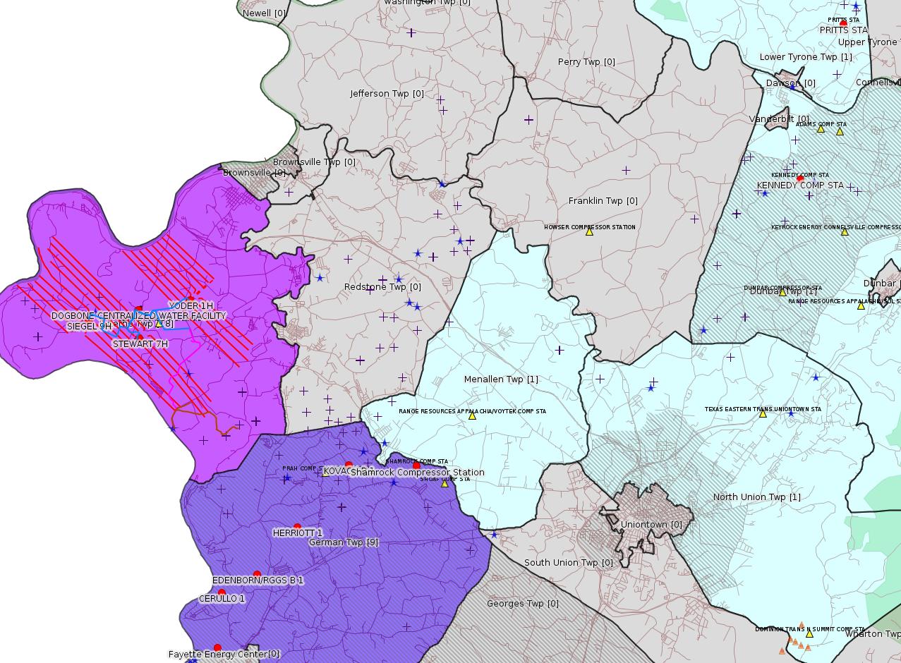
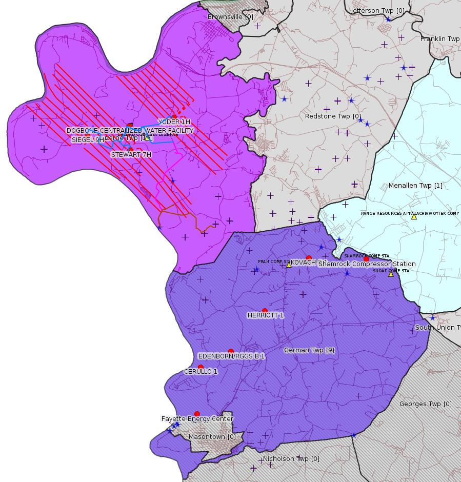
Fayette County Marcellus Shale Permits 2/26/18 - 3/11/18
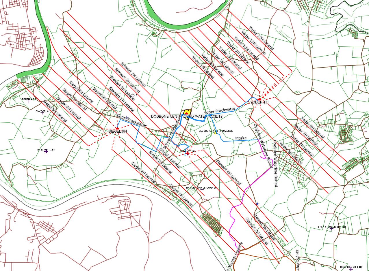
Click the map to enlarge
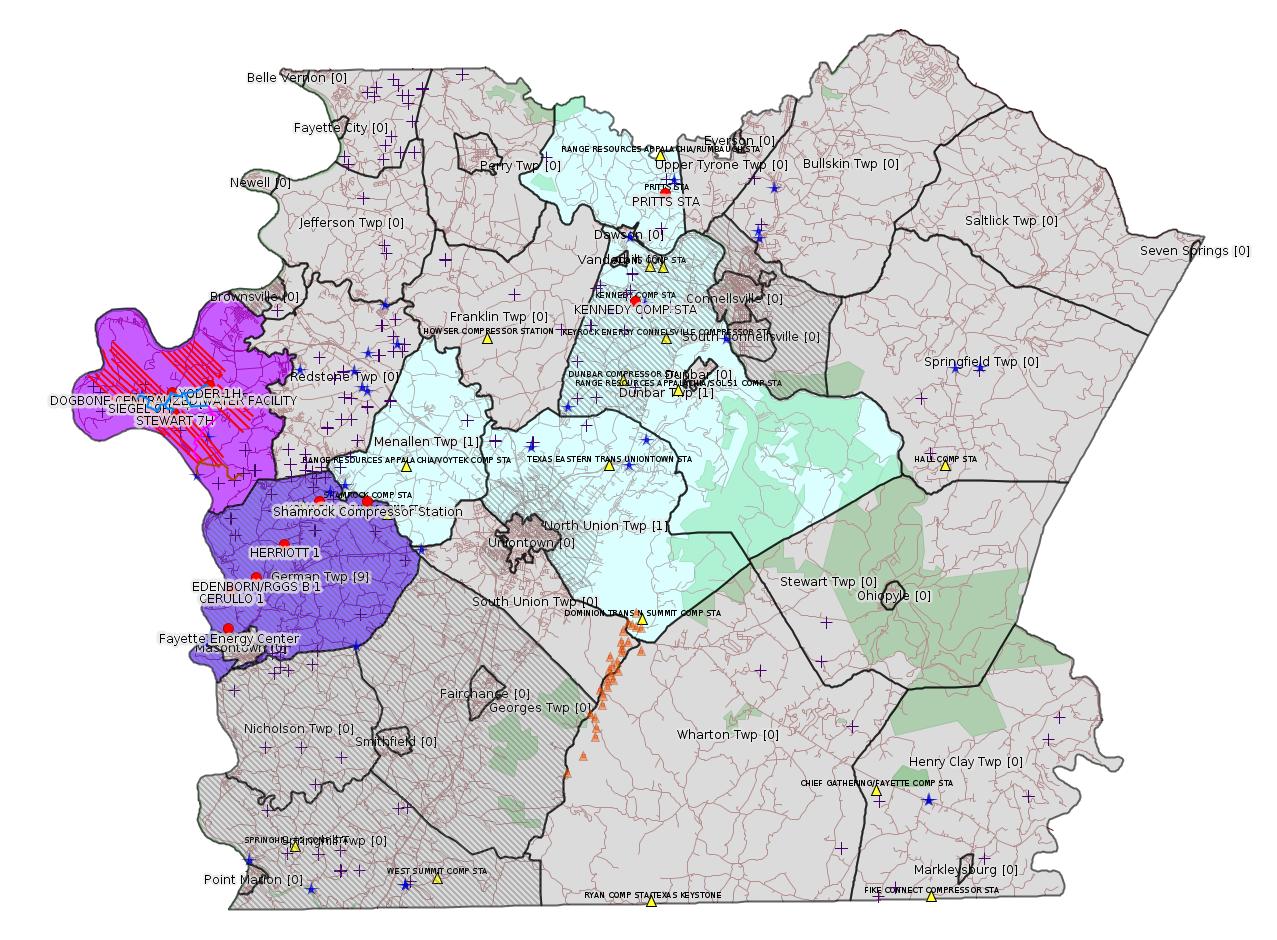
Map
Key
Red dots: items in this permit list with an exact location.
Blue stars: Marcellus Gas Well Water Sources.
Municipality shading: number of "facilities", with each well counting separately
(includes the red dots):
Red dots: items in this permit list with an exact location.
Blue stars: Marcellus Gas Well Water Sources.
Municipality shading: number of "facilities", with each well counting separately
(includes the red dots):
gray: 0
pale turquoise: 1
turquoise: 2
pale blue: 3
middle blue: 4
dark blue: 5
dark purple: 7
purple: 20
(Color coding may differ from one issue to the next.)
(Note if a project spans multiple municipalities -- e.g. a pipeline -- it will show in the count for each municipality.)
The number of facilities also follows the municipality name in brackets.
Municipality counts are based on the way the permit is listed by DEP; DEP has been known to get a municipality wrong.
Locations in brackets identify a precise location used to locate a surrogate for the actual site being permitted (e.g. locating a well pad or pipeline by the known location of a well.) Locations labeled beginning with "~" and ending in "[?]" are approximate and speculative based on inferences using on-line property and lease records. These are marked in the text as "[Approximate, Speculative]
Cross-hatching: Environmental Justice Areas
Yellow triangles: Compressor Stations
Orange triangles: Storage Field Wells (currently Dominion North Summit Storage Field)
Crosses: SPUD Unconventional well permits
Green: "Natural areas", e.g. state game lands, state forests
Yellow triangles: Compressor Stations
Orange triangles: Storage Field Wells (currently Dominion North Summit Storage Field)
Crosses: SPUD Unconventional well permits
Green: "Natural areas", e.g. state game lands, state forests
More Maps
 |
 |
 |
 |
Source: Pennsylvania Bulletin
NOTICES
GOVERNOR'S OFFICE
Regulatory Agenda
[48 Pa.B. 1368]
[Saturday, March 3, 2018]
Executive Order 1996-1 requires all agencies under the jurisdiction of the Governor to submit for publication semi-annually an agenda of regulations under development or consideration.
The agendas are compiled to provide members of the regulated community advanced notice of regulatory activity. It is the intention of the Administration that these agendas will serve to increase public participation in the regulatory process.
Agency contacts should be contacted for more information regarding the regulation and the procedure for submitting comments.
This Agenda represents the Administration's present intentions regarding future regulations. The information provided is current as of January 12, 2018. The nature and complexity of an individual regulation obviously will determine whether and when any particular regulation listed (as well as any considered subsequent to publication of this Agenda) is published.
[Excerpts:]
| Oil and Gas Program Fee 25 Pa. Code Chapter 78a |
Quarter 2, 2018, EQB Consideration, as Proposed | This rulemaking amends the fees paid by operators of unconventional wells. DEP must review the adequacy of established fees every three years. The current fee review indicates the need for a fee increase to provide for the administration of the oil and gas program. (2012 Oil and Gas Act, Clean Streams Law) | Kurt Klapkowski (717) 772-2199 kklapkowsk@pa.gov |
| Environmental Protection Performance Standards for
Conventional Oil and Gas Operators 25 Pa. Code Chapter 78 (# 7-539) |
Quarter 3, 2018, EQB Consideration, as Proposed | This rulemaking proposes to amend the Oil and Gas regulations applicable to conventional operators (Chapter 78) to update the environmental protection performance standards related to oil and gas activities. (2012 Oil and Gas Act, Clean Streams Law, Solid Waste Management Act, Dam Safety Encroachment Act, Land Recycling and Environmental Remediation Standards Act, Radiation Protection Act, Unconventional Well Report Act, Act 126 of 2014) | Kurt Klapkowski (717) 772-2199 kklapkowsk@pa.gov |
| Control of Emissions from the Oil and Natural Gas Industry 25 Pa. Code Chapter 129 |
Quarter 3, 2018, EQB Consideration, as Proposed | This rulemaking proposes to establish emission limitations and other requirements codified in 25 Pa. Code Chapter 129 consistent with reasonably available control technology (RACT) recommendations of the Control Technique Guidelines for the Oil and Natural Gas Industry finalized by the EPA on October 27, 2016. The proposed rulemaking would establish RACT requirements for volatile organic compounds and other pollutants from existing oil and natural gas production facilities, compressor stations, processing plants, and transmission stations. Upon promulgation, the final-form regulation will be submitted to the EPA for approval as a SIP revision. (Air Pollution Control Act) | Susan Hoyle (717) 772-2329 shoyle@pa.gov |
---
GP5-26-00578C: Laurel Mountain Midstream Operating, LLC (Park Place Corporate Center 2, 2000 Commerce Drive, Pittsburgh, PA 15275) on February 13, 2018, for the continued operation one (1) 1,380 bhp Caterpillar G3516B compressor engine and one (1) 30 MMscfd dehydrator at the Pritts Compressor Station located in Lower Tyrone Township, Fayette County.
<https://www.pabulletin.com/secure/data/vol48/48-9/330c.html>
Location: 40.066216,-79.633629 <http://osm.org/go/ZWp370n6--?m=>
Municipalities: Lower Tyrone Twp
Parcel Id: 1808001301
Fayette County Act 14 Notification: <http://faymarwatch.org/documents/Pritts_NOI_GP5-26-00578C.pdf>
---
General Permit Application No. WMGR123SW025. Chevron Appalachia, LLC, 800 Mountain View Drive, Smithfield, PA 15478. A registration for coverage under General Permit WMGR123 for the processing and beneficial use of oil and gas liquid waste for the Dogbone Centralized Water Facility to be located in Luzerne Township, Fayette County was issued by the Regional Office on February 26, 2018.
<https://www.pabulletin.com/secure/data/vol48/48-10/365b.html>
Location: 39.972496,-79.946939 <http://osm.org/go/ZWpZaULM--?m=>
Municipalities: Luzerne Twp
Presumed Parcel Id: 19160040
Fayette County Act 14 Notification: <http://faymarwatch.org/documents/SKM_554e17050309530.pdf>
Chevron Topographic Map Including "Proposed" Pipelines: <http://faymarwatch.org/documents/ZHB_17-41_121317_topo.pdf>
-------------------------
Source: eNOTICE (+ PA Oil and Gas Mapping, Well Pad Report.) Well Details via Data Portal Services: Oil and Gas Wells All (ID: 3).
Please see the Disclaimer below regarding Parcel Id data.
New:
Authorization ID: 1219738
Permit number: 26-00596B
Site: ALLIANCE PETROLEUM CORP/KENNEDY COMP STA
Client: ALLIANCE PETROLEUM CORP
Authorization type: AQ GP 5 - Natural Gas Compression and/or Processing Facilities
Application type: New
Authorization is for: FACILITY
Date received: 01/29/2018
Status: Pending
Permit Decision Guarantee Applies?: No
<http://www.ahs.dep.pa.gov/eFACTSWeb/searchResults_singleAuth.aspx?AuthID=1219738>
Site Programs:
Air Quality
Municipalities:
Dunbar Twp, Fayette County
Primary Facility ID: 749999
Location: 40.013889,-79.653889 [an Environmental Justice Area]
Map URL: <http://www.openstreetmap.org/?mlat=40.013889&mlon=-79.653889#map=15/40.013889/-79.653889>
Parcel Id: 09110006
[See Notes.]
New:
Authorization ID: 1219473
Permit number: GP08260718001
Site: DOGBONE WATER LINE SYSTEM GP5 & GP8
Client: CHEVRON APPALACHIA LLC
Authorization type: GP-08 Temporary Road Crossings
Application type: New
Authorization is for: FACILITY
Date received: 02/26/2018
Status: Pending
Permit Decision Guarantee Applies?: No
Sub-Facilities for Authorization:
Sub-Facility ID Sub-Facility Name Description
1255183 DOGBONE WATER LINE SYSTEM GP08260718-001 Bridge
<http://www.ahs.dep.pa.gov/eFACTSWeb/searchResults_singleAuth.aspx?AuthID=1219473>
Site Programs:
Water Planning and Conservation
Municipalities:
Luzerne Twp, Fayette County
[See Notes.]
New:
Authorization ID: 1219469
Permit number: GP05260718001
Site: DOGBONE WATER LINE SYSTEM GP5 & GP8
Client: CHEVRON APPALACHIA LLC
Authorization type: GP-05 Utility Line Stream Crossings
Application type: New
Authorization is for: FACILITY
Date received: 02/26/2018
Status: Pending
Permit Decision Guarantee Applies?: Yes
Permit Decision Guarantee status: ACTIVE
Sub-Facilities for Authorization:
Sub-Facility ID Sub-Facility Name Description
1255180 DOGBONE WATER LINE SYSTEM GP05260718-001 Pipeline or Conduit
<http://www.ahs.dep.pa.gov/eFACTSWeb/searchResults_singleAuth.aspx?AuthID=1219469>
Site Programs:
Water Planning and Conservation
Municipalities:
Luzerne Twp, Fayette County
New:
Authorization ID: 1219420
Permit number: GP052618203
Site: TEXAS EASTERN TRANSMISSION FAYETTE CNTY
Client: TEXAS EASTERN TRANS LP
Authorization type: Individual Chapter 102 NPDES Permit, PCSM Review by DEP
Application type: New
Authorization is for: FACILITY
Date received: 03/01/2018
Status: Pending
Permit Decision Guarantee Applies?: Yes
Permit Decision Guarantee status: ACTIVE
<http://www.ahs.dep.pa.gov/eFACTSWeb/searchResults_singleAuth.aspx?AuthID=1219420>
Site Programs:
Water Planning and Conservation
Municipalities:
German Twp [an Environmental Justice Area], Fayette County
Menallen Twp, Fayette County
North Union Twp, Fayette County
Authorization ID: 1217031
Permit number: 051-24663
Site: YODER WELL PAD ESCGP-2 EXPEDITED
Client: CHEVRON APPALACHIA LLC
Authorization type: Drill & Operate Well Permit (Unconventional)
Application type: New
Authorization is for: FACILITY
Date received: 02/14/2018
Status: Issued on 3/6/2018
Permit Decision Guarantee Applies?: No
Sub-Facilities for Authorization:
Sub-Facility ID Sub-Facility Name Description
1254069 WELLBORE SURFACE HOLE LOCATION Well
Permit Review Notes:
Date Review Note
3/6/2018 The technical review and decision review are complete and either the permit decision and/or permit issuance are forthcoming.
2/20/2018 The permit application package is complete, has been accepted, and is undergoing technical review.
<http://www.ahs.dep.pa.gov/eFACTSWeb/searchResults_singleAuth.aspx?AuthID=1217031>
Site Programs:
Oil & Gas
Municipalities:
Luzerne Twp, Fayette County
Well Details:
Permit Number: 051-24663
Well Name: YODER 12H
Unconventional Well: Y
Well Configuration: Horizontal Well
Well Type: GAS
Well Status: Active
Coal Association: NonCoal
Conservation Well: N
Primary Facility ID: 824637
Site ID: 790607
Site Name: YODER WELL PAD ESCGP-2 EXPEDITED
Well Pad ID: 153100
Well Pad Name: YODER
Storage Field:
Operator: CHEVRON APPALACHIA LLC
Operator Number: OGO-39307
Permit Date: 2018-03-06
Permit Date Expires: 2019-03-06
SPUD Date:
Date Plugged:
UIC ID:
UIC Type:
Surface Elevation: 1118
County: Fayette
Municipality: Luzerne Twp
Location: 39.975561,-79.923769
Map URL: <http://www.openstreetmap.org/?mlat=39.975561&mlon=-79.923769#map=15/39.975561/-79.923769>
Presumed Parcel Id: 19160034
Authorization ID: 1217030
Permit number: 051-24662
Site: YODER WELL PAD ESCGP-2 EXPEDITED
Client: CHEVRON APPALACHIA LLC
Authorization type: Drill & Operate Well Permit (Unconventional)
Application type: New
Authorization is for: FACILITY
Date received: 02/14/2018
Status: Issued on 3/6/2018
Permit Decision Guarantee Applies?: No
Sub-Facilities for Authorization:
Sub-Facility ID Sub-Facility Name Description
1254068 WELLBORE SURFACE HOLE LOCATION Well
Permit Review Notes:
Date Review Note
3/6/2018 The technical review and decision review are complete and either the permit decision and/or permit issuance are forthcoming.
2/20/2018 The permit application package is complete, has been accepted, and is undergoing technical review.
<http://www.ahs.dep.pa.gov/eFACTSWeb/searchResults_singleAuth.aspx?AuthID=1217030>
Site Programs:
Oil & Gas
Municipalities:
Luzerne Twp, Fayette County
Well Details:
Permit Number: 051-24662
Well Name: YODER 11H
Unconventional Well: Y
Well Configuration: Horizontal Well
Well Type: GAS
Well Status: Active
Coal Association: NonCoal
Conservation Well: N
Primary Facility ID: 824636
Site ID: 790607
Site Name: YODER WELL PAD ESCGP-2 EXPEDITED
Well Pad ID: 153100
Well Pad Name: YODER
Storage Field:
Operator: CHEVRON APPALACHIA LLC
Operator Number: OGO-39307
Permit Date: 2018-03-06
Permit Date Expires: 2019-03-06
SPUD Date:
Date Plugged:
UIC ID:
UIC Type:
Surface Elevation: 1118
County: Fayette
Municipality: Luzerne Twp
Location: 39.975603,-79.923769
Map URL: <http://www.openstreetmap.org/?mlat=39.975603&mlon=-79.923769#map=15/39.975603/-79.923769>
Authorization ID: 1217029
Permit number: 051-24661
Site: YODER WELL PAD ESCGP-2 EXPEDITED
Client: CHEVRON APPALACHIA LLC
Authorization type: Drill & Operate Well Permit (Unconventional)
Application type: New
Authorization is for: FACILITY
Date received: 02/14/2018
Status: Issued on 3/6/2018
Permit Decision Guarantee Applies?: No
Sub-Facilities for Authorization:
Sub-Facility ID Sub-Facility Name Description
1254067 WELLBORE SURFACE HOLE LOCATION Well
Permit Review Notes:
Date Review Note
3/6/2018 The technical review and decision review are complete and either the permit decision and/or permit issuance are forthcoming.
2/20/2018 The permit application package is complete, has been accepted, and is undergoing technical review.
<http://www.ahs.dep.pa.gov/eFACTSWeb/searchResults_singleAuth.aspx?AuthID=1217029>
Site Programs:
Oil & Gas
Municipalities:
Luzerne Twp, Fayette County
Well Details:
Permit Number: 051-24661
Well Name: YODER 10H
Unconventional Well: Y
Well Configuration: Horizontal Well
Well Type: GAS
Well Status: Active
Coal Association: NonCoal
Conservation Well: N
Primary Facility ID: 824635
Site ID: 790607
Site Name: YODER WELL PAD ESCGP-2 EXPEDITED
Well Pad ID: 153100
Well Pad Name: YODER
Storage Field:
Operator: CHEVRON APPALACHIA LLC
Operator Number: OGO-39307
Permit Date: 2018-03-06
Permit Date Expires: 2019-03-06
SPUD Date:
Date Plugged:
UIC ID:
UIC Type:
Surface Elevation: 1118
County: Fayette
Municipality: Luzerne Twp
Location: 39.975644,-79.923767
Map URL: <http://www.openstreetmap.org/?mlat=39.975644&mlon=-79.923767#map=15/39.975644/-79.923767>
Authorization ID: 1217028
Permit number: 051-24660
Site: YODER WELL PAD ESCGP-2 EXPEDITED
Client: CHEVRON APPALACHIA LLC
Authorization type: Drill & Operate Well Permit (Unconventional)
Application type: New
Authorization is for: FACILITY
Date received: 02/14/2018
Status: Issued on 3/6/2018
Permit Decision Guarantee Applies?: No
Sub-Facilities for Authorization:
Sub-Facility ID Sub-Facility Name Description
1254066 WELLBORE SURFACE HOLE LOCATION Well
Permit Review Notes:
Date Review Note
3/6/2018 The technical review and decision review are complete and either the permit decision and/or permit issuance are forthcoming.
2/20/2018 The permit application package is complete, has been accepted, and is undergoing technical review.
<http://www.ahs.dep.pa.gov/eFACTSWeb/searchResults_singleAuth.aspx?AuthID=1217028>
Site Programs:
Oil & Gas
Municipalities:
Luzerne Twp, Fayette County
Well Details:
Permit Number: 051-24660
Well Name: YODER 9H
Unconventional Well: Y
Well Configuration: Horizontal Well
Well Type: GAS
Well Status: Active
Coal Association: NonCoal
Conservation Well: N
Primary Facility ID: 824634
Site ID: 790607
Site Name: YODER WELL PAD ESCGP-2 EXPEDITED
Well Pad ID: 153100
Well Pad Name: YODER
Storage Field:
Operator: CHEVRON APPALACHIA LLC
Operator Number: OGO-39307
Permit Date: 2018-03-06
Permit Date Expires: 2019-03-06
SPUD Date:
Date Plugged:
UIC ID:
UIC Type:
Surface Elevation: 1118
County: Fayette
Municipality: Luzerne Twp
Location: 39.975683,-79.923764
Map URL: <http://www.openstreetmap.org/?mlat=39.975683&mlon=-79.923764#map=15/39.975683/-79.923764>
Authorization ID: 1217027
Permit number: 051-24659
Site: YODER WELL PAD ESCGP-2 EXPEDITED
Client: CHEVRON APPALACHIA LLC
Authorization type: Drill & Operate Well Permit (Unconventional)
Application type: New
Authorization is for: FACILITY
Date received: 02/14/2018
Status: Issued on 3/6/2018
Permit Decision Guarantee Applies?: No
Sub-Facilities for Authorization:
Sub-Facility ID Sub-Facility Name Description
1254065 WELLBORE SURFACE HOLE LOCATION Well
Permit Review Notes:
Date Review Note
3/5/2018 The technical review and decision review are complete and either the permit decision and/or permit issuance are forthcoming.
2/20/2018 The permit application package is complete, has been accepted, and is undergoing technical review.
<http://www.ahs.dep.pa.gov/eFACTSWeb/searchResults_singleAuth.aspx?AuthID=1217027>
Site Programs:
Oil & Gas
Municipalities:
Luzerne Twp, Fayette County
Well Details:
Permit Number: 051-24659
Well Name: YODER 8H
Unconventional Well: Y
Well Configuration: Horizontal Well
Well Type: GAS
Well Status: Active
Coal Association: NonCoal
Conservation Well: N
Primary Facility ID: 824633
Site ID: 790607
Site Name: YODER WELL PAD ESCGP-2 EXPEDITED
Well Pad ID: 153100
Well Pad Name: YODER
Storage Field:
Operator: CHEVRON APPALACHIA LLC
Operator Number: OGO-39307
Permit Date: 2018-03-06
Permit Date Expires: 2019-03-06
SPUD Date:
Date Plugged:
UIC ID:
UIC Type:
Surface Elevation: 1118
County: Fayette
Municipality: Luzerne Twp
Location: 39.9754,-79.923886
Map URL: <http://www.openstreetmap.org/?mlat=39.9754&mlon=-79.923886#map=15/39.9754/-79.923886>
Authorization ID: 1217026
Permit number: 051-24658
Site: YODER WELL PAD ESCGP-2 EXPEDITED
Client: CHEVRON APPALACHIA LLC
Authorization type: Drill & Operate Well Permit (Unconventional)
Application type: New
Authorization is for: FACILITY
Date received: 02/14/2018
Status: Issued on 3/6/2018
Permit Decision Guarantee Applies?: No
Sub-Facilities for Authorization:
Sub-Facility ID Sub-Facility Name Description
1254064 WELLBORE SURFACE HOLE LOCATION Well
Permit Review Notes:
Date Review Note
3/5/2018 The technical review and decision review are complete and either the permit decision and/or permit issuance are forthcoming.
2/20/2018 The permit application package is complete, has been accepted, and is undergoing technical review.
<http://www.ahs.dep.pa.gov/eFACTSWeb/searchResults_singleAuth.aspx?AuthID=1217026>
Site Programs:
Oil & Gas
Municipalities:
Luzerne Twp, Fayette County
Well Details:
Permit Number: 051-24658
Well Name: YODER 7H
Unconventional Well: Y
Well Configuration: Horizontal Well
Well Type: GAS
Well Status: Active
Coal Association: NonCoal
Conservation Well: N
Primary Facility ID: 824632
Site ID: 790607
Site Name: YODER WELL PAD ESCGP-2 EXPEDITED
Well Pad ID: 153100
Well Pad Name: YODER
Storage Field:
Operator: CHEVRON APPALACHIA LLC
Operator Number: OGO-39307
Permit Date: 2018-03-06
Permit Date Expires: 2019-03-06
SPUD Date:
Date Plugged:
UIC ID:
UIC Type:
Surface Elevation: 1118
County: Fayette
Municipality: Luzerne Twp
Location: 39.975442,-79.923883
Map URL: <http://www.openstreetmap.org/?mlat=39.975442&mlon=-79.923883#map=15/39.975442/-79.923883>
Authorization ID: 1217025
Permit number: 051-24657
Site: YODER WELL PAD ESCGP-2 EXPEDITED
Client: CHEVRON APPALACHIA LLC
Authorization type: Drill & Operate Well Permit (Unconventional)
Application type: New
Authorization is for: FACILITY
Date received: 02/14/2018
Status: Issued on 3/6/2018
Permit Decision Guarantee Applies?: No
Sub-Facilities for Authorization:
Sub-Facility ID Sub-Facility Name Description
1254063 WELLBORE SURFACE HOLE LOCATION Well
Permit Review Notes:
Date Review Note
3/5/2018 The technical review and decision review are complete and either the permit decision and/or permit issuance are forthcoming.
2/20/2018 The permit application package is complete, has been accepted, and is undergoing technical review.
<http://www.ahs.dep.pa.gov/eFACTSWeb/searchResults_singleAuth.aspx?AuthID=1217025>
Site Programs:
Oil & Gas
Municipalities:
Luzerne Twp, Fayette County
Well Details:
Permit Number: 051-24657
Well Name: YODER 6H
Unconventional Well: Y
Well Configuration: Horizontal Well
Well Type: GAS
Well Status: Active
Coal Association: NonCoal
Conservation Well: N
Primary Facility ID: 824631
Site ID: 790607
Site Name: YODER WELL PAD ESCGP-2 EXPEDITED
Well Pad ID: 153100
Well Pad Name: YODER
Storage Field:
Operator: CHEVRON APPALACHIA LLC
Operator Number: OGO-39307
Permit Date: 2018-03-06
Permit Date Expires: 2019-03-06
SPUD Date:
Date Plugged:
UIC ID:
UIC Type:
Surface Elevation: 1118
County: Fayette
Municipality: Luzerne Twp
Location: 39.975481,-79.923881
Map URL: <http://www.openstreetmap.org/?mlat=39.975481&mlon=-79.923881#map=15/39.975481/-79.923881>
Authorization ID: 1217024
Permit number: 051-24656
Site: YODER WELL PAD ESCGP-2 EXPEDITED
Client: CHEVRON APPALACHIA LLC
Authorization type: Drill & Operate Well Permit (Unconventional)
Application type: New
Authorization is for: FACILITY
Date received: 02/14/2018
Status: Issued on 3/6/2018
Permit Decision Guarantee Applies?: No
Sub-Facilities for Authorization:
Sub-Facility ID Sub-Facility Name Description
1254062 WELLBORE SURFACE HOLE LOCATION Well
Permit Review Notes:
Date Review Note
3/5/2018 The technical review and decision review are complete and either the permit decision and/or permit issuance are forthcoming.
2/20/2018 The permit application package is complete, has been accepted, and is undergoing technical review.
<http://www.ahs.dep.pa.gov/eFACTSWeb/searchResults_singleAuth.aspx?AuthID=1217024>
Site Programs:
Oil & Gas
Municipalities:
Luzerne Twp, Fayette County
Well Details:
Permit Number: 051-24656
Well Name: YODER 5H
Unconventional Well: Y
Well Configuration: Horizontal Well
Well Type: GAS
Well Status: Active
Coal Association: NonCoal
Conservation Well: N
Primary Facility ID: 824630
Site ID: 790607
Site Name: YODER WELL PAD ESCGP-2 EXPEDITED
Well Pad ID: 153100
Well Pad Name: YODER
Storage Field:
Operator: CHEVRON APPALACHIA LLC
Operator Number: OGO-39307
Permit Date: 2018-03-06
Permit Date Expires: 2019-03-06
SPUD Date:
Date Plugged:
UIC ID:
UIC Type:
Surface Elevation: 1118
County: Fayette
Municipality: Luzerne Twp
Location: 39.975522,-79.923878
Map URL: <http://www.openstreetmap.org/?mlat=39.975522&mlon=-79.923878#map=15/39.975522/-79.923878>
Authorization ID: 1217023
Permit number: 051-24655
Site: YODER WELL PAD ESCGP-2 EXPEDITED
Client: CHEVRON APPALACHIA LLC
Authorization type: Drill & Operate Well Permit (Unconventional)
Application type: New
Authorization is for: FACILITY
Date received: 02/14/2018
Status: Issued on 3/6/2018
Permit Decision Guarantee Applies?: No
Sub-Facilities for Authorization:
Sub-Facility ID Sub-Facility Name Description
1254061 WELLBORE SURFACE HOLE LOCATION Well
Permit Review Notes:
Date Review Note
3/2/2018 The technical review and decision review are complete and either the permit decision and/or permit issuance are forthcoming.
2/20/2018 The permit application package is complete, has been accepted, and is undergoing technical review.
<http://www.ahs.dep.pa.gov/eFACTSWeb/searchResults_singleAuth.aspx?AuthID=1217023>
Site Programs:
Oil & Gas
Municipalities:
Luzerne Twp, Fayette County
Well Details:
Permit Number: 051-24655
Well Name: YODER 4H
Unconventional Well: Y
Well Configuration: Horizontal Well
Well Type: GAS
Well Status: Active
Coal Association: NonCoal
Conservation Well: N
Primary Facility ID: 824629
Site ID: 790607
Site Name: YODER WELL PAD ESCGP-2 EXPEDITED
Well Pad ID: 153100
Well Pad Name: YODER
Storage Field:
Operator: CHEVRON APPALACHIA LLC
Operator Number: OGO-39307
Permit Date: 2018-03-06
Permit Date Expires: 2019-03-06
SPUD Date:
Date Plugged:
UIC ID:
UIC Type:
Surface Elevation: 1118
County: Fayette
Municipality: Luzerne Twp
Location: 39.975564,-79.923878
Map URL: <http://www.openstreetmap.org/?mlat=39.975564&mlon=-79.923878#map=15/39.975564/-79.923878>
Authorization ID: 1217022
Permit number: 051-24654
Site: YODER WELL PAD ESCGP-2 EXPEDITED
Client: CHEVRON APPALACHIA LLC
Authorization type: Drill & Operate Well Permit (Unconventional)
Application type: New
Authorization is for: FACILITY
Date received: 02/14/2018
Status: Pending
Permit Decision Guarantee Applies?: No
Sub-Facilities for Authorization:
Sub-Facility ID Sub-Facility Name Description
1254060 WELLBORE SURFACE HOLE LOCATION Well
Permit Review Notes:
Date Review Note
3/2/2018 The technical review and decision review are complete and either the permit decision and/or permit issuance are forthcoming.
2/20/2018 The permit application package is complete, has been accepted, and is undergoing technical review.
<http://www.ahs.dep.pa.gov/eFACTSWeb/searchResults_singleAuth.aspx?AuthID=1217022>
Site Programs:
Oil & Gas
Municipalities:
Luzerne Twp, Fayette County
Well Details:
Permit Number: 051-24654
Well Name: YODER 3H
Unconventional Well: Y
Well Configuration: Horizontal Well
Well Type: GAS
Well Status: Active
Coal Association: NonCoal
Conservation Well: N
Primary Facility ID: 824628
Site ID: 790607
Site Name: YODER WELL PAD ESCGP-2 EXPEDITED
Well Pad ID: 153100
Well Pad Name: YODER
Storage Field:
Operator: CHEVRON APPALACHIA LLC
Operator Number: OGO-39307
Permit Date:
Permit Date Expires:
SPUD Date:
Date Plugged:
UIC ID:
UIC Type:
Surface Elevation: 1118
County: Fayette
Municipality: Luzerne Twp
Location: 39.975606,-79.923875
Map URL: <http://www.openstreetmap.org/?mlat=39.975606&mlon=-79.923875#map=15/39.975606/-79.923875>
Authorization ID: 1217021
Permit number: 051-24653
Site: YODER WELL PAD ESCGP-2 EXPEDITED
Client: CHEVRON APPALACHIA LLC
Authorization type: Drill & Operate Well Permit (Unconventional)
Application type: New
Authorization is for: FACILITY
Date received: 02/14/2018
Status: Issued on 3/6/2018
Permit Decision Guarantee Applies?: No
Sub-Facilities for Authorization:
Sub-Facility ID Sub-Facility Name Description
1254059 WELLBORE SURFACE HOLE LOCATION Well
Permit Review Notes:
Date Review Note
3/2/2018 The technical review and decision review are complete and either the permit decision and/or permit issuance are forthcoming.
2/20/2018 The permit application package is complete, has been accepted, and is undergoing technical review.
<http://www.ahs.dep.pa.gov/eFACTSWeb/searchResults_singleAuth.aspx?AuthID=1217021>
Site Programs:
Oil & Gas
Municipalities:
Luzerne Twp, Fayette County
Well Details:
Permit Number: 051-24653
Well Name: YODER 2H
Unconventional Well: Y
Well Configuration: Horizontal Well
Well Type: GAS
Well Status: Active
Coal Association: NonCoal
Conservation Well: N
Primary Facility ID: 824627
Site ID: 790607
Site Name: YODER WELL PAD ESCGP-2 EXPEDITED
Well Pad ID: 153100
Well Pad Name: YODER
Storage Field:
Operator: CHEVRON APPALACHIA LLC
Operator Number: OGO-39307
Permit Date: 2018-03-06
Permit Date Expires: 2019-03-06
SPUD Date:
Date Plugged:
UIC ID:
UIC Type:
Surface Elevation: 1118
County: Fayette
Municipality: Luzerne Twp
Location: 39.975647,-79.923872
Map URL: <http://www.openstreetmap.org/?mlat=39.975647&mlon=-79.923872#map=15/39.975647/-79.923872>
Authorization ID: 1217018
Permit number: 051-24652
Site: YODER WELL PAD ESCGP-2 EXPEDITED
Client: CHEVRON APPALACHIA LLC
Authorization type: Drill & Operate Well Permit (Unconventional)
Application type: New
Authorization is for: FACILITY
Date received: 02/14/2018
Status: Issued on 3/6/2018
Permit Decision Guarantee Applies?: No
Sub-Facilities for Authorization:
Sub-Facility ID Sub-Facility Name Description
1254055 WELLBORE SURFACE HOLE LOCATION Well
Permit Review Notes:
Date Review Note
3/2/2018 The technical review and decision review are complete and either the permit decision and/or permit issuance are forthcoming.
2/20/2018 The permit application package is complete, has been accepted, and is undergoing technical review.
<http://www.ahs.dep.pa.gov/eFACTSWeb/searchResults_singleAuth.aspx?AuthID=1217018>
Site Programs:
Oil & Gas
Municipalities:
Luzerne Twp, Fayette County
Well Details:
Permit Number: 051-24652
Well Name: YODER 1H
Unconventional Well: Y
Well Configuration: Horizontal Well
Well Type: GAS
Well Status: Active
Coal Association: NonCoal
Conservation Well: N
Primary Facility ID: 824625
Site ID: 790607
Site Name: YODER WELL PAD ESCGP-2 EXPEDITED
Well Pad ID: 153100
Well Pad Name: YODER
Storage Field:
Operator: CHEVRON APPALACHIA LLC
Operator Number: OGO-39307
Permit Date: 2018-03-06
Permit Date Expires: 2019-03-06
SPUD Date:
Date Plugged:
UIC ID:
UIC Type:
Surface Elevation: 1118
County: Fayette
Municipality: Luzerne Twp
Location: 39.975686,-79.923872
Map URL: <http://www.openstreetmap.org/?mlat=39.975686&mlon=-79.923872#map=15/39.975686/-79.923872>
Authorization ID: 1216448
Permit number: 26-00588A
Site: SHAMROCK COMP STA
Client: LAUREL MTN MIDSTREAM OPR LLC
Authorization type: Major Facility Plan Approval New Facility Review Prevention of Significant Deterioration
Application type: Extension
Authorization is for: FACILITY
Date received: 01/26/2018
Status: Issued on 2/21/2018
Permit Decision Guarantee Applies?: No
Sub-Facilities for Authorization:
Sub-Facility ID Sub-Facility Name Description
1020043 CATERPILLAR G3516B COMPRESSOR ENGINE #1 (1380 BHP) Process
1020044 CATERPILLAR G3516B COMPRESSOR ENGINE #2 (1380 BHP) Process
1020045 CATERPILLAR G3516B COMPRESSOR ENGINE #3 (1380 BHP) Process
1024425 CATERPILLAR G3516B COMPRESSOR ENGINE #4 (1380 BHP) Process
1024426 CATERPILLAR G3516B COMPRESSOR ENGINE #5 (1380 BHP) Process
1024427 CATERPILLAR G3516B COMPRESSOR ENGINE #6 (1380 BHP) Process
1087412 CATERPILLAR G3516B EMERGENCY GENERATOR (1,818 BHP) Process
1087413 CATERPILLAR G3516B EMERGENCY GENERATOR OXIDATION CATALYST Air Pollution Control Device
1024432 ENGINE #1 OXIDATION CATALYST Air Pollution Control Device
1024434 ENGINE #2 OXIDATION CATALYST Air Pollution Control Device
1024435 ENGINE #3 OXIDATION CATALYST Air Pollution Control Device
1024436 ENGINE #4 OXIDATION CATALYST Air Pollution Control Device
1024437 ENGINE #5 OXIDATION CATALYST Air Pollution Control Device
1024438 ENGINE #6 OXIDATION CATALYST Air Pollution Control Device
1024428 SOLAR MARS 100-16000S TURBINE (15,252 HP) Process
1024431 TEG DEHYDRATOR 1 (200 MMSCF/DAY) Process
1087369 TEG DEHYDRATOR 2 (200 MMSCF/DAY) Process
Permit Review Notes:
Date Review Note
2/21/2018 The technical review and decision review are complete and either the permit decision and/or permit issuance are forthcoming.
2/21/2018 The permit application package is complete, has been accepted, and is undergoing technical review.
<http://www.ahs.dep.pa.gov/eFACTSWeb/searchResults_singleAuth.aspx?AuthID=1216448>
Site Programs:
Air Quality
Municipalities:
German Twp [an Environmental Justice Area], Fayette County
Location: 39.918333,-79.825 <http://osm.org/go/ZWpasXGm--?m=>
Parcel ID: 15140026
Authorization ID: 1216447
Permit number: 26-00588
Site: SHAMROCK COMP STA
Client: LAUREL MTN MIDSTREAM OPR LLC
Authorization type: Minor Facility Plan Approval New Source Performance Std
Application type: Extension
Authorization is for: FACILITY
Date received: 01/26/2018
Status: Issued on 2/21/2018
Permit Decision Guarantee Applies?: No
Sub-Facilities for Authorization:
Sub-Facility ID Sub-Facility Name Description
1020043 CATERPILLAR G3516B COMPRESSOR ENGINE #1 (1380 BHP) Process
1020044 CATERPILLAR G3516B COMPRESSOR ENGINE #2 (1380 BHP) Process
1020045 CATERPILLAR G3516B COMPRESSOR ENGINE #3 (1380 BHP) Process
1024425 CATERPILLAR G3516B COMPRESSOR ENGINE #4 (1380 BHP) Process
1024426 CATERPILLAR G3516B COMPRESSOR ENGINE #5 (1380 BHP) Process
1024427 CATERPILLAR G3516B COMPRESSOR ENGINE #6 (1380 BHP) Process
1024432 ENGINE #1 OXIDATION CATALYST Air Pollution Control Device
1024434 ENGINE #2 OXIDATION CATALYST Air Pollution Control Device
1024435 ENGINE #3 OXIDATION CATALYST Air Pollution Control Device
1024436 ENGINE #4 OXIDATION CATALYST Air Pollution Control Device
1024437 ENGINE #5 OXIDATION CATALYST Air Pollution Control Device
1024438 ENGINE #6 OXIDATION CATALYST Air Pollution Control Device
1024428 SOLAR MARS 100-16000S TURBINE (15,252 HP) Process
1024431 TEG DEHYDRATOR 1 (200 MMSCF/DAY) Process
Permit Review Notes:
Date Review Note
2/21/2018 The technical review and decision review are complete and either the permit decision and/or permit issuance are forthcoming.
2/21/2018 The permit application package is complete, has been accepted, and is undergoing technical review.
<http://www.ahs.dep.pa.gov/eFACTSWeb/searchResults_singleAuth.aspx?AuthID=1216447>
Site Programs:
Air Quality
Municipalities:
German Twp [an Environmental Justice Area], Fayette County
[Arguably Off-Topic:]
Authorization ID: 1214629
Permit number: 26-00535B
Site: FAYETTE ENERGY FACILITY
Client: DYNEGY FAYETTE II, LLC
Authorization type: Major Facility Plan Approval New Source Performance Std
Application type: Extension
Authorization is for: FACILITY
Date received: 01/18/2018
Status: Issued on 2/21/2018
Permit Decision Guarantee Applies?: No
Sub-Facilities for Authorization:
Sub-Facility ID Sub-Facility Name Description
805954 CGT TRAIN 1 COMBINED CYCLE TURBINE Process
805959 CGT TRAIN 2 COMBINED CYCLE TURBINE Process
1095705 OXIDATION CATALYST UNIT 1 Air Pollution Control Device
1095706 OXIDATION CATALYST UNIT 2 Air Pollution Control Device
1095701 SCR UNIT 1 Air Pollution Control Device
1095702 SCR UNIT 2 Air Pollution Control Device
Permit Review Notes:
Date Review Note
2/21/2018 The technical review and decision review are complete and either the permit decision and/or permit issuance are forthcoming.
1/26/2018 The permit application package is complete, has been accepted, and is undergoing technical review.
<http://www.ahs.dep.pa.gov/eFACTSWeb/searchResults_singleAuth.aspx?AuthID=1214629>
Site Programs:
Air Quality
Waste Management
Water Planning and Conservation
Municipalities:
German Twp [an Environmental Justice Area], Fayette County
Masontown Boro [probably incorrect - jr], Fayette County
Location: 39.857412,-79.913878 <http://osm.org/go/ZWpM9Ua6--?m=>
Presumed Parcel Id: 1530006703
Authorization ID: 1213996
Permit number: 051-24651
Site: EDENBORN/RGGS B
Client: CHEVRON APPALACHIA LLC
Authorization type: Drill & Operate Well Permit (Unconventional)
Application type: New
Authorization is for: FACILITY
Date received: 01/19/2018
Status: Pending
Permit Decision Guarantee Applies?: No
Sub-Facilities for Authorization:
Sub-Facility ID Sub-Facility Name Description
1252365 WELLBORE SURFACE HOLE LOCATION Well
Permit Review Notes:
Date Review Note
2/20/2018 The technical review and decision review are complete and either the permit decision and/or permit issuance are forthcoming.
1/23/2018 The permit application package is complete, has been accepted, and is undergoing technical review.
<http://www.ahs.dep.pa.gov/eFACTSWeb/searchResults_singleAuth.aspx?AuthID=1213996>
Site Programs:
Oil & Gas
Municipalities:
German Twp [an Environmental Justice Area], Fayette County
Well Details:
Permit Number: 051-24651
Well Name: EDENBORN/RGGS B 1
Unconventional Well: Y
Well Configuration: Vertical Well
Well Type: GAS
Well Status: Active
Coal Association: Coal
Conservation Well: N
Primary Facility ID: 824076
Site ID: 827338
Site Name: EDENBORN/RGGS B
Well Pad ID: 155083
Well Pad Name: EDENBORN/RGGS B
Storage Field:
Operator: CHEVRON APPALACHIA LLC
Operator Number: OGO-39307
Permit Date: 2018-03-07
Permit Date Expires: 2019-03-07
SPUD Date:
Date Plugged:
UIC ID:
UIC Type:
Surface Elevation: 1167
County: Fayette
Municipality: German Twp
Location: 39.882106,-79.895881
Map URL: <http://www.openstreetmap.org/?mlat=39.882106&mlon=-79.895881#map=15/39.882106/-79.895881>
Presumed Parcel Id: 15220014
Authorization ID: 1213817
Permit number: 051-24650
Site: CERULLO
Client: CHEVRON APPALACHIA LLC
Authorization type: Drill & Operate Well Permit (Unconventional)
Application type: New
Authorization is for: FACILITY
Date received: 01/18/2018
Status: Issued on 3/1/2018
Permit Decision Guarantee Applies?: No
Sub-Facilities for Authorization:
Sub-Facility ID Sub-Facility Name Description
1252291 WELLBORE SURFACE HOLE LOCATION Well
Permit Review Notes:
Date Review Note
3/1/2018 The technical review and decision review are complete and either the permit decision and/or permit issuance are forthcoming.
2/21/2018 Applicant has been issued a deficiency letter. If applicable, this application no longer qualifies for the Permit Decision Guarantee.
1/19/2018 The permit application package is complete, has been accepted, and is undergoing technical review.
<http://www.ahs.dep.pa.gov/eFACTSWeb/searchResults_singleAuth.aspx?AuthID=1213817>
Site Programs:
Oil & Gas
Municipalities:
German Twp [an Environmental Justice Area], Fayette County
Well Details:
Permit Number: 051-24650
Well Name: CERULLO 1
Unconventional Well: Y
Well Configuration: Vertical Well
Well Type: GAS
Well Status: Active
Coal Association: Coal
Conservation Well: N
Primary Facility ID: 824042
Site ID: 827238
Site Name: CERULLO
Well Pad ID: 155068
Well Pad Name: CERULLO
Storage Field:
Operator: CHEVRON APPALACHIA LLC
Operator Number: OGO-39307
Permit Date: 2018-03-01
Permit Date Expires: 2019-03-01
SPUD Date:
Date Plugged:
UIC ID:
UIC Type:
Surface Elevation: 1063
County: Fayette
Municipality: German Twp
Location: 39.875992,-79.911644
Map URL: <http://www.openstreetmap.org/?mlat=39.875992&mlon=-79.911644#map=15/39.875992/-79.911644>
Presumed Parcel Id: 15190070
Authorization ID: 1213815
Permit number: 051-24649
Site: HERRIOTT
Client: CHEVRON APPALACHIA LLC
Authorization type: Drill & Operate Well Permit (Unconventional)
Application type: New
Authorization is for: FACILITY
Date received: 01/18/2018
Status: Issued on 2/23/2018
Permit Decision Guarantee Applies?: No
Sub-Facilities for Authorization:
Sub-Facility ID Sub-Facility Name Description
1252289 WELLBORE SURFACE HOLE LOCATION Well
Permit Review Notes:
Date Review Note
2/23/2018 The technical review and decision review are complete and either the permit decision and/or permit issuance are forthcoming.
1/19/2018 The permit application package is complete, has been accepted, and is undergoing technical review.
<http://www.ahs.dep.pa.gov/eFACTSWeb/searchResults_singleAuth.aspx?AuthID=1213815>
Site Programs:
Oil & Gas
Municipalities:
German Twp [an Environmental Justice Area], Fayette County
Well Details:
Permit Number: 051-24649
Well Name: HERRIOTT 1
Unconventional Well: Y
Well Configuration: Vertical Well
Well Type: GAS
Well Status: Active
Coal Association: Coal
Conservation Well: N
Primary Facility ID: 824040
Site ID: 827337
Site Name: HERRIOTT
Well Pad ID: 155082
Well Pad Name: HERRIOTT
Storage Field:
Operator: CHEVRON APPALACHIA LLC
Operator Number: OGO-39307
Permit Date: 2018-02-23
Permit Date Expires: 2019-02-23
SPUD Date:
Date Plugged:
UIC ID:
UIC Type:
Surface Elevation: 1265
County: Fayette
Municipality: German Twp
Location: 39.898056,-79.877942
Map URL: <http://www.openstreetmap.org/?mlat=39.898056&mlon=-79.877942#map=15/39.898056/-79.877942>
Presumed Parcel Id: 15220125
Authorization ID: 1212442
Permit number: 051-24648
Site: SIEGEL WELL PAD ESCGP-2 EXPEDITED
Client: CHEVRON APPALACHIA LLC
Authorization type: Drill & Operate Well Permit (Unconventional)
Application type: New
Authorization is for: FACILITY
Date received: 01/05/2018
Status: Issued on 2/23/2018
Permit Decision Guarantee Applies?: No
Sub-Facilities for Authorization:
Sub-Facility ID Sub-Facility Name Description
1251521 WELLBORE SURFACE HOLE LOCATION Well
Permit Review Notes:
Date Review Note
2/23/2018 The technical review and decision review are complete and either the permit decision and/or permit issuance are forthcoming.
1/11/2018 The permit application package is complete, has been accepted, and is undergoing technical review.
<http://www.ahs.dep.pa.gov/eFACTSWeb/searchResults_singleAuth.aspx?AuthID=1212442>
Site Programs:
Oil & Gas
Municipalities:
Luzerne Twp, Fayette County
Well Details:
Permit Number: 051-24648
Well Name: SIEGEL 9H
Unconventional Well: Y
Well Configuration: Horizontal Well
Well Type: GAS
Well Status: Active
Coal Association: Coal
Conservation Well: N
Primary Facility ID: 823796
Site ID: 790384
Site Name: SIEGEL WELL PAD ESCGP-2 EXPEDITED
Well Pad ID: 152926
Well Pad Name: SIEGEL 1
Storage Field:
Operator: CHEVRON APPALACHIA LLC
Operator Number: OGO-39307
Permit Date: 2018-02-23
Permit Date Expires: 2019-02-23
SPUD Date:
Date Plugged:
UIC ID:
UIC Type:
Surface Elevation: 1173
County: Fayette
Municipality: Luzerne Twp
Location: 39.969036,-79.968861
Map URL: <http://www.openstreetmap.org/?mlat=39.969036&mlon=-79.968861#map=15/39.969036/-79.968861>
Presumed Parcel Id: 19240018
Authorization ID: 1212441
Permit number: 051-24647
Site: SIEGEL WELL PAD ESCGP-2 EXPEDITED
Client: CHEVRON APPALACHIA LLC
Authorization type: Drill & Operate Well Permit (Unconventional)
Application type: New
Authorization is for: FACILITY
Date received: 01/05/2018
Status: Issued on 2/23/2018
Permit Decision Guarantee Applies?: No
Sub-Facilities for Authorization:
Sub-Facility ID Sub-Facility Name Description
1251520 WELLBORE SURFACE HOLE LOCATION Well
Permit Review Notes:
Date Review Note
2/23/2018 The technical review and decision review are complete and either the permit decision and/or permit issuance are forthcoming.
1/11/2018 The permit application package is complete, has been accepted, and is undergoing technical review.
<http://www.ahs.dep.pa.gov/eFACTSWeb/searchResults_singleAuth.aspx?AuthID=1212441>
Site Programs:
Oil & Gas
Municipalities:
Luzerne Twp, Fayette County
Well Details:
Permit Number: 051-24647
Well Name: SIEGEL 8H
Unconventional Well: Y
Well Configuration: Horizontal Well
Well Type: GAS
Well Status: Active
Coal Association: Coal
Conservation Well: N
Primary Facility ID: 823795
Site ID: 790384
Site Name: SIEGEL WELL PAD ESCGP-2 EXPEDITED
Well Pad ID: 152926
Well Pad Name: SIEGEL 1
Storage Field:
Operator: CHEVRON APPALACHIA LLC
Operator Number: OGO-39307
Permit Date: 2018-02-23
Permit Date Expires: 2019-02-23
SPUD Date:
Date Plugged:
UIC ID:
UIC Type:
Surface Elevation: 1173
County: Fayette
Municipality: Luzerne Twp
Location: 39.968997,-79.968928
Map URL: <http://www.openstreetmap.org/?mlat=39.968997&mlon=-79.968928#map=15/39.968997/-79.968928>
Authorization ID: 1212440
Permit number: 051-24646
Site: SIEGEL WELL PAD ESCGP-2 EXPEDITED
Client: CHEVRON APPALACHIA LLC
Authorization type: Drill & Operate Well Permit (Unconventional)
Application type: New
Authorization is for: FACILITY
Date received: 01/05/2018
Status: Issued on 2/23/2018
Permit Decision Guarantee Applies?: No
Sub-Facilities for Authorization:
Sub-Facility ID Sub-Facility Name Description
1251519 WELLBORE SURFACE HOLE LOCATION Well
Permit Review Notes:
Date Review Note
2/23/2018 The technical review and decision review are complete and either the permit decision and/or permit issuance are forthcoming.
1/11/2018 The permit application package is complete, has been accepted, and is undergoing technical review.
<http://www.ahs.dep.pa.gov/eFACTSWeb/searchResults_singleAuth.aspx?AuthID=1212440>
Site Programs:
Oil & Gas
Municipalities:
Luzerne Twp, Fayette County
Well Details:
Permit Number: 051-24646
Well Name: SIEGEL 7H
Unconventional Well: Y
Well Configuration: Horizontal Well
Well Type: GAS
Well Status: Active
Coal Association: Coal
Conservation Well: N
Primary Facility ID: 823794
Site ID: 790384
Site Name: SIEGEL WELL PAD ESCGP-2 EXPEDITED
Well Pad ID: 152926
Well Pad Name: SIEGEL 1
Storage Field:
Operator: CHEVRON APPALACHIA LLC
Operator Number: OGO-39307
Permit Date: 2018-02-23
Permit Date Expires: 2019-02-23
SPUD Date:
Date Plugged:
UIC ID:
UIC Type:
Surface Elevation: 1173
County: Fayette
Municipality: Luzerne Twp
Location: 39.968956,-79.968994
Map URL: <http://www.openstreetmap.org/?mlat=39.968956&mlon=-79.968994#map=15/39.968956/-79.968994>
Authorization ID: 1210459
Permit number: 051-24640
Site: KOVACH B
Client: CHEVRON APPALACHIA LLC
Authorization type: Drill & Operate Well Permit (Unconventional)
Application type: New
Authorization is for: FACILITY
Date received: 12/15/2017
Status: Issued on 2/22/2018
Permit Decision Guarantee Applies?: No
Sub-Facilities for Authorization:
Sub-Facility ID Sub-Facility Name Description
1250546 WELLBORE SURFACE HOLE LOCATION Well
Permit Review Notes:
Date Review Note
2/21/2018 The technical review and decision review are complete and either the permit decision and/or permit issuance are forthcoming.
2/15/2018 Applicant has been issued a deficiency letter. If applicable, this application no longer qualifies for the Permit Decision Guarantee.
2/8/2018 Applicant has been issued a deficiency letter. If applicable, this application no longer qualifies for the Permit Decision Guarantee.
1/8/2018 The permit application package is complete, has been accepted, and is undergoing technical review.
<http://www.ahs.dep.pa.gov/eFACTSWeb/searchResults_singleAuth.aspx?AuthID=1210459>
Site Programs:
Oil & Gas
Municipalities:
German Twp [an Environmental Justice Area], Fayette County
Well Details:
Permit Number: 051-24640
Well Name: KOVACH B 1
Unconventional Well: Y
Well Configuration: Vertical Well
Well Type: GAS
Well Status: Active
Coal Association: Coal
Conservation Well: N
Primary Facility ID: 823474
Site ID: 826935
Site Name: KOVACH B
Well Pad ID: 155005
Well Pad Name: KOVACH B
Storage Field:
Operator: CHEVRON APPALACHIA LLC
Operator Number: OGO-39307
Permit Date: 2018-02-22
Permit Date Expires: 2019-02-22
SPUD Date:
Date Plugged:
UIC ID:
UIC Type:
Surface Elevation: 1278
County: Fayette
Municipality: German Twp
Location: 39.918967,-79.854906
Map URL: <http://www.openstreetmap.org/?mlat=39.918967&mlon=-79.854906#map=15/39.918967/-79.854906>
Authorization ID: 1210331
Permit number: ESX17-051-0003
Site: KOVACH B WELL SITE AND TANK SITE ESCGP ESX17-051-0003
Client: CHEVRON APPALACHIA LLC
Authorization type: Expedited E&S Stormwater General Permit 1
Application type: New
Authorization is for: SITE
Date received: 12/12/2017
Status: Issued on 2/28/2018
Permit Decision Guarantee Applies?: Yes
Permit Decision Guarantee status: VOID
Permit Review Notes:
Date Review Note
2/28/2018 The technical review and decision review are complete and either the permit decision and/or permit issuance are forthcoming.
1/18/2018 Applicant has been issued a deficiency letter. If applicable, this application no longer qualifies for the Permit Decision Guarantee.
1/16/2018 The permit application package is complete, has been accepted, and is undergoing technical review.
<http://www.ahs.dep.pa.gov/eFACTSWeb/searchResults_singleAuth.aspx?AuthID=1210331>
Site Programs:
Municipalities:
German Twp [an Environmental Justice Area], Fayette County
Authorization ID: 1179749
Permit number: WMGR123SW025
Site: DOGBONE CENTRALIZED WATER FACILITY
Client: CHEVRON APPALACHIA LLC
Authorization type: RW General Permit Processing Registration
Application type: New
Authorization is for: FACILITY
Date received: 04/25/2017
Status: Issued on 2/26/2018
Permit Decision Guarantee Applies?: Yes
Permit Decision Guarantee status: VOID
Sub-Facilities for Authorization:
Sub-Facility ID Sub-Facility Name Description
1232831 DOGBONE CENTRALIZED WATER FACILITY Processing Facility
Permit Review Notes:
Date Review Note
2/26/2018 The technical review and decision review are complete and either the permit decision and/or permit issuance are forthcoming.
7/24/2017 Applicant has been issued a deficiency letter. If applicable, this application no longer qualifies for the Permit Decision Guarantee.
6/5/2017 Applicant has been issued a deficiency letter. If applicable, this application no longer qualifies for the Permit Decision Guarantee.
<http://www.ahs.dep.pa.gov/eFACTSWeb/searchResults_singleAuth.aspx?AuthID=1179749>
Site Programs:
Waste Management
Municipalities:
Luzerne Twp, Fayette County
-------------------------
Source: DEP SPUD (drilling started) Report
SPUD_DATE: 2/26/2018
API: 051-24639
OGO_NUM: OGO-39307
OPERATOR: CHEVRON APPALACHIA LLC
REGION: EP DOGO SWDO Dstr Off
COUNTY: Fayette
MUNICIPALITY: Luzerne Twp
FARM_NAME: STEWART 7H
WELL_CODE_DESC: GAS
WELL_STATUS: Active
LATITUDE: 39.962917
LONGITUDE: -79.946617
CONFIGURATION: Horizontal Well
UNCONVENTIONAL: Yes
Well Details:
Permit Number: 051-24639
Well Name: STEWART 7H
Unconventional Well: Y
Well Configuration: Horizontal Well
Well Type: GAS
Well Status: Active
Coal Association: Coal
Conservation Well: N
Primary Facility ID: 822072
Site ID: 788124
Site Name: STEWART WELL SITE ESCGP-2 EXPEDITED
Well Pad ID: 152396
Well Pad Name: STEWART
Storage Field:
Operator: CHEVRON APPALACHIA LLC
Operator Number: OGO-39307
Permit Date: 2018-01-26
Permit Date Expires: 2019-01-26
SPUD Date: 2018-02-26
Date Plugged:
UIC ID:
UIC Type:
Surface Elevation: 1140
County: Fayette
Municipality: Luzerne Twp
Location: 39.962917,-79.946617
Map URL: <http://www.openstreetmap.org/?mlat=39.962917&mlon=-79.946617#map=15/39.962917/-79.946617>
Presumed Parcel Id: 19250010
-------------------------
Source: Reuters Commodities: Energy
Natural Gas
| Commodity | Exchange | Currency | Expire | Last Trade | Trade Time | Change | Open | Day's High | Day's Low |
|---|---|---|---|---|---|---|---|---|---|
| NATURAL
GAS CON1 Mar18 |
NYM | USD | 03/27 | 2.80 | 03/14 00:17 | +0.01 | 2.79 | 2.80 | 2.79 |
<http://www.reuters.com/finance/commodities/energy>
-------------------------
Notes:
For a horizontal well, routing of the horizontal is "published" by means of a document called a plat. The DEP now requires applications for unconventional gas wells to be submitted electronically, and requires the plat to be provided in a file format called ".dwg", which is a CAD (Computer Aided Design) file format family. Most computer users probably don't have installed a program which will read .dwg. Stay tuned for a more systematic approach to publishing links to plats from future issues of this bulletin.
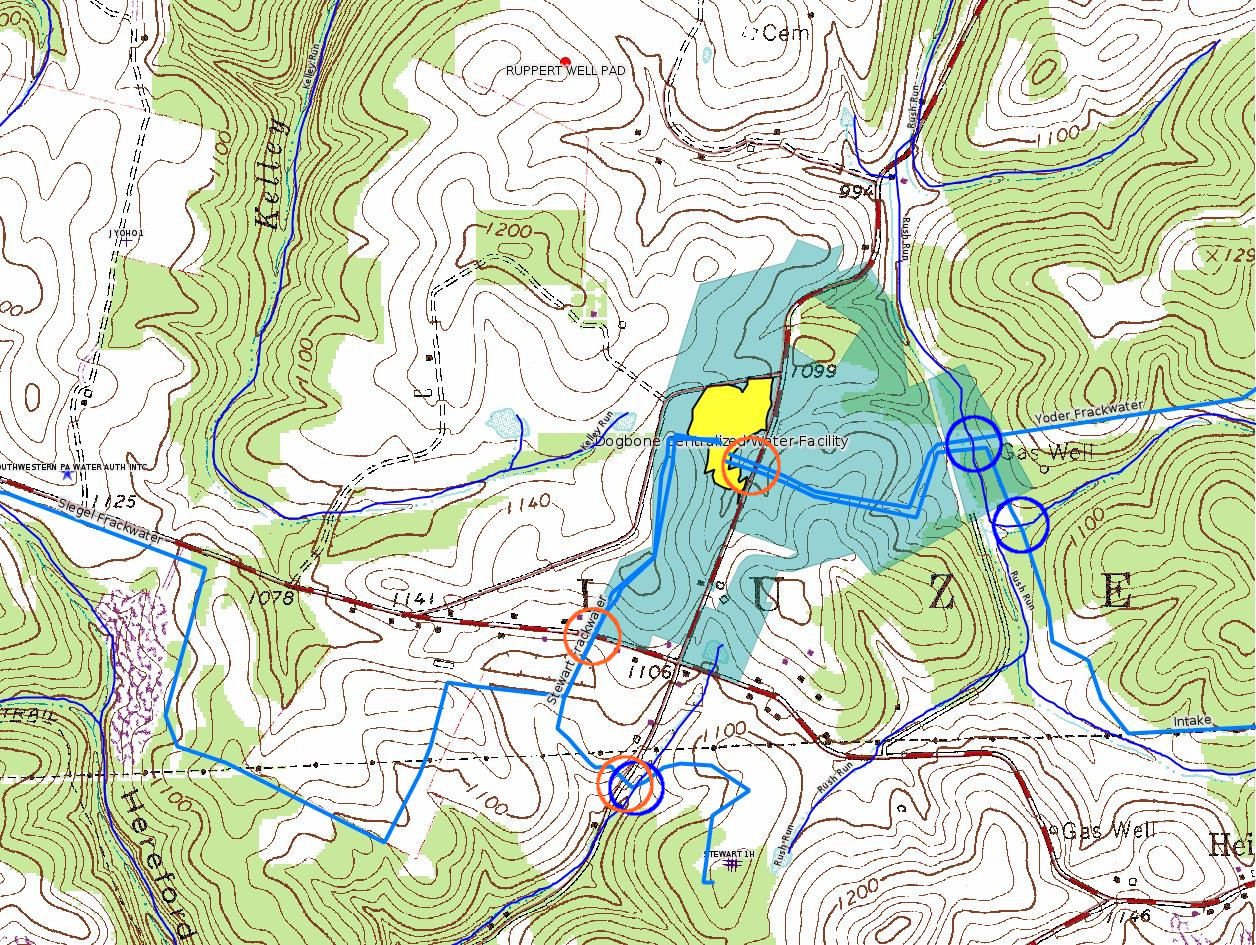
While DEP publishes in several places the latitude and longitude of the well bore surface location (this is known as the "Top Hole"), for a horizontal well there are additional locations that determine the routing. The Landing Point is the point at which the well bore actually "arrives" at the depth in the shale from which gas will be produced. The Bottom Hole is the point at the far end of the horizontal. The plat shows latitude and longitude for both the Landing Point and Bottom Hole; these locations do not seem to be available in data DEP publishes anywhere else. For the majority of horizontal wells, the routing of the horizontal appears to be a straight line from the Landing Point to the Bottom Hole. However, the plats for some of the wells among Stewart / Siegel / Yoder show a point marked Inflection Point, which appears to be a point along the horizontal between the Landing Point and the Bottom Hole at which the horizontal changes direction. (Note however that the plat for Siegel 9H shows a routing that is curved as it approaches the Bottom Hole.)
All of the horizontals mapped with this issue -- except for Siegel 9H -- are mapped as either a solid red line from the Landing Point to the Bottom Hole, or a solid red line from Landing Point to Inflection Point and then from Landing Point to Bottom Hole. The association between the Top Hole and Landing Point is shown as a dashed red line; this is meant to show only "logical" association and does not show the actual routing of the horizontal. (The horizontal route from Top Hole to Landing Point is typically curved.)
Disclaimer: There can be some imprecision when GIS layers are overlaid from different data sources. The maps provided here are entirely unofficial, subject to error, and should not be taken as definitive in determining questions of rights to extract gas from the subsurface underneath the indicated parcels.
---
The GP08 and GP05 crossings permits above for the DOG BONE WATER SYSTEM show only one subfacility each, with no mapping link for either one. Overlaying a trace of Chevron's "proposed" pipelines to be connected to the Dogbone Centralized Water Facility, as presented to the Fayette County Zoning Hearing Board on 12/13/17 (case ZHB 17-41) onto a topographic map with the "NHD Flowline" stream data superimposed (see the top right map under "More Maps" above) shows 3 road crossings (orange circles) and 3 stream crossings (blue circles). It is not clear what accounts for this discrepancy.
---
The Kennedy Compressor Station was previously owned by Mountain Gathering, which is a subsidiary of XTO, which is itself a subsidiary of Exxon. It is not clear whether the current authorization is for any change to installed equipment, or just the change of ownership.
------------------------
DEP defines an environmental justice area as "any census tract where 20 percent or more individuals live in poverty, and/or 30 percent or more of the population is minority". (See:
<http://www.dep.pa.gov/PublicParticipation/OfficeofEnvironmentalJustice/Pages/default.aspx>). There are supposed to be enhanced public participation requirements for permits in environmental justice areas, but news of this actually ever happening is scarce. In Fayette County, the entirety of Springhill, Nicholson, German, and Georges Townships are environmental justice areas, as well as a large part of Dunbar Township. DEP's policy document on public participation guidelines for environmental justice areas is located here:
<http://www.elibrary.dep.state.pa.us/dsweb/Get/Version-48671/012-0501-002.pdf>
eNOTICE records are likely to list the same permit multiple times, as that permit moves through the DEP process.
Oil & Gas Wells designated with a site a number and the letter H typically designate horizontal wells.
-------------------------
Resources:
Pennsylvania Bulletin: <http://www.pabulletin.com/>
eNOTICE: <http://www.ahs2.dep.state.pa.
DEP Oil and Gas Reports: <http://www.dep.pa.gov/DataandTools/Reports/Oil%20and%20Gas%20Reports/Pages/default.aspx>
DEP Permits Issued Detail Report:
<http://www.depreportingservic
DEP SPUD (drilling started) Report:
<http://www.depreportingservices.state.pa.us/ReportServer/Pages/ReportViewer.aspx?/Oil_Gas/Spud_External_Data>
DEP Oil and Gas Compliance Report:
<http://www.depreportingservices.state.pa.us/ReportServer/Pages/ReportViewer.aspx?/Oil_Gas/OG_Compliance>
DEP PA Oil & Gas Mapping:
<http://www.depgis.state.pa.us/PaOilAndGasMapping>
Data Portal Services Directory [Technical]
<http://www.depgis.state.pa.us/arcgis/rest/services>
Query: Oil and Gas Wells All (ID: 3) [Technical]:
<http://www.depgis.state.pa.us/arcgis/rest/services/OilGas/OilGasAllStrayGas/MapServer/3/query?where=&text=&objectIds=&time=&geometry=&geometryType=esriGeometryEnvelope&inSR=&spatialRel=esriSpatialRelIntersects&relationParam=&outFields=OBJECTID%2CPERMIT_NUMBER%2CWELL_NAME%2COPERATOR%2COPERATOR_NUMBER%2CWELL_TYPE%2CWELL_TYPE_CODE%2CWELL_STATUS%2CWELL_STATUS_CODE%2CPERMIT_DATE%2CPERMIT_DATE_EXPIRES%2CSPUD_DATE%2CCONSERVATION_IND%2CCOUNTY%2CCOUNTY_ID%2CMUNICIPALITY%2CMUNICIPALITY_TYPE%2CMUNICIPALITY_CODE%2CLATITUDE%2CLONGITUDE%2CPRMRY_FID%2CUNCONVENTIONAL_IND%2CSURFACE_ELEVATION%2CWELL_CONFIG_CODE%2CCOAL_IND%2CWELL_PAD_NAME%2CSHAPE%2CDATE_PLUGGED%2CWELL_PAD_ID%2CUIC_ID%2CUIC_TYPE_DESCRIPTION%2CSTORAGE_FIELD_NAME%2CSITE_ID%2CSITE_NAME&returnGeometry=true&returnTrueCurves=false&maxAllowableOffset=&geometryPrecision=&outSR=&returnIdsOnly=false&returnCountOnly=false&orderByFields=&groupByFieldsForStatistics=&outStatistics=&returnZ=false&returnM=false&gdbVersion=&returnDistinctValues=false&resultOffset=&resultRecordCount=&f=html>
(Be sure to enter a Where clause in SQL format. Dates are in milliseconds since midnight 1/1/1970).
DEP Oil and Gas Electronic Notifications
<http://www.depreportingservices.state.pa.us/ReportServer?/Oil_Gas/OG_Notifications>
DEP Oil and Gas Well Pad Report
<http://www.depreportingservices.state.pa.us/ReportServer?/Oil_Gas/Well_Pads>
Fayette County Assessment Office Search For Tax Records:
<http://property.co.fayette.pa.us/search.aspx>
Pennsylvania Spatial Data Access:
<http://www.pasda.psu.edu/default.asp>
DEP Spatial Data Repository:
<ftp://www.pasda.psu.edu/pub/pasda/dep/>
National Response Center:
<http://www.nrc.uscg.mil/>
EPA-Echo: <http://www.epa-echo.gov/echo/
FERC citizen involvement: <http://www.ferc.gov/for-citiz
To receive E-mail notification of
all documents filed in a FERC docket, see:
<http://www.ferc.gov/docs-filing/esubscription.asp >
<http://www.ferc.gov/docs-fili
Follow the directions and enter the docket number to subscribe to.
Township Supervisors receive information regarding Erosion & Sedimentation permits, and these records may be reviewable at township municipal offices.
DEP permits are reviewable through the File Review process, for application to do file review see: <http://www.portal.state.pa.us/portal/server.pt/community/southwest_regional_office/13775/file_review/593164>
Environmental Hearing Board: <http://ehb.courtapps.com/publ
PA DEP Environmental Policy Comment System:
<http://www.ahs.dep.pa.gov/eComment/>
Federal Register Environment: <https://www.federalregister.g
Browsing of recent comment
opportunities for federal agencies, e.g. EPA. Click "sign up" to
subscribe to daily E-mails of new document listings.
SkyTruth Fayette County Drilling Alerts: <http://frack.skytruth.org/pen
U.S. Army Corps of Engineers, Pittsburgh District, Public Notices:
<http://www.lrp.usace.army.mil/Missions/Regulatory/Public-Notices/>
EPA Pennsylvania Public Notices: <http://www2.epa.gov/aboutepa/epa-pennsylvania#notice>
Marcellus Shale waste disposal
injection wells in Pennsylvania are regulated directly by EPA, not
DEP. Notice of any new permit applications will appear at the
above web address. I'm not aware of any subscription service
to be notified of such applications. I'm not aware of any
Marcellus Shale waste disposal injection wells in Fayette County
(yet ...) but we need to monitor this page for future
applications.
Energy Assurance Daily: <http://www.oe.netl.doe.gov/ead.aspx>
Daily newsletter from the US
Department of Energy about events relating to energy. The Natural
Gas section has information about pipelines.
-------------------------
Disclaimers:
This compilation from the above sources was done by hand using copy and paste and may omit relevant permits.
Parcel data is provided via the tax records search web page offered by the Fayette County Assessment Office (http://property.co.fayette.pa.us/). Presumed Parcel Id links are subject to availability provided by that agency and associated web sites. Presumed Parcel Ids are determined as the mapped parcel containing a given latitude and longitude, are a best effort determination which is subject to error, and are not official. In cases where a facility is leased and there is a separate parcel id for the lease, if this parcel id is not separately mapped, the parcel id shown will be the id for the enclosing parcel. Parcel owners may be surface owners only and may or may not have any relationship to oil & gas facilities.
Does not currently include water supply permits. Does not include landfill permits even though many such are for Marcellus Shale waste. (It is not possible at this time to distinguish which landfill permits are for Marcellus Shale waste and which are not without doing File Review for each permit.)
Erosion & Sedimentation permit records do not currently include latitude and longitude. Where I am publishing latitude and longitude with E&S permits it is by inferring an associated well permit and using published latitude and longitude for the well. It is possible I may be inferring the wrong well site.
Municipalities are shown from eFACTS records on the DEP web site. The DEP has been known to list a municipality incorrectly.