The Harmed Success Stories Concepts How To What Is Commentary
Fayette County Marcellus Shale Permits 3/11/19 - 3/24/19
Contents
Pennsylvania Bulletin Listings
PROPOSED RULEMAKING: Additional Requirements for Control of Fine Particulate MattereFACTS Listings
Fayette Energy Center turbine components replaced and combustion control logic change Extension
Shamrock Compressor Station extend temporary operation of 3 Caterpillar G3516B compressor engines
Shamrock Compressor Station extend temporary operation of new dehydrator and emergency generator
Governor's Office Regulatory Agenda
Shamrock Compressor Station DEP intends to issue PA-26-00588B Public Comment Period
GANS GENERATING FAC Major Facility Operating Permit Renewal (New)Electronic Notifications
TEXAS EASTERN TRANSMISSION FAYETTE CNTY GP-08 Temporary Road Crossings Issued 3/12/2019 (New)
POLK UNIT 2H Drill & Operate Well Permit Inactive Status Denied 3/12/2019 (New)
TEXAS EASTERN TRANSMISSION FAYETTE CNTY BWM-GP-11 Maintenance, Testing, Repair, Rehabilitation or Replacement Issued 3/12/2019 (New)
RONCO WATER TREATMENT PLANT GP-04 Intake & Outfall Structures (New)
RONCO WATER TREATMENT PLANT GP-02 Small Docks & Boat Launch Ramps (New)
STEWART 6H Well Plugging Notice Intent to Plug Single Well Issued 3/12/2019
SNAPP TESLOVICH WELL PAD A Erosion and Sediment Control General Permit 3 2/26/2019 deficiency letter
KOVACH B M07H Casing cementing notification Coal Protected Casing 1: 3/15/2019
KOVACH B M09H Drilling resumption After Break of 30 days or more 03/22/2019
KOVACH B M09H Casing cementing notification Coal Protected Casing 2: 3/24/2019
STEWART 1H Pressure test notification 03/25/2019
STEWART 2H Pressure test notification 03/25/2019
STEWART 3H Pressure test notification 03/25/2019
STEWART 1H Stimulation [= fracking -jr] notification 03/25/2019
STEWART 2H Stimulation notification 03/25/2019
STEWART 3H Stimulation notification 03/25/2019
Inspection Anomalies (Oil & Gas
Compliance Report)
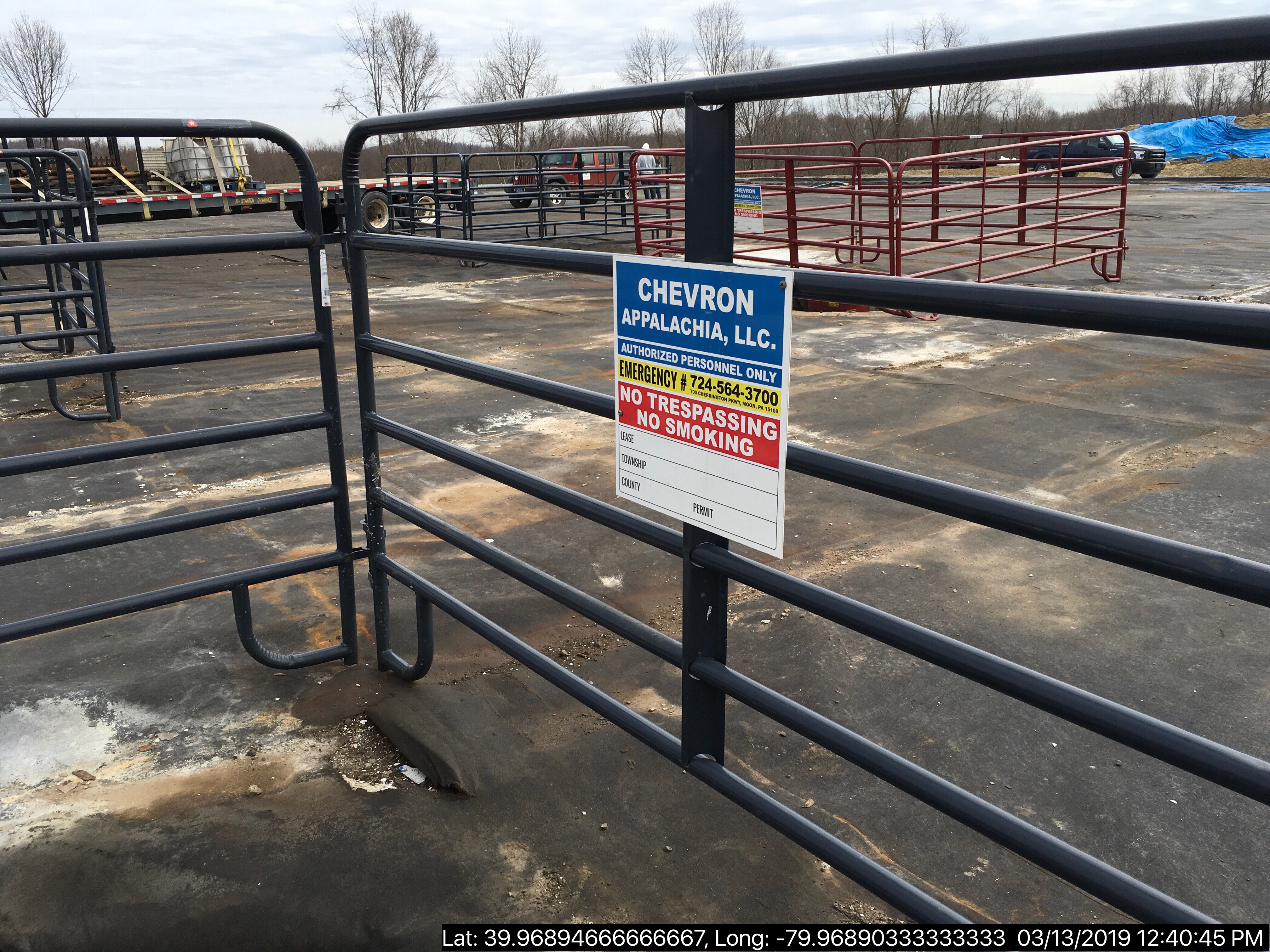
Price of Natural GasSIEGEL 1 drilling mud impacted soil spilled; became uncovered; secondary containment insufficient Violation(s) Noted (Includes photos)
BOZEK 1 corrosion was observed
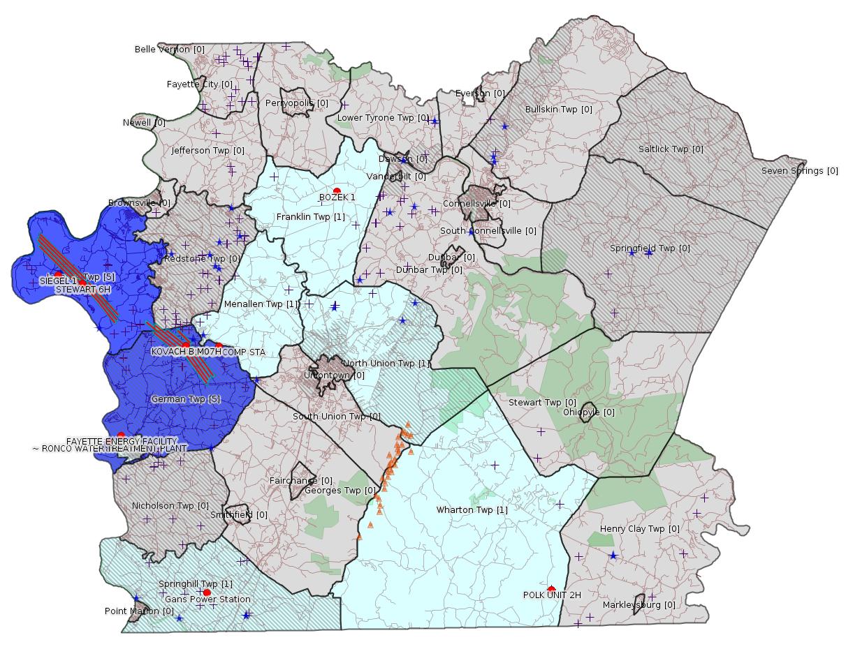
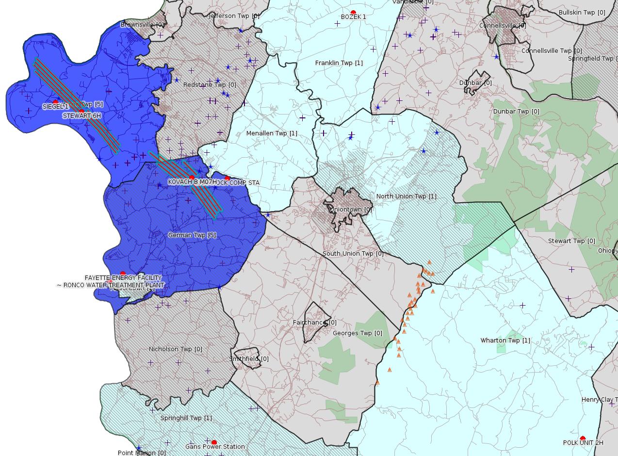
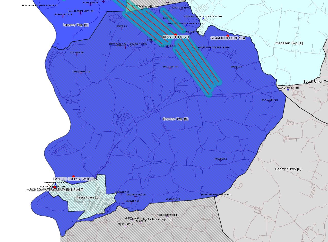
Map
Key
Red dots: items in this permit list with an exact location.
Blue stars: Marcellus Gas Well Water Sources.
Where well laterals are mapped they show in red; a 400-foot buffer surrounding the lateral shows in blue (lavender where it overlaps a mapped mineral tract).
Where mineral tracts are mapped, they show in pink. Mineral tracts can overlap; the overlap will show in red. The precise meaning of "mineral tract" is not clear.
Municipality shading: number of "facilities", with each well counting separately
(includes the red dots):
gray: 0
pale turquoise: 1
turquoise: 2
pale blue: 3
middle blue: 4
dark blue: 5
dark purple: 8
purple: 19
(Color coding may differ from one issue to the next.)
(Note if a project spans multiple municipalities -- e.g. a pipeline -- it will show in the count for each municipality.)
The number of facilities also follows the municipality name in brackets.
Municipality counts are based on the way the permit is listed by DEP; DEP has been known to get a municipality wrong.
Locations in brackets identify a precise location used to locate a surrogate for the actual site being permitted (e.g. locating a well pad or pipeline by the known location of a well.) Locations labeled beginning with "~" and ending in "[?]" are approximate and speculative based on inferences using on-line property and lease records. These are marked in the text as "[Approximate, Speculative]
Cross-hatching: Environmental Justice Areas
Yellow triangles: Compressor Stations
Orange triangles: Storage Field Wells (currently Dominion North Summit Storage Field)
Crosses: SPUD Unconventional well permits
Green: "Natural areas", e.g. state game lands, state forests
Yellow triangles: Compressor Stations
Orange triangles: Storage Field Wells (currently Dominion North Summit Storage Field)
Crosses: SPUD Unconventional well permits
Green: "Natural areas", e.g. state game lands, state forests
More Maps
 |
 |
Source: Pennsylvania Bulletin
[Not clear if this applies to Fayette County:]
PROPOSED RULEMAKING
ENVIRONMENTAL QUALITY BOARD
[ 25 PA. CODE CHS. 121 AND 127 ]
Additional Requirements for Control of Fine Particulate Matter in the Nonattainment New Source Review Program
[49 Pa.B. 1146]
[Saturday, March 16, 2019]
[Excerpts]
The Environmental Quality Board (Board) proposes to amend Chapters 121 (relating to general provisions) and 127, Subchapters E and H (relating to new source review; and general plan approvals and operating permits) to read as set forth in Annex A. This proposed rulemaking would incorporate recently promulgated Federal requirements for the regulation of volatile organic compounds (VOC) and ammonia as precursor emissions to the formation of fine particulate matter, which is particulate matter less than and equal to 2.5 micrometers in diameter (PM2.5). This proposed rulemaking would also revise the application submission options for the use of general plan approvals and operating permits for portable sources in § 127.641(c) (relating to application for use of plan approvals and operating permits for portable sources).
This proposed rulemaking is necessary to address a mandatory 18-month sanction clock, in accordance with section 179 of the Clean Air Act (CAA) (42 U.S.C.A. § 7509), following the United States Environmental Protection Agency's (EPA) determination that the Commonwealth has not met its obligations for the nonattainment new source review (NNSR) permit program, because its existing NNSR program does not include emissions of VOC and ammonia as PM2.5 precursors. To stop the sanction clock, the Commonwealth will need to submit this proposed rulemaking to the EPA, for the EPA's technical and administrative review, by November 7, 2019.
This proposed rulemaking will be submitted to the EPA for approval as a revision to the Commonwealth's State Implementation Plan (SIP) following promulgation of the final-form rulemaking.
This proposed rulemaking is given under Board order at its meeting of December 18, 2018.
[Sections Omitted ...]
This proposed rulemaking amends the § 121.1 definitions of ''major facility'' and ''significant'' and the Chapter 127 Subchapter E NNSR permitting regulations related to the VOC and ammonia offset ratio provisions under the Implementation Rule. On November 4, 2016, the South Coast Air Quality Management District (SCAQMD) amended its NNSR program to include ammonia and VOC as precursors to PM2.5 (SCAQMD Rule 1325). As part of that rulemaking, SCAQMD added a significance threshold for ammonia of 40 TPY, which is the same significance threshold in this proposed rulemaking. SCAQMD also included an offset ratio for VOC and ammonia of 1:1, which is the same offset ratio in this proposed rulemaking. On May 8, 2017, the California Air Resources Board submitted a SIP revision to the EPA with the amendments to SCAQMD Rule 1325. On November 30, 2018, the EPA issued a conditional approval of the SIP revision. See 83 FR 61551 (November 30, 2018).
A. Effective Date
This proposed rulemaking will be effective upon final-form publication in the Pennsylvania Bulletin.
B. Contact Persons
For further information, contact Virendra Trivedi, Chief, Division of Permits, Bureau of Air Quality, Rachel Carson State Office Building, P.O Box 8468, Harrisburg, PA 17105-8468, (717) 783-9476; or Elizabeth Davis, Assistant Counsel, Bureau of Regulatory Counsel, Rachel Carson State Office Building, P.O. Box 8464, Harrisburg, PA 17105-8464, (717) 787-7060. Information regarding submitting comments on this proposed rulemaking appears in Section J of this preamble. Persons with a disability may use the Pennsylvania AT&T Relay Service, (800) 654-5984 (TDD users) or (800) 654-5988 (voice users). This proposed rulemaking is available on the Department of Environmental Protection's (Department) web site at www.dep.pa.gov (select ''Public Participation,'' then ''Environmental Quality Board (EQB)'').
C. Statutory Authority
This proposed rulemaking is authorized under section 5(a)(1) of the Air Pollution Control Act (APCA) (35 P.S. § 4005(a)(1)), which grants the Board the authority to adopt rules and regulations for the prevention, control, reduction and abatement of air pollution in this Commonwealth. Section 5(a)(8) of the APCA also grants the Board the authority to adopt rules and regulations designed to implement the provisions of the CAA (42 U.S.C.A. §§ 7401—7671q).
[Sections Omitted ...]
On April 6, 2018, the EPA published a notice of finding of failure to submit (FFS) SIP revisions for the 2012 annual PM2.5 NAAQS, effective May 7, 2018. See 83 FR 14759 (April 6, 2018). The EPA's FFS included a determination that the Commonwealth has not met its obligations for the NNSR permit program for Allegheny, Delaware and Lebanon Counties because emissions of VOCs and ammonia are not currently regulated as PM2.5 precursors. In addition, the FFS included a determination that the following required SIP elements were not submitted for Allegheny County: emissions inventory, control strategy, attainment demonstration, reasonable further progress, qualitative milestones and contingency measures. Because the Allegheny County Health Department is an approved local air pollution control agency under section 12(b) of the APCA (35 P.S. § 4012(b)), it is developing its own SIP revision to address these required SIP elements which the Department will submit to the EPA. In accordance with section 179 of the CAA, a mandatory 18-month sanction clock began on May 7, 2018, the effective date of the FFS.
Therefore, to stop the sanction clock and correct the deficiency that the Commonwealth has not met its obligations for the NNSR permit program, because the Commonwealth's existing NNSR program does not include VOC and ammonia as PM2.5 precursors, one of the following must occur by November 7, 2019:
1) The Commonwealth submits an updated NNSR regulation that addresses VOC and ammonia as PM2.5 precursors as a SIP revision, which the EPA determines to be technically and administratively complete; or
2) The Commonwealth submits a SIP revision for each nonattainment area, and the EPA fully approves and redesignates the area from nonattainment to attainment. Once an area is redesignated as attainment, NNSR would no longer apply.
The Department is currently working on both options to correct the deficiency to ensure that the sanction clock stops by November 7, 2019. Section 179 of the CAA authorizes the EPA to use two types of sanctions: 1) imposing what are called ''2:1 offsets'' on new or modified sources of emissions; and 2) withholding of certain Federal highway funds. Under section 179 of the CAA and its implementing regulations, the Administrator first imposes ''2:1 offsets'' sanctions for new or modified major stationary sources in the nonattainment area, and then, if the deficiency has not been corrected within 6 months, also applies Federal highway funding sanctions. See 40 CFR 52.31 (relating to selection of sequence of mandatory sanctions for findings made pursuant to section 179 of the Clean Air Act). Therefore, if the deficiency is not corrected, the EPA will impose mandatory ''2:1 offsets'' sanctions beginning November 7, 2019, and highway fund sanctions beginning May 7, 2020. The Commonwealth receives approximately $1.7 billion in Federal transportation funding annually, which would be at risk if the Commonwealth does not implement one of the previously listed options.
This proposed rulemaking would also revise the application submission options for the use of general plan approvals and operating permits for portable sources in § 127.641(c). Currently applications may only be delivered through hand delivery or certified mail return receipt requested. The proposed change would remove these options thereby allowing delivery by any means.
This proposed rulemaking would help assure that the citizens of this Commonwealth benefit from reduced emissions of PM2.5 and PM2.5 precursors from regulated sources. Attaining and maintaining levels of PM2.5 below the health-based and welfare-based NAAQS is important to reduce premature mortality and other health and environmental effects associated with PM2.5 exposure.
[Sections Omitted ...]
K. Public Hearings
The Board will hold three public hearings for the purpose of accepting comments on this proposed rulemaking. The hearings will be held at 1 p.m. on the following dates:
April 16, 2019 Department of Environmental Protection
Southcentral Regional Office
Susquehanna Room A
909 Elmerton Avenue
Harrisburg, PA 17110
April 17, 2019 Department of Environmental Protection
Southwest Regional Office
Waterfront Conference Room A
400 Waterfront Drive
Pittsburgh, PA 15222
April 18, 2019 Department of Environmental Protection
Southeast Regional Office
Delaware River Room
2 East Main Street
Norristown, PA 19401
Persons wishing to present testimony at a hearing are requested to contact the Environmental Quality Board, P.O. Box 8477, Harrisburg, PA 17105-8477, (717) 787-4526 at least 1 week in advance of the hearing to reserve a time to present testimony. Oral testimony is limited to 5 minutes for each witness. Witnesses are requested to submit three written copies of their oral testimony to the hearing chairperson at the hearing. Organizations are limited to designating one witness to present testimony on their behalf at each hearing.
Persons in need of accommodations as provided for in the Americans with Disabilities Act of 1990 should contact the Board at (717) 787-4526 or through the Pennsylvania AT&T Relay Service at (800) 654-5984 (TDD) or (800) 654-5988 (voice users) to discuss how the Board may accommodate their needs.
PATRICK McDONNELL,
Chairperson
<https://www.pabulletin.com/secure/data/vol49/49-11/362.html>
---
26-00535B: Dynegy Fayette II, LLC (100 Energy Drive, Masontown, PA 15461) Extension effective February 28, 2019, to allow continued temporary operation of the modified combustion gas turbines (''CGT'') at Fayette Energy Center located in Masontown Borough, Fayette County. Components of the turbine section have been replaced and combustion control logic change to increase combustion air flow.
<https://www.pabulletin.com/secure/data/vol49/49-11/369c.html>
Location: 39.857408,-79.913878 [See
Notes.]
Map URL: <http://www.openstreetmap.org/?mlat=39.857408&mlon=-79.913878#map=15/39.857408/-79.913878>
Presumed Parcel Id: 1530006703
Map URL: <http://www.openstreetmap.org/?mlat=39.857408&mlon=-79.913878#map=15/39.857408/-79.913878>
Presumed Parcel Id: 1530006703
---
26-00588: Laurel Mountain Midstream Operating, LLC (1550 Coraopolis Heights Road, Suite 140, Moon Township, PA 15108) Extension effective February 28, 2019, to extend the period of temporary operation of the three Caterpillar G3516B natural gas-fired compressor engines rated at 1,380 bhp each and controlled by oxidation catalysts, and a Solar Mars 100 gas-fired turbine rated at 15,525 bhp authorized under plan approval PA-26-00588 at Shamrock Compressor Station located in German Township [an Environmental Justice Area], Fayette County.
<https://www.pabulletin.com/secure/data/vol49/49-11/369c.html>
Location: 39.918333,-79.825
Map URL: <http://www.openstreetmap.org/?mlat=39.918333&mlon=-79.825#map=15/39.918333/-79.825>
Map URL: <http://www.openstreetmap.org/?mlat=39.918333&mlon=-79.825#map=15/39.918333/-79.825>
Parcel ID: 15140026
---
26-00588A: Laurel Mountain Midstream Operating, LLC (1550 Coraopolis Heights Road, Suite 140, Moon Township, PA 15108) Extension effective February 28, 2019, to extend the period of temporary operation of the new dehydrator and emergency generator authorized under plan approval PA-26-00588A at Shamrock Compressor Station located in German Township [an Environmental Justice Area], Fayette County.
<https://www.pabulletin.com/secure/data/vol49/49-11/369c.html>
---
NOTICES
GOVERNOR'S OFFICE
Regulatory Agenda
[49 Pa.B. 1461]
[Saturday, March 23, 2019]
Executive Order 1996-1 requires all agencies under the jurisdiction of the Governor to submit for publication semi-annually an agenda of regulations under development or consideration.
The agendas are compiled to provide members of the regulated community advanced notice of regulatory activity. It is the intention of the Administration that these agendas will serve to increase public participation in the regulatory process.
Agency contacts should be contacted for more information regarding the regulation and the procedure for submitting comments.
This Agenda represents the Administration's present intentions regarding future regulations. The information provided is current as of February 22, 2019. The nature and complexity of an individual regulation obviously will determine whether and when any particular regulation listed (as well as any considered subsequent to publication of this Agenda) is published.
[Exceprts:]
| Regulation Being Considered |
Proposed Date of Promulgation |
Need and Legal Basis for Action |
Agency Contact |
|---|---|---|---|
| Unconventional Well Permit Application Fees 25 Pa. Code Chapter 78a (# 7-542) |
Quarter 3, 2019, EQB Consideration, as Final |
This rulemaking amends 25 Pa. Code §§ 78a.1 (relating to
definitions) and 78a.19 (relating to permit application fee schedule). These amendments are necessary to increase fees to support the administration of 58 Pa.C.S. Chapter 32 (related to development) (2012 Oil and Gas Act) by the DEP's Office of Oil and Gas Management. The rulemaking increases the current well permit application fees from $5,000 for nonvertical unconventional wells and $4,200 for vertical unconventional wells, to $12,500 for all unconventional well permit applications to administer the 2012 Oil and Gas Act. (2012 Oil and Gas Act) |
Kurt Klapkowski (717) 772-2199 kklapkowsk@pa.gov |
| Environmental Protection Performance Standards for
Conventional Oil and Gas Operators 25 Pa. Code Chapter 78 (# 7-539) |
Quarter 4, 2019, EQB Consideration, as Proposed |
This rulemaking proposes to amend the Oil and Gas regulations applicable to conventional operators (Chapter 78) to update the environmental protection performance standards related to oil and gas activities. (2012 Oil and Gas Act, Clean Streams Law, Solid Waste Management Act, Dam Safety Encroachment Act, Land Recycling and Environmental Remediation Standards Act, Radiation Protection Act, Unconventional Well Report Act, Act 126 of 2014) | Kurt Klapkowski (717) 772-2199 kklapkowsk@pa.gov |
| Control of Emissions from the Oil and Natural Gas Industry
25 Pa. Code Chapter 129 (# 7-544) |
Quarter 2, 2019, EQB Consideration, as Proposed |
This rulemaking proposes to establish emission limitations and other requirements codified in 25 Pa. Code Chapter 129 consistent with reasonably available control technology (RACT). The proposed rulemaking would establish RACT requirements for volatile organic compounds and other pollutants from existing oil and natural gas production facilities, compressor stations, processing plants, and transmission stations. Upon promulgation, the final-form regulation would be submitted to the EPA for approval as a SIP revision. (Air Pollution Control Act) | Susan Hoyle (717) 772-2329 shoyle@pa.gov |
---
PA-26-00588B: Laurel Mountain Midstream, LLC (''LMM'') (1550 Coraopolis Heights Road, Suite 140, Moon Township, PA 15108) Notice is hereby given in accordance with 25 Pa. Code §§ 127.44—127.46 that the Department of Environmental Protection (DEP) intends to issue Air Quality Plan Approval: PA-26-00588B to LMM for the Shamrock Compressor Station located in German Township [an Environmental Justice Area], Fayette County to authorize for the construction, modification, and temporary operation of the following air contamination sources, controls, and/or activities at a synthetic minor facility:
• One (1) existing, CAT G3516B (CE-06) 1,380 bhp natural gas-fired compressor engine equipped with a Miratech SP-XESO-36X31-14-XH2B1 or equivalent oxidation catalyst and an air to fuel ratio controller in which the hours of operation will be increased to 8,760 hours per consecutive 12-month period.
• Two (2) new, CAT G3516J (CE-03 and CE-04), 1,380 bhp natural gas fired compressor engines equipped with a Miratech SP-XESO-36X31-14-XH2B1 or equivalent oxidation catalyst and an air to fuel ratio controller.
• One (1) new Solar Titan 130-23502S (CT-02) rated at 22,248 bhp with SoLoNOx technology
• One (1) existing Glycol Purification Unit (GPU-ENG, GPU-HTR) with Cimarron Tank Pacer time on site will be increased to 8,760 hours per consecutive 12-month period
• One (1) new Produced Water Storage Tank (TK-03) with a capacity of 476 bbl
Modified Facility Wide Potential to Emit
This authorization is subject to State regulations including 25 Pa. Code Chapters 123—Standards for Contaminants; 124—National Emission Standards for Hazardous Air Pollutants, 127—Construction, Modification, Reactivation, and Operation of Sources; 129—Standards for Sources; 135—Reporting of Sources; and 139—Sampling and Testing. State standards for contaminants and sources are superseded in most cases by more stringent Best Available Technology (BAT) determinations in accordance with 25 Pa. Code § 127.12(a)(5) requirements. This authorization is also subject to Federal New Source Performance Standards (NSPS) including 40 CFR Part 60 Subparts A, JJJJ, KKKK, OOOOa, and National Emission Standards for Hazardous Air Pollutants (NESHAP) including 40 CFR Part 63 Subparts A, HH, and ZZZZ, and 40 CFR Part 98 Mandatory Greenhouse Gas Reporting.
Modified Facility Wide Potential to Emit
Air Contaminant Emission Rate
(tpy)
Nitrogen Oxides (NOx) 84.39 Carbon Monoxide (CO) 76.52 Total Particulate Matter (PM) 15.24 Particulate Matter Less Than
10 Microns In Diameter (PM10)15.24 Particulate Matter Less Than
2.5 Microns In Diameter (PM2.5)15.24 Sulfur Oxides (SOx) 4.57 Volatile Organic Compounds (VOC) 32.26 Hazardous Air Pollutants (HAP) 9.65 Carbon Dioxide Equivalents (CO2e) 183,497
Plan approval conditions will include source specific and facility-wide emission limitation, operational restrictions, compliance testing and monitoring requirements, work practice standards, and associated recordkeeping and reporting requirements. The Department has determined that the proposed facility satisfies the Department's Best Available Technology (BAT) requirements. Once compliance with the Plan Approval is demonstrated, the applicant will be required to submit a State Only Operating Permit (SOOP) application in accordance with 25 Pa. Code Subchapter F.
A person may oppose the proposed plan approval by filing a written protest with the Department through Sheri Guerrieri via the U.S. Postal Service to Pennsylvania Department of Environmental Protection, 400 Waterfront Drive, Pittsburgh, PA 15222; email to shguerrier@pa.gov; or fax to 412.442.4194. Additional written comments may also be submitted. Each protest or set of written comments must contain the name, address and telephone number of the person submitting the comments, identification of the proposed Plan Approval (PA-26-00588B) and a concise statement of the objections to the plan approval issuance and the relevant facts upon which the objections are based.
LMM's Plan Approval application, the Department's Air Quality Review Memorandum, and the Proposed Air Quality Plan Approval for this project are available for review by any interested party at the Pennsylvania Department of Environmental Protection, Southwest Regional Office, 400 Waterfront Drive, Pittsburgh, PA 15222. To request a review of the LMM Plan Approval Application, to receive an electronic copy of the Department's Air Quality Review Memorandum, or to receive an electronic copy of the Department's proposed air Quality Plan Approval for this project, a person may contact Sheri Guerrieri at shguerrier@pa.gov or 412.442.4069.
All comments must be received prior to the close of business 30 days after the date of this publication.
A public hearing may be held, if the Department, in its discretion, decides that such a hearing is warranted based on the information received. All persons submitting comments or requesting a hearing will be notified of the decision to hold a hearing in writing or by publication in the newspaper and the Pennsylvania Bulletin, or by telephone, where the Department determines such notification by telephone is sufficient.
<https://www.pabulletin.com/secure/data/vol49/49-12/430a.html>
-------------------------
Source: eNOTICE (+ PA Oil and Gas Mapping, Well Pad Report.) Well Details via Data Portal Services: Oil and Gas Wells All (ID: 3).
Please see the Disclaimer below regarding Parcel Id data.
Authorization ID: 1264863
Permit number: 26-00495
Site: GANS GENERATING FAC
Client: GANS ENERGY LLC
Authorization type: Major Facility Operating Permit
Application type: Renewal
Authorization is for: FACILITY
Date received: 07/27/2009
Status: Pending
Permit Decision Guarantee Applies?: No
Sub-Facilities for Authorization:
Sub-Facility ID Sub-Facility Name Description
571256 COMBUSTION GAS TURBINE UNIT 8(355 MMBTU/HR,NG,SIMPLE CYCLE) Process
Location: 39.747518,-79.838772
Map URL: <http://www.openstreetmap.org/?mlat=39.747518&mlon=-79.838772#map=15/39.747518/-79.838772>
571257 COMBUSTION GAS TURBINE UNIT 9(355 MMBTU/HR,NG,SIMPLE CYCLE) Process
Location: 39.747518,-79.838772
Map URL: <http://www.openstreetmap.org/?mlat=39.747518&mlon=-79.838772#map=15/39.747518/-79.838772>
1280758 COOLING TOWERS Process
Location: 39.747518,-79.838772
Map URL: <http://www.openstreetmap.org/?mlat=39.747518&mlon=-79.838772#map=15/39.747518/-79.838772>
802896 UNIT 8 WATER INJECTION SYSTEM Air Pollution Control Device
Location: 39.747518,-79.838772
Map URL: <http://www.openstreetmap.org/?mlat=39.747518&mlon=-79.838772#map=15/39.747518/-79.838772>
802897 UNIT 9 WATER INJECTION SYSTEM Air Pollution Control Device
Location: 39.747518,-79.838772
Map URL: <http://www.openstreetmap.org/?mlat=39.747518&mlon=-79.838772#map=15/39.747518/-79.838772>
<https://www.ahs.dep.pa.gov/eFACTSWeb/searchResults_singleAuth.aspx?AuthID=1264863>
Site Programs:
Air Quality
Clean Water
Site Municipalities:
Springhill Twp, Fayette County
---
Authorization ID: 1264675
Permit number: GP082605219-002
Site: TEXAS EASTERN TRANSMISSION FAYETTE CNTY
Client: TEXAS EASTERN TRANS LP
Authorization type: GP-08 Temporary Road Crossings
Application type: New
Authorization is for: FACILITY
Date received: 03/04/2019
Status: Issued on 3/12/2019
Permit Decision Guarantee Applies?: No
Permit Review Notes:
Date Review Note
3/12/2019 The technical review and decision review are complete and either the permit decision and/or permit issuance are forthcoming.
3/12/2019 The permit application package is complete, has been accepted, and is undergoing technical review.
<https://www.ahs.dep.pa.gov/eFACTSWeb/searchResults_singleAuth.aspx?AuthID=1264675>
Site Programs:
Water Planning and Conservation
Site Municipalities:
German Twp [an Environmental Justice Area], Fayette County
Menallen Twp, Fayette County
North Union Twp, Fayette County
Authorization ID: 1264674
Permit number: 051-24429
Site: POLK 1H OG WELL
Client: LPR ENERGY LLC
Authorization type: Drill & Operate Well Permit Inactive Status
Application type: New
Authorization is for: FACILITY
Date received: 03/08/2019
Status: Denied on 3/12/2019
Permit Decision Guarantee Applies?: No
Sub-Facilities for Authorization:
Sub-Facility ID Sub-Facility Name Description
1035637 POLK UNIT 2H Well
1035636 POLK UNIT 2H Well
Permit Review Notes:
Date Review Note
3/12/2019 Application has been deemed to be technically deficient and has been denied.
3/12/2019 Application has been deemed to be technically deficient and has been denied.
3/11/2019 The permit application package is complete, has been accepted, and is undergoing technical review.
<https://www.ahs.dep.pa.gov/eFACTSWeb/searchResults_singleAuth.aspx?AuthID=1264674>
Site Programs:
Oil & Gas
Site Municipalities:
Wharton Twp, Fayette County
Well Details:
Permit Number: 051-24429
Well Name: POLK UNIT 2H
Unconventional Well: Y
Well Configuration: Horizontal Well
Well Type: GAS
Well Status: Regulatory Inactive Status
Coal Association: NonCoal
Conservation Well: N
Primary Facility ID: 738664
Site ID: 739411
Site Name: POLK 1H OG WELL
Well Pad ID: 149075
Well Pad Name: POLK UNIT 1H
Storage Field:
Operator: LPR ENERGY LLC
Operator Number: OGO-68579
Permit Date: 2011-02-28
Permit Date Expires: 2012-02-28
SPUD Date: 2011-08-26
Date Plugged:
UIC ID:
UIC Type:
Surface Elevation: 2310
County: Fayette
Municipality: Wharton Twp
Location: 39.746419,-79.529614
Map URL: <http://www.openstreetmap.org/?mlat=39.746419&mlon=-79.529614#map=15/39.746419/-79.529614>
OG WELLS PERMIT DOCS:
2017-11-30: Other Permit Documents, Name: Inactive 051-24429 (for Authorization: 1206221):
<http://www.depgis.state.pa.us/pdfHandler/pdFHandler.ashx?Doc=NTI2NDI1&ext=PDF>
Presumed Parcel Id: 4233000106
---
Authorization ID: 1264671
Permit number: GP112605219-002
Site: TEXAS EASTERN TRANSMISSION FAYETTE CNTY
Client: TEXAS EASTERN TRANS LP
Authorization type: BWM-GP-11 Maintenance, Testing, Repair, Rehabilitation or Replacement General Pmt
Application type: New
Authorization is for: FACILITY
Date received: 03/04/2019
Status: Issued on 3/12/2019
Permit Decision Guarantee Applies?: Yes
Permit Decision Guarantee status: ACTIVE
Permit Review Notes:
Date Review Note
3/12/2019 The technical review and decision review are complete and either the permit decision and/or permit issuance are forthcoming.
3/12/2019 The permit application package is complete, has been accepted, and is undergoing technical review.
<https://www.ahs.dep.pa.gov/eFACTSWeb/searchResults_singleAuth.aspx?AuthID=1264671>
Site Programs:
Water Planning and Conservation
Site Municipalities:
German Twp [an Environmental Justice Area], Fayette County
Menallen Twp, Fayette County
North Union Twp, Fayette County
Authorization ID: 1263830
Permit number: GP042607219-001
Site: RONCO WATER TREATMENT PLANT GP02 GP04
Client: APPALACHIAN WATER SVC LLC
Authorization type: GP-04 Intake & Outfall Structures
Application type: New
Authorization is for: FACILITY
Date received: 02/27/2019
Status: Pending
Permit Decision Guarantee Applies?: No
Sub-Facilities for Authorization:
Sub-Facility ID Sub-Facility Name Description
1282358 RONCO WATER TREATMENT PLANT GP04 Intake Structure
Permit Review Notes:
Date Review Note
3/13/2019 The permit application package is complete, has been accepted, and is undergoing technical review.
<https://www.ahs.dep.pa.gov/eFACTSWeb/searchResults_singleAuth.aspx?AuthID=1263830>
Site Programs:
Water Planning and Conservation
Site Municipalities:
Masontown Boro, Fayette County
Location [approximate]: 39.852778,-79.924722 <http://osm.org/go/ZWpM2V0y--?m=>
Presumed Parcel Id: 21010001[See Notes.]
---
Authorization ID: 1263829
Permit number: GP022607219-001
Site: RONCO WATER TREATMENT PLANT GP02 GP04
Client: APPALACHIAN WATER SVC LLC
Authorization type: GP-02 Small Docks & Boat Launch Ramps
Application type: New
Authorization is for: FACILITY
Date received: 02/27/2019
Status: Pending
Permit Decision Guarantee Applies?: No
Sub-Facilities for Authorization:
Sub-Facility ID Sub-Facility Name Description
1282357 RONCO WATER TREATMENT PLANT GP02 Dock
Permit Review Notes:
Date Review Note
3/13/2019 The permit application package is complete, has been accepted, and is undergoing technical review.
<https://www.ahs.dep.pa.gov/eFACTSWeb/searchResults_singleAuth.aspx?AuthID=1263829>
Site Programs:
Water Planning and Conservation
Site Municipalities:
Masontown Boro, Fayette County
Authorization ID: 1259064
Permit number: 051-24632
Site: STEWART WELL SITE ESCGP-2 EXPEDITED
Client: CHEVRON APPALACHIA LLC
Authorization type: Well Plugging Notice Intent to Plug Single Well
Application type: New
Authorization is for: FACILITY
Date received: 01/22/2019
Status: Issued on 3/12/2019
Permit Decision Guarantee Applies?: No
Sub-Facilities for Authorization:
Sub-Facility ID Sub-Facility Name Description
1248438 STEWART 6H Well
Permit Review Notes:
Date Review Note
2/5/2019 The technical review and decision review are complete and either the permit decision and/or permit issuance are forthcoming.
1/23/2019 The permit application package is complete, has been accepted, and is undergoing technical review.
<https://www.ahs.dep.pa.gov/eFACTSWeb/searchResults_singleAuth.aspx?AuthID=1259064>
Site Programs:
Environmental Cleanup & Brownfields
Oil & Gas
Site Municipalities:
Luzerne Twp, Fayette County
Well Details:
Permit Number: 051-24632
Well Name: STEWART 6H
Unconventional Well: Y
Well Configuration: Horizontal Well
Well Type: GAS
Well Status: Active
Coal Association: Coal
Conservation Well: N
Primary Facility ID: 794420
Site ID: 788124
Site Name: STEWART WELL SITE ESCGP-2 EXPEDITED
Well Pad ID: 152396
Well Pad Name: STEWART
Storage Field:
Operator: CHEVRON APPALACHIA LLC
Operator Number: OGO-39307
Permit Date: 2015-07-17
Permit Date Expires: 2019-01-26
SPUD Date: 2015-09-01
Date Plugged: 2019-02-09
UIC ID:
UIC Type:
Surface Elevation: 1145
County: Fayette
Municipality: Luzerne Twp
Location: 39.962881,-79.946972
Map URL: <http://www.openstreetmap.org/?mlat=39.962881&mlon=-79.946972#map=15/39.962881/-79.946972>
OG WELLS PERMIT DOCS:
2015-07-17: Final Permit Documents, Name: 051-24632-00-00 1077205 (for Authorization: 1077205):
<http://www.depgis.state.pa.us/pdfHandler/pdFHandler.ashx?Doc=MjExNjEw&ext=PDF>
2018-01-26: Final Permit Documents, Name: 1203104 (for Authorization: 1203104):
<http://www.depgis.state.pa.us/pdfHandler/pdFHandler.ashx?Doc=NTUxMTMx&ext=PDF>
2018-01-26: Other Permit Documents, Name: Approval of Surface Locations by Landowners (for Authorization: 1203104):
<http://www.depgis.state.pa.us/pdfHandler/pdFHandler.ashx?Doc=NTQ5NzEy&ext=PDF>
Electronically Submitted Records:
2018-01-26: Submission for Authorization 1203104
Pennsylvania Natural Diversity Inventory Form: Stewart Pad A PNDI 8-22-17.pdf
<http://www.depgis.state.pa.us/eWellDocHandler/pdFHandler.ashx?Doc=MzkwOTUw&ext=PDF>
Permit Application to Drill and Operate a Well: Stewart 6H Mod Application 2017.pdf
<http://www.depgis.state.pa.us/eWellDocHandler/pdFHandler.ashx?Doc=MzkwOTUx&ext=PDF>
Location Plat: Stewart Well Plats 6H.dwg
<http://www.depgis.state.pa.us/eWellDocHandler/pdFHandler.ashx?Doc=MzkwOTUy&ext=PDF>
Coal and Gas Resource Coord Act - Section 7 Exception: Stewart 1H-7H Waiver Request Section 7.pdf
<http://www.depgis.state.pa.us/eWellDocHandler/pdFHandler.ashx?Doc=MzkwOTUz&ext=PDF>
Well Cross-Section Diagram: Stewart 6H Page 4.pdf
<http://www.depgis.state.pa.us/eWellDocHandler/pdFHandler.ashx?Doc=MzkwOTU0&ext=PDF>
Record of Notification to Interested Parties: Stewart 6H Notification of Interested Parties.pdf
<http://www.depgis.state.pa.us/eWellDocHandler/pdFHandler.ashx?Doc=MzkwOTU1&ext=PDF>
Well Permit Application - Coal Module: Stewart 1H-7H 2017 Coal Module.pdf
<http://www.depgis.state.pa.us/eWellDocHandler/pdFHandler.ashx?Doc=MzkwOTU2&ext=PDF>
Electronic Submission Docket: 1628616.pdf
<http://www.depgis.state.pa.us/eWellDocHandler/pdFHandler.ashx?Doc=MzkyNzk2&ext=PDF>
Presumed Parcel Id: 19250010
For Well Record see:
<http://www.ahs.dep.pa.gov/eSubmissionsDocs/DownloadESubmissionDocument.ashx?enc=MOpmV6IzBtmToVjqF07C9SRAf8AQSTbeMdYe9kUceYM%3d>
For Well Record see:
<http://www.ahs.dep.pa.gov/eSubmissionsDocs/DownloadESubmissionDocument.ashx?enc=MOpmV6IzBtmToVjqF07C9SRAf8AQSTbeMdYe9kUceYM%3d>
---
Authorization ID: 1256620
Permit number: ESG30705118-002
Site: SNAPP TESLOVICH WELL PAD A ESCGP3 ESG30705118-002
Client: CHEVRON APPALACHIA LLC
Authorization type: Erosion and Sediment Control General Permit 3
Application type: New
Authorization is for: SITE
Date received: 12/20/2018
Status: Pending
Permit Decision Guarantee Applies?: Yes
Permit Decision Guarantee status: VOID
Permit Review Notes:
Date Review Note
2/26/2019 Applicant has been issued a deficiency letter. If applicable, this application no longer qualifies for the Permit Decision Guarantee.
1/28/2019 Applicant has been issued a deficiency letter. If applicable, this application no longer qualifies for the Permit Decision Guarantee.
<https://www.ahs.dep.pa.gov/eFACTSWeb/searchResults_singleAuth.aspx?AuthID=1256620>
Site Programs:
Site Municipalities:
Luzerne Twp, Fayette County
Location: 39.9877,-79.9023 <https://osm.org/go/ZWpZ~QrU--?m=>
Presumed Parcel Id: 19160028
Act 14 Notification: <https://www.faymarwatch.org/documents/SNAPP_TESLOVICH_WELL_PAD_A_NOI.pdf>
Presumed Parcel Id: 19160028
Act 14 Notification: <https://www.faymarwatch.org/documents/SNAPP_TESLOVICH_WELL_PAD_A_NOI.pdf>
-------------------------
Source: DEP Oil and Gas Electronic Notifications
NOTIFICATION_ID: 46560
OGO: 39307
OPERATOR: CHEVRON APPALACHIA LLC
API_PERMIT: 051-24668
SPUD_DATE: 10/23/2018
COUNTY: Fayette
MUNICIPALITY: German [an Environmental Justice Area]
LATITUDE: 39.919161
LONGITUDE: -79.854681
SUBJECT: [NOTIFICATION]: Casing cementing notification 58 Pa. C.S. 3211(f)(2) for well API 37-051-24668-00-00
QUESTION: Enter the Date and Time for the applicable Casing Types
ANSWER: Coal Protected Casing 1: 3/15/2019 11:00:00 AM
SENT_DATE: 3/11/2019 6:46:54 AM
SENT_SUCCESS: Yes
LAST_RESENT_DATE:
RESENT_SUCCESS:
Well Details:
Permit Number: 051-24668
Well Name: KOVACH B M07H
Unconventional Well: Y
Well Configuration: Horizontal Well
Well Type: GAS
Well Status: Active
Coal Association: Coal
Conservation Well: N
Primary Facility ID: 828034
Site ID: 826949
Site Name: KOVACH B WELL SITE AND TANK SITE ESCGP ESX17-051-0003
Well Pad ID: 155005
Well Pad Name: KOVACH B
Storage Field:
Operator: CHEVRON APPALACHIA LLC
Operator Number: OGO-39307
Permit Date: 2018-08-08
Permit Date Expires: 2019-08-08
SPUD Date: 2018-10-23
Date Plugged:
UIC ID:
UIC Type:
Surface Elevation: 1278
County: Fayette
Municipality: German Twp
Location: 39.919161,-79.854681
Map URL: <http://www.openstreetmap.org/?mlat=39.919161&mlon=-79.854681#map=15/39.919161/-79.854681>
OG WELLS PERMIT DOCS:
2018-08-08: Final Permit Documents, Name: 1237724 (for Authorization: 1237724):
<http://www.depgis.state.pa.us/pdfHandler/pdFHandler.ashx?Doc=NjQ2Nzcz&ext=PDF>
2019-01-09: Other Permit Documents, Name: 051-24668 (for Authorization: 1256785):
<http://www.depgis.state.pa.us/pdfHandler/pdFHandler.ashx?Doc=NzI5MDgy&ext=PDF>
Electronically Submitted Records:
2018-08-08: Submission for Authorization 1237724
Interested Party Notification: Kovach B Affidavit of Non-Delivery Venere.pdf
<http://www.depgis.state.pa.us/eWellDocHandler/pdFHandler.ashx?Doc=NjAyNTUw&ext=PDF>
Coal and Gas Resource Coord Act - Section 7 Exception: Kovach B Horizontals Section 7 Exception.pdf
<http://www.depgis.state.pa.us/eWellDocHandler/pdFHandler.ashx?Doc=NjAyNTY1&ext=PDF>
Pennsylvania Natural Diversity Inventory Form: Kovach B PNDI.pdf
<http://www.depgis.state.pa.us/eWellDocHandler/pdFHandler.ashx?Doc=NjAyNTY2&ext=PDF>
Location Plat: Kovach B M07H Plat.dwg
<http://www.depgis.state.pa.us/eWellDocHandler/pdFHandler.ashx?Doc=NjAyNTY3&ext=PDF>
Well Cross-Section Diagram: Kovach B M07H Page 4.pdf
<http://www.depgis.state.pa.us/eWellDocHandler/pdFHandler.ashx?Doc=NjAyNTY4&ext=PDF>
Permit Application to Drill and Operate a Well: 1753553.pdf
<http://www.depgis.state.pa.us/eWellDocHandler/pdFHandler.ashx?Doc=NjAzODcy&ext=PDF>
Presumed Parcel Id: 1511002301
---
NOTIFICATION_ID: 46788
OGO: 39307
OPERATOR: CHEVRON APPALACHIA LLC
API_PERMIT: 051-24670
SPUD_DATE: 10/23/2018
COUNTY: Fayette
MUNICIPALITY: German [an Environmental Justice Area]
LATITUDE: 39.919231
LONGITUDE: -79.854758
SUBJECT: [NOTIFICATION]: Drilling resumption After Break of 30 days or more notification 58 Pa. C.S. 3211(f)(1) for well API 37-051-24670-00-00
QUESTION: Date and approximate time action is to occur
ANSWER: Date: 03/22/2019 Time: 6:00pm
SENT_DATE: 3/21/2019 1:37:30 PM
SENT_SUCCESS: Yes
LAST_RESENT_DATE:
RESENT_SUCCESS:
Well Details:
Permit Number: 051-24670
Well Name: KOVACH B M09H
Unconventional Well: Y
Well Configuration: Horizontal Well
Well Type: GAS
Well Status: Active
Coal Association: Coal
Conservation Well: N
Primary Facility ID: 828036
Site ID: 826949
Site Name: KOVACH B WELL SITE AND TANK SITE ESCGP ESX17-051-0003
Well Pad ID: 155005
Well Pad Name: KOVACH B
Storage Field:
Operator: CHEVRON APPALACHIA LLC
Operator Number: OGO-39307
Permit Date: 2018-08-08
Permit Date Expires: 2019-08-08
SPUD Date: 2018-10-23
Date Plugged:
UIC ID:
UIC Type:
Surface Elevation: 1278
County: Fayette
Municipality: German Twp
Location: 39.919231,-79.854758
Map URL: <http://www.openstreetmap.org/?mlat=39.919231&mlon=-79.854758#map=15/39.919231/-79.854758>
OG WELLS PERMIT DOCS:
2018-08-08: Final Permit Documents, Name: 1237726 (for Authorization: 1237726):
<http://www.depgis.state.pa.us/pdfHandler/pdFHandler.ashx?Doc=NjQ2Nzc1&ext=PDF>
2019-01-07: Other Permit Documents, Name: 051-24670 (for Authorization: 1256805):
<http://www.depgis.state.pa.us/pdfHandler/pdFHandler.ashx?Doc=NzI3OTkx&ext=PDF>
Electronically Submitted Records:
2018-08-08: Submission for Authorization 1237726
Interested Party Notification: Kovach B Affidavit of Non-Delivery Venere.pdf
<http://www.depgis.state.pa.us/eWellDocHandler/pdFHandler.ashx?Doc=NjAyNjM1&ext=PDF>
Coal and Gas Resource Coord Act - Section 7 Exception: Kovach B Horizontals Section 7 Exception.pdf
<http://www.depgis.state.pa.us/eWellDocHandler/pdFHandler.ashx?Doc=NjAyNjQw&ext=PDF>
Pennsylvania Natural Diversity Inventory Form: Kovach B PNDI.pdf
<http://www.depgis.state.pa.us/eWellDocHandler/pdFHandler.ashx?Doc=NjAyNjQx&ext=PDF>
Location Plat: Kovach B M09H Plat.dwg
<http://www.depgis.state.pa.us/eWellDocHandler/pdFHandler.ashx?Doc=NjAyNjQy&ext=PDF>
Well Cross-Section Diagram: Kovach B M09H Page 4.pdf
<http://www.depgis.state.pa.us/eWellDocHandler/pdFHandler.ashx?Doc=NjAyNjQz&ext=PDF>
Permit Application to Drill and Operate a Well: 1753557.pdf
<http://www.depgis.state.pa.us/eWellDocHandler/pdFHandler.ashx?Doc=NjAzODg3&ext=PDF>
---
NOTIFICATION_ID: 46789
OGO: 39307
OPERATOR: CHEVRON APPALACHIA LLC
API_PERMIT: 051-24670
SPUD_DATE: 10/23/2018
COUNTY: Fayette
MUNICIPALITY: German [an Environmental Justice Area]
LATITUDE: 39.919231
LONGITUDE: -79.854758
SUBJECT: [NOTIFICATION]: Casing cementing notification 58 Pa. C.S. 3211(f)(2) for well API 37-051-24670-00-00
QUESTION: Enter the Date and Time for the applicable Casing Types
ANSWER: Coal Protected Casing 2: 3/24/2019 12:00:00 AM
SENT_DATE: 3/21/2019 1:38:32 PM
SENT_SUCCESS: Yes
LAST_RESENT_DATE:
RESENT_SUCCESS:
Well Details above
Well Name: KOVACH B M09H
---
NOTIFICATION_ID: 46832
OGO: 39307
OPERATOR: CHEVRON APPALACHIA LLC
API_PERMIT: 051-24621
SPUD_DATE: 09/02/2015
COUNTY: Fayette
MUNICIPALITY: Luzerne
LATITUDE: 39.962961
LONGITUDE: -79.946956
SUBJECT: [NOTIFICATION]: Pressure test notification 58 Pa. C.S. 3211(f)(2) for well API 37-051-24621-00-00
QUESTION: Date and approximate time action is to occur
ANSWER: Date: 03/25/2019 Time: 6:00pm
SENT_DATE: 3/24/2019 11:57:15 AM
SENT_SUCCESS: Yes
LAST_RESENT_DATE:
RESENT_SUCCESS:
Well Details:
Permit Number: 051-24621
Well Name: STEWART 1H
Unconventional Well: Y
Well Configuration: Horizontal Well
Well Type: GAS
Well Status: Active
Coal Association: Coal
Conservation Well: N
Primary Facility ID: 783859
Site ID: 788124
Site Name: STEWART WELL SITE ESCGP-2 EXPEDITED
Well Pad ID: 152396
Well Pad Name: STEWART
Storage Field:
Operator: CHEVRON APPALACHIA LLC
Operator Number: OGO-39307
Permit Date: 2015-04-23
Permit Date Expires: 2019-01-26
SPUD Date: 2015-09-02
Date Plugged:
UIC ID:
UIC Type:
Surface Elevation: 1140
County: Fayette
Municipality: Luzerne Twp
Location: 39.962961,-79.946956
Map URL: <http://www.openstreetmap.org/?mlat=39.962961&mlon=-79.946956#map=15/39.962961/-79.946956>
OG WELLS PERMIT DOCS:
2015-08-31: Final Permit Documents, Name: 051-24621-00-00 (for Authorization: 1063357):
<http://www.depgis.state.pa.us/pdfHandler/pdFHandler.ashx?Doc=MjA0NDM0&ext=PDF>
2016-05-27: Final Permit Documents, Name: 1136282 (for Authorization: 1136282):
<http://www.depgis.state.pa.us/pdfHandler/pdFHandler.ashx?Doc=MzYzMTMy&ext=PDF>
2017-08-18: Final Permit Documents, Name: 1172766 (for Authorization: 1172766):
<http://www.depgis.state.pa.us/pdfHandler/pdFHandler.ashx?Doc=NDg2MDY0&ext=PDF>
2018-01-26: Other Permit Documents, Name: Approval of Surface Locations by Landowners (for Authorization: 1203097):
<http://www.depgis.state.pa.us/pdfHandler/pdFHandler.ashx?Doc=NTQ5NzA1&ext=PDF>
2018-01-26: Final Permit Documents, Name: 1203097 (for Authorization: 1203097):
<http://www.depgis.state.pa.us/pdfHandler/pdFHandler.ashx?Doc=NTUxMTE4&ext=PDF>
Electronically Submitted Records:
2017-08-18: Submission for Authorization 1172766
Pennsylvania Natural Diversity Inventory Form: Stewart PNDI.pdf
<http://www.depgis.state.pa.us/eWellDocHandler/pdFHandler.ashx?Doc=MjQ1NDQx&ext=PDF>
Permit Application to Drill and Operate a Well: Stewart 1H Re-Permit 2017 Application.pdf
<http://www.depgis.state.pa.us/eWellDocHandler/pdFHandler.ashx?Doc=MjQ1NDQy&ext=PDF>
Operator Ownership and Control Information: Commonwealth 8000-FM-OOGM0118.pdf
<http://www.depgis.state.pa.us/eWellDocHandler/pdFHandler.ashx?Doc=MjQ1NDQz&ext=PDF>
Record of Notification to Interested Parties: Stewart 1H Re-Permit 2017 Record of Notification.pdf
<http://www.depgis.state.pa.us/eWellDocHandler/pdFHandler.ashx?Doc=MjQ1NDQ0&ext=PDF>
Well Permit Application - Coal Module: Stewart 1H Re-Permit 2017 Coal Module.pdf
<http://www.depgis.state.pa.us/eWellDocHandler/pdFHandler.ashx?Doc=MjQ1NDQ1&ext=PDF>
Coal and Gas Resource Coord Act - Section 7 Exception: Stewart 1H Waiver Request Section 7.pdf
<http://www.depgis.state.pa.us/eWellDocHandler/pdFHandler.ashx?Doc=MjQ1NDcy&ext=PDF>
Well Cross-Section Diagram: Stewart 1H Page 4.pdf
<http://www.depgis.state.pa.us/eWellDocHandler/pdFHandler.ashx?Doc=MjUwMDQz&ext=PDF>
Location Plat: STEWART-1H WELL PLAT.dwg
<http://www.depgis.state.pa.us/eWellDocHandler/pdFHandler.ashx?Doc=MzUzODE1&ext=PDF>
Electronic Submission Docket: 1405650.pdf
<http://www.depgis.state.pa.us/eWellDocHandler/pdFHandler.ashx?Doc=MzUzODE3&ext=PDF>
2018-01-26: Submission for Authorization 1203097
Pennsylvania Natural Diversity Inventory Form: Stewart Pad A PNDI 8-22-17.pdf
<http://www.depgis.state.pa.us/eWellDocHandler/pdFHandler.ashx?Doc=Mzg4Mzk2&ext=PDF>
Permit Application to Drill and Operate a Well: Stewart 1H Mod Application 2017.pdf
<http://www.depgis.state.pa.us/eWellDocHandler/pdFHandler.ashx?Doc=Mzg4Mzk3&ext=PDF>
Location Plat: Stewart Well Plats 1H.dwg
<http://www.depgis.state.pa.us/eWellDocHandler/pdFHandler.ashx?Doc=Mzg4Mzk4&ext=PDF>
Well Cross-Section Diagram: Stewart 1H Page 4.pdf
<http://www.depgis.state.pa.us/eWellDocHandler/pdFHandler.ashx?Doc=Mzg4Mzk5&ext=PDF>
Well Permit Application - Coal Module: Stewart 1H-7H 2017 Coal Module.pdf
<http://www.depgis.state.pa.us/eWellDocHandler/pdFHandler.ashx?Doc=Mzg5MzQy&ext=PDF>
Coal and Gas Resource Coord Act - Section 7 Exception: Stewart 1H-7H Waiver Request Section 7.pdf
<http://www.depgis.state.pa.us/eWellDocHandler/pdFHandler.ashx?Doc=Mzg5NTg3&ext=PDF>
Record of Notification to Interested Parties: Stewart 1H Notification of Interested Parties.pdf
<http://www.depgis.state.pa.us/eWellDocHandler/pdFHandler.ashx?Doc=Mzg5NTg4&ext=PDF>
Electronic Submission Docket: 1615787.pdf
<http://www.depgis.state.pa.us/eWellDocHandler/pdFHandler.ashx?Doc=MzkyNzYy&ext=PDF>
---
NOTIFICATION_ID: 46834
OGO: 39307
OPERATOR: CHEVRON APPALACHIA LLC
API_PERMIT: 051-24628
SPUD_DATE: 09/02/2015
COUNTY: Fayette
MUNICIPALITY: Luzerne
LATITUDE: 39.962947
LONGITUDE: -79.946842
SUBJECT: [NOTIFICATION]: Pressure test notification 58 Pa. C.S. 3211(f)(2) for well API 37-051-24628-00-00
QUESTION: Date and approximate time action is to occur
ANSWER: Date: 03/25/2019 Time: 6:00pm
SENT_DATE: 3/24/2019 11:59:31 AM
SENT_SUCCESS: Yes
LAST_RESENT_DATE:
RESENT_SUCCESS:
Well Details:
Permit Number: 051-24628
Well Name: STEWART 2H
Unconventional Well: Y
Well Configuration: Horizontal Well
Well Type: GAS
Well Status: Active
Coal Association: Coal
Conservation Well: N
Primary Facility ID: 794410
Site ID: 788124
Site Name: STEWART WELL SITE ESCGP-2 EXPEDITED
Well Pad ID: 152396
Well Pad Name: STEWART
Storage Field:
Operator: CHEVRON APPALACHIA LLC
Operator Number: OGO-39307
Permit Date: 2015-07-17
Permit Date Expires: 2019-01-26
SPUD Date: 2015-09-02
Date Plugged:
UIC ID:
UIC Type:
Surface Elevation: 1145
County: Fayette
Municipality: Luzerne Twp
Location: 39.962947,-79.946842
Map URL: <http://www.openstreetmap.org/?mlat=39.962947&mlon=-79.946842#map=15/39.962947/-79.946842>
OG WELLS PERMIT DOCS:
2015-07-17: Final Permit Documents, Name: 051-24628-00-00 1077193 (for Authorization: 1077193):
<http://www.depgis.state.pa.us/pdfHandler/pdFHandler.ashx?Doc=MjExNjA5&ext=PDF>
2018-01-26: Final Permit Documents, Name: 1203098 (for Authorization: 1203098):
<http://www.depgis.state.pa.us/pdfHandler/pdFHandler.ashx?Doc=NTUxMTIx&ext=PDF>
2018-01-26: Other Permit Documents, Name: Approval of Surface Locations by Landowners (for Authorization: 1203098):
<http://www.depgis.state.pa.us/pdfHandler/pdFHandler.ashx?Doc=NTQ5NzA3&ext=PDF>
Electronically Submitted Records:
2018-01-26: Submission for Authorization 1203098
Pennsylvania Natural Diversity Inventory Form: Stewart Pad A PNDI 8-22-17.pdf
<http://www.depgis.state.pa.us/eWellDocHandler/pdFHandler.ashx?Doc=MzkwODUy&ext=PDF>
Permit Application to Drill and Operate a Well: Stewart 2H Mod Application 2017.pdf
<http://www.depgis.state.pa.us/eWellDocHandler/pdFHandler.ashx?Doc=MzkwODUz&ext=PDF>
Location Plat: Stewart Well Plats 2H.dwg
<http://www.depgis.state.pa.us/eWellDocHandler/pdFHandler.ashx?Doc=MzkwODU0&ext=PDF>
Coal and Gas Resource Coord Act - Section 7 Exception: Stewart 1H-7H Waiver Request Section 7.pdf
<http://www.depgis.state.pa.us/eWellDocHandler/pdFHandler.ashx?Doc=MzkwODU1&ext=PDF>
Well Cross-Section Diagram: Stewart 2H Page 4.pdf
<http://www.depgis.state.pa.us/eWellDocHandler/pdFHandler.ashx?Doc=MzkwODU2&ext=PDF>
Record of Notification to Interested Parties: Stewart 2H Notification of Interested Parties.pdf
<http://www.depgis.state.pa.us/eWellDocHandler/pdFHandler.ashx?Doc=MzkwODU3&ext=PDF>
Well Permit Application - Coal Module: Stewart 1H-7H 2017 Coal Module.pdf
<http://www.depgis.state.pa.us/eWellDocHandler/pdFHandler.ashx?Doc=MzkwODU4&ext=PDF>
Electronic Submission Docket: 1628602.pdf
<http://www.depgis.state.pa.us/eWellDocHandler/pdFHandler.ashx?Doc=MzkyNzY1&ext=PDF>
---
NOTIFICATION_ID: 46836
OGO: 39307
OPERATOR: CHEVRON APPALACHIA LLC
API_PERMIT: 051-24629
SPUD_DATE: 09/02/2015
COUNTY: Fayette
MUNICIPALITY: Luzerne
LATITUDE: 39.962933
LONGITUDE: -79.946728
SUBJECT: [NOTIFICATION]: Pressure test notification 58 Pa. C.S. 3211(f)(2) for well API 37-051-24629-00-00
QUESTION: Date and approximate time action is to occur
ANSWER: Date: 03/25/2019 Time: 6:00pm
SENT_DATE: 3/24/2019 12:01:25 PM
SENT_SUCCESS: Yes
LAST_RESENT_DATE:
RESENT_SUCCESS:
Well Details:
Permit Number: 051-24629
Well Name: STEWART 3H
Unconventional Well: Y
Well Configuration: Horizontal Well
Well Type: GAS
Well Status: Active
Coal Association: Coal
Conservation Well: N
Primary Facility ID: 794414
Site ID: 788124
Site Name: STEWART WELL SITE ESCGP-2 EXPEDITED
Well Pad ID: 152396
Well Pad Name: STEWART
Storage Field:
Operator: CHEVRON APPALACHIA LLC
Operator Number: OGO-39307
Permit Date: 2015-07-17
Permit Date Expires: 2019-01-26
SPUD Date: 2015-09-02
Date Plugged:
UIC ID:
UIC Type:
Surface Elevation: 1145
County: Fayette
Municipality: Luzerne Twp
Location: 39.962933,-79.946728
Map URL: <http://www.openstreetmap.org/?mlat=39.962933&mlon=-79.946728#map=15/39.962933/-79.946728>
OG WELLS PERMIT DOCS:
2015-07-17: Final Permit Documents, Name: 051-24629-00-00 1077195 (for Authorization: 1077195):
<http://www.depgis.state.pa.us/pdfHandler/pdFHandler.ashx?Doc=MjExNjEx&ext=PDF>
2018-01-26: Final Permit Documents, Name: 1203099 (for Authorization: 1203099):
<http://www.depgis.state.pa.us/pdfHandler/pdFHandler.ashx?Doc=NTUxMTIz&ext=PDF>
2018-01-26: Other Permit Documents, Name: Approval of Surface Locations by Landowners (for Authorization: 1203099):
<http://www.depgis.state.pa.us/pdfHandler/pdFHandler.ashx?Doc=NTQ5NzA4&ext=PDF>
Electronically Submitted Records:
2018-01-26: Submission for Authorization 1203099
Pennsylvania Natural Diversity Inventory Form: Stewart Pad A PNDI 8-22-17.pdf
<http://www.depgis.state.pa.us/eWellDocHandler/pdFHandler.ashx?Doc=MzkwODY1&ext=PDF>
Permit Application to Drill and Operate a Well: Stewart 3H Mod Application 2017.pdf
<http://www.depgis.state.pa.us/eWellDocHandler/pdFHandler.ashx?Doc=MzkwODY2&ext=PDF>
Location Plat: Stewart Well Plats 3H.dwg
<http://www.depgis.state.pa.us/eWellDocHandler/pdFHandler.ashx?Doc=MzkwODY3&ext=PDF>
Well Cross-Section Diagram: Stewart 3H Page 4.pdf
<http://www.depgis.state.pa.us/eWellDocHandler/pdFHandler.ashx?Doc=MzkwODY4&ext=PDF>
Record of Notification to Interested Parties: Stewart 3H Notification of Interested Parties.pdf
<http://www.depgis.state.pa.us/eWellDocHandler/pdFHandler.ashx?Doc=MzkwODY5&ext=PDF>
Well Permit Application - Coal Module: Stewart 1H-7H 2017 Coal Module.pdf
<http://www.depgis.state.pa.us/eWellDocHandler/pdFHandler.ashx?Doc=MzkwODcw&ext=PDF>
Coal and Gas Resource Coord Act - Section 7 Exception: Stewart 1H-7H Waiver Request Section 7.pdf
<http://www.depgis.state.pa.us/eWellDocHandler/pdFHandler.ashx?Doc=MzkwODc0&ext=PDF>
Electronic Submission Docket: 1628608.pdf
<http://www.depgis.state.pa.us/eWellDocHandler/pdFHandler.ashx?Doc=MzkyNzcw&ext=PDF>
---
NOTIFICATION_ID: 46837
OGO: 39307
OPERATOR: CHEVRON APPALACHIA LLC
API_PERMIT: 051-24621
SPUD_DATE: 09/02/2015
COUNTY: Fayette
MUNICIPALITY: Luzerne
LATITUDE: 39.962961
LONGITUDE: -79.946956
SUBJECT: [NOTIFICATION]: Stimulation notification 58 Pa. C.S. 3211(f)(2) for well API 37-051-24621-00-00
QUESTION: Date and approximate time action is to occur
ANSWER: Date: 03/25/2019 Time: 6:30pm
SENT_DATE: 3/24/2019 12:03:30 PM
SENT_SUCCESS: Yes
LAST_RESENT_DATE:
RESENT_SUCCESS:
Well Details above
Well Name: STEWART 1H
---
NOTIFICATION_ID: 46838
OGO: 39307
OPERATOR: CHEVRON APPALACHIA LLC
API_PERMIT: 051-24628
SPUD_DATE: 09/02/2015
COUNTY: Fayette
MUNICIPALITY: Luzerne
LATITUDE: 39.962947
LONGITUDE: -79.946842
SUBJECT: [NOTIFICATION]: Stimulation notification 58 Pa. C.S. 3211(f)(2) for well API 37-051-24628-00-00
QUESTION: Date and approximate time action is to occur
ANSWER: Date: 03/25/2019 Time: 6:30pm
SENT_DATE: 3/24/2019 12:05:21 PM
SENT_SUCCESS: Yes
LAST_RESENT_DATE:
RESENT_SUCCESS:
Well Details above
Well Name: STEWART 2H
---
NOTIFICATION_ID: 46839
OGO: 39307
OPERATOR: CHEVRON APPALACHIA LLC
API_PERMIT: 051-24629
SPUD_DATE: 09/02/2015
COUNTY: Fayette
MUNICIPALITY: Luzerne
LATITUDE: 39.962933
LONGITUDE: -79.946728
SUBJECT: [NOTIFICATION]: Stimulation notification 58 Pa. C.S. 3211(f)(2) for well API 37-051-24629-00-00
QUESTION: Date and approximate time action is to occur
ANSWER: Date: 03/25/2019 Time: 6:30pm
SENT_DATE: 3/24/2019 12:07:38 PM
SENT_SUCCESS: Yes
LAST_RESENT_DATE:
RESENT_SUCCESS:
Well Details above
Well Name: STEWART 3H
-------------------------
------------------------ Source:
Oil
and Gas Compliance Report
OPERATOR: CHEVRON APPALACHIA LLC
INSPECTION_ID: 2853843
INSPECTION_DATE: 03/13/2019
INSPECTION_TYPE: Routine/Complete Inspection
API_PERMIT: 051-24633
FARM_NAME: SIEGEL 1
UNCONVENTIONAL: Yes
SITE_ID: 790384
SITE_NAME: SIEGEL WELL PAD ESCGP-2 EXPEDITED
FACILITY_TYPE: Oil & Gas Location
INSPECTION_CATEGORY: Primary Facility
REGION: EP DOGO SWDO Dstr Off
COUNTY: Fayette
MUNICIPALITY: Luzerne Twp
INSPECTOR: NAJEWICZ, JUSTIN
INSPECTION_SOURCE: SAIR
INSPECTION_RESULT_DESCRIPTION: Violation(s) Noted
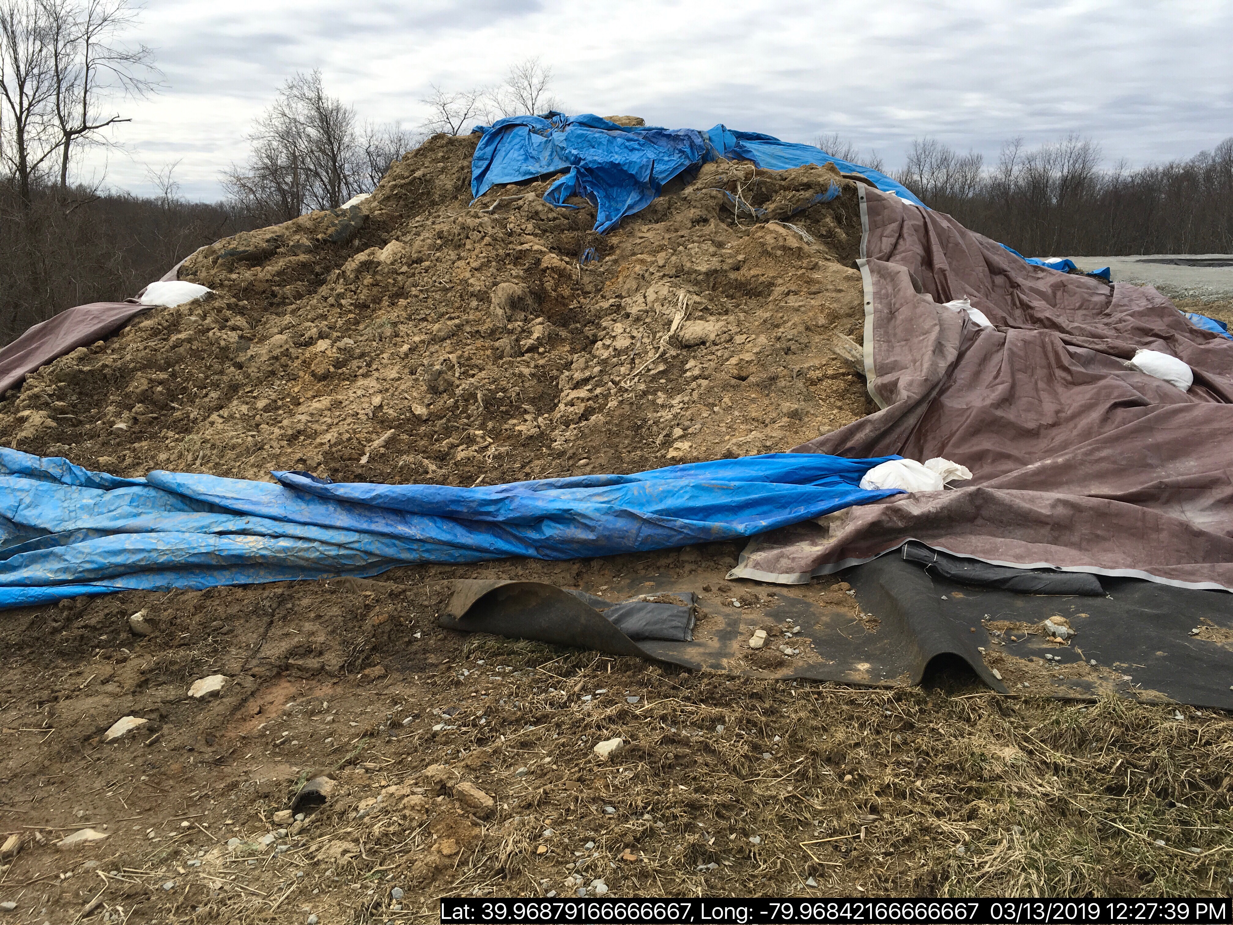
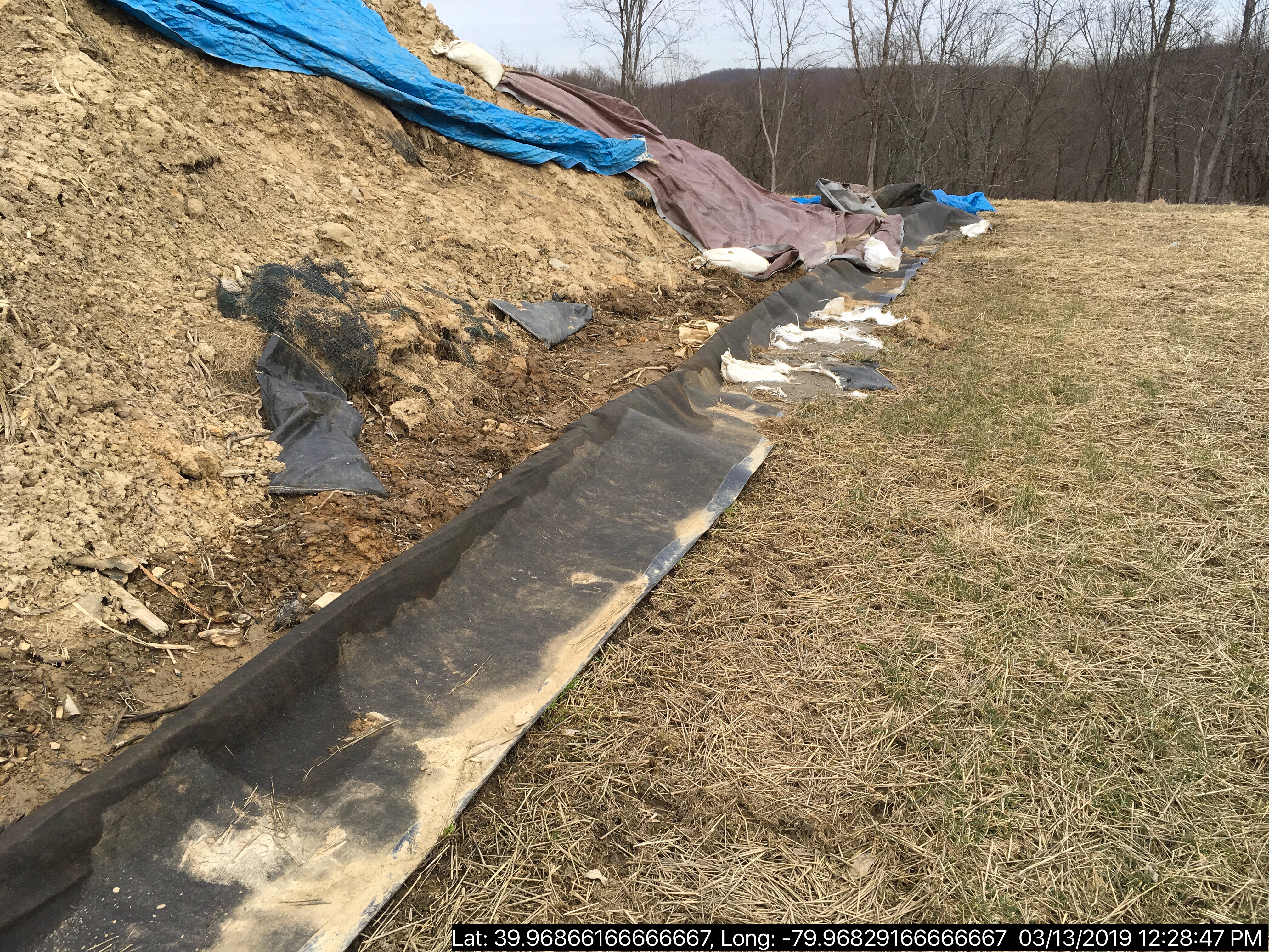
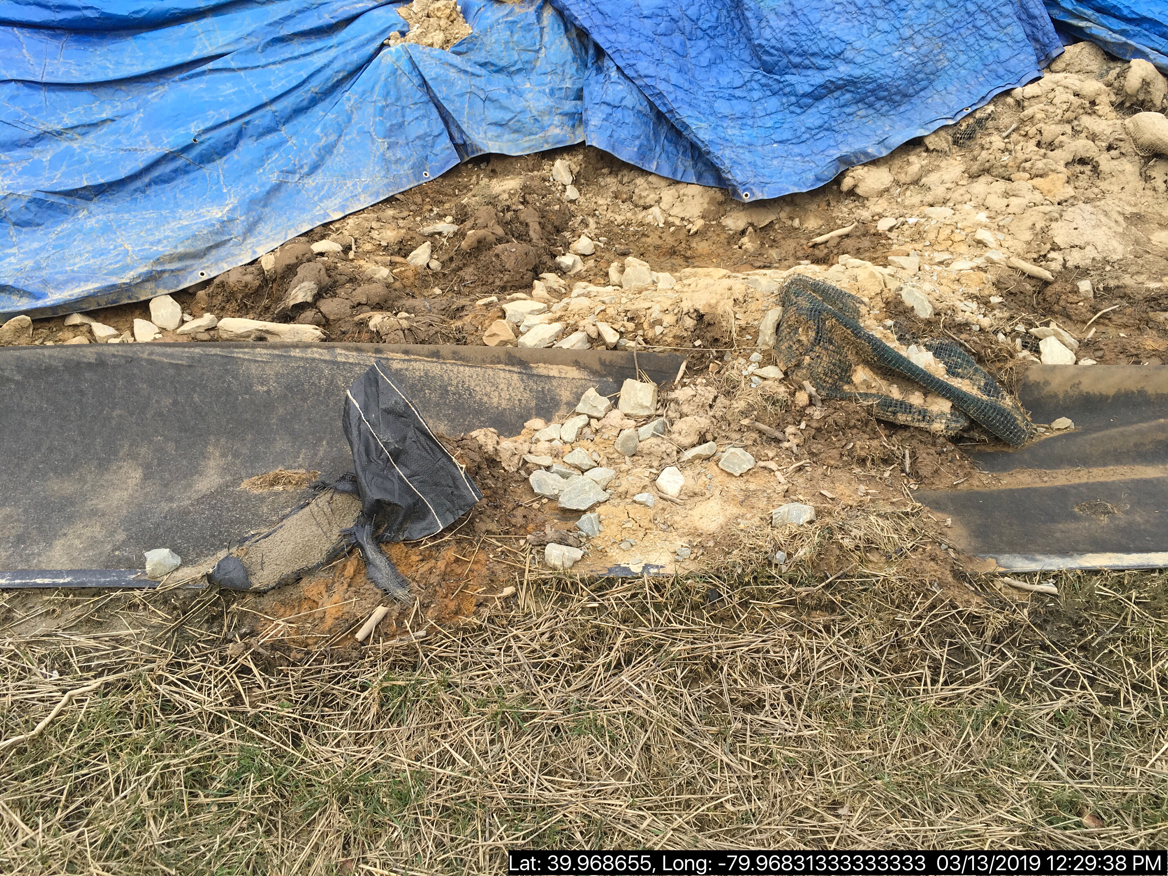
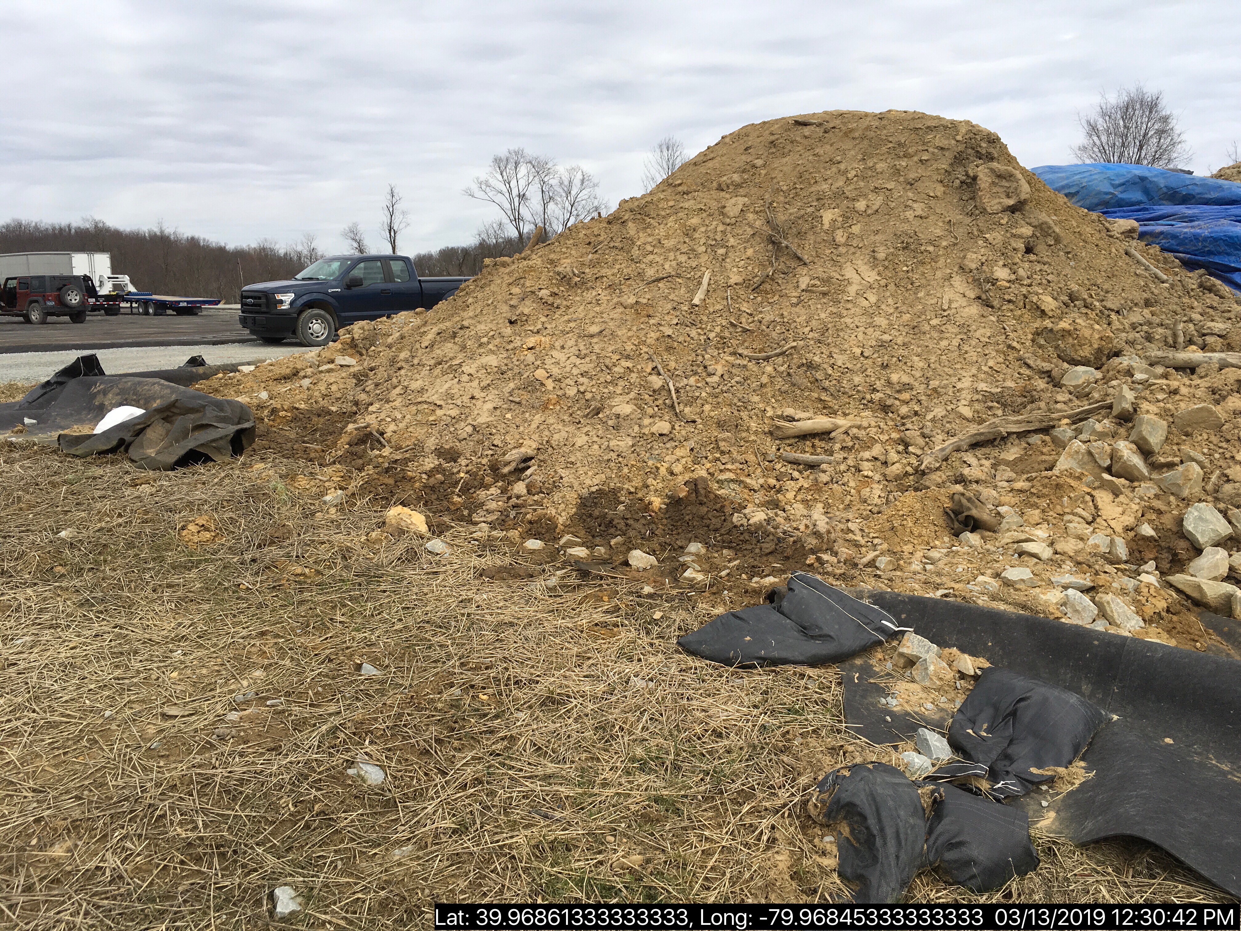
INSPECTION_COMMENT: "On 03/13/19 DEP Soil Scientist Ed Bates was conducting an inspection to evaluate Act 2 compliance at the Siegel well site, due to a prior oil based mud spill. Bates observed the OBM impacted soil on secondary containment, but noted impacted soil had spilled, the impacted soil was no longer appropriately covered, and the secondary containment was insufficient. Bates contacted this WQS to inform me of violations observed at the site.
I contacted Curtis Small of Chevron to inform him of Bates' observations and that I was going to be conducting an inspection shortly. Small indicated he would also head to the site.
At approximately 1225 hours I, along with Water Quality Specialist Supervisor John Carson, conducted an inspection of the site. Oil & Gas Inspector James Braunns was also present at the site conducting an inspection prior to the fluid rig coming onto the site.
The impacted soil stockpile appeared to have been covered with tarps, but was now largely exposed. Spilled impacted soil was observed and the secondary containment lacked berms on two sides of the pile.
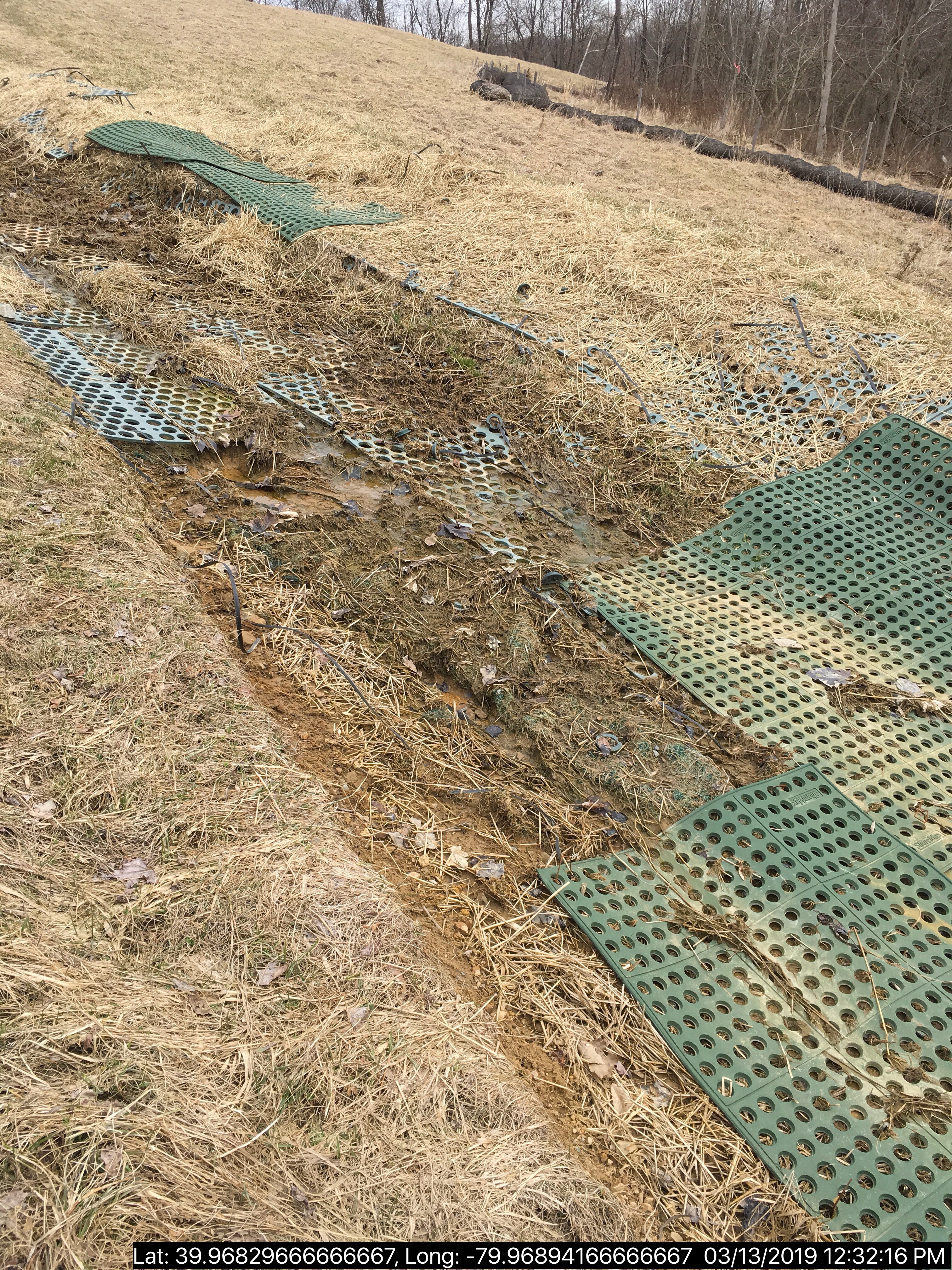
WQSS Carson and I also noted mild accelerated erosion in the channel to the basin. It is recommended the channel be addressed to prevent further erosion. The well tags appeared to have been completed, but the writing had faded and was no longer legible.
Toward the conclusion of the inspection Curtis Small of Chevron arrived on site. We discussed our observations with Small, who indicated the impacted soil had been approved for disposal and disposal was planned for the following week. Small indicated the spilled material would be removed and confirmatory samples collected. Small also indicated the well tags would be addressed to ensure they were legible."
VIOLATION_ID: 844359
VIOLATION_DATE: 03/13/2019
VIOLATION_CODE: 78a64a(b) - SECONDARY CONTAINMENT – All regulated substances, including solid wastes and other regulated substances in equipment or vehicles, failed to be managed within secondary containment on the well site.
VIOLATION_TYPE: Environmental Health & Safety
VIOLATION_COMMENT:
RESOLVED_DATE:
RESOLUTION_REASON_CODE_DESCRIPTION:
CONTINUING_VIOLATION:
ENFORCEMENT_ID: 373121
ENFORCEMENT_CODE_DESCRIPTION: NOV - Notice of Violation
DATE_EXECUTED: 03/14/2019
ENFORCEMENT_FINAL_DATE:
ENFORCEMENT_FINAL_STATUS:
PENALTY_FINAL_DATE:
PENALTY_FINAL_STATUS_CODE_DESCRIPTION:
PENALTY_AMOUNT:
TOTAL_AMOUNT_COLLECTED:
VIOLATION_ID: 844358
VIOLATION_DATE: 03/13/2019
VIOLATION_CODE: SWMA 301 - MANAGEMENT OF RESIDUAL WASTE - Person operated a residual waste processing or disposal facility without obtaining a permit for such facility from DEP. Person stored, transported, processed, or disposed of residual waste inconsistent with or unauthorized by the rules and regulations of DEP.
VIOLATION_TYPE: Environmental Health & Safety
VIOLATION_COMMENT:
RESOLVED_DATE:
RESOLUTION_REASON_CODE_DESCRIPTION:
CONTINUING_VIOLATION:
ENFORCEMENT_ID: 373121
ENFORCEMENT_CODE_DESCRIPTION: NOV - Notice of Violation
DATE_EXECUTED: 03/14/2019
ENFORCEMENT_FINAL_DATE:
ENFORCEMENT_FINAL_STATUS:
PENALTY_FINAL_DATE:
PENALTY_FINAL_STATUS_CODE_DESCRIPTION:
PENALTY_AMOUNT:
TOTAL_AMOUNT_COLLECTED:
VIOLATION_ID: 844357
VIOLATION_DATE: 03/13/2019
VIOLATION_CODE: 78a54 - GENERAL REQUIREMENTS - Operator failed to control and dispose of fluids, residual waste and drill cuttings, including tophole water, brines, drilling fluids, drilling muds, stimulation fluids, well servicing fluids, oil, and production fluids in a manner that prevents pollution of the waters of the Commonwealth and in accordance with 25 Pa. Code §§ 78a.55 – 78a.58 and 78a.60 – 78a.63.
VIOLATION_TYPE: Environmental Health & Safety
VIOLATION_COMMENT:
RESOLVED_DATE:
RESOLUTION_REASON_CODE_DESCRIPTION:
CONTINUING_VIOLATION:
ENFORCEMENT_ID: 373121
ENFORCEMENT_CODE_DESCRIPTION: NOV - Notice of Violation
DATE_EXECUTED: 03/14/2019
ENFORCEMENT_FINAL_DATE:
ENFORCEMENT_FINAL_STATUS:
PENALTY_FINAL_DATE:
PENALTY_FINAL_STATUS_CODE_DESCRIPTION:
PENALTY_AMOUNT:
TOTAL_AMOUNT_COLLECTED:
Photos source <https://www.depgreenport.state.pa.us/eWellDocs/download/DocsZipFile/?P_DER_CODE=9&P_ENTITY_TYPE=2&S=4&P_ID=2853843>
(from Oil and Gas Inspection Reports Viewer)
Well Details:
Permit Number: 051-24633
Well Name: SIEGEL 1
Unconventional Well: Y
Well Configuration: Horizontal Well
Well Type: GAS
Well Status: Active
Coal Association: Coal
Conservation Well: N
Primary Facility ID: 803337
Site ID: 790384
Site Name: SIEGEL WELL PAD ESCGP-2 EXPEDITED
Well Pad ID: 152926
Well Pad Name: SIEGEL 1
Storage Field:
Operator: CHEVRON APPALACHIA LLC
Operator Number: OGO-39307
Permit Date: 2015-08-12
Permit Date Expires: 2019-02-12
SPUD Date: 2018-04-02
Date Plugged:
UIC ID:
UIC Type:
Surface Elevation: 1173
County: Fayette
Municipality: Luzerne Twp
Location: 39.968972,-79.968794
Map URL: <http://www.openstreetmap.org/?mlat=39.968972&mlon=-79.968794#map=15/39.968972/-79.968794>
OG WELLS PERMIT DOCS:
2015-08-12: Final Permit Documents, Name: 051-24633-00-00 1082707 (for Authorization: 1082707):
<http://www.depgis.state.pa.us/pdfHandler/pdFHandler.ashx?Doc=MjE0NjU4&ext=PDF>
2017-07-28: Final Permit Documents, Name: Authorization ID 1170979 (for Authorization: 1170979):
<http://www.depgis.state.pa.us/pdfHandler/pdFHandler.ashx?Doc=NDc0MjUx&ext=PDF>
2018-02-12: Final Permit Documents, Name: 1212434 (for Authorization: 1212434):
<http://www.depgis.state.pa.us/pdfHandler/pdFHandler.ashx?Doc=NTU4NjY3&ext=PDF>
Electronically Submitted Records:
2017-07-28: Submission for Authorization 1170979
Record of Notification to Interested Parties: Siegel 1 Re-Permit Record of Notification.pdf
<http://www.depgis.state.pa.us/eWellDocHandler/pdFHandler.ashx?Doc=MjI5NzY2&ext=PDF>
Well Permit Application - Coal Module: Siegel Re-Permit Coal Module.pdf
<http://www.depgis.state.pa.us/eWellDocHandler/pdFHandler.ashx?Doc=MjI5NzY3&ext=PDF>
Pennsylvania Natural Diversity Inventory Form: Siegel 1 PNDI.pdf
<http://www.depgis.state.pa.us/eWellDocHandler/pdFHandler.ashx?Doc=MjI5ODMw&ext=PDF>
Permit Application to Drill and Operate a Well: Siegel 1 Re-Permit Application.pdf
<http://www.depgis.state.pa.us/eWellDocHandler/pdFHandler.ashx?Doc=MjM0NTE1&ext=PDF>
Coal and Gas Resource Coord Act - Section 7 Exception: Siegel 1 Waiver Request Section 7.pdf
<http://www.depgis.state.pa.us/eWellDocHandler/pdFHandler.ashx?Doc=MjM0NTE5&ext=PDF>
Operator Ownership and Control Information: Siegel 1 Re-Permit OG-118.pdf
<http://www.depgis.state.pa.us/eWellDocHandler/pdFHandler.ashx?Doc=MjM0NTI2&ext=PDF>
Location Plat: Siegel 1 Re-Permit Plat 7-21-17.dwg
<http://www.depgis.state.pa.us/eWellDocHandler/pdFHandler.ashx?Doc=MzM1OTky&ext=PDF>
Electronic Submission Docket: 1405595.pdf
<http://www.depgis.state.pa.us/eWellDocHandler/pdFHandler.ashx?Doc=MzM1OTk0&ext=PDF>
2018-02-12: Submission for Authorization 1212434
Location Plat: 143-781-Well Plat 1H-pages1-2-3_3702.dwg
<http://www.depgis.state.pa.us/eWellDocHandler/pdFHandler.ashx?Doc=NDQ4NTg4&ext=PDF>
Pennsylvania Natural Diversity Inventory Form: Siegel PNDI.pdf
<http://www.depgis.state.pa.us/eWellDocHandler/pdFHandler.ashx?Doc=NDQ4NTg5&ext=PDF>
Permit Application to Drill and Operate a Well: Siegel 1H Drill Permit Application.pdf
<http://www.depgis.state.pa.us/eWellDocHandler/pdFHandler.ashx?Doc=NDQ5MDk1&ext=PDF>
Coal and Gas Resource Coord Act - Section 7 Exception: Siegel 1H-9H Waiver Request Section 7.pdf
<http://www.depgis.state.pa.us/eWellDocHandler/pdFHandler.ashx?Doc=NDQ5MDk2&ext=PDF>
Well Cross-Section Diagram: Siegel 1H Page 4.pdf
<http://www.depgis.state.pa.us/eWellDocHandler/pdFHandler.ashx?Doc=NDQ5MDk3&ext=PDF>
Well Permit Application - Coal Module: Siegel 1H Coal Module.pdf
<http://www.depgis.state.pa.us/eWellDocHandler/pdFHandler.ashx?Doc=NDQ5MDk4&ext=PDF>
Interested Party Notification: Siegel 1H Interested Parties.pdf
<http://www.depgis.state.pa.us/eWellDocHandler/pdFHandler.ashx?Doc=NDQ5MTAw&ext=PDF>
Electronic Submission Docket: 1661897.pdf
<http://www.depgis.state.pa.us/eWellDocHandler/pdFHandler.ashx?Doc=NDQ5Nzk2&ext=PDF>
---
OPERATOR: CAMPBELL OIL & GAS INC
INSPECTION_ID: 2857414
INSPECTION_DATE: 03/15/2019
INSPECTION_TYPE: Routine/Complete Inspection
API_PERMIT: 051-22869
FARM_NAME: BOZEK 1
UNCONVENTIONAL: No
SITE_ID: 658451
SITE_NAME: BOZEK 1 OG WELL
FACILITY_TYPE: Oil & Gas Location
INSPECTION_CATEGORY: Primary Facility
REGION: EP DOGO SWDO Dstr Off
COUNTY: Fayette
MUNICIPALITY: Franklin Twp
INSPECTOR: NAJEWICZ, JUSTIN
INSPECTION_SOURCE: SAIR
INSPECTION_RESULT_DESCRIPTION: No Violations Noted
INSPECTION_COMMENT: On 03/15/19 at approximately 1345 I conducted a routine complete inspection of the site. The site was well vegetated and there were no signs of erosion observed. There were no signs of spills or releases observed. The production equipment appeared to be in fair condition, but corrosion was observed. It is recommended the equipment be painted to prevent corrosion. There were no violations observed at the time of inspection.
Well Details:
Permit Number: 051-22869
Well Name: BOZEK 1
Unconventional Well: N
Well Configuration: Vertical Well
Well Type: GAS
Well Status: Active
Coal Association: Coal
Conservation Well: N
Primary Facility ID: 670038
Site ID: 658451
Site Name: BOZEK 1 OG WELL
Well Pad ID: 0
Well Pad Name:
Storage Field:
Operator: CAMPBELL OIL & GAS INC
Operator Number: OGO-36838
Permit Date: 2005-08-24
Permit Date Expires: 2006-08-24
SPUD Date: 2006-03-22
Date Plugged:
UIC ID:
UIC Type:
Surface Elevation: 1300
County: Fayette
Municipality: Franklin Twp
Location: 40.024527,-79.716947
Map URL: <http://www.openstreetmap.org/?mlat=40.024527&mlon=-79.716947#map=15/40.024527/-79.716947>
OPERATOR: CHEVRON APPALACHIA LLC
INSPECTION_ID: 2853843
INSPECTION_DATE: 03/13/2019
INSPECTION_TYPE: Routine/Complete Inspection
API_PERMIT: 051-24633
FARM_NAME: SIEGEL 1
UNCONVENTIONAL: Yes
SITE_ID: 790384
SITE_NAME: SIEGEL WELL PAD ESCGP-2 EXPEDITED
FACILITY_TYPE: Oil & Gas Location
INSPECTION_CATEGORY: Primary Facility
REGION: EP DOGO SWDO Dstr Off
COUNTY: Fayette
MUNICIPALITY: Luzerne Twp
INSPECTOR: NAJEWICZ, JUSTIN
INSPECTION_SOURCE: SAIR
INSPECTION_RESULT_DESCRIPTION: Violation(s) Noted
INSPECTION_COMMENT: "On 03/13/19 DEP Soil Scientist Ed Bates was conducting an inspection to evaluate Act 2 compliance at the Siegel well site, due to a prior oil based mud spill. Bates observed the OBM impacted soil on secondary containment, but noted impacted soil had spilled, the impacted soil was no longer appropriately covered, and the secondary containment was insufficient. Bates contacted this WQS to inform me of violations observed at the site.
I contacted Curtis Small of Chevron to inform him of Bates' observations and that I was going to be conducting an inspection shortly. Small indicated he would also head to the site.
At approximately 1225 hours I, along with Water Quality Specialist Supervisor John Carson, conducted an inspection of the site. Oil & Gas Inspector James Braunns was also present at the site conducting an inspection prior to the fluid rig coming onto the site.
The impacted soil stockpile appeared to have been covered with tarps, but was now largely exposed. Spilled impacted soil was observed and the secondary containment lacked berms on two sides of the pile.
WQSS Carson and I also noted mild accelerated erosion in the channel to the basin. It is recommended the channel be addressed to prevent further erosion. The well tags appeared to have been completed, but the writing had faded and was no longer legible.
Toward the conclusion of the inspection Curtis Small of Chevron arrived on site. We discussed our observations with Small, who indicated the impacted soil had been approved for disposal and disposal was planned for the following week. Small indicated the spilled material would be removed and confirmatory samples collected. Small also indicated the well tags would be addressed to ensure they were legible."
VIOLATION_ID: 844359
VIOLATION_DATE: 03/13/2019
VIOLATION_CODE: 78a64a(b) - SECONDARY CONTAINMENT – All regulated substances, including solid wastes and other regulated substances in equipment or vehicles, failed to be managed within secondary containment on the well site.
VIOLATION_TYPE: Environmental Health & Safety
VIOLATION_COMMENT:
RESOLVED_DATE:
RESOLUTION_REASON_CODE_DESCRIPTION:
CONTINUING_VIOLATION:
ENFORCEMENT_ID: 373121
ENFORCEMENT_CODE_DESCRIPTION: NOV - Notice of Violation
DATE_EXECUTED: 03/14/2019
ENFORCEMENT_FINAL_DATE:
ENFORCEMENT_FINAL_STATUS:
PENALTY_FINAL_DATE:
PENALTY_FINAL_STATUS_CODE_DESCRIPTION:
PENALTY_AMOUNT:
TOTAL_AMOUNT_COLLECTED:
VIOLATION_ID: 844358
VIOLATION_DATE: 03/13/2019
VIOLATION_CODE: SWMA 301 - MANAGEMENT OF RESIDUAL WASTE - Person operated a residual waste processing or disposal facility without obtaining a permit for such facility from DEP. Person stored, transported, processed, or disposed of residual waste inconsistent with or unauthorized by the rules and regulations of DEP.
VIOLATION_TYPE: Environmental Health & Safety
VIOLATION_COMMENT:
RESOLVED_DATE:
RESOLUTION_REASON_CODE_DESCRIPTION:
CONTINUING_VIOLATION:
ENFORCEMENT_ID: 373121
ENFORCEMENT_CODE_DESCRIPTION: NOV - Notice of Violation
DATE_EXECUTED: 03/14/2019
ENFORCEMENT_FINAL_DATE:
ENFORCEMENT_FINAL_STATUS:
PENALTY_FINAL_DATE:
PENALTY_FINAL_STATUS_CODE_DESCRIPTION:
PENALTY_AMOUNT:
TOTAL_AMOUNT_COLLECTED:
VIOLATION_ID: 844357
VIOLATION_DATE: 03/13/2019
VIOLATION_CODE: 78a54 - GENERAL REQUIREMENTS - Operator failed to control and dispose of fluids, residual waste and drill cuttings, including tophole water, brines, drilling fluids, drilling muds, stimulation fluids, well servicing fluids, oil, and production fluids in a manner that prevents pollution of the waters of the Commonwealth and in accordance with 25 Pa. Code §§ 78a.55 – 78a.58 and 78a.60 – 78a.63.
VIOLATION_TYPE: Environmental Health & Safety
VIOLATION_COMMENT:
RESOLVED_DATE:
RESOLUTION_REASON_CODE_DESCRIPTION:
CONTINUING_VIOLATION:
ENFORCEMENT_ID: 373121
ENFORCEMENT_CODE_DESCRIPTION: NOV - Notice of Violation
DATE_EXECUTED: 03/14/2019
ENFORCEMENT_FINAL_DATE:
ENFORCEMENT_FINAL_STATUS:
PENALTY_FINAL_DATE:
PENALTY_FINAL_STATUS_CODE_DESCRIPTION:
PENALTY_AMOUNT:
TOTAL_AMOUNT_COLLECTED:
Photos
 |
 |
 |
 |
 |
 |
(from Oil and Gas Inspection Reports Viewer)
Well Details:
Permit Number: 051-24633
Well Name: SIEGEL 1
Unconventional Well: Y
Well Configuration: Horizontal Well
Well Type: GAS
Well Status: Active
Coal Association: Coal
Conservation Well: N
Primary Facility ID: 803337
Site ID: 790384
Site Name: SIEGEL WELL PAD ESCGP-2 EXPEDITED
Well Pad ID: 152926
Well Pad Name: SIEGEL 1
Storage Field:
Operator: CHEVRON APPALACHIA LLC
Operator Number: OGO-39307
Permit Date: 2015-08-12
Permit Date Expires: 2019-02-12
SPUD Date: 2018-04-02
Date Plugged:
UIC ID:
UIC Type:
Surface Elevation: 1173
County: Fayette
Municipality: Luzerne Twp
Location: 39.968972,-79.968794
Map URL: <http://www.openstreetmap.org/?mlat=39.968972&mlon=-79.968794#map=15/39.968972/-79.968794>
OG WELLS PERMIT DOCS:
2015-08-12: Final Permit Documents, Name: 051-24633-00-00 1082707 (for Authorization: 1082707):
<http://www.depgis.state.pa.us/pdfHandler/pdFHandler.ashx?Doc=MjE0NjU4&ext=PDF>
2017-07-28: Final Permit Documents, Name: Authorization ID 1170979 (for Authorization: 1170979):
<http://www.depgis.state.pa.us/pdfHandler/pdFHandler.ashx?Doc=NDc0MjUx&ext=PDF>
2018-02-12: Final Permit Documents, Name: 1212434 (for Authorization: 1212434):
<http://www.depgis.state.pa.us/pdfHandler/pdFHandler.ashx?Doc=NTU4NjY3&ext=PDF>
Electronically Submitted Records:
2017-07-28: Submission for Authorization 1170979
Record of Notification to Interested Parties: Siegel 1 Re-Permit Record of Notification.pdf
<http://www.depgis.state.pa.us/eWellDocHandler/pdFHandler.ashx?Doc=MjI5NzY2&ext=PDF>
Well Permit Application - Coal Module: Siegel Re-Permit Coal Module.pdf
<http://www.depgis.state.pa.us/eWellDocHandler/pdFHandler.ashx?Doc=MjI5NzY3&ext=PDF>
Pennsylvania Natural Diversity Inventory Form: Siegel 1 PNDI.pdf
<http://www.depgis.state.pa.us/eWellDocHandler/pdFHandler.ashx?Doc=MjI5ODMw&ext=PDF>
Permit Application to Drill and Operate a Well: Siegel 1 Re-Permit Application.pdf
<http://www.depgis.state.pa.us/eWellDocHandler/pdFHandler.ashx?Doc=MjM0NTE1&ext=PDF>
Coal and Gas Resource Coord Act - Section 7 Exception: Siegel 1 Waiver Request Section 7.pdf
<http://www.depgis.state.pa.us/eWellDocHandler/pdFHandler.ashx?Doc=MjM0NTE5&ext=PDF>
Operator Ownership and Control Information: Siegel 1 Re-Permit OG-118.pdf
<http://www.depgis.state.pa.us/eWellDocHandler/pdFHandler.ashx?Doc=MjM0NTI2&ext=PDF>
Location Plat: Siegel 1 Re-Permit Plat 7-21-17.dwg
<http://www.depgis.state.pa.us/eWellDocHandler/pdFHandler.ashx?Doc=MzM1OTky&ext=PDF>
Electronic Submission Docket: 1405595.pdf
<http://www.depgis.state.pa.us/eWellDocHandler/pdFHandler.ashx?Doc=MzM1OTk0&ext=PDF>
2018-02-12: Submission for Authorization 1212434
Location Plat: 143-781-Well Plat 1H-pages1-2-3_3702.dwg
<http://www.depgis.state.pa.us/eWellDocHandler/pdFHandler.ashx?Doc=NDQ4NTg4&ext=PDF>
Pennsylvania Natural Diversity Inventory Form: Siegel PNDI.pdf
<http://www.depgis.state.pa.us/eWellDocHandler/pdFHandler.ashx?Doc=NDQ4NTg5&ext=PDF>
Permit Application to Drill and Operate a Well: Siegel 1H Drill Permit Application.pdf
<http://www.depgis.state.pa.us/eWellDocHandler/pdFHandler.ashx?Doc=NDQ5MDk1&ext=PDF>
Coal and Gas Resource Coord Act - Section 7 Exception: Siegel 1H-9H Waiver Request Section 7.pdf
<http://www.depgis.state.pa.us/eWellDocHandler/pdFHandler.ashx?Doc=NDQ5MDk2&ext=PDF>
Well Cross-Section Diagram: Siegel 1H Page 4.pdf
<http://www.depgis.state.pa.us/eWellDocHandler/pdFHandler.ashx?Doc=NDQ5MDk3&ext=PDF>
Well Permit Application - Coal Module: Siegel 1H Coal Module.pdf
<http://www.depgis.state.pa.us/eWellDocHandler/pdFHandler.ashx?Doc=NDQ5MDk4&ext=PDF>
Interested Party Notification: Siegel 1H Interested Parties.pdf
<http://www.depgis.state.pa.us/eWellDocHandler/pdFHandler.ashx?Doc=NDQ5MTAw&ext=PDF>
Electronic Submission Docket: 1661897.pdf
<http://www.depgis.state.pa.us/eWellDocHandler/pdFHandler.ashx?Doc=NDQ5Nzk2&ext=PDF>
---
OPERATOR: CAMPBELL OIL & GAS INC
INSPECTION_ID: 2857414
INSPECTION_DATE: 03/15/2019
INSPECTION_TYPE: Routine/Complete Inspection
API_PERMIT: 051-22869
FARM_NAME: BOZEK 1
UNCONVENTIONAL: No
SITE_ID: 658451
SITE_NAME: BOZEK 1 OG WELL
FACILITY_TYPE: Oil & Gas Location
INSPECTION_CATEGORY: Primary Facility
REGION: EP DOGO SWDO Dstr Off
COUNTY: Fayette
MUNICIPALITY: Franklin Twp
INSPECTOR: NAJEWICZ, JUSTIN
INSPECTION_SOURCE: SAIR
INSPECTION_RESULT_DESCRIPTION: No Violations Noted
INSPECTION_COMMENT: On 03/15/19 at approximately 1345 I conducted a routine complete inspection of the site. The site was well vegetated and there were no signs of erosion observed. There were no signs of spills or releases observed. The production equipment appeared to be in fair condition, but corrosion was observed. It is recommended the equipment be painted to prevent corrosion. There were no violations observed at the time of inspection.
Well Details:
Permit Number: 051-22869
Well Name: BOZEK 1
Unconventional Well: N
Well Configuration: Vertical Well
Well Type: GAS
Well Status: Active
Coal Association: Coal
Conservation Well: N
Primary Facility ID: 670038
Site ID: 658451
Site Name: BOZEK 1 OG WELL
Well Pad ID: 0
Well Pad Name:
Storage Field:
Operator: CAMPBELL OIL & GAS INC
Operator Number: OGO-36838
Permit Date: 2005-08-24
Permit Date Expires: 2006-08-24
SPUD Date: 2006-03-22
Date Plugged:
UIC ID:
UIC Type:
Surface Elevation: 1300
County: Fayette
Municipality: Franklin Twp
Location: 40.024527,-79.716947
Map URL: <http://www.openstreetmap.org/?mlat=40.024527&mlon=-79.716947#map=15/40.024527/-79.716947>
The location of Masontown given by DEP in the PA Bulletin Listing above for the Fayette Energy Facility appears to be incorrect. The correct location should be German Twp. It is apparently situated on a parcel immediately adjacent to Masontown.
---
The Ronco Water Treatment Plant is one of the few facilities in this area that claims to be able to recycle frackwater. It was the subject of extensive litigation by Clean Water Action and other environmental groups under Environmental Hearing Board Case 009-134-R, with EarthJustice attorney Deborah Goldberg acting as the principal environmental groups' attorney. A settlement in the case was achieved, which can be found here:
<https://earthjustice.org/sites/default/files/files/Fracking_Wastewater_Settlement.pdf>
DEP Waste Reports show that the Ronco facility is the principal destination for frackwater from Chevron's Fayette County Marcellus Shale wells. Chevron has recently been in negotiation with German Twp landowners for easements for a frackwater pipeline from the Ronco facility to the recently permitted well pads in German Twp. (Herriott, Edenborn RGGS, Cerrulo, and Kovach B; for a map see <https://www.faymarwatch.org/happening/permits/map_focus1_031019.jpg> from the previous issue of this bulletin).
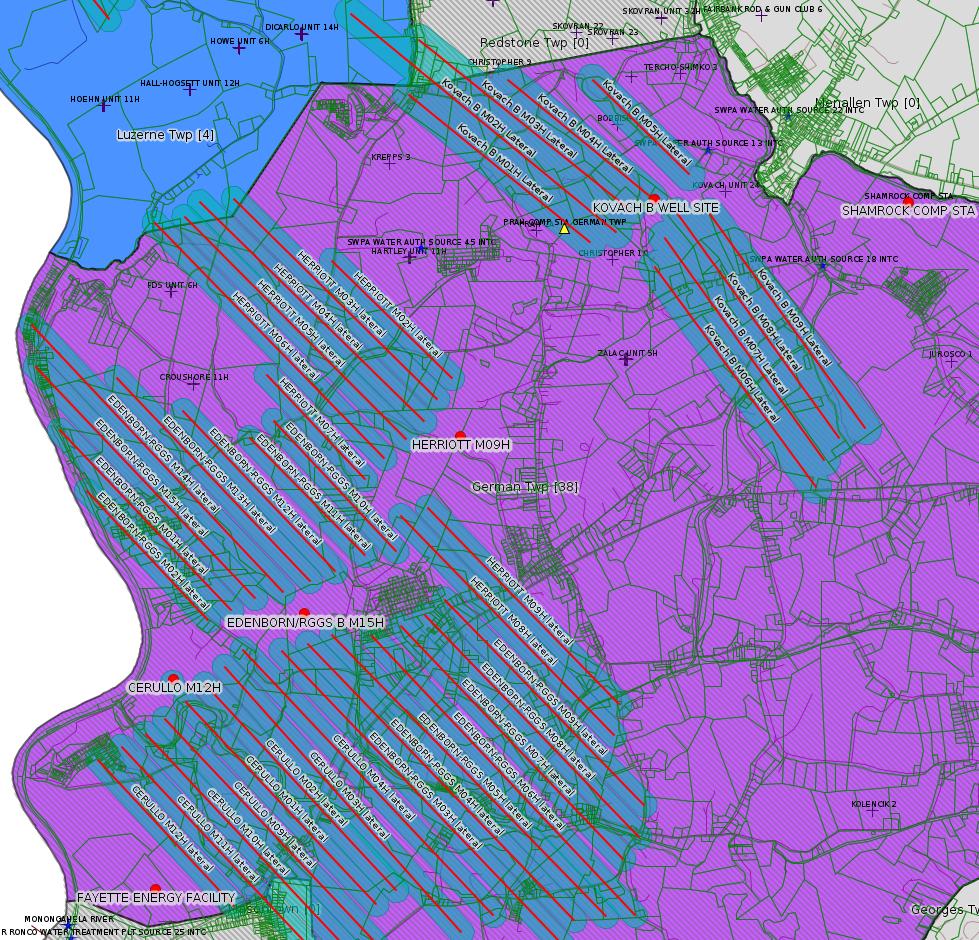
Apologies to all, the two Ronco listings in this bulletin should have been included in the previous issue.
------------------------
DEP defines an environmental justice area as "any census tract where 20 percent or more individuals live in poverty, and/or 30 percent or more of the population is minority". (See:
<http://www.dep.pa.gov/PublicParticipation/OfficeofEnvironmentalJustice/Pages/default.aspx>). There are supposed to be enhanced public participation requirements for permits in environmental justice areas, but news of this actually ever happening is scarce. In Fayette County, the entirety of Redstone, Springhill, Nicholson, and German Townships are environmental justice areas, as well as a large part of Dunbar Township. DEP's policy document on public participation guidelines for environmental justice areas is located here:
<http://www.elibrary.dep.state.pa.us/dsweb/Get/Version-48671/012-0501-002.pdf>
eNOTICE records are likely to list the same permit multiple times, as that permit moves through the DEP process.
Oil & Gas Wells designated with a site a number and the letter H typically designate horizontal wells.
-------------------------
Resources:
Pennsylvania Bulletin: <http://www.pabulletin.com/>
eNOTICE: <http://www.ahs2.dep.state.pa.
DEP Oil and Gas Reports: <http://www.dep.pa.gov/DataandTools/Reports/Oil%20and%20Gas%20Reports/Pages/default.aspx>
DEP Permits Issued Detail Report:
<http://www.depreportingservic
DEP SPUD (drilling started) Report:
<http://www.depreportingservices.state.pa.us/ReportServer/Pages/ReportViewer.aspx?/Oil_Gas/Spud_External_Data>
DEP Oil and Gas Compliance Report:
<http://www.depreportingservices.state.pa.us/ReportServer/Pages/ReportViewer.aspx?/Oil_Gas/OG_Compliance>
DEP PA Oil & Gas Mapping:
<http://www.depgis.state.pa.us/PaOilAndGasMapping>
Data Portal Services Directory [Technical]
<http://www.depgis.state.pa.us/arcgis/rest/services>
Query: Oil and Gas Wells All (ID: 3) [Technical]:
<http://www.depgis.state.pa.us/arcgis/rest/services/OilGas/OilGasAllStrayGasEGSP/MapServer/3/query?where=&text=&objectIds=&time=&geometry=&geometryType=esriGeometryEnvelope&inSR=&spatialRel=esriSpatialRelIntersects&relationParam=&outFields=*&returnGeometry=true&returnTrueCurves=false&maxAllowableOffset=&geometryPrecision=&outSR=&returnIdsOnly=false&returnCountOnly=false&orderByFields=&groupByFieldsForStatistics=&outStatistics=&returnZ=false&returnM=false&gdbVersion=&returnDistinctValues=false&resultOffset=&resultRecordCount=&f=html>
(Be sure to enter a Where clause in SQL format. Dates are in milliseconds since midnight 1/1/1970).
New:
DEP Oil and Gas Electronic Submissions
<http://www.ahs.dep.pa.gov/eSubmissionPublicSearch>
DEP Oil and Gas Electronic Notifications
<http://www.depreportingservices.state.pa.us/ReportServer?/Oil_Gas/OG_Notifications>
DEP Oil and Gas Well Pad Report
<http://www.depreportingservices.state.pa.us/ReportServer?/Oil_Gas/Well_Pads>
Fayette County Assessment Office Search For Tax Records:
<http://property.co.fayette.pa.us/search.aspx>
Pennsylvania Spatial Data Access:
<http://www.pasda.psu.edu/default.asp>
DEP Spatial Data Repository:
<ftp://www.pasda.psu.edu/pub/pasda/dep/>
National Response Center:
<http://www.nrc.uscg.mil/>
EPA-Echo: <http://www.epa-echo.gov/echo/
FERC citizen involvement: <http://www.ferc.gov/for-citiz
To receive E-mail notification of
all documents filed in a FERC docket, see:
<http://www.ferc.gov/docs-filing/esubscription.asp >
<http://www.ferc.gov/docs-fili
Follow the directions and enter the docket number to subscribe to.
Township Supervisors receive information regarding Erosion & Sedimentation permits, and these records may be reviewable at township municipal offices.
DEP permits are reviewable through the File Review process, for application to do file review see: <http://www.portal.state.pa.us/portal/server.pt/community/southwest_regional_office/13775/file_review/593164>
Environmental Hearing Board: <http://ehb.courtapps.com/publ
PA DEP Environmental Policy Comment System:
<http://www.ahs.dep.pa.gov/eComment/>
Federal Register Environment: <https://www.federalregister.g
Browsing of recent comment
opportunities for federal agencies, e.g. EPA. Click "sign up" to
subscribe to daily E-mails of new document listings.
SkyTruth Fayette County Drilling Alerts: <http://frack.skytruth.org/pen
U.S. Army Corps of Engineers, Pittsburgh District, Public Notices:
<http://www.lrp.usace.army.mil/Missions/Regulatory/Public-Notices/>
EPA Pennsylvania Public Notices: <http://www2.epa.gov/aboutepa/epa-pennsylvania#notice>
Marcellus Shale waste disposal
injection wells in Pennsylvania are regulated directly by EPA, not
DEP. Notice of any new permit applications will appear at the
above web address. I'm not aware of any subscription service
to be notified of such applications. I'm not aware of any
Marcellus Shale waste disposal injection wells in Fayette County
(yet ...) but we need to monitor this page for future
applications.
Energy Assurance Daily: <http://www.oe.netl.doe.gov/ead.aspx>
Daily newsletter from the US
Department of Energy about events relating to energy. The Natural
Gas section has information about pipelines.
-------------------------
Disclaimers:
This compilation from the above sources was done in part by hand using copy and paste and in part using automated methods; it may omit relevant permits.
Parcel data is provided via the tax records search web page offered by the Fayette County Assessment Office (http://property.co.fayette.pa.us/). Presumed Parcel Id links are subject to availability provided by that agency and associated web sites. Presumed Parcel Ids are determined as the mapped parcel containing a given latitude and longitude, are a best effort determination which is subject to error, and are not official. In cases where a facility is leased and there is a separate parcel id for the lease, if this parcel id is not separately mapped, the parcel id shown will be the id for the enclosing parcel. Parcel owners may be surface owners only and may or may not have any relationship to oil & gas facilities.
Does not currently include water supply permits. Does not include landfill permits even though many such are for Marcellus Shale waste. (It is not possible at this time to distinguish which landfill permits are for Marcellus Shale waste and which are not without doing File Review for each permit.)
Erosion & Sedimentation permit records do not currently include latitude and longitude. Where I am publishing latitude and longitude with E&S permits it is by inferring an associated well permit and using published latitude and longitude for the well. It is possible I may be inferring the wrong well site.
Municipalities are shown from eFACTS records on the DEP web site. The DEP has been known to list a municipality incorrectly.