The Harmed Success Stories Concepts How To What Is Commentary
Fayette County Marcellus Shale Permits 3/12/18 - 3/25/18
Click the map to enlarge
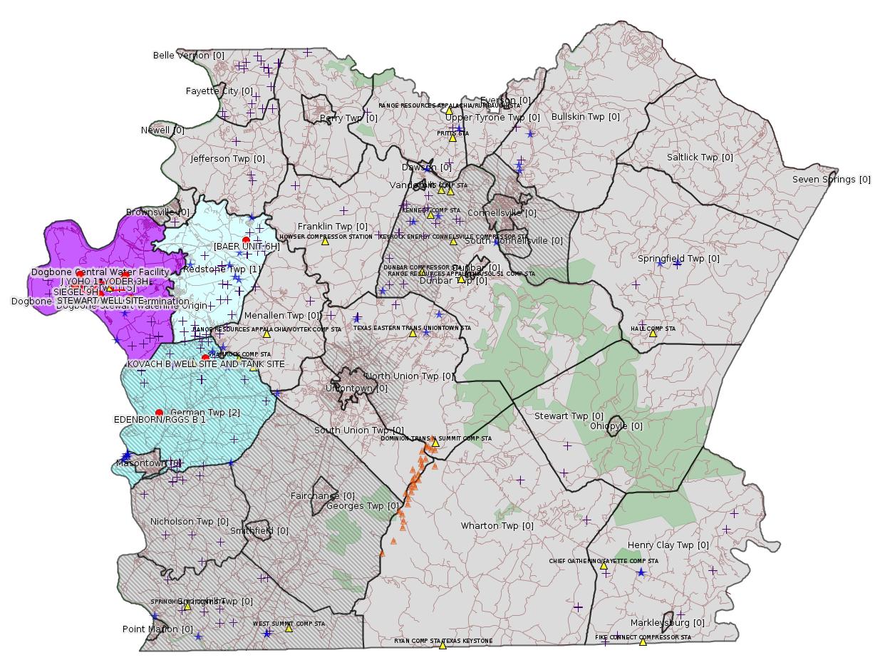
Map
Key
Red dots: items in this permit list with an exact location.
Blue stars: Marcellus Gas Well Water Sources.
Municipality shading: number of "facilities", with each well counting separately
(includes the red dots):
Red dots: items in this permit list with an exact location.
Blue stars: Marcellus Gas Well Water Sources.
Municipality shading: number of "facilities", with each well counting separately
(includes the red dots):
gray: 0
pale turquoise: 1
turquoise: 2
pale blue: 3
middle blue: 4
dark blue: 5
dark purple: 9
purple: 15
(Color coding may differ from one issue to the next.)
(Note if a project spans multiple municipalities -- e.g. a pipeline -- it will show in the count for each municipality.)
The number of facilities also follows the municipality name in brackets.
Municipality counts are based on the way the permit is listed by DEP; DEP has been known to get a municipality wrong.
Locations in brackets identify a precise location used to locate a surrogate for the actual site being permitted (e.g. locating a well pad or pipeline by the known location of a well.) Locations labeled beginning with "~" and ending in "[?]" are approximate and speculative based on inferences using on-line property and lease records. These are marked in the text as "[Approximate, Speculative]
Cross-hatching: Environmental Justice Areas
Yellow triangles: Compressor Stations
Orange triangles: Storage Field Wells (currently Dominion North Summit Storage Field)
Crosses: SPUD Unconventional well permits
Green: "Natural areas", e.g. state game lands, state forests
Yellow triangles: Compressor Stations
Orange triangles: Storage Field Wells (currently Dominion North Summit Storage Field)
Crosses: SPUD Unconventional well permits
Green: "Natural areas", e.g. state game lands, state forests
More Maps
 |
Source: Pennsylvania Bulletin
NOTICES
DEPARTMENT OF
ENVIRONMENTAL PROTECTION
Proposed State Implementation Plan Revision; Regional Haze Five-Year Progress Report; Public Hearings
[48 Pa.B. 1624]
[Saturday, March 17, 2018]
The Department of Environmental Protection (Department) is seeking public comment on a proposed State Implementation Plan (SIP) revision consisting of a Regional Haze Five-Year Progress Report. The proposed SIP revision evaluates progress made in implementing the measures included in the Commonwealth's Regional Haze SIP revision, which was submitted to the United States Environmental Protection Agency (EPA) on December 20, 2010, and which received a limited approval by the EPA (see 77 FR 41279 (July 13, 2012) and 77 FR 48061 (August 13, 2012)) and a limited disapproval by the EPA (see 77 FR 33642 (June 7, 2012)). This proposed SIP revision is submitted in accordance with the visibility and regional haze provisions of sections 169A and 169B of the Federal Clean Air Act (CAA) (42 U.S.C.A. §§ 7491 and 7492) and the Federal Regional Haze Rule in 40 CFR 51.308 (relating to regional haze program requirements).
This proposed SIP revision is intended to address the requirements for periodic reports evaluating progress towards the Reasonable Progress Goals established for mandatory Class I areas where visibility may be impacted by sources in this Commonwealth (40 CFR 51.308(g)). In accordance with 40 CFR 51.308(h)(1), the proposed SIP revision includes a negative declaration that further revision of the 2010 Regional Haze SIP is not needed at this time to achieve established goals for visibility improvement and emissions reductions.
The Regional Haze Rule in 40 CFR 51.308(i) requires states to consult with the Federal Land Managers (FLM) at least 60 days prior to the scheduled public hearing on the proposed Regional Haze SIP revision. Section 169A(d) of the CAA requires states to include a summary of the conclusions and recommendations of the FLMs in the notice to the public. The FLMs were provided an opportunity for consultation with the United States National Park Service and the United States Department of Agriculture's Forest Service providing comments to the Department; the United States Department of the Interior's Fish and Wildlife Service did not comment. A copy of all comments submitted by the FLMs to the Department, and the Department's responses, is available in Appendix N of the proposed SIP revision.
The proposed SIP revision is available on the Department's web site at www.ahs.dep.pa.gov/eComment. The Department is seeking public comment on this proposed SIP revision.
The Department will hold three public hearings to receive comments on the proposed SIP revision:
• April 19, 2018, at 10 a.m. at the Department's Southwest Regional Office, 400 Waterfront Drive, Pittsburgh, PA.
• April 19, 2018, at 10 a.m. at the Department's Southeast Regional Office, 2 East Main Street, Norristown, PA.
• April 20, 2018, at 10 a.m. at the Department's Southcentral Regional Office, 909 Elmerton Avenue, Harrisburg, PA.
Persons wishing to present testimony at a hearing should contact Kaylene Wance, P.O. Box 8468, Harrisburg, PA 17105, (717) 787-9257 or kwance@pa.gov to reserve a time. Speakers will be limited to 10 minutes and should provide two written copies of their comments. Persons who do not reserve a time will be able to testify as time allows.
If by 12 p.m. on Monday, April 16, 2018, no person has expressed an interest in testifying at the hearing, the hearing will be cancelled. The Department will provide public notice on the Bureau of Air Quality webpage at http://www.dep.pa.gov/Business/Air/BAQ/Pages/default.aspx if the hearing is cancelled. Persons may also contact Kaylene Wance at (717) 787-9257 or kwance@pa.gov to find out if the hearing is cancelled.
Persons with a disability who wish to attend a hearing and require an auxiliary aid, service or other accommodation to participate in the proceeding should contact Kaylene Wance. TDD users may contact the Pennsylvania AT&T Relay Service at (800) 654-5984 to discuss how the Department can best accommodate their needs.
The Department must receive comments no later than April 20, 2018. Commentators are encouraged to submit comments using the Department's eComment system at www.ahs.dep.pa.gov/eComment or by e-mail to ecomment@pa.gov. Written comments may be mailed to the Policy Office, Department of Environmental Protection, Rachel Carson State Office Building, P.O. Box 2063, Harrisburg, PA 17105-2063. Use ''Regional Haze Five-Year Progress Report'' as the subject line in written communication.
PATRICK McDONNELL,
Secretary
<https://www.pabulletin.com/secure/data/vol48/48-11/404.html>
The documents are available here:
<http://www.depgreenport.state.pa.us/elibrary/GetFolder?FolderID=4736>
---
ESCGP-2 # ESX17-051-0003
Applicant Name Chevron Appalachia, LLC
Contact Person Branden Weimer
Address 700 Cherrington Parkway
City, State, Zip Coraopolis, PA 15108
County Fayette County
Township(s) German Township [an Environmental Justice Area]
Receiving Stream(s) and Classification(s) Trib 40216 to
Dunlap Creek (WWF), Trib 40220 to Dunlap Creek
(WWF), & Trib 40223 to Dunlap Creek (WWF)
<https://www.pabulletin.com/secure/data/vol48/48-11/400d.html>
Site: KOVACH B WELL SITE AND TANK SITE ESCGP ESX17-051-0003
Location: 39.918939,-79.854611 <https://osm.org/go/ZWpaPKjG--?m=>
Well Pad ID: 155005
Wells on this Pad:
051-24640 KOVACH B 1
Presumed Parcel Id: 1511002301
---
NOTICES
DEPARTMENT OF CONSERVATION AND NATURAL RESOURCES
Execution of First Amendment to Oil and Gas Lease for Publicly-Owned Streambeds
[48 Pa.B. 1722]
[Saturday, March 24, 2018]
Effective September 22, 2017, a First Amendment to Oil and Gas Lease for Publicly-Owned Streambeds, Contract No. M-2102032-04, was executed by and between the Commonwealth, acting through the Department of Conservation and Natural Resources (Department) (lessor), and EQT Production Company (lessee), with its principal place of business located at 625 Liberty Avenue, Pittsburgh, PA 15222.
The lease is for Streambed Tract 2032 on the Monongahela River encompassing a total of 945 acres of submerged lands located in Carroll, Monongahela, Union, Luzerne, Forward, Jefferson, Rices Landing, Jefferson Hills, Elizabeth, West Elizabeth, Monessen and Fallowfield Townships, Greene, Fayette, Washington, Westmoreland and Allegheny Counties. The lease was recorded at the Allegheny County courthouse on November 21, 2017, document No. 2017-36440, Bk-DE VI-17022 Page 250; the Fayette County courthouse on February 20, 2018, instrument No. 201800001873, Book 3364, Page 2381; the Greene County courthouse on January 10, 2018, instrument No. 201800000206, Book 510 Page 1018; the Westmoreland County courthouse on January 03, 2018, instrument No. 201801030000228; and the Washington County courthouse on December 4, 2017, instrument No. 201731696. The lease allows for the development of oil and natural gas below and between the ordinary low water marks of the Monongahela River solely by means of directional, including horizontal, drilling on a nondevelopment basis that will not disturb the river or its bed. Contract No. M-2102032-04 may be viewed online at http://contracts.patreasury.gov/Admin/Upload/432781_First%20Amendment%20Tract%202032%20M-2102032-04%20-%20EQT%20Monongahela.pdf.
Questions regarding this lease should be directed to the Department's Bureau of Forestry, Minerals Division, (717) 787-2703.
CINDY ADAMS DUNN,
Secretary
<https://www.pabulletin.com/secure/data/vol48/48-12/454.html>
The lease is available on-line (for a fee) from the office of the Fayette County Recorder of Deeds here:
<https://pa.uslandrecords.com/palr2/controller?officeid=1&ptrNo=201800001873&subscriberSearchPrice=&range=&unitto=&subname=&surveyname=&docTypeVal=&pageto=2381&half=&lastname=&block=&todate=03%2F22%2F2018&rowincrement=25&instfrom=2018001873&searchType=searchByBookPage&condoname=&quarters=&name=&fromdate=01%2F01%2F1975&abstract=&building=&partyType=&submit=Search&pagefrom=2381&lastname2=&lotfrom=&instto=2018001873§ion=&countypage=&pinfrom=&lotto=&unitfrom=&isSubscriptionActive=false&volume=3364&town=&condophase=&part=&doctype=All&subphase=&commandflag=getDetails&optflag=DetailsCommand>
-------------------------
Source: eNOTICE (+ PA Oil and Gas Mapping, Well Pad Report.) Well Details via Data Portal Services: Oil and Gas Wells All (ID: 3).
Please see the Disclaimer below regarding Parcel Id data.
New:
Authorization ID: 1221642
Permit number:
Site: STEWART WELL SITE ESCGP-2 EXPEDITED
Client: CHEVRON APPALACHIA LLC
Authorization type: Temporary Storage
Application type: New
Authorization is for: FACILITY
Date received: 03/23/2018
Status: Pending
Permit Decision Guarantee Applies?: No
Sub-Facilities for Authorization:
Sub-Facility ID Sub-Facility Name Description
1256157 STEWART ALT ST Temporary Storage Structures
Permit Review Notes:
Date Review Note
3/23/2018 The technical review and decision review are complete and either the permit decision and/or permit issuance are forthcoming.
3/23/2018 The permit application package is complete, has been accepted, and is undergoing technical review.
<http://www.ahs.dep.pa.gov/eFACTSWeb/searchResults_singleAuth.aspx?AuthID=1221642>
Site Programs:
Oil & Gas
Municipalities:
Luzerne Twp, Fayette County
Well Pad Details:
Well Pad ID: 152396
Well Pad Name: STEWART
Location: 39.962961,-79.946956
Wells on this Pad:
051-24621 STEWART 1H
051-24628 STEWART 2H
051-24629 STEWART 3H
051-24630 STEWART 4H
051-24631 STEWART 5H
051-24632 STEWART 6H
051-24639 STEWART 7H
Map URL: <http://www.openstreetmap.org/?mlat=39.962961&mlon=-79.946956#map=15/39.962961/-79.946956>
Presumed Parcel Id: 19250010
New:
Authorization ID: 1221395
Permit number: 051-24648
Site: SIEGEL WELL PAD ESCGP-2 EXPEDITED
Client: CHEVRON APPALACHIA LLC
Authorization type: Alt Method of Equipping, Casing, or Venting Well
Application type: New
Authorization is for: FACILITY
Date received: 03/15/2018
Status: Pending
Permit Decision Guarantee Applies?: Yes
Permit Decision Guarantee status: ACTIVE
Sub-Facilities for Authorization:
Sub-Facility ID Sub-Facility Name Description
1251521 WELLBORE SURFACE HOLE LOCATION Well
Permit Review Notes:
Date Review Note
3/21/2018 The permit application package is complete, has been accepted, and is undergoing technical review.
<http://www.ahs.dep.pa.gov/eFACTSWeb/searchResults_singleAuth.aspx?AuthID=1221395>
Site Programs:
Oil & Gas
Municipalities:
Luzerne Twp, Fayette County
Well Details:
Permit Number: 051-24648
Well Name: SIEGEL 9H
Unconventional Well: Y
Well Configuration: Horizontal Well
Well Type: GAS
Well Status: Active
Coal Association: Coal
Conservation Well: N
Primary Facility ID: 823796
Site ID: 790384
Site Name: SIEGEL WELL PAD ESCGP-2 EXPEDITED
Well Pad ID: 152926
Well Pad Name: SIEGEL 1
Storage Field:
Operator: CHEVRON APPALACHIA LLC
Operator Number: OGO-39307
Permit Date: 2018-02-23
Permit Date Expires: 2019-02-23
SPUD Date:
Date Plugged:
UIC ID:
UIC Type:
Surface Elevation: 1173
County: Fayette
Municipality: Luzerne Twp
Location: 39.969036,-79.968861
Map URL: <http://www.openstreetmap.org/?mlat=39.969036&mlon=-79.968861#map=15/39.969036/-79.968861>
Presumed Parcel Id: 19240018
New:
Authorization ID: 1221393
Permit number: 051-24647
Site: SIEGEL WELL PAD ESCGP-2 EXPEDITED
Client: CHEVRON APPALACHIA LLC
Authorization type: Alt Method of Equipping, Casing, or Venting Well
Application type: New
Authorization is for: FACILITY
Date received: 03/15/2018
Status: Pending
Permit Decision Guarantee Applies?: Yes
Permit Decision Guarantee status: ACTIVE
Sub-Facilities for Authorization:
Sub-Facility ID Sub-Facility Name Description
1251520 WELLBORE SURFACE HOLE LOCATION Well
Permit Review Notes:
Date Review Note
3/21/2018 The permit application package is complete, has been accepted, and is undergoing technical review.
<http://www.ahs.dep.pa.gov/eFACTSWeb/searchResults_singleAuth.aspx?AuthID=1221393>
Site Programs:
Oil & Gas
Municipalities:
Luzerne Twp, Fayette County
Well Details:
Permit Number: 051-24647
Well Name: SIEGEL 8H
Unconventional Well: Y
Well Configuration: Horizontal Well
Well Type: GAS
Well Status: Active
Coal Association: Coal
Conservation Well: N
Primary Facility ID: 823795
Site ID: 790384
Site Name: SIEGEL WELL PAD ESCGP-2 EXPEDITED
Well Pad ID: 152926
Well Pad Name: SIEGEL 1
Storage Field:
Operator: CHEVRON APPALACHIA LLC
Operator Number: OGO-39307
Permit Date: 2018-02-23
Permit Date Expires: 2019-02-23
SPUD Date:
Date Plugged:
UIC ID:
UIC Type:
Surface Elevation: 1173
County: Fayette
Municipality: Luzerne Twp
Location: 39.968997,-79.968928
Map URL: <http://www.openstreetmap.org/?mlat=39.968997&mlon=-79.968928#map=15/39.968997/-79.968928>
New:
Authorization ID: 1221392
Permit number: 051-24646
Site: SIEGEL WELL PAD ESCGP-2 EXPEDITED
Client: CHEVRON APPALACHIA LLC
Authorization type: Alt Method of Equipping, Casing, or Venting Well
Application type: New
Authorization is for: FACILITY
Date received: 03/15/2018
Status: Pending
Permit Decision Guarantee Applies?: Yes
Permit Decision Guarantee status: ACTIVE
Sub-Facilities for Authorization:
Sub-Facility ID Sub-Facility Name Description
1251519 WELLBORE SURFACE HOLE LOCATION Well
Permit Review Notes:
Date Review Note
3/21/2018 The permit application package is complete, has been accepted, and is undergoing technical review.
<http://www.ahs.dep.pa.gov/eFACTSWeb/searchResults_singleAuth.aspx?AuthID=1221392>
Site Programs:
Oil & Gas
Municipalities:
Luzerne Twp, Fayette County
Well Details:
Permit Number: 051-24646
Well Name: SIEGEL 7H
Unconventional Well: Y
Well Configuration: Horizontal Well
Well Type: GAS
Well Status: Active
Coal Association: Coal
Conservation Well: N
Primary Facility ID: 823794
Site ID: 790384
Site Name: SIEGEL WELL PAD ESCGP-2 EXPEDITED
Well Pad ID: 152926
Well Pad Name: SIEGEL 1
Storage Field:
Operator: CHEVRON APPALACHIA LLC
Operator Number: OGO-39307
Permit Date: 2018-02-23
Permit Date Expires: 2019-02-23
SPUD Date:
Date Plugged:
UIC ID:
UIC Type:
Surface Elevation: 1173
County: Fayette
Municipality: Luzerne Twp
Location: 39.968956,-79.968994
Map URL: <http://www.openstreetmap.org/?mlat=39.968956&mlon=-79.968994#map=15/39.968956/-79.968994>
New:
Authorization ID: 1221382
Permit number: 051-24645
Site: SIEGEL WELL PAD ESCGP-2 EXPEDITED
Client: CHEVRON APPALACHIA LLC
Authorization type: Alt Method of Equipping, Casing, or Venting Well
Application type: New
Authorization is for: FACILITY
Date received: 03/15/2018
Status: Pending
Permit Decision Guarantee Applies?: Yes
Permit Decision Guarantee status: ACTIVE
Sub-Facilities for Authorization:
Sub-Facility ID Sub-Facility Name Description
1251518 WELLBORE SURFACE HOLE LOCATION Well
Permit Review Notes:
Date Review Note
3/21/2018 The permit application package is complete, has been accepted, and is undergoing technical review.
<http://www.ahs.dep.pa.gov/eFACTSWeb/searchResults_singleAuth.aspx?AuthID=1221382>
Site Programs:
Oil & Gas
Municipalities:
Luzerne Twp, Fayette County
Well Details:
Permit Number: 051-24645
Well Name: SIEGEL 6H
Unconventional Well: Y
Well Configuration: Horizontal Well
Well Type: GAS
Well Status: Active
Coal Association: Coal
Conservation Well: N
Primary Facility ID: 823793
Site ID: 790384
Site Name: SIEGEL WELL PAD ESCGP-2 EXPEDITED
Well Pad ID: 152926
Well Pad Name: SIEGEL 1
Storage Field:
Operator: CHEVRON APPALACHIA LLC
Operator Number: OGO-39307
Permit Date: 2018-02-20
Permit Date Expires: 2019-02-20
SPUD Date:
Date Plugged:
UIC ID:
UIC Type:
Surface Elevation: 1173
County: Fayette
Municipality: Luzerne Twp
Location: 39.968914,-79.969061
Map URL: <http://www.openstreetmap.org/?mlat=39.968914&mlon=-79.969061#map=15/39.968914/-79.969061>
New:
Authorization ID: 1221368
Permit number: 051-24644
Site: SIEGEL WELL PAD ESCGP-2 EXPEDITED
Client: CHEVRON APPALACHIA LLC
Authorization type: Alt Method of Equipping, Casing, or Venting Well
Application type: New
Authorization is for: FACILITY
Date received: 03/15/2018
Status: Pending
Permit Decision Guarantee Applies?: Yes
Permit Decision Guarantee status: ACTIVE
Sub-Facilities for Authorization:
Sub-Facility ID Sub-Facility Name Description
1251517 WELLBORE SURFACE HOLE LOCATION Well
Permit Review Notes:
Date Review Note
3/21/2018 The permit application package is complete, has been accepted, and is undergoing technical review.
<http://www.ahs.dep.pa.gov/eFACTSWeb/searchResults_singleAuth.aspx?AuthID=1221368>
Site Programs:
Oil & Gas
Municipalities:
Luzerne Twp, Fayette County
Well Details:
Permit Number: 051-24644
Well Name: SIEGEL 5H
Unconventional Well: Y
Well Configuration: Horizontal Well
Well Type: GAS
Well Status: Active
Coal Association: Coal
Conservation Well: N
Primary Facility ID: 823792
Site ID: 790384
Site Name: SIEGEL WELL PAD ESCGP-2 EXPEDITED
Well Pad ID: 152926
Well Pad Name: SIEGEL 1
Storage Field:
Operator: CHEVRON APPALACHIA LLC
Operator Number: OGO-39307
Permit Date: 2018-02-16
Permit Date Expires: 2019-02-16
SPUD Date:
Date Plugged:
UIC ID:
UIC Type:
Surface Elevation: 1173
County: Fayette
Municipality: Luzerne Twp
Location: 39.968808,-79.969061
Map URL: <http://www.openstreetmap.org/?mlat=39.968808&mlon=-79.969061#map=15/39.968808/-79.969061>
New:
Authorization ID: 1221367
Permit number: 051-24643
Site: SIEGEL WELL PAD ESCGP-2 EXPEDITED
Client: CHEVRON APPALACHIA LLC
Authorization type: Alt Method of Equipping, Casing, or Venting Well
Application type: New
Authorization is for: FACILITY
Date received: 03/15/2018
Status: Pending
Permit Decision Guarantee Applies?: Yes
Permit Decision Guarantee status: ACTIVE
Sub-Facilities for Authorization:
Sub-Facility ID Sub-Facility Name Description
1251516 WELLBORE SURFACE HOLE LOCATION Well
Permit Review Notes:
Date Review Note
3/21/2018 The permit application package is complete, has been accepted, and is undergoing technical review.
<http://www.ahs.dep.pa.gov/eFACTSWeb/searchResults_singleAuth.aspx?AuthID=1221367>
Site Programs:
Oil & Gas
Municipalities:
Luzerne Twp, Fayette County
Well Details:
Permit Number: 051-24643
Well Name: SIEGEL 3H
Unconventional Well: Y
Well Configuration: Horizontal Well
Well Type: GAS
Well Status: Active
Coal Association: Coal
Conservation Well: N
Primary Facility ID: 823791
Site ID: 790384
Site Name: SIEGEL WELL PAD ESCGP-2 EXPEDITED
Well Pad ID: 152926
Well Pad Name: SIEGEL 1
Storage Field:
Operator: CHEVRON APPALACHIA LLC
Operator Number: OGO-39307
Permit Date: 2018-02-13
Permit Date Expires: 2019-02-13
SPUD Date:
Date Plugged:
UIC ID:
UIC Type:
Surface Elevation: 1173
County: Fayette
Municipality: Luzerne Twp
Location: 39.968892,-79.968928
Map URL: <http://www.openstreetmap.org/?mlat=39.968892&mlon=-79.968928#map=15/39.968892/-79.968928>
New:
Authorization ID: 1221361
Permit number: 051-24641
Site: SIEGEL WELL PAD ESCGP-2 EXPEDITED
Client: CHEVRON APPALACHIA LLC
Authorization type: Alt Method of Equipping, Casing, or Venting Well
Application type: New
Authorization is for: FACILITY
Date received: 03/15/2018
Status: Pending
Permit Decision Guarantee Applies?: Yes
Permit Decision Guarantee status: ACTIVE
Sub-Facilities for Authorization:
Sub-Facility ID Sub-Facility Name Description
1251514 WELLBORE SURFACE HOLE LOCATION Well
Permit Review Notes:
Date Review Note
3/21/2018 The permit application package is complete, has been accepted, and is undergoing technical review.
<http://www.ahs.dep.pa.gov/eFACTSWeb/searchResults_singleAuth.aspx?AuthID=1221361>
Site Programs:
Oil & Gas
Municipalities:
Luzerne Twp, Fayette County
Well Details:
Permit Number: 051-24641
Well Name: SIEGEL 2H
Unconventional Well: Y
Well Configuration: Horizontal Well
Well Type: GAS
Well Status: Active
Coal Association: Coal
Conservation Well: N
Primary Facility ID: 823789
Site ID: 790384
Site Name: SIEGEL WELL PAD ESCGP-2 EXPEDITED
Well Pad ID: 152926
Well Pad Name: SIEGEL 1
Storage Field:
Operator: CHEVRON APPALACHIA LLC
Operator Number: OGO-39307
Permit Date: 2018-02-13
Permit Date Expires: 2019-02-13
SPUD Date:
Date Plugged:
UIC ID:
UIC Type:
Surface Elevation: 1173
County: Fayette
Municipality: Luzerne Twp
Location: 39.968931,-79.968861
Map URL: <http://www.openstreetmap.org/?mlat=39.968931&mlon=-79.968861#map=15/39.968931/-79.968861>
New:
Authorization ID: 1221326
Permit number: 051-24642
Site: SIEGEL WELL PAD ESCGP-2 EXPEDITED
Client: CHEVRON APPALACHIA LLC
Authorization type: Alt Method of Equipping, Casing, or Venting Well
Application type: New
Authorization is for: FACILITY
Date received: 03/15/2018
Status: Pending
Permit Decision Guarantee Applies?: Yes
Permit Decision Guarantee status: ACTIVE
Sub-Facilities for Authorization:
Sub-Facility ID Sub-Facility Name Description
1251515 WELLBORE SURFACE HOLE LOCATION Well
Permit Review Notes:
Date Review Note
3/21/2018 The permit application package is complete, has been accepted, and is undergoing technical review.
<http://www.ahs.dep.pa.gov/eFACTSWeb/searchResults_singleAuth.aspx?AuthID=1221326>
Site Programs:
Oil & Gas
Municipalities:
Luzerne Twp, Fayette County
Well Details:
Permit Number: 051-24642
Well Name: SIEGEL 4H
Unconventional Well: Y
Well Configuration: Horizontal Well
Well Type: GAS
Well Status: Active
Coal Association: Coal
Conservation Well: N
Primary Facility ID: 823790
Site ID: 790384
Site Name: SIEGEL WELL PAD ESCGP-2 EXPEDITED
Well Pad ID: 152926
Well Pad Name: SIEGEL 1
Storage Field:
Operator: CHEVRON APPALACHIA LLC
Operator Number: OGO-39307
Permit Date: 2018-02-15
Permit Date Expires: 2019-02-15
SPUD Date:
Date Plugged:
UIC ID:
UIC Type:
Surface Elevation: 1173
County: Fayette
Municipality: Luzerne Twp
Location: 39.96885,-79.968994
Map URL: <http://www.openstreetmap.org/?mlat=39.96885&mlon=-79.968994#map=15/39.96885/-79.968994>
New:
Authorization ID: 1221321
Permit number: 015-24633 [Incorrect! Should be 051-24633 -jr]
Site: SIEGEL WELL PAD ESCGP-2 EXPEDITED
Client: CHEVRON APPALACHIA LLC
Authorization type: Alt Method of Equipping, Casing, or Venting Well
Application type: New
Authorization is for: FACILITY
Date received: 03/15/2018
Status: Pending
Permit Decision Guarantee Applies?: Yes
Permit Decision Guarantee status: ACTIVE
Sub-Facilities for Authorization:
Sub-Facility ID Sub-Facility Name Description
1246830 SIEGEL 1 Well
Permit Review Notes:
Date Review Note
3/21/2018 The permit application package is complete, has been accepted, and is undergoing technical review.
<http://www.ahs.dep.pa.gov/eFACTSWeb/searchResults_singleAuth.aspx?AuthID=1221321>
Site Programs:
Oil & Gas
Municipalities:
Luzerne Twp, Fayette County
Well Details:
Permit Number: 051-24633
Well Name: SIEGEL 1
Unconventional Well: Y
Well Configuration: Horizontal Well
Well Type: GAS
Well Status: Active
Coal Association: Coal
Conservation Well: N
Primary Facility ID: 803337
Site ID: 790384
Site Name: SIEGEL WELL PAD ESCGP-2 EXPEDITED
Well Pad ID: 152926
Well Pad Name: SIEGEL 1
Storage Field: Operator: CHEVRON APPALACHIA LLC
Operator Number: OGO-39307
Permit Date: 2015-08-12
Permit Date Expires: 2019-02-12
SPUD Date:
Date Plugged:
UIC ID:
UIC Type:
Surface Elevation: 1173
County: Fayette
Municipality: Luzerne Twp
Location: 39.968972,-79.968794
Map URL: <http://www.openstreetmap.org/?mlat=39.968972&mlon=-79.968794#map=15/39.968972/-79.968794>
New:
Authorization ID: 1221252
Permit number: ESG18-051-0001
Site: DOGBONE WATER LINE ESCGP ESG18-051-0001
Client: CHEVRON APPALACHIA LLC
Authorization type: Erosion and Sediment Control GP-2
Application type: New
Authorization is for: SITE
Date received: 03/02/2018
Status: Pending
Permit Decision Guarantee Applies?: Yes
Permit Decision Guarantee status: ACTIVE
Permit Review Notes:
Date Review Note
3/20/2018 The permit application package is complete, has been accepted, and is undergoing technical review.
<http://www.ahs.dep.pa.gov/eFACTSWeb/searchResults_singleAuth.aspx?AuthID=1221252>
Site Programs:
Municipalities:
Luzerne Twp, Fayette County
Origin Location: 39.960107,-79.919763 <https://osm.org/go/ZWpZmwC3--?m=>
Termination Location: 39.963358,-79.947377 <https://osm.org/go/ZWpZPAU8--?m=>
[See Notes.]
Authorization ID: 1219473
Permit number: GP08260718001
Site: DOGBONE WATER LINE SYSTEM GP5 & GP8
Client: CHEVRON APPALACHIA LLC
Authorization type: GP-08 Temporary Road Crossings
Application type: New
Authorization is for: FACILITY
Date received: 02/26/2018
Status: Pending
Permit Decision Guarantee Applies?: No
Sub-Facilities for Authorization:
Sub-Facility ID Sub-Facility Name Description
1255183 DOGBONE WATER LINE SYSTEM GP08260718-001 Bridge
<http://www.ahs.dep.pa.gov/eFACTSWeb/searchResults_singleAuth.aspx?AuthID=1219473>
Site Programs:
Water Planning and Conservation
Municipalities:
Luzerne Twp, Fayette County
Authorization ID: 1219469
Permit number: GP05260718001
Site: DOGBONE WATER LINE SYSTEM GP5 & GP8
Client: CHEVRON APPALACHIA LLC
Authorization type: GP-05 Utility Line Stream Crossings
Application type: New
Authorization is for: FACILITY
Date received: 02/26/2018
Status: Pending
Permit Decision Guarantee Applies?: Yes
Permit Decision Guarantee status: VOID
Sub-Facilities for Authorization:
Sub-Facility ID Sub-Facility Name Description
1255180 DOGBONE WATER LINE SYSTEM GP05260718-001 Pipeline or Conduit
<http://www.ahs.dep.pa.gov/eFACTSWeb/searchResults_singleAuth.aspx?AuthID=1219469>
Site Programs:
Water Planning and Conservation
Municipalities:
Luzerne Twp, Fayette County
Authorization ID: 1217573
Permit number: ESX11-051-0023
Site: BAER WELL SITES ESCGP-EXPEDITED
Client: CHEVRON APPALACHIA LLC
Authorization type: Expedited E&S Stormwater General Permit 1
Application type: Notification
Authorization is for: SITE
Date received: 02/16/2018
Status: Denied on 3/20/2018
Permit Decision Guarantee Applies?: No
Permit Review Notes:
Date Review Note
3/20/2018 Application has been deemed to be technically deficient and has been denied.
3/20/2018 Application has been deemed to be technically deficient and has been denied.
2/20/2018 The permit application package is complete, has been accepted, and is undergoing technical review.
<http://www.ahs.dep.pa.gov/eFACTSWeb/searchResults_singleAuth.aspx?AuthID=1217573>
Site Programs:
Oil & Gas
Municipalities:
Redstone Twp, Fayette County
Location [of BAER UNIT 6H]: 39.998708,-79.817186 <https://osm.org/go/ZWpep4uT--?m=>
Presumed Parcel Id: 30060203
Authorization ID: 1217022
Permit number: 051-24654
Site: YODER WELL PAD ESCGP-2 EXPEDITED
Client: CHEVRON APPALACHIA LLC
Authorization type: Drill & Operate Well Permit (Unconventional)
Application type: New
Authorization is for: FACILITY
Date received: 02/14/2018
Status: Issued on 3/12/2018
Permit Decision Guarantee Applies?: No
Sub-Facilities for Authorization:
Sub-Facility ID Sub-Facility Name Description
1254060 WELLBORE SURFACE HOLE LOCATION Well
Permit Review Notes:
Date Review Note
3/2/2018 The technical review and decision review are complete and either the permit decision and/or permit issuance are forthcoming.
2/20/2018 The permit application package is complete, has been accepted, and is undergoing technical review.
<http://www.ahs.dep.pa.gov/eFACTSWeb/searchResults_singleAuth.aspx?AuthID=1217022>
Site Programs:
Oil & Gas
Municipalities:
Luzerne Twp, Fayette County
Well Details:
Permit Number: 051-24654
Well Name: YODER 3H
Unconventional Well: Y
Well Configuration: Horizontal Well
Well Type: GAS
Well Status: Active
Coal Association: NonCoal
Conservation Well: N
Primary Facility ID: 824628
Site ID: 790607
Site Name: YODER WELL PAD ESCGP-2 EXPEDITED
Well Pad ID: 153100
Well Pad Name: YODER
Storage Field:
Operator: CHEVRON APPALACHIA LLC
Operator Number: OGO-39307
Permit Date: 2018-03-12
Permit Date Expires: 2019-03-12
SPUD Date:
Date Plugged:
UIC ID:
UIC Type:
Surface Elevation: 1118
County: Fayette
Municipality: Luzerne Twp
Location: 39.975606,-79.923875
Map URL: <http://www.openstreetmap.org/?mlat=39.975606&mlon=-79.923875#map=15/39.975606/-79.923875>
Presumed Parcel Id: 19160034
Authorization ID: 1213996
Permit number: 051-24651
Site: EDENBORN/RGGS B
Client: CHEVRON APPALACHIA LLC
Authorization type: Drill & Operate Well Permit (Unconventional)
Application type: New
Authorization is for: FACILITY
Date received: 01/19/2018
Status: Issued on 3/7/2018
Permit Decision Guarantee Applies?: No
Sub-Facilities for Authorization:
Sub-Facility ID Sub-Facility Name Description
1252365 WELLBORE SURFACE HOLE LOCATION Well
Permit Review Notes:
Date Review Note
2/20/2018 The technical review and decision review are complete and either the permit decision and/or permit issuance are forthcoming.
1/23/2018 The permit application package is complete, has been accepted, and is undergoing technical review.
<http://www.ahs.dep.pa.gov/eFACTSWeb/searchResults_singleAuth.aspx?AuthID=1213996>
Site Programs:
Oil & Gas
Municipalities:
German Twp, Fayette County
Well Details:
Permit Number: 051-24651
Well Name: EDENBORN/RGGS B 1
Unconventional Well: Y
Well Configuration: Vertical Well
Well Type: GAS
Well Status: Active
Coal Association: Coal
Conservation Well: N
Primary Facility ID: 824076
Site ID: 827338
Site Name: EDENBORN/RGGS B
Well Pad ID: 155083
Well Pad Name: EDENBORN/RGGS B
Storage Field:
Operator: CHEVRON APPALACHIA LLC
Operator Number: OGO-39307
Permit Date: 2018-03-07
Permit Date Expires: 2019-03-07
SPUD Date:
Date Plugged:
UIC ID:
UIC Type:
Surface Elevation: 1167
County: Fayette
Municipality: German Twp
Location: 39.882106,-79.895881
Map URL: <http://www.openstreetmap.org/?mlat=39.882106&mlon=-79.895881#map=15/39.882106/-79.895881>
Presumed Parcel Id: 15220014
-------------------------
Source: DEP Oil and Gas Compliance Report
OPERATOR: THE PRODUCTION CO LLC
INSPECTION_ID: 2706271
INSPECTION_DATE: 03/02/2018
INSPECTION_TYPE: Complaint Inspection
API_PERMIT: 051-21072
FARM_NAME: J YOHO 1
UNCONVENTIONAL: Yes
SITE_ID: 501644
SITE_NAME: J YOHO 1 OG WELL
FACILITY_TYPE: Oil & Gas Location
INSPECTION_CATEGORY: Primary Facility
REGION: EP DOGO SWDO Dstr Off
COUNTY: Fayette
MUNICIPALITY: Luzerne Twp
INSPECTOR: NAJEWICZ, JUSTIN
INSPECTION_SOURCE: SAIR
INSPECTION_RESULT_DESCRIPTION: No Violations Noted
INSPECTION_COMMENT: An inspection was conducted in response to a water supply complaint. The Act 9 sign was in place. The site was well vegetated and there were no signs of erosion observed. The production equipment appeared to be in good condition and no signs of leaks or releases were observed.
Well Details:
Permit Number: 051-21072
Well Name: J YOHO 1
Unconventional Well: Y
Well Configuration: Vertical Well
Well Type: GAS
Well Status: Active
Coal Association: NonCoal
Conservation Well: N
Primary Facility ID: 525156
Site ID: 501644
Site Name: J YOHO 1 OG WELL
Well Pad ID: 147156
Well Pad Name: J YOHO 1
Storage Field:
Operator: THE PRODUCTION CO LLC
Operator Number: OGO-39567
Permit Date: 1999-02-04
Permit Date Expires: 2000-02-04
SPUD Date: 1999-02-09
Date Plugged:
UIC ID:
UIC Type:
Surface Elevation: 1130
County: Fayette
Municipality: Luzerne Twp
Location: 39.976887,-79.964099
Map URL: <http://www.openstreetmap.org/?mlat=39.976887&mlon=-79.964099#map=15/39.976887/-79.964099>
[See Notes.]
-------------------------
Source: Reuters Commodities: Energy
Natural Gas
| Commodity | Exchange | Currency | Expire | Last Trade | Trade Time | Change | Open | Day's High | Day's Low |
|---|---|---|---|---|---|---|---|---|---|
| NATURAL
GAS CON1 Mar18 |
NYM | USD | 03/27 | 2.64 | 03/27 03:06 | +0.03 | 2.63 | 2.65 | 2.62 |
<http://www.reuters.com/finance/commodities/energy>
-------------------------
Notes:
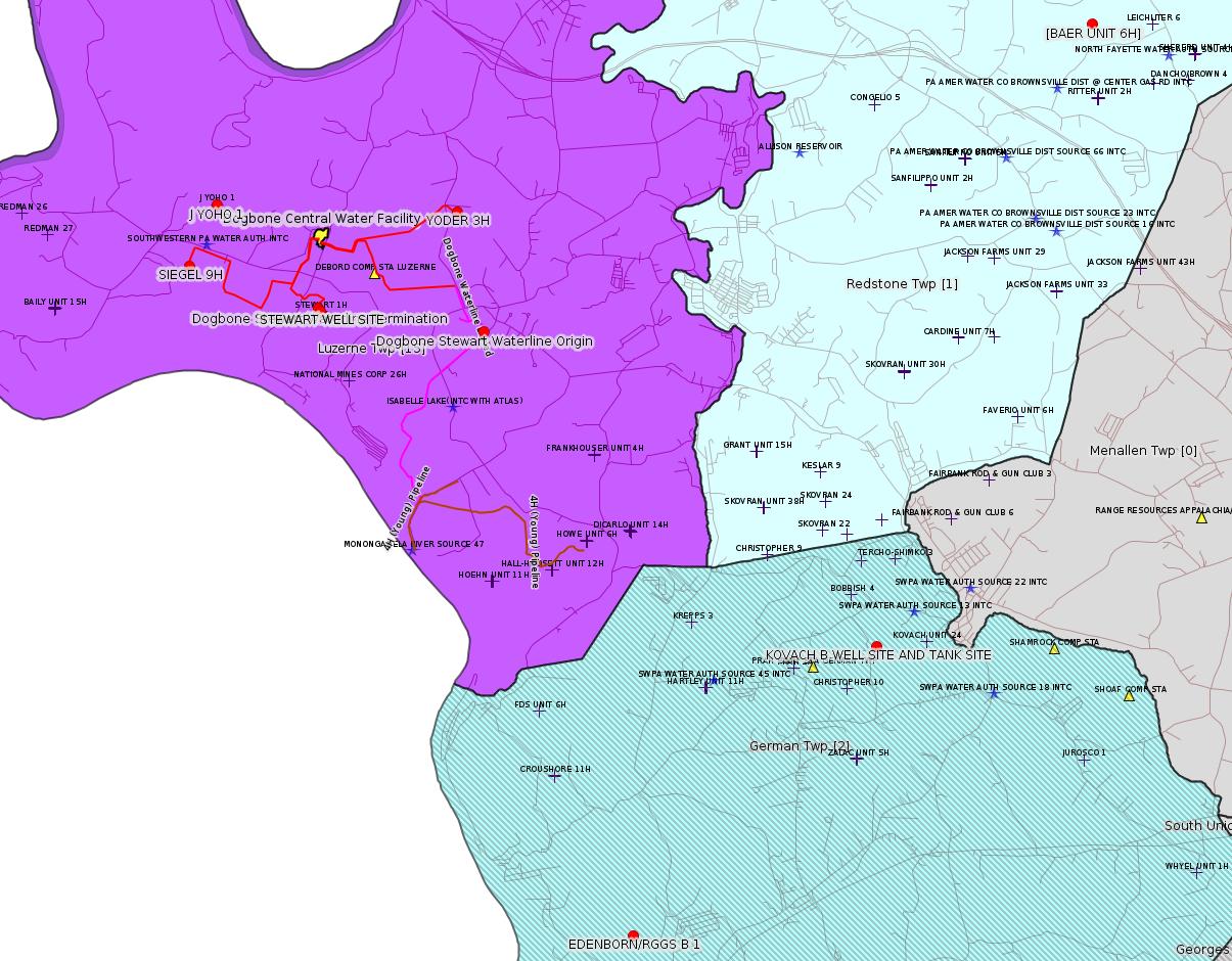
The Luzerne Twp pipeline mapped in red shows the route of the "proposed" pipeline system for the Dogbone Centralized Water Facility, as provided to the Fayette County Zoning Hearing Board on 12/13/2017 in case ZHB 17-41. The waterline applied for in Authorization 1221252 above is evidently a routing "directly" from the buried section of the Dog Bone Waterline to the Stewart Well Pad, and from the Stewart Well Pad to the Dogbone Centralized Water Facility. (Origin and termination latitude / longitude are from the Act 14 Notification for this project, for which we don't yet have the maps. Stay tuned for more accurate mapping.)
---
The well J YOHO 1 was inspected twice before regarding complaints:
OPERATOR: THE PRODUCTION CO LLC
INSPECTION_ID: 2430516
INSPECTION_DATE: 08/06/2015
INSPECTION_TYPE: Complaint Inspection
API_PERMIT: 051-21072
FARM_NAME: J YOHO 1
UNCONVENTIONAL: Yes
SITE_ID: 501644
SITE_NAME: J YOHO 1 OG WELL
FACILITY_TYPE: Oil & Gas Location
INSPECTION_CATEGORY: Primary Facility
REGION: EP DOGO SWDO Dstr Off
COUNTY: Fayette
MUNICIPALITY: Luzerne Twp
INSPECTOR: NAJEWICZ, JUSTIN
INSPECTION_SOURCE: EFACTS
INSPECTION_RESULT_DESCRIPTION: No Violations Noted
INSPECTION_COMMENT: On 08/06/15 at approximately 1315 hours I conducted a complaint inspection of the J Yoho #1 in response to a water supply complaint. The Act 9 sign was in place and all required documents were present in the mail box. The well was labeled and appeared to be in good condition. The tank on site showed signs of corrosion and should be inspected to verify integrity. The site was well vegetated and no signs of a pollutional discharge were observed at the time of inspection.
OPERATOR: THE PRODUCTION CO LLC
INSPECTION_ID: 2542171
INSPECTION_DATE: 09/21/2016
INSPECTION_TYPE: Complaint Inspection
API_PERMIT: 051-21072
FARM_NAME: J YOHO 1
UNCONVENTIONAL: Yes
SITE_ID: 501644
SITE_NAME: J YOHO 1 OG WELL
FACILITY_TYPE: Oil & Gas Location
INSPECTION_CATEGORY: Primary Facility
REGION: EP DOGO SWDO Dstr Off
COUNTY: Fayette
MUNICIPALITY: Luzerne Twp
INSPECTOR: NAJEWICZ, JUSTIN
INSPECTION_SOURCE: EFACTS
INSPECTION_RESULT_DESCRIPTION: No Violations Noted
INSPECTION_COMMENT: On 09/21/16 at approximately 1300 hours I conducted a complaint inspection of the J Yoho #1. The Act 9 sign was in place and all required documents were present in the mail box. The well was labeled and appeared to be in good condition. The site was well vegetated and no signs of a pollutional discharge were observed at the time of inspection. There were no violations noted at the time of inspection.
------------------------
DEP defines an environmental justice area as "any census tract where 20 percent or more individuals live in poverty, and/or 30 percent or more of the population is minority". (See:
<http://www.dep.pa.gov/PublicParticipation/OfficeofEnvironmentalJustice/Pages/default.aspx>). There are supposed to be enhanced public participation requirements for permits in environmental justice areas, but news of this actually ever happening is scarce. In Fayette County, the entirety of Springhill, Nicholson, German, and Georges Townships are environmental justice areas, as well as a large part of Dunbar Township. DEP's policy document on public participation guidelines for environmental justice areas is located here:
<http://www.elibrary.dep.state.pa.us/dsweb/Get/Version-48671/012-0501-002.pdf>
eNOTICE records are likely to list the same permit multiple times, as that permit moves through the DEP process.
Oil & Gas Wells designated with a site a number and the letter H typically designate horizontal wells.
-------------------------
Resources:
Pennsylvania Bulletin: <http://www.pabulletin.com/>
eNOTICE: <http://www.ahs2.dep.state.pa.
DEP Oil and Gas Reports: <http://www.dep.pa.gov/DataandTools/Reports/Oil%20and%20Gas%20Reports/Pages/default.aspx>
DEP Permits Issued Detail Report:
<http://www.depreportingservic
DEP SPUD (drilling started) Report:
<http://www.depreportingservices.state.pa.us/ReportServer/Pages/ReportViewer.aspx?/Oil_Gas/Spud_External_Data>
DEP Oil and Gas Compliance Report:
<http://www.depreportingservices.state.pa.us/ReportServer/Pages/ReportViewer.aspx?/Oil_Gas/OG_Compliance>
DEP PA Oil & Gas Mapping:
<http://www.depgis.state.pa.us/PaOilAndGasMapping>
Data Portal Services Directory [Technical]
<http://www.depgis.state.pa.us/arcgis/rest/services>
Query: Oil and Gas Wells All (ID: 3) [Technical]:
<http://www.depgis.state.pa.us/arcgis/rest/services/OilGas/OilGasAllStrayGas/MapServer/3/query?where=&text=&objectIds=&time=&geometry=&geometryType=esriGeometryEnvelope&inSR=&spatialRel=esriSpatialRelIntersects&relationParam=&outFields=OBJECTID%2CPERMIT_NUMBER%2CWELL_NAME%2COPERATOR%2COPERATOR_NUMBER%2CWELL_TYPE%2CWELL_TYPE_CODE%2CWELL_STATUS%2CWELL_STATUS_CODE%2CPERMIT_DATE%2CPERMIT_DATE_EXPIRES%2CSPUD_DATE%2CCONSERVATION_IND%2CCOUNTY%2CCOUNTY_ID%2CMUNICIPALITY%2CMUNICIPALITY_TYPE%2CMUNICIPALITY_CODE%2CLATITUDE%2CLONGITUDE%2CPRMRY_FID%2CUNCONVENTIONAL_IND%2CSURFACE_ELEVATION%2CWELL_CONFIG_CODE%2CCOAL_IND%2CWELL_PAD_NAME%2CSHAPE%2CDATE_PLUGGED%2CWELL_PAD_ID%2CUIC_ID%2CUIC_TYPE_DESCRIPTION%2CSTORAGE_FIELD_NAME%2CSITE_ID%2CSITE_NAME&returnGeometry=true&returnTrueCurves=false&maxAllowableOffset=&geometryPrecision=&outSR=&returnIdsOnly=false&returnCountOnly=false&orderByFields=&groupByFieldsForStatistics=&outStatistics=&returnZ=false&returnM=false&gdbVersion=&returnDistinctValues=false&resultOffset=&resultRecordCount=&f=html>
(Be sure to enter a Where clause in SQL format. Dates are in milliseconds since midnight 1/1/1970).
DEP Oil and Gas Electronic Notifications
<http://www.depreportingservices.state.pa.us/ReportServer?/Oil_Gas/OG_Notifications>
DEP Oil and Gas Well Pad Report
<http://www.depreportingservices.state.pa.us/ReportServer?/Oil_Gas/Well_Pads>
Fayette County Assessment Office Search For Tax Records:
<http://property.co.fayette.pa.us/search.aspx>
Pennsylvania Spatial Data Access:
<http://www.pasda.psu.edu/default.asp>
DEP Spatial Data Repository:
<ftp://www.pasda.psu.edu/pub/pasda/dep/>
National Response Center:
<http://www.nrc.uscg.mil/>
EPA-Echo: <http://www.epa-echo.gov/echo/
FERC citizen involvement: <http://www.ferc.gov/for-citiz
To receive E-mail notification of
all documents filed in a FERC docket, see:
<http://www.ferc.gov/docs-filing/esubscription.asp >
<http://www.ferc.gov/docs-fili
Follow the directions and enter the docket number to subscribe to.
Township Supervisors receive information regarding Erosion & Sedimentation permits, and these records may be reviewable at township municipal offices.
DEP permits are reviewable through the File Review process, for application to do file review see: <http://www.portal.state.pa.us/portal/server.pt/community/southwest_regional_office/13775/file_review/593164>
Environmental Hearing Board: <http://ehb.courtapps.com/publ
PA DEP Environmental Policy Comment System:
<http://www.ahs.dep.pa.gov/eComment/>
Federal Register Environment: <https://www.federalregister.g
Browsing of recent comment
opportunities for federal agencies, e.g. EPA. Click "sign up" to
subscribe to daily E-mails of new document listings.
SkyTruth Fayette County Drilling Alerts: <http://frack.skytruth.org/pen
U.S. Army Corps of Engineers, Pittsburgh District, Public Notices:
<http://www.lrp.usace.army.mil/Missions/Regulatory/Public-Notices/>
EPA Pennsylvania Public Notices: <http://www2.epa.gov/aboutepa/epa-pennsylvania#notice>
Marcellus Shale waste disposal
injection wells in Pennsylvania are regulated directly by EPA, not
DEP. Notice of any new permit applications will appear at the
above web address. I'm not aware of any subscription service
to be notified of such applications. I'm not aware of any
Marcellus Shale waste disposal injection wells in Fayette County
(yet ...) but we need to monitor this page for future
applications.
Energy Assurance Daily: <http://www.oe.netl.doe.gov/ead.aspx>
Daily newsletter from the US
Department of Energy about events relating to energy. The Natural
Gas section has information about pipelines.
-------------------------
Disclaimers:
This compilation from the above sources was done by hand using copy and paste and may omit relevant permits.
Parcel data is provided via the tax records search web page offered by the Fayette County Assessment Office (http://property.co.fayette.pa.us/). Presumed Parcel Id links are subject to availability provided by that agency and associated web sites. Presumed Parcel Ids are determined as the mapped parcel containing a given latitude and longitude, are a best effort determination which is subject to error, and are not official. In cases where a facility is leased and there is a separate parcel id for the lease, if this parcel id is not separately mapped, the parcel id shown will be the id for the enclosing parcel. Parcel owners may be surface owners only and may or may not have any relationship to oil & gas facilities.
Does not currently include water supply permits. Does not include landfill permits even though many such are for Marcellus Shale waste. (It is not possible at this time to distinguish which landfill permits are for Marcellus Shale waste and which are not without doing File Review for each permit.)
Erosion & Sedimentation permit records do not currently include latitude and longitude. Where I am publishing latitude and longitude with E&S permits it is by inferring an associated well permit and using published latitude and longitude for the well. It is possible I may be inferring the wrong well site.
Municipalities are shown from eFACTS records on the DEP web site. The DEP has been known to list a municipality incorrectly.