The Harmed Success Stories Concepts How To What Is Commentary
Fayette County Marcellus Shale Permits 3/22/21 - 4/4/21
Contents
Pennsylvania Bulletin Listings
[No Activity]eFACTS Listings
FAYETTE ENERGY FAC TRTMT PLT Water Quality Mgmt Part II, Industrial Wastewater Fac Transfer (New)
CHESTNUT VALLEY LDFL PAG-03 Discharge of Stormwater Assoc w Industrial Activities Transfer (New)
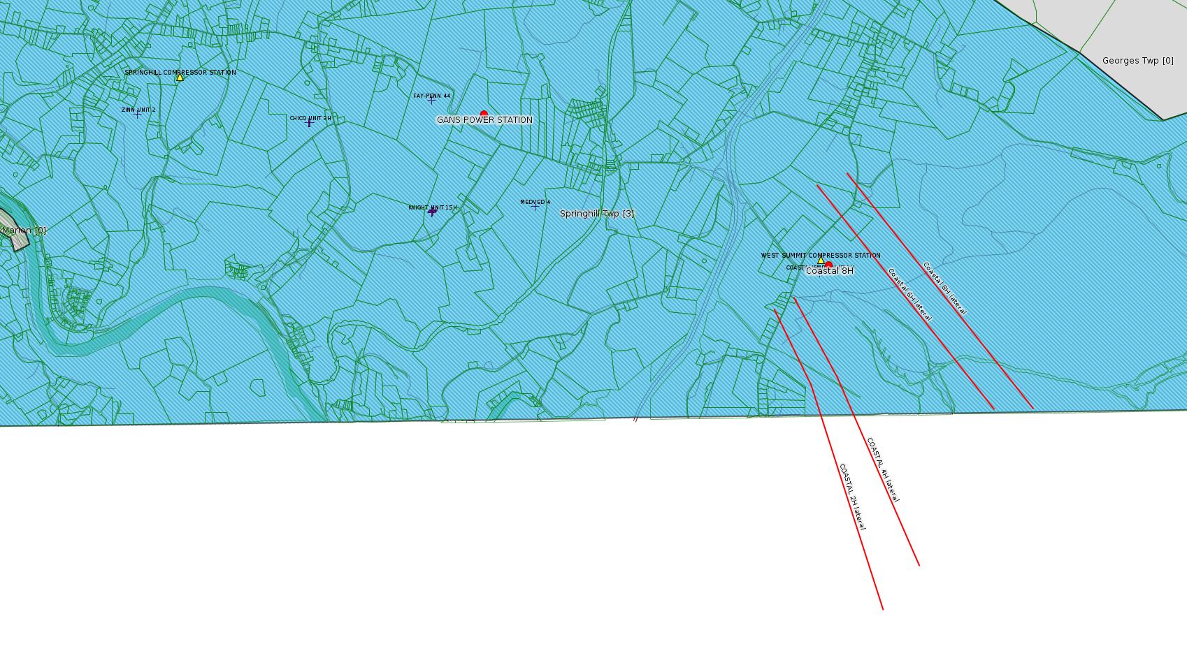
Coastal 8H Drill & Operate Well Permit (Unconventional) Issued 3/26/2021 (New)
Coastal 6H Drill & Operate Well Permit (Unconventional) Issued 3/26/2021 (New)
BOBAK 1 Well Plugging Notice Alternate Method Issued 3/22/2021
YODER WATERLINE ESCGP ESX18-051-0006 Expedited E&S Stormwater General Permit 1 [Termination?] Notification Issued 3/19/2021
CERULLO PAD A ESCGP ESX18-051-0004 Expedited E&S Stormwater General Permit 1 [Termination?] Notification Withdrawn 3/18/2021
GANS POWER STATION Major Facility Operating Permit Amendment
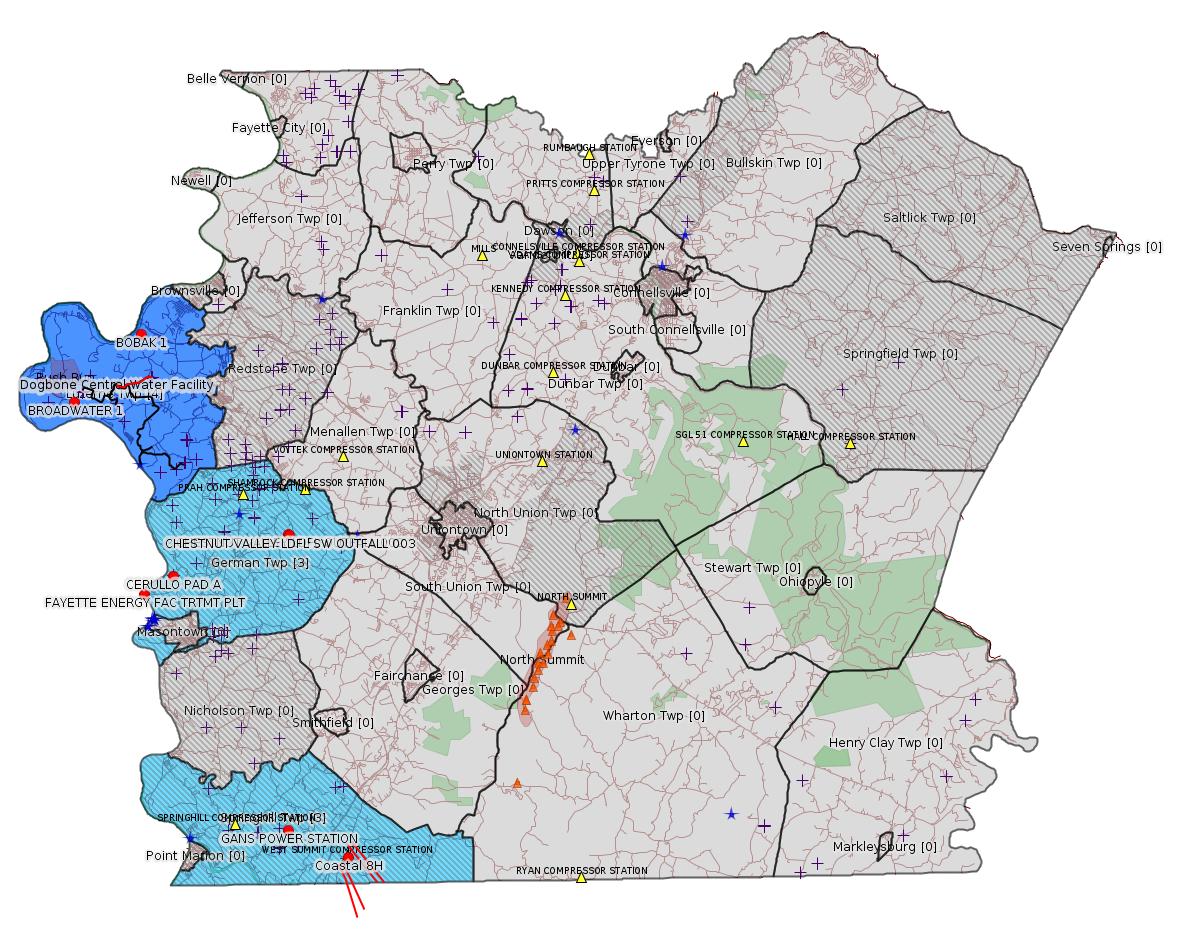
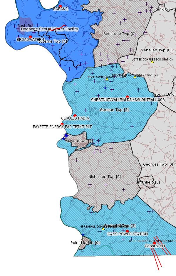
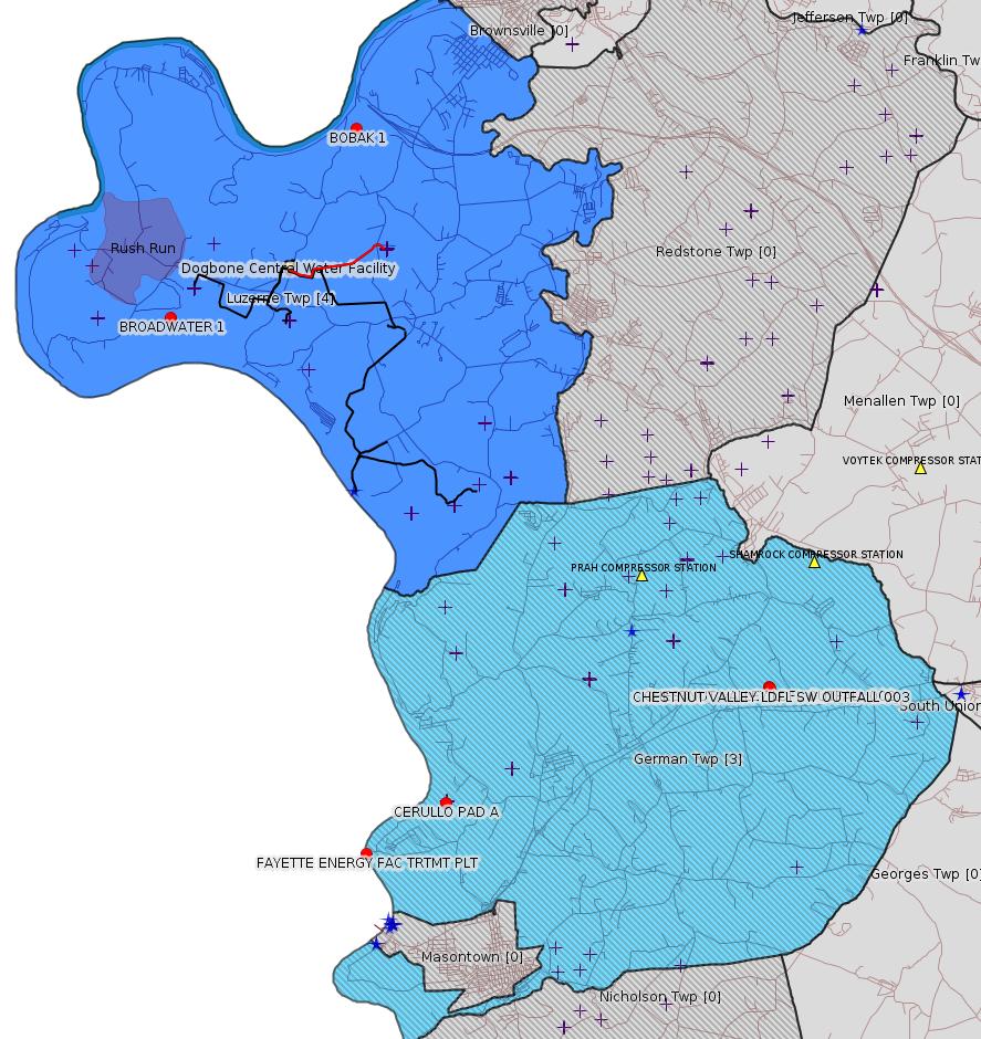
Map
Key
Red dots: items in this permit list with an exact location.
Blue stars: Marcellus Gas Well Water Sources.
Where well laterals are mapped they show in red; a 400-foot buffer surrounding the lateral shows in blue (lavender where it overlaps a mapped mineral tract).
Where mineral tracts are mapped, they show in pink. Mineral tracts can overlap; the overlap will show in red. The precise meaning of "mineral tract" is not clear.
Municipality shading: number of "facilities", with each well counting separately
(includes the red dots):
gray: 0
pale turquoise: 1
turquoise: 2
pale blue: 3
middle blue: 4
dark blue: 5
dark purple: 7
purple: 11
(Color coding may differ from one issue to the next.)
(Note if a project spans multiple municipalities -- e.g. a pipeline -- it will show in the count for each municipality.)
The number of facilities also follows the municipality name in brackets.
Municipality counts are based on the way the permit is listed by DEP; DEP has been known to get a municipality wrong.
Locations in brackets identify a precise location used to locate a surrogate for the actual site being permitted (e.g. locating a well pad or pipeline by the known location of a well.) Locations labeled beginning with "~" and ending in "[?]" are approximate and speculative based on inferences using on-line property and lease records. These are marked in the text as "[Approximate, Speculative]
Cross-hatching: Environmental Justice Areas
Yellow triangles: Compressor Stations
Orange triangles: Storage Field Wells (currently Dominion North Summit Storage Field)
Crosses: SPUD Unconventional well permits
Green: "Natural areas", e.g. state game lands, state forests
Yellow triangles: Compressor Stations
Orange triangles: Storage Field Wells (currently Dominion North Summit Storage Field)
Crosses: SPUD Unconventional well permits
Green: "Natural areas", e.g. state game lands, state forests
More Maps
 |
 |
 |
Source: Pennsylvania Bulletin
[No Activity]
-------------------------
Source: eNOTICE
(+ PA
Oil and Gas Mapping, Well
Pad Report.) Well Details via Data
Portal Services: Oil and Gas Wells All (ID: 3).
Please see the Disclaimer below regarding Parcel Id data.
Authorization ID: 1347187
Permit number: 2602201
Site: FAYETTE ENERGY FAC
Client: FAYETTE POWER CO LLC
Authorization type: Water Quality Mgmt Part II, Industrial Wastewater Fac
Application type: Transfer
Authorization is for: FACILITY
Date received: 03/17/2021
Status: Pending
Permit Decision Guarantee Applies: No
Sub-Facilities for Authorization:
Sub-Facility ID Sub-Facility Name Description
1049122 TRTMT PLT Treatment Plant
Location: 39.866944,-79.930278
Map URL: <http://www.openstreetmap.org/?mlat=39.866944&mlon=-79.930278#map=15/39.866944/-79.930278>
Permit Review Notes:
Date Review Note
3/26/2021 The permit application package is complete, has been accepted, and is undergoing technical review.
<https://www.ahs.dep.pa.gov/eFACTSWeb/searchResults_singleAuth.aspx?AuthID=1347187>
Site Programs:
Clean Water
Site Municipalities:
German Twp, Fayette County
[See Notes.]
---
Authorization ID: 1346845
Permit number: PAG036257
Site: CHESTNUT VALLEY LDFL
Client: CHESTNUT VALLEY LDFL LLC
Authorization type: PAG-03 Discharge of Stormwater Assoc w Industrial Activities
Application type: Transfer
Authorization is for: FACILITY
Date received: 03/03/2021
Status: Pending
Permit Decision Guarantee Applies: No
Sub-Facilities for Authorization:
Sub-Facility ID Sub-Facility Name Description
989305 SW OUTFALL 003 Internal Monitoring Point
989304 OUTFALL 002 Internal Monitoring Point
568840 SW OUTFALL 003 Discharge Point
Location: 39.895833,-79.835833
Map URL: <http://www.openstreetmap.org/?mlat=39.895833&mlon=-79.835833#map=15/39.895833/-79.835833>
989303 OUTFALL 001 Internal Monitoring Point
568839 OUTFALL 002 Discharge Point
Location: 39.896111,-79.836111
Map URL: <http://www.openstreetmap.org/?mlat=39.896111&mlon=-79.836111#map=15/39.896111/-79.836111>
Permit Review Notes:
Date Review Note
3/25/2021 The permit application package is complete, has been accepted, and is undergoing technical review.
<https://www.ahs.dep.pa.gov/eFACTSWeb/searchResults_singleAuth.aspx?AuthID=1346845>
Site Programs:
Air Quality
Clean Water
Environmental Cleanup & Brownfields
Mining
Radiation Protection
Waste Management
Water Planning and Conservation
Site Municipalities:
German Twp, Fayette County
Presumed Parcel Id: 15280012
---
Authorization ID: 1346720
Permit number: 051-24725
Site: COASTAL 1H FLOW BACK PIT FRESHWATER PITS ESCGP-EXPEDITED
Client: INR OPR LLC
Authorization type: Drill & Operate Well Permit (Unconventional)
Application type: New
Authorization is for: FACILITY
Date received: 03/22/2021
Status: Issued on 3/26/2021
Public_Permit_Review:
<http://www.ahs.dep.pa.gov/ePermitPublicAccess/Public/PublicAuthOverview?q=gQWeDlrZtAPMqYfIi854G67zBtXUf4grjsRahEtHOi0%3d>
Plat:
<https://www.ahs.dep.pa.gov/ePermitPublicAccess/Public/DownloadFileFromWebServer/62928?onBaseDocId=3590930>
Landing Point: 39.741992,-79.797819
Bottom Hole: 39.721110,-79.777047
Permit Decision Guarantee Applies: Yes
Permit Decision Guarantee status: ACTIVE
Sub-Facilities for Authorization:
Sub-Facility ID Sub-Facility Name Description
1326825 Horizontal MARCELLUS Well
Permit Review Notes:
Date Review Note
3/24/2021 The technical review and decision review are complete and either the permit decision and/or permit issuance are forthcoming.
3/24/2021 The permit application package is complete, has been accepted, and is undergoing technical review.
<https://www.ahs.dep.pa.gov/eFACTSWeb/searchResults_singleAuth.aspx?AuthID=1346720>
Site Programs:
Oil & Gas
Site Municipalities:
Springhill Twp, Fayette County
Well Details:
Permit Number: 051-24725
Well Name: Coastal 8H
Unconventional Well: Y
Well Configuration: Horizontal Well
Well Type: GAS
Well Status: Active
Coal Association: NonCoal
Conservation Well: N
Primary Facility ID: 848119
Site ID: 739525
Site Name: COASTAL 1H FLOW BACK PIT FRESHWATER PITS ESCGP-EXPEDITED
Well Pad ID: 147971
Well Pad Name: COASTAL WELL PAD
Storage Field:
Operator: INR OPR LLC
Operator Number: OGO-51036
Permit Date: 2021-03-26
Permit Date Expires: 2022-03-26
SPUD Date:
Date Plugged:
UIC ID:
UIC Type:
Surface Elevation: 1138
County: Fayette
Municipality: Springhill Twp
Location: 39.73396,-79.79999
Map URL: <http://www.openstreetmap.org/?mlat=39.73396&mlon=-79.79999#map=15/39.73396/-79.79999>
---
Authorization ID: 1346718
Permit number: 051-24724
Site: COASTAL 1H FLOW BACK PIT FRESHWATER PITS ESCGP-EXPEDITED
Client: INR OPR LLC
Authorization type: Drill & Operate Well Permit (Unconventional)
Application type: New
Authorization is for: FACILITY
Date received: 03/22/2021
Status: Issued on 3/26/2021
Public_Permit_Review:
<http://www.ahs.dep.pa.gov/ePermitPublicAccess/Public/PublicAuthOverview?q=xhprYKyKXDeynnDEmAsvnfMo9tlRxe81d9Qrx5zsLfg%3d>
Plat:
<https://www.ahs.dep.pa.gov/ePermitPublicAccess/Public/DownloadFileFromWebServer/62965?onBaseDocId=3588973>
Landing Point: 39.740947,-79.801262
Bottom Hole: 39.721101,-79.781519
Permit Decision Guarantee Applies: Yes
Permit Decision Guarantee status: ACTIVE
Sub-Facilities for Authorization:
Sub-Facility ID Sub-Facility Name Description
1326819 Horizontal MARCELLUS Well
Permit Review Notes:
Date Review Note
3/24/2021 The technical review and decision review are complete and either the permit decision and/or permit issuance are forthcoming.
3/24/2021 The permit application package is complete, has been accepted, and is undergoing technical review.
<https://www.ahs.dep.pa.gov/eFACTSWeb/searchResults_singleAuth.aspx?AuthID=1346718>
Site Programs:
Oil & Gas
Site Municipalities:
Springhill Twp, Fayette County
Well Details:
Permit Number: 051-24724
Well Name: Coastal 6H
Unconventional Well: Y
Well Configuration: Horizontal Well
Well Type: GAS
Well Status: Active
Coal Association: NonCoal
Conservation Well: N
Primary Facility ID: 848117
Site ID: 739525
Site Name: COASTAL 1H FLOW BACK PIT FRESHWATER PITS ESCGP-EXPEDITED
Well Pad ID: 147971
Well Pad Name: COASTAL WELL PAD
Storage Field:
Operator: INR OPR LLC
Operator Number: OGO-51036
Permit Date: 2021-03-26
Permit Date Expires: 2022-03-26
SPUD Date:
Date Plugged:
UIC ID:
UIC Type:
Surface Elevation: 1138
County: Fayette
Municipality: Springhill Twp
Location: 39.73393,-79.80003
Map URL: <http://www.openstreetmap.org/?mlat=39.73393&mlon=-79.80003#map=15/39.73393/-79.80003>
---
Authorization ID: 1343884
Permit number: 051-22541
Site: BOBAK 1 OG WELL
Client: BURKLAND WILLIAM S
Authorization type: Well Plugging Notice Alternate Method
Application type: New
Authorization is for: FACILITY
Date received: 02/12/2021
Status: Issued on 3/22/2021
Permit Decision Guarantee Applies: No
Sub-Facilities for Authorization:
Sub-Facility ID Sub-Facility Name Description
842494 BOBAK 1 Well
Permit Review Notes:
Date Review Note
3/22/2021 The technical review and decision review are complete and either the permit decision and/or permit issuance are forthcoming.
2/25/2021 The permit application package is complete, has been accepted, and is undergoing technical review.
<https://www.ahs.dep.pa.gov/eFACTSWeb/searchResults_singleAuth.aspx?AuthID=1343884>
Site Programs:
Oil & Gas
Site Municipalities:
Luzerne Twp, Fayette County
Well Details:
Permit Number: 051-22541
Well Name: BOBAK 1
Unconventional Well: N
Well Configuration: Vertical Well
Well Type: GAS
Well Status: Active
Coal Association: NonCoal
Conservation Well: N
Primary Facility ID: 662605
Site ID: 648552
Site Name: BOBAK 1 OG WELL
Well Pad ID: 0
Well Pad Name:
Storage Field:
Operator: THE PRODUCTION CO LLC
Operator Number: OGO-39567
Permit Date: 2005-03-16
Permit Date Expires: 2006-03-16
SPUD Date: 2005-10-21
Date Plugged:
UIC ID:
UIC Type:
Surface Elevation: 1022
County: Fayette
Municipality: Luzerne Twp
Location: 39.99718,-79.930647
Map URL: <http://www.openstreetmap.org/?mlat=39.99718&mlon=-79.930647#map=15/39.99718/-79.930647>
OG WELLS PERMIT DOCS:
2021-03-04: Other Permit Documents, Name: 051-22541_William Burkland_G Bobak_NOI_2-12-21_noncoal_signed_sa (for Authorization: 1343860.0):
<http://www.depgis.state.pa.us/pdfHandler/pdFHandler.ashx?Doc=MTY5NzE1My4w&ext=PDF>
2021-03-22: Final Permit Documents, Name: 051-22541_William Burkland_G Bobak_Alt Method_2-12-21 (for Authorization: 1343884.0):
<http://www.depgis.state.pa.us/pdfHandler/pdFHandler.ashx?Doc=MTczNTg5Mi4w&ext=PDF>
---
Authorization ID: 1335460
Permit number: ESX18-051-0006
Site: YODER WATERLINE ESCGP ESX18-051-0006
Client: EQT CHAP LLC
Authorization type: Expedited E&S Stormwater General Permit 1
Application type: Notification
Authorization is for: SITE
Date received: 11/24/2020
Status: Issued on 3/19/2021
Permit Decision Guarantee Applies: No
Permit Review Notes:
Date Review Note
3/19/2021 The technical review and decision review are complete and either the permit decision and/or permit issuance are forthcoming.
11/24/2020 The permit application package is complete, has been accepted, and is undergoing technical review.
<https://www.ahs.dep.pa.gov/eFACTSWeb/searchResults_singleAuth.aspx?AuthID=1335460>
Site Programs:
Site Municipalities:
Luzerne Twp, Fayette County
---
Authorization ID: 1334873
Permit number: ESX18-051-0004
Site: CERULLO PAD A ESCGP ESX18-051-0004
Client: EQT CHAP LLC
Authorization type: Expedited E&S Stormwater General Permit 1
Application type: Notification
Authorization is for: SITE
Date received: 12/01/2020
Status: Withdrawn on 3/18/2021
Permit Decision Guarantee Applies: No
Permit Review Notes:
Date Review Note
12/1/2020 The permit application package is complete, has been accepted, and is undergoing technical review.
<https://www.ahs.dep.pa.gov/eFACTSWeb/searchResults_singleAuth.aspx?AuthID=1334873>
Site Programs:
Oil & Gas
Site Municipalities:
German Twp, Fayette County
---
Authorization ID: 1327126
Permit number: 26-00495
Site: GANS POWER STATION
Client: GANS ENERGY LLC
Authorization type: Major Facility Operating Permit
Application type: Amendment
Authorization is for: FACILITY
Date received: 09/09/2020
Status: Pending
Permit Decision Guarantee Applies: No
Permit Review Notes:
Date Review Note
9/15/2020 The permit application package is complete, has been accepted, and is undergoing technical review.
<https://www.ahs.dep.pa.gov/eFACTSWeb/searchResults_singleAuth.aspx?AuthID=1327126>
Site Programs:
Air Quality
Clean Water
Waste Management
Site Municipalities:
Springhill Twp, Fayette County
-------------------------
Inspection Issues Source: DEP Oil and Gas Compliance Report
OPERATOR: THE PRODUCTION CO LLC
INSPECTION_ID: 3167532
INSPECTION_DATE: 3/25/2021
INSPECTION_TYPE: Routine/Complete Inspection
API_PERMIT: 051-21841
FARM_NAME: BROADWATER 1
UNCONVENTIONAL: No
SITE_ID: 622324
SITE_NAME: BROADWATER 1 OG WELL
FACILITY_TYPE: Oil & Gas Location
INSPECTION_CATEGORY: Primary Facility
REGION: EP DOGO SWDO Dstr Off
COUNTY: Fayette
MUNICIPALITY: Luzerne Twp
INSPECTOR: ZADZILKO, ANDREW
INSPECTION_SOURCE: SAIR
INSPECTION_RESULT_DESCRIPTION: Violation(s) & Outstanding Violations
INSPECTION_COMMENT: "At the time of inspection, well appears equipped for production (Photo 1).
Well head is shown in Photo 2.
No well tag on well head. No posting complete with operator's name, address and phone number.
At the time of inspection, no E&S issues on pad.
Large erosion rills have formed in various locations along access road (Photos 3-7). Access road is impassible.
Blocked inlet and outlet of cross pipes on access road are shown in Photos 8,12.
Large ruts on access road holding muddy water are shown in Photos 9-11. Photo 10 shows muddy water ponding on access road at stream crossing. At the time of inspection it does not appear that sediment laden material has impacted the stream.
The Department recommends that the operator immediately remediate the access road, to restore site access via the access road and to prevent any potential sediment impacts to waters of the Commonwealth.
At the time of inspection, the Department was unable to contact the operator."
VIOLATION_ID: 912618
VIOLATION_DATE: 3/25/2021
VIOLATION_CODE: 102.22(a) - SITE STABILIZATION – PERMANENT STABILIZATION – Permitee failed to have site permanently stabilized and protected from accelerated erosion and sedimentation upon final completion of earth disturbance activity.
VIOLATION_TYPE: Environmental Health & Safety
VIOLATION_COMMENT:
RESOLVED_DATE:
RESOLUTION_REASON_CODE_DESC:
CONTINUING_VIOLATION:
ENFORCEMENT_ID:
ENFORCEMENT_CODE_DESCRIPTION:
DATE_EXECUTED:
ENFORCEMENT_FINAL_DATE:
ENFORCEMENT_FINAL_STATUS:
PENALTY_FINAL_DATE:
PENALTY_FINAL_STATUS_CODE_DESC:
PENALTY_AMOUNT:
TOTAL_AMOUNT_COLLECTED:
VIOLATION_ID: 912616
VIOLATION_DATE: 3/25/2021
VIOLATION_CODE: 102.11(a)1 - GENERAL REQUIREMENTS – BMP AND DESIGN STANDARDS - Person failed to design, implement and maintain E & S BMPs to minimize the potential for accelerated erosion and sedimentation to protect, maintain, reclaim and restore water quality and existing and designated uses.
VIOLATION_TYPE: Environmental Health & Safety
VIOLATION_COMMENT:
RESOLVED_DATE:
RESOLUTION_REASON_CODE_DESC:
CONTINUING_VIOLATION:
ENFORCEMENT_ID:
ENFORCEMENT_CODE_DESCRIPTION:
DATE_EXECUTED:
ENFORCEMENT_FINAL_DATE:
ENFORCEMENT_FINAL_STATUS:
PENALTY_FINAL_DATE:
PENALTY_FINAL_STATUS_CODE_DESC:
PENALTY_AMOUNT:
TOTAL_AMOUNT_COLLECTED:
VIOLATION_ID: 912617
VIOLATION_DATE: 3/25/2021
VIOLATION_CODE: 102.4(b)1 - EROSION AND SEDIMENT CONTROL REQUIREMENTS - Person conducting earth disturbance activity failed to implement and maintain E & S BMPs to minimize the potential for accelerated erosion and sedimentation.
VIOLATION_TYPE: Environmental Health & Safety
VIOLATION_COMMENT:
RESOLVED_DATE:
RESOLUTION_REASON_CODE_DESC:
CONTINUING_VIOLATION:
ENFORCEMENT_ID:
ENFORCEMENT_CODE_DESCRIPTION:
DATE_EXECUTED:
ENFORCEMENT_FINAL_DATE:
ENFORCEMENT_FINAL_STATUS:
PENALTY_FINAL_DATE:
PENALTY_FINAL_STATUS_CODE_DESC:
PENALTY_AMOUNT:
TOTAL_AMOUNT_COLLECTED:
VIOLATION_ID: 912615
VIOLATION_DATE: 3/25/2021
VIOLATION_CODE: 78.53 - EROSION AND SEDIMENT CONTROL - Operator failed to design, implement and maintain best management practices and an erosion and sediment control plan in accordance with 25 Pa. Code Chapter 102, during and after earthmoving or soil disturbing activities, including the activities related to siting, drilling, completing, producing, servicing and plugging, constructing, utilizing and restoring the site and access road.
VIOLATION_TYPE: Environmental Health & Safety
VIOLATION_COMMENT:
RESOLVED_DATE:
RESOLUTION_REASON_CODE_DESC:
CONTINUING_VIOLATION:
ENFORCEMENT_ID:
ENFORCEMENT_CODE_DESCRIPTION:
DATE_EXECUTED:
ENFORCEMENT_FINAL_DATE:
ENFORCEMENT_FINAL_STATUS:
PENALTY_FINAL_DATE:
PENALTY_FINAL_STATUS_CODE_DESC:
PENALTY_AMOUNT:
TOTAL_AMOUNT_COLLECTED:
Well Details:
Permit Number: 051-21841
Well Name: BROADWATER 1
Unconventional Well: N
Well Configuration: Vertical Well
Well Type: GAS
Well Status: Active
Coal Association: Coal
Conservation Well: N
Primary Facility ID: 641820
Site ID: 622324
Site Name: BROADWATER 1 OG WELL
Well Pad ID: 0
Well Pad Name:
Storage Field:
Operator: THE PRODUCTION CO LLC
Operator Number: OGO-39567
Permit Date: 2003-09-05
Permit Date Expires: 2004-09-05
SPUD Date: 2004-06-07
Date Plugged:
UIC ID:
UIC Type:
Surface Elevation: 1173
County: Fayette
Municipality: Luzerne Twp
Location: 39.963649,-79.974312
Map URL: <http://www.openstreetmap.org/?mlat=39.963649&mlon=-79.974312#map=15/39.963649/-79.974312>
Presumed Parcel Id: 19240019
-------------------------
Please see the Disclaimer below regarding Parcel Id data.
Authorization ID: 1347187
Permit number: 2602201
Site: FAYETTE ENERGY FAC
Client: FAYETTE POWER CO LLC
Authorization type: Water Quality Mgmt Part II, Industrial Wastewater Fac
Application type: Transfer
Authorization is for: FACILITY
Date received: 03/17/2021
Status: Pending
Permit Decision Guarantee Applies: No
Sub-Facilities for Authorization:
Sub-Facility ID Sub-Facility Name Description
1049122 TRTMT PLT Treatment Plant
Location: 39.866944,-79.930278
Map URL: <http://www.openstreetmap.org/?mlat=39.866944&mlon=-79.930278#map=15/39.866944/-79.930278>
Permit Review Notes:
Date Review Note
3/26/2021 The permit application package is complete, has been accepted, and is undergoing technical review.
<https://www.ahs.dep.pa.gov/eFACTSWeb/searchResults_singleAuth.aspx?AuthID=1347187>
Site Programs:
Clean Water
Site Municipalities:
German Twp, Fayette County
[See Notes.]
---
Authorization ID: 1346845
Permit number: PAG036257
Site: CHESTNUT VALLEY LDFL
Client: CHESTNUT VALLEY LDFL LLC
Authorization type: PAG-03 Discharge of Stormwater Assoc w Industrial Activities
Application type: Transfer
Authorization is for: FACILITY
Date received: 03/03/2021
Status: Pending
Permit Decision Guarantee Applies: No
Sub-Facilities for Authorization:
Sub-Facility ID Sub-Facility Name Description
989305 SW OUTFALL 003 Internal Monitoring Point
989304 OUTFALL 002 Internal Monitoring Point
568840 SW OUTFALL 003 Discharge Point
Location: 39.895833,-79.835833
Map URL: <http://www.openstreetmap.org/?mlat=39.895833&mlon=-79.835833#map=15/39.895833/-79.835833>
989303 OUTFALL 001 Internal Monitoring Point
568839 OUTFALL 002 Discharge Point
Location: 39.896111,-79.836111
Map URL: <http://www.openstreetmap.org/?mlat=39.896111&mlon=-79.836111#map=15/39.896111/-79.836111>
Permit Review Notes:
Date Review Note
3/25/2021 The permit application package is complete, has been accepted, and is undergoing technical review.
<https://www.ahs.dep.pa.gov/eFACTSWeb/searchResults_singleAuth.aspx?AuthID=1346845>
Site Programs:
Air Quality
Clean Water
Environmental Cleanup & Brownfields
Mining
Radiation Protection
Waste Management
Water Planning and Conservation
Site Municipalities:
German Twp, Fayette County
Presumed Parcel Id: 15280012
---
Authorization ID: 1346720
Permit number: 051-24725
Site: COASTAL 1H FLOW BACK PIT FRESHWATER PITS ESCGP-EXPEDITED
Client: INR OPR LLC
Authorization type: Drill & Operate Well Permit (Unconventional)
Application type: New
Authorization is for: FACILITY
Date received: 03/22/2021
Status: Issued on 3/26/2021
Public_Permit_Review:
<http://www.ahs.dep.pa.gov/ePermitPublicAccess/Public/PublicAuthOverview?q=gQWeDlrZtAPMqYfIi854G67zBtXUf4grjsRahEtHOi0%3d>
Plat:
<https://www.ahs.dep.pa.gov/ePermitPublicAccess/Public/DownloadFileFromWebServer/62928?onBaseDocId=3590930>
Landing Point: 39.741992,-79.797819
Bottom Hole: 39.721110,-79.777047
Permit Decision Guarantee Applies: Yes
Permit Decision Guarantee status: ACTIVE
Sub-Facilities for Authorization:
Sub-Facility ID Sub-Facility Name Description
1326825 Horizontal MARCELLUS Well
Permit Review Notes:
Date Review Note
3/24/2021 The technical review and decision review are complete and either the permit decision and/or permit issuance are forthcoming.
3/24/2021 The permit application package is complete, has been accepted, and is undergoing technical review.
<https://www.ahs.dep.pa.gov/eFACTSWeb/searchResults_singleAuth.aspx?AuthID=1346720>
Site Programs:
Oil & Gas
Site Municipalities:
Springhill Twp, Fayette County
Well Details:
Permit Number: 051-24725
Well Name: Coastal 8H
Unconventional Well: Y
Well Configuration: Horizontal Well
Well Type: GAS
Well Status: Active
Coal Association: NonCoal
Conservation Well: N
Primary Facility ID: 848119
Site ID: 739525
Site Name: COASTAL 1H FLOW BACK PIT FRESHWATER PITS ESCGP-EXPEDITED
Well Pad ID: 147971
Well Pad Name: COASTAL WELL PAD
Storage Field:
Operator: INR OPR LLC
Operator Number: OGO-51036
Permit Date: 2021-03-26
Permit Date Expires: 2022-03-26
SPUD Date:
Date Plugged:
UIC ID:
UIC Type:
Surface Elevation: 1138
County: Fayette
Municipality: Springhill Twp
Location: 39.73396,-79.79999
Map URL: <http://www.openstreetmap.org/?mlat=39.73396&mlon=-79.79999#map=15/39.73396/-79.79999>
---
Authorization ID: 1346718
Permit number: 051-24724
Site: COASTAL 1H FLOW BACK PIT FRESHWATER PITS ESCGP-EXPEDITED
Client: INR OPR LLC
Authorization type: Drill & Operate Well Permit (Unconventional)
Application type: New
Authorization is for: FACILITY
Date received: 03/22/2021
Status: Issued on 3/26/2021
Public_Permit_Review:
<http://www.ahs.dep.pa.gov/ePermitPublicAccess/Public/PublicAuthOverview?q=xhprYKyKXDeynnDEmAsvnfMo9tlRxe81d9Qrx5zsLfg%3d>
Plat:
<https://www.ahs.dep.pa.gov/ePermitPublicAccess/Public/DownloadFileFromWebServer/62965?onBaseDocId=3588973>
Landing Point: 39.740947,-79.801262
Bottom Hole: 39.721101,-79.781519
Permit Decision Guarantee Applies: Yes
Permit Decision Guarantee status: ACTIVE
Sub-Facilities for Authorization:
Sub-Facility ID Sub-Facility Name Description
1326819 Horizontal MARCELLUS Well
Permit Review Notes:
Date Review Note
3/24/2021 The technical review and decision review are complete and either the permit decision and/or permit issuance are forthcoming.
3/24/2021 The permit application package is complete, has been accepted, and is undergoing technical review.
<https://www.ahs.dep.pa.gov/eFACTSWeb/searchResults_singleAuth.aspx?AuthID=1346718>
Site Programs:
Oil & Gas
Site Municipalities:
Springhill Twp, Fayette County
Well Details:
Permit Number: 051-24724
Well Name: Coastal 6H
Unconventional Well: Y
Well Configuration: Horizontal Well
Well Type: GAS
Well Status: Active
Coal Association: NonCoal
Conservation Well: N
Primary Facility ID: 848117
Site ID: 739525
Site Name: COASTAL 1H FLOW BACK PIT FRESHWATER PITS ESCGP-EXPEDITED
Well Pad ID: 147971
Well Pad Name: COASTAL WELL PAD
Storage Field:
Operator: INR OPR LLC
Operator Number: OGO-51036
Permit Date: 2021-03-26
Permit Date Expires: 2022-03-26
SPUD Date:
Date Plugged:
UIC ID:
UIC Type:
Surface Elevation: 1138
County: Fayette
Municipality: Springhill Twp
Location: 39.73393,-79.80003
Map URL: <http://www.openstreetmap.org/?mlat=39.73393&mlon=-79.80003#map=15/39.73393/-79.80003>
---
Authorization ID: 1343884
Permit number: 051-22541
Site: BOBAK 1 OG WELL
Client: BURKLAND WILLIAM S
Authorization type: Well Plugging Notice Alternate Method
Application type: New
Authorization is for: FACILITY
Date received: 02/12/2021
Status: Issued on 3/22/2021
Permit Decision Guarantee Applies: No
Sub-Facilities for Authorization:
Sub-Facility ID Sub-Facility Name Description
842494 BOBAK 1 Well
Permit Review Notes:
Date Review Note
3/22/2021 The technical review and decision review are complete and either the permit decision and/or permit issuance are forthcoming.
2/25/2021 The permit application package is complete, has been accepted, and is undergoing technical review.
<https://www.ahs.dep.pa.gov/eFACTSWeb/searchResults_singleAuth.aspx?AuthID=1343884>
Site Programs:
Oil & Gas
Site Municipalities:
Luzerne Twp, Fayette County
Well Details:
Permit Number: 051-22541
Well Name: BOBAK 1
Unconventional Well: N
Well Configuration: Vertical Well
Well Type: GAS
Well Status: Active
Coal Association: NonCoal
Conservation Well: N
Primary Facility ID: 662605
Site ID: 648552
Site Name: BOBAK 1 OG WELL
Well Pad ID: 0
Well Pad Name:
Storage Field:
Operator: THE PRODUCTION CO LLC
Operator Number: OGO-39567
Permit Date: 2005-03-16
Permit Date Expires: 2006-03-16
SPUD Date: 2005-10-21
Date Plugged:
UIC ID:
UIC Type:
Surface Elevation: 1022
County: Fayette
Municipality: Luzerne Twp
Location: 39.99718,-79.930647
Map URL: <http://www.openstreetmap.org/?mlat=39.99718&mlon=-79.930647#map=15/39.99718/-79.930647>
OG WELLS PERMIT DOCS:
2021-03-04: Other Permit Documents, Name: 051-22541_William Burkland_G Bobak_NOI_2-12-21_noncoal_signed_sa (for Authorization: 1343860.0):
<http://www.depgis.state.pa.us/pdfHandler/pdFHandler.ashx?Doc=MTY5NzE1My4w&ext=PDF>
2021-03-22: Final Permit Documents, Name: 051-22541_William Burkland_G Bobak_Alt Method_2-12-21 (for Authorization: 1343884.0):
<http://www.depgis.state.pa.us/pdfHandler/pdFHandler.ashx?Doc=MTczNTg5Mi4w&ext=PDF>
---
Authorization ID: 1335460
Permit number: ESX18-051-0006
Site: YODER WATERLINE ESCGP ESX18-051-0006
Client: EQT CHAP LLC
Authorization type: Expedited E&S Stormwater General Permit 1
Application type: Notification
Authorization is for: SITE
Date received: 11/24/2020
Status: Issued on 3/19/2021
Permit Decision Guarantee Applies: No
Permit Review Notes:
Date Review Note
3/19/2021 The technical review and decision review are complete and either the permit decision and/or permit issuance are forthcoming.
11/24/2020 The permit application package is complete, has been accepted, and is undergoing technical review.
<https://www.ahs.dep.pa.gov/eFACTSWeb/searchResults_singleAuth.aspx?AuthID=1335460>
Site Programs:
Site Municipalities:
Luzerne Twp, Fayette County
---
Authorization ID: 1334873
Permit number: ESX18-051-0004
Site: CERULLO PAD A ESCGP ESX18-051-0004
Client: EQT CHAP LLC
Authorization type: Expedited E&S Stormwater General Permit 1
Application type: Notification
Authorization is for: SITE
Date received: 12/01/2020
Status: Withdrawn on 3/18/2021
Permit Decision Guarantee Applies: No
Permit Review Notes:
Date Review Note
12/1/2020 The permit application package is complete, has been accepted, and is undergoing technical review.
<https://www.ahs.dep.pa.gov/eFACTSWeb/searchResults_singleAuth.aspx?AuthID=1334873>
Site Programs:
Oil & Gas
Site Municipalities:
German Twp, Fayette County
Well
Pad Details:
Map URL;
<http://www.openstreetmap.org/?mlat=39.875992&mlon=-79.911644#map=15/39.875992/-79.911644>
Presumed Parcel Id: 15190070
OPERATOR: CHEVRON APPALACHIA LLCWells on this pad:
OGO: OGO-39307
CLIENT_ID: 279986
WELL_PAD: CERULLO
WELL_PAD_ID: 155068
SITE_NAME: CERULLO PAD A ESCGP ESX18-051-0004
SITE_ID: 829618
ADDRESS_TYPE: 911WL
ADDRESS1: 297 GATES ROAD
ADDRESS2:
CITY: ADAH
STATE: PA
ZIP: 15410
WELL_PAD_REFERENCE_POINT: WSGPS
WELL_PAD_LATITUDE: 39.875992
WELL_PAD_LONGITUDE: -79.911644
WELL_PAD_DATUM: NAD83
WELL_PAD_COLLECTION_METHOD: GPS
ACCESS_ROAD_REFERENCE_POINT: LACRD
ACCESS_ROAD_LATITUDE: 39.876317
ACCESS_ROAD_LONGITUDE: -79.911278
ACCESS_ROAD_DATUM: NAD83
ACCESS_ROAD_COLLECTION_METHOD: GPS
REGION: EP DOGO SWDO Dstr Off
COUNTY: Fayette
MUNICIPALITY: German Twp
CHAPTER_93_WATER_QUALITY:
051-24690 CERULLO M09HLocation: 39.875992,-79.911644
051-24691 CERULLO M10H
051-24692 CERULLO M03H
051-24693 CERULLO M01H
051-24694 CERULLO M04H
051-24695 CERULLO M02H
051-24696 CERULLO M11H
051-24697 CERULLO M12H
Map URL;
Presumed Parcel Id: 15190070
---
Authorization ID: 1327126
Permit number: 26-00495
Site: GANS POWER STATION
Client: GANS ENERGY LLC
Authorization type: Major Facility Operating Permit
Application type: Amendment
Authorization is for: FACILITY
Date received: 09/09/2020
Status: Pending
Permit Decision Guarantee Applies: No
Permit Review Notes:
Date Review Note
9/15/2020 The permit application package is complete, has been accepted, and is undergoing technical review.
<https://www.ahs.dep.pa.gov/eFACTSWeb/searchResults_singleAuth.aspx?AuthID=1327126>
Site Programs:
Air Quality
Clean Water
Waste Management
Site Municipalities:
Springhill Twp, Fayette County
Inspection Issues Source: DEP Oil and Gas Compliance Report
OPERATOR: THE PRODUCTION CO LLC
INSPECTION_ID: 3167532
INSPECTION_DATE: 3/25/2021
INSPECTION_TYPE: Routine/Complete Inspection
API_PERMIT: 051-21841
FARM_NAME: BROADWATER 1
UNCONVENTIONAL: No
SITE_ID: 622324
SITE_NAME: BROADWATER 1 OG WELL
FACILITY_TYPE: Oil & Gas Location
INSPECTION_CATEGORY: Primary Facility
REGION: EP DOGO SWDO Dstr Off
COUNTY: Fayette
MUNICIPALITY: Luzerne Twp
INSPECTOR: ZADZILKO, ANDREW
INSPECTION_SOURCE: SAIR
INSPECTION_RESULT_DESCRIPTION: Violation(s) & Outstanding Violations
INSPECTION_COMMENT: "At the time of inspection, well appears equipped for production (Photo 1).
Well head is shown in Photo 2.
No well tag on well head. No posting complete with operator's name, address and phone number.
At the time of inspection, no E&S issues on pad.
Large erosion rills have formed in various locations along access road (Photos 3-7). Access road is impassible.
Blocked inlet and outlet of cross pipes on access road are shown in Photos 8,12.
Large ruts on access road holding muddy water are shown in Photos 9-11. Photo 10 shows muddy water ponding on access road at stream crossing. At the time of inspection it does not appear that sediment laden material has impacted the stream.
The Department recommends that the operator immediately remediate the access road, to restore site access via the access road and to prevent any potential sediment impacts to waters of the Commonwealth.
At the time of inspection, the Department was unable to contact the operator."
VIOLATION_ID: 912618
VIOLATION_DATE: 3/25/2021
VIOLATION_CODE: 102.22(a) - SITE STABILIZATION – PERMANENT STABILIZATION – Permitee failed to have site permanently stabilized and protected from accelerated erosion and sedimentation upon final completion of earth disturbance activity.
VIOLATION_TYPE: Environmental Health & Safety
VIOLATION_COMMENT:
RESOLVED_DATE:
RESOLUTION_REASON_CODE_DESC:
CONTINUING_VIOLATION:
ENFORCEMENT_ID:
ENFORCEMENT_CODE_DESCRIPTION:
DATE_EXECUTED:
ENFORCEMENT_FINAL_DATE:
ENFORCEMENT_FINAL_STATUS:
PENALTY_FINAL_DATE:
PENALTY_FINAL_STATUS_CODE_DESC:
PENALTY_AMOUNT:
TOTAL_AMOUNT_COLLECTED:
VIOLATION_ID: 912616
VIOLATION_DATE: 3/25/2021
VIOLATION_CODE: 102.11(a)1 - GENERAL REQUIREMENTS – BMP AND DESIGN STANDARDS - Person failed to design, implement and maintain E & S BMPs to minimize the potential for accelerated erosion and sedimentation to protect, maintain, reclaim and restore water quality and existing and designated uses.
VIOLATION_TYPE: Environmental Health & Safety
VIOLATION_COMMENT:
RESOLVED_DATE:
RESOLUTION_REASON_CODE_DESC:
CONTINUING_VIOLATION:
ENFORCEMENT_ID:
ENFORCEMENT_CODE_DESCRIPTION:
DATE_EXECUTED:
ENFORCEMENT_FINAL_DATE:
ENFORCEMENT_FINAL_STATUS:
PENALTY_FINAL_DATE:
PENALTY_FINAL_STATUS_CODE_DESC:
PENALTY_AMOUNT:
TOTAL_AMOUNT_COLLECTED:
VIOLATION_ID: 912617
VIOLATION_DATE: 3/25/2021
VIOLATION_CODE: 102.4(b)1 - EROSION AND SEDIMENT CONTROL REQUIREMENTS - Person conducting earth disturbance activity failed to implement and maintain E & S BMPs to minimize the potential for accelerated erosion and sedimentation.
VIOLATION_TYPE: Environmental Health & Safety
VIOLATION_COMMENT:
RESOLVED_DATE:
RESOLUTION_REASON_CODE_DESC:
CONTINUING_VIOLATION:
ENFORCEMENT_ID:
ENFORCEMENT_CODE_DESCRIPTION:
DATE_EXECUTED:
ENFORCEMENT_FINAL_DATE:
ENFORCEMENT_FINAL_STATUS:
PENALTY_FINAL_DATE:
PENALTY_FINAL_STATUS_CODE_DESC:
PENALTY_AMOUNT:
TOTAL_AMOUNT_COLLECTED:
VIOLATION_ID: 912615
VIOLATION_DATE: 3/25/2021
VIOLATION_CODE: 78.53 - EROSION AND SEDIMENT CONTROL - Operator failed to design, implement and maintain best management practices and an erosion and sediment control plan in accordance with 25 Pa. Code Chapter 102, during and after earthmoving or soil disturbing activities, including the activities related to siting, drilling, completing, producing, servicing and plugging, constructing, utilizing and restoring the site and access road.
VIOLATION_TYPE: Environmental Health & Safety
VIOLATION_COMMENT:
RESOLVED_DATE:
RESOLUTION_REASON_CODE_DESC:
CONTINUING_VIOLATION:
ENFORCEMENT_ID:
ENFORCEMENT_CODE_DESCRIPTION:
DATE_EXECUTED:
ENFORCEMENT_FINAL_DATE:
ENFORCEMENT_FINAL_STATUS:
PENALTY_FINAL_DATE:
PENALTY_FINAL_STATUS_CODE_DESC:
PENALTY_AMOUNT:
TOTAL_AMOUNT_COLLECTED:
Well Details:
Permit Number: 051-21841
Well Name: BROADWATER 1
Unconventional Well: N
Well Configuration: Vertical Well
Well Type: GAS
Well Status: Active
Coal Association: Coal
Conservation Well: N
Primary Facility ID: 641820
Site ID: 622324
Site Name: BROADWATER 1 OG WELL
Well Pad ID: 0
Well Pad Name:
Storage Field:
Operator: THE PRODUCTION CO LLC
Operator Number: OGO-39567
Permit Date: 2003-09-05
Permit Date Expires: 2004-09-05
SPUD Date: 2004-06-07
Date Plugged:
UIC ID:
UIC Type:
Surface Elevation: 1173
County: Fayette
Municipality: Luzerne Twp
Location: 39.963649,-79.974312
Map URL: <http://www.openstreetmap.org/?mlat=39.963649&mlon=-79.974312#map=15/39.963649/-79.974312>
Presumed Parcel Id: 19240019
-------------------------
The sub-facility indicated for the Fayette Energy Facility authorization above is marked "TRTMT PLT", but the indicated latitude / longitude place it in the Monongahela River, so it is probably more likely an outfall. The likely parcel id for the actual facility appears to be 1530007601
------------------------
<https://www.dep.pa.gov/PublicParticipation/OfficeofEnvironmentalJustice/Pages/default.aspx>). There are supposed to be enhanced public participation requirements for permits in environmental justice areas, but news of this actually ever happening is scarce. In Fayette County, the entirety of Redstone, Springhill, Nicholson, and German Townships are environmental justice areas, as well as a large part of Dunbar Township. DEP's policy document on public participation guidelines for environmental justice areas is located here:
<https://www.elibrary.dep.state.pa.us/dsweb/Get/Version-48671/012-0501-002.pdf>
eNOTICE records are likely to list the same permit multiple times, as that permit moves through the DEP process.
Oil & Gas Wells designated with a site a number and the letter H typically designate horizontal wells.
-------------------------
Resources:
Pennsylvania Bulletin: <https://www.pabulletin.com/>
eNOTICE: <https://www.ahs2.dep.state.pa.
DEP Oil and Gas Reports: <https://www.dep.pa.gov/DataandTools/Reports/Oil%20and%20Gas%20Reports/Pages/default.aspx>
DEP Permits Issued Detail Report:
<http://cedatareporting.pa.gov/Reportserver/Pages/ReportViewer.aspx?/Public/DEP/OG/SSRS/Permits_Issued_Detail>
DEP SPUD (drilling started) Report:
<http://cedatareporting.pa.gov/Reportserver/Pages/ReportViewer.aspx?/Public/DEP/OG/SSRS/Spud_External_Data>
DEP Oil and Gas Compliance Report:
<http://cedatareporting.pa.gov/Reportserver/Pages/ReportViewer.aspx?/Public/DEP/OG/SSRS/OG_Compliance>
DEP PA Oil & Gas Mapping:
<https://www.depgis.state.pa.us/PaOilAndGasMapping>
Data Portal Services Directory [Technical]
<https://www.depgis.state.pa.us/arcgis/rest/services>
Query: Oil and Gas Wells All (ID: 3) [Technical]:
<https://www.depgis.state.pa.us/arcgis/rest/services/OilGas/OilGasAllStrayGasEGSP/MapServer/3/query?where=&text=&objectIds=&time=&geometry=&geometryType=esriGeometryEnvelope&inSR=&spatialRel=esriSpatialRelIntersects&relationParam=&outFields=*&returnGeometry=true&returnTrueCurves=false&maxAllowableOffset=&geometryPrecision=&outSR=&returnIdsOnly=false&returnCountOnly=false&orderByFields=&groupByFieldsForStatistics=&outStatistics=&returnZ=false&returnM=false&gdbVersion=&returnDistinctValues=false&resultOffset=&resultRecordCount=&f=html>
(Be sure to enter a Where clause in SQL format. Dates are in milliseconds since midnight 1/1/1970).
DEP Oil and Gas Electronic Submissions
<https://www.ahs.dep.pa.gov/eSubmissionPublicSearch>
DEP Air Quality Air Emission Plants Facilities Report
<http://cedatareporting.pa.gov/Reportserver/Pages/ReportViewer.aspx?/Public/DEP/AQ/SSRS/AQ_AEP_Facilities>
DEP Oil and Gas Electronic Notifications
<http://cedatareporting.pa.gov/Reportserver/Pages/ReportViewer.aspx?/Public/DEP/OG/SSRS/OG_Notifications>
DEP Oil and Gas Well Pad Report
<http://cedatareporting.pa.gov/Reportserver/Pages/ReportViewer.aspx?/Public/DEP/OG/SSRS/Well_Pads>
Fayette County Assessment Office Search For Tax Records:
<http://property.co.fayette.pa.us/search.aspx>
Pennsylvania Spatial Data Access:
<https://www.pasda.psu.edu/default.asp>
DEP Spatial Data Repository:
<ftp://www.pasda.psu.edu/pub/pasda/dep/>
National Response Center:
<https://www.nrc.uscg.mil/>
EPA-Echo: <https://www.epa-echo.gov/echo/
FERC citizen involvement: <https://www.ferc.gov/for-citiz
To receive E-mail notification of
all documents filed in a FERC docket, see:
<https://www.ferc.gov/docs-filing/esubscription.asp >
<https://www.ferc.gov/docs-fili
Follow the directions and enter the docket number to subscribe to.
Township Supervisors receive information regarding Erosion & Sedimentation permits, and these records may be reviewable at township municipal offices.
DEP permits are reviewable through the File Review process, for application to do file review see: <https://www.portal.state.pa.us/portal/server.pt/community/southwest_regional_office/13775/file_review/593164>
Environmental Hearing Board: <https://ehb.courtapps.com/publ
PA DEP Environmental Policy Comment System:
<https://www.ahs.dep.pa.gov/eComment/>
Federal Register Environment: <https://www.federalregister.g
Browsing of recent comment
opportunities for federal agencies, e.g. EPA. Click "sign up" to
subscribe to daily E-mails of new document listings.
SkyTruth Fayette County Drilling Alerts: <https://frack.skytruth.org/pen
U.S. Army Corps of Engineers, Pittsburgh District, Public Notices:
<https://www.lrp.usace.army.mil/Missions/Regulatory/Public-Notices/>
EPA Pennsylvania Public Notices: <https://www2.epa.gov/aboutepa/epa-pennsylvania#notice>
Marcellus Shale waste disposal
injection wells in Pennsylvania are regulated directly by EPA, not
DEP. Notice of any new permit applications will appear at the
above web address. I'm not aware of any subscription service
to be notified of such applications. I'm not aware of any
Marcellus Shale waste disposal injection wells in Fayette County
(yet ...) but we need to monitor this page for future
applications.
Energy Assurance Daily: <https://www.oe.netl.doe.gov/ead.aspx>
Daily newsletter from the US
Department of Energy about events relating to energy. The Natural
Gas section has information about pipelines.
-------------------------
Disclaimers:
This compilation from the above sources was done in part by hand using copy and paste and in part using automated methods; it may omit relevant permits.
Parcel data is provided via the tax records search web page offered by the Fayette County Assessment Office (http://property.co.fayette.pa.us/). Presumed Parcel Id links are subject to availability provided by that agency and associated web sites. Presumed Parcel Ids are determined as the mapped parcel containing a given latitude and longitude, are a best effort determination which is subject to error, and are not official. In cases where a facility is leased and there is a separate parcel id for the lease, if this parcel id is not separately mapped, the parcel id shown will be the id for the enclosing parcel. Parcel owners may be surface owners only and may or may not have any relationship to oil & gas facilities.
Does not currently include water supply permits. Does not include landfill permits even though many such are for Marcellus Shale waste. (It is not possible at this time to distinguish which landfill permits are for Marcellus Shale waste and which are not without doing File Review for each permit.)
Erosion & Sedimentation permit records do not currently include latitude and longitude. Where I am publishing latitude and longitude with E&S permits it is by inferring an associated well permit and using published latitude and longitude for the well. It is possible I may be inferring the wrong well site.
Municipalities are shown from eFACTS records on the DEP web site. The DEP has been known to list a municipality incorrectly.