The Harmed Success Stories Concepts How To What Is Commentary
Fayette County Marcellus Shale Permits 3/26/18 - 4/8/18
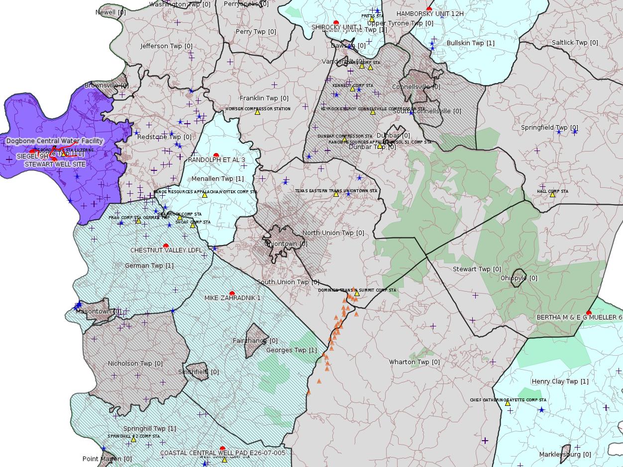
Click the map to enlarge
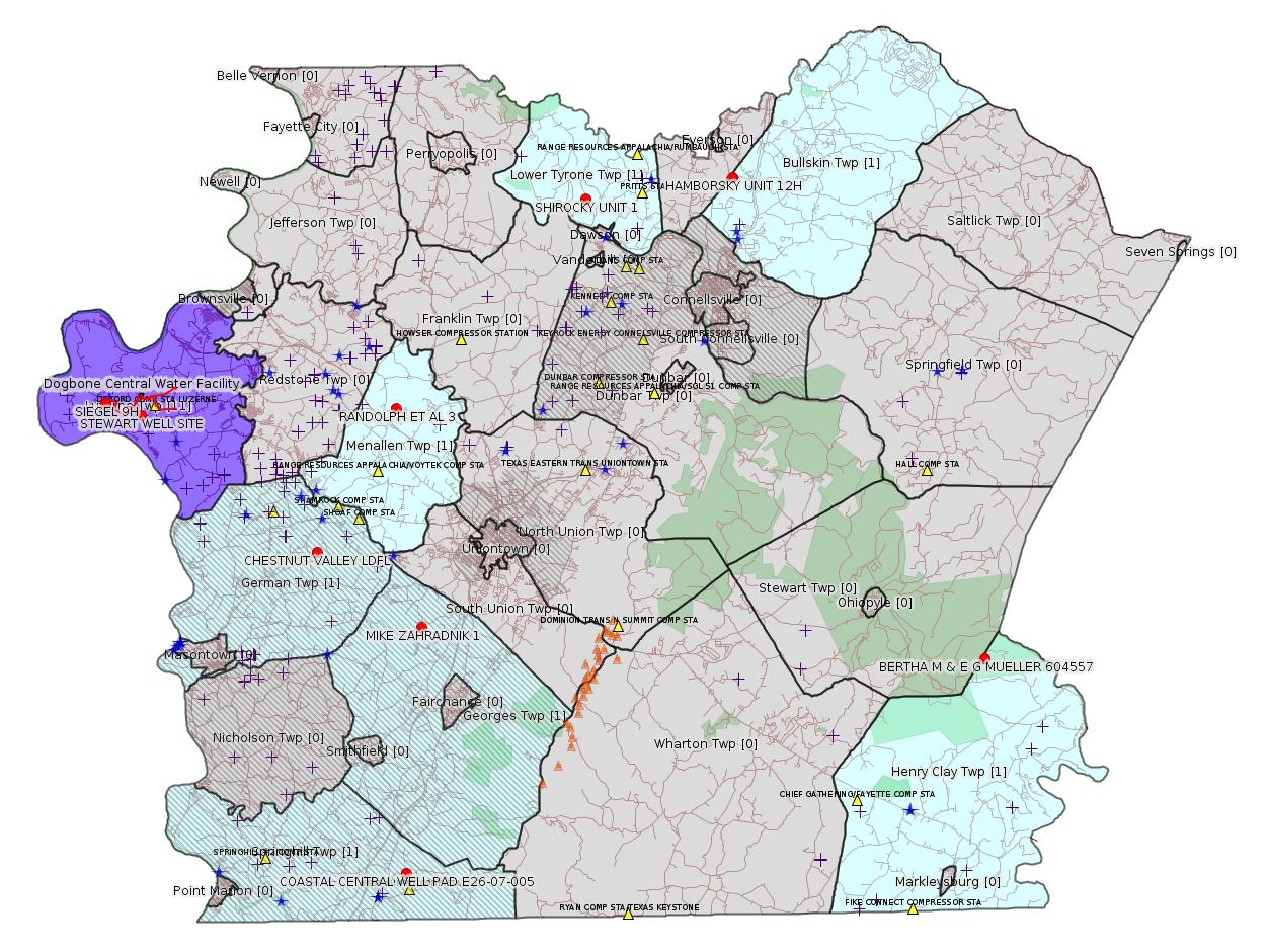
Map
Key
Red dots: items in this permit list with an exact location.
Blue stars: Marcellus Gas Well Water Sources.
Municipality shading: number of "facilities", with each well counting separately
(includes the red dots):
Red dots: items in this permit list with an exact location.
Blue stars: Marcellus Gas Well Water Sources.
Municipality shading: number of "facilities", with each well counting separately
(includes the red dots):
gray: 0
pale turquoise: 1
turquoise: 2
pale blue: 3
middle blue: 4
dark blue: 5
dark purple: 11
purple: 15
(Color coding may differ from one issue to the next.)
(Note if a project spans multiple municipalities -- e.g. a pipeline -- it will show in the count for each municipality.)
The number of facilities also follows the municipality name in brackets.
Municipality counts are based on the way the permit is listed by DEP; DEP has been known to get a municipality wrong.
Locations in brackets identify a precise location used to locate a surrogate for the actual site being permitted (e.g. locating a well pad or pipeline by the known location of a well.) Locations labeled beginning with "~" and ending in "[?]" are approximate and speculative based on inferences using on-line property and lease records. These are marked in the text as "[Approximate, Speculative]
Cross-hatching: Environmental Justice Areas
Yellow triangles: Compressor Stations
Orange triangles: Storage Field Wells (currently Dominion North Summit Storage Field)
Crosses: SPUD Unconventional well permits
Green: "Natural areas", e.g. state game lands, state forests
Yellow triangles: Compressor Stations
Orange triangles: Storage Field Wells (currently Dominion North Summit Storage Field)
Crosses: SPUD Unconventional well permits
Green: "Natural areas", e.g. state game lands, state forests
More Maps
 |
Source: Pennsylvania Bulletin
NOTICES
DEPARTMENT OF
ENVIRONMENTAL PROTECTION
Proposed General Plan Approval and/or General Operating Permit No. 5A for Unconventional Natural Gas Well Site Operations or Remote Pigging Stations (BAQ-GPA/GP-5A); Proposed Modifications to General Plan Approval and/or General Operating Permit No. 5 for Natural Gas Compressor Stations, Processing Plants and Transmission Stations (BAQ-GPA/GP-5); Proposed Modifications to the Air Quality Permit Exemptions List (Doc. No. 275-2101-003); Public Comment Opportunity
[48 Pa.B. 1902]
[Saturday, March 31, 2018]
The Department of Environmental Protection (Department) announces the opportunity for public comment on the proposed General Plan Approval and/or General Operating Permit for Unconventional Natural Gas Well Site Operations or Remote Pigging Stations (BAQ-GPA/GP-5A or GP-5A); revisions to the existing General Plan Approval and/or General Operating Permit for Natural Gas Compressor Stations, Processing Plants and Transmission Stations (BAQ-GPA/GP-5 or GP-5); and revisions to the Air Quality Permit Exemptions List (Doc. No. 275-2101-003).
Notice of availability of these documents and opportunity to submit comments for GP-5A, GP-5 and the Exemptions List was published at 47 Pa.B. 733 (February 4, 2017), which initial notice is hereby reissued in accordance with 25 Pa. Code § 127.612(a) (relating to public notice and review period). This notice will be published in the Pennsylvania Bulletin and in six newspapers of general circulation, and sent to nearby states and the United States Environmental Protection Agency in full compliance with 25 Pa. Code § 127.612(a). A second notice was published at 47 Pa.B. 1235 (February 25, 2017) to extend the comment period to June 5, 2017. The Department received more than 10,000 comments on the proposals. Based on these comments, the Department made significant changes to GP-5A, GP-5 and the Exemptions List.
The proposed GP-5A was developed under the authority of section 6.1(f) of the Air Pollution Control Act (35 P.S. § 4006.1(f)) and 25 Pa. Code Chapter 127, Subchapter H (relating to general plan approvals and operating permits), and will be applicable to unconventional natural gas well site operations or remote pigging stations. The revised GP-5 was developed under the same authorities and will remain applicable to natural gas compressor stations and processing plants and add applicability to natural gas transmission stations.
The proposed GP-5A and revisions to GP-5 include requirements for the following:
(1) Natural Gas-Fired Combustion Units—which includes requirements for combustion units rated greater than or equal to 10 MMBtu/h to meet emission limits for oxides of nitrogen (NOx), carbon monoxide (CO) and particulate matter (PM) and for all combustion units to keep records of fuel usage and throughput to facilitate emissions calculations. Combustion units at unconventional natural gas well sites or remote pigging stations are limited to a rating less than 10 MMBtu/h.
(2) Glycol Dehydration Units—which includes a control threshold requirement of 200 tpy of methane, 2.7 tpy volatile organic compound (VOC), 0.5 tpy of a single hazardous air pollutant (HAP) or 1.0 tpy of total HAP and a control efficiency requirement of 98% if any of the stated thresholds are exceeded.
(3) Stationary Natural Gas-Fired Spark Ignition Internal Combustion Engines—which includes a best available technology (BAT) requirement to meet emission limits for NOx, CO, nonmethane nonethane hydrocarbons (NMNEHC) and formaldehyde.
(4) Reciprocating Compressors—which includes the Federal requirements from 40 CFR Part 60, Subpart OOOOa (relating to standards of performance for crude oil and natural gas facilities for which construction, modification, or reconstruction commenced after September 18, 2015). This includes the requirement to replace the rod-end packing every 26,000 hours of operation or every 3 years.
(5) Storage Vessels—which includes a control threshold requirement of 200 tpy of methane, 2.7 tpy VOC, 0.5 tpy of a single HAP or 1.0 tpy of total HAP and a control efficiency requirement of 98% if any of the stated thresholds are exceeded.
(6) Tanker Truck Load-Out Operations—which includes a requirement to use a vapor recovery system and that trucks that perform load-out operations are appropriately certified. The requirement is met by keeping records that detail the load-out operations, including the identification (ID) number of the truck performing the load-out and the volume of liquids loaded and keeping a list of trucks authorized to perform load-out operations with an ID number and the date of the most recent certification test.
(7) Fugitive Emissions Components—which includes requirements to perform monthly audio, visual and olfactory inspections and quarterly leak detection and repair (LDAR) inspections. LDAR inspections can be performed using an optical gas imaging camera, a Method 21 gas analyzer or other approved methods. For LDAR programs at unconventional natural gas well sites and remote pigging stations, there is an option to track the number of leaking components and reduce the inspection frequency to the Federally required semiannual increment if less than 2% of components are found to be leaking in two consecutive inspections. If 2% or more of components are found to be leaking at the reduced frequency, the LDAR returns to the quarterly schedule.
(8) Controllers—which includes a requirement that electric controllers be installed where electricity is available onsite. For sites where electricity is not available onsite, the Federal requirements from 40 CFR Part 60, Subpart OOOOa must be met.
(9) Pumps—which includes a requirement that electric pumps be installed where electricity is available onsite. For sites where electricity is not available onsite, the Federal requirements from 40 CFR Part 60, Subpart OOOOa must be met. There are also recordkeeping requirements for pumps that are not subject to 40 CFR Part 60, Subpart OOOOa.
(10) Control Devices—which includes the Federal requirements from 40 CFR Part 60, Subpart OOOOa. The only modification of these requirements is that if the option to monitor combustion zone temperature is chosen instead of stack testing an enclosed flare or other combustion device, the combustion zone temperature must be 1,600°F to ensure a 98% methane destruction efficiency.
(11) Pigging Operations—which includes the requirements to install a liquids drain in pig receiver chambers, to route emissions from a high-pressure pig launcher or receiver to a low-pressure vessel or line, a control threshold requirement of 200 tpy of methane, 2.7 tpy VOC, 0.5 tpy of a single HAP or 1.0 tpy of total HAP, and a control efficiency requirement of 98% if any of the stated thresholds are exceeded.
The proposed GP-5A also includes the following additional requirements:
(1) Well Drilling and Hydraulic Fracturing Operations—which includes requirements to notify the Department at least 24 hours prior to the beginning of either type of operation and ensuring that engines used during the operation meet the applicable nonroad engine standards. Records of engine usage are required to facilitate emissions calculations.
(2) Well Completion Operations—which includes the Federal requirements from 40 CFR Part 60, Subpart OOOOa. This includes the requirement to perform a reduced emissions completion, also known as Green Completion, to notify the Department at least 24 hours prior to the beginning of flowback and to keep records of the duration of flowback and the disposition of gas during the flowback period.
(3) Wellbore Liquids Unloading Operations—which includes a requirement that an operator remain onsite for the duration of a manual unloading operation.
The proposed GP-5 also includes the following additional requirements:
(1) Stationary Natural Gas-Fired Combustion Turbines—which includes a BAT requirement for turbines rated above 1,000 hp to meet emission limits for NOx, CO, NMNEHC and PM.
(2) Centrifugal Compressors—which includes the Federal requirements from 40 CFR Part 60, Subpart OOOOa, except that the required control efficiency is 98%. There are also recordkeeping requirements for centrifugal compressors that are not subject to 40 CFR Part 60, Subpart OOOOa.
The general permits include emission limits, testing, monitoring, recordkeeping and reporting requirements designed to keep the facility operating within all applicable State and Federal air quality requirements. The general permits also include the fee required to authorize the construction and operation of sources. The term for general permit is 5 years and authorization can be renewed before the expiration date.
The Department proposes to make changes to the Air Quality Permits Exemption List under 25 Pa. Code § 127.14(a)(8) (relating to exemptions), Category Nos. 35 and 38; under 25 Pa. Code § 127.14(a)(9), Category No. 16; and under the Trivial Activities provision, Category No. 40.
These documents are available on the Department's Bureau of Air Quality web site at http://www.dep.pa.gov/Business/Air/BAQ/Permits/Pages/GeneralPermits.aspx and by contacting Frank Zarefoss, P.O. Box 8468, Harrisburg, PA 17105, (717) 787-4325 or fzarefoss@pa.gov.
The Department must receive comments no later than May 15, 2018. Commentators are encouraged to submit comments using the Department's eComment system at www.ahs.dep.pa.gov/eComment or by e-mail to ecomment@pa.gov. Comments submitted by facsimile will not be accepted. Comments, including comments submitted by e-mail, must include the originator's name and address. Written comments may be mailed to the Policy Office, Department of Environmental Protection, Rachel Carson State Office Building, P.O. Box 2063, Harrisburg, PA 17105-2063.
PATRICK McDONNELL,
Secretary
<https://www.pabulletin.com/secure/data/vol48/48-13/502.html>
The actual documents are available here:
FINAL DRAFT AIR QUALITY PERMIT EXEMPTIONS.PDF 275-2101-003 COMMENTS DUE MAY 15, 2018
<http://www.depgreenport.state.pa.us/elibrary/GetDocument?docId=12966&DocName=FINAL%20DRAFT%20AIR%20QUALITY%20PERMIT%20EXEMPTIONS.PDF%20%20%3Cspan%20style%3D%22color%3Ablue%3B%22%3E%3C%2Fspan%3E>
FINAL DRAFT GP-5 - NATURAL GAS COMPRESSION STATIONS, PROCESSING PLANTS, AND TRANSMISSION STATIONS.PDF 2700-PM-BAQ0267 COMMENTS DUE MAY 15, 2018
<http://www.depgreenport.state.pa.us/elibrary/GetDocument?docId=12967&DocName=FINAL%20DRAFT%20GP-5%20-%20NATURAL%20GAS%20COMPRESSION%20STATIONS%2C%20PROCESSING%20PLANTS%2C%20AND%20TRANSMISSION%20STATIONS.PDF%20%20%3Cspan%20style%3D%22color%3Ablue%3B%22%3E%3C%2Fspan%3E>
FINAL DRAFT GP-5A - UNCONVENTIONAL NATURAL GAS WELL SITE OPERATIONS AND REMOTE PIGGING STATIONS.PDF 2700-PM-BAQ0268 COMMENTS DUE MAY 15, 2018
<http://www.depgreenport.state.pa.us/elibrary/GetDocument?docId=12968&DocName=FINAL%20DRAFT%20GP-5A%20-%20UNCONVENTIONAL%20NATURAL%20GAS%20WELL%20SITE%20OPERATIONS%20AND%20REMOTE%20PIGGING%20STATIONS.PDF%20%20%3Cspan%20style%3D%22color%3Ablue%3B%22%3E%3C%2Fspan%3E>
TECHNICAL SUPPORT DOCUMENT FOR GP-5 AND GP-5A.PDF COMMENT PERIOD CLOSED - FEBRUARY 4, 2017
<http://www.depgreenport.state.pa.us/elibrary/GetDocument?docId=10735&DocName=TECHNICAL%20SUPPORT%20DOCUMENT%20FOR%20GP-5%20AND%20GP-5A.PDF%20%20%3Cspan%20style%3D%22color%3Ablue%3B%22%3E%3C%2Fspan%3E>
[See Notes.]
-------------------------
Source: eNOTICE (+ PA Oil and Gas Mapping, Well Pad Report.) Well Details via Data Portal Services: Oil and Gas Wells All (ID: 3).
Please see the Disclaimer below regarding Parcel Id data.
New:
[Conventional Well:]
Authorization ID: 1223385
Permit number: 051-20362
Site: MIKE ZAHRADNIK 1 WELL
Client: BURNETT OIL CO INC
Authorization type: Well Plugging Notice Intent to Plug Single Well
Application type: New
Authorization is for: FACILITY
Date received: 04/05/2018
Status: Pending
Permit Decision Guarantee Applies?: No
Sub-Facilities for Authorization:
Sub-Facility ID Sub-Facility Name Description
56542 MIKE ZAHRADNIK 1 Well
Permit Review Notes:
Date Review Note
4/5/2018 The technical review and decision review are complete and either the permit decision and/or permit issuance are forthcoming.
4/5/2018 The permit application package is complete, has been accepted, and is undergoing technical review.
<http://www.ahs.dep.pa.gov/eFACTSWeb/searchResults_singleAuth.aspx?AuthID=1223385>
Site Programs:
Oil & Gas
Municipalities:
Georges Twp[an Environmental Justice Area], Fayette County
Well Details:
Permit Number: 051-20362
Well Name: MIKE ZAHRADNIK 1
Unconventional Well: N
Well Configuration: Vertical Well
Well Type: GAS
Well Status: Active
Coal Association: Coal
Conservation Well: N
Primary Facility ID: 43012
Site ID: 41260
Site Name: MIKE ZAHRADNIK 1 WELL
Well Pad ID: 0
Well Pad Name:
Storage Field:
Operator: BURNETT OIL CO INC
Operator Number: OGO-39119
Permit Date: 1983-06-08
Permit Date Expires: 1984-06-08
SPUD Date: 1983-10-17
Date Plugged:
UIC ID:
UIC Type:
Surface Elevation: 1211
County: Fayette
Municipality: Georges Twp
Location: 39.860056,-79.774694
Map URL: <http://www.openstreetmap.org/?mlat=39.860056&mlon=-79.774694#map=15/39.860056/-79.774694>
Presumed Parcel Id: 14060079
New:
[Conventional Well:]
Authorization ID: 1223083
Permit number: 051-20011
Site: BERTHA M & E G MUELLER 604557 WELL
Client: EQT PRODUCTION CO
Authorization type: Well Plugging Notice Intent to Plug Single Well
Application type: New
Authorization is for: FACILITY
Date received: 03/29/2018
Status: Pending
Permit Decision Guarantee Applies?: No
Sub-Facilities for Authorization:
Sub-Facility ID Sub-Facility Name Description
56218 BERTHA M & E G MUELLER 604557 Well
Permit Review Notes:
Date Review Note
4/5/2018 The technical review and decision review are complete and either the permit decision and/or permit issuance are forthcoming.
4/5/2018 The permit application package is complete, has been accepted, and is undergoing technical review.
<http://www.ahs.dep.pa.gov/eFACTSWeb/searchResults_singleAuth.aspx?AuthID=1223083>
Site Programs:
Oil & Gas
Municipalities:
Henry Clay Twp, Fayette County
Well Details:
Permit Number: 051-20011
Well Name: BERTHA M & E G MUELLER 604557
Unconventional Well: N
Well Configuration: Vertical Well
Well Type: GAS
Well Status: Active
Coal Association: NonCoal
Conservation Well: N
Primary Facility ID: 42688
Site ID: 40936
Site Name: BERTHA M & E G MUELLER 604557 WELL
Well Pad ID: 0
Well Pad Name:
Storage Field:
Operator: EQT PRODUCTION CO
Operator Number: OGO-61555
Permit Date: 1901-01-01
Permit Date Expires:
SPUD Date: 1959-08-29
Date Plugged:
UIC ID:
UIC Type:
Surface Elevation: 2825
County: Fayette
Municipality: Henry Clay Twp
Location: 39.84126,-79.42603
Map URL: <http://www.openstreetmap.org/?mlat=39.84126&mlon=-79.42603#map=15/39.84126/-79.42603>
Parcel Id: 16010001
New:
Authorization ID: 1221795
Permit number: ESG18-051-0001
Site: DOGBONE WATER LINE ESCGP ESG18-051-0001
Client: CHEVRON APPALACHIA LLC
Authorization type: Erosion and Sediment Control GP-2
Application type: New
Authorization is for: SITE
Date received: 03/22/2018
Status: Pending
Permit Decision Guarantee Applies?: Yes
Permit Decision Guarantee status: ACTIVE
<http://www.ahs.dep.pa.gov/eFACTSWeb/searchResults_singleAuth.aspx?AuthID=1221795>
Site Programs:
Municipalities:
Luzerne Twp, Fayette County
Authorization ID: 1221642
Permit number:
Site: STEWART WELL SITE ESCGP-2 EXPEDITED
Client: CHEVRON APPALACHIA LLC
Authorization type: Temporary Storage
Application type: New
Authorization is for: FACILITY
Date received: 03/23/2018
Status: Issued on 3/26/2018
Permit Decision Guarantee Applies?: No
Sub-Facilities for Authorization:
Sub-Facility ID Sub-Facility Name Description
1256157 STEWART ALT ST Temporary Storage Structures
Permit Review Notes:
Date Review Note
3/23/2018 The technical review and decision review are complete and either the permit decision and/or permit issuance are forthcoming.
3/23/2018 The permit application package is complete, has been accepted, and is undergoing technical review.
<http://www.ahs.dep.pa.gov/eFACTSWeb/searchResults_singleAuth.aspx?AuthID=1221642>
Site Programs:
Oil & Gas
Municipalities:
Luzerne Twp, Fayette County
Well Pad Details:
Well Pad ID: 152396
Well Pad Name: STEWART
Location: 39.962961,-79.946956
Wells on this Pad:
051-24621 STEWART 1H
051-24628 STEWART 2H
051-24629 STEWART 3H
051-24630 STEWART 4H
051-24631 STEWART 5H
051-24632 STEWART 6H
051-24639 STEWART 7H
Map URL: <http://www.openstreetmap.org/?mlat=39.962961&mlon=-79.946956#map=15/39.962961/-79.946956>
Presumed Parcel Id: 19250010
Authorization ID: 1221395
Permit number: 051-24648
Site: SIEGEL WELL PAD ESCGP-2 EXPEDITED
Client: CHEVRON APPALACHIA LLC
Authorization type: Alt Method of Equipping, Casing, or Venting Well
Application type: New
Authorization is for: FACILITY
Date received: 03/15/2018
Status: Issued on 3/27/2018
Permit Decision Guarantee Applies?: Yes
Permit Decision Guarantee status: ACTIVE
Sub-Facilities for Authorization:
Sub-Facility ID Sub-Facility Name Description
1251521 WELLBORE SURFACE HOLE LOCATION Well
Permit Review Notes:
Date Review Note
3/27/2018 The technical review and decision review are complete and either the permit decision and/or permit issuance are forthcoming.
3/21/2018 The permit application package is complete, has been accepted, and is undergoing technical review.
<http://www.ahs.dep.pa.gov/eFACTSWeb/searchResults_singleAuth.aspx?AuthID=1221395>
Site Programs:
Oil & Gas
Municipalities:
Luzerne Twp, Fayette County
Well Details:
Permit Number: 051-24648
Well Name: SIEGEL 9H
Unconventional Well: Y
Well Configuration: Horizontal Well
Well Type: GAS
Well Status: Active
Coal Association: Coal
Conservation Well: N
Primary Facility ID: 823796
Site ID: 790384
Site Name: SIEGEL WELL PAD ESCGP-2 EXPEDITED
Well Pad ID: 152926
Well Pad Name: SIEGEL 1
Storage Field:
Operator: CHEVRON APPALACHIA LLC
Operator Number: OGO-39307
Permit Date: 2018-02-23
Permit Date Expires: 2019-02-23
SPUD Date: 2018-04-02
Date Plugged:
UIC ID:
UIC Type:
Surface Elevation: 1173
County: Fayette
Municipality: Luzerne Twp
Location: 39.969036,-79.968861
Map URL: <http://www.openstreetmap.org/?mlat=39.969036&mlon=-79.968861#map=15/39.969036/-79.968861>
Authorization ID: 1221393
Permit number: 051-24647
Site: SIEGEL WELL PAD ESCGP-2 EXPEDITED
Client: CHEVRON APPALACHIA LLC
Authorization type: Alt Method of Equipping, Casing, or Venting Well
Application type: New
Authorization is for: FACILITY
Date received: 03/15/2018
Status: Issued on 3/27/2018
Permit Decision Guarantee Applies?: Yes
Permit Decision Guarantee status: ACTIVE
Sub-Facilities for Authorization:
Sub-Facility ID Sub-Facility Name Description
1251520 WELLBORE SURFACE HOLE LOCATION Well
Permit Review Notes:
Date Review Note
3/27/2018 The technical review and decision review are complete and either the permit decision and/or permit issuance are forthcoming.
3/21/2018 The permit application package is complete, has been accepted, and is undergoing technical review.
<http://www.ahs.dep.pa.gov/eFACTSWeb/searchResults_singleAuth.aspx?AuthID=1221393>
Site Programs:
Oil & Gas
Municipalities:
Luzerne Twp, Fayette County
Well Details:
Permit Number: 051-24647
Well Name: SIEGEL 8H
Unconventional Well: Y
Well Configuration: Horizontal Well
Well Type: GAS
Well Status: Active
Coal Association: Coal
Conservation Well: N
Primary Facility ID: 823795
Site ID: 790384
Site Name: SIEGEL WELL PAD ESCGP-2 EXPEDITED
Well Pad ID: 152926
Well Pad Name: SIEGEL 1
Storage Field:
Operator: CHEVRON APPALACHIA LLC
Operator Number: OGO-39307
Permit Date: 2018-02-23
Permit Date Expires: 2019-02-23
SPUD Date: 2018-04-02
Date Plugged:
UIC ID:
UIC Type:
Surface Elevation: 1173
County: Fayette
Municipality: Luzerne Twp
Location: 39.968997,-79.968928
Map URL: <http://www.openstreetmap.org/?mlat=39.968997&mlon=-79.968928#map=15/39.968997/-79.968928>
Authorization ID: 1221392
Permit number: 051-24646
Site: SIEGEL WELL PAD ESCGP-2 EXPEDITED
Client: CHEVRON APPALACHIA LLC
Authorization type: Alt Method of Equipping, Casing, or Venting Well
Application type: New
Authorization is for: FACILITY
Date received: 03/15/2018
Status: Issued on 3/27/2018
Permit Decision Guarantee Applies?: Yes
Permit Decision Guarantee status: ACTIVE
Sub-Facilities for Authorization:
Sub-Facility ID Sub-Facility Name Description
1251519 WELLBORE SURFACE HOLE LOCATION Well
Permit Review Notes:
Date Review Note
3/27/2018 The technical review and decision review are complete and either the permit decision and/or permit issuance are forthcoming.
3/21/2018 The permit application package is complete, has been accepted, and is undergoing technical review.
<http://www.ahs.dep.pa.gov/eFACTSWeb/searchResults_singleAuth.aspx?AuthID=1221392>
Site Programs:
Oil & Gas
Municipalities:
Luzerne Twp, Fayette County
Well Details:
Permit Number: 051-24646
Well Name: SIEGEL 7H
Unconventional Well: Y
Well Configuration: Horizontal Well
Well Type: GAS
Well Status: Active
Coal Association: Coal
Conservation Well: N
Primary Facility ID: 823794
Site ID: 790384
Site Name: SIEGEL WELL PAD ESCGP-2 EXPEDITED
Well Pad ID: 152926
Well Pad Name: SIEGEL 1
Storage Field:
Operator: CHEVRON APPALACHIA LLC
Operator Number: OGO-39307
Permit Date: 2018-02-23
Permit Date Expires: 2019-02-23
SPUD Date: 2018-04-02
Date Plugged:
UIC ID:
UIC Type:
Surface Elevation: 1173
County: Fayette
Municipality: Luzerne Twp
Location: 39.968956,-79.968994
Map URL: <http://www.openstreetmap.org/?mlat=39.968956&mlon=-79.968994#map=15/39.968956/-79.968994>
Authorization ID: 1221382
Permit number: 051-24645
Site: SIEGEL WELL PAD ESCGP-2 EXPEDITED
Client: CHEVRON APPALACHIA LLC
Authorization type: Alt Method of Equipping, Casing, or Venting Well
Application type: New
Authorization is for: FACILITY
Date received: 03/15/2018
Status: Issued on 3/27/2018
Permit Decision Guarantee Applies?: Yes
Permit Decision Guarantee status: ACTIVE
Sub-Facilities for Authorization:
Sub-Facility ID Sub-Facility Name Description
1251518 WELLBORE SURFACE HOLE LOCATION Well
Permit Review Notes:
Date Review Note
3/27/2018 The technical review and decision review are complete and either the permit decision and/or permit issuance are forthcoming.
3/21/2018 The permit application package is complete, has been accepted, and is undergoing technical review.
<http://www.ahs.dep.pa.gov/eFACTSWeb/searchResults_singleAuth.aspx?AuthID=1221382>
Site Programs:
Oil & Gas
Municipalities:
Luzerne Twp, Fayette County
Well Details:
Permit Number: 051-24645
Well Name: SIEGEL 6H
Unconventional Well: Y
Well Configuration: Horizontal Well
Well Type: GAS
Well Status: Active
Coal Association: Coal
Conservation Well: N
Primary Facility ID: 823793
Site ID: 790384
Site Name: SIEGEL WELL PAD ESCGP-2 EXPEDITED
Well Pad ID: 152926
Well Pad Name: SIEGEL 1
Storage Field:
Operator: CHEVRON APPALACHIA LLC
Operator Number: OGO-39307
Permit Date: 2018-02-20
Permit Date Expires: 2019-02-20
SPUD Date: 2018-04-02
Date Plugged:
UIC ID:
UIC Type:
Surface Elevation: 1173
County: Fayette
Municipality: Luzerne Twp
Location: 39.968914,-79.969061
Map URL: <http://www.openstreetmap.org/?mlat=39.968914&mlon=-79.969061#map=15/39.968914/-79.969061>
Authorization ID: 1221368
Permit number: 051-24644
Site: SIEGEL WELL PAD ESCGP-2 EXPEDITED
Client: CHEVRON APPALACHIA LLC
Authorization type: Alt Method of Equipping, Casing, or Venting Well
Application type: New
Authorization is for: FACILITY
Date received: 03/15/2018
Status: Issued on 3/27/2018
Permit Decision Guarantee Applies?: Yes
Permit Decision Guarantee status: ACTIVE
Sub-Facilities for Authorization:
Sub-Facility ID Sub-Facility Name Description
1251517 WELLBORE SURFACE HOLE LOCATION Well
Permit Review Notes:
Date Review Note
3/27/2018 The technical review and decision review are complete and either the permit decision and/or permit issuance are forthcoming.
3/21/2018 The permit application package is complete, has been accepted, and is undergoing technical review.
<http://www.ahs.dep.pa.gov/eFACTSWeb/searchResults_singleAuth.aspx?AuthID=1221368>
Site Programs:
Oil & Gas
Municipalities:
Luzerne Twp, Fayette County
Well Details:
Permit Number: 051-24644
Well Name: SIEGEL 5H
Unconventional Well: Y
Well Configuration: Horizontal Well
Well Type: GAS
Well Status: Active
Coal Association: Coal
Conservation Well: N
Primary Facility ID: 823792
Site ID: 790384
Site Name: SIEGEL WELL PAD ESCGP-2 EXPEDITED
Well Pad ID: 152926
Well Pad Name: SIEGEL 1
Storage Field:
Operator: CHEVRON APPALACHIA LLC
Operator Number: OGO-39307
Permit Date: 2018-02-16
Permit Date Expires: 2019-02-16
SPUD Date: 2018-04-02
Date Plugged:
UIC ID:
UIC Type:
Surface Elevation: 1173
County: Fayette
Municipality: Luzerne Twp
Location: 39.968808,-79.969061
Map URL: <http://www.openstreetmap.org/?mlat=39.968808&mlon=-79.969061#map=15/39.968808/-79.969061>
Authorization ID: 1221367
Permit number: 051-24643
Site: SIEGEL WELL PAD ESCGP-2 EXPEDITED
Client: CHEVRON APPALACHIA LLC
Authorization type: Alt Method of Equipping, Casing, or Venting Well
Application type: New
Authorization is for: FACILITY
Date received: 03/15/2018
Status: Issued on 3/27/2018
Permit Decision Guarantee Applies?: Yes
Permit Decision Guarantee status: ACTIVE
Sub-Facilities for Authorization:
Sub-Facility ID Sub-Facility Name Description
1251516 WELLBORE SURFACE HOLE LOCATION Well
Permit Review Notes:
Date Review Note
3/27/2018 The technical review and decision review are complete and either the permit decision and/or permit issuance are forthcoming.
3/21/2018 The permit application package is complete, has been accepted, and is undergoing technical review.
<http://www.ahs.dep.pa.gov/eFACTSWeb/searchResults_singleAuth.aspx?AuthID=1221367>
Site Programs:
Oil & Gas
Municipalities:
Luzerne Twp, Fayette County
Well Details:
Permit Number: 051-24643
Well Name: SIEGEL 3H
Unconventional Well: Y
Well Configuration: Horizontal Well
Well Type: GAS
Well Status: Active
Coal Association: Coal
Conservation Well: N
Primary Facility ID: 823791
Site ID: 790384
Site Name: SIEGEL WELL PAD ESCGP-2 EXPEDITED
Well Pad ID: 152926
Well Pad Name: SIEGEL 1
Storage Field:
Operator: CHEVRON APPALACHIA LLC
Operator Number: OGO-39307
Permit Date: 2018-02-13
Permit Date Expires: 2019-02-13
SPUD Date: 2018-04-02
Date Plugged:
UIC ID:
UIC Type:
Surface Elevation: 1173
County: Fayette
Municipality: Luzerne Twp
Location: 39.968892,-79.968928
Map URL: <http://www.openstreetmap.org/?mlat=39.968892&mlon=-79.968928#map=15/39.968892/-79.968928>
Authorization ID: 1221361
Permit number: 051-24641
Site: SIEGEL WELL PAD ESCGP-2 EXPEDITED
Client: CHEVRON APPALACHIA LLC
Authorization type: Alt Method of Equipping, Casing, or Venting Well
Application type: New
Authorization is for: FACILITY
Date received: 03/15/2018
Status: Issued on 3/27/2018
Permit Decision Guarantee Applies?: Yes
Permit Decision Guarantee status: ACTIVE
Sub-Facilities for Authorization:
Sub-Facility ID Sub-Facility Name Description
1251514 WELLBORE SURFACE HOLE LOCATION Well
Permit Review Notes:
Date Review Note
3/27/2018 The technical review and decision review are complete and either the permit decision and/or permit issuance are forthcoming.
3/21/2018 The permit application package is complete, has been accepted, and is undergoing technical review.
<http://www.ahs.dep.pa.gov/eFACTSWeb/searchResults_singleAuth.aspx?AuthID=1221361>
Site Programs:
Oil & Gas
Municipalities:
Luzerne Twp, Fayette County
Well Details:
Permit Number: 051-24641
Well Name: SIEGEL 2H
Unconventional Well: Y
Well Configuration: Horizontal Well
Well Type: GAS
Well Status: Active
Coal Association: Coal
Conservation Well: N
Primary Facility ID: 823789
Site ID: 790384
Site Name: SIEGEL WELL PAD ESCGP-2 EXPEDITED
Well Pad ID: 152926
Well Pad Name: SIEGEL 1
Storage Field:
Operator: CHEVRON APPALACHIA LLC
Operator Number: OGO-39307
Permit Date: 2018-02-13
Permit Date Expires: 2019-02-13
SPUD Date: 2018-04-02
Date Plugged:
UIC ID:
UIC Type:
Surface Elevation: 1173
County: Fayette
Municipality: Luzerne Twp
Location: 39.968931,-79.968861
Map URL: <http://www.openstreetmap.org/?mlat=39.968931&mlon=-79.968861#map=15/39.968931/-79.968861>
Authorization ID: 1221326
Permit number: 051-24642
Site: SIEGEL WELL PAD ESCGP-2 EXPEDITED
Client: CHEVRON APPALACHIA LLC
Authorization type: Alt Method of Equipping, Casing, or Venting Well
Application type: New
Authorization is for: FACILITY
Date received: 03/15/2018
Status: Issued on 3/27/2018
Permit Decision Guarantee Applies?: Yes
Permit Decision Guarantee status: ACTIVE
Sub-Facilities for Authorization:
Sub-Facility ID Sub-Facility Name Description
1251515 WELLBORE SURFACE HOLE LOCATION Well
Permit Review Notes:
Date Review Note
3/27/2018 The technical review and decision review are complete and either the permit decision and/or permit issuance are forthcoming.
3/21/2018 The permit application package is complete, has been accepted, and is undergoing technical review.
<http://www.ahs.dep.pa.gov/eFACTSWeb/searchResults_singleAuth.aspx?AuthID=1221326>
Site Programs:
Oil & Gas
Municipalities:
Luzerne Twp, Fayette County
Well Details:
Permit Number: 051-24642
Well Name: SIEGEL 4H
Unconventional Well: Y
Well Configuration: Horizontal Well
Well Type: GAS
Well Status: Active
Coal Association: Coal
Conservation Well: N
Primary Facility ID: 823790
Site ID: 790384
Site Name: SIEGEL WELL PAD ESCGP-2 EXPEDITED
Well Pad ID: 152926
Well Pad Name: SIEGEL 1
Storage Field:
Operator: CHEVRON APPALACHIA LLC
Operator Number: OGO-39307
Permit Date: 2018-02-15
Permit Date Expires: 2019-02-15
SPUD Date: 2018-04-02
Date Plugged:
UIC ID:
UIC Type:
Surface Elevation: 1173
County: Fayette
Municipality: Luzerne Twp
Location: 39.96885,-79.968994
Map URL: <http://www.openstreetmap.org/?mlat=39.96885&mlon=-79.968994#map=15/39.96885/-79.968994>
Authorization ID: 1221321
Permit number: 015-24633 [Incorrect! Should be 051-24633 -jr]
Site: SIEGEL WELL PAD ESCGP-2 EXPEDITED
Client: CHEVRON APPALACHIA LLC
Authorization type: Alt Method of Equipping, Casing, or Venting Well
Application type: New
Authorization is for: FACILITY
Date received: 03/15/2018
Status: Issued on 3/27/2018
Permit Decision Guarantee Applies?: Yes
Permit Decision Guarantee status: ACTIVE
Sub-Facilities for Authorization:
Sub-Facility ID Sub-Facility Name Description
1246830 SIEGEL 1 Well
Permit Review Notes:
Date Review Note
3/27/2018 The technical review and decision review are complete and either the permit decision and/or permit issuance are forthcoming.
3/21/2018 The permit application package is complete, has been accepted, and is undergoing technical review.
<http://www.ahs.dep.pa.gov/eFACTSWeb/searchResults_singleAuth.aspx?AuthID=1221321>
Site Programs:
Oil & Gas
Municipalities:
Luzerne Twp, Fayette County
Well Details:
Well Details:
Permit Number: 051-24633
Well Name: SIEGEL 1
Unconventional Well: Y
Well Configuration: Horizontal Well
Well Type: GAS
Well Status: Active
Coal Association: Coal
Conservation Well: N
Primary Facility ID: 803337
Site ID: 790384
Site Name: SIEGEL WELL PAD ESCGP-2 EXPEDITED
Well Pad ID: 152926
Well Pad Name: SIEGEL 1
Storage Field: Operator: CHEVRON APPALACHIA LLC
Operator Number: OGO-39307
Permit Date: 2015-08-12
Permit Date Expires: 2019-02-12
SPUD Date:
Date Plugged:
UIC ID:
UIC Type:
Surface Elevation: 1173
County: Fayette
Municipality: Luzerne Twp
Location: 39.968972,-79.968794
Map URL: <http://www.openstreetmap.org/?mlat=39.968972&mlon=-79.968794#map=15/39.968972/-79.968794>
[Conventional Well:]
Authorization ID: 1202324
Permit number: 051-21618
Site: RANDOLPH ET AL 3 OG WELL
Client: RANGE RESOURCES APPALACHIA LLC
Authorization type: Drill & Operate Well Permit Inactive Status
Application type: New
Authorization is for: FACILITY
Date received: 10/11/2017
Status: Denied on 4/5/2018
Permit Decision Guarantee Applies?: No
Sub-Facilities for Authorization:
Sub-Facility ID Sub-Facility Name Description
758003 RANDOLPH ET AL 3 Well
Permit Review Notes:
Date Review Note
4/5/2018 Application has been deemed to be technically deficient and has been denied.
4/5/2018 Application has been deemed to be technically deficient and has been denied.
10/11/2017 The permit application package is complete, has been accepted, and is undergoing technical review.
<http://www.ahs.dep.pa.gov/eFACTSWeb/searchResults_singleAuth.aspx?AuthID=1202324>
Site Programs:
Oil & Gas
Municipalities:
Menallen Twp, Fayette County
Well Details:
Permit Number: 051-21618
Well Name: RANDOLPH ET AL 3
Unconventional Well: N
Well Configuration: Vertical Well
Well Type: GAS
Well Status: Active
Coal Association: Coal
Conservation Well: N
Primary Facility ID: 631098
Site ID: 607330
Site Name: RANDOLPH ET AL 3 OG WELL
Well Pad ID: 0
Well Pad Name:
Storage Field:
Operator: RANGE RESOURCES APPALACHIA LLC
Operator Number: OGO-60915
Permit Date: 2002-12-06
Permit Date Expires: 2003-12-06
SPUD Date: 2002-12-11
Date Plugged:
UIC ID:
UIC Type:
Surface Elevation: 1035
County: Fayette
Municipality: Menallen Twp
Location: 39.964748,-79.788649
Map URL: <http://www.openstreetmap.org/?mlat=39.964748&mlon=-79.788649#map=15/39.964748/-79.788649>
Presumed Parcel Id: 22060031
[Conventional Well:]
Authorization ID: 1202319
Permit number: 051-20829
Site: SHIROCKY UNIT 1 WELL
Client: RANGE RESOURCES APPALACHIA LLC
Authorization type: Drill & Operate Well Permit Inactive Status
Application type: New
Authorization is for: FACILITY
Date received: 10/11/2017
Status: Pending
Permit Decision Guarantee Applies?: No
Sub-Facilities for Authorization:
Sub-Facility ID Sub-Facility Name Description
259041 SHIROCKY UNIT 1 Well
Permit Review Notes:
Date Review Note
10/11/2017 The permit application package is complete, has been accepted, and is undergoing technical review.
<http://www.ahs.dep.pa.gov/eFACTSWeb/searchResults_singleAuth.aspx?AuthID=1202319>
Site Programs:
Oil & Gas
Municipalities:
Lower Tyrone Twp, Fayette County
Well Details:
Permit Number: 051-20829
Well Name: SHIROCKY UNIT 1
Unconventional Well: N
Well Configuration: Vertical Well
Well Type: GAS
Well Status: Active
Coal Association: Coal
Conservation Well: N
Primary Facility ID: 264326
Site ID: 253816
Site Name: SHIROCKY UNIT 1 WELL
Well Pad ID: 0
Well Pad Name:
Storage Field:
Operator: RANGE RESOURCES APPALACHIA LLC
Operator Number: OGO-60915
Permit Date: 1996-06-28
Permit Date Expires: 1997-06-28
SPUD Date: 1997-06-16
Date Plugged:
UIC ID:
UIC Type:
Surface Elevation: 1059
County: Fayette
Municipality: Lower Tyrone Twp
Location: 40.063551,-79.668781
Map URL: <http://www.openstreetmap.org/?mlat=40.063551&mlon=-79.668781#map=15/40.063551/-79.668781>
Presumed Parcel Id: 18070019
[Possibly Off-Topic:]
Authorization ID: 1189541
Permit number: 100419
Site: CHESTNUT VALLEY LDFL
Client: ADVANCED DSPL SVC CHESTNUT VALLEY LDFL INC
Authorization type: Landfill Pmt Final Construction Certification Form 37
Application type: Modification
Authorization is for: FACILITY
Date received: 07/06/2017
Status: Issued on 4/3/2018
Permit Decision Guarantee Applies?: Yes
Permit Decision Guarantee status: ACTIVE
Permit Review Notes:
Date Review Note
4/3/2018 The technical review and decision review are complete and either the permit decision and/or permit issuance are forthcoming.
7/25/2017 The permit application package is complete, has been accepted, and is undergoing technical review.
<http://www.ahs.dep.pa.gov/eFACTSWeb/searchResults_singleAuth.aspx?AuthID=1189541>
Site Programs:
Air Quality
Clean Water
Environmental Cleanup & Brownfields
Mining
Radiation Protection
Waste Management
Water Planning and Conservation
Municipalities:
German Twp [an Environmental Justice Area], Fayette County
Location: 39.896765,-79.838766 <http://osm.org/go/ZWpP0~XK--?m=>
Presumed Parcel Id: 15280012
Authorization ID: 1161323
Permit number: E26-07-005
Site: COASTAL CENTRAL WELL PAD E26-07-005
Client: BURNETT OIL CO INC
Authorization type: Water Obstruction & Encroachment Pmt
Application type: New
Authorization is for: FACILITY
Date received: 10/14/2016
Status: Issued on 3/27/2018
Permit Decision Guarantee Applies?: Yes
Permit Decision Guarantee status: VOID
Sub-Facilities for Authorization:
Sub-Facility ID Sub-Facility Name Description
1256317 CROSSING 1 (UNT TO RUBLES RUN) Culvert
Location: 39.743,-79.7861
Map URL: <http://www.openstreetmap.org/?mlat=39.743&mlon=-79.7861#map=15/39.743/-79.7861>
1256318 CROSSING 2 (UNT TO RUBLES RUN) Culvert
Location: 39.7422,-79.7859
Map URL: <http://www.openstreetmap.org/?mlat=39.7422&mlon=-79.7859#map=15/39.7422/-79.7859>
1256319 CROSSING 3A (RUBLES RUN) Culvert
Location: 39.7416,-79.7855
Map URL: <http://www.openstreetmap.org/?mlat=39.7416&mlon=-79.7855#map=15/39.7416/-79.7855>
1256320 CROSSING 3B (UNT TO RUBLES RUN) Culvert
Location: 39.7417,-79.7857
Map URL: <http://www.openstreetmap.org/?mlat=39.7417&mlon=-79.7857#map=15/39.7417/-79.7857>
1256322 CROSSING 4 (UNT TO RUBLES RUN) Culvert
Location: 39.7408,-79.7847
Map URL: <http://www.openstreetmap.org/?mlat=39.7408&mlon=-79.7847#map=15/39.7408/-79.7847>
1222427 NO PIPE CROSSING Pipeline or Conduit
Location: 39.743,-79.7863
Map URL: <http://www.openstreetmap.org/?mlat=39.743&mlon=-79.7863#map=15/39.743/-79.7863>
Permit Review Notes:
Date Review Note
3/23/2018 The technical review and decision review are complete and either the permit decision and/or permit issuance are forthcoming.
5/10/2017 Applicant has been issued a deficiency letter. If applicable, this application no longer qualifies for the Permit Decision Guarantee.
2/21/2017 Applicant has been issued a deficiency letter. If applicable, this application no longer qualifies for the Permit Decision Guarantee.
<http://www.ahs.dep.pa.gov/eFACTSWeb/searchResults_singleAuth.aspx?AuthID=1161323>
Site Programs:
Water Planning and Conservation
Municipalities:
Springhill Twp [an Environmental Justice Area], Fayette County
Location: 39.743049,-79.786279 <http://osm.org/go/ZWpgHiKC--?m=>
Municipalities: Springhill Twp [an Environmental Justice Area]
Presumed Parcel Id: 36210048
-------------------------
Source: DEP SPUD (drilling started) Report
SPUD_DATE: 4/2/2018
API: 051-24633
OGO_NUM: OGO-39307
OPERATOR: CHEVRON APPALACHIA LLC
REGION: EP DOGO SWDO Dstr Off
COUNTY: Fayette
MUNICIPALITY: Luzerne Twp
FARM_NAME: SIEGEL 1
WELL_CODE_DESC: GAS
WELL_STATUS: Active
LATITUDE: 39.968972
LONGITUDE: -79.968794
CONFIGURATION: Horizontal Well
UNCONVENTIONAL: Yes
[Well Details for the Siegel wells are above.]
SPUD_DATE: 4/2/2018
API: 051-24641
OGO_NUM: OGO-39307
OPERATOR: CHEVRON APPALACHIA LLC
REGION: EP DOGO SWDO Dstr Off
COUNTY: Fayette
MUNICIPALITY: Luzerne Twp
FARM_NAME: SIEGEL 2H
WELL_CODE_DESC: GAS
WELL_STATUS: Active
LATITUDE: 39.968931
LONGITUDE: -79.968861
CONFIGURATION: Horizontal Well
UNCONVENTIONAL: Yes
SPUD_DATE: 4/2/2018
API: 051-24643
OGO_NUM: OGO-39307
OPERATOR: CHEVRON APPALACHIA LLC
REGION: EP DOGO SWDO Dstr Off
COUNTY: Fayette
MUNICIPALITY: Luzerne Twp
FARM_NAME: SIEGEL 3H
WELL_CODE_DESC: GAS
WELL_STATUS: Active
LATITUDE: 39.968892
LONGITUDE: -79.968928
CONFIGURATION: Horizontal Well
UNCONVENTIONAL: Yes
SPUD_DATE: 4/2/2018
API: 051-24642
OGO_NUM: OGO-39307
OPERATOR: CHEVRON APPALACHIA LLC
REGION: EP DOGO SWDO Dstr Off
COUNTY: Fayette
MUNICIPALITY: Luzerne Twp
FARM_NAME: SIEGEL 4H
WELL_CODE_DESC: GAS
WELL_STATUS: Active
LATITUDE: 39.968850
LONGITUDE: -79.968994
CONFIGURATION: Horizontal Well
UNCONVENTIONAL: Yes
SPUD_DATE: 4/2/2018
API: 051-24644
OGO_NUM: OGO-39307
OPERATOR: CHEVRON APPALACHIA LLC
REGION: EP DOGO SWDO Dstr Off
COUNTY: Fayette
MUNICIPALITY: Luzerne Twp
FARM_NAME: SIEGEL 5H
WELL_CODE_DESC: GAS
WELL_STATUS: Active
LATITUDE: 39.968808
LONGITUDE: -79.969061
CONFIGURATION: Horizontal Well
UNCONVENTIONAL: Yes
SPUD_DATE: 4/2/2018
API: 051-24645
OGO_NUM: OGO-39307
OPERATOR: CHEVRON APPALACHIA LLC
REGION: EP DOGO SWDO Dstr Off
COUNTY: Fayette
MUNICIPALITY: Luzerne Twp
FARM_NAME: SIEGEL 6H
WELL_CODE_DESC: GAS
WELL_STATUS: Active
LATITUDE: 39.968914
LONGITUDE: -79.969061
CONFIGURATION: Horizontal Well
UNCONVENTIONAL: Yes
SPUD_DATE: 4/2/2018
API: 051-24646
OGO_NUM: OGO-39307
OPERATOR: CHEVRON APPALACHIA LLC
REGION: EP DOGO SWDO Dstr Off
COUNTY: Fayette
MUNICIPALITY: Luzerne Twp
FARM_NAME: SIEGEL 7H
WELL_CODE_DESC: GAS
WELL_STATUS: Active
LATITUDE: 39.968956
LONGITUDE: -79.968994
CONFIGURATION: Horizontal Well
UNCONVENTIONAL: Yes
SPUD_DATE: 4/2/2018
API: 051-24647
OGO_NUM: OGO-39307
OPERATOR: CHEVRON APPALACHIA LLC
REGION: EP DOGO SWDO Dstr Off
COUNTY: Fayette
MUNICIPALITY: Luzerne Twp
FARM_NAME: SIEGEL 8H
WELL_CODE_DESC: GAS
WELL_STATUS: Active
LATITUDE: 39.968997
LONGITUDE: -79.968928
CONFIGURATION: Horizontal Well
UNCONVENTIONAL: Yes
SPUD_DATE: 4/2/2018
API: 051-24648
OGO_NUM: OGO-39307
OPERATOR: CHEVRON APPALACHIA LLC
REGION: EP DOGO SWDO Dstr Off
COUNTY: Fayette
MUNICIPALITY: Luzerne Twp
FARM_NAME: SIEGEL 9H
WELL_CODE_DESC: GAS
WELL_STATUS: Active
LATITUDE: 39.969036
LONGITUDE: -79.968861
CONFIGURATION: Horizontal Well
UNCONVENTIONAL: Yes
-------------------------
Source: DEP Oil and Gas Compliance Report
OPERATOR: CHEVRON APPALACHIA LLC
INSPECTION_ID: 2712867
INSPECTION_DATE: 03/29/2018
INSPECTION_TYPE: Follow-up Inspection
API_PERMIT: 051-24381
FARM_NAME: HAMBORSKY UNIT 12H
UNCONVENTIONAL: Yes
SITE_ID: 737696
SITE_NAME: HAMBORSKY UNIT 12H OG WELL
FACILITY_TYPE: Oil & Gas Location
INSPECTION_CATEGORY: Primary Facility
REGION: EP DOGO SWDO Dstr Off
COUNTY: Fayette
MUNICIPALITY: Bullskin Twp
INSPECTOR: WITHAM, CYNTHIA
INSPECTION_SOURCE: SAIR
INSPECTION_RESULT_DESCRIPTION: Outstanding Violations - Viols Req'd
INSPECTION_COMMENT: "Routine partial follow up inspection to inspection record #2685605 where a violation was issued for failure to comply with 25 PA Code 102.
At time of inspection fluid is leaving site and entering an adjacent field (photo #1). As a result of the fluid leaving the site, an erosion gully has formed and this gully continues into the adjacent field (photo #2). It does not appear that the operator has taken any corrective measures to minimize the run-off in this area since the 1-22-18 inspection. Department recommends operator evaluate and implement measures to address run-off and gully formation.
Violation issued on 1-22-18 remains outstanding. A follow up inspection will be conducted at a later date."
VIOLATION_ID: 812556
VIOLATION_DATE: 01/22/2018
VIOLATION_CODE: 78a53 - EROSION AND SEDIMENT CONTROL AND STORMWATER MANAGEMENT - Person proposing or conducting earth disturbance activities associated with oil and gas operations failed to comply with 25 Pa. Code § 102.
VIOLATION_TYPE: Environmental Health & Safety
VIOLATION_COMMENT: Liquid leaving well pad area.
RESOLVED_DATE:
RESOLUTION_REASON_CODE_DESCRIPTION:
CONTINUING_VIOLATION: Yes
Well Details:
Permit Number: 051-24381Map URL: <http://www.openstreetmap.org/?mlat=40.072761&mlon=-79.577281#map=15/40.072761/-79.577281>
Well Name: HAMBORSKY UNIT 12H
Unconventional Well: Y
Well Configuration: Horizontal Well
Well Type: GAS
Well Status: Active
Coal Association: Coal
Conservation Well: Y
Primary Facility ID: 733126
Site ID: 737696
Site Name: HAMBORSKY UNIT 12H OG WELL
Well Pad ID: 148470
Well Pad Name: HAMBORSKY UNIT 12H
Storage Field:
Operator: CHEVRON APPALACHIA LLC
Operator Number: OGO-39307
Permit Date: 2010-09-09
Permit Date Expires: 2011-09-09
SPUD Date: 2011-06-13
Date Plugged:
UIC ID:
UIC Type:
Surface Elevation: 1200
County: Fayette
Municipality: Bullskin Twp
Location: 40.072761,-79.577281
Presumed Parcel Id: 04280001
-------------------------
Source: Reuters Commodities: Energy
Natural Gas
| Commodity | Exchange | Currency | Expire | Last Trade | Trade Time | Change | Open | Day's High | Day's Low |
|---|---|---|---|---|---|---|---|---|---|
| NATURAL
GAS CON1 Apr18 |
NYM | USD | 04/26 | 2.70 | 04/10 02:23 | +0.00 | 2.70 | 2.71 | 2.68 |
<http://www.reuters.com/finance/commodities/energy>
-------------------------
Notes:
Stay tuned for a writeup page on this important public comment opportunity. This represents the opportunity to comment on the Final Draft for 3 important documents. For a writeup on the previous draft of these documents, see:
<http://faymarwatch.org/happening/public_comments/gp-5_gp-5a_exemption_38.shtml>
For Fayette Marcellus Watcher Jim Rosenberg's public comment on the previous draft of these documents, see
<http://faymarwatch.org/documents/GP-5_GP-5A_Exemption_38_020317_Comments_full.pdf>
------------------------
DEP defines an environmental justice area as "any census tract where 20 percent or more individuals live in poverty, and/or 30 percent or more of the population is minority". (See:
<http://www.dep.pa.gov/PublicParticipation/OfficeofEnvironmentalJustice/Pages/default.aspx>). There are supposed to be enhanced public participation requirements for permits in environmental justice areas, but news of this actually ever happening is scarce. In Fayette County, the entirety of Springhill, Nicholson, German, and Georges Townships are environmental justice areas, as well as a large part of Dunbar Township. DEP's policy document on public participation guidelines for environmental justice areas is located here:
<http://www.elibrary.dep.state.pa.us/dsweb/Get/Version-48671/012-0501-002.pdf>
eNOTICE records are likely to list the same permit multiple times, as that permit moves through the DEP process.
Oil & Gas Wells designated with a site a number and the letter H typically designate horizontal wells.
-------------------------
Resources:
Pennsylvania Bulletin: <http://www.pabulletin.com/>
eNOTICE: <http://www.ahs2.dep.state.pa.
DEP Oil and Gas Reports: <http://www.dep.pa.gov/DataandTools/Reports/Oil%20and%20Gas%20Reports/Pages/default.aspx>
DEP Permits Issued Detail Report:
<http://www.depreportingservic
DEP SPUD (drilling started) Report:
<http://www.depreportingservices.state.pa.us/ReportServer/Pages/ReportViewer.aspx?/Oil_Gas/Spud_External_Data>
DEP Oil and Gas Compliance Report:
<http://www.depreportingservices.state.pa.us/ReportServer/Pages/ReportViewer.aspx?/Oil_Gas/OG_Compliance>
DEP PA Oil & Gas Mapping:
<http://www.depgis.state.pa.us/PaOilAndGasMapping>
Data Portal Services Directory [Technical]
<http://www.depgis.state.pa.us/arcgis/rest/services>
Query: Oil and Gas Wells All (ID: 3) [Technical]:
<http://www.depgis.state.pa.us/arcgis/rest/services/OilGas/OilGasAllStrayGas/MapServer/3/query?where=&text=&objectIds=&time=&geometry=&geometryType=esriGeometryEnvelope&inSR=&spatialRel=esriSpatialRelIntersects&relationParam=&outFields=OBJECTID%2CPERMIT_NUMBER%2CWELL_NAME%2COPERATOR%2COPERATOR_NUMBER%2CWELL_TYPE%2CWELL_TYPE_CODE%2CWELL_STATUS%2CWELL_STATUS_CODE%2CPERMIT_DATE%2CPERMIT_DATE_EXPIRES%2CSPUD_DATE%2CCONSERVATION_IND%2CCOUNTY%2CCOUNTY_ID%2CMUNICIPALITY%2CMUNICIPALITY_TYPE%2CMUNICIPALITY_CODE%2CLATITUDE%2CLONGITUDE%2CPRMRY_FID%2CUNCONVENTIONAL_IND%2CSURFACE_ELEVATION%2CWELL_CONFIG_CODE%2CCOAL_IND%2CWELL_PAD_NAME%2CSHAPE%2CDATE_PLUGGED%2CWELL_PAD_ID%2CUIC_ID%2CUIC_TYPE_DESCRIPTION%2CSTORAGE_FIELD_NAME%2CSITE_ID%2CSITE_NAME&returnGeometry=true&returnTrueCurves=false&maxAllowableOffset=&geometryPrecision=&outSR=&returnIdsOnly=false&returnCountOnly=false&orderByFields=&groupByFieldsForStatistics=&outStatistics=&returnZ=false&returnM=false&gdbVersion=&returnDistinctValues=false&resultOffset=&resultRecordCount=&f=html>
(Be sure to enter a Where clause in SQL format. Dates are in milliseconds since midnight 1/1/1970).
DEP Oil and Gas Electronic Notifications
<http://www.depreportingservices.state.pa.us/ReportServer?/Oil_Gas/OG_Notifications>
DEP Oil and Gas Well Pad Report
<http://www.depreportingservices.state.pa.us/ReportServer?/Oil_Gas/Well_Pads>
Fayette County Assessment Office Search For Tax Records:
<http://property.co.fayette.pa.us/search.aspx>
Pennsylvania Spatial Data Access:
<http://www.pasda.psu.edu/default.asp>
DEP Spatial Data Repository:
<ftp://www.pasda.psu.edu/pub/pasda/dep/>
National Response Center:
<http://www.nrc.uscg.mil/>
EPA-Echo: <http://www.epa-echo.gov/echo/
FERC citizen involvement: <http://www.ferc.gov/for-citiz
To receive E-mail notification of
all documents filed in a FERC docket, see:
<http://www.ferc.gov/docs-filing/esubscription.asp >
<http://www.ferc.gov/docs-fili
Follow the directions and enter the docket number to subscribe to.
Township Supervisors receive information regarding Erosion & Sedimentation permits, and these records may be reviewable at township municipal offices.
DEP permits are reviewable through the File Review process, for application to do file review see: <http://www.portal.state.pa.us/portal/server.pt/community/southwest_regional_office/13775/file_review/593164>
Environmental Hearing Board: <http://ehb.courtapps.com/publ
PA DEP Environmental Policy Comment System:
<http://www.ahs.dep.pa.gov/eComment/>
Federal Register Environment: <https://www.federalregister.g
Browsing of recent comment
opportunities for federal agencies, e.g. EPA. Click "sign up" to
subscribe to daily E-mails of new document listings.
SkyTruth Fayette County Drilling Alerts: <http://frack.skytruth.org/pen
U.S. Army Corps of Engineers, Pittsburgh District, Public Notices:
<http://www.lrp.usace.army.mil/Missions/Regulatory/Public-Notices/>
EPA Pennsylvania Public Notices: <http://www2.epa.gov/aboutepa/epa-pennsylvania#notice>
Marcellus Shale waste disposal
injection wells in Pennsylvania are regulated directly by EPA, not
DEP. Notice of any new permit applications will appear at the
above web address. I'm not aware of any subscription service
to be notified of such applications. I'm not aware of any
Marcellus Shale waste disposal injection wells in Fayette County
(yet ...) but we need to monitor this page for future
applications.
Energy Assurance Daily: <http://www.oe.netl.doe.gov/ead.aspx>
Daily newsletter from the US
Department of Energy about events relating to energy. The Natural
Gas section has information about pipelines.
-------------------------
Disclaimers:
This compilation from the above sources was done by hand using copy and paste and may omit relevant permits.
Parcel data is provided via the tax records search web page offered by the Fayette County Assessment Office (http://property.co.fayette.pa.us/). Presumed Parcel Id links are subject to availability provided by that agency and associated web sites. Presumed Parcel Ids are determined as the mapped parcel containing a given latitude and longitude, are a best effort determination which is subject to error, and are not official. In cases where a facility is leased and there is a separate parcel id for the lease, if this parcel id is not separately mapped, the parcel id shown will be the id for the enclosing parcel. Parcel owners may be surface owners only and may or may not have any relationship to oil & gas facilities.
Does not currently include water supply permits. Does not include landfill permits even though many such are for Marcellus Shale waste. (It is not possible at this time to distinguish which landfill permits are for Marcellus Shale waste and which are not without doing File Review for each permit.)
Erosion & Sedimentation permit records do not currently include latitude and longitude. Where I am publishing latitude and longitude with E&S permits it is by inferring an associated well permit and using published latitude and longitude for the well. It is possible I may be inferring the wrong well site.
Municipalities are shown from eFACTS records on the DEP web site. The DEP has been known to list a municipality incorrectly.