The Harmed Success Stories Concepts How To What Is Commentary
Fayette County Marcellus Shale Permits 4/8/19 - 4/21/19
Contents
Pennsylvania Bulletin Listings
First Amendment to Oil and Gas Lease for Streambed Tract 2008 on the Youghiogheny River Chevron Appalachia, LLC (lessee) for Streambed Tract 2008 on the Youghiogheny RivereFACTS Listings
OLIVER 1 Well Plugging Notice Intent to Plug Single Well Issued 4/15/2019 (New)Electronic Notifications
SHIROCKY UNIT 1 Well Plugging Notice Intent to Plug Single Well Issued 4/15/2019 (New)
CHRISTNER UNIT 1 Well Plugging Notice Alternate Method (New)
CHRISTNER UNIT 1 Well Plugging Notice Intent to Plug Single Well (New)
SNAPP TESLOVICH M01V Drill & Operate Well Permit (Unconventional)
EDENBORN/RGGS B M15H Alt Method of Equipping, Casing, or Venting Well Issued 4/16/2019
EDENBORN/RGGS B M14H Alt Method of Equipping, Casing, or Venting Well Issued 4/16/2019
EDENBORN/RGGS B M13H Alt Method of Equipping, Casing, or Venting Well Issued 4/16/2019
EDENBORN/RGGS B M12H Alt Method of Equipping, Casing, or Venting Well Issued 4/16/2019
EDENBORN/RGGS B M11H Alt Method of Equipping, Casing, or Venting Well Issued 4/16/2019
EDENBORN/RGGS B M10H Alt Method of Equipping, Casing, or Venting Well Issued 4/16/2019
EDENBORN/RGGS B M09H Alt Method of Equipping, Casing, or Venting Well Issued 4/16/2019
EDENBORN/RGGS B M08H Alt Method of Equipping, Casing, or Venting Well Issued 4/16/2019
EDENBORN/RGGS B M07H Alt Method of Equipping, Casing, or Venting Well Issued 4/16/2019
EDENBORN/RGGS B M06H Alt Method of Equipping, Casing, or Venting Well Issued 4/16/2019
EDENBORN/RGGS B M05H Alt Method of Equipping, Casing, or Venting Well Issued 4/16/2019
EDENBORN/RGGS B M04H Alt Method of Equipping, Casing, or Venting Well Issued 4/16/2019
EDENBORN/RGGS B M03H Alt Method of Equipping, Casing, or Venting Well Issued 4/16/2019
EDENBORN/RGGS B M02H Alt Method of Equipping, Casing, or Venting Well Issued 4/16/2019
EDENBORN/RGGS B M01H Alt Method of Equipping, Casing, or Venting Well Issued 4/16/2019
S PA GATHERING SYSTEM ABANDOMENT PPL 7655 PROJ GP08 GP11 BWM-GP-11 Maintenance, Testing, Repair, Rehabilitation or Replacement 12/12/2018 deficiency letter
S PA GATHERING SYSTEM ABANDOMENT PPL 7655 PROJ GP08 GP11 GP-08 Temporary Road Crossings 12/12/2018 deficiency letter
S PA GATHERING SYSTEM ABANDONMENT PIPELINES 7648 & 7837 PROJECT GP-08 Temporary Road Crossings 12/12/2018 deficiency letter
SHAMROCK COMP STA Minor Facility Plan Approval New Source Performance Std
SOUTHERN PA GSA PPL 7652 7653 7921 PROJ GP08 GP11 GP-08 Temporary Road Crossings 12/12/2018 deficiency letter
GANS GENERATING FAC Water Quality Mgmt Part II, Industrial Wastewater Fac Treatment Plant
GANS GENERATING FAC Minor IW Facility without ELG
GANS GENERATING FAC Major Facility Operating Permit Replaced on 4/4/2019
SHIROCKY UNIT 1 Abandonment or plugging notification 04/15/2019
Inspection
Anomalies (Oil & Gas Compliance Report)
Price of Natural GasHATALOWICH 2 Accelerated erosion still present; stone downslope of the access road. Violation(s) & Outstanding Violations
HATALOWICH 4 accelerated erosion and debris; the operator had not maintained the culvert. Outstanding Violations - Viols Req'd
BURNSIDE 8 brine tanks were heavily corroded and had poor structural integrity. Violation(s) Noted
OLEXA 9 brine tanks were heavily corroded and had poor structural integrity. Violation(s) Noted
BRAZZON 15 stream crossing over Lutz Run had been destroyed and was missing; brine tanks were heavily corroded and had poor structural integrity. Violation(s) Noted
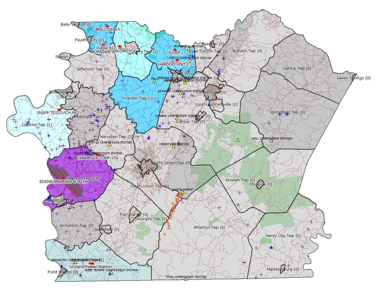
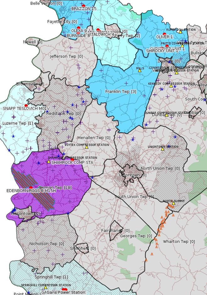
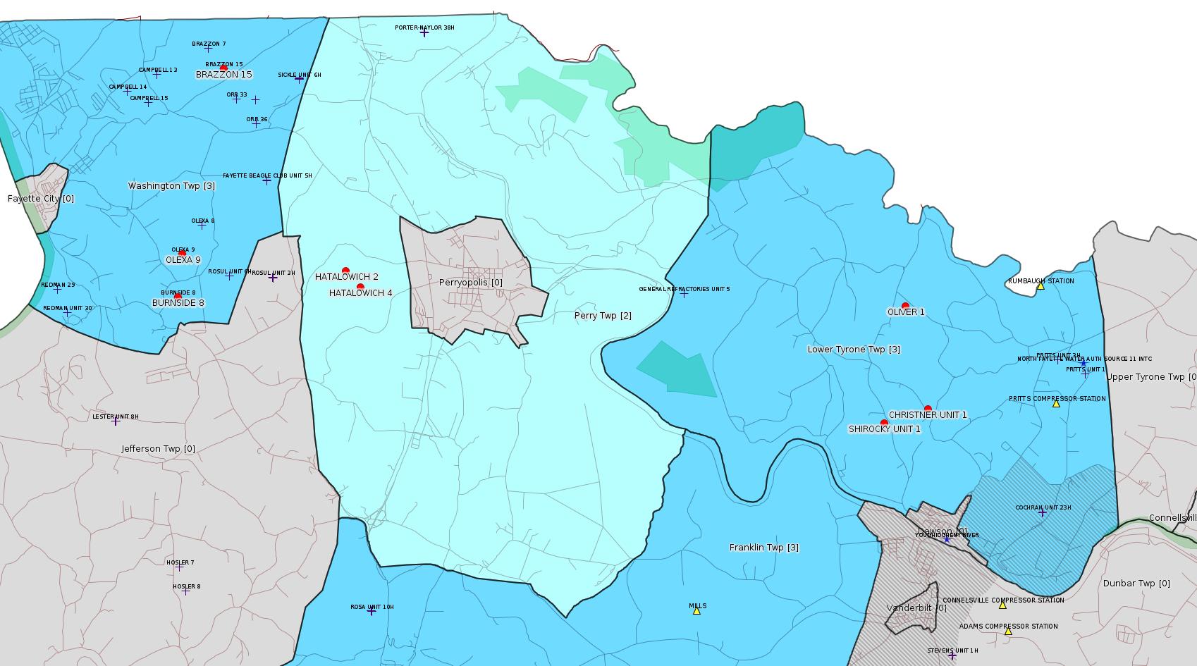
Map
Key
Red dots: items in this permit list with an exact location.
Blue stars: Marcellus Gas Well Water Sources.
Where well laterals are mapped they show in red; a 400-foot buffer surrounding the lateral shows in blue (lavender where it overlaps a mapped mineral tract).
Where mineral tracts are mapped, they show in pink. Mineral tracts can overlap; the overlap will show in red. The precise meaning of "mineral tract" is not clear.
Municipality shading: number of "facilities", with each well counting separately
(includes the red dots):
gray: 0
pale turquoise: 1
turquoise: 2
pale blue: 3
middle blue: 4
dark blue: 5
dark purple: 8
purple: 18
(Color coding may differ from one issue to the next.)
(Note if a project spans multiple municipalities -- e.g. a pipeline -- it will show in the count for each municipality.)
The number of facilities also follows the municipality name in brackets.
Municipality counts are based on the way the permit is listed by DEP; DEP has been known to get a municipality wrong.
Locations in brackets identify a precise location used to locate a surrogate for the actual site being permitted (e.g. locating a well pad or pipeline by the known location of a well.) Locations labeled beginning with "~" and ending in "[?]" are approximate and speculative based on inferences using on-line property and lease records. These are marked in the text as "[Approximate, Speculative]
Cross-hatching: Environmental Justice Areas
Yellow triangles: Compressor Stations
Orange triangles: Storage Field Wells (currently Dominion North Summit Storage Field)
Crosses: SPUD Unconventional well permits
Green: "Natural areas", e.g. state game lands, state forests
Yellow triangles: Compressor Stations
Orange triangles: Storage Field Wells (currently Dominion North Summit Storage Field)
Crosses: SPUD Unconventional well permits
Green: "Natural areas", e.g. state game lands, state forests
More Maps
 |
 |
Source: Pennsylvania Bulletin
NOTICES
DEPARTMENT OF CONSERVATION AND NATURAL RESOURCES
Execution of Oil and Gas Lease for Publicly-Owned Streambeds
[49 Pa.B. 1795]
[Saturday, April 13, 2019]
Effective January 28, 2019, a First Amendment to Oil and Gas Lease for Publicly-Owned Streambeds, Contract No. M-2102008-04, was executed by and between the Commonwealth, acting through the Department of Conservation and Natural Resources (Department) (lessor), and Chevron Appalachia, LLC (lessee), with its principal place of business located at 700 Cherrington Parkway, Coraopolis, PA 15108.
The lease is for Streambed Tract 2008 on the Youghiogheny River encompassing a total of 335.2 acres of submerged lands located in South Versailles and Elizabeth Townships, Allegheny County; Sewickley Town-ship, Westmoreland County; and Perry Township, Fayette County. The lease was recorded at the Allegheny County Courthouse on March 1, 2019, instrument No. 2019-5452, BK-DE VL-17534, page 76; in Westmoreland County Courthouse on February 28, 2019, instrument No. 201902280005520; and in Fayette County Courthouse on February 28, 2019, instrument No. 201900001785, book 3395, page 2395. The lease allows for the development of oil and natural gas below and between the ordinary low water marks of the Youghiogheny River solely by means of directional, including horizontal, drilling on a nondevelopment basis that will not disturb the river or its bed. Contract No. M-2102008-04 may be viewed online at http://contracts.patreasury.gov/Admin/Upload/483943_ M-2102008-04%20First%20Amendment%20Streambed%20Lease%20Tract%202008%20Youghiogheny%20-%20Chevron%20Appalachia%20-%2001_28_2019.pdf.
Questions regarding this lease should be directed to the Department's Bureau of Forestry, Minerals Division, (717) 787-2703.
<https://www.pabulletin.com/secure/data/vol49/49-15/524.html>
-------------------------
Source: eNOTICE (+ PA Oil and Gas Mapping, Well Pad Report.) Well Details via Data Portal Services: Oil and Gas Wells All (ID: 3).
Please see the Disclaimer below regarding Parcel Id data.
New:
Authorization ID: 1268964
Permit number: 051-21273
Site: OLIVER 1 OG WELL
Client: RANGE RESOURCES APPALACHIA LLC
Authorization type: Well Plugging Notice Intent to Plug Single Well
Application type: New
Authorization is for: FACILITY
Date received: 04/12/2019
Status: Issued on 4/15/2019
Permit Decision Guarantee Applies?: No
Sub-Facilities for Authorization:
Sub-Facility ID Sub-Facility Name Description
542897 OLIVER 1 Well
Permit Review Notes:
Date Review Note
4/15/2019 The technical review and decision review are complete and either the permit decision and/or permit issuance are forthcoming.
4/12/2019 The permit application package is complete, has been accepted, and is undergoing technical review.
<https://www.ahs.dep.pa.gov/eFACTSWeb/searchResults_singleAuth.aspx?AuthID=1268964>
Site Programs:
Oil & Gas
Site Municipalities:
Lower Tyrone Twp, Fayette County
Well Details:
Permit Number: 051-21273
Well Name: OLIVER 1
Unconventional Well: N
Well Configuration: Vertical Well
Well Type: GAS
Well Status: Active
Coal Association: NonCoal
Conservation Well: N
Primary Facility ID: 562956
Site ID: 544359
Site Name: OLIVER 1 OG WELL
Well Pad ID: 0
Well Pad Name:
Storage Field:
Operator: RANGE RESOURCES APPALACHIA LLC
Operator Number: OGO-60915
Permit Date: 2001-03-12
Permit Date Expires: 2002-03-12
SPUD Date: 2001-04-27
Date Plugged:
UIC ID:
UIC Type:
Surface Elevation: 1132
County: Fayette
Municipality: Lower Tyrone Twp
Location: 40.081779,-79.664078
Map URL: <http://www.openstreetmap.org/?mlat=40.081779&mlon=-79.664078#map=15/40.081779/-79.664078>
OG WELLS PERMIT DOCS:
2019-04-15: Other Permit Documents, Name: NOI (for Authorization: 1268964):
<http://www.depgis.state.pa.us/pdfHandler/pdFHandler.ashx?Doc=Nzg3MzMz&ext=PDF>
Presumed Parcel Id: 18040086
---
New:
Authorization ID: 1268963
Permit number: 051-20829
Site: SHIROCKY UNIT 1 WELL
Client: RANGE RESOURCES APPALACHIA LLC
Authorization type: Well Plugging Notice Intent to Plug Single Well
Application type: New
Authorization is for: FACILITY
Date received: 04/12/2019
Status: Issued on 4/15/2019
Permit Decision Guarantee Applies?: No
Sub-Facilities for Authorization:
Sub-Facility ID Sub-Facility Name Description
259041 SHIROCKY UNIT 1 Well
Permit Review Notes:
Date Review Note
4/15/2019 The technical review and decision review are complete and either the permit decision and/or permit issuance are forthcoming.
4/12/2019 The permit application package is complete, has been accepted, and is undergoing technical review.
<https://www.ahs.dep.pa.gov/eFACTSWeb/searchResults_singleAuth.aspx?AuthID=1268963>
Site Programs:
Oil & Gas
Site Municipalities:
Lower Tyrone Twp, Fayette County
Well Details:
Permit Number: 051-20829
Well Name: SHIROCKY UNIT 1
Unconventional Well: N
Well Configuration: Vertical Well
Well Type: GAS
Well Status: Active
Coal Association: Coal
Conservation Well: N
Primary Facility ID: 264326
Site ID: 253816
Site Name: SHIROCKY UNIT 1 WELL
Well Pad ID: 0
Well Pad Name:
Storage Field:
Operator: RANGE RESOURCES APPALACHIA LLC
Operator Number: OGO-60915
Permit Date: 1996-06-28
Permit Date Expires: 1997-06-28
SPUD Date: 1997-06-16
Date Plugged:
UIC ID:
UIC Type:
Surface Elevation: 1059
County: Fayette
Municipality: Lower Tyrone Twp
Location: 40.063551,-79.668781
Map URL: <http://www.openstreetmap.org/?mlat=40.063551&mlon=-79.668781#map=15/40.063551/-79.668781>
OG WELLS PERMIT DOCS:
2019-04-15: Other Permit Documents, Name: NOI (for Authorization: 1268963):
<http://www.depgis.state.pa.us/pdfHandler/pdFHandler.ashx?Doc=Nzg3NDYz&ext=PDF>
Presumed Parcel Id: 18070019
---
New:
Authorization ID: 1268961
Permit number: 051-21339
Site: CHRISTNER UNIT 1 OG WELL
Client: RANGE RESOURCES APPALACHIA LLC
Authorization type: Well Plugging Notice Alternate Method
Application type: New
Authorization is for: FACILITY
Date received: 04/12/2019
Status: Pending
Permit Decision Guarantee Applies?: No
Sub-Facilities for Authorization:
Sub-Facility ID Sub-Facility Name Description
560378 CHRISTNER UNIT 1 Well
Permit Review Notes:
Date Review Note
4/12/2019 The permit application package is complete, has been accepted, and is undergoing technical review.
<https://www.ahs.dep.pa.gov/eFACTSWeb/searchResults_singleAuth.aspx?AuthID=1268961>
Site Programs:
Oil & Gas
Site Municipalities:
Lower Tyrone Twp, Fayette County
Well Details:
Permit Number: 051-21339
Well Name: CHRISTNER UNIT 1
Unconventional Well: N
Well Configuration: Vertical Well
Well Type: GAS
Well Status: Active
Coal Association: NonCoal
Conservation Well: N
Primary Facility ID: 567391
Site ID: 549951
Site Name: CHRISTNER UNIT 1 OG WELL
Well Pad ID: 0
Well Pad Name:
Storage Field:
Operator: RANGE RESOURCES APPALACHIA LLC
Operator Number: OGO-60915
Permit Date: 2001-09-06
Permit Date Expires: 2002-09-06
SPUD Date: 2001-10-23
Date Plugged:
UIC ID:
UIC Type:
Surface Elevation: 970
County: Fayette
Municipality: Lower Tyrone Twp
Location: 40.06568,-79.659853
Map URL: <http://www.openstreetmap.org/?mlat=40.06568&mlon=-79.659853#map=15/40.06568/-79.659853>
Presumed Parcel Id: 1808000103
---
New:
Authorization ID: 1268959
Permit number: 051-21339
Site: CHRISTNER UNIT 1 OG WELL
Client: RANGE RESOURCES APPALACHIA LLC
Authorization type: Well Plugging Notice Intent to Plug Single Well
Application type: New
Authorization is for: FACILITY
Date received: 04/12/2019
Status: Pending
Permit Decision Guarantee Applies?: No
Sub-Facilities for Authorization:
Sub-Facility ID Sub-Facility Name Description
560378 CHRISTNER UNIT 1 Well
Permit Review Notes:
Date Review Note
4/15/2019 The technical review and decision review are complete and either the permit decision and/or permit issuance are forthcoming.
4/12/2019 The permit application package is complete, has been accepted, and is undergoing technical review.
<https://www.ahs.dep.pa.gov/eFACTSWeb/searchResults_singleAuth.aspx?AuthID=1268959>
Site Programs:
Oil & Gas
Site Municipalities:
Lower Tyrone Twp, Fayette County
Well Details:
Permit Number: 051-21339
Well Name: CHRISTNER UNIT 1
Unconventional Well: N
Well Configuration: Vertical Well
Well Type: GAS
Well Status: Active
Coal Association: NonCoal
Conservation Well: N
Primary Facility ID: 567391
Site ID: 549951
Site Name: CHRISTNER UNIT 1 OG WELL
Well Pad ID: 0
Well Pad Name:
Storage Field:
Operator: RANGE RESOURCES APPALACHIA LLC
Operator Number: OGO-60915
Permit Date: 2001-09-06
Permit Date Expires: 2002-09-06
SPUD Date: 2001-10-23
Date Plugged:
UIC ID:
UIC Type:
Surface Elevation: 970
County: Fayette
Municipality: Lower Tyrone Twp
Location: 40.06568,-79.659853
Map URL: <http://www.openstreetmap.org/?mlat=40.06568&mlon=-79.659853#map=15/40.06568/-79.659853>
---
Authorization ID: 1267676
Permit number: 051-24706
Site: SNAPP-TESLOVICH PAD A
Client: CHEVRON APPALACHIA LLC
Authorization type: Drill & Operate Well Permit (Unconventional)
Application type: New
Authorization is for: FACILITY
Date received: 04/03/2019
Status: Pending
Permit Decision Guarantee Applies?: No
Sub-Facilities for Authorization:
Sub-Facility ID Sub-Facility Name Description
1284291 WELLBORE SURFACE HOLE LOCATION Well
Permit Review Notes:
Date Review Note
4/4/2019 The permit application package is complete, has been accepted, and is undergoing technical review.
<https://www.ahs.dep.pa.gov/eFACTSWeb/searchResults_singleAuth.aspx?AuthID=1267676>
Site Programs:
Oil & Gas
Site Municipalities:
Luzerne Twp, Fayette County
Well Details:
Permit Number: 051-24706
Well Name: SNAPP TESLOVICH M01V
Unconventional Well: Y
Well Configuration: Vertical Well
Well Type: GAS
Well Status: Active
Coal Association: NonCoal
Conservation Well: N
Primary Facility ID: 833681
Site ID: 834533
Site Name: SNAPP-TESLOVICH PAD A
Well Pad ID: 155747
Well Pad Name: SNAPP-TESLOVICH PAD A
Storage Field:
Operator: CHEVRON APPALACHIA LLC
Operator Number: OGO-39307
Permit Date:
Permit Date Expires:
SPUD Date:
Date Plugged:
UIC ID:
UIC Type:
Surface Elevation: 1100
County: Fayette
Municipality: Luzerne Twp
Location: 39.989942,-79.902631
Map URL: <http://www.openstreetmap.org/?mlat=39.989942&mlon=-79.902631#map=15/39.989942/-79.902631>
OG WELLS PERMIT DOCS:
2019-04-19: Other Permit Documents, Name: 1267676_Snapp Teslovich_M01V_Non-Coal Determination (for Authorization: 1267676):
<http://www.depgis.state.pa.us/pdfHandler/pdFHandler.ashx?Doc=NzkxNzk1&ext=PDF>
Electronically Submitted Records:
2019-04-18: Submission for Authorization 1267676
Justification for Non-Coal Well: Snapp Teslovich Non-Coal Packet.pdf
<http://www.depgis.state.pa.us/eWellDocHandler/pdFHandler.ashx?Doc=ODA1MDM2&ext=PDF>
Location Plat: Snapp Teslovich - Final V Well Plat M01V - 2019.02.20.dwg
<http://www.depgis.state.pa.us/eWellDocHandler/pdFHandler.ashx?Doc=ODA1MDY0&ext=PDF>
Pennsylvania Natural Diversity Inventory Support Document: PNDI Clearance.pdf
<http://www.depgis.state.pa.us/eWellDocHandler/pdFHandler.ashx?Doc=ODA4NTMw&ext=PDF>
Pennsylvania Natural Diversity Inventory Form: Snapp Teslovich_PNDI.pdf
<http://www.depgis.state.pa.us/eWellDocHandler/pdFHandler.ashx?Doc=ODA4NTMx&ext=PDF>
Interested Party Notification: Snapp Teslovich_Affidavit of Non-Delivery_M Cochrane.pdf
<http://www.depgis.state.pa.us/eWellDocHandler/pdFHandler.ashx?Doc=ODA4NTM2&ext=PDF>
Coordination of Well Location with Public Resources: Snapp Teslovich For OOGM0076U.pdf
<http://www.depgis.state.pa.us/eWellDocHandler/pdFHandler.ashx?Doc=ODA4NzM1&ext=PDF>
Permit Application to Drill and Operate a Well: 1886282.pdf
<http://www.depgis.state.pa.us/eWellDocHandler/pdFHandler.ashx?Doc=ODA4NzY2&ext=PDF>
Presumed Parcel Id: 19160028
---
Authorization ID: 1264023
Permit number: 051-24689
Site: EDENBORN/RGGS B ESCGP ESX18-051-0003
Client: CHEVRON APPALACHIA LLC
Authorization type: Alt Method of Equipping, Casing, or Venting Well
Application type: New
Authorization is for: FACILITY
Date received: 03/05/2019
Status: Issued on 4/16/2019
Permit Decision Guarantee Applies?: Yes
Permit Decision Guarantee status: ACTIVE
Sub-Facilities for Authorization:
Sub-Facility ID Sub-Facility Name Description
1274762 WELLBORE SURFACE HOLE LOCATION Well
Permit Review Notes:
Date Review Note
4/16/2019 The technical review and decision review are complete and either the permit decision and/or permit issuance are forthcoming.
3/6/2019 The permit application package is complete, has been accepted, and is undergoing technical review.
<https://www.ahs.dep.pa.gov/eFACTSWeb/searchResults_singleAuth.aspx?AuthID=1264023>
Site Programs:
Oil & Gas
Site Municipalities:
German Twp [an Environmental Justice Area], Fayette County
Well Details:
Permit Number: 051-24689
Well Name: EDENBORN/RGGS B M15H
Unconventional Well: Y
Well Configuration: Horizontal Well
Well Type: GAS
Well Status: Active
Coal Association: Coal
Conservation Well: N
Primary Facility ID: 830215
Site ID: 829418
Site Name: EDENBORN/RGGS B ESCGP ESX18-051-0003
Well Pad ID: 155083
Well Pad Name: EDENBORN/RGGS B
Storage Field:
Operator: CHEVRON APPALACHIA LLC
Operator Number: OGO-39307
Permit Date: 2018-12-13
Permit Date Expires: 2019-12-13
SPUD Date:
Date Plugged:
UIC ID:
UIC Type:
Surface Elevation: 1167
County: Fayette
Municipality: German Twp
Location: 39.882061,-79.896197
Map URL: <http://www.openstreetmap.org/?mlat=39.882061&mlon=-79.896197#map=15/39.882061/-79.896197>
OG WELLS PERMIT DOCS:
2018-12-13: Other Permit Documents, Name: Povlik Deficiency Letter (for Authorization: 1251236):
<http://www.depgis.state.pa.us/pdfHandler/pdFHandler.ashx?Doc=NzEwMTE3&ext=PDF>
2018-12-13: Final Permit Documents, Name: 033-27257 Permit (11-30-18) (for Authorization: 1251236):
<http://www.depgis.state.pa.us/pdfHandler/pdFHandler.ashx?Doc=NzEwMTEw&ext=PDF>
2018-12-13: Final Permit Documents, Name: Povlik Record of Decision (11-30-18) (for Authorization: 1251236):
<http://www.depgis.state.pa.us/pdfHandler/pdFHandler.ashx?Doc=NzEwMTEy&ext=PDF>
2018-12-13: Final Permit Documents, Name: Authorization ID 1251236 (for Authorization: 1251236):
<http://www.depgis.state.pa.us/pdfHandler/pdFHandler.ashx?Doc=NzE1NDM0&ext=PDF>
2018-12-13: Other Permit Documents, Name: E&S-C&D email (for Authorization: 1251236):
<http://www.depgis.state.pa.us/pdfHandler/pdFHandler.ashx?Doc=NzEwMTU1&ext=PDF>
2018-12-13: Initial Submitted Documents, Name: Povlik 2018 application - approved (for Authorization: 1251236):
<http://www.depgis.state.pa.us/pdfHandler/pdFHandler.ashx?Doc=NzEwMTU3&ext=PDF>
2019-04-16: Other Permit Documents, Name: Alternate Method (for Authorization: 1264023):
<http://www.depgis.state.pa.us/pdfHandler/pdFHandler.ashx?Doc=Nzg5NTA0&ext=PDF>
Electronically Submitted Records:
2018-12-13: Submission for Authorization 1251236
Pennsylvania Natural Diversity Inventory Form: EdenbornRGGS PNDI.pdf
<http://www.depgis.state.pa.us/eWellDocHandler/pdFHandler.ashx?Doc=NjgyMzQx&ext=PDF>
Location Plat: Edenborn Well Plat M15H.dwg
<http://www.depgis.state.pa.us/eWellDocHandler/pdFHandler.ashx?Doc=NjgyMzQy&ext=PDF>
Coordination of Well Location with Public Resources: Edenborn M15H OG-76.pdf
<http://www.depgis.state.pa.us/eWellDocHandler/pdFHandler.ashx?Doc=NjgyMzQz&ext=PDF>
Well Cross-Section Diagram: Edenborn RGGS M15H Page 4.pdf
<http://www.depgis.state.pa.us/eWellDocHandler/pdFHandler.ashx?Doc=NjgyMzQ0&ext=PDF>
Permit Application to Drill and Operate a Well: 1812304.pdf
<http://www.depgis.state.pa.us/eWellDocHandler/pdFHandler.ashx?Doc=NjgyOTI4&ext=PDF>
Presumed Parcel Id: 15220014
---
Authorization ID: 1264019
Permit number: 051-24688
Site: EDENBORN/RGGS B ESCGP ESX18-051-0003
Client: CHEVRON APPALACHIA LLC
Authorization type: Alt Method of Equipping, Casing, or Venting Well
Application type: New
Authorization is for: FACILITY
Date received: 03/05/2019
Status: Issued on 4/16/2019
Permit Decision Guarantee Applies?: Yes
Permit Decision Guarantee status: ACTIVE
Sub-Facilities for Authorization:
Sub-Facility ID Sub-Facility Name Description
1274760 WELLBORE SURFACE HOLE LOCATION Well
Permit Review Notes:
Date Review Note
4/16/2019 The technical review and decision review are complete and either the permit decision and/or permit issuance are forthcoming.
3/6/2019 The permit application package is complete, has been accepted, and is undergoing technical review.
<https://www.ahs.dep.pa.gov/eFACTSWeb/searchResults_singleAuth.aspx?AuthID=1264019>
Site Programs:
Oil & Gas
Site Municipalities:
German Twp [an Environmental Justice Area], Fayette County
Well Details:
Permit Number: 051-24688
Well Name: EDENBORN/RGGS B M14H
Unconventional Well: Y
Well Configuration: Horizontal Well
Well Type: GAS
Well Status: Active
Coal Association: Coal
Conservation Well: N
Primary Facility ID: 830214
Site ID: 829418
Site Name: EDENBORN/RGGS B ESCGP ESX18-051-0003
Well Pad ID: 155083
Well Pad Name: EDENBORN/RGGS B
Storage Field:
Operator: CHEVRON APPALACHIA LLC
Operator Number: OGO-39307
Permit Date: 2018-12-13
Permit Date Expires: 2019-12-13
SPUD Date:
Date Plugged:
UIC ID:
UIC Type:
Surface Elevation: 1167
County: Fayette
Municipality: German Twp
Location: 39.882069,-79.896144
Map URL: <http://www.openstreetmap.org/?mlat=39.882069&mlon=-79.896144#map=15/39.882069/-79.896144>
OG WELLS PERMIT DOCS:
2018-12-13: Final Permit Documents, Name: Authorization ID 1251234 (for Authorization: 1251234):
<http://www.depgis.state.pa.us/pdfHandler/pdFHandler.ashx?Doc=NzE1NDM3&ext=PDF>
2019-04-16: Other Permit Documents, Name: Alternate Method (for Authorization: 1264019):
<http://www.depgis.state.pa.us/pdfHandler/pdFHandler.ashx?Doc=Nzg5NDk5&ext=PDF>
Electronically Submitted Records:
2018-12-13: Submission for Authorization 1251234
Pennsylvania Natural Diversity Inventory Form: EdenbornRGGS PNDI.pdf
<http://www.depgis.state.pa.us/eWellDocHandler/pdFHandler.ashx?Doc=NjgyMzMz&ext=PDF>
Location Plat: Edenborn Well Plat M14H.dwg
<http://www.depgis.state.pa.us/eWellDocHandler/pdFHandler.ashx?Doc=NjgyMzM0&ext=PDF>
Coordination of Well Location with Public Resources: Edenborn M14H OG-76.pdf
<http://www.depgis.state.pa.us/eWellDocHandler/pdFHandler.ashx?Doc=NjgyMzM1&ext=PDF>
Well Cross-Section Diagram: Edenborn RGGS M14H Page 4.pdf
<http://www.depgis.state.pa.us/eWellDocHandler/pdFHandler.ashx?Doc=NjgyMzM2&ext=PDF>
Permit Application to Drill and Operate a Well: 1812295.pdf
<http://www.depgis.state.pa.us/eWellDocHandler/pdFHandler.ashx?Doc=NjgyOTIz&ext=PDF>
---
Authorization ID: 1264017
Permit number: 051-24686
Site: EDENBORN/RGGS B ESCGP ESX18-051-0003
Client: CHEVRON APPALACHIA LLC
Authorization type: Alt Method of Equipping, Casing, or Venting Well
Application type: New
Authorization is for: FACILITY
Date received: 03/05/2019
Status: Issued on 4/16/2019
Permit Decision Guarantee Applies?: Yes
Permit Decision Guarantee status: ACTIVE
Sub-Facilities for Authorization:
Sub-Facility ID Sub-Facility Name Description
1274758 WELLBORE SURFACE HOLE LOCATION Well
Permit Review Notes:
Date Review Note
4/16/2019 The technical review and decision review are complete and either the permit decision and/or permit issuance are forthcoming.
3/6/2019 The permit application package is complete, has been accepted, and is undergoing technical review.
<https://www.ahs.dep.pa.gov/eFACTSWeb/searchResults_singleAuth.aspx?AuthID=1264017>
Site Programs:
Oil & Gas
Site Municipalities:
German Twp [an Environmental Justice Area], Fayette County
Well Details:
Permit Number: 051-24686
Well Name: EDENBORN/RGGS B M13H
Unconventional Well: Y
Well Configuration: Horizontal Well
Well Type: GAS
Well Status: Active
Coal Association: Coal
Conservation Well: N
Primary Facility ID: 830212
Site ID: 829418
Site Name: EDENBORN/RGGS B ESCGP ESX18-051-0003
Well Pad ID: 155083
Well Pad Name: EDENBORN/RGGS B
Storage Field:
Operator: CHEVRON APPALACHIA LLC
Operator Number: OGO-39307
Permit Date: 2018-12-13
Permit Date Expires: 2019-12-13
SPUD Date:
Date Plugged:
UIC ID:
UIC Type:
Surface Elevation: 1167
County: Fayette
Municipality: German Twp
Location: 39.882075,-79.896092
Map URL: <http://www.openstreetmap.org/?mlat=39.882075&mlon=-79.896092#map=15/39.882075/-79.896092>
OG WELLS PERMIT DOCS:
2018-12-13: Final Permit Documents, Name: Authorization ID 1251232 (for Authorization: 1251232):
<http://www.depgis.state.pa.us/pdfHandler/pdFHandler.ashx?Doc=NzE1NDQ2&ext=PDF>
2019-04-16: Other Permit Documents, Name: Alternate Method (for Authorization: 1264017):
<http://www.depgis.state.pa.us/pdfHandler/pdFHandler.ashx?Doc=Nzg5NDgw&ext=PDF>
Electronically Submitted Records:
2018-12-13: Submission for Authorization 1251232
Pennsylvania Natural Diversity Inventory Form: EdenbornRGGS PNDI.pdf
<http://www.depgis.state.pa.us/eWellDocHandler/pdFHandler.ashx?Doc=NjgyMzIy&ext=PDF>
Location Plat: Edenborn Well Plat M13H.dwg
<http://www.depgis.state.pa.us/eWellDocHandler/pdFHandler.ashx?Doc=NjgyMzIz&ext=PDF>
Coordination of Well Location with Public Resources: Edenborn M13H OG-76.pdf
<http://www.depgis.state.pa.us/eWellDocHandler/pdFHandler.ashx?Doc=NjgyMzI0&ext=PDF>
Well Cross-Section Diagram: Edenborn RGGS M13H Page 4.pdf
<http://www.depgis.state.pa.us/eWellDocHandler/pdFHandler.ashx?Doc=NjgyMzI1&ext=PDF>
Permit Application to Drill and Operate a Well: 1812288.pdf
<http://www.depgis.state.pa.us/eWellDocHandler/pdFHandler.ashx?Doc=NjgyOTE0&ext=PDF>
---
Authorization ID: 1264015
Permit number: 051-24685
Site: EDENBORN/RGGS B ESCGP ESX18-051-0003
Client: CHEVRON APPALACHIA LLC
Authorization type: Alt Method of Equipping, Casing, or Venting Well
Application type: New
Authorization is for: FACILITY
Date received: 03/05/2019
Status: Issued on 4/16/2019
Permit Decision Guarantee Applies?: Yes
Permit Decision Guarantee status: ACTIVE
Sub-Facilities for Authorization:
Sub-Facility ID Sub-Facility Name Description
1274757 WELLBORE SURFACE HOLE LOCATION Well
Permit Review Notes:
Date Review Note
4/16/2019 The technical review and decision review are complete and either the permit decision and/or permit issuance are forthcoming.
3/6/2019 The permit application package is complete, has been accepted, and is undergoing technical review.
<https://www.ahs.dep.pa.gov/eFACTSWeb/searchResults_singleAuth.aspx?AuthID=1264015>
Site Programs:
Oil & Gas
Site Municipalities:
German Twp [an Environmental Justice Area], Fayette County
Well Details:
Permit Number: 051-24685
Well Name: EDENBORN/RGGS B M12H
Unconventional Well: Y
Well Configuration: Horizontal Well
Well Type: GAS
Well Status: Active
Coal Association: Coal
Conservation Well: N
Primary Facility ID: 830211
Site ID: 829418
Site Name: EDENBORN/RGGS B ESCGP ESX18-051-0003
Well Pad ID: 155083
Well Pad Name: EDENBORN/RGGS B
Storage Field:
Operator: CHEVRON APPALACHIA LLC
Operator Number: OGO-39307
Permit Date: 2018-12-10
Permit Date Expires: 2019-12-10
SPUD Date:
Date Plugged:
UIC ID:
UIC Type:
Surface Elevation: 1167
County: Fayette
Municipality: German Twp
Location: 39.882081,-79.896039
Map URL: <http://www.openstreetmap.org/?mlat=39.882081&mlon=-79.896039#map=15/39.882081/-79.896039>
OG WELLS PERMIT DOCS:
2018-12-10: Final Permit Documents, Name: Authorization ID 1251231 (for Authorization: 1251231):
<http://www.depgis.state.pa.us/pdfHandler/pdFHandler.ashx?Doc=NzEyNDg4&ext=PDF>
2019-04-16: Other Permit Documents, Name: Alternate Method (for Authorization: 1264015):
<http://www.depgis.state.pa.us/pdfHandler/pdFHandler.ashx?Doc=Nzg5NDcw&ext=PDF>
Electronically Submitted Records:
2018-12-10: Submission for Authorization 1251231
Coordination of Well Location with Public Resources: Edenborn M12H OG-76.pdf
<http://www.depgis.state.pa.us/eWellDocHandler/pdFHandler.ashx?Doc=NjgyMzEw&ext=PDF>
Pennsylvania Natural Diversity Inventory Form: EdenbornRGGS PNDI.pdf
<http://www.depgis.state.pa.us/eWellDocHandler/pdFHandler.ashx?Doc=NjgyMzEx&ext=PDF>
Location Plat: Edenborn Well Plat M12H.dwg
<http://www.depgis.state.pa.us/eWellDocHandler/pdFHandler.ashx?Doc=NjgyMzEy&ext=PDF>
Well Cross-Section Diagram: Edenborn RGGS M12H Page 4.pdf
<http://www.depgis.state.pa.us/eWellDocHandler/pdFHandler.ashx?Doc=NjgyMzEz&ext=PDF>
Permit Application to Drill and Operate a Well: 1812280.pdf
<http://www.depgis.state.pa.us/eWellDocHandler/pdFHandler.ashx?Doc=NjgyOTEx&ext=PDF>
---
Authorization ID: 1264008
Permit number: 051-24687
Site: EDENBORN/RGGS B ESCGP ESX18-051-0003
Client: CHEVRON APPALACHIA LLC
Authorization type: Alt Method of Equipping, Casing, or Venting Well
Application type: New
Authorization is for: FACILITY
Date received: 03/05/2019
Status: Issued on 4/16/2019
Permit Decision Guarantee Applies?: Yes
Permit Decision Guarantee status: ACTIVE
Sub-Facilities for Authorization:
Sub-Facility ID Sub-Facility Name Description
1274759 WELLBORE SURFACE HOLE LOCATION Well
Permit Review Notes:
Date Review Note
4/16/2019 The technical review and decision review are complete and either the permit decision and/or permit issuance are forthcoming.
3/6/2019 The permit application package is complete, has been accepted, and is undergoing technical review.
<https://www.ahs.dep.pa.gov/eFACTSWeb/searchResults_singleAuth.aspx?AuthID=1264008>
Site Programs:
Oil & Gas
Site Municipalities:
German Twp [an Environmental Justice Area], Fayette County
Well Details:
Permit Number: 051-24687
Well Name: EDENBORN/RGGS B M11H
Unconventional Well: Y
Well Configuration: Horizontal Well
Well Type: GAS
Well Status: Active
Coal Association: Coal
Conservation Well: N
Primary Facility ID: 830213
Site ID: 829418
Site Name: EDENBORN/RGGS B ESCGP ESX18-051-0003
Well Pad ID: 155083
Well Pad Name: EDENBORN/RGGS B
Storage Field:
Operator: CHEVRON APPALACHIA LLC
Operator Number: OGO-39307
Permit Date: 2018-12-10
Permit Date Expires: 2019-12-10
SPUD Date:
Date Plugged:
UIC ID:
UIC Type:
Surface Elevation: 1167
County: Fayette
Municipality: German Twp
Location: 39.882089,-79.895986
Map URL: <http://www.openstreetmap.org/?mlat=39.882089&mlon=-79.895986#map=15/39.882089/-79.895986>
OG WELLS PERMIT DOCS:
2018-12-10: Final Permit Documents, Name: Authorization ID 1251233 (for Authorization: 1251233):
<http://www.depgis.state.pa.us/pdfHandler/pdFHandler.ashx?Doc=NzEyNDkz&ext=PDF>
2019-04-16: Other Permit Documents, Name: Alternate Method (for Authorization: 1264008):
<http://www.depgis.state.pa.us/pdfHandler/pdFHandler.ashx?Doc=Nzg5NDc0&ext=PDF>
Electronically Submitted Records:
2018-12-10: Submission for Authorization 1251233
Coordination of Well Location with Public Resources: Edenborn M11H OG-76.pdf
<http://www.depgis.state.pa.us/eWellDocHandler/pdFHandler.ashx?Doc=NjgyMjk5&ext=PDF>
Pennsylvania Natural Diversity Inventory Form: EdenbornRGGS PNDI.pdf
<http://www.depgis.state.pa.us/eWellDocHandler/pdFHandler.ashx?Doc=NjgyMzAw&ext=PDF>
Location Plat: Edenborn Well Plat M11H.dwg
<http://www.depgis.state.pa.us/eWellDocHandler/pdFHandler.ashx?Doc=NjgyMzAx&ext=PDF>
Well Cross-Section Diagram: Edenborn RGGS M11H Page 4.pdf
<http://www.depgis.state.pa.us/eWellDocHandler/pdFHandler.ashx?Doc=NjgyMzAy&ext=PDF>
Permit Application to Drill and Operate a Well: 1812270.pdf
<http://www.depgis.state.pa.us/eWellDocHandler/pdFHandler.ashx?Doc=NjgyOTA4&ext=PDF>
---
Authorization ID: 1264006
Permit number: 051-24684
Site: EDENBORN/RGGS B ESCGP ESX18-051-0003
Client: CHEVRON APPALACHIA LLC
Authorization type: Alt Method of Equipping, Casing, or Venting Well
Application type: New
Authorization is for: FACILITY
Date received: 03/05/2019
Status: Issued on 4/16/2019
Permit Decision Guarantee Applies?: Yes
Permit Decision Guarantee status: ACTIVE
Sub-Facilities for Authorization:
Sub-Facility ID Sub-Facility Name Description
1274751 WELLBORE SURFACE HOLE LOCATION Well
Permit Review Notes:
Date Review Note
4/16/2019 The technical review and decision review are complete and either the permit decision and/or permit issuance are forthcoming.
3/6/2019 The permit application package is complete, has been accepted, and is undergoing technical review.
<https://www.ahs.dep.pa.gov/eFACTSWeb/searchResults_singleAuth.aspx?AuthID=1264006>
Site Programs:
Oil & Gas
Site Municipalities:
German Twp [an Environmental Justice Area], Fayette County
Well Details:
Permit Number: 051-24684
Well Name: EDENBORN/RGGS B M10H
Unconventional Well: Y
Well Configuration: Horizontal Well
Well Type: GAS
Well Status: Active
Coal Association: Coal
Conservation Well: N
Primary Facility ID: 830209
Site ID: 829418
Site Name: EDENBORN/RGGS B ESCGP ESX18-051-0003
Well Pad ID: 155083
Well Pad Name: EDENBORN/RGGS B
Storage Field:
Operator: CHEVRON APPALACHIA LLC
Operator Number: OGO-39307
Permit Date: 2018-12-10
Permit Date Expires: 2019-12-10
SPUD Date:
Date Plugged:
UIC ID:
UIC Type:
Surface Elevation: 1167
County: Fayette
Municipality: German Twp
Location: 39.882094,-79.895933
Map URL: <http://www.openstreetmap.org/?mlat=39.882094&mlon=-79.895933#map=15/39.882094/-79.895933>
OG WELLS PERMIT DOCS:
2018-12-10: Final Permit Documents, Name: Authorization ID 1251227 (for Authorization: 1251227):
<http://www.depgis.state.pa.us/pdfHandler/pdFHandler.ashx?Doc=NzEyNDY3&ext=PDF>
2019-04-16: Other Permit Documents, Name: Alternate Method (for Authorization: 1264006):
<http://www.depgis.state.pa.us/pdfHandler/pdFHandler.ashx?Doc=Nzg5NDU4&ext=PDF>
Electronically Submitted Records:
2018-12-10: Submission for Authorization 1251227
Coordination of Well Location with Public Resources: Edenborn M10H OG-76.pdf
<http://www.depgis.state.pa.us/eWellDocHandler/pdFHandler.ashx?Doc=NjgyMjg4&ext=PDF>
Location Plat: Edenborn Well Plat M10H.dwg
<http://www.depgis.state.pa.us/eWellDocHandler/pdFHandler.ashx?Doc=NjgyMjg5&ext=PDF>
Pennsylvania Natural Diversity Inventory Form: EdenbornRGGS PNDI.pdf
<http://www.depgis.state.pa.us/eWellDocHandler/pdFHandler.ashx?Doc=NjgyMjkw&ext=PDF>
Well Cross-Section Diagram: Edenborn RGGS M10H Page 4.pdf
<http://www.depgis.state.pa.us/eWellDocHandler/pdFHandler.ashx?Doc=NjgyMjkx&ext=PDF>
Permit Application to Drill and Operate a Well: 1812040.pdf
<http://www.depgis.state.pa.us/eWellDocHandler/pdFHandler.ashx?Doc=NjgyODg5&ext=PDF>
---
Authorization ID: 1264002
Permit number: 051-24680
Site: EDENBORN/RGGS B ESCGP ESX18-051-0003
Client: CHEVRON APPALACHIA LLC
Authorization type: Alt Method of Equipping, Casing, or Venting Well
Application type: New
Authorization is for: FACILITY
Date received: 03/05/2016
Status: Issued on 4/16/2019
Permit Decision Guarantee Applies?: Yes
Permit Decision Guarantee status: ACTIVE
Sub-Facilities for Authorization:
Sub-Facility ID Sub-Facility Name Description
1274747 WELLBORE SURFACE HOLE LOCATION Well
Permit Review Notes:
Date Review Note
4/16/2019 The technical review and decision review are complete and either the permit decision and/or permit issuance are forthcoming.
3/6/2019 The permit application package is complete, has been accepted, and is undergoing technical review.
<https://www.ahs.dep.pa.gov/eFACTSWeb/searchResults_singleAuth.aspx?AuthID=1264002>
Site Programs:
Oil & Gas
Site Municipalities:
German Twp [an Environmental Justice Area], Fayette County
Well Details:
Permit Number: 051-24680
Well Name: EDENBORN/RGGS B M09H
Unconventional Well: Y
Well Configuration: Horizontal Well
Well Type: GAS
Well Status: Active
Coal Association: Coal
Conservation Well: N
Primary Facility ID: 830205
Site ID: 829418
Site Name: EDENBORN/RGGS B ESCGP ESX18-051-0003
Well Pad ID: 155083
Well Pad Name: EDENBORN/RGGS B
Storage Field:
Operator: CHEVRON APPALACHIA LLC
Operator Number: OGO-39307
Permit Date: 2018-12-10
Permit Date Expires: 2019-12-10
SPUD Date:
Date Plugged:
UIC ID:
UIC Type:
Surface Elevation: 1167
County: Fayette
Municipality: German Twp
Location: 39.882103,-79.895881
Map URL: <http://www.openstreetmap.org/?mlat=39.882103&mlon=-79.895881#map=15/39.882103/-79.895881>
OG WELLS PERMIT DOCS:
2018-12-10: Final Permit Documents, Name: Authorization ID 1251223 (for Authorization: 1251223):
<http://www.depgis.state.pa.us/pdfHandler/pdFHandler.ashx?Doc=NzEyNDMy&ext=PDF>
2019-04-16: Other Permit Documents, Name: Alternate Method (for Authorization: 1264002):
<http://www.depgis.state.pa.us/pdfHandler/pdFHandler.ashx?Doc=Nzg5NDUx&ext=PDF>
Electronically Submitted Records:
2018-12-10: Submission for Authorization 1251223
Pennsylvania Natural Diversity Inventory Form: EdenbornRGGS PNDI.pdf
<http://www.depgis.state.pa.us/eWellDocHandler/pdFHandler.ashx?Doc=NjMzNTAz&ext=PDF>
Coordination of Well Location with Public Resources: Edenborn M09H OG-76.pdf
<http://www.depgis.state.pa.us/eWellDocHandler/pdFHandler.ashx?Doc=NjgyMjgy&ext=PDF>
Location Plat: Edenborn Well Plat M9H.dwg
<http://www.depgis.state.pa.us/eWellDocHandler/pdFHandler.ashx?Doc=NjgyMjgz&ext=PDF>
Well Cross-Section Diagram: Edenborn RGGS M09H Page 4.pdf
<http://www.depgis.state.pa.us/eWellDocHandler/pdFHandler.ashx?Doc=NjgyMjg0&ext=PDF>
Permit Application to Drill and Operate a Well: 1812038.pdf
<http://www.depgis.state.pa.us/eWellDocHandler/pdFHandler.ashx?Doc=NjgyODg2&ext=PDF>
---
Authorization ID: 1264000
Permit number: 051-24677
Site: EDENBORN/RGGS B ESCGP ESX18-051-0003
Client: CHEVRON APPALACHIA LLC
Authorization type: Alt Method of Equipping, Casing, or Venting Well
Application type: New
Authorization is for: FACILITY
Date received: 03/05/2019
Status: Issued on 4/16/2019
Permit Decision Guarantee Applies?: Yes
Permit Decision Guarantee status: ACTIVE
Sub-Facilities for Authorization:
Sub-Facility ID Sub-Facility Name Description
1274744 WELLBORE SURFACE HOLE LOCATION Well
Permit Review Notes:
Date Review Note
4/16/2019 The technical review and decision review are complete and either the permit decision and/or permit issuance are forthcoming.
3/6/2019 The permit application package is complete, has been accepted, and is undergoing technical review.
<https://www.ahs.dep.pa.gov/eFACTSWeb/searchResults_singleAuth.aspx?AuthID=1264000>
Site Programs:
Oil & Gas
Site Municipalities:
German Twp [an Environmental Justice Area], Fayette County
Well Details:
Permit Number: 051-24677
Well Name: EDENBORN/RGGS B M08H
Unconventional Well: Y
Well Configuration: Horizontal Well
Well Type: GAS
Well Status: Active
Coal Association: Coal
Conservation Well: N
Primary Facility ID: 830202
Site ID: 829418
Site Name: EDENBORN/RGGS B ESCGP ESX18-051-0003
Well Pad ID: 155083
Well Pad Name: EDENBORN/RGGS B
Storage Field:
Operator: CHEVRON APPALACHIA LLC
Operator Number: OGO-39307
Permit Date: 2018-12-10
Permit Date Expires: 2019-12-10
SPUD Date:
Date Plugged:
UIC ID:
UIC Type:
Surface Elevation: 1167
County: Fayette
Municipality: German Twp
Location: 39.882019,-79.895861
Map URL: <http://www.openstreetmap.org/?mlat=39.882019&mlon=-79.895861#map=15/39.882019/-79.895861>
OG WELLS PERMIT DOCS:
2018-12-13: Final Permit Documents, Name: Authorization ID 1251220 (for Authorization: 1251220):
<http://www.depgis.state.pa.us/pdfHandler/pdFHandler.ashx?Doc=NzEyNDI3&ext=PDF>
2019-04-16: Other Permit Documents, Name: Alternate Method (for Authorization: 1264000):
<http://www.depgis.state.pa.us/pdfHandler/pdFHandler.ashx?Doc=Nzg5NDQx&ext=PDF>
Electronically Submitted Records:
2018-12-13: Submission for Authorization 1251220
Pennsylvania Natural Diversity Inventory Form: EdenbornRGGS PNDI.pdf
<http://www.depgis.state.pa.us/eWellDocHandler/pdFHandler.ashx?Doc=NjgyMjc1&ext=PDF>
Location Plat: Edenborn Well Plat M8H.dwg
<http://www.depgis.state.pa.us/eWellDocHandler/pdFHandler.ashx?Doc=NjgyMjc2&ext=PDF>
Coordination of Well Location with Public Resources: Edenborn M08H OG-76.pdf
<http://www.depgis.state.pa.us/eWellDocHandler/pdFHandler.ashx?Doc=NjgyMjc3&ext=PDF>
Well Cross-Section Diagram: Edenborn RGGS M08H Page 4.pdf
<http://www.depgis.state.pa.us/eWellDocHandler/pdFHandler.ashx?Doc=NjgyMjc4&ext=PDF>
Permit Application to Drill and Operate a Well: 1812022.pdf
<http://www.depgis.state.pa.us/eWellDocHandler/pdFHandler.ashx?Doc=NjgyODgw&ext=PDF>
---
Authorization ID: 1263998
Permit number: 051-24683
Site: EDENBORN/RGGS B ESCGP ESX18-051-0003
Client: CHEVRON APPALACHIA LLC
Authorization type: Alt Method of Equipping, Casing, or Venting Well
Application type: New
Authorization is for: FACILITY
Date received: 03/05/2019
Status: Issued on 4/16/2019
Permit Decision Guarantee Applies?: Yes
Permit Decision Guarantee status: ACTIVE
Sub-Facilities for Authorization:
Sub-Facility ID Sub-Facility Name Description
1274750 WELLBORE SURFACE HOLE LOCATION Well
Permit Review Notes:
Date Review Note
4/16/2019 The technical review and decision review are complete and either the permit decision and/or permit issuance are forthcoming.
3/6/2019 The permit application package is complete, has been accepted, and is undergoing technical review.
<https://www.ahs.dep.pa.gov/eFACTSWeb/searchResults_singleAuth.aspx?AuthID=1263998>
Site Programs:
Oil & Gas
Site Municipalities:
German Twp [an Environmental Justice Area], Fayette County
Well Details:
Permit Number: 051-24683
Well Name: EDENBORN/RGGS B M07H
Unconventional Well: Y
Well Configuration: Horizontal Well
Well Type: GAS
Well Status: Active
Coal Association: Coal
Conservation Well: N
Primary Facility ID: 830208
Site ID: 829418
Site Name: EDENBORN/RGGS B ESCGP ESX18-051-0003
Well Pad ID: 155083
Well Pad Name: EDENBORN/RGGS B
Storage Field:
Operator: CHEVRON APPALACHIA LLC
Operator Number: OGO-39307
Permit Date: 2018-12-10
Permit Date Expires: 2019-12-10
SPUD Date:
Date Plugged:
UIC ID:
UIC Type:
Surface Elevation: 1167
County: Fayette
Municipality: German Twp
Location: 39.882014,-79.895914
Map URL: <http://www.openstreetmap.org/?mlat=39.882014&mlon=-79.895914#map=15/39.882014/-79.895914>
OG WELLS PERMIT DOCS:
2018-12-10: Final Permit Documents, Name: Authorization ID 1251226 (for Authorization: 1251226):
<http://www.depgis.state.pa.us/pdfHandler/pdFHandler.ashx?Doc=NzEyNDQw&ext=PDF>
2019-04-16: Other Permit Documents, Name: Alternate Method (for Authorization: 1263998):
<http://www.depgis.state.pa.us/pdfHandler/pdFHandler.ashx?Doc=Nzg5NDYz&ext=PDF>
Electronically Submitted Records:
2018-12-10: Submission for Authorization 1251226
Coordination of Well Location with Public Resources: Edenborn M07H OG-76.pdf
<http://www.depgis.state.pa.us/eWellDocHandler/pdFHandler.ashx?Doc=NjgyMjY4&ext=PDF>
Pennsylvania Natural Diversity Inventory Form: EdenbornRGGS PNDI.pdf
<http://www.depgis.state.pa.us/eWellDocHandler/pdFHandler.ashx?Doc=NjgyMjY5&ext=PDF>
Location Plat: Edenborn Well Plat M7H.dwg
<http://www.depgis.state.pa.us/eWellDocHandler/pdFHandler.ashx?Doc=NjgyMjcw&ext=PDF>
Well Cross-Section Diagram: Edenborn RGGS M07H Page 4.pdf
<http://www.depgis.state.pa.us/eWellDocHandler/pdFHandler.ashx?Doc=NjgyMjcx&ext=PDF>
Permit Application to Drill and Operate a Well: 1811989.pdf
<http://www.depgis.state.pa.us/eWellDocHandler/pdFHandler.ashx?Doc=NjgyODcz&ext=PDF>
---
Authorization ID: 1263996
Permit number: 051-24679
Site: EDENBORN/RGGS B ESCGP ESX18-051-0003
Client: CHEVRON APPALACHIA LLC
Authorization type: Alt Method of Equipping, Casing, or Venting Well
Application type: New
Authorization is for: FACILITY
Date received: 03/05/2019
Status: Issued on 4/16/2019
Permit Decision Guarantee Applies?: Yes
Permit Decision Guarantee status: ACTIVE
Sub-Facilities for Authorization:
Sub-Facility ID Sub-Facility Name Description
1274746 WELLBORE SURFACE HOLE LOCATION Well
Permit Review Notes:
Date Review Note
4/16/2019 The technical review and decision review are complete and either the permit decision and/or permit issuance are forthcoming.
3/6/2019 The permit application package is complete, has been accepted, and is undergoing technical review.
<https://www.ahs.dep.pa.gov/eFACTSWeb/searchResults_singleAuth.aspx?AuthID=1263996>
Site Programs:
Oil & Gas
Site Municipalities:
German Twp [an Environmental Justice Area], Fayette County
Well Details:
Permit Number: 051-24679
Well Name: EDENBORN/RGGS B M06H
Unconventional Well: Y
Well Configuration: Horizontal Well
Well Type: GAS
Well Status: Active
Coal Association: Coal
Conservation Well: N
Primary Facility ID: 830204
Site ID: 829418
Site Name: EDENBORN/RGGS B ESCGP ESX18-051-0003
Well Pad ID: 155083
Well Pad Name: EDENBORN/RGGS B
Storage Field:
Operator: CHEVRON APPALACHIA LLC
Operator Number: OGO-39307
Permit Date: 2018-12-10
Permit Date Expires: 2019-12-10
SPUD Date:
Date Plugged:
UIC ID:
UIC Type:
Surface Elevation: 1167
County: Fayette
Municipality: German Twp
Location: 39.882008,-79.895967
Map URL: <http://www.openstreetmap.org/?mlat=39.882008&mlon=-79.895967#map=15/39.882008/-79.895967>
OG WELLS PERMIT DOCS:
2018-12-10: Final Permit Documents, Name: Authorization ID 1251222 (for Authorization: 1251222):
<http://www.depgis.state.pa.us/pdfHandler/pdFHandler.ashx?Doc=NzEyNDMw&ext=PDF>
2019-04-16: Other Permit Documents, Name: Alternate Method (for Authorization: 1263996):
<http://www.depgis.state.pa.us/pdfHandler/pdFHandler.ashx?Doc=Nzg5NDQ4&ext=PDF>
Electronically Submitted Records:
2018-12-10: Submission for Authorization 1251222
Coordination of Well Location with Public Resources: Edenborn M06H OG-76.pdf
<http://www.depgis.state.pa.us/eWellDocHandler/pdFHandler.ashx?Doc=NjgyMjU0&ext=PDF>
Pennsylvania Natural Diversity Inventory Form: EdenbornRGGS PNDI.pdf
<http://www.depgis.state.pa.us/eWellDocHandler/pdFHandler.ashx?Doc=NjgyMjU1&ext=PDF>
Location Plat: Edenborn Well Plat M6H.dwg
<http://www.depgis.state.pa.us/eWellDocHandler/pdFHandler.ashx?Doc=NjgyMjU2&ext=PDF>
Well Cross-Section Diagram: Edenborn RGGS M06H Page 4.pdf
<http://www.depgis.state.pa.us/eWellDocHandler/pdFHandler.ashx?Doc=NjgyMjU3&ext=PDF>
Permit Application to Drill and Operate a Well: 1811979.pdf
<http://www.depgis.state.pa.us/eWellDocHandler/pdFHandler.ashx?Doc=NjgyODY4&ext=PDF>
---
Authorization ID: 1263993
Permit number: 051-24682
Site: EDENBORN/RGGS B ESCGP ESX18-051-0003
Client: CHEVRON APPALACHIA LLC
Authorization type: Alt Method of Equipping, Casing, or Venting Well
Application type: New
Authorization is for: FACILITY
Date received: 03/05/2019
Status: Issued on 4/16/2019
Permit Decision Guarantee Applies?: Yes
Permit Decision Guarantee status: ACTIVE
Sub-Facilities for Authorization:
Sub-Facility ID Sub-Facility Name Description
1274749 WELLBORE SURFACE HOLE LOCATION Well
Permit Review Notes:
Date Review Note
4/16/2019 The technical review and decision review are complete and either the permit decision and/or permit issuance are forthcoming.
3/6/2019 The permit application package is complete, has been accepted, and is undergoing technical review.
<https://www.ahs.dep.pa.gov/eFACTSWeb/searchResults_singleAuth.aspx?AuthID=1263993>
Site Programs:
Oil & Gas
Site Municipalities:
German Twp [an Environmental Justice Area], Fayette County
Well Details:
Permit Number: 051-24682
Well Name: EDENBORN/RGGS B M05H
Unconventional Well: Y
Well Configuration: Horizontal Well
Well Type: GAS
Well Status: Active
Coal Association: Coal
Conservation Well: N
Primary Facility ID: 830207
Site ID: 829418
Site Name: EDENBORN/RGGS B ESCGP ESX18-051-0003
Well Pad ID: 155083
Well Pad Name: EDENBORN/RGGS B
Storage Field:
Operator: CHEVRON APPALACHIA LLC
Operator Number: OGO-39307
Permit Date: 2018-12-10
Permit Date Expires: 2019-12-10
SPUD Date:
Date Plugged:
UIC ID:
UIC Type:
Surface Elevation: 1167
County: Fayette
Municipality: German Twp
Location: 39.882,-79.896019
Map URL: <http://www.openstreetmap.org/?mlat=39.882&mlon=-79.896019#map=15/39.882/-79.896019>
OG WELLS PERMIT DOCS:
2018-12-10: Final Permit Documents, Name: Authorization ID 1251225 (for Authorization: 1251225):
<http://www.depgis.state.pa.us/pdfHandler/pdFHandler.ashx?Doc=NzEyNDM1&ext=PDF>
2019-04-16: Other Permit Documents, Name: Alternate Method (for Authorization: 1263993):
<http://www.depgis.state.pa.us/pdfHandler/pdFHandler.ashx?Doc=Nzg5NDU1&ext=PDF>
Electronically Submitted Records:
2018-12-10: Submission for Authorization 1251225
Pennsylvania Natural Diversity Inventory Form: EdenbornRGGS PNDI.pdf
<http://www.depgis.state.pa.us/eWellDocHandler/pdFHandler.ashx?Doc=NjgyMjM5&ext=PDF>
Location Plat: Edenborn Well Plat M5H.dwg
<http://www.depgis.state.pa.us/eWellDocHandler/pdFHandler.ashx?Doc=NjgyMjQw&ext=PDF>
Coordination of Well Location with Public Resources: Edenborn M05H OG-76.pdf
<http://www.depgis.state.pa.us/eWellDocHandler/pdFHandler.ashx?Doc=NjgyMjQx&ext=PDF>
Well Cross-Section Diagram: Edenborn RGGS M05H Page 4.pdf
<http://www.depgis.state.pa.us/eWellDocHandler/pdFHandler.ashx?Doc=NjgyMjQy&ext=PDF>
Permit Application to Drill and Operate a Well: 1811964.pdf
<http://www.depgis.state.pa.us/eWellDocHandler/pdFHandler.ashx?Doc=NjgyODY1&ext=PDF>
---
Authorization ID: 1263992
Permit number: 051-24681
Site: EDENBORN/RGGS B ESCGP ESX18-051-0003
Client: CHEVRON APPALACHIA LLC
Authorization type: Alt Method of Equipping, Casing, or Venting Well
Application type: New
Authorization is for: FACILITY
Date received: 03/05/2019
Status: Issued on 4/16/2019
Permit Decision Guarantee Applies?: Yes
Permit Decision Guarantee status: ACTIVE
Sub-Facilities for Authorization:
Sub-Facility ID Sub-Facility Name Description
1274748 WELLBORE SURFACE HOLE LOCATION Well
Permit Review Notes:
Date Review Note
4/16/2019 The technical review and decision review are complete and either the permit decision and/or permit issuance are forthcoming.
3/6/2019 The permit application package is complete, has been accepted, and is undergoing technical review.
<https://www.ahs.dep.pa.gov/eFACTSWeb/searchResults_singleAuth.aspx?AuthID=1263992>
Site Programs:
Oil & Gas
Site Municipalities:
German Twp [an Environmental Justice Area], Fayette County
Well Details:
Permit Number: 051-24681
Well Name: EDENBORN/RGGS B M04H
Unconventional Well: Y
Well Configuration: Horizontal Well
Well Type: GAS
Well Status: Active
Coal Association: Coal
Conservation Well: N
Primary Facility ID: 830206
Site ID: 829418
Site Name: EDENBORN/RGGS B ESCGP ESX18-051-0003
Well Pad ID: 155083
Well Pad Name: EDENBORN/RGGS B
Storage Field:
Operator: CHEVRON APPALACHIA LLC
Operator Number: OGO-39307
Permit Date: 2018-12-06
Permit Date Expires: 2019-12-06
SPUD Date:
Date Plugged:
UIC ID:
UIC Type:
Surface Elevation: 1167
County: Fayette
Municipality: German Twp
Location: 39.881994,-79.896072
Map URL: <http://www.openstreetmap.org/?mlat=39.881994&mlon=-79.896072#map=15/39.881994/-79.896072>
OG WELLS PERMIT DOCS:
2018-12-06: Final Permit Documents, Name: Authorization ID 1251224 (for Authorization: 1251224):
<http://www.depgis.state.pa.us/pdfHandler/pdFHandler.ashx?Doc=NzEwNDk5&ext=PDF>
2019-04-16: Other Permit Documents, Name: Alternate Method (for Authorization: 1263992):
<http://www.depgis.state.pa.us/pdfHandler/pdFHandler.ashx?Doc=Nzg5NDU0&ext=PDF>
Electronically Submitted Records:
2018-12-06: Submission for Authorization 1251224
Pennsylvania Natural Diversity Inventory Form: EdenbornRGGS PNDI.pdf
<http://www.depgis.state.pa.us/eWellDocHandler/pdFHandler.ashx?Doc=NjgyMjE5&ext=PDF>
Location Plat: Edenborn Well Plat M4H.dwg
<http://www.depgis.state.pa.us/eWellDocHandler/pdFHandler.ashx?Doc=NjgyMjIw&ext=PDF>
Coordination of Well Location with Public Resources: Edenborn M04H OG-76.pdf
<http://www.depgis.state.pa.us/eWellDocHandler/pdFHandler.ashx?Doc=NjgyMjIx&ext=PDF>
Well Cross-Section Diagram: Edenborn RGGS M04H Page 4.pdf
<http://www.depgis.state.pa.us/eWellDocHandler/pdFHandler.ashx?Doc=NjgyMjIy&ext=PDF>
Permit Application to Drill and Operate a Well: 1811952.pdf
<http://www.depgis.state.pa.us/eWellDocHandler/pdFHandler.ashx?Doc=NjgyODYy&ext=PDF>
---
Authorization ID: 1263989
Permit number: 051-24676
Site: EDENBORN/RGGS B ESCGP ESX18-051-0003
Client: CHEVRON APPALACHIA LLC
Authorization type: Alt Method of Equipping, Casing, or Venting Well
Application type: New
Authorization is for: FACILITY
Date received: 03/05/2019
Status: Issued on 4/16/2019
Permit Decision Guarantee Applies?: Yes
Permit Decision Guarantee status: ACTIVE
Sub-Facilities for Authorization:
Sub-Facility ID Sub-Facility Name Description
1274743 WELLBORE SURFACE HOLE LOCATION Well
Permit Review Notes:
Date Review Note
4/16/2019 The technical review and decision review are complete and either the permit decision and/or permit issuance are forthcoming.
3/6/2019 The permit application package is complete, has been accepted, and is undergoing technical review.
<https://www.ahs.dep.pa.gov/eFACTSWeb/searchResults_singleAuth.aspx?AuthID=1263989>
Site Programs:
Oil & Gas
Site Municipalities:
German Twp [an Environmental Justice Area], Fayette County
Well Details:
Permit Number: 051-24676
Well Name: EDENBORN/RGGS B M03H
Unconventional Well: Y
Well Configuration: Horizontal Well
Well Type: GAS
Well Status: Active
Coal Association: Coal
Conservation Well: N
Primary Facility ID: 830201
Site ID: 829418
Site Name: EDENBORN/RGGS B ESCGP ESX18-051-0003
Well Pad ID: 155083
Well Pad Name: EDENBORN/RGGS B
Storage Field:
Operator: CHEVRON APPALACHIA LLC
Operator Number: OGO-39307
Permit Date: 2018-12-06
Permit Date Expires: 2019-12-06
SPUD Date:
Date Plugged:
UIC ID:
UIC Type:
Surface Elevation: 1167
County: Fayette
Municipality: German Twp
Location: 39.881986,-79.896125
Map URL: <http://www.openstreetmap.org/?mlat=39.881986&mlon=-79.896125#map=15/39.881986/-79.896125>
OG WELLS PERMIT DOCS:
2018-12-06: Final Permit Documents, Name: Authorization ID 1251219 (for Authorization: 1251219):
<http://www.depgis.state.pa.us/pdfHandler/pdFHandler.ashx?Doc=NzEwNDc5&ext=PDF>
2019-04-16: Other Permit Documents, Name: Alternate Method (for Authorization: 1263989):
<http://www.depgis.state.pa.us/pdfHandler/pdFHandler.ashx?Doc=Nzg5NDM4&ext=PDF>
Electronically Submitted Records:
2018-12-06: Submission for Authorization 1251219
Coordination of Well Location with Public Resources: Edenborn M03H OG-76.pdf
<http://www.depgis.state.pa.us/eWellDocHandler/pdFHandler.ashx?Doc=NjgyMjEx&ext=PDF>
Pennsylvania Natural Diversity Inventory Form: EdenbornRGGS PNDI.pdf
<http://www.depgis.state.pa.us/eWellDocHandler/pdFHandler.ashx?Doc=NjgyMjEy&ext=PDF>
Location Plat: Edenborn Well Plat M3H.dwg
<http://www.depgis.state.pa.us/eWellDocHandler/pdFHandler.ashx?Doc=NjgyMjE0&ext=PDF>
Well Cross-Section Diagram: Edenborn RGGS M03H Page 4.pdf
<http://www.depgis.state.pa.us/eWellDocHandler/pdFHandler.ashx?Doc=NjgyMjE1&ext=PDF>
Permit Application to Drill and Operate a Well: 1811938.pdf
<http://www.depgis.state.pa.us/eWellDocHandler/pdFHandler.ashx?Doc=NjgyODU2&ext=PDF>
---
Authorization ID: 1263988
Permit number: 051-24678
Site: EDENBORN/RGGS B ESCGP ESX18-051-0003
Client: CHEVRON APPALACHIA LLC
Authorization type: Alt Method of Equipping, Casing, or Venting Well
Application type: New
Authorization is for: FACILITY
Date received: 03/05/2019
Status: Issued on 4/16/2019
Permit Decision Guarantee Applies?: Yes
Permit Decision Guarantee status: ACTIVE
Sub-Facilities for Authorization:
Sub-Facility ID Sub-Facility Name Description
1274745 WELLBORE SURFACE HOLE LOCATION Well
Permit Review Notes:
Date Review Note
4/16/2019 The technical review and decision review are complete and either the permit decision and/or permit issuance are forthcoming.
3/6/2019 The permit application package is complete, has been accepted, and is undergoing technical review.
<https://www.ahs.dep.pa.gov/eFACTSWeb/searchResults_singleAuth.aspx?AuthID=1263988>
Site Programs:
Oil & Gas
Site Municipalities:
German Twp [an Environmental Justice Area], Fayette County
Well Details:
Permit Number: 051-24678
Well Name: EDENBORN/RGGS B M02H
Unconventional Well: Y
Well Configuration: Horizontal Well
Well Type: GAS
Well Status: Active
Coal Association: Coal
Conservation Well: N
Primary Facility ID: 830203
Site ID: 829418
Site Name: EDENBORN/RGGS B ESCGP ESX18-051-0003
Well Pad ID: 155083
Well Pad Name: EDENBORN/RGGS B
Storage Field:
Operator: CHEVRON APPALACHIA LLC
Operator Number: OGO-39307
Permit Date: 2018-12-06
Permit Date Expires: 2019-12-06
SPUD Date:
Date Plugged:
UIC ID:
UIC Type:
Surface Elevation: 1167
County: Fayette
Municipality: German Twp
Location: 39.881981,-79.896178
Map URL: <http://www.openstreetmap.org/?mlat=39.881981&mlon=-79.896178#map=15/39.881981/-79.896178>
OG WELLS PERMIT DOCS:
2018-12-06: Final Permit Documents, Name: Authorization ID 1251221 (for Authorization: 1251221):
<http://www.depgis.state.pa.us/pdfHandler/pdFHandler.ashx?Doc=NzEwNDc2&ext=PDF>
2019-04-16: Other Permit Documents, Name: Alternate Method (for Authorization: 1263988):
<http://www.depgis.state.pa.us/pdfHandler/pdFHandler.ashx?Doc=Nzg5NDQ2&ext=PDF>
Electronically Submitted Records:
2018-12-06: Submission for Authorization 1251221
Coordination of Well Location with Public Resources: Edenborn M02H OG-76.pdf
<http://www.depgis.state.pa.us/eWellDocHandler/pdFHandler.ashx?Doc=NjgyMTcy&ext=PDF>
Pennsylvania Natural Diversity Inventory Form: EdenbornRGGS PNDI.pdf
<http://www.depgis.state.pa.us/eWellDocHandler/pdFHandler.ashx?Doc=NjgyMTcz&ext=PDF>
Location Plat: Edenborn Well Plat M2H.dwg
<http://www.depgis.state.pa.us/eWellDocHandler/pdFHandler.ashx?Doc=NjgyMTc0&ext=PDF>
Well Cross-Section Diagram: Edenborn RGGS M02H Page 4.pdf
<http://www.depgis.state.pa.us/eWellDocHandler/pdFHandler.ashx?Doc=NjgyMTc1&ext=PDF>
Permit Application to Drill and Operate a Well: 1811579.pdf
<http://www.depgis.state.pa.us/eWellDocHandler/pdFHandler.ashx?Doc=NjgyODUy&ext=PDF>
---
Authorization ID: 1263985
Permit number: 051-24675
Site: EDENBORN/RGGS B ESCGP ESX18-051-0003
Client: CHEVRON APPALACHIA LLC
Authorization type: Alt Method of Equipping, Casing, or Venting Well
Application type: New
Authorization is for: FACILITY
Date received: 03/05/2019
Status: Issued on 4/16/2019
Permit Decision Guarantee Applies?: Yes
Permit Decision Guarantee status: ACTIVE
Sub-Facilities for Authorization:
Sub-Facility ID Sub-Facility Name Description
1274737 WELLBORE SURFACE HOLE LOCATION Well
Permit Review Notes:
Date Review Note
4/16/2019 The technical review and decision review are complete and either the permit decision and/or permit issuance are forthcoming.
3/6/2019 The permit application package is complete, has been accepted, and is undergoing technical review.
<https://www.ahs.dep.pa.gov/eFACTSWeb/searchResults_singleAuth.aspx?AuthID=1263985>
Site Programs:
Oil & Gas
Site Municipalities:
German Twp [an Environmental Justice Area], Fayette County
Well Details:
Permit Number: 051-24675
Well Name: EDENBORN/RGGS B M01H
Unconventional Well: Y
Well Configuration: Horizontal Well
Well Type: GAS
Well Status: Active
Coal Association: Coal
Conservation Well: N
Primary Facility ID: 830199
Site ID: 829418
Site Name: EDENBORN/RGGS B ESCGP ESX18-051-0003
Well Pad ID: 155083
Well Pad Name: EDENBORN/RGGS B
Storage Field:
Operator: CHEVRON APPALACHIA LLC
Operator Number: OGO-39307
Permit Date: 2018-12-06
Permit Date Expires: 2019-12-06
SPUD Date:
Date Plugged:
UIC ID:
UIC Type:
Surface Elevation: 1167
County: Fayette
Municipality: German Twp
Location: 39.881975,-79.896231
Map URL: <http://www.openstreetmap.org/?mlat=39.881975&mlon=-79.896231#map=15/39.881975/-79.896231>
OG WELLS PERMIT DOCS:
2018-12-06: Final Permit Documents, Name: Authorization ID 1251216 (for Authorization: 1251216):
<http://www.depgis.state.pa.us/pdfHandler/pdFHandler.ashx?Doc=NzEwNTA0&ext=PDF>
2019-04-16: Other Permit Documents, Name: Alternate Method (for Authorization: 1263985):
<http://www.depgis.state.pa.us/pdfHandler/pdFHandler.ashx?Doc=Nzg5NDM1&ext=PDF>
Electronically Submitted Records:
2018-12-06: Submission for Authorization 1251216
Pennsylvania Natural Diversity Inventory Form: EdenbornRGGS PNDI.pdf
<http://www.depgis.state.pa.us/eWellDocHandler/pdFHandler.ashx?Doc=Njc0NTI3&ext=PDF>
Coordination of Well Location with Public Resources: Edenborn M01H OG-76.pdf
<http://www.depgis.state.pa.us/eWellDocHandler/pdFHandler.ashx?Doc=Njc0NTI4&ext=PDF>
Location Plat: Edenborn Well Plat M1H.dwg
<http://www.depgis.state.pa.us/eWellDocHandler/pdFHandler.ashx?Doc=NjgyMTU5&ext=PDF>
Well Cross-Section Diagram: Edenborn RGGS M01H Page 4.pdf
<http://www.depgis.state.pa.us/eWellDocHandler/pdFHandler.ashx?Doc=NjgyMTYw&ext=PDF>
Permit Application to Drill and Operate a Well: 1811517.pdf
<http://www.depgis.state.pa.us/eWellDocHandler/pdFHandler.ashx?Doc=NjgyODQ4&ext=PDF>
---
Authorization ID: 1254128
Permit number: GP112607218-510
Site: S PA GATHERING SYSTEM ABANDOMENT PPL 7655 PROJ GP08 GP11
Client: COLUMBIA GAS TRANS
Authorization type: BWM-GP-11 Maintenance, Testing, Repair, Rehabilitation or Replacement General Pmt
Application type: New
Authorization is for: FACILITY
Date received: 11/26/2018
Status: Pending
Permit Decision Guarantee Applies?: Yes
Permit Decision Guarantee status: VOID
Sub-Facilities for Authorization:
Sub-Facility ID Sub-Facility Name Description
1276299 S PA GATHERING SYSTEM ABANDOMENT PPL 7655 PROJ GP08 Bridge
Permit Review Notes:
Date Review Note
12/12/2018 Applicant has been issued a deficiency letter. If applicable, this application no longer qualifies for the Permit Decision Guarantee.
12/10/2018 The permit application package is complete, has been accepted, and is undergoing technical review.
<https://www.ahs.dep.pa.gov/eFACTSWeb/searchResults_singleAuth.aspx?AuthID=1254128>
Site Programs:
Water Planning and Conservation
Site Municipalities:
Franklin Twp, Fayette County
---
Authorization ID: 1254127
Permit number: GP082607218-504
Site: S PA GATHERING SYSTEM ABANDOMENT PPL 7655 PROJ GP08 GP11
Client: COLUMBIA GAS TRANS
Authorization type: GP-08 Temporary Road Crossings
Application type: New
Authorization is for: FACILITY
Date received: 11/26/2018
Status: Pending
Permit Decision Guarantee Applies?: No
Sub-Facilities for Authorization:
Sub-Facility ID Sub-Facility Name Description
1276299 S PA GATHERING SYSTEM ABANDOMENT PPL 7655 PROJ GP08 Bridge
Permit Review Notes:
Date Review Note
12/12/2018 Applicant has been issued a deficiency letter. If applicable, this application no longer qualifies for the Permit Decision Guarantee.
12/10/2018 The permit application package is complete, has been accepted, and is undergoing technical review.
<https://www.ahs.dep.pa.gov/eFACTSWeb/searchResults_singleAuth.aspx?AuthID=1254127>
Site Programs:
Water Planning and Conservation
Site Municipalities:
Franklin Twp, Fayette County
---
Authorization ID: 1252957
Permit number: GP082607218-503
Site: S PA GATHERING SYSTEM ABANDONMENT PIPELINES 7648 & 7837 PROJECT
Client: COLUMBIA GAS TRANS
Authorization type: GP-08 Temporary Road Crossings
Application type: New
Authorization is for: FACILITY
Date received: 11/20/2018
Status: Pending
Permit Decision Guarantee Applies?: No
Sub-Facilities for Authorization:
Sub-Facility ID Sub-Facility Name Description
1275747 S PA GATHERING SYSTEM ABANDONMENT PIPELINES 7648 & 7837 PROJ Bridge
Permit Review Notes:
Date Review Note
12/12/2018 Applicant has been issued a deficiency letter. If applicable, this application no longer qualifies for the Permit Decision Guarantee.
12/10/2018 The permit application package is complete, has been accepted, and is undergoing technical review.
<https://www.ahs.dep.pa.gov/eFACTSWeb/searchResults_singleAuth.aspx?AuthID=1252957>
Site Programs:
Water Planning and Conservation
Site Municipalities:
Franklin Twp, Fayette County
---
Authorization ID: 1251666
Permit number: 26-00588B
Site: SHAMROCK COMP STA
Client: LAUREL MTN MIDSTREAM OPR LLC
Authorization type: Minor Facility Plan Approval New Source Performance Std
Application type: New
Authorization is for: FACILITY
Date received: 11/08/2018
Status: Pending
Permit Decision Guarantee Applies?: Yes
Permit Decision Guarantee status: ACTIVE
Sub-Facilities for Authorization:
Sub-Facility ID Sub-Facility Name Description
1284691 CAT 3516J CE-03 CAT OX Air Pollution Control Device
1284699 CAT 3516J CE-04 CAT OX Air Pollution Control Device
1284685 CAT G3516J COMPRESSOR ENGINE (CE-03) (1380 HP) Process
1284687 CAT G3516J COMPRESSOR ENGINE (CE-04) (1380 HP) Process
1024427 CATERPILLAR G3516B COMPRESSOR ENGINE #6 (1380 BHP) Process
1087412 CATERPILLAR G3516B EMERGENCY GENERATOR (1,818 BHP)(EG-01) Process
1087413 CATERPILLAR G3516B EMERGENCY GENERATOR OXIDATION CATALYST Air Pollution Control Device
1020043 CATG3516B COMPRESSOR ENGINE #1 (1380 BHP)(CE-01) Process
1024432 ENGINE #1 OXIDATION CATALYST Air Pollution Control Device
1024438 ENGINE #6 OXIDATION CATALYST Air Pollution Control Device
1185240 FUGITIVES Process
1284697 GLYCOL PURIFICATION UNIT (GPU-ENG, GPU-HTR) Process
1185234 HEATERS/REBOILERS Process
1185230 NATURAL GAS LINE Fuel Material Location
1195984 PIGGING OPERATIONS Process
1185236 PNEUMATIC DEVICES Process
1024428 SOLAR MARS 100-16000S TURBINE (15,252 HP) (CT-01) Process
1284695 SOLAR TITAN 130 -23502S (21,158 HP)(CT-02) Process
1284700 SOLAR TITAN SOLONOX COMBUSTION CONTROL Air Pollution Control Device
1045809 TANKS/VESSELS Process
1024431 TEG DEHYDRATOR 1 (200 MMSCF/DAY) (DHY-01) Process
1087369 TEG DEHYDRATOR 2 (200 MMSCF/DAY)(DHY-02) Process
1185238 VENTING/BLOWDOWNS Process
Permit Review Notes:
Date Review Note
3/1/2019 The permit application package is complete, has been accepted, and is undergoing technical review.
<https://www.ahs.dep.pa.gov/eFACTSWeb/searchResults_singleAuth.aspx?AuthID=1251666>
Site Programs:
Air Quality
Site Municipalities:
German Twp [an Environmental Justice Area], Fayette County
Location: 39.918333,-79.825
Map URL: <http://www.openstreetmap.org/?mlat=39.918333&mlon=-79.825#map=15/39.918333/-79.825>
Parcel ID: 15140026
---
Authorization ID: 1251624
Permit number: GP112607218-507
Site: SOUTHERN PA GSA PPL 7652 7653 7921 PROJ GP08 GP11
Client: COLUMBIA GAS TRANS
Authorization type: BWM-GP-11 Maintenance, Testing, Repair, Rehabilitation or Replacement General Pmt
Application type: New
Authorization is for: FACILITY
Date received: 10/31/2018
Status: Withdrawn on 4/9/2019
Permit Decision Guarantee Applies?: Yes
Permit Decision Guarantee status: VOID
Sub-Facilities for Authorization:
Sub-Facility ID Sub-Facility Name Description
1274954 SOUTHERN PA GSA PPL 7652 7653 7921 PROJ GP11 Other Activities
Permit Review Notes:
Date Review Note
12/12/2018 Applicant has been issued a deficiency letter. If applicable, this application no longer qualifies for the Permit Decision Guarantee.
11/19/2018 The permit application package is complete, has been accepted, and is undergoing technical review.
<https://www.ahs.dep.pa.gov/eFACTSWeb/searchResults_singleAuth.aspx?AuthID=1251624>
Site Programs:
Water Planning and Conservation
Site Municipalities:
Franklin Twp, Fayette County
Authorization ID: 1251622
Permit number: GP082607218-502
Site: SOUTHERN PA GSA PPL 7652 7653 7921 PROJ GP08 GP11
Client: COLUMBIA GAS TRANS
Authorization type: GP-08 Temporary Road Crossings
Application type: New
Authorization is for: FACILITY
Date received: 10/31/2018
Status: Withdrawn on 4/9/2019
Permit Decision Guarantee Applies?: No
Sub-Facilities for Authorization:
Sub-Facility ID Sub-Facility Name Description
1274953 SOUTHERN PA GSA PPL 7652 7653 7921 PROJ GP08 Bridge
Permit Review Notes:
Date Review Note
12/12/2018 Applicant has been issued a deficiency letter. If applicable, this application no longer qualifies for the Permit Decision Guarantee.
11/19/2018 The permit application package is complete, has been accepted, and is undergoing technical review.
<https://www.ahs.dep.pa.gov/eFACTSWeb/searchResults_singleAuth.aspx?AuthID=1251622>
Site Programs:
Water Planning and Conservation
Site Municipalities:
Franklin Twp, Fayette County
---
Authorization ID: 1215249
Permit number: 2600201
Site: GANS GENERATING FAC
Client: GANS ENERGY LLC
Authorization type: Water Quality Mgmt Part II, Industrial Wastewater Fac
Application type: Transfer
Authorization is for: FACILITY
Date received: 11/14/2017
Status: Issued on 4/12/2019
Permit Decision Guarantee Applies?: No
Sub-Facilities for Authorization:
Sub-Facility ID Sub-Facility Name Description
512930 TRTMT PLT Treatment Plant
Location: 39.7475,-79.8425
Map URL: <http://www.openstreetmap.org/?mlat=39.7475&mlon=-79.8425#map=15/39.7475/-79.8425>
Permit Review Notes:
Date Review Note
4/11/2019 The technical review and decision review are complete and either the permit decision and/or permit issuance are forthcoming.
3/20/2019 The permit application package is complete, has been accepted, and is undergoing technical review.
<https://www.ahs.dep.pa.gov/eFACTSWeb/searchResults_singleAuth.aspx?AuthID=1215249>
Site Programs:
Air Quality
Clean Water
Site Municipalities:
Springhill Twp, Fayette County
---
Authorization ID: 1215248
Permit number: PA0218464
Site: GANS GENERATING FAC
Client: GANS ENERGY LLC
Authorization type: Minor IW Facility without ELG
Application type: Transfer
Authorization is for: FACILITY
Date received: 11/14/2017
Status: Issued on 4/12/2019
Permit Decision Guarantee Applies?: No
Sub-Facilities for Authorization:
Sub-Facility ID Sub-Facility Name Description
512929 OUTFALL 001 Discharge Point
Location: 39.7475,-79.8425
Map URL: <http://www.openstreetmap.org/?mlat=39.7475&mlon=-79.8425#map=15/39.7475/-79.8425>
1061519 OUTFALL 101 Internal Monitoring Point
1061526 OUTFALL 201 Internal Monitoring Point
Permit Review Notes:
Date Review Note
4/11/2019 The technical review and decision review are complete and either the permit decision and/or permit issuance are forthcoming.
3/20/2019 The permit application package is complete, has been accepted, and is undergoing technical review.
<https://www.ahs.dep.pa.gov/eFACTSWeb/searchResults_singleAuth.aspx?AuthID=1215248>
Site Programs:
Air Quality
Clean Water
Site Municipalities:
Springhill Twp, Fayette County
---
Authorization ID: 802336
Permit number: 26-00495
Site: GANS GENERATING FAC
Client: ALLEGHENY ENERGY SUPPLY CO LLC
Authorization type: Major Facility Operating Permit
Application type: Renewal
Authorization is for: FACILITY
Date received: 07/27/2009
Status: Replaced on 4/4/2019
Permit Decision Guarantee Applies?: No
Sub-Facilities for Authorization:
Sub-Facility ID Sub-Facility Name Description
571256 COMBUSTION GAS TURBINE UNIT 8(355 MMBTU/HR,NG,SIMPLE CYCLE) Process
571257 COMBUSTION GAS TURBINE UNIT 9(355 MMBTU/HR,NG,SIMPLE CYCLE) Process
1280758 COOLING TOWERS Process
802896 UNIT 8 WATER INJECTION SYSTEM Air Pollution Control Device
802897 UNIT 9 WATER INJECTION SYSTEM Air Pollution Control Device
<https://www.ahs.dep.pa.gov/eFACTSWeb/searchResults_singleAuth.aspx?AuthID=802336>
Site Programs:
Air Quality
Clean Water
Site Municipalities:
Springhill Twp, Fayette County
Location: 39.747518,-79.838772
Map URL: <http://www.openstreetmap.org/?mlat=39.747518&mlon=-79.838772#map=15/39.747518/-79.838772>
Presumed Parcel Id: 36180001
-------------------------
Source: DEP Oil and Gas Electronic Notifications
NOTIFICATION_ID: 47265
OGO: 60915
OPERATOR: RANGE RESOURCES APPALACHIA LLC
API_PERMIT: 051-20829
SPUD_DATE: 06/16/1997
COUNTY: Fayette
MUNICIPALITY: Lower Tyrone
LATITUDE: 40.063551
LONGITUDE: -79.668781
SUBJECT: [NOTIFICATION]: Abandonment or plugging notification 58 Pa. C.S. 3211(f)(2) for well API 37-051-20829-00-00
QUESTION: Date and approximate time action is to occur
ANSWER: Date: 04/15/2019 Time: 08:00 am
SENT_DATE: 4/12/2019 8:06:39 AM
SENT_SUCCESS: Yes
LAST_RESENT_DATE:
RESENT_SUCCESS:
Well Details above
Well Name: SHIROCKY UNIT 1
-------------------------
OPERATOR: DIVERSIFIED OIL & GAS LLC
INSPECTION_ID: 2864293
INSPECTION_DATE: 04/03/2019
INSPECTION_TYPE: Follow-up Inspection
API_PERMIT: 051-22380
FARM_NAME: HATALOWICH 2
UNCONVENTIONAL: No
SITE_ID: 638790
SITE_NAME: HATALOWICH 2 OG WELL
FACILITY_TYPE: Oil & Gas Location
INSPECTION_CATEGORY: Primary Facility
REGION: EP DOGO SWDO Dstr Off
COUNTY: Fayette
MUNICIPALITY: Perry Twp
INSPECTOR: NAJEWICZ, JUSTIN
INSPECTION_SOURCE: SAIR
INSPECTION_RESULT_DESCRIPTION: Violation(s) & Outstanding Violations
INSPECTION_COMMENT: On 04/03/19 at approximately 0730 I conducted a follow up inspection at the site, due to outstanding violations. Accelerated erosion was still present on the access road and in the field below. Stone from the drainage channel and road was observed in the field downslope of the access road. It is recommended Diversified address the erosion and remove the material from the field. The violations remain outstanding.
VIOLATION_ID: 846264
VIOLATION_DATE: 04/03/2019
VIOLATION_CODE: 78.53 - EROSION AND SEDIMENT CONTROL - Operator failed to design, implement and maintain best management practices and an erosion and sediment control plan in accordance with 25 Pa. Code Chapter 102, during and after earthmoving or soil disturbing activities, including the activities related to siting, drilling, completing, producing, servicing and plugging, constructing, utilizing and restoring the site and access road.
VIOLATION_TYPE: Environmental Health & Safety
VIOLATION_COMMENT: Operator failed to maintain the access road and roadside ditch resulting in accelerated erosion.
RESOLVED_DATE:
RESOLUTION_REASON_CODE_DESCRIPTION:
CONTINUING_VIOLATION: Yes
ENFORCEMENT_ID: 372235
ENFORCEMENT_CODE_DESCRIPTION: NOV - Notice of Violation
DATE_EXECUTED: 05/10/2018
ENFORCEMENT_FINAL_DATE:
ENFORCEMENT_FINAL_STATUS:
PENALTY_FINAL_DATE:
PENALTY_FINAL_STATUS_CODE_DESCRIPTION:
PENALTY_AMOUNT:
TOTAL_AMOUNT_COLLECTED:
VIOLATION_ID: 846265
VIOLATION_DATE: 04/03/2019
VIOLATION_CODE: 102.22(a) - SITE STABILIZATION – PERMANENT STABILIZATION – Permitee failed to have site permanently stabilized and protected from accelerated erosion and sedimentation upon final completion of earth disturbance activity.
VIOLATION_TYPE: Environmental Health & Safety
VIOLATION_COMMENT:
RESOLVED_DATE:
RESOLUTION_REASON_CODE_DESCRIPTION:
CONTINUING_VIOLATION:
ENFORCEMENT_ID: 372235
ENFORCEMENT_CODE_DESCRIPTION: NOV - Notice of Violation
DATE_EXECUTED: 05/10/2018
ENFORCEMENT_FINAL_DATE:
ENFORCEMENT_FINAL_STATUS:
PENALTY_FINAL_DATE:
PENALTY_FINAL_STATUS_CODE_DESCRIPTION:
PENALTY_AMOUNT:
TOTAL_AMOUNT_COLLECTED:
VIOLATION_ID: 846263
VIOLATION_DATE: 04/03/2019
VIOLATION_CODE: 102.11(a)1 - GENERAL REQUIREMENTS – BMP AND DESIGN STANDARDS - Person failed to design, implement and maintain E & S BMPs to minimize the potential for accelerated erosion and sedimentation to protect, maintain, reclaim and restore water quality and existing and designated uses.
VIOLATION_TYPE: Environmental Health & Safety
VIOLATION_COMMENT: Operator failed to maintain the access road and roadside ditch resulting in accelerated erosion.
RESOLVED_DATE:
RESOLUTION_REASON_CODE_DESCRIPTION:
CONTINUING_VIOLATION: Yes
ENFORCEMENT_ID: 372235
ENFORCEMENT_CODE_DESCRIPTION: NOV - Notice of Violation
DATE_EXECUTED: 05/10/2018
ENFORCEMENT_FINAL_DATE:
ENFORCEMENT_FINAL_STATUS:
PENALTY_FINAL_DATE:
PENALTY_FINAL_STATUS_CODE_DESCRIPTION:
PENALTY_AMOUNT:
TOTAL_AMOUNT_COLLECTED:
Well Details:
Permit Number: 051-22380
Well Name: HATALOWICH 2
Unconventional Well: N
Well Configuration: Vertical Well
Well Type: GAS
Well Status: Active
Coal Association: NonCoal
Conservation Well: N
Primary Facility ID: 654167
Site ID: 638790
Site Name: HATALOWICH 2 OG WELL
Well Pad ID: 0
Well Pad Name:
Storage Field:
Operator: DIVERSIFIED OIL & GAS LLC
Operator Number: OGO-68792
Permit Date: 2004-09-24
Permit Date Expires: 2005-09-24
SPUD Date: 2005-01-15
Date Plugged:
UIC ID:
UIC Type:
Surface Elevation: 1158
County: Fayette
Municipality: Perry Twp
Location: 40.088505,-79.777629
Map URL: <http://www.openstreetmap.org/?mlat=40.088505&mlon=-79.777629#map=15/40.088505/-79.777629>
Presumed Parcel Id: 2710002001
---
OPERATOR: DIVERSIFIED OIL & GAS LLC
INSPECTION_ID: 2864342
INSPECTION_DATE: 04/03/2019
INSPECTION_TYPE: Follow-up Inspection
API_PERMIT: 051-22382
FARM_NAME: HATALOWICH 4
UNCONVENTIONAL: No
SITE_ID: 638793
SITE_NAME: HATALOWICH 4 OG WELL
FACILITY_TYPE: Oil & Gas Location
INSPECTION_CATEGORY: Primary Facility
REGION: EP DOGO SWDO Dstr Off
COUNTY: Fayette
MUNICIPALITY: Perry Twp
INSPECTOR: NAJEWICZ, JUSTIN
INSPECTION_SOURCE: SAIR
INSPECTION_RESULT_DESCRIPTION: Outstanding Violations - Viols Req'd
INSPECTION_COMMENT: "On 02/14/19 I conducted a follow up inspection at the site after the culvert and accelerated erosion had been repaired by the Operator (inspection report #2843220). The culvert was not properly maintained and had become covered in silt. Only a small amount water was making it through the pipe and the majority of the stream was rerouted, causing further accelerated erosion.
On 04/03/19 at approximately 0800 I conducted a follow up inspection at the site. The accelerated erosion and debris had not been addressed and the operator had not maintained the culvert. The stream was still following an alternate course, due to the inability of the culvert to convey the stream flow beneath the access road crossing. The Department recommends Diversified maintain the culvert consistent with chapter 105 and return the stream to its appropriate course. The Department also recommends the accelerated erosion be addressed and the debris removed from the site."
VIOLATION_ID: 846269
VIOLATION_DATE: 04/03/2019
VIOLATION_CODE: 102.22(a) - SITE STABILIZATION – PERMANENT STABILIZATION – Permitee failed to have site permanently stabilized and protected from accelerated erosion and sedimentation upon final completion of earth disturbance activity.
VIOLATION_TYPE: Environmental Health & Safety
VIOLATION_COMMENT:
RESOLVED_DATE:
RESOLUTION_REASON_CODE_DESCRIPTION:
CONTINUING_VIOLATION: Yes
ENFORCEMENT_ID: 367602
ENFORCEMENT_CODE_DESCRIPTION: NOV - Notice of Violation
DATE_EXECUTED: 09/20/2018
ENFORCEMENT_FINAL_DATE:
ENFORCEMENT_FINAL_STATUS:
PENALTY_FINAL_DATE:
PENALTY_FINAL_STATUS_CODE_DESCRIPTION:
PENALTY_AMOUNT:
TOTAL_AMOUNT_COLLECTED:
VIOLATION_ID: 846266
VIOLATION_DATE: 04/03/2019
VIOLATION_CODE: 105.171(a) - MAINTENANCE – Owner or permittee of a culvert or bridge failed to maintain the structure opening in good repair and assure that flood carrying capacity of the structure is maintained.
VIOLATION_TYPE: Environmental Health & Safety
VIOLATION_COMMENT:
RESOLVED_DATE:
RESOLUTION_REASON_CODE_DESCRIPTION:
CONTINUING_VIOLATION: Yes
ENFORCEMENT_ID: 367602
ENFORCEMENT_CODE_DESCRIPTION: NOV - Notice of Violation
DATE_EXECUTED: 09/20/2018
ENFORCEMENT_FINAL_DATE:
ENFORCEMENT_FINAL_STATUS:
PENALTY_FINAL_DATE:
PENALTY_FINAL_STATUS_CODE_DESCRIPTION:
PENALTY_AMOUNT:
TOTAL_AMOUNT_COLLECTED:
VIOLATION_ID: 846267
VIOLATION_DATE: 04/03/2019
VIOLATION_CODE: 102.11(a)1 - GENERAL REQUIREMENTS – BMP AND DESIGN STANDARDS - Person failed to design, implement and maintain E & S BMPs to minimize the potential for accelerated erosion and sedimentation to protect, maintain, reclaim and restore water quality and existing and designated uses.
VIOLATION_TYPE: Environmental Health & Safety
VIOLATION_COMMENT:
RESOLVED_DATE:
RESOLUTION_REASON_CODE_DESCRIPTION:
CONTINUING_VIOLATION: Yes
ENFORCEMENT_ID: 367602
ENFORCEMENT_CODE_DESCRIPTION: NOV - Notice of Violation
DATE_EXECUTED: 09/20/2018
ENFORCEMENT_FINAL_DATE:
ENFORCEMENT_FINAL_STATUS:
PENALTY_FINAL_DATE:
PENALTY_FINAL_STATUS_CODE_DESCRIPTION:
PENALTY_AMOUNT:
TOTAL_AMOUNT_COLLECTED:
VIOLATION_ID: 846268
VIOLATION_DATE: 04/03/2019
VIOLATION_CODE: 78.53 - EROSION AND SEDIMENT CONTROL - Operator failed to design, implement and maintain best management practices and an erosion and sediment control plan in accordance with 25 Pa. Code Chapter 102, during and after earthmoving or soil disturbing activities, including the activities related to siting, drilling, completing, producing, servicing and plugging, constructing, utilizing and restoring the site and access road.
VIOLATION_TYPE: Environmental Health & Safety
VIOLATION_COMMENT:
RESOLVED_DATE:
RESOLUTION_REASON_CODE_DESCRIPTION:
CONTINUING_VIOLATION: Yes
ENFORCEMENT_ID: 367602
ENFORCEMENT_CODE_DESCRIPTION: NOV - Notice of Violation
DATE_EXECUTED: 09/20/2018
ENFORCEMENT_FINAL_DATE:
ENFORCEMENT_FINAL_STATUS:
PENALTY_FINAL_DATE:
PENALTY_FINAL_STATUS_CODE_DESCRIPTION:
PENALTY_AMOUNT:
TOTAL_AMOUNT_COLLECTED:
Well Details:
Permit Number: 051-22382
Well Name: HATALOWICH 4
Unconventional Well: N
Well Configuration: Vertical Well
Well Type: GAS
Well Status: Active
Coal Association: NonCoal
Conservation Well: N
Primary Facility ID: 654169
Site ID: 638793
Site Name: HATALOWICH 4 OG WELL
Well Pad ID: 0
Well Pad Name:
Storage Field:
Operator: DIVERSIFIED OIL & GAS LLC
Operator Number: OGO-68792
Permit Date: 2004-09-24
Permit Date Expires: 2005-09-24
SPUD Date: 2005-03-01
Date Plugged:
UIC ID:
UIC Type:
Surface Elevation: 1110
County: Fayette
Municipality: Perry Twp
Location: 40.085952,-79.774784
Map URL: <http://www.openstreetmap.org/?mlat=40.085952&mlon=-79.774784#map=15/40.085952/-79.774784>
Presumed Parcel Id: 2710002001
---
OPERATOR: DIVERSIFIED OIL & GAS LLC
INSPECTION_ID: 2864530
INSPECTION_DATE: 04/03/2019
INSPECTION_TYPE: Routine/Complete Inspection
API_PERMIT: 051-24189
FARM_NAME: BURNSIDE 8
UNCONVENTIONAL: Yes
SITE_ID: 717275
SITE_NAME: BURNSIDE 8 OG WELL
FACILITY_TYPE: Oil & Gas Location
INSPECTION_CATEGORY: Primary Facility
REGION: EP DOGO SWDO Dstr Off
COUNTY: Fayette
MUNICIPALITY: Washington Twp
INSPECTOR: NAJEWICZ, JUSTIN
INSPECTION_SOURCE: SAIR
INSPECTION_RESULT_DESCRIPTION: Violation(s) Noted
INSPECTION_COMMENT: "On 04/03/19 at approximately 1300 hours I conducted a routine complete inspection of the site. The Act 9 sign was in place. The site was well vegetated and there were no signs of erosion observed.
The brine tanks were heavily corroded and had poor structural integrity. Multiple holes were observed in both brine tanks. The more heavily damaged tank was missing the tank roof and a portion of the tank wall.
Diversified failed to notify the Department of tank deficiencies within 3 days of discovery and failed to address and remedy the deficiencies contrary to 78A57(i).
The Department requests 1 year (12 months) of brine tank inspections per 78A57(i) be provided to the Department. To achieve compliance the brine tanks must be replaced or remedied in accordance with manufacturer’s specifications and applicable engineering design criteria. If the tanks are replaced adherence to chapter 78A regulations regarding secondary containment will be necessary."
VIOLATION_ID: 846409
VIOLATION_DATE: 04/03/2019
VIOLATION_CODE: 78a57(d) - CONTROL, STORAGE AND DISPOSAL OF PRODUCTION FLUIDS – Primary containment used to store brine or other fluids produced during operation of the well was not designed, constructed and maintained to be structurally sound in accordance with sound engineering practices adhering to nationally recognized industry standards and the manufacturer’s specifications.
VIOLATION_TYPE: Environmental Health & Safety
VIOLATION_COMMENT:
RESOLVED_DATE:
RESOLUTION_REASON_CODE_DESCRIPTION:
CONTINUING_VIOLATION:
ENFORCEMENT_ID: 373751
ENFORCEMENT_CODE_DESCRIPTION: NOV - Notice of Violation
DATE_EXECUTED: 04/11/2019
ENFORCEMENT_FINAL_DATE:
ENFORCEMENT_FINAL_STATUS:
PENALTY_FINAL_DATE:
PENALTY_FINAL_STATUS_CODE_DESCRIPTION:
PENALTY_AMOUNT:
TOTAL_AMOUNT_COLLECTED:
VIOLATION_ID: 846407
VIOLATION_DATE: 04/03/2019
VIOLATION_CODE: 78A57(I)___ - CONTROL, STORAGE AND DISPOSAL OF PRODUCTION FLUIDS – Operator failed to address and remedy deficiencies noted during an inspection prior to continued use of the tank. Substantial modification(s) to correct deficiencies are not in accordance with manufacturer’s specifications and applicable engineering design criteria.
VIOLATION_TYPE: Environmental Health & Safety
VIOLATION_COMMENT:
RESOLVED_DATE:
RESOLUTION_REASON_CODE_DESCRIPTION:
CONTINUING_VIOLATION:
ENFORCEMENT_ID: 373751
ENFORCEMENT_CODE_DESCRIPTION: NOV - Notice of Violation
DATE_EXECUTED: 04/11/2019
ENFORCEMENT_FINAL_DATE:
ENFORCEMENT_FINAL_STATUS:
PENALTY_FINAL_DATE:
PENALTY_FINAL_STATUS_CODE_DESCRIPTION:
PENALTY_AMOUNT:
TOTAL_AMOUNT_COLLECTED:
VIOLATION_ID: 846408
VIOLATION_DATE: 04/03/2019
VIOLATION_CODE: 78A57(I)__ - CONTROL, STORAGE AND DISPOSAL OF PRODUCTION FLUIDS – Operator failed to report tank deficiencies identified during the inspection to the within 3 days of the inspection.
VIOLATION_TYPE: Administrative
VIOLATION_COMMENT:
RESOLVED_DATE:
RESOLUTION_REASON_CODE_DESCRIPTION:
CONTINUING_VIOLATION:
ENFORCEMENT_ID: 373751
ENFORCEMENT_CODE_DESCRIPTION: NOV - Notice of Violation
DATE_EXECUTED: 04/11/2019
ENFORCEMENT_FINAL_DATE:
ENFORCEMENT_FINAL_STATUS:
PENALTY_FINAL_DATE:
PENALTY_FINAL_STATUS_CODE_DESCRIPTION:
PENALTY_AMOUNT:
TOTAL_AMOUNT_COLLECTED:
Well Details:
Permit Number: 051-24189
Well Name: BURNSIDE 8
Unconventional Well: Y
Well Configuration: Vertical Well
Well Type: GAS
Well Status: Active
Coal Association: Coal
Conservation Well: Y
Primary Facility ID: 716044
Site ID: 717275
Site Name: BURNSIDE 8 OG WELL
Well Pad ID: 147261
Well Pad Name: BURNSIDE 8
Storage Field:
Operator: DIVERSIFIED OIL & GAS LLC
Operator Number: OGO-68792
Permit Date: 2009-03-04
Permit Date Expires: 2010-03-04
SPUD Date: 2009-08-25
Date Plugged:
UIC ID:
UIC Type:
Surface Elevation: 1001
County: Fayette
Municipality: Washington Twp
Location: 40.084771,-79.811883
Map URL: <http://www.openstreetmap.org/?mlat=40.084771&mlon=-79.811883#map=15/40.084771/-79.811883>
Presumed Parcel Id: 41200039
---
OPERATOR: DIVERSIFIED OIL & GAS LLC
INSPECTION_ID: 2864568
INSPECTION_DATE: 04/03/2019
INSPECTION_TYPE: Routine/Complete Inspection
API_PERMIT: 051-24194
FARM_NAME: OLEXA 9
UNCONVENTIONAL: Yes
SITE_ID: 717735
SITE_NAME: OLEXA 9 OG WELL
FACILITY_TYPE: Oil & Gas Location
INSPECTION_CATEGORY: Primary Facility
REGION: EP DOGO SWDO Dstr Off
COUNTY: Fayette
MUNICIPALITY: Washington Twp
INSPECTOR: NAJEWICZ, JUSTIN
INSPECTION_SOURCE: SAIR
INSPECTION_RESULT_DESCRIPTION: Violation(s) Noted
INSPECTION_COMMENT: "On 04/03/19 at approximately 1430 hours I conducted a routine complete inspection of the site. The Act 9 sign was in place. The site was well vegetated and there were no signs of erosion observed.
The brine tanks were heavily corroded and had poor structural integrity. Multiple holes were observed in both brine tanks. Upon tapping the side of the tanks material appeared to fall on the inside of the tank into fluid. The Department requests fluid levels from the tanks be provided.
Diversified failed to notify the Department of tank deficiencies within 3 days of discovery and failed to address and remedy the deficiencies contrary to 78A57(i).
The Department requests 1 year (12 months) of brine tank inspections per 78A57(i) be provided to the Department. To achieve compliance the brine tanks must be replaced or remedied in accordance with manufacturer’s specifications and applicable engineering design criteria. If the tanks are replaced adherence to chapter 78A regulations regarding secondary containment will be necessary."
VIOLATION_ID: 846405
VIOLATION_DATE: 04/03/2019
VIOLATION_CODE: 78A57(I)___ - CONTROL, STORAGE AND DISPOSAL OF PRODUCTION FLUIDS – Operator failed to address and remedy deficiencies noted during an inspection prior to continued use of the tank. Substantial modification(s) to correct deficiencies are not in accordance with manufacturer’s specifications and applicable engineering design criteria.
VIOLATION_TYPE: Environmental Health & Safety
VIOLATION_COMMENT:
RESOLVED_DATE:
RESOLUTION_REASON_CODE_DESCRIPTION:
CONTINUING_VIOLATION:
ENFORCEMENT_ID: 373749
ENFORCEMENT_CODE_DESCRIPTION: NOV - Notice of Violation
DATE_EXECUTED: 04/11/2019
ENFORCEMENT_FINAL_DATE:
ENFORCEMENT_FINAL_STATUS:
PENALTY_FINAL_DATE:
PENALTY_FINAL_STATUS_CODE_DESCRIPTION:
PENALTY_AMOUNT:
TOTAL_AMOUNT_COLLECTED:
VIOLATION_ID: 846406
VIOLATION_DATE: 04/03/2019
VIOLATION_CODE: 78a57(d) - CONTROL, STORAGE AND DISPOSAL OF PRODUCTION FLUIDS – Primary containment used to store brine or other fluids produced during operation of the well was not designed, constructed and maintained to be structurally sound in accordance with sound engineering practices adhering to nationally recognized industry standards and the manufacturer’s specifications.
VIOLATION_TYPE: Environmental Health & Safety
VIOLATION_COMMENT:
RESOLVED_DATE:
RESOLUTION_REASON_CODE_DESCRIPTION:
CONTINUING_VIOLATION:
ENFORCEMENT_ID: 373749
ENFORCEMENT_CODE_DESCRIPTION: NOV - Notice of Violation
DATE_EXECUTED: 04/11/2019
ENFORCEMENT_FINAL_DATE:
ENFORCEMENT_FINAL_STATUS:
PENALTY_FINAL_DATE:
PENALTY_FINAL_STATUS_CODE_DESCRIPTION:
PENALTY_AMOUNT:
TOTAL_AMOUNT_COLLECTED:
VIOLATION_ID: 846404
VIOLATION_DATE: 04/03/2019
VIOLATION_CODE: 78A57(I)__ - CONTROL, STORAGE AND DISPOSAL OF PRODUCTION FLUIDS – Operator failed to report tank deficiencies identified during the inspection to the within 3 days of the inspection.
VIOLATION_TYPE: Administrative
VIOLATION_COMMENT:
RESOLVED_DATE:
RESOLUTION_REASON_CODE_DESCRIPTION:
CONTINUING_VIOLATION:
ENFORCEMENT_ID: 373749
ENFORCEMENT_CODE_DESCRIPTION: NOV - Notice of Violation
DATE_EXECUTED: 04/11/2019
ENFORCEMENT_FINAL_DATE:
ENFORCEMENT_FINAL_STATUS:
PENALTY_FINAL_DATE:
PENALTY_FINAL_STATUS_CODE_DESCRIPTION:
PENALTY_AMOUNT:
TOTAL_AMOUNT_COLLECTED:
Well Details:
Permit Number: 051-24194
Well Name: OLEXA 9
Unconventional Well: Y
Well Configuration: Vertical Well
Well Type: GAS
Well Status: Active
Coal Association: Coal
Conservation Well: Y
Primary Facility ID: 716465
Site ID: 717735
Site Name: OLEXA 9 OG WELL
Well Pad ID: 146722
Well Pad Name: OLEXA 9
Storage Field:
Operator: DIVERSIFIED OIL & GAS LLC
Operator Number: OGO-68792
Permit Date: 2009-03-20
Permit Date Expires: 2010-03-20
SPUD Date: 2009-05-18
Date Plugged:
UIC ID:
UIC Type:
Surface Elevation: 1201
County: Fayette
Municipality: Washington Twp
Location: 40.091499,-79.810824
Map URL: <http://www.openstreetmap.org/?mlat=40.091499&mlon=-79.810824#map=15/40.091499/-79.810824>
Presumed Parcel Id: 41100026
---
OPERATOR: DIVERSIFIED OIL & GAS LLC
INSPECTION_ID: 2867038
INSPECTION_DATE: 04/04/2019
INSPECTION_TYPE: Routine/Complete Inspection
API_PERMIT: 051-23977
FARM_NAME: BRAZZON 15
UNCONVENTIONAL: Yes
SITE_ID: 704775
SITE_NAME: BRAZZON 15 OG WELL
FACILITY_TYPE: Oil & Gas Location
INSPECTION_CATEGORY: Primary Facility
REGION: EP DOGO SWDO Dstr Off
COUNTY: Fayette
MUNICIPALITY: Washington Twp
INSPECTOR: NAJEWICZ, JUSTIN
INSPECTION_SOURCE: SAIR
INSPECTION_RESULT_DESCRIPTION: Violation(s) Noted
INSPECTION_COMMENT: "On 04/04/19 at approximately 1200 hours I conducted a routine complete inspection of the site. The Act 9 sign was in place. The site was gated and locked.
The stream crossing over Lutz Run had been destroyed and was missing. Contrary to 105.172(a), Diversified failed to immediately notify the Department of the collapse of the crossing. Remaining culvert pipes were not properly maintained and sediment and debris were obstructing the flow of water through the structures. Materials used to construct the crossing had been washed downstream. Large stones from the crossing were present in the stream.
The brine tanks were heavily corroded and had poor structural integrity. Multiple holes were observed in both brine tanks.
Diversified failed to notify the Department of tank deficiencies within 3 days of discovery and failed to address and remedy the deficiencies contrary to 78A57(i).
The Department requests 1 year (12 months) of brine tank inspections per 78A57(i) be provided to the Department. To achieve compliance the brine tanks must be replaced or remedied in accordance with manufacturer’s specifications and applicable engineering design criteria. If the tanks are replaced adherence to chapter 78A regulations regarding secondary containment will be necessary.
The Department requests 1 year (12 months) of periodic inspections of the crossing per 105.53 be provided to the Department. The Department requests Diversified provide the date the stream crossing was observed to be missing."
VIOLATION_ID: 846706
VIOLATION_DATE: 04/04/2019
VIOLATION_CODE: 105.172(a) - INADEQUATE OR COLLAPSED STRUCTURES – Owner or permittee of a bridge or culvert failed to immediately notify the Department of the collapse of the structure or a portion thereof or of the existence of unusual conditions that threaten structural integrity of the bridge or culvert.
VIOLATION_TYPE: Environmental Health & Safety
VIOLATION_COMMENT:
RESOLVED_DATE:
RESOLUTION_REASON_CODE_DESCRIPTION:
CONTINUING_VIOLATION:
ENFORCEMENT_ID: 373838
ENFORCEMENT_CODE_DESCRIPTION: NOV - Notice of Violation
DATE_EXECUTED: 04/16/2019
ENFORCEMENT_FINAL_DATE:
ENFORCEMENT_FINAL_STATUS:
PENALTY_FINAL_DATE:
PENALTY_FINAL_STATUS_CODE_DESCRIPTION:
PENALTY_AMOUNT:
TOTAL_AMOUNT_COLLECTED:
VIOLATION_ID: 846707
VIOLATION_DATE: 04/04/2019
VIOLATION_CODE: 105.51 - OPERATION AND MAINTENANCE - Permittee or owner of a water obstruction or encroachment failed to operate and maintain the facility and appurtenant structures in a safe condition in accordance with permit terms and conditions.
VIOLATION_TYPE: Environmental Health & Safety
VIOLATION_COMMENT:
RESOLVED_DATE:
RESOLUTION_REASON_CODE_DESCRIPTION:
CONTINUING_VIOLATION:
ENFORCEMENT_ID: 373838
ENFORCEMENT_CODE_DESCRIPTION: NOV - Notice of Violation
DATE_EXECUTED: 04/16/2019
ENFORCEMENT_FINAL_DATE:
ENFORCEMENT_FINAL_STATUS:
PENALTY_FINAL_DATE:
PENALTY_FINAL_STATUS_CODE_DESCRIPTION:
PENALTY_AMOUNT:
TOTAL_AMOUNT_COLLECTED:
VIOLATION_ID: 846708
VIOLATION_DATE: 04/04/2019
VIOLATION_CODE: CSL 401 - PROHIBITION AGAINST OTHER POLLUTIONS - Discharged substance of any kind or character resulting in pollution of Waters of the Commonwealth.
VIOLATION_TYPE: Environmental Health & Safety
VIOLATION_COMMENT:
RESOLVED_DATE:
RESOLUTION_REASON_CODE_DESCRIPTION:
CONTINUING_VIOLATION:
ENFORCEMENT_ID: 373838
ENFORCEMENT_CODE_DESCRIPTION: NOV - Notice of Violation
DATE_EXECUTED: 04/16/2019
ENFORCEMENT_FINAL_DATE:
ENFORCEMENT_FINAL_STATUS:
PENALTY_FINAL_DATE:
PENALTY_FINAL_STATUS_CODE_DESCRIPTION:
PENALTY_AMOUNT:
TOTAL_AMOUNT_COLLECTED:
VIOLATION_ID: 846709
VIOLATION_DATE: 04/04/2019
VIOLATION_CODE: 78A57(I)__ - CONTROL, STORAGE AND DISPOSAL OF PRODUCTION FLUIDS – Operator failed to report tank deficiencies identified during the inspection to the within 3 days of the inspection.
VIOLATION_TYPE: Administrative
VIOLATION_COMMENT:
RESOLVED_DATE:
RESOLUTION_REASON_CODE_DESCRIPTION:
CONTINUING_VIOLATION:
ENFORCEMENT_ID: 373838
ENFORCEMENT_CODE_DESCRIPTION: NOV - Notice of Violation
DATE_EXECUTED: 04/16/2019
ENFORCEMENT_FINAL_DATE:
ENFORCEMENT_FINAL_STATUS:
PENALTY_FINAL_DATE:
PENALTY_FINAL_STATUS_CODE_DESCRIPTION:
PENALTY_AMOUNT:
TOTAL_AMOUNT_COLLECTED:
VIOLATION_ID: 846710
VIOLATION_DATE: 04/04/2019
VIOLATION_CODE: 78A57(I)___ - CONTROL, STORAGE AND DISPOSAL OF PRODUCTION FLUIDS – Operator failed to address and remedy deficiencies noted during an inspection prior to continued use of the tank. Substantial modification(s) to correct deficiencies are not in accordance with manufacturer’s specifications and applicable engineering design criteria.
VIOLATION_TYPE: Environmental Health & Safety
VIOLATION_COMMENT:
RESOLVED_DATE:
RESOLUTION_REASON_CODE_DESCRIPTION:
CONTINUING_VIOLATION:
ENFORCEMENT_ID: 373838
ENFORCEMENT_CODE_DESCRIPTION: NOV - Notice of Violation
DATE_EXECUTED: 04/16/2019
ENFORCEMENT_FINAL_DATE:
ENFORCEMENT_FINAL_STATUS:
PENALTY_FINAL_DATE:
PENALTY_FINAL_STATUS_CODE_DESCRIPTION:
PENALTY_AMOUNT:
TOTAL_AMOUNT_COLLECTED:
VIOLATION_ID: 846711
VIOLATION_DATE: 04/04/2019
VIOLATION_CODE: 78a57(d) - CONTROL, STORAGE AND DISPOSAL OF PRODUCTION FLUIDS – Primary containment used to store brine or other fluids produced during operation of the well was not designed, constructed and maintained to be structurally sound in accordance with sound engineering practices adhering to nationally recognized industry standards and the manufacturer’s specifications.
VIOLATION_TYPE: Environmental Health & Safety
VIOLATION_COMMENT:
RESOLVED_DATE:
RESOLUTION_REASON_CODE_DESCRIPTION:
CONTINUING_VIOLATION:
ENFORCEMENT_ID: 373838
ENFORCEMENT_CODE_DESCRIPTION: NOV - Notice of Violation
DATE_EXECUTED: 04/16/2019
ENFORCEMENT_FINAL_DATE:
ENFORCEMENT_FINAL_STATUS:
PENALTY_FINAL_DATE:
PENALTY_FINAL_STATUS_CODE_DESCRIPTION:
PENALTY_AMOUNT:
TOTAL_AMOUNT_COLLECTED:
VIOLATION_ID: 846705
VIOLATION_DATE: 04/04/2019
VIOLATION_CODE: 105.171(A)_ - MAINTENANCE – Owner or permittee of a culvert or bridge failed to remove silt and debris which might obstruct the flow of water through the structure.
VIOLATION_TYPE: Environmental Health & Safety
VIOLATION_COMMENT:
RESOLVED_DATE:
RESOLUTION_REASON_CODE_DESCRIPTION:
CONTINUING_VIOLATION:
ENFORCEMENT_ID: 373838
ENFORCEMENT_CODE_DESCRIPTION: NOV - Notice of Violation
DATE_EXECUTED: 04/16/2019
ENFORCEMENT_FINAL_DATE:
ENFORCEMENT_FINAL_STATUS:
PENALTY_FINAL_DATE:
PENALTY_FINAL_STATUS_CODE_DESCRIPTION:
PENALTY_AMOUNT:
TOTAL_AMOUNT_COLLECTED:
Well Details:
Permit Number: 051-23977
Well Name: BRAZZON 15
Unconventional Well: Y
Well Configuration: Vertical Well
Well Type: GAS
Well Status: Active
Coal Association: Coal
Conservation Well: Y
Primary Facility ID: 705611
Site ID: 704775
Site Name: BRAZZON 15 OG WELL
Well Pad ID: 147068
Well Pad Name: BRAZZON 15
Storage Field:
Operator: DIVERSIFIED OIL & GAS LLC
Operator Number: OGO-68792
Permit Date: 2008-05-09
Permit Date Expires: 2009-05-09
SPUD Date: 2008-06-02
Date Plugged:
UIC ID:
UIC Type:
Surface Elevation: 1015
County: Fayette
Municipality: Washington Twp
Location: 40.120332,-79.801974
Map URL: <http://www.openstreetmap.org/?mlat=40.120332&mlon=-79.801974#map=15/40.120332/-79.801974>
Presumed Parcel Id: 41090004
------------------------
[None]
------------------------
DEP defines an environmental justice area as "any census tract where 20 percent or more individuals live in poverty, and/or 30 percent or more of the population is minority". (See:
<http://www.dep.pa.gov/PublicParticipation/OfficeofEnvironmentalJustice/Pages/default.aspx>). There are supposed to be enhanced public participation requirements for permits in environmental justice areas, but news of this actually ever happening is scarce. In Fayette County, the entirety of Redstone, Springhill, Nicholson, and German Townships are environmental justice areas, as well as a large part of Dunbar Township. DEP's policy document on public participation guidelines for environmental justice areas is located here:
<http://www.elibrary.dep.state.pa.us/dsweb/Get/Version-48671/012-0501-002.pdf>
eNOTICE records are likely to list the same permit multiple times, as that permit moves through the DEP process.
Oil & Gas Wells designated with a site a number and the letter H typically designate horizontal wells.
-------------------------
Resources:
Pennsylvania Bulletin: <http://www.pabulletin.com/>
eNOTICE: <http://www.ahs2.dep.state.pa.
DEP Oil and Gas Reports: <http://www.dep.pa.gov/DataandTools/Reports/Oil%20and%20Gas%20Reports/Pages/default.aspx>
DEP Permits Issued Detail Report:
<http://www.depreportingservic
DEP SPUD (drilling started) Report:
<http://www.depreportingservices.state.pa.us/ReportServer/Pages/ReportViewer.aspx?/Oil_Gas/Spud_External_Data>
DEP Oil and Gas Compliance Report:
<http://www.depreportingservices.state.pa.us/ReportServer/Pages/ReportViewer.aspx?/Oil_Gas/OG_Compliance>
DEP PA Oil & Gas Mapping:
<http://www.depgis.state.pa.us/PaOilAndGasMapping>
Data Portal Services Directory [Technical]
<http://www.depgis.state.pa.us/arcgis/rest/services>
Query: Oil and Gas Wells All (ID: 3) [Technical]:
<http://www.depgis.state.pa.us/arcgis/rest/services/OilGas/OilGasAllStrayGasEGSP/MapServer/3/query?where=&text=&objectIds=&time=&geometry=&geometryType=esriGeometryEnvelope&inSR=&spatialRel=esriSpatialRelIntersects&relationParam=&outFields=*&returnGeometry=true&returnTrueCurves=false&maxAllowableOffset=&geometryPrecision=&outSR=&returnIdsOnly=false&returnCountOnly=false&orderByFields=&groupByFieldsForStatistics=&outStatistics=&returnZ=false&returnM=false&gdbVersion=&returnDistinctValues=false&resultOffset=&resultRecordCount=&f=html>
(Be sure to enter a Where clause in SQL format. Dates are in milliseconds since midnight 1/1/1970).
New:
DEP Oil and Gas Electronic Submissions
<http://www.ahs.dep.pa.gov/eSubmissionPublicSearch>
DEP Oil and Gas Electronic Notifications
<http://www.depreportingservices.state.pa.us/ReportServer?/Oil_Gas/OG_Notifications>
DEP Oil and Gas Well Pad Report
<http://www.depreportingservices.state.pa.us/ReportServer?/Oil_Gas/Well_Pads>
Fayette County Assessment Office Search For Tax Records:
<http://property.co.fayette.pa.us/search.aspx>
Pennsylvania Spatial Data Access:
<http://www.pasda.psu.edu/default.asp>
DEP Spatial Data Repository:
<ftp://www.pasda.psu.edu/pub/pasda/dep/>
National Response Center:
<http://www.nrc.uscg.mil/>
EPA-Echo: <http://www.epa-echo.gov/echo/
FERC citizen involvement: <http://www.ferc.gov/for-citiz
To receive E-mail notification of
all documents filed in a FERC docket, see:
<http://www.ferc.gov/docs-filing/esubscription.asp >
<http://www.ferc.gov/docs-fili
Follow the directions and enter the docket number to subscribe to.
Township Supervisors receive information regarding Erosion & Sedimentation permits, and these records may be reviewable at township municipal offices.
DEP permits are reviewable through the File Review process, for application to do file review see: <http://www.portal.state.pa.us/portal/server.pt/community/southwest_regional_office/13775/file_review/593164>
Environmental Hearing Board: <http://ehb.courtapps.com/publ
PA DEP Environmental Policy Comment System:
<http://www.ahs.dep.pa.gov/eComment/>
Federal Register Environment: <https://www.federalregister.g
Browsing of recent comment
opportunities for federal agencies, e.g. EPA. Click "sign up" to
subscribe to daily E-mails of new document listings.
SkyTruth Fayette County Drilling Alerts: <http://frack.skytruth.org/pen
U.S. Army Corps of Engineers, Pittsburgh District, Public Notices:
<http://www.lrp.usace.army.mil/Missions/Regulatory/Public-Notices/>
EPA Pennsylvania Public Notices: <http://www2.epa.gov/aboutepa/epa-pennsylvania#notice>
Marcellus Shale waste disposal
injection wells in Pennsylvania are regulated directly by EPA, not
DEP. Notice of any new permit applications will appear at the
above web address. I'm not aware of any subscription service
to be notified of such applications. I'm not aware of any
Marcellus Shale waste disposal injection wells in Fayette County
(yet ...) but we need to monitor this page for future
applications.
Energy Assurance Daily: <http://www.oe.netl.doe.gov/ead.aspx>
Daily newsletter from the US
Department of Energy about events relating to energy. The Natural
Gas section has information about pipelines.
-------------------------
Disclaimers:
This compilation from the above sources was done in part by hand using copy and paste and in part using automated methods; it may omit relevant permits.
Parcel data is provided via the tax records search web page offered by the Fayette County Assessment Office (http://property.co.fayette.pa.us/). Presumed Parcel Id links are subject to availability provided by that agency and associated web sites. Presumed Parcel Ids are determined as the mapped parcel containing a given latitude and longitude, are a best effort determination which is subject to error, and are not official. In cases where a facility is leased and there is a separate parcel id for the lease, if this parcel id is not separately mapped, the parcel id shown will be the id for the enclosing parcel. Parcel owners may be surface owners only and may or may not have any relationship to oil & gas facilities.
Does not currently include water supply permits. Does not include landfill permits even though many such are for Marcellus Shale waste. (It is not possible at this time to distinguish which landfill permits are for Marcellus Shale waste and which are not without doing File Review for each permit.)
Erosion & Sedimentation permit records do not currently include latitude and longitude. Where I am publishing latitude and longitude with E&S permits it is by inferring an associated well permit and using published latitude and longitude for the well. It is possible I may be inferring the wrong well site.
Municipalities are shown from eFACTS records on the DEP web site. The DEP has been known to list a municipality incorrectly.