The Harmed Success Stories Concepts How To What Is Commentary
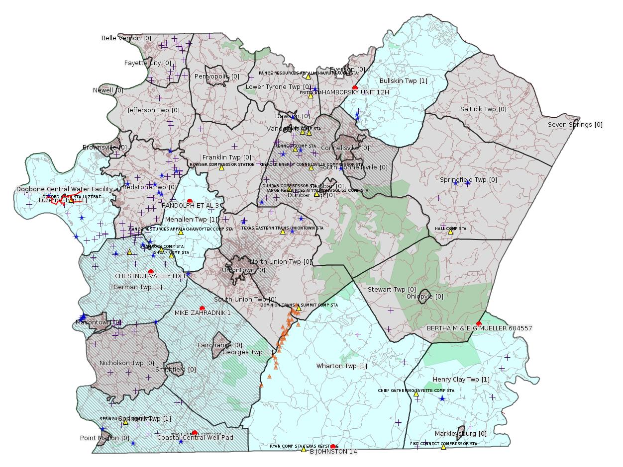
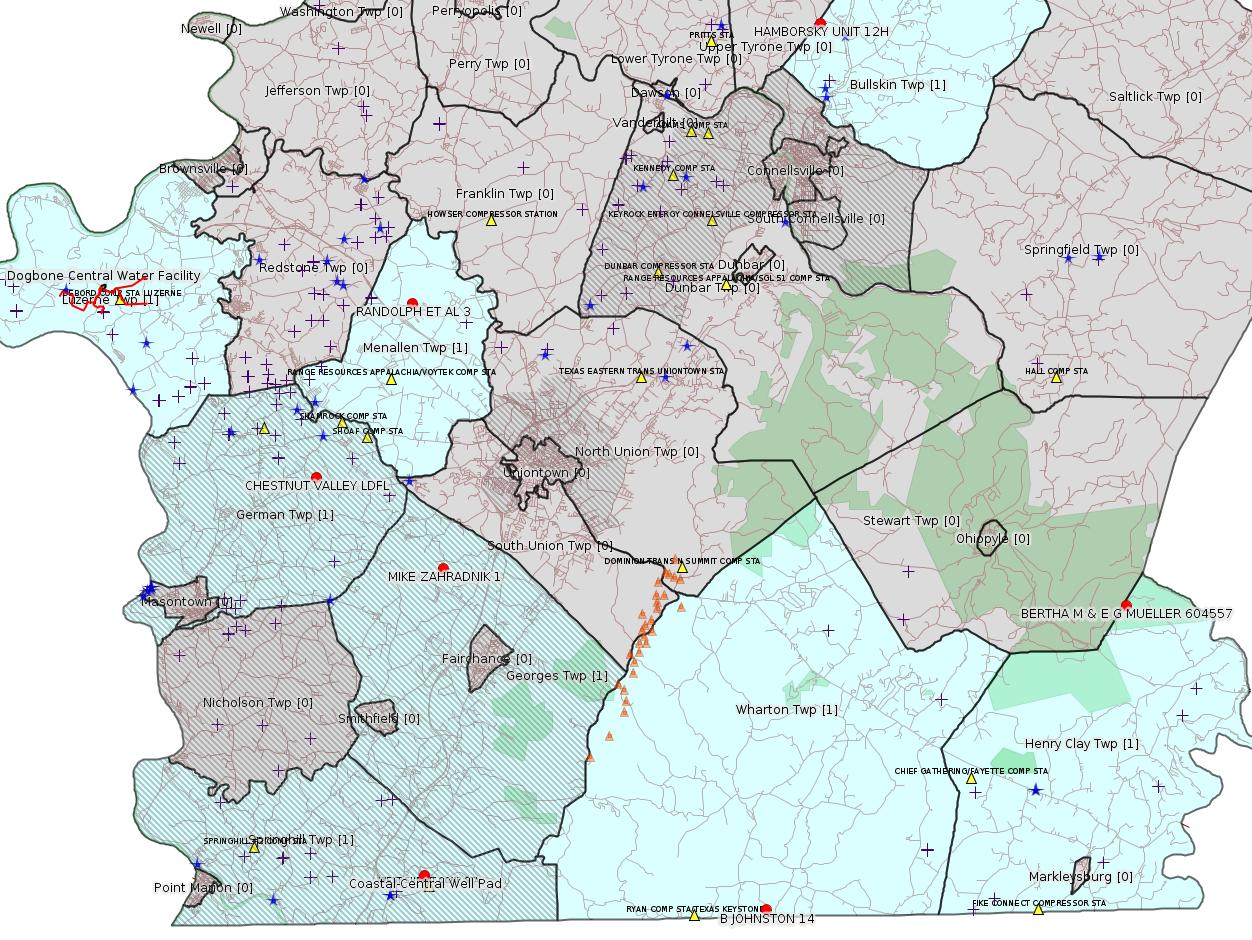
Fayette County Marcellus Shale Permits 4/9/18 - 4/22/18
Click the map to enlarge
Map
Key
Red dots: items in this permit list with an exact location.
Blue stars: Marcellus Gas Well Water Sources.
Municipality shading: number of "facilities", with each well counting separately
(includes the red dots):
Red dots: items in this permit list with an exact location.
Blue stars: Marcellus Gas Well Water Sources.
Municipality shading: number of "facilities", with each well counting separately
(includes the red dots):
gray: 0
pale turquoise: 1
turquoise: 2
pale blue: 3
middle blue: 4
dark blue: 5
dark purple: 11
purple: 15
(Color coding may differ from one issue to the next.)
(Note if a project spans multiple municipalities -- e.g. a pipeline -- it will show in the count for each municipality.)
The number of facilities also follows the municipality name in brackets.
Municipality counts are based on the way the permit is listed by DEP; DEP has been known to get a municipality wrong.
Locations in brackets identify a precise location used to locate a surrogate for the actual site being permitted (e.g. locating a well pad or pipeline by the known location of a well.) Locations labeled beginning with "~" and ending in "[?]" are approximate and speculative based on inferences using on-line property and lease records. These are marked in the text as "[Approximate, Speculative]
Cross-hatching: Environmental Justice Areas
Yellow triangles: Compressor Stations
Orange triangles: Storage Field Wells (currently Dominion North Summit Storage Field)
Crosses: SPUD Unconventional well permits
Green: "Natural areas", e.g. state game lands, state forests
Yellow triangles: Compressor Stations
Orange triangles: Storage Field Wells (currently Dominion North Summit Storage Field)
Crosses: SPUD Unconventional well permits
Green: "Natural areas", e.g. state game lands, state forests
More Maps
 |
Source: Pennsylvania Bulletin
E26-07-005: Burnett Oil Company, Inc., 801 Cherry Street, Unity 9, Fort Worth, TX 76102, Springhill Township, Fayette County, ACOE Pittsburgh District.
Burnett Oil Company, Inc. is proposing to install 0.99 mile of permanent gravel access road and the 119,500 square foot Coastal-Central Well Pad (N 39° 44` 21.48", W 79° 47` 10.68") in Springhill Township, Fayette County, Pennsylvania. The well pad is located approximately 0.59 mile Southwest of State Route 3004 (Wymps Gap Road) and approximately 0.59 mile East of State Route 857 (Springhill Furnace Road). The proposed access road will be 16 feet wide with additional spaces required for road construction and stormwater management.
The entire project area is approximately 23.3 acres and consists primarily of meadow and woodlands. The project will result in no wetland crossings and five (5) watercourse crossings, including a Wild Trout Reproduction stream, resulting in a total of 348 linear feet of permanent stream impacts. Per PA Fish and Boat Commission recommendations, no instream construction shall occur from October 1 to December 31 to protect wild trout spawning and egg disposition behavior. Four individuals of the tree species Oxydendrum arboreum (Sourwood) was found in the project area and, per a letter from the Department of Conservation and Natural Resources (DCNR), will be relocated to an area outside of the limit of disturbance. All disturbed areas except for the described access road and well pad will be stabilized and seeded upon construction completion. The project is a Joint Permit Application due to the crossing of a stream where the drainage area is greater than 1 square mile (based on USGS StreamStats).
Each of the following crossings will be crossed by the permanent access road previously mentioned:
Stream Crossings Latitude/Longitude Area of Impact
UNT 1 to Rubles Run (CWF) Lat: N 39.7429 Temporary: 410 ft2
Long: W 79.7863 Permanent: 310 ft2
UNT 2 to Rubles Run (CWF) Lat: N 39.7422 Temporary: 136 ft2
Long: W 79.7875 Permanent: 168 ft2
UNT 3 to Rubles Run (CWF) Lat: N 39.7417 Temporary: 438 ft2
Long: W 79.7857 Permanent: 1,149 ft2
Rubles Run (CWF—Wild Trout Reproduction stream) Lat: N 39.7416 Temporary: 714 ft2
Long: W 79.7855 Permanent: 1,875 ft2
UNT 4 to Rubles Run (CWF) Lat: N 39.7408 Temporary: 290 ft2
Long: W 79.7847 Permanent: 1,640 ft2
Location: 39.7393,-79.7863
Municipalities: Springhill Twp [an Environmental Justice Area]
Presumed Parcel Id: 36210048
-------------------------
Source: eNOTICE (+ PA Oil and Gas Mapping, Well Pad Report.) Well Details via Data Portal Services: Oil and Gas Wells All (ID: 3).
Please see the Disclaimer below regarding Parcel Id data.
[Conventional Well:]
Authorization ID: 1223385
Permit number: 051-20362
Site: MIKE ZAHRADNIK 1 WELL
Client: BURNETT OIL CO INC
Authorization type: Well Plugging Notice Intent to Plug Single Well
Application type: New
Authorization is for: FACILITY
Date received: 04/05/2018
Status: Issued on 4/5/2018
Permit Decision Guarantee Applies?: No
Sub-Facilities for Authorization:
Sub-Facility ID Sub-Facility Name Description
56542 MIKE ZAHRADNIK 1 Well
Permit Review Notes:
Date Review Note
4/5/2018 The technical review and decision review are complete and either the permit decision and/or permit issuance are forthcoming.
4/5/2018 The permit application package is complete, has been accepted, and is undergoing technical review.
<http://www.ahs.dep.pa.gov/eFACTSWeb/searchResults_singleAuth.aspx?AuthID=1223385>
Site Programs:
Oil & Gas
Municipalities:
Georges Twp [an Environmental Justice Area], Fayette County
Well Details:
Permit Number: 051-20362
Well Name: MIKE ZAHRADNIK 1
Unconventional Well: N
Well Configuration: Vertical Well
Well Type: GAS
Well Status: Active
Coal Association: Coal
Conservation Well: N
Primary Facility ID: 43012
Site ID: 41260
Site Name: MIKE ZAHRADNIK 1 WELL
Well Pad ID: 0
Well Pad Name:
Storage Field:
Operator: BURNETT OIL CO INC
Operator Number: OGO-39119
Permit Date: 1983-06-08
Permit Date Expires: 1984-06-08
SPUD Date: 1983-10-17
Date Plugged:
UIC ID:
UIC Type:
Surface Elevation: 1211
County: Fayette
Municipality: Georges Twp
Location: 39.860056,-79.774694
Map URL: <http://www.openstreetmap.org/?mlat=39.860056&mlon=-79.774694#map=15/39.860056/-79.774694>
Presumed Parcel Id: 14060079
[Conventional Well:]
Authorization ID: 1223083
Permit number: 051-20011
Site: BERTHA M & E G MUELLER 604557 WELL
Client: EQT PRODUCTION CO
Authorization type: Well Plugging Notice Intent to Plug Single Well
Application type: New
Authorization is for: FACILITY
Date received: 03/29/2018
Status: Issued on 4/5/2018
Permit Decision Guarantee Applies?: No
Sub-Facilities for Authorization:
Sub-Facility ID Sub-Facility Name Description
56218 BERTHA M & E G MUELLER 604557 Well
Permit Review Notes:
Date Review Note
4/5/2018 The technical review and decision review are complete and either the permit decision and/or permit issuance are forthcoming.
4/5/2018 The permit application package is complete, has been accepted, and is undergoing technical review.
<http://www.ahs.dep.pa.gov/eFACTSWeb/searchResults_singleAuth.aspx?AuthID=1223083>
Site Programs:
Oil & Gas
Municipalities:
Henry Clay Twp, Fayette County
Well Details:
Permit Number: 051-20011
Well Name: BERTHA M & E G MUELLER 604557
Unconventional Well: N
Well Configuration: Vertical Well
Well Type: GAS
Well Status: Active
Coal Association: NonCoal
Conservation Well: N
Primary Facility ID: 42688
Site ID: 40936
Site Name: BERTHA M & E G MUELLER 604557 WELL
Well Pad ID: 0
Well Pad Name:
Storage Field:
Operator: EQT PRODUCTION CO
Operator Number: OGO-61555
Permit Date: 1901-01-01
Permit Date Expires:
SPUD Date: 1959-08-29
Date Plugged:
UIC ID:
UIC Type:
Surface Elevation: 2825
County: Fayette
Municipality: Henry Clay Twp
Location: 39.84126,-79.42603
Map URL: <http://www.openstreetmap.org/?mlat=39.84126&mlon=-79.42603#map=15/39.84126/-79.42603>
Parcel Id: 16010001
Authorization ID: 1221795
Permit number: ESG18-051-0001
Site: DOGBONE WATER LINE ESCGP ESG18-051-0001
Client: CHEVRON APPALACHIA LLC
Authorization type: Erosion and Sediment Control GP-2
Application type: New
Authorization is for: SITE
Date received: 03/22/2018
Status: Pending
Permit Decision Guarantee Applies?: Yes
Permit Decision Guarantee status: VOID
<http://www.ahs.dep.pa.gov/eFACTSWeb/searchResults_singleAuth.aspx?AuthID=1221795>
Site Programs:
Municipalities:
Luzerne Twp, Fayette County
[Conventional Well:]
Authorization ID: 1202324
Permit number: 051-21618
Site: RANDOLPH ET AL 3 OG WELL
Client: RANGE RESOURCES APPALACHIA LLC
Authorization type: Drill & Operate Well Permit Inactive Status
Application type: New
Authorization is for: FACILITY
Date received: 10/11/2017
Status: Denied on 4/5/2018
Permit Decision Guarantee Applies?: No
Sub-Facilities for Authorization:
Sub-Facility ID Sub-Facility Name Description
758003 RANDOLPH ET AL 3 Well
Permit Review Notes:
Date Review Note
4/5/2018 Application has been deemed to be technically deficient and has been denied.
4/5/2018 Application has been deemed to be technically deficient and has been denied.
10/11/2017 The permit application package is complete, has been accepted, and is undergoing technical review.
<http://www.ahs.dep.pa.gov/eFACTSWeb/searchResults_singleAuth.aspx?AuthID=1202324>
Site Programs:
Oil & Gas
Municipalities:
Menallen Twp, Fayette County
Well Details:
Permit Number: 051-21618
Well Name: RANDOLPH ET AL 3
Unconventional Well: N
Well Configuration: Vertical Well
Well Type: GAS
Well Status: Active
Coal Association: Coal
Conservation Well: N
Primary Facility ID: 631098
Site ID: 607330
Site Name: RANDOLPH ET AL 3 OG WELL
Well Pad ID: 0
Well Pad Name:
Storage Field:
Operator: RANGE RESOURCES APPALACHIA LLC
Operator Number: OGO-60915
Permit Date: 2002-12-06
Permit Date Expires: 2003-12-06
SPUD Date: 2002-12-11
Date Plugged:
UIC ID:
UIC Type:
Surface Elevation: 1035
County: Fayette
Municipality: Menallen Twp
Location: 39.964748,-79.788649
Map URL: <http://www.openstreetmap.org/?mlat=39.964748&mlon=-79.788649#map=15/39.964748/-79.788649>
Presumed Parcel Id: 22060031
[Possibly Off-Topic:]
Authorization ID: 1202153
Permit number: 100419
Site: CHESTNUT VALLEY LDFL
Client: ADVANCED DSPL SVC CHESTNUT VALLEY LDFL INC
Authorization type: Minor Modification to an Existing Fac
Application type: Modification
Authorization is for: FACILITY
Date received: 10/11/2017
Status: Pending
Permit Decision Guarantee Applies?: Yes
Permit Decision Guarantee status: VOID
Sub-Facilities for Authorization:
Sub-Facility ID Sub-Facility Name Description
212043 J&J LANDFILL Landfill
Permit Review Notes:
Date Review Note
4/17/2018 Applicant has been issued a deficiency letter. If applicable, this application no longer qualifies for the Permit Decision Guarantee.
2/21/2018 Applicant has been issued a deficiency letter. If applicable, this application no longer qualifies for the Permit Decision Guarantee.
<http://www.ahs.dep.pa.gov/eFACTSWeb/searchResults_singleAuth.aspx?AuthID=1202153>
Site Programs:
Air Quality
Clean Water
Environmental Cleanup & Brownfields
Mining
Radiation Protection
Waste Management
Water Planning and Conservation
Municipalities:
German Twp [an Environmental Justice Area], Fayette County
Location: 39.896765,-79.838766 <http://osm.org/go/ZWpP0~XK--?m=>
Presumed Parcel Id: 15280012
-------------------------
Source: DEP Oil and Gas Compliance Report
OPERATOR: CHEVRON APPALACHIA LLC
INSPECTION_ID: 2718219
INSPECTION_DATE: 04/09/2018
INSPECTION_TYPE: Follow-up Inspection
API_PERMIT: 051-24381
FARM_NAME: HAMBORSKY UNIT 12H
UNCONVENTIONAL: Yes
SITE_ID: 737696
SITE_NAME: HAMBORSKY UNIT 12H OG WELL
FACILITY_TYPE: Oil & Gas Location
INSPECTION_CATEGORY: Primary Facility
REGION: EP DOGO SWDO Dstr Off
COUNTY: Fayette
MUNICIPALITY: Bullskin Twp
INSPECTOR: WITHAM, CYNTHIA
INSPECTION_SOURCE: SAIR
INSPECTION_RESULT_DESCRIPTION: Outstanding Violations - Viols Req'd
INSPECTION_COMMENT: "Routine partial follow up inspection to inspection record #2685605 where a violation was issued for failure to comply with E and S requirements.
At time of inspection, gully observed in inspection record #2685605 remains, and appears to have worsened (photo #1 and 2). No fluid is flowing at this time. It does not appear operator has taken any corrective measures to address run-off in this area.
Wet area observed in inspection record #2714408 on the south-facing slope of the well pad remains (photo #3). Department recommends operator continue to monitor this area to avoid any E and S issues.
Upon review of operator's Post-Construction Stormwater Management/Restoration Narrative, it appears stormwater runoff is contained by subsurface infiltration beds. According to this narrative, these infiltration beds are to be inspected at least 4 times a year. Department requests a copy of these inspections for the last 2 years.
Violation issued on 1-22-18 remains outstanding. A follow up inspection will be conducted at a later date."
VIOLATION_ID: 813682
VIOLATION_DATE: 01/22/2018
VIOLATION_CODE: 78a53 - EROSION AND SEDIMENT CONTROL AND STORMWATER MANAGEMENT - Person proposing or conducting earth disturbance activities associated with oil and gas operations failed to comply with 25 Pa. Code § 102.
VIOLATION_TYPE: Environmental Health & Safety
VIOLATION_COMMENT:
RESOLVED_DATE:
RESOLUTION_REASON_CODE_DESCRIPTION:
CONTINUING_VIOLATION: Yes
ENFORCEMENT_ID:
ENFORCEMENT_CODE_DESCRIPTION:
DATE_EXECUTED:
ENFORCEMENT_FINAL_DATE:
ENFORCEMENT_FINAL_STATUS:
PENALTY_FINAL_DATE:
PENALTY_FINAL_STATUS_CODE_DESCRIPTION:
PENALTY_AMOUNT:
TOTAL_AMOUNT_COLLECTED:
Well Details:
Permit Number: 051-24381Map URL: <http://www.openstreetmap.org/?mlat=40.072761&mlon=-79.577281#map=15/40.072761/-79.577281>
Well Name: HAMBORSKY UNIT 12H
Unconventional Well: Y
Well Configuration: Horizontal Well
Well Type: GAS
Well Status: Active
Coal Association: Coal
Conservation Well: Y
Primary Facility ID: 733126
Site ID: 737696
Site Name: HAMBORSKY UNIT 12H OG WELL
Well Pad ID: 148470
Well Pad Name: HAMBORSKY UNIT 12H
Storage Field:
Operator: CHEVRON APPALACHIA LLC
Operator Number: OGO-39307
Permit Date: 2010-09-09
Permit Date Expires: 2011-09-09
SPUD Date: 2011-06-13
Date Plugged:
UIC ID:
UIC Type:
Surface Elevation: 1200
County: Fayette
Municipality: Bullskin Twp
Location: 40.072761,-79.577281
Presumed Parcel Id: 04280001
---
[Conventional Well:]
OPERATOR: DIVERSIFIED OIL & GAS LLC
INSPECTION_ID: 2711096
INSPECTION_DATE: 03/27/2018
INSPECTION_TYPE: Routine/Complete Inspection
API_PERMIT: 051-23829
FARM_NAME: B JOHNSTON 14
UNCONVENTIONAL: No
SITE_ID: 696849
SITE_NAME: B JOHNSTON 14 OG WELL
FACILITY_TYPE: Oil & Gas Location
INSPECTION_CATEGORY: Primary Facility
REGION: EP DOGO SWDO Dstr Off
COUNTY: Fayette
MUNICIPALITY: Wharton Twp
INSPECTOR: WITHAM, CYNTHIA
INSPECTION_SOURCE: SAIR
INSPECTION_RESULT_DESCRIPTION: No Violations Noted
INSPECTION_COMMENT: "Well appears equipped for production.
Department spoke with operator rep Lisa Raffle by phone regarding fluid ponding on site. Ms. Raffle stated a well tender will visit site today and she will follow up with Department on his findings.
UPDATE 15:50: Ms. Raffle contacted Department by phone. She stated tank contains 5' 4"" of brine and that that level is consistent with her records. In addition, snowmelt, current rainfall, and livestock presence may have contributed to ponding. Department recommends operator continue to monitor and maintain site to avoid any E and S issues."
Well Details:
Permit Number: 051-23829
Well Name: B JOHNSTON 14
Unconventional Well: N
Well Configuration: Vertical Well
Well Type: GAS
Well Status: Active
Coal Association: Coal
Conservation Well: N
Primary Facility ID: 699268
Site ID: 696849
Site Name: B JOHNSTON 14 OG WELL
Well Pad ID: 0
Well Pad Name:
Storage Field:
Operator: DIVERSIFIED OIL & GAS LLC
Operator Number: OGO-68792
Permit Date: 2007-11-09
Permit Date Expires: 2008-11-09
SPUD Date: 2008-11-03
Date Plugged:
UIC ID:
UIC Type:
Surface Elevation: 1805
County: Fayette
Municipality: Wharton Twp
Location: 39.723917,-79.612422
Map URL: <http://www.openstreetmap.org/?mlat=39.723917&mlon=-79.612422#map=15/39.723917/-79.612422>
Parcel Id: 42360016
-------------------------
Source: Reuters Commodities: Energy
Natural Gas
| Commodity | Exchange | Currency | Expire | Last Trade | Trade Time | Change | Open | Day's High | Day's Low |
|---|---|---|---|---|---|---|---|---|---|
| NATURAL
GAS CON1 Apr18 |
NYM | USD | 04/26 | 2.74 | 04/24 00:42 | +0.00 | 2.74 | 2.75 | 2.73 |
<http://www.reuters.com/finance/commodities/energy>
-------------------------
Notes:
[None]
------------------------
DEP defines an environmental justice area as "any census tract where 20 percent or more individuals live in poverty, and/or 30 percent or more of the population is minority". (See:
<http://www.dep.pa.gov/PublicParticipation/OfficeofEnvironmentalJustice/Pages/default.aspx>). There are supposed to be enhanced public participation requirements for permits in environmental justice areas, but news of this actually ever happening is scarce. In Fayette County, the entirety of Springhill, Nicholson, German, and Georges Townships are environmental justice areas, as well as a large part of Dunbar Township. DEP's policy document on public participation guidelines for environmental justice areas is located here:
<http://www.elibrary.dep.state.pa.us/dsweb/Get/Version-48671/012-0501-002.pdf>
eNOTICE records are likely to list the same permit multiple times, as that permit moves through the DEP process.
Oil & Gas Wells designated with a site a number and the letter H typically designate horizontal wells.
-------------------------
Resources:
Pennsylvania Bulletin: <http://www.pabulletin.com/>
eNOTICE: <http://www.ahs2.dep.state.pa.
DEP Oil and Gas Reports: <http://www.dep.pa.gov/DataandTools/Reports/Oil%20and%20Gas%20Reports/Pages/default.aspx>
DEP Permits Issued Detail Report:
<http://www.depreportingservic
DEP SPUD (drilling started) Report:
<http://www.depreportingservices.state.pa.us/ReportServer/Pages/ReportViewer.aspx?/Oil_Gas/Spud_External_Data>
DEP Oil and Gas Compliance Report:
<http://www.depreportingservices.state.pa.us/ReportServer/Pages/ReportViewer.aspx?/Oil_Gas/OG_Compliance>
DEP PA Oil & Gas Mapping:
<http://www.depgis.state.pa.us/PaOilAndGasMapping>
Data Portal Services Directory [Technical]
<http://www.depgis.state.pa.us/arcgis/rest/services>
Query: Oil and Gas Wells All (ID: 3) [Technical]:
<http://www.depgis.state.pa.us/arcgis/rest/services/OilGas/OilGasAllStrayGas/MapServer/3/query?where=&text=&objectIds=&time=&geometry=&geometryType=esriGeometryEnvelope&inSR=&spatialRel=esriSpatialRelIntersects&relationParam=&outFields=OBJECTID%2CPERMIT_NUMBER%2CWELL_NAME%2COPERATOR%2COPERATOR_NUMBER%2CWELL_TYPE%2CWELL_TYPE_CODE%2CWELL_STATUS%2CWELL_STATUS_CODE%2CPERMIT_DATE%2CPERMIT_DATE_EXPIRES%2CSPUD_DATE%2CCONSERVATION_IND%2CCOUNTY%2CCOUNTY_ID%2CMUNICIPALITY%2CMUNICIPALITY_TYPE%2CMUNICIPALITY_CODE%2CLATITUDE%2CLONGITUDE%2CPRMRY_FID%2CUNCONVENTIONAL_IND%2CSURFACE_ELEVATION%2CWELL_CONFIG_CODE%2CCOAL_IND%2CWELL_PAD_NAME%2CSHAPE%2CDATE_PLUGGED%2CWELL_PAD_ID%2CUIC_ID%2CUIC_TYPE_DESCRIPTION%2CSTORAGE_FIELD_NAME%2CSITE_ID%2CSITE_NAME&returnGeometry=true&returnTrueCurves=false&maxAllowableOffset=&geometryPrecision=&outSR=&returnIdsOnly=false&returnCountOnly=false&orderByFields=&groupByFieldsForStatistics=&outStatistics=&returnZ=false&returnM=false&gdbVersion=&returnDistinctValues=false&resultOffset=&resultRecordCount=&f=html>
(Be sure to enter a Where clause in SQL format. Dates are in milliseconds since midnight 1/1/1970).
DEP Oil and Gas Electronic Notifications
<http://www.depreportingservices.state.pa.us/ReportServer?/Oil_Gas/OG_Notifications>
DEP Oil and Gas Well Pad Report
<http://www.depreportingservices.state.pa.us/ReportServer?/Oil_Gas/Well_Pads>
Fayette County Assessment Office Search For Tax Records:
<http://property.co.fayette.pa.us/search.aspx>
Pennsylvania Spatial Data Access:
<http://www.pasda.psu.edu/default.asp>
DEP Spatial Data Repository:
<ftp://www.pasda.psu.edu/pub/pasda/dep/>
National Response Center:
<http://www.nrc.uscg.mil/>
EPA-Echo: <http://www.epa-echo.gov/echo/
FERC citizen involvement: <http://www.ferc.gov/for-citiz
To receive E-mail notification of
all documents filed in a FERC docket, see:
<http://www.ferc.gov/docs-filing/esubscription.asp >
<http://www.ferc.gov/docs-fili
Follow the directions and enter the docket number to subscribe to.
Township Supervisors receive information regarding Erosion & Sedimentation permits, and these records may be reviewable at township municipal offices.
DEP permits are reviewable through the File Review process, for application to do file review see: <http://www.portal.state.pa.us/portal/server.pt/community/southwest_regional_office/13775/file_review/593164>
Environmental Hearing Board: <http://ehb.courtapps.com/publ
PA DEP Environmental Policy Comment System:
<http://www.ahs.dep.pa.gov/eComment/>
Federal Register Environment: <https://www.federalregister.g
Browsing of recent comment
opportunities for federal agencies, e.g. EPA. Click "sign up" to
subscribe to daily E-mails of new document listings.
SkyTruth Fayette County Drilling Alerts: <http://frack.skytruth.org/pen
U.S. Army Corps of Engineers, Pittsburgh District, Public Notices:
<http://www.lrp.usace.army.mil/Missions/Regulatory/Public-Notices/>
EPA Pennsylvania Public Notices: <http://www2.epa.gov/aboutepa/epa-pennsylvania#notice>
Marcellus Shale waste disposal
injection wells in Pennsylvania are regulated directly by EPA, not
DEP. Notice of any new permit applications will appear at the
above web address. I'm not aware of any subscription service
to be notified of such applications. I'm not aware of any
Marcellus Shale waste disposal injection wells in Fayette County
(yet ...) but we need to monitor this page for future
applications.
Energy Assurance Daily: <http://www.oe.netl.doe.gov/ead.aspx>
Daily newsletter from the US
Department of Energy about events relating to energy. The Natural
Gas section has information about pipelines.
-------------------------
Disclaimers:
This compilation from the above sources was done by hand using copy and paste and may omit relevant permits.
Parcel data is provided via the tax records search web page offered by the Fayette County Assessment Office (http://property.co.fayette.pa.us/). Presumed Parcel Id links are subject to availability provided by that agency and associated web sites. Presumed Parcel Ids are determined as the mapped parcel containing a given latitude and longitude, are a best effort determination which is subject to error, and are not official. In cases where a facility is leased and there is a separate parcel id for the lease, if this parcel id is not separately mapped, the parcel id shown will be the id for the enclosing parcel. Parcel owners may be surface owners only and may or may not have any relationship to oil & gas facilities.
Does not currently include water supply permits. Does not include landfill permits even though many such are for Marcellus Shale waste. (It is not possible at this time to distinguish which landfill permits are for Marcellus Shale waste and which are not without doing File Review for each permit.)
Erosion & Sedimentation permit records do not currently include latitude and longitude. Where I am publishing latitude and longitude with E&S permits it is by inferring an associated well permit and using published latitude and longitude for the well. It is possible I may be inferring the wrong well site.
Municipalities are shown from eFACTS records on the DEP web site. The DEP has been known to list a municipality incorrectly.