The Harmed Success Stories Concepts How To What Is Commentary
Fayette County Marcellus Shale Permits 4/22/19 - 5/5/19
Contents
Pennsylvania Bulletin Listings
ENVIRONMENTAL QUALITY BOARD Acceptance of Rulemaking Petition for Study: Program to Limit Greenhouse Gas EmissionseFACTS Listings
Withdrawal of Technical Guidance: Civil Penalty Assessment Informal Hearing Procedure for the Office of Oil and Gas Management
DAWSON TP Minor IW Facility without ELG (New) [Originally Authorization # 1210110]Electronic Notifications
SIEGEL 7H Drill & Operate Well Permit (Unconventional) Modification [of schedule] (New)
SIEGEL 9H Drill & Operate Well Permit (Unconventional) Modification [of schedule] (New)
SIEGEL 8H Drill & Operate Well Permit (Unconventional) Modification [of schedule] (New)
SIEGEL 6H Drill & Operate Well Permit (Unconventional) Modification [of schedule] (New)
SIEGEL 5H Drill & Operate Well Permit (Unconventional) Modification [of schedule] (New)
SIEGEL 3H Drill & Operate Well Permit (Unconventional) Modification [of schedule] (New)
SIEGEL 2H Drill & Operate Well Permit (Unconventional) Modification [of schedule] (New)
CHESTNUT VALLEY LDFL Landfill Pmt Final Construction Certification Form 37 4/26/2019 deficiency letter (New)
FIKE UNIT 1H Drill & Operate Well Permit Inactive Status (New)
S PA GATHERING SYSTEM ABANDONMENT PIPELINES 7648 & 7837 PROJECT BWM-GP-11 Maintenance, Testing, Repair, Rehabilitation or Replacement (New)
GANS GENERATING FAC Minor IW Facility without ELG (New)
CHRISTNER UNIT 1 Well Plugging Notice Alternate Method
SNAPP TESLOVICH M01V Drill & Operate Well Permit (Unconventional)
CERULLO M12H Alt Method of Equipping, Casing, or Venting Well Issued 4/17/2019
CERULLO M11H Alt Method of Equipping, Casing, or Venting Well Issued 4/17/2019
CERULLO M10H Alt Method of Equipping, Casing, or Venting Well Issued 4/17/2019
CERULLO M09H Alt Method of Equipping, Casing, or Venting Well Issued 4/17/2019
CERULLO M04H Alt Method of Equipping, Casing, or Venting Well Issued 4/17/2019
CERULLO M03H Alt Method of Equipping, Casing, or Venting Well Issued 4/17/2019
CERULLO M02H Alt Method of Equipping, Casing, or Venting Well Issued 4/17/2019
CERULLO M01H Alt Method of Equipping, Casing, or Venting Well Issued 4/17/2019
CHRISTOFEL WELL PAD A Erosion and Sediment Control General Permit 3 5/3/2019 deficiency letter
S PA GATHERING SYSTEM ABANDONMENT PIPELINES 7648 & 7837 PROJECT GP-08 Temporary Road Crossings
SOUTHERN PA GATHERING SYSTEM ABANDONMENT PPL 8605 GP8 & GP11 BWM-GP-11 Maintenance, Testing, Repair, Rehabilitation or Replacement
SOUTHERN PA GATHERING SYSTEM ABANDONMENT PPL 8605 GP8 & GP11 GP-08 Temporary Road Crossings
FAYETTE ENERGY FAC Minor IW Facility with ELG
OLIVER 1 Abandonment or plugging notification 04/23/2019
CHRISTNER UNIT 1 Abandonment or plugging notification 04/27/2019
YODER 12H Drilling resumption After Break of 30 days or more 04/29/2019
REA 1 channeling at the juncture of the access road and the public road; production tank with extensive rust and many holes Violation(s) Noted
REDMAN UNIT 30 brine tanks heavily corroded, poor structural integrity Violation(s) Noted
STEWART WELL SITE spill of five barrels of mixed fresh and produced water violation regarded as immediately corrected
STEWART WELL SITE follow up inspection conductivity readings between 1300-1500us
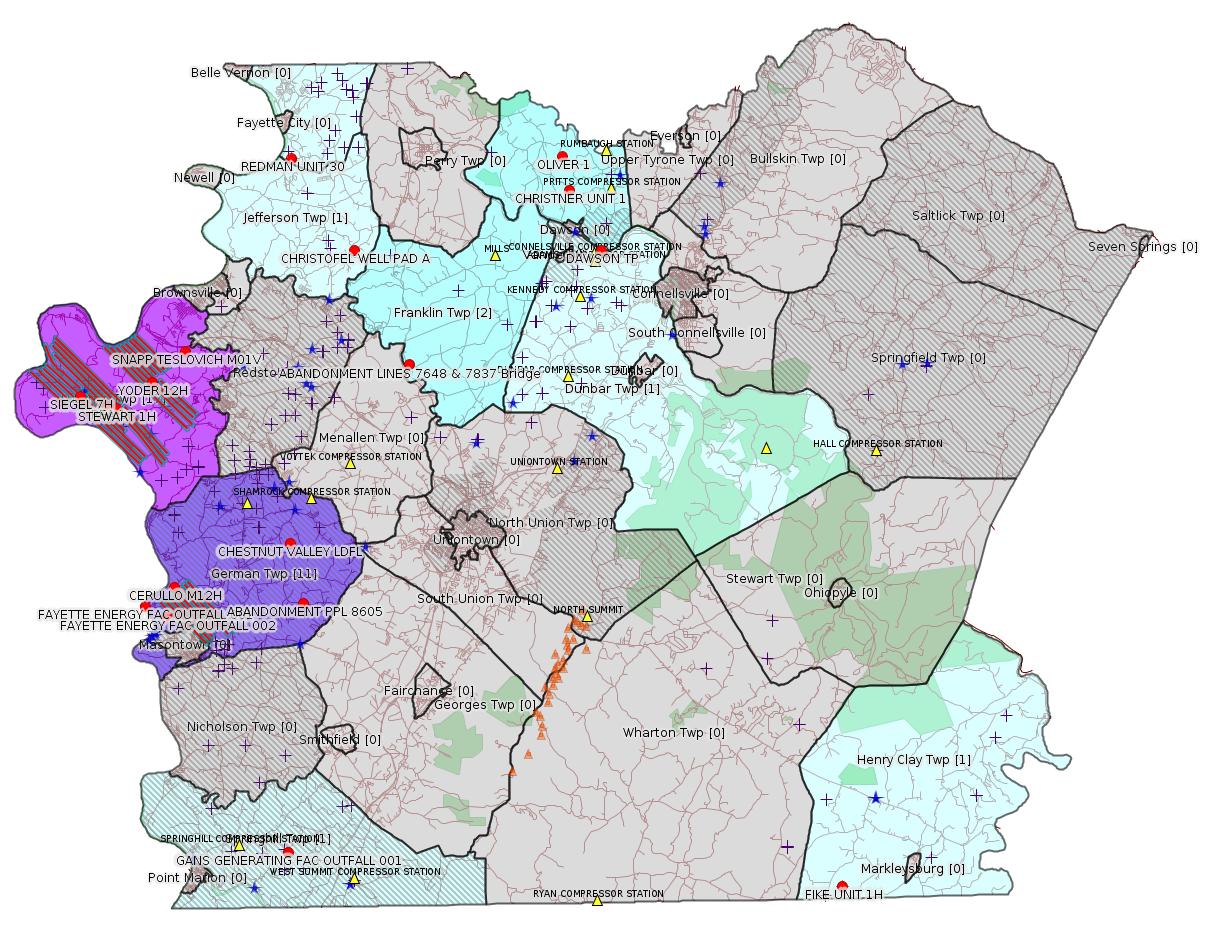
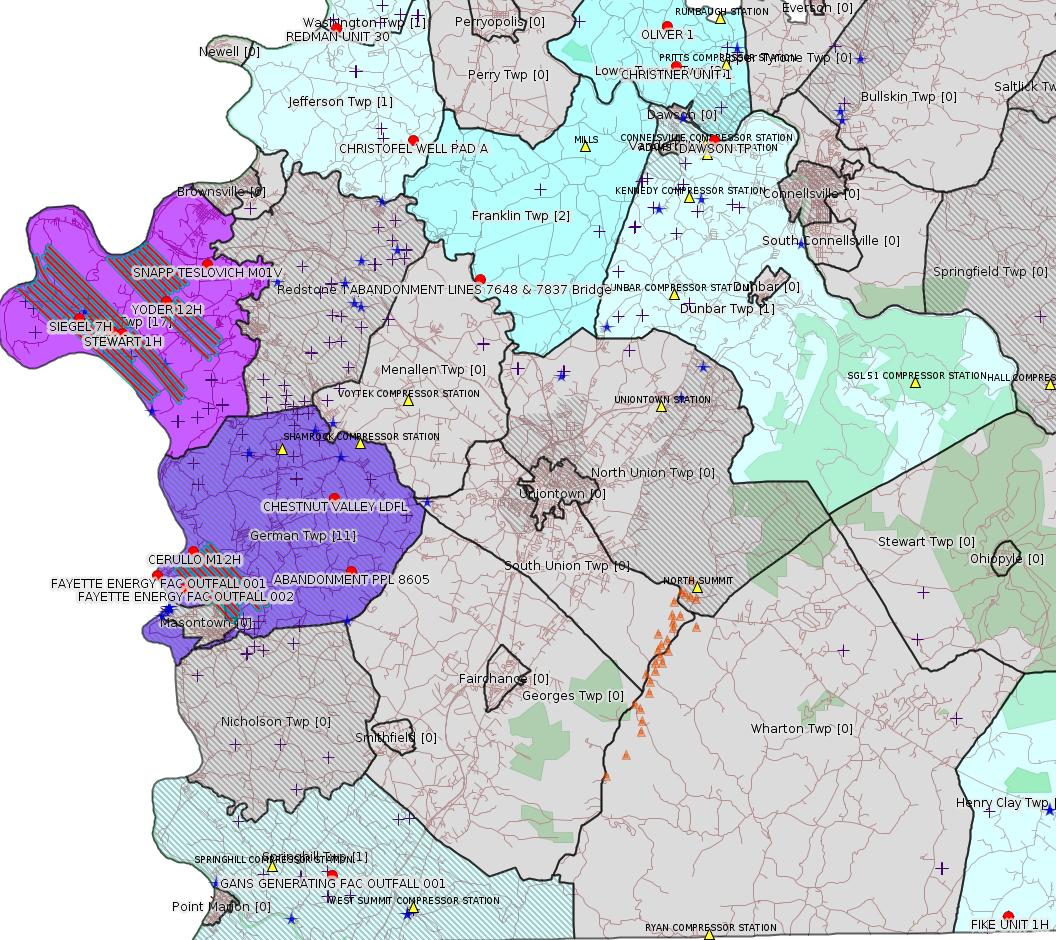
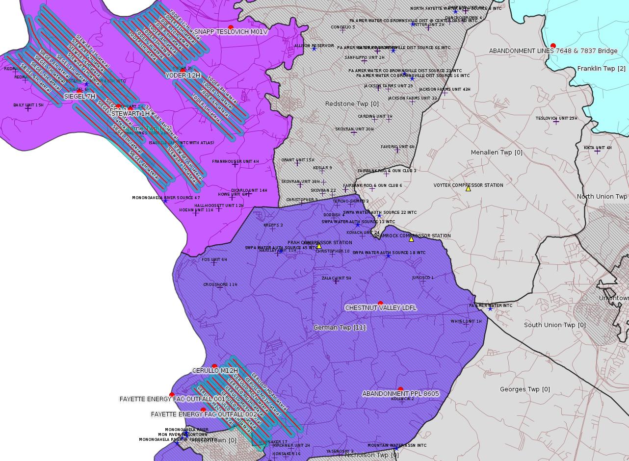
Red dots: items in this permit list with an exact location.
Blue stars: Marcellus Gas Well Water Sources.
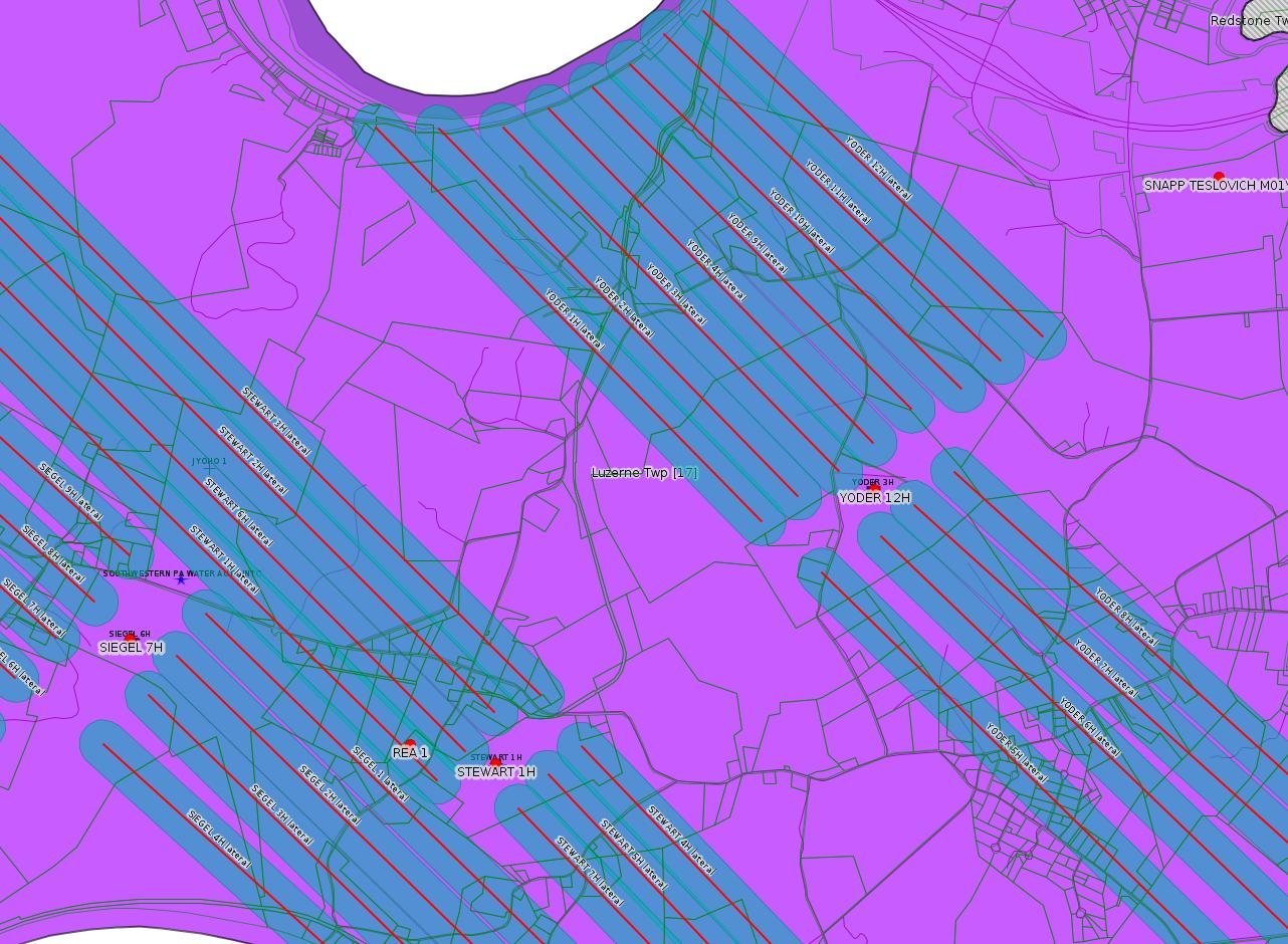
Where well laterals are mapped they show in red; a 400-foot buffer surrounding the lateral shows in blue (lavender where it overlaps a mapped mineral tract).
Where mineral tracts are mapped, they show in pink. Mineral tracts can overlap; the overlap will show in red. The precise meaning of "mineral tract" is not clear.
Municipality shading: number of "facilities", with each well counting separately
(includes the red dots):
pale turquoise: 1
turquoise: 2
pale blue: 3
middle blue: 4
dark blue: 5
dark purple: 11
purple: 17
(Color coding may differ from one issue to the next.)
(Note if a project spans multiple municipalities -- e.g. a pipeline -- it will show in the count for each municipality.)
The number of facilities also follows the municipality name in brackets.
Municipality counts are based on the way the permit is listed by DEP; DEP has been known to get a municipality wrong.
Locations in brackets identify a precise location used to locate a surrogate for the actual site being permitted (e.g. locating a well pad or pipeline by the known location of a well.) Locations labeled beginning with "~" and ending in "[?]" are approximate and speculative based on inferences using on-line property and lease records. These are marked in the text as "[Approximate, Speculative]
Yellow triangles: Compressor Stations
Orange triangles: Storage Field Wells (currently Dominion North Summit Storage Field)
Crosses: SPUD Unconventional well permits
Green: "Natural areas", e.g. state game lands, state forests
More Maps
 |
 |
 |
Source: Pennsylvania Bulletin
PROPOSED RULEMAKING
ENVIRONMENTAL QUALITY BOARD
Acceptance of Rulemaking Petition for Study
[49 Pa.B. 2004]
[Saturday, April 27, 2019]
On April 16, 2019, the Environmental Quality Board (Board) accepted a rulemaking petition for study under 25 Pa. Code Chapter 23 (relating to Environmental Quality Board policy for processing petitions—statement of policy). The petition requests the establishment of a program to limit greenhouse gas emissions.
Under the Board's acceptance of the petition, the Department of Environmental Protection (Department) will prepare a report evaluating the petition. This report will include a recommendation on whether the Board should proceed with a proposed rulemaking and, if so, the process that the Department would need to undertake to develop a proposed rulemaking.
The previously-referenced petition is available to the public by contacting the Environmental Quality Board, P.O. Box 8477, Harrisburg, PA 17105-8477, (717) 783-8727, and is accessible on the Department's web site at www.dep.pa.gov (select ''Public Participation,'' then ''Environmental Quality Board (EQB),'' then ''2019 Meetings,'' then ''Meeting Agendas/Minutes/Handouts; April 16, 2019'').
PATRICK McDONNELL,
Chairperson
<https://www.pabulletin.com/secure/data/vol49/49-17/612.html>
The text of the petition is available here:
<http://files.dep.state.pa.us/PublicParticipation/Public%20Participation%20Center/PubPartCenterPortalFiles/Environmental%20Quality%20Board/2019/02_Petition_GHG%20Emissions/GHG%20Emission%20Petition_February%2028,%202019.pdf>
A PowerPoint presentation explaining the petition process is available here:
<http://files.dep.state.pa.us/PublicParticipation/Public%20Participation%20Center/PubPartCenterPortalFiles/Environmental%20Quality%20Board/2019/PPT%20PRESENTATIONS/Program%20to%20Limit%20Greenhouse%20Gas%20Emissions.pdf>
---
Withdrawal of Technical Guidance
DEP ID: 800-4000-002. Title: Civil Penalty Assessment Informal Hearing Procedure for the Office of Oil and Gas Management. Description: This TGD was published as a draft at 44 Pa.B. 2582 (April 26, 2014). Section 3256 of the 2012 Oil and Gas Act (act) (58 Pa.C.S. § 3256) provides that the Department may assess a civil penalty for violations of the act or a regulation, order or permit issued by the Department under the act, after a hearing. Section 3256 of the act further provides that a person charged with a penalty must, within 30 days of notification, pay the penalty or file an appeal of the assessment with the Environmental Hearing Board. This document outlined a procedure for the conduct of the informal civil penalty assessment hearings. This document is being withdrawn because it is not necessary.
Contact: Questions regarding this action can be directed to Kurt Klapkowski, Bureau of Oil and Gas Plan- ning and Program Management, P.O. Box 8765, Harrisburg, PA at kklapkowsk@pa.gov or (717) 772-2199.
<https://www.pabulletin.com/secure/data/vol49/49-17/618.html>
-------------------------
Source: eNOTICE (+ PA Oil and Gas Mapping, Well Pad Report.) Well Details via Data Portal Services: Oil and Gas Wells All (ID: 3).
Please see the Disclaimer below regarding Parcel Id data.
Authorization ID: 1271846
Permit number: PA0217778
Site: DAWSON TP
Client: KEYROCK ENERGY LLC
Authorization type: Minor IW Facility without ELG
Application type: Renewal
Authorization is for: FACILITY
Date received: 11/28/2017
Status: Pending
Permit Decision Guarantee Applies?: No
Sub-Facilities for Authorization:
Sub-Facility ID Sub-Facility Name Description
1025459 OUTFALL 001 Discharge Point
Location: 40.036247,-79.640533
Map URL: <http://www.openstreetmap.org/?mlat=40.036247&mlon=-79.640533#map=15/40.036247/-79.640533>
Permit Review Notes:
Date Review Note
4/26/2019 The permit application package is complete, has been accepted, and is undergoing technical review.
<https://www.ahs.dep.pa.gov/eFACTSWeb/searchResults_singleAuth.aspx?AuthID=1271846>
Site Programs:
Clean Water
Oil & Gas
Site Municipalities:
Dunbar Twp, Fayette County
---
Authorization ID: 1270809
Permit number: 051-24646
Site: SIEGEL WELL PAD ESCGP-2 EXPEDITED
Client: CHEVRON APPALACHIA LLC
Authorization type: Drill & Operate Well Permit (Unconventional)
Application type: Modification [See Notes -jr]
Authorization is for: FACILITY
Date received: 04/26/2019
Status: Pending
Permit Decision Guarantee Applies?: No
Sub-Facilities for Authorization:
Sub-Facility ID Sub-Facility Name Description
1251519 WELLBORE SURFACE HOLE LOCATION Well
Permit Review Notes:
Date Review Note
4/29/2019 The permit application package is complete, has been accepted, and is undergoing technical review.
<https://www.ahs.dep.pa.gov/eFACTSWeb/searchResults_singleAuth.aspx?AuthID=1270809>
Site Programs:
Environmental Cleanup & Brownfields
Oil & Gas
Site Municipalities:
Luzerne Twp, Fayette County
Well Details:
Permit Number: 051-24646
Well Name: SIEGEL 7H
Unconventional Well: Y
Well Configuration: Horizontal Well
Well Type: GAS
Well Status: Active
Coal Association: Coal
Conservation Well: N
Primary Facility ID: 823794
Site ID: 790384
Site Name: SIEGEL WELL PAD ESCGP-2 EXPEDITED
Well Pad ID: 152926
Well Pad Name: SIEGEL 1
Storage Field:
Operator: CHEVRON APPALACHIA LLC
Operator Number: OGO-39307
Permit Date: 2018-02-23
Permit Date Expires: 2019-02-23
SPUD Date: 2018-04-02
Date Plugged:
UIC ID:
UIC Type:
Surface Elevation: 1173
County: Fayette
Municipality: Luzerne Twp
Location: 39.968956,-79.968994
Map URL: <http://www.openstreetmap.org/?mlat=39.968956&mlon=-79.968994#map=15/39.968956/-79.968994>
OG WELLS PERMIT DOCS:
2018-02-26: Final Permit Documents, Name: 1212440 (for Authorization: 1212440):
<http://www.depgis.state.pa.us/pdfHandler/pdFHandler.ashx?Doc=NTYzOTU3&ext=PDF>
Electronically Submitted Records:
2019-05-03: Submission for Authorization 1270809
Pennsylvania Natural Diversity Inventory Form: Siegel PNDI.pdf
<http://www.depgis.state.pa.us/eWellDocHandler/pdFHandler.ashx?Doc=ODIwNzI4&ext=PDF>
Location Plat: 143-781-Well Plat 7H-pages1-2-3_3702.dwg
<http://www.depgis.state.pa.us/eWellDocHandler/pdFHandler.ashx?Doc=ODIwNzMw&ext=PDF>
Interested Party Notification: Siegel 7H_Record of Notification.pdf
<http://www.depgis.state.pa.us/eWellDocHandler/pdFHandler.ashx?Doc=ODIwNzMx&ext=PDF>
Well Cross-Section Diagram: Siegel 7H Page 4.pdf
<http://www.depgis.state.pa.us/eWellDocHandler/pdFHandler.ashx?Doc=ODIwNzMy&ext=PDF>
Well Permit Application - Coal Module: Siegel Coal Module.pdf
<http://www.depgis.state.pa.us/eWellDocHandler/pdFHandler.ashx?Doc=ODIwNzMz&ext=PDF>
Coal and Gas Resource Coord Act - Section 7 Exception: Siegel Waiver Request Section 7.pdf
<http://www.depgis.state.pa.us/eWellDocHandler/pdFHandler.ashx?Doc=ODI0MzMx&ext=PDF>
Permit Application to Drill and Operate a Well: Siegel 7H_Drill Permit Application.pdf
<http://www.depgis.state.pa.us/eWellDocHandler/pdFHandler.ashx?Doc=ODI0NzY4&ext=PDF>
Electronic Submission Docket: 1929165.pdf
<http://www.depgis.state.pa.us/eWellDocHandler/pdFHandler.ashx?Doc=ODI5Nzcw&ext=PDF>
2018-02-26: Submission for Authorization 1212440
Interested Party Notification: Siegel Affidavit of Non-Delivery Foster.pdf
<http://www.depgis.state.pa.us/eWellDocHandler/pdFHandler.ashx?Doc=NDQ5MDI4&ext=PDF>
Interested Party Notification: Siegel Affidavit of Non-Delivery Foster.pdf
<http://www.depgis.state.pa.us/eWellDocHandler/pdFHandler.ashx?Doc=NDQ5MDI5&ext=PDF>
Interested Party Notification: Siegel Affidavit of Non-Delivery Foster.pdf
<http://www.depgis.state.pa.us/eWellDocHandler/pdFHandler.ashx?Doc=NDQ5MDMw&ext=PDF>
Interested Party Notification: Siegel Affidavit of Non-Delivery Foster.pdf
<http://www.depgis.state.pa.us/eWellDocHandler/pdFHandler.ashx?Doc=NDQ5MDMx&ext=PDF>
Interested Party Notification: Siegel Affidavit of Non-Delivery Foster.pdf
<http://www.depgis.state.pa.us/eWellDocHandler/pdFHandler.ashx?Doc=NDQ5MDMy&ext=PDF>
Interested Party Notification: Siegel Affidavit of Non-Delivery Foster.pdf
<http://www.depgis.state.pa.us/eWellDocHandler/pdFHandler.ashx?Doc=NDQ5MDMz&ext=PDF>
Interested Party Notification: Siegel Affidavit of Non-Delivery Foster.pdf
<http://www.depgis.state.pa.us/eWellDocHandler/pdFHandler.ashx?Doc=NDQ5MDM0&ext=PDF>
Interested Party Notification: Siegel Affidavit of Non-Delivery Franks.pdf
<http://www.depgis.state.pa.us/eWellDocHandler/pdFHandler.ashx?Doc=NDQ5MDM1&ext=PDF>
Interested Party Notification: Siegel Affidavit of Non-Delivery Franks.pdf
<http://www.depgis.state.pa.us/eWellDocHandler/pdFHandler.ashx?Doc=NDQ5MDM2&ext=PDF>
Location Plat: 143-781-Well Plat 7H-pages1-2-3_3702.dwg
<http://www.depgis.state.pa.us/eWellDocHandler/pdFHandler.ashx?Doc=NDQ5MDM3&ext=PDF>
Pennsylvania Natural Diversity Inventory Form: Siegel PNDI.pdf
<http://www.depgis.state.pa.us/eWellDocHandler/pdFHandler.ashx?Doc=NDQ5MDM4&ext=PDF>
Coal and Gas Resource Coord Act - Section 7 Exception: Siegel 1H-9H Waiver Request Section 7.pdf
<http://www.depgis.state.pa.us/eWellDocHandler/pdFHandler.ashx?Doc=NDQ5MDM5&ext=PDF>
Well Cross-Section Diagram: Siegel 7H Page 4.pdf
<http://www.depgis.state.pa.us/eWellDocHandler/pdFHandler.ashx?Doc=NDQ5MDQw&ext=PDF>
Permit Application to Drill and Operate a Well: 1640181.pdf
<http://www.depgis.state.pa.us/eWellDocHandler/pdFHandler.ashx?Doc=NDQ5ODIx&ext=PDF>
Presumed Parcel Id: 19240018
---
Authorization ID: 1270808
Permit number: 051-24648
Site: SIEGEL WELL PAD ESCGP-2 EXPEDITED
Client: CHEVRON APPALACHIA LLC
Authorization type: Drill & Operate Well Permit (Unconventional)
Application type: Modification
Authorization is for: FACILITY
Date received: 04/26/2019
Status: Pending
Permit Decision Guarantee Applies?: No
Sub-Facilities for Authorization:
Sub-Facility ID Sub-Facility Name Description
1251521 WELLBORE SURFACE HOLE LOCATION Well
Permit Review Notes:
Date Review Note
4/29/2019 The permit application package is complete, has been accepted, and is undergoing technical review.
<https://www.ahs.dep.pa.gov/eFACTSWeb/searchResults_singleAuth.aspx?AuthID=1270808>
Site Programs:
Environmental Cleanup & Brownfields
Oil & Gas
Site Municipalities:
Luzerne Twp, Fayette County
Well Details:
Permit Number: 051-24648
Well Name: SIEGEL 9H
Unconventional Well: Y
Well Configuration: Horizontal Well
Well Type: GAS
Well Status: Active
Coal Association: Coal
Conservation Well: N
Primary Facility ID: 823796
Site ID: 790384
Site Name: SIEGEL WELL PAD ESCGP-2 EXPEDITED
Well Pad ID: 152926
Well Pad Name: SIEGEL 1
Storage Field:
Operator: CHEVRON APPALACHIA LLC
Operator Number: OGO-39307
Permit Date: 2018-02-23
Permit Date Expires: 2019-02-23
SPUD Date: 2018-04-02
Date Plugged:
UIC ID:
UIC Type:
Surface Elevation: 1173
County: Fayette
Municipality: Luzerne Twp
Location: 39.969036,-79.968861
Map URL: <http://www.openstreetmap.org/?mlat=39.969036&mlon=-79.968861#map=15/39.969036/-79.968861>
OG WELLS PERMIT DOCS:
2018-02-27: Final Permit Documents, Name: 1212442 (for Authorization: 1212442):
<http://www.depgis.state.pa.us/pdfHandler/pdFHandler.ashx?Doc=NTY0ODc4&ext=PDF>
Electronically Submitted Records:
2019-05-03: Submission for Authorization 1270808
Pennsylvania Natural Diversity Inventory Form: Siegel PNDI.pdf
<http://www.depgis.state.pa.us/eWellDocHandler/pdFHandler.ashx?Doc=ODIwNzUw&ext=PDF>
Location Plat: 143-781-Well Plat 9H-pages1-2-3_3702.dwg
<http://www.depgis.state.pa.us/eWellDocHandler/pdFHandler.ashx?Doc=ODIwNzUy&ext=PDF>
Interested Party Notification: Siegel 9H_Record of Notification.pdf
<http://www.depgis.state.pa.us/eWellDocHandler/pdFHandler.ashx?Doc=ODIwNzUz&ext=PDF>
Well Cross-Section Diagram: Siegel 9H Page 4.pdf
<http://www.depgis.state.pa.us/eWellDocHandler/pdFHandler.ashx?Doc=ODIwNzU0&ext=PDF>
Well Permit Application - Coal Module: Siegel Coal Module.pdf
<http://www.depgis.state.pa.us/eWellDocHandler/pdFHandler.ashx?Doc=ODIwNzU1&ext=PDF>
Coal and Gas Resource Coord Act - Section 7 Exception: Siegel Waiver Request Section 7.pdf
<http://www.depgis.state.pa.us/eWellDocHandler/pdFHandler.ashx?Doc=ODI0MzUx&ext=PDF>
Permit Application to Drill and Operate a Well: Siegel 9H_Drill Permit Application.pdf
<http://www.depgis.state.pa.us/eWellDocHandler/pdFHandler.ashx?Doc=ODI0Nzgx&ext=PDF>
Electronic Submission Docket: 1929167.pdf
<http://www.depgis.state.pa.us/eWellDocHandler/pdFHandler.ashx?Doc=ODI5ODE5&ext=PDF>
2018-02-27: Submission for Authorization 1212442
Interested Party Notification: Siegel Affidavit of Non-Delivery Foster.pdf
<http://www.depgis.state.pa.us/eWellDocHandler/pdFHandler.ashx?Doc=NDQ5MDY4&ext=PDF>
Interested Party Notification: Siegel Affidavit of Non-Delivery Foster.pdf
<http://www.depgis.state.pa.us/eWellDocHandler/pdFHandler.ashx?Doc=NDQ5MDY5&ext=PDF>
Interested Party Notification: Siegel Affidavit of Non-Delivery Foster.pdf
<http://www.depgis.state.pa.us/eWellDocHandler/pdFHandler.ashx?Doc=NDQ5MDcw&ext=PDF>
Interested Party Notification: Siegel Affidavit of Non-Delivery Foster.pdf
<http://www.depgis.state.pa.us/eWellDocHandler/pdFHandler.ashx?Doc=NDQ5MDcx&ext=PDF>
Interested Party Notification: Siegel Affidavit of Non-Delivery Foster.pdf
<http://www.depgis.state.pa.us/eWellDocHandler/pdFHandler.ashx?Doc=NDQ5MDcy&ext=PDF>
Interested Party Notification: Siegel Affidavit of Non-Delivery Foster.pdf
<http://www.depgis.state.pa.us/eWellDocHandler/pdFHandler.ashx?Doc=NDQ5MDcz&ext=PDF>
Interested Party Notification: Siegel Affidavit of Non-Delivery Foster.pdf
<http://www.depgis.state.pa.us/eWellDocHandler/pdFHandler.ashx?Doc=NDQ5MDc0&ext=PDF>
Interested Party Notification: Siegel Affidavit of Non-Delivery Franks.pdf
<http://www.depgis.state.pa.us/eWellDocHandler/pdFHandler.ashx?Doc=NDQ5MDc1&ext=PDF>
Interested Party Notification: Siegel Affidavit of Non-Delivery Franks.pdf
<http://www.depgis.state.pa.us/eWellDocHandler/pdFHandler.ashx?Doc=NDQ5MDc4&ext=PDF>
Location Plat: 143-781-Well Plat 9H-pages1-2-3_3702.dwg
<http://www.depgis.state.pa.us/eWellDocHandler/pdFHandler.ashx?Doc=NDQ5MDgy&ext=PDF>
Pennsylvania Natural Diversity Inventory Form: Siegel PNDI.pdf
<http://www.depgis.state.pa.us/eWellDocHandler/pdFHandler.ashx?Doc=NDQ5MDgz&ext=PDF>
Coal and Gas Resource Coord Act - Section 7 Exception: Siegel 1H-9H Waiver Request Section 7.pdf
<http://www.depgis.state.pa.us/eWellDocHandler/pdFHandler.ashx?Doc=NDQ5MDg0&ext=PDF>
Well Cross-Section Diagram: Siegel 9H Page 4.pdf
<http://www.depgis.state.pa.us/eWellDocHandler/pdFHandler.ashx?Doc=NDQ5MDg1&ext=PDF>
Permit Application to Drill and Operate a Well: 1640187.pdf
<http://www.depgis.state.pa.us/eWellDocHandler/pdFHandler.ashx?Doc=NDQ5ODMz&ext=PDF>
---
Authorization ID: 1270807
Permit number: 051-24647
Site: SIEGEL WELL PAD ESCGP-2 EXPEDITED
Client: CHEVRON APPALACHIA LLC
Authorization type: Drill & Operate Well Permit (Unconventional)
Application type: Modification
Authorization is for: FACILITY
Date received: 04/26/2019
Status: Pending
Permit Decision Guarantee Applies?: No
Sub-Facilities for Authorization:
Sub-Facility ID Sub-Facility Name Description
1251520 WELLBORE SURFACE HOLE LOCATION Well
Permit Review Notes:
Date Review Note
4/29/2019 The permit application package is complete, has been accepted, and is undergoing technical review.
<https://www.ahs.dep.pa.gov/eFACTSWeb/searchResults_singleAuth.aspx?AuthID=1270807>
Site Programs:
Environmental Cleanup & Brownfields
Oil & Gas
Site Municipalities:
Luzerne Twp, Fayette County
Well Details:
Permit Number: 051-24647
Well Name: SIEGEL 8H
Unconventional Well: Y
Well Configuration: Horizontal Well
Well Type: GAS
Well Status: Active
Coal Association: Coal
Conservation Well: N
Primary Facility ID: 823795
Site ID: 790384
Site Name: SIEGEL WELL PAD ESCGP-2 EXPEDITED
Well Pad ID: 152926
Well Pad Name: SIEGEL 1
Storage Field:
Operator: CHEVRON APPALACHIA LLC
Operator Number: OGO-39307
Permit Date: 2018-02-23
Permit Date Expires: 2019-02-23
SPUD Date: 2018-04-02
Date Plugged:
UIC ID:
UIC Type:
Surface Elevation: 1173
County: Fayette
Municipality: Luzerne Twp
Location: 39.968997,-79.968928
Map URL: <http://www.openstreetmap.org/?mlat=39.968997&mlon=-79.968928#map=15/39.968997/-79.968928>
OG WELLS PERMIT DOCS:
2018-02-27: Final Permit Documents, Name: 1212441 (for Authorization: 1212441):
<http://www.depgis.state.pa.us/pdfHandler/pdFHandler.ashx?Doc=NTY0ODc0&ext=PDF>
Electronically Submitted Records:
2019-05-03: Submission for Authorization 1270807
Pennsylvania Natural Diversity Inventory Form: Siegel PNDI.pdf
<http://www.depgis.state.pa.us/eWellDocHandler/pdFHandler.ashx?Doc=ODIwNzM4&ext=PDF>
Location Plat: 143-781-Well Plat 8H-pages1-2-3_3702.dwg
<http://www.depgis.state.pa.us/eWellDocHandler/pdFHandler.ashx?Doc=ODIwNzQw&ext=PDF>
Interested Party Notification: Siegel 8H_Record of Notification.pdf
<http://www.depgis.state.pa.us/eWellDocHandler/pdFHandler.ashx?Doc=ODIwNzQx&ext=PDF>
Well Cross-Section Diagram: Siegel 8H Page 4.pdf
<http://www.depgis.state.pa.us/eWellDocHandler/pdFHandler.ashx?Doc=ODIwNzQy&ext=PDF>
Well Permit Application - Coal Module: Siegel Coal Module.pdf
<http://www.depgis.state.pa.us/eWellDocHandler/pdFHandler.ashx?Doc=ODIwNzQz&ext=PDF>
Coal and Gas Resource Coord Act - Section 7 Exception: Siegel Waiver Request Section 7.pdf
<http://www.depgis.state.pa.us/eWellDocHandler/pdFHandler.ashx?Doc=ODI0MzQw&ext=PDF>
Permit Application to Drill and Operate a Well: Siegel 8H_Drill Permit Application.pdf
<http://www.depgis.state.pa.us/eWellDocHandler/pdFHandler.ashx?Doc=ODI0Nzcz&ext=PDF>
Electronic Submission Docket: 1929166.pdf
<http://www.depgis.state.pa.us/eWellDocHandler/pdFHandler.ashx?Doc=ODI5Nzkx&ext=PDF>
2018-02-27: Submission for Authorization 1212441
Interested Party Notification: Siegel Affidavit of Non-Delivery Foster.pdf
<http://www.depgis.state.pa.us/eWellDocHandler/pdFHandler.ashx?Doc=NDQ5MDQ0&ext=PDF>
Interested Party Notification: Siegel Affidavit of Non-Delivery Foster.pdf
<http://www.depgis.state.pa.us/eWellDocHandler/pdFHandler.ashx?Doc=NDQ5MDQ1&ext=PDF>
Interested Party Notification: Siegel Affidavit of Non-Delivery Foster.pdf
<http://www.depgis.state.pa.us/eWellDocHandler/pdFHandler.ashx?Doc=NDQ5MDQ2&ext=PDF>
Interested Party Notification: Siegel Affidavit of Non-Delivery Foster.pdf
<http://www.depgis.state.pa.us/eWellDocHandler/pdFHandler.ashx?Doc=NDQ5MDUw&ext=PDF>
Interested Party Notification: Siegel Affidavit of Non-Delivery Foster.pdf
<http://www.depgis.state.pa.us/eWellDocHandler/pdFHandler.ashx?Doc=NDQ5MDUx&ext=PDF>
Interested Party Notification: Siegel Affidavit of Non-Delivery Foster.pdf
<http://www.depgis.state.pa.us/eWellDocHandler/pdFHandler.ashx?Doc=NDQ5MDUy&ext=PDF>
Interested Party Notification: Siegel Affidavit of Non-Delivery Foster.pdf
<http://www.depgis.state.pa.us/eWellDocHandler/pdFHandler.ashx?Doc=NDQ5MDUz&ext=PDF>
Interested Party Notification: Siegel Affidavit of Non-Delivery Franks.pdf
<http://www.depgis.state.pa.us/eWellDocHandler/pdFHandler.ashx?Doc=NDQ5MDU0&ext=PDF>
Interested Party Notification: Siegel Affidavit of Non-Delivery Franks.pdf
<http://www.depgis.state.pa.us/eWellDocHandler/pdFHandler.ashx?Doc=NDQ5MDU1&ext=PDF>
Pennsylvania Natural Diversity Inventory Form: Siegel PNDI.pdf
<http://www.depgis.state.pa.us/eWellDocHandler/pdFHandler.ashx?Doc=NDQ5MDU2&ext=PDF>
Location Plat: 143-781-Well Plat 8H-pages1-2-3_3702.dwg
<http://www.depgis.state.pa.us/eWellDocHandler/pdFHandler.ashx?Doc=NDQ5MDU3&ext=PDF>
Coal and Gas Resource Coord Act - Section 7 Exception: Siegel 1H-9H Waiver Request Section 7.pdf
<http://www.depgis.state.pa.us/eWellDocHandler/pdFHandler.ashx?Doc=NDQ5MDU4&ext=PDF>
Well Cross-Section Diagram: Siegel 8H Page 4.pdf
<http://www.depgis.state.pa.us/eWellDocHandler/pdFHandler.ashx?Doc=NDQ5MDU5&ext=PDF>
Permit Application to Drill and Operate a Well: 1640184.pdf
<http://www.depgis.state.pa.us/eWellDocHandler/pdFHandler.ashx?Doc=NDQ5ODMw&ext=PDF>
---
Authorization ID: 1270803
Permit number: 051-24645
Site: SIEGEL WELL PAD ESCGP-2 EXPEDITED
Client: CHEVRON APPALACHIA LLC
Authorization type: Drill & Operate Well Permit (Unconventional)
Application type: Modification
Authorization is for: FACILITY
Date received: 04/26/2019
Status: Pending
Permit Decision Guarantee Applies?: No
Sub-Facilities for Authorization:
Sub-Facility ID Sub-Facility Name Description
1251518 WELLBORE SURFACE HOLE LOCATION Well
Permit Review Notes:
Date Review Note
4/29/2019 The permit application package is complete, has been accepted, and is undergoing technical review.
<https://www.ahs.dep.pa.gov/eFACTSWeb/searchResults_singleAuth.aspx?AuthID=1270803>
Site Programs:
Environmental Cleanup & Brownfields
Oil & Gas
Site Municipalities:
Luzerne Twp, Fayette County
Well Details:
Permit Number: 051-24645
Well Name: SIEGEL 6H
Unconventional Well: Y
Well Configuration: Horizontal Well
Well Type: GAS
Well Status: Active
Coal Association: Coal
Conservation Well: N
Primary Facility ID: 823793
Site ID: 790384
Site Name: SIEGEL WELL PAD ESCGP-2 EXPEDITED
Well Pad ID: 152926
Well Pad Name: SIEGEL 1
Storage Field:
Operator: CHEVRON APPALACHIA LLC
Operator Number: OGO-39307
Permit Date: 2018-02-20
Permit Date Expires: 2019-02-20
SPUD Date: 2018-04-02
Date Plugged:
UIC ID:
UIC Type:
Surface Elevation: 1173
County: Fayette
Municipality: Luzerne Twp
Location: 39.968914,-79.969061
Map URL: <http://www.openstreetmap.org/?mlat=39.968914&mlon=-79.969061#map=15/39.968914/-79.969061>
OG WELLS PERMIT DOCS:
2018-02-20: Final Permit Documents, Name: 1212439 (for Authorization: 1212439):
<http://www.depgis.state.pa.us/pdfHandler/pdFHandler.ashx?Doc=NTY1ODUw&ext=PDF>
Electronically Submitted Records:
2018-02-20: Submission for Authorization 1212439
Interested Party Notification: Siegel Affidavit of Non-Delivery Foster.pdf
<http://www.depgis.state.pa.us/eWellDocHandler/pdFHandler.ashx?Doc=NDQ5MDA5&ext=PDF>
Interested Party Notification: Siegel Affidavit of Non-Delivery Foster.pdf
<http://www.depgis.state.pa.us/eWellDocHandler/pdFHandler.ashx?Doc=NDQ5MDEw&ext=PDF>
Interested Party Notification: Siegel Affidavit of Non-Delivery Foster.pdf
<http://www.depgis.state.pa.us/eWellDocHandler/pdFHandler.ashx?Doc=NDQ5MDEx&ext=PDF>
Interested Party Notification: Siegel Affidavit of Non-Delivery Foster.pdf
<http://www.depgis.state.pa.us/eWellDocHandler/pdFHandler.ashx?Doc=NDQ5MDEy&ext=PDF>
Interested Party Notification: Siegel Affidavit of Non-Delivery Foster.pdf
<http://www.depgis.state.pa.us/eWellDocHandler/pdFHandler.ashx?Doc=NDQ5MDEz&ext=PDF>
Interested Party Notification: Siegel Affidavit of Non-Delivery Foster.pdf
<http://www.depgis.state.pa.us/eWellDocHandler/pdFHandler.ashx?Doc=NDQ5MDE0&ext=PDF>
Interested Party Notification: Siegel Affidavit of Non-Delivery Foster.pdf
<http://www.depgis.state.pa.us/eWellDocHandler/pdFHandler.ashx?Doc=NDQ5MDE1&ext=PDF>
Interested Party Notification: Siegel Affidavit of Non-Delivery Franks.pdf
<http://www.depgis.state.pa.us/eWellDocHandler/pdFHandler.ashx?Doc=NDQ5MDE2&ext=PDF>
Interested Party Notification: Siegel Affidavit of Non-Delivery Franks.pdf
<http://www.depgis.state.pa.us/eWellDocHandler/pdFHandler.ashx?Doc=NDQ5MDE3&ext=PDF>
Pennsylvania Natural Diversity Inventory Form: Siegel PNDI.pdf
<http://www.depgis.state.pa.us/eWellDocHandler/pdFHandler.ashx?Doc=NDQ5MDIw&ext=PDF>
Location Plat: 143-781-Well Plat 6H-pages1-2-3_3702.dwg
<http://www.depgis.state.pa.us/eWellDocHandler/pdFHandler.ashx?Doc=NDQ5MDIx&ext=PDF>
Coal and Gas Resource Coord Act - Section 7 Exception: Siegel 1H-9H Waiver Request Section 7.pdf
<http://www.depgis.state.pa.us/eWellDocHandler/pdFHandler.ashx?Doc=NDQ5MDIy&ext=PDF>
Well Cross-Section Diagram: Siegel 6H Page 4.pdf
<http://www.depgis.state.pa.us/eWellDocHandler/pdFHandler.ashx?Doc=NDQ5MDIz&ext=PDF>
Permit Application to Drill and Operate a Well: 1640174.pdf
<http://www.depgis.state.pa.us/eWellDocHandler/pdFHandler.ashx?Doc=NDQ5ODE4&ext=PDF>
2019-05-03: Submission for Authorization 1270803
Pennsylvania Natural Diversity Inventory Form: Siegel PNDI.pdf
<http://www.depgis.state.pa.us/eWellDocHandler/pdFHandler.ashx?Doc=ODIwNzEw&ext=PDF>
Location Plat: 143-781-Well Plat 6H-pages1-2-3_3702.dwg
<http://www.depgis.state.pa.us/eWellDocHandler/pdFHandler.ashx?Doc=ODIwNzEy&ext=PDF>
Interested Party Notification: Siegel 6H_Record of Notification.pdf
<http://www.depgis.state.pa.us/eWellDocHandler/pdFHandler.ashx?Doc=ODIwNzEz&ext=PDF>
Well Cross-Section Diagram: Siegel 6H Page 4.pdf
<http://www.depgis.state.pa.us/eWellDocHandler/pdFHandler.ashx?Doc=ODIwNzE0&ext=PDF>
Well Permit Application - Coal Module: Siegel Coal Module.pdf
<http://www.depgis.state.pa.us/eWellDocHandler/pdFHandler.ashx?Doc=ODIwNzE1&ext=PDF>
Coal and Gas Resource Coord Act - Section 7 Exception: Siegel Waiver Request Section 7.pdf
<http://www.depgis.state.pa.us/eWellDocHandler/pdFHandler.ashx?Doc=ODI0MzE1&ext=PDF>
Permit Application to Drill and Operate a Well: Siegel 6H_Drill Permit Application.pdf
<http://www.depgis.state.pa.us/eWellDocHandler/pdFHandler.ashx?Doc=ODI0NzY0&ext=PDF>
Electronic Submission Docket: 1929159.pdf
<http://www.depgis.state.pa.us/eWellDocHandler/pdFHandler.ashx?Doc=ODI5NzU0&ext=PDF>
---
Authorization ID: 1270802
Permit number: 051-24644
Site: SIEGEL WELL PAD ESCGP-2 EXPEDITED
Client: CHEVRON APPALACHIA LLC
Authorization type: Drill & Operate Well Permit (Unconventional)
Application type: Modification
Authorization is for: FACILITY
Date received: 04/26/2019
Status: Pending
Permit Decision Guarantee Applies?: No
Sub-Facilities for Authorization:
Sub-Facility ID Sub-Facility Name Description
1251517 WELLBORE SURFACE HOLE LOCATION Well
Permit Review Notes:
Date Review Note
4/29/2019 The permit application package is complete, has been accepted, and is undergoing technical review.
<https://www.ahs.dep.pa.gov/eFACTSWeb/searchResults_singleAuth.aspx?AuthID=1270802>
Site Programs:
Environmental Cleanup & Brownfields
Oil & Gas
Site Municipalities:
Luzerne Twp, Fayette County
Well Details:
Permit Number: 051-24644
Well Name: SIEGEL 5H
Unconventional Well: Y
Well Configuration: Horizontal Well
Well Type: GAS
Well Status: Active
Coal Association: Coal
Conservation Well: N
Primary Facility ID: 823792
Site ID: 790384
Site Name: SIEGEL WELL PAD ESCGP-2 EXPEDITED
Well Pad ID: 152926
Well Pad Name: SIEGEL 1
Storage Field:
Operator: CHEVRON APPALACHIA LLC
Operator Number: OGO-39307
Permit Date: 2018-02-16
Permit Date Expires: 2019-02-16
SPUD Date: 2018-04-02
Date Plugged:
UIC ID:
UIC Type:
Surface Elevation: 1173
County: Fayette
Municipality: Luzerne Twp
Location: 39.968808,-79.969061
Map URL: <http://www.openstreetmap.org/?mlat=39.968808&mlon=-79.969061#map=15/39.968808/-79.969061>
OG WELLS PERMIT DOCS:
2018-02-20: Final Permit Documents, Name: 1212438 (for Authorization: 1212438):
<http://www.depgis.state.pa.us/pdfHandler/pdFHandler.ashx?Doc=NTY1ODQ4&ext=PDF>
Electronically Submitted Records:
2019-05-03: Submission for Authorization 1270802
Pennsylvania Natural Diversity Inventory Form: Siegel PNDI.pdf
<http://www.depgis.state.pa.us/eWellDocHandler/pdFHandler.ashx?Doc=ODIwNjYz&ext=PDF>
Location Plat: 143-781-Well Plat 5H-pages1-2-3_3702.dwg
<http://www.depgis.state.pa.us/eWellDocHandler/pdFHandler.ashx?Doc=ODIwNjY1&ext=PDF>
Interested Party Notification: Siegel 5H_Record of Notification.pdf
<http://www.depgis.state.pa.us/eWellDocHandler/pdFHandler.ashx?Doc=ODIwNjY2&ext=PDF>
Well Cross-Section Diagram: Siegel 5H Page 4.pdf
<http://www.depgis.state.pa.us/eWellDocHandler/pdFHandler.ashx?Doc=ODIwNjY3&ext=PDF>
Well Permit Application - Coal Module: Siegel Coal Module.pdf
<http://www.depgis.state.pa.us/eWellDocHandler/pdFHandler.ashx?Doc=ODIwNjY4&ext=PDF>
Coal and Gas Resource Coord Act - Section 7 Exception: Siegel Waiver Request Section 7.pdf
<http://www.depgis.state.pa.us/eWellDocHandler/pdFHandler.ashx?Doc=ODI0MzA0&ext=PDF>
Permit Application to Drill and Operate a Well: Siegel 5H_Drill Permit Application.pdf
<http://www.depgis.state.pa.us/eWellDocHandler/pdFHandler.ashx?Doc=ODI0NzU5&ext=PDF>
Electronic Submission Docket: 1929157.pdf
<http://www.depgis.state.pa.us/eWellDocHandler/pdFHandler.ashx?Doc=ODI5NjM0&ext=PDF>
2018-02-20: Submission for Authorization 1212438
Interested Party Notification: Siegel Affidavit of Non-Delivery Foster.pdf
<http://www.depgis.state.pa.us/eWellDocHandler/pdFHandler.ashx?Doc=NDQ4OTg4&ext=PDF>
Interested Party Notification: Siegel Affidavit of Non-Delivery Foster.pdf
<http://www.depgis.state.pa.us/eWellDocHandler/pdFHandler.ashx?Doc=NDQ4OTky&ext=PDF>
Interested Party Notification: Siegel Affidavit of Non-Delivery Foster.pdf
<http://www.depgis.state.pa.us/eWellDocHandler/pdFHandler.ashx?Doc=NDQ4OTkz&ext=PDF>
Interested Party Notification: Siegel Affidavit of Non-Delivery Foster.pdf
<http://www.depgis.state.pa.us/eWellDocHandler/pdFHandler.ashx?Doc=NDQ4OTk0&ext=PDF>
Interested Party Notification: Siegel Affidavit of Non-Delivery Foster.pdf
<http://www.depgis.state.pa.us/eWellDocHandler/pdFHandler.ashx?Doc=NDQ4OTk1&ext=PDF>
Interested Party Notification: Siegel Affidavit of Non-Delivery Foster.pdf
<http://www.depgis.state.pa.us/eWellDocHandler/pdFHandler.ashx?Doc=NDQ4OTk2&ext=PDF>
Interested Party Notification: Siegel Affidavit of Non-Delivery Foster.pdf
<http://www.depgis.state.pa.us/eWellDocHandler/pdFHandler.ashx?Doc=NDQ4OTk3&ext=PDF>
Interested Party Notification: Siegel Affidavit of Non-Delivery Franks.pdf
<http://www.depgis.state.pa.us/eWellDocHandler/pdFHandler.ashx?Doc=NDQ4OTk4&ext=PDF>
Interested Party Notification: Siegel Affidavit of Non-Delivery Franks.pdf
<http://www.depgis.state.pa.us/eWellDocHandler/pdFHandler.ashx?Doc=NDQ4OTk5&ext=PDF>
Pennsylvania Natural Diversity Inventory Form: Siegel PNDI.pdf
<http://www.depgis.state.pa.us/eWellDocHandler/pdFHandler.ashx?Doc=NDQ5MDAx&ext=PDF>
Location Plat: 143-781-Well Plat 5H-pages1-2-3_3702.dwg
<http://www.depgis.state.pa.us/eWellDocHandler/pdFHandler.ashx?Doc=NDQ5MDAy&ext=PDF>
Coal and Gas Resource Coord Act - Section 7 Exception: Siegel 1H-9H Waiver Request Section 7.pdf
<http://www.depgis.state.pa.us/eWellDocHandler/pdFHandler.ashx?Doc=NDQ5MDAz&ext=PDF>
Well Cross-Section Diagram: Siegel 5H Page 4.pdf
<http://www.depgis.state.pa.us/eWellDocHandler/pdFHandler.ashx?Doc=NDQ5MDA0&ext=PDF>
Permit Application to Drill and Operate a Well: 1640042.pdf
<http://www.depgis.state.pa.us/eWellDocHandler/pdFHandler.ashx?Doc=NDQ5ODE1&ext=PDF>
---
Authorization ID: 1270800
Permit number: 051-24643
Site: SIEGEL WELL PAD ESCGP-2 EXPEDITED
Client: CHEVRON APPALACHIA LLC
Authorization type: Drill & Operate Well Permit (Unconventional)
Application type: Modification
Authorization is for: FACILITY
Date received: 04/26/2019
Status: Pending
Permit Decision Guarantee Applies?: No
Sub-Facilities for Authorization:
Sub-Facility ID Sub-Facility Name Description
1251516 WELLBORE SURFACE HOLE LOCATION Well
Permit Review Notes:
Date Review Note
4/29/2019 The permit application package is complete, has been accepted, and is undergoing technical review.
<https://www.ahs.dep.pa.gov/eFACTSWeb/searchResults_singleAuth.aspx?AuthID=1270800>
Site Programs:
Environmental Cleanup & Brownfields
Oil & Gas
Site Municipalities:
Luzerne Twp, Fayette County
Well Details:
Permit Number: 051-24643
Well Name: SIEGEL 3H
Unconventional Well: Y
Well Configuration: Horizontal Well
Well Type: GAS
Well Status: Active
Coal Association: Coal
Conservation Well: N
Primary Facility ID: 823791
Site ID: 790384
Site Name: SIEGEL WELL PAD ESCGP-2 EXPEDITED
Well Pad ID: 152926
Well Pad Name: SIEGEL 1
Storage Field:
Operator: CHEVRON APPALACHIA LLC
Operator Number: OGO-39307
Permit Date: 2018-02-13
Permit Date Expires: 2019-02-13
SPUD Date: 2018-04-02
Date Plugged:
UIC ID:
UIC Type:
Surface Elevation: 1173
County: Fayette
Municipality: Luzerne Twp
Location: 39.968892,-79.968928
Map URL: <http://www.openstreetmap.org/?mlat=39.968892&mlon=-79.968928#map=15/39.968892/-79.968928>
OG WELLS PERMIT DOCS:
2018-02-14: Final Permit Documents, Name: 1212437 (for Authorization: 1212437):
<http://www.depgis.state.pa.us/pdfHandler/pdFHandler.ashx?Doc=NTU5MjE5&ext=PDF>
Electronically Submitted Records:
2019-05-03: Submission for Authorization 1270800
Pennsylvania Natural Diversity Inventory Form: Siegel PNDI.pdf
<http://www.depgis.state.pa.us/eWellDocHandler/pdFHandler.ashx?Doc=ODIwNjQz&ext=PDF>
Location Plat: 143-781-Well Plat 3H-pages1-2-3_3702.dwg
<http://www.depgis.state.pa.us/eWellDocHandler/pdFHandler.ashx?Doc=ODIwNjQ1&ext=PDF>
Interested Party Notification: Siegel 3H_Record of Notification.pdf
<http://www.depgis.state.pa.us/eWellDocHandler/pdFHandler.ashx?Doc=ODIwNjQ2&ext=PDF>
Well Cross-Section Diagram: Siegel 3H Page 4.pdf
<http://www.depgis.state.pa.us/eWellDocHandler/pdFHandler.ashx?Doc=ODIwNjQ3&ext=PDF>
Well Permit Application - Coal Module: Siegel Coal Module.pdf
<http://www.depgis.state.pa.us/eWellDocHandler/pdFHandler.ashx?Doc=ODIwNjQ4&ext=PDF>
Coal and Gas Resource Coord Act - Section 7 Exception: Siegel Waiver Request Section 7.pdf
<http://www.depgis.state.pa.us/eWellDocHandler/pdFHandler.ashx?Doc=ODI0Mjk0&ext=PDF>
Permit Application to Drill and Operate a Well: Siegel 3H_Drill Permit Application.pdf
<http://www.depgis.state.pa.us/eWellDocHandler/pdFHandler.ashx?Doc=ODI0NzUy&ext=PDF>
Electronic Submission Docket: 1929153.pdf
<http://www.depgis.state.pa.us/eWellDocHandler/pdFHandler.ashx?Doc=ODI5NjI0&ext=PDF>
2018-02-14: Submission for Authorization 1212437
Interested Party Notification: Siegel Affidavit of Non-Delivery Foster.pdf
<http://www.depgis.state.pa.us/eWellDocHandler/pdFHandler.ashx?Doc=NDQ4OTE1&ext=PDF>
Interested Party Notification: Siegel Affidavit of Non-Delivery Franks.pdf
<http://www.depgis.state.pa.us/eWellDocHandler/pdFHandler.ashx?Doc=NDQ4OTIx&ext=PDF>
Interested Party Notification: Siegel Affidavit of Non-Delivery Franks.pdf
<http://www.depgis.state.pa.us/eWellDocHandler/pdFHandler.ashx?Doc=NDQ4OTIy&ext=PDF>
Pennsylvania Natural Diversity Inventory Form: Siegel PNDI.pdf
<http://www.depgis.state.pa.us/eWellDocHandler/pdFHandler.ashx?Doc=NDQ4OTIz&ext=PDF>
Location Plat: 143-781-Well Plat 3H-pages1-2-3_3702.dwg
<http://www.depgis.state.pa.us/eWellDocHandler/pdFHandler.ashx?Doc=NDQ4OTI0&ext=PDF>
Coal and Gas Resource Coord Act - Section 7 Exception: Siegel 1H-9H Waiver Request Section 7.pdf
<http://www.depgis.state.pa.us/eWellDocHandler/pdFHandler.ashx?Doc=NDQ4OTI1&ext=PDF>
Well Cross-Section Diagram: Siegel 3H Page 4.pdf
<http://www.depgis.state.pa.us/eWellDocHandler/pdFHandler.ashx?Doc=NDQ4OTI2&ext=PDF>
Permit Application to Drill and Operate a Well: 1640037.pdf
<http://www.depgis.state.pa.us/eWellDocHandler/pdFHandler.ashx?Doc=NDQ5ODAz&ext=PDF>
---
Authorization ID: 1270799
Permit number: 051-24641
Site: SIEGEL WELL PAD ESCGP-2 EXPEDITED
Client: CHEVRON APPALACHIA LLC
Authorization type: Drill & Operate Well Permit (Unconventional)
Application type: Modification
Authorization is for: FACILITY
Date received: 04/26/2019
Status: Pending
Permit Decision Guarantee Applies?: No
Sub-Facilities for Authorization:
Sub-Facility ID Sub-Facility Name Description
1251514 WELLBORE SURFACE HOLE LOCATION Well
Permit Review Notes:
Date Review Note
4/29/2019 The permit application package is complete, has been accepted, and is undergoing technical review.
<https://www.ahs.dep.pa.gov/eFACTSWeb/searchResults_singleAuth.aspx?AuthID=1270799>
Site Programs:
Environmental Cleanup & Brownfields
Oil & Gas
Site Municipalities:
Luzerne Twp, Fayette County
Well Details:
Permit Number: 051-24641
Well Name: SIEGEL 2H
Unconventional Well: Y
Well Configuration: Horizontal Well
Well Type: GAS
Well Status: Active
Coal Association: Coal
Conservation Well: N
Primary Facility ID: 823789
Site ID: 790384
Site Name: SIEGEL WELL PAD ESCGP-2 EXPEDITED
Well Pad ID: 152926
Well Pad Name: SIEGEL 1
Storage Field:
Operator: CHEVRON APPALACHIA LLC
Operator Number: OGO-39307
Permit Date: 2018-02-13
Permit Date Expires: 2019-02-13
SPUD Date: 2018-04-02
Date Plugged:
UIC ID:
UIC Type:
Surface Elevation: 1173
County: Fayette
Municipality: Luzerne Twp
Location: 39.968931,-79.968861
Map URL: <http://www.openstreetmap.org/?mlat=39.968931&mlon=-79.968861#map=15/39.968931/-79.968861>
OG WELLS PERMIT DOCS:
2018-02-14: Final Permit Documents, Name: 1212435 (for Authorization: 1212435):
<http://www.depgis.state.pa.us/pdfHandler/pdFHandler.ashx?Doc=NTU5MjIw&ext=PDF>
Electronically Submitted Records:
2019-05-03: Submission for Authorization 1270799
Pennsylvania Natural Diversity Inventory Form: Siegel PNDI.pdf
<http://www.depgis.state.pa.us/eWellDocHandler/pdFHandler.ashx?Doc=ODIwNjE1&ext=PDF>
Location Plat: 143-781-Well Plat 2H-pages1-2-3_3702.dwg
<http://www.depgis.state.pa.us/eWellDocHandler/pdFHandler.ashx?Doc=ODIwNjE3&ext=PDF>
Interested Party Notification: Siegel 2H_Record of Notification.pdf
<http://www.depgis.state.pa.us/eWellDocHandler/pdFHandler.ashx?Doc=ODIwNjE4&ext=PDF>
Well Cross-Section Diagram: Siegel 2H Page 4.pdf
<http://www.depgis.state.pa.us/eWellDocHandler/pdFHandler.ashx?Doc=ODIwNjE5&ext=PDF>
Well Permit Application - Coal Module: Siegel Coal Module.pdf
<http://www.depgis.state.pa.us/eWellDocHandler/pdFHandler.ashx?Doc=ODIwNjIw&ext=PDF>
Coal and Gas Resource Coord Act - Section 7 Exception: Siegel Waiver Request Section 7.pdf
<http://www.depgis.state.pa.us/eWellDocHandler/pdFHandler.ashx?Doc=ODI0MjYw&ext=PDF>
Permit Application to Drill and Operate a Well: Siegel 2H_Drill Permit Application.pdf
<http://www.depgis.state.pa.us/eWellDocHandler/pdFHandler.ashx?Doc=ODI0NzEy&ext=PDF>
Electronic Submission Docket: 1929152.pdf
<http://www.depgis.state.pa.us/eWellDocHandler/pdFHandler.ashx?Doc=ODI5NjAy&ext=PDF>
2018-02-14: Submission for Authorization 1212435
Pennsylvania Natural Diversity Inventory Form: Siegel PNDI.pdf
<http://www.depgis.state.pa.us/eWellDocHandler/pdFHandler.ashx?Doc=NDQ4NjQ4&ext=PDF>
Location Plat: 143-781-Well Plat 2H-pages1-2-3_3702.dwg
<http://www.depgis.state.pa.us/eWellDocHandler/pdFHandler.ashx?Doc=NDQ4NjQ5&ext=PDF>
Well Cross-Section Diagram: Siegel 2H Page 4.pdf
<http://www.depgis.state.pa.us/eWellDocHandler/pdFHandler.ashx?Doc=NDQ4NjUw&ext=PDF>
Interested Party Notification: Siegel Affidavit of Non-Delivery Foster.pdf
<http://www.depgis.state.pa.us/eWellDocHandler/pdFHandler.ashx?Doc=NDQ4ODgw&ext=PDF>
Interested Party Notification: Siegel Affidavit of Non-Delivery Foster.pdf
<http://www.depgis.state.pa.us/eWellDocHandler/pdFHandler.ashx?Doc=NDQ4ODg0&ext=PDF>
Interested Party Notification: Siegel Affidavit of Non-Delivery Foster.pdf
<http://www.depgis.state.pa.us/eWellDocHandler/pdFHandler.ashx?Doc=NDQ4ODg1&ext=PDF>
Interested Party Notification: Siegel Affidavit of Non-Delivery Foster.pdf
<http://www.depgis.state.pa.us/eWellDocHandler/pdFHandler.ashx?Doc=NDQ4ODg2&ext=PDF>
Interested Party Notification: Siegel Affidavit of Non-Delivery Foster.pdf
<http://www.depgis.state.pa.us/eWellDocHandler/pdFHandler.ashx?Doc=NDQ4ODg3&ext=PDF>
Interested Party Notification: Siegel Affidavit of Non-Delivery Foster.pdf
<http://www.depgis.state.pa.us/eWellDocHandler/pdFHandler.ashx?Doc=NDQ4ODg4&ext=PDF>
Interested Party Notification: Siegel Affidavit of Non-Delivery Foster.pdf
<http://www.depgis.state.pa.us/eWellDocHandler/pdFHandler.ashx?Doc=NDQ4ODg5&ext=PDF>
Interested Party Notification: Siegel Affidavit of Non-Delivery Franks.pdf
<http://www.depgis.state.pa.us/eWellDocHandler/pdFHandler.ashx?Doc=NDQ4ODkw&ext=PDF>
Interested Party Notification: Siegel Affidavit of Non-Delivery Franks.pdf
<http://www.depgis.state.pa.us/eWellDocHandler/pdFHandler.ashx?Doc=NDQ4ODkx&ext=PDF>
Coal and Gas Resource Coord Act - Section 7 Exception: Siegel 1H-9H Waiver Request Section 7.pdf
<http://www.depgis.state.pa.us/eWellDocHandler/pdFHandler.ashx?Doc=NDQ4ODky&ext=PDF>
Permit Application to Drill and Operate a Well: 1634165.pdf
<http://www.depgis.state.pa.us/eWellDocHandler/pdFHandler.ashx?Doc=NDQ5Nzk5&ext=PDF>
---
Authorization ID: 1270691
Permit number: 100419
Site: CHESTNUT VALLEY LDFL
Client: ADVANCED DSPL SVC CHESTNUT VALLEY LDFL INC
Authorization type: Landfill Pmt Final Construction Certification Form 37
Application type: Modification
Authorization is for: FACILITY
Date received: 04/17/2019
Status: Pending
Permit Decision Guarantee Applies?: Yes
Permit Decision Guarantee status: VOID
Permit Review Notes:
Date Review Note
4/26/2019 Applicant has been issued a deficiency letter. If applicable, this application no longer qualifies for the Permit Decision Guarantee.
4/25/2019 The permit application package is complete, has been accepted, and is undergoing technical review.
<https://www.ahs.dep.pa.gov/eFACTSWeb/searchResults_singleAuth.aspx?AuthID=1270691>
Site Programs:
Air Quality
Clean Water
Environmental Cleanup & Brownfields
Mining
Radiation Protection
Waste Management
Water Planning and Conservation
Site Municipalities:
German Twp [an Environmental Justice Area], Fayette County
Map URL: <http://www.openstreetmap.org/?mlat=39.896749&mlon=-79.838809#map=15/39.896749/-79.838809>
---
Authorization ID: 1270657
Permit number: 051-24164
Site: FIKE UNIT 1H OG WELL
Client: CHIEF OIL & GAS LLC [Incorrect. Should be LPR ENERGY LLC -jr]
Authorization type: Drill & Operate Well Permit Inactive Status
Application type: New
Authorization is for: FACILITY
Date received: 04/22/2019
Status: Pending
Permit Decision Guarantee Applies?: No
Permit Review Notes:
Date Review Note
4/25/2019 The permit application package is complete, has been accepted, and is undergoing technical review.
<https://www.ahs.dep.pa.gov/eFACTSWeb/searchResults_singleAuth.aspx?AuthID=1270657>
Site Programs:
Oil & Gas
Site Municipalities:
Henry Clay Twp, Fayette County
Well Details:
Permit Number: 051-24164
Well Name: FIKE UNIT 1H
Unconventional Well: Y
Well Configuration: Horizontal Well
Well Type: GAS
Well Status: Regulatory Inactive Status
Coal Association: NonCoal
Conservation Well: Y
Primary Facility ID: 715064
Site ID: 716179
Site Name: FIKE UNIT 1H OG WELL
Well Pad ID: 146852
Well Pad Name: FIKE UNIT 1H
Storage Field:
Operator: LPR ENERGY LLC
Operator Number: OGO-68579
Permit Date: 2009-02-09
Permit Date Expires: 2010-02-09
SPUD Date: 2009-02-12
Date Plugged:
UIC ID:
UIC Type:
Surface Elevation: 2222
County: Fayette
Municipality: Henry Clay Twp
Location: 39.727028,-79.495752
Map URL: <http://www.openstreetmap.org/?mlat=39.727028&mlon=-79.495752#map=15/39.727028/-79.495752>
Presumed Parcel Id: 16190003
OG WELLS PERMIT DOCS:
2018-04-23: Other Permit Documents, Name: 1149059 (for Authorization: 1149059):
<http://www.depgis.state.pa.us/pdfHandler/pdFHandler.ashx?Doc=NTk4NzYw&ext=PDF>
---
Authorization ID: 1270605
Permit number: GP112607219-001
Site: S PA GATHERING SYSTEM ABANDONMENT PIPELINES 7648 & 7837 PROJECT
Client: COLUMBIA GAS TRANS
Authorization type: BWM-GP-11 Maintenance, Testing, Repair, Rehabilitation or Replacement General Pmt
Application type: New
Authorization is for: FACILITY
Date received: 04/12/2019
Status: Issued on 4/29/2019
Permit Decision Guarantee Applies?: Yes
Permit Decision Guarantee status: ACTIVE
Sub-Facilities for Authorization:
Sub-Facility ID Sub-Facility Name Description
1285597 SOUTHERN PA GATHERING SYSTEM PROJECT - PL-7648 & PL-7837 Other Activities
Permit Review Notes:
Date Review Note
4/29/2019 The technical review and decision review are complete and either the permit decision and/or permit issuance are forthcoming.
4/26/2019 The permit application package is complete, has been accepted, and is undergoing technical review.
<https://www.ahs.dep.pa.gov/eFACTSWeb/searchResults_singleAuth.aspx?AuthID=1270605>
Site Programs:
Water Planning and Conservation
Site Municipalities:
Franklin Twp, Fayette County
---
Authorization ID: 1270121
Permit number: PA0218464
Site: GANS GENERATING FAC
Client: GANS ENERGY LLC
Authorization type: Minor IW Facility without ELG
Application type: Renewal
Authorization is for: FACILITY
Date received: 04/03/2019
Status: Pending
Permit Decision Guarantee Applies?: No
Sub-Facilities for Authorization:
Sub-Facility ID Sub-Facility Name Description
512929 OUTFALL 001 Discharge Point
Location: 39.7475,-79.8425
Map URL: <http://www.openstreetmap.org/?mlat=39.7475&mlon=-79.8425#map=15/39.7475/-79.8425>
1061519 OUTFALL 101 Internal Monitoring Point
1061526 OUTFALL 201 Internal Monitoring Point
Permit Review Notes:
Date Review Note
4/22/2019 The permit application package is complete, has been accepted, and is undergoing technical review.
<https://www.ahs.dep.pa.gov/eFACTSWeb/searchResults_singleAuth.aspx?AuthID=1270121>
Site Programs:
Air Quality
Clean Water
Site Municipalities:
Springhill Twp, Fayette County
Presumed Parcel Id: 36080105
---
Authorization ID: 1268961
Permit number: 051-21339
Site: CHRISTNER UNIT 1 OG WELL
Client: RANGE RESOURCES APPALACHIA LLC
Authorization type: Well Plugging Notice Alternate Method
Application type: New
Authorization is for: FACILITY
Date received: 04/12/2019
Status: Pending
Permit Decision Guarantee Applies?: No
Sub-Facilities for Authorization:
Sub-Facility ID Sub-Facility Name Description
560378 CHRISTNER UNIT 1 Well
Permit Review Notes:
Date Review Note
5/1/2019 The technical review and decision review are complete and either the permit decision and/or permit issuance are forthcoming.
4/12/2019 The permit application package is complete, has been accepted, and is undergoing technical review.
<https://www.ahs.dep.pa.gov/eFACTSWeb/searchResults_singleAuth.aspx?AuthID=1268961>
Site Programs:
Oil & Gas
Site Municipalities:
Lower Tyrone Twp, Fayette County
Well Details:
Permit Number: 051-21339
Well Name: CHRISTNER UNIT 1
Unconventional Well: N
Well Configuration: Vertical Well
Well Type: GAS
Well Status: Active
Coal Association: NonCoal
Conservation Well: N
Primary Facility ID: 567391
Site ID: 549951
Site Name: CHRISTNER UNIT 1 OG WELL
Well Pad ID: 0
Well Pad Name:
Storage Field:
Operator: RANGE RESOURCES APPALACHIA LLC
Operator Number: OGO-60915
Permit Date: 2001-09-06
Permit Date Expires: 2002-09-06
SPUD Date: 2001-10-23
Date Plugged:
UIC ID:
UIC Type:
Surface Elevation: 970
County: Fayette
Municipality: Lower Tyrone Twp
Location: 40.06568,-79.659853
Map URL: <http://www.openstreetmap.org/?mlat=40.06568&mlon=-79.659853#map=15/40.06568/-79.659853>
OG WELLS PERMIT DOCS:
2019-05-01: Other Permit Documents, Name: Notice of Intent to Plug a Well with Alternate Method (for Authorization: 1268959):
<http://www.depgis.state.pa.us/pdfHandler/pdFHandler.ashx?Doc=ODAwMzMx&ext=PDF>
---
Authorization ID: 1267676
Permit number: 051-24706
Site: SNAPP-TESLOVICH PAD A
Client: CHEVRON APPALACHIA LLC
Authorization type: Drill & Operate Well Permit (Unconventional)
Application type: New
Authorization is for: FACILITY
Date received: 04/03/2019
Status: Pending
Permit Decision Guarantee Applies?: No
Sub-Facilities for Authorization:
Sub-Facility ID Sub-Facility Name Description
1284291 WELLBORE SURFACE HOLE LOCATION Well
Permit Review Notes:
Date Review Note
4/29/2019 Applicant has been issued a deficiency letter. If applicable, this application no longer qualifies for the Permit Decision Guarantee.
4/4/2019 The permit application package is complete, has been accepted, and is undergoing technical review.
<https://www.ahs.dep.pa.gov/eFACTSWeb/searchResults_singleAuth.aspx?AuthID=1267676>
Site Programs:
Oil & Gas
Site Municipalities:
Luzerne Twp, Fayette County
Well Details:
Permit Number: 051-24706
Well Name: SNAPP TESLOVICH M01V
Unconventional Well: Y
Well Configuration: Vertical Well
Well Type: GAS
Well Status: Active
Coal Association: NonCoal
Conservation Well: N
Primary Facility ID: 833681
Site ID: 834533
Site Name: SNAPP-TESLOVICH PAD A
Well Pad ID: 155747
Well Pad Name: SNAPP-TESLOVICH PAD A
Storage Field:
Operator: CHEVRON APPALACHIA LLC
Operator Number: OGO-39307
Permit Date:
Permit Date Expires:
SPUD Date:
Date Plugged:
UIC ID:
UIC Type:
Surface Elevation: 1100
County: Fayette
Municipality: Luzerne Twp
Location: 39.989942,-79.902631
Map URL: <http://www.openstreetmap.org/?mlat=39.989942&mlon=-79.902631#map=15/39.989942/-79.902631>
OG WELLS PERMIT DOCS:
2019-05-03: Other Permit Documents, Name: 1267676_Snapp Teslovich_M01V_Non-Coal Determination (for Authorization: 1267676):
<http://www.depgis.state.pa.us/pdfHandler/pdFHandler.ashx?Doc=NzkxNzk1&ext=PDF>
Electronically Submitted Records:
2019-05-03: Submission for Authorization 1267676
Justification for Non-Coal Well: Snapp Teslovich Non-Coal Packet.pdf
<http://www.depgis.state.pa.us/eWellDocHandler/pdFHandler.ashx?Doc=ODA1MDM2&ext=PDF>
Location Plat: Snapp Teslovich - Final V Well Plat M01V - 2019.02.20.dwg
<http://www.depgis.state.pa.us/eWellDocHandler/pdFHandler.ashx?Doc=ODA1MDY0&ext=PDF>
Pennsylvania Natural Diversity Inventory Support Document: PNDI Clearance.pdf
<http://www.depgis.state.pa.us/eWellDocHandler/pdFHandler.ashx?Doc=ODA4NTMw&ext=PDF>
Pennsylvania Natural Diversity Inventory Form: Snapp Teslovich_PNDI.pdf
<http://www.depgis.state.pa.us/eWellDocHandler/pdFHandler.ashx?Doc=ODA4NTMx&ext=PDF>
Interested Party Notification: Snapp Teslovich_Affidavit of Non-Delivery_M Cochrane.pdf
<http://www.depgis.state.pa.us/eWellDocHandler/pdFHandler.ashx?Doc=ODA4NTM2&ext=PDF>
Coordination of Well Location with Public Resources: Snapp Teslovich For OOGM0076U.pdf
<http://www.depgis.state.pa.us/eWellDocHandler/pdFHandler.ashx?Doc=ODA4NzM1&ext=PDF>
Permit Application to Drill and Operate a Well: 1886282.pdf
<http://www.depgis.state.pa.us/eWellDocHandler/pdFHandler.ashx?Doc=ODA4NzY2&ext=PDF>
---
Authorization ID: 1263975
Permit number: 051-24697
Site: CERULLO PAD A ESCGP ESX18-051-0004
Client: CHEVRON APPALACHIA LLC
Authorization type: Alt Method of Equipping, Casing, or Venting Well
Application type: New
Authorization is for: FACILITY
Date received: 03/05/2019
Status: Issued on 4/17/2019
Permit Decision Guarantee Applies?: Yes
Permit Decision Guarantee status: ACTIVE
Sub-Facilities for Authorization:
Sub-Facility ID Sub-Facility Name Description
1276244 WELLBORE SURFACE HOLE LOCATION Well
Permit Review Notes:
Date Review Note
4/16/2019 The technical review and decision review are complete and either the permit decision and/or permit issuance are forthcoming.
3/6/2019 The permit application package is complete, has been accepted, and is undergoing technical review.
<https://www.ahs.dep.pa.gov/eFACTSWeb/searchResults_singleAuth.aspx?AuthID=1263975>
Site Programs:
Oil & Gas
Site Municipalities:
German Twp [an Environmental Justice Area], Fayette County
Well Details:
Permit Number: 051-24697
Well Name: CERULLO M12H
Unconventional Well: Y
Well Configuration: Horizontal Well
Well Type: GAS
Well Status: Active
Coal Association: Coal
Conservation Well: N
Primary Facility ID: 830840
Site ID: 829618
Site Name: CERULLO PAD A ESCGP ESX18-051-0004
Well Pad ID: 155068
Well Pad Name: CERULLO
Storage Field:
Operator: CHEVRON APPALACHIA LLC
Operator Number: OGO-39307
Permit Date: 2019-01-11
Permit Date Expires: 2020-01-11
SPUD Date:
Date Plugged:
UIC ID:
UIC Type:
Surface Elevation: 1063
County: Fayette
Municipality: German Twp
Location: 39.876292,-79.9115
Map URL: <http://www.openstreetmap.org/?mlat=39.876292&mlon=-79.9115#map=15/39.876292/-79.9115>
OG WELLS PERMIT DOCS:
2019-01-11: Other Permit Documents, Name: CerulloPad_Notification_of_unlocked_authorization_request-AuthorizationID1254004 (for Authorization: 1254004):
<http://www.depgis.state.pa.us/pdfHandler/pdFHandler.ashx?Doc=NzI2MjY1&ext=PDF>
2019-01-11: Final Permit Documents, Name: 051-24697 (for Authorization: 1254004):
<http://www.depgis.state.pa.us/pdfHandler/pdFHandler.ashx?Doc=NzMwNTYx&ext=PDF>
2019-04-17: Other Permit Documents, Name: Alternate Method (for Authorization: 1263975):
<http://www.depgis.state.pa.us/pdfHandler/pdFHandler.ashx?Doc=NzkwMzk3&ext=PDF>
Electronically Submitted Records:
2019-01-11: Submission for Authorization 1254004
Pennsylvania Natural Diversity Inventory Form: Cerullo PNDI.pdf
<http://www.depgis.state.pa.us/eWellDocHandler/pdFHandler.ashx?Doc=NzAzNDg5&ext=PDF>
Well Cross-Section Diagram: Cerullo M12H Page 4.pdf
<http://www.depgis.state.pa.us/eWellDocHandler/pdFHandler.ashx?Doc=NzAzNDkw&ext=PDF>
Location Plat: CERULLO Well Plat M12H.dwg
<http://www.depgis.state.pa.us/eWellDocHandler/pdFHandler.ashx?Doc=NzI4MjQ0&ext=PDF>
Permit Application to Drill and Operate a Well: 1842690.pdf
<http://www.depgis.state.pa.us/eWellDocHandler/pdFHandler.ashx?Doc=NzI4NTk0&ext=PDF>
---
Authorization ID: 1263974
Permit number: 051-24696
Site: CERULLO PAD A ESCGP ESX18-051-0004
Client: CHEVRON APPALACHIA LLC
Authorization type: Alt Method of Equipping, Casing, or Venting Well
Application type: New
Authorization is for: FACILITY
Date received: 03/05/2019
Status: Issued on 4/17/2019
Permit Decision Guarantee Applies?: Yes
Permit Decision Guarantee status: ACTIVE
Sub-Facilities for Authorization:
Sub-Facility ID Sub-Facility Name Description
1276243 WELLBORE SURFACE HOLE LOCATION Well
Permit Review Notes:
Date Review Note
4/16/2019 The technical review and decision review are complete and either the permit decision and/or permit issuance are forthcoming.
3/6/2019 The permit application package is complete, has been accepted, and is undergoing technical review.
<https://www.ahs.dep.pa.gov/eFACTSWeb/searchResults_singleAuth.aspx?AuthID=1263974>
Site Programs:
Oil & Gas
Site Municipalities:
German Twp [an Environmental Justice Area], Fayette County
Well Details:
Permit Number: 051-24696
Well Name: CERULLO M11H
Unconventional Well: Y
Well Configuration: Horizontal Well
Well Type: GAS
Well Status: Active
Coal Association: Coal
Conservation Well: N
Primary Facility ID: 830839
Site ID: 829618
Site Name: CERULLO PAD A ESCGP ESX18-051-0004
Well Pad ID: 155068
Well Pad Name: CERULLO
Storage Field:
Operator: CHEVRON APPALACHIA LLC
Operator Number: OGO-39307
Permit Date: 2019-01-11
Permit Date Expires: 2020-01-11
SPUD Date:
Date Plugged:
UIC ID:
UIC Type:
Surface Elevation: 1063
County: Fayette
Municipality: German Twp
Location: 39.876258,-79.911469
Map URL: <http://www.openstreetmap.org/?mlat=39.876258&mlon=-79.911469#map=15/39.876258/-79.911469>
OG WELLS PERMIT DOCS:
2019-01-11: Other Permit Documents, Name: CerulloPad_Notification_of_unlocked_authorization_request-AuthorizationID1254003 (for Authorization: 1254003):
<http://www.depgis.state.pa.us/pdfHandler/pdFHandler.ashx?Doc=NzI2MjYw&ext=PDF>
2019-01-11: Final Permit Documents, Name: 051-24696 (for Authorization: 1254003):
<http://www.depgis.state.pa.us/pdfHandler/pdFHandler.ashx?Doc=NzMwNTYw&ext=PDF>
2019-04-17: Other Permit Documents, Name: Alternate Method (for Authorization: 1263974):
<http://www.depgis.state.pa.us/pdfHandler/pdFHandler.ashx?Doc=NzkwMzkw&ext=PDF>
Electronically Submitted Records:
2019-01-11: Submission for Authorization 1254003
Pennsylvania Natural Diversity Inventory Form: Cerullo PNDI.pdf
<http://www.depgis.state.pa.us/eWellDocHandler/pdFHandler.ashx?Doc=NzAzNDgx&ext=PDF>
Well Cross-Section Diagram: Cerullo M11H Page 4.pdf
<http://www.depgis.state.pa.us/eWellDocHandler/pdFHandler.ashx?Doc=NzAzNDgz&ext=PDF>
Location Plat: CERULLO Well Plat M11H.dwg
<http://www.depgis.state.pa.us/eWellDocHandler/pdFHandler.ashx?Doc=NzI4MjM5&ext=PDF>
Permit Application to Drill and Operate a Well: 1842688.pdf
<http://www.depgis.state.pa.us/eWellDocHandler/pdFHandler.ashx?Doc=NzI4NTkw&ext=PDF>
---
Authorization ID: 1263971
Permit number: 051-24691
Site: CERULLO PAD A ESCGP ESX18-051-0004
Client: CHEVRON APPALACHIA LLC
Authorization type: Alt Method of Equipping, Casing, or Venting Well
Application type: New
Authorization is for: FACILITY
Date received: 03/05/2019
Status: Issued on 4/17/2019
Permit Decision Guarantee Applies?: Yes
Permit Decision Guarantee status: ACTIVE
Sub-Facilities for Authorization:
Sub-Facility ID Sub-Facility Name Description
1276236 WELLBORE SURFACE HOLE LOCATION Well
Permit Review Notes:
Date Review Note
4/16/2019 The technical review and decision review are complete and either the permit decision and/or permit issuance are forthcoming.
3/6/2019 The permit application package is complete, has been accepted, and is undergoing technical review.
<https://www.ahs.dep.pa.gov/eFACTSWeb/searchResults_singleAuth.aspx?AuthID=1263971>
Site Programs:
Oil & Gas
Site Municipalities:
German Twp [an Environmental Justice Area], Fayette County
Well Details:
Permit Number: 051-24691
Well Name: CERULLO M10H
Unconventional Well: Y
Well Configuration: Horizontal Well
Well Type: GAS
Well Status: Active
Coal Association: Coal
Conservation Well: N
Primary Facility ID: 830833
Site ID: 829618
Site Name: CERULLO PAD A ESCGP ESX18-051-0004
Well Pad ID: 155068
Well Pad Name: CERULLO
Storage Field:
Operator: CHEVRON APPALACHIA LLC
Operator Number: OGO-39307
Permit Date: 2019-01-11
Permit Date Expires: 2020-01-11
SPUD Date:
Date Plugged:
UIC ID:
UIC Type:
Surface Elevation: 1063
County: Fayette
Municipality: German Twp
Location: 39.876225,-79.911436
Map URL: <http://www.openstreetmap.org/?mlat=39.876225&mlon=-79.911436#map=15/39.876225/-79.911436>
OG WELLS PERMIT DOCS:
2019-01-11: Other Permit Documents, Name: CerulloPad_Notification_of_unlocked_authorization_request-AuthorizationID1253992 (for Authorization: 1253992):
<http://www.depgis.state.pa.us/pdfHandler/pdFHandler.ashx?Doc=NzI2MjU1&ext=PDF>
2019-01-11: Final Permit Documents, Name: 051-24691 (for Authorization: 1253992):
<http://www.depgis.state.pa.us/pdfHandler/pdFHandler.ashx?Doc=NzMwNTYy&ext=PDF>
2019-04-17: Other Permit Documents, Name: Alternate Method (for Authorization: 1263971):
<http://www.depgis.state.pa.us/pdfHandler/pdFHandler.ashx?Doc=NzkwNDA2&ext=PDF>
Electronically Submitted Records:
2019-01-11: Submission for Authorization 1253992
Pennsylvania Natural Diversity Inventory Form: Cerullo PNDI.pdf
<http://www.depgis.state.pa.us/eWellDocHandler/pdFHandler.ashx?Doc=NzAzNDY5&ext=PDF>
Well Cross-Section Diagram: Cerullo M10H Page 4.pdf
<http://www.depgis.state.pa.us/eWellDocHandler/pdFHandler.ashx?Doc=NzAzNDcx&ext=PDF>
Location Plat: CERULLO Well Plat M10H.dwg
<http://www.depgis.state.pa.us/eWellDocHandler/pdFHandler.ashx?Doc=NzI4MjM3&ext=PDF>
Permit Application to Drill and Operate a Well: 1842680.pdf
<http://www.depgis.state.pa.us/eWellDocHandler/pdFHandler.ashx?Doc=NzI4NTc4&ext=PDF>
---
Authorization ID: 1263969
Permit number: 051-24690
Site: CERULLO PAD A ESCGP ESX18-051-0004
Client: CHEVRON APPALACHIA LLC
Authorization type: Alt Method of Equipping, Casing, or Venting Well
Application type: New
Authorization is for: FACILITY
Date received: 03/05/2019
Status: Issued on 4/17/2019
Permit Decision Guarantee Applies?: Yes
Permit Decision Guarantee status: ACTIVE
Sub-Facilities for Authorization:
Sub-Facility ID Sub-Facility Name Description
1276235 WELLBORE SURFACE HOLE LOCATION Well
Permit Review Notes:
Date Review Note
4/16/2019 The technical review and decision review are complete and either the permit decision and/or permit issuance are forthcoming.
3/6/2019 The permit application package is complete, has been accepted, and is undergoing technical review.
<https://www.ahs.dep.pa.gov/eFACTSWeb/searchResults_singleAuth.aspx?AuthID=1263969>
Site Programs:
Oil & Gas
Site Municipalities:
German Twp [an Environmental Justice Area], Fayette County
Well Details:
Permit Number: 051-24690
Well Name: CERULLO M09H
Unconventional Well: Y
Well Configuration: Horizontal Well
Well Type: GAS
Well Status: Active
Coal Association: Coal
Conservation Well: N
Primary Facility ID: 830832
Site ID: 829618
Site Name: CERULLO PAD A ESCGP ESX18-051-0004
Well Pad ID: 155068
Well Pad Name: CERULLO
Storage Field:
Operator: CHEVRON APPALACHIA LLC
Operator Number: OGO-39307
Permit Date: 2019-01-11
Permit Date Expires: 2020-01-11
SPUD Date:
Date Plugged:
UIC ID:
UIC Type:
Surface Elevation: 1063
County: Fayette
Municipality: German Twp
Location: 39.876192,-79.911406
Map URL: <http://www.openstreetmap.org/?mlat=39.876192&mlon=-79.911406#map=15/39.876192/-79.911406>
OG WELLS PERMIT DOCS:
2019-01-11: Other Permit Documents, Name: CerulloPad_Notification_of_unlocked_authorization_request-AuthorizationID1253991 (for Authorization: 1253991):
<http://www.depgis.state.pa.us/pdfHandler/pdFHandler.ashx?Doc=NzI2MjUy&ext=PDF>
2019-01-11: Final Permit Documents, Name: 051-24690 (for Authorization: 1253991):
<http://www.depgis.state.pa.us/pdfHandler/pdFHandler.ashx?Doc=NzMwNTUz&ext=PDF>
2019-04-17: Other Permit Documents, Name: Alternate Method (for Authorization: 1263969):
<http://www.depgis.state.pa.us/pdfHandler/pdFHandler.ashx?Doc=NzkwNDA0&ext=PDF>
Electronically Submitted Records:
2019-01-11: Submission for Authorization 1253991
Pennsylvania Natural Diversity Inventory Form: Cerullo PNDI.pdf
<http://www.depgis.state.pa.us/eWellDocHandler/pdFHandler.ashx?Doc=NzAzNDU5&ext=PDF>
Well Cross-Section Diagram: Cerullo M09H Page 4.pdf
<http://www.depgis.state.pa.us/eWellDocHandler/pdFHandler.ashx?Doc=NzAzNDYx&ext=PDF>
Location Plat: CERULLO Well Plat M09H.dwg
<http://www.depgis.state.pa.us/eWellDocHandler/pdFHandler.ashx?Doc=NzI4MjM0&ext=PDF>
Permit Application to Drill and Operate a Well: 1842671.pdf
<http://www.depgis.state.pa.us/eWellDocHandler/pdFHandler.ashx?Doc=NzI4NTc0&ext=PDF>
---
Authorization ID: 1263968
Permit number: 051-24694
Site: CERULLO PAD A ESCGP ESX18-051-0004
Client: CHEVRON APPALACHIA LLC
Authorization type: Alt Method of Equipping, Casing, or Venting Well
Application type: New
Authorization is for: FACILITY
Date received: 03/05/2019
Status: Issued on 4/17/2019
Permit Decision Guarantee Applies?: Yes
Permit Decision Guarantee status: ACTIVE
Sub-Facilities for Authorization:
Sub-Facility ID Sub-Facility Name Description
1276239 WELLBORE SURFACE HOLE LOCATION Well
Permit Review Notes:
Date Review Note
4/16/2019 The technical review and decision review are complete and either the permit decision and/or permit issuance are forthcoming.
3/6/2019 The permit application package is complete, has been accepted, and is undergoing technical review.
<https://www.ahs.dep.pa.gov/eFACTSWeb/searchResults_singleAuth.aspx?AuthID=1263968>
Site Programs:
Oil & Gas
Site Municipalities:
German Twp [an Environmental Justice Area], Fayette County
Well Details:
Permit Number: 051-24694
Well Name: CERULLO M04H
Unconventional Well: Y
Well Configuration: Horizontal Well
Well Type: GAS
Well Status: Active
Coal Association: Coal
Conservation Well: N
Primary Facility ID: 830836
Site ID: 829618
Site Name: CERULLO PAD A ESCGP ESX18-051-0004
Well Pad ID: 155068
Well Pad Name: CERULLO
Storage Field:
Operator: CHEVRON APPALACHIA LLC
Operator Number: OGO-39307
Permit Date: 2019-01-11
Permit Date Expires: 2020-01-11
SPUD Date:
Date Plugged:
UIC ID:
UIC Type:
Surface Elevation: 1063
County: Fayette
Municipality: German Twp
Location: 39.876342,-79.911414
Map URL: <http://www.openstreetmap.org/?mlat=39.876342&mlon=-79.911414#map=15/39.876342/-79.911414>
OG WELLS PERMIT DOCS:
2019-01-11: Other Permit Documents, Name: CerulloPad_Notification_of_unlocked_authorization_request-AuthorizationID1253995 (for Authorization: 1253995):
<http://www.depgis.state.pa.us/pdfHandler/pdFHandler.ashx?Doc=NzI2MjQ1&ext=PDF>
2019-01-11: Final Permit Documents, Name: 051-24694 (for Authorization: 1253995):
<http://www.depgis.state.pa.us/pdfHandler/pdFHandler.ashx?Doc=NzMwNTUy&ext=PDF>
2019-04-17: Other Permit Documents, Name: Alternate Method (for Authorization: 1263968):
<http://www.depgis.state.pa.us/pdfHandler/pdFHandler.ashx?Doc=NzkwMzk0&ext=PDF>
Electronically Submitted Records:
2019-01-11: Submission for Authorization 1253995
Pennsylvania Natural Diversity Inventory Form: Cerullo PNDI.pdf
<http://www.depgis.state.pa.us/eWellDocHandler/pdFHandler.ashx?Doc=NzAzNDUw&ext=PDF>
Well Cross-Section Diagram: Cerullo M04H Page 4.pdf
<http://www.depgis.state.pa.us/eWellDocHandler/pdFHandler.ashx?Doc=NzAzNDUy&ext=PDF>
Location Plat: CERULLO Well Plat M04H.dwg
<http://www.depgis.state.pa.us/eWellDocHandler/pdFHandler.ashx?Doc=NzI4MjMy&ext=PDF>
Permit Application to Drill and Operate a Well: 1842531.pdf
<http://www.depgis.state.pa.us/eWellDocHandler/pdFHandler.ashx?Doc=NzI4NTY4&ext=PDF>
---
Authorization ID: 1263967
Permit number: 051-24692
Site: CERULLO PAD A ESCGP ESX18-051-0004
Client: CHEVRON APPALACHIA LLC
Authorization type: Alt Method of Equipping, Casing, or Venting Well
Application type: New
Authorization is for: FACILITY
Date received: 03/05/2019
Status: Issued on 4/17/2019
Permit Decision Guarantee Applies?: Yes
Permit Decision Guarantee status: ACTIVE
Sub-Facilities for Authorization:
Sub-Facility ID Sub-Facility Name Description
1276237 WELLBORE SURFACE HOLE LOCATION Well
Permit Review Notes:
Date Review Note
4/16/2019 The technical review and decision review are complete and either the permit decision and/or permit issuance are forthcoming.
3/6/2019 The permit application package is complete, has been accepted, and is undergoing technical review.
<https://www.ahs.dep.pa.gov/eFACTSWeb/searchResults_singleAuth.aspx?AuthID=1263967>
Site Programs:
Oil & Gas
Site Municipalities:
German Twp [an Environmental Justice Area], Fayette County
Well Details:
Permit Number: 051-24692
Well Name: CERULLO M03H
Unconventional Well: Y
Well Configuration: Horizontal Well
Well Type: GAS
Well Status: Active
Coal Association: Coal
Conservation Well: N
Primary Facility ID: 830834
Site ID: 829618
Site Name: CERULLO PAD A ESCGP ESX18-051-0004
Well Pad ID: 155068
Well Pad Name: CERULLO
Storage Field:
Operator: CHEVRON APPALACHIA LLC
Operator Number: OGO-39307
Permit Date: 2019-01-11
Permit Date Expires: 2020-01-11
SPUD Date:
Date Plugged:
UIC ID:
UIC Type:
Surface Elevation: 1063
County: Fayette
Municipality: German Twp
Location: 39.876308,-79.911383
Map URL: <http://www.openstreetmap.org/?mlat=39.876308&mlon=-79.911383#map=15/39.876308/-79.911383>
OG WELLS PERMIT DOCS:
2019-01-11: Other Permit Documents, Name: CerulloPad_Notification_of_unlocked_authorization_request-AuthorizationID1253993 (for Authorization: 1253993):
<http://www.depgis.state.pa.us/pdfHandler/pdFHandler.ashx?Doc=NzI2MjI0&ext=PDF>
2019-01-11: Final Permit Documents, Name: 051-24692 (for Authorization: 1253993):
<http://www.depgis.state.pa.us/pdfHandler/pdFHandler.ashx?Doc=NzMwNTU4&ext=PDF>
2019-04-17: Other Permit Documents, Name: Alternate Method (for Authorization: 1263967):
<http://www.depgis.state.pa.us/pdfHandler/pdFHandler.ashx?Doc=NzkwMzk1&ext=PDF>
Electronically Submitted Records:
2019-01-11: Submission for Authorization 1253993
Pennsylvania Natural Diversity Inventory Form: Cerullo PNDI.pdf
<http://www.depgis.state.pa.us/eWellDocHandler/pdFHandler.ashx?Doc=NzAzNDQw&ext=PDF>
Well Cross-Section Diagram: Cerullo M03H Page 4.pdf
<http://www.depgis.state.pa.us/eWellDocHandler/pdFHandler.ashx?Doc=NzAzNDQx&ext=PDF>
Location Plat: CERULLO Well Plat M03H.dwg
<http://www.depgis.state.pa.us/eWellDocHandler/pdFHandler.ashx?Doc=NzI4MjI4&ext=PDF>
Permit Application to Drill and Operate a Well: 1842522.pdf
<http://www.depgis.state.pa.us/eWellDocHandler/pdFHandler.ashx?Doc=NzI4NTYw&ext=PDF>
---
Authorization ID: 1263966
Permit number: 051-24695
Site: CERULLO PAD A ESCGP ESX18-051-0004
Client: CHEVRON APPALACHIA LLC
Authorization type: Alt Method of Equipping, Casing, or Venting Well
Application type: New
Authorization is for: FACILITY
Date received: 03/05/2019
Status: Issued on 4/17/2019
Permit Decision Guarantee Applies?: Yes
Permit Decision Guarantee status: ACTIVE
Sub-Facilities for Authorization:
Sub-Facility ID Sub-Facility Name Description
1276240 WELLBORE SURFACE HOLE LOCATION Well
Permit Review Notes:
Date Review Note
4/16/2019 The technical review and decision review are complete and either the permit decision and/or permit issuance are forthcoming.
3/6/2019 The permit application package is complete, has been accepted, and is undergoing technical review.
<https://www.ahs.dep.pa.gov/eFACTSWeb/searchResults_singleAuth.aspx?AuthID=1263966>
Site Programs:
Oil & Gas
Site Municipalities:
German Twp [an Environmental Justice Area], Fayette County
Well Details:
Permit Number: 051-24695
Well Name: CERULLO M02H
Unconventional Well: Y
Well Configuration: Horizontal Well
Well Type: GAS
Well Status: Active
Coal Association: Coal
Conservation Well: N
Primary Facility ID: 830837
Site ID: 829618
Site Name: CERULLO PAD A ESCGP ESX18-051-0004
Well Pad ID: 155068
Well Pad Name: CERULLO
Storage Field:
Operator: CHEVRON APPALACHIA LLC
Operator Number: OGO-39307
Permit Date: 2019-01-11
Permit Date Expires: 2020-01-11
SPUD Date:
Date Plugged:
UIC ID:
UIC Type:
Surface Elevation: 1063
County: Fayette
Municipality: German Twp
Location: 39.876275,-79.91135
Map URL: <http://www.openstreetmap.org/?mlat=39.876275&mlon=-79.91135#map=15/39.876275/-79.91135>
OG WELLS PERMIT DOCS:
2019-01-11: Other Permit Documents, Name: CerulloPad_Notification_of_unlocked_authorization_request-AuthorizationID1253996 (for Authorization: 1253996):
<http://www.depgis.state.pa.us/pdfHandler/pdFHandler.ashx?Doc=NzI2MjE0&ext=PDF>
2019-01-11: Final Permit Documents, Name: 051-24695 (for Authorization: 1253996):
<http://www.depgis.state.pa.us/pdfHandler/pdFHandler.ashx?Doc=NzMwNTUw&ext=PDF>
2019-04-17: Other Permit Documents, Name: Alternate Method (for Authorization: 1263966):
<http://www.depgis.state.pa.us/pdfHandler/pdFHandler.ashx?Doc=NzkwMzkx&ext=PDF>
Electronically Submitted Records:
2019-01-11: Submission for Authorization 1253996
Pennsylvania Natural Diversity Inventory Form: Cerullo PNDI.pdf
<http://www.depgis.state.pa.us/eWellDocHandler/pdFHandler.ashx?Doc=NzAzNDIy&ext=PDF>
Well Cross-Section Diagram: Cerullo M02H Page 4.pdf
<http://www.depgis.state.pa.us/eWellDocHandler/pdFHandler.ashx?Doc=NzAzNDIz&ext=PDF>
Location Plat: CERULLO Well Plat M02H.dwg
<http://www.depgis.state.pa.us/eWellDocHandler/pdFHandler.ashx?Doc=NzI4MjI3&ext=PDF>
Permit Application to Drill and Operate a Well: 1842505.pdf
<http://www.depgis.state.pa.us/eWellDocHandler/pdFHandler.ashx?Doc=NzI4NTU3&ext=PDF>
---
Authorization ID: 1263965
Permit number: 051-24693
Site: CERULLO PAD A ESCGP ESX18-051-0004
Client: CHEVRON APPALACHIA LLC
Authorization type: Alt Method of Equipping, Casing, or Venting Well
Application type: New
Authorization is for: FACILITY
Date received: 03/05/2019
Status: Issued on 4/17/2019
Permit Decision Guarantee Applies?: Yes
Permit Decision Guarantee status: ACTIVE
Sub-Facilities for Authorization:
Sub-Facility ID Sub-Facility Name Description
1276238 WELLBORE SURFACE HOLE LOCATION Well
Permit Review Notes:
Date Review Note
4/16/2019 The technical review and decision review are complete and either the permit decision and/or permit issuance are forthcoming.
3/6/2019 The permit application package is complete, has been accepted, and is undergoing technical review.
<https://www.ahs.dep.pa.gov/eFACTSWeb/searchResults_singleAuth.aspx?AuthID=1263965>
Site Programs:
Oil & Gas
Site Municipalities:
German Twp [an Environmental Justice Area], Fayette County
Well Details:
Permit Number: 051-24693
Well Name: CERULLO M01H
Unconventional Well: Y
Well Configuration: Horizontal Well
Well Type: GAS
Well Status: Active
Coal Association: Coal
Conservation Well: N
Primary Facility ID: 830835
Site ID: 829618
Site Name: CERULLO PAD A ESCGP ESX18-051-0004
Well Pad ID: 155068
Well Pad Name: CERULLO
Storage Field:
Operator: CHEVRON APPALACHIA LLC
Operator Number: OGO-39307
Permit Date: 2019-01-11
Permit Date Expires: 2020-01-11
SPUD Date:
Date Plugged:
UIC ID:
UIC Type:
Surface Elevation: 1063
County: Fayette
Municipality: German Twp
Location: 39.876242,-79.911319
Map URL: <http://www.openstreetmap.org/?mlat=39.876242&mlon=-79.911319#map=15/39.876242/-79.911319>
OG WELLS PERMIT DOCS:
2019-01-11: Other Permit Documents, Name: CerulloPad_Notification_of_unlocked_authorization_request-AuthorizationID1253994 (for Authorization: 1253994):
<http://www.depgis.state.pa.us/pdfHandler/pdFHandler.ashx?Doc=NzI2MjA3&ext=PDF>
2019-01-11: Final Permit Documents, Name: 051-24693 (for Authorization: 1253994):
<http://www.depgis.state.pa.us/pdfHandler/pdFHandler.ashx?Doc=NzMwNTQ3&ext=PDF>
2019-04-17: Other Permit Documents, Name: Alternate Method (for Authorization: 1263965):
<http://www.depgis.state.pa.us/pdfHandler/pdFHandler.ashx?Doc=NzkwNDAy&ext=PDF>
Electronically Submitted Records:
2019-01-11: Submission for Authorization 1253994
Pennsylvania Natural Diversity Inventory Form: Cerullo PNDI.pdf
<http://www.depgis.state.pa.us/eWellDocHandler/pdFHandler.ashx?Doc=NzAzNDEz&ext=PDF>
Well Cross-Section Diagram: Cerullo M01H Page 4.pdf
<http://www.depgis.state.pa.us/eWellDocHandler/pdFHandler.ashx?Doc=NzAzNDE1&ext=PDF>
Location Plat: CERULLO Well Plat M01H.dwg
<http://www.depgis.state.pa.us/eWellDocHandler/pdFHandler.ashx?Doc=NzI4MjI2&ext=PDF>
Permit Application to Drill and Operate a Well: 1842469.pdf
<http://www.depgis.state.pa.us/eWellDocHandler/pdFHandler.ashx?Doc=NzI4NTQ5&ext=PDF>
---
Authorization ID: 1256580
Permit number: ESG072618001-00
Site: CHRISTOFEL WELL PAD A PROJECT ESG30705118-001
Client: CHEVRON APPALACHIA LLC
Authorization type: Erosion and Sediment Control General Permit 3
Application type: New
Authorization is for: SITE
Date received: 12/20/2018
Status: Pending
Permit Decision Guarantee Applies?: Yes
Permit Decision Guarantee status: VOID
Permit Review Notes:
Date Review Note
5/3/2019 Applicant has been issued a deficiency letter. If applicable, this application no longer qualifies for the Permit Decision Guarantee.
3/4/2019 Applicant has been issued a deficiency letter. If applicable, this application no longer qualifies for the Permit Decision Guarantee.
1/28/2019 Applicant has been issued a deficiency letter. If applicable, this application no longer qualifies for the Permit Decision Guarantee.
<https://www.ahs.dep.pa.gov/eFACTSWeb/searchResults_singleAuth.aspx?AuthID=1256580>
Site Programs:
Site Municipalities:
Jefferson Twp, Fayette County
Presumed Parcel Id: 17130025
Act 14 Notification:
<https://www.faymarwatch.org/documents/Christofel_Well_Pad_A_Act_14_NOI.pdf>
---
Authorization ID: 1252957
Permit number: GP082607218-503
Site: S PA GATHERING SYSTEM ABANDONMENT PIPELINES 7648 & 7837 PROJECT
Client: COLUMBIA GAS TRANS
Authorization type: GP-08 Temporary Road Crossings
Application type: New
Authorization is for: FACILITY
Date received: 11/20/2018
Status: Issued on 4/29/2019
Permit Decision Guarantee Applies?: No
Sub-Facilities for Authorization:
Sub-Facility ID Sub-Facility Name Description
1275747 S PA GATHERING SYSTEM ABANDONMENT PIPELINES 7648 & 7837 PROJ Bridge
Location: 39.982432,-79.762084
Map URL: <http://www.openstreetmap.org/?mlat=39.982432&mlon=-79.762084#map=15/39.982432/-79.762084>
Permit Review Notes:
Date Review Note
4/29/2019 The technical review and decision review are complete and either the permit decision and/or permit issuance are forthcoming.
12/12/2018 Applicant has been issued a deficiency letter. If applicable, this application no longer qualifies for the Permit Decision Guarantee.
12/10/2018 The permit application package is complete, has been accepted, and is undergoing technical review.
<https://www.ahs.dep.pa.gov/eFACTSWeb/searchResults_singleAuth.aspx?AuthID=1252957>
Site Programs:
Water Planning and Conservation
Site Municipalities:
Franklin Twp, Fayette County
Presumed Parcel Id: 13150013
---
Authorization ID: 1249637
Permit number: GP11260718-001
Site: SOUTHERN PA GATHERING SYSTEM ABANDONMENT PPL 8605 GP8 & GP11
Client: COLUMBIA GAS TRANS
Authorization type: BWM-GP-11 Maintenance, Testing, Repair, Rehabilitation or Replacement General Pmt
Application type: New
Authorization is for: FACILITY
Date received: 10/19/2018
Status: Issued on 4/25/2019
Permit Decision Guarantee Applies?: Yes
Permit Decision Guarantee status: VOID
Sub-Facilities for Authorization:
Sub-Facility ID Sub-Facility Name Description
1274075 SOUTHERN PA GATH SYS ABANDONMENT PPL 8605 GP11260718-001 Other Activities
Permit Review Notes:
Date Review Note
4/25/2019 The technical review and decision review are complete and either the permit decision and/or permit issuance are forthcoming.
12/12/2018 Applicant has been issued a deficiency letter. If applicable, this application no longer qualifies for the Permit Decision Guarantee.
11/7/2018 The permit application package is complete, has been accepted, and is undergoing technical review.
<https://www.ahs.dep.pa.gov/eFACTSWeb/searchResults_singleAuth.aspx?AuthID=1249637>
Site Programs:
Water Planning and Conservation
Site Municipalities:
German Twp [an Environmental Justice Area], Fayette County
---
Authorization ID: 1249636
Permit number: GP08260718-001
Site: SOUTHERN PA GATHERING SYSTEM ABANDONMENT PPL 8605 GP8 & GP11
Client: COLUMBIA GAS TRANS
Authorization type: GP-08 Temporary Road Crossings
Application type: New
Authorization is for: FACILITY
Date received: 10/19/2018
Status: Issued on 4/25/2019
Permit Decision Guarantee Applies?: No
Sub-Facilities for Authorization:
Sub-Facility ID Sub-Facility Name Description
1274074 SOUTHERN PA GATH SYS ABANDONMENT PPL 8605 GP08260718-003 Bridge
Location: 39.867707,-79.830596
Map URL: <http://www.openstreetmap.org/?mlat=39.867707&mlon=-79.830596#map=15/39.867707/-79.830596>
Permit Review Notes:
Date Review Note
4/25/2019 The technical review and decision review are complete and either the permit decision and/or permit issuance are forthcoming.
12/12/2018 Applicant has been issued a deficiency letter. If applicable, this application no longer qualifies for the Permit Decision Guarantee.
11/7/2018 The permit application package is complete, has been accepted, and is undergoing technical review.
<https://www.ahs.dep.pa.gov/eFACTSWeb/searchResults_singleAuth.aspx?AuthID=1249636>
Site Programs:
Water Planning and Conservation
Site Municipalities:
German Twp [an Environmental Justice Area], Fayette County
Presumed Parcel Id: 15360027
---
Authorization ID: 1094420
Permit number: PA0218863
Site: FAYETTE ENERGY FAC
Client: DYNEGY FAYETTE II, LLC
Authorization type: Minor IW Facility with ELG
Application type: Amendment, Minor
Authorization is for: FACILITY
Date received: 10/22/2015
Status: Pending
Permit Decision Guarantee Applies?: No
Sub-Facilities for Authorization:
Sub-Facility ID Sub-Facility Name Description
556321 OUTFALL 001 Discharge Point
Location: 39.866944,-79.930278
Map URL: <http://www.openstreetmap.org/?mlat=39.866944&mlon=-79.930278#map=15/39.866944/-79.930278>
932927 OUTFALL 002 Discharge Point
Location: 39.861667,-79.916667
Map URL: <http://www.openstreetmap.org/?mlat=39.861667&mlon=-79.916667#map=15/39.861667/-79.916667>
556322 OUTFALL 101 Discharge Point
Location: 39.866944,-79.930278
Map URL: <http://www.openstreetmap.org/?mlat=39.866944&mlon=-79.930278#map=15/39.866944/-79.930278>
556323 OUTFALL 201 Discharge Point
Location: 39.866944,-79.930278
Map URL: <http://www.openstreetmap.org/?mlat=39.866944&mlon=-79.930278#map=15/39.866944/-79.930278>
556324 OUTFALL 301 Discharge Point
Location: 39.866944,-79.930278
Map URL: <http://www.openstreetmap.org/?mlat=39.866944&mlon=-79.930278#map=15/39.866944/-79.930278>
556325 OUTFALL 401 Discharge Point
Location: 39.866944,-79.930278
Map URL: <http://www.openstreetmap.org/?mlat=39.866944&mlon=-79.930278#map=15/39.866944/-79.930278>
556326 OUTFALL 501 Discharge Point
Location: 39.866944,-79.930278
Map URL: <http://www.openstreetmap.org/?mlat=39.866944&mlon=-79.930278#map=15/39.866944/-79.930278>
Permit Review Notes:
Date Review Note
5/2/2019 The permit application package is complete, has been accepted, and is undergoing technical review.
<https://www.ahs.dep.pa.gov/eFACTSWeb/searchResults_singleAuth.aspx?AuthID=1094420>
Site Programs:
Clean Water
Site Municipalities:
German Twp [an Environmental Justice Area], Fayette County
OUTFALL 002 Presumed Parcel Id: 1530007602
-------------------------
Source: DEP Oil and Gas Electronic Notifications
NOTIFICATION_ID: 47460
OGO: 60915
OPERATOR: RANGE RESOURCES APPALACHIA LLC
API_PERMIT: 051-21273
SPUD_DATE: 04/27/2001
COUNTY: Fayette
MUNICIPALITY: Lower Tyrone
LATITUDE: 40.081779
LONGITUDE: -79.664078
SUBJECT: [NOTIFICATION]: Abandonment or plugging notification 58 Pa. C.S. 3211(f)(2) for well API 37-051-21273-00-00
QUESTION: Date and approximate time action is to occur
ANSWER: Date: 04/23/2019 Time: 8:30 am
SENT_DATE: 4/22/2019 8:13:57 AM
SENT_SUCCESS: Yes
LAST_RESENT_DATE:
RESENT_SUCCESS:
Well Details:
Permit Number: 051-21273
Well Name: OLIVER 1
Unconventional Well: N
Well Configuration: Vertical Well
Well Type: GAS
Well Status: Active
Coal Association: NonCoal
Conservation Well: N
Primary Facility ID: 562956
Site ID: 544359
Site Name: OLIVER 1 OG WELL
Well Pad ID: 0
Well Pad Name:
Storage Field:
Operator: RANGE RESOURCES APPALACHIA LLC
Operator Number: OGO-60915
Permit Date: 2001-03-12
Permit Date Expires: 2002-03-12
SPUD Date: 2001-04-27
Date Plugged: 2019-04-29
UIC ID:
UIC Type:
Surface Elevation: 1132
County: Fayette
Municipality: Lower Tyrone Twp
Location: 40.081779,-79.664078
Map URL: <http://www.openstreetmap.org/?mlat=40.081779&mlon=-79.664078#map=15/40.081779/-79.664078>
OG WELLS PERMIT DOCS:
2019-04-15: Other Permit Documents, Name: NOI (for Authorization: 1268964):
<http://www.depgis.state.pa.us/pdfHandler/pdFHandler.ashx?Doc=Nzg3MzMz&ext=PDF>
---
NOTIFICATION_ID: 47528
OGO: 60915
OPERATOR: RANGE RESOURCES APPALACHIA LLC
API_PERMIT: 051-21339
SPUD_DATE: 10/23/2001
COUNTY: Fayette
MUNICIPALITY: Lower Tyrone
LATITUDE: 40.06568
LONGITUDE: -79.659853
SUBJECT: [NOTIFICATION]: Abandonment or plugging notification 58 Pa. C.S. 3211(f)(2) for well API 37-051-21339-00-00
QUESTION: Date and approximate time action is to occur
ANSWER: Date: 04/27/2019 Time: 11:30 am
SENT_DATE: 4/26/2019 11:21:49 AM
SENT_SUCCESS: Yes
LAST_RESENT_DATE:
RESENT_SUCCESS:
Well Details above
Well Name: CHRISTNER UNIT 1
---
NOTIFICATION_ID: 47546
OGO: 39307
OPERATOR: CHEVRON APPALACHIA LLC
API_PERMIT: 051-24663
SPUD_DATE: 05/07/2018
COUNTY: Fayette
MUNICIPALITY: Luzerne
LATITUDE: 39.975561
LONGITUDE: -79.923769
SUBJECT: [NOTIFICATION]: Drilling resumption After Break of 30 days or more notification 58 Pa. C.S. 3211(f)(1) for well API 37-051-24663-00-00
QUESTION: Date and approximate time action is to occur
ANSWER: Date: 04/29/2019 Time: 5:30pm
SENT_DATE: 4/28/2019 5:26:51 PM
SENT_SUCCESS: Yes
LAST_RESENT_DATE:
RESENT_SUCCESS:
Well Details:
Permit Number: 051-24663
Well Name: YODER 12H
Unconventional Well: Y
Well Configuration: Horizontal Well
Well Type: GAS
Well Status: Active
Coal Association: NonCoal
Conservation Well: N
Primary Facility ID: 824637
Site ID: 790607
Site Name: YODER WELL PAD ESCGP-2 EXPEDITED
Well Pad ID: 153100
Well Pad Name: YODER
Storage Field:
Operator: CHEVRON APPALACHIA LLC
Operator Number: OGO-39307
Permit Date: 2018-03-06
Permit Date Expires: 2019-03-06
SPUD Date: 2018-05-07
Date Plugged:
UIC ID:
UIC Type:
Surface Elevation: 1118
County: Fayette
Municipality: Luzerne Twp
Location: 39.975561,-79.923769
Map URL: <http://www.openstreetmap.org/?mlat=39.975561&mlon=-79.923769#map=15/39.975561/-79.923769>
OG WELLS PERMIT DOCS:
2018-03-08: Final Permit Documents, Name: 1217031 (for Authorization: 1217031):
<http://www.depgis.state.pa.us/pdfHandler/pdFHandler.ashx?Doc=NTY5ODAz&ext=PDF>
2018-03-08: Other Permit Documents, Name: Non-Coal Determination 051-24663 (for Authorization: 1217031):
<http://www.depgis.state.pa.us/pdfHandler/pdFHandler.ashx?Doc=NTY4MjIx&ext=PDF>
Electronically Submitted Records:
2018-03-08: Submission for Authorization 1217031
Justification for Non-Coal Well: Yoder Non Coal Packet.pdf
<http://www.depgis.state.pa.us/eWellDocHandler/pdFHandler.ashx?Doc=NDgyNzg1&ext=PDF>
Location Plat: Yoder Well Plat 12H.dwg
<http://www.depgis.state.pa.us/eWellDocHandler/pdFHandler.ashx?Doc=NDgyNzg2&ext=PDF>
Pennsylvania Natural Diversity Inventory Form: Yoder PNDI.PDF
<http://www.depgis.state.pa.us/eWellDocHandler/pdFHandler.ashx?Doc=NDgyNzg3&ext=PDF>
Well Cross-Section Diagram: Yoder 12H_Page 4.pdf
<http://www.depgis.state.pa.us/eWellDocHandler/pdFHandler.ashx?Doc=NDgyNzg4&ext=PDF>
Permit Application to Drill and Operate a Well: 1679589.pdf
<http://www.depgis.state.pa.us/eWellDocHandler/pdFHandler.ashx?Doc=NDgzMzEz&ext=PDF>
OPERATOR: DIVERSIFIED OIL & GAS LLC
INSPECTION_ID: 2869633
INSPECTION_DATE: 04/17/2019
INSPECTION_TYPE: Complaint Inspection
API_PERMIT: 051-23932
FARM_NAME: REA 1
UNCONVENTIONAL: No
SITE_ID: 701262
SITE_NAME: REA 1 OG WELL
FACILITY_TYPE: Oil & Gas Location
INSPECTION_CATEGORY: Primary Facility
REGION: EP DOGO SWDO Dstr Off
COUNTY: Fayette
MUNICIPALITY: Luzerne Twp
INSPECTOR: EICHENLAUB, KRISTOFER
INSPECTION_SOURCE: SAIR
INSPECTION_RESULT_DESCRIPTION: Violation(s) Noted
INSPECTION_COMMENT: "On 4/17/19 a complaint inspection of the Rea 1 Well was conducted in response to reported runoff from the site. The following was observed:
>>Inspection of the site found channeling at the juncture of the access road and the public road indicating that during heavy rains substantial flow from the site may impact the public roadway. Remediation recommended including flow control and check devices along the access road and measures to prevent channeled flow off site and onto the public road. This constitutes a violation of 25 Pa. Code 102.11(a)(1) in that the operator failed to successfully design, implement, and maintain site BMPs.
>>The production tank on site was found to be severely compromised with extensive rust and many holes. This piece of equipment can no longer serve as a tank or appropriate storage device for production fluids. A thick gravel base below the tank and containment berm conceals any likely spillage. Immediate replacement and removal of impacted materials recommended. This constitutes a violation of SWMA 401(A) and 610(4) in that the operator failed to store hazardous waste in accordance with the rules and regulations of the DEP resulting in conditions hazardous to public health and safety."
VIOLATION_ID: 848373
VIOLATION_DATE: 04/17/2019
VIOLATION_CODE: 102.11(a)1 - GENERAL REQUIREMENTS – BMP AND DESIGN STANDARDS - Person failed to design, implement and maintain E & S BMPs to minimize the potential for accelerated erosion and sedimentation to protect, maintain, reclaim and restore water quality and existing and designated uses.
VIOLATION_TYPE: Environmental Health & Safety
VIOLATION_COMMENT:
RESOLVED_DATE:
RESOLUTION_REASON_CODE_DESCRIPTION:
CONTINUING_VIOLATION:
ENFORCEMENT_ID: 374389
ENFORCEMENT_CODE_DESCRIPTION: NOV - Notice of Violation
DATE_EXECUTED: 05/02/2019
ENFORCEMENT_FINAL_DATE:
ENFORCEMENT_FINAL_STATUS:
PENALTY_FINAL_DATE:
PENALTY_FINAL_STATUS_CODE_DESCRIPTION:
PENALTY_AMOUNT:
TOTAL_AMOUNT_COLLECTED:
VIOLATION_ID: 848374
VIOLATION_DATE: 04/17/2019
VIOLATION_CODE: SWMA 401(A) - MANAGEMENT OF HAZARDOUS WASTE – Person operated a hazardous waste storage, treatment or disposal facility without obtaining a permit for the storage, treatment and disposal of hazardous waste from DEP. Person stored, transported, treated, or disposed of hazardous waste unauthorized by the rules and regulations of DEP. Person transported hazardous waste within the Commonwealth without obtaining a license for the transportation of hazardous waste from DEP.
VIOLATION_TYPE: Environmental Health & Safety
VIOLATION_COMMENT:
RESOLVED_DATE:
RESOLUTION_REASON_CODE_DESCRIPTION:
CONTINUING_VIOLATION:
ENFORCEMENT_ID: 374389
ENFORCEMENT_CODE_DESCRIPTION: NOV - Notice of Violation
DATE_EXECUTED: 05/02/2019
ENFORCEMENT_FINAL_DATE:
ENFORCEMENT_FINAL_STATUS:
PENALTY_FINAL_DATE:
PENALTY_FINAL_STATUS_CODE_DESCRIPTION:
PENALTY_AMOUNT:
TOTAL_AMOUNT_COLLECTED:
VIOLATION_ID: 848375
VIOLATION_DATE: 04/17/2019
VIOLATION_CODE: SWMA 610(4) - UNLAWFUL CONDUCT - Person stored, collected, transported, processed, treated, beneficially used or disposed of, or assisted in the storage, collection, transportation, processing, treatment, or disposal of, solid waste contrary to the rules or regulations adopted under the Solid Waste Management Act, or orders of DEP, or terms or conditions of a permit, or in a manner creating a public nuisance or which adversely affected the public health, safety and welfare.
VIOLATION_TYPE: Environmental Health & Safety
VIOLATION_COMMENT:
RESOLVED_DATE:
RESOLUTION_REASON_CODE_DESCRIPTION:
CONTINUING_VIOLATION:
ENFORCEMENT_ID: 374389
ENFORCEMENT_CODE_DESCRIPTION: NOV - Notice of Violation
DATE_EXECUTED: 05/02/2019
ENFORCEMENT_FINAL_DATE:
ENFORCEMENT_FINAL_STATUS:
PENALTY_FINAL_DATE:
PENALTY_FINAL_STATUS_CODE_DESCRIPTION:
PENALTY_AMOUNT:
TOTAL_AMOUNT_COLLECTED:
Well Details:
Permit Number: 051-23932
Well Name: REA 1
Unconventional Well: N
Well Configuration: Vertical Well
Well Type: GAS
Well Status: Active
Coal Association: Coal
Conservation Well: N
Primary Facility ID: 702736
Site ID: 701262
Site Name: REA 1 OG WELL
Well Pad ID: 0
Well Pad Name:
Storage Field:
Operator: DIVERSIFIED OIL & GAS LLC
Operator Number: OGO-68792
Permit Date: 2008-02-25
Permit Date Expires: 2009-02-25
SPUD Date: 2008-03-06
Date Plugged:
UIC ID:
UIC Type:
Surface Elevation: 1091
County: Fayette
Municipality: Luzerne Twp
Location: 39.963904,-79.952121
Map URL: <http://www.openstreetmap.org/?mlat=39.963904&mlon=-79.952121#map=15/39.963904/-79.952121>
Presumed Parcel Id: 19240035
---
OPERATOR: DIVERSIFIED OIL & GAS LLC
INSPECTION_ID: 2872742
INSPECTION_DATE: 04/24/2019
INSPECTION_TYPE: Complaint Inspection
API_PERMIT: 051-24231
FARM_NAME: REDMAN UNIT 30
UNCONVENTIONAL: Yes
SITE_ID: 720964
SITE_NAME: REDMAN UNIT 30 OG WELL
FACILITY_TYPE: Oil & Gas Location
INSPECTION_CATEGORY: Primary Facility
REGION: EP DOGO SWDO Dstr Off
COUNTY: Fayette
MUNICIPALITY: Washington Twp
INSPECTOR: NAJEWICZ, JUSTIN
INSPECTION_SOURCE: SAIR
INSPECTION_RESULT_DESCRIPTION: Violation(s) Noted
INSPECTION_COMMENT: "On 04/15/19 the Department received a complaint alleging a white discharge into the Monongahela river was occurring. The complainant believed the discharge could be brine from nearby well sites.
The well head appeared to be in good condition and there were no signs of leaks or releases observed.
The brine tanks were heavily corroded and had poor structural integrity. Multiple holes were observed in both brine tanks. No release was observed at the time of inspection.
Diversified failed to notify the Department of tank deficiencies within 3 days of discovery and failed to address and remedy the deficiencies contrary to 78A57(i).
The Department requests 1 year (12 months) of brine tank inspections per 78A57(i) be provided to the Department. To achieve compliance the brine tanks must be replaced or remedied in accordance with manufacturer’s specifications and applicable engineering design criteria. If the tanks are replaced adherence to chapter 78A regulations regarding secondary containment will be necessary."
VIOLATION_ID: 848099
VIOLATION_DATE: 04/24/2019
VIOLATION_CODE: 78a57(d) - CONTROL, STORAGE AND DISPOSAL OF PRODUCTION FLUIDS – Primary containment used to store brine or other fluids produced during operation of the well was not designed, constructed and maintained to be structurally sound in accordance with sound engineering practices adhering to nationally recognized industry standards and the manufacturer’s specifications.
VIOLATION_TYPE: Environmental Health & Safety
VIOLATION_COMMENT:
RESOLVED_DATE:
RESOLUTION_REASON_CODE_DESCRIPTION:
CONTINUING_VIOLATION:
ENFORCEMENT_ID:
ENFORCEMENT_CODE_DESCRIPTION:
DATE_EXECUTED:
ENFORCEMENT_FINAL_DATE:
ENFORCEMENT_FINAL_STATUS:
PENALTY_FINAL_DATE:
PENALTY_FINAL_STATUS_CODE_DESCRIPTION:
PENALTY_AMOUNT:
TOTAL_AMOUNT_COLLECTED:
VIOLATION_ID: 848100
VIOLATION_DATE: 04/24/2019
VIOLATION_CODE: 78A57(I)__ - CONTROL, STORAGE AND DISPOSAL OF PRODUCTION FLUIDS – Operator failed to report tank deficiencies identified during the inspection to the within 3 days of the inspection.
VIOLATION_TYPE: Administrative
VIOLATION_COMMENT:
RESOLVED_DATE:
RESOLUTION_REASON_CODE_DESCRIPTION:
CONTINUING_VIOLATION:
ENFORCEMENT_ID:
ENFORCEMENT_CODE_DESCRIPTION:
DATE_EXECUTED:
ENFORCEMENT_FINAL_DATE:
ENFORCEMENT_FINAL_STATUS:
PENALTY_FINAL_DATE:
PENALTY_FINAL_STATUS_CODE_DESCRIPTION:
PENALTY_AMOUNT:
TOTAL_AMOUNT_COLLECTED:
VIOLATION_ID: 848101
VIOLATION_DATE: 04/24/2019
VIOLATION_CODE: 78A57(I)___ - CONTROL, STORAGE AND DISPOSAL OF PRODUCTION FLUIDS – Operator failed to address and remedy deficiencies noted during an inspection prior to continued use of the tank. Substantial modification(s) to correct deficiencies are not in accordance with manufacturer’s specifications and applicable engineering design criteria.
VIOLATION_TYPE: Environmental Health & Safety
VIOLATION_COMMENT:
RESOLVED_DATE:
RESOLUTION_REASON_CODE_DESCRIPTION:
CONTINUING_VIOLATION:
ENFORCEMENT_ID:
ENFORCEMENT_CODE_DESCRIPTION:
DATE_EXECUTED:
ENFORCEMENT_FINAL_DATE:
ENFORCEMENT_FINAL_STATUS:
PENALTY_FINAL_DATE:
PENALTY_FINAL_STATUS_CODE_DESCRIPTION:
PENALTY_AMOUNT:
TOTAL_AMOUNT_COLLECTED:
Well Details:
Permit Number: 051-24231
Well Name: REDMAN UNIT 30
Unconventional Well: Y
Well Configuration: Vertical Well
Well Type: GAS
Well Status: Active
Coal Association: Coal
Conservation Well: Y
Primary Facility ID: 719369
Site ID: 720964
Site Name: REDMAN UNIT 30 OG WELL
Well Pad ID: 146065
Well Pad Name: REDMAN UNIT 30
Storage Field:
Operator: DIVERSIFIED OIL & GAS LLC
Operator Number: OGO-68792
Permit Date: 2009-06-11
Permit Date Expires: 2010-06-11
SPUD Date: 2009-06-19
Date Plugged:
UIC ID:
UIC Type:
Surface Elevation: 910
County: Fayette
Municipality: Washington Twp
Location: 40.082602,-79.834431
Map URL: <http://www.openstreetmap.org/?mlat=40.082602&mlon=-79.834431#map=15/40.082602/-79.834431>
Presumed Parcel Id: 4120000801
---
OPERATOR: CHEVRON APPALACHIA LLC
INSPECTION_ID: 2875574
INSPECTION_DATE: 04/26/2019
INSPECTION_TYPE: Routine/Complete Inspection
API_PERMIT: 051-24621
FARM_NAME: STEWART 1H
UNCONVENTIONAL: Yes
SITE_ID: 788124
SITE_NAME: STEWART WELL SITE ESCGP-2 EXPEDITED
FACILITY_TYPE: Oil & Gas Location
INSPECTION_CATEGORY: Primary Facility
REGION: EP DOGO SWDO Dstr Off
COUNTY: Fayette
MUNICIPALITY: Luzerne Twp
INSPECTOR: EICHENLAUB, KRISTOFER
INSPECTION_SOURCE: SAIR
INSPECTION_RESULT_DESCRIPTION: No Violations Noted
INSPECTION_COMMENT: "On 4/25/19 a complaint inspection of the Stewart Well Site was conducted in response to an operator reported spill. The following was observed:
>>The operator reported a spill of five barrels of mixed fresh and produced water to the pad and surrounding area. The report specified no waterway was impacted.
>>Inspection of the area of the spill found the initial clean up was completed with two roll of boxes of material excavated from the area. A secondary berm below the pad was reported to have contained the spill within site boundaries. No evidence of residual contamination or impact was found in the area. A possible intermittent stream was found roughly 30 feet from the edge of the excavated area but no evidence of impact was found. This constitutes a violation of 25 Pa. Code § 78.54 and 25 Pa. Code § 78.57(a) in that the operator failed to control regulated materials in a manner that prevents pollution to the ground and Waters of the Commonwealth. The violation is regarded as immediately corrected pending soil sample analysis.
>>A compromised section of containment holding multiple storage units of ""used oil"". No evidence of spill or impact found. Situation communicated to site supervisor. This constitutes a violation of 58 Pa. C.S. § 3218.2(d) in that the damaged containment no longer met the required 110% capacity requirement. The violation is regarded as immediately corrected.
>>A bin of equipment with minor contamination was noted without secondary containment was found near the production tanks, no evidence of spill or contamination was found. The situation was communicated to the site supervisor at the time of inspection. This constitutes a violation of 58 Pa. C.S. § 3218.2(d) in that the conditions do not meet the required 110% capacity requirement. The violation is regarded as immediately corrected.
>>Multiple pieces of heavily lubricated and otherwise contaminated equipment were found on site and reported to the site supervisor. No evidence of surface impact or contamination found. This constitutes a violation of 58 Pa. C.S. § 3218.2(d) in that the conditions do not meet the required 110% capacity requirement. The violation is regarded as immediately corrected.
>>Several jugs of antifreeze were noted off containment. No spillage noted. This constitutes a violation of 58 Pa. C.S. § 3218.2(d) in that the conditions do not meet the required 110% capacity requirement. The violation is regarded as immediately corrected.
>>All GPUs on site were noted to have appropriate secondary"
[See Notes.]
There is a similar inspection report for each of the other 6 wells at the Stewart Well Pad.
Well Details:
Permit Number: 051-24621
Well Name: STEWART 1H
Unconventional Well: Y
Well Configuration: Horizontal Well
Well Type: GAS
Well Status: Active
Coal Association: Coal
Conservation Well: N
Primary Facility ID: 783859
Site ID: 788124
Site Name: STEWART WELL SITE ESCGP-2 EXPEDITED
Well Pad ID: 152396
Well Pad Name: STEWART
Storage Field:
Operator: CHEVRON APPALACHIA LLC
Operator Number: OGO-39307
Permit Date: 2015-04-23
Permit Date Expires: 2019-01-26
SPUD Date: 2015-09-02
Date Plugged:
UIC ID:
UIC Type:
Surface Elevation: 1140
County: Fayette
Municipality: Luzerne Twp
Location: 39.962961,-79.946956
Map URL: <http://www.openstreetmap.org/?mlat=39.962961&mlon=-79.946956#map=15/39.962961/-79.946956>
OG WELLS PERMIT DOCS:
2015-08-31: Final Permit Documents, Name: 051-24621-00-00 (for Authorization: 1063357):
<http://www.depgis.state.pa.us/pdfHandler/pdFHandler.ashx?Doc=MjA0NDM0&ext=PDF>
2016-05-27: Final Permit Documents, Name: 1136282 (for Authorization: 1136282):
<http://www.depgis.state.pa.us/pdfHandler/pdFHandler.ashx?Doc=MzYzMTMy&ext=PDF>
2017-08-18: Final Permit Documents, Name: 1172766 (for Authorization: 1172766):
<http://www.depgis.state.pa.us/pdfHandler/pdFHandler.ashx?Doc=NDg2MDY0&ext=PDF>
2018-01-26: Other Permit Documents, Name: Approval of Surface Locations by Landowners (for Authorization: 1203097):
<http://www.depgis.state.pa.us/pdfHandler/pdFHandler.ashx?Doc=NTQ5NzA1&ext=PDF>
2018-01-26: Final Permit Documents, Name: 1203097 (for Authorization: 1203097):
<http://www.depgis.state.pa.us/pdfHandler/pdFHandler.ashx?Doc=NTUxMTE4&ext=PDF>
Electronically Submitted Records:
2017-08-18: Submission for Authorization 1172766
Pennsylvania Natural Diversity Inventory Form: Stewart PNDI.pdf
<http://www.depgis.state.pa.us/eWellDocHandler/pdFHandler.ashx?Doc=MjQ1NDQx&ext=PDF>
Permit Application to Drill and Operate a Well: Stewart 1H Re-Permit 2017 Application.pdf
<http://www.depgis.state.pa.us/eWellDocHandler/pdFHandler.ashx?Doc=MjQ1NDQy&ext=PDF>
Operator Ownership and Control Information: Commonwealth 8000-FM-OOGM0118.pdf
<http://www.depgis.state.pa.us/eWellDocHandler/pdFHandler.ashx?Doc=MjQ1NDQz&ext=PDF>
Record of Notification to Interested Parties: Stewart 1H Re-Permit 2017 Record of Notification.pdf
<http://www.depgis.state.pa.us/eWellDocHandler/pdFHandler.ashx?Doc=MjQ1NDQ0&ext=PDF>
Well Permit Application - Coal Module: Stewart 1H Re-Permit 2017 Coal Module.pdf
<http://www.depgis.state.pa.us/eWellDocHandler/pdFHandler.ashx?Doc=MjQ1NDQ1&ext=PDF>
Coal and Gas Resource Coord Act - Section 7 Exception: Stewart 1H Waiver Request Section 7.pdf
<http://www.depgis.state.pa.us/eWellDocHandler/pdFHandler.ashx?Doc=MjQ1NDcy&ext=PDF>
Well Cross-Section Diagram: Stewart 1H Page 4.pdf
<http://www.depgis.state.pa.us/eWellDocHandler/pdFHandler.ashx?Doc=MjUwMDQz&ext=PDF>
Location Plat: STEWART-1H WELL PLAT.dwg
<http://www.depgis.state.pa.us/eWellDocHandler/pdFHandler.ashx?Doc=MzUzODE1&ext=PDF>
Electronic Submission Docket: 1405650.pdf
<http://www.depgis.state.pa.us/eWellDocHandler/pdFHandler.ashx?Doc=MzUzODE3&ext=PDF>
2018-01-26: Submission for Authorization 1203097
Pennsylvania Natural Diversity Inventory Form: Stewart Pad A PNDI 8-22-17.pdf
<http://www.depgis.state.pa.us/eWellDocHandler/pdFHandler.ashx?Doc=Mzg4Mzk2&ext=PDF>
Permit Application to Drill and Operate a Well: Stewart 1H Mod Application 2017.pdf
<http://www.depgis.state.pa.us/eWellDocHandler/pdFHandler.ashx?Doc=Mzg4Mzk3&ext=PDF>
Location Plat: Stewart Well Plats 1H.dwg
<http://www.depgis.state.pa.us/eWellDocHandler/pdFHandler.ashx?Doc=Mzg4Mzk4&ext=PDF>
Well Cross-Section Diagram: Stewart 1H Page 4.pdf
<http://www.depgis.state.pa.us/eWellDocHandler/pdFHandler.ashx?Doc=Mzg4Mzk5&ext=PDF>
Well Permit Application - Coal Module: Stewart 1H-7H 2017 Coal Module.pdf
<http://www.depgis.state.pa.us/eWellDocHandler/pdFHandler.ashx?Doc=Mzg5MzQy&ext=PDF>
Coal and Gas Resource Coord Act - Section 7 Exception: Stewart 1H-7H Waiver Request Section 7.pdf
<http://www.depgis.state.pa.us/eWellDocHandler/pdFHandler.ashx?Doc=Mzg5NTg3&ext=PDF>
Record of Notification to Interested Parties: Stewart 1H Notification of Interested Parties.pdf
<http://www.depgis.state.pa.us/eWellDocHandler/pdFHandler.ashx?Doc=Mzg5NTg4&ext=PDF>
Electronic Submission Docket: 1615787.pdf
<http://www.depgis.state.pa.us/eWellDocHandler/pdFHandler.ashx?Doc=MzkyNzYy&ext=PDF>
---
OPERATOR: CHEVRON APPALACHIA LLC
INSPECTION_ID: 2875778
INSPECTION_DATE: 05/03/2019
INSPECTION_TYPE: Follow-up Inspection
API_PERMIT: 051-24621
FARM_NAME: STEWART 1H
UNCONVENTIONAL: Yes
SITE_ID: 788124
SITE_NAME: STEWART WELL SITE ESCGP-2 EXPEDITED
FACILITY_TYPE: Oil & Gas Location
INSPECTION_CATEGORY: Primary Facility
REGION: EP DOGO SWDO Dstr Off
COUNTY: Fayette
MUNICIPALITY: Luzerne Twp
INSPECTOR: EICHENLAUB, KRISTOFER
INSPECTION_SOURCE: SAIR
INSPECTION_RESULT_DESCRIPTION: No Violations Noted
INSPECTION_COMMENT: "On 5/3/19 a follow up inspection of the Stewart Well Site was conducted in response to a spill initially investigated on 4/25/19. The following was observed:
>>All containment issues noted during the prior inspection were fully remediated and no new containment issues were found.
>>A sheen was noted on a pool of standing water in the primary containment. Remediation recommended, no violation.
>>Field testing of the location of the breach found conductivity readings between 1300-1500us, further testing and excavation for residual contamination is indicated. No violation."
[See Notes.]
------------------------
An entry for this permit from the PA Bulletin of April 20, 2013 shows:
PA0217778, SIC Code 1389, Keyrock Energy LLC, 106 Ferrell Avenue Suite 5, Kingsport, TN 37663-2371. Facility Name: Dawson Treatment Plant. This existing facility is located in Dunbar Township, Fayette County.
Description of Existing Activity: The application is for a renewal of an NPDES permit for an existing discharge of treated coalbed methane production water.
The receiving stream(s), Unnamed Tributary to Youghiogheny River, is located in State Water Plan watershed 19-D and is classified for Warm Water Fishes, aquatic life, water supply and recreation. The discharge is not expected to affect public water supplies.
The proposed effluent limits for Outfall 001 are based on a design flow of 0.06 MGD.
| Mass (lb/day) | Concentration (mg/l) | |||||
|---|---|---|---|---|---|---|
| Parameters | Average Monthly |
Daily Maximum |
Minimum | Average Monthly |
Daily Maximum |
Instant. Maximum |
| Flow (MGD) | Report | 0.06 | XXX | XXX | XXX | XXX |
| pH | XXX | XXX | 6 | XXX | XXX | 9 |
| Total Suspended Solids | XXX | XXX | XXX | 30 | XXX | 60 |
| Total Dissolved Solids | Report | Report | XXX | Report | Report | XXX |
| Oil and Grease | XXX | XXX | XXX | 15 | XXX | 30 |
| Acidity, Total (as CaCO3) | XXX | XXX | XXX | Report | Report | XXX |
| Alkalinity, Total (as CaCO3) | XXX | XXX | XXX | Report | Report | XXX |
| Alkalinity, Total (as CaCO3) | ||||||
| Effluent Net | XXX | XXX | XXX | Report | Report | XXX |
| Dissolved Iron | XXX | XXX | XXX | Report | Report | XXX |
| Total Iron | XXX | XXX | XXX | 3.5 | XXX | 7.0 |
| Chloride | Report | Report | XXX | Report | Report | XXX |
In addition, the permit contains the following major special conditions:
• Chemical Additives, Total Dissolved Solids—Chapter 95.10 Discharge Loadings
You may make an appointment to review the DEP files on this case by calling the File Review Coordinator at 412-442-4000.
The EPA Waiver is not in effect.
<https://www.pabulletin.com/secure/data/vol43/43-16/713.html>---
The application for modification of Siegel 7H contains a letter, which states: "There are no modifications to these permits. We are re-permitting due to drilling schedule changes." This letter is included in each of the Siegel modification applications above.
---
We have seen many inspection reports in previous issues of this bulletin where a spill was reported by the operator and cleaned up by the time the DEP inspector arrived; in such cases the INSPECTION_RESULT_DESCRIPTION field typically indicates "In compliance with policy" rather than "Violation(s) Noted". In the case of the spill at the Stewart Well Pad above, instead it reads "No Violations Noted". Hmm. Is this a mistake? A change in DEP policy? A concession?
This type of inspection is known as a "PF Inspection" -- "PF" stands for Primary Facility, which in this case is the well. The incident really pertains to the well pad, but DEP's database will not let them enter it that way. So instead there is one PF Inspection record for each well on the pad, even though there is really only one incident and one inspection.
---
It is worth noting that while the follow-up inspection at the Stewart Well Pad showed residual soil contamination, there is no indication for either inspection that soil was tested for radiation.
------------------------
DEP defines an environmental justice area as "any census tract where 20 percent or more individuals live in poverty, and/or 30 percent or more of the population is minority". (See:
<http://www.dep.pa.gov/PublicParticipation/OfficeofEnvironmentalJustice/Pages/default.aspx>). There are supposed to be enhanced public participation requirements for permits in environmental justice areas, but news of this actually ever happening is scarce. In Fayette County, the entirety of Redstone, Springhill, Nicholson, and German Townships are environmental justice areas, as well as a large part of Dunbar Township. DEP's policy document on public participation guidelines for environmental justice areas is located here:
<http://www.elibrary.dep.state.pa.us/dsweb/Get/Version-48671/012-0501-002.pdf>
eNOTICE records are likely to list the same permit multiple times, as that permit moves through the DEP process.
Oil & Gas Wells designated with a site a number and the letter H typically designate horizontal wells.
-------------------------
Resources:
Pennsylvania Bulletin: <http://www.pabulletin.com/>
eNOTICE: <http://www.ahs2.dep.state.pa.
DEP Oil and Gas Reports: <http://www.dep.pa.gov/DataandTools/Reports/Oil%20and%20Gas%20Reports/Pages/default.aspx>
DEP Permits Issued Detail Report:
<http://www.depreportingservic
DEP SPUD (drilling started) Report:
<http://www.depreportingservices.state.pa.us/ReportServer/Pages/ReportViewer.aspx?/Oil_Gas/Spud_External_Data>
DEP Oil and Gas Compliance Report:
<http://www.depreportingservices.state.pa.us/ReportServer/Pages/ReportViewer.aspx?/Oil_Gas/OG_Compliance>
DEP PA Oil & Gas Mapping:
<http://www.depgis.state.pa.us/PaOilAndGasMapping>
Data Portal Services Directory [Technical]
<http://www.depgis.state.pa.us/arcgis/rest/services>
Query: Oil and Gas Wells All (ID: 3) [Technical]:
<http://www.depgis.state.pa.us/arcgis/rest/services/OilGas/OilGasAllStrayGasEGSP/MapServer/3/query?where=&text=&objectIds=&time=&geometry=&geometryType=esriGeometryEnvelope&inSR=&spatialRel=esriSpatialRelIntersects&relationParam=&outFields=*&returnGeometry=true&returnTrueCurves=false&maxAllowableOffset=&geometryPrecision=&outSR=&returnIdsOnly=false&returnCountOnly=false&orderByFields=&groupByFieldsForStatistics=&outStatistics=&returnZ=false&returnM=false&gdbVersion=&returnDistinctValues=false&resultOffset=&resultRecordCount=&f=html>
(Be sure to enter a Where clause in SQL format. Dates are in milliseconds since midnight 1/1/1970).
New:
DEP Oil and Gas Electronic Submissions
<http://www.ahs.dep.pa.gov/eSubmissionPublicSearch>
DEP Oil and Gas Electronic Notifications
<http://www.depreportingservices.state.pa.us/ReportServer?/Oil_Gas/OG_Notifications>
DEP Oil and Gas Well Pad Report
<http://www.depreportingservices.state.pa.us/ReportServer?/Oil_Gas/Well_Pads>
Fayette County Assessment Office Search For Tax Records:
<http://property.co.fayette.pa.us/search.aspx>
Pennsylvania Spatial Data Access:
<http://www.pasda.psu.edu/default.asp>
DEP Spatial Data Repository:
<ftp://www.pasda.psu.edu/pub/pasda/dep/>
National Response Center:
<http://www.nrc.uscg.mil/>
EPA-Echo: <http://www.epa-echo.gov/echo/
FERC citizen involvement: <http://www.ferc.gov/for-citiz
<http://www.ferc.gov/docs-fili
Follow the directions and enter the docket number to subscribe to.
Township Supervisors receive information regarding Erosion & Sedimentation permits, and these records may be reviewable at township municipal offices.
DEP permits are reviewable through the File Review process, for application to do file review see: <http://www.portal.state.pa.us/portal/server.pt/community/southwest_regional_office/13775/file_review/593164>
Environmental Hearing Board: <http://ehb.courtapps.com/publ
PA DEP Environmental Policy Comment System:
<http://www.ahs.dep.pa.gov/eComment/>
Federal Register Environment: <https://www.federalregister.g
SkyTruth Fayette County Drilling Alerts: <http://frack.skytruth.org/pen
U.S. Army Corps of Engineers, Pittsburgh District, Public Notices:
<http://www.lrp.usace.army.mil/Missions/Regulatory/Public-Notices/>
EPA Pennsylvania Public Notices: <http://www2.epa.gov/aboutepa/epa-pennsylvania#notice>
Energy Assurance Daily: <http://www.oe.netl.doe.gov/ead.aspx>
-------------------------
Disclaimers:
This compilation from the above sources was done in part by hand using copy and paste and in part using automated methods; it may omit relevant permits.
Parcel data is provided via the tax records search web page offered by the Fayette County Assessment Office (http://property.co.fayette.pa.us/). Presumed Parcel Id links are subject to availability provided by that agency and associated web sites. Presumed Parcel Ids are determined as the mapped parcel containing a given latitude and longitude, are a best effort determination which is subject to error, and are not official. In cases where a facility is leased and there is a separate parcel id for the lease, if this parcel id is not separately mapped, the parcel id shown will be the id for the enclosing parcel. Parcel owners may be surface owners only and may or may not have any relationship to oil & gas facilities.
Does not currently include water supply permits. Does not include landfill permits even though many such are for Marcellus Shale waste. (It is not possible at this time to distinguish which landfill permits are for Marcellus Shale waste and which are not without doing File Review for each permit.)
Erosion & Sedimentation permit records do not currently include latitude and longitude. Where I am publishing latitude and longitude with E&S permits it is by inferring an associated well permit and using published latitude and longitude for the well. It is possible I may be inferring the wrong well site.
Municipalities are shown from eFACTS records on the DEP web site. The DEP has been known to list a municipality incorrectly.