The Harmed Success Stories Concepts How To What Is Commentary
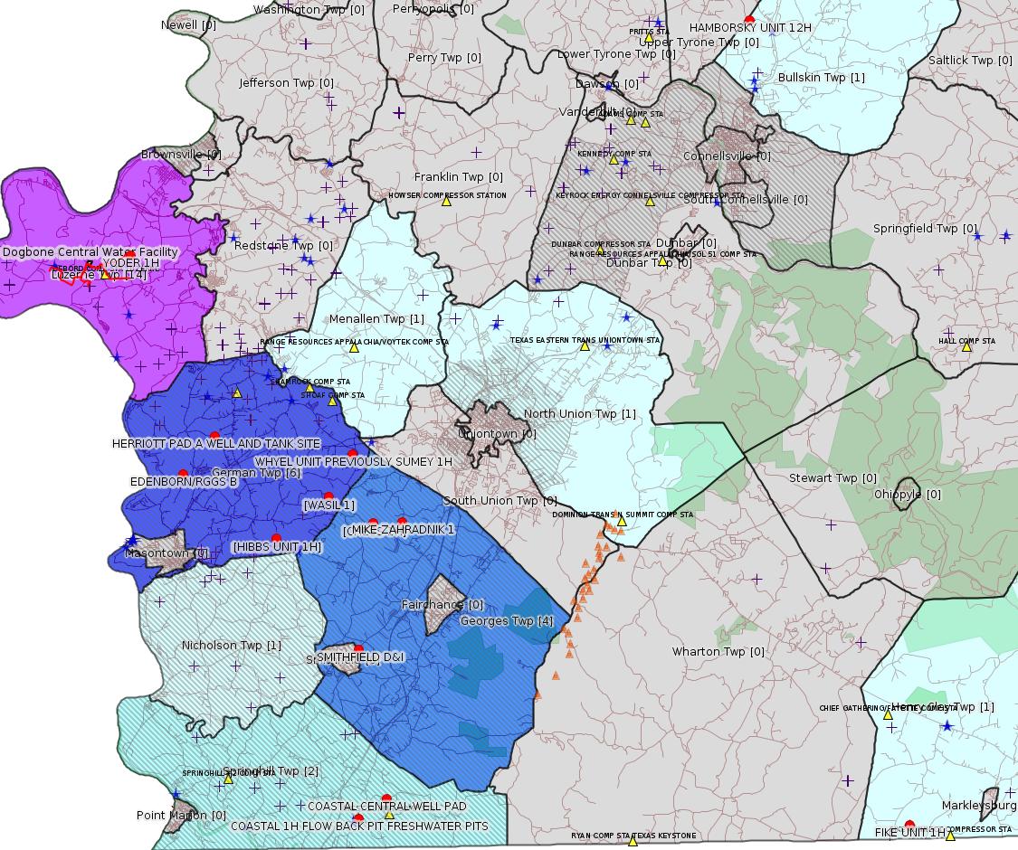
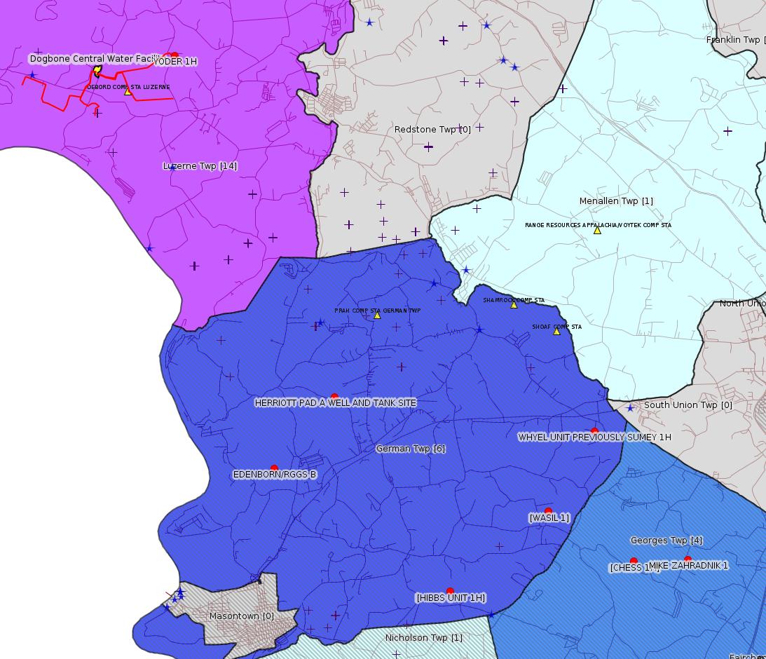
Fayette County Marcellus Shale Permits 4/23/18 - 5/6/18
Click the map to enlarge
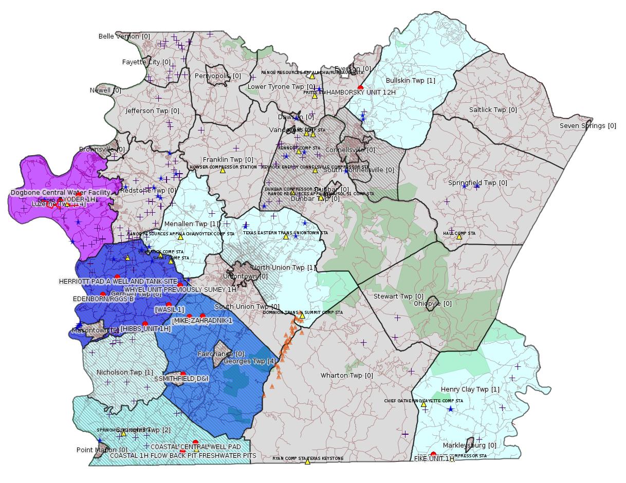
Map
Key
Red dots: items in this permit list with an exact location.
Blue stars: Marcellus Gas Well Water Sources.
Municipality shading: number of "facilities", with each well counting separately
(includes the red dots):
Red dots: items in this permit list with an exact location.
Blue stars: Marcellus Gas Well Water Sources.
Municipality shading: number of "facilities", with each well counting separately
(includes the red dots):
gray: 0
pale turquoise: 1
turquoise: 2
pale blue: 3
middle blue: 4
dark blue: 6
dark purple: 11
purple: 14
(Color coding may differ from one issue to the next.)
(Note if a project spans multiple municipalities -- e.g. a pipeline -- it will show in the count for each municipality.)
The number of facilities also follows the municipality name in brackets.
Municipality counts are based on the way the permit is listed by DEP; DEP has been known to get a municipality wrong.
Locations in brackets identify a precise location used to locate a surrogate for the actual site being permitted (e.g. locating a well pad or pipeline by the known location of a well.) Locations labeled beginning with "~" and ending in "[?]" are approximate and speculative based on inferences using on-line property and lease records. These are marked in the text as "[Approximate, Speculative]
Cross-hatching: Environmental Justice Areas
Yellow triangles: Compressor Stations
Orange triangles: Storage Field Wells (currently Dominion North Summit Storage Field)
Crosses: SPUD Unconventional well permits
Green: "Natural areas", e.g. state game lands, state forests
Yellow triangles: Compressor Stations
Orange triangles: Storage Field Wells (currently Dominion North Summit Storage Field)
Crosses: SPUD Unconventional well permits
Green: "Natural areas", e.g. state game lands, state forests
More Maps
 |
 |
 |
Source: Pennsylvania Bulletin
[Next-door county:]
DEPARTMENT OF CONSERVATION AND NATURAL RESOURCES
Execution of Third Amendment to Oil and Gas Lease for Publicly-Owned Streambeds
[48 Pa.B. 2390]
[Saturday, April 28, 2018]
Effective September 22, 2017, a Third Amendment to Oil and Gas Lease for Publicly-Owned Streambeds, Contract No. M-2102030-04, was executed by and between the Commonwealth, acting through the Department of Conservation and Natural Resources (Department) (lessor) and EQT Production Company (lessee), with its principal place of business located at 625 Liberty Avenue, Pittsburgh, PA 15222.
The lease is for Streambed Tract 2030 on Tenmile Creek encompassing a total of 218.55 acres of submerged lands located in Morgan, Jefferson, Amwell, East Bethlehem, Clarksville, Center and Marianna Borough Townships, Greene and Washington Counties. The lease was recorded at the Greene County courthouse on December 4, 2017, document No. 201700008790, Book 509, Page 1006-1026; and the Washington County courthouse on December 4, 2017, instrument No. 201731683. The lease allows for the development of oil and natural gas below and between the ordinary low water marks of the Tenmile Creek solely by means of directional, including horizontal, drilling on a nondevelopment basis that will not disturb the river or its bed. Contract No. M-2102030-04 may be viewed online at http://contracts.patreasury.gov/Admin/Upload/432780_Third%20Amendment%20Tract%202030%20M-2102030-04%20-%20EQT%20Tenmile%20Creek.pdf.
Questions regarding this lease should be directed to the Department's Bureau of Forestry, Minerals Division, (717) 787-2703.
CINDY ADAMS DUNN,
Secretary
<https://www.pabulletin.com/secure/data/vol48/48-17/638.html>
---
NOTICES
INDEPENDENT REGULATORY REVIEW COMMISSION
Action Taken by the Commission
[48 Pa.B. 2731]
[Saturday, May 5, 1018]
Approval Order
Public Meeting Held
April 19, 2018
Commissioners Voting: George D. Bedwick, Chairperson; John F. Mizner, Esq., Vice Chairperson; W. Russell Faber; Murray Ufberg, Esq.; Dennis A. Watson, Esq.
Environmental Quality Board
Handling and Use of Explosives
Regulation No. 7-522 (# 3138)
On February 17, 2016, the Independent Regulatory Review Commission (Commission) received this proposed regulation from the Environmental Quality Board (Board). This rulemaking amends 25 Pa. Code Chapters 210 and 211. The proposed regulation was published in the February 27, 2016 Pennsylvania Bulletin with a public comment period ending March 28, 2016. The final-form regulation was submitted to the Commission on March 16, 2018.
This final regulation amends regulations to address the use of explosives for seismic exploration, update explosives use requirements and eliminate antiquated requirements.
We have determined this regulation is consistent with the statutory authority of the Board (52 P.S. §§ 1396.4b and 3311(e); 71 P.S. §§ 751-22 and 751-35; 73 P.S. §§ 157, 161, 166, and 167) and the intention of the General Assembly. Having considered all of the other criteria of the Regulatory Review Act, we find promulgation of this regulation is in the public interest.
By Order of the Commission:
This regulation is approved.
GEORGE D. BEDWICK,
Chairperson
<https://www.pabulletin.com/secure/data/vol48/48-18/700.html>
-------------------------
Source: eNOTICE (+ PA Oil and Gas Mapping, Well Pad Report.) Well Details via Data Portal Services: Oil and Gas Wells All (ID: 3).
Please see the Disclaimer below regarding Parcel Id data.
New:
Authorization ID: 1227101
Permit number: ESX18-051-0003
Site: EDENBORN/RGGS B ESCGP ESX18-051-0003
Client: CHEVRON APPALACHIA LLC
Authorization type: Expedited E&S Stormwater General Permit 1
Application type: New
Authorization is for: SITE
Date received: 05/03/2018
Status: Pending
Permit Decision Guarantee Applies?: Yes
Permit Decision Guarantee status: ACTIVE
<http://www.ahs.dep.pa.gov/eFACTSWeb/searchResults_singleAuth.aspx?AuthID=1227101>
Site Programs:
Municipalities:
German Twp [an Environmental Justice Area], Fayette County
Well Pad ID: 155083
Location: 39.881931,-79.896106 <https://osm.org/go/ZWpN6mOL--?m=>
Wells on this Pad:
051-24651 EDENBORN/RGGS B 1
Presumed Parcel Id: 15220014
New:
Authorization ID: 1226967
Permit number: ESX18-051-0002
Site: HERRIOTT PAD A WELL AND TANK SITE ESCGP ESX18-051-0002
Client: CHEVRON APPALACHIA LLC
Authorization type: Expedited E&S Stormwater General Permit 1
Application type: New
Authorization is for: SITE
Date received: 05/01/2018
Status: Pending
Permit Decision Guarantee Applies?: Yes
Permit Decision Guarantee status: ACTIVE
<http://www.ahs.dep.pa.gov/eFACTSWeb/searchResults_singleAuth.aspx?AuthID=1226967>
Site Programs:
Municipalities:
German Twp [an Environmental Justice Area], Fayette County
Well Pad ID: 155082
Location: 39.897981,-79.878003 <https://osm.org/go/ZWpPXJxr--?m=>
Wells on this Pad:
051-24649 HERRIOTT 1
Presumed Parcel Id: 15220125
New:
Authorization ID: 1226745
Permit number: 051-20362
Site: MIKE ZAHRADNIK 1 WELL
Client: BURNETT OIL CO INC
Authorization type: Well Plugging Notice Intent to Plug Single Well
Application type: New
Authorization is for: FACILITY
Date received: 05/01/2018
Status: Issued on 5/1/2018
Permit Decision Guarantee Applies?: No
Sub-Facilities for Authorization:
Sub-Facility ID Sub-Facility Name Description
56542 MIKE ZAHRADNIK 1 Well
Permit Review Notes:
Date Review Note
5/1/2018 The technical review and decision review are complete and either the permit decision and/or permit issuance are forthcoming.
5/1/2018 The permit application package is complete, has been accepted, and is undergoing technical review.
<http://www.ahs.dep.pa.gov/eFACTSWeb/searchResults_singleAuth.aspx?AuthID=1226745>
Site Programs:
Oil & Gas
Municipalities:
Georges Twp [an Environmental Justice Area], Fayette County
Well Details:
Permit Number: 051-20362
Well Name: MIKE ZAHRADNIK 1
Unconventional Well: N
Well Configuration: Vertical Well
Well Type: GAS
Well Status: Active
Coal Association: Coal
Conservation Well: N
Primary Facility ID: 43012
Site ID: 41260
Site Name: MIKE ZAHRADNIK 1 WELL
Well Pad ID: 0
Well Pad Name:
Storage Field:
Operator: BURNETT OIL CO INC
Operator Number: OGO-39119
Permit Date: 1983-06-08
Permit Date Expires: 1984-06-08
SPUD Date: 1983-10-17
Date Plugged:
UIC ID:
UIC Type:
Surface Elevation: 1211
County: Fayette
Municipality: Georges Twp
Location: 39.860056,-79.774694
Map URL: <http://www.openstreetmap.org/?mlat=39.860056&mlon=-79.774694#map=15/39.860056/-79.774694>
New:
Authorization ID: 1225814
Permit number: ESX11-051-0017
Site: WHYEL UNIT PREVIOUSLY SUMEY 1H ESCGP-EXPEDITED
Client: INR OPERATING LLC
Authorization type: Expedited E&S Stormwater General Permit 1
Application type: Transfer
Authorization is for: SITE
Date received: 04/18/2018
Status: Pending
Permit Decision Guarantee Applies?: Yes
Permit Decision Guarantee status: ACTIVE
<http://www.ahs.dep.pa.gov/eFACTSWeb/searchResults_singleAuth.aspx?AuthID=1225814>
Site Programs:
Oil & Gas
Municipalities:
German Twp [an Environmental Justice Area], Fayette County
Well Pad ID: 147078
Location: 39.889444,-79.801667 <https://osm.org/go/ZWplRZDx--?m=>
Wells on this Pad:
051-24449 WHYEL UNIT 1H
Presumed Parcel Id: 15290036
New:
Authorization ID: 1225811
Permit number: ESX11-051-0025
Site: WASIL 1 WELL PAD ESCGP-EXPEDITED
Client: INR OPERATING LLC
Authorization type: Expedited E&S Stormwater General Permit 1
Application type: Transfer
Authorization is for: SITE
Date received: 04/18/2018
Status: Pending
Permit Decision Guarantee Applies?: Yes
Permit Decision Guarantee status: ACTIVE
<http://www.ahs.dep.pa.gov/eFACTSWeb/searchResults_singleAuth.aspx?AuthID=1225811>
Site Programs:
Oil & Gas
Municipalities:
German Twp [an Environmental Justice Area], Fayette County
Location [of WASIL 1]: 39.871472,-79.815522 <http://osm.org/go/ZWpPuFAu--?m=>
Presumed Parcel Id: 1536004304
New:
Authorization ID: 1225809
Permit number: ESX10-051-0026
Site: HIBBS 1H ESCGP-EXPEDITED
Client: INR OPERATING LLC
Authorization type: Expedited E&S Stormwater General Permit 1
Application type: Transfer
Authorization is for: SITE
Date received: 04/18/2018
Status: Pending
Permit Decision Guarantee Applies?: Yes
Permit Decision Guarantee status: ACTIVE
<http://www.ahs.dep.pa.gov/eFACTSWeb/searchResults_singleAuth.aspx?AuthID=1225809>
Site Programs:
Oil & Gas
Municipalities:
German Twp [an Environmental Justice Area], Fayette County
Nicholson Twp, Fayette County [likely incorrect -jr]
Location [of HIBBS UNIT 1H]: 39.853611,-79.844861 <https://osm.org/go/ZWpO1Jir--?m=>
Presumed Parcel Id: 1536010401
[See Notes.]
New:
Authorization ID: 1225805
Permit number: ESX15-051-0012
Site: COASTAL CENTRAL WELL PAD ESCGP-2 EXPEDITED
Client: INR OPERATING LLC
Authorization type: Expedited E&S Stormwater General Permit 1
Application type: Transfer
Authorization is for: SITE
Date received: 04/18/2018
Status: Pending
Permit Decision Guarantee Applies?: Yes
Permit Decision Guarantee status: ACTIVE
<http://www.ahs.dep.pa.gov/eFACTSWeb/searchResults_singleAuth.aspx?AuthID=1225805>
Site Programs:
Municipalities:
Springhill Twp [an Environmental Justice Area], Fayette County
Location: 39.7415,-79.7854 <http://osm.org/go/ZWpKm56R--?m=>
Presumed Parcel Id: 36210048
New:
Authorization ID: 1225804
Permit number: ESX10-051-0035
Site: COASTAL 1H FLOW BACK PIT FRESHWATER PITS ESCGP-EXPEDITED
Client: INR OPERATING LLC
Authorization type: Expedited E&S Stormwater General Permit 1
Application type: Transfer
Authorization is for: SITE
Date received: 04/18/2018
Status: Pending
Permit Decision Guarantee Applies?: Yes
Permit Decision Guarantee status: ACTIVE
<http://www.ahs.dep.pa.gov/eFACTSWeb/searchResults_singleAuth.aspx?AuthID=1225804>
Site Programs:
Oil & Gas
Municipalities:
Springhill Twp [an Environmental Justice Area], Fayette County
Location: 39.733294,-79.801028 <https://osm.org/go/ZWpgBJ2N--?m=>
Presumed Parcel Id: 36210048
Well Pad Id: 147971
Wells on this pad:
051-24318 COASTAL 1H
051-24382 COASTAL/SMITH UNIT 1H
New:
Authorization ID: 1225792
Permit number: ESX10-051-0017
Site: CHESS 1H ESCGP-EXPEDITED
Client: INR OPERATING LLC
Authorization type: Expedited E&S Stormwater General Permit 1
Application type: Transfer
Authorization is for: SITE
Date received: 04/18/2018
Status: Pending
Permit Decision Guarantee Applies?: Yes
Permit Decision Guarantee status: ACTIVE
Permit Review Notes:
Date Review Note
4/25/2018 The permit application package is complete, has been accepted, and is undergoing technical review.
<http://www.ahs.dep.pa.gov/eFACTSWeb/searchResults_singleAuth.aspx?AuthID=1225792>
Site Programs:
Oil & Gas
Municipalities:
Georges Twp [an Environmental Justice Area], Fayette County
Location [of CHESS 1H]: 39.859833,-79.790694 <http://osm.org/go/ZWplCMCx--?m=>
Presumed Parcel Id: 14060098
Authorization ID: 1219473
Permit number: GP08260718001
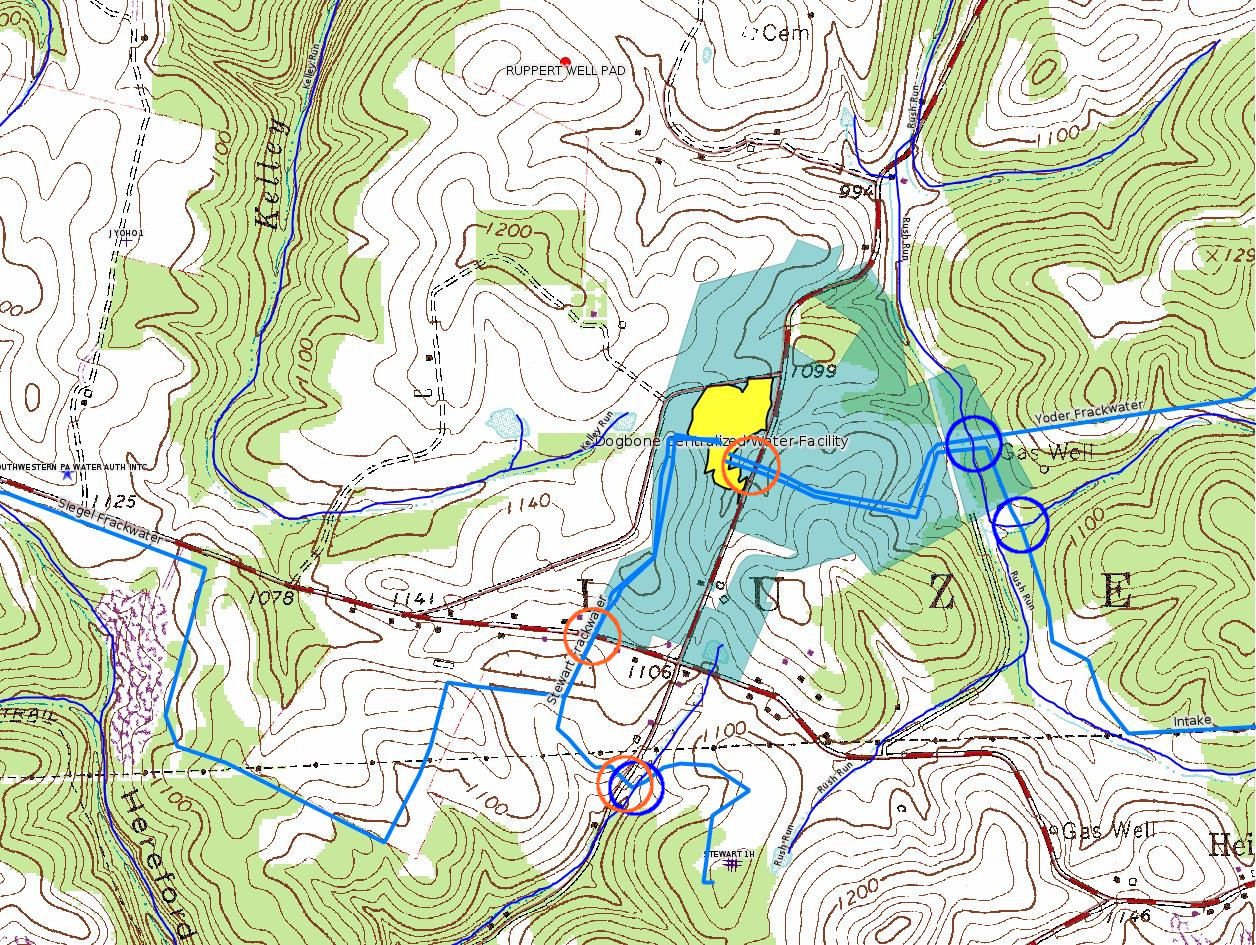
Site: DOGBONE WATER LINE SYSTEM GP5 & GP8
Client: CHEVRON APPALACHIA LLC
Authorization type: GP-08 Temporary Road Crossings
Application type: New
Authorization is for: FACILITY
Date received: 02/26/2018
Status: Pending
Permit Decision Guarantee Applies?: No
Sub-Facilities for Authorization:
Sub-Facility ID Sub-Facility Name Description
1255183 DOGBONE WATER LINE SYSTEM GP08260718-001 Bridge
Permit Review Notes:
Date Review Note
4/20/2018 Applicant has been issued a deficiency letter. If applicable, this application no longer qualifies for the Permit Decision Guarantee.
<http://www.ahs.dep.pa.gov/eFACTSWeb/searchResults_singleAuth.aspx?AuthID=1219473>
Site Programs:
Water Planning and Conservation
Municipalities:
Luzerne Twp, Fayette County
Authorization ID: 1219469
Permit number: GP05260718001
Site: DOGBONE WATER LINE SYSTEM GP5 & GP8
Client: CHEVRON APPALACHIA LLC
Authorization type: GP-05 Utility Line Stream Crossings
Application type: New
Authorization is for: FACILITY
Date received: 02/26/2018
Status: Pending
Permit Decision Guarantee Applies?: Yes
Permit Decision Guarantee status: VOID
Sub-Facilities for Authorization:
Sub-Facility ID Sub-Facility Name Description
1255180 DOGBONE WATER LINE SYSTEM GP05260718-001 Pipeline or Conduit
Permit Review Notes:
Date Review Note
4/20/2018 Applicant has been issued a deficiency letter. If applicable, this application no longer qualifies for the Permit Decision Guarantee.
<http://www.ahs.dep.pa.gov/eFACTSWeb/searchResults_singleAuth.aspx?AuthID=1219469>
Site Programs:
Water Planning and Conservation
Municipalities:
Luzerne Twp, Fayette County
Authorization ID: 1219420
Permit number: GP052618203
Site: TEXAS EASTERN TRANSMISSION FAYETTE CNTY
Client: TEXAS EASTERN TRANS LP
Authorization type: GP-05 Utility Line Stream Crossings
Application type: New
Authorization is for: FACILITY
Date received: 03/01/2018
Status: Pending
Permit Decision Guarantee Applies?: Yes
Permit Decision Guarantee status: ACTIVE
Permit Review Notes:
Date Review Note
4/25/2018 The permit application package is complete, has been accepted, and is undergoing technical review.
<http://www.ahs.dep.pa.gov/eFACTSWeb/searchResults_singleAuth.aspx?AuthID=1219420>
Site Programs:
Water Planning and Conservation
Municipalities:
German Twp, Fayette County
Menallen Twp, Fayette County
North Union Twp, Fayette County
Authorization ID: 1149059
Permit number: 051-24164
Site: FIKE UNIT 1H OG WELL
Client: LPR ENERGY LLC
Authorization type: Drill & Operate Well Permit Inactive Status
Application type: New
Authorization is for: FACILITY
Date received: 06/23/2016
Status: Issued on 4/23/2018
Permit Decision Guarantee Applies?: No
Sub-Facilities for Authorization:
Sub-Facility ID Sub-Facility Name Description
983871 FIKE UNIT 1H Well
Permit Review Notes:
Date Review Note
4/23/2018 The technical review and decision review are complete and either the permit decision and/or permit issuance are forthcoming.
8/24/2016 The permit application package is complete, has been accepted, and is undergoing technical review.
<http://www.ahs.dep.pa.gov/eFACTSWeb/searchResults_singleAuth.aspx?AuthID=1149059>
Site Programs:
Oil & Gas
Municipalities:
Henry Clay Twp, Fayette County
Well Details:
Permit Number: 051-24164
Well Name: FIKE UNIT 1H
Unconventional Well: Y
Well Configuration: Horizontal Well
Well Type: GAS
Well Status: Regulatory Inactive Status
Coal Association: NonCoal
Conservation Well: Y
Primary Facility ID: 715064
Site ID: 716179
Site Name: FIKE UNIT 1H OG WELL
Well Pad ID: 146852
Well Pad Name: FIKE UNIT 1H
Storage Field:
Operator: LPR ENERGY LLC
Operator Number: OGO-68579
Permit Date: 2009-02-09
Permit Date Expires: 2010-02-09
SPUD Date: 2009-02-12
Date Plugged:
UIC ID:
UIC Type:
Surface Elevation: 2222
County: Fayette
Municipality: Henry Clay Twp
Location: 39.727028,-79.495752
Map URL: <http://www.openstreetmap.org/?mlat=39.727028&mlon=-79.495752#map=15/39.727028/-79.495752>
Presumed Parcel Id: 16190003
Authorization ID: 998899
Permit number: 26-00602A
Site: SMITHFIELD D&I
Client: D&I LLC
Authorization type: Minor Facility Plan Approval State Regulation
Application type: New
Authorization is for: FACILITY
Date received: 10/22/2013
Status: Pending
Permit Decision Guarantee Applies?: Yes
Permit Decision Guarantee status: VOID
Permit Review Notes:
Date Review Note
7/9/2015 Applicant has been issued a deficiency letter. If applicable, this application no longer qualifies for the Permit Decision Guarantee.
10/22/2013 The permit application package is complete, has been accepted, and is undergoing technical review.
<http://www.ahs.dep.pa.gov/eFACTSWeb/searchResults_singleAuth.aspx?AuthID=998899>
Site Programs:
Air Quality
Municipalities:
Georges Twp, Fayette County
Location: 39.805767,-79.799581 <https://osm.org/go/ZWphUPm2--?m=>
-------------------------
Source: DEP SPUD (drilling started) Report
SPUD_DATE: 5/7/2018
API: 051-24652
OGO_NUM: OGO-39307
OPERATOR: CHEVRON APPALACHIA LLC
REGION: EP DOGO SWDO Dstr Off
COUNTY: Fayette
MUNICIPALITY: Luzerne Twp
FARM_NAME: YODER 1H
WELL_CODE_DESC: GAS
WELL_STATUS: Active
LATITUDE: 39.975686
LONGITUDE: -79.923872
CONFIGURATION: Horizontal Well
UNCONVENTIONAL: Yes
Well Details:
Permit Number: 051-24652
Well Name: YODER 1H
Unconventional Well: Y
Well Configuration: Horizontal Well
Well Type: GAS
Well Status: Active
Coal Association: NonCoal
Conservation Well: N
Primary Facility ID: 824625
Site ID: 790607
Site Name: YODER WELL PAD ESCGP-2 EXPEDITED
Well Pad ID: 153100
Well Pad Name: YODER
Storage Field:
Operator: CHEVRON APPALACHIA LLC
Operator Number: OGO-39307
Permit Date: 2018-03-06
Permit Date Expires: 2019-03-06
SPUD Date: 2018-05-07
Date Plugged:
UIC ID:
UIC Type:
Surface Elevation: 1118
County: Fayette
Municipality: Luzerne Twp
Location: 39.975686,-79.923872
Map URL: <http://www.openstreetmap.org/?mlat=39.975686&mlon=-79.923872#map=15/39.975686/-79.923872>
Presumed Parcel Id: 19160034
SPUD_DATE: 5/7/2018
API: 051-24653
OGO_NUM: OGO-39307
OPERATOR: CHEVRON APPALACHIA LLC
REGION: EP DOGO SWDO Dstr Off
COUNTY: Fayette
MUNICIPALITY: Luzerne Twp
FARM_NAME: YODER 2H
WELL_CODE_DESC: GAS
WELL_STATUS: Active
LATITUDE: 39.975647
LONGITUDE: -79.923872
CONFIGURATION: Horizontal Well
UNCONVENTIONAL: Yes
Well Details:
Permit Number: 051-24653
Well Name: YODER 2H
Unconventional Well: Y
Well Configuration: Horizontal Well
Well Type: GAS
Well Status: Active
Coal Association: NonCoal
Conservation Well: N
Primary Facility ID: 824627
Site ID: 790607
Site Name: YODER WELL PAD ESCGP-2 EXPEDITED
Well Pad ID: 153100
Well Pad Name: YODER
Storage Field:
Operator: CHEVRON APPALACHIA LLC
Operator Number: OGO-39307
Permit Date: 2018-03-06
Permit Date Expires: 2019-03-06
SPUD Date: 2018-05-07
Date Plugged:
UIC ID:
UIC Type:
Surface Elevation: 1118
County: Fayette
Municipality: Luzerne Twp
Location: 39.975647,-79.923872
Map URL: <http://www.openstreetmap.org/?mlat=39.975647&mlon=-79.923872#map=15/39.975647/-79.923872>
SPUD_DATE: 5/7/2018
API: 051-24654
OGO_NUM: OGO-39307
OPERATOR: CHEVRON APPALACHIA LLC
REGION: EP DOGO SWDO Dstr Off
COUNTY: Fayette
MUNICIPALITY: Luzerne Twp
FARM_NAME: YODER 3H
WELL_CODE_DESC: GAS
WELL_STATUS: Active
LATITUDE: 39.975606
LONGITUDE: -79.923875
CONFIGURATION: Horizontal Well
UNCONVENTIONAL: Yes
Well Details:
Permit Number: 051-24654
Well Name: YODER 3H
Unconventional Well: Y
Well Configuration: Horizontal Well
Well Type: GAS
Well Status: Active
Coal Association: NonCoal
Conservation Well: N
Primary Facility ID: 824628
Site ID: 790607
Site Name: YODER WELL PAD ESCGP-2 EXPEDITED
Well Pad ID: 153100
Well Pad Name: YODER
Storage Field:
Operator: CHEVRON APPALACHIA LLC
Operator Number: OGO-39307
Permit Date: 2018-03-12
Permit Date Expires: 2019-03-12
SPUD Date: 2018-05-07
Date Plugged:
UIC ID:
UIC Type:
Surface Elevation: 1118
County: Fayette
Municipality: Luzerne Twp
Location: 39.975606,-79.923875
Map URL: <http://www.openstreetmap.org/?mlat=39.975606&mlon=-79.923875#map=15/39.975606/-79.923875>
SPUD_DATE: 5/7/2018
API: 051-24655
OGO_NUM: OGO-39307
OPERATOR: CHEVRON APPALACHIA LLC
REGION: EP DOGO SWDO Dstr Off
COUNTY: Fayette
MUNICIPALITY: Luzerne Twp
FARM_NAME: YODER 4H
WELL_CODE_DESC: GAS
WELL_STATUS: Active
LATITUDE: 39.975564
LONGITUDE: -79.923878
CONFIGURATION: Horizontal Well
UNCONVENTIONAL: Yes
Well Details:
Permit Number: 051-24655
Well Name: YODER 4H
Unconventional Well: Y
Well Configuration: Horizontal Well
Well Type: GAS
Well Status: Active
Coal Association: NonCoal
Conservation Well: N
Primary Facility ID: 824629
Site ID: 790607
Site Name: YODER WELL PAD ESCGP-2 EXPEDITED
Well Pad ID: 153100
Well Pad Name: YODER
Storage Field:
Operator: CHEVRON APPALACHIA LLC
Operator Number: OGO-39307
Permit Date: 2018-03-06
Permit Date Expires: 2019-03-06
SPUD Date: 2018-05-07
Date Plugged:
UIC ID:
UIC Type:
Surface Elevation: 1118
County: Fayette
Municipality: Luzerne Twp
Location: 39.975564,-79.923878
Map URL: <http://www.openstreetmap.org/?mlat=39.975564&mlon=-79.923878#map=15/39.975564/-79.923878>
SPUD_DATE: 5/7/2018
API: 051-24656
OGO_NUM: OGO-39307
OPERATOR: CHEVRON APPALACHIA LLC
REGION: EP DOGO SWDO Dstr Off
COUNTY: Fayette
MUNICIPALITY: Luzerne Twp
FARM_NAME: YODER 5H
WELL_CODE_DESC: GAS
WELL_STATUS: Active
LATITUDE: 39.975522
LONGITUDE: -79.923878
CONFIGURATION: Horizontal Well
UNCONVENTIONAL: Yes
Well Details:
Permit Number: 051-24656
Well Name: YODER 5H
Unconventional Well: Y
Well Configuration: Horizontal Well
Well Type: GAS
Well Status: Active
Coal Association: NonCoal
Conservation Well: N
Primary Facility ID: 824630
Site ID: 790607
Site Name: YODER WELL PAD ESCGP-2 EXPEDITED
Well Pad ID: 153100
Well Pad Name: YODER
Storage Field:
Operator: CHEVRON APPALACHIA LLC
Operator Number: OGO-39307
Permit Date: 2018-03-06
Permit Date Expires: 2019-03-06
SPUD Date: 2018-05-07
Date Plugged:
UIC ID:
UIC Type:
Surface Elevation: 1118
County: Fayette
Municipality: Luzerne Twp
Location: 39.975522,-79.923878
Map URL: <http://www.openstreetmap.org/?mlat=39.975522&mlon=-79.923878#map=15/39.975522/-79.923878>
SPUD_DATE: 5/7/2018
API: 051-24657
OGO_NUM: OGO-39307
OPERATOR: CHEVRON APPALACHIA LLC
REGION: EP DOGO SWDO Dstr Off
COUNTY: Fayette
MUNICIPALITY: Luzerne Twp
FARM_NAME: YODER 6H
WELL_CODE_DESC: GAS
WELL_STATUS: Active
LATITUDE: 39.975481
LONGITUDE: -79.923881
CONFIGURATION: Horizontal Well
UNCONVENTIONAL: Yes
Well Details:
Permit Number: 051-24657
Well Name: YODER 6H
Unconventional Well: Y
Well Configuration: Horizontal Well
Well Type: GAS
Well Status: Active
Coal Association: NonCoal
Conservation Well: N
Primary Facility ID: 824631
Site ID: 790607
Site Name: YODER WELL PAD ESCGP-2 EXPEDITED
Well Pad ID: 153100
Well Pad Name: YODER
Storage Field:
Operator: CHEVRON APPALACHIA LLC
Operator Number: OGO-39307
Permit Date: 2018-03-06
Permit Date Expires: 2019-03-06
SPUD Date: 2018-05-07
Date Plugged:
UIC ID:
UIC Type:
Surface Elevation: 1118
County: Fayette
Municipality: Luzerne Twp
Location: 39.975481,-79.923881
Map URL: <http://www.openstreetmap.org/?mlat=39.975481&mlon=-79.923881#map=15/39.975481/-79.923881>
SPUD_DATE: 5/7/2018
API: 051-24658
OGO_NUM: OGO-39307
OPERATOR: CHEVRON APPALACHIA LLC
REGION: EP DOGO SWDO Dstr Off
COUNTY: Fayette
MUNICIPALITY: Luzerne Twp
FARM_NAME: YODER 7H
WELL_CODE_DESC: GAS
WELL_STATUS: Active
LATITUDE: 39.975442
LONGITUDE: -79.923883
CONFIGURATION: Horizontal Well
UNCONVENTIONAL: Yes
Well Details:
Permit Number: 051-24658
Well Name: YODER 7H
Unconventional Well: Y
Well Configuration: Horizontal Well
Well Type: GAS
Well Status: Active
Coal Association: NonCoal
Conservation Well: N
Primary Facility ID: 824632
Site ID: 790607
Site Name: YODER WELL PAD ESCGP-2 EXPEDITED
Well Pad ID: 153100
Well Pad Name: YODER
Storage Field:
Operator: CHEVRON APPALACHIA LLC
Operator Number: OGO-39307
Permit Date: 2018-03-06
Permit Date Expires: 2019-03-06
SPUD Date: 2018-05-07
Date Plugged:
UIC ID:
UIC Type:
Surface Elevation: 1118
County: Fayette
Municipality: Luzerne Twp
Location: 39.975442,-79.923883
Map URL: <http://www.openstreetmap.org/?mlat=39.975442&mlon=-79.923883#map=15/39.975442/-79.923883>
SPUD_DATE: 5/7/2018
API: 051-24659
OGO_NUM: OGO-39307
OPERATOR: CHEVRON APPALACHIA LLC
REGION: EP DOGO SWDO Dstr Off
COUNTY: Fayette
MUNICIPALITY: Luzerne Twp
FARM_NAME: YODER 8H
WELL_CODE_DESC: GAS
WELL_STATUS: Active
LATITUDE: 39.975400
LONGITUDE: -79.923886
CONFIGURATION: Horizontal Well
UNCONVENTIONAL: Yes
Well Details:
Permit Number: 051-24659
Well Name: YODER 8H
Unconventional Well: Y
Well Configuration: Horizontal Well
Well Type: GAS
Well Status: Active
Coal Association: NonCoal
Conservation Well: N
Primary Facility ID: 824633
Site ID: 790607
Site Name: YODER WELL PAD ESCGP-2 EXPEDITED
Well Pad ID: 153100
Well Pad Name: YODER
Storage Field:
Operator: CHEVRON APPALACHIA LLC
Operator Number: OGO-39307
Permit Date: 2018-03-06
Permit Date Expires: 2019-03-06
SPUD Date: 2018-05-07
Date Plugged:
UIC ID:
UIC Type:
Surface Elevation: 1118
County: Fayette
Municipality: Luzerne Twp
Location: 39.9754,-79.923886
Map URL: <http://www.openstreetmap.org/?mlat=39.9754&mlon=-79.923886#map=15/39.9754/-79.923886>
SPUD_DATE: 5/7/2018
API: 051-24660
OGO_NUM: OGO-39307
OPERATOR: CHEVRON APPALACHIA LLC
REGION: EP DOGO SWDO Dstr Off
COUNTY: Fayette
MUNICIPALITY: Luzerne Twp
FARM_NAME: YODER 9H
WELL_CODE_DESC: GAS
WELL_STATUS: Active
LATITUDE: 39.975683
LONGITUDE: -79.923764
CONFIGURATION: Horizontal Well
UNCONVENTIONAL: Yes
Well Details:
Permit Number: 051-24660
Well Name: YODER 9H
Unconventional Well: Y
Well Configuration: Horizontal Well
Well Type: GAS
Well Status: Active
Coal Association: NonCoal
Conservation Well: N
Primary Facility ID: 824634
Site ID: 790607
Site Name: YODER WELL PAD ESCGP-2 EXPEDITED
Well Pad ID: 153100
Well Pad Name: YODER
Storage Field:
Operator: CHEVRON APPALACHIA LLC
Operator Number: OGO-39307
Permit Date: 2018-03-06
Permit Date Expires: 2019-03-06
SPUD Date: 2018-05-07
Date Plugged:
UIC ID:
UIC Type:
Surface Elevation: 1118
County: Fayette
Municipality: Luzerne Twp
Location: 39.975683,-79.923764
Map URL: <http://www.openstreetmap.org/?mlat=39.975683&mlon=-79.923764#map=15/39.975683/-79.923764>
SPUD_DATE: 5/7/2018
API: 051-24661
OGO_NUM: OGO-39307
OPERATOR: CHEVRON APPALACHIA LLC
REGION: EP DOGO SWDO Dstr Off
COUNTY: Fayette
MUNICIPALITY: Luzerne Twp
FARM_NAME: YODER 10H
WELL_CODE_DESC: GAS
WELL_STATUS: Active
LATITUDE: 39.975644
LONGITUDE: -79.923767
CONFIGURATION: Horizontal Well
UNCONVENTIONAL: Yes
Well Details:
Permit Number: 051-24661
Well Name: YODER 10H
Unconventional Well: Y
Well Configuration: Horizontal Well
Well Type: GAS
Well Status: Active
Coal Association: NonCoal
Conservation Well: N
Primary Facility ID: 824635
Site ID: 790607
Site Name: YODER WELL PAD ESCGP-2 EXPEDITED
Well Pad ID: 153100
Well Pad Name: YODER
Storage Field:
Operator: CHEVRON APPALACHIA LLC
Operator Number: OGO-39307
Permit Date: 2018-03-06
Permit Date Expires: 2019-03-06
SPUD Date: 2018-05-07
Date Plugged:
UIC ID:
UIC Type:
Surface Elevation: 1118
County: Fayette
Municipality: Luzerne Twp
Location: 39.975644,-79.923767
Map URL: <http://www.openstreetmap.org/?mlat=39.975644&mlon=-79.923767#map=15/39.975644/-79.923767>
SPUD_DATE: 5/7/2018
API: 051-24662
OGO_NUM: OGO-39307
OPERATOR: CHEVRON APPALACHIA LLC
REGION: EP DOGO SWDO Dstr Off
COUNTY: Fayette
MUNICIPALITY: Luzerne Twp
FARM_NAME: YODER 11H
WELL_CODE_DESC: GAS
WELL_STATUS: Active
LATITUDE: 39.975603
LONGITUDE: -79.923769
CONFIGURATION: Horizontal Well
UNCONVENTIONAL: Yes
Well Details:
Permit Number: 051-24662
Well Name: YODER 11H
Unconventional Well: Y
Well Configuration: Horizontal Well
Well Type: GAS
Well Status: Active
Coal Association: NonCoal
Conservation Well: N
Primary Facility ID: 824636
Site ID: 790607
Site Name: YODER WELL PAD ESCGP-2 EXPEDITED
Well Pad ID: 153100
Well Pad Name: YODER
Storage Field:
Operator: CHEVRON APPALACHIA LLC
Operator Number: OGO-39307
Permit Date: 2018-03-06
Permit Date Expires: 2019-03-06
SPUD Date: 2018-05-07
Date Plugged:
UIC ID:
UIC Type:
Surface Elevation: 1118
County: Fayette
Municipality: Luzerne Twp
Location: 39.975603,-79.923769
Map URL: <http://www.openstreetmap.org/?mlat=39.975603&mlon=-79.923769#map=15/39.975603/-79.923769>
SPUD_DATE: 5/7/2018
API: 051-24663
OGO_NUM: OGO-39307
OPERATOR: CHEVRON APPALACHIA LLC
REGION: EP DOGO SWDO Dstr Off
COUNTY: Fayette
MUNICIPALITY: Luzerne Twp
FARM_NAME: YODER 12H
WELL_CODE_DESC: GAS
WELL_STATUS: Active
LATITUDE: 39.975561
LONGITUDE: -79.923769
CONFIGURATION: Horizontal Well
UNCONVENTIONAL: Yes
Well Details:
Permit Number: 051-24663
Well Name: YODER 12H
Unconventional Well: Y
Well Configuration: Horizontal Well
Well Type: GAS
Well Status: Active
Coal Association: NonCoal
Conservation Well: N
Primary Facility ID: 824637
Site ID: 790607
Site Name: YODER WELL PAD ESCGP-2 EXPEDITED
Well Pad ID: 153100
Well Pad Name: YODER
Storage Field:
Operator: CHEVRON APPALACHIA LLC
Operator Number: OGO-39307
Permit Date: 2018-03-06
Permit Date Expires: 2019-03-06
SPUD Date: 2018-05-07
Date Plugged:
UIC ID:
UIC Type:
Surface Elevation: 1118
County: Fayette
Municipality: Luzerne Twp
Location: 39.975561,-79.923769
Map URL: <http://www.openstreetmap.org/?mlat=39.975561&mlon=-79.923769#map=15/39.975561/-79.923769>
-------------------------
Source: DEP Oil and Gas Compliance Report
OPERATOR: CHEVRON APPALACHIA LLC
INSPECTION_ID: 2723185
INSPECTION_DATE: 04/23/2018
INSPECTION_TYPE: Administrative/File Review
API_PERMIT: 051-24381
FARM_NAME: HAMBORSKY UNIT 12H
UNCONVENTIONAL: Yes
SITE_ID: 737696
SITE_NAME: HAMBORSKY UNIT 12H OG WELL
FACILITY_TYPE: Oil & Gas Location
INSPECTION_CATEGORY: Primary Facility
REGION: EP DOGO SWDO Dstr Off
COUNTY: Fayette
MUNICIPALITY: Bullskin Twp
INSPECTOR: WITHAM, CYNTHIA
INSPECTION_SOURCE: SAIR
INSPECTION_RESULT_DESCRIPTION: Outstanding Violations - Viols Req'd
INSPECTION_COMMENT: "ADMIN inspection to inspection record #2685605 where a violation was issued for failure to comply with 25 PA Code 102 (E and S requirements).
Department reviewed file for ESX09-051-0044 Hamborsky 12H, 13H. According to this file, this ESCGP-1 was issued in 2009 and a major modification was approved on 12-24-2011. The NOT for this permit was approved on 1-22-2013 with the following comments: ""Operator was reminded to check vegetative growth in area of reclaimed sed trap in spring 2014 to ensure it continues to have 70% uniform coverage. ""
Submitted with the ESCGP-1 is a Post-Construction Stormwater Management/Restoration Narrative. This narrative states that water quality is provided through infiltration system, swales, diversion ditches, and seeding and landscaping. This narrative also states that inspections will be conducted on these BMP's on a yearly basis (at least). In inspection record #2718219 Department requested copies of the inspections of the infiltration bed for the last 2 years. As of today, those copies have not been received.
Violation issued on 1-22-18 remains outstanding. A follow up inspection will be conducted at a later date."
VIOLATION_ID: 814826
VIOLATION_DATE: 01/22/2018
VIOLATION_CODE: 78a53 - EROSION AND SEDIMENT CONTROL AND STORMWATER MANAGEMENT - Person proposing or conducting earth disturbance activities associated with oil and gas operations failed to comply with 25 Pa. Code § 102.
VIOLATION_TYPE: Environmental Health & Safety
VIOLATION_COMMENT: What appears to water is leaving well pad area, entering Ag field.
RESOLVED_DATE:
RESOLUTION_REASON_CODE_DESCRIPTION:
CONTINUING_VIOLATION: Yes
Well Details:
Permit Number: 051-24381
Well Name: HAMBORSKY UNIT 12H
Unconventional Well: Y
Well Configuration: Horizontal Well
Well Type: GAS
Well Status: Active
Coal Association: Coal
Conservation Well: Y
Primary Facility ID: 733126
Site ID: 737696
Site Name: HAMBORSKY UNIT 12H OG WELL
Well Pad ID: 148470
Well Pad Name: HAMBORSKY UNIT 12H
Storage Field:
Operator: CHEVRON APPALACHIA LLC
Operator Number: OGO-39307
Permit Date: 2010-09-09
Permit Date Expires: 2011-09-09
SPUD Date: 2011-06-13
Date Plugged:
UIC ID:
UIC Type:
Surface Elevation: 1200
County: Fayette
Municipality: Bullskin Twp
Location: 40.072761,-79.577281
Map URL: <http://www.openstreetmap.org/?mlat=40.072761&mlon=-79.577281#map=15/40.072761/-79.577281>
Presumed Parcel Id: 04280001
-------------------------
Source: Reuters Commodities: Energy
Natural Gas
| Commodity | Exchange | Currency | Expire | Last Trade | Trade Time | Change | Open | Day's High | Day's Low |
|---|---|---|---|---|---|---|---|---|---|
| NATURAL
GAS CON1 May18 |
NYM | USD | 05/29 | 2.75 | 05/08 04:15 | +0.00 | 2.74 | 2.75 | 2.73 |
<http://www.reuters.com/finance/commodities/energy>
-------------------------
Notes:
Hibbs 1H was apparently never drilled:
Well Details:
Permit Number: 051-24387
Well Name: HIBBS UNIT 1H
Unconventional Well: Y
Well Configuration: Horizontal Well
Well Type: GAS
Well Status: Operator Reported Not Drilled
Coal Association: NonCoal
Conservation Well: N
Primary Facility ID: 734097
Site ID: 738858
Site Name: HIBBS UNIT 1H OG WELL
Well Pad ID: 0
Well Pad Name:
Storage Field:
Operator: BURNETT OIL CO INC
Operator Number: OGO-39119
Permit Date: 2010-11-03
Permit Date Expires: 2011-11-03
SPUD Date:
Date Plugged:
UIC ID:
UIC Type:
Surface Elevation: 1253
County: Fayette
Municipality: German Twp
Location: 39.853611,-79.844861
Map URL: <http://www.openstreetmap.org/?mlat=39.853611&mlon=-79.844861#map=15/39.853611/-79.844861>
------------------------
DEP defines an environmental justice area as "any census tract where 20 percent or more individuals live in poverty, and/or 30 percent or more of the population is minority". (See:
<http://www.dep.pa.gov/PublicParticipation/OfficeofEnvironmentalJustice/Pages/default.aspx>). There are supposed to be enhanced public participation requirements for permits in environmental justice areas, but news of this actually ever happening is scarce. In Fayette County, the entirety of Springhill, Nicholson, German, and Georges Townships are environmental justice areas, as well as a large part of Dunbar Township. DEP's policy document on public participation guidelines for environmental justice areas is located here:
<http://www.elibrary.dep.state.pa.us/dsweb/Get/Version-48671/012-0501-002.pdf>
eNOTICE records are likely to list the same permit multiple times, as that permit moves through the DEP process.
Oil & Gas Wells designated with a site a number and the letter H typically designate horizontal wells.
-------------------------
Resources:
Pennsylvania Bulletin: <http://www.pabulletin.com/>
eNOTICE: <http://www.ahs2.dep.state.pa.
DEP Oil and Gas Reports: <http://www.dep.pa.gov/DataandTools/Reports/Oil%20and%20Gas%20Reports/Pages/default.aspx>
DEP Permits Issued Detail Report:
<http://www.depreportingservic
DEP SPUD (drilling started) Report:
<http://www.depreportingservices.state.pa.us/ReportServer/Pages/ReportViewer.aspx?/Oil_Gas/Spud_External_Data>
DEP Oil and Gas Compliance Report:
<http://www.depreportingservices.state.pa.us/ReportServer/Pages/ReportViewer.aspx?/Oil_Gas/OG_Compliance>
DEP PA Oil & Gas Mapping:
<http://www.depgis.state.pa.us/PaOilAndGasMapping>
Data Portal Services Directory [Technical]
<http://www.depgis.state.pa.us/arcgis/rest/services>
Query: Oil and Gas Wells All (ID: 3) [Technical]:
<http://www.depgis.state.pa.us/arcgis/rest/services/OilGas/OilGasAllStrayGas/MapServer/3/query?where=&text=&objectIds=&time=&geometry=&geometryType=esriGeometryEnvelope&inSR=&spatialRel=esriSpatialRelIntersects&relationParam=&outFields=*&returnGeometry=true&returnTrueCurves=false&maxAllowableOffset=&geometryPrecision=&outSR=&returnIdsOnly=false&returnCountOnly=false&orderByFields=&groupByFieldsForStatistics=&outStatistics=&returnZ=false&returnM=false&gdbVersion=&returnDistinctValues=false&resultOffset=&resultRecordCount=&f=html>
(Be sure to enter a Where clause in SQL format. Dates are in milliseconds since midnight 1/1/1970).
DEP Oil and Gas Electronic Notifications
<http://www.depreportingservices.state.pa.us/ReportServer?/Oil_Gas/OG_Notifications>
DEP Oil and Gas Well Pad Report
<http://www.depreportingservices.state.pa.us/ReportServer?/Oil_Gas/Well_Pads>
Fayette County Assessment Office Search For Tax Records:
<http://property.co.fayette.pa.us/search.aspx>
Pennsylvania Spatial Data Access:
<http://www.pasda.psu.edu/default.asp>
DEP Spatial Data Repository:
<ftp://www.pasda.psu.edu/pub/pasda/dep/>
National Response Center:
<http://www.nrc.uscg.mil/>
EPA-Echo: <http://www.epa-echo.gov/echo/
FERC citizen involvement: <http://www.ferc.gov/for-citiz
To receive E-mail notification of
all documents filed in a FERC docket, see:
<http://www.ferc.gov/docs-filing/esubscription.asp >
<http://www.ferc.gov/docs-fili
Follow the directions and enter the docket number to subscribe to.
Township Supervisors receive information regarding Erosion & Sedimentation permits, and these records may be reviewable at township municipal offices.
DEP permits are reviewable through the File Review process, for application to do file review see: <http://www.portal.state.pa.us/portal/server.pt/community/southwest_regional_office/13775/file_review/593164>
Environmental Hearing Board: <http://ehb.courtapps.com/publ
PA DEP Environmental Policy Comment System:
<http://www.ahs.dep.pa.gov/eComment/>
Federal Register Environment: <https://www.federalregister.g
Browsing of recent comment
opportunities for federal agencies, e.g. EPA. Click "sign up" to
subscribe to daily E-mails of new document listings.
SkyTruth Fayette County Drilling Alerts: <http://frack.skytruth.org/pen
U.S. Army Corps of Engineers, Pittsburgh District, Public Notices:
<http://www.lrp.usace.army.mil/Missions/Regulatory/Public-Notices/>
EPA Pennsylvania Public Notices: <http://www2.epa.gov/aboutepa/epa-pennsylvania#notice>
Marcellus Shale waste disposal
injection wells in Pennsylvania are regulated directly by EPA, not
DEP. Notice of any new permit applications will appear at the
above web address. I'm not aware of any subscription service
to be notified of such applications. I'm not aware of any
Marcellus Shale waste disposal injection wells in Fayette County
(yet ...) but we need to monitor this page for future
applications.
Energy Assurance Daily: <http://www.oe.netl.doe.gov/ead.aspx>
Daily newsletter from the US
Department of Energy about events relating to energy. The Natural
Gas section has information about pipelines.
-------------------------
Disclaimers:
This compilation from the above sources was done in part by hand using copy and paste and in part using automated methods; it may omit relevant permits.
Parcel data is provided via the tax records search web page offered by the Fayette County Assessment Office (http://property.co.fayette.pa.us/). Presumed Parcel Id links are subject to availability provided by that agency and associated web sites. Presumed Parcel Ids are determined as the mapped parcel containing a given latitude and longitude, are a best effort determination which is subject to error, and are not official. In cases where a facility is leased and there is a separate parcel id for the lease, if this parcel id is not separately mapped, the parcel id shown will be the id for the enclosing parcel. Parcel owners may be surface owners only and may or may not have any relationship to oil & gas facilities.
Does not currently include water supply permits. Does not include landfill permits even though many such are for Marcellus Shale waste. (It is not possible at this time to distinguish which landfill permits are for Marcellus Shale waste and which are not without doing File Review for each permit.)
Erosion & Sedimentation permit records do not currently include latitude and longitude. Where I am publishing latitude and longitude with E&S permits it is by inferring an associated well permit and using published latitude and longitude for the well. It is possible I may be inferring the wrong well site.
Municipalities are shown from eFACTS records on the DEP web site. The DEP has been known to list a municipality incorrectly.