The Harmed Success Stories Concepts How To What Is Commentary
Fayette County Marcellus Shale Permits 5/6/19 - 5/19/19
Contents
Pennsylvania Bulletin Listings
Dawson TP NPDES Permit RenewaleFACTS Listings
CHESTNUT VALLEY LDFL PAG-03 Discharge of Stormwater Assoc w Industrial Activities (New)Electronic Notifications
Fayette Energy Facility BWM-GP-11 Maintenance, Testing, Repair, Rehabilitation or Replacement (New)
CERULLO PAD A Residual Waste Processing Issued 5/14/2019 (New)
HERRIOTT PAD A WELL AND TANK SITE Residual Waste Processing Issued 5/14/2019 (New)
TEXAS EASTERN TRANSMISSION BWM-GP-11 Maintenance, Testing, Repair, Rehabilitation or Replacement (New)
SIEGEL 7H Drill & Operate Well Permit (Unconventional) Modification [of schedule]
SIEGEL 9H Drill & Operate Well Permit (Unconventional) Modification [of schedule]
SIEGEL 8H Drill & Operate Well Permit (Unconventional) Modification [of schedule]
SIEGEL 6H Drill & Operate Well Permit (Unconventional) Modification [of schedule]
SIEGEL 5H Drill & Operate Well Permit (Unconventional) Modification [of schedule]
SIEGEL 3H Drill & Operate Well Permit (Unconventional) Modification [of schedule]
SIEGEL 2H Drill & Operate Well Permit (Unconventional) Modification [of schedule]
CHRISTNER UNIT 1 Well Plugging Notice Alternate Method Issued 5/1/2019
SNAPP TESLOVICH M01V Drill & Operate Well Permit (Unconventional) Issued 5/8/2019
RONCO WATER TREATMENT PLANT GP-04 Intake & Outfall Structures
RONCO WATER TREATMENT PLANT GP-02 Small Docks & Boat Launch Ramps
SNAPP TESLOVICH WELL PAD A Erosion and Sediment Control General Permit 3 Issued 5/13/2019
CHRISTOFEL WELL PAD A Erosion and Sediment Control General Permit 3 5/3/2019 deficiency letter
SHAMROCK COMP STA Minor Facility Plan Approval New Source Performance Std
UNIVAR USA INC EVERSON PLANT Minor Source Operating Permit
YODER 11H Drilling resumption After Break of 30 days or more 05/09/2019
YODER 12H Casing cementing notification Production Casing: 5/8/2019
YODER 11H Casing cementing notification Production Casing: 5/16/2019
YODER 10H Drilling resumption After Break of 30 days or more 05/17/2019
EDENBORN/RGGS B M01H 2019-05-09Price of Natural Gas
EDENBORN/RGGS B M02H 2019-05-09
EDENBORN/RGGS B M03H 2019-05-09
EDENBORN/RGGS B M04H 2019-05-09
EDENBORN/RGGS B M05H 2019-05-09
EDENBORN/RGGS B M06H 2019-05-09
EDENBORN/RGGS B M07H 2019-05-09
EDENBORN/RGGS B M08H 2019-05-09
EDENBORN/RGGS B M09H 2019-05-09
EDENBORN/RGGS B M10H 2019-05-09
EDENBORN/RGGS B M11H 2019-05-09
EDENBORN/RGGS B M12H 2019-05-09
EDENBORN/RGGS B M13H 2019-05-09
EDENBORN/RGGS B M14H 2019-05-09
EDENBORN/RGGS B M15H 2019-05-09
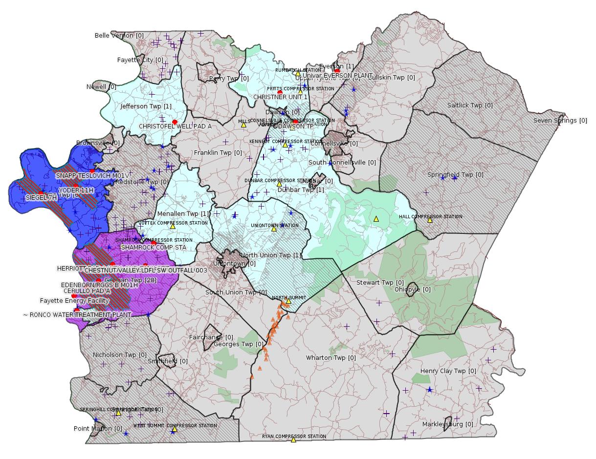
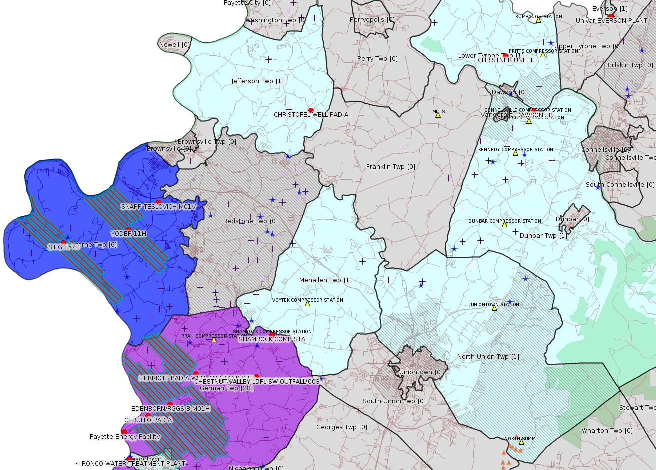
Red dots: items in this permit list with an exact location.
Blue stars: Marcellus Gas Well Water Sources.
Where well laterals are mapped they show in red; a 400-foot buffer surrounding the lateral shows in blue (lavender where it overlaps a mapped mineral tract).
Where mineral tracts are mapped, they show in pink. Mineral tracts can overlap; the overlap will show in red. The precise meaning of "mineral tract" is not clear.
Municipality shading: number of "facilities", with each well counting separately
(includes the red dots):
pale turquoise: 1
turquoise: 2
pale blue: 3
middle blue: 4
dark blue: 6
dark purple: 11
purple: 28
(Color coding may differ from one issue to the next.)
(Note if a project spans multiple municipalities -- e.g. a pipeline -- it will show in the count for each municipality.)
The number of facilities also follows the municipality name in brackets.
Municipality counts are based on the way the permit is listed by DEP; DEP has been known to get a municipality wrong.
Locations in brackets identify a precise location used to locate a surrogate for the actual site being permitted (e.g. locating a well pad or pipeline by the known location of a well.) Locations labeled beginning with "~" and ending in "[?]" are approximate and speculative based on inferences using on-line property and lease records. These are marked in the text as "[Approximate, Speculative]
Yellow triangles: Compressor Stations
Orange triangles: Storage Field Wells (currently Dominion North Summit Storage Field)
Crosses: SPUD Unconventional well permits
Green: "Natural areas", e.g. state game lands, state forests
More Maps
 |
 |
Source: Pennsylvania Bulletin
| NPDES No. (Type) |
Facility Name & Address | County & Municipality |
Stream Name (Watershed No.) |
EPA Waived Y/N? |
|---|---|---|---|---|
| PA0217778 (Industrial) |
Dawson TP P.O. Box 2223 Johnson City, TN 37605-2223 |
Fayette County Dunbar Township |
Youghiogheny River (WWF) (19-D) |
Yes |
<https://www.pabulletin.com/secure/data/vol49/49-20/757b.html>
Map URL: <http://www.openstreetmap.org/?mlat=40.036247&mlon=-79.640533#map=15/40.036247/-79.640533>
-------------------------
Source: eNOTICE (+ PA Oil and Gas Mapping, Well Pad Report.) Well Details via Data Portal Services: Oil and Gas Wells All (ID: 3).
Please see the Disclaimer below regarding Parcel Id data.
Authorization ID: 1273634
Permit number: PAG036257
Site: CHESTNUT VALLEY LDFL
Client: ADVANCED DSPL SVC CHESTNUT VALLEY LDFL INC
Authorization type: PAG-03 Discharge of Stormwater Assoc w Industrial Activities
Application type: New
Authorization is for: FACILITY
Date received: 05/17/2019
Status: Pending
Permit Decision Guarantee Applies?: Yes
Permit Decision Guarantee status: ACTIVE
Sub-Facilities for Authorization:
Sub-Facility ID Sub-Facility Name Description
568839 OUTFALL 002 Discharge Point
Location: 39.896111,-79.836111
Map URL: <http://www.openstreetmap.org/?mlat=39.896111&mlon=-79.836111#map=15/39.896111/-79.836111>
568840 SW OUTFALL 003 Discharge Point
Location: 39.895833,-79.835833
Map URL: <http://www.openstreetmap.org/?mlat=39.895833&mlon=-79.835833#map=15/39.895833/-79.835833>
Permit Review Notes:
Date Review Note
5/17/2019 The permit application package is complete, has been accepted, and is undergoing technical review.
<https://www.ahs.dep.pa.gov/eFACTSWeb/searchResults_singleAuth.aspx?AuthID=1273634>
Site Programs:
Air Quality
Clean Water
Environmental Cleanup & Brownfields
Mining
Radiation Protection
Waste Management
Water Planning and Conservation
Site Municipalities:
German Twp, Fayette County
---
Authorization ID: 1273582
Permit number: GP112619-009
Site: Fayette Energy Facility
Client: DYNEGY FAYETTE II, LLC
Authorization type: BWM-GP-11 Maintenance, Testing, Repair, Rehabilitation or Replacement General Pmt
Application type: New
Authorization is for: FACILITY
Date received: 05/17/2019
Status: Pending
Permit Decision Guarantee Applies?: Yes
Permit Decision Guarantee status: ACTIVE
Sub-Facilities for Authorization:
Sub-Facility ID Sub-Facility Name Description
1287057 GP-11-F1 Temporary Floodway Impact
1287055 GP-11-S1 Stream Direct Impact
1287056 GP-11-S1 Floodway Direct Impact
1287054 Tributary 41154 to Monongahela River Culvert
<https://www.ahs.dep.pa.gov/eFACTSWeb/searchResults_singleAuth.aspx?AuthID=1273582>
Site Programs:
Water Planning and Conservation
Site Municipalities:
German Twp, Fayette County
Public Permit Review: <http://www.ahs.dep.pa.gov/ePermitPublicAccess/Public/PublicAuthOverview?q=69jDo5cYpXtFf5%2bO%2b%2bvYuA%3d%3d>
Project Description and Purpose: <http://www.ahs.dep.pa.gov/ePermitPublicAccess/Permit/DownloadFileFromVault/829572>
Location: 39.86746,-79.92818 <https://osm.org/go/ZWpNJ5kE--?m=>
Presumed Parcel Id: 1530007601
---
Authorization ID: 1273127
Permit number:
Site: CERULLO PAD A ESCGP ESX18-051-0004
Client: CHEVRON APPALACHIA LLC
Authorization type: Residual Waste Processing
Application type: New
Authorization is for: FACILITY
Date received: 05/10/2019
Status: Issued on 5/14/2019
Permit Decision Guarantee Applies?: No
Permit Review Notes:
Date Review Note
5/14/2019 The technical review and decision review are complete and either the permit decision and/or permit issuance are forthcoming.
5/14/2019 The permit application package is complete, has been accepted, and is undergoing technical review.
<https://www.ahs.dep.pa.gov/eFACTSWeb/searchResults_singleAuth.aspx?AuthID=1273127>
Site Programs:
Oil & Gas
Site Municipalities:
German Twp, Fayette County
Location: 39.875992,-79.911644 <https://osm.org/go/ZWpLAUFF--?m=>
Presumed Parcel Id: 15190070
Wells on this pad:
051-24690 CERULLO M09H
051-24691 CERULLO M10H
051-24692 CERULLO M03H
051-24693 CERULLO M01H
051-24694 CERULLO M04H
051-24695 CERULLO M02H
051-24696 CERULLO M11H
051-24697 CERULLO M12H
Application: <http://www.ahs.dep.pa.gov/eSubmissionsDocs/DownloadESubmissionDocument.ashx?enc=MOpmV6IzBtmToVjqF07C9U24kyBW9vlHzFDMaLO%2bTO0%3d>
Previous Authorization ID: 1214775
[See Notes.]
---
Authorization ID: 1273123
Permit number:
Site: HERRIOTT PAD A WELL AND TANK SITE ESCGP ESX18-051-0002
Client: CHEVRON APPALACHIA LLC
Authorization type: Residual Waste Processing
Application type: New
Authorization is for: FACILITY
Date received: 05/10/2019
Status: Issued on 5/14/2019
Permit Decision Guarantee Applies?: No
Permit Review Notes:
Date Review Note
5/14/2019 The technical review and decision review are complete and either the permit decision and/or permit issuance are forthcoming.
5/14/2019 The permit application package is complete, has been accepted, and is undergoing technical review.
<https://www.ahs.dep.pa.gov/eFACTSWeb/searchResults_singleAuth.aspx?AuthID=1273123>
Site Programs:
Oil & Gas
Site Municipalities:
German Twp, Fayette County
Application: <http://www.ahs.dep.pa.gov/eSubmissionsDocs/DownloadESubmissionDocument.ashx?enc=MOpmV6IzBtmToVjqF07C9TNBcB%2byXJonjhL7gsbCQ%2f0%3d>
Previous Authorization ID: 1214775
Location: 39.897981,-79.878003 <https://osm.org/go/ZWpPXJxr--?m=>
Presumed Parcel Id: 15220125
Wells on this pad:
051-24698 HERRIOTT M04H
051-24699 HERRIOTT M05H
051-24700 HERRIOTT M06H
051-24701 HERRIOTT M02H
051-24702 HERRIOTT M07H
051-24703 HERRIOTT M08H
051-24704 HERRIOTT M03H
051-24705 HERRIOTT M09H
---
Authorization ID: 1272398
Permit number: GP112605219-008
Site: TEXAS EASTERN TRANSMISSION FAYETTE CNTY
Client: TEXAS EASTERN TRANS LP
Authorization type: BWM-GP-11 Maintenance, Testing, Repair, Rehabilitation or Replacement General Pmt
Application type: New
Authorization is for: FACILITY
Date received: 04/30/2019
Status: Pending
Permit Decision Guarantee Applies?: Yes
Permit Decision Guarantee status: ACTIVE
Permit Review Notes:
Date Review Note
5/9/2019 The technical review and decision review are complete and either the permit decision and/or permit issuance are forthcoming.
5/9/2019 The permit application package is complete, has been accepted, and is undergoing technical review.
<https://www.ahs.dep.pa.gov/eFACTSWeb/searchResults_singleAuth.aspx?AuthID=1272398>
Site Programs:
Water Planning and Conservation
Site Municipalities:
German Twp, Fayette County
Menallen Twp, Fayette County
North Union Twp, Fayette County
---
Authorization ID: 1270809
Permit number: 051-24646
Site: SIEGEL WELL PAD ESCGP-2 EXPEDITED
Client: CHEVRON APPALACHIA LLC
Authorization type: Drill & Operate Well Permit (Unconventional)
Application type: Modification
Authorization is for: FACILITY
Date received: 04/26/2019
Status: Pending
Permit Decision Guarantee Applies?: No
Sub-Facilities for Authorization:
Sub-Facility ID Sub-Facility Name Description
1251519 WELLBORE SURFACE HOLE LOCATION Well
Permit Review Notes:
Date Review Note
5/15/2019 Applicant has been issued a deficiency letter. If applicable, this application no longer qualifies for the Permit Decision Guarantee.
4/29/2019 The permit application package is complete, has been accepted, and is undergoing technical review.
<https://www.ahs.dep.pa.gov/eFACTSWeb/searchResults_singleAuth.aspx?AuthID=1270809>
Site Programs:
Environmental Cleanup & Brownfields
Oil & Gas
Site Municipalities:
Luzerne Twp, Fayette County
Well Details:
Permit Number: 051-24646
Well Name: SIEGEL 7H
Unconventional Well: Y
Well Configuration: Horizontal Well
Well Type: GAS
Well Status: Active
Coal Association: Coal
Conservation Well: N
Primary Facility ID: 823794
Site ID: 790384
Site Name: SIEGEL WELL PAD ESCGP-2 EXPEDITED
Well Pad ID: 152926
Well Pad Name: SIEGEL 1
Storage Field:
Operator: CHEVRON APPALACHIA LLC
Operator Number: OGO-39307
Permit Date: 2018-02-23
Permit Date Expires: 2019-02-23
SPUD Date: 2018-04-02
Date Plugged:
UIC ID:
UIC Type:
Surface Elevation: 1173
County: Fayette
Municipality: Luzerne Twp
Location: 39.968956,-79.968994
Map URL: <http://www.openstreetmap.org/?mlat=39.968956&mlon=-79.968994#map=15/39.968956/-79.968994>
OG WELLS PERMIT DOCS:
2018-02-26: Final Permit Documents, Name: 1212440 (for Authorization: 1212440):
<http://www.depgis.state.pa.us/pdfHandler/pdFHandler.ashx?Doc=NTYzOTU3&ext=PDF>
Electronically Submitted Records:
2019-05-17: Submission for Authorization 1270809
Pennsylvania Natural Diversity Inventory Form: Siegel PNDI.pdf
<http://www.depgis.state.pa.us/eWellDocHandler/pdFHandler.ashx?Doc=ODIwNzI4&ext=PDF>
Location Plat: 143-781-Well Plat 7H-pages1-2-3_3702.dwg
<http://www.depgis.state.pa.us/eWellDocHandler/pdFHandler.ashx?Doc=ODIwNzMw&ext=PDF>
Interested Party Notification: Siegel 7H_Record of Notification.pdf
<http://www.depgis.state.pa.us/eWellDocHandler/pdFHandler.ashx?Doc=ODIwNzMx&ext=PDF>
Well Cross-Section Diagram: Siegel 7H Page 4.pdf
<http://www.depgis.state.pa.us/eWellDocHandler/pdFHandler.ashx?Doc=ODIwNzMy&ext=PDF>
Well Permit Application - Coal Module: Siegel Coal Module.pdf
<http://www.depgis.state.pa.us/eWellDocHandler/pdFHandler.ashx?Doc=ODIwNzMz&ext=PDF>
Coal and Gas Resource Coord Act - Section 7 Exception: Siegel Waiver Request Section 7.pdf
<http://www.depgis.state.pa.us/eWellDocHandler/pdFHandler.ashx?Doc=ODI0MzMx&ext=PDF>
Permit Application to Drill and Operate a Well: Siegel 7H_Drill Permit Application.pdf
<http://www.depgis.state.pa.us/eWellDocHandler/pdFHandler.ashx?Doc=ODI0NzY4&ext=PDF>
Electronic Submission Docket: 1929165.pdf
<http://www.depgis.state.pa.us/eWellDocHandler/pdFHandler.ashx?Doc=ODI5Nzcw&ext=PDF>
2018-02-26: Submission for Authorization 1212440
Interested Party Notification: Siegel Affidavit of Non-Delivery Foster.pdf
<http://www.depgis.state.pa.us/eWellDocHandler/pdFHandler.ashx?Doc=NDQ5MDI4&ext=PDF>
Interested Party Notification: Siegel Affidavit of Non-Delivery Foster.pdf
<http://www.depgis.state.pa.us/eWellDocHandler/pdFHandler.ashx?Doc=NDQ5MDI5&ext=PDF>
Interested Party Notification: Siegel Affidavit of Non-Delivery Foster.pdf
<http://www.depgis.state.pa.us/eWellDocHandler/pdFHandler.ashx?Doc=NDQ5MDMw&ext=PDF>
Interested Party Notification: Siegel Affidavit of Non-Delivery Foster.pdf
<http://www.depgis.state.pa.us/eWellDocHandler/pdFHandler.ashx?Doc=NDQ5MDMx&ext=PDF>
Interested Party Notification: Siegel Affidavit of Non-Delivery Foster.pdf
<http://www.depgis.state.pa.us/eWellDocHandler/pdFHandler.ashx?Doc=NDQ5MDMy&ext=PDF>
Interested Party Notification: Siegel Affidavit of Non-Delivery Foster.pdf
<http://www.depgis.state.pa.us/eWellDocHandler/pdFHandler.ashx?Doc=NDQ5MDMz&ext=PDF>
Interested Party Notification: Siegel Affidavit of Non-Delivery Foster.pdf
<http://www.depgis.state.pa.us/eWellDocHandler/pdFHandler.ashx?Doc=NDQ5MDM0&ext=PDF>
Interested Party Notification: Siegel Affidavit of Non-Delivery Franks.pdf
<http://www.depgis.state.pa.us/eWellDocHandler/pdFHandler.ashx?Doc=NDQ5MDM1&ext=PDF>
Interested Party Notification: Siegel Affidavit of Non-Delivery Franks.pdf
<http://www.depgis.state.pa.us/eWellDocHandler/pdFHandler.ashx?Doc=NDQ5MDM2&ext=PDF>
Location Plat: 143-781-Well Plat 7H-pages1-2-3_3702.dwg
<http://www.depgis.state.pa.us/eWellDocHandler/pdFHandler.ashx?Doc=NDQ5MDM3&ext=PDF>
Pennsylvania Natural Diversity Inventory Form: Siegel PNDI.pdf
<http://www.depgis.state.pa.us/eWellDocHandler/pdFHandler.ashx?Doc=NDQ5MDM4&ext=PDF>
Coal and Gas Resource Coord Act - Section 7 Exception: Siegel 1H-9H Waiver Request Section 7.pdf
<http://www.depgis.state.pa.us/eWellDocHandler/pdFHandler.ashx?Doc=NDQ5MDM5&ext=PDF>
Well Cross-Section Diagram: Siegel 7H Page 4.pdf
<http://www.depgis.state.pa.us/eWellDocHandler/pdFHandler.ashx?Doc=NDQ5MDQw&ext=PDF>
Permit Application to Drill and Operate a Well: 1640181.pdf
<http://www.depgis.state.pa.us/eWellDocHandler/pdFHandler.ashx?Doc=NDQ5ODIx&ext=PDF>
---
Authorization ID: 1270808
Permit number: 051-24648
Site: SIEGEL WELL PAD ESCGP-2 EXPEDITED
Client: CHEVRON APPALACHIA LLC
Authorization type: Drill & Operate Well Permit (Unconventional)
Application type: Modification
Authorization is for: FACILITY
Date received: 04/26/2019
Status: Pending
Permit Decision Guarantee Applies?: No
Sub-Facilities for Authorization:
Sub-Facility ID Sub-Facility Name Description
1251521 WELLBORE SURFACE HOLE LOCATION Well
Permit Review Notes:
Date Review Note
5/15/2019 Applicant has been issued a deficiency letter. If applicable, this application no longer qualifies for the Permit Decision Guarantee.
4/29/2019 The permit application package is complete, has been accepted, and is undergoing technical review.
<https://www.ahs.dep.pa.gov/eFACTSWeb/searchResults_singleAuth.aspx?AuthID=1270808>
Site Programs:
Environmental Cleanup & Brownfields
Oil & Gas
Site Municipalities:
Luzerne Twp, Fayette County
Well Details:
Permit Number: 051-24648
Well Name: SIEGEL 9H
Unconventional Well: Y
Well Configuration: Horizontal Well
Well Type: GAS
Well Status: Active
Coal Association: Coal
Conservation Well: N
Primary Facility ID: 823796
Site ID: 790384
Site Name: SIEGEL WELL PAD ESCGP-2 EXPEDITED
Well Pad ID: 152926
Well Pad Name: SIEGEL 1
Storage Field:
Operator: CHEVRON APPALACHIA LLC
Operator Number: OGO-39307
Permit Date: 2018-02-23
Permit Date Expires: 2019-02-23
SPUD Date: 2018-04-02
Date Plugged:
UIC ID:
UIC Type:
Surface Elevation: 1173
County: Fayette
Municipality: Luzerne Twp
Location: 39.969036,-79.968861
Map URL: <http://www.openstreetmap.org/?mlat=39.969036&mlon=-79.968861#map=15/39.969036/-79.968861>
OG WELLS PERMIT DOCS:
2018-02-27: Final Permit Documents, Name: 1212442 (for Authorization: 1212442):
<http://www.depgis.state.pa.us/pdfHandler/pdFHandler.ashx?Doc=NTY0ODc4&ext=PDF>
Electronically Submitted Records:
2019-05-17: Submission for Authorization 1270808
Pennsylvania Natural Diversity Inventory Form: Siegel PNDI.pdf
<http://www.depgis.state.pa.us/eWellDocHandler/pdFHandler.ashx?Doc=ODIwNzUw&ext=PDF>
Location Plat: 143-781-Well Plat 9H-pages1-2-3_3702.dwg
<http://www.depgis.state.pa.us/eWellDocHandler/pdFHandler.ashx?Doc=ODIwNzUy&ext=PDF>
Interested Party Notification: Siegel 9H_Record of Notification.pdf
<http://www.depgis.state.pa.us/eWellDocHandler/pdFHandler.ashx?Doc=ODIwNzUz&ext=PDF>
Well Cross-Section Diagram: Siegel 9H Page 4.pdf
<http://www.depgis.state.pa.us/eWellDocHandler/pdFHandler.ashx?Doc=ODIwNzU0&ext=PDF>
Well Permit Application - Coal Module: Siegel Coal Module.pdf
<http://www.depgis.state.pa.us/eWellDocHandler/pdFHandler.ashx?Doc=ODIwNzU1&ext=PDF>
Coal and Gas Resource Coord Act - Section 7 Exception: Siegel Waiver Request Section 7.pdf
<http://www.depgis.state.pa.us/eWellDocHandler/pdFHandler.ashx?Doc=ODI0MzUx&ext=PDF>
Permit Application to Drill and Operate a Well: Siegel 9H_Drill Permit Application.pdf
<http://www.depgis.state.pa.us/eWellDocHandler/pdFHandler.ashx?Doc=ODI0Nzgx&ext=PDF>
Electronic Submission Docket: 1929167.pdf
<http://www.depgis.state.pa.us/eWellDocHandler/pdFHandler.ashx?Doc=ODI5ODE5&ext=PDF>
2018-02-27: Submission for Authorization 1212442
Interested Party Notification: Siegel Affidavit of Non-Delivery Foster.pdf
<http://www.depgis.state.pa.us/eWellDocHandler/pdFHandler.ashx?Doc=NDQ5MDY4&ext=PDF>
Interested Party Notification: Siegel Affidavit of Non-Delivery Foster.pdf
<http://www.depgis.state.pa.us/eWellDocHandler/pdFHandler.ashx?Doc=NDQ5MDY5&ext=PDF>
Interested Party Notification: Siegel Affidavit of Non-Delivery Foster.pdf
<http://www.depgis.state.pa.us/eWellDocHandler/pdFHandler.ashx?Doc=NDQ5MDcw&ext=PDF>
Interested Party Notification: Siegel Affidavit of Non-Delivery Foster.pdf
<http://www.depgis.state.pa.us/eWellDocHandler/pdFHandler.ashx?Doc=NDQ5MDcx&ext=PDF>
Interested Party Notification: Siegel Affidavit of Non-Delivery Foster.pdf
<http://www.depgis.state.pa.us/eWellDocHandler/pdFHandler.ashx?Doc=NDQ5MDcy&ext=PDF>
Interested Party Notification: Siegel Affidavit of Non-Delivery Foster.pdf
<http://www.depgis.state.pa.us/eWellDocHandler/pdFHandler.ashx?Doc=NDQ5MDcz&ext=PDF>
Interested Party Notification: Siegel Affidavit of Non-Delivery Foster.pdf
<http://www.depgis.state.pa.us/eWellDocHandler/pdFHandler.ashx?Doc=NDQ5MDc0&ext=PDF>
Interested Party Notification: Siegel Affidavit of Non-Delivery Franks.pdf
<http://www.depgis.state.pa.us/eWellDocHandler/pdFHandler.ashx?Doc=NDQ5MDc1&ext=PDF>
Interested Party Notification: Siegel Affidavit of Non-Delivery Franks.pdf
<http://www.depgis.state.pa.us/eWellDocHandler/pdFHandler.ashx?Doc=NDQ5MDc4&ext=PDF>
Location Plat: 143-781-Well Plat 9H-pages1-2-3_3702.dwg
<http://www.depgis.state.pa.us/eWellDocHandler/pdFHandler.ashx?Doc=NDQ5MDgy&ext=PDF>
Pennsylvania Natural Diversity Inventory Form: Siegel PNDI.pdf
<http://www.depgis.state.pa.us/eWellDocHandler/pdFHandler.ashx?Doc=NDQ5MDgz&ext=PDF>
Coal and Gas Resource Coord Act - Section 7 Exception: Siegel 1H-9H Waiver Request Section 7.pdf
<http://www.depgis.state.pa.us/eWellDocHandler/pdFHandler.ashx?Doc=NDQ5MDg0&ext=PDF>
Well Cross-Section Diagram: Siegel 9H Page 4.pdf
<http://www.depgis.state.pa.us/eWellDocHandler/pdFHandler.ashx?Doc=NDQ5MDg1&ext=PDF>
Permit Application to Drill and Operate a Well: 1640187.pdf
<http://www.depgis.state.pa.us/eWellDocHandler/pdFHandler.ashx?Doc=NDQ5ODMz&ext=PDF>
---
Authorization ID: 1270807
Permit number: 051-24647
Site: SIEGEL WELL PAD ESCGP-2 EXPEDITED
Client: CHEVRON APPALACHIA LLC
Authorization type: Drill & Operate Well Permit (Unconventional)
Application type: Modification
Authorization is for: FACILITY
Date received: 04/26/2019
Status: Pending
Permit Decision Guarantee Applies?: No
Sub-Facilities for Authorization:
Sub-Facility ID Sub-Facility Name Description
1251520 WELLBORE SURFACE HOLE LOCATION Well
Permit Review Notes:
Date Review Note
5/15/2019 Applicant has been issued a deficiency letter. If applicable, this application no longer qualifies for the Permit Decision Guarantee.
4/29/2019 The permit application package is complete, has been accepted, and is undergoing technical review.
<https://www.ahs.dep.pa.gov/eFACTSWeb/searchResults_singleAuth.aspx?AuthID=1270807>
Site Programs:
Environmental Cleanup & Brownfields
Oil & Gas
Site Municipalities:
Luzerne Twp, Fayette County
Well Details:
Permit Number: 051-24647
Well Name: SIEGEL 8H
Unconventional Well: Y
Well Configuration: Horizontal Well
Well Type: GAS
Well Status: Active
Coal Association: Coal
Conservation Well: N
Primary Facility ID: 823795
Site ID: 790384
Site Name: SIEGEL WELL PAD ESCGP-2 EXPEDITED
Well Pad ID: 152926
Well Pad Name: SIEGEL 1
Storage Field:
Operator: CHEVRON APPALACHIA LLC
Operator Number: OGO-39307
Permit Date: 2018-02-23
Permit Date Expires: 2019-02-23
SPUD Date: 2018-04-02
Date Plugged:
UIC ID:
UIC Type:
Surface Elevation: 1173
County: Fayette
Municipality: Luzerne Twp
Location: 39.968997,-79.968928
Map URL: <http://www.openstreetmap.org/?mlat=39.968997&mlon=-79.968928#map=15/39.968997/-79.968928>
OG WELLS PERMIT DOCS:
2018-02-27: Final Permit Documents, Name: 1212441 (for Authorization: 1212441):
<http://www.depgis.state.pa.us/pdfHandler/pdFHandler.ashx?Doc=NTY0ODc0&ext=PDF>
Electronically Submitted Records:
2018-02-27: Submission for Authorization 1212441
Interested Party Notification: Siegel Affidavit of Non-Delivery Foster.pdf
<http://www.depgis.state.pa.us/eWellDocHandler/pdFHandler.ashx?Doc=NDQ5MDQ0&ext=PDF>
Interested Party Notification: Siegel Affidavit of Non-Delivery Foster.pdf
<http://www.depgis.state.pa.us/eWellDocHandler/pdFHandler.ashx?Doc=NDQ5MDQ1&ext=PDF>
Interested Party Notification: Siegel Affidavit of Non-Delivery Foster.pdf
<http://www.depgis.state.pa.us/eWellDocHandler/pdFHandler.ashx?Doc=NDQ5MDQ2&ext=PDF>
Interested Party Notification: Siegel Affidavit of Non-Delivery Foster.pdf
<http://www.depgis.state.pa.us/eWellDocHandler/pdFHandler.ashx?Doc=NDQ5MDUw&ext=PDF>
Interested Party Notification: Siegel Affidavit of Non-Delivery Foster.pdf
<http://www.depgis.state.pa.us/eWellDocHandler/pdFHandler.ashx?Doc=NDQ5MDUx&ext=PDF>
Interested Party Notification: Siegel Affidavit of Non-Delivery Foster.pdf
<http://www.depgis.state.pa.us/eWellDocHandler/pdFHandler.ashx?Doc=NDQ5MDUy&ext=PDF>
Interested Party Notification: Siegel Affidavit of Non-Delivery Foster.pdf
<http://www.depgis.state.pa.us/eWellDocHandler/pdFHandler.ashx?Doc=NDQ5MDUz&ext=PDF>
Interested Party Notification: Siegel Affidavit of Non-Delivery Franks.pdf
<http://www.depgis.state.pa.us/eWellDocHandler/pdFHandler.ashx?Doc=NDQ5MDU0&ext=PDF>
Interested Party Notification: Siegel Affidavit of Non-Delivery Franks.pdf
<http://www.depgis.state.pa.us/eWellDocHandler/pdFHandler.ashx?Doc=NDQ5MDU1&ext=PDF>
Pennsylvania Natural Diversity Inventory Form: Siegel PNDI.pdf
<http://www.depgis.state.pa.us/eWellDocHandler/pdFHandler.ashx?Doc=NDQ5MDU2&ext=PDF>
Location Plat: 143-781-Well Plat 8H-pages1-2-3_3702.dwg
<http://www.depgis.state.pa.us/eWellDocHandler/pdFHandler.ashx?Doc=NDQ5MDU3&ext=PDF>
Coal and Gas Resource Coord Act - Section 7 Exception: Siegel 1H-9H Waiver Request Section 7.pdf
<http://www.depgis.state.pa.us/eWellDocHandler/pdFHandler.ashx?Doc=NDQ5MDU4&ext=PDF>
Well Cross-Section Diagram: Siegel 8H Page 4.pdf
<http://www.depgis.state.pa.us/eWellDocHandler/pdFHandler.ashx?Doc=NDQ5MDU5&ext=PDF>
Permit Application to Drill and Operate a Well: 1640184.pdf
<http://www.depgis.state.pa.us/eWellDocHandler/pdFHandler.ashx?Doc=NDQ5ODMw&ext=PDF>
2019-05-17: Submission for Authorization 1270807
Pennsylvania Natural Diversity Inventory Form: Siegel PNDI.pdf
<http://www.depgis.state.pa.us/eWellDocHandler/pdFHandler.ashx?Doc=ODIwNzM4&ext=PDF>
Location Plat: 143-781-Well Plat 8H-pages1-2-3_3702.dwg
<http://www.depgis.state.pa.us/eWellDocHandler/pdFHandler.ashx?Doc=ODIwNzQw&ext=PDF>
Interested Party Notification: Siegel 8H_Record of Notification.pdf
<http://www.depgis.state.pa.us/eWellDocHandler/pdFHandler.ashx?Doc=ODIwNzQx&ext=PDF>
Well Cross-Section Diagram: Siegel 8H Page 4.pdf
<http://www.depgis.state.pa.us/eWellDocHandler/pdFHandler.ashx?Doc=ODIwNzQy&ext=PDF>
Well Permit Application - Coal Module: Siegel Coal Module.pdf
<http://www.depgis.state.pa.us/eWellDocHandler/pdFHandler.ashx?Doc=ODIwNzQz&ext=PDF>
Coal and Gas Resource Coord Act - Section 7 Exception: Siegel Waiver Request Section 7.pdf
<http://www.depgis.state.pa.us/eWellDocHandler/pdFHandler.ashx?Doc=ODI0MzQw&ext=PDF>
Permit Application to Drill and Operate a Well: Siegel 8H_Drill Permit Application.pdf
<http://www.depgis.state.pa.us/eWellDocHandler/pdFHandler.ashx?Doc=ODI0Nzcz&ext=PDF>
Electronic Submission Docket: 1929166.pdf
<http://www.depgis.state.pa.us/eWellDocHandler/pdFHandler.ashx?Doc=ODI5Nzkx&ext=PDF>
---
Authorization ID: 1270803
Permit number: 051-24645
Site: SIEGEL WELL PAD ESCGP-2 EXPEDITED
Client: CHEVRON APPALACHIA LLC
Authorization type: Drill & Operate Well Permit (Unconventional)
Application type: Modification
Authorization is for: FACILITY
Date received: 04/26/2019
Status: Pending
Permit Decision Guarantee Applies?: No
Sub-Facilities for Authorization:
Sub-Facility ID Sub-Facility Name Description
1251518 WELLBORE SURFACE HOLE LOCATION Well
Permit Review Notes:
Date Review Note
5/15/2019 Applicant has been issued a deficiency letter. If applicable, this application no longer qualifies for the Permit Decision Guarantee.
4/29/2019 The permit application package is complete, has been accepted, and is undergoing technical review.
<https://www.ahs.dep.pa.gov/eFACTSWeb/searchResults_singleAuth.aspx?AuthID=1270803>
Site Programs:
Environmental Cleanup & Brownfields
Oil & Gas
Site Municipalities:
Luzerne Twp, Fayette County
Well Details:
Permit Number: 051-24645
Well Name: SIEGEL 6H
Unconventional Well: Y
Well Configuration: Horizontal Well
Well Type: GAS
Well Status: Active
Coal Association: Coal
Conservation Well: N
Primary Facility ID: 823793
Site ID: 790384
Site Name: SIEGEL WELL PAD ESCGP-2 EXPEDITED
Well Pad ID: 152926
Well Pad Name: SIEGEL 1
Storage Field:
Operator: CHEVRON APPALACHIA LLC
Operator Number: OGO-39307
Permit Date: 2018-02-20
Permit Date Expires: 2019-02-20
SPUD Date: 2018-04-02
Date Plugged:
UIC ID:
UIC Type:
Surface Elevation: 1173
County: Fayette
Municipality: Luzerne Twp
Location: 39.968914,-79.969061
Map URL: <http://www.openstreetmap.org/?mlat=39.968914&mlon=-79.969061#map=15/39.968914/-79.969061>
OG WELLS PERMIT DOCS:
2018-02-20: Final Permit Documents, Name: 1212439 (for Authorization: 1212439):
<http://www.depgis.state.pa.us/pdfHandler/pdFHandler.ashx?Doc=NTY1ODUw&ext=PDF>
Electronically Submitted Records:
2019-05-17: Submission for Authorization 1270803
Pennsylvania Natural Diversity Inventory Form: Siegel PNDI.pdf
<http://www.depgis.state.pa.us/eWellDocHandler/pdFHandler.ashx?Doc=ODIwNzEw&ext=PDF>
Location Plat: 143-781-Well Plat 6H-pages1-2-3_3702.dwg
<http://www.depgis.state.pa.us/eWellDocHandler/pdFHandler.ashx?Doc=ODIwNzEy&ext=PDF>
Interested Party Notification: Siegel 6H_Record of Notification.pdf
<http://www.depgis.state.pa.us/eWellDocHandler/pdFHandler.ashx?Doc=ODIwNzEz&ext=PDF>
Well Cross-Section Diagram: Siegel 6H Page 4.pdf
<http://www.depgis.state.pa.us/eWellDocHandler/pdFHandler.ashx?Doc=ODIwNzE0&ext=PDF>
Well Permit Application - Coal Module: Siegel Coal Module.pdf
<http://www.depgis.state.pa.us/eWellDocHandler/pdFHandler.ashx?Doc=ODIwNzE1&ext=PDF>
Coal and Gas Resource Coord Act - Section 7 Exception: Siegel Waiver Request Section 7.pdf
<http://www.depgis.state.pa.us/eWellDocHandler/pdFHandler.ashx?Doc=ODI0MzE1&ext=PDF>
Permit Application to Drill and Operate a Well: Siegel 6H_Drill Permit Application.pdf
<http://www.depgis.state.pa.us/eWellDocHandler/pdFHandler.ashx?Doc=ODI0NzY0&ext=PDF>
Electronic Submission Docket: 1929159.pdf
<http://www.depgis.state.pa.us/eWellDocHandler/pdFHandler.ashx?Doc=ODI5NzU0&ext=PDF>
2018-02-20: Submission for Authorization 1212439
Interested Party Notification: Siegel Affidavit of Non-Delivery Foster.pdf
<http://www.depgis.state.pa.us/eWellDocHandler/pdFHandler.ashx?Doc=NDQ5MDA5&ext=PDF>
Interested Party Notification: Siegel Affidavit of Non-Delivery Foster.pdf
<http://www.depgis.state.pa.us/eWellDocHandler/pdFHandler.ashx?Doc=NDQ5MDEw&ext=PDF>
Interested Party Notification: Siegel Affidavit of Non-Delivery Foster.pdf
<http://www.depgis.state.pa.us/eWellDocHandler/pdFHandler.ashx?Doc=NDQ5MDEx&ext=PDF>
Interested Party Notification: Siegel Affidavit of Non-Delivery Foster.pdf
<http://www.depgis.state.pa.us/eWellDocHandler/pdFHandler.ashx?Doc=NDQ5MDEy&ext=PDF>
Interested Party Notification: Siegel Affidavit of Non-Delivery Foster.pdf
<http://www.depgis.state.pa.us/eWellDocHandler/pdFHandler.ashx?Doc=NDQ5MDEz&ext=PDF>
Interested Party Notification: Siegel Affidavit of Non-Delivery Foster.pdf
<http://www.depgis.state.pa.us/eWellDocHandler/pdFHandler.ashx?Doc=NDQ5MDE0&ext=PDF>
Interested Party Notification: Siegel Affidavit of Non-Delivery Foster.pdf
<http://www.depgis.state.pa.us/eWellDocHandler/pdFHandler.ashx?Doc=NDQ5MDE1&ext=PDF>
Interested Party Notification: Siegel Affidavit of Non-Delivery Franks.pdf
<http://www.depgis.state.pa.us/eWellDocHandler/pdFHandler.ashx?Doc=NDQ5MDE2&ext=PDF>
Interested Party Notification: Siegel Affidavit of Non-Delivery Franks.pdf
<http://www.depgis.state.pa.us/eWellDocHandler/pdFHandler.ashx?Doc=NDQ5MDE3&ext=PDF>
Pennsylvania Natural Diversity Inventory Form: Siegel PNDI.pdf
<http://www.depgis.state.pa.us/eWellDocHandler/pdFHandler.ashx?Doc=NDQ5MDIw&ext=PDF>
Location Plat: 143-781-Well Plat 6H-pages1-2-3_3702.dwg
<http://www.depgis.state.pa.us/eWellDocHandler/pdFHandler.ashx?Doc=NDQ5MDIx&ext=PDF>
Coal and Gas Resource Coord Act - Section 7 Exception: Siegel 1H-9H Waiver Request Section 7.pdf
<http://www.depgis.state.pa.us/eWellDocHandler/pdFHandler.ashx?Doc=NDQ5MDIy&ext=PDF>
Well Cross-Section Diagram: Siegel 6H Page 4.pdf
<http://www.depgis.state.pa.us/eWellDocHandler/pdFHandler.ashx?Doc=NDQ5MDIz&ext=PDF>
Permit Application to Drill and Operate a Well: 1640174.pdf
<http://www.depgis.state.pa.us/eWellDocHandler/pdFHandler.ashx?Doc=NDQ5ODE4&ext=PDF>
---
Authorization ID: 1270802
Permit number: 051-24644
Site: SIEGEL WELL PAD ESCGP-2 EXPEDITED
Client: CHEVRON APPALACHIA LLC
Authorization type: Drill & Operate Well Permit (Unconventional)
Application type: Modification
Authorization is for: FACILITY
Date received: 04/26/2019
Status: Pending
Permit Decision Guarantee Applies?: No
Sub-Facilities for Authorization:
Sub-Facility ID Sub-Facility Name Description
1251517 WELLBORE SURFACE HOLE LOCATION Well
Permit Review Notes:
Date Review Note
5/15/2019 Applicant has been issued a deficiency letter. If applicable, this application no longer qualifies for the Permit Decision Guarantee.
4/29/2019 The permit application package is complete, has been accepted, and is undergoing technical review.
<https://www.ahs.dep.pa.gov/eFACTSWeb/searchResults_singleAuth.aspx?AuthID=1270802>
Site Programs:
Environmental Cleanup & Brownfields
Oil & Gas
Site Municipalities:
Luzerne Twp, Fayette County
Well Details:
Permit Number: 051-24644
Well Name: SIEGEL 5H
Unconventional Well: Y
Well Configuration: Horizontal Well
Well Type: GAS
Well Status: Active
Coal Association: Coal
Conservation Well: N
Primary Facility ID: 823792
Site ID: 790384
Site Name: SIEGEL WELL PAD ESCGP-2 EXPEDITED
Well Pad ID: 152926
Well Pad Name: SIEGEL 1
Storage Field:
Operator: CHEVRON APPALACHIA LLC
Operator Number: OGO-39307
Permit Date: 2018-02-16
Permit Date Expires: 2019-02-16
SPUD Date: 2018-04-02
Date Plugged:
UIC ID:
UIC Type:
Surface Elevation: 1173
County: Fayette
Municipality: Luzerne Twp
Location: 39.968808,-79.969061
Map URL: <http://www.openstreetmap.org/?mlat=39.968808&mlon=-79.969061#map=15/39.968808/-79.969061>
OG WELLS PERMIT DOCS:
2018-02-20: Final Permit Documents, Name: 1212438 (for Authorization: 1212438):
<http://www.depgis.state.pa.us/pdfHandler/pdFHandler.ashx?Doc=NTY1ODQ4&ext=PDF>
Electronically Submitted Records:
2019-05-17: Submission for Authorization 1270802
Pennsylvania Natural Diversity Inventory Form: Siegel PNDI.pdf
<http://www.depgis.state.pa.us/eWellDocHandler/pdFHandler.ashx?Doc=ODIwNjYz&ext=PDF>
Location Plat: 143-781-Well Plat 5H-pages1-2-3_3702.dwg
<http://www.depgis.state.pa.us/eWellDocHandler/pdFHandler.ashx?Doc=ODIwNjY1&ext=PDF>
Interested Party Notification: Siegel 5H_Record of Notification.pdf
<http://www.depgis.state.pa.us/eWellDocHandler/pdFHandler.ashx?Doc=ODIwNjY2&ext=PDF>
Well Cross-Section Diagram: Siegel 5H Page 4.pdf
<http://www.depgis.state.pa.us/eWellDocHandler/pdFHandler.ashx?Doc=ODIwNjY3&ext=PDF>
Well Permit Application - Coal Module: Siegel Coal Module.pdf
<http://www.depgis.state.pa.us/eWellDocHandler/pdFHandler.ashx?Doc=ODIwNjY4&ext=PDF>
Coal and Gas Resource Coord Act - Section 7 Exception: Siegel Waiver Request Section 7.pdf
<http://www.depgis.state.pa.us/eWellDocHandler/pdFHandler.ashx?Doc=ODI0MzA0&ext=PDF>
Permit Application to Drill and Operate a Well: Siegel 5H_Drill Permit Application.pdf
<http://www.depgis.state.pa.us/eWellDocHandler/pdFHandler.ashx?Doc=ODI0NzU5&ext=PDF>
Electronic Submission Docket: 1929157.pdf
<http://www.depgis.state.pa.us/eWellDocHandler/pdFHandler.ashx?Doc=ODI5NjM0&ext=PDF>
2018-02-20: Submission for Authorization 1212438
Interested Party Notification: Siegel Affidavit of Non-Delivery Foster.pdf
<http://www.depgis.state.pa.us/eWellDocHandler/pdFHandler.ashx?Doc=NDQ4OTg4&ext=PDF>
Interested Party Notification: Siegel Affidavit of Non-Delivery Foster.pdf
<http://www.depgis.state.pa.us/eWellDocHandler/pdFHandler.ashx?Doc=NDQ4OTky&ext=PDF>
Interested Party Notification: Siegel Affidavit of Non-Delivery Foster.pdf
<http://www.depgis.state.pa.us/eWellDocHandler/pdFHandler.ashx?Doc=NDQ4OTkz&ext=PDF>
Interested Party Notification: Siegel Affidavit of Non-Delivery Foster.pdf
<http://www.depgis.state.pa.us/eWellDocHandler/pdFHandler.ashx?Doc=NDQ4OTk0&ext=PDF>
Interested Party Notification: Siegel Affidavit of Non-Delivery Foster.pdf
<http://www.depgis.state.pa.us/eWellDocHandler/pdFHandler.ashx?Doc=NDQ4OTk1&ext=PDF>
Interested Party Notification: Siegel Affidavit of Non-Delivery Foster.pdf
<http://www.depgis.state.pa.us/eWellDocHandler/pdFHandler.ashx?Doc=NDQ4OTk2&ext=PDF>
Interested Party Notification: Siegel Affidavit of Non-Delivery Foster.pdf
<http://www.depgis.state.pa.us/eWellDocHandler/pdFHandler.ashx?Doc=NDQ4OTk3&ext=PDF>
Interested Party Notification: Siegel Affidavit of Non-Delivery Franks.pdf
<http://www.depgis.state.pa.us/eWellDocHandler/pdFHandler.ashx?Doc=NDQ4OTk4&ext=PDF>
Interested Party Notification: Siegel Affidavit of Non-Delivery Franks.pdf
<http://www.depgis.state.pa.us/eWellDocHandler/pdFHandler.ashx?Doc=NDQ4OTk5&ext=PDF>
Pennsylvania Natural Diversity Inventory Form: Siegel PNDI.pdf
<http://www.depgis.state.pa.us/eWellDocHandler/pdFHandler.ashx?Doc=NDQ5MDAx&ext=PDF>
Location Plat: 143-781-Well Plat 5H-pages1-2-3_3702.dwg
<http://www.depgis.state.pa.us/eWellDocHandler/pdFHandler.ashx?Doc=NDQ5MDAy&ext=PDF>
Coal and Gas Resource Coord Act - Section 7 Exception: Siegel 1H-9H Waiver Request Section 7.pdf
<http://www.depgis.state.pa.us/eWellDocHandler/pdFHandler.ashx?Doc=NDQ5MDAz&ext=PDF>
Well Cross-Section Diagram: Siegel 5H Page 4.pdf
<http://www.depgis.state.pa.us/eWellDocHandler/pdFHandler.ashx?Doc=NDQ5MDA0&ext=PDF>
Permit Application to Drill and Operate a Well: 1640042.pdf
<http://www.depgis.state.pa.us/eWellDocHandler/pdFHandler.ashx?Doc=NDQ5ODE1&ext=PDF>
---
Authorization ID: 1270800
Permit number: 051-24643
Site: SIEGEL WELL PAD ESCGP-2 EXPEDITED
Client: CHEVRON APPALACHIA LLC
Authorization type: Drill & Operate Well Permit (Unconventional)
Application type: Modification
Authorization is for: FACILITY
Date received: 04/26/2019
Status: Pending
Permit Decision Guarantee Applies?: No
Sub-Facilities for Authorization:
Sub-Facility ID Sub-Facility Name Description
1251516 WELLBORE SURFACE HOLE LOCATION Well
Permit Review Notes:
Date Review Note
5/15/2019 Applicant has been issued a deficiency letter. If applicable, this application no longer qualifies for the Permit Decision Guarantee.
4/29/2019 The permit application package is complete, has been accepted, and is undergoing technical review.
<https://www.ahs.dep.pa.gov/eFACTSWeb/searchResults_singleAuth.aspx?AuthID=1270800>
Site Programs:
Environmental Cleanup & Brownfields
Oil & Gas
Site Municipalities:
Luzerne Twp, Fayette County
Well Details:
Permit Number: 051-24643
Well Name: SIEGEL 3H
Unconventional Well: Y
Well Configuration: Horizontal Well
Well Type: GAS
Well Status: Active
Coal Association: Coal
Conservation Well: N
Primary Facility ID: 823791
Site ID: 790384
Site Name: SIEGEL WELL PAD ESCGP-2 EXPEDITED
Well Pad ID: 152926
Well Pad Name: SIEGEL 1
Storage Field:
Operator: CHEVRON APPALACHIA LLC
Operator Number: OGO-39307
Permit Date: 2018-02-13
Permit Date Expires: 2019-02-13
SPUD Date: 2018-04-02
Date Plugged:
UIC ID:
UIC Type:
Surface Elevation: 1173
County: Fayette
Municipality: Luzerne Twp
Location: 39.968892,-79.968928
Map URL: <http://www.openstreetmap.org/?mlat=39.968892&mlon=-79.968928#map=15/39.968892/-79.968928>
OG WELLS PERMIT DOCS:
2018-02-14: Final Permit Documents, Name: 1212437 (for Authorization: 1212437):
<http://www.depgis.state.pa.us/pdfHandler/pdFHandler.ashx?Doc=NTU5MjE5&ext=PDF>
Electronically Submitted Records:
2019-05-17: Submission for Authorization 1270800
Pennsylvania Natural Diversity Inventory Form: Siegel PNDI.pdf
<http://www.depgis.state.pa.us/eWellDocHandler/pdFHandler.ashx?Doc=ODIwNjQz&ext=PDF>
Location Plat: 143-781-Well Plat 3H-pages1-2-3_3702.dwg
<http://www.depgis.state.pa.us/eWellDocHandler/pdFHandler.ashx?Doc=ODIwNjQ1&ext=PDF>
Interested Party Notification: Siegel 3H_Record of Notification.pdf
<http://www.depgis.state.pa.us/eWellDocHandler/pdFHandler.ashx?Doc=ODIwNjQ2&ext=PDF>
Well Cross-Section Diagram: Siegel 3H Page 4.pdf
<http://www.depgis.state.pa.us/eWellDocHandler/pdFHandler.ashx?Doc=ODIwNjQ3&ext=PDF>
Well Permit Application - Coal Module: Siegel Coal Module.pdf
<http://www.depgis.state.pa.us/eWellDocHandler/pdFHandler.ashx?Doc=ODIwNjQ4&ext=PDF>
Coal and Gas Resource Coord Act - Section 7 Exception: Siegel Waiver Request Section 7.pdf
<http://www.depgis.state.pa.us/eWellDocHandler/pdFHandler.ashx?Doc=ODI0Mjk0&ext=PDF>
Permit Application to Drill and Operate a Well: Siegel 3H_Drill Permit Application.pdf
<http://www.depgis.state.pa.us/eWellDocHandler/pdFHandler.ashx?Doc=ODI0NzUy&ext=PDF>
Electronic Submission Docket: 1929153.pdf
<http://www.depgis.state.pa.us/eWellDocHandler/pdFHandler.ashx?Doc=ODI5NjI0&ext=PDF>
2018-02-14: Submission for Authorization 1212437
Interested Party Notification: Siegel Affidavit of Non-Delivery Foster.pdf
<http://www.depgis.state.pa.us/eWellDocHandler/pdFHandler.ashx?Doc=NDQ4OTE1&ext=PDF>
Interested Party Notification: Siegel Affidavit of Non-Delivery Franks.pdf
<http://www.depgis.state.pa.us/eWellDocHandler/pdFHandler.ashx?Doc=NDQ4OTIx&ext=PDF>
Interested Party Notification: Siegel Affidavit of Non-Delivery Franks.pdf
<http://www.depgis.state.pa.us/eWellDocHandler/pdFHandler.ashx?Doc=NDQ4OTIy&ext=PDF>
Pennsylvania Natural Diversity Inventory Form: Siegel PNDI.pdf
<http://www.depgis.state.pa.us/eWellDocHandler/pdFHandler.ashx?Doc=NDQ4OTIz&ext=PDF>
Location Plat: 143-781-Well Plat 3H-pages1-2-3_3702.dwg
<http://www.depgis.state.pa.us/eWellDocHandler/pdFHandler.ashx?Doc=NDQ4OTI0&ext=PDF>
Coal and Gas Resource Coord Act - Section 7 Exception: Siegel 1H-9H Waiver Request Section 7.pdf
<http://www.depgis.state.pa.us/eWellDocHandler/pdFHandler.ashx?Doc=NDQ4OTI1&ext=PDF>
Well Cross-Section Diagram: Siegel 3H Page 4.pdf
<http://www.depgis.state.pa.us/eWellDocHandler/pdFHandler.ashx?Doc=NDQ4OTI2&ext=PDF>
Permit Application to Drill and Operate a Well: 1640037.pdf
<http://www.depgis.state.pa.us/eWellDocHandler/pdFHandler.ashx?Doc=NDQ5ODAz&ext=PDF>
---
Authorization ID: 1270799
Permit number: 051-24641
Site: SIEGEL WELL PAD ESCGP-2 EXPEDITED
Client: CHEVRON APPALACHIA LLC
Authorization type: Drill & Operate Well Permit (Unconventional)
Application type: Modification
Authorization is for: FACILITY
Date received: 04/26/2019
Status: Pending
Permit Decision Guarantee Applies?: No
Sub-Facilities for Authorization:
Sub-Facility ID Sub-Facility Name Description
1251514 WELLBORE SURFACE HOLE LOCATION Well
Permit Review Notes:
Date Review Note
5/15/2019 Applicant has been issued a deficiency letter. If applicable, this application no longer qualifies for the Permit Decision Guarantee.
4/29/2019 The permit application package is complete, has been accepted, and is undergoing technical review.
<https://www.ahs.dep.pa.gov/eFACTSWeb/searchResults_singleAuth.aspx?AuthID=1270799>
Site Programs:
Environmental Cleanup & Brownfields
Oil & Gas
Site Municipalities:
Luzerne Twp, Fayette County
Well Details:
Permit Number: 051-24641
Well Name: SIEGEL 2H
Unconventional Well: Y
Well Configuration: Horizontal Well
Well Type: GAS
Well Status: Active
Coal Association: Coal
Conservation Well: N
Primary Facility ID: 823789
Site ID: 790384
Site Name: SIEGEL WELL PAD ESCGP-2 EXPEDITED
Well Pad ID: 152926
Well Pad Name: SIEGEL 1
Storage Field:
Operator: CHEVRON APPALACHIA LLC
Operator Number: OGO-39307
Permit Date: 2018-02-13
Permit Date Expires: 2019-02-13
SPUD Date: 2018-04-02
Date Plugged:
UIC ID:
UIC Type:
Surface Elevation: 1173
County: Fayette
Municipality: Luzerne Twp
Location: 39.968931,-79.968861
Map URL: <http://www.openstreetmap.org/?mlat=39.968931&mlon=-79.968861#map=15/39.968931/-79.968861>
OG WELLS PERMIT DOCS:
2018-02-14: Final Permit Documents, Name: 1212435 (for Authorization: 1212435):
<http://www.depgis.state.pa.us/pdfHandler/pdFHandler.ashx?Doc=NTU5MjIw&ext=PDF>
Electronically Submitted Records:
2019-05-17: Submission for Authorization 1270799
Pennsylvania Natural Diversity Inventory Form: Siegel PNDI.pdf
<http://www.depgis.state.pa.us/eWellDocHandler/pdFHandler.ashx?Doc=ODIwNjE1&ext=PDF>
Location Plat: 143-781-Well Plat 2H-pages1-2-3_3702.dwg
<http://www.depgis.state.pa.us/eWellDocHandler/pdFHandler.ashx?Doc=ODIwNjE3&ext=PDF>
Interested Party Notification: Siegel 2H_Record of Notification.pdf
<http://www.depgis.state.pa.us/eWellDocHandler/pdFHandler.ashx?Doc=ODIwNjE4&ext=PDF>
Well Cross-Section Diagram: Siegel 2H Page 4.pdf
<http://www.depgis.state.pa.us/eWellDocHandler/pdFHandler.ashx?Doc=ODIwNjE5&ext=PDF>
Well Permit Application - Coal Module: Siegel Coal Module.pdf
<http://www.depgis.state.pa.us/eWellDocHandler/pdFHandler.ashx?Doc=ODIwNjIw&ext=PDF>
Coal and Gas Resource Coord Act - Section 7 Exception: Siegel Waiver Request Section 7.pdf
<http://www.depgis.state.pa.us/eWellDocHandler/pdFHandler.ashx?Doc=ODI0MjYw&ext=PDF>
Permit Application to Drill and Operate a Well: Siegel 2H_Drill Permit Application.pdf
<http://www.depgis.state.pa.us/eWellDocHandler/pdFHandler.ashx?Doc=ODI0NzEy&ext=PDF>
Electronic Submission Docket: 1929152.pdf
<http://www.depgis.state.pa.us/eWellDocHandler/pdFHandler.ashx?Doc=ODI5NjAy&ext=PDF>
2018-02-14: Submission for Authorization 1212435
Pennsylvania Natural Diversity Inventory Form: Siegel PNDI.pdf
<http://www.depgis.state.pa.us/eWellDocHandler/pdFHandler.ashx?Doc=NDQ4NjQ4&ext=PDF>
Location Plat: 143-781-Well Plat 2H-pages1-2-3_3702.dwg
<http://www.depgis.state.pa.us/eWellDocHandler/pdFHandler.ashx?Doc=NDQ4NjQ5&ext=PDF>
Well Cross-Section Diagram: Siegel 2H Page 4.pdf
<http://www.depgis.state.pa.us/eWellDocHandler/pdFHandler.ashx?Doc=NDQ4NjUw&ext=PDF>
Interested Party Notification: Siegel Affidavit of Non-Delivery Foster.pdf
<http://www.depgis.state.pa.us/eWellDocHandler/pdFHandler.ashx?Doc=NDQ4ODgw&ext=PDF>
Interested Party Notification: Siegel Affidavit of Non-Delivery Foster.pdf
<http://www.depgis.state.pa.us/eWellDocHandler/pdFHandler.ashx?Doc=NDQ4ODg0&ext=PDF>
Interested Party Notification: Siegel Affidavit of Non-Delivery Foster.pdf
<http://www.depgis.state.pa.us/eWellDocHandler/pdFHandler.ashx?Doc=NDQ4ODg1&ext=PDF>
Interested Party Notification: Siegel Affidavit of Non-Delivery Foster.pdf
<http://www.depgis.state.pa.us/eWellDocHandler/pdFHandler.ashx?Doc=NDQ4ODg2&ext=PDF>
Interested Party Notification: Siegel Affidavit of Non-Delivery Foster.pdf
<http://www.depgis.state.pa.us/eWellDocHandler/pdFHandler.ashx?Doc=NDQ4ODg3&ext=PDF>
Interested Party Notification: Siegel Affidavit of Non-Delivery Foster.pdf
<http://www.depgis.state.pa.us/eWellDocHandler/pdFHandler.ashx?Doc=NDQ4ODg4&ext=PDF>
Interested Party Notification: Siegel Affidavit of Non-Delivery Foster.pdf
<http://www.depgis.state.pa.us/eWellDocHandler/pdFHandler.ashx?Doc=NDQ4ODg5&ext=PDF>
Interested Party Notification: Siegel Affidavit of Non-Delivery Franks.pdf
<http://www.depgis.state.pa.us/eWellDocHandler/pdFHandler.ashx?Doc=NDQ4ODkw&ext=PDF>
Interested Party Notification: Siegel Affidavit of Non-Delivery Franks.pdf
<http://www.depgis.state.pa.us/eWellDocHandler/pdFHandler.ashx?Doc=NDQ4ODkx&ext=PDF>
Coal and Gas Resource Coord Act - Section 7 Exception: Siegel 1H-9H Waiver Request Section 7.pdf
<http://www.depgis.state.pa.us/eWellDocHandler/pdFHandler.ashx?Doc=NDQ4ODky&ext=PDF>
Permit Application to Drill and Operate a Well: 1634165.pdf
<http://www.depgis.state.pa.us/eWellDocHandler/pdFHandler.ashx?Doc=NDQ5Nzk5&ext=PDF>
---
Authorization ID: 1268961
Permit number: 051-21339
Site: CHRISTNER UNIT 1 OG WELL
Client: RANGE RESOURCES APPALACHIA LLC
Authorization type: Well Plugging Notice Alternate Method
Application type: New
Authorization is for: FACILITY
Date received: 04/12/2019
Status: Issued on 5/1/2019
Permit Decision Guarantee Applies?: No
Sub-Facilities for Authorization:
Sub-Facility ID Sub-Facility Name Description
560378 CHRISTNER UNIT 1 Well
Permit Review Notes:
Date Review Note
5/1/2019 The technical review and decision review are complete and either the permit decision and/or permit issuance are forthcoming.
4/12/2019 The permit application package is complete, has been accepted, and is undergoing technical review.
<https://www.ahs.dep.pa.gov/eFACTSWeb/searchResults_singleAuth.aspx?AuthID=1268961>
Site Programs:
Oil & Gas
Site Municipalities:
Lower Tyrone Twp, Fayette County
Well Details:
Permit Number: 051-21339
Well Name: CHRISTNER UNIT 1
Unconventional Well: N
Well Configuration: Vertical Well
Well Type: GAS
Well Status: Active
Coal Association: NonCoal
Conservation Well: N
Primary Facility ID: 567391
Site ID: 549951
Site Name: CHRISTNER UNIT 1 OG WELL
Well Pad ID: 0
Well Pad Name:
Storage Field:
Operator: RANGE RESOURCES APPALACHIA LLC
Operator Number: OGO-60915
Permit Date: 2001-09-06
Permit Date Expires: 2002-09-06
SPUD Date: 2001-10-23
Date Plugged: 2019-05-09
UIC ID:
UIC Type:
Surface Elevation: 970
County: Fayette
Municipality: Lower Tyrone Twp
Location: 40.06568,-79.659853
Map URL: <http://www.openstreetmap.org/?mlat=40.06568&mlon=-79.659853#map=15/40.06568/-79.659853>
OG WELLS PERMIT DOCS:
2019-05-01: Other Permit Documents, Name: Notice of Intent to Plug a Well with Alternate Method (for Authorization: 1268959):
<http://www.depgis.state.pa.us/pdfHandler/pdFHandler.ashx?Doc=ODAwMzMx&ext=PDF>
---
Authorization ID: 1267676
Permit number: 051-24706
Site: SNAPP-TESLOVICH PAD A
Client: CHEVRON APPALACHIA LLC
Authorization type: Drill & Operate Well Permit (Unconventional)
Application type: New
Authorization is for: FACILITY
Date received: 04/03/2019
Status: Issued on 5/8/2019
Permit Decision Guarantee Applies?: No
Sub-Facilities for Authorization:
Sub-Facility ID Sub-Facility Name Description
1284291 WELLBORE SURFACE HOLE LOCATION Well
Permit Review Notes:
Date Review Note
5/6/2019 The technical review and decision review are complete and either the permit decision and/or permit issuance are forthcoming.
4/29/2019 Applicant has been issued a deficiency letter. If applicable, this application no longer qualifies for the Permit Decision Guarantee.
4/4/2019 The permit application package is complete, has been accepted, and is undergoing technical review.
<https://www.ahs.dep.pa.gov/eFACTSWeb/searchResults_singleAuth.aspx?AuthID=1267676>
Site Programs:
Oil & Gas
Site Municipalities:
Luzerne Twp, Fayette County
Well Details:
Permit Number: 051-24706
Well Name: SNAPP TESLOVICH M01V
Unconventional Well: Y
Well Configuration: Vertical Well
Well Type: GAS
Well Status: Active
Coal Association: NonCoal
Conservation Well: N
Primary Facility ID: 833681
Site ID: 834533
Site Name: SNAPP-TESLOVICH PAD A
Well Pad ID: 155747
Well Pad Name: SNAPP-TESLOVICH PAD A
Storage Field:
Operator: CHEVRON APPALACHIA LLC
Operator Number: OGO-39307
Permit Date: 2019-05-08
Permit Date Expires: 2020-05-08
SPUD Date:
Date Plugged:
UIC ID:
UIC Type:
Surface Elevation: 1100
County: Fayette
Municipality: Luzerne Twp
Location: 39.989942,-79.902631
Map URL: <http://www.openstreetmap.org/?mlat=39.989942&mlon=-79.902631#map=15/39.989942/-79.902631>
OG WELLS PERMIT DOCS:
2019-05-08: Other Permit Documents, Name: 1267676_Snapp Teslovich_M01V_Non-Coal Determination (for Authorization: 1267676):
<http://www.depgis.state.pa.us/pdfHandler/pdFHandler.ashx?Doc=NzkxNzk1&ext=PDF>
2019-05-08: Final Permit Documents, Name: Authorization ID 1267676 (for Authorization: 1267676):
<http://www.depgis.state.pa.us/pdfHandler/pdFHandler.ashx?Doc=ODA3NzY0&ext=PDF>
2019-05-08: Other Permit Documents, Name: 1267676_Snapp Teslovich_Explanation of Depth of Onondaga (for Authorization: 1267676):
<http://www.depgis.state.pa.us/pdfHandler/pdFHandler.ashx?Doc=ODA0MjA1&ext=PDF>
Electronically Submitted Records:
2019-05-08: Submission for Authorization 1267676
Pennsylvania Natural Diversity Inventory Support Document: PNDI Clearance.pdf
<http://www.depgis.state.pa.us/eWellDocHandler/pdFHandler.ashx?Doc=ODA4NTMw&ext=PDF>
Pennsylvania Natural Diversity Inventory Form: Snapp Teslovich_PNDI.pdf
<http://www.depgis.state.pa.us/eWellDocHandler/pdFHandler.ashx?Doc=ODA4NTMx&ext=PDF>
Coordination of Well Location with Public Resources: Snapp Teslovich For OOGM0076U.pdf
<http://www.depgis.state.pa.us/eWellDocHandler/pdFHandler.ashx?Doc=ODA4NzM1&ext=PDF>
Justification for Non-Coal Well: Snapp Teslovich Non-Coal Packet.pdf
<http://www.depgis.state.pa.us/eWellDocHandler/pdFHandler.ashx?Doc=ODMyODkz&ext=PDF>
Location Plat: Snapp Teslovich - Final V Well Plat M01V - 2019.05.01.dwg
<http://www.depgis.state.pa.us/eWellDocHandler/pdFHandler.ashx?Doc=ODMzNjUw&ext=PDF>
Interested Party Notification: Snapp Teslovich_Affidavit of Non-Delivery_M Cochrane.pdf
<http://www.depgis.state.pa.us/eWellDocHandler/pdFHandler.ashx?Doc=ODM1MDEz&ext=PDF>
Permit Application to Drill and Operate a Well: 1886282.pdf
<http://www.depgis.state.pa.us/eWellDocHandler/pdFHandler.ashx?Doc=ODM1MDE2&ext=PDF>
---
Authorization ID: 1263830
Permit number: GP042607219-001
Site: RONCO WATER TREATMENT PLANT GP02 GP04
Client: APPALACHIAN WATER SVC LLC
Authorization type: GP-04 Intake & Outfall Structures
Application type: New
Authorization is for: FACILITY
Date received: 02/27/2019
Status: Pending
Permit Decision Guarantee Applies?: No
Sub-Facilities for Authorization:
Sub-Facility ID Sub-Facility Name Description
1282358 RONCO WATER TREATMENT PLANT GP04 Intake Structure
Permit Review Notes:
Date Review Note
3/13/2019 DEP's interim review is complete. Final decision review/permit issuance is pending receipt of comments/approvals from other state or federal resources agencies.
3/13/2019 The permit application package is complete, has been accepted, and is undergoing technical review.
<https://www.ahs.dep.pa.gov/eFACTSWeb/searchResults_singleAuth.aspx?AuthID=1263830>
Site Programs:
Water Planning and Conservation
Site Municipalities:
Masontown Boro, Fayette County
---
Authorization ID: 1263829
Permit number: GP022607219-001
Site: RONCO WATER TREATMENT PLANT GP02 GP04
Client: APPALACHIAN WATER SVC LLC
Authorization type: GP-02 Small Docks & Boat Launch Ramps
Application type: New
Authorization is for: FACILITY
Date received: 02/27/2019
Status: Pending
Permit Decision Guarantee Applies?: No
Sub-Facilities for Authorization:
Sub-Facility ID Sub-Facility Name Description
1282357 RONCO WATER TREATMENT PLANT GP02 Dock
Permit Review Notes:
Date Review Note
3/13/2019 DEP's interim review is complete. Final decision review/permit issuance is pending receipt of comments/approvals from other state or federal resources agencies.
3/13/2019 The permit application package is complete, has been accepted, and is undergoing technical review.
<https://www.ahs.dep.pa.gov/eFACTSWeb/searchResults_singleAuth.aspx?AuthID=1263829>
Site Programs:
Water Planning and Conservation
Site Municipalities:
Masontown Boro, Fayette County
---
Authorization ID: 1256620
Permit number: ESG072618002-00
Site: SNAPP TESLOVICH WELL PAD A ESCGP3 ESG30705118-002
Client: CHEVRON APPALACHIA LLC
Authorization type: Erosion and Sediment Control General Permit 3
Application type: New
Authorization is for: SITE
Date received: 12/20/2018
Status: Issued on 5/13/2019
Permit Decision Guarantee Applies?: Yes
Permit Decision Guarantee status: VOID
Permit Review Notes:
Date Review Note
5/13/2019 The technical review and decision review are complete and either the permit decision and/or permit issuance are forthcoming.
5/7/2019 Applicant has been issued a deficiency letter. If applicable, this application no longer qualifies for the Permit Decision Guarantee.
2/26/2019 Applicant has been issued a deficiency letter. If applicable, this application no longer qualifies for the Permit Decision Guarantee.
1/28/2019 Applicant has been issued a deficiency letter. If applicable, this application no longer qualifies for the Permit Decision Guarantee.
<https://www.ahs.dep.pa.gov/eFACTSWeb/searchResults_singleAuth.aspx?AuthID=1256620>
Site Programs:
Site Municipalities:
Luzerne Twp, Fayette County
Presumed Parcel Id: 19160028
Act 14 Notification: <https://www.faymarwatch.org/documents/SNAPP_TESLOVICH_WELL_PAD_A_NOI.pdf>
---
Authorization ID: 1256580
Permit number: ESG072618001-00
Site: CHRISTOFEL WELL PAD A PROJECT ESG30705118-001
Client: CHEVRON APPALACHIA LLC
Authorization type: Erosion and Sediment Control General Permit 3
Application type: New
Authorization is for: SITE
Date received: 12/20/2018
Status: Pending
Permit Decision Guarantee Applies?: Yes
Permit Decision Guarantee status: VOID
Permit Review Notes:
Date Review Note
5/3/2019 Applicant has been issued a deficiency letter. If applicable, this application no longer qualifies for the Permit Decision Guarantee.
3/4/2019 Applicant has been issued a deficiency letter. If applicable, this application no longer qualifies for the Permit Decision Guarantee.
1/28/2019 Applicant has been issued a deficiency letter. If applicable, this application no longer qualifies for the Permit Decision Guarantee.
<https://www.ahs.dep.pa.gov/eFACTSWeb/searchResults_singleAuth.aspx?AuthID=1256580>
Site Programs:
Oil & Gas
Site Municipalities:
Jefferson Twp, Fayette County
Presumed Parcel Id: 17130025
Act 14 Notification:
<https://www.faymarwatch.org/documents/Christofel_Well_Pad_A_Act_14_NOI.pdf>
---
Authorization ID: 1251666
Permit number: 26-00588B
Site: SHAMROCK COMP STA
Client: LAUREL MTN MIDSTREAM OPR LLC
Authorization type: Minor Facility Plan Approval New Source Performance Std
Application type: New
Authorization is for: FACILITY
Date received: 11/08/2018
Status: Pending
Permit Decision Guarantee Applies?: Yes
Permit Decision Guarantee status: ACTIVE
Sub-Facilities for Authorization:
Sub-Facility ID Sub-Facility Name Description
1284691 CAT 3516J CE-03 CAT OX Air Pollution Control Device
1284699 CAT 3516J CE-04 CAT OX Air Pollution Control Device
1284685 CAT G3516J COMPRESSOR ENGINE (CE-03) (1380 HP) Process
1284687 CAT G3516J COMPRESSOR ENGINE (CE-04) (1380 HP) Process
1024427 CATERPILLAR G3516B COMPRESSOR ENGINE #6 (1380 BHP) Process
1087412 CATERPILLAR G3516B EMERGENCY GENERATOR (1,818 BHP)(EG-01) Process
1087413 CATERPILLAR G3516B EMERGENCY GENERATOR OXIDATION CATALYST Air Pollution Control Device
1020043 CATG3516B COMPRESSOR ENGINE #1 (1380 BHP)(CE-01) Process
1024432 ENGINE #1 OXIDATION CATALYST Air Pollution Control Device
1024438 ENGINE #6 OXIDATION CATALYST Air Pollution Control Device
1185240 FUGITIVES Process
1284697 GLYCOL PURIFICATION UNIT (GPU-ENG, GPU-HTR) Process
1185234 HEATERS/REBOILERS Process
1185230 NATURAL GAS LINE Fuel Material Location
1195984 PIGGING OPERATIONS Process
1185236 PNEUMATIC DEVICES Process
1024428 SOLAR MARS 100-16000S TURBINE (15,252 HP) (CT-01) Process
1284695 SOLAR TITAN 130 -23502S (21,158 HP)(CT-02) Process
1284700 SOLAR TITAN SOLONOX COMBUSTION CONTROL Air Pollution Control Device
1045809 TANKS/VESSELS Process
1024431 TEG DEHYDRATOR 1 (200 MMSCF/DAY) (DHY-01) Process
1087369 TEG DEHYDRATOR 2 (200 MMSCF/DAY)(DHY-02) Process
1185238 VENTING/BLOWDOWNS Process
Permit Review Notes:
Date Review Note
3/1/2019 The permit application package is complete, has been accepted, and is undergoing technical review.
<https://www.ahs.dep.pa.gov/eFACTSWeb/searchResults_singleAuth.aspx?AuthID=1251666>
Site Programs:
Air Quality
Site Municipalities:
German Twp, Fayette County
Location: 39.918333,-79.825
Map URL: <http://www.openstreetmap.org/?mlat=39.918333&mlon=-79.825#map=15/39.918333/-79.825>
Map URL: <http://www.openstreetmap.org/?mlat=39.918333&mlon=-79.825#map=15/39.918333/-79.825>
Parcel ID: 15140026
---
Authorization ID: 1061896
Permit number: 26-00595
Site: UNIVAR USA INC EVERSON PLANT
Client: UNIVAR USA INC
Authorization type: Minor Source Operating Permit
Application type: New
Authorization is for: FACILITY
Date received: 02/18/2015
Status: Pending
Permit Decision Guarantee Applies?: No
Permit Review Notes:
Date Review Note
4/15/2019 The permit application package is complete, has been accepted, and is undergoing technical review.
<https://www.ahs.dep.pa.gov/eFACTSWeb/searchResults_singleAuth.aspx?AuthID=1061896>
Site Programs:
Air Quality
Clean Water
Waste Management
Water Planning and Conservation
Site Municipalities:
Bullskin Twp, Fayette County
Municipalities: Bullskin Twp [Apparently Incorrect -jr], Everson Boro
Presumed Parcel Id: 10040079
-------------------------
Source: DEP Oil and Gas Electronic Notifications
NOTIFICATION_ID: 47723
OGO: 39307
OPERATOR: CHEVRON APPALACHIA LLC
API_PERMIT: 051-24662
SPUD_DATE: 05/07/2018
COUNTY: Fayette
MUNICIPALITY: Luzerne
LATITUDE: 39.975603
LONGITUDE: -79.923769
SUBJECT: [NOTIFICATION]: Drilling resumption After Break of 30 days or more notification 58 Pa. C.S. 3211(f)(1) for well API 37-051-24662-00-00
QUESTION: Date and approximate time action is to occur
ANSWER: Date: 05/09/2019 Time: 12:00pm
SENT_DATE: 5/7/2019 5:12:29 PM
SENT_SUCCESS: Yes
LAST_RESENT_DATE:
RESENT_SUCCESS:
Well Details:
Permit Number: 051-24662
Well Name: YODER 11H
Unconventional Well: Y
Well Configuration: Horizontal Well
Well Type: GAS
Well Status: Active
Coal Association: NonCoal
Conservation Well: N
Primary Facility ID: 824636
Site ID: 790607
Site Name: YODER WELL PAD ESCGP-2 EXPEDITED
Well Pad ID: 153100
Well Pad Name: YODER
Storage Field:
Operator: CHEVRON APPALACHIA LLC
Operator Number: OGO-39307
Permit Date: 2018-03-06
Permit Date Expires: 2019-03-06
SPUD Date: 2018-05-07
Date Plugged:
UIC ID:
UIC Type:
Surface Elevation: 1118
County: Fayette
Municipality: Luzerne Twp
Location: 39.975603,-79.923769
Map URL: <http://www.openstreetmap.org/?mlat=39.975603&mlon=-79.923769#map=15/39.975603/-79.923769>
OG WELLS PERMIT DOCS:
2018-03-08: Final Permit Documents, Name: 1217030 (for Authorization: 1217030):
<http://www.depgis.state.pa.us/pdfHandler/pdFHandler.ashx?Doc=NTY5ODA0&ext=PDF>
2018-03-08: Other Permit Documents, Name: Non-Coal Determination 051-24662 (for Authorization: 1217030):
<http://www.depgis.state.pa.us/pdfHandler/pdFHandler.ashx?Doc=NTY4MjEz&ext=PDF>
Electronically Submitted Records:
2018-03-08: Submission for Authorization 1217030
Pennsylvania Natural Diversity Inventory Form: Yoder PNDI.PDF
<http://www.depgis.state.pa.us/eWellDocHandler/pdFHandler.ashx?Doc=NDgyNzQ5&ext=PDF>
Location Plat: Yoder Well Plat 11H.dwg
<http://www.depgis.state.pa.us/eWellDocHandler/pdFHandler.ashx?Doc=NDgyNzUw&ext=PDF>
Justification for Non-Coal Well: Yoder Non Coal Packet.pdf
<http://www.depgis.state.pa.us/eWellDocHandler/pdFHandler.ashx?Doc=NDgyNzUx&ext=PDF>
Well Cross-Section Diagram: Yoder 11H_Page 4.pdf
<http://www.depgis.state.pa.us/eWellDocHandler/pdFHandler.ashx?Doc=NDgyNzUy&ext=PDF>
Permit Application to Drill and Operate a Well: 1679587.pdf
<http://www.depgis.state.pa.us/eWellDocHandler/pdFHandler.ashx?Doc=NDgzMzA3&ext=PDF>
---
NOTIFICATION_ID: 47724
OGO: 39307
OPERATOR: CHEVRON APPALACHIA LLC
API_PERMIT: 051-24663
SPUD_DATE: 05/07/2018
COUNTY: Fayette
MUNICIPALITY: Luzerne
LATITUDE: 39.975561
LONGITUDE: -79.923769
SUBJECT: [NOTIFICATION]: Casing cementing notification 58 Pa. C.S. 3211(f)(2) for well API 37-051-24663-00-00
QUESTION: Enter the Date and Time for the applicable Casing Types
ANSWER: Production Casing: 5/8/2019 9:00:00 PM
SENT_DATE: 5/7/2019 5:14:35 PM
SENT_SUCCESS: Yes
LAST_RESENT_DATE:
RESENT_SUCCESS:
Well Details:
Permit Number: 051-24663
Well Name: YODER 12H
Unconventional Well: Y
Well Configuration: Horizontal Well
Well Type: GAS
Well Status: Active
Coal Association: NonCoal
Conservation Well: N
Primary Facility ID: 824637
Site ID: 790607
Site Name: YODER WELL PAD ESCGP-2 EXPEDITED
Well Pad ID: 153100
Well Pad Name: YODER
Storage Field:
Operator: CHEVRON APPALACHIA LLC
Operator Number: OGO-39307
Permit Date: 2018-03-06
Permit Date Expires: 2019-03-06
SPUD Date: 2018-05-07
Date Plugged:
UIC ID:
UIC Type:
Surface Elevation: 1118
County: Fayette
Municipality: Luzerne Twp
Location: 39.975561,-79.923769
Map URL: <http://www.openstreetmap.org/?mlat=39.975561&mlon=-79.923769#map=15/39.975561/-79.923769>
OG WELLS PERMIT DOCS:
2018-03-08: Final Permit Documents, Name: 1217031 (for Authorization: 1217031):
<http://www.depgis.state.pa.us/pdfHandler/pdFHandler.ashx?Doc=NTY5ODAz&ext=PDF>
2018-03-08: Other Permit Documents, Name: Non-Coal Determination 051-24663 (for Authorization: 1217031):
<http://www.depgis.state.pa.us/pdfHandler/pdFHandler.ashx?Doc=NTY4MjIx&ext=PDF>
Electronically Submitted Records:
2018-03-08: Submission for Authorization 1217031
Justification for Non-Coal Well: Yoder Non Coal Packet.pdf
<http://www.depgis.state.pa.us/eWellDocHandler/pdFHandler.ashx?Doc=NDgyNzg1&ext=PDF>
Location Plat: Yoder Well Plat 12H.dwg
<http://www.depgis.state.pa.us/eWellDocHandler/pdFHandler.ashx?Doc=NDgyNzg2&ext=PDF>
Pennsylvania Natural Diversity Inventory Form: Yoder PNDI.PDF
<http://www.depgis.state.pa.us/eWellDocHandler/pdFHandler.ashx?Doc=NDgyNzg3&ext=PDF>
Well Cross-Section Diagram: Yoder 12H_Page 4.pdf
<http://www.depgis.state.pa.us/eWellDocHandler/pdFHandler.ashx?Doc=NDgyNzg4&ext=PDF>
Permit Application to Drill and Operate a Well: 1679589.pdf
<http://www.depgis.state.pa.us/eWellDocHandler/pdFHandler.ashx?Doc=NDgzMzEz&ext=PDF>
---
NOTIFICATION_ID: 47828
OGO: 39307
OPERATOR: CHEVRON APPALACHIA LLC
API_PERMIT: 051-24662
SPUD_DATE: 05/07/2018
COUNTY: Fayette
MUNICIPALITY: Luzerne
LATITUDE: 39.975603
LONGITUDE: -79.923769
SUBJECT: [NOTIFICATION]: Casing cementing notification 58 Pa. C.S. 3211(f)(2) for well API 37-051-24662-00-00
QUESTION: Enter the Date and Time for the applicable Casing Types
ANSWER: Production Casing: 5/16/2019 6:00:00 AM
SENT_DATE: 5/14/2019 6:51:35 AM
SENT_SUCCESS: Yes
LAST_RESENT_DATE:
RESENT_SUCCESS:
Well Details above
Well Name: YODER 11H
---
NOTIFICATION_ID: 47829
OGO: 39307
OPERATOR: CHEVRON APPALACHIA LLC
API_PERMIT: 051-24661
SPUD_DATE: 05/07/2018
COUNTY: Fayette
MUNICIPALITY: Luzerne
LATITUDE: 39.975644
LONGITUDE: -79.923767
SUBJECT: [NOTIFICATION]: Drilling resumption After Break of 30 days or more notification 58 Pa. C.S. 3211(f)(1) for well API 37-051-24661-00-00
QUESTION: Date and approximate time action is to occur
ANSWER: Date: 05/17/2019 Time: 12:00am
SENT_DATE: 5/14/2019 6:52:18 AM
SENT_SUCCESS: Yes
LAST_RESENT_DATE:
RESENT_SUCCESS:
Well Details:
Permit Number: 051-24661
Well Name: YODER 10H
Unconventional Well: Y
Well Configuration: Horizontal Well
Well Type: GAS
Well Status: Active
Coal Association: NonCoal
Conservation Well: N
Primary Facility ID: 824635
Site ID: 790607
Site Name: YODER WELL PAD ESCGP-2 EXPEDITED
Well Pad ID: 153100
Well Pad Name: YODER
Storage Field:
Operator: CHEVRON APPALACHIA LLC
Operator Number: OGO-39307
Permit Date: 2018-03-06
Permit Date Expires: 2019-03-06
SPUD Date: 2018-05-07
Date Plugged:
UIC ID:
UIC Type:
Surface Elevation: 1118
County: Fayette
Municipality: Luzerne Twp
Location: 39.975644,-79.923767
Map URL: <http://www.openstreetmap.org/?mlat=39.975644&mlon=-79.923767#map=15/39.975644/-79.923767>
OG WELLS PERMIT DOCS:
2018-03-08: Final Permit Documents, Name: 1217029 (for Authorization: 1217029):
<http://www.depgis.state.pa.us/pdfHandler/pdFHandler.ashx?Doc=NTY5ODA3&ext=PDF>
2018-03-08: Other Permit Documents, Name: Non-Coal Determination 051-24661 (for Authorization: 1217029):
<http://www.depgis.state.pa.us/pdfHandler/pdFHandler.ashx?Doc=NTY4MTkx&ext=PDF>
Electronically Submitted Records:
2018-03-08: Submission for Authorization 1217029
Pennsylvania Natural Diversity Inventory Form: Yoder PNDI.PDF
<http://www.depgis.state.pa.us/eWellDocHandler/pdFHandler.ashx?Doc=NDgyNzI4&ext=PDF>
Location Plat: Yoder Well Plat 10H.dwg
<http://www.depgis.state.pa.us/eWellDocHandler/pdFHandler.ashx?Doc=NDgyNzI5&ext=PDF>
Justification for Non-Coal Well: Yoder Non Coal Packet.pdf
<http://www.depgis.state.pa.us/eWellDocHandler/pdFHandler.ashx?Doc=NDgyNzMw&ext=PDF>
Well Cross-Section Diagram: Yoder 10H_Page 4.pdf
<http://www.depgis.state.pa.us/eWellDocHandler/pdFHandler.ashx?Doc=NDgyNzMx&ext=PDF>
Permit Application to Drill and Operate a Well: 1679581.pdf
<http://www.depgis.state.pa.us/eWellDocHandler/pdFHandler.ashx?Doc=NDgzMjk4&ext=PDF>
-------------------------
Source: DEP SPUD (drilling started) Report
Well Details:
Permit Number: 051-24675
Well Name: EDENBORN/RGGS B M01H
Unconventional Well: Y
Well Configuration: Horizontal Well
Well Type: GAS
Well Status: Active
Coal Association: Coal
Conservation Well: N
Primary Facility ID: 830199
Site ID: 829418
Site Name: EDENBORN/RGGS B ESCGP ESX18-051-0003
Well Pad ID: 155083
Well Pad Name: EDENBORN/RGGS B
Storage Field:
Operator: CHEVRON APPALACHIA LLC
Operator Number: OGO-39307
Permit Date: 2018-12-06
Permit Date Expires: 2019-12-06
SPUD Date: 2019-05-09
Date Plugged:
UIC ID:
UIC Type:
Surface Elevation: 1167
County: Fayette
Municipality: German Twp
Location: 39.881975,-79.896231
Map URL: <http://www.openstreetmap.org/?mlat=39.881975&mlon=-79.896231#map=15/39.881975/-79.896231>
OG WELLS PERMIT DOCS:
2018-12-06: Final Permit Documents, Name: Authorization ID 1251216 (for Authorization: 1251216):
<http://www.depgis.state.pa.us/pdfHandler/pdFHandler.ashx?Doc=NzEwNTA0&ext=PDF>
2019-04-16: Other Permit Documents, Name: Alternate Method (for Authorization: 1263985):
<http://www.depgis.state.pa.us/pdfHandler/pdFHandler.ashx?Doc=Nzg5NDM1&ext=PDF>
Electronically Submitted Records:
2018-12-06: Submission for Authorization 1251216
Pennsylvania Natural Diversity Inventory Form: EdenbornRGGS PNDI.pdf
<http://www.depgis.state.pa.us/eWellDocHandler/pdFHandler.ashx?Doc=Njc0NTI3&ext=PDF>
Coordination of Well Location with Public Resources: Edenborn M01H OG-76.pdf
<http://www.depgis.state.pa.us/eWellDocHandler/pdFHandler.ashx?Doc=Njc0NTI4&ext=PDF>
Location Plat: Edenborn Well Plat M1H.dwg
<http://www.depgis.state.pa.us/eWellDocHandler/pdFHandler.ashx?Doc=NjgyMTU5&ext=PDF>
Well Cross-Section Diagram: Edenborn RGGS M01H Page 4.pdf
<http://www.depgis.state.pa.us/eWellDocHandler/pdFHandler.ashx?Doc=NjgyMTYw&ext=PDF>
Permit Application to Drill and Operate a Well: 1811517.pdf
<http://www.depgis.state.pa.us/eWellDocHandler/pdFHandler.ashx?Doc=NjgyODQ4&ext=PDF>
---
Well Details:
Permit Number: 051-24678
Well Name: EDENBORN/RGGS B M02H
Unconventional Well: Y
Well Configuration: Horizontal Well
Well Type: GAS
Well Status: Active
Coal Association: Coal
Conservation Well: N
Primary Facility ID: 830203
Site ID: 829418
Site Name: EDENBORN/RGGS B ESCGP ESX18-051-0003
Well Pad ID: 155083
Well Pad Name: EDENBORN/RGGS B
Storage Field:
Operator: CHEVRON APPALACHIA LLC
Operator Number: OGO-39307
Permit Date: 2018-12-06
Permit Date Expires: 2019-12-06
SPUD Date: 2019-05-09
Date Plugged:
UIC ID:
UIC Type:
Surface Elevation: 1167
County: Fayette
Municipality: German Twp
Location: 39.881981,-79.896178
Map URL: <http://www.openstreetmap.org/?mlat=39.881981&mlon=-79.896178#map=15/39.881981/-79.896178>
OG WELLS PERMIT DOCS:
2018-12-06: Final Permit Documents, Name: Authorization ID 1251221 (for Authorization: 1251221):
<http://www.depgis.state.pa.us/pdfHandler/pdFHandler.ashx?Doc=NzEwNDc2&ext=PDF>
2019-04-16: Other Permit Documents, Name: Alternate Method (for Authorization: 1263988):
<http://www.depgis.state.pa.us/pdfHandler/pdFHandler.ashx?Doc=Nzg5NDQ2&ext=PDF>
Electronically Submitted Records:
2018-12-06: Submission for Authorization 1251221
Coordination of Well Location with Public Resources: Edenborn M02H OG-76.pdf
<http://www.depgis.state.pa.us/eWellDocHandler/pdFHandler.ashx?Doc=NjgyMTcy&ext=PDF>
Pennsylvania Natural Diversity Inventory Form: EdenbornRGGS PNDI.pdf
<http://www.depgis.state.pa.us/eWellDocHandler/pdFHandler.ashx?Doc=NjgyMTcz&ext=PDF>
Location Plat: Edenborn Well Plat M2H.dwg
<http://www.depgis.state.pa.us/eWellDocHandler/pdFHandler.ashx?Doc=NjgyMTc0&ext=PDF>
Well Cross-Section Diagram: Edenborn RGGS M02H Page 4.pdf
<http://www.depgis.state.pa.us/eWellDocHandler/pdFHandler.ashx?Doc=NjgyMTc1&ext=PDF>
Permit Application to Drill and Operate a Well: 1811579.pdf
<http://www.depgis.state.pa.us/eWellDocHandler/pdFHandler.ashx?Doc=NjgyODUy&ext=PDF>
---
Well Details:
Permit Number: 051-24676
Well Name: EDENBORN/RGGS B M03H
Unconventional Well: Y
Well Configuration: Horizontal Well
Well Type: GAS
Well Status: Active
Coal Association: Coal
Conservation Well: N
Primary Facility ID: 830201
Site ID: 829418
Site Name: EDENBORN/RGGS B ESCGP ESX18-051-0003
Well Pad ID: 155083
Well Pad Name: EDENBORN/RGGS B
Storage Field:
Operator: CHEVRON APPALACHIA LLC
Operator Number: OGO-39307
Permit Date: 2018-12-06
Permit Date Expires: 2019-12-06
SPUD Date: 2019-05-09
Date Plugged:
UIC ID:
UIC Type:
Surface Elevation: 1167
County: Fayette
Municipality: German Twp
Location: 39.881986,-79.896125
Map URL: <http://www.openstreetmap.org/?mlat=39.881986&mlon=-79.896125#map=15/39.881986/-79.896125>
OG WELLS PERMIT DOCS:
2018-12-06: Final Permit Documents, Name: Authorization ID 1251219 (for Authorization: 1251219):
<http://www.depgis.state.pa.us/pdfHandler/pdFHandler.ashx?Doc=NzEwNDc5&ext=PDF>
2019-04-16: Other Permit Documents, Name: Alternate Method (for Authorization: 1263989):
<http://www.depgis.state.pa.us/pdfHandler/pdFHandler.ashx?Doc=Nzg5NDM4&ext=PDF>
Electronically Submitted Records:
2018-12-06: Submission for Authorization 1251219
Coordination of Well Location with Public Resources: Edenborn M03H OG-76.pdf
<http://www.depgis.state.pa.us/eWellDocHandler/pdFHandler.ashx?Doc=NjgyMjEx&ext=PDF>
Pennsylvania Natural Diversity Inventory Form: EdenbornRGGS PNDI.pdf
<http://www.depgis.state.pa.us/eWellDocHandler/pdFHandler.ashx?Doc=NjgyMjEy&ext=PDF>
Location Plat: Edenborn Well Plat M3H.dwg
<http://www.depgis.state.pa.us/eWellDocHandler/pdFHandler.ashx?Doc=NjgyMjE0&ext=PDF>
Well Cross-Section Diagram: Edenborn RGGS M03H Page 4.pdf
<http://www.depgis.state.pa.us/eWellDocHandler/pdFHandler.ashx?Doc=NjgyMjE1&ext=PDF>
Permit Application to Drill and Operate a Well: 1811938.pdf
<http://www.depgis.state.pa.us/eWellDocHandler/pdFHandler.ashx?Doc=NjgyODU2&ext=PDF>
---
Well Details:
Permit Number: 051-24681
Well Name: EDENBORN/RGGS B M04H
Unconventional Well: Y
Well Configuration: Horizontal Well
Well Type: GAS
Well Status: Active
Coal Association: Coal
Conservation Well: N
Primary Facility ID: 830206
Site ID: 829418
Site Name: EDENBORN/RGGS B ESCGP ESX18-051-0003
Well Pad ID: 155083
Well Pad Name: EDENBORN/RGGS B
Storage Field:
Operator: CHEVRON APPALACHIA LLC
Operator Number: OGO-39307
Permit Date: 2018-12-06
Permit Date Expires: 2019-12-06
SPUD Date: 2019-05-09
Date Plugged:
UIC ID:
UIC Type:
Surface Elevation: 1167
County: Fayette
Municipality: German Twp
Location: 39.881994,-79.896072
Map URL: <http://www.openstreetmap.org/?mlat=39.881994&mlon=-79.896072#map=15/39.881994/-79.896072>
OG WELLS PERMIT DOCS:
2018-12-06: Final Permit Documents, Name: Authorization ID 1251224 (for Authorization: 1251224):
<http://www.depgis.state.pa.us/pdfHandler/pdFHandler.ashx?Doc=NzEwNDk5&ext=PDF>
2019-04-16: Other Permit Documents, Name: Alternate Method (for Authorization: 1263992):
<http://www.depgis.state.pa.us/pdfHandler/pdFHandler.ashx?Doc=Nzg5NDU0&ext=PDF>
Electronically Submitted Records:
2018-12-06: Submission for Authorization 1251224
Pennsylvania Natural Diversity Inventory Form: EdenbornRGGS PNDI.pdf
<http://www.depgis.state.pa.us/eWellDocHandler/pdFHandler.ashx?Doc=NjgyMjE5&ext=PDF>
Location Plat: Edenborn Well Plat M4H.dwg
<http://www.depgis.state.pa.us/eWellDocHandler/pdFHandler.ashx?Doc=NjgyMjIw&ext=PDF>
Coordination of Well Location with Public Resources: Edenborn M04H OG-76.pdf
<http://www.depgis.state.pa.us/eWellDocHandler/pdFHandler.ashx?Doc=NjgyMjIx&ext=PDF>
Well Cross-Section Diagram: Edenborn RGGS M04H Page 4.pdf
<http://www.depgis.state.pa.us/eWellDocHandler/pdFHandler.ashx?Doc=NjgyMjIy&ext=PDF>
Permit Application to Drill and Operate a Well: 1811952.pdf
<http://www.depgis.state.pa.us/eWellDocHandler/pdFHandler.ashx?Doc=NjgyODYy&ext=PDF>
---
Well Details:
Permit Number: 051-24682
Well Name: EDENBORN/RGGS B M05H
Unconventional Well: Y
Well Configuration: Horizontal Well
Well Type: GAS
Well Status: Active
Coal Association: Coal
Conservation Well: N
Primary Facility ID: 830207
Site ID: 829418
Site Name: EDENBORN/RGGS B ESCGP ESX18-051-0003
Well Pad ID: 155083
Well Pad Name: EDENBORN/RGGS B
Storage Field:
Operator: CHEVRON APPALACHIA LLC
Operator Number: OGO-39307
Permit Date: 2018-12-10
Permit Date Expires: 2019-12-10
SPUD Date: 2019-05-09
Date Plugged:
UIC ID:
UIC Type:
Surface Elevation: 1167
County: Fayette
Municipality: German Twp
Location: 39.882,-79.896019
Map URL: <http://www.openstreetmap.org/?mlat=39.882&mlon=-79.896019#map=15/39.882/-79.896019>
OG WELLS PERMIT DOCS:
2018-12-10: Final Permit Documents, Name: Authorization ID 1251225 (for Authorization: 1251225):
<http://www.depgis.state.pa.us/pdfHandler/pdFHandler.ashx?Doc=NzEyNDM1&ext=PDF>
2019-04-16: Other Permit Documents, Name: Alternate Method (for Authorization: 1263993):
<http://www.depgis.state.pa.us/pdfHandler/pdFHandler.ashx?Doc=Nzg5NDU1&ext=PDF>
Electronically Submitted Records:
2018-12-10: Submission for Authorization 1251225
Pennsylvania Natural Diversity Inventory Form: EdenbornRGGS PNDI.pdf
<http://www.depgis.state.pa.us/eWellDocHandler/pdFHandler.ashx?Doc=NjgyMjM5&ext=PDF>
Location Plat: Edenborn Well Plat M5H.dwg
<http://www.depgis.state.pa.us/eWellDocHandler/pdFHandler.ashx?Doc=NjgyMjQw&ext=PDF>
Coordination of Well Location with Public Resources: Edenborn M05H OG-76.pdf
<http://www.depgis.state.pa.us/eWellDocHandler/pdFHandler.ashx?Doc=NjgyMjQx&ext=PDF>
Well Cross-Section Diagram: Edenborn RGGS M05H Page 4.pdf
<http://www.depgis.state.pa.us/eWellDocHandler/pdFHandler.ashx?Doc=NjgyMjQy&ext=PDF>
Permit Application to Drill and Operate a Well: 1811964.pdf
<http://www.depgis.state.pa.us/eWellDocHandler/pdFHandler.ashx?Doc=NjgyODY1&ext=PDF>
---
Well Details:
Permit Number: 051-24679
Well Name: EDENBORN/RGGS B M06H
Unconventional Well: Y
Well Configuration: Horizontal Well
Well Type: GAS
Well Status: Active
Coal Association: Coal
Conservation Well: N
Primary Facility ID: 830204
Site ID: 829418
Site Name: EDENBORN/RGGS B ESCGP ESX18-051-0003
Well Pad ID: 155083
Well Pad Name: EDENBORN/RGGS B
Storage Field:
Operator: CHEVRON APPALACHIA LLC
Operator Number: OGO-39307
Permit Date: 2018-12-10
Permit Date Expires: 2019-12-10
SPUD Date: 2019-05-09
Date Plugged:
UIC ID:
UIC Type:
Surface Elevation: 1167
County: Fayette
Municipality: German Twp
Location: 39.882008,-79.895967
Map URL: <http://www.openstreetmap.org/?mlat=39.882008&mlon=-79.895967#map=15/39.882008/-79.895967>
OG WELLS PERMIT DOCS:
2018-12-10: Final Permit Documents, Name: Authorization ID 1251222 (for Authorization: 1251222):
<http://www.depgis.state.pa.us/pdfHandler/pdFHandler.ashx?Doc=NzEyNDMw&ext=PDF>
2019-04-16: Other Permit Documents, Name: Alternate Method (for Authorization: 1263996):
<http://www.depgis.state.pa.us/pdfHandler/pdFHandler.ashx?Doc=Nzg5NDQ4&ext=PDF>
Electronically Submitted Records:
2018-12-10: Submission for Authorization 1251222
Coordination of Well Location with Public Resources: Edenborn M06H OG-76.pdf
<http://www.depgis.state.pa.us/eWellDocHandler/pdFHandler.ashx?Doc=NjgyMjU0&ext=PDF>
Pennsylvania Natural Diversity Inventory Form: EdenbornRGGS PNDI.pdf
<http://www.depgis.state.pa.us/eWellDocHandler/pdFHandler.ashx?Doc=NjgyMjU1&ext=PDF>
Location Plat: Edenborn Well Plat M6H.dwg
<http://www.depgis.state.pa.us/eWellDocHandler/pdFHandler.ashx?Doc=NjgyMjU2&ext=PDF>
Well Cross-Section Diagram: Edenborn RGGS M06H Page 4.pdf
<http://www.depgis.state.pa.us/eWellDocHandler/pdFHandler.ashx?Doc=NjgyMjU3&ext=PDF>
Permit Application to Drill and Operate a Well: 1811979.pdf
<http://www.depgis.state.pa.us/eWellDocHandler/pdFHandler.ashx?Doc=NjgyODY4&ext=PDF>
---
Well Details:
Permit Number: 051-24683
Well Name: EDENBORN/RGGS B M07H
Unconventional Well: Y
Well Configuration: Horizontal Well
Well Type: GAS
Well Status: Active
Coal Association: Coal
Conservation Well: N
Primary Facility ID: 830208
Site ID: 829418
Site Name: EDENBORN/RGGS B ESCGP ESX18-051-0003
Well Pad ID: 155083
Well Pad Name: EDENBORN/RGGS B
Storage Field:
Operator: CHEVRON APPALACHIA LLC
Operator Number: OGO-39307
Permit Date: 2018-12-10
Permit Date Expires: 2019-12-10
SPUD Date: 2019-05-09
Date Plugged:
UIC ID:
UIC Type:
Surface Elevation: 1167
County: Fayette
Municipality: German Twp
Location: 39.882014,-79.895914
Map URL: <http://www.openstreetmap.org/?mlat=39.882014&mlon=-79.895914#map=15/39.882014/-79.895914>
OG WELLS PERMIT DOCS:
2018-12-10: Final Permit Documents, Name: Authorization ID 1251226 (for Authorization: 1251226):
<http://www.depgis.state.pa.us/pdfHandler/pdFHandler.ashx?Doc=NzEyNDQw&ext=PDF>
2019-04-16: Other Permit Documents, Name: Alternate Method (for Authorization: 1263998):
<http://www.depgis.state.pa.us/pdfHandler/pdFHandler.ashx?Doc=Nzg5NDYz&ext=PDF>
Electronically Submitted Records:
2018-12-10: Submission for Authorization 1251226
Coordination of Well Location with Public Resources: Edenborn M07H OG-76.pdf
<http://www.depgis.state.pa.us/eWellDocHandler/pdFHandler.ashx?Doc=NjgyMjY4&ext=PDF>
Pennsylvania Natural Diversity Inventory Form: EdenbornRGGS PNDI.pdf
<http://www.depgis.state.pa.us/eWellDocHandler/pdFHandler.ashx?Doc=NjgyMjY5&ext=PDF>
Location Plat: Edenborn Well Plat M7H.dwg
<http://www.depgis.state.pa.us/eWellDocHandler/pdFHandler.ashx?Doc=NjgyMjcw&ext=PDF>
Well Cross-Section Diagram: Edenborn RGGS M07H Page 4.pdf
<http://www.depgis.state.pa.us/eWellDocHandler/pdFHandler.ashx?Doc=NjgyMjcx&ext=PDF>
Permit Application to Drill and Operate a Well: 1811989.pdf
<http://www.depgis.state.pa.us/eWellDocHandler/pdFHandler.ashx?Doc=NjgyODcz&ext=PDF>
---
Well Details:
Permit Number: 051-24677
Well Name: EDENBORN/RGGS B M08H
Unconventional Well: Y
Well Configuration: Horizontal Well
Well Type: GAS
Well Status: Active
Coal Association: Coal
Conservation Well: N
Primary Facility ID: 830202
Site ID: 829418
Site Name: EDENBORN/RGGS B ESCGP ESX18-051-0003
Well Pad ID: 155083
Well Pad Name: EDENBORN/RGGS B
Storage Field:
Operator: CHEVRON APPALACHIA LLC
Operator Number: OGO-39307
Permit Date: 2018-12-10
Permit Date Expires: 2019-12-10
SPUD Date: 2019-05-09
Date Plugged:
UIC ID:
UIC Type:
Surface Elevation: 1167
County: Fayette
Municipality: German Twp
Location: 39.882019,-79.895861
Map URL: <http://www.openstreetmap.org/?mlat=39.882019&mlon=-79.895861#map=15/39.882019/-79.895861>
OG WELLS PERMIT DOCS:
2018-12-13: Final Permit Documents, Name: Authorization ID 1251220 (for Authorization: 1251220):
<http://www.depgis.state.pa.us/pdfHandler/pdFHandler.ashx?Doc=NzEyNDI3&ext=PDF>
2019-04-16: Other Permit Documents, Name: Alternate Method (for Authorization: 1264000):
<http://www.depgis.state.pa.us/pdfHandler/pdFHandler.ashx?Doc=Nzg5NDQx&ext=PDF>
Electronically Submitted Records:
2018-12-13: Submission for Authorization 1251220
Pennsylvania Natural Diversity Inventory Form: EdenbornRGGS PNDI.pdf
<http://www.depgis.state.pa.us/eWellDocHandler/pdFHandler.ashx?Doc=NjgyMjc1&ext=PDF>
Location Plat: Edenborn Well Plat M8H.dwg
<http://www.depgis.state.pa.us/eWellDocHandler/pdFHandler.ashx?Doc=NjgyMjc2&ext=PDF>
Coordination of Well Location with Public Resources: Edenborn M08H OG-76.pdf
<http://www.depgis.state.pa.us/eWellDocHandler/pdFHandler.ashx?Doc=NjgyMjc3&ext=PDF>
Well Cross-Section Diagram: Edenborn RGGS M08H Page 4.pdf
<http://www.depgis.state.pa.us/eWellDocHandler/pdFHandler.ashx?Doc=NjgyMjc4&ext=PDF>
Permit Application to Drill and Operate a Well: 1812022.pdf
<http://www.depgis.state.pa.us/eWellDocHandler/pdFHandler.ashx?Doc=NjgyODgw&ext=PDF>
---
Well Details:
Permit Number: 051-24680
Well Name: EDENBORN/RGGS B M09H
Unconventional Well: Y
Well Configuration: Horizontal Well
Well Type: GAS
Well Status: Active
Coal Association: Coal
Conservation Well: N
Primary Facility ID: 830205
Site ID: 829418
Site Name: EDENBORN/RGGS B ESCGP ESX18-051-0003
Well Pad ID: 155083
Well Pad Name: EDENBORN/RGGS B
Storage Field:
Operator: CHEVRON APPALACHIA LLC
Operator Number: OGO-39307
Permit Date: 2018-12-10
Permit Date Expires: 2019-12-10
SPUD Date: 2019-05-09
Date Plugged:
UIC ID:
UIC Type:
Surface Elevation: 1167
County: Fayette
Municipality: German Twp
Location: 39.882103,-79.895881
Map URL: <http://www.openstreetmap.org/?mlat=39.882103&mlon=-79.895881#map=15/39.882103/-79.895881>
OG WELLS PERMIT DOCS:
2018-12-10: Final Permit Documents, Name: Authorization ID 1251223 (for Authorization: 1251223):
<http://www.depgis.state.pa.us/pdfHandler/pdFHandler.ashx?Doc=NzEyNDMy&ext=PDF>
2019-04-16: Other Permit Documents, Name: Alternate Method (for Authorization: 1264002):
<http://www.depgis.state.pa.us/pdfHandler/pdFHandler.ashx?Doc=Nzg5NDUx&ext=PDF>
Electronically Submitted Records:
2018-12-10: Submission for Authorization 1251223
Pennsylvania Natural Diversity Inventory Form: EdenbornRGGS PNDI.pdf
<http://www.depgis.state.pa.us/eWellDocHandler/pdFHandler.ashx?Doc=NjMzNTAz&ext=PDF>
Coordination of Well Location with Public Resources: Edenborn M09H OG-76.pdf
<http://www.depgis.state.pa.us/eWellDocHandler/pdFHandler.ashx?Doc=NjgyMjgy&ext=PDF>
Location Plat: Edenborn Well Plat M9H.dwg
<http://www.depgis.state.pa.us/eWellDocHandler/pdFHandler.ashx?Doc=NjgyMjgz&ext=PDF>
Well Cross-Section Diagram: Edenborn RGGS M09H Page 4.pdf
<http://www.depgis.state.pa.us/eWellDocHandler/pdFHandler.ashx?Doc=NjgyMjg0&ext=PDF>
Permit Application to Drill and Operate a Well: 1812038.pdf
<http://www.depgis.state.pa.us/eWellDocHandler/pdFHandler.ashx?Doc=NjgyODg2&ext=PDF>
---
Well Details:
Permit Number: 051-24684
Well Name: EDENBORN/RGGS B M10H
Unconventional Well: Y
Well Configuration: Horizontal Well
Well Type: GAS
Well Status: Active
Coal Association: Coal
Conservation Well: N
Primary Facility ID: 830209
Site ID: 829418
Site Name: EDENBORN/RGGS B ESCGP ESX18-051-0003
Well Pad ID: 155083
Well Pad Name: EDENBORN/RGGS B
Storage Field:
Operator: CHEVRON APPALACHIA LLC
Operator Number: OGO-39307
Permit Date: 2018-12-10
Permit Date Expires: 2019-12-10
SPUD Date: 2019-05-09
Date Plugged:
UIC ID:
UIC Type:
Surface Elevation: 1167
County: Fayette
Municipality: German Twp
Location: 39.882094,-79.895933
Map URL: <http://www.openstreetmap.org/?mlat=39.882094&mlon=-79.895933#map=15/39.882094/-79.895933>
OG WELLS PERMIT DOCS:
2018-12-10: Final Permit Documents, Name: Authorization ID 1251227 (for Authorization: 1251227):
<http://www.depgis.state.pa.us/pdfHandler/pdFHandler.ashx?Doc=NzEyNDY3&ext=PDF>
2019-04-16: Other Permit Documents, Name: Alternate Method (for Authorization: 1264006):
<http://www.depgis.state.pa.us/pdfHandler/pdFHandler.ashx?Doc=Nzg5NDU4&ext=PDF>
Electronically Submitted Records:
2018-12-10: Submission for Authorization 1251227
Coordination of Well Location with Public Resources: Edenborn M10H OG-76.pdf
<http://www.depgis.state.pa.us/eWellDocHandler/pdFHandler.ashx?Doc=NjgyMjg4&ext=PDF>
Location Plat: Edenborn Well Plat M10H.dwg
<http://www.depgis.state.pa.us/eWellDocHandler/pdFHandler.ashx?Doc=NjgyMjg5&ext=PDF>
Pennsylvania Natural Diversity Inventory Form: EdenbornRGGS PNDI.pdf
<http://www.depgis.state.pa.us/eWellDocHandler/pdFHandler.ashx?Doc=NjgyMjkw&ext=PDF>
Well Cross-Section Diagram: Edenborn RGGS M10H Page 4.pdf
<http://www.depgis.state.pa.us/eWellDocHandler/pdFHandler.ashx?Doc=NjgyMjkx&ext=PDF>
Permit Application to Drill and Operate a Well: 1812040.pdf
<http://www.depgis.state.pa.us/eWellDocHandler/pdFHandler.ashx?Doc=NjgyODg5&ext=PDF>
---
Well Details:
Permit Number: 051-24687
Well Name: EDENBORN/RGGS B M11H
Unconventional Well: Y
Well Configuration: Horizontal Well
Well Type: GAS
Well Status: Active
Coal Association: Coal
Conservation Well: N
Primary Facility ID: 830213
Site ID: 829418
Site Name: EDENBORN/RGGS B ESCGP ESX18-051-0003
Well Pad ID: 155083
Well Pad Name: EDENBORN/RGGS B
Storage Field:
Operator: CHEVRON APPALACHIA LLC
Operator Number: OGO-39307
Permit Date: 2018-12-10
Permit Date Expires: 2019-12-10
SPUD Date: 2019-05-09
Date Plugged:
UIC ID:
UIC Type:
Surface Elevation: 1167
County: Fayette
Municipality: German Twp
Location: 39.882089,-79.895986
Map URL: <http://www.openstreetmap.org/?mlat=39.882089&mlon=-79.895986#map=15/39.882089/-79.895986>
OG WELLS PERMIT DOCS:
2018-12-10: Final Permit Documents, Name: Authorization ID 1251233 (for Authorization: 1251233):
<http://www.depgis.state.pa.us/pdfHandler/pdFHandler.ashx?Doc=NzEyNDkz&ext=PDF>
2019-04-16: Other Permit Documents, Name: Alternate Method (for Authorization: 1264008):
<http://www.depgis.state.pa.us/pdfHandler/pdFHandler.ashx?Doc=Nzg5NDc0&ext=PDF>
Electronically Submitted Records:
2018-12-10: Submission for Authorization 1251233
Coordination of Well Location with Public Resources: Edenborn M11H OG-76.pdf
<http://www.depgis.state.pa.us/eWellDocHandler/pdFHandler.ashx?Doc=NjgyMjk5&ext=PDF>
Pennsylvania Natural Diversity Inventory Form: EdenbornRGGS PNDI.pdf
<http://www.depgis.state.pa.us/eWellDocHandler/pdFHandler.ashx?Doc=NjgyMzAw&ext=PDF>
Location Plat: Edenborn Well Plat M11H.dwg
<http://www.depgis.state.pa.us/eWellDocHandler/pdFHandler.ashx?Doc=NjgyMzAx&ext=PDF>
Well Cross-Section Diagram: Edenborn RGGS M11H Page 4.pdf
<http://www.depgis.state.pa.us/eWellDocHandler/pdFHandler.ashx?Doc=NjgyMzAy&ext=PDF>
Permit Application to Drill and Operate a Well: 1812270.pdf
<http://www.depgis.state.pa.us/eWellDocHandler/pdFHandler.ashx?Doc=NjgyOTA4&ext=PDF>
---
Well Details:
Permit Number: 051-24685
Well Name: EDENBORN/RGGS B M12H
Unconventional Well: Y
Well Configuration: Horizontal Well
Well Type: GAS
Well Status: Active
Coal Association: Coal
Conservation Well: N
Primary Facility ID: 830211
Site ID: 829418
Site Name: EDENBORN/RGGS B ESCGP ESX18-051-0003
Well Pad ID: 155083
Well Pad Name: EDENBORN/RGGS B
Storage Field:
Operator: CHEVRON APPALACHIA LLC
Operator Number: OGO-39307
Permit Date: 2018-12-10
Permit Date Expires: 2019-12-10
SPUD Date: 2019-05-09
Date Plugged:
UIC ID:
UIC Type:
Surface Elevation: 1167
County: Fayette
Municipality: German Twp
Location: 39.882081,-79.896039
Map URL: <http://www.openstreetmap.org/?mlat=39.882081&mlon=-79.896039#map=15/39.882081/-79.896039>
OG WELLS PERMIT DOCS:
2018-12-10: Final Permit Documents, Name: Authorization ID 1251231 (for Authorization: 1251231):
<http://www.depgis.state.pa.us/pdfHandler/pdFHandler.ashx?Doc=NzEyNDg4&ext=PDF>
2019-04-16: Other Permit Documents, Name: Alternate Method (for Authorization: 1264015):
<http://www.depgis.state.pa.us/pdfHandler/pdFHandler.ashx?Doc=Nzg5NDcw&ext=PDF>
Electronically Submitted Records:
2018-12-10: Submission for Authorization 1251231
Coordination of Well Location with Public Resources: Edenborn M12H OG-76.pdf
<http://www.depgis.state.pa.us/eWellDocHandler/pdFHandler.ashx?Doc=NjgyMzEw&ext=PDF>
Pennsylvania Natural Diversity Inventory Form: EdenbornRGGS PNDI.pdf
<http://www.depgis.state.pa.us/eWellDocHandler/pdFHandler.ashx?Doc=NjgyMzEx&ext=PDF>
Location Plat: Edenborn Well Plat M12H.dwg
<http://www.depgis.state.pa.us/eWellDocHandler/pdFHandler.ashx?Doc=NjgyMzEy&ext=PDF>
Well Cross-Section Diagram: Edenborn RGGS M12H Page 4.pdf
<http://www.depgis.state.pa.us/eWellDocHandler/pdFHandler.ashx?Doc=NjgyMzEz&ext=PDF>
Permit Application to Drill and Operate a Well: 1812280.pdf
<http://www.depgis.state.pa.us/eWellDocHandler/pdFHandler.ashx?Doc=NjgyOTEx&ext=PDF>
---
Well Details:
Permit Number: 051-24686
Well Name: EDENBORN/RGGS B M13H
Unconventional Well: Y
Well Configuration: Horizontal Well
Well Type: GAS
Well Status: Active
Coal Association: Coal
Conservation Well: N
Primary Facility ID: 830212
Site ID: 829418
Site Name: EDENBORN/RGGS B ESCGP ESX18-051-0003
Well Pad ID: 155083
Well Pad Name: EDENBORN/RGGS B
Storage Field:
Operator: CHEVRON APPALACHIA LLC
Operator Number: OGO-39307
Permit Date: 2018-12-13
Permit Date Expires: 2019-12-13
SPUD Date: 2019-05-09
Date Plugged:
UIC ID:
UIC Type:
Surface Elevation: 1167
County: Fayette
Municipality: German Twp
Location: 39.882075,-79.896092
Map URL: <http://www.openstreetmap.org/?mlat=39.882075&mlon=-79.896092#map=15/39.882075/-79.896092>
OG WELLS PERMIT DOCS:
2018-12-13: Final Permit Documents, Name: Authorization ID 1251232 (for Authorization: 1251232):
<http://www.depgis.state.pa.us/pdfHandler/pdFHandler.ashx?Doc=NzE1NDQ2&ext=PDF>
2019-04-16: Other Permit Documents, Name: Alternate Method (for Authorization: 1264017):
<http://www.depgis.state.pa.us/pdfHandler/pdFHandler.ashx?Doc=Nzg5NDgw&ext=PDF>
Electronically Submitted Records:
2018-12-13: Submission for Authorization 1251232
Pennsylvania Natural Diversity Inventory Form: EdenbornRGGS PNDI.pdf
<http://www.depgis.state.pa.us/eWellDocHandler/pdFHandler.ashx?Doc=NjgyMzIy&ext=PDF>
Location Plat: Edenborn Well Plat M13H.dwg
<http://www.depgis.state.pa.us/eWellDocHandler/pdFHandler.ashx?Doc=NjgyMzIz&ext=PDF>
Coordination of Well Location with Public Resources: Edenborn M13H OG-76.pdf
<http://www.depgis.state.pa.us/eWellDocHandler/pdFHandler.ashx?Doc=NjgyMzI0&ext=PDF>
Well Cross-Section Diagram: Edenborn RGGS M13H Page 4.pdf
<http://www.depgis.state.pa.us/eWellDocHandler/pdFHandler.ashx?Doc=NjgyMzI1&ext=PDF>
Permit Application to Drill and Operate a Well: 1812288.pdf
<http://www.depgis.state.pa.us/eWellDocHandler/pdFHandler.ashx?Doc=NjgyOTE0&ext=PDF>
---
Well Details:
Permit Number: 051-24688
Well Name: EDENBORN/RGGS B M14H
Unconventional Well: Y
Well Configuration: Horizontal Well
Well Type: GAS
Well Status: Active
Coal Association: Coal
Conservation Well: N
Primary Facility ID: 830214
Site ID: 829418
Site Name: EDENBORN/RGGS B ESCGP ESX18-051-0003
Well Pad ID: 155083
Well Pad Name: EDENBORN/RGGS B
Storage Field:
Operator: CHEVRON APPALACHIA LLC
Operator Number: OGO-39307
Permit Date: 2018-12-13
Permit Date Expires: 2019-12-13
SPUD Date: 2019-05-09
Date Plugged:
UIC ID:
UIC Type:
Surface Elevation: 1167
County: Fayette
Municipality: German Twp
Location: 39.882069,-79.896144
Map URL: <http://www.openstreetmap.org/?mlat=39.882069&mlon=-79.896144#map=15/39.882069/-79.896144>
OG WELLS PERMIT DOCS:
2018-12-13: Final Permit Documents, Name: Authorization ID 1251234 (for Authorization: 1251234):
<http://www.depgis.state.pa.us/pdfHandler/pdFHandler.ashx?Doc=NzE1NDM3&ext=PDF>
2019-04-16: Other Permit Documents, Name: Alternate Method (for Authorization: 1264019):
<http://www.depgis.state.pa.us/pdfHandler/pdFHandler.ashx?Doc=Nzg5NDk5&ext=PDF>
Electronically Submitted Records:
2018-12-13: Submission for Authorization 1251234
Pennsylvania Natural Diversity Inventory Form: EdenbornRGGS PNDI.pdf
<http://www.depgis.state.pa.us/eWellDocHandler/pdFHandler.ashx?Doc=NjgyMzMz&ext=PDF>
Location Plat: Edenborn Well Plat M14H.dwg
<http://www.depgis.state.pa.us/eWellDocHandler/pdFHandler.ashx?Doc=NjgyMzM0&ext=PDF>
Coordination of Well Location with Public Resources: Edenborn M14H OG-76.pdf
<http://www.depgis.state.pa.us/eWellDocHandler/pdFHandler.ashx?Doc=NjgyMzM1&ext=PDF>
Well Cross-Section Diagram: Edenborn RGGS M14H Page 4.pdf
<http://www.depgis.state.pa.us/eWellDocHandler/pdFHandler.ashx?Doc=NjgyMzM2&ext=PDF>
Permit Application to Drill and Operate a Well: 1812295.pdf
<http://www.depgis.state.pa.us/eWellDocHandler/pdFHandler.ashx?Doc=NjgyOTIz&ext=PDF>
---
Well Details:
Permit Number: 051-24689
Well Name: EDENBORN/RGGS B M15H
Unconventional Well: Y
Well Configuration: Horizontal Well
Well Type: GAS
Well Status: Active
Coal Association: Coal
Conservation Well: N
Primary Facility ID: 830215
Site ID: 829418
Site Name: EDENBORN/RGGS B ESCGP ESX18-051-0003
Well Pad ID: 155083
Well Pad Name: EDENBORN/RGGS B
Storage Field:
Operator: CHEVRON APPALACHIA LLC
Operator Number: OGO-39307
Permit Date: 2018-12-13
Permit Date Expires: 2019-12-13
SPUD Date: 2019-05-09
Date Plugged:
UIC ID:
UIC Type:
Surface Elevation: 1167
County: Fayette
Municipality: German Twp
Location: 39.882061,-79.896197
Map URL: <http://www.openstreetmap.org/?mlat=39.882061&mlon=-79.896197#map=15/39.882061/-79.896197>
OG WELLS PERMIT DOCS:
2018-12-13: Other Permit Documents, Name: Povlik Deficiency Letter (for Authorization: 1251236):
<http://www.depgis.state.pa.us/pdfHandler/pdFHandler.ashx?Doc=NzEwMTE3&ext=PDF>
2018-12-13: Final Permit Documents, Name: 033-27257 Permit (11-30-18) (for Authorization: 1251236):
<http://www.depgis.state.pa.us/pdfHandler/pdFHandler.ashx?Doc=NzEwMTEw&ext=PDF>
2018-12-13: Final Permit Documents, Name: Povlik Record of Decision (11-30-18) (for Authorization: 1251236):
<http://www.depgis.state.pa.us/pdfHandler/pdFHandler.ashx?Doc=NzEwMTEy&ext=PDF>
2018-12-13: Final Permit Documents, Name: Authorization ID 1251236 (for Authorization: 1251236):
<http://www.depgis.state.pa.us/pdfHandler/pdFHandler.ashx?Doc=NzE1NDM0&ext=PDF>
2018-12-13: Other Permit Documents, Name: E&S-C&D email (for Authorization: 1251236):
<http://www.depgis.state.pa.us/pdfHandler/pdFHandler.ashx?Doc=NzEwMTU1&ext=PDF>
2018-12-13: Initial Submitted Documents, Name: Povlik 2018 application - approved (for Authorization: 1251236):
<http://www.depgis.state.pa.us/pdfHandler/pdFHandler.ashx?Doc=NzEwMTU3&ext=PDF>
2019-04-16: Other Permit Documents, Name: Alternate Method (for Authorization: 1264023):
<http://www.depgis.state.pa.us/pdfHandler/pdFHandler.ashx?Doc=Nzg5NTA0&ext=PDF>
Electronically Submitted Records:
2018-12-13: Submission for Authorization 1251236
Pennsylvania Natural Diversity Inventory Form: EdenbornRGGS PNDI.pdf
<http://www.depgis.state.pa.us/eWellDocHandler/pdFHandler.ashx?Doc=NjgyMzQx&ext=PDF>
Location Plat: Edenborn Well Plat M15H.dwg
<http://www.depgis.state.pa.us/eWellDocHandler/pdFHandler.ashx?Doc=NjgyMzQy&ext=PDF>
Coordination of Well Location with Public Resources: Edenborn M15H OG-76.pdf
<http://www.depgis.state.pa.us/eWellDocHandler/pdFHandler.ashx?Doc=NjgyMzQz&ext=PDF>
Well Cross-Section Diagram: Edenborn RGGS M15H Page 4.pdf
<http://www.depgis.state.pa.us/eWellDocHandler/pdFHandler.ashx?Doc=NjgyMzQ0&ext=PDF>
Permit Application to Drill and Operate a Well: 1812304.pdf
<http://www.depgis.state.pa.us/eWellDocHandler/pdFHandler.ashx?Doc=NjgyOTI4&ext=PDF>
------------------------
An entry for this permit from the PA Bulletin of April 20, 2013 shows:
PA0217778, SIC Code 1389, Keyrock Energy LLC, 106 Ferrell Avenue Suite 5, Kingsport, TN 37663-2371. Facility Name: Dawson Treatment Plant. This existing facility is located in Dunbar Township, Fayette County.
Description of Existing Activity: The application is for a renewal of an NPDES permit for an existing discharge of treated coalbed methane production water.
The receiving stream(s), Unnamed Tributary to Youghiogheny River, is located in State Water Plan watershed 19-D and is classified for Warm Water Fishes, aquatic life, water supply and recreation. The discharge is not expected to affect public water supplies.
The proposed effluent limits for Outfall 001 are based on a design flow of 0.06 MGD.
| Mass (lb/day) | Concentration (mg/l) | |||||
|---|---|---|---|---|---|---|
| Parameters | Average Monthly |
Daily Maximum |
Minimum | Average Monthly |
Daily Maximum |
Instant. Maximum |
| Flow (MGD) | Report | 0.06 | XXX | XXX | XXX | XXX |
| pH | XXX | XXX | 6 | XXX | XXX | 9 |
| Total Suspended Solids | XXX | XXX | XXX | 30 | XXX | 60 |
| Total Dissolved Solids | Report | Report | XXX | Report | Report | XXX |
| Oil and Grease | XXX | XXX | XXX | 15 | XXX | 30 |
| Acidity, Total (as CaCO3) | XXX | XXX | XXX | Report | Report | XXX |
| Alkalinity, Total (as CaCO3) | XXX | XXX | XXX | Report | Report | XXX |
| Alkalinity, Total (as CaCO3) | ||||||
| Effluent Net | XXX | XXX | XXX | Report | Report | XXX |
| Dissolved Iron | XXX | XXX | XXX | Report | Report | XXX |
| Total Iron | XXX | XXX | XXX | 3.5 | XXX | 7.0 |
| Chloride | Report | Report | XXX | Report | Report | XXX |
In addition, the permit contains the following major special conditions:
• Chemical Additives, Total Dissolved Solids—Chapter 95.10 Discharge Loadings
You may make an appointment to review the DEP files on this case by calling the File Review Coordinator at 412-442-4000.
The EPA Waiver is not in effect.
<https://www.pabulletin.com/secure/data/vol43/43-16/713.html>---
The location authorized to receive waste from the Cerullo and Herriott Well Pads is a well pad in Greene County called COMMONWEALTH 496:
Authorization ID: 1214775
Permit number:
Site: COMMONWEALTH 496 WELL SITE ESCGP-2 EXPEDITED
Client: CHEVRON APPALACHIA LLC
Authorization type: Residual Waste Processing
Application type: New
Authorization is for: FACILITY
Date received: 01/18/2018
Status: Issued on 1/25/2018
Permit Decision Guarantee Applies?: No
Sub-Facilities for Authorization:
Sub-Facility ID Sub-Facility Name Description
1252742 COMMONWEALTH 496 ALT RW Residual Waste Processing Locations
Permit Review Notes:
Date Review Note
1/25/2018 The technical review and decision review are complete and either the permit decision and/or permit issuance are forthcoming.
1/25/2018 The permit application package is complete, has been accepted, and is undergoing technical review.
<https://www.ahs.dep.pa.gov/eFACTSWeb/searchResults_singleAuth.aspx?AuthID=1214775>
Site Programs:
Oil & Gas
Site Municipalities:
Dunkard Twp, Greene County
Greene Twp, Greene County
059-26768 COMMONWEALTH 496 4H
059-26914 COMMONWEALTH 496 1H
059-26920 COMMONWEALTH 496 2H
059-26921 COMMONWEALTH 496 3H
059-26922 COMMONWEALTH 496 5H
059-26923 COMMONWEALTH 496 6H
059-26924 COMMONWEALTH 496 7H
059-27538 COMMONWEALTH A 8H
059-27676 COMMONWEALTH B 1
---
<https://earthjustice.org/sites/default/files/files/Fracking_Wastewater_Settlement.pdf>
DEP Waste Reports show that the Ronco facility is the principal destination for frackwater from Chevron's Fayette County Marcellus Shale wells. Chevron has recently been in negotiation with German Twp landowners for easements for a frackwater pipeline from the Ronco facility to the recently permitted well pads in German Twp. (Herriott, Edenborn RGGS, Cerrulo, and Kovach B; for a map see <https://www.faymarwatch.org/happening/permits/map_focus1_031019.jpg> from the 3/10/19 issue of this bulletin).
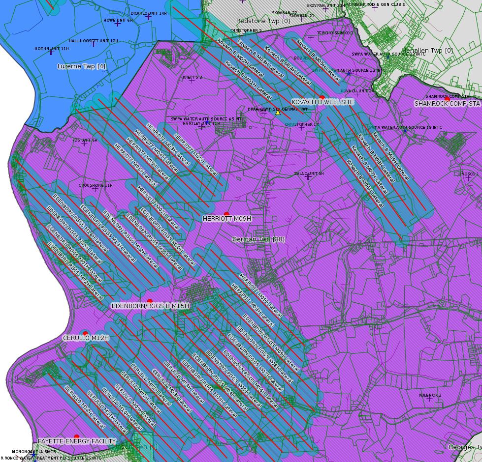
---
The Magnablend Everson Plant is evidently a mixing plant for fracking chemicals. They have a prior violation for discharging without a permit:
<http://www.ahs.dep.pa.gov/eFACTSWeb/searchResults_singleViol.aspx?InspectionID=2226981>
Violation ID Date Violation Description
684641 03/13/2013 Industrial waste was discharged without a permit
Resolution: Corrected/Abated
PA Code Legal Citation: P.L. 1987 301 : PA Code Website
Violation Type: Environmental Health & Safety
Related Enforcements
Please note: the following related enforcement data is accumulated from possibly many different sites/facilities that may be unrelated to the facility for this inspection.
Enforcement ID: 305386
Enforcement Type: Notice of Violation
Date Executed: 04/02/2013
Taken Against: MAGNABLEND INC
On Appeal? N
Enforcement Status: Comply/Closed
# of Violations Addressed by this Enforcement and Penalty Action (possibly from many facilities): 1
Although the new permit is for a Minor Source, it does not appear to be a General Permit, which means there should be public comment. When this occurs, it will be important to get as many people to respond as possible to request a hearing. There is an obvious concern about what would happen at this facility in the case of an accident. The plant is currently owned by Univar, which acquired Magnablend. According to the Tribune Review:
"The plan calls for expansion of the rail and trucking facilities to handle railroad tank cars of hydrochloric acid that will be shipped in from West Virginia. The acid, used in the fracking drilling process, will then be transferred to trucks for shipment to drilling sites in the area.
Hydrochloric acid, while corrosive, is not flammable or explosive. The acid is regulated by the federal Environmental Protection Agency."
<http://triblive.com/news/fayette/6041292-74/everson-univar-acid>
<http://www.dep.pa.gov/PublicParticipation/OfficeofEnvironmentalJustice/Pages/default.aspx>). There are supposed to be enhanced public participation requirements for permits in environmental justice areas, but news of this actually ever happening is scarce. In Fayette County, the entirety of Redstone, Springhill, Nicholson, and German Townships are environmental justice areas, as well as a large part of Dunbar Township. DEP's policy document on public participation guidelines for environmental justice areas is located here:
<http://www.elibrary.dep.state.pa.us/dsweb/Get/Version-48671/012-0501-002.pdf>
eNOTICE records are likely to list the same permit multiple times, as that permit moves through the DEP process.
Oil & Gas Wells designated with a site a number and the letter H typically designate horizontal wells.
-------------------------
Resources:
Pennsylvania Bulletin: <http://www.pabulletin.com/>
eNOTICE: <http://www.ahs2.dep.state.pa.
DEP Oil and Gas Reports: <http://www.dep.pa.gov/DataandTools/Reports/Oil%20and%20Gas%20Reports/Pages/default.aspx>
DEP Permits Issued Detail Report:
<http://www.depreportingservic
DEP SPUD (drilling started) Report:
<http://www.depreportingservices.state.pa.us/ReportServer/Pages/ReportViewer.aspx?/Oil_Gas/Spud_External_Data>
DEP Oil and Gas Compliance Report:
<http://www.depreportingservices.state.pa.us/ReportServer/Pages/ReportViewer.aspx?/Oil_Gas/OG_Compliance>
DEP PA Oil & Gas Mapping:
<http://www.depgis.state.pa.us/PaOilAndGasMapping>
Data Portal Services Directory [Technical]
<http://www.depgis.state.pa.us/arcgis/rest/services>
Query: Oil and Gas Wells All (ID: 3) [Technical]:
<http://www.depgis.state.pa.us/arcgis/rest/services/OilGas/OilGasAllStrayGasEGSP/MapServer/3/query?where=&text=&objectIds=&time=&geometry=&geometryType=esriGeometryEnvelope&inSR=&spatialRel=esriSpatialRelIntersects&relationParam=&outFields=*&returnGeometry=true&returnTrueCurves=false&maxAllowableOffset=&geometryPrecision=&outSR=&returnIdsOnly=false&returnCountOnly=false&orderByFields=&groupByFieldsForStatistics=&outStatistics=&returnZ=false&returnM=false&gdbVersion=&returnDistinctValues=false&resultOffset=&resultRecordCount=&f=html>
(Be sure to enter a Where clause in SQL format. Dates are in milliseconds since midnight 1/1/1970).
New:
DEP Oil and Gas Electronic Submissions
<http://www.ahs.dep.pa.gov/eSubmissionPublicSearch>
DEP Oil and Gas Electronic Notifications
<http://www.depreportingservices.state.pa.us/ReportServer?/Oil_Gas/OG_Notifications>
DEP Oil and Gas Well Pad Report
<http://www.depreportingservices.state.pa.us/ReportServer?/Oil_Gas/Well_Pads>
Fayette County Assessment Office Search For Tax Records:
<http://property.co.fayette.pa.us/search.aspx>
Pennsylvania Spatial Data Access:
<http://www.pasda.psu.edu/default.asp>
DEP Spatial Data Repository:
<ftp://www.pasda.psu.edu/pub/pasda/dep/>
National Response Center:
<http://www.nrc.uscg.mil/>
EPA-Echo: <http://www.epa-echo.gov/echo/
FERC citizen involvement: <http://www.ferc.gov/for-citiz
<http://www.ferc.gov/docs-fili
Follow the directions and enter the docket number to subscribe to.
Township Supervisors receive information regarding Erosion & Sedimentation permits, and these records may be reviewable at township municipal offices.
DEP permits are reviewable through the File Review process, for application to do file review see: <http://www.portal.state.pa.us/portal/server.pt/community/southwest_regional_office/13775/file_review/593164>
Environmental Hearing Board: <http://ehb.courtapps.com/publ
PA DEP Environmental Policy Comment System:
<http://www.ahs.dep.pa.gov/eComment/>
Federal Register Environment: <https://www.federalregister.g
SkyTruth Fayette County Drilling Alerts: <http://frack.skytruth.org/pen
U.S. Army Corps of Engineers, Pittsburgh District, Public Notices:
<http://www.lrp.usace.army.mil/Missions/Regulatory/Public-Notices/>
EPA Pennsylvania Public Notices: <http://www2.epa.gov/aboutepa/epa-pennsylvania#notice>
Energy Assurance Daily: <http://www.oe.netl.doe.gov/ead.aspx>
-------------------------
Disclaimers:
This compilation from the above sources was done in part by hand using copy and paste and in part using automated methods; it may omit relevant permits.
Parcel data is provided via the tax records search web page offered by the Fayette County Assessment Office (http://property.co.fayette.pa.us/). Presumed Parcel Id links are subject to availability provided by that agency and associated web sites. Presumed Parcel Ids are determined as the mapped parcel containing a given latitude and longitude, are a best effort determination which is subject to error, and are not official. In cases where a facility is leased and there is a separate parcel id for the lease, if this parcel id is not separately mapped, the parcel id shown will be the id for the enclosing parcel. Parcel owners may be surface owners only and may or may not have any relationship to oil & gas facilities.
Does not currently include water supply permits. Does not include landfill permits even though many such are for Marcellus Shale waste. (It is not possible at this time to distinguish which landfill permits are for Marcellus Shale waste and which are not without doing File Review for each permit.)
Erosion & Sedimentation permit records do not currently include latitude and longitude. Where I am publishing latitude and longitude with E&S permits it is by inferring an associated well permit and using published latitude and longitude for the well. It is possible I may be inferring the wrong well site.
Municipalities are shown from eFACTS records on the DEP web site. The DEP has been known to list a municipality incorrectly.