The Harmed Success Stories Concepts How To What Is Commentary
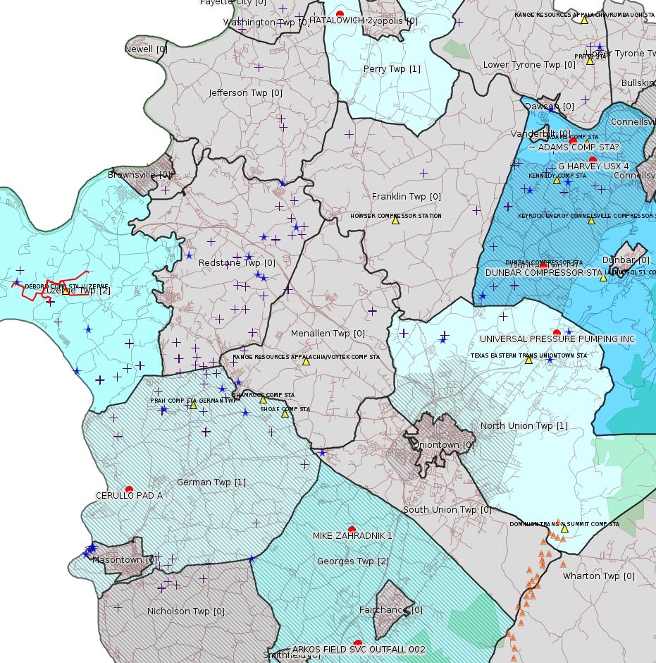
Fayette County Marcellus Shale Permits 5/21/18 - 6/3/18
Click the map to enlarge
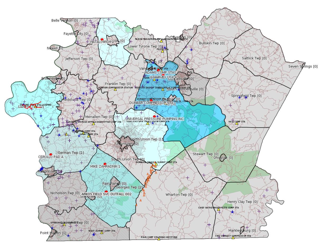
Map
Key
Red dots: items in this permit list with an exact location.
Blue stars: Marcellus Gas Well Water Sources.
Municipality shading: number of "facilities", with each well counting separately
(includes the red dots):
Red dots: items in this permit list with an exact location.
Blue stars: Marcellus Gas Well Water Sources.
Municipality shading: number of "facilities", with each well counting separately
(includes the red dots):
gray: 0
pale turquoise: 1
turquoise: 2
pale blue: 3
middle blue: 4
dark blue: 5
dark purple: 11
purple: 14
(Color coding may differ from one issue to the next.)
(Note if a project spans multiple municipalities -- e.g. a pipeline -- it will show in the count for each municipality.)
The number of facilities also follows the municipality name in brackets.
Municipality counts are based on the way the permit is listed by DEP; DEP has been known to get a municipality wrong.
Locations in brackets identify a precise location used to locate a surrogate for the actual site being permitted (e.g. locating a well pad or pipeline by the known location of a well.) Locations labeled beginning with "~" and ending in "[?]" are approximate and speculative based on inferences using on-line property and lease records. These are marked in the text as "[Approximate, Speculative]
Cross-hatching: Environmental Justice Areas
Yellow triangles: Compressor Stations
Orange triangles: Storage Field Wells (currently Dominion North Summit Storage Field)
Crosses: SPUD Unconventional well permits
Green: "Natural areas", e.g. state game lands, state forests
Yellow triangles: Compressor Stations
Orange triangles: Storage Field Wells (currently Dominion North Summit Storage Field)
Crosses: SPUD Unconventional well permits
Green: "Natural areas", e.g. state game lands, state forests
More Maps
 |
Source: Pennsylvania Bulletin
The EPA Region III Administrator has waived the right to review or object to this permit action under the waiver provision 40 CFR 123.23(d).
| Facility Location Municipality & County | Permit No. | Applicant Name & Address | Receiving Water/Use | Contact Office & Phone No. |
|---|---|---|---|---|
| Smithfield Borough Fayette County |
PAG036154 | Arkos Field Service LP 301 Laurel View Drive Smithfield, PA 15478-8909 |
Georges Creek— 19-G |
DEP Southwest Regional Office Clean Water Program 400 Waterfront Drive Pittsburgh, PA 15222-4745 412.442.4000 |
| Smithfield Borough Fayette County |
PAG036154 | Arkos Field Service LP 301 Laurel View Drive Smithfield, PA 15478-8909 |
Georges Creek— 19-G |
DEP Southwest Regional Office Clean Water Program 400 Waterfront Drive Pittsburgh, PA 15222-4745 412.442.4000 |
[For location information, see Notes.]
---
26-00585: Universal Pressure Pumping, Inc. (18360 Technology Drive, Box 4, Meadville, PA 16335) located in North Union Township, Fayette County. The Department on May 14, 2018, issued an administrative amendment to the State Only Operating Permit for the Mt. Braddock facility to incorporate a change in ownership from Universal Well Services, Inc. to Universal Pressure Pumping, Inc.
<https://www.pabulletin.com/secure/data/vol48/48-21/829d.html>
Location 39.94585,-79.655403 <http://osm.org/go/ZWpy31m3--?m=>
Presumed Parcel Id: 2516000702
---
GP5-26-00584E: Laurel Mountain Midstream Operating, LLC (Park Place Corporate Center 2, 2000 Commerce Drive, Pittsburgh, PA 15275) on May 15, 2018, to allow the continued operation of: one (1) G3516LE Caterpillar Compressor Engine (Source 101), rated at 1,340 bhp; one (1) Electric Motor Driven Compressor (Source 102), rated at 3,000 bhp; one (1) Dehydrator (Source 201), rated at 10 MMscf/d; w/reboiler, rated at 0.5 MMBtu/hr; six (6) Produced Water Tanks (Source 301)—(650 bbl total); Produced Water Truck Load-Out; Pneumatic Devices (Source 401); Compressor Rod Packing/Engine Crankcase Leaks (Source 501); Startup/Stop/Maintenance (including Blowdown) (Source 601); and Piping and Equipment Fugitives (Source 701) at their Dunbar Compressor Station, located in Dunbar Township, Fayette County.
<https://www.pabulletin.com/secure/data/vol48/48-22/861c.html>
Location: 39.975576,-79.662295 <http://osm.org/go/ZWpzxuzL--?m=> [an Environmental Justice Area]
Presumed Parcel Id: 0920019903
Fayette County Act 14 Notification: <http://faymarwatch.org/documents/SKM_554e17041316430.pdf>
[See Notes.]
-------------------------
Source: eNOTICE (+ PA Oil and Gas Mapping, Well Pad Report.) Well Details via Data Portal Services: Oil and Gas Wells All (ID: 3).
Please see the Disclaimer below regarding Parcel Id data.
New:
Authorization ID: 1230801
Permit number: 051-20362
Site: MIKE ZAHRADNIK 1 WELL
Client: BURNETT OIL CO INC
Authorization type: Well Plugging Notice Intent to Plug Single Well
Application type: New
Authorization is for: FACILITY
Date received: 05/25/2018
Status: Issued on 5/29/2018
Permit Decision Guarantee Applies?: No
Sub-Facilities for Authorization:
Sub-Facility ID Sub-Facility Name Description
56542 MIKE ZAHRADNIK 1 Well
Permit Review Notes:
Date Review Note
5/29/2018 The technical review and decision review are complete and either the permit decision and/or permit issuance are forthcoming.
5/29/2018 The permit application package is complete, has been accepted, and is undergoing technical review.
<https://www.ahs.dep.pa.gov/eFACTSWeb/searchResults_singleAuth.aspx?AuthID=1230801>
Site Programs:
Oil & Gas
Municipalities:
Georges Twp [an Environmental Justice Area], Fayette County
Well Details:
Permit Number: 051-20362
Well Name: MIKE ZAHRADNIK 1
Unconventional Well: N
Well Configuration: Vertical Well
Well Type: GAS
Well Status: Active
Coal Association: Coal
Conservation Well: N
Primary Facility ID: 43012
Site ID: 41260
Site Name: MIKE ZAHRADNIK 1 WELL
Well Pad ID: 0
Well Pad Name:
Storage Field:
Operator: BURNETT OIL CO INC
Operator Number: OGO-39119
Permit Date: 1983-06-08
Permit Date Expires: 1984-06-08
SPUD Date: 1983-10-17
Date Plugged:
UIC ID:
UIC Type:
Surface Elevation: 1211
County: Fayette
Municipality: Georges Twp
Location: 39.860056,-79.774694
Map URL: <http://www.openstreetmap.org/?mlat=39.860056&mlon=-79.774694#map=15/39.860056/-79.774694>
Presumed Parcel Id: 14060079
New:
Authorization ID: 1230777
Permit number: 26-00585
Site: UNIVERSAL PRESSURE PUMPING INC
Client: UNIVERSAL PRESSURE PUMPING INC
Authorization type: Minor Source Operating Permit
Application type: Renewal
Authorization is for: FACILITY
Date received: 05/24/2018
Status: Pending
Permit Decision Guarantee Applies?: No
<https://www.ahs.dep.pa.gov/eFACTSWeb/searchResults_singleAuth.aspx?AuthID=1230777>
Site Programs:
Air Quality
Clean Water
Environmental Cleanup & Brownfields
Waste Management
Municipalities:
North Union Twp, Fayette County
Location 39.94585,-79.655403 <http://osm.org/go/ZWpy31m3--?m=>
Presumed Parcel Id: 2516000702
New:
Authorization ID: 1230405
Permit number: ESX18-051-0004
Site: CERULLO PAD A ESCGP ESX18-051-0004
Client: CHEVRON APPALACHIA LLC
Authorization type: Expedited E&S Stormwater General Permit 1
Application type: New
Authorization is for: SITE
Date received: 05/24/2018
Status: Pending
Permit Decision Guarantee Applies?: Yes
Permit Decision Guarantee status: ACTIVE
<https://www.ahs.dep.pa.gov/eFACTSWeb/searchResults_singleAuth.aspx?AuthID=1230405>
Site Programs:
Municipalities:
German Twp [an Environmental Justice Area], Fayette County
Well Pad Id: 155068
Wells on this Pad:
051-24650 CERULLO 1
Location: 39.879083,-79.902789 <https://osm.org/go/ZWpNvUhQ--?m=>
Presumed Parcel Id: 15190070
Authorization ID: 1219473
Permit number: GP08260718001
Site: DOGBONE WATER LINE SYSTEM GP5 & GP8
Client: CHEVRON APPALACHIA LLC
Authorization type: GP-08 Temporary Road Crossings
Application type: New
Authorization is for: FACILITY
Date received: 02/26/2018
Status: Pending
Permit Decision Guarantee Applies?: No
Sub-Facilities for Authorization:
Sub-Facility ID Sub-Facility Name Description
1255183 DOGBONE WATER LINE SYSTEM GP08260718-001 Bridge
Permit Review Notes:
Date Review Note
5/2/2018 Applicant has been issued a deficiency letter. If applicable, this application no longer qualifies for the Permit Decision Guarantee.
4/20/2018 Applicant has been issued a deficiency letter. If applicable, this application no longer qualifies for the Permit Decision Guarantee.
<https://www.ahs.dep.pa.gov/eFACTSWeb/searchResults_singleAuth.aspx?AuthID=1219473>
Site Programs:
Water Planning and Conservation
Municipalities:
Luzerne Twp, Fayette County
Authorization ID: 1219469
Permit number: GP05260718001
Site: DOGBONE WATER LINE SYSTEM GP5 & GP8
Client: CHEVRON APPALACHIA LLC
Authorization type: GP-05 Utility Line Stream Crossings
Application type: New
Authorization is for: FACILITY
Date received: 02/26/2018
Status: Pending
Permit Decision Guarantee Applies?: Yes
Permit Decision Guarantee status: VOID
Sub-Facilities for Authorization:
Sub-Facility ID Sub-Facility Name Description
1255180 DOGBONE WATER LINE SYSTEM GP05260718-001 Pipeline or Conduit
Permit Review Notes:
Date Review Note
5/2/2018 Applicant has been issued a deficiency letter. If applicable, this application no longer qualifies for the Permit Decision Guarantee.
4/20/2018 Applicant has been issued a deficiency letter. If applicable, this application no longer qualifies for the Permit Decision Guarantee.
<https://www.ahs.dep.pa.gov/eFACTSWeb/searchResults_singleAuth.aspx?AuthID=1219469>
Site Programs:
Water Planning and Conservation
Municipalities:
Luzerne Twp, Fayette County
Authorization ID: 1166384
Permit number: GP5-26-00549F
Site: ADAMS COMP STA
Client: MTN GATHERING LLC
Authorization type: AQ GP 5 - Natural Gas Compression and/or Processing Facilities
Application type: New
Authorization is for: FACILITY
Date received: 01/12/2017
Status: Issued on 5/24/2018
Permit Decision Guarantee Applies?: No
Sub-Facilities for Authorization:
Sub-Facility ID Sub-Facility Name Description
1072089 DEHYDRATION UNIT Process
Location: 40.03313,-79.661428
Map URL: <http://www.openstreetmap.org/?mlat=40.03313&mlon=-79.661428#map=15/40.03313/-79.661428>
1072091 EMIT OXIDATION CATALYST Air Pollution Control Device
Location: 40.03313,-79.661428
Map URL: <http://www.openstreetmap.org/?mlat=40.03313&mlon=-79.661428#map=15/40.03313/-79.661428>
1072088 ENGINE 2 CATERPILLAR G3516LE, 1340 HP Process
Location: 40.03313,-79.661428
Map URL: <http://www.openstreetmap.org/?mlat=40.03313&mlon=-79.661428#map=15/40.03313/-79.661428>
1190026 FUGITIVES Process
Location: 40.030833,-79.644167
Map URL: <http://www.openstreetmap.org/?mlat=40.030833&mlon=-79.644167#map=15/40.030833/-79.644167>
1190016 HEATERS/REBOILERS Process
Location: 40.030833,-79.644167
Map URL: <http://www.openstreetmap.org/?mlat=40.030833&mlon=-79.644167#map=15/40.030833/-79.644167>
1072090 MISC VOC, TANKS, BLOWDOWNS, LEAKS, ETC. Process
Location: 40.03313,-79.661428
Map URL: <http://www.openstreetmap.org/?mlat=40.03313&mlon=-79.661428#map=15/40.03313/-79.661428>
1190015 NATURAL GAS LINE Fuel Material Location
Location: 40.030833,-79.644167
Map URL: <http://www.openstreetmap.org/?mlat=40.030833&mlon=-79.644167#map=15/40.030833/-79.644167>
1196120 PIGGING OPERATIONS Process
Location: 40.030833,-79.644167
Map URL: <http://www.openstreetmap.org/?mlat=40.030833&mlon=-79.644167#map=15/40.030833/-79.644167>
1190022 PNEUMATIC DEVICES Process
Location: 40.030833,-79.644167
Map URL: <http://www.openstreetmap.org/?mlat=40.030833&mlon=-79.644167#map=15/40.030833/-79.644167>
1190018 TANKS/VESSELS Process
Location: 40.030833,-79.644167
Map URL: <http://www.openstreetmap.org/?mlat=40.030833&mlon=-79.644167#map=15/40.030833/-79.644167>
1190024 VENTING/BLOWDOWNS Process
Location: 40.030833,-79.644167
Map URL: <http://www.openstreetmap.org/?mlat=40.030833&mlon=-79.644167#map=15/40.030833/-79.644167>
1194699 WAUKESHA/VRG-330 Process
Location: 40.030833,-79.644167
Map URL: <http://www.openstreetmap.org/?mlat=40.030833&mlon=-79.644167#map=15/40.030833/-79.644167>
Permit Review Notes:
Date Review Note
5/24/2018 The technical review and decision review are complete and either the permit decision and/or permit issuance are forthcoming.
1/18/2017 The permit application package is complete, has been accepted, and is undergoing technical review.
<https://www.ahs.dep.pa.gov/eFACTSWeb/searchResults_singleAuth.aspx?AuthID=1166384>
Site Programs:
Air Quality
Municipalities:
Dunbar Twp, Fayette County
Location: 40.030833,-79.644167 [an Environmental Justice Area] <http://osm.org/go/ZWp29lrC--?m=>
[See Notes.]
-------------------------
Source: DEP Oil and Gas Compliance Report
[Conventional Well:]
OPERATOR: ATLAS RESOURCES LLC
INSPECTION_ID: 2731451
INSPECTION_DATE: 05/10/2018
INSPECTION_TYPE: Complaint Inspection
API_PERMIT: 051-22380
FARM_NAME: HATALOWICH 2
UNCONVENTIONAL: No
SITE_ID: 638790
SITE_NAME: HATALOWICH 2 OG WELL
FACILITY_TYPE: Oil & Gas Location
INSPECTION_CATEGORY: Primary Facility
REGION: EP DOGO SWDO Dstr Off
COUNTY: Fayette
MUNICIPALITY: Perry Twp
INSPECTOR: NAJEWICZ, JUSTIN
INSPECTION_SOURCE: SAIR
INSPECTION_RESULT_DESCRIPTION: Violation(s) Noted
INSPECTION_COMMENT: "On 05/10/18 at approximately 1330 hours WQSS John Carson and I conducted a complaint inspection.
The production equipment appeared to be in good condition. A cross culvert was observed near the well. The inlet side appeared to be in good condition and functioning. The outlet side showed signs of erosion. It is recommended that an energy diffusing feature, such as rip rap, be added.
Significant accelerated erosion was observed along the access road near the well (see photographs). The access road and roadside ditch appeared to be poorly maintained. Eroded material from beside the access road was observed in the field below. Violations of 102.11(a)(1) and 78.53 have occurred."
VIOLATION_ID: 817130
VIOLATION_DATE: 05/10/2018
VIOLATION_CODE: 78.53 - EROSION AND SEDIMENT CONTROL - Operator failed to design, implement and maintain best management practices and an erosion and sediment control plan in accordance with 25 Pa. Code Chapter 102, during and after earthmoving or soil disturbing activities, including the activities related to siting, drilling, completing, producing, servicing and plugging, constructing, utilizing and restoring the site and access road.
VIOLATION_TYPE: Environmental Health & Safety
VIOLATION_COMMENT: Operator failed to maintain the access road and roadside ditch resulting in accelerated erosion.
RESOLVED_DATE:
RESOLUTION_REASON_CODE_DESCRIPTION:
CONTINUING_VIOLATION:
ENFORCEMENT_ID:
ENFORCEMENT_CODE_DESCRIPTION:
DATE_EXECUTED:
ENFORCEMENT_FINAL_DATE:
ENFORCEMENT_FINAL_STATUS:
PENALTY_FINAL_DATE:
PENALTY_FINAL_STATUS_CODE_DESCRIPTION:
PENALTY_AMOUNT:
TOTAL_AMOUNT_COLLECTED:
Well Details:
Permit Number: 051-22380
Well Name: HATALOWICH 2
Unconventional Well: N
Well Configuration: Vertical Well
Well Type: GAS
Well Status: Active
Coal Association: NonCoal
Conservation Well: N
Primary Facility ID: 654167
Site ID: 638790
Site Name: HATALOWICH 2 OG WELL
Well Pad ID: 0
Well Pad Name:
Storage Field:
Operator: ATLAS RESOURCES LLC
Operator Number: OGO-66455
Permit Date: 2004-09-24
Permit Date Expires: 2005-09-24
SPUD Date: 2005-01-15
Date Plugged:
UIC ID:
UIC Type:
Surface Elevation: 1158
County: Fayette
Municipality: Perry Twp
Location: 40.088505,-79.777629
Map URL: <http://www.openstreetmap.org/?mlat=40.088505&mlon=-79.777629#map=15/40.088505/-79.777629>
Parcel Id: 2710002001
[For a copy of the SAIR (Surface Activity Inspection Report) -- including photographs -- see:
<https://www.depgreenport.state.pa.us/eWellDocs/download/DocsZipFile/?P_DER_CODE=9&P_ENTITY_TYPE=2&S=4&P_ID=2731451>
Accessed via DEP Oil and Gas Inspection Reports Viewer.]
---
[Conventional Well:]
OPERATOR: KEYROCK ENERGY LLC
INSPECTION_ID: 2731589
INSPECTION_DATE: 05/10/2018
INSPECTION_TYPE: Routine/Partial Inspection
API_PERMIT: 051-21013
FARM_NAME: G HARVEY USX 4
UNCONVENTIONAL: No
SITE_ID: 489985
SITE_NAME: G HARVEY USX 4 OG WELL
FACILITY_TYPE: Oil & Gas Location
INSPECTION_CATEGORY: Primary Facility
REGION: EP DOGO SWDO Dstr Off
COUNTY: Fayette
MUNICIPALITY: Dunbar Twp
INSPECTOR: WITHAM, CYNTHIA
INSPECTION_SOURCE: SAIR
INSPECTION_RESULT_DESCRIPTION: No Violations Noted
INSPECTION_COMMENT: "Routine Partial Inspection to inspection record #2731555.
At time of inspection disturbed area appears to have been backfilled, seeded, and mulched. No leaking air/gas observed at this time. It appears the leaking line has been fixed.
Inspection(s) will be conducted at a later date to ensure site is permanently stabilized.
Violation(s) may be issued based on future inspection(s)."
OPERATOR: KEYROCK ENERGY LLC
INSPECTION_ID: 2733869
INSPECTION_DATE: 05/04/2018
INSPECTION_TYPE: Administrative/File Review
API_PERMIT: 051-21013
FARM_NAME: G HARVEY USX 4
UNCONVENTIONAL: No
SITE_ID: 489985
SITE_NAME: G HARVEY USX 4 OG WELL
FACILITY_TYPE: Oil & Gas Location
INSPECTION_CATEGORY: Primary Facility
REGION: EP DOGO SWDO Dstr Off
COUNTY: Fayette
MUNICIPALITY: Dunbar Twp
INSPECTOR: WITHAM, CYNTHIA
INSPECTION_SOURCE: SAIR
INSPECTION_RESULT_DESCRIPTION: Violation(s) Noted
INSPECTION_COMMENT: "ADMIN Inspection to inspection record #2731555. At the time of that inspection, it appears the buried line was compromised and air/gas was escaping.
Based on observations made in above mentioned inspection, a violation is being issued for venting of gas to the atmosphere that produced a hazard to the public health and safety.
This inspection is being referred to OGI Supervisor for OGI follow up."
VIOLATION_ID: 817495
VIOLATION_DATE: 05/04/2018
VIOLATION_CODE: 78.74 - VENTING OF GAS - Operator vented gas to the atmosphere that produced a hazard to the public health and safety.
VIOLATION_TYPE: Environmental Health & Safety
VIOLATION_COMMENT:
RESOLVED_DATE: 05/08/2018
RESOLUTION_REASON_CODE_DESCRIPTION: CRCTD - Corrected/Abated
CONTINUING_VIOLATION:
ENFORCEMENT_ID: 364292
ENFORCEMENT_CODE_DESCRIPTION: NOV - Notice of Violation
DATE_EXECUTED: 05/04/2018
ENFORCEMENT_FINAL_DATE:
ENFORCEMENT_FINAL_STATUS:
PENALTY_FINAL_DATE:
PENALTY_FINAL_STATUS_CODE_DESCRIPTION:
PENALTY_AMOUNT:
TOTAL_AMOUNT_COLLECTED:
OPERATOR: KEYROCK ENERGY LLC
INSPECTION_ID: 2733911
INSPECTION_DATE: 05/08/2018
INSPECTION_TYPE: Compliance Evaluation
API_PERMIT: 051-21013
FARM_NAME: G HARVEY USX 4
UNCONVENTIONAL: No
SITE_ID: 489985
SITE_NAME: G HARVEY USX 4 OG WELL
FACILITY_TYPE: Oil & Gas Location
INSPECTION_CATEGORY: Primary Facility
REGION: EP DOGO SWDO Dstr Off
COUNTY: Fayette
MUNICIPALITY: Dunbar Twp
INSPECTOR: WITHAM, CYNTHIA
INSPECTION_SOURCE: SAIR
INSPECTION_RESULT_DESCRIPTION: No Violations Noted
INSPECTION_COMMENT: "ADMIN Compliance Evaluation Inspection to inspection record #2733869.
According to inspection record #2731584, operator reported that the leaking line was fixed on 5-7-18.
Based on observations recorded in inspection record #2731589 no leaking air/gas was observed and it appears the line has been fixed.
The violation issued on 5-4-18 has been corrected and is closed."
OPERATOR: KEYROCK ENERGY LLC
INSPECTION_ID: 2734744
INSPECTION_DATE: 05/24/2018
INSPECTION_TYPE: Administrative/File Review
API_PERMIT: 051-21013
FARM_NAME: G HARVEY USX 4
UNCONVENTIONAL: No
SITE_ID: 489985
SITE_NAME: G HARVEY USX 4 OG WELL
FACILITY_TYPE: Oil & Gas Location
INSPECTION_CATEGORY: Primary Facility
REGION: EP DOGO SWDO Dstr Off
COUNTY: Fayette
MUNICIPALITY: Dunbar Twp
INSPECTOR: WITHAM, CYNTHIA
INSPECTION_SOURCE: SAIR
INSPECTION_RESULT_DESCRIPTION: No Violations Noted
INSPECTION_COMMENT: "ADMIN Inspection to inspection record #2731555.
Department contacted operator rep Doug Wadsworth by phone. Department requested information about pipe lines located near area of no vegetation observed in above inspection. Mr. Wadsworth stated a municipal water line is located alongside the operators brine and gas lines. Mr. Wadsworth also stated that pictures were taken by him during the fixing of the pipe.
Inspection(s) will be conducted at a later date to ensure site is permanently stabilized.
Violation(s) may be issued based on future inspection(s)."
Well Details:
Permit Number: 051-21013
Well Name: G HARVEY USX 4
Unconventional Well: N
Well Configuration: Vertical Well
Well Type: COALBED METHANE
Well Status: Active
Coal Association: Coal
Conservation Well: N
Primary Facility ID: 518408
Site ID: 489985
Site Name: G HARVEY USX 4 OG WELL
Well Pad ID: 0
Well Pad Name:
Storage Field:
Operator: KEYROCK ENERGY LLC
Operator Number: OGO-39111
Permit Date: 1998-07-24
Permit Date Expires: 1999-07-24
SPUD Date: 1998-09-28
Date Plugged:
UIC ID:
UIC Type:
Surface Elevation: 1118
County: Fayette
Municipality: Dunbar Twp
Location: 40.022269,-79.633041 [an Environmental Justice Area]
Map URL: <http://www.openstreetmap.org/?mlat=40.022269&mlon=-79.633041#map=15/40.022269/-79.633041>
Presumed Parcel Id: 09110262
[For a copy of the SAIR (Surface Activity Inspection Report) from a prior inspection -- including photographs -- see:
<https://www.depgreenport.state.pa.us/eWellDocs/download/DocsZipFile/?P_DER_CODE=9&P_ENTITY_TYPE=2&S=4&P_ID=2731555>
Accessed via DEP Oil and Gas Inspection Reports Viewer.]
-------------------------
Source: Reuters Commodities: Energy
Natural Gas
| Commodity | Exchange | Currency | Expire | Last Trade | Trade Time | Change | Open | Day's High | Day's Low |
|---|---|---|---|---|---|---|---|---|---|
| NATURAL
GAS CON1 Jun18 |
NYM | USD | 06/27 | 2.89 | 06/05 00:00 | +0.00 | 2.89 | 2.89 | 2.89 |
-------------------------
Notes:
The Authorization Record for the ARKOS FIELD SVC site shows the following:
Authorization ID: 1109304
Permit number: PAG036154
Site: ARKOS FIELD SVC SMITHFIELD
Client: ARKOS FIELD SVC LP
Authorization type: PAG-03 Discharge of Stormwater Assoc w Industrial Activities
Application type: New
Authorization is for: FACILITY
Date received: 02/23/2016
Status: Issued on 5/15/2018
Permit Decision Guarantee Applies?: Yes
Permit Decision Guarantee status: VOID
Sub-Facilities for Authorization:
Sub-Facility ID Sub-Facility Name Description
1206640 OUTFALL 001 Discharge Point
Location: 39.809261,-79.772939
Map URL: <http://www.openstreetmap.org/?mlat=39.809261&mlon=-79.772939#map=15/39.809261/-79.772939>
1258866 OUTFALL 002 Discharge Point
Location: 39.809678,-79.772061
Map URL: <http://www.openstreetmap.org/?mlat=39.809678&mlon=-79.772061#map=15/39.809678/-79.772061>
Permit Review Notes:
Date Review Note
5/14/2018 The technical review and decision review are complete and either the permit decision and/or permit issuance are forthcoming.
5/11/2018 Applicant has been issued a deficiency letter. If applicable, this application no longer qualifies for the Permit Decision Guarantee.
<https://www.ahs.dep.pa.gov/eFACTSWeb/searchResults_singleAuth.aspx?AuthID=1109304>
Site Programs:
Clean Water
Municipalities:
Smithfield Boro, Fayette County
Smithfield Boro as the municipality is almost certainly incorrect. The two outfall locations are clearly in Georges Twp, an Environmental Justice Area, and the enclosing Parcel ID, 1425020722, also appears to be correct. It is possible DEP is confusing a postal address with an actual location municipality.
---
There is major uncertainty about the location of the Adams Compressor Station. The DEP maintains latitude and longitude for "Air Emission Plants" at the sub-facility level. Separate geolocation by sub-facility makes sense for certain types of permits, where e.g. each outfall or stream crossing has its own location. For compressor stations this can cause serious confusion. For the Adams compressor station, sub-facilities are currently carrying two different locations:
Location: 40.03313,-79.661428
Map URL: <http://www.openstreetmap.org/?mlat=40.03313&mlon=-79.661428#map=15/40.03313/-79.661428>
This is not in Dunbar Twp; instead it maps to Vanderbilt. The second location is:
Location: 40.030833,-79.644167
Map URL: <http://www.openstreetmap.org/?mlat=40.030833&mlon=-79.644167#map=15/40.030833/-79.644167>
The previous location published via an "eMapPA link" [an older system, no longer operating] in the Facility Record was:
Location: 40.030837,-79.644161 [an Environmental Justice Area] <http://osm.org/go/ZWp29lrC--?m=>
Meanwhile, the address in the Facility Record is:
362 LEISENRING VANDERBILT RD
VANDERBILT, PA 15486-1018
Dunbar Township, Fayette County
which is in yet a different place. Discrepancies in geolocating compressor stations are so profuse, one is tempted to think there is deliberate obfuscation. If DEP is "confused" about the location of a compressor station, how can it ever have been properly inspected?
The location being shown on the maps in this issue is the second one (Dunbar Twp) from the sub-facility records, but this is not verified.
---
The location of the Dunbar Compressor Station, both in DEP records and as notified to Fayette County by Laurel Mountain Midstream, appears to be incorrect. The location shown above has been determined using property records, and we believe it is correct. For details see the Notes in the 4/16/17 issue of this bulletin. The "sub-facility" records shown above seem include ones for equipment which LMM claims in its Act 14 notification have been removed.
------------------------
DEP defines an environmental justice area as "any census tract where 20 percent or more individuals live in poverty, and/or 30 percent or more of the population is minority". (See:
<http://www.dep.pa.gov/PublicParticipation/OfficeofEnvironmentalJustice/Pages/default.aspx>). There are supposed to be enhanced public participation requirements for permits in environmental justice areas, but news of this actually ever happening is scarce. In Fayette County, the entirety of Springhill, Nicholson, German, and Georges Townships are environmental justice areas, as well as a large part of Dunbar Township. DEP's policy document on public participation guidelines for environmental justice areas is located here:
<http://www.elibrary.dep.state.pa.us/dsweb/Get/Version-48671/012-0501-002.pdf>
eNOTICE records are likely to list the same permit multiple times, as that permit moves through the DEP process.
Oil & Gas Wells designated with a site a number and the letter H typically designate horizontal wells.
-------------------------
Resources:
Pennsylvania Bulletin: <http://www.pabulletin.com/>
eNOTICE: <http://www.ahs2.dep.state.pa.
DEP Oil and Gas Reports: <http://www.dep.pa.gov/DataandTools/Reports/Oil%20and%20Gas%20Reports/Pages/default.aspx>
DEP Permits Issued Detail Report:
<http://www.depreportingservic
DEP SPUD (drilling started) Report:
<http://www.depreportingservices.state.pa.us/ReportServer/Pages/ReportViewer.aspx?/Oil_Gas/Spud_External_Data>
DEP Oil and Gas Compliance Report:
<http://www.depreportingservices.state.pa.us/ReportServer/Pages/ReportViewer.aspx?/Oil_Gas/OG_Compliance>
DEP PA Oil & Gas Mapping:
<http://www.depgis.state.pa.us/PaOilAndGasMapping>
Data Portal Services Directory [Technical]
<http://www.depgis.state.pa.us/arcgis/rest/services>
Query: Oil and Gas Wells All (ID: 3) [Technical]:
<http://www.depgis.state.pa.us/arcgis/rest/services/OilGas/OilGasAllStrayGas/MapServer/3/query?where=&text=&objectIds=&time=&geometry=&geometryType=esriGeometryEnvelope&inSR=&spatialRel=esriSpatialRelIntersects&relationParam=&outFields=*&returnGeometry=true&returnTrueCurves=false&maxAllowableOffset=&geometryPrecision=&outSR=&returnIdsOnly=false&returnCountOnly=false&orderByFields=&groupByFieldsForStatistics=&outStatistics=&returnZ=false&returnM=false&gdbVersion=&returnDistinctValues=false&resultOffset=&resultRecordCount=&f=html>
(Be sure to enter a Where clause in SQL format. Dates are in milliseconds since midnight 1/1/1970).
New:
DEP Oil and Gas Electronic Submissions
<http://www.ahs.dep.pa.gov/eSubmissionPublicSearch>
DEP Oil and Gas Electronic Notifications
<http://www.depreportingservices.state.pa.us/ReportServer?/Oil_Gas/OG_Notifications>
DEP Oil and Gas Well Pad Report
<http://www.depreportingservices.state.pa.us/ReportServer?/Oil_Gas/Well_Pads>
Fayette County Assessment Office Search For Tax Records:
<http://property.co.fayette.pa.us/search.aspx>
Pennsylvania Spatial Data Access:
<http://www.pasda.psu.edu/default.asp>
DEP Spatial Data Repository:
<ftp://www.pasda.psu.edu/pub/pasda/dep/>
National Response Center:
<http://www.nrc.uscg.mil/>
EPA-Echo: <http://www.epa-echo.gov/echo/
FERC citizen involvement: <http://www.ferc.gov/for-citiz
To receive E-mail notification of
all documents filed in a FERC docket, see:
<http://www.ferc.gov/docs-filing/esubscription.asp >
<http://www.ferc.gov/docs-fili
Follow the directions and enter the docket number to subscribe to.
Township Supervisors receive information regarding Erosion & Sedimentation permits, and these records may be reviewable at township municipal offices.
DEP permits are reviewable through the File Review process, for application to do file review see: <http://www.portal.state.pa.us/portal/server.pt/community/southwest_regional_office/13775/file_review/593164>
Environmental Hearing Board: <http://ehb.courtapps.com/publ
PA DEP Environmental Policy Comment System:
<http://www.ahs.dep.pa.gov/eComment/>
Federal Register Environment: <https://www.federalregister.g
Browsing of recent comment
opportunities for federal agencies, e.g. EPA. Click "sign up" to
subscribe to daily E-mails of new document listings.
SkyTruth Fayette County Drilling Alerts: <http://frack.skytruth.org/pen
U.S. Army Corps of Engineers, Pittsburgh District, Public Notices:
<http://www.lrp.usace.army.mil/Missions/Regulatory/Public-Notices/>
EPA Pennsylvania Public Notices: <http://www2.epa.gov/aboutepa/epa-pennsylvania#notice>
Marcellus Shale waste disposal
injection wells in Pennsylvania are regulated directly by EPA, not
DEP. Notice of any new permit applications will appear at the
above web address. I'm not aware of any subscription service
to be notified of such applications. I'm not aware of any
Marcellus Shale waste disposal injection wells in Fayette County
(yet ...) but we need to monitor this page for future
applications.
Energy Assurance Daily: <http://www.oe.netl.doe.gov/ead.aspx>
Daily newsletter from the US
Department of Energy about events relating to energy. The Natural
Gas section has information about pipelines.
-------------------------
Disclaimers:
This compilation from the above sources was done in part by hand using copy and paste and in part using automated methods; it may omit relevant permits.
Parcel data is provided via the tax records search web page offered by the Fayette County Assessment Office (http://property.co.fayette.pa.us/). Presumed Parcel Id links are subject to availability provided by that agency and associated web sites. Presumed Parcel Ids are determined as the mapped parcel containing a given latitude and longitude, are a best effort determination which is subject to error, and are not official. In cases where a facility is leased and there is a separate parcel id for the lease, if this parcel id is not separately mapped, the parcel id shown will be the id for the enclosing parcel. Parcel owners may be surface owners only and may or may not have any relationship to oil & gas facilities.
Does not currently include water supply permits. Does not include landfill permits even though many such are for Marcellus Shale waste. (It is not possible at this time to distinguish which landfill permits are for Marcellus Shale waste and which are not without doing File Review for each permit.)
Erosion & Sedimentation permit records do not currently include latitude and longitude. Where I am publishing latitude and longitude with E&S permits it is by inferring an associated well permit and using published latitude and longitude for the well. It is possible I may be inferring the wrong well site.
Municipalities are shown from eFACTS records on the DEP web site. The DEP has been known to list a municipality incorrectly.