The Harmed Success Stories Concepts How To What Is Commentary
Fayette County Marcellus Shale Permits 6/15/20 - 6/28/20
Contents
Pennsylvania Bulletin Listings
[No Activity]eFACTS Listings
SHOAF NORTH CENTRALIZED FRESHWATER IMPOUNDMENT Erosion and Sediment Control GP-2 [Termination?] Notification (New)Price of Natural Gas
HIBBS FRESHWATER PIT ESCGP-EXPEDITED Erosion and Sediment Control GP-2 [Termination?] Notification (New)
TEXAS EASTERN TRANS LP UNIONTOWN Minor Source Operating Permit Amendment (New)
TEXAS EASTERN TRANS LP UNIONTOWN Major Facility Operating Permit Amendment Withdrawn 6/17/2020
GANS POWER STATION Minor IW Facility without ELG
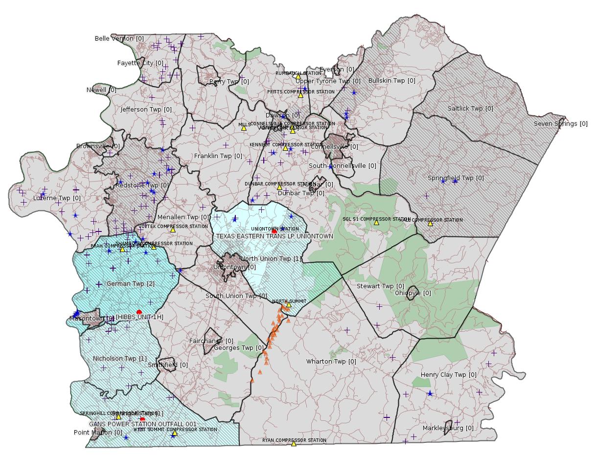
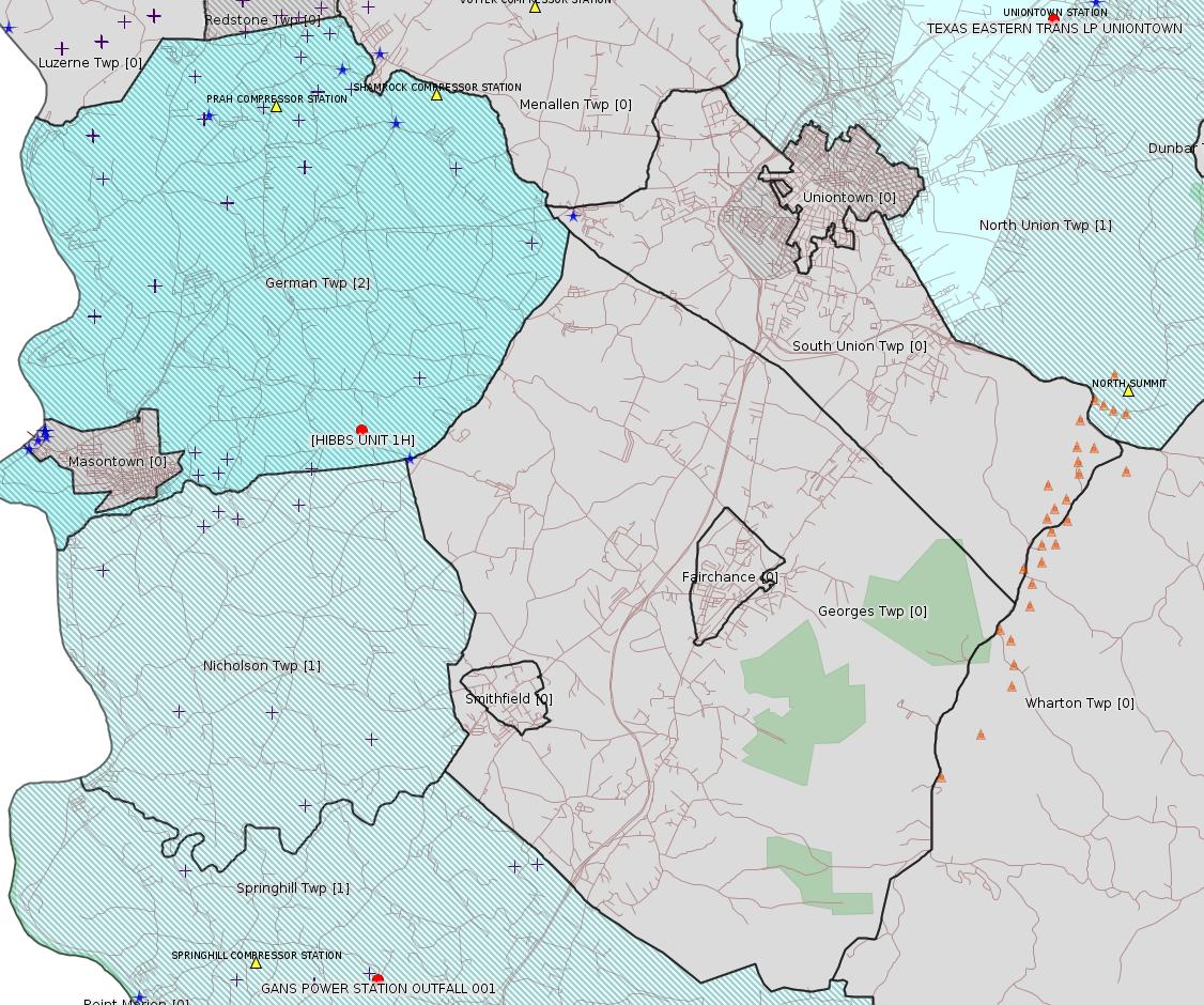
Map
Key
Red dots: items in this permit list with an exact location.
Blue stars: Marcellus Gas Well Water Sources.
Where well laterals are mapped they show in red; a 400-foot buffer surrounding the lateral shows in blue (lavender where it overlaps a mapped mineral tract).
Where mineral tracts are mapped, they show in pink. Mineral tracts can overlap; the overlap will show in red. The precise meaning of "mineral tract" is not clear.
Municipality shading: number of "facilities", with each well counting separately
(includes the red dots):
gray: 0
pale turquoise: 1
turquoise: 2
pale blue: 3
middle blue: 4
dark blue: 5
dark purple: 6
purple: 18
(Color coding may differ from one issue to the next.)
(Note if a project spans multiple municipalities -- e.g. a pipeline -- it will show in the count for each municipality.)
The number of facilities also follows the municipality name in brackets.
Municipality counts are based on the way the permit is listed by DEP; DEP has been known to get a municipality wrong.
Locations in brackets identify a precise location used to locate a surrogate for the actual site being permitted (e.g. locating a well pad or pipeline by the known location of a well.) Locations labeled beginning with "~" and ending in "[?]" are approximate and speculative based on inferences using on-line property and lease records. These are marked in the text as "[Approximate, Speculative]
Cross-hatching: Environmental Justice Areas
Yellow triangles: Compressor Stations
Orange triangles: Storage Field Wells (currently Dominion North Summit Storage Field)
Crosses: SPUD Unconventional well permits
Green: "Natural areas", e.g. state game lands, state forests
Yellow triangles: Compressor Stations
Orange triangles: Storage Field Wells (currently Dominion North Summit Storage Field)
Crosses: SPUD Unconventional well permits
Green: "Natural areas", e.g. state game lands, state forests
More Maps
 |
Source: Pennsylvania Bulletin
[No Activity]
-------------------------
Source: eNOTICE
(+ PA
Oil and Gas Mapping, Well
Pad Report.) Well Details via Data
Portal Services: Oil and Gas Wells All (ID: 3).
Please see the Disclaimer below regarding Parcel Id data.
Authorization ID: 1317955
Permit number: ESX11-051-0042
Site: SHOAF NORTH CENTRALIZED FRESHWATER IMPOUNDMENT ESCGP-X
Client: BURNETT OIL CO INC
Authorization type: Erosion and Sediment Control GP-2
Application type: Notification
Authorization is for: SITE
Date received: 06/17/2020
Status: Pending
Permit Decision Guarantee Applies?: No
<https://www.ahs.dep.pa.gov/eFACTSWeb/searchResults_singleAuth.aspx?AuthID=1317955>
Site Programs:
Site Municipalities:
German Twp, Fayette County
---
Authorization ID: 1317954
Permit number: ESX10-051-0034
Site: HIBBS FRESHWATER PIT ESCGP-EXPEDITED
Client: BURNETT OIL CO INC
Authorization type: Erosion and Sediment Control GP-2
Application type: Notification
Authorization is for: SITE
Date received: 06/17/2020
Status: Pending
Permit Decision Guarantee Applies?: No
Permit Review Notes:
Date Review Note
6/22/2020 The permit application package is complete, has been accepted, and is undergoing technical review.
<https://www.ahs.dep.pa.gov/eFACTSWeb/searchResults_singleAuth.aspx?AuthID=1317954>
Site Programs:
Site Municipalities:
German Twp, Fayette County
Nicholson Twp, Fayette County
Location [of HIBBS UNIT 1H]: 39.853611,-79.844861
Presumed Parcel Id: 1536010401
---
Authorization ID: 1317555
Permit number: 26-00413
Site: TEXAS EASTERN TRANS LP UNIONTOWN
Client: TEXAS EASTERN TRANS LP
Authorization type: Minor Source Operating Permit
Application type: Amendment
Authorization is for: FACILITY
Date received: 06/11/2020
Status: Pending
Permit Decision Guarantee Applies?: No
Permit Review Notes:
Date Review Note
6/17/2020 The permit application package is complete, has been accepted, and is undergoing technical review.
<https://www.ahs.dep.pa.gov/eFACTSWeb/searchResults_singleAuth.aspx?AuthID=1317555>
Site Programs:
Air Quality
Waste Management
Site Municipalities:
North Union Twp, Fayette County
Uniontown [Incorrect -jr], Fayette County
Location: 39.93111,-79.67
Map URL: <https://www.openstreetmap.org/?mlat=39.93111&mlon=-79.67#map=15/39.93111/-79.67>
Presumed Parcel Id: 25120168
---
Authorization ID: 1291761
Permit number: 26-00413
Site: TEXAS EASTERN TRANS LP UNIONTOWN
Client: TEXAS EASTERN TRANS LP
Authorization type: Major Facility Operating Permit
Application type: Amendment
Authorization is for: FACILITY
Date received: 06/19/2019
Status: Withdrawn on 6/17/2020
Permit Decision Guarantee Applies?: No
Permit Review Notes:
Date Review Note
10/11/2019 The permit application package is complete, has been accepted, and is undergoing technical review.
<https://www.ahs.dep.pa.gov/eFACTSWeb/searchResults_singleAuth.aspx?AuthID=1291761>
Site Programs:
Air Quality
Waste Management
Site Municipalities:
North Union Twp, Fayette County
Uniontown [Incorrect -jr], Fayette County
Location: 39.93111,-79.67
Map URL: <https://www.openstreetmap.org/?mlat=39.93111&mlon=-79.67#map=15/39.93111/-79.67>
Presumed Parcel Id: 25120168
---
Authorization ID: 1270121
Permit number: PA0218464
Site: GANS POWER STATION
Client: GANS ENERGY LLC
Authorization type: Minor IW Facility without ELG
Application type: Renewal
Authorization is for: FACILITY
Date received: 04/03/2019
Status: Pending
Permit Decision Guarantee Applies?: No
Sub-Facilities for Authorization:
Sub-Facility ID Sub-Facility Name Description
512929 OUTFALL 001 Discharge Point
Location: 39.7475,-79.8425
Map URL: <http://www.openstreetmap.org/?mlat=39.7475&mlon=-79.8425#map=15/39.7475/-79.8425>
1061519 OUTFALL 101 Internal Monitoring Point
1061526 OUTFALL 201 Internal Monitoring Point
Permit Review Notes:
Date Review Note
6/24/2020 The technical review and decision review are complete and either the permit decision and/or permit issuance are forthcoming.
4/22/2019 The permit application package is complete, has been accepted, and is undergoing technical review.
<https://www.ahs.dep.pa.gov/eFACTSWeb/searchResults_singleAuth.aspx?AuthID=1270121>
Site Programs:
Air Quality
Clean Water
Waste Management
Site Municipalities:
Springhill Twp, Fayette County
-------------------------
Please see the Disclaimer below regarding Parcel Id data.
Authorization ID: 1317955
Permit number: ESX11-051-0042
Site: SHOAF NORTH CENTRALIZED FRESHWATER IMPOUNDMENT ESCGP-X
Client: BURNETT OIL CO INC
Authorization type: Erosion and Sediment Control GP-2
Application type: Notification
Authorization is for: SITE
Date received: 06/17/2020
Status: Pending
Permit Decision Guarantee Applies?: No
<https://www.ahs.dep.pa.gov/eFACTSWeb/searchResults_singleAuth.aspx?AuthID=1317955>
Site Programs:
Site Municipalities:
German Twp, Fayette County
---
Authorization ID: 1317954
Permit number: ESX10-051-0034
Site: HIBBS FRESHWATER PIT ESCGP-EXPEDITED
Client: BURNETT OIL CO INC
Authorization type: Erosion and Sediment Control GP-2
Application type: Notification
Authorization is for: SITE
Date received: 06/17/2020
Status: Pending
Permit Decision Guarantee Applies?: No
Permit Review Notes:
Date Review Note
6/22/2020 The permit application package is complete, has been accepted, and is undergoing technical review.
<https://www.ahs.dep.pa.gov/eFACTSWeb/searchResults_singleAuth.aspx?AuthID=1317954>
Site Programs:
Site Municipalities:
German Twp, Fayette County
Nicholson Twp, Fayette County
Location [of HIBBS UNIT 1H]: 39.853611,-79.844861
Presumed Parcel Id: 1536010401
---
Authorization ID: 1317555
Permit number: 26-00413
Site: TEXAS EASTERN TRANS LP UNIONTOWN
Client: TEXAS EASTERN TRANS LP
Authorization type: Minor Source Operating Permit
Application type: Amendment
Authorization is for: FACILITY
Date received: 06/11/2020
Status: Pending
Permit Decision Guarantee Applies?: No
Permit Review Notes:
Date Review Note
6/17/2020 The permit application package is complete, has been accepted, and is undergoing technical review.
<https://www.ahs.dep.pa.gov/eFACTSWeb/searchResults_singleAuth.aspx?AuthID=1317555>
Site Programs:
Air Quality
Waste Management
Site Municipalities:
North Union Twp, Fayette County
Uniontown [Incorrect -jr], Fayette County
Location: 39.93111,-79.67
Map URL: <https://www.openstreetmap.org/?mlat=39.93111&mlon=-79.67#map=15/39.93111/-79.67>
Presumed Parcel Id: 25120168
---
Authorization ID: 1291761
Permit number: 26-00413
Site: TEXAS EASTERN TRANS LP UNIONTOWN
Client: TEXAS EASTERN TRANS LP
Authorization type: Major Facility Operating Permit
Application type: Amendment
Authorization is for: FACILITY
Date received: 06/19/2019
Status: Withdrawn on 6/17/2020
Permit Decision Guarantee Applies?: No
Permit Review Notes:
Date Review Note
10/11/2019 The permit application package is complete, has been accepted, and is undergoing technical review.
<https://www.ahs.dep.pa.gov/eFACTSWeb/searchResults_singleAuth.aspx?AuthID=1291761>
Site Programs:
Air Quality
Waste Management
Site Municipalities:
North Union Twp, Fayette County
Uniontown [Incorrect -jr], Fayette County
Location: 39.93111,-79.67
Map URL: <https://www.openstreetmap.org/?mlat=39.93111&mlon=-79.67#map=15/39.93111/-79.67>
Presumed Parcel Id: 25120168
---
Permit number: PA0218464
Site: GANS POWER STATION
Client: GANS ENERGY LLC
Authorization type: Minor IW Facility without ELG
Application type: Renewal
Authorization is for: FACILITY
Date received: 04/03/2019
Status: Pending
Permit Decision Guarantee Applies?: No
Sub-Facilities for Authorization:
Sub-Facility ID Sub-Facility Name Description
512929 OUTFALL 001 Discharge Point
Location: 39.7475,-79.8425
Map URL: <http://www.openstreetmap.org/?mlat=39.7475&mlon=-79.8425#map=15/39.7475/-79.8425>
1061519 OUTFALL 101 Internal Monitoring Point
1061526 OUTFALL 201 Internal Monitoring Point
Permit Review Notes:
Date Review Note
6/24/2020 The technical review and decision review are complete and either the permit decision and/or permit issuance are forthcoming.
4/22/2019 The permit application package is complete, has been accepted, and is undergoing technical review.
<https://www.ahs.dep.pa.gov/eFACTSWeb/searchResults_singleAuth.aspx?AuthID=1270121>
Site Programs:
Air Quality
Clean Water
Waste Management
Site Municipalities:
Springhill Twp, Fayette County
Presumed Parcel Id: 36080105
-------------------------
[None.]
------------------------
<https://www.dep.pa.gov/PublicParticipation/OfficeofEnvironmentalJustice/Pages/default.aspx>). There are supposed to be enhanced public participation requirements for permits in environmental justice areas, but news of this actually ever happening is scarce. In Fayette County, the entirety of Redstone, Springhill, Nicholson, and German Townships are environmental justice areas, as well as a large part of Dunbar Township. DEP's policy document on public participation guidelines for environmental justice areas is located here:
<https://www.elibrary.dep.state.pa.us/dsweb/Get/Version-48671/012-0501-002.pdf>
eNOTICE records are likely to list the same permit multiple times, as that permit moves through the DEP process.
Oil & Gas Wells designated with a site a number and the letter H typically designate horizontal wells.
-------------------------
Resources:
Pennsylvania Bulletin: <https://www.pabulletin.com/>
eNOTICE: <https://www.ahs2.dep.state.pa.
DEP Oil and Gas Reports: <https://www.dep.pa.gov/DataandTools/Reports/Oil%20and%20Gas%20Reports/Pages/default.aspx>
DEP Permits Issued Detail Report:
<https://www.depreportingservic
DEP SPUD (drilling started) Report:
<https://www.depreportingservices.state.pa.us/ReportServer/Pages/ReportViewer.aspx?/Oil_Gas/Spud_External_Data>
DEP Oil and Gas Compliance Report:
<https://www.depreportingservices.state.pa.us/ReportServer/Pages/ReportViewer.aspx?/Oil_Gas/OG_Compliance>
DEP PA Oil & Gas Mapping:
<https://www.depgis.state.pa.us/PaOilAndGasMapping>
Data Portal Services Directory [Technical]
<https://www.depgis.state.pa.us/arcgis/rest/services>
Query: Oil and Gas Wells All (ID: 3) [Technical]:
<https://www.depgis.state.pa.us/arcgis/rest/services/OilGas/OilGasAllStrayGasEGSP/MapServer/3/query?where=&text=&objectIds=&time=&geometry=&geometryType=esriGeometryEnvelope&inSR=&spatialRel=esriSpatialRelIntersects&relationParam=&outFields=*&returnGeometry=true&returnTrueCurves=false&maxAllowableOffset=&geometryPrecision=&outSR=&returnIdsOnly=false&returnCountOnly=false&orderByFields=&groupByFieldsForStatistics=&outStatistics=&returnZ=false&returnM=false&gdbVersion=&returnDistinctValues=false&resultOffset=&resultRecordCount=&f=html>
(Be sure to enter a Where clause in SQL format. Dates are in milliseconds since midnight 1/1/1970).
DEP Oil and Gas Electronic Submissions
<https://www.ahs.dep.pa.gov/eSubmissionPublicSearch>
DEP Oil and Gas Electronic Notifications
<https://www.depreportingservices.state.pa.us/ReportServer?/Oil_Gas/OG_Notifications>
DEP Oil and Gas Well Pad Report
<https://www.depreportingservices.state.pa.us/ReportServer?/Oil_Gas/Well_Pads>
Fayette County Assessment Office Search For Tax Records:
<http://property.co.fayette.pa.us/search.aspx>
Pennsylvania Spatial Data Access:
<https://www.pasda.psu.edu/default.asp>
DEP Spatial Data Repository:
<ftp://www.pasda.psu.edu/pub/pasda/dep/>
National Response Center:
<https://www.nrc.uscg.mil/>
EPA-Echo: <https://www.epa-echo.gov/echo/
FERC citizen involvement: <https://www.ferc.gov/for-citiz
To receive E-mail notification of
all documents filed in a FERC docket, see:
<https://www.ferc.gov/docs-filing/esubscription.asp >
<https://www.ferc.gov/docs-fili
Follow the directions and enter the docket number to subscribe to.
Township Supervisors receive information regarding Erosion & Sedimentation permits, and these records may be reviewable at township municipal offices.
DEP permits are reviewable through the File Review process, for application to do file review see: <https://www.portal.state.pa.us/portal/server.pt/community/southwest_regional_office/13775/file_review/593164>
Environmental Hearing Board: <https://ehb.courtapps.com/publ
PA DEP Environmental Policy Comment System:
<https://www.ahs.dep.pa.gov/eComment/>
Federal Register Environment: <https://www.federalregister.g
Browsing of recent comment
opportunities for federal agencies, e.g. EPA. Click "sign up" to
subscribe to daily E-mails of new document listings.
SkyTruth Fayette County Drilling Alerts: <https://frack.skytruth.org/pen
U.S. Army Corps of Engineers, Pittsburgh District, Public Notices:
<https://www.lrp.usace.army.mil/Missions/Regulatory/Public-Notices/>
EPA Pennsylvania Public Notices: <https://www2.epa.gov/aboutepa/epa-pennsylvania#notice>
Marcellus Shale waste disposal
injection wells in Pennsylvania are regulated directly by EPA, not
DEP. Notice of any new permit applications will appear at the
above web address. I'm not aware of any subscription service
to be notified of such applications. I'm not aware of any
Marcellus Shale waste disposal injection wells in Fayette County
(yet ...) but we need to monitor this page for future
applications.
Energy Assurance Daily: <https://www.oe.netl.doe.gov/ead.aspx>
Daily newsletter from the US
Department of Energy about events relating to energy. The Natural
Gas section has information about pipelines.
-------------------------
Disclaimers:
This compilation from the above sources was done in part by hand using copy and paste and in part using automated methods; it may omit relevant permits.
Parcel data is provided via the tax records search web page offered by the Fayette County Assessment Office (http://property.co.fayette.pa.us/). Presumed Parcel Id links are subject to availability provided by that agency and associated web sites. Presumed Parcel Ids are determined as the mapped parcel containing a given latitude and longitude, are a best effort determination which is subject to error, and are not official. In cases where a facility is leased and there is a separate parcel id for the lease, if this parcel id is not separately mapped, the parcel id shown will be the id for the enclosing parcel. Parcel owners may be surface owners only and may or may not have any relationship to oil & gas facilities.
Does not currently include water supply permits. Does not include landfill permits even though many such are for Marcellus Shale waste. (It is not possible at this time to distinguish which landfill permits are for Marcellus Shale waste and which are not without doing File Review for each permit.)
Erosion & Sedimentation permit records do not currently include latitude and longitude. Where I am publishing latitude and longitude with E&S permits it is by inferring an associated well permit and using published latitude and longitude for the well. It is possible I may be inferring the wrong well site.
Municipalities are shown from eFACTS records on the DEP web site. The DEP has been known to list a municipality incorrectly.