The Harmed Success Stories Concepts How To What Is Commentary
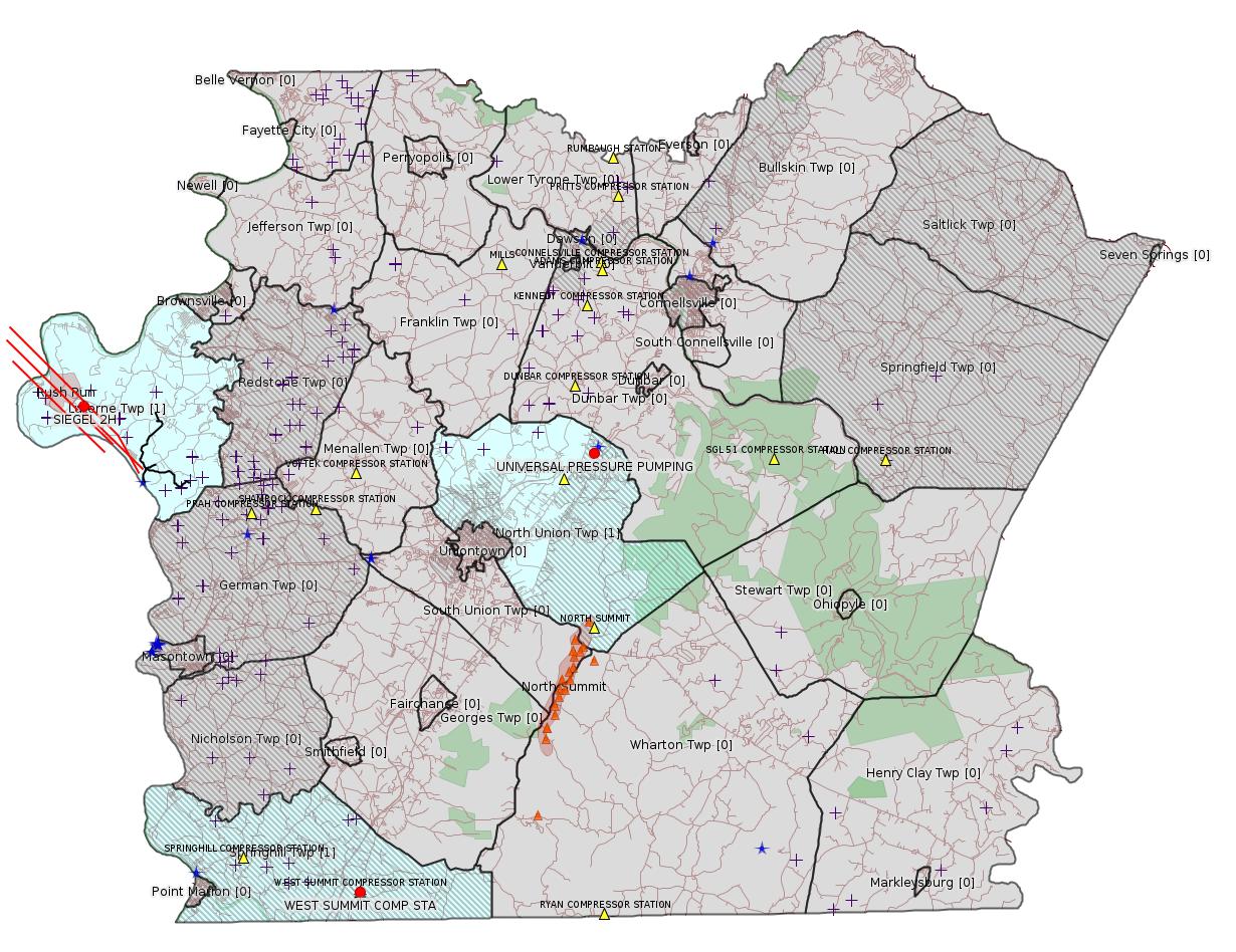
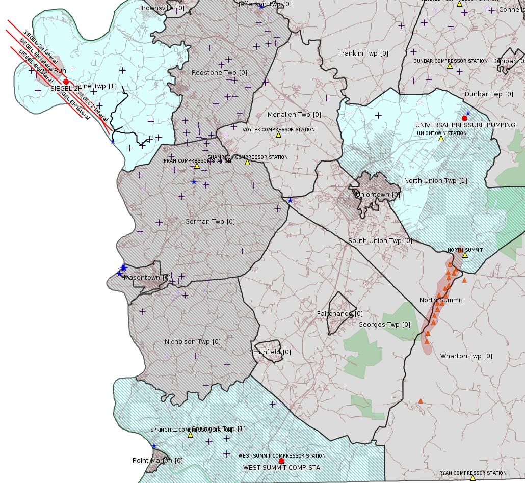
Fayette County Marcellus Shale Permits 6/28/21 - 7/11/21
Contents
Pennsylvania Bulletin Listings
[None]eFACTS Listings
WEST SUMMIT COMP STA AQ GP 5 - Natural Gas Compression and/or Processing Facilities (New)
UNIVERSAL PRESSURE PUMPING INC Minor Source Operating Permit Renewal
Map
Key
Red dots: items in this permit list with an exact location.
Blue stars: Marcellus Gas Well Water Sources.
Where well laterals are mapped they show in red; a 400-foot buffer surrounding the lateral shows in blue (lavender where it overlaps a mapped mineral tract).
Where mineral tracts are mapped, they show in pink. Mineral tracts can overlap; the overlap will show in red. The precise meaning of "mineral tract" is not clear.
Municipality shading: number of "facilities", with each well counting separately
(includes the red dots):
gray: 0
pale turquoise: 1
turquoise: 2
pale blue: 3
middle blue: 4
dark blue: 5
dark purple: 7
purple: 9
(Color coding may differ from one issue to the next.)
(Note if a project spans multiple municipalities -- e.g. a pipeline -- it will show in the count for each municipality.)
The number of facilities also follows the municipality name in brackets.
Municipality counts are based on the way the permit is listed by DEP; DEP has been known to get a municipality wrong.
Locations in brackets identify a precise location used to locate a surrogate for the actual site being permitted (e.g. locating a well pad or pipeline by the known location of a well.) Locations labeled beginning with "~" and ending in "[?]" are approximate and speculative based on inferences using on-line property and lease records. These are marked in the text as "[Approximate, Speculative]
Cross-hatching: Environmental Justice Areas
Yellow triangles: Compressor Stations
Orange triangles: Storage Field Wells (currently Dominion North Summit Storage Field)
Crosses: SPUD Unconventional well permits
Green: "Natural areas", e.g. state game lands, state forests
Yellow triangles: Compressor Stations
Orange triangles: Storage Field Wells (currently Dominion North Summit Storage Field)
Crosses: SPUD Unconventional well permits
Green: "Natural areas", e.g. state game lands, state forests
More Maps
 |
Source: Pennsylvania Bulletin
[No Activity]
-------------------------
Please see the Disclaimer below regarding Parcel Id data.
Authorization ID: 1360627
Permit number: AG5-26-00005A
Site: WEST SUMMIT COMP STA
Client: INR OPR LLC
Authorization type: AQ GP 5 - Natural Gas Compression and/or Processing Facilities
Application type: New
Authorization is for: FACILITY
Date received: 05/25/2021
Status: Pending
Permit Decision Guarantee Applies: No
Sub-Facilities for Authorization:
Sub-Facility ID Sub-Facility Name Description
1186818 DEHYDRATOR RATED AT 25 MMSCFD Process
1186826 VENTING/BLOWDOWNS Process
1186820 FIVE STORAGE TANKS/VESSELS @ COMPRESSOR STA. Process
1186822 FOUR TANKS @ PAD Process
1186824 PNEUMATIC DEVICES Process
1253786 WAUKESHA COMPRESSOR ENGINE RATED AT 400 BHP Process
1049059 FUGITIVES Process
1025054 CATERPILLAR ENGINE RATED AT 1,380 BHP Process
1195514 PIGGING OPERATIONS Process
1049057 REBOILER Process
1186817 NATURAL GAS LINE Fuel Material Location
<https://www.ahs.dep.pa.gov/eFACTSWeb/searchResults_singleAuth.aspx?AuthID=1360627>
Site Programs:
Air Quality
Site Municipalities:
Springhill Twp, Fayette County
AQ
AEP Details:
Location: 39.73437,-79.80091
Map URL: <http://www.openstreetmap.org/?mlat=39.73437&mlon=-79.80091#map=15/39.73437/-79.80091>
Presumed Parcel Id: 36210048
CLIENT_ID: 360521
CLIENT: INR MIDSTREAM LLC
CLIENT_TYPE: NON-GOVERNMENT
CLIENT_ADDRESS1: 2605 CRANBERRY SQUARE
CLIENT_ADDRESS2:
CLIENT_CITY: MORGANTOWN
CLIENT_STATE: WV
CLIENT_ZIP: 26508-9201
SITE_ID: 739878
PRIMARY_FACILITY_ID: 734851
PRIMARY_FACILITY_NAME: INR MIDSTREAM LLC/WEST SUMMIT COMP STA
NAICS_CODE: 211130
NAICS_DESCRIPTION: Natural Gas Extraction
PRIMARY_FACILITY_STATUS: Active
FACILITY_TYPE: Other
REGION: Southwest Regional Office
COUNTY: Fayette
MUNICIPALITY: Springhill Twp
LATITUDE: 39.73437
LONGITUDE: -79.80091
LOCATION_ADDRESS1: GANS RD
LOCATION_ADDRESS2: SPRINGHILL FURNACE RD
LOCATION_CITY: LAKE LYNN
LOCATION_STATE: PA
LOCATION_ZIP: 15451
Location: 39.73437,-79.80091
Map URL: <http://www.openstreetmap.org/?mlat=39.73437&mlon=-79.80091#map=15/39.73437/-79.80091>
Presumed Parcel Id: 36210048
[See Notes.]
---
Authorization ID: 1230777
Permit number: 26-00585
Site: UNIVERSAL PRESSURE PUMPING INC
Client: UNIVERSAL PRESSURE PUMPING INC
Authorization type: Minor Source Operating Permit
Application type: Renewal
Authorization is for: FACILITY
Date received: 05/24/2018
Status: Issued on 6/30/2021
Permit Decision Guarantee Applies: No
Sub-Facilities for Authorization:
Sub-Facility ID Sub-Facility Name Description
1103858 HCL STORAGE TANKS (2) Process
1331717 CEMENT SILOS NEW (3) Process
1331715 TRUCK LOADING OPERATIONS CEMENT Process
1103863 HCL STORAGE TANKS SCRUBBER Air Pollution Control Device
1103853 CEMENT & FLY ASH MIXING Process
1103855 SILOS & MIXING DUST COLLECTOR Air Pollution Control Device
1331719 CEMENTS SILOS NEW DUST COLLECTORS (3) Air Pollution Control Device
1331721 FLY ASH SILO NEW (1) Process
1103736 SAND TIPPLE #1 Process
1103856 DIESEL STORAGE TANK Process
1331724 CEMENT & FLY ASH BATCH TANKS NEW (4) Process
1331725 CEMENT & FLY ASH BATCH TANKS NEW DUST COLLECTOR (1) Air Pollution Control Device
1331722 FLY ASH SILO NEW DUST COLLECTOR (1) Air Pollution Control Device
1103955 PLANT PAVED & UNPAVED ROADS & SURFACES Process
1103867 HCL TRANSLOADING SCRUBBER Air Pollution Control Device
1103864 HCL TRANSLOADING SYSTEM Process
1103745 CEMENT/FLY ASH SILOS (3) Process
1103868 WASTE OIL SPACE HEATER Process
1103740 SAND TIPPLE #1 DUST COLLECTOR Air Pollution Control Device
Permit Review Notes:
Date Review Note
6/30/2021 The technical review and decision review are complete and either the permit decision and/or permit issuance are forthcoming.
5/30/2018 The permit application package is complete, has been accepted, and is undergoing technical review.
<https://www.ahs.dep.pa.gov/eFACTSWeb/searchResults_singleAuth.aspx?AuthID=1230777>
Site Programs:
Air Quality
Clean Water
Environmental Cleanup & Brownfields
Waste Management
Site Municipalities:
North Union Twp, Fayette County
AQ AEP Details:
CLIENT_ID: 336119
CLIENT: UNIVERSAL PRESSURE PUMPING INC
CLIENT_TYPE: NON-GOVERNMENT
CLIENT_ADDRESS1: 10713 W SAM HOUSTON PKWY N STE 800
CLIENT_ADDRESS2:
CLIENT_CITY: HOUSTON
CLIENT_STATE: TX
CLIENT_ZIP: 77064-3583
SITE_ID: 689112
PRIMARY_FACILITY_ID: 715559
PRIMARY_FACILITY_NAME: UNIVERSAL PRESSURE PUMPING INC/CONNELLSVILLE CAMP
NAICS_CODE: 213112
NAICS_DESCRIPTION: Support Activities for Oil and Gas Operations
PRIMARY_FACILITY_STATUS: Active
FACILITY_TYPE: Other
REGION: Southwest Regional Office
COUNTY: Fayette
MUNICIPALITY: North Union Twp
LATITUDE: 39.943333
LONGITUDE: -79.651111
LOCATION_ADDRESS1: PO BOX 130
LOCATION_ADDRESS2: 730 BRADDOCK VIEW DR
LOCATION_CITY: MOUNT BRADDOCK
LOCATION_STATE: PA
LOCATION_ZIP: 15465-0130
CONTACT_NAME:
CONTACT_PHONE:
CONTACT_EMAIL:
Location: 39.943333,-79.651111
Map URL: <http://www.openstreetmap.org/?mlat=39.943333&mlon=-79.651111#map=15/39.943333/-79.651111>
Presumed Parcel Id: 2516002301
-------------------------
Source: DEP Electronic Notifications
NOTIFICATION_ID: 56962
OGO: 39307
OPERATOR: EQT CHAP LLC
API_PERMIT: 051-24641
SPUD_DATE: 04/02/2018
COUNTY: Fayette
MUNICIPALITY: Luzerne
LATITUDE: 39.96893
LONGITUDE: -79.96886
SUBJECT: [NOTIFICATION]: Casing cementing notification 58 Pa. C.S. 3211(f)(2) for well API 37-051-24641-00-00
QUESTION: Enter the Date and Time for the applicable Casing Types
ANSWER: Production Casing: 7/5/2021 6:00:00 AM
SENT_DATE: 7/2/2021 4:58:51 PM
SENT_SUCCESS: Yes
LAST_RESENT_DATE:
RESENT_SUCCESS:
REGION: EP DOGO SWDO Dstr Off
Well Details:
Permit Number: 051-24641
Well Name: SIEGEL 2H
Unconventional Well: Y
Well Configuration: Horizontal Well
Well Type: GAS
Well Status: Active
Coal Association: Coal
Conservation Well: N
Primary Facility ID: 823789
Site ID: 790384
Site Name: SIEGEL WELL PAD ESCGP-2 EXPEDITED
Well Pad ID: 152926
Well Pad Name: SIEGEL 1
Storage Field:
Operator: EQT CHAP LLC
Operator Number: OGO-39307
Permit Date: 2018-02-13
Permit Date Expires: 2022-04-09
SPUD Date: 2018-04-02
Date Plugged:
UIC ID:
UIC Type:
Surface Elevation: 1173
County: Fayette
Municipality: Luzerne Twp
Location: 39.96893,-79.96886
Map URL: <http://www.openstreetmap.org/?mlat=39.96893&mlon=-79.96886#map=15/39.96893/-79.96886>
OG WELLS PERMIT DOCS:
2020-02-13: Final Permit Documents, Name: Auth No. 1270799 (for Authorization: 1270799.0):
<http://www.depgis.state.pa.us/pdfHandler/pdFHandler.ashx?Doc=ODM4MDMyLjA=&ext=PDF>
Electronically Submitted Records:
2020-05-15: Submission for Authorization 1311283.0
Pennsylvania Natural Diversity Inventory Form: Siegel PNDI 3.26.20.pdf
<http://www.depgis.state.pa.us/eWellDocHandler/pdFHandler.ashx?Doc=MTE0NjYwNi4w&ext=PDF>
Permit Application to Drill and Operate a Well: Siegel 2H_Drill Permit Application_4.2020.pdf
<http://www.depgis.state.pa.us/eWellDocHandler/pdFHandler.ashx?Doc=MTE0NjYwNy4w&ext=PDF>
Location Plat: 143-781-Well Plat 2H-pages1-2-3_3702.dwg
<http://www.depgis.state.pa.us/eWellDocHandler/pdFHandler.ashx?Doc=MTE0NjYwOC4w&ext=PDF>
Well Cross-Section Diagram: Siegel 2H Page 4.pdf
<http://www.depgis.state.pa.us/eWellDocHandler/pdFHandler.ashx?Doc=MTE0NjYwOS4w&ext=PDF>
Interested Party Notification: Siegel 2H Interested Parties_4.2020.pdf
<http://www.depgis.state.pa.us/eWellDocHandler/pdFHandler.ashx?Doc=MTE0NzA2OS4w&ext=PDF>
Coal and Gas Resource Coord Act - Section 7 Exception: Siegel Waiver Request Section 7.pdf
<http://www.depgis.state.pa.us/eWellDocHandler/pdFHandler.ashx?Doc=MTE0NzE3My4w&ext=PDF>
Well Permit Application - Coal Module: Siegel Coal Module_4.15.20.pdf
<http://www.depgis.state.pa.us/eWellDocHandler/pdFHandler.ashx?Doc=MTE0Nzc3MC4w&ext=PDF>
Electronic Submission Docket: 2108699.pdf
<http://www.depgis.state.pa.us/eWellDocHandler/pdFHandler.ashx?Doc=MTE0ODQxOS4w&ext=PDF>
2020-02-13: Submission for Authorization 1270799.0
Pennsylvania Natural Diversity Inventory Form: Siegel PNDI.pdf
<http://www.depgis.state.pa.us/eWellDocHandler/pdFHandler.ashx?Doc=ODIwNjE1LjA=&ext=PDF>
Well Cross-Section Diagram: Siegel 2H Page 4.pdf
<http://www.depgis.state.pa.us/eWellDocHandler/pdFHandler.ashx?Doc=ODIwNjE5LjA=&ext=PDF>
Well Permit Application - Coal Module: Siegel Coal Module.pdf
<http://www.depgis.state.pa.us/eWellDocHandler/pdFHandler.ashx?Doc=ODIwNjIwLjA=&ext=PDF>
Coal and Gas Resource Coord Act - Section 7 Exception: Siegel Waiver Request Section 7.pdf
<http://www.depgis.state.pa.us/eWellDocHandler/pdFHandler.ashx?Doc=ODI0MjYwLjA=&ext=PDF>
Permit Application to Drill and Operate a Well: Siegel 2H_Drill Permit Application.pdf
<http://www.depgis.state.pa.us/eWellDocHandler/pdFHandler.ashx?Doc=ODI0NzEyLjA=&ext=PDF>
Interested Party Notification: Siegel 2H_Record of Notification.pdf
<http://www.depgis.state.pa.us/eWellDocHandler/pdFHandler.ashx?Doc=ODQwNDM3LjA=&ext=PDF>
Location Plat: 143-781-Well Plat 2H-pages1-2-3_3702.dwg
<http://www.depgis.state.pa.us/eWellDocHandler/pdFHandler.ashx?Doc=ODU2MzQ1LjA=&ext=PDF>
Electronic Submission Docket: 1929152.pdf
<http://www.depgis.state.pa.us/eWellDocHandler/pdFHandler.ashx?Doc=ODU2MzQ3LjA=&ext=PDF>
2020-02-13: Submission for Authorization 1212435.0
Pennsylvania Natural Diversity Inventory Form: Siegel PNDI.pdf
<http://www.depgis.state.pa.us/eWellDocHandler/pdFHandler.ashx?Doc=NDQ4NjQ4LjA=&ext=PDF>
Location Plat: 143-781-Well Plat 2H-pages1-2-3_3702.dwg
<http://www.depgis.state.pa.us/eWellDocHandler/pdFHandler.ashx?Doc=NDQ4NjQ5LjA=&ext=PDF>
Well Cross-Section Diagram: Siegel 2H Page 4.pdf
<http://www.depgis.state.pa.us/eWellDocHandler/pdFHandler.ashx?Doc=NDQ4NjUwLjA=&ext=PDF>
Interested Party Notification: Siegel Affidavit of Non-Delivery Foster.pdf
<http://www.depgis.state.pa.us/eWellDocHandler/pdFHandler.ashx?Doc=NDQ4ODgwLjA=&ext=PDF>
Interested Party Notification: Siegel Affidavit of Non-Delivery Foster.pdf
<http://www.depgis.state.pa.us/eWellDocHandler/pdFHandler.ashx?Doc=NDQ4ODg0LjA=&ext=PDF>
Interested Party Notification: Siegel Affidavit of Non-Delivery Foster.pdf
<http://www.depgis.state.pa.us/eWellDocHandler/pdFHandler.ashx?Doc=NDQ4ODg1LjA=&ext=PDF>
Interested Party Notification: Siegel Affidavit of Non-Delivery Foster.pdf
<http://www.depgis.state.pa.us/eWellDocHandler/pdFHandler.ashx?Doc=NDQ4ODg2LjA=&ext=PDF>
Interested Party Notification: Siegel Affidavit of Non-Delivery Foster.pdf
<http://www.depgis.state.pa.us/eWellDocHandler/pdFHandler.ashx?Doc=NDQ4ODg3LjA=&ext=PDF>
Interested Party Notification: Siegel Affidavit of Non-Delivery Foster.pdf
<http://www.depgis.state.pa.us/eWellDocHandler/pdFHandler.ashx?Doc=NDQ4ODg4LjA=&ext=PDF>
Interested Party Notification: Siegel Affidavit of Non-Delivery Foster.pdf
<http://www.depgis.state.pa.us/eWellDocHandler/pdFHandler.ashx?Doc=NDQ4ODg5LjA=&ext=PDF>
Interested Party Notification: Siegel Affidavit of Non-Delivery Franks.pdf
<http://www.depgis.state.pa.us/eWellDocHandler/pdFHandler.ashx?Doc=NDQ4ODkwLjA=&ext=PDF>
Interested Party Notification: Siegel Affidavit of Non-Delivery Franks.pdf
<http://www.depgis.state.pa.us/eWellDocHandler/pdFHandler.ashx?Doc=NDQ4ODkxLjA=&ext=PDF>
Coal and Gas Resource Coord Act - Section 7 Exception: Siegel 1H-9H Waiver Request Section 7.pdf
<http://www.depgis.state.pa.us/eWellDocHandler/pdFHandler.ashx?Doc=NDQ4ODkyLjA=&ext=PDF>
Permit Application to Drill and Operate a Well: 1634165.pdf
<http://www.depgis.state.pa.us/eWellDocHandler/pdFHandler.ashx?Doc=NDQ5Nzk5LjA=&ext=PDF>
Public Permit Review:
<http://www.ahs.dep.pa.gov/ePermitPublicAccess/Public/PublicAuthOverview?q=VJigEFD7oClDNNDRS1M41a2vlnpze%2fV71CN2o4OrU9Q%3d>
Plat:
<https://www.ahs.dep.pa.gov/ePermitPublicAccess/Public/DownloadFileFromWebServer/57704?onBaseDocId=3530348>
-------------------------NOTIFICATION_ID: 56962
OGO: 39307
OPERATOR: EQT CHAP LLC
API_PERMIT: 051-24641
SPUD_DATE: 04/02/2018
COUNTY: Fayette
MUNICIPALITY: Luzerne
LATITUDE: 39.96893
LONGITUDE: -79.96886
SUBJECT: [NOTIFICATION]: Casing cementing notification 58 Pa. C.S. 3211(f)(2) for well API 37-051-24641-00-00
QUESTION: Enter the Date and Time for the applicable Casing Types
ANSWER: Production Casing: 7/5/2021 6:00:00 AM
SENT_DATE: 7/2/2021 4:58:51 PM
SENT_SUCCESS: Yes
LAST_RESENT_DATE:
RESENT_SUCCESS:
REGION: EP DOGO SWDO Dstr Off
Well Details:
Permit Number: 051-24641
Well Name: SIEGEL 2H
Unconventional Well: Y
Well Configuration: Horizontal Well
Well Type: GAS
Well Status: Active
Coal Association: Coal
Conservation Well: N
Primary Facility ID: 823789
Site ID: 790384
Site Name: SIEGEL WELL PAD ESCGP-2 EXPEDITED
Well Pad ID: 152926
Well Pad Name: SIEGEL 1
Storage Field:
Operator: EQT CHAP LLC
Operator Number: OGO-39307
Permit Date: 2018-02-13
Permit Date Expires: 2022-04-09
SPUD Date: 2018-04-02
Date Plugged:
UIC ID:
UIC Type:
Surface Elevation: 1173
County: Fayette
Municipality: Luzerne Twp
Location: 39.96893,-79.96886
Map URL: <http://www.openstreetmap.org/?mlat=39.96893&mlon=-79.96886#map=15/39.96893/-79.96886>
OG WELLS PERMIT DOCS:
2020-02-13: Final Permit Documents, Name: Auth No. 1270799 (for Authorization: 1270799.0):
<http://www.depgis.state.pa.us/pdfHandler/pdFHandler.ashx?Doc=ODM4MDMyLjA=&ext=PDF>
Electronically Submitted Records:
2020-05-15: Submission for Authorization 1311283.0
Pennsylvania Natural Diversity Inventory Form: Siegel PNDI 3.26.20.pdf
<http://www.depgis.state.pa.us/eWellDocHandler/pdFHandler.ashx?Doc=MTE0NjYwNi4w&ext=PDF>
Permit Application to Drill and Operate a Well: Siegel 2H_Drill Permit Application_4.2020.pdf
<http://www.depgis.state.pa.us/eWellDocHandler/pdFHandler.ashx?Doc=MTE0NjYwNy4w&ext=PDF>
Location Plat: 143-781-Well Plat 2H-pages1-2-3_3702.dwg
<http://www.depgis.state.pa.us/eWellDocHandler/pdFHandler.ashx?Doc=MTE0NjYwOC4w&ext=PDF>
Well Cross-Section Diagram: Siegel 2H Page 4.pdf
<http://www.depgis.state.pa.us/eWellDocHandler/pdFHandler.ashx?Doc=MTE0NjYwOS4w&ext=PDF>
Interested Party Notification: Siegel 2H Interested Parties_4.2020.pdf
<http://www.depgis.state.pa.us/eWellDocHandler/pdFHandler.ashx?Doc=MTE0NzA2OS4w&ext=PDF>
Coal and Gas Resource Coord Act - Section 7 Exception: Siegel Waiver Request Section 7.pdf
<http://www.depgis.state.pa.us/eWellDocHandler/pdFHandler.ashx?Doc=MTE0NzE3My4w&ext=PDF>
Well Permit Application - Coal Module: Siegel Coal Module_4.15.20.pdf
<http://www.depgis.state.pa.us/eWellDocHandler/pdFHandler.ashx?Doc=MTE0Nzc3MC4w&ext=PDF>
Electronic Submission Docket: 2108699.pdf
<http://www.depgis.state.pa.us/eWellDocHandler/pdFHandler.ashx?Doc=MTE0ODQxOS4w&ext=PDF>
2020-02-13: Submission for Authorization 1270799.0
Pennsylvania Natural Diversity Inventory Form: Siegel PNDI.pdf
<http://www.depgis.state.pa.us/eWellDocHandler/pdFHandler.ashx?Doc=ODIwNjE1LjA=&ext=PDF>
Well Cross-Section Diagram: Siegel 2H Page 4.pdf
<http://www.depgis.state.pa.us/eWellDocHandler/pdFHandler.ashx?Doc=ODIwNjE5LjA=&ext=PDF>
Well Permit Application - Coal Module: Siegel Coal Module.pdf
<http://www.depgis.state.pa.us/eWellDocHandler/pdFHandler.ashx?Doc=ODIwNjIwLjA=&ext=PDF>
Coal and Gas Resource Coord Act - Section 7 Exception: Siegel Waiver Request Section 7.pdf
<http://www.depgis.state.pa.us/eWellDocHandler/pdFHandler.ashx?Doc=ODI0MjYwLjA=&ext=PDF>
Permit Application to Drill and Operate a Well: Siegel 2H_Drill Permit Application.pdf
<http://www.depgis.state.pa.us/eWellDocHandler/pdFHandler.ashx?Doc=ODI0NzEyLjA=&ext=PDF>
Interested Party Notification: Siegel 2H_Record of Notification.pdf
<http://www.depgis.state.pa.us/eWellDocHandler/pdFHandler.ashx?Doc=ODQwNDM3LjA=&ext=PDF>
Location Plat: 143-781-Well Plat 2H-pages1-2-3_3702.dwg
<http://www.depgis.state.pa.us/eWellDocHandler/pdFHandler.ashx?Doc=ODU2MzQ1LjA=&ext=PDF>
Electronic Submission Docket: 1929152.pdf
<http://www.depgis.state.pa.us/eWellDocHandler/pdFHandler.ashx?Doc=ODU2MzQ3LjA=&ext=PDF>
2020-02-13: Submission for Authorization 1212435.0
Pennsylvania Natural Diversity Inventory Form: Siegel PNDI.pdf
<http://www.depgis.state.pa.us/eWellDocHandler/pdFHandler.ashx?Doc=NDQ4NjQ4LjA=&ext=PDF>
Location Plat: 143-781-Well Plat 2H-pages1-2-3_3702.dwg
<http://www.depgis.state.pa.us/eWellDocHandler/pdFHandler.ashx?Doc=NDQ4NjQ5LjA=&ext=PDF>
Well Cross-Section Diagram: Siegel 2H Page 4.pdf
<http://www.depgis.state.pa.us/eWellDocHandler/pdFHandler.ashx?Doc=NDQ4NjUwLjA=&ext=PDF>
Interested Party Notification: Siegel Affidavit of Non-Delivery Foster.pdf
<http://www.depgis.state.pa.us/eWellDocHandler/pdFHandler.ashx?Doc=NDQ4ODgwLjA=&ext=PDF>
Interested Party Notification: Siegel Affidavit of Non-Delivery Foster.pdf
<http://www.depgis.state.pa.us/eWellDocHandler/pdFHandler.ashx?Doc=NDQ4ODg0LjA=&ext=PDF>
Interested Party Notification: Siegel Affidavit of Non-Delivery Foster.pdf
<http://www.depgis.state.pa.us/eWellDocHandler/pdFHandler.ashx?Doc=NDQ4ODg1LjA=&ext=PDF>
Interested Party Notification: Siegel Affidavit of Non-Delivery Foster.pdf
<http://www.depgis.state.pa.us/eWellDocHandler/pdFHandler.ashx?Doc=NDQ4ODg2LjA=&ext=PDF>
Interested Party Notification: Siegel Affidavit of Non-Delivery Foster.pdf
<http://www.depgis.state.pa.us/eWellDocHandler/pdFHandler.ashx?Doc=NDQ4ODg3LjA=&ext=PDF>
Interested Party Notification: Siegel Affidavit of Non-Delivery Foster.pdf
<http://www.depgis.state.pa.us/eWellDocHandler/pdFHandler.ashx?Doc=NDQ4ODg4LjA=&ext=PDF>
Interested Party Notification: Siegel Affidavit of Non-Delivery Foster.pdf
<http://www.depgis.state.pa.us/eWellDocHandler/pdFHandler.ashx?Doc=NDQ4ODg5LjA=&ext=PDF>
Interested Party Notification: Siegel Affidavit of Non-Delivery Franks.pdf
<http://www.depgis.state.pa.us/eWellDocHandler/pdFHandler.ashx?Doc=NDQ4ODkwLjA=&ext=PDF>
Interested Party Notification: Siegel Affidavit of Non-Delivery Franks.pdf
<http://www.depgis.state.pa.us/eWellDocHandler/pdFHandler.ashx?Doc=NDQ4ODkxLjA=&ext=PDF>
Coal and Gas Resource Coord Act - Section 7 Exception: Siegel 1H-9H Waiver Request Section 7.pdf
<http://www.depgis.state.pa.us/eWellDocHandler/pdFHandler.ashx?Doc=NDQ4ODkyLjA=&ext=PDF>
Permit Application to Drill and Operate a Well: 1634165.pdf
<http://www.depgis.state.pa.us/eWellDocHandler/pdFHandler.ashx?Doc=NDQ5Nzk5LjA=&ext=PDF>
Public Permit Review:
<http://www.ahs.dep.pa.gov/ePermitPublicAccess/Public/PublicAuthOverview?q=VJigEFD7oClDNNDRS1M41a2vlnpze%2fV71CN2o4OrU9Q%3d>
Plat:
<https://www.ahs.dep.pa.gov/ePermitPublicAccess/Public/DownloadFileFromWebServer/57704?onBaseDocId=3530348>
The previous issue of this bulletin carried Authorization # 1354909 for this site, with an authorization type of AQ GP 5A - Unconventional Natural Gas Well Site Operations, which is supposed to be for covering air pollution at unconventional well sites, so was wrong for this facility. (The permit number given last time -- AG5A-26-00001A -- was also wrong.) That previous authorization indicated 5 compression engines; this current one only indicates one. It's not clear what the situation is for the other 4.
The previous permit for the West Summit Compressor Station was GP5-26-00589A. The [notorious] General Permit GP-5 from the Bureau of Air Quality apparently caused confusion in naming with the Water Planning and Conservation stream crossing permit GP-05, so apparently the BAQ has changed its naming scheme for these permits, and the new permit number for West Summit is AG5A-26-00001A. Having the permit number change with each revision is a longstanding BAQ Data Horror, which thankfully the other fiefdoms at DEP don't share.
------------------------
<https://www.dep.pa.gov/PublicParticipation/OfficeofEnvironmentalJustice/Pages/default.aspx>). There are supposed to be enhanced public participation requirements for permits in environmental justice areas, but news of this actually ever happening is scarce. In Fayette County, the entirety of Redstone, Springhill, Nicholson, and German Townships are environmental justice areas, as well as a large part of Dunbar Township. DEP's policy document on public participation guidelines for environmental justice areas is located here:
<https://www.elibrary.dep.state.pa.us/dsweb/Get/Version-48671/012-0501-002.pdf>
eNOTICE records are likely to list the same permit multiple times, as that permit moves through the DEP process.
Oil & Gas Wells designated with a site a number and the letter H typically designate horizontal wells.
-------------------------
Resources:
Pennsylvania Bulletin: <https://www.pabulletin.com/>
eNOTICE: <https://www.ahs2.dep.state.pa.
DEP Oil and Gas Reports: <https://www.dep.pa.gov/DataandTools/Reports/Oil%20and%20Gas%20Reports/Pages/default.aspx>
DEP Permits Issued Detail Report:
<http://cedatareporting.pa.gov/Reportserver/Pages/ReportViewer.aspx?/Public/DEP/OG/SSRS/Permits_Issued_Detail>
DEP SPUD (drilling started) Report:
<http://cedatareporting.pa.gov/Reportserver/Pages/ReportViewer.aspx?/Public/DEP/OG/SSRS/Spud_External_Data>
DEP Oil and Gas Compliance Report:
<http://cedatareporting.pa.gov/Reportserver/Pages/ReportViewer.aspx?/Public/DEP/OG/SSRS/OG_Compliance>
DEP PA Oil & Gas Mapping:
<https://www.depgis.state.pa.us/PaOilAndGasMapping>
Data Portal Services Directory [Technical]
<https://www.depgis.state.pa.us/arcgis/rest/services>
Query: Oil and Gas Wells All (ID: 3) [Technical]:
<https://www.depgis.state.pa.us/arcgis/rest/services/OilGas/OilGasAllStrayGasEGSP/MapServer/3/query?where=&text=&objectIds=&time=&geometry=&geometryType=esriGeometryEnvelope&inSR=&spatialRel=esriSpatialRelIntersects&relationParam=&outFields=*&returnGeometry=true&returnTrueCurves=false&maxAllowableOffset=&geometryPrecision=&outSR=&returnIdsOnly=false&returnCountOnly=false&orderByFields=&groupByFieldsForStatistics=&outStatistics=&returnZ=false&returnM=false&gdbVersion=&returnDistinctValues=false&resultOffset=&resultRecordCount=&f=html>
(Be sure to enter a Where clause in SQL format. Dates are in milliseconds since midnight 1/1/1970).
DEP Oil and Gas Electronic Submissions
<https://www.ahs.dep.pa.gov/eSubmissionPublicSearch>
DEP Air Quality Air Emission Plants Facilities Report
<http://cedatareporting.pa.gov/Reportserver/Pages/ReportViewer.aspx?/Public/DEP/AQ/SSRS/AQ_AEP_Facilities>
DEP Oil and Gas Electronic Notifications
<http://cedatareporting.pa.gov/Reportserver/Pages/ReportViewer.aspx?/Public/DEP/OG/SSRS/OG_Notifications>
DEP Oil and Gas Well Pad Report
<http://cedatareporting.pa.gov/Reportserver/Pages/ReportViewer.aspx?/Public/DEP/OG/SSRS/Well_Pads>
Fayette County Assessment Office Search For Tax Records:
<http://property.co.fayette.pa.us/search.aspx>
Pennsylvania Spatial Data Access:
<https://www.pasda.psu.edu/default.asp>
DEP Spatial Data Repository:
<ftp://www.pasda.psu.edu/pub/pasda/dep/>
National Response Center:
<https://www.nrc.uscg.mil/>
EPA-Echo: <https://www.epa-echo.gov/echo/
FERC citizen involvement: <https://www.ferc.gov/for-citiz
To receive E-mail notification of
all documents filed in a FERC docket, see:
<https://www.ferc.gov/docs-filing/esubscription.asp >
<https://www.ferc.gov/docs-fili
Follow the directions and enter the docket number to subscribe to.
Township Supervisors receive information regarding Erosion & Sedimentation permits, and these records may be reviewable at township municipal offices.
DEP permits are reviewable through the File Review process, for application to do file review see: <https://www.portal.state.pa.us/portal/server.pt/community/southwest_regional_office/13775/file_review/593164>
Environmental Hearing Board: <https://ehb.courtapps.com/publ
PA DEP Environmental Policy Comment System:
<https://www.ahs.dep.pa.gov/eComment/>
Federal Register Environment: <https://www.federalregister.g
Browsing of recent comment
opportunities for federal agencies, e.g. EPA. Click "sign up" to
subscribe to daily E-mails of new document listings.
SkyTruth Fayette County Drilling Alerts: <https://frack.skytruth.org/pen
U.S. Army Corps of Engineers, Pittsburgh District, Public Notices:
<https://www.lrp.usace.army.mil/Missions/Regulatory/Public-Notices/>
EPA Pennsylvania Public Notices: <https://www2.epa.gov/aboutepa/epa-pennsylvania#notice>
Marcellus Shale waste disposal
injection wells in Pennsylvania are regulated directly by EPA, not
DEP. Notice of any new permit applications will appear at the
above web address. I'm not aware of any subscription service
to be notified of such applications. I'm not aware of any
Marcellus Shale waste disposal injection wells in Fayette County
(yet ...) but we need to monitor this page for future
applications.
Energy Assurance Daily: <https://www.oe.netl.doe.gov/ead.aspx>
Daily newsletter from the US
Department of Energy about events relating to energy. The Natural
Gas section has information about pipelines.
-------------------------
Disclaimers:
This compilation from the above sources was done in part by hand using copy and paste and in part using automated methods; it may omit relevant permits.
Parcel data is provided via the tax records search web page offered by the Fayette County Assessment Office (http://property.co.fayette.pa.us/). Presumed Parcel Id links are subject to availability provided by that agency and associated web sites. Presumed Parcel Ids are determined as the mapped parcel containing a given latitude and longitude, are a best effort determination which is subject to error, and are not official. In cases where a facility is leased and there is a separate parcel id for the lease, if this parcel id is not separately mapped, the parcel id shown will be the id for the enclosing parcel. Parcel owners may be surface owners only and may or may not have any relationship to oil & gas facilities.
Does not currently include water supply permits. Does not include landfill permits even though many such are for Marcellus Shale waste. (It is not possible at this time to distinguish which landfill permits are for Marcellus Shale waste and which are not without doing File Review for each permit.)
Erosion & Sedimentation permit records do not currently include latitude and longitude. Where I am publishing latitude and longitude with E&S permits it is by inferring an associated well permit and using published latitude and longitude for the well. It is possible I may be inferring the wrong well site.
Municipalities are shown from eFACTS records on the DEP web site. The DEP has been known to list a municipality incorrectly.