The Harmed Success Stories Concepts How To What Is Commentary
Fayette County Marcellus Shale Permits 7/10/17 - 7/23/17
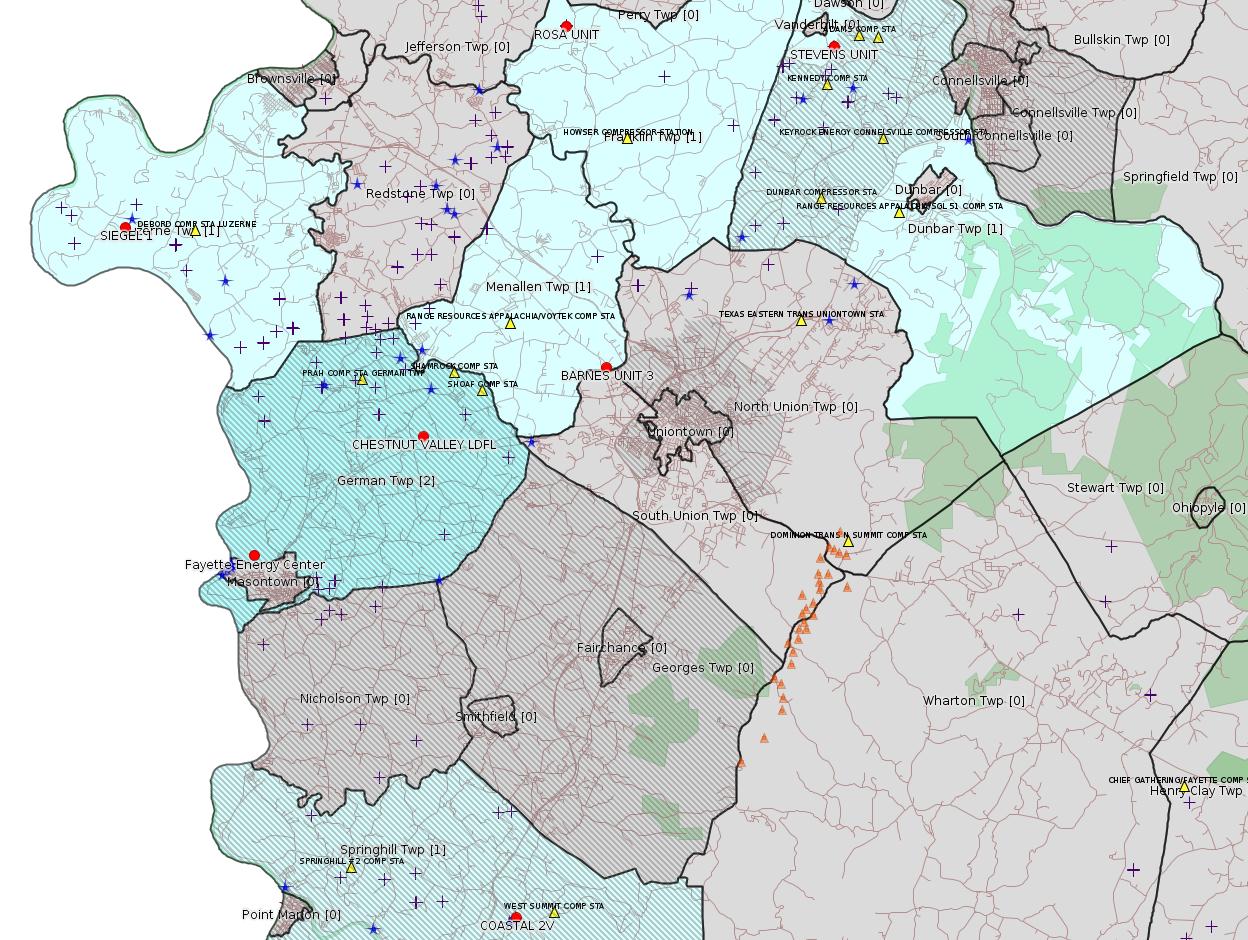
Click the map to enlarge
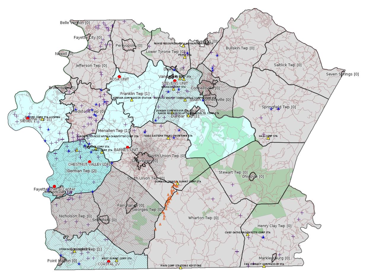
Map
Key
Red dots: items in this permit list with an exact location.
Blue stars: Marcellus Gas Well Water Sources.
Municipality shading: number of "facilities", with each well counting separately
(includes the red dots):
Red dots: items in this permit list with an exact location.
Blue stars: Marcellus Gas Well Water Sources.
Municipality shading: number of "facilities", with each well counting separately
(includes the red dots):
gray: 0
pale turquoise: 1
turquoise: 2
pale blue: 3
middle blue: 4
dark blue: 6
dark purple: 10
purple: 19
(Color coding may differ from one issue to the next.)
(Note if a project spans multiple municipalities -- e.g. a pipeline -- it will show in the count for each municipality.)
The number of facilities also follows the municipality name in brackets.
Municipality counts are based on the way the permit is listed by DEP; DEP has been known to get a municipality wrong.
Locations in brackets identify a precise location used to locate a surrogate for the actual site being permitted (e.g. locating a well pad or pipeline by the known location of a well.) Locations labeled beginning with "~" and ending in "[?]" are approximate and speculative based on inferences using on-line property and lease records. These are marked in the text as "[Approximate, Speculative]
Cross-hatching: Environmental Justice Areas
Yellow triangles: Compressor Stations
Orange triangles: Storage Field Wells (currently Dominion North Summit Storage Field)
Crosses: Unconventional well permits (may not have been drilled)
Green: "Natural areas", e.g. state game lands, state forests
Yellow triangles: Compressor Stations
Orange triangles: Storage Field Wells (currently Dominion North Summit Storage Field)
Crosses: Unconventional well permits (may not have been drilled)
Green: "Natural areas", e.g. state game lands, state forests
More Maps
 |
 |
Source: Pennsylvania Bulletin
[Slightly Off-Topic]
THE GOVERNOR
[47 Pa.B. 3804]
[Saturday, July 15, 2017]
Notice of Veto; House Bill 1071, Printer's No. 1270
June 30, 2017
To the Honorable House of Representatives
of the Commonwealth of Pennsylvania:
Pursuant to Article IV, Section 15 of the Pennsylvania Constitution, I am returning herewith, without my approval, House Bill 1071, Printer's Number 1270.
This legislation does considerably more than forbid political subdivisions from imposing a ban, fee, surcharge, or tax on recyclable plastic bags provided to consumers. It potentially thwarts local governments from complying with their trustee obligations under Article I, Section 27 of the Pennsylvania Constitution, to protect and preserve the environmental resources in their communities. The prohibition under this bill, therefore, is not consistent with the rights vested by the Environmental Rights Amendment of the Pennsylvania Constitution, and the duties upon all governmental actors, including municipalities. The constitutional obligation under the amendment binds not only state but also local government. As such, the bill cannot remove a political subdivision's separate authority to implement its independent constitutional duties. In practical terms, this means government, at all levels, is required to prevent the unreasonable degradation, diminution, or depletion of our water, air, and land. This prohibition hinders the performance of this important requirement.
This bill also contains a significant preemption issue as it relates to the rights of political subdivisions. In my view, the Commonwealth should only on rare occasions preempt the rights of local governments to implement laws and policies that it believes are in its best interest. Here, the Commonwealth is impeding the freedom of local governments to regulate recyclable plastic bags. This policy supporting this preemption is misguided and should not become the law of this Commonwealth.
For the reasons set forth above, I must withhold my signature from House Bill 1071, Printer's Number 1270.
Sincerely,
[Tom Wolf signature]
Governor
<http://www.pabulletin.com/secure/data/vol47/47-28/1154.html>
---
NOTICES
Classification of Wild Trout Streams; Proposed Additions, Revisions and Removals; September 2017
[47 Pa.B. 4050]
[Saturday, July 22, 2017]
Under 58 Pa. Code § 57.11 (relating to listing of wild trout streams), it is the policy of the Fish and Boat Commission (Commission) to accurately identify and classify stream sections supporting naturally reproducing populations of trout as wild trout streams. The Commission's Fisheries Management Division maintains the list of wild trout streams. The Executive Director, with the approval of the Commission, will from time-to-time publish the list of wild trout streams in the Pennsylvania Bulletin. The listing of a stream section as a wild trout stream is a biological designation that does not determine how it is managed. The Commission relies upon many factors in determining the appropriate management of streams.
At the next Commission meeting on September 25 and 26, 2017, the Commission will consider changes to its list of wild trout streams. Specifically, the Commission will consider the addition of the following streams or portions of streams to the list:
[Excerpt:]
Fayette UNT to Brownfield Hollow Run (RM 3.08) Headwaters to Mouth Brownfield Hollow Run 39.763535
79.757528
<http://www.pabulletin.com/secure/data/vol47/47-29/1230.html>
---
ESCGP-2 # ESX16-051-0001
Applicant Name XTO Energy Inc
Contact Person Melissa Breitenbach
Address 190 Thorn Hill Run Road
City, State, Zip Warrendale, PA 15086
County Fayette County
Township(s) Dubar Township
Receiving Stream(s) and Classification(s) Dickerson Run (WWF)
<http://www.pabulletin.com/secure/data/vol47/47-29/1212c.html>
Site: STEVENS UNIT 1H 2H ESCGP-2 EXPEDITED
Well Pad Name: STEVENS UNIT
Well Pad ID: 149369
Wells on this Pad:
051-24401 STEVENS UNIT 1H
051-24402 STEVENS UNIT 2H
Location: 40.027236,-79.655525 <http://osm.org/go/ZWp22x1q--?m=>
Municipality: Dunbar Twp
Presumed Parcel ID: 09050277
-------------------------
Source: eNOTICE (+ PA Oil and Gas Mapping, Well Pad Report) Please see the Disclaimer below regarding Parcel Id data.
Authorization ID: 1170979
Permit number: 051-24633
Site:
Client: CHEVRON APPALACHIA LLC
Authorization type: Drill & Operate Well Permit (Unconventional)
Application type: Modification
Authorization is for: FACILITY
Date received: 02/24/2017
Status: Pending
Sub-Facilities for Authorization:
Sub-Facility ID Sub-Facility Name Description
1181842 SIEGEL 1 Well
Permit Review Notes:
Date Review Note
7/21/2017 The technical review and decision review are complete and either the permit decision and/or permit issuance are forthcoming.
7/20/2017 Applicant has been issued a deficiency letter. If applicable, this application no longer qualifies for the Permit Decision Guarantee.
6/14/2017 The permit application package is complete, has been accepted, and is undergoing technical review.
<http://www.ahs.dep.pa.gov/eFACTSWeb/searchResults_singleAuth.aspx?AuthID=1170979>
Well Details:
Permit Number: 051-24633Map URL: <http://www.openstreetmap.org/?mlat=39.968972&mlon=-79.968794#map=15/39.96897/-79.968794>
Well Name: SIEGEL 1
Unconventional Well: Y
Well Configuration: Vertical Well
Well Type: GAS
Well Status: Proposed But Never Materialized
Coal Association: Coal
Conservation Well: N
Primary Facility ID: 803337
Site ID: 790384
Site Name: SIEGEL WELL PAD ESCGP-2 EXPEDITED
Well Pad ID: 0
Well Pad Name:
Storage Field:
Operator: CHEVRON APPALACHIA LLC
Operator Number: OGO-39307
Permit Date: 2015-08-12
Permit Date Expires: 2016-08-12
SPUD Date:
Date Plugged:
UIC ID:
UIC Type:
Surface Elevation: 1173
County: Fayette
Municipality: Luzerne Twp
Location: 39.968972,-79.968794
Presumed Parcel Id: 19240018
Permit Documents:
<http://www.depgis.state.pa.us/pdfHandler/pdFHandler.ashx?Doc=MjE0NjU4&ext=PDF>
<http://www.depgis.state.pa.us/eWellDocHandler/pdFHandler.ashx?Doc=MjI5NzY2>
<http://www.depgis.state.pa.us/eWellDocHandler/pdFHandler.ashx?Doc=MjI5NzY3>
<http://www.depgis.state.pa.us/eWellDocHandler/pdFHandler.ashx?Doc=MjI5ODMw>
Anticipated Maximum TVD: 7768 feet
---
Authorization ID: 1187805
Permit number: PA0090948
Site: CHESTNUT VALLEY LDFL
Client: ADVANCED DSPL SVC CHESTNUT VALLEY LDFL INC
Authorization type: Minor IW Facility with ELG
Application type: Renewal
Authorization is for: FACILITY
Date received: 06/12/2017
Status: Pending
Sub-Facilities for Authorization:
Sub-Facility ID Sub-Facility Name Description
212046 OUTFALL 001 Discharge Point
568839 OUTFALL 002 Discharge Point
568840 SW OUTFALL 003 Discharge Point
Permit Review Notes:
Date Review Note
7/10/2017 The permit application package is complete, has been accepted, and is undergoing technical review.
<http://www.ahs.dep.pa.gov/eFACTSWeb/searchResults_singleAuth.aspx?AuthID=1187805>
Location: 39.896765,-79.838766 <http://osm.org/go/ZWpP0~XK--?m=>
Municipalities: German Twp [an Environmental Justice Area]
Presumed Parcel Id: 15280012
---
[Arguably off-topic:]
Authorization ID: 1189714
Permit number: 26-00535
Site: FAYETTE ENERGY FACILITY
Client: DYNEGY FAYETTE II, LLC
Authorization type: Major Facility Operating Permit
Application type: Renewal
Authorization is for: FACILITY
Date received: 06/19/2017
Status: Pending
<http://www.ahs.dep.pa.gov/eFACTSWeb/searchResults_singleAuth.aspx?AuthID=1189714>
Location: 39.857412,-79.913878 <http://osm.org/go/ZWpM9Ua6--?m=>
Municipalities: German Twp [an Environmental Justice Area], Masontown Boro
Presumed Parcel Id: 1530006703
---
Authorization ID: 1191327
Permit number: 051-24636
Site: COASTAL 1H FLOW BACK PIT FRESHWATER PITS ESCGP-EXPEDITED
Client: BURNETT OIL CO INC
Authorization type: Drill & Operate Well Permit
Application type: Renewal
Authorization is for: FACILITY
Date received: 05/11/2017
Status: Pending
Permit Review Notes:
Date Review Note
7/21/2017 The permit application package is complete, has been accepted, and is undergoing technical review.
<http://www.ahs.dep.pa.gov/eFACTSWeb/searchResults_singleAuth.aspx?AuthID=1191327>
Well Details:
Permit Number: 051-24636Map URL: <http://www.openstreetmap.org/?mlat=39.733336&mlon=-79.800886#map=15/39.733336/-79.800886>
Well Name: COASTAL 2V
Unconventional Well: N
Well Configuration: Vertical Well
Well Type: GAS
Well Status: Active
Coal Association: NonCoal
Conservation Well: Y
Primary Facility ID: 808138
Site ID: 739525
Site Name: COASTAL 1H FLOW BACK PIT FRESHWATER PITS ESCGP-EXPEDITED
Well Pad ID: 152060
Well Pad Name: COASTAL
Storage Field:
Operator: BURNETT OIL CO INC
Operator Number: OGO-39119
Permit Date: 2016-06-22
Permit Date Expires: 2017-06-22
SPUD Date:
Date Plugged:
UIC ID:
UIC Type:
Surface Elevation: 1130
County: Fayette
Municipality: Springhill Twp [an Environmental Justice Area]
Location: 39.733336,-79.800886
Presumed Parcel Id: 36210048
Original Full Permit:
<http://www.depgis.state.pa.us/pdfHandler/pdFHandler.ashx?Doc=MzY5MDA5&ext=PDF>
Anticipated Maximum TVD: 8000 feet
-------------------------
Source: DEP Oil and Gas Electronic Notifications
NOTIFICATION_ID: 35868
OGO: 60915
OPERATOR: RANGE RESOURCES APPALACHIA LLC
API_PERMIT: 051-22712
SPUD_DATE: 07/12/2005
COUNTY: Fayette
MUNICIPALITY: Menallen
LATITUDE: 39.919332
LONGITUDE: -79.757843
SUBJECT: [NOTIFICATION]: Abandonment or plugging notification 58 Pa. C.S. 3211(f)(2) for well API 37-051-22712-00-00
QUESTION: Date and approximate time action is to occur
ANSWER: Date: 07/24/2017 Time: 1:00 pm
SENT_DATE: 7/21/2017 12:31:56 PM
SENT_SUCCESS: Yes
LAST_RESENT_DATE:
RESENT_SUCCESS:
Comments:
Kyle ThomasWell Details:
Area Completions Supervisor - PA
Office: 814-425-3100 -- Cell:814-720-1056
Email: kthomas@rangeresources.com
Range Resources-Appalachia LLC.
1369 Cochranton Road
Carlton, Pa 16311
www.rangeresources.com
Permit Number: 051-22712Map URL: <http://www.openstreetmap.org/?mlat=39.919332&mlon=-79.757843#map=15/39.919332/-79.757843>
Well Name: BARNES UNIT 3
Unconventional Well: N
Well Configuration: Vertical Well
Well Type: COMB. OIL&GAS
Well Status: Active
Coal Association: NonCoal
Conservation Well: N
Primary Facility ID: 666875
Site ID: 654276
Site Name: BARNES UNIT 3 OG WELL
Well Pad ID: 0
Well Pad Name:
Storage Field:
Operator: RANGE RESOURCES APPALACHIA LLC
Operator Number: OGO-60915
Permit Date: 2005-05-26
Permit Date Expires: 2006-05-26
SPUD Date: 2005-07-12
Date Plugged:
UIC ID:
UIC Type:
Surface Elevation: 1025
County: Fayette
Municipality: Menallen Twp
Location: 39.919332,-79.757843
Presumed Parcel Id: 2221010301
-------------------------
Source: DEP Oil and Gas Compliance Report
OPERATOR: CHEVRON APPALACHIA LLC
INSPECTION_ID: 2615354
INSPECTION_DATE: 06/30/2017
INSPECTION_TYPE: Routine/Complete Inspection
API_PERMIT: 051-24519
FARM_NAME: ROSA UNIT 6H
UNCONVENTIONAL: Yes
SITE_ID: 754022
SITE_NAME: ROSA WELL MCLS NO 1511 ESCGP-EXPEDITED
FACILITY_TYPE: Oil & Gas Location
INSPECTION_CATEGORY: Primary Facility
REGION: EP DOGO SWDO Dstr Off
COUNTY: Fayette
MUNICIPALITY: Franklin Twp
INSPECTOR: NAJEWICZ, JUSTIN
INSPECTION_SOURCE: MOBILE
INSPECTION_RESULT_DESCRIPTION: No Violations Noted
INSPECTION_COMMENT: "Representatives of Chevron requested an on site meeting at the location to discuss the installation of a drainage channel. Since the site was constructed, a landowner constructed a home and graded the land adjacent to the access road to the south east. Chevron recently installed a drainage channel and rain garden on the opposite side of the access road and were to begin construction of the channel of interest when the landowner voiced their concerns that they did not want the channel installed.
The location where the channel is to be installed is well vegetated and there were no signs of erosion observed. Chevron is seeking guidance if the channel could not be installed and the plan amended by red line changes or if a major or minor modification would need to be submitted to DEP Environmental Engineering staff. This WQS is requesting guidance from Department Environmental Engineering staff regarding the issue. Once a determination has been made Chevron will be notified."
Well Pad Id: 146724
Well Pad Name: ROSA UNIT 6H
Location: 40.035386,-79.773394 <http://osm.org/go/ZWp1Ip8I--?m=>
Presumed Parcel Id: 13040083
Wells on this pad:
051-24519 ROSA UNIT 6H
051-24520 ROSA UNIT 7H
051-24521 ROSA UNIT 8H
051-24522 ROSA UNIT 9H
051-24523 ROSA UNIT 10H
051-24524 ROSA UNIT 11H
[There are similar inspection reports for the other wells on this pad.]
-------------------------
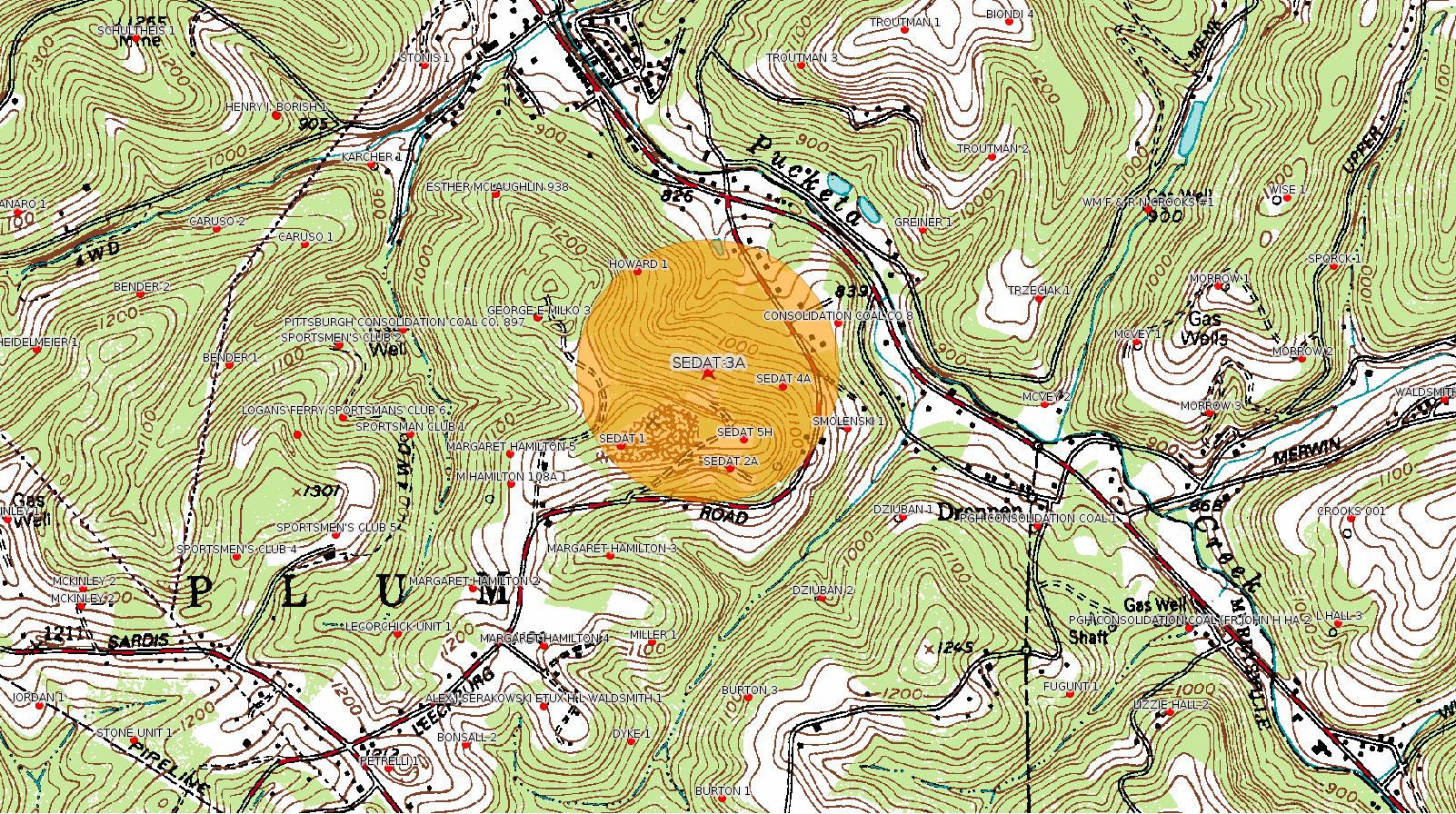
Source: EPA PA Public Notices
[Out of County:]
Public Notice: Public Notice: Draft Permit: Penneco, LLC PAS2D701BALL
Summary
The United States Environmental Protection Agency (EPA) Region III plans to
issue one Underground Injection Control (UIC) Class II-D permit to Penneco
Environmental Solutions, LLC (Penneco) for disposal of fluids from
commercial oil and gas operations. These actions are being taken pursuant
to the Federal UIC regulations at 40 CFR Parts 124, 144, 146, and 147.The
new permit authorizes the conversion and operation of one former gas well
for use as UIC Class II-D commercial brine disposal injection well, Sedat
#3A, located in Plum Borough, Allegheny County, Pennsylvania.
How to Comment:
To comment on the decision to issue this permit, you may submit a comment
in writing to:
ATTN: Grant Scavello
U.S. Environmental Protection Agency
Region III Ground Water & Enforcement Branch (3WP22)
Water Protection Division
1650 Arch Street
Philadelphia, PA 19103
or by email message to:
scavello.grant@epa.gov
<https://www.epa.gov/uic/public-notice-draft-permit-penneco-llc-pas2d701ball>
DEP eFACTS Record:
Authorization ID: 52215
Permit number: 003-21223
Site: SEDAT 3A WELL
Client: PENNECO OIL CO INC
Authorization type: Drill & Operate Well Permit
Application type: New
Authorization is for: FACILITY
Date received: 09/19/1988
Status: Issued on 9/19/1988
Sub-Facilities for Authorization:
Sub-Facility ID Sub-Facility Name Description
21234 SEDAT 3A Well
<http://www.ahs.dep.pa.gov/eFACTSWeb/searchResults_singleAuth.aspx?AuthID=52215>
Documents:
Public notice for penneco well permit number PAS2D701BALL:Well Details:
<https://www.epa.gov/sites/production/files/2017-06/documents/finaloptimizedforweb.penneco.publicnotice.6.22.17.pdf>
Statement of Basis for Penneco well permit number PAS2D701BALL:
<https://www.epa.gov/sites/production/files/2017-06/documents/finaloptimizedforweb.pennecosobmasterpas2d701ball.pdf>
Draft permit for penneco well permit number PAS2D701BALL:
<https://www.epa.gov/sites/production/files/2017-06/documents/finaloptimizedforweb.pennecodraftpermit06.22.17.pdf>
Administrative index for penneco well permit number PAS2D701BALL:
<https://www.epa.gov/sites/production/files/2017-06/documents/finaloptimizedforweb.administrative_record_-_penneco_sedat_3a.pdf>
Permit Number: 003-21223Map URL: <http://www.openstreetmap.org/?mlat=40.527385&mlon=-79.713485#map=15/40.527385/-79.713485>
Well Name: SEDAT 3A
Unconventional Well: N
Well Configuration: Vertical Well
Well Type: GAS
Well Status: Active
Coal Association: Coal
Conservation Well: N
Primary Facility ID: 7741
Site ID: 5993
Site Name: SEDAT 3A WELL
Well Pad ID: 0
Well Pad Name:
Storage Field:
Operator: PENNECO ENVIRONMENTAL SOLUTIONS LLC
Operator Number: OGO-40011
Permit Date: 1988-09-19
Permit Date Expires: 1989-09-19
SPUD Date: 1989-01-25
Date Plugged:
UIC ID:
UIC Type:
Surface Elevation: 1106
County: Allegheny
Municipality: Plum Boro
Location: 40.527385,-79.713485
[See Notes.]
-------------------------
Source: Reuters Commodities: Energy
Natural Gas
| Commodity | Exchange | Currency | Expire | Last Trade | Trade Time | Change | Open | Day's High | Day's Low |
|---|---|---|---|---|---|---|---|---|---|
| NATURAL
GAS CON1 Jul17 |
NYM | USD | 07/27 | 2.93 | 07/24 02:28 | -0.04 | 2.91 | 2.94 | 2.91 |
-------------------------
Notes:
Although the Sedat 3A well which Penneco wants to repurpose as an injection well is in Allegheny County some distance from Fayette County, this is an important case which could serve as a precedent for unleashing injection wells in many places, including Fayette County. Historically, the geology of Western PA has been considered "not suitable" for injection wells. There is a clear scientific consensus that injection wells can cause earthquakes, which have happened in Ohio and Oklahoma. Historically injection wells have been quite deep, but this one is shallow. There is a great deal to worry about in this proposal.
------------------------
DEP defines an environmental justice area as "any census tract where 20 percent or more individuals live in poverty, and/or 30 percent or more of the population is minority". (See:
<http://www.dep.pa.gov/PublicParticipation/OfficeofEnvironmentalJustice/Pages/default.aspx>). There are supposed to be enhanced public participation requirements for permits in environmental justice areas, but news of this actually ever happening is scarce. In Fayette County, the entirety of Springhill, Nicholson, German, and Georges Townships are environmental justice areas, as well as a large part of Dunbar Township. DEP's policy document on public participation guidelines for environmental justice areas is located here:
<http://www.elibrary.dep.state.pa.us/dsweb/Get/Version-48671/012-0501-002.pdf>
eNOTICE records are likely to list the same permit multiple times, as that permit moves through the DEP process.
Oil & Gas Wells designated with a site a number and the letter H typically designate horizontal wells.
-------------------------
Resources:
Pennsylvania Bulletin: <http://www.pabulletin.com/>
eNOTICE: <http://www.ahs2.dep.state.pa.
DEP Oil and Gas Reports: <http://www.dep.pa.gov/DataandTools/Reports/Oil%20and%20Gas%20Reports/Pages/default.aspx>
DEP Well Details Report: <https://www.paoilandgasreport
Well Details may not show any
information for new permits and will not show permits which have
not yet been issued. Lookup for Well Details is by permit number.
DEP Permits Issued Detail Report:
<http://www.depreportingservic
DEP SPUD (drilling started) Report:
<http://www.depreportingservices.state.pa.us/ReportServer/Pages/ReportViewer.aspx?/Oil_Gas/Spud_External_Data>
DEP Oil and Gas Compliance Report:
<http://www.depreportingservices.state.pa.us/ReportServer/Pages/ReportViewer.aspx?/Oil_Gas/OG_Compliance>
DEP PA Oil & Gas Mapping:
<http://www.depgis.state.pa.us/PaOilAndGasMapping>
DEP Oil and Gas Electronic Notifications
<http://www.depreportingservices.state.pa.us/ReportServer?/Oil_Gas/OG_Notifications>
DEP Oil and Gas Well Pad Report
<http://www.depreportingservices.state.pa.us/ReportServer?/Oil_Gas/Well_Pads>
Fayette County Assessment Office Search For Tax Records:
<http://property.co.fayette.pa.us/search.aspx>
Pennsylvania Spatial Data Access:
<http://www.pasda.psu.edu/default.asp>
DEP Spatial Data Repository:
<ftp://www.pasda.psu.edu/pub/pasda/dep/>
National Response Center:
<http://www.nrc.uscg.mil/>
EPA-Echo: <http://www.epa-echo.gov/echo/
FERC citizen involvement: <http://www.ferc.gov/for-citiz
To receive E-mail notification of
all documents filed in a FERC docket, see:
<http://www.ferc.gov/docs-filing/esubscription.asp >
<http://www.ferc.gov/docs-fili
Follow the directions and enter the docket number to subscribe to.
Township Supervisors receive information regarding Erosion & Sedimentation permits, and these records may be reviewable at township municipal offices.
DEP permits are reviewable through the File Review process, for application to do file review see: <http://www.portal.state.pa.us/portal/server.pt/community/southwest_regional_office/13775/file_review/593164>
Environmental Hearing Board: <http://ehb.courtapps.com/publ
PA DEP Environmental Policy Comment System:
<http://www.ahs.dep.pa.gov/eComment/>
Federal Register Environment: <https://www.federalregister.g
Browsing of recent comment
opportunities for federal agencies, e.g. EPA. Click "sign up" to
subscribe to daily E-mails of new document listings.
SkyTruth Fayette County Drilling Alerts: <http://frack.skytruth.org/pen
U.S. Army Corps of Engineers, Pittsburgh District, Public Notices:
<http://www.lrp.usace.army.mil/Missions/Regulatory/Public-Notices/>
EPA Pennsylvania Public Notices: <http://www2.epa.gov/aboutepa/epa-pennsylvania#notice>
Marcellus Shale waste disposal
injection wells in Pennsylvania are regulated directly by EPA, not
DEP. Notice of any new permit applications will appear at the
above web address. I'm not aware of any subscription service
to be notified of such applications. I'm not aware of any
Marcellus Shale waste disposal injection wells in Fayette County
(yet ...) but we need to monitor this page for future
applications.
Energy Assurance Daily: <http://www.oe.netl.doe.gov/ead.aspx>
Daily newsletter from the US
Department of Energy about events relating to energy. The Natural
Gas section has information about pipelines.
-------------------------
Disclaimers:
This compilation from the above sources was done by hand using copy and paste and may omit relevant permits.
Parcel data is provided via the tax records search web page offered by the Fayette County Assessment Office (http://property.co.fayette.pa.us/). Presumed Parcel Id links are subject to availability provided by that agency and associated web sites. Presumed Parcel Ids are determined as the mapped parcel containing a given latitude and longitude, are a best effort determination which is subject to error, and are not official. In cases where a facility is leased and there is a separate parcel id for the lease, if this parcel id is not separately mapped, the parcel id shown will be the id for the enclosing parcel. Parcel owners may be surface owners only and may or may not have any relationship to oil & gas facilities.
Does not currently include water supply permits. Does not include landfill permits even though many such are for Marcellus Shale waste. (It is not possible at this time to distinguish which landfill permits are for Marcellus Shale waste and which are not without doing File Review for each permit.)
Erosion & Sedimentation permit records do not currently include latitude and longitude. Where I am publishing latitude and longitude with E&S permits it is by inferring an associated well permit and using published latitude and longitude for the well. It is possible I may be inferring the wrong well site.
Municipalities are shown from eFACTS records on the DEP web site. The DEP has been known to list a municipality incorrectly.