The Harmed Success Stories Concepts How To What Is Commentary
Fayette County Marcellus Shale Permits 7/29/19 - 8/11/19
Contents
Pennsylvania Bulletin Listings
Dawson TPeFACTS Listings
Yoder Well Connect Pipeline Project PAG-10 Discharge Resulting from Hydrostatic Testing of Tanks & Pipelines (New)
RONCO Minor Modification to an Existing Fac (New)
MONONGAHELA RIVER DOG BONE SOURCE 47 WATER WITHDRAWAL GP04 (New)
BRAZZON 15 ACCESS RD CULVERT REPLACEMENT BWM-GP-11 Maintenance, Testing, Repair, Rehabilitation or Replacement General Pmt
USX-524 1 Well Plugging Notice Alternate Method Issued 7/30/2019
USX-524 1 Well Plugging Notice Intent to Plug Single Well Issued 7/30/2019
GUYNN UNIT 1 Well Plugging Notice Alternate Method Issued 7/30/2019
GUYNN UNIT 1 Well Plugging Notice Intent to Plug Single Well Issued 7/30/2019
EDENBORN/RGGS B U16H Alt Method of Equipping, Casing, or Venting Well
SOUTHERN PA GATHERING SYSTEM ABANDONMENT PIPELINE 8610 PROJECT GP08 GP11 BWM-GP-11 Maintenance, Testing, Repair, Rehabilitation or Replacement General Pmt Issued 7/25/2019
SOUTHERN PA GATHERING SYSTEM ABANDONMENT PIPELINE 8610 PROJECT GP08 GP11 GP-08 Temporary Road Crossings Issued 7/26/2019
SOUTHERN PA GATHERING SYSTEM ABANDONMENT PIPELINE 7645 PROJECT GP08 GP11 BWM-GP-11 Maintenance, Testing, Repair, Rehabilitation or Replacement Issued 7/25/2019
SOUTHERN PA GATHERING SYSTEM ABANDONMENT PIPELINE 7645 PROJECT GP08 GP11 GP-08 Temporary Road Crossings Issued 7/25/2019
HERRIOTT M09H Casing cementing notification Surface: 8/1/2019Inspection Anomalies (Oil & Gas Compliance Report)
HERRIOTT M09H Casing cementing notification Intermediate: 8/2/2019
EDENBORN/RGGS B M03H Drilling resumption After Break of 30 days or more 08/01/2019
EDENBORN/RGGS B M03H Casing cementing notification Intermediate: 8/3/2019
YODER 6H Casing cementing notification Production Casing: 8/3/2019
HERRIOTT M02H Drilling resumption After Break of 30 days or more 08/03/2019
HERRIOTT M02H Casing cementing notification Intermediate: 8/4/2019
YODER 5H Drilling resumption After Break of 30 days or more 08/04/2019
YODER 5H Casing cementing notification Production Casing: 8/8/2019
EDENBORN/RGGS B M02H Drilling resumption After Break of 30 days or more 08/08/2019
YODER 11H Drilling resumption After Break of 30 days or more 08/09/2019
EDENBORN/RGGS B M02H Casing cementing notification Intermediate: 8/10/2019
HERRIOTT M02H Casing cementing notification Intermediate: 8/10/2019
USHER 1 Gas Leaks next door to suspected gas accident site (supposedly minor, no violations)
ROSUL UNIT 5H, ROSUL UNIT 1H inspection in response to a water supply complaint
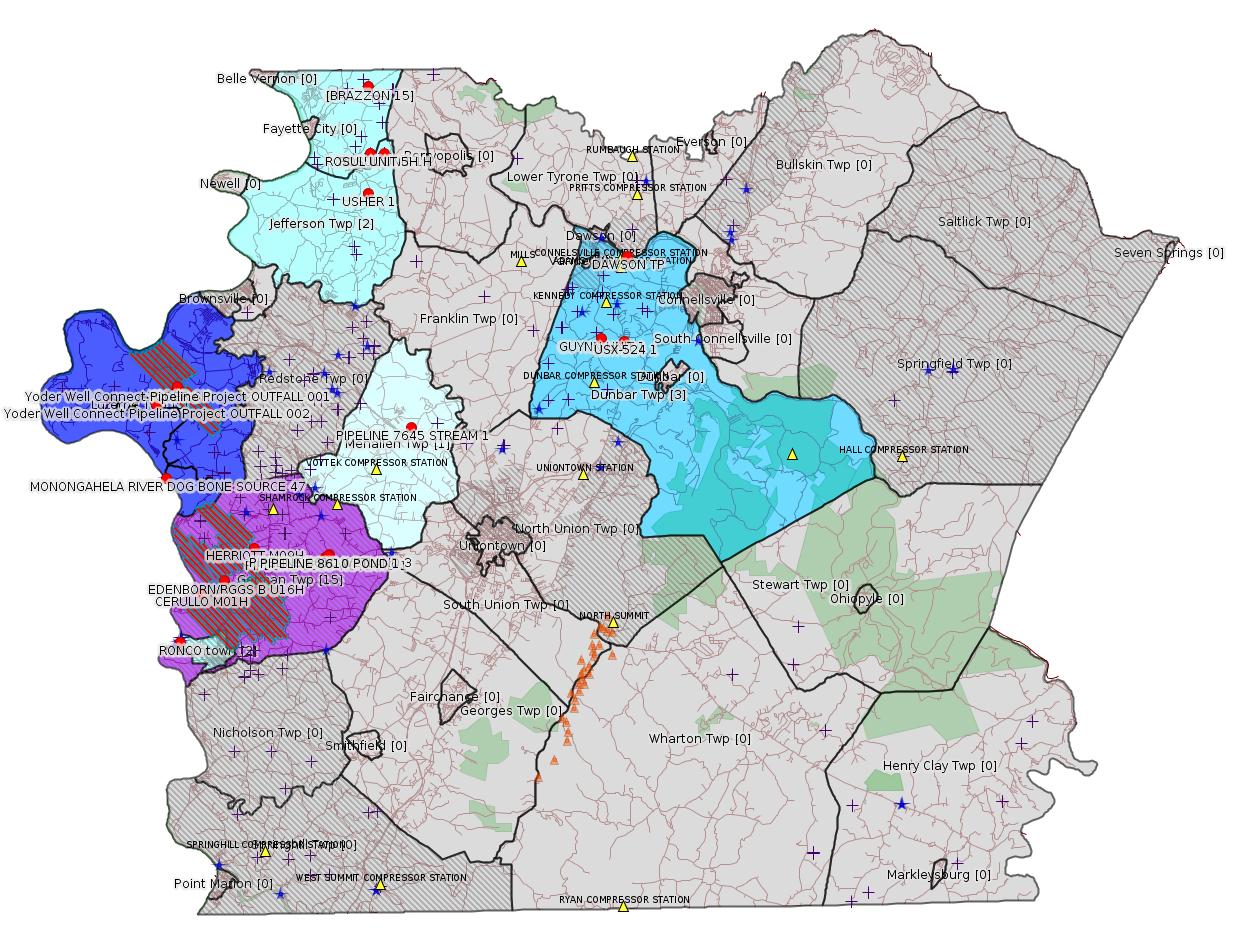
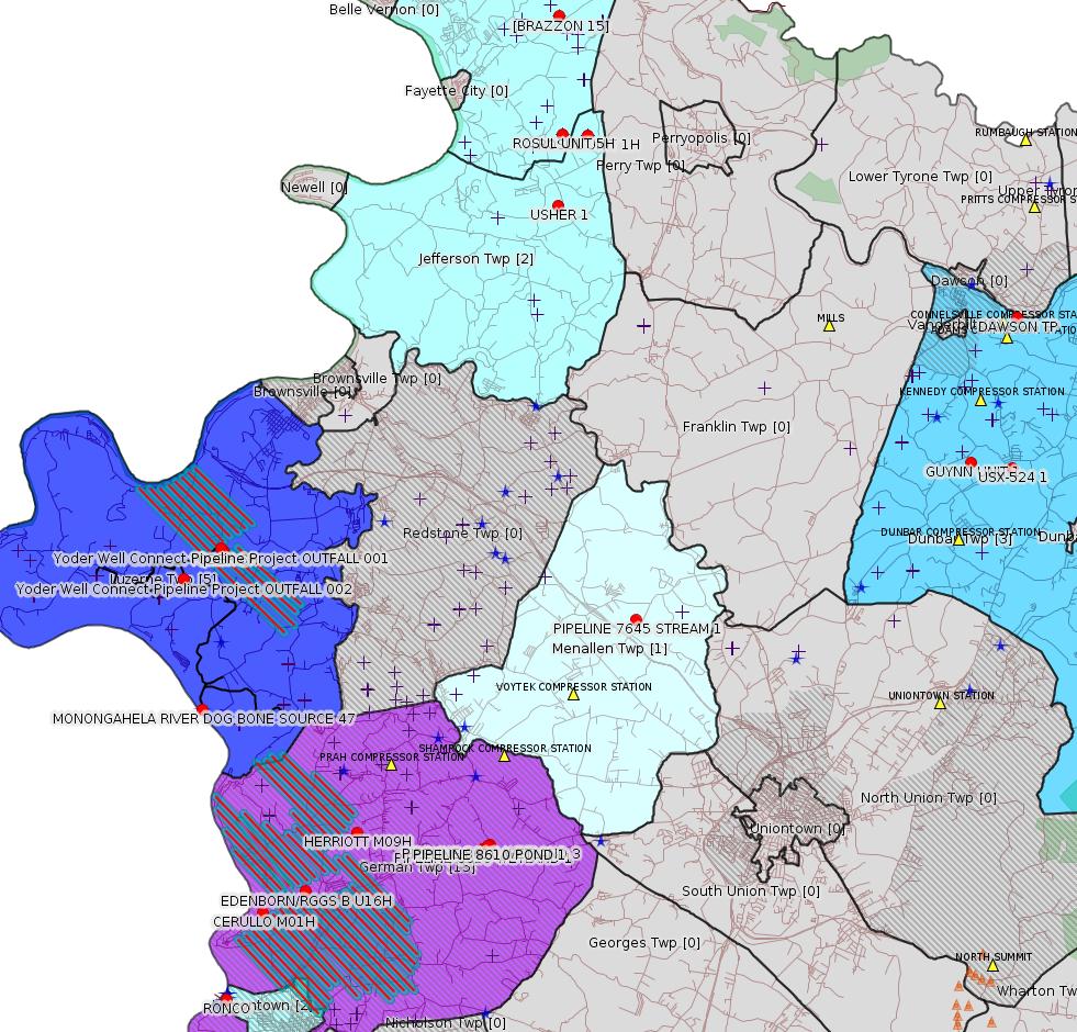
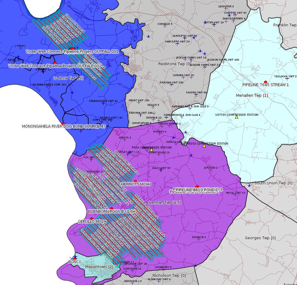
Map
Key
Red dots: items in this permit list with an exact location.
Blue stars: Marcellus Gas Well Water Sources.
Where well laterals are mapped they show in red; a 400-foot buffer surrounding the lateral shows in blue (lavender where it overlaps a mapped mineral tract).
Where mineral tracts are mapped, they show in pink. Mineral tracts can overlap; the overlap will show in red. The precise meaning of "mineral tract" is not clear.
Municipality shading: number of "facilities", with each well counting separately
(includes the red dots):
gray: 0
pale turquoise: 1
turquoise: 2
pale blue: 3
middle blue: 4
dark blue: 5
dark purple: 12
purple: 15
(Color coding may differ from one issue to the next.)
(Note if a project spans multiple municipalities -- e.g. a pipeline -- it will show in the count for each municipality.)
The number of facilities also follows the municipality name in brackets.
Municipality counts are based on the way the permit is listed by DEP; DEP has been known to get a municipality wrong.
Locations in brackets identify a precise location used to locate a surrogate for the actual site being permitted (e.g. locating a well pad or pipeline by the known location of a well.) Locations labeled beginning with "~" and ending in "[?]" are approximate and speculative based on inferences using on-line property and lease records. These are marked in the text as "[Approximate, Speculative]
Cross-hatching: Environmental Justice Areas
Yellow triangles: Compressor Stations
Orange triangles: Storage Field Wells (currently Dominion North Summit Storage Field)
Crosses: SPUD Unconventional well permits
Green: "Natural areas", e.g. state game lands, state forests
Yellow triangles: Compressor Stations
Orange triangles: Storage Field Wells (currently Dominion North Summit Storage Field)
Crosses: SPUD Unconventional well permits
Green: "Natural areas", e.g. state game lands, state forests
More Maps
 |
 |
Source: Pennsylvania Bulletin
| NPDES No. (Type) |
Facility Name & Address | County & Municipality | Stream Name (Watershed No.) |
EPA Waived Y/N? |
|---|---|---|---|---|
| PA0217778 (Industrial) |
Dawson TP P.O. Box 2223 Johnson City, TN 37605-2223 |
Fayette County Dunbar Township |
Youghiogheny River (WWF) (19-D) |
Yes |
Sub-Facilities for Authorization:
Sub-Facility ID Sub-Facility Name Description
1025459 OUTFALL 001 Discharge Point
Location: 40.036247,-79.640533
Map URL: <http://www.openstreetmap.org/?mlat=40.036247&mlon=-79.640533#map=15/40.036247/-79.640533>
Sub-Facility ID Sub-Facility Name Description
1025459 OUTFALL 001 Discharge Point
Location: 40.036247,-79.640533
Map URL: <http://www.openstreetmap.org/?mlat=40.036247&mlon=-79.640533#map=15/40.036247/-79.640533>
-------------------------
Source: eNOTICE
(+ PA
Oil and Gas Mapping, Well
Pad Report.) Well Details via Data
Portal Services: Oil and Gas Wells All (ID: 3).
Please see the Disclaimer below regarding Parcel Id data.
Authorization ID: 1282459
Permit number: PAG106222
Site: Yoder Well Connect Pipeline Project
Client: LAUREL MTN MIDSTREAM OPR LLC
Authorization type: PAG-10 Discharge Resulting from Hydrostatic Testing of Tanks & Pipelines
Application type: New
Authorization is for: FACILITY
Date received: 07/31/2019
Status: Issued on 8/6/2019
Permit Decision Guarantee Applies?: Yes
Permit Decision Guarantee status: ACTIVE
Sub-Facilities for Authorization:
Sub-Facility ID Sub-Facility Name Description
1291629 OUTFALL 001 Discharge Point
Location: 39.976094,-79.924633
Map URL: <http://www.openstreetmap.org/?mlat=39.976094&mlon=-79.924633#map=15/39.976094/-79.924633>
Presumed Parcel Id: 19160034
1291630 OUTFALL 002 Discharge Point
Location: 39.967828,-79.938114
Map URL: <http://www.openstreetmap.org/?mlat=39.967828&mlon=-79.938114#map=15/39.967828/-79.938114>
Presumed Parcel Id: 19250012
Permit Review Notes:
Date Review Note
8/5/2019 The technical review and decision review are complete and either the permit decision and/or permit issuance are forthcoming.
8/1/2019 The permit application package is complete, has been accepted, and is undergoing technical review.
<https://www.ahs.dep.pa.gov/eFACTSWeb/searchResults_singleAuth.aspx?AuthID=1282459>
Site Programs:
Clean Water
Water Planning and Conservation
Site Municipalities:
Luzerne Twp, Fayette County
---
Authorization ID: 1282037
Permit number: WMGR123SW001
Site: RONCO
Client: SHALLENBERGER CONST INC
Authorization type: Minor Modification to an Existing Fac
Application type: Modification
Authorization is for: FACILITY
Date received: 07/30/2019
Status: Pending
Permit Decision Guarantee Applies?: Yes
Permit Decision Guarantee status: VOID
<https://www.ahs.dep.pa.gov/eFACTSWeb/searchResults_singleAuth.aspx?AuthID=1282037>
Site Programs:
Radiation Protection
Waste Management
Site Municipalities:
Masontown Boro, Fayette County
---
Authorization ID: 1281914
Permit number: GP042607219-003
Site: MONONGAHELA RIVER DOG BONE SOURCE 47 WATER WITHDRAWAL GP04
Client: CHEVRON APPALACHIA LLC
Authorization type: GP-04 Intake & Outfall Structures
Application type: New
Authorization is for: FACILITY
Date received: 07/29/2019
Status: Pending
Permit Decision Guarantee Applies?: No
Sub-Facilities for Authorization:
Sub-Facility ID Sub-Facility Name Description
1291208 MONONGAHELA RIVER DOG BONE SOURCE 47 WATER WITHDRAWAL GP04 Intake Structure
Permit Review Notes:
Date Review Note
8/7/2019 DEP's interim review is complete. Final decision review/permit issuance is pending receipt of comments/approvals from other state or federal resources agencies.
8/7/2019 The permit application package is complete, has been accepted, and is undergoing technical review.
<https://www.ahs.dep.pa.gov/eFACTSWeb/searchResults_singleAuth.aspx?AuthID=1281914>
Site Programs:
Water Planning and Conservation
Site Municipalities:
Luzerne Twp, Fayette County
Location: 39.932071,-79.932038
---
Authorization ID: 1281403
Permit number: GP112607219-016
Site: BRAZZON 15 ACCESS RD CULVERT REPLACEMENT PROJ GP11
Client: DIVERSIFIED OIL & GAS LLC
Authorization type: BWM-GP-11 Maintenance, Testing, Repair, Rehabilitation or Replacement General Pmt
Application type: New
Authorization is for: FACILITY
Date received: 07/23/2019
Status: Pending
Permit Decision Guarantee Applies?: Yes
Permit Decision Guarantee status: ACTIVE
Sub-Facilities for Authorization:
Sub-Facility ID Sub-Facility Name Description
1291040 BRAZZON 15 ACCESS RD CULVERT REPLACEMENT GP11 Other Activities
<https://www.ahs.dep.pa.gov/eFACTSWeb/searchResults_singleAuth.aspx?AuthID=1281403>
Site Programs:
Water Planning and Conservation
Site Municipalities:
Washington Twp, Fayette County
Permit number: 051-20785
Site: USX-524 1 WELL
Client: AMER EXPLORATION CO
Authorization type: Well Plugging Notice Alternate Method
Application type: New
Authorization is for: FACILITY
Date received: 07/17/2019
Status: Issued on 7/30/2019
Permit Decision Guarantee Applies?: No
Sub-Facilities for Authorization:
Sub-Facility ID Sub-Facility Name Description
56962 USX-524 1 Well
Permit Review Notes:
Date Review Note
7/30/2019 The technical review and decision review are complete and either the permit decision and/or permit issuance are forthcoming.
7/17/2019 The permit application package is complete, has been accepted, and is undergoing technical review.
<https://www.ahs.dep.pa.gov/eFACTSWeb/searchResults_singleAuth.aspx?AuthID=1280692>
Site Programs:
Oil & Gas
Site Municipalities:
Dunbar Twp, Fayette County
Well Details:
Permit Number: 051-20785
Well Name: USX-524 1
Unconventional Well: N
Well Configuration: Vertical Well
Well Type: GAS
Well Status: Active
Coal Association: NonCoal
Conservation Well: N
Primary Facility ID: 43432
Site ID: 41680
Site Name: USX-524 1 WELL
Well Pad ID: 0
Well Pad Name:
Storage Field:
Operator: AMER EXPLORATION CO
Operator Number: OGO-49725
Permit Date: 1995-07-07
Permit Date Expires: 1996-07-07
SPUD Date: 1995-07-10
Date Plugged:
UIC ID:
UIC Type:
Surface Elevation: 1060
County: Fayette
Municipality: Dunbar Twp
Location: 39.995084,-79.643142
Map URL: <http://www.openstreetmap.org/?mlat=39.995084&mlon=-79.643142#map=15/39.995084/-79.643142>
OG WELLS PERMIT DOCS:
2019-08-01: Other Permit Documents, Name: NOI with Alternate Method (for Authorization: 1280690):
<http://www.depgis.state.pa.us/pdfHandler/pdFHandler.ashx?Doc=ODkxNjcx&ext=PDF>
---
Authorization ID: 1280690
Permit number: 051-20785
Site: USX-524 1 WELL
Client: AMER EXPLORATION CO
Authorization type: Well Plugging Notice Intent to Plug Single Well
Application type: New
Authorization is for: FACILITY
Date received: 07/17/2019
Status: Issued on 7/30/2019
Permit Decision Guarantee Applies?: No
Sub-Facilities for Authorization:
Sub-Facility ID Sub-Facility Name Description
56962 USX-524 1 Well
Permit Review Notes:
Date Review Note
7/30/2019 The technical review and decision review are complete and either the permit decision and/or permit issuance are forthcoming.
7/17/2019 The permit application package is complete, has been accepted, and is undergoing technical review.
<https://www.ahs.dep.pa.gov/eFACTSWeb/searchResults_singleAuth.aspx?AuthID=1280690>
Site Programs:
Oil & Gas
Site Municipalities:
Dunbar Twp, Fayette County
---
Authorization ID: 1280686
Permit number: 051-20842
Site: GUYNN UNIT 1 Well
Client: AMER EXPLORATION CO
Authorization type: Well Plugging Notice Alternate Method
Application type: New
Authorization is for: FACILITY
Date received: 07/17/2019
Status: Issued on 7/30/2019
Permit Decision Guarantee Applies?: No
Sub-Facilities for Authorization:
Sub-Facility ID Sub-Facility Name Description
313107 GUYNN UNIT 1 Well
Permit Review Notes:
Date Review Note
7/30/2019 The technical review and decision review are complete and either the permit decision and/or permit issuance are forthcoming.
7/17/2019 The permit application package is complete, has been accepted, and is undergoing technical review.
<https://www.ahs.dep.pa.gov/eFACTSWeb/searchResults_singleAuth.aspx?AuthID=1280686>
Site Programs:
Oil & Gas
Site Municipalities:
Dunbar Twp, Fayette County
Well Details:
Permit Number: 051-20842
Well Name: GUYNN UNIT 1
Unconventional Well: N
Well Configuration: Vertical Well
Well Type: GAS
Well Status: Active
Coal Association: Coal
Conservation Well: N
Primary Facility ID: 332166
Site ID: 308946
Site Name: GUYNN UNIT 1 Well
Well Pad ID: 0
Well Pad Name:
Storage Field:
Operator: AMER EXPLORATION CO
Operator Number: OGO-49725
Permit Date: 1996-07-22
Permit Date Expires: 1997-07-22
SPUD Date: 1996-07-24
Date Plugged:
UIC ID:
UIC Type:
Surface Elevation: 1145
County: Fayette
Municipality: Dunbar Twp
Location: 39.996731,-79.657603
Map URL: <http://www.openstreetmap.org/?mlat=39.996731&mlon=-79.657603#map=15/39.996731/-79.657603>
OG WELLS PERMIT DOCS:
2019-08-01: Other Permit Documents, Name: NOI with Alternate Method (for Authorization: 1280684):
<http://www.depgis.state.pa.us/pdfHandler/pdFHandler.ashx?Doc=ODkxNjcw&ext=PDF>
---
Authorization ID: 1280684
Permit number: 051-20842
Site: GUYNN UNIT 1 Well
Client: AMER EXPLORATION CO
Authorization type: Well Plugging Notice Intent to Plug Single Well
Application type: New
Authorization is for: FACILITY
Date received: 07/17/2019
Status: Issued on 7/30/2019
Permit Decision Guarantee Applies?: No
Sub-Facilities for Authorization:
Sub-Facility ID Sub-Facility Name Description
313107 GUYNN UNIT 1 Well
Permit Review Notes:
Date Review Note
7/30/2019 The technical review and decision review are complete and either the permit decision and/or permit issuance are forthcoming.
7/17/2019 The permit application package is complete, has been accepted, and is undergoing technical review.
<https://www.ahs.dep.pa.gov/eFACTSWeb/searchResults_singleAuth.aspx?AuthID=1280684>
Site Programs:
Oil & Gas
Site Municipalities:
Dunbar Twp, Fayette County
Well Details above
---
Authorization ID: 1274670
Permit number: 051-24708
Site: EDENBORN/RGGS B ESCGP ESX18-051-0003
Client: CHEVRON APPALACHIA LLC
Authorization type: Alt Method of Equipping, Casing, or Venting Well
Application type: New
Authorization is for: FACILITY
Date received: 05/23/2019
Status: Pending
Permit Decision Guarantee Applies?: Yes
Permit Decision Guarantee status: ACTIVE
Sub-Facilities for Authorization:
Sub-Facility ID Sub-Facility Name Description
1286626 WELLBORE SIDETRACK Well
1286625 WELLBORE SURFACE HOLE LOCATION Well
Permit Review Notes:
Date Review Note
5/28/2019 The permit application package is complete, has been accepted, and is undergoing technical review.
<https://www.ahs.dep.pa.gov/eFACTSWeb/searchResults_singleAuth.aspx?AuthID=1274670>
Site Programs:
Oil & Gas
Site Municipalities:
German Twp [an Environmental Justice Area], Fayette County
Well Details:
Permit Number: 051-24708
Well Name: EDENBORN/RGGS B U16H
Unconventional Well: Y
Well Configuration: Horizontal Well
Well Type: GAS
Well Status: Active
Coal Association: Coal
Conservation Well: Y
Primary Facility ID: 834603
Site ID: 829418
Site Name: EDENBORN/RGGS B ESCGP ESX18-051-0003
Well Pad ID: 155083
Well Pad Name: EDENBORN/RGGS B
Storage Field:
Operator: CHEVRON APPALACHIA LLC
Operator Number: OGO-39307
Permit Date: 2019-06-03
Permit Date Expires: 2020-06-03
SPUD Date:
Date Plugged:
UIC ID:
UIC Type:
Surface Elevation: 1167
County: Fayette
Municipality: German Twp
Location: 39.882056,-79.89625
Map URL: <http://www.openstreetmap.org/?mlat=39.882056&mlon=-79.89625#map=15/39.882056/-79.89625>
OG WELLS PERMIT DOCS:
2019-06-03: Final Permit Documents, Name: auth id 1272783 (for Authorization: 1272783):
<http://www.depgis.state.pa.us/pdfHandler/pdFHandler.ashx?Doc=ODI4MzUw&ext=PDF>
Electronically Submitted Records:
2019-06-03: Submission for Authorization 1272783
Interested Party Notification: Edenbon 16H Affidavit of NonDelivery.pdf
<http://www.depgis.state.pa.us/eWellDocHandler/pdFHandler.ashx?Doc=ODM3MTQ4&ext=PDF>
Coordination of Well Location with Public Resources: Edenborn 16H OG-76.pdf
<http://www.depgis.state.pa.us/eWellDocHandler/pdFHandler.ashx?Doc=ODM3MTUz&ext=PDF>
Pennsylvania Natural Diversity Inventory Form: EdenbornRGGS PNDI.pdf
<http://www.depgis.state.pa.us/eWellDocHandler/pdFHandler.ashx?Doc=ODM3MTU0&ext=PDF>
Location Plat: Edenborn - Final Well Plat U16H - 2019.04.25.dwg
<http://www.depgis.state.pa.us/eWellDocHandler/pdFHandler.ashx?Doc=ODM3MTU1&ext=PDF>
Well Cross-Section Diagram: Edenborn U16H Page 4.pdf
<http://www.depgis.state.pa.us/eWellDocHandler/pdFHandler.ashx?Doc=ODM3MTU2&ext=PDF>
Permit Application to Drill and Operate a Well: 1929952.pdf
<http://www.depgis.state.pa.us/eWellDocHandler/pdFHandler.ashx?Doc=ODM3NDM1&ext=PDF>
---
Authorization ID: 1274532
Permit number: GP112607219-013
Site: SOUTHERN PA GATHERING SYSTEM ABANDONMENT PIPELINE 8610 PROJECT GP08 GP11
Client: COLUMBIA GAS TRANS
Authorization type: BWM-GP-11 Maintenance, Testing, Repair, Rehabilitation or Replacement General Pmt
Application type: New
Authorization is for: FACILITY
Date received: 05/23/2019
Status: Issued on 7/25/2019
Permit Decision Guarantee Applies?: Yes
Permit Decision Guarantee status: ACTIVE
Sub-Facilities for Authorization:
Sub-Facility ID Sub-Facility Name Description
1291085 POND 1- ABANDONMENT Other Activities
Location: 39.893874,-79.831128
Map URL: <http://www.openstreetmap.org/?mlat=39.893874&mlon=-79.831128#map=15/39.893874/-79.831128>
1287623 S PA GATHERING SYS ABANDONMENT PPL 8610 PROJECT GP11 Other Activities
1287622 WETLAND 1 Bridge
Location: 39.892928,-79.833191
Map URL: <http://www.openstreetmap.org/?mlat=39.892928&mlon=-79.833191#map=15/39.892928/-79.833191>
1291082 WETLAND 1 Temporary Wetland Impact
Location: 39.892928,-79.833191
Map URL: <http://www.openstreetmap.org/?mlat=39.892928&mlon=-79.833191#map=15/39.892928/-79.833191>
1291083 WETLAND 1- ABANDONMENT Wetland Impact
Location: 39.892928,-79.833191
Map URL: <http://www.openstreetmap.org/?mlat=39.892928&mlon=-79.833191#map=15/39.892928/-79.833191>
1291084 WETLAND 3- ABANDONMENT Wetland Impact
Location: 39.894175,-79.830501
Map URL: <http://www.openstreetmap.org/?mlat=39.894175&mlon=-79.830501#map=15/39.894175/-79.830501>
Permit Review Notes:
Date Review Note
7/25/2019 The technical review and decision review are complete and either the permit decision and/or permit issuance are forthcoming.
5/30/2019 The permit application package is complete, has been accepted, and is undergoing technical review.
<https://www.ahs.dep.pa.gov/eFACTSWeb/searchResults_singleAuth.aspx?AuthID=1274532>
Site Programs:
Water Planning and Conservation
Site Municipalities:
German Twp [an Environmental Justice Area], Fayette County
---
Authorization ID: 1274531
Permit number: GP082607219-005
Site: SOUTHERN PA GATHERING SYSTEM ABANDONMENT PIPELINE 8610 PROJECT GP08 GP11
Client: COLUMBIA GAS TRANS
Authorization type: GP-08 Temporary Road Crossings
Application type: New
Authorization is for: FACILITY
Date received: 05/23/2019
Status: Issued on 7/26/2019
Permit Decision Guarantee Applies?: No
Sub-Facilities for Authorization:
Sub-Facility ID Sub-Facility Name Description
1291082 WETLAND 1 Temporary Wetland Impact
Location: 39.892928,-79.833191
Map URL: <http://www.openstreetmap.org/?mlat=39.892928&mlon=-79.833191#map=15/39.892928/-79.833191>
1287622 WETLAND 1 Bridge
Location: 39.892928,-79.833191
Map URL: <http://www.openstreetmap.org/?mlat=39.892928&mlon=-79.833191#map=15/39.892928/-79.833191>
Permit Review Notes:
Date Review Note
7/25/2019 The technical review and decision review are complete and either the permit decision and/or permit issuance are forthcoming.
5/30/2019 The permit application package is complete, has been accepted, and is undergoing technical review.
<https://www.ahs.dep.pa.gov/eFACTSWeb/searchResults_singleAuth.aspx?AuthID=1274531>
Site Programs:
Water Planning and Conservation
Site Municipalities:
German Twp [an Environmental Justice Area], Fayette County
---
Authorization ID: 1274525
Permit number: GP112607219-012
Site: SOUTHERN PA GATHERING SYSTEM ABANDONMENT PIPELINE 7645 PROJECT GP08 GP11
Client: COLUMBIA GAS TRANS
Authorization type: BWM-GP-11 Maintenance, Testing, Repair, Rehabilitation or Replacement General Pmt
Application type: New
Authorization is for: FACILITY
Date received: 05/23/2019
Status: Issued on 7/25/2019
Permit Decision Guarantee Applies?: Yes
Permit Decision Guarantee status: VOID
Sub-Facilities for Authorization:
Sub-Facility ID Sub-Facility Name Description
1287617 S PA GATHERING SYS ABANDONMENT PPL 7645 PROJ GP11 Other Activities
1287616 STREAM 1 FLOODWAY Bridge
Location: 39.954966,-79.777663
Map URL: <http://www.openstreetmap.org/?mlat=39.954966&mlon=-79.777663#map=15/39.954966/-79.777663>
1291088 STREAM 1 FLOODWAY-ABANDONMENT Floodway Activity
Location: 39.954966,-79.777663
Map URL: <http://www.openstreetmap.org/?mlat=39.954966&mlon=-79.777663#map=15/39.954966/-79.777663>
Permit Review Notes:
Date Review Note
7/25/2019 The technical review and decision review are complete and either the permit decision and/or permit issuance are forthcoming.
7/9/2019 Applicant has been issued a deficiency letter. If applicable, this application no longer qualifies for the Permit Decision Guarantee.
5/30/2019 The permit application package is complete, has been accepted, and is undergoing technical review.
<https://www.ahs.dep.pa.gov/eFACTSWeb/searchResults_singleAuth.aspx?AuthID=1274525>
Site Programs:
Water Planning and Conservation
Site Municipalities:
Menallen Twp, Fayette County
---
Authorization ID: 1274524
Permit number: GP082607219-004
Site: SOUTHERN PA GATHERING SYSTEM ABANDONMENT PIPELINE 7645 PROJECT GP08 GP11
Client: COLUMBIA GAS TRANS
Authorization type: GP-08 Temporary Road Crossings
Application type: New
Authorization is for: FACILITY
Date received: 05/23/2019
Status: Issued on 7/25/2019
Permit Decision Guarantee Applies?: No
Sub-Facilities for Authorization:
Sub-Facility ID Sub-Facility Name Description
1287616 STREAM 1 FLOODWAY Bridge
Location: 39.954966,-79.777663
Map URL: <http://www.openstreetmap.org/?mlat=39.954966&mlon=-79.777663#map=15/39.954966/-79.777663>
1291088 STREAM 1 FLOODWAY-ABANDONMENT Floodway Activity
Location: 39.954966,-79.777663
Map URL: <http://www.openstreetmap.org/?mlat=39.954966&mlon=-79.777663#map=15/39.954966/-79.777663>
Permit Review Notes:
Date Review Note
7/25/2019 The technical review and decision review are complete and either the permit decision and/or permit issuance are forthcoming.
7/9/2019 Applicant has been issued a deficiency letter. If applicable, this application no longer qualifies for the Permit Decision Guarantee.
5/30/2019 The permit application package is complete, has been accepted, and is undergoing technical review.
<https://www.ahs.dep.pa.gov/eFACTSWeb/searchResults_singleAuth.aspx?AuthID=1274524>
Site Programs:
Water Planning and Conservation
Site Municipalities:
Menallen Twp, Fayette County
---
Authorization ID: 1274218
Permit number: E26-07-006
Site: RONCO PLANT JPA 326-07-006
Client: APPALACHIAN WATER SVC LLC
Authorization type: Water Obstruction & Encroachment Pmt
Application type: New
Authorization is for: FACILITY
Date received: 05/13/2019
Status: Pending
Permit Decision Guarantee Applies?: Yes
Permit Decision Guarantee status: VOID
Sub-Facilities for Authorization:
Sub-Facility ID Sub-Facility Name Description
1287361 RONCO PLANT JPA 326-07-006 Pipeline or Conduit
Permit Review Notes:
Date Review Note
7/19/2019 Applicant has been issued a deficiency letter. If applicable, this application no longer qualifies for the Permit Decision Guarantee.
<https://www.ahs.dep.pa.gov/eFACTSWeb/searchResults_singleAuth.aspx?AuthID=1274218>
Site Programs:
Water Planning and Conservation
Site Municipalities:
Masontown Boro, Fayette County
-------------------------
Source: DEP
Oil and Gas Electronic NotificationsPlease see the Disclaimer below regarding Parcel Id data.
Authorization ID: 1282459
Permit number: PAG106222
Site: Yoder Well Connect Pipeline Project
Client: LAUREL MTN MIDSTREAM OPR LLC
Authorization type: PAG-10 Discharge Resulting from Hydrostatic Testing of Tanks & Pipelines
Application type: New
Authorization is for: FACILITY
Date received: 07/31/2019
Status: Issued on 8/6/2019
Permit Decision Guarantee Applies?: Yes
Permit Decision Guarantee status: ACTIVE
Sub-Facilities for Authorization:
Sub-Facility ID Sub-Facility Name Description
1291629 OUTFALL 001 Discharge Point
Location: 39.976094,-79.924633
Map URL: <http://www.openstreetmap.org/?mlat=39.976094&mlon=-79.924633#map=15/39.976094/-79.924633>
Presumed Parcel Id: 19160034
1291630 OUTFALL 002 Discharge Point
Location: 39.967828,-79.938114
Map URL: <http://www.openstreetmap.org/?mlat=39.967828&mlon=-79.938114#map=15/39.967828/-79.938114>
Presumed Parcel Id: 19250012
Permit Review Notes:
Date Review Note
8/5/2019 The technical review and decision review are complete and either the permit decision and/or permit issuance are forthcoming.
8/1/2019 The permit application package is complete, has been accepted, and is undergoing technical review.
<https://www.ahs.dep.pa.gov/eFACTSWeb/searchResults_singleAuth.aspx?AuthID=1282459>
Site Programs:
Clean Water
Water Planning and Conservation
Site Municipalities:
Luzerne Twp, Fayette County
---
Authorization ID: 1282037
Permit number: WMGR123SW001
Site: RONCO
Client: SHALLENBERGER CONST INC
Authorization type: Minor Modification to an Existing Fac
Application type: Modification
Authorization is for: FACILITY
Date received: 07/30/2019
Status: Pending
Permit Decision Guarantee Applies?: Yes
Permit Decision Guarantee status: VOID
<https://www.ahs.dep.pa.gov/eFACTSWeb/searchResults_singleAuth.aspx?AuthID=1282037>
Site Programs:
Radiation Protection
Waste Management
Site Municipalities:
Masontown Boro, Fayette County
Location: 39.852778,-79.924722 <http://osm.org/go/ZWpM2V0y--?m=>
Presumed Parcel Id: 21010001---
Authorization ID: 1281914
Permit number: GP042607219-003
Site: MONONGAHELA RIVER DOG BONE SOURCE 47 WATER WITHDRAWAL GP04
Client: CHEVRON APPALACHIA LLC
Authorization type: GP-04 Intake & Outfall Structures
Application type: New
Authorization is for: FACILITY
Date received: 07/29/2019
Status: Pending
Permit Decision Guarantee Applies?: No
Sub-Facilities for Authorization:
Sub-Facility ID Sub-Facility Name Description
1291208 MONONGAHELA RIVER DOG BONE SOURCE 47 WATER WITHDRAWAL GP04 Intake Structure
Permit Review Notes:
Date Review Note
8/7/2019 DEP's interim review is complete. Final decision review/permit issuance is pending receipt of comments/approvals from other state or federal resources agencies.
8/7/2019 The permit application package is complete, has been accepted, and is undergoing technical review.
<https://www.ahs.dep.pa.gov/eFACTSWeb/searchResults_singleAuth.aspx?AuthID=1281914>
Site Programs:
Water Planning and Conservation
Site Municipalities:
Luzerne Twp, Fayette County
Location: 39.932071,-79.932038
---
Authorization ID: 1281403
Permit number: GP112607219-016
Site: BRAZZON 15 ACCESS RD CULVERT REPLACEMENT PROJ GP11
Client: DIVERSIFIED OIL & GAS LLC
Authorization type: BWM-GP-11 Maintenance, Testing, Repair, Rehabilitation or Replacement General Pmt
Application type: New
Authorization is for: FACILITY
Date received: 07/23/2019
Status: Pending
Permit Decision Guarantee Applies?: Yes
Permit Decision Guarantee status: ACTIVE
Sub-Facilities for Authorization:
Sub-Facility ID Sub-Facility Name Description
1291040 BRAZZON 15 ACCESS RD CULVERT REPLACEMENT GP11 Other Activities
<https://www.ahs.dep.pa.gov/eFACTSWeb/searchResults_singleAuth.aspx?AuthID=1281403>
Site Programs:
Water Planning and Conservation
Site Municipalities:
Washington Twp, Fayette County
Well
Details [of BRAZZON 15]:
Permit Number: 051-23977
Well Name: BRAZZON 15
Unconventional Well: Y
Well Configuration: Vertical Well
Well Type: GAS
Well Status: Active
Coal Association: Coal
Conservation Well: Y
Primary Facility ID: 705611
Site ID: 704775
Site Name: BRAZZON 15 OG WELL
Well Pad ID: 147068
Well Pad Name: BRAZZON 15
Storage Field:
Operator: DIVERSIFIED OIL & GAS LLC
Operator Number: OGO-68792
Permit Date: 2008-05-09
Permit Date Expires: 2009-05-09
SPUD Date: 2008-06-02
Date Plugged:
UIC ID:
UIC Type:
Surface Elevation: 1015
County: Fayette
Municipality: Washington Twp
Location: 40.120332,-79.801974
Map URL: <http://www.openstreetmap.org/?mlat=40.120332&mlon=-79.801974#map=15/40.120332/-79.801974>
---
Authorization ID: 1280692Permit Number: 051-23977
Well Name: BRAZZON 15
Unconventional Well: Y
Well Configuration: Vertical Well
Well Type: GAS
Well Status: Active
Coal Association: Coal
Conservation Well: Y
Primary Facility ID: 705611
Site ID: 704775
Site Name: BRAZZON 15 OG WELL
Well Pad ID: 147068
Well Pad Name: BRAZZON 15
Storage Field:
Operator: DIVERSIFIED OIL & GAS LLC
Operator Number: OGO-68792
Permit Date: 2008-05-09
Permit Date Expires: 2009-05-09
SPUD Date: 2008-06-02
Date Plugged:
UIC ID:
UIC Type:
Surface Elevation: 1015
County: Fayette
Municipality: Washington Twp
Location: 40.120332,-79.801974
Map URL: <http://www.openstreetmap.org/?mlat=40.120332&mlon=-79.801974#map=15/40.120332/-79.801974>
Presumed Parcel Id: 41090004
---
Permit number: 051-20785
Site: USX-524 1 WELL
Client: AMER EXPLORATION CO
Authorization type: Well Plugging Notice Alternate Method
Application type: New
Authorization is for: FACILITY
Date received: 07/17/2019
Status: Issued on 7/30/2019
Permit Decision Guarantee Applies?: No
Sub-Facilities for Authorization:
Sub-Facility ID Sub-Facility Name Description
56962 USX-524 1 Well
Permit Review Notes:
Date Review Note
7/30/2019 The technical review and decision review are complete and either the permit decision and/or permit issuance are forthcoming.
7/17/2019 The permit application package is complete, has been accepted, and is undergoing technical review.
<https://www.ahs.dep.pa.gov/eFACTSWeb/searchResults_singleAuth.aspx?AuthID=1280692>
Site Programs:
Oil & Gas
Site Municipalities:
Dunbar Twp, Fayette County
Well Details:
Permit Number: 051-20785
Well Name: USX-524 1
Unconventional Well: N
Well Configuration: Vertical Well
Well Type: GAS
Well Status: Active
Coal Association: NonCoal
Conservation Well: N
Primary Facility ID: 43432
Site ID: 41680
Site Name: USX-524 1 WELL
Well Pad ID: 0
Well Pad Name:
Storage Field:
Operator: AMER EXPLORATION CO
Operator Number: OGO-49725
Permit Date: 1995-07-07
Permit Date Expires: 1996-07-07
SPUD Date: 1995-07-10
Date Plugged:
UIC ID:
UIC Type:
Surface Elevation: 1060
County: Fayette
Municipality: Dunbar Twp
Location: 39.995084,-79.643142
Map URL: <http://www.openstreetmap.org/?mlat=39.995084&mlon=-79.643142#map=15/39.995084/-79.643142>
OG WELLS PERMIT DOCS:
2019-08-01: Other Permit Documents, Name: NOI with Alternate Method (for Authorization: 1280690):
<http://www.depgis.state.pa.us/pdfHandler/pdFHandler.ashx?Doc=ODkxNjcx&ext=PDF>
Presumed Parcel Id: 09240255
---
Authorization ID: 1280690
Permit number: 051-20785
Site: USX-524 1 WELL
Client: AMER EXPLORATION CO
Authorization type: Well Plugging Notice Intent to Plug Single Well
Application type: New
Authorization is for: FACILITY
Date received: 07/17/2019
Status: Issued on 7/30/2019
Permit Decision Guarantee Applies?: No
Sub-Facilities for Authorization:
Sub-Facility ID Sub-Facility Name Description
56962 USX-524 1 Well
Permit Review Notes:
Date Review Note
7/30/2019 The technical review and decision review are complete and either the permit decision and/or permit issuance are forthcoming.
7/17/2019 The permit application package is complete, has been accepted, and is undergoing technical review.
<https://www.ahs.dep.pa.gov/eFACTSWeb/searchResults_singleAuth.aspx?AuthID=1280690>
Site Programs:
Oil & Gas
Site Municipalities:
Dunbar Twp, Fayette County
Well Details above
---
Authorization ID: 1280686
Permit number: 051-20842
Site: GUYNN UNIT 1 Well
Client: AMER EXPLORATION CO
Authorization type: Well Plugging Notice Alternate Method
Application type: New
Authorization is for: FACILITY
Date received: 07/17/2019
Status: Issued on 7/30/2019
Permit Decision Guarantee Applies?: No
Sub-Facilities for Authorization:
Sub-Facility ID Sub-Facility Name Description
313107 GUYNN UNIT 1 Well
Permit Review Notes:
Date Review Note
7/30/2019 The technical review and decision review are complete and either the permit decision and/or permit issuance are forthcoming.
7/17/2019 The permit application package is complete, has been accepted, and is undergoing technical review.
<https://www.ahs.dep.pa.gov/eFACTSWeb/searchResults_singleAuth.aspx?AuthID=1280686>
Site Programs:
Oil & Gas
Site Municipalities:
Dunbar Twp, Fayette County
Well Details:
Permit Number: 051-20842
Well Name: GUYNN UNIT 1
Unconventional Well: N
Well Configuration: Vertical Well
Well Type: GAS
Well Status: Active
Coal Association: Coal
Conservation Well: N
Primary Facility ID: 332166
Site ID: 308946
Site Name: GUYNN UNIT 1 Well
Well Pad ID: 0
Well Pad Name:
Storage Field:
Operator: AMER EXPLORATION CO
Operator Number: OGO-49725
Permit Date: 1996-07-22
Permit Date Expires: 1997-07-22
SPUD Date: 1996-07-24
Date Plugged:
UIC ID:
UIC Type:
Surface Elevation: 1145
County: Fayette
Municipality: Dunbar Twp
Location: 39.996731,-79.657603
Map URL: <http://www.openstreetmap.org/?mlat=39.996731&mlon=-79.657603#map=15/39.996731/-79.657603>
OG WELLS PERMIT DOCS:
2019-08-01: Other Permit Documents, Name: NOI with Alternate Method (for Authorization: 1280684):
<http://www.depgis.state.pa.us/pdfHandler/pdFHandler.ashx?Doc=ODkxNjcw&ext=PDF>
---
Authorization ID: 1280684
Permit number: 051-20842
Site: GUYNN UNIT 1 Well
Client: AMER EXPLORATION CO
Authorization type: Well Plugging Notice Intent to Plug Single Well
Application type: New
Authorization is for: FACILITY
Date received: 07/17/2019
Status: Issued on 7/30/2019
Permit Decision Guarantee Applies?: No
Sub-Facilities for Authorization:
Sub-Facility ID Sub-Facility Name Description
313107 GUYNN UNIT 1 Well
Permit Review Notes:
Date Review Note
7/30/2019 The technical review and decision review are complete and either the permit decision and/or permit issuance are forthcoming.
7/17/2019 The permit application package is complete, has been accepted, and is undergoing technical review.
<https://www.ahs.dep.pa.gov/eFACTSWeb/searchResults_singleAuth.aspx?AuthID=1280684>
Site Programs:
Oil & Gas
Site Municipalities:
Dunbar Twp, Fayette County
Well Details above
---
Authorization ID: 1274670
Permit number: 051-24708
Site: EDENBORN/RGGS B ESCGP ESX18-051-0003
Client: CHEVRON APPALACHIA LLC
Authorization type: Alt Method of Equipping, Casing, or Venting Well
Application type: New
Authorization is for: FACILITY
Date received: 05/23/2019
Status: Pending
Permit Decision Guarantee Applies?: Yes
Permit Decision Guarantee status: ACTIVE
Sub-Facilities for Authorization:
Sub-Facility ID Sub-Facility Name Description
1286626 WELLBORE SIDETRACK Well
1286625 WELLBORE SURFACE HOLE LOCATION Well
Permit Review Notes:
Date Review Note
5/28/2019 The permit application package is complete, has been accepted, and is undergoing technical review.
<https://www.ahs.dep.pa.gov/eFACTSWeb/searchResults_singleAuth.aspx?AuthID=1274670>
Site Programs:
Oil & Gas
Site Municipalities:
German Twp [an Environmental Justice Area], Fayette County
Well Details:
Permit Number: 051-24708
Well Name: EDENBORN/RGGS B U16H
Unconventional Well: Y
Well Configuration: Horizontal Well
Well Type: GAS
Well Status: Active
Coal Association: Coal
Conservation Well: Y
Primary Facility ID: 834603
Site ID: 829418
Site Name: EDENBORN/RGGS B ESCGP ESX18-051-0003
Well Pad ID: 155083
Well Pad Name: EDENBORN/RGGS B
Storage Field:
Operator: CHEVRON APPALACHIA LLC
Operator Number: OGO-39307
Permit Date: 2019-06-03
Permit Date Expires: 2020-06-03
SPUD Date:
Date Plugged:
UIC ID:
UIC Type:
Surface Elevation: 1167
County: Fayette
Municipality: German Twp
Location: 39.882056,-79.89625
Map URL: <http://www.openstreetmap.org/?mlat=39.882056&mlon=-79.89625#map=15/39.882056/-79.89625>
OG WELLS PERMIT DOCS:
2019-06-03: Final Permit Documents, Name: auth id 1272783 (for Authorization: 1272783):
<http://www.depgis.state.pa.us/pdfHandler/pdFHandler.ashx?Doc=ODI4MzUw&ext=PDF>
Electronically Submitted Records:
2019-06-03: Submission for Authorization 1272783
Interested Party Notification: Edenbon 16H Affidavit of NonDelivery.pdf
<http://www.depgis.state.pa.us/eWellDocHandler/pdFHandler.ashx?Doc=ODM3MTQ4&ext=PDF>
Coordination of Well Location with Public Resources: Edenborn 16H OG-76.pdf
<http://www.depgis.state.pa.us/eWellDocHandler/pdFHandler.ashx?Doc=ODM3MTUz&ext=PDF>
Pennsylvania Natural Diversity Inventory Form: EdenbornRGGS PNDI.pdf
<http://www.depgis.state.pa.us/eWellDocHandler/pdFHandler.ashx?Doc=ODM3MTU0&ext=PDF>
Location Plat: Edenborn - Final Well Plat U16H - 2019.04.25.dwg
<http://www.depgis.state.pa.us/eWellDocHandler/pdFHandler.ashx?Doc=ODM3MTU1&ext=PDF>
Well Cross-Section Diagram: Edenborn U16H Page 4.pdf
<http://www.depgis.state.pa.us/eWellDocHandler/pdFHandler.ashx?Doc=ODM3MTU2&ext=PDF>
Permit Application to Drill and Operate a Well: 1929952.pdf
<http://www.depgis.state.pa.us/eWellDocHandler/pdFHandler.ashx?Doc=ODM3NDM1&ext=PDF>
---
Authorization ID: 1274532
Permit number: GP112607219-013
Site: SOUTHERN PA GATHERING SYSTEM ABANDONMENT PIPELINE 8610 PROJECT GP08 GP11
Client: COLUMBIA GAS TRANS
Authorization type: BWM-GP-11 Maintenance, Testing, Repair, Rehabilitation or Replacement General Pmt
Application type: New
Authorization is for: FACILITY
Date received: 05/23/2019
Status: Issued on 7/25/2019
Permit Decision Guarantee Applies?: Yes
Permit Decision Guarantee status: ACTIVE
Sub-Facilities for Authorization:
Sub-Facility ID Sub-Facility Name Description
1291085 POND 1- ABANDONMENT Other Activities
Location: 39.893874,-79.831128
Map URL: <http://www.openstreetmap.org/?mlat=39.893874&mlon=-79.831128#map=15/39.893874/-79.831128>
1287623 S PA GATHERING SYS ABANDONMENT PPL 8610 PROJECT GP11 Other Activities
1287622 WETLAND 1 Bridge
Location: 39.892928,-79.833191
Map URL: <http://www.openstreetmap.org/?mlat=39.892928&mlon=-79.833191#map=15/39.892928/-79.833191>
1291082 WETLAND 1 Temporary Wetland Impact
Location: 39.892928,-79.833191
Map URL: <http://www.openstreetmap.org/?mlat=39.892928&mlon=-79.833191#map=15/39.892928/-79.833191>
1291083 WETLAND 1- ABANDONMENT Wetland Impact
Location: 39.892928,-79.833191
Map URL: <http://www.openstreetmap.org/?mlat=39.892928&mlon=-79.833191#map=15/39.892928/-79.833191>
1291084 WETLAND 3- ABANDONMENT Wetland Impact
Location: 39.894175,-79.830501
Map URL: <http://www.openstreetmap.org/?mlat=39.894175&mlon=-79.830501#map=15/39.894175/-79.830501>
Permit Review Notes:
Date Review Note
7/25/2019 The technical review and decision review are complete and either the permit decision and/or permit issuance are forthcoming.
5/30/2019 The permit application package is complete, has been accepted, and is undergoing technical review.
<https://www.ahs.dep.pa.gov/eFACTSWeb/searchResults_singleAuth.aspx?AuthID=1274532>
Site Programs:
Water Planning and Conservation
Site Municipalities:
German Twp [an Environmental Justice Area], Fayette County
Presumed Parcel Id: 15280016
(Sub-Facility 1291085)
Presumed Parcel Id: 15280018 (Sub-Facilities 1287622, 1291084)
Presumed Parcel Id: 15280018 (Sub-Facilities 1287622, 1291084)
---
Authorization ID: 1274531
Permit number: GP082607219-005
Site: SOUTHERN PA GATHERING SYSTEM ABANDONMENT PIPELINE 8610 PROJECT GP08 GP11
Client: COLUMBIA GAS TRANS
Authorization type: GP-08 Temporary Road Crossings
Application type: New
Authorization is for: FACILITY
Date received: 05/23/2019
Status: Issued on 7/26/2019
Permit Decision Guarantee Applies?: No
Sub-Facilities for Authorization:
Sub-Facility ID Sub-Facility Name Description
1291082 WETLAND 1 Temporary Wetland Impact
Location: 39.892928,-79.833191
Map URL: <http://www.openstreetmap.org/?mlat=39.892928&mlon=-79.833191#map=15/39.892928/-79.833191>
1287622 WETLAND 1 Bridge
Location: 39.892928,-79.833191
Map URL: <http://www.openstreetmap.org/?mlat=39.892928&mlon=-79.833191#map=15/39.892928/-79.833191>
Permit Review Notes:
Date Review Note
7/25/2019 The technical review and decision review are complete and either the permit decision and/or permit issuance are forthcoming.
5/30/2019 The permit application package is complete, has been accepted, and is undergoing technical review.
<https://www.ahs.dep.pa.gov/eFACTSWeb/searchResults_singleAuth.aspx?AuthID=1274531>
Site Programs:
Water Planning and Conservation
Site Municipalities:
German Twp [an Environmental Justice Area], Fayette County
---
Authorization ID: 1274525
Permit number: GP112607219-012
Site: SOUTHERN PA GATHERING SYSTEM ABANDONMENT PIPELINE 7645 PROJECT GP08 GP11
Client: COLUMBIA GAS TRANS
Authorization type: BWM-GP-11 Maintenance, Testing, Repair, Rehabilitation or Replacement General Pmt
Application type: New
Authorization is for: FACILITY
Date received: 05/23/2019
Status: Issued on 7/25/2019
Permit Decision Guarantee Applies?: Yes
Permit Decision Guarantee status: VOID
Sub-Facilities for Authorization:
Sub-Facility ID Sub-Facility Name Description
1287617 S PA GATHERING SYS ABANDONMENT PPL 7645 PROJ GP11 Other Activities
1287616 STREAM 1 FLOODWAY Bridge
Location: 39.954966,-79.777663
Map URL: <http://www.openstreetmap.org/?mlat=39.954966&mlon=-79.777663#map=15/39.954966/-79.777663>
1291088 STREAM 1 FLOODWAY-ABANDONMENT Floodway Activity
Location: 39.954966,-79.777663
Map URL: <http://www.openstreetmap.org/?mlat=39.954966&mlon=-79.777663#map=15/39.954966/-79.777663>
Permit Review Notes:
Date Review Note
7/25/2019 The technical review and decision review are complete and either the permit decision and/or permit issuance are forthcoming.
7/9/2019 Applicant has been issued a deficiency letter. If applicable, this application no longer qualifies for the Permit Decision Guarantee.
5/30/2019 The permit application package is complete, has been accepted, and is undergoing technical review.
<https://www.ahs.dep.pa.gov/eFACTSWeb/searchResults_singleAuth.aspx?AuthID=1274525>
Site Programs:
Water Planning and Conservation
Site Municipalities:
Menallen Twp, Fayette County
---
Authorization ID: 1274524
Permit number: GP082607219-004
Site: SOUTHERN PA GATHERING SYSTEM ABANDONMENT PIPELINE 7645 PROJECT GP08 GP11
Client: COLUMBIA GAS TRANS
Authorization type: GP-08 Temporary Road Crossings
Application type: New
Authorization is for: FACILITY
Date received: 05/23/2019
Status: Issued on 7/25/2019
Permit Decision Guarantee Applies?: No
Sub-Facilities for Authorization:
Sub-Facility ID Sub-Facility Name Description
1287616 STREAM 1 FLOODWAY Bridge
Location: 39.954966,-79.777663
Map URL: <http://www.openstreetmap.org/?mlat=39.954966&mlon=-79.777663#map=15/39.954966/-79.777663>
1291088 STREAM 1 FLOODWAY-ABANDONMENT Floodway Activity
Location: 39.954966,-79.777663
Map URL: <http://www.openstreetmap.org/?mlat=39.954966&mlon=-79.777663#map=15/39.954966/-79.777663>
Permit Review Notes:
Date Review Note
7/25/2019 The technical review and decision review are complete and either the permit decision and/or permit issuance are forthcoming.
7/9/2019 Applicant has been issued a deficiency letter. If applicable, this application no longer qualifies for the Permit Decision Guarantee.
5/30/2019 The permit application package is complete, has been accepted, and is undergoing technical review.
<https://www.ahs.dep.pa.gov/eFACTSWeb/searchResults_singleAuth.aspx?AuthID=1274524>
Site Programs:
Water Planning and Conservation
Site Municipalities:
Menallen Twp, Fayette County
---
Authorization ID: 1274218
Permit number: E26-07-006
Site: RONCO PLANT JPA 326-07-006
Client: APPALACHIAN WATER SVC LLC
Authorization type: Water Obstruction & Encroachment Pmt
Application type: New
Authorization is for: FACILITY
Date received: 05/13/2019
Status: Pending
Permit Decision Guarantee Applies?: Yes
Permit Decision Guarantee status: VOID
Sub-Facilities for Authorization:
Sub-Facility ID Sub-Facility Name Description
1287361 RONCO PLANT JPA 326-07-006 Pipeline or Conduit
Permit Review Notes:
Date Review Note
7/19/2019 Applicant has been issued a deficiency letter. If applicable, this application no longer qualifies for the Permit Decision Guarantee.
<https://www.ahs.dep.pa.gov/eFACTSWeb/searchResults_singleAuth.aspx?AuthID=1274218>
Site Programs:
Water Planning and Conservation
Site Municipalities:
Masontown Boro, Fayette County
Location [approximate]:
39.852778,-79.924722 <http://osm.org/go/ZWpM2V0y--?m=>
Presumed Parcel Id: 21010001-------------------------
NOTIFICATION_ID: 49197
OGO: 39307
OPERATOR: CHEVRON APPALACHIA LLC
API_PERMIT: 051-24705
SPUD_DATE: 06/22/2019
COUNTY: Fayette
MUNICIPALITY: German [an Environmental Justice Area]
LATITUDE: 39.897794
LONGITUDE: -79.877717
SUBJECT: [NOTIFICATION]: Casing cementing notification 58 Pa. C.S. 3211(f)(2) for well API 37-051-24705-00-00
QUESTION: Enter the Date and Time for the applicable Casing Types
ANSWER: Surface: 8/1/2019 12:00:00 PM
SENT_DATE: 7/29/2019 7:19:02 AM
SENT_SUCCESS: Yes
LAST_RESENT_DATE:
RESENT_SUCCESS:
REGION: EP DOGO SWDO Dstr Off
Well Details:
Permit Number: 051-24705
Well Name: HERRIOTT M09H
Unconventional Well: Y
Well Configuration: Horizontal Well
Well Type: GAS
Well Status: Active
Coal Association: Coal
Conservation Well: N
Primary Facility ID: 832297
Site ID: 829399
Site Name: HERRIOTT PAD A WELL AND TANK SITE ESCGP ESX18-051-0002
Well Pad ID: 155082
Well Pad Name: HERRIOTT
Storage Field:
Operator: CHEVRON APPALACHIA LLC
Operator Number: OGO-39307
Permit Date: 2019-02-22
Permit Date Expires: 2020-02-22
SPUD Date: 2019-06-22
Date Plugged:
UIC ID:
UIC Type:
Surface Elevation: 1265
County: Fayette
Municipality: German Twp
Location: 39.897794,-79.877717
Map URL: <http://www.openstreetmap.org/?mlat=39.897794&mlon=-79.877717#map=15/39.897794/-79.877717>
OG WELLS PERMIT DOCS:
2019-02-22: Final Permit Documents, Name: auth id 1260912 (for Authorization: 1260912):
<http://www.depgis.state.pa.us/pdfHandler/pdFHandler.ashx?Doc=NzU0NDY4&ext=PDF>
2019-07-23: Other Permit Documents, Name: Alternate Method (for Authorization: 1275516):
<http://www.depgis.state.pa.us/pdfHandler/pdFHandler.ashx?Doc=ODgwOTYz&ext=PDF>
Electronically Submitted Records:
2019-02-22: Submission for Authorization 1260912
Location Plat: 172-319-Well Plat M09H-pages1-2-3_3702.dwg
<http://www.depgis.state.pa.us/eWellDocHandler/pdFHandler.ashx?Doc=NzYzMDg2&ext=PDF>
Pennsylvania Natural Diversity Inventory Form: Herriott PNDI.pdf
<http://www.depgis.state.pa.us/eWellDocHandler/pdFHandler.ashx?Doc=NzYzMDg3&ext=PDF>
Well Cross-Section Diagram: Herriott M09H Page 4.pdf
<http://www.depgis.state.pa.us/eWellDocHandler/pdFHandler.ashx?Doc=NzYzMDg5&ext=PDF>
Coal and Gas Resource Coord Act - Section 7 Exception: Herriott Section 7 Exception.pdf
<http://www.depgis.state.pa.us/eWellDocHandler/pdFHandler.ashx?Doc=NzY4NDg0&ext=PDF>
Permit Application to Drill and Operate a Well: 1865932.pdf
<http://www.depgis.state.pa.us/eWellDocHandler/pdFHandler.ashx?Doc=NzY4NTEx&ext=PDF>
---
NOTIFICATION_ID: 49205
OGO: 39307
OPERATOR: CHEVRON APPALACHIA LLC
API_PERMIT: 051-24705
SPUD_DATE: 06/22/2019
COUNTY: Fayette
MUNICIPALITY: German [an Environmental Justice Area]
LATITUDE: 39.897794
LONGITUDE: -79.877717
SUBJECT: [NOTIFICATION]: Casing cementing notification 58 Pa. C.S. 3211(f)(2) for well API 37-051-24705-00-00
QUESTION: Enter the Date and Time for the applicable Casing Types
ANSWER: Intermediate: 8/2/2019 12:00:00 PM
SENT_DATE: 7/30/2019 6:30:36 AM
SENT_SUCCESS: Yes
LAST_RESENT_DATE:
RESENT_SUCCESS:
REGION: EP DOGO SWDO Dstr Off
Well Details above
Well Name: HERRIOTT M09H
---
NOTIFICATION_ID: 49206
OGO: 39307
OPERATOR: CHEVRON APPALACHIA LLC
API_PERMIT: 051-24676
SPUD_DATE: 05/10/2019
COUNTY: Fayette
MUNICIPALITY: German [an Environmental Justice Area]
LATITUDE: 39.881986
LONGITUDE: -79.896125
SUBJECT: [NOTIFICATION]: Drilling resumption After Break of 30 days or more notification 58 Pa. C.S. 3211(f)(1) for well API 37-051-24676-00-00
QUESTION: Date and approximate time action is to occur
ANSWER: Date: 08/01/2019 Time: 6:00am
SENT_DATE: 7/30/2019 6:31:41 AM
SENT_SUCCESS: Yes
LAST_RESENT_DATE:
RESENT_SUCCESS:
REGION: EP DOGO SWDO Dstr Off
Well Details:
Permit Number: 051-24676
Well Name: EDENBORN/RGGS B M03H
Unconventional Well: Y
Well Configuration: Horizontal Well
Well Type: GAS
Well Status: Active
Coal Association: Coal
Conservation Well: N
Primary Facility ID: 830201
Site ID: 829418
Site Name: EDENBORN/RGGS B ESCGP ESX18-051-0003
Well Pad ID: 155083
Well Pad Name: EDENBORN/RGGS B
Storage Field:
Operator: CHEVRON APPALACHIA LLC
Operator Number: OGO-39307
Permit Date: 2018-12-06
Permit Date Expires: 2019-12-06
SPUD Date: 2019-05-10
Date Plugged:
UIC ID:
UIC Type:
Surface Elevation: 1167
County: Fayette
Municipality: German Twp
Location: 39.881986,-79.896125
Map URL: <http://www.openstreetmap.org/?mlat=39.881986&mlon=-79.896125#map=15/39.881986/-79.896125>
OG WELLS PERMIT DOCS:
2018-12-06: Final Permit Documents, Name: Authorization ID 1251219 (for Authorization: 1251219):
<http://www.depgis.state.pa.us/pdfHandler/pdFHandler.ashx?Doc=NzEwNDc5&ext=PDF>
2019-04-16: Other Permit Documents, Name: Alternate Method (for Authorization: 1263989):
<http://www.depgis.state.pa.us/pdfHandler/pdFHandler.ashx?Doc=Nzg5NDM4&ext=PDF>
Electronically Submitted Records:
2018-12-06: Submission for Authorization 1251219
Coordination of Well Location with Public Resources: Edenborn M03H OG-76.pdf
<http://www.depgis.state.pa.us/eWellDocHandler/pdFHandler.ashx?Doc=NjgyMjEx&ext=PDF>
Pennsylvania Natural Diversity Inventory Form: EdenbornRGGS PNDI.pdf
<http://www.depgis.state.pa.us/eWellDocHandler/pdFHandler.ashx?Doc=NjgyMjEy&ext=PDF>
Location Plat: Edenborn Well Plat M3H.dwg
<http://www.depgis.state.pa.us/eWellDocHandler/pdFHandler.ashx?Doc=NjgyMjE0&ext=PDF>
Well Cross-Section Diagram: Edenborn RGGS M03H Page 4.pdf
<http://www.depgis.state.pa.us/eWellDocHandler/pdFHandler.ashx?Doc=NjgyMjE1&ext=PDF>
Permit Application to Drill and Operate a Well: 1811938.pdf
<http://www.depgis.state.pa.us/eWellDocHandler/pdFHandler.ashx?Doc=NjgyODU2&ext=PDF>
---
NOTIFICATION_ID: 49207
OGO: 39307
OPERATOR: CHEVRON APPALACHIA LLC
API_PERMIT: 051-24676
SPUD_DATE: 05/10/2019
COUNTY: Fayette
MUNICIPALITY: German [an Environmental Justice Area]
LATITUDE: 39.881986
LONGITUDE: -79.896125
SUBJECT: [NOTIFICATION]: Casing cementing notification 58 Pa. C.S. 3211(f)(2) for well API 37-051-24676-00-00
QUESTION: Enter the Date and Time for the applicable Casing Types
ANSWER: Intermediate: 8/3/2019 6:00:00 AM
SENT_DATE: 7/30/2019 6:32:34 AM
SENT_SUCCESS: Yes
LAST_RESENT_DATE:
RESENT_SUCCESS:
REGION: EP DOGO SWDO Dstr Off
Well Details above
Well Name: EDENBORN/RGGS B M03H
---
NOTIFICATION_ID: 49230
OGO: 39307
OPERATOR: CHEVRON APPALACHIA LLC
API_PERMIT: 051-24657
SPUD_DATE: 05/07/2018
COUNTY: Fayette
MUNICIPALITY: Luzerne
LATITUDE: 39.975481
LONGITUDE: -79.923881
SUBJECT: [NOTIFICATION]: Casing cementing notification 58 Pa. C.S. 3211(f)(2) for well API 37-051-24657-00-00
QUESTION: Enter the Date and Time for the applicable Casing Types
ANSWER: Production Casing: 8/3/2019 12:00:00 AM
SENT_DATE: 8/1/2019 11:15:19 AM
SENT_SUCCESS: Yes
LAST_RESENT_DATE:
RESENT_SUCCESS:
REGION: EP DOGO SWDO Dstr Off
Well Details:
Permit Number: 051-24657
Well Name: YODER 6H
Unconventional Well: Y
Well Configuration: Horizontal Well
Well Type: GAS
Well Status: Active
Coal Association: NonCoal
Conservation Well: N
Primary Facility ID: 824631
Site ID: 790607
Site Name: YODER WELL PAD ESCGP-2 EXPEDITED
Well Pad ID: 153100
Well Pad Name: YODER
Storage Field:
Operator: CHEVRON APPALACHIA LLC
Operator Number: OGO-39307
Permit Date: 2018-03-06
Permit Date Expires: 2019-03-06
SPUD Date: 2018-05-07
Date Plugged:
UIC ID:
UIC Type:
Surface Elevation: 1118
County: Fayette
Municipality: Luzerne Twp
Location: 39.975481,-79.923881
Map URL: <http://www.openstreetmap.org/?mlat=39.975481&mlon=-79.923881#map=15/39.975481/-79.923881>
OG WELLS PERMIT DOCS:
2018-03-08: Final Permit Documents, Name: 1217025 (for Authorization: 1217025):
<http://www.depgis.state.pa.us/pdfHandler/pdFHandler.ashx?Doc=NTY5ODg2&ext=PDF>
2018-03-08: Other Permit Documents, Name: Non-Coal Determination 051-24657 (for Authorization: 1217025):
<http://www.depgis.state.pa.us/pdfHandler/pdFHandler.ashx?Doc=NTY3ODE4&ext=PDF>
Electronically Submitted Records:
2018-03-08: Submission for Authorization 1217025
Pennsylvania Natural Diversity Inventory Form: Yoder PNDI.PDF
<http://www.depgis.state.pa.us/eWellDocHandler/pdFHandler.ashx?Doc=NDgyNjM3&ext=PDF>
Location Plat: Yoder Well Plat 6H.dwg
<http://www.depgis.state.pa.us/eWellDocHandler/pdFHandler.ashx?Doc=NDgyNjM4&ext=PDF>
Justification for Non-Coal Well: Yoder Non Coal Packet.pdf
<http://www.depgis.state.pa.us/eWellDocHandler/pdFHandler.ashx?Doc=NDgyNjM5&ext=PDF>
Well Cross-Section Diagram: Yoder 6H_Page 4.pdf
<http://www.depgis.state.pa.us/eWellDocHandler/pdFHandler.ashx?Doc=NDgyNjQw&ext=PDF>
Permit Application to Drill and Operate a Well: 1679547.pdf
<http://www.depgis.state.pa.us/eWellDocHandler/pdFHandler.ashx?Doc=NDgzMjgz&ext=PDF>
---
NOTIFICATION_ID: 49240
OGO: 39307
OPERATOR: CHEVRON APPALACHIA LLC
API_PERMIT: 051-24701
SPUD_DATE: 06/18/2019
COUNTY: Fayette
MUNICIPALITY: German [an Environmental Justice Area]
LATITUDE: 39.898003
LONGITUDE: -79.877919
SUBJECT: [NOTIFICATION]: Drilling resumption After Break of 30 days or more notification 58 Pa. C.S. 3211(f)(1) for well API 37-051-24701-00-00
QUESTION: Date and approximate time action is to occur
ANSWER: Date: 08/03/2019 Time: 12:00pm
SENT_DATE: 8/1/2019 9:48:00 PM
SENT_SUCCESS: Yes
LAST_RESENT_DATE:
RESENT_SUCCESS:
REGION: EP DOGO SWDO Dstr Off
Well Details:
Permit Number: 051-24701
Well Name: HERRIOTT M02H
Unconventional Well: Y
Well Configuration: Horizontal Well
Well Type: GAS
Well Status: Active
Coal Association: Coal
Conservation Well: N
Primary Facility ID: 832293
Site ID: 829399
Site Name: HERRIOTT PAD A WELL AND TANK SITE ESCGP ESX18-051-0002
Well Pad ID: 155082
Well Pad Name: HERRIOTT
Storage Field:
Operator: CHEVRON APPALACHIA LLC
Operator Number: OGO-39307
Permit Date: 2019-02-22
Permit Date Expires: 2020-02-22
SPUD Date: 2019-06-18
Date Plugged:
UIC ID:
UIC Type:
Surface Elevation: 1265
County: Fayette
Municipality: German Twp
Location: 39.898003,-79.877919
Map URL: <http://www.openstreetmap.org/?mlat=39.898003&mlon=-79.877919#map=15/39.898003/-79.877919>
OG WELLS PERMIT DOCS:
2019-02-22: Final Permit Documents, Name: auth id 1260908 (for Authorization: 1260908):
<http://www.depgis.state.pa.us/pdfHandler/pdFHandler.ashx?Doc=NzU0NDcy&ext=PDF>
2019-07-23: Other Permit Documents, Name: Alternate Method (for Authorization: 1275506):
<http://www.depgis.state.pa.us/pdfHandler/pdFHandler.ashx?Doc=ODgwOTc2&ext=PDF>
Electronically Submitted Records:
2019-02-22: Submission for Authorization 1260908
Pennsylvania Natural Diversity Inventory Form: Herriott PNDI.pdf
<http://www.depgis.state.pa.us/eWellDocHandler/pdFHandler.ashx?Doc=NzYyOTE4&ext=PDF>
Well Cross-Section Diagram: Herriott M02H Page 4.pdf
<http://www.depgis.state.pa.us/eWellDocHandler/pdFHandler.ashx?Doc=NzYyOTIw&ext=PDF>
Location Plat: 172-319-Well Plat M02H-pages1-2-3_3702.dwg
<http://www.depgis.state.pa.us/eWellDocHandler/pdFHandler.ashx?Doc=NzYyOTIx&ext=PDF>
Coal and Gas Resource Coord Act - Section 7 Exception: Herriott Section 7 Exception.pdf
<http://www.depgis.state.pa.us/eWellDocHandler/pdFHandler.ashx?Doc=NzY4MzQ1&ext=PDF>
Permit Application to Drill and Operate a Well: 1865609.pdf
<http://www.depgis.state.pa.us/eWellDocHandler/pdFHandler.ashx?Doc=NzY4NDk2&ext=PDF>
---
NOTIFICATION_ID: 49251
OGO: 39307
OPERATOR: CHEVRON APPALACHIA LLC
API_PERMIT: 051-24701
SPUD_DATE: 06/18/2019
COUNTY: Fayette
MUNICIPALITY: German [an Environmental Justice Area]
LATITUDE: 39.898003
LONGITUDE: -79.877919
SUBJECT: [NOTIFICATION]: Casing cementing notification 58 Pa. C.S. 3211(f)(2) for well API 37-051-24701-00-00
QUESTION: Enter the Date and Time for the applicable Casing Types
ANSWER: Intermediate: 8/4/2019 12:00:00 AM
SENT_DATE: 8/2/2019 8:23:10 AM
SENT_SUCCESS: Yes
LAST_RESENT_DATE:
RESENT_SUCCESS:
REGION: EP DOGO SWDO Dstr Off
Well Details above
Well Name: HERRIOTT M02H
---
NOTIFICATION_ID: 49269
OGO: 39307
OPERATOR: CHEVRON APPALACHIA LLC
API_PERMIT: 051-24656
SPUD_DATE: 05/07/2018
COUNTY: Fayette
MUNICIPALITY: Luzerne
LATITUDE: 39.975522
LONGITUDE: -79.923878
SUBJECT: [NOTIFICATION]: Drilling resumption After Break of 30 days or more notification 58 Pa. C.S. 3211(f)(1) for well API 37-051-24656-00-00
QUESTION: Date and approximate time action is to occur
ANSWER: Date: 08/04/2019 Time: 4:15pm
SENT_DATE: 8/3/2019 4:07:21 PM
SENT_SUCCESS: Yes
LAST_RESENT_DATE:
RESENT_SUCCESS:
REGION: EP DOGO SWDO Dstr Off
Well Details:
Permit Number: 051-24656
Well Name: YODER 5H
Unconventional Well: Y
Well Configuration: Horizontal Well
Well Type: GAS
Well Status: Active
Coal Association: NonCoal
Conservation Well: N
Primary Facility ID: 824630
Site ID: 790607
Site Name: YODER WELL PAD ESCGP-2 EXPEDITED
Well Pad ID: 153100
Well Pad Name: YODER
Storage Field:
Operator: CHEVRON APPALACHIA LLC
Operator Number: OGO-39307
Permit Date: 2018-03-06
Permit Date Expires: 2019-03-06
SPUD Date: 2018-05-07
Date Plugged:
UIC ID:
UIC Type:
Surface Elevation: 1118
County: Fayette
Municipality: Luzerne Twp
Location: 39.975522,-79.923878
Map URL: <http://www.openstreetmap.org/?mlat=39.975522&mlon=-79.923878#map=15/39.975522/-79.923878>
OG WELLS PERMIT DOCS:
2018-03-08: Final Permit Documents, Name: 1217024 (for Authorization: 1217024):
<http://www.depgis.state.pa.us/pdfHandler/pdFHandler.ashx?Doc=NTY5Nzgx&ext=PDF>
2018-03-08: Other Permit Documents, Name: Non-Coal Determination 051-24656 (for Authorization: 1217024):
<http://www.depgis.state.pa.us/pdfHandler/pdFHandler.ashx?Doc=NTY3ODA3&ext=PDF>
Electronically Submitted Records:
2018-03-08: Submission for Authorization 1217024
Pennsylvania Natural Diversity Inventory Form: Yoder PNDI.PDF
<http://www.depgis.state.pa.us/eWellDocHandler/pdFHandler.ashx?Doc=NDgyNjE2&ext=PDF>
Location Plat: Yoder Well Plat 5H.dwg
<http://www.depgis.state.pa.us/eWellDocHandler/pdFHandler.ashx?Doc=NDgyNjE3&ext=PDF>
Justification for Non-Coal Well: Yoder Non Coal Packet.pdf
<http://www.depgis.state.pa.us/eWellDocHandler/pdFHandler.ashx?Doc=NDgyNjE4&ext=PDF>
Well Cross-Section Diagram: Yoder 5H_Page 4.pdf
<http://www.depgis.state.pa.us/eWellDocHandler/pdFHandler.ashx?Doc=NDgyNjE5&ext=PDF>
Permit Application to Drill and Operate a Well: 1679421.pdf
<http://www.depgis.state.pa.us/eWellDocHandler/pdFHandler.ashx?Doc=NDgzMjgw&ext=PDF>
---
NOTIFICATION_ID: 49282
OGO: 39307
OPERATOR: CHEVRON APPALACHIA LLC
API_PERMIT: 051-24656
SPUD_DATE: 05/07/2018
COUNTY: Fayette
MUNICIPALITY: Luzerne
LATITUDE: 39.975522
LONGITUDE: -79.923878
SUBJECT: [NOTIFICATION]: Casing cementing notification 58 Pa. C.S. 3211(f)(2) for well API 37-051-24656-00-00
QUESTION: Enter the Date and Time for the applicable Casing Types
ANSWER: Production Casing: 8/8/2019 6:00:00 AM
SENT_DATE: 8/5/2019 7:45:08 AM
SENT_SUCCESS: Yes
LAST_RESENT_DATE:
RESENT_SUCCESS:
REGION: EP DOGO SWDO Dstr Off
Well Details above
Well Name: YODER 5H
---
NOTIFICATION_ID: 49295
OGO: 39307
OPERATOR: CHEVRON APPALACHIA LLC
API_PERMIT: 051-24678
SPUD_DATE: 05/09/2019
COUNTY: Fayette
MUNICIPALITY: German [an Environmental Justice Area]
LATITUDE: 39.881981
LONGITUDE: -79.896178
SUBJECT: [NOTIFICATION]: Drilling resumption After Break of 30 days or more notification 58 Pa. C.S. 3211(f)(1) for well API 37-051-24678-00-00
QUESTION: Date and approximate time action is to occur
ANSWER: Date: 08/08/2019 Time: 6:00pm
SENT_DATE: 8/5/2019 12:44:56 PM
SENT_SUCCESS: Yes
LAST_RESENT_DATE:
RESENT_SUCCESS:
REGION: EP DOGO SWDO Dstr Off
Well Details:
Permit Number: 051-24678
Well Name: EDENBORN/RGGS B M02H
Unconventional Well: Y
Well Configuration: Horizontal Well
Well Type: GAS
Well Status: Active
Coal Association: Coal
Conservation Well: N
Primary Facility ID: 830203
Site ID: 829418
Site Name: EDENBORN/RGGS B ESCGP ESX18-051-0003
Well Pad ID: 155083
Well Pad Name: EDENBORN/RGGS B
Storage Field:
Operator: CHEVRON APPALACHIA LLC
Operator Number: OGO-39307
Permit Date: 2018-12-06
Permit Date Expires: 2019-12-06
SPUD Date: 2019-05-09
Date Plugged:
UIC ID:
UIC Type:
Surface Elevation: 1167
County: Fayette
Municipality: German Twp
Location: 39.881981,-79.896178
Map URL: <http://www.openstreetmap.org/?mlat=39.881981&mlon=-79.896178#map=15/39.881981/-79.896178>
OG WELLS PERMIT DOCS:
2018-12-06: Final Permit Documents, Name: Authorization ID 1251221 (for Authorization: 1251221):
<http://www.depgis.state.pa.us/pdfHandler/pdFHandler.ashx?Doc=NzEwNDc2&ext=PDF>
2019-04-16: Other Permit Documents, Name: Alternate Method (for Authorization: 1263988):
<http://www.depgis.state.pa.us/pdfHandler/pdFHandler.ashx?Doc=Nzg5NDQ2&ext=PDF>
Electronically Submitted Records:
2018-12-06: Submission for Authorization 1251221
Coordination of Well Location with Public Resources: Edenborn M02H OG-76.pdf
<http://www.depgis.state.pa.us/eWellDocHandler/pdFHandler.ashx?Doc=NjgyMTcy&ext=PDF>
Pennsylvania Natural Diversity Inventory Form: EdenbornRGGS PNDI.pdf
<http://www.depgis.state.pa.us/eWellDocHandler/pdFHandler.ashx?Doc=NjgyMTcz&ext=PDF>
Location Plat: Edenborn Well Plat M2H.dwg
<http://www.depgis.state.pa.us/eWellDocHandler/pdFHandler.ashx?Doc=NjgyMTc0&ext=PDF>
Well Cross-Section Diagram: Edenborn RGGS M02H Page 4.pdf
<http://www.depgis.state.pa.us/eWellDocHandler/pdFHandler.ashx?Doc=NjgyMTc1&ext=PDF>
Permit Application to Drill and Operate a Well: 1811579.pdf
<http://www.depgis.state.pa.us/eWellDocHandler/pdFHandler.ashx?Doc=NjgyODUy&ext=PDF>
---
NOTIFICATION_ID: 49322
OGO: 39307
OPERATOR: CHEVRON APPALACHIA LLC
API_PERMIT: 051-24662
SPUD_DATE: 05/07/2018
COUNTY: Fayette
MUNICIPALITY: Luzerne
LATITUDE: 39.975603
LONGITUDE: -79.923769
SUBJECT: [NOTIFICATION]: Drilling resumption After Break of 30 days or more notification 58 Pa. C.S. 3211(f)(1) for well API 37-051-24662-00-00
QUESTION: Date and approximate time action is to occur
ANSWER: Date: 08/09/2019 Time: 6:00am
SENT_DATE: 8/7/2019 8:40:10 AM
SENT_SUCCESS: Yes
LAST_RESENT_DATE:
RESENT_SUCCESS:
REGION: EP DOGO SWDO Dstr Off
Well Details:
Permit Number: 051-24662
Well Name: YODER 11H
Unconventional Well: Y
Well Configuration: Horizontal Well
Well Type: GAS
Well Status: Active
Coal Association: NonCoal
Conservation Well: N
Primary Facility ID: 824636
Site ID: 790607
Site Name: YODER WELL PAD ESCGP-2 EXPEDITED
Well Pad ID: 153100
Well Pad Name: YODER
Storage Field:
Operator: CHEVRON APPALACHIA LLC
Operator Number: OGO-39307
Permit Date: 2018-03-06
Permit Date Expires: 2019-03-06
SPUD Date: 2018-05-07
Date Plugged:
UIC ID:
UIC Type:
Surface Elevation: 1118
County: Fayette
Municipality: Luzerne Twp
Location: 39.975603,-79.923769
Map URL: <http://www.openstreetmap.org/?mlat=39.975603&mlon=-79.923769#map=15/39.975603/-79.923769>
OG WELLS PERMIT DOCS:
2018-03-08: Final Permit Documents, Name: 1217030 (for Authorization: 1217030):
<http://www.depgis.state.pa.us/pdfHandler/pdFHandler.ashx?Doc=NTY5ODA0&ext=PDF>
2018-03-08: Other Permit Documents, Name: Non-Coal Determination 051-24662 (for Authorization: 1217030):
<http://www.depgis.state.pa.us/pdfHandler/pdFHandler.ashx?Doc=NTY4MjEz&ext=PDF>
Electronically Submitted Records:
2018-03-08: Submission for Authorization 1217030
Pennsylvania Natural Diversity Inventory Form: Yoder PNDI.PDF
<http://www.depgis.state.pa.us/eWellDocHandler/pdFHandler.ashx?Doc=NDgyNzQ5&ext=PDF>
Location Plat: Yoder Well Plat 11H.dwg
<http://www.depgis.state.pa.us/eWellDocHandler/pdFHandler.ashx?Doc=NDgyNzUw&ext=PDF>
Justification for Non-Coal Well: Yoder Non Coal Packet.pdf
<http://www.depgis.state.pa.us/eWellDocHandler/pdFHandler.ashx?Doc=NDgyNzUx&ext=PDF>
Well Cross-Section Diagram: Yoder 11H_Page 4.pdf
<http://www.depgis.state.pa.us/eWellDocHandler/pdFHandler.ashx?Doc=NDgyNzUy&ext=PDF>
Permit Application to Drill and Operate a Well: 1679587.pdf
<http://www.depgis.state.pa.us/eWellDocHandler/pdFHandler.ashx?Doc=NDgzMzA3&ext=PDF>
---
NOTIFICATION_ID: 49323
OGO: 39307
OPERATOR: CHEVRON APPALACHIA LLC
API_PERMIT: 051-24678
SPUD_DATE: 05/09/2019
COUNTY: Fayette
MUNICIPALITY: German [an Environmental Justice Area]
LATITUDE: 39.881981
LONGITUDE: -79.896178
SUBJECT: [NOTIFICATION]: Casing cementing notification 58 Pa. C.S. 3211(f)(2) for well API 37-051-24678-00-00
QUESTION: Enter the Date and Time for the applicable Casing Types
ANSWER: Intermediate: 8/10/2019 6:00:00 PM
SENT_DATE: 8/7/2019 8:41:22 AM
SENT_SUCCESS: Yes
LAST_RESENT_DATE:
RESENT_SUCCESS:
REGION: EP DOGO SWDO Dstr Off
Well Details above
Well Name: EDENBORN/RGGS B M02H
---
NOTIFICATION_ID: 49357
OGO: 39307
OPERATOR: CHEVRON APPALACHIA LLC
API_PERMIT: 051-24701
SPUD_DATE: 06/18/2019
COUNTY: Fayette
MUNICIPALITY: German [an Environmental Justice Area]
LATITUDE: 39.898003
LONGITUDE: -79.877919
SUBJECT: [NOTIFICATION]: Casing cementing notification 58 Pa. C.S. 3211(f)(2) for well API 37-051-24701-00-00
QUESTION: Enter the Date and Time for the applicable Casing Types
ANSWER: Intermediate: 8/10/2019 10:00:00 AM
SENT_DATE: 8/9/2019 9:51:01 AM
SENT_SUCCESS: Yes
LAST_RESENT_DATE:
RESENT_SUCCESS:
REGION: EP DOGO SWDO Dstr Off
Well Details above
Well Name: HERRIOTT M02H
-------------------------
Source:
Oil
and Gas Compliance Report
OPERATOR: DIVERSIFIED OIL & GAS LLC
INSPECTION_ID: 2912148
INSPECTION_DATE: 07/18/2019
INSPECTION_TYPE: Incident- Response to Accident or Event
API_PERMIT: 051-23212
FARM_NAME: USHER 1
UNCONVENTIONAL: No
SITE_ID: 669996
SITE_NAME: USHER 1 OG WELL
FACILITY_TYPE: Oil & Gas Location
INSPECTION_CATEGORY: Primary Facility
REGION: EP DOGO SWDO Dstr Off
COUNTY: Fayette
MUNICIPALITY: Jefferson Twp
INSPECTOR: PETERSON, ERIC
INSPECTION_SOURCE: SUBSAIR
INSPECTION_RESULT_DESCRIPTION: No Violations Noted
INSPECTION_COMMENT: "Called out to inspect a gas well due to an accident on an adjacent property involving what was reported as an explosion possibly involving natural gas. Accident site being investigated by Pennsylvania State Police.
Walked from accident site to wellhead through a field with no indication of hydrocarbon leaks or staining. Wellhead had an API tag attached properly identifying well. Annulus was open and venting to atmosphere. Gas readings being taken by a Bascom Turner gas meter SN# 1812-310042. No gas detected until very close to wellhead and annulus.
220 ppm combustible gas reading found at hammer union with a peak reading off 980 ppm. Annulus reading as high as 64% LEL with probe in annular connection. It should be noted that a PVC fitting was found on the well head and later indicated by well tender as simply acting as a thread protector.
Production cabinet, separation tank and brine tank were then inspected. A small 20 ppm steady (peaking to 40 ppm) gas reading was found at a connection to an abandoned production control box.
Operator was later informed of the gas leaks and asked to and agreed to tighten connections and eliminate leaks. No violations written as gas leaks were very minor.
Operator current with with annual production reports and mechanical integrity testing.
On site inspection found no apparent violations. NOVIO"
Well Details:
Permit Number: 051-23212
Well Name: USHER 1
Unconventional Well: N
Well Configuration: Vertical Well
Well Type: GAS
Well Status: Active
Coal Association: Coal
Conservation Well: N
Primary Facility ID: 678783
Site ID: 669996
Site Name: USHER 1 OG WELL
Well Pad ID: 0
Well Pad Name:
Storage Field:
Operator: DIVERSIFIED OIL & GAS LLC
Operator Number: OGO-68792
Permit Date: 2006-04-19
Permit Date Expires: 2007-04-19
SPUD Date: 2006-06-29
Date Plugged:
UIC ID:
UIC Type:
Surface Elevation: 950
County: Fayette
Municipality: Jefferson Twp
Location: 40.068552,-79.803121
Map URL: <http://www.openstreetmap.org/?mlat=40.068552&mlon=-79.803121#map=15/40.068552/-79.803121>
Presumed Parcel Id: 17050069
Full Inspection Report (including pictures):
<https://www.depgreenport.state.pa.us/eWellDocs/download/DocsZipFile/?P_DER_CODE=9&P_ENTITY_TYPE=2&S=4&P_ID=2912148>
---
OPERATOR: CHEVRON APPALACHIA LLC
INSPECTION_ID: 2917705
INSPECTION_DATE: 07/26/2019
INSPECTION_TYPE: Complaint Inspection
API_PERMIT: 051-24483
FARM_NAME: ROSUL UNIT 5H
UNCONVENTIONAL: Yes
SITE_ID: 753761
SITE_NAME: ROSUL UNIT WEST OG WELL PAD
FACILITY_TYPE: Oil & Gas Location
INSPECTION_CATEGORY: Primary Facility
REGION: EP DOGO SWDO Dstr Off
COUNTY: Fayette
MUNICIPALITY: Washington Twp
INSPECTOR: NAJEWICZ, JUSTIN
INSPECTION_SOURCE: SAIR
INSPECTION_RESULT_DESCRIPTION: No Violations Noted
INSPECTION_COMMENT: On 07/26/19 at approximately 0700 hours I conducted a complaint inspection at the Rosul Unit West pad in response to a water supply complaint. The Act 9 sign was in place and all required documents were present at the site. The site was well vegetated and there were no signs of erosion observed. The production equipment appeared to be in good condition and there were no signs of leaks or releases observed. There were no violations observed at the time of inspection.
Well Details:
Permit Number: 051-24483
Well Name: ROSUL UNIT 5H
Unconventional Well: Y
Well Configuration: Horizontal Well
Well Type: GAS
Well Status: Active
Coal Association: Coal
Conservation Well: Y
Primary Facility ID: 746279
Site ID: 753761
Site Name: ROSUL UNIT WEST OG WELL PAD
Well Pad ID: 144862
Well Pad Name: ROSUL UNIT (WEST)
Storage Field:
Operator: CHEVRON APPALACHIA LLC
Operator Number: OGO-39307
Permit Date: 2011-11-14
Permit Date Expires: 2015-01-23
SPUD Date: 2012-08-29
Date Plugged:
UIC ID:
UIC Type:
Surface Elevation: 1125
County: Fayette
Municipality: Washington Twp
Location: 40.087967,-79.801267
Map URL: <http://www.openstreetmap.org/?mlat=40.087967&mlon=-79.801267#map=15/40.087967/-79.801267>
OG WELLS PERMIT DOCS:
2014-01-23: Final Permit Documents, Name: Authorization ID 1004503 (for Authorization: 1004503):
<http://www.depgis.state.pa.us/pdfHandler/pdFHandler.ashx?Doc=MTY3MDMz&ext=PDF>
Well Details:
Permit Number: 051-24479
Well Name: ROSUL UNIT 1H
Unconventional Well: Y
Well Configuration: Horizontal Well
Well Type: GAS
Well Status: Active
Coal Association: NonCoal
Conservation Well: Y
Primary Facility ID: 746337
Site ID: 753789
Site Name: ROSUL UNIT EAST OG WELL PAD
Well Pad ID: 144934
Well Pad Name: ROSUL UNIT (EAST)
Storage Field:
Operator: CHEVRON APPALACHIA LLC
Operator Number: OGO-39307
Permit Date: 2011-11-14
Permit Date Expires: 2014-03-06
SPUD Date: 2013-06-01
Date Plugged:
UIC ID:
UIC Type:
Surface Elevation: 1200
County: Fayette
Municipality: Jefferson Twp
Location: 40.0876,-79.792428
Map URL: <http://www.openstreetmap.org/?mlat=40.0876&mlon=-79.792428#map=15/40.0876/-79.792428>
Presumed Parcel Id: 41230003 (West Pad), 17050003 (East Pad)
[See Notes.]
-------------------------
Source: DEP SPUD (drilling started) Report
Well Details:
Permit Number: 051-24693
Well Name: CERULLO M01H
Unconventional Well: Y
Well Configuration: Horizontal Well
Well Type: GAS
Well Status: Active
Coal Association: Coal
Conservation Well: N
Primary Facility ID: 830835
Site ID: 829618
Site Name: CERULLO PAD A ESCGP ESX18-051-0004
Well Pad ID: 155068
Well Pad Name: CERULLO
Storage Field:
Operator: CHEVRON APPALACHIA LLC
Operator Number: OGO-39307
Permit Date: 2019-01-11
Permit Date Expires: 2020-01-11
SPUD Date: 2019-07-04
Date Plugged:
UIC ID:
UIC Type:
Surface Elevation: 1063
County: Fayette
Municipality: German Twp [an Environmental Justice Area]
Location: 39.876242,-79.911319
Map URL: <http://www.openstreetmap.org/?mlat=39.876242&mlon=-79.911319#map=15/39.876242/-79.911319>
OG WELLS PERMIT DOCS:
2019-01-11: Other Permit Documents, Name: CerulloPad_Notification_of_unlocked_authorization_request-AuthorizationID1253994 (for Authorization: 1253994):
<http://www.depgis.state.pa.us/pdfHandler/pdFHandler.ashx?Doc=NzI2MjA3&ext=PDF>
2019-01-11: Final Permit Documents, Name: 051-24693 (for Authorization: 1253994):
<http://www.depgis.state.pa.us/pdfHandler/pdFHandler.ashx?Doc=NzMwNTQ3&ext=PDF>
2019-04-17: Other Permit Documents, Name: Alternate Method (for Authorization: 1263965):
<http://www.depgis.state.pa.us/pdfHandler/pdFHandler.ashx?Doc=NzkwNDAy&ext=PDF>
Electronically Submitted Records:
2019-01-11: Submission for Authorization 1253994
Pennsylvania Natural Diversity Inventory Form: Cerullo PNDI.pdf
<http://www.depgis.state.pa.us/eWellDocHandler/pdFHandler.ashx?Doc=NzAzNDEz&ext=PDF>
Well Cross-Section Diagram: Cerullo M01H Page 4.pdf
<http://www.depgis.state.pa.us/eWellDocHandler/pdFHandler.ashx?Doc=NzAzNDE1&ext=PDF>
Location Plat: CERULLO Well Plat M01H.dwg
<http://www.depgis.state.pa.us/eWellDocHandler/pdFHandler.ashx?Doc=NzI4MjI2&ext=PDF>
Permit Application to Drill and Operate a Well: 1842469.pdf
<http://www.depgis.state.pa.us/eWellDocHandler/pdFHandler.ashx?Doc=NzI4NTQ5&ext=PDF>
---
Well Details:
Permit Number: 051-24695
Well Name: CERULLO M02H
Unconventional Well: Y
Well Configuration: Horizontal Well
Well Type: GAS
Well Status: Active
Coal Association: Coal
Conservation Well: N
Primary Facility ID: 830837
Site ID: 829618
Site Name: CERULLO PAD A ESCGP ESX18-051-0004
Well Pad ID: 155068
Well Pad Name: CERULLO
Storage Field:
Operator: CHEVRON APPALACHIA LLC
Operator Number: OGO-39307
Permit Date: 2019-01-11
Permit Date Expires: 2020-01-11
SPUD Date: 2019-07-15
Date Plugged:
UIC ID:
UIC Type:
Surface Elevation: 1063
County: Fayette
Municipality: German Twp [an Environmental Justice Area]
Location: 39.876275,-79.91135
Map URL: <http://www.openstreetmap.org/?mlat=39.876275&mlon=-79.91135#map=15/39.876275/-79.91135>
OG WELLS PERMIT DOCS:
2019-01-11: Other Permit Documents, Name: CerulloPad_Notification_of_unlocked_authorization_request-AuthorizationID1253996 (for Authorization: 1253996):
<http://www.depgis.state.pa.us/pdfHandler/pdFHandler.ashx?Doc=NzI2MjE0&ext=PDF>
2019-01-11: Final Permit Documents, Name: 051-24695 (for Authorization: 1253996):
<http://www.depgis.state.pa.us/pdfHandler/pdFHandler.ashx?Doc=NzMwNTUw&ext=PDF>
2019-04-17: Other Permit Documents, Name: Alternate Method (for Authorization: 1263966):
<http://www.depgis.state.pa.us/pdfHandler/pdFHandler.ashx?Doc=NzkwMzkx&ext=PDF>
Electronically Submitted Records:
2019-01-11: Submission for Authorization 1253996
Pennsylvania Natural Diversity Inventory Form: Cerullo PNDI.pdf
<http://www.depgis.state.pa.us/eWellDocHandler/pdFHandler.ashx?Doc=NzAzNDIy&ext=PDF>
Well Cross-Section Diagram: Cerullo M02H Page 4.pdf
<http://www.depgis.state.pa.us/eWellDocHandler/pdFHandler.ashx?Doc=NzAzNDIz&ext=PDF>
Location Plat: CERULLO Well Plat M02H.dwg
<http://www.depgis.state.pa.us/eWellDocHandler/pdFHandler.ashx?Doc=NzI4MjI3&ext=PDF>
Permit Application to Drill and Operate a Well: 1842505.pdf
<http://www.depgis.state.pa.us/eWellDocHandler/pdFHandler.ashx?Doc=NzI4NTU3&ext=PDF>
---
Well Details:
Permit Number: 051-24692
Well Name: CERULLO M03H
Unconventional Well: Y
Well Configuration: Horizontal Well
Well Type: GAS
Well Status: Active
Coal Association: Coal
Conservation Well: N
Primary Facility ID: 830834
Site ID: 829618
Site Name: CERULLO PAD A ESCGP ESX18-051-0004
Well Pad ID: 155068
Well Pad Name: CERULLO
Storage Field:
Operator: CHEVRON APPALACHIA LLC
Operator Number: OGO-39307
Permit Date: 2019-01-11
Permit Date Expires: 2020-01-11
SPUD Date: 2019-07-18
Date Plugged:
UIC ID:
UIC Type:
Surface Elevation: 1063
County: Fayette
Municipality: German Twp [an Environmental Justice Area]
Location: 39.876308,-79.911383
Map URL: <http://www.openstreetmap.org/?mlat=39.876308&mlon=-79.911383#map=15/39.876308/-79.911383>
OG WELLS PERMIT DOCS:
2019-01-11: Other Permit Documents, Name: CerulloPad_Notification_of_unlocked_authorization_request-AuthorizationID1253993 (for Authorization: 1253993):
<http://www.depgis.state.pa.us/pdfHandler/pdFHandler.ashx?Doc=NzI2MjI0&ext=PDF>
2019-01-11: Final Permit Documents, Name: 051-24692 (for Authorization: 1253993):
<http://www.depgis.state.pa.us/pdfHandler/pdFHandler.ashx?Doc=NzMwNTU4&ext=PDF>
2019-04-17: Other Permit Documents, Name: Alternate Method (for Authorization: 1263967):
<http://www.depgis.state.pa.us/pdfHandler/pdFHandler.ashx?Doc=NzkwMzk1&ext=PDF>
Electronically Submitted Records:
2019-01-11: Submission for Authorization 1253993
Pennsylvania Natural Diversity Inventory Form: Cerullo PNDI.pdf
<http://www.depgis.state.pa.us/eWellDocHandler/pdFHandler.ashx?Doc=NzAzNDQw&ext=PDF>
Well Cross-Section Diagram: Cerullo M03H Page 4.pdf
<http://www.depgis.state.pa.us/eWellDocHandler/pdFHandler.ashx?Doc=NzAzNDQx&ext=PDF>
Location Plat: CERULLO Well Plat M03H.dwg
<http://www.depgis.state.pa.us/eWellDocHandler/pdFHandler.ashx?Doc=NzI4MjI4&ext=PDF>
Permit Application to Drill and Operate a Well: 1842522.pdf
<http://www.depgis.state.pa.us/eWellDocHandler/pdFHandler.ashx?Doc=NzI4NTYw&ext=PDF>
---
Well Details:
Permit Number: 051-24690
Well Name: CERULLO M09H
Unconventional Well: Y
Well Configuration: Horizontal Well
Well Type: GAS
Well Status: Active
Coal Association: Coal
Conservation Well: N
Primary Facility ID: 830832
Site ID: 829618
Site Name: CERULLO PAD A ESCGP ESX18-051-0004
Well Pad ID: 155068
Well Pad Name: CERULLO
Storage Field:
Operator: CHEVRON APPALACHIA LLC
Operator Number: OGO-39307
Permit Date: 2019-01-11
Permit Date Expires: 2020-01-11
SPUD Date: 2019-07-19
Date Plugged:
UIC ID:
UIC Type:
Surface Elevation: 1063
County: Fayette
Municipality: German Twp [an Environmental Justice Area]
Location: 39.876192,-79.911406
Map URL: <http://www.openstreetmap.org/?mlat=39.876192&mlon=-79.911406#map=15/39.876192/-79.911406>
OG WELLS PERMIT DOCS:
2019-01-11: Other Permit Documents, Name: CerulloPad_Notification_of_unlocked_authorization_request-AuthorizationID1253991 (for Authorization: 1253991):
<http://www.depgis.state.pa.us/pdfHandler/pdFHandler.ashx?Doc=NzI2MjUy&ext=PDF>
2019-01-11: Final Permit Documents, Name: 051-24690 (for Authorization: 1253991):
<http://www.depgis.state.pa.us/pdfHandler/pdFHandler.ashx?Doc=NzMwNTUz&ext=PDF>
2019-04-17: Other Permit Documents, Name: Alternate Method (for Authorization: 1263969):
<http://www.depgis.state.pa.us/pdfHandler/pdFHandler.ashx?Doc=NzkwNDA0&ext=PDF>
Electronically Submitted Records:
2019-01-11: Submission for Authorization 1253991
Pennsylvania Natural Diversity Inventory Form: Cerullo PNDI.pdf
<http://www.depgis.state.pa.us/eWellDocHandler/pdFHandler.ashx?Doc=NzAzNDU5&ext=PDF>
Well Cross-Section Diagram: Cerullo M09H Page 4.pdf
<http://www.depgis.state.pa.us/eWellDocHandler/pdFHandler.ashx?Doc=NzAzNDYx&ext=PDF>
Location Plat: CERULLO Well Plat M09H.dwg
<http://www.depgis.state.pa.us/eWellDocHandler/pdFHandler.ashx?Doc=NzI4MjM0&ext=PDF>
Permit Application to Drill and Operate a Well: 1842671.pdf
<http://www.depgis.state.pa.us/eWellDocHandler/pdFHandler.ashx?Doc=NzI4NTc0&ext=PDF>
---
Well Details:
Permit Number: 051-24694
Well Name: CERULLO M04H
Unconventional Well: Y
Well Configuration: Horizontal Well
Well Type: GAS
Well Status: Active
Coal Association: Coal
Conservation Well: N
Primary Facility ID: 830836
Site ID: 829618
Site Name: CERULLO PAD A ESCGP ESX18-051-0004
Well Pad ID: 155068
Well Pad Name: CERULLO
Storage Field:
Operator: CHEVRON APPALACHIA LLC
Operator Number: OGO-39307
Permit Date: 2019-01-11
Permit Date Expires: 2020-01-11
SPUD Date: 2019-07-21
Date Plugged:
UIC ID:
UIC Type:
Surface Elevation: 1063
County: Fayette
Municipality: German Twp [an Environmental Justice Area]
Location: 39.876342,-79.911414
Map URL: <http://www.openstreetmap.org/?mlat=39.876342&mlon=-79.911414#map=15/39.876342/-79.911414>
OG WELLS PERMIT DOCS:
2019-01-11: Other Permit Documents, Name: CerulloPad_Notification_of_unlocked_authorization_request-AuthorizationID1253995 (for Authorization: 1253995):
<http://www.depgis.state.pa.us/pdfHandler/pdFHandler.ashx?Doc=NzI2MjQ1&ext=PDF>
2019-01-11: Final Permit Documents, Name: 051-24694 (for Authorization: 1253995):
<http://www.depgis.state.pa.us/pdfHandler/pdFHandler.ashx?Doc=NzMwNTUy&ext=PDF>
2019-04-17: Other Permit Documents, Name: Alternate Method (for Authorization: 1263968):
<http://www.depgis.state.pa.us/pdfHandler/pdFHandler.ashx?Doc=NzkwMzk0&ext=PDF>
Electronically Submitted Records:
2019-01-11: Submission for Authorization 1253995
Pennsylvania Natural Diversity Inventory Form: Cerullo PNDI.pdf
<http://www.depgis.state.pa.us/eWellDocHandler/pdFHandler.ashx?Doc=NzAzNDUw&ext=PDF>
Well Cross-Section Diagram: Cerullo M04H Page 4.pdf
<http://www.depgis.state.pa.us/eWellDocHandler/pdFHandler.ashx?Doc=NzAzNDUy&ext=PDF>
Location Plat: CERULLO Well Plat M04H.dwg
<http://www.depgis.state.pa.us/eWellDocHandler/pdFHandler.ashx?Doc=NzI4MjMy&ext=PDF>
Permit Application to Drill and Operate a Well: 1842531.pdf
<http://www.depgis.state.pa.us/eWellDocHandler/pdFHandler.ashx?Doc=NzI4NTY4&ext=PDF>
---
Well Details:
Permit Number: 051-24691
Well Name: CERULLO M10H
Unconventional Well: Y
Well Configuration: Horizontal Well
Well Type: GAS
Well Status: Active
Coal Association: Coal
Conservation Well: N
Primary Facility ID: 830833
Site ID: 829618
Site Name: CERULLO PAD A ESCGP ESX18-051-0004
Well Pad ID: 155068
Well Pad Name: CERULLO
Storage Field:
Operator: CHEVRON APPALACHIA LLC
Operator Number: OGO-39307
Permit Date: 2019-01-11
Permit Date Expires: 2020-01-11
SPUD Date: 2019-07-25
Date Plugged:
UIC ID:
UIC Type:
Surface Elevation: 1063
County: Fayette
Municipality: German Twp [an Environmental Justice Area]
Location: 39.876225,-79.911436
Map URL: <http://www.openstreetmap.org/?mlat=39.876225&mlon=-79.911436#map=15/39.876225/-79.911436>
---
OG WELLS PERMIT DOCS:
2019-01-11: Other Permit Documents, Name: CerulloPad_Notification_of_unlocked_authorization_request-AuthorizationID1253992 (for Authorization: 1253992):
<http://www.depgis.state.pa.us/pdfHandler/pdFHandler.ashx?Doc=NzI2MjU1&ext=PDF>
2019-01-11: Final Permit Documents, Name: 051-24691 (for Authorization: 1253992):
<http://www.depgis.state.pa.us/pdfHandler/pdFHandler.ashx?Doc=NzMwNTYy&ext=PDF>
2019-04-17: Other Permit Documents, Name: Alternate Method (for Authorization: 1263971):
<http://www.depgis.state.pa.us/pdfHandler/pdFHandler.ashx?Doc=NzkwNDA2&ext=PDF>
Electronically Submitted Records:
2019-01-11: Submission for Authorization 1253992
Pennsylvania Natural Diversity Inventory Form: Cerullo PNDI.pdf
<http://www.depgis.state.pa.us/eWellDocHandler/pdFHandler.ashx?Doc=NzAzNDY5&ext=PDF>
Well Cross-Section Diagram: Cerullo M10H Page 4.pdf
<http://www.depgis.state.pa.us/eWellDocHandler/pdFHandler.ashx?Doc=NzAzNDcx&ext=PDF>
Location Plat: CERULLO Well Plat M10H.dwg
<http://www.depgis.state.pa.us/eWellDocHandler/pdFHandler.ashx?Doc=NzI4MjM3&ext=PDF>
Permit Application to Drill and Operate a Well: 1842680.pdf
<http://www.depgis.state.pa.us/eWellDocHandler/pdFHandler.ashx?Doc=NzI4NTc4&ext=PDF>
---
Well Details:
Permit Number: 051-24697
Well Name: CERULLO M12H
Unconventional Well: Y
Well Configuration: Horizontal Well
Well Type: GAS
Well Status: Active
Coal Association: Coal
Conservation Well: N
Primary Facility ID: 830840
Site ID: 829618
Site Name: CERULLO PAD A ESCGP ESX18-051-0004
Well Pad ID: 155068
Well Pad Name: CERULLO
Storage Field:
Operator: CHEVRON APPALACHIA LLC
Operator Number: OGO-39307
Permit Date: 2019-01-11
Permit Date Expires: 2020-01-11
SPUD Date: 2019-07-26
Date Plugged:
UIC ID:
UIC Type:
Surface Elevation: 1063
County: Fayette
Municipality: German Twp [an Environmental Justice Area]
Location: 39.876292,-79.9115
Map URL: <http://www.openstreetmap.org/?mlat=39.876292&mlon=-79.9115#map=15/39.876292/-79.9115>
---
OG WELLS PERMIT DOCS:
2019-01-11: Other Permit Documents, Name: CerulloPad_Notification_of_unlocked_authorization_request-AuthorizationID1254004 (for Authorization: 1254004):
<http://www.depgis.state.pa.us/pdfHandler/pdFHandler.ashx?Doc=NzI2MjY1&ext=PDF>
2019-01-11: Final Permit Documents, Name: 051-24697 (for Authorization: 1254004):
<http://www.depgis.state.pa.us/pdfHandler/pdFHandler.ashx?Doc=NzMwNTYx&ext=PDF>
2019-04-17: Other Permit Documents, Name: Alternate Method (for Authorization: 1263975):
<http://www.depgis.state.pa.us/pdfHandler/pdFHandler.ashx?Doc=NzkwMzk3&ext=PDF>
Electronically Submitted Records:
2019-01-11: Submission for Authorization 1254004
Pennsylvania Natural Diversity Inventory Form: Cerullo PNDI.pdf
<http://www.depgis.state.pa.us/eWellDocHandler/pdFHandler.ashx?Doc=NzAzNDg5&ext=PDF>
Well Cross-Section Diagram: Cerullo M12H Page 4.pdf
<http://www.depgis.state.pa.us/eWellDocHandler/pdFHandler.ashx?Doc=NzAzNDkw&ext=PDF>
Location Plat: CERULLO Well Plat M12H.dwg
<http://www.depgis.state.pa.us/eWellDocHandler/pdFHandler.ashx?Doc=NzI4MjQ0&ext=PDF>
Permit Application to Drill and Operate a Well: 1842690.pdf
<http://www.depgis.state.pa.us/eWellDocHandler/pdFHandler.ashx?Doc=NzI4NTk0&ext=PDF>
---
Well Details:
Permit Number: 051-24696
Well Name: CERULLO M11H
Unconventional Well: Y
Well Configuration: Horizontal Well
Well Type: GAS
Well Status: Active
Coal Association: Coal
Conservation Well: N
Primary Facility ID: 830839
Site ID: 829618
Site Name: CERULLO PAD A ESCGP ESX18-051-0004
Well Pad ID: 155068
Well Pad Name: CERULLO
Storage Field:
Operator: CHEVRON APPALACHIA LLC
Operator Number: OGO-39307
Permit Date: 2019-01-11
Permit Date Expires: 2020-01-11
SPUD Date: 2019-07-29
Date Plugged:
UIC ID:
UIC Type:
Surface Elevation: 1063
County: Fayette
Municipality: German Twp [an Environmental Justice Area]
Location: 39.876258,-79.911469
Map URL: <http://www.openstreetmap.org/?mlat=39.876258&mlon=-79.911469#map=15/39.876258/-79.911469>
OG WELLS PERMIT DOCS:
2019-01-11: Other Permit Documents, Name: CerulloPad_Notification_of_unlocked_authorization_request-AuthorizationID1254003 (for Authorization: 1254003):
<http://www.depgis.state.pa.us/pdfHandler/pdFHandler.ashx?Doc=NzI2MjYw&ext=PDF>
2019-01-11: Final Permit Documents, Name: 051-24696 (for Authorization: 1254003):
<http://www.depgis.state.pa.us/pdfHandler/pdFHandler.ashx?Doc=NzMwNTYw&ext=PDF>
2019-04-17: Other Permit Documents, Name: Alternate Method (for Authorization: 1263974):
<http://www.depgis.state.pa.us/pdfHandler/pdFHandler.ashx?Doc=NzkwMzkw&ext=PDF>
Electronically Submitted Records:
2019-01-11: Submission for Authorization 1254003
Pennsylvania Natural Diversity Inventory Form: Cerullo PNDI.pdf
<http://www.depgis.state.pa.us/eWellDocHandler/pdFHandler.ashx?Doc=NzAzNDgx&ext=PDF>
Well Cross-Section Diagram: Cerullo M11H Page 4.pdf
<http://www.depgis.state.pa.us/eWellDocHandler/pdFHandler.ashx?Doc=NzAzNDgz&ext=PDF>
Location Plat: CERULLO Well Plat M11H.dwg
<http://www.depgis.state.pa.us/eWellDocHandler/pdFHandler.ashx?Doc=NzI4MjM5&ext=PDF>
Permit Application to Drill and Operate a Well: 1842688.pdf
<http://www.depgis.state.pa.us/eWellDocHandler/pdFHandler.ashx?Doc=NzI4NTkw&ext=PDF>
Source: Reuters Commodities: Energy
| Commodity | Exchange | Currency | Expire | Last Trade | Trade Time | Change | Open | Day's High | Day's Low |
|---|---|---|---|---|---|---|---|---|---|
| NATURAL
GAS CON1 Aug19 |
NYM | USD | 08/28 | 2.16 | 08/15 02:09 | +0.02 | 2.16 | 2.17 | 2.15 |
Chevron issued revised SPUD dates for nearly all of the wells on the Cerullo Well Pad. For completeness they're all included; SPUD date for Cerullo M01H seems not to have changed
---
There are actually two Rosul well pads just across the Washington / Jefferson Twp line. Both were inspected, with nearly identical inspection reports showing the same results. Rosul Unit 5H and 6H are located on the Rosul West Pad, 1H - 4H are located on the Rosul East Pad.
------------------------
DEP defines an environmental justice area as "any census tract where 20 percent or more individuals live in poverty, and/or 30 percent or more of the population is minority". (See:
<http://www.dep.pa.gov/PublicParticipation/OfficeofEnvironmentalJustice/Pages/default.aspx>). There are supposed to be enhanced public participation requirements for permits in environmental justice areas, but news of this actually ever happening is scarce. In Fayette County, the entirety of Redstone, Springhill, Nicholson, and German Townships are environmental justice areas, as well as a large part of Dunbar Township. DEP's policy document on public participation guidelines for environmental justice areas is located here:
<http://www.elibrary.dep.state.pa.us/dsweb/Get/Version-48671/012-0501-002.pdf>
eNOTICE records are likely to list the same permit multiple times, as that permit moves through the DEP process.
Oil & Gas Wells designated with a site a number and the letter H typically designate horizontal wells.
-------------------------
Resources:
Pennsylvania Bulletin: <http://www.pabulletin.com/>
eNOTICE: <http://www.ahs2.dep.state.pa.
DEP Oil and Gas Reports: <http://www.dep.pa.gov/DataandTools/Reports/Oil%20and%20Gas%20Reports/Pages/default.aspx>
DEP Permits Issued Detail Report:
<http://www.depreportingservic
DEP SPUD (drilling started) Report:
<http://www.depreportingservices.state.pa.us/ReportServer/Pages/ReportViewer.aspx?/Oil_Gas/Spud_External_Data>
DEP Oil and Gas Compliance Report:
<http://www.depreportingservices.state.pa.us/ReportServer/Pages/ReportViewer.aspx?/Oil_Gas/OG_Compliance>
DEP PA Oil & Gas Mapping:
<http://www.depgis.state.pa.us/PaOilAndGasMapping>
Data Portal Services Directory [Technical]
<http://www.depgis.state.pa.us/arcgis/rest/services>
Query: Oil and Gas Wells All (ID: 3) [Technical]:
<http://www.depgis.state.pa.us/arcgis/rest/services/OilGas/OilGasAllStrayGasEGSP/MapServer/3/query?where=&text=&objectIds=&time=&geometry=&geometryType=esriGeometryEnvelope&inSR=&spatialRel=esriSpatialRelIntersects&relationParam=&outFields=*&returnGeometry=true&returnTrueCurves=false&maxAllowableOffset=&geometryPrecision=&outSR=&returnIdsOnly=false&returnCountOnly=false&orderByFields=&groupByFieldsForStatistics=&outStatistics=&returnZ=false&returnM=false&gdbVersion=&returnDistinctValues=false&resultOffset=&resultRecordCount=&f=html>
(Be sure to enter a Where clause in SQL format. Dates are in milliseconds since midnight 1/1/1970).
DEP Oil and Gas Electronic Submissions
<http://www.ahs.dep.pa.gov/eSubmissionPublicSearch>
DEP Oil and Gas Electronic Notifications
<http://www.depreportingservices.state.pa.us/ReportServer?/Oil_Gas/OG_Notifications>
DEP Oil and Gas Well Pad Report
<http://www.depreportingservices.state.pa.us/ReportServer?/Oil_Gas/Well_Pads>
Fayette County Assessment Office Search For Tax Records:
<http://property.co.fayette.pa.us/search.aspx>
Pennsylvania Spatial Data Access:
<http://www.pasda.psu.edu/default.asp>
DEP Spatial Data Repository:
<ftp://www.pasda.psu.edu/pub/pasda/dep/>
National Response Center:
<http://www.nrc.uscg.mil/>
EPA-Echo: <http://www.epa-echo.gov/echo/
FERC citizen involvement: <http://www.ferc.gov/for-citiz
To receive E-mail notification of
all documents filed in a FERC docket, see:
<http://www.ferc.gov/docs-filing/esubscription.asp >
<http://www.ferc.gov/docs-fili
Follow the directions and enter the docket number to subscribe to.
Township Supervisors receive information regarding Erosion & Sedimentation permits, and these records may be reviewable at township municipal offices.
DEP permits are reviewable through the File Review process, for application to do file review see: <http://www.portal.state.pa.us/portal/server.pt/community/southwest_regional_office/13775/file_review/593164>
Environmental Hearing Board: <http://ehb.courtapps.com/publ
PA DEP Environmental Policy Comment System:
<http://www.ahs.dep.pa.gov/eComment/>
Federal Register Environment: <https://www.federalregister.g
Browsing of recent comment
opportunities for federal agencies, e.g. EPA. Click "sign up" to
subscribe to daily E-mails of new document listings.
SkyTruth Fayette County Drilling Alerts: <http://frack.skytruth.org/pen
U.S. Army Corps of Engineers, Pittsburgh District, Public Notices:
<http://www.lrp.usace.army.mil/Missions/Regulatory/Public-Notices/>
EPA Pennsylvania Public Notices: <http://www2.epa.gov/aboutepa/epa-pennsylvania#notice>
Marcellus Shale waste disposal
injection wells in Pennsylvania are regulated directly by EPA, not
DEP. Notice of any new permit applications will appear at the
above web address. I'm not aware of any subscription service
to be notified of such applications. I'm not aware of any
Marcellus Shale waste disposal injection wells in Fayette County
(yet ...) but we need to monitor this page for future
applications.
Energy Assurance Daily: <http://www.oe.netl.doe.gov/ead.aspx>
Daily newsletter from the US
Department of Energy about events relating to energy. The Natural
Gas section has information about pipelines.
-------------------------
Disclaimers:
This compilation from the above sources was done in part by hand using copy and paste and in part using automated methods; it may omit relevant permits.
Parcel data is provided via the tax records search web page offered by the Fayette County Assessment Office (http://property.co.fayette.pa.us/). Presumed Parcel Id links are subject to availability provided by that agency and associated web sites. Presumed Parcel Ids are determined as the mapped parcel containing a given latitude and longitude, are a best effort determination which is subject to error, and are not official. In cases where a facility is leased and there is a separate parcel id for the lease, if this parcel id is not separately mapped, the parcel id shown will be the id for the enclosing parcel. Parcel owners may be surface owners only and may or may not have any relationship to oil & gas facilities.
Does not currently include water supply permits. Does not include landfill permits even though many such are for Marcellus Shale waste. (It is not possible at this time to distinguish which landfill permits are for Marcellus Shale waste and which are not without doing File Review for each permit.)
Erosion & Sedimentation permit records do not currently include latitude and longitude. Where I am publishing latitude and longitude with E&S permits it is by inferring an associated well permit and using published latitude and longitude for the well. It is possible I may be inferring the wrong well site.
Municipalities are shown from eFACTS records on the DEP web site. The DEP has been known to list a municipality incorrectly.