The Harmed Success Stories Concepts How To What Is Commentary
Fayette County Marcellus Shale Permits 8/12/19 - 8/25/19
Contents
Pennsylvania Bulletin Listings
Public Notice of Draft NPDES General Permit for Stormwater Discharges Associated with Construction Activities (PAG-02)eFACTS Listings
Yoder Well Connect Pipeline Project PAG-10 Discharge Resulting from Hydrostatic Testing of Tanks & Pipelines
SNAPP TESLOVICH M15H Alt Method of Equipping, Casing, or Venting Well (New)
SNAPP TESLOVICH M12H Alt Method of Equipping, Casing, or Venting Well (New)
SNAPP TESLOVICH M09H Alt Method of Equipping, Casing, or Venting Well (New)
SNAPP TESLOVICH M08H Alt Method of Equipping, Casing, or Venting Well (New)
SNAPP TESLOVICH M07H Alt Method of Equipping, Casing, or Venting Well (New)
SNAPP TESLOVICH M06H Alt Method of Equipping, Casing, or Venting Well (New)
SNAPP TESLOVICH M05H Alt Method of Equipping, Casing, or Venting Well (New)
SNAPP TESLOVICH M04H Alt Method of Equipping, Casing, or Venting Well (New)
SNAPP TESLOVICH M03H Alt Method of Equipping, Casing, or Venting Well (New)
SNAPP TESLOVICH M02H Alt Method of Equipping, Casing, or Venting Well (New)
SNAPP TESLOVICH M01V Alt Method of Equipping, Casing, or Venting Well (New)
CHESS 1H Drill & Operate Well Permit (Unconventional) (New)
SNAPP TESLOVICH M03H Drill & Operate Well Permit (Unconventional) (New)
SNAPP TESLOVICH M02H Drill & Operate Well Permit (Unconventional) (New)
SNAPP TESLOVICH M15H Drill & Operate Well Permit (Unconventional) (New)
SNAPP TESLOVICH M12H Drill & Operate Well Permit (Unconventional) (New)
SNAPP TESLOVICH M04H Drill & Operate Well Permit (Unconventional) (New)
SNAPP TESLOVICH M05H Drill & Operate Well Permit (Unconventional) (New)
SNAPP TESLOVICH M09H Drill & Operate Well Permit (Unconventional) (New)
SNAPP TESLOVICH M06H Drill & Operate Well Permit (Unconventional) (New)
SNAPP TESLOVICH M08H Drill & Operate Well Permit (Unconventional) (New)
SNAPP TESLOVICH M07H Drill & Operate Well Permit (Unconventional) (New)
CHESS 1 Drill & Operate Well Permit (Conventional) Withdrawn 8/14/2019 (New)
RONCO Minor Modification to an Existing Fac
BRAZZON 15 ACCESS RD CULVERT REPLACEMENT BWM-GP-11 Maintenance, Testing, Repair, Rehabilitation or Replacement General Pmt
FAYETTE ENERGY FACILITY Major Facility Plan Approval New Source Performance Std Extension
GATOR WATER SVCS GP-04 Intake & Outfall Structures Returned 8/12/2019
RONCO PLANT JPA 326-07-006 Water Obstruction & Encroachment Pmt
EDENBORN/RGGS B M01H Drilling resumption After Break of 30 days or more 08/15/2019Inspection Anomalies (Oil & Gas Compliance Report)
EDENBORN/RGGS B M01H Casing cementing notification Intermediate: 8/17/2019
HERRIOTT M04H Drilling resumption After Break of 30 days or more HERRIOTT M04H
HERRIOTT M04H Casing cementing notification Coal Protected Casing 1: 8/20/2019
YODER 11H Casing cementing notification Production Casing: 8/25/2019
HERRIOTT M05H Drilling resumption After Break of 30 days or more 08/26/2019
HERRIOTT M05H Casing cementing notification Coal Protected Casing 1: 8/27/2019
SIEGEL 1 tank containment in poor conditionNotes
YASENOSKY 3 Brine tanks heavily corroded and had poor structural integrity; dike breached; Violation(s) & Outstanding Violations
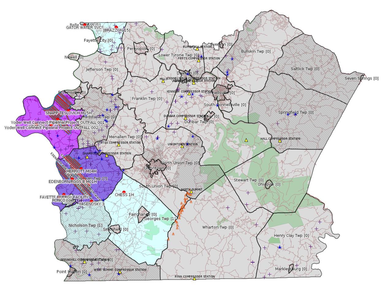
Map
Key
Red dots: items in this permit list with an exact location.
Blue stars: Marcellus Gas Well Water Sources.
Where well laterals are mapped they show in red; a 400-foot buffer surrounding the lateral shows in blue (lavender where it overlaps a mapped mineral tract).
Where mineral tracts are mapped, they show in pink. Mineral tracts can overlap; the overlap will show in red. The precise meaning of "mineral tract" is not clear.
Municipality shading: number of "facilities", with each well counting separately
(includes the red dots):
gray: 0
pale turquoise: 1
turquoise: 2
pale blue: 3
middle blue: 4
dark blue: 5
dark purple: 7
purple: 14
(Color coding may differ from one issue to the next.)
(Note if a project spans multiple municipalities -- e.g. a pipeline -- it will show in the count for each municipality.)
The number of facilities also follows the municipality name in brackets.
Municipality counts are based on the way the permit is listed by DEP; DEP has been known to get a municipality wrong.
Locations in brackets identify a precise location used to locate a surrogate for the actual site being permitted (e.g. locating a well pad or pipeline by the known location of a well.) Locations labeled beginning with "~" and ending in "[?]" are approximate and speculative based on inferences using on-line property and lease records. These are marked in the text as "[Approximate, Speculative]
Cross-hatching: Environmental Justice Areas
Yellow triangles: Compressor Stations
Orange triangles: Storage Field Wells (currently Dominion North Summit Storage Field)
Crosses: SPUD Unconventional well permits
Green: "Natural areas", e.g. state game lands, state forests
Yellow triangles: Compressor Stations
Orange triangles: Storage Field Wells (currently Dominion North Summit Storage Field)
Crosses: SPUD Unconventional well permits
Green: "Natural areas", e.g. state game lands, state forests
More Maps
 |
 |
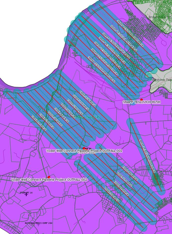 |
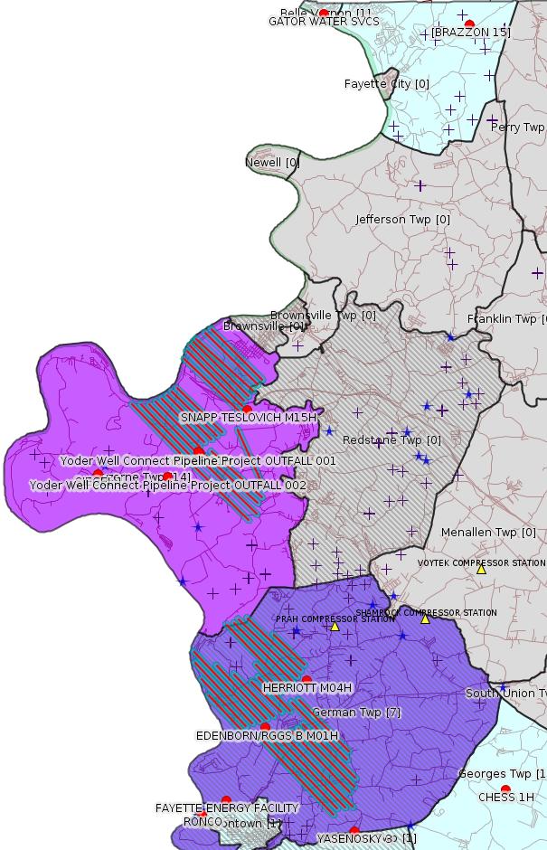
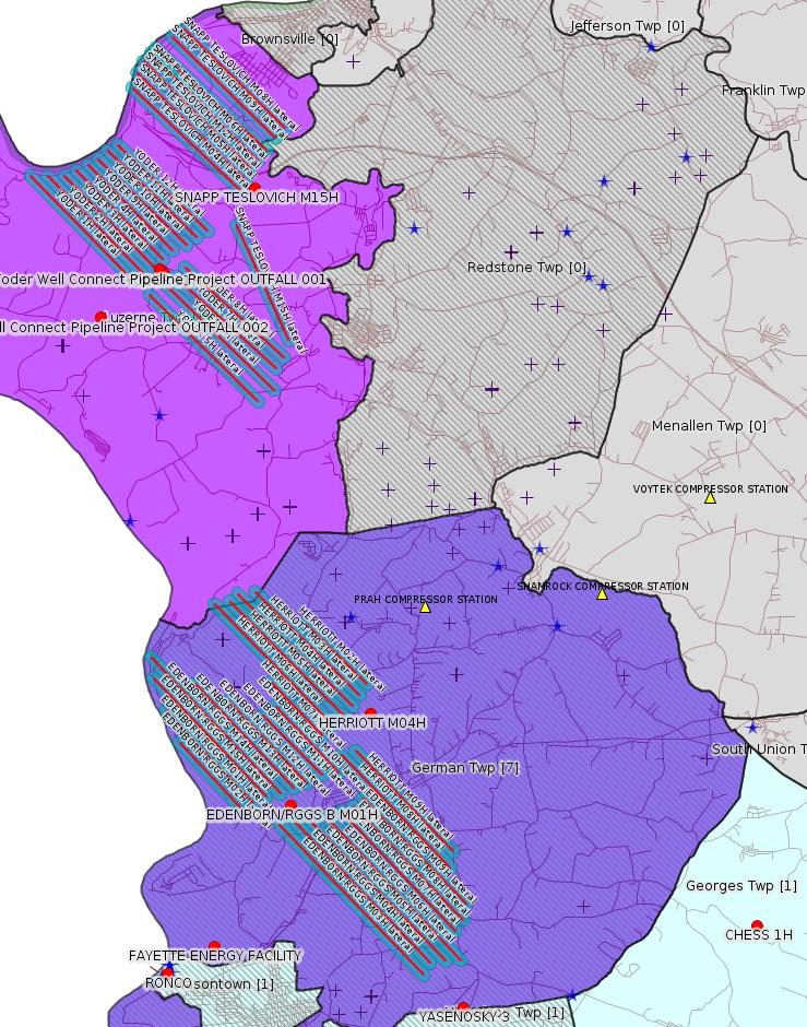
| The maps of the Snapp Teslovich laterals are
incomplete, preliminary, and possibly inaccurate. See Notes. |
Source: Pennsylvania Bulletin
NOTICES
DEPARTMENT OF
ENVIRONMENTAL PROTECTION
Public Notice of Draft NPDES General Permit for Stormwater Discharges Associated with Construction Activities (PAG-02)
[49 Pa.B. 4603]
[Saturday, August 17, 2019]
The Department of Environmental Protection (Department) is announcing the availability of a draft National Pollutant Discharge Elimination System (NPDES) General Permit for Stormwater Discharges Associated with Construction Activities (PAG-02) for reissuance. To access the draft PAG-02 and related documents, visit the Department's eLibrary at www.depgreenport.state.pa.us/elibrary/ (select ''Permit and Authorization Packages,'' then ''Clean Water,'' then ''PAG-02 NPDES General Permit (Draft)'').
The PAG-02 General Permit is intended to provide NPDES permit coverage to persons discharging stormwater associated with construction activities to surface waters of this Commonwealth in satisfaction of State NPDES permit requirements (25 Pa. Code §§ 92a.1(b) and 102.5(a) (relating to purpose and scope; and permit requirements)) and Federal NPDES permit requirements (40 CFR 122.26(b)(14)(x) and (b)(15) (relating to storm water discharges (applicable to State NPDES programs, see § 123.25)). This draft PAG-02 General Permit would apply to eligible projects proposing an earth disturbance activity that involves 1 acre or more of earth disturbance, or an earth disturbance on any portion, part, or during any stage of a larger common plan of development or sale that involves 1 acre or more of earth disturbance. If a project requires NPDES permit coverage but is ineligible for PAG-02 coverage, an applicant may apply for an individual NPDES permit.
Notices of Intent (NOI) to use this draft PAG-02 General Permit for NPDES permit coverage would be submitted to county conservation districts (CCD) that are delegated by the Department to complete reviews of NPDES permit applications under 25 Pa. Code Chapter 102 (relating to erosion and sediment control), or in the absence of a delegated CCD, a regional office of the Department. An eligible applicant may not commence a discharge under the General Permit until the following conditions have been met:
1. The applicant has submitted a complete NOI package (3800-PM-BCW0405b and required attachments) in accordance with the requirements of the General Permit and the NOI instructions.
2. The applicant has received written approval of coverage under PAG-02, signed by the appropriate Department/CCD manager or supervisor.
3. All other permits and approvals relating to the earth disturbance activities reported in the NOI, including but not limited to sewage planning approval required by the Pennsylvania Sewage Facilities Act (35 P.S. §§ 750.1—750.20a), if applicable, have been obtained.
4. A pre-construction meeting has been held unless waived in writing by the Department/CCD.
The following bullet points summarize the proposed changes for the reissuance of this draft PAG-02 General Permit in comparison to the PAG-02 General Permit currently in effect, which expires on December 7, 2019:
• Expiration date of coverage—Coverage under this draft PAG-02 would expire on the date the master General Permit expires, which is currently planned for December 7, 2024.
• New requirements are proposed to ensure onsite personnel are properly trained and are aware of responsibilities under the General Permit.
• The proposed draft General Permit would include changes to non-compliance reporting to align with the reporting requirements of 25 Pa. Code §§ 91.33 and 92a.41(b) (relating to incidents causing or threatening pollution; and conditions applicable to all permits).
• This draft General Permit would clarify the appropriate form that must be used for documenting visual site inspections (or equivalent) and the measurable rainfall that triggers a post-storm inspection (that is, 0.25 inches).
• New forms would be available for notifying municipalities and counties of construction projects to satisfy Acts 14, 67, 68 and 127.
• Prohibitions concerning discharge to impaired waters, with and without a Total Maximum Daily Load, would be revised to clarify the causes of impairment trigger- ing additional measures, and to specify that the additional measures include non-discharge alternatives or antidegradation best available combination of technologies best management practices.
• For the proposed General Permit, the Department is seeking to improve the efficiency and consistency of Department/CCD completeness and technical reviews by requiring the use of templates for the narrative components of Erosion and Sediment (E&S) and Post-Construction Stormwater Management (PCSM) Plans (that is, E&S Module 1 and PCSM Module 2).
Additional information on the proposed terms and conditions of this draft PAG-02 General Permit can be found in the draft PAG-02 General Permit Fact Sheet and other supporting documents available in the Department's eLibrary.
Applicants must submit a $500 administrative filing fee and the NOI package to the delegated CCD, along with any additional fees the CCD requires. Applicants must also submit a fee in the amount of $100 for each disturbed acre to the Department. If a project is located in a county without a delegated CCD, both the disturbed acre fee and the administrative filing fee must be submitted to the Department.
The Department is also announcing the availability of a draft Department PCSM Spreadsheet that may be used to facilitate calculations for PCSM Plans. The PCSM Spreadsheet may be accessed by visiting the Department's Construction Stormwater web site at www.dep.pa.gov/constructionstormwater (select ''E&S Resources''). The PCSM Spreadsheet is macro-enabled and requires the use of Microsoft Excel.
Written Comments
Interested persons are invited to submit written comments regarding the draft PAG-02 General Permit, associated documents and PCSM Spreadsheet through Monday, September 16, 2019. Comments submitted by facsimile will not be accepted. Comments, including comments submitted by e-mail, must include the commentator's name and address. Commentators are encouraged to submit comments using the Department's online eComment tool at www.ahs.dep.pa.gov/eComment or by e-mail to ecomment@pa.gov. Written comments can be mailed to the Department of Environmental Protection, Policy Office, Rachel Carson State Office Building, P.O. Box 2063, Harrisburg, PA 17105-2063.
Written comments submitted during the 30-day public comment period will be retained by the Department and considered before finalization of the General Permit. The Department will provide an opportunity for any interested person or group of persons, any affected state, any affected interstate agency, the United States Environmental Protection Agency or any interested agency to request or petition for a public hearing with respect to the draft General Permit. The request or petition for public hearing, which must be filed within the 30-day time period allowed for filing of written comments, must indicate the interest of the party filing the request and the reasons why a hearing is warranted. A hearing will be scheduled if there is significant public interest.
Questions regarding the draft PAG-02 can be directed to Sean Furjanic at sefurjanic@pa.gov or (717) 787-2137.
PATRICK McDONNELL,
Secretary
<https://www.pabulletin.com/secure/data/vol49/49-33/1239.html>
[See Notes.]
---
| Facility Location Municipality & County |
Permit No. | Applicant Name & Address | Receiving Water/Use |
Contact Office & Phone No. |
|---|---|---|---|---|
| Luzerne Township Fayette County |
PAG106222 | Laurel Mountain Midstream Operating LLC 2000 Commerce Drive Pittsburgh, PA 15275-1026 |
Cox Run (WWF) and Rush Run (WWF)—19-C |
DEP Southwest Regional Office Clean Water Program 400 Waterfront Drive Pittsburgh, PA 15222-4745 412.442.4000 |
<https://www.faymarwatch.org/happening/permits/082519.shtml#authid_1282459>
Site: Yoder Well Connect Pipeline Project
Sub-Facilities for Authorization:
Sub-Facility ID Sub-Facility Name Description
1291629 OUTFALL 001 Discharge Point
Location: 39.976094,-79.924633
Map URL: <http://www.openstreetmap.org/?mlat=39.976094&mlon=-79.924633#map=15/39.976094/-79.924633>
Presumed Parcel Id: 19160034
1291630 OUTFALL 002 Discharge Point
Location: 39.967828,-79.938114
Map URL: <http://www.openstreetmap.org/?mlat=39.967828&mlon=-79.938114#map=15/39.967828/-79.938114>
Presumed Parcel Id: 19250012
-------------------------
Source: eNOTICE
(+ PA
Oil and Gas Mapping, Well
Pad Report.) Well Details via Data
Portal Services: Oil and Gas Wells All (ID: 3).
Please see the Disclaimer below regarding Parcel Id data.
Authorization ID: 1285047
Permit number: 051-24716
Site: SNAPP TESLOVICH WELL PAD A ESCGP3 ESG30705118-002
Client: CHEVRON APPALACHIA LLC
Authorization type: Alt Method of Equipping, Casing, or Venting Well
Application type: New
Authorization is for: FACILITY
Date received: 08/22/2019
Status: Pending
Permit Decision Guarantee Applies?: Yes
Permit Decision Guarantee status: ACTIVE
Sub-Facilities for Authorization:
Sub-Facility ID Sub-Facility Name Description
1292500 WELLBORE SURFACE HOLE LOCATION Well
Permit Review Notes:
Date Review Note
8/23/2019 The permit application package is complete, has been accepted, and is undergoing technical review.
<https://www.ahs.dep.pa.gov/eFACTSWeb/searchResults_singleAuth.aspx?AuthID=1285047>
Site Programs:
Oil & Gas
Site Municipalities:
Luzerne Twp, Fayette County
Well Details:
Permit Number: 051-24716
Well Name: SNAPP TESLOVICH M15H
Unconventional Well: Y
Well Configuration: Horizontal Well
Well Type: GAS
Well Status: Active
Coal Association: NonCoal
Conservation Well: N
Primary Facility ID: 836750
Site ID: 833740
Site Name: SNAPP TESLOVICH WELL PAD A ESCGP3 ESG30705118-002
Well Pad ID: 155747
Well Pad Name: SNAPP-TESLOVICH PAD A
Storage Field:
Operator: CHEVRON APPALACHIA LLC
Operator Number: OGO-39307
Permit Date:
Permit Date Expires:
SPUD Date:
Date Plugged:
UIC ID:
UIC Type:
Surface Elevation: 1100
County: Fayette
Municipality: Luzerne Twp
Location: 39.990031,-79.902594
Map URL: <http://www.openstreetmap.org/?mlat=39.990031&mlon=-79.902594#map=15/39.990031/-79.902594>
Electronically Submitted Records:
2019-08-23: Submission for Authorization 1284022
Pennsylvania Natural Diversity Inventory Form: Snapp Teslovich_PNDI.pdf
<http://www.depgis.state.pa.us/eWellDocHandler/pdFHandler.ashx?Doc=OTExMTEw&ext=PDF>
Justification for Non-Coal Well: Snapp Teslovich Non-Coal Packet.pdf
<http://www.depgis.state.pa.us/eWellDocHandler/pdFHandler.ashx?Doc=OTExMTEx&ext=PDF>
Coordination of Well Location with Public Resources: COORDINATION_OF_A_WELL_LOCATION_WITH_PUBLIC_RESOURCES_Snapp Teslovich - M15H.pdf
<http://www.depgis.state.pa.us/eWellDocHandler/pdFHandler.ashx?Doc=OTE4NzAz&ext=PDF>
Pennsylvania Natural Diversity Inventory Support Document: PNDI Clearance.pdf
<http://www.depgis.state.pa.us/eWellDocHandler/pdFHandler.ashx?Doc=OTE5MjAy&ext=PDF>
Well Cross-Section Diagram: Page 4_Snapp Teslovich Pad A_M15H.pdf
<http://www.depgis.state.pa.us/eWellDocHandler/pdFHandler.ashx?Doc=OTE5NjY2&ext=PDF>
Location Plat: Snapp Teslovich - M15H Plat - 2019.08.15.dwg
<http://www.depgis.state.pa.us/eWellDocHandler/pdFHandler.ashx?Doc=OTIwMTIy&ext=PDF>
Permit Application to Drill and Operate a Well: 1985280.pdf
<http://www.depgis.state.pa.us/eWellDocHandler/pdFHandler.ashx?Doc=OTIwMTYz&ext=PDF>
---
Authorization ID: 1285046
Permit number: 051-24715
Site: SNAPP TESLOVICH WELL PAD A ESCGP3 ESG30705118-002
Client: CHEVRON APPALACHIA LLC
Authorization type: Alt Method of Equipping, Casing, or Venting Well
Application type: New
Authorization is for: FACILITY
Date received: 08/22/2019
Status: Pending
Permit Decision Guarantee Applies?: Yes
Permit Decision Guarantee status: ACTIVE
Sub-Facilities for Authorization:
Sub-Facility ID Sub-Facility Name Description
1292499 WELLBORE SURFACE HOLE LOCATION Well
Permit Review Notes:
Date Review Note
8/23/2019 The permit application package is complete, has been accepted, and is undergoing technical review.
<https://www.ahs.dep.pa.gov/eFACTSWeb/searchResults_singleAuth.aspx?AuthID=1285046>
Site Programs:
Oil & Gas
Site Municipalities:
Luzerne Twp, Fayette County
Well Details:
Permit Number: 051-24715
Well Name: SNAPP TESLOVICH M12H
Unconventional Well: Y
Well Configuration: Horizontal Well
Well Type: GAS
Well Status: Active
Coal Association: NonCoal
Conservation Well: N
Primary Facility ID: 836749
Site ID: 833740
Site Name: SNAPP TESLOVICH WELL PAD A ESCGP3 ESG30705118-002
Well Pad ID: 155747
Well Pad Name: SNAPP-TESLOVICH PAD A
Storage Field:
Operator: CHEVRON APPALACHIA LLC
Operator Number: OGO-39307
Permit Date:
Permit Date Expires:
SPUD Date:
Date Plugged:
UIC ID:
UIC Type:
Surface Elevation: 1100
County: Fayette
Municipality: Luzerne Twp
Location: 39.99005,-79.902436
Map URL: <http://www.openstreetmap.org/?mlat=39.99005&mlon=-79.902436#map=15/39.99005/-79.902436>
Electronically Submitted Records:
2019-08-23: Submission for Authorization 1284021
Pennsylvania Natural Diversity Inventory Form: Snapp Teslovich_PNDI.pdf
<http://www.depgis.state.pa.us/eWellDocHandler/pdFHandler.ashx?Doc=OTExMDk1&ext=PDF>
Justification for Non-Coal Well: Snapp Teslovich Non-Coal Packet.pdf
<http://www.depgis.state.pa.us/eWellDocHandler/pdFHandler.ashx?Doc=OTExMDk2&ext=PDF>
Coordination of Well Location with Public Resources: COORDINATION_OF_A_WELL_LOCATION_WITH_PUBLIC_RESOURCES_Snapp Teslovich - M12H.pdf
<http://www.depgis.state.pa.us/eWellDocHandler/pdFHandler.ashx?Doc=OTE4NzAy&ext=PDF>
Pennsylvania Natural Diversity Inventory Support Document: PNDI Clearance.pdf
<http://www.depgis.state.pa.us/eWellDocHandler/pdFHandler.ashx?Doc=OTE5MTkz&ext=PDF>
Well Cross-Section Diagram: Page 4_Snapp Teslovich Pad A_M12H.pdf
<http://www.depgis.state.pa.us/eWellDocHandler/pdFHandler.ashx?Doc=OTE5NjYw&ext=PDF>
Location Plat: Snapp Teslovich - M12H Plat - 2019.08.15.dwg
<http://www.depgis.state.pa.us/eWellDocHandler/pdFHandler.ashx?Doc=OTIwMTE0&ext=PDF>
Permit Application to Drill and Operate a Well: 1985276.pdf
<http://www.depgis.state.pa.us/eWellDocHandler/pdFHandler.ashx?Doc=OTIwMTYw&ext=PDF>
---
Authorization ID: 1285044
Permit number: 051-24712
Site: SNAPP TESLOVICH WELL PAD A ESCGP3 ESG30705118-002
Client: CHEVRON APPALACHIA LLC
Authorization type: Alt Method of Equipping, Casing, or Venting Well
Application type: New
Authorization is for: FACILITY
Date received: 08/22/2019
Status: Pending
Permit Decision Guarantee Applies?: Yes
Permit Decision Guarantee status: ACTIVE
Sub-Facilities for Authorization:
Sub-Facility ID Sub-Facility Name Description
1292496 WELLBORE SURFACE HOLE LOCATION Well
Permit Review Notes:
Date Review Note
8/23/2019 The permit application package is complete, has been accepted, and is undergoing technical review.
<https://www.ahs.dep.pa.gov/eFACTSWeb/searchResults_singleAuth.aspx?AuthID=1285044>
Site Programs:
Oil & Gas
Site Municipalities:
Luzerne Twp, Fayette County
Well Details:
Permit Number: 051-24712
Well Name: SNAPP TESLOVICH M09H
Unconventional Well: Y
Well Configuration: Horizontal Well
Well Type: GAS
Well Status: Active
Coal Association: NonCoal
Conservation Well: N
Primary Facility ID: 836746
Site ID: 833740
Site Name: SNAPP TESLOVICH WELL PAD A ESCGP3 ESG30705118-002
Well Pad ID: 155747
Well Pad Name: SNAPP-TESLOVICH PAD A
Storage Field:
Operator: CHEVRON APPALACHIA LLC
Operator Number: OGO-39307
Permit Date:
Permit Date Expires:
SPUD Date:
Date Plugged:
UIC ID:
UIC Type:
Surface Elevation: 1100
County: Fayette
Municipality: Luzerne Twp
Location: 39.990072,-79.902278
Map URL: <http://www.openstreetmap.org/?mlat=39.990072&mlon=-79.902278#map=15/39.990072/-79.902278>
Electronically Submitted Records:
2019-08-23: Submission for Authorization 1284013
Justification for Non-Coal Well: Snapp Teslovich Non-Coal Packet.pdf
<http://www.depgis.state.pa.us/eWellDocHandler/pdFHandler.ashx?Doc=OTExMDg5&ext=PDF>
Pennsylvania Natural Diversity Inventory Form: Snapp Teslovich_PNDI.pdf
<http://www.depgis.state.pa.us/eWellDocHandler/pdFHandler.ashx?Doc=OTExMDkw&ext=PDF>
Coordination of Well Location with Public Resources: COORDINATION_OF_A_WELL_LOCATION_WITH_PUBLIC_RESOURCES_Snapp Teslovich - M09H.pdf
<http://www.depgis.state.pa.us/eWellDocHandler/pdFHandler.ashx?Doc=OTE4NzAw&ext=PDF>
Pennsylvania Natural Diversity Inventory Support Document: PNDI Clearance.pdf
<http://www.depgis.state.pa.us/eWellDocHandler/pdFHandler.ashx?Doc=OTE5MTYx&ext=PDF>
Well Cross-Section Diagram: Page 4_Snapp Teslovich Pad A_M09H.pdf
<http://www.depgis.state.pa.us/eWellDocHandler/pdFHandler.ashx?Doc=OTE5NjQ0&ext=PDF>
Location Plat: Snapp Teslovich - M09H Plat - 2019.08.15.dwg
<http://www.depgis.state.pa.us/eWellDocHandler/pdFHandler.ashx?Doc=OTIwMTA2&ext=PDF>
Permit Application to Drill and Operate a Well: 1984953.pdf
<http://www.depgis.state.pa.us/eWellDocHandler/pdFHandler.ashx?Doc=OTIwMTU3&ext=PDF>
---
Authorization ID: 1285042
Permit number: 051-24710
Site: SNAPP TESLOVICH WELL PAD A ESCGP3 ESG30705118-002
Client: CHEVRON APPALACHIA LLC
Authorization type: Alt Method of Equipping, Casing, or Venting Well
Application type: New
Authorization is for: FACILITY
Date received: 08/22/2019
Status: Pending
Permit Decision Guarantee Applies?: Yes
Permit Decision Guarantee status: ACTIVE
Sub-Facilities for Authorization:
Sub-Facility ID Sub-Facility Name Description
1292494 WELLBORE SURFACE HOLE LOCATION Well
Permit Review Notes:
Date Review Note
8/23/2019 The permit application package is complete, has been accepted, and is undergoing technical review.
<https://www.ahs.dep.pa.gov/eFACTSWeb/searchResults_singleAuth.aspx?AuthID=1285042>
Site Programs:
Oil & Gas
Site Municipalities:
Luzerne Twp, Fayette County
Well Details:
Permit Number: 051-24710
Well Name: SNAPP TESLOVICH M08H
Unconventional Well: Y
Well Configuration: Horizontal Well
Well Type: GAS
Well Status: Active
Coal Association: NonCoal
Conservation Well: N
Primary Facility ID: 836744
Site ID: 833740
Site Name: SNAPP TESLOVICH WELL PAD A ESCGP3 ESG30705118-002
Well Pad ID: 155747
Well Pad Name: SNAPP-TESLOVICH PAD A
Storage Field:
Operator: CHEVRON APPALACHIA LLC
Operator Number: OGO-39307
Permit Date:
Permit Date Expires:
SPUD Date:
Date Plugged:
UIC ID:
UIC Type:
Surface Elevation: 1100
County: Fayette
Municipality: Luzerne Twp
Location: 39.989992,-79.902261
Map URL: <http://www.openstreetmap.org/?mlat=39.989992&mlon=-79.902261#map=15/39.989992/-79.902261>
Electronically Submitted Records:
2019-08-23: Submission for Authorization 1284010
Justification for Non-Coal Well: Snapp Teslovich Non-Coal Packet.pdf
<http://www.depgis.state.pa.us/eWellDocHandler/pdFHandler.ashx?Doc=OTExMDg0&ext=PDF>
Pennsylvania Natural Diversity Inventory Form: Snapp Teslovich_PNDI.pdf
<http://www.depgis.state.pa.us/eWellDocHandler/pdFHandler.ashx?Doc=OTExMDg1&ext=PDF>
Coordination of Well Location with Public Resources: COORDINATION_OF_A_WELL_LOCATION_WITH_PUBLIC_RESOURCES_Snapp Teslovich - M08H.pdf
<http://www.depgis.state.pa.us/eWellDocHandler/pdFHandler.ashx?Doc=OTE4Njk4&ext=PDF>
Pennsylvania Natural Diversity Inventory Support Document: PNDI Clearance.pdf
<http://www.depgis.state.pa.us/eWellDocHandler/pdFHandler.ashx?Doc=OTE5MTQ0&ext=PDF>
Well Cross-Section Diagram: Page 4_Snapp Teslovich Pad A_M08H.pdf
<http://www.depgis.state.pa.us/eWellDocHandler/pdFHandler.ashx?Doc=OTE5NjQw&ext=PDF>
Location Plat: Snapp Teslovich - M08H Plat - 2019.08.15.dwg
<http://www.depgis.state.pa.us/eWellDocHandler/pdFHandler.ashx?Doc=OTIwMDk5&ext=PDF>
Permit Application to Drill and Operate a Well: 1984951.pdf
<http://www.depgis.state.pa.us/eWellDocHandler/pdFHandler.ashx?Doc=OTIwMTU0&ext=PDF>
---
Authorization ID: 1285040
Permit number: 051-24709
Site: SNAPP TESLOVICH WELL PAD A ESCGP3 ESG30705118-002
Client: CHEVRON APPALACHIA LLC
Authorization type: Alt Method of Equipping, Casing, or Venting Well
Application type: New
Authorization is for: FACILITY
Date received: 08/22/2019
Status: Pending
Permit Decision Guarantee Applies?: Yes
Permit Decision Guarantee status: ACTIVE
Sub-Facilities for Authorization:
Sub-Facility ID Sub-Facility Name Description
1292493 WELLBORE SURFACE HOLE LOCATION Well
Permit Review Notes:
Date Review Note
8/23/2019 The permit application package is complete, has been accepted, and is undergoing technical review.
<https://www.ahs.dep.pa.gov/eFACTSWeb/searchResults_singleAuth.aspx?AuthID=1285040>
Site Programs:
Oil & Gas
Site Municipalities:
Luzerne Twp, Fayette County
Well Details:
Permit Number: 051-24709
Well Name: SNAPP TESLOVICH M07H
Unconventional Well: Y
Well Configuration: Horizontal Well
Well Type: GAS
Well Status: Active
Coal Association: NonCoal
Conservation Well: N
Primary Facility ID: 836743
Site ID: 833740
Site Name: SNAPP TESLOVICH WELL PAD A ESCGP3 ESG30705118-002
Well Pad ID: 155747
Well Pad Name: SNAPP-TESLOVICH PAD A
Storage Field:
Operator: CHEVRON APPALACHIA LLC
Operator Number: OGO-39307
Permit Date:
Permit Date Expires:
SPUD Date:
Date Plugged:
UIC ID:
UIC Type:
Surface Elevation: 1100
County: Fayette
Municipality: Luzerne Twp
Location: 39.989983,-79.902314
Map URL: <http://www.openstreetmap.org/?mlat=39.989983&mlon=-79.902314#map=15/39.989983/-79.902314>
Electronically Submitted Records:
2019-08-23: Submission for Authorization 1284009
Pennsylvania Natural Diversity Inventory Form: Snapp Teslovich_PNDI.pdf
<http://www.depgis.state.pa.us/eWellDocHandler/pdFHandler.ashx?Doc=OTExMDgy&ext=PDF>
Justification for Non-Coal Well: Snapp Teslovich Non-Coal Packet.pdf
<http://www.depgis.state.pa.us/eWellDocHandler/pdFHandler.ashx?Doc=OTExMDgz&ext=PDF>
Coordination of Well Location with Public Resources: COORDINATION_OF_A_WELL_LOCATION_WITH_PUBLIC_RESOURCES_Snapp Teslovich - M07H.pdf
<http://www.depgis.state.pa.us/eWellDocHandler/pdFHandler.ashx?Doc=OTE4Njkz&ext=PDF>
Pennsylvania Natural Diversity Inventory Support Document: PNDI Clearance.pdf
<http://www.depgis.state.pa.us/eWellDocHandler/pdFHandler.ashx?Doc=OTE5MTM2&ext=PDF>
Well Cross-Section Diagram: Page 4_Snapp Teslovich Pad A_M07H.pdf
<http://www.depgis.state.pa.us/eWellDocHandler/pdFHandler.ashx?Doc=OTE5NjI1&ext=PDF>
Location Plat: Snapp Teslovich - M07H Plat - 2019.08.15.dwg
<http://www.depgis.state.pa.us/eWellDocHandler/pdFHandler.ashx?Doc=OTIwMDk1&ext=PDF>
Permit Application to Drill and Operate a Well: 1984949.pdf
<http://www.depgis.state.pa.us/eWellDocHandler/pdFHandler.ashx?Doc=OTIwMTUx&ext=PDF>
---
Authorization ID: 1285039
Permit number: 051-24711
Site: SNAPP TESLOVICH WELL PAD A ESCGP3 ESG30705118-002
Client: CHEVRON APPALACHIA LLC
Authorization type: Alt Method of Equipping, Casing, or Venting Well
Application type: New
Authorization is for: FACILITY
Date received: 08/22/2019
Status: Pending
Permit Decision Guarantee Applies?: Yes
Permit Decision Guarantee status: ACTIVE
Sub-Facilities for Authorization:
Sub-Facility ID Sub-Facility Name Description
1292495 WELLBORE SURFACE HOLE LOCATION Well
Permit Review Notes:
Date Review Note
8/23/2019 The permit application package is complete, has been accepted, and is undergoing technical review.
<https://www.ahs.dep.pa.gov/eFACTSWeb/searchResults_singleAuth.aspx?AuthID=1285039>
Site Programs:
Oil & Gas
Site Municipalities:
Luzerne Twp, Fayette County
Well Details:
Permit Number: 051-24711
Well Name: SNAPP TESLOVICH M06H
Unconventional Well: Y
Well Configuration: Horizontal Well
Well Type: GAS
Well Status: Active
Coal Association: NonCoal
Conservation Well: N
Primary Facility ID: 836745
Site ID: 833740
Site Name: SNAPP TESLOVICH WELL PAD A ESCGP3 ESG30705118-002
Well Pad ID: 155747
Well Pad Name: SNAPP-TESLOVICH PAD A
Storage Field:
Operator: CHEVRON APPALACHIA LLC
Operator Number: OGO-39307
Permit Date:
Permit Date Expires:
SPUD Date:
Date Plugged:
UIC ID:
UIC Type:
Surface Elevation: 1100
County: Fayette
Municipality: Luzerne Twp
Location: 39.989978,-79.902367
Map URL: <http://www.openstreetmap.org/?mlat=39.989978&mlon=-79.902367#map=15/39.989978/-79.902367>
Electronically Submitted Records:
2019-08-23: Submission for Authorization 1284011
Pennsylvania Natural Diversity Inventory Form: Snapp Teslovich_PNDI.pdf
<http://www.depgis.state.pa.us/eWellDocHandler/pdFHandler.ashx?Doc=OTExMDYz&ext=PDF>
Justification for Non-Coal Well: Snapp Teslovich Non-Coal Packet.pdf
<http://www.depgis.state.pa.us/eWellDocHandler/pdFHandler.ashx?Doc=OTExMDY0&ext=PDF>
Coordination of Well Location with Public Resources: COORDINATION_OF_A_WELL_LOCATION_WITH_PUBLIC_RESOURCES_Snapp Teslovich - M06H.pdf
<http://www.depgis.state.pa.us/eWellDocHandler/pdFHandler.ashx?Doc=OTE4Njky&ext=PDF>
Pennsylvania Natural Diversity Inventory Support Document: PNDI Clearance.pdf
<http://www.depgis.state.pa.us/eWellDocHandler/pdFHandler.ashx?Doc=OTE5MTE4&ext=PDF>
Well Cross-Section Diagram: Page 4_Snapp Teslovich Pad A_M06H.pdf
<http://www.depgis.state.pa.us/eWellDocHandler/pdFHandler.ashx?Doc=OTE5NjE1&ext=PDF>
Location Plat: Snapp Teslovich - M06H Plat - 2019.08.15.dwg
<http://www.depgis.state.pa.us/eWellDocHandler/pdFHandler.ashx?Doc=OTIwMDg3&ext=PDF>
Permit Application to Drill and Operate a Well: 1984910.pdf
<http://www.depgis.state.pa.us/eWellDocHandler/pdFHandler.ashx?Doc=OTIwMTQ3&ext=PDF>
---
Authorization ID: 1285036
Permit number: 051-24713
Site: SNAPP TESLOVICH WELL PAD A ESCGP3 ESG30705118-002
Client: CHEVRON APPALACHIA LLC
Authorization type: Alt Method of Equipping, Casing, or Venting Well
Application type: New
Authorization is for: FACILITY
Date received: 08/22/2019
Status: Pending
Permit Decision Guarantee Applies?: Yes
Permit Decision Guarantee status: ACTIVE
Sub-Facilities for Authorization:
Sub-Facility ID Sub-Facility Name Description
1292497 WELLBORE SURFACE HOLE LOCATION Well
Permit Review Notes:
Date Review Note
8/23/2019 The permit application package is complete, has been accepted, and is undergoing technical review.
<https://www.ahs.dep.pa.gov/eFACTSWeb/searchResults_singleAuth.aspx?AuthID=1285036>
Site Programs:
Oil & Gas
Site Municipalities:
Luzerne Twp, Fayette County
Well Details:
Permit Number: 051-24713
Well Name: SNAPP TESLOVICH M05H
Unconventional Well: Y
Well Configuration: Horizontal Well
Well Type: GAS
Well Status: Active
Coal Association: NonCoal
Conservation Well: N
Primary Facility ID: 836747
Site ID: 833740
Site Name: SNAPP TESLOVICH WELL PAD A ESCGP3 ESG30705118-002
Well Pad ID: 155747
Well Pad Name: SNAPP-TESLOVICH PAD A
Storage Field:
Operator: CHEVRON APPALACHIA LLC
Operator Number: OGO-39307
Permit Date:
Permit Date Expires:
SPUD Date:
Date Plugged:
UIC ID:
UIC Type:
Surface Elevation: 1100
County: Fayette
Municipality: Luzerne Twp
Location: 39.989969,-79.902417
Map URL: <http://www.openstreetmap.org/?mlat=39.989969&mlon=-79.902417#map=15/39.989969/-79.902417>
Electronically Submitted Records:
2019-08-23: Submission for Authorization 1284014
Justification for Non-Coal Well: Snapp Teslovich Non-Coal Packet.pdf
<http://www.depgis.state.pa.us/eWellDocHandler/pdFHandler.ashx?Doc=OTExMDI5&ext=PDF>
Pennsylvania Natural Diversity Inventory Form: Snapp Teslovich_PNDI.pdf
<http://www.depgis.state.pa.us/eWellDocHandler/pdFHandler.ashx?Doc=OTExMDMw&ext=PDF>
Coordination of Well Location with Public Resources: COORDINATION_OF_A_WELL_LOCATION_WITH_PUBLIC_RESOURCES_Snapp Teslovich - M05H.pdf
<http://www.depgis.state.pa.us/eWellDocHandler/pdFHandler.ashx?Doc=OTE4Njkx&ext=PDF>
Pennsylvania Natural Diversity Inventory Support Document: PNDI Clearance.pdf
<http://www.depgis.state.pa.us/eWellDocHandler/pdFHandler.ashx?Doc=OTE5MTA0&ext=PDF>
Well Cross-Section Diagram: Page 4_Snapp Teslovich Pad A_M05H.pdf
<http://www.depgis.state.pa.us/eWellDocHandler/pdFHandler.ashx?Doc=OTE5NjAz&ext=PDF>
Location Plat: Snapp Teslovich - M05H Plat - 2019.08.15.dwg
<http://www.depgis.state.pa.us/eWellDocHandler/pdFHandler.ashx?Doc=OTIwMDc3&ext=PDF>
Permit Application to Drill and Operate a Well: 1984897.pdf
<http://www.depgis.state.pa.us/eWellDocHandler/pdFHandler.ashx?Doc=OTIwMTQw&ext=PDF>
---
Authorization ID: 1285035
Permit number: 051-24714
Site: SNAPP TESLOVICH WELL PAD A ESCGP3 ESG30705118-002
Client: CHEVRON APPALACHIA LLC
Authorization type: Alt Method of Equipping, Casing, or Venting Well
Application type: New
Authorization is for: FACILITY
Date received: 08/22/2019
Status: Pending
Permit Decision Guarantee Applies?: Yes
Permit Decision Guarantee status: ACTIVE
Sub-Facilities for Authorization:
Sub-Facility ID Sub-Facility Name Description
1292498 WELLBORE SURFACE HOLE LOCATION Well
Permit Review Notes:
Date Review Note
8/23/2019 The permit application package is complete, has been accepted, and is undergoing technical review.
<https://www.ahs.dep.pa.gov/eFACTSWeb/searchResults_singleAuth.aspx?AuthID=1285035>
Site Programs:
Oil & Gas
Site Municipalities:
Luzerne Twp, Fayette County
Well Details:
Permit Number: 051-24714
Well Name: SNAPP TESLOVICH M04H
Unconventional Well: Y
Well Configuration: Horizontal Well
Well Type: GAS
Well Status: Active
Coal Association: NonCoal
Conservation Well: N
Primary Facility ID: 836748
Site ID: 833740
Site Name: SNAPP TESLOVICH WELL PAD A ESCGP3 ESG30705118-002
Well Pad ID: 155747
Well Pad Name: SNAPP-TESLOVICH PAD A
Storage Field:
Operator: CHEVRON APPALACHIA LLC
Operator Number: OGO-39307
Permit Date:
Permit Date Expires:
SPUD Date:
Date Plugged:
UIC ID:
UIC Type:
Surface Elevation: 1100
County: Fayette
Municipality: Luzerne Twp
Location: 39.989964,-79.902472
Map URL: <http://www.openstreetmap.org/?mlat=39.989964&mlon=-79.902472#map=15/39.989964/-79.902472>
Electronically Submitted Records:
2019-08-23: Submission for Authorization 1284015
Justification for Non-Coal Well: Snapp Teslovich Non-Coal Packet.pdf
<http://www.depgis.state.pa.us/eWellDocHandler/pdFHandler.ashx?Doc=OTEwOTIw&ext=PDF>
Pennsylvania Natural Diversity Inventory Form: Snapp Teslovich_PNDI.pdf
<http://www.depgis.state.pa.us/eWellDocHandler/pdFHandler.ashx?Doc=OTEwOTIx&ext=PDF>
Coordination of Well Location with Public Resources: COORDINATION_OF_A_WELL_LOCATION_WITH_PUBLIC_RESOURCES_Snapp Teslovich - M04H.pdf
<http://www.depgis.state.pa.us/eWellDocHandler/pdFHandler.ashx?Doc=OTE4Njkw&ext=PDF>
Pennsylvania Natural Diversity Inventory Support Document: PNDI Clearance.pdf
<http://www.depgis.state.pa.us/eWellDocHandler/pdFHandler.ashx?Doc=OTE5MDky&ext=PDF>
Well Cross-Section Diagram: Page 4_Snapp Teslovich Pad A_M04H.pdf
<http://www.depgis.state.pa.us/eWellDocHandler/pdFHandler.ashx?Doc=OTE5NTg5&ext=PDF>
Location Plat: Snapp Teslovich - M04H Plat - 2019.08.15.dwg
<http://www.depgis.state.pa.us/eWellDocHandler/pdFHandler.ashx?Doc=OTIwMDc2&ext=PDF>
Permit Application to Drill and Operate a Well: 1984876.pdf
<http://www.depgis.state.pa.us/eWellDocHandler/pdFHandler.ashx?Doc=OTIwMTMz&ext=PDF>
---
Authorization ID: 1285032
Permit number: 051-24718
Site: SNAPP TESLOVICH WELL PAD A ESCGP3 ESG30705118-002
Client: CHEVRON APPALACHIA LLC
Authorization type: Alt Method of Equipping, Casing, or Venting Well
Application type: New
Authorization is for: FACILITY
Date received: 08/22/2019
Status: Pending
Permit Decision Guarantee Applies?: Yes
Permit Decision Guarantee status: ACTIVE
Sub-Facilities for Authorization:
Sub-Facility ID Sub-Facility Name Description
1292827 WELLBORE SURFACE HOLE LOCATION Well
Permit Review Notes:
Date Review Note
8/23/2019 The permit application package is complete, has been accepted, and is undergoing technical review.
<https://www.ahs.dep.pa.gov/eFACTSWeb/searchResults_singleAuth.aspx?AuthID=1285032>
Site Programs:
Oil & Gas
Site Municipalities:
Luzerne Twp, Fayette County
Well Details:
Permit Number: 051-24718
Well Name: SNAPP TESLOVICH M03H
Unconventional Well: Y
Well Configuration: Vertical Well
Well Type: GAS
Well Status: Active
Coal Association: NonCoal
Conservation Well: N
Primary Facility ID: 836867
Site ID: 833740
Site Name: SNAPP TESLOVICH WELL PAD A ESCGP3 ESG30705118-002
Well Pad ID: 155747
Well Pad Name: SNAPP-TESLOVICH PAD A
Storage Field:
Operator: CHEVRON APPALACHIA LLC
Operator Number: OGO-39307
Permit Date:
Permit Date Expires:
SPUD Date:
Date Plugged:
UIC ID:
UIC Type:
Surface Elevation: 1100
County: Fayette
Municipality: Luzerne Twp
Location: 39.989956,-79.902525
Map URL: <http://www.openstreetmap.org/?mlat=39.989956&mlon=-79.902525#map=15/39.989956/-79.902525>
Electronically Submitted Records:
2019-08-23: Submission for Authorization 1284565
Pennsylvania Natural Diversity Inventory Form: Snapp Teslovich_PNDI.pdf
<http://www.depgis.state.pa.us/eWellDocHandler/pdFHandler.ashx?Doc=OTE4ODk5&ext=PDF>
Justification for Non-Coal Well: Snapp Teslovich Non-Coal Packet.pdf
<http://www.depgis.state.pa.us/eWellDocHandler/pdFHandler.ashx?Doc=OTE4OTAw&ext=PDF>
Location Plat: Snapp Teslovich - M03H Plat - 2019.08.15.dwg
<http://www.depgis.state.pa.us/eWellDocHandler/pdFHandler.ashx?Doc=OTIyMDgw&ext=PDF>
Pennsylvania Natural Diversity Inventory Support Document: PNDI Clearance.pdf
<http://www.depgis.state.pa.us/eWellDocHandler/pdFHandler.ashx?Doc=OTIyMDgx&ext=PDF>
Coordination of Well Location with Public Resources: COORDINATION_OF_A_WELL_LOCATION_WITH_PUBLIC_RESOURCES_Snapp Teslovich - M03H.pdf
<http://www.depgis.state.pa.us/eWellDocHandler/pdFHandler.ashx?Doc=OTIyMDky&ext=PDF>
Permit Application to Drill and Operate a Well: 1995530.pdf
<http://www.depgis.state.pa.us/eWellDocHandler/pdFHandler.ashx?Doc=OTIzODEx&ext=PDF>
---
Authorization ID: 1285031
Permit number: 051-24717
Site: SNAPP TESLOVICH WELL PAD A ESCGP3 ESG30705118-002
Client: CHEVRON APPALACHIA LLC
Authorization type: Alt Method of Equipping, Casing, or Venting Well
Application type: New
Authorization is for: FACILITY
Date received: 08/22/2019
Status: Pending
Permit Decision Guarantee Applies?: Yes
Permit Decision Guarantee status: ACTIVE
Sub-Facilities for Authorization:
Sub-Facility ID Sub-Facility Name Description
1292826 WELLBORE SURFACE HOLE LOCATION Well
Permit Review Notes:
Date Review Note
8/23/2019 The permit application package is complete, has been accepted, and is undergoing technical review.
<https://www.ahs.dep.pa.gov/eFACTSWeb/searchResults_singleAuth.aspx?AuthID=1285031>
Site Programs:
Oil & Gas
Site Municipalities:
Luzerne Twp, Fayette County
Well Details:
Permit Number: 051-24717
Well Name: SNAPP TESLOVICH M02H
Unconventional Well: Y
Well Configuration: Vertical Well
Well Type: GAS
Well Status: Active
Coal Association: NonCoal
Conservation Well: N
Primary Facility ID: 836866
Site ID: 833740
Site Name: SNAPP TESLOVICH WELL PAD A ESCGP3 ESG30705118-002
Well Pad ID: 155747
Well Pad Name: SNAPP-TESLOVICH PAD A
Storage Field:
Operator: CHEVRON APPALACHIA LLC
Operator Number: OGO-39307
Permit Date:
Permit Date Expires:
SPUD Date:
Date Plugged:
UIC ID:
UIC Type:
Surface Elevation: 1100
County: Fayette
Municipality: Luzerne Twp
Location: 39.989947,-79.902578
Map URL: <http://www.openstreetmap.org/?mlat=39.989947&mlon=-79.902578#map=15/39.989947/-79.902578>
Electronically Submitted Records:
2019-08-26: Submission for Authorization 1284564
Pennsylvania Natural Diversity Inventory Form: Snapp Teslovich_PNDI.pdf
<http://www.depgis.state.pa.us/eWellDocHandler/pdFHandler.ashx?Doc=OTE4ODgy&ext=PDF>
Justification for Non-Coal Well: Snapp Teslovich Non-Coal Packet.pdf
<http://www.depgis.state.pa.us/eWellDocHandler/pdFHandler.ashx?Doc=OTE4ODgz&ext=PDF>
Pennsylvania Natural Diversity Inventory Support Document: PNDI Clearance.pdf
<http://www.depgis.state.pa.us/eWellDocHandler/pdFHandler.ashx?Doc=OTE4ODg0&ext=PDF>
Location Plat: Snapp Teslovich - M02H Plat - 2019.08.15.dwg
<http://www.depgis.state.pa.us/eWellDocHandler/pdFHandler.ashx?Doc=OTIyMDYy&ext=PDF>
Coordination of Well Location with Public Resources: COORDINATION_OF_A_WELL_LOCATION_WITH_PUBLIC_RESOURCES_Snapp Teslovich - M02H.pdf
<http://www.depgis.state.pa.us/eWellDocHandler/pdFHandler.ashx?Doc=OTIyMDYz&ext=PDF>
Permit Application to Drill and Operate a Well: 1995152.pdf
<http://www.depgis.state.pa.us/eWellDocHandler/pdFHandler.ashx?Doc=OTIzODAz&ext=PDF>
---
Authorization ID: 1285029
Permit number: 051-24706
Site: SNAPP TESLOVICH WELL PAD A ESCGP3 ESG30705118-002
Client: CHEVRON APPALACHIA LLC
Authorization type: Alt Method of Equipping, Casing, or Venting Well
Application type: New
Authorization is for: FACILITY
Date received: 08/22/2019
Status: Pending
Permit Decision Guarantee Applies?: Yes
Permit Decision Guarantee status: ACTIVE
Sub-Facilities for Authorization:
Sub-Facility ID Sub-Facility Name Description
1284291 WELLBORE SURFACE HOLE LOCATION Well
Permit Review Notes:
Date Review Note
8/23/2019 The permit application package is complete, has been accepted, and is undergoing technical review.
<https://www.ahs.dep.pa.gov/eFACTSWeb/searchResults_singleAuth.aspx?AuthID=1285029>
Site Programs:
Oil & Gas
Site Municipalities:
Luzerne Twp, Fayette County
Well Details:
Permit Number: 051-24706
Well Name: SNAPP TESLOVICH M01V
Unconventional Well: Y
Well Configuration: Vertical Well
Well Type: GAS
Well Status: Active
Coal Association: NonCoal
Conservation Well: N
Primary Facility ID: 833681
Site ID: 833740
Site Name: SNAPP TESLOVICH WELL PAD A ESCGP3 ESG30705118-002
Well Pad ID: 155747
Well Pad Name: SNAPP-TESLOVICH PAD A
Storage Field:
Operator: CHEVRON APPALACHIA LLC
Operator Number: OGO-39307
Permit Date: 2019-05-08
Permit Date Expires: 2020-05-08
SPUD Date:
Date Plugged:
UIC ID:
UIC Type:
Surface Elevation: 1100
County: Fayette
Municipality: Luzerne Twp
Location: 39.989942,-79.902631
Map URL: <http://www.openstreetmap.org/?mlat=39.989942&mlon=-79.902631#map=15/39.989942/-79.902631>
OG WELLS PERMIT DOCS:
2019-05-08: Other Permit Documents, Name: 1267676_Snapp Teslovich_M01V_Non-Coal Determination (for Authorization: 1267676):
<http://www.depgis.state.pa.us/pdfHandler/pdFHandler.ashx?Doc=NzkxNzk1&ext=PDF>
2019-05-08: Final Permit Documents, Name: Authorization ID 1267676 (for Authorization: 1267676):
<http://www.depgis.state.pa.us/pdfHandler/pdFHandler.ashx?Doc=ODA3NzY0&ext=PDF>
2019-05-08: Other Permit Documents, Name: 1267676_Snapp Teslovich_Explanation of Depth of Onondaga (for Authorization: 1267676):
<http://www.depgis.state.pa.us/pdfHandler/pdFHandler.ashx?Doc=ODA0MjA1&ext=PDF>
Electronically Submitted Records:
2019-05-08: Submission for Authorization 1267676
Pennsylvania Natural Diversity Inventory Support Document: PNDI Clearance.pdf
<http://www.depgis.state.pa.us/eWellDocHandler/pdFHandler.ashx?Doc=ODA4NTMw&ext=PDF>
Pennsylvania Natural Diversity Inventory Form: Snapp Teslovich_PNDI.pdf
<http://www.depgis.state.pa.us/eWellDocHandler/pdFHandler.ashx?Doc=ODA4NTMx&ext=PDF>
Coordination of Well Location with Public Resources: Snapp Teslovich For OOGM0076U.pdf
<http://www.depgis.state.pa.us/eWellDocHandler/pdFHandler.ashx?Doc=ODA4NzM1&ext=PDF>
Justification for Non-Coal Well: Snapp Teslovich Non-Coal Packet.pdf
<http://www.depgis.state.pa.us/eWellDocHandler/pdFHandler.ashx?Doc=ODMyODkz&ext=PDF>
Location Plat: Snapp Teslovich - Final V Well Plat M01V - 2019.05.01.dwg
<http://www.depgis.state.pa.us/eWellDocHandler/pdFHandler.ashx?Doc=ODMzNjUw&ext=PDF>
Interested Party Notification: Snapp Teslovich_Affidavit of Non-Delivery_M Cochrane.pdf
<http://www.depgis.state.pa.us/eWellDocHandler/pdFHandler.ashx?Doc=ODM1MDEz&ext=PDF>
Permit Application to Drill and Operate a Well: 1886282.pdf
<http://www.depgis.state.pa.us/eWellDocHandler/pdFHandler.ashx?Doc=ODM1MDE2&ext=PDF>
---
Authorization ID: 1284748
Permit number: 051-24719
Site: CHESS 1H ESCGP-EXPEDITED
Client: INR OPR LLC
Authorization type: Drill & Operate Well Permit (Unconventional)
Application type: New
Authorization is for: FACILITY
Date received: 08/21/2019
Status: Pending
Permit Decision Guarantee Applies?: No
Sub-Facilities for Authorization:
Sub-Facility ID Sub-Facility Name Description
1292918 CHESS 1H Well
<https://www.ahs.dep.pa.gov/eFACTSWeb/searchResults_singleAuth.aspx?AuthID=1284748>
Site Programs:
Oil & Gas
Site Municipalities:
Georges Twp, Fayette County
Well Details:
Permit Number: 051-24719
Well Name: CHESS 1H
Unconventional Well: N
Well Configuration: Vertical Well
Well Type: GAS
Well Status: Active
Coal Association: Coal
Conservation Well: Y
Primary Facility ID: 836896
Site ID: 735899
Site Name: CHESS 1H ESCGP-EXPEDITED
Well Pad ID: 154471
Well Pad Name: CHESS 1
Storage Field:
Operator: INR OPR LLC
Operator Number: OGO-51036
Permit Date:
Permit Date Expires:
SPUD Date:
Date Plugged:
UIC ID:
UIC Type:
Surface Elevation: 1183
County: Fayette
Municipality: Georges Twp
Location: 39.859844,-79.7907
Map URL: <http://www.openstreetmap.org/?mlat=39.859844&mlon=-79.7907#map=15/39.859844/-79.7907>
---
Authorization ID: 1284565
Permit number: 051-24718
Site: SNAPP TESLOVICH WELL PAD A ESCGP3 ESG30705118-002
Client: CHEVRON APPALACHIA LLC
Authorization type: Drill & Operate Well Permit (Unconventional)
Application type: New
Authorization is for: FACILITY
Date received: 08/20/2019
Status: Pending
Permit Decision Guarantee Applies?: No
Sub-Facilities for Authorization:
Sub-Facility ID Sub-Facility Name Description
1292827 WELLBORE SURFACE HOLE LOCATION Well
Permit Review Notes:
Date Review Note
8/20/2019 The permit application package is complete, has been accepted, and is undergoing technical review.
<https://www.ahs.dep.pa.gov/eFACTSWeb/searchResults_singleAuth.aspx?AuthID=1284565>
Site Programs:
Oil & Gas
Site Municipalities:
Luzerne Twp, Fayette County
Well Details:
Permit Number: 051-24718
Well Name: SNAPP TESLOVICH M03H
Unconventional Well: Y
Well Configuration: Vertical Well
Well Type: GAS
Well Status: Active
Coal Association: NonCoal
Conservation Well: N
Primary Facility ID: 836867
Site ID: 833740
Site Name: SNAPP TESLOVICH WELL PAD A ESCGP3 ESG30705118-002
Well Pad ID: 155747
Well Pad Name: SNAPP-TESLOVICH PAD A
Storage Field:
Operator: CHEVRON APPALACHIA LLC
Operator Number: OGO-39307
Permit Date:
Permit Date Expires:
SPUD Date:
Date Plugged:
UIC ID:
UIC Type:
Surface Elevation: 1100
County: Fayette
Municipality: Luzerne Twp
Location: 39.989956,-79.902525
Map URL: <http://www.openstreetmap.org/?mlat=39.989956&mlon=-79.902525#map=15/39.989956/-79.902525>
Electronically Submitted Records:
2019-08-30: Submission for Authorization 1284565
Pennsylvania Natural Diversity Inventory Form: Snapp Teslovich_PNDI.pdf
<http://www.depgis.state.pa.us/eWellDocHandler/pdFHandler.ashx?Doc=OTE4ODk5&ext=PDF>
Justification for Non-Coal Well: Snapp Teslovich Non-Coal Packet.pdf
<http://www.depgis.state.pa.us/eWellDocHandler/pdFHandler.ashx?Doc=OTE4OTAw&ext=PDF>
Location Plat: Snapp Teslovich - M03H Plat - 2019.08.15.dwg
<http://www.depgis.state.pa.us/eWellDocHandler/pdFHandler.ashx?Doc=OTIyMDgw&ext=PDF>
Pennsylvania Natural Diversity Inventory Support Document: PNDI Clearance.pdf
<http://www.depgis.state.pa.us/eWellDocHandler/pdFHandler.ashx?Doc=OTIyMDgx&ext=PDF>
Coordination of Well Location with Public Resources: COORDINATION_OF_A_WELL_LOCATION_WITH_PUBLIC_RESOURCES_Snapp Teslovich - M03H.pdf
<http://www.depgis.state.pa.us/eWellDocHandler/pdFHandler.ashx?Doc=OTIyMDky&ext=PDF>
Permit Application to Drill and Operate a Well: 1995530.pdf
<http://www.depgis.state.pa.us/eWellDocHandler/pdFHandler.ashx?Doc=OTIzODEx&ext=PDF>
---
Authorization ID: 1284564
Permit number: 051-24717
Site: SNAPP TESLOVICH WELL PAD A ESCGP3 ESG30705118-002
Client: CHEVRON APPALACHIA LLC
Authorization type: Drill & Operate Well Permit (Unconventional)
Application type: New
Authorization is for: FACILITY
Date received: 08/20/2019
Status: Pending
Permit Decision Guarantee Applies?: No
Sub-Facilities for Authorization:
Sub-Facility ID Sub-Facility Name Description
1292826 WELLBORE SURFACE HOLE LOCATION Well
Permit Review Notes:
Date Review Note
8/20/2019 The permit application package is complete, has been accepted, and is undergoing technical review.
<https://www.ahs.dep.pa.gov/eFACTSWeb/searchResults_singleAuth.aspx?AuthID=1284564>
Site Programs:
Oil & Gas
Site Municipalities:
Luzerne Twp, Fayette County
Well Details:
Permit Number: 051-24717
Well Name: SNAPP TESLOVICH M02H
Unconventional Well: Y
Well Configuration: Vertical Well
Well Type: GAS
Well Status: Active
Coal Association: NonCoal
Conservation Well: N
Primary Facility ID: 836866
Site ID: 833740
Site Name: SNAPP TESLOVICH WELL PAD A ESCGP3 ESG30705118-002
Well Pad ID: 155747
Well Pad Name: SNAPP-TESLOVICH PAD A
Storage Field:
Operator: CHEVRON APPALACHIA LLC
Operator Number: OGO-39307
Permit Date:
Permit Date Expires:
SPUD Date:
Date Plugged:
UIC ID:
UIC Type:
Surface Elevation: 1100
County: Fayette
Municipality: Luzerne Twp
Location: 39.989947,-79.902578
Map URL: <http://www.openstreetmap.org/?mlat=39.989947&mlon=-79.902578#map=15/39.989947/-79.902578>
Electronically Submitted Records:
2019-08-30: Submission for Authorization 1284564
Pennsylvania Natural Diversity Inventory Form: Snapp Teslovich_PNDI.pdf
<http://www.depgis.state.pa.us/eWellDocHandler/pdFHandler.ashx?Doc=OTE4ODgy&ext=PDF>
Justification for Non-Coal Well: Snapp Teslovich Non-Coal Packet.pdf
<http://www.depgis.state.pa.us/eWellDocHandler/pdFHandler.ashx?Doc=OTE4ODgz&ext=PDF>
Pennsylvania Natural Diversity Inventory Support Document: PNDI Clearance.pdf
<http://www.depgis.state.pa.us/eWellDocHandler/pdFHandler.ashx?Doc=OTE4ODg0&ext=PDF>
Location Plat: Snapp Teslovich - M02H Plat - 2019.08.15.dwg
<http://www.depgis.state.pa.us/eWellDocHandler/pdFHandler.ashx?Doc=OTIyMDYy&ext=PDF>
Coordination of Well Location with Public Resources: COORDINATION_OF_A_WELL_LOCATION_WITH_PUBLIC_RESOURCES_Snapp Teslovich - M02H.pdf
<http://www.depgis.state.pa.us/eWellDocHandler/pdFHandler.ashx?Doc=OTIyMDYz&ext=PDF>
Permit Application to Drill and Operate a Well: 1995152.pdf
<http://www.depgis.state.pa.us/eWellDocHandler/pdFHandler.ashx?Doc=OTIzODAz&ext=PDF>
---
Authorization ID: 1284022
Permit number: 051-24716
Site: SNAPP TESLOVICH WELL PAD A ESCGP3 ESG30705118-002
Client: CHEVRON APPALACHIA LLC
Authorization type: Drill & Operate Well Permit (Unconventional)
Application type: New
Authorization is for: FACILITY
Date received: 08/14/2019
Status: Pending
Permit Decision Guarantee Applies?: No
Sub-Facilities for Authorization:
Sub-Facility ID Sub-Facility Name Description
1292500 WELLBORE SURFACE HOLE LOCATION Well
Permit Review Notes:
Date Review Note
8/16/2019 Applicant has been issued a deficiency letter. If applicable, this application no longer qualifies for the Permit Decision Guarantee.
<https://www.ahs.dep.pa.gov/eFACTSWeb/searchResults_singleAuth.aspx?AuthID=1284022>
Site Programs:
Oil & Gas
Site Municipalities:
Luzerne Twp, Fayette County
Well Details:
Permit Number: 051-24716
Well Name: SNAPP TESLOVICH M15H
Unconventional Well: Y
Well Configuration: Horizontal Well
Well Type: GAS
Well Status: Active
Coal Association: NonCoal
Conservation Well: N
Primary Facility ID: 836750
Site ID: 833740
Site Name: SNAPP TESLOVICH WELL PAD A ESCGP3 ESG30705118-002
Well Pad ID: 155747
Well Pad Name: SNAPP-TESLOVICH PAD A
Storage Field:
Operator: CHEVRON APPALACHIA LLC
Operator Number: OGO-39307
Permit Date:
Permit Date Expires:
SPUD Date:
Date Plugged:
UIC ID:
UIC Type:
Surface Elevation: 1100
County: Fayette
Municipality: Luzerne Twp
Location: 39.990031,-79.902594
Map URL: <http://www.openstreetmap.org/?mlat=39.990031&mlon=-79.902594#map=15/39.990031/-79.902594>
Electronically Submitted Records:
2019-08-23: Submission for Authorization 1284022
Pennsylvania Natural Diversity Inventory Form: Snapp Teslovich_PNDI.pdf
<http://www.depgis.state.pa.us/eWellDocHandler/pdFHandler.ashx?Doc=OTExMTEw&ext=PDF>
Justification for Non-Coal Well: Snapp Teslovich Non-Coal Packet.pdf
<http://www.depgis.state.pa.us/eWellDocHandler/pdFHandler.ashx?Doc=OTExMTEx&ext=PDF>
Coordination of Well Location with Public Resources: COORDINATION_OF_A_WELL_LOCATION_WITH_PUBLIC_RESOURCES_Snapp Teslovich - M15H.pdf
<http://www.depgis.state.pa.us/eWellDocHandler/pdFHandler.ashx?Doc=OTE4NzAz&ext=PDF>
Pennsylvania Natural Diversity Inventory Support Document: PNDI Clearance.pdf
<http://www.depgis.state.pa.us/eWellDocHandler/pdFHandler.ashx?Doc=OTE5MjAy&ext=PDF>
Well Cross-Section Diagram: Page 4_Snapp Teslovich Pad A_M15H.pdf
<http://www.depgis.state.pa.us/eWellDocHandler/pdFHandler.ashx?Doc=OTE5NjY2&ext=PDF>
Location Plat: Snapp Teslovich - M15H Plat - 2019.08.15.dwg
<http://www.depgis.state.pa.us/eWellDocHandler/pdFHandler.ashx?Doc=OTIwMTIy&ext=PDF>
Permit Application to Drill and Operate a Well: 1985280.pdf
<http://www.depgis.state.pa.us/eWellDocHandler/pdFHandler.ashx?Doc=OTIwMTYz&ext=PDF>
---
Authorization ID: 1284021
Permit number: 051-24715
Site: SNAPP TESLOVICH WELL PAD A ESCGP3 ESG30705118-002
Client: CHEVRON APPALACHIA LLC
Authorization type: Drill & Operate Well Permit (Unconventional)
Application type: New
Authorization is for: FACILITY
Date received: 08/14/2019
Status: Pending
Permit Decision Guarantee Applies?: No
Sub-Facilities for Authorization:
Sub-Facility ID Sub-Facility Name Description
1292499 WELLBORE SURFACE HOLE LOCATION Well
Permit Review Notes:
Date Review Note
8/16/2019 Applicant has been issued a deficiency letter. If applicable, this application no longer qualifies for the Permit Decision Guarantee.
<https://www.ahs.dep.pa.gov/eFACTSWeb/searchResults_singleAuth.aspx?AuthID=1284021>
Site Programs:
Oil & Gas
Site Municipalities:
Luzerne Twp, Fayette County
Well Details:
Permit Number: 051-24715
Well Name: SNAPP TESLOVICH M12H
Unconventional Well: Y
Well Configuration: Horizontal Well
Well Type: GAS
Well Status: Active
Coal Association: NonCoal
Conservation Well: N
Primary Facility ID: 836749
Site ID: 833740
Site Name: SNAPP TESLOVICH WELL PAD A ESCGP3 ESG30705118-002
Well Pad ID: 155747
Well Pad Name: SNAPP-TESLOVICH PAD A
Storage Field:
Operator: CHEVRON APPALACHIA LLC
Operator Number: OGO-39307
Permit Date:
Permit Date Expires:
SPUD Date:
Date Plugged:
UIC ID:
UIC Type:
Surface Elevation: 1100
County: Fayette
Municipality: Luzerne Twp
Location: 39.99005,-79.902436
Map URL: <http://www.openstreetmap.org/?mlat=39.99005&mlon=-79.902436#map=15/39.99005/-79.902436>
Electronically Submitted Records:
2019-08-23: Submission for Authorization 1284021
Pennsylvania Natural Diversity Inventory Form: Snapp Teslovich_PNDI.pdf
<http://www.depgis.state.pa.us/eWellDocHandler/pdFHandler.ashx?Doc=OTExMDk1&ext=PDF>
Justification for Non-Coal Well: Snapp Teslovich Non-Coal Packet.pdf
<http://www.depgis.state.pa.us/eWellDocHandler/pdFHandler.ashx?Doc=OTExMDk2&ext=PDF>
Coordination of Well Location with Public Resources: COORDINATION_OF_A_WELL_LOCATION_WITH_PUBLIC_RESOURCES_Snapp Teslovich - M12H.pdf
<http://www.depgis.state.pa.us/eWellDocHandler/pdFHandler.ashx?Doc=OTE4NzAy&ext=PDF>
Pennsylvania Natural Diversity Inventory Support Document: PNDI Clearance.pdf
<http://www.depgis.state.pa.us/eWellDocHandler/pdFHandler.ashx?Doc=OTE5MTkz&ext=PDF>
Well Cross-Section Diagram: Page 4_Snapp Teslovich Pad A_M12H.pdf
<http://www.depgis.state.pa.us/eWellDocHandler/pdFHandler.ashx?Doc=OTE5NjYw&ext=PDF>
Location Plat: Snapp Teslovich - M12H Plat - 2019.08.15.dwg
<http://www.depgis.state.pa.us/eWellDocHandler/pdFHandler.ashx?Doc=OTIwMTE0&ext=PDF>
Permit Application to Drill and Operate a Well: 1985276.pdf
<http://www.depgis.state.pa.us/eWellDocHandler/pdFHandler.ashx?Doc=OTIwMTYw&ext=PDF>
---
Authorization ID: 1284015
Permit number: 051-24714
Site: SNAPP TESLOVICH WELL PAD A ESCGP3 ESG30705118-002
Client: CHEVRON APPALACHIA LLC
Authorization type: Drill & Operate Well Permit (Unconventional)
Application type: New
Authorization is for: FACILITY
Date received: 08/14/2019
Status: Pending
Permit Decision Guarantee Applies?: No
Sub-Facilities for Authorization:
Sub-Facility ID Sub-Facility Name Description
1292498 WELLBORE SURFACE HOLE LOCATION Well
Permit Review Notes:
Date Review Note
8/16/2019 Applicant has been issued a deficiency letter. If applicable, this application no longer qualifies for the Permit Decision Guarantee.
<https://www.ahs.dep.pa.gov/eFACTSWeb/searchResults_singleAuth.aspx?AuthID=1284015>
Site Programs:
Oil & Gas
Site Municipalities:
Luzerne Twp, Fayette County
Well Details:
Permit Number: 051-24714
Well Name: SNAPP TESLOVICH M04H
Unconventional Well: Y
Well Configuration: Horizontal Well
Well Type: GAS
Well Status: Active
Coal Association: NonCoal
Conservation Well: N
Primary Facility ID: 836748
Site ID: 833740
Site Name: SNAPP TESLOVICH WELL PAD A ESCGP3 ESG30705118-002
Well Pad ID: 155747
Well Pad Name: SNAPP-TESLOVICH PAD A
Storage Field:
Operator: CHEVRON APPALACHIA LLC
Operator Number: OGO-39307
Permit Date:
Permit Date Expires:
SPUD Date:
Date Plugged:
UIC ID:
UIC Type:
Surface Elevation: 1100
County: Fayette
Municipality: Luzerne Twp
Location: 39.989964,-79.902472
Map URL: <http://www.openstreetmap.org/?mlat=39.989964&mlon=-79.902472#map=15/39.989964/-79.902472>
Electronically Submitted Records:
2019-08-23: Submission for Authorization 1284015
Justification for Non-Coal Well: Snapp Teslovich Non-Coal Packet.pdf
<http://www.depgis.state.pa.us/eWellDocHandler/pdFHandler.ashx?Doc=OTEwOTIw&ext=PDF>
Pennsylvania Natural Diversity Inventory Form: Snapp Teslovich_PNDI.pdf
<http://www.depgis.state.pa.us/eWellDocHandler/pdFHandler.ashx?Doc=OTEwOTIx&ext=PDF>
Coordination of Well Location with Public Resources: COORDINATION_OF_A_WELL_LOCATION_WITH_PUBLIC_RESOURCES_Snapp Teslovich - M04H.pdf
<http://www.depgis.state.pa.us/eWellDocHandler/pdFHandler.ashx?Doc=OTE4Njkw&ext=PDF>
Pennsylvania Natural Diversity Inventory Support Document: PNDI Clearance.pdf
<http://www.depgis.state.pa.us/eWellDocHandler/pdFHandler.ashx?Doc=OTE5MDky&ext=PDF>
Well Cross-Section Diagram: Page 4_Snapp Teslovich Pad A_M04H.pdf
<http://www.depgis.state.pa.us/eWellDocHandler/pdFHandler.ashx?Doc=OTE5NTg5&ext=PDF>
Location Plat: Snapp Teslovich - M04H Plat - 2019.08.15.dwg
<http://www.depgis.state.pa.us/eWellDocHandler/pdFHandler.ashx?Doc=OTIwMDc2&ext=PDF>
Permit Application to Drill and Operate a Well: 1984876.pdf
<http://www.depgis.state.pa.us/eWellDocHandler/pdFHandler.ashx?Doc=OTIwMTMz&ext=PDF>
---
Authorization ID: 1284014
Permit number: 051-24713
Site: SNAPP TESLOVICH WELL PAD A ESCGP3 ESG30705118-002
Client: CHEVRON APPALACHIA LLC
Authorization type: Drill & Operate Well Permit (Unconventional)
Application type: New
Authorization is for: FACILITY
Date received: 08/14/2019
Status: Pending
Permit Decision Guarantee Applies?: No
Sub-Facilities for Authorization:
Sub-Facility ID Sub-Facility Name Description
1292497 WELLBORE SURFACE HOLE LOCATION Well
Permit Review Notes:
Date Review Note
8/16/2019 Applicant has been issued a deficiency letter. If applicable, this application no longer qualifies for the Permit Decision Guarantee.
<https://www.ahs.dep.pa.gov/eFACTSWeb/searchResults_singleAuth.aspx?AuthID=1284014>
Site Programs:
Oil & Gas
Site Municipalities:
Luzerne Twp, Fayette County
Well Details:
Permit Number: 051-24713
Well Name: SNAPP TESLOVICH M05H
Unconventional Well: Y
Well Configuration: Horizontal Well
Well Type: GAS
Well Status: Active
Coal Association: NonCoal
Conservation Well: N
Primary Facility ID: 836747
Site ID: 833740
Site Name: SNAPP TESLOVICH WELL PAD A ESCGP3 ESG30705118-002
Well Pad ID: 155747
Well Pad Name: SNAPP-TESLOVICH PAD A
Storage Field:
Operator: CHEVRON APPALACHIA LLC
Operator Number: OGO-39307
Permit Date:
Permit Date Expires:
SPUD Date:
Date Plugged:
UIC ID:
UIC Type:
Surface Elevation: 1100
County: Fayette
Municipality: Luzerne Twp
Location: 39.989969,-79.902417
Map URL: <http://www.openstreetmap.org/?mlat=39.989969&mlon=-79.902417#map=15/39.989969/-79.902417>
Electronically Submitted Records:
2019-08-23: Submission for Authorization 1284014
Justification for Non-Coal Well: Snapp Teslovich Non-Coal Packet.pdf
<http://www.depgis.state.pa.us/eWellDocHandler/pdFHandler.ashx?Doc=OTExMDI5&ext=PDF>
Pennsylvania Natural Diversity Inventory Form: Snapp Teslovich_PNDI.pdf
<http://www.depgis.state.pa.us/eWellDocHandler/pdFHandler.ashx?Doc=OTExMDMw&ext=PDF>
Coordination of Well Location with Public Resources: COORDINATION_OF_A_WELL_LOCATION_WITH_PUBLIC_RESOURCES_Snapp Teslovich - M05H.pdf
<http://www.depgis.state.pa.us/eWellDocHandler/pdFHandler.ashx?Doc=OTE4Njkx&ext=PDF>
Pennsylvania Natural Diversity Inventory Support Document: PNDI Clearance.pdf
<http://www.depgis.state.pa.us/eWellDocHandler/pdFHandler.ashx?Doc=OTE5MTA0&ext=PDF>
Well Cross-Section Diagram: Page 4_Snapp Teslovich Pad A_M05H.pdf
<http://www.depgis.state.pa.us/eWellDocHandler/pdFHandler.ashx?Doc=OTE5NjAz&ext=PDF>
Location Plat: Snapp Teslovich - M05H Plat - 2019.08.15.dwg
<http://www.depgis.state.pa.us/eWellDocHandler/pdFHandler.ashx?Doc=OTIwMDc3&ext=PDF>
Permit Application to Drill and Operate a Well: 1984897.pdf
<http://www.depgis.state.pa.us/eWellDocHandler/pdFHandler.ashx?Doc=OTIwMTQw&ext=PDF>
---
Authorization ID: 1284013
Permit number: 051-24712
Site: SNAPP TESLOVICH WELL PAD A ESCGP3 ESG30705118-002
Client: CHEVRON APPALACHIA LLC
Authorization type: Drill & Operate Well Permit (Unconventional)
Application type: New
Authorization is for: FACILITY
Date received: 08/14/2019
Status: Pending
Permit Decision Guarantee Applies?: No
Sub-Facilities for Authorization:
Sub-Facility ID Sub-Facility Name Description
1292496 WELLBORE SURFACE HOLE LOCATION Well
Permit Review Notes:
Date Review Note
8/16/2019 Applicant has been issued a deficiency letter. If applicable, this application no longer qualifies for the Permit Decision Guarantee.
<https://www.ahs.dep.pa.gov/eFACTSWeb/searchResults_singleAuth.aspx?AuthID=1284013>
Site Programs:
Oil & Gas
Site Municipalities:
Luzerne Twp, Fayette County
Well Details:
Permit Number: 051-24712
Well Name: SNAPP TESLOVICH M09H
Unconventional Well: Y
Well Configuration: Horizontal Well
Well Type: GAS
Well Status: Active
Coal Association: NonCoal
Conservation Well: N
Primary Facility ID: 836746
Site ID: 833740
Site Name: SNAPP TESLOVICH WELL PAD A ESCGP3 ESG30705118-002
Well Pad ID: 155747
Well Pad Name: SNAPP-TESLOVICH PAD A
Storage Field:
Operator: CHEVRON APPALACHIA LLC
Operator Number: OGO-39307
Permit Date:
Permit Date Expires:
SPUD Date:
Date Plugged:
UIC ID:
UIC Type:
Surface Elevation: 1100
County: Fayette
Municipality: Luzerne Twp
Location: 39.990072,-79.902278
Map URL: <http://www.openstreetmap.org/?mlat=39.990072&mlon=-79.902278#map=15/39.990072/-79.902278>
Electronically Submitted Records:
2019-08-23: Submission for Authorization 1284013
Justification for Non-Coal Well: Snapp Teslovich Non-Coal Packet.pdf
<http://www.depgis.state.pa.us/eWellDocHandler/pdFHandler.ashx?Doc=OTExMDg5&ext=PDF>
Pennsylvania Natural Diversity Inventory Form: Snapp Teslovich_PNDI.pdf
<http://www.depgis.state.pa.us/eWellDocHandler/pdFHandler.ashx?Doc=OTExMDkw&ext=PDF>
Coordination of Well Location with Public Resources: COORDINATION_OF_A_WELL_LOCATION_WITH_PUBLIC_RESOURCES_Snapp Teslovich - M09H.pdf
<http://www.depgis.state.pa.us/eWellDocHandler/pdFHandler.ashx?Doc=OTE4NzAw&ext=PDF>
Pennsylvania Natural Diversity Inventory Support Document: PNDI Clearance.pdf
<http://www.depgis.state.pa.us/eWellDocHandler/pdFHandler.ashx?Doc=OTE5MTYx&ext=PDF>
Well Cross-Section Diagram: Page 4_Snapp Teslovich Pad A_M09H.pdf
<http://www.depgis.state.pa.us/eWellDocHandler/pdFHandler.ashx?Doc=OTE5NjQ0&ext=PDF>
Location Plat: Snapp Teslovich - M09H Plat - 2019.08.15.dwg
<http://www.depgis.state.pa.us/eWellDocHandler/pdFHandler.ashx?Doc=OTIwMTA2&ext=PDF>
Permit Application to Drill and Operate a Well: 1984953.pdf
<http://www.depgis.state.pa.us/eWellDocHandler/pdFHandler.ashx?Doc=OTIwMTU3&ext=PDF>
---
Authorization ID: 1284011
Permit number: 051-24711
Site: SNAPP TESLOVICH WELL PAD A ESCGP3 ESG30705118-002
Client: CHEVRON APPALACHIA LLC
Authorization type: Drill & Operate Well Permit (Unconventional)
Application type: New
Authorization is for: FACILITY
Date received: 08/14/2019
Status: Pending
Permit Decision Guarantee Applies?: No
Sub-Facilities for Authorization:
Sub-Facility ID Sub-Facility Name Description
1292495 WELLBORE SURFACE HOLE LOCATION Well
Permit Review Notes:
Date Review Note
8/16/2019 Applicant has been issued a deficiency letter. If applicable, this application no longer qualifies for the Permit Decision Guarantee.
<https://www.ahs.dep.pa.gov/eFACTSWeb/searchResults_singleAuth.aspx?AuthID=1284011>
Site Programs:
Oil & Gas
Site Municipalities:
Luzerne Twp, Fayette County
Well Details:
Permit Number: 051-24711
Well Name: SNAPP TESLOVICH M06H
Unconventional Well: Y
Well Configuration: Horizontal Well
Well Type: GAS
Well Status: Active
Coal Association: NonCoal
Conservation Well: N
Primary Facility ID: 836745
Site ID: 833740
Site Name: SNAPP TESLOVICH WELL PAD A ESCGP3 ESG30705118-002
Well Pad ID: 155747
Well Pad Name: SNAPP-TESLOVICH PAD A
Storage Field:
Operator: CHEVRON APPALACHIA LLC
Operator Number: OGO-39307
Permit Date:
Permit Date Expires:
SPUD Date:
Date Plugged:
UIC ID:
UIC Type:
Surface Elevation: 1100
County: Fayette
Municipality: Luzerne Twp
Location: 39.989978,-79.902367
Map URL: <http://www.openstreetmap.org/?mlat=39.989978&mlon=-79.902367#map=15/39.989978/-79.902367>
Electronically Submitted Records:
2019-08-23: Submission for Authorization 1284011
Pennsylvania Natural Diversity Inventory Form: Snapp Teslovich_PNDI.pdf
<http://www.depgis.state.pa.us/eWellDocHandler/pdFHandler.ashx?Doc=OTExMDYz&ext=PDF>
Justification for Non-Coal Well: Snapp Teslovich Non-Coal Packet.pdf
<http://www.depgis.state.pa.us/eWellDocHandler/pdFHandler.ashx?Doc=OTExMDY0&ext=PDF>
Coordination of Well Location with Public Resources: COORDINATION_OF_A_WELL_LOCATION_WITH_PUBLIC_RESOURCES_Snapp Teslovich - M06H.pdf
<http://www.depgis.state.pa.us/eWellDocHandler/pdFHandler.ashx?Doc=OTE4Njky&ext=PDF>
Pennsylvania Natural Diversity Inventory Support Document: PNDI Clearance.pdf
<http://www.depgis.state.pa.us/eWellDocHandler/pdFHandler.ashx?Doc=OTE5MTE4&ext=PDF>
Well Cross-Section Diagram: Page 4_Snapp Teslovich Pad A_M06H.pdf
<http://www.depgis.state.pa.us/eWellDocHandler/pdFHandler.ashx?Doc=OTE5NjE1&ext=PDF>
Location Plat: Snapp Teslovich - M06H Plat - 2019.08.15.dwg
<http://www.depgis.state.pa.us/eWellDocHandler/pdFHandler.ashx?Doc=OTIwMDg3&ext=PDF>
Permit Application to Drill and Operate a Well: 1984910.pdf
<http://www.depgis.state.pa.us/eWellDocHandler/pdFHandler.ashx?Doc=OTIwMTQ3&ext=PDF>
---
Authorization ID: 1284010
Permit number: 051-24710
Site: SNAPP TESLOVICH WELL PAD A ESCGP3 ESG30705118-002
Client: CHEVRON APPALACHIA LLC
Authorization type: Drill & Operate Well Permit (Unconventional)
Application type: New
Authorization is for: FACILITY
Date received: 08/14/2019
Status: Pending
Permit Decision Guarantee Applies?: No
Sub-Facilities for Authorization:
Sub-Facility ID Sub-Facility Name Description
1292494 WELLBORE SURFACE HOLE LOCATION Well
Permit Review Notes:
Date Review Note
8/16/2019 Applicant has been issued a deficiency letter. If applicable, this application no longer qualifies for the Permit Decision Guarantee.
<https://www.ahs.dep.pa.gov/eFACTSWeb/searchResults_singleAuth.aspx?AuthID=1284010>
Site Programs:
Oil & Gas
Site Municipalities:
Luzerne Twp, Fayette County
Well Details:
Permit Number: 051-24710
Well Name: SNAPP TESLOVICH M08H
Unconventional Well: Y
Well Configuration: Horizontal Well
Well Type: GAS
Well Status: Active
Coal Association: NonCoal
Conservation Well: N
Primary Facility ID: 836744
Site ID: 833740
Site Name: SNAPP TESLOVICH WELL PAD A ESCGP3 ESG30705118-002
Well Pad ID: 155747
Well Pad Name: SNAPP-TESLOVICH PAD A
Storage Field:
Operator: CHEVRON APPALACHIA LLC
Operator Number: OGO-39307
Permit Date:
Permit Date Expires:
SPUD Date:
Date Plugged:
UIC ID:
UIC Type:
Surface Elevation: 1100
County: Fayette
Municipality: Luzerne Twp
Location: 39.989992,-79.902261
Map URL: <http://www.openstreetmap.org/?mlat=39.989992&mlon=-79.902261#map=15/39.989992/-79.902261>
Electronically Submitted Records:
2019-08-23: Submission for Authorization 1284010
Justification for Non-Coal Well: Snapp Teslovich Non-Coal Packet.pdf
<http://www.depgis.state.pa.us/eWellDocHandler/pdFHandler.ashx?Doc=OTExMDg0&ext=PDF>
Pennsylvania Natural Diversity Inventory Form: Snapp Teslovich_PNDI.pdf
<http://www.depgis.state.pa.us/eWellDocHandler/pdFHandler.ashx?Doc=OTExMDg1&ext=PDF>
Coordination of Well Location with Public Resources: COORDINATION_OF_A_WELL_LOCATION_WITH_PUBLIC_RESOURCES_Snapp Teslovich - M08H.pdf
<http://www.depgis.state.pa.us/eWellDocHandler/pdFHandler.ashx?Doc=OTE4Njk4&ext=PDF>
Pennsylvania Natural Diversity Inventory Support Document: PNDI Clearance.pdf
<http://www.depgis.state.pa.us/eWellDocHandler/pdFHandler.ashx?Doc=OTE5MTQ0&ext=PDF>
Well Cross-Section Diagram: Page 4_Snapp Teslovich Pad A_M08H.pdf
<http://www.depgis.state.pa.us/eWellDocHandler/pdFHandler.ashx?Doc=OTE5NjQw&ext=PDF>
Location Plat: Snapp Teslovich - M08H Plat - 2019.08.15.dwg
<http://www.depgis.state.pa.us/eWellDocHandler/pdFHandler.ashx?Doc=OTIwMDk5&ext=PDF>
Permit Application to Drill and Operate a Well: 1984951.pdf
<http://www.depgis.state.pa.us/eWellDocHandler/pdFHandler.ashx?Doc=OTIwMTU0&ext=PDF>
---
Authorization ID: 1284009
Permit number: 051-24709
Site: SNAPP TESLOVICH WELL PAD A ESCGP3 ESG30705118-002
Client: CHEVRON APPALACHIA LLC
Authorization type: Drill & Operate Well Permit (Unconventional)
Application type: New
Authorization is for: FACILITY
Date received: 08/14/2019
Status: Pending
Permit Decision Guarantee Applies?: No
Sub-Facilities for Authorization:
Sub-Facility ID Sub-Facility Name Description
1292493 WELLBORE SURFACE HOLE LOCATION Well
Permit Review Notes:
Date Review Note
8/15/2019 Applicant has been issued a deficiency letter. If applicable, this application no longer qualifies for the Permit Decision Guarantee.
<https://www.ahs.dep.pa.gov/eFACTSWeb/searchResults_singleAuth.aspx?AuthID=1284009>
Site Programs:
Oil & Gas
Site Municipalities:
Luzerne Twp, Fayette County
Well Details:
Permit Number: 051-24709
Well Name: SNAPP TESLOVICH M07H
Unconventional Well: Y
Well Configuration: Horizontal Well
Well Type: GAS
Well Status: Active
Coal Association: NonCoal
Conservation Well: N
Primary Facility ID: 836743
Site ID: 833740
Site Name: SNAPP TESLOVICH WELL PAD A ESCGP3 ESG30705118-002
Well Pad ID: 155747
Well Pad Name: SNAPP-TESLOVICH PAD A
Storage Field:
Operator: CHEVRON APPALACHIA LLC
Operator Number: OGO-39307
Permit Date:
Permit Date Expires:
SPUD Date:
Date Plugged:
UIC ID:
UIC Type:
Surface Elevation: 1100
County: Fayette
Municipality: Luzerne Twp
Location: 39.989983,-79.902314
Map URL: <http://www.openstreetmap.org/?mlat=39.989983&mlon=-79.902314#map=15/39.989983/-79.902314>
Electronically Submitted Records:
2019-08-23: Submission for Authorization 1284009
Pennsylvania Natural Diversity Inventory Form: Snapp Teslovich_PNDI.pdf
<http://www.depgis.state.pa.us/eWellDocHandler/pdFHandler.ashx?Doc=OTExMDgy&ext=PDF>
Justification for Non-Coal Well: Snapp Teslovich Non-Coal Packet.pdf
<http://www.depgis.state.pa.us/eWellDocHandler/pdFHandler.ashx?Doc=OTExMDgz&ext=PDF>
Coordination of Well Location with Public Resources: COORDINATION_OF_A_WELL_LOCATION_WITH_PUBLIC_RESOURCES_Snapp Teslovich - M07H.pdf
<http://www.depgis.state.pa.us/eWellDocHandler/pdFHandler.ashx?Doc=OTE4Njkz&ext=PDF>
Pennsylvania Natural Diversity Inventory Support Document: PNDI Clearance.pdf
<http://www.depgis.state.pa.us/eWellDocHandler/pdFHandler.ashx?Doc=OTE5MTM2&ext=PDF>
Well Cross-Section Diagram: Page 4_Snapp Teslovich Pad A_M07H.pdf
<http://www.depgis.state.pa.us/eWellDocHandler/pdFHandler.ashx?Doc=OTE5NjI1&ext=PDF>
Location Plat: Snapp Teslovich - M07H Plat - 2019.08.15.dwg
<http://www.depgis.state.pa.us/eWellDocHandler/pdFHandler.ashx?Doc=OTIwMDk1&ext=PDF>
Permit Application to Drill and Operate a Well: 1984949.pdf
<http://www.depgis.state.pa.us/eWellDocHandler/pdFHandler.ashx?Doc=OTIwMTUx&ext=PDF>
---
Authorization ID: 1283583
Permit number: 051-24665
Site: CHESS 1H ESCGP-EXPEDITED
Client: INR OPR LLC
Authorization type: Drill & Operate Well Permit (Conventional)
Application type: Renewal
Authorization is for: FACILITY
Date received: 08/08/2019
Status: Withdrawn on 8/14/2019
Permit Decision Guarantee Applies?: No
<https://www.ahs.dep.pa.gov/eFACTSWeb/searchResults_singleAuth.aspx?AuthID=1283583>
Site Programs:
Oil & Gas
Site Municipalities:
Georges Twp, Fayette County
Well Details:
Permit Number: 051-24665
Well Name: CHESS 1
Unconventional Well: N
Well Configuration: Vertical Well
Well Type: GAS
Well Status: Proposed But Never Materialized
Coal Association: Coal
Conservation Well: Y
Primary Facility ID: 827530
Site ID: 735899
Site Name: CHESS 1H ESCGP-EXPEDITED
Well Pad ID: 0
Well Pad Name:
Storage Field:
Operator: INR OPR LLC
Operator Number: OGO-51036
Permit Date: 2018-08-02
Permit Date Expires: 2019-08-02
SPUD Date:
Date Plugged:
UIC ID:
UIC Type:
Surface Elevation: 1183
County: Fayette
Municipality: Georges Twp
Location: 39.859844,-79.7907
Map URL: <http://www.openstreetmap.org/?mlat=39.859844&mlon=-79.7907#map=15/39.859844/-79.7907>
OG WELLS PERMIT DOCS:
2018-08-03: Other Permit Documents, Name: RE Notification of unlocked authorization request - Authorization ID 1234983 (for Authorization: 1234983):
<http://www.depgis.state.pa.us/pdfHandler/pdFHandler.ashx?Doc=NjQyMjA5&ext=PDF>
2018-08-03: Final Permit Documents, Name: 1234983 (for Authorization: 1234983):
<http://www.depgis.state.pa.us/pdfHandler/pdFHandler.ashx?Doc=NjQ2NzMy&ext=PDF>
2019-07-17: Initial Submitted Documents, Name: 1279814 (for Authorization: 1279814):
<http://www.depgis.state.pa.us/pdfHandler/pdFHandler.ashx?Doc=ODY4NjQ1&ext=PDF>
2019-07-17: Other Permit Documents, Name: External INR Operating LLC Chess 1H Well Permit Renewal (for Authorization: 1279814):
<http://www.depgis.state.pa.us/pdfHandler/pdFHandler.ashx?Doc=ODcwNzQ5&ext=PDF>
2019-08-14: Initial Submitted Documents, Name: 1283583 (for Authorization: 1283583):
<http://www.depgis.state.pa.us/pdfHandler/pdFHandler.ashx?Doc=OTAwNTc5&ext=PDF>
Electronically Submitted Records:
2018-08-03: Submission for Authorization 1234983
Pennsylvania Natural Diversity Inventory Form: project_receipt_chess_1_well_658428_FINAL_1.pdf
<http://www.depgis.state.pa.us/eWellDocHandler/pdFHandler.ashx?Doc=NTc5MzQ2&ext=PDF>
Location Plat: CHESS 1_3702.dwg
<http://www.depgis.state.pa.us/eWellDocHandler/pdFHandler.ashx?Doc=NjEwNzU2&ext=PDF>
Permit Application to Drill and Operate a Well: 1764208.pdf
<http://www.depgis.state.pa.us/eWellDocHandler/pdFHandler.ashx?Doc=NjEwNzU5&ext=PDF>
---
Authorization ID: 1282037
Permit number: WMGR123SW001
Site: RONCO
Client: SHALLENBERGER CONST INC
Authorization type: Minor Modification to an Existing Fac
Application type: Modification
Authorization is for: FACILITY
Date received: 07/30/2019
Status: Pending
Permit Decision Guarantee Applies?: Yes
Permit Decision Guarantee status: VOID
Permit Review Notes:
Date Review Note
8/15/2019 Applicant has been issued a deficiency letter. If applicable, this application no longer qualifies for the Permit Decision Guarantee.
<https://www.ahs.dep.pa.gov/eFACTSWeb/searchResults_singleAuth.aspx?AuthID=1282037>
Site Programs:
Radiation Protection
Waste Management
Site Municipalities:
Masontown Boro, Fayette County
---
Authorization ID: 1281403
Permit number: GP112607219-016
Site: BRAZZON 15 ACCESS RD CULVERT REPLACEMENT PROJ GP11
Client: DIVERSIFIED OIL & GAS LLC
Authorization type: BWM-GP-11 Maintenance, Testing, Repair, Rehabilitation or Replacement General Pmt
Application type: New
Authorization is for: FACILITY
Date received: 07/23/2019
Status: Pending
Permit Decision Guarantee Applies?: Yes
Permit Decision Guarantee status: VOID
Sub-Facilities for Authorization:
Sub-Facility ID Sub-Facility Name Description
1291040 BRAZZON 15 ACCESS RD CULVERT REPLACEMENT GP11 Other Activities
<https://www.ahs.dep.pa.gov/eFACTSWeb/searchResults_singleAuth.aspx?AuthID=1281403>
Site Programs:
Water Planning and Conservation
Site Municipalities:
Washington Twp, Fayette County
---
Authorization ID: 1280621
Permit number: 26-00535B
Site: FAYETTE ENERGY FACILITY
Client: DYNEGY FAYETTE II, LLC
Authorization type: Major Facility Plan Approval New Source Performance Std
Application type: Extension
Authorization is for: FACILITY
Date received: 07/16/2019
Status: Issued on 8/14/2019
Permit Decision Guarantee Applies?: No
Sub-Facilities for Authorization:
Sub-Facility ID Sub-Facility Name Description
805954 CGT TRAIN 1 COMBINED CYCLE TURBINE Process
805959 CGT TRAIN 2 COMBINED CYCLE TURBINE Process
1095705 OXIDATION CATALYST UNIT 1 Air Pollution Control Device
Location: 39.857408,-79.913878
Map URL: <http://www.openstreetmap.org/?mlat=39.857408&mlon=-79.913878#map=15/39.857408/-79.913878>
1095706 OXIDATION CATALYST UNIT 2 Air Pollution Control Device
Location: 39.857408,-79.913878
Map URL: <http://www.openstreetmap.org/?mlat=39.857408&mlon=-79.913878#map=15/39.857408/-79.913878>
1095701 SCR UNIT 1 Air Pollution Control Device
Location: 39.857408,-79.913878
Map URL: <http://www.openstreetmap.org/?mlat=39.857408&mlon=-79.913878#map=15/39.857408/-79.913878>
1095702 SCR UNIT 2 Air Pollution Control Device
Location: 39.857408,-79.913878
Map URL: <http://www.openstreetmap.org/?mlat=39.857408&mlon=-79.913878#map=15/39.857408/-79.913878>
Permit Review Notes:
Date Review Note
8/14/2019 The technical review and decision review are complete and either the permit decision and/or permit issuance are forthcoming.
7/17/2019 The permit application package is complete, has been accepted, and is undergoing technical review.
<https://www.ahs.dep.pa.gov/eFACTSWeb/searchResults_singleAuth.aspx?AuthID=1280621>
Site Programs:
Air Quality
Waste Management
Water Planning and Conservation
Site Municipalities:
German Twp [an Environmental Justice Area], Fayette County
Masontown Boro [incorrect -jr], Fayette County
---
Authorization ID: 1280553
Permit number: GP042605219-001
Site: GATOR WATER SVCS
Client: GATOR WATER SVCS
Authorization type: GP-04 Intake & Outfall Structures
Application type: New
Authorization is for: FACILITY
Date received: 07/11/2019
Status: Returned on 8/12/2019
Permit Decision Guarantee Applies?: No
Sub-Facilities for Authorization:
Sub-Facility ID Sub-Facility Name Description
1290477 WITHDRAWAL DISTRIBUTION Intake Structure
Location: 40.1246,-79.8666
Map URL: <http://www.openstreetmap.org/?mlat=40.1246&mlon=-79.8666#map=15/40.1246/-79.8666>
<https://www.ahs.dep.pa.gov/eFACTSWeb/searchResults_singleAuth.aspx?AuthID=1280553>
Site Programs:
Water Planning and Conservation
Site Municipalities:
Belle Vernon Boro, Fayette County
---
Authorization ID: 1274218
Permit number: E26-07-006
Site: RONCO PLANT JPA 326-07-006
Client: APPALACHIAN WATER SVC LLC
Authorization type: Water Obstruction & Encroachment Pmt
Application type: New
Authorization is for: FACILITY
Date received: 05/13/2019
Status: Pending
Permit Decision Guarantee Applies?: Yes
Permit Decision Guarantee status: VOID
Sub-Facilities for Authorization:
Sub-Facility ID Sub-Facility Name Description
1287361 RONCO PLANT JPA 326-07-006 Pipeline or Conduit
Permit Review Notes:
Date Review Note
8/21/2019 DEP's interim review is complete. Final decision review/permit issuance is pending receipt of comments/approvals from other state or federal resources agencies.
8/21/2019 DEP's interim review is complete. Final decision review/permit issuance is pending receipt of comments/approvals from other state or federal resources agencies.
7/19/2019 Applicant has been issued a deficiency letter. If applicable, this application no longer qualifies for the Permit Decision Guarantee.
<https://www.ahs.dep.pa.gov/eFACTSWeb/searchResults_singleAuth.aspx?AuthID=1274218>
Site Programs:
Water Planning and Conservation
Site Municipalities:
Masontown Boro, Fayette County
-------------------------
Source: DEP
Oil and Gas Electronic NotificationsPlease see the Disclaimer below regarding Parcel Id data.
Authorization ID: 1285047
Permit number: 051-24716
Site: SNAPP TESLOVICH WELL PAD A ESCGP3 ESG30705118-002
Client: CHEVRON APPALACHIA LLC
Authorization type: Alt Method of Equipping, Casing, or Venting Well
Application type: New
Authorization is for: FACILITY
Date received: 08/22/2019
Status: Pending
Permit Decision Guarantee Applies?: Yes
Permit Decision Guarantee status: ACTIVE
Sub-Facilities for Authorization:
Sub-Facility ID Sub-Facility Name Description
1292500 WELLBORE SURFACE HOLE LOCATION Well
Permit Review Notes:
Date Review Note
8/23/2019 The permit application package is complete, has been accepted, and is undergoing technical review.
<https://www.ahs.dep.pa.gov/eFACTSWeb/searchResults_singleAuth.aspx?AuthID=1285047>
Site Programs:
Oil & Gas
Site Municipalities:
Luzerne Twp, Fayette County
Well Details:
Permit Number: 051-24716
Well Name: SNAPP TESLOVICH M15H
Unconventional Well: Y
Well Configuration: Horizontal Well
Well Type: GAS
Well Status: Active
Coal Association: NonCoal
Conservation Well: N
Primary Facility ID: 836750
Site ID: 833740
Site Name: SNAPP TESLOVICH WELL PAD A ESCGP3 ESG30705118-002
Well Pad ID: 155747
Well Pad Name: SNAPP-TESLOVICH PAD A
Storage Field:
Operator: CHEVRON APPALACHIA LLC
Operator Number: OGO-39307
Permit Date:
Permit Date Expires:
SPUD Date:
Date Plugged:
UIC ID:
UIC Type:
Surface Elevation: 1100
County: Fayette
Municipality: Luzerne Twp
Location: 39.990031,-79.902594
Map URL: <http://www.openstreetmap.org/?mlat=39.990031&mlon=-79.902594#map=15/39.990031/-79.902594>
Electronically Submitted Records:
2019-08-23: Submission for Authorization 1284022
Pennsylvania Natural Diversity Inventory Form: Snapp Teslovich_PNDI.pdf
<http://www.depgis.state.pa.us/eWellDocHandler/pdFHandler.ashx?Doc=OTExMTEw&ext=PDF>
Justification for Non-Coal Well: Snapp Teslovich Non-Coal Packet.pdf
<http://www.depgis.state.pa.us/eWellDocHandler/pdFHandler.ashx?Doc=OTExMTEx&ext=PDF>
Coordination of Well Location with Public Resources: COORDINATION_OF_A_WELL_LOCATION_WITH_PUBLIC_RESOURCES_Snapp Teslovich - M15H.pdf
<http://www.depgis.state.pa.us/eWellDocHandler/pdFHandler.ashx?Doc=OTE4NzAz&ext=PDF>
Pennsylvania Natural Diversity Inventory Support Document: PNDI Clearance.pdf
<http://www.depgis.state.pa.us/eWellDocHandler/pdFHandler.ashx?Doc=OTE5MjAy&ext=PDF>
Well Cross-Section Diagram: Page 4_Snapp Teslovich Pad A_M15H.pdf
<http://www.depgis.state.pa.us/eWellDocHandler/pdFHandler.ashx?Doc=OTE5NjY2&ext=PDF>
Location Plat: Snapp Teslovich - M15H Plat - 2019.08.15.dwg
<http://www.depgis.state.pa.us/eWellDocHandler/pdFHandler.ashx?Doc=OTIwMTIy&ext=PDF>
Permit Application to Drill and Operate a Well: 1985280.pdf
<http://www.depgis.state.pa.us/eWellDocHandler/pdFHandler.ashx?Doc=OTIwMTYz&ext=PDF>
---
Authorization ID: 1285046
Permit number: 051-24715
Site: SNAPP TESLOVICH WELL PAD A ESCGP3 ESG30705118-002
Client: CHEVRON APPALACHIA LLC
Authorization type: Alt Method of Equipping, Casing, or Venting Well
Application type: New
Authorization is for: FACILITY
Date received: 08/22/2019
Status: Pending
Permit Decision Guarantee Applies?: Yes
Permit Decision Guarantee status: ACTIVE
Sub-Facilities for Authorization:
Sub-Facility ID Sub-Facility Name Description
1292499 WELLBORE SURFACE HOLE LOCATION Well
Permit Review Notes:
Date Review Note
8/23/2019 The permit application package is complete, has been accepted, and is undergoing technical review.
<https://www.ahs.dep.pa.gov/eFACTSWeb/searchResults_singleAuth.aspx?AuthID=1285046>
Site Programs:
Oil & Gas
Site Municipalities:
Luzerne Twp, Fayette County
Well Details:
Permit Number: 051-24715
Well Name: SNAPP TESLOVICH M12H
Unconventional Well: Y
Well Configuration: Horizontal Well
Well Type: GAS
Well Status: Active
Coal Association: NonCoal
Conservation Well: N
Primary Facility ID: 836749
Site ID: 833740
Site Name: SNAPP TESLOVICH WELL PAD A ESCGP3 ESG30705118-002
Well Pad ID: 155747
Well Pad Name: SNAPP-TESLOVICH PAD A
Storage Field:
Operator: CHEVRON APPALACHIA LLC
Operator Number: OGO-39307
Permit Date:
Permit Date Expires:
SPUD Date:
Date Plugged:
UIC ID:
UIC Type:
Surface Elevation: 1100
County: Fayette
Municipality: Luzerne Twp
Location: 39.99005,-79.902436
Map URL: <http://www.openstreetmap.org/?mlat=39.99005&mlon=-79.902436#map=15/39.99005/-79.902436>
Electronically Submitted Records:
2019-08-23: Submission for Authorization 1284021
Pennsylvania Natural Diversity Inventory Form: Snapp Teslovich_PNDI.pdf
<http://www.depgis.state.pa.us/eWellDocHandler/pdFHandler.ashx?Doc=OTExMDk1&ext=PDF>
Justification for Non-Coal Well: Snapp Teslovich Non-Coal Packet.pdf
<http://www.depgis.state.pa.us/eWellDocHandler/pdFHandler.ashx?Doc=OTExMDk2&ext=PDF>
Coordination of Well Location with Public Resources: COORDINATION_OF_A_WELL_LOCATION_WITH_PUBLIC_RESOURCES_Snapp Teslovich - M12H.pdf
<http://www.depgis.state.pa.us/eWellDocHandler/pdFHandler.ashx?Doc=OTE4NzAy&ext=PDF>
Pennsylvania Natural Diversity Inventory Support Document: PNDI Clearance.pdf
<http://www.depgis.state.pa.us/eWellDocHandler/pdFHandler.ashx?Doc=OTE5MTkz&ext=PDF>
Well Cross-Section Diagram: Page 4_Snapp Teslovich Pad A_M12H.pdf
<http://www.depgis.state.pa.us/eWellDocHandler/pdFHandler.ashx?Doc=OTE5NjYw&ext=PDF>
Location Plat: Snapp Teslovich - M12H Plat - 2019.08.15.dwg
<http://www.depgis.state.pa.us/eWellDocHandler/pdFHandler.ashx?Doc=OTIwMTE0&ext=PDF>
Permit Application to Drill and Operate a Well: 1985276.pdf
<http://www.depgis.state.pa.us/eWellDocHandler/pdFHandler.ashx?Doc=OTIwMTYw&ext=PDF>
---
Authorization ID: 1285044
Permit number: 051-24712
Site: SNAPP TESLOVICH WELL PAD A ESCGP3 ESG30705118-002
Client: CHEVRON APPALACHIA LLC
Authorization type: Alt Method of Equipping, Casing, or Venting Well
Application type: New
Authorization is for: FACILITY
Date received: 08/22/2019
Status: Pending
Permit Decision Guarantee Applies?: Yes
Permit Decision Guarantee status: ACTIVE
Sub-Facilities for Authorization:
Sub-Facility ID Sub-Facility Name Description
1292496 WELLBORE SURFACE HOLE LOCATION Well
Permit Review Notes:
Date Review Note
8/23/2019 The permit application package is complete, has been accepted, and is undergoing technical review.
<https://www.ahs.dep.pa.gov/eFACTSWeb/searchResults_singleAuth.aspx?AuthID=1285044>
Site Programs:
Oil & Gas
Site Municipalities:
Luzerne Twp, Fayette County
Well Details:
Permit Number: 051-24712
Well Name: SNAPP TESLOVICH M09H
Unconventional Well: Y
Well Configuration: Horizontal Well
Well Type: GAS
Well Status: Active
Coal Association: NonCoal
Conservation Well: N
Primary Facility ID: 836746
Site ID: 833740
Site Name: SNAPP TESLOVICH WELL PAD A ESCGP3 ESG30705118-002
Well Pad ID: 155747
Well Pad Name: SNAPP-TESLOVICH PAD A
Storage Field:
Operator: CHEVRON APPALACHIA LLC
Operator Number: OGO-39307
Permit Date:
Permit Date Expires:
SPUD Date:
Date Plugged:
UIC ID:
UIC Type:
Surface Elevation: 1100
County: Fayette
Municipality: Luzerne Twp
Location: 39.990072,-79.902278
Map URL: <http://www.openstreetmap.org/?mlat=39.990072&mlon=-79.902278#map=15/39.990072/-79.902278>
Electronically Submitted Records:
2019-08-23: Submission for Authorization 1284013
Justification for Non-Coal Well: Snapp Teslovich Non-Coal Packet.pdf
<http://www.depgis.state.pa.us/eWellDocHandler/pdFHandler.ashx?Doc=OTExMDg5&ext=PDF>
Pennsylvania Natural Diversity Inventory Form: Snapp Teslovich_PNDI.pdf
<http://www.depgis.state.pa.us/eWellDocHandler/pdFHandler.ashx?Doc=OTExMDkw&ext=PDF>
Coordination of Well Location with Public Resources: COORDINATION_OF_A_WELL_LOCATION_WITH_PUBLIC_RESOURCES_Snapp Teslovich - M09H.pdf
<http://www.depgis.state.pa.us/eWellDocHandler/pdFHandler.ashx?Doc=OTE4NzAw&ext=PDF>
Pennsylvania Natural Diversity Inventory Support Document: PNDI Clearance.pdf
<http://www.depgis.state.pa.us/eWellDocHandler/pdFHandler.ashx?Doc=OTE5MTYx&ext=PDF>
Well Cross-Section Diagram: Page 4_Snapp Teslovich Pad A_M09H.pdf
<http://www.depgis.state.pa.us/eWellDocHandler/pdFHandler.ashx?Doc=OTE5NjQ0&ext=PDF>
Location Plat: Snapp Teslovich - M09H Plat - 2019.08.15.dwg
<http://www.depgis.state.pa.us/eWellDocHandler/pdFHandler.ashx?Doc=OTIwMTA2&ext=PDF>
Permit Application to Drill and Operate a Well: 1984953.pdf
<http://www.depgis.state.pa.us/eWellDocHandler/pdFHandler.ashx?Doc=OTIwMTU3&ext=PDF>
---
Authorization ID: 1285042
Permit number: 051-24710
Site: SNAPP TESLOVICH WELL PAD A ESCGP3 ESG30705118-002
Client: CHEVRON APPALACHIA LLC
Authorization type: Alt Method of Equipping, Casing, or Venting Well
Application type: New
Authorization is for: FACILITY
Date received: 08/22/2019
Status: Pending
Permit Decision Guarantee Applies?: Yes
Permit Decision Guarantee status: ACTIVE
Sub-Facilities for Authorization:
Sub-Facility ID Sub-Facility Name Description
1292494 WELLBORE SURFACE HOLE LOCATION Well
Permit Review Notes:
Date Review Note
8/23/2019 The permit application package is complete, has been accepted, and is undergoing technical review.
<https://www.ahs.dep.pa.gov/eFACTSWeb/searchResults_singleAuth.aspx?AuthID=1285042>
Site Programs:
Oil & Gas
Site Municipalities:
Luzerne Twp, Fayette County
Well Details:
Permit Number: 051-24710
Well Name: SNAPP TESLOVICH M08H
Unconventional Well: Y
Well Configuration: Horizontal Well
Well Type: GAS
Well Status: Active
Coal Association: NonCoal
Conservation Well: N
Primary Facility ID: 836744
Site ID: 833740
Site Name: SNAPP TESLOVICH WELL PAD A ESCGP3 ESG30705118-002
Well Pad ID: 155747
Well Pad Name: SNAPP-TESLOVICH PAD A
Storage Field:
Operator: CHEVRON APPALACHIA LLC
Operator Number: OGO-39307
Permit Date:
Permit Date Expires:
SPUD Date:
Date Plugged:
UIC ID:
UIC Type:
Surface Elevation: 1100
County: Fayette
Municipality: Luzerne Twp
Location: 39.989992,-79.902261
Map URL: <http://www.openstreetmap.org/?mlat=39.989992&mlon=-79.902261#map=15/39.989992/-79.902261>
Electronically Submitted Records:
2019-08-23: Submission for Authorization 1284010
Justification for Non-Coal Well: Snapp Teslovich Non-Coal Packet.pdf
<http://www.depgis.state.pa.us/eWellDocHandler/pdFHandler.ashx?Doc=OTExMDg0&ext=PDF>
Pennsylvania Natural Diversity Inventory Form: Snapp Teslovich_PNDI.pdf
<http://www.depgis.state.pa.us/eWellDocHandler/pdFHandler.ashx?Doc=OTExMDg1&ext=PDF>
Coordination of Well Location with Public Resources: COORDINATION_OF_A_WELL_LOCATION_WITH_PUBLIC_RESOURCES_Snapp Teslovich - M08H.pdf
<http://www.depgis.state.pa.us/eWellDocHandler/pdFHandler.ashx?Doc=OTE4Njk4&ext=PDF>
Pennsylvania Natural Diversity Inventory Support Document: PNDI Clearance.pdf
<http://www.depgis.state.pa.us/eWellDocHandler/pdFHandler.ashx?Doc=OTE5MTQ0&ext=PDF>
Well Cross-Section Diagram: Page 4_Snapp Teslovich Pad A_M08H.pdf
<http://www.depgis.state.pa.us/eWellDocHandler/pdFHandler.ashx?Doc=OTE5NjQw&ext=PDF>
Location Plat: Snapp Teslovich - M08H Plat - 2019.08.15.dwg
<http://www.depgis.state.pa.us/eWellDocHandler/pdFHandler.ashx?Doc=OTIwMDk5&ext=PDF>
Permit Application to Drill and Operate a Well: 1984951.pdf
<http://www.depgis.state.pa.us/eWellDocHandler/pdFHandler.ashx?Doc=OTIwMTU0&ext=PDF>
---
Authorization ID: 1285040
Permit number: 051-24709
Site: SNAPP TESLOVICH WELL PAD A ESCGP3 ESG30705118-002
Client: CHEVRON APPALACHIA LLC
Authorization type: Alt Method of Equipping, Casing, or Venting Well
Application type: New
Authorization is for: FACILITY
Date received: 08/22/2019
Status: Pending
Permit Decision Guarantee Applies?: Yes
Permit Decision Guarantee status: ACTIVE
Sub-Facilities for Authorization:
Sub-Facility ID Sub-Facility Name Description
1292493 WELLBORE SURFACE HOLE LOCATION Well
Permit Review Notes:
Date Review Note
8/23/2019 The permit application package is complete, has been accepted, and is undergoing technical review.
<https://www.ahs.dep.pa.gov/eFACTSWeb/searchResults_singleAuth.aspx?AuthID=1285040>
Site Programs:
Oil & Gas
Site Municipalities:
Luzerne Twp, Fayette County
Well Details:
Permit Number: 051-24709
Well Name: SNAPP TESLOVICH M07H
Unconventional Well: Y
Well Configuration: Horizontal Well
Well Type: GAS
Well Status: Active
Coal Association: NonCoal
Conservation Well: N
Primary Facility ID: 836743
Site ID: 833740
Site Name: SNAPP TESLOVICH WELL PAD A ESCGP3 ESG30705118-002
Well Pad ID: 155747
Well Pad Name: SNAPP-TESLOVICH PAD A
Storage Field:
Operator: CHEVRON APPALACHIA LLC
Operator Number: OGO-39307
Permit Date:
Permit Date Expires:
SPUD Date:
Date Plugged:
UIC ID:
UIC Type:
Surface Elevation: 1100
County: Fayette
Municipality: Luzerne Twp
Location: 39.989983,-79.902314
Map URL: <http://www.openstreetmap.org/?mlat=39.989983&mlon=-79.902314#map=15/39.989983/-79.902314>
Electronically Submitted Records:
2019-08-23: Submission for Authorization 1284009
Pennsylvania Natural Diversity Inventory Form: Snapp Teslovich_PNDI.pdf
<http://www.depgis.state.pa.us/eWellDocHandler/pdFHandler.ashx?Doc=OTExMDgy&ext=PDF>
Justification for Non-Coal Well: Snapp Teslovich Non-Coal Packet.pdf
<http://www.depgis.state.pa.us/eWellDocHandler/pdFHandler.ashx?Doc=OTExMDgz&ext=PDF>
Coordination of Well Location with Public Resources: COORDINATION_OF_A_WELL_LOCATION_WITH_PUBLIC_RESOURCES_Snapp Teslovich - M07H.pdf
<http://www.depgis.state.pa.us/eWellDocHandler/pdFHandler.ashx?Doc=OTE4Njkz&ext=PDF>
Pennsylvania Natural Diversity Inventory Support Document: PNDI Clearance.pdf
<http://www.depgis.state.pa.us/eWellDocHandler/pdFHandler.ashx?Doc=OTE5MTM2&ext=PDF>
Well Cross-Section Diagram: Page 4_Snapp Teslovich Pad A_M07H.pdf
<http://www.depgis.state.pa.us/eWellDocHandler/pdFHandler.ashx?Doc=OTE5NjI1&ext=PDF>
Location Plat: Snapp Teslovich - M07H Plat - 2019.08.15.dwg
<http://www.depgis.state.pa.us/eWellDocHandler/pdFHandler.ashx?Doc=OTIwMDk1&ext=PDF>
Permit Application to Drill and Operate a Well: 1984949.pdf
<http://www.depgis.state.pa.us/eWellDocHandler/pdFHandler.ashx?Doc=OTIwMTUx&ext=PDF>
---
Authorization ID: 1285039
Permit number: 051-24711
Site: SNAPP TESLOVICH WELL PAD A ESCGP3 ESG30705118-002
Client: CHEVRON APPALACHIA LLC
Authorization type: Alt Method of Equipping, Casing, or Venting Well
Application type: New
Authorization is for: FACILITY
Date received: 08/22/2019
Status: Pending
Permit Decision Guarantee Applies?: Yes
Permit Decision Guarantee status: ACTIVE
Sub-Facilities for Authorization:
Sub-Facility ID Sub-Facility Name Description
1292495 WELLBORE SURFACE HOLE LOCATION Well
Permit Review Notes:
Date Review Note
8/23/2019 The permit application package is complete, has been accepted, and is undergoing technical review.
<https://www.ahs.dep.pa.gov/eFACTSWeb/searchResults_singleAuth.aspx?AuthID=1285039>
Site Programs:
Oil & Gas
Site Municipalities:
Luzerne Twp, Fayette County
Well Details:
Permit Number: 051-24711
Well Name: SNAPP TESLOVICH M06H
Unconventional Well: Y
Well Configuration: Horizontal Well
Well Type: GAS
Well Status: Active
Coal Association: NonCoal
Conservation Well: N
Primary Facility ID: 836745
Site ID: 833740
Site Name: SNAPP TESLOVICH WELL PAD A ESCGP3 ESG30705118-002
Well Pad ID: 155747
Well Pad Name: SNAPP-TESLOVICH PAD A
Storage Field:
Operator: CHEVRON APPALACHIA LLC
Operator Number: OGO-39307
Permit Date:
Permit Date Expires:
SPUD Date:
Date Plugged:
UIC ID:
UIC Type:
Surface Elevation: 1100
County: Fayette
Municipality: Luzerne Twp
Location: 39.989978,-79.902367
Map URL: <http://www.openstreetmap.org/?mlat=39.989978&mlon=-79.902367#map=15/39.989978/-79.902367>
Electronically Submitted Records:
2019-08-23: Submission for Authorization 1284011
Pennsylvania Natural Diversity Inventory Form: Snapp Teslovich_PNDI.pdf
<http://www.depgis.state.pa.us/eWellDocHandler/pdFHandler.ashx?Doc=OTExMDYz&ext=PDF>
Justification for Non-Coal Well: Snapp Teslovich Non-Coal Packet.pdf
<http://www.depgis.state.pa.us/eWellDocHandler/pdFHandler.ashx?Doc=OTExMDY0&ext=PDF>
Coordination of Well Location with Public Resources: COORDINATION_OF_A_WELL_LOCATION_WITH_PUBLIC_RESOURCES_Snapp Teslovich - M06H.pdf
<http://www.depgis.state.pa.us/eWellDocHandler/pdFHandler.ashx?Doc=OTE4Njky&ext=PDF>
Pennsylvania Natural Diversity Inventory Support Document: PNDI Clearance.pdf
<http://www.depgis.state.pa.us/eWellDocHandler/pdFHandler.ashx?Doc=OTE5MTE4&ext=PDF>
Well Cross-Section Diagram: Page 4_Snapp Teslovich Pad A_M06H.pdf
<http://www.depgis.state.pa.us/eWellDocHandler/pdFHandler.ashx?Doc=OTE5NjE1&ext=PDF>
Location Plat: Snapp Teslovich - M06H Plat - 2019.08.15.dwg
<http://www.depgis.state.pa.us/eWellDocHandler/pdFHandler.ashx?Doc=OTIwMDg3&ext=PDF>
Permit Application to Drill and Operate a Well: 1984910.pdf
<http://www.depgis.state.pa.us/eWellDocHandler/pdFHandler.ashx?Doc=OTIwMTQ3&ext=PDF>
---
Authorization ID: 1285036
Permit number: 051-24713
Site: SNAPP TESLOVICH WELL PAD A ESCGP3 ESG30705118-002
Client: CHEVRON APPALACHIA LLC
Authorization type: Alt Method of Equipping, Casing, or Venting Well
Application type: New
Authorization is for: FACILITY
Date received: 08/22/2019
Status: Pending
Permit Decision Guarantee Applies?: Yes
Permit Decision Guarantee status: ACTIVE
Sub-Facilities for Authorization:
Sub-Facility ID Sub-Facility Name Description
1292497 WELLBORE SURFACE HOLE LOCATION Well
Permit Review Notes:
Date Review Note
8/23/2019 The permit application package is complete, has been accepted, and is undergoing technical review.
<https://www.ahs.dep.pa.gov/eFACTSWeb/searchResults_singleAuth.aspx?AuthID=1285036>
Site Programs:
Oil & Gas
Site Municipalities:
Luzerne Twp, Fayette County
Well Details:
Permit Number: 051-24713
Well Name: SNAPP TESLOVICH M05H
Unconventional Well: Y
Well Configuration: Horizontal Well
Well Type: GAS
Well Status: Active
Coal Association: NonCoal
Conservation Well: N
Primary Facility ID: 836747
Site ID: 833740
Site Name: SNAPP TESLOVICH WELL PAD A ESCGP3 ESG30705118-002
Well Pad ID: 155747
Well Pad Name: SNAPP-TESLOVICH PAD A
Storage Field:
Operator: CHEVRON APPALACHIA LLC
Operator Number: OGO-39307
Permit Date:
Permit Date Expires:
SPUD Date:
Date Plugged:
UIC ID:
UIC Type:
Surface Elevation: 1100
County: Fayette
Municipality: Luzerne Twp
Location: 39.989969,-79.902417
Map URL: <http://www.openstreetmap.org/?mlat=39.989969&mlon=-79.902417#map=15/39.989969/-79.902417>
Electronically Submitted Records:
2019-08-23: Submission for Authorization 1284014
Justification for Non-Coal Well: Snapp Teslovich Non-Coal Packet.pdf
<http://www.depgis.state.pa.us/eWellDocHandler/pdFHandler.ashx?Doc=OTExMDI5&ext=PDF>
Pennsylvania Natural Diversity Inventory Form: Snapp Teslovich_PNDI.pdf
<http://www.depgis.state.pa.us/eWellDocHandler/pdFHandler.ashx?Doc=OTExMDMw&ext=PDF>
Coordination of Well Location with Public Resources: COORDINATION_OF_A_WELL_LOCATION_WITH_PUBLIC_RESOURCES_Snapp Teslovich - M05H.pdf
<http://www.depgis.state.pa.us/eWellDocHandler/pdFHandler.ashx?Doc=OTE4Njkx&ext=PDF>
Pennsylvania Natural Diversity Inventory Support Document: PNDI Clearance.pdf
<http://www.depgis.state.pa.us/eWellDocHandler/pdFHandler.ashx?Doc=OTE5MTA0&ext=PDF>
Well Cross-Section Diagram: Page 4_Snapp Teslovich Pad A_M05H.pdf
<http://www.depgis.state.pa.us/eWellDocHandler/pdFHandler.ashx?Doc=OTE5NjAz&ext=PDF>
Location Plat: Snapp Teslovich - M05H Plat - 2019.08.15.dwg
<http://www.depgis.state.pa.us/eWellDocHandler/pdFHandler.ashx?Doc=OTIwMDc3&ext=PDF>
Permit Application to Drill and Operate a Well: 1984897.pdf
<http://www.depgis.state.pa.us/eWellDocHandler/pdFHandler.ashx?Doc=OTIwMTQw&ext=PDF>
---
Authorization ID: 1285035
Permit number: 051-24714
Site: SNAPP TESLOVICH WELL PAD A ESCGP3 ESG30705118-002
Client: CHEVRON APPALACHIA LLC
Authorization type: Alt Method of Equipping, Casing, or Venting Well
Application type: New
Authorization is for: FACILITY
Date received: 08/22/2019
Status: Pending
Permit Decision Guarantee Applies?: Yes
Permit Decision Guarantee status: ACTIVE
Sub-Facilities for Authorization:
Sub-Facility ID Sub-Facility Name Description
1292498 WELLBORE SURFACE HOLE LOCATION Well
Permit Review Notes:
Date Review Note
8/23/2019 The permit application package is complete, has been accepted, and is undergoing technical review.
<https://www.ahs.dep.pa.gov/eFACTSWeb/searchResults_singleAuth.aspx?AuthID=1285035>
Site Programs:
Oil & Gas
Site Municipalities:
Luzerne Twp, Fayette County
Well Details:
Permit Number: 051-24714
Well Name: SNAPP TESLOVICH M04H
Unconventional Well: Y
Well Configuration: Horizontal Well
Well Type: GAS
Well Status: Active
Coal Association: NonCoal
Conservation Well: N
Primary Facility ID: 836748
Site ID: 833740
Site Name: SNAPP TESLOVICH WELL PAD A ESCGP3 ESG30705118-002
Well Pad ID: 155747
Well Pad Name: SNAPP-TESLOVICH PAD A
Storage Field:
Operator: CHEVRON APPALACHIA LLC
Operator Number: OGO-39307
Permit Date:
Permit Date Expires:
SPUD Date:
Date Plugged:
UIC ID:
UIC Type:
Surface Elevation: 1100
County: Fayette
Municipality: Luzerne Twp
Location: 39.989964,-79.902472
Map URL: <http://www.openstreetmap.org/?mlat=39.989964&mlon=-79.902472#map=15/39.989964/-79.902472>
Electronically Submitted Records:
2019-08-23: Submission for Authorization 1284015
Justification for Non-Coal Well: Snapp Teslovich Non-Coal Packet.pdf
<http://www.depgis.state.pa.us/eWellDocHandler/pdFHandler.ashx?Doc=OTEwOTIw&ext=PDF>
Pennsylvania Natural Diversity Inventory Form: Snapp Teslovich_PNDI.pdf
<http://www.depgis.state.pa.us/eWellDocHandler/pdFHandler.ashx?Doc=OTEwOTIx&ext=PDF>
Coordination of Well Location with Public Resources: COORDINATION_OF_A_WELL_LOCATION_WITH_PUBLIC_RESOURCES_Snapp Teslovich - M04H.pdf
<http://www.depgis.state.pa.us/eWellDocHandler/pdFHandler.ashx?Doc=OTE4Njkw&ext=PDF>
Pennsylvania Natural Diversity Inventory Support Document: PNDI Clearance.pdf
<http://www.depgis.state.pa.us/eWellDocHandler/pdFHandler.ashx?Doc=OTE5MDky&ext=PDF>
Well Cross-Section Diagram: Page 4_Snapp Teslovich Pad A_M04H.pdf
<http://www.depgis.state.pa.us/eWellDocHandler/pdFHandler.ashx?Doc=OTE5NTg5&ext=PDF>
Location Plat: Snapp Teslovich - M04H Plat - 2019.08.15.dwg
<http://www.depgis.state.pa.us/eWellDocHandler/pdFHandler.ashx?Doc=OTIwMDc2&ext=PDF>
Permit Application to Drill and Operate a Well: 1984876.pdf
<http://www.depgis.state.pa.us/eWellDocHandler/pdFHandler.ashx?Doc=OTIwMTMz&ext=PDF>
---
Authorization ID: 1285032
Permit number: 051-24718
Site: SNAPP TESLOVICH WELL PAD A ESCGP3 ESG30705118-002
Client: CHEVRON APPALACHIA LLC
Authorization type: Alt Method of Equipping, Casing, or Venting Well
Application type: New
Authorization is for: FACILITY
Date received: 08/22/2019
Status: Pending
Permit Decision Guarantee Applies?: Yes
Permit Decision Guarantee status: ACTIVE
Sub-Facilities for Authorization:
Sub-Facility ID Sub-Facility Name Description
1292827 WELLBORE SURFACE HOLE LOCATION Well
Permit Review Notes:
Date Review Note
8/23/2019 The permit application package is complete, has been accepted, and is undergoing technical review.
<https://www.ahs.dep.pa.gov/eFACTSWeb/searchResults_singleAuth.aspx?AuthID=1285032>
Site Programs:
Oil & Gas
Site Municipalities:
Luzerne Twp, Fayette County
Well Details:
Permit Number: 051-24718
Well Name: SNAPP TESLOVICH M03H
Unconventional Well: Y
Well Configuration: Vertical Well
Well Type: GAS
Well Status: Active
Coal Association: NonCoal
Conservation Well: N
Primary Facility ID: 836867
Site ID: 833740
Site Name: SNAPP TESLOVICH WELL PAD A ESCGP3 ESG30705118-002
Well Pad ID: 155747
Well Pad Name: SNAPP-TESLOVICH PAD A
Storage Field:
Operator: CHEVRON APPALACHIA LLC
Operator Number: OGO-39307
Permit Date:
Permit Date Expires:
SPUD Date:
Date Plugged:
UIC ID:
UIC Type:
Surface Elevation: 1100
County: Fayette
Municipality: Luzerne Twp
Location: 39.989956,-79.902525
Map URL: <http://www.openstreetmap.org/?mlat=39.989956&mlon=-79.902525#map=15/39.989956/-79.902525>
Electronically Submitted Records:
2019-08-23: Submission for Authorization 1284565
Pennsylvania Natural Diversity Inventory Form: Snapp Teslovich_PNDI.pdf
<http://www.depgis.state.pa.us/eWellDocHandler/pdFHandler.ashx?Doc=OTE4ODk5&ext=PDF>
Justification for Non-Coal Well: Snapp Teslovich Non-Coal Packet.pdf
<http://www.depgis.state.pa.us/eWellDocHandler/pdFHandler.ashx?Doc=OTE4OTAw&ext=PDF>
Location Plat: Snapp Teslovich - M03H Plat - 2019.08.15.dwg
<http://www.depgis.state.pa.us/eWellDocHandler/pdFHandler.ashx?Doc=OTIyMDgw&ext=PDF>
Pennsylvania Natural Diversity Inventory Support Document: PNDI Clearance.pdf
<http://www.depgis.state.pa.us/eWellDocHandler/pdFHandler.ashx?Doc=OTIyMDgx&ext=PDF>
Coordination of Well Location with Public Resources: COORDINATION_OF_A_WELL_LOCATION_WITH_PUBLIC_RESOURCES_Snapp Teslovich - M03H.pdf
<http://www.depgis.state.pa.us/eWellDocHandler/pdFHandler.ashx?Doc=OTIyMDky&ext=PDF>
Permit Application to Drill and Operate a Well: 1995530.pdf
<http://www.depgis.state.pa.us/eWellDocHandler/pdFHandler.ashx?Doc=OTIzODEx&ext=PDF>
---
Authorization ID: 1285031
Permit number: 051-24717
Site: SNAPP TESLOVICH WELL PAD A ESCGP3 ESG30705118-002
Client: CHEVRON APPALACHIA LLC
Authorization type: Alt Method of Equipping, Casing, or Venting Well
Application type: New
Authorization is for: FACILITY
Date received: 08/22/2019
Status: Pending
Permit Decision Guarantee Applies?: Yes
Permit Decision Guarantee status: ACTIVE
Sub-Facilities for Authorization:
Sub-Facility ID Sub-Facility Name Description
1292826 WELLBORE SURFACE HOLE LOCATION Well
Permit Review Notes:
Date Review Note
8/23/2019 The permit application package is complete, has been accepted, and is undergoing technical review.
<https://www.ahs.dep.pa.gov/eFACTSWeb/searchResults_singleAuth.aspx?AuthID=1285031>
Site Programs:
Oil & Gas
Site Municipalities:
Luzerne Twp, Fayette County
Well Details:
Permit Number: 051-24717
Well Name: SNAPP TESLOVICH M02H
Unconventional Well: Y
Well Configuration: Vertical Well
Well Type: GAS
Well Status: Active
Coal Association: NonCoal
Conservation Well: N
Primary Facility ID: 836866
Site ID: 833740
Site Name: SNAPP TESLOVICH WELL PAD A ESCGP3 ESG30705118-002
Well Pad ID: 155747
Well Pad Name: SNAPP-TESLOVICH PAD A
Storage Field:
Operator: CHEVRON APPALACHIA LLC
Operator Number: OGO-39307
Permit Date:
Permit Date Expires:
SPUD Date:
Date Plugged:
UIC ID:
UIC Type:
Surface Elevation: 1100
County: Fayette
Municipality: Luzerne Twp
Location: 39.989947,-79.902578
Map URL: <http://www.openstreetmap.org/?mlat=39.989947&mlon=-79.902578#map=15/39.989947/-79.902578>
Electronically Submitted Records:
2019-08-26: Submission for Authorization 1284564
Pennsylvania Natural Diversity Inventory Form: Snapp Teslovich_PNDI.pdf
<http://www.depgis.state.pa.us/eWellDocHandler/pdFHandler.ashx?Doc=OTE4ODgy&ext=PDF>
Justification for Non-Coal Well: Snapp Teslovich Non-Coal Packet.pdf
<http://www.depgis.state.pa.us/eWellDocHandler/pdFHandler.ashx?Doc=OTE4ODgz&ext=PDF>
Pennsylvania Natural Diversity Inventory Support Document: PNDI Clearance.pdf
<http://www.depgis.state.pa.us/eWellDocHandler/pdFHandler.ashx?Doc=OTE4ODg0&ext=PDF>
Location Plat: Snapp Teslovich - M02H Plat - 2019.08.15.dwg
<http://www.depgis.state.pa.us/eWellDocHandler/pdFHandler.ashx?Doc=OTIyMDYy&ext=PDF>
Coordination of Well Location with Public Resources: COORDINATION_OF_A_WELL_LOCATION_WITH_PUBLIC_RESOURCES_Snapp Teslovich - M02H.pdf
<http://www.depgis.state.pa.us/eWellDocHandler/pdFHandler.ashx?Doc=OTIyMDYz&ext=PDF>
Permit Application to Drill and Operate a Well: 1995152.pdf
<http://www.depgis.state.pa.us/eWellDocHandler/pdFHandler.ashx?Doc=OTIzODAz&ext=PDF>
---
Authorization ID: 1285029
Permit number: 051-24706
Site: SNAPP TESLOVICH WELL PAD A ESCGP3 ESG30705118-002
Client: CHEVRON APPALACHIA LLC
Authorization type: Alt Method of Equipping, Casing, or Venting Well
Application type: New
Authorization is for: FACILITY
Date received: 08/22/2019
Status: Pending
Permit Decision Guarantee Applies?: Yes
Permit Decision Guarantee status: ACTIVE
Sub-Facilities for Authorization:
Sub-Facility ID Sub-Facility Name Description
1284291 WELLBORE SURFACE HOLE LOCATION Well
Permit Review Notes:
Date Review Note
8/23/2019 The permit application package is complete, has been accepted, and is undergoing technical review.
<https://www.ahs.dep.pa.gov/eFACTSWeb/searchResults_singleAuth.aspx?AuthID=1285029>
Site Programs:
Oil & Gas
Site Municipalities:
Luzerne Twp, Fayette County
Well Details:
Permit Number: 051-24706
Well Name: SNAPP TESLOVICH M01V
Unconventional Well: Y
Well Configuration: Vertical Well
Well Type: GAS
Well Status: Active
Coal Association: NonCoal
Conservation Well: N
Primary Facility ID: 833681
Site ID: 833740
Site Name: SNAPP TESLOVICH WELL PAD A ESCGP3 ESG30705118-002
Well Pad ID: 155747
Well Pad Name: SNAPP-TESLOVICH PAD A
Storage Field:
Operator: CHEVRON APPALACHIA LLC
Operator Number: OGO-39307
Permit Date: 2019-05-08
Permit Date Expires: 2020-05-08
SPUD Date:
Date Plugged:
UIC ID:
UIC Type:
Surface Elevation: 1100
County: Fayette
Municipality: Luzerne Twp
Location: 39.989942,-79.902631
Map URL: <http://www.openstreetmap.org/?mlat=39.989942&mlon=-79.902631#map=15/39.989942/-79.902631>
OG WELLS PERMIT DOCS:
2019-05-08: Other Permit Documents, Name: 1267676_Snapp Teslovich_M01V_Non-Coal Determination (for Authorization: 1267676):
<http://www.depgis.state.pa.us/pdfHandler/pdFHandler.ashx?Doc=NzkxNzk1&ext=PDF>
2019-05-08: Final Permit Documents, Name: Authorization ID 1267676 (for Authorization: 1267676):
<http://www.depgis.state.pa.us/pdfHandler/pdFHandler.ashx?Doc=ODA3NzY0&ext=PDF>
2019-05-08: Other Permit Documents, Name: 1267676_Snapp Teslovich_Explanation of Depth of Onondaga (for Authorization: 1267676):
<http://www.depgis.state.pa.us/pdfHandler/pdFHandler.ashx?Doc=ODA0MjA1&ext=PDF>
Electronically Submitted Records:
2019-05-08: Submission for Authorization 1267676
Pennsylvania Natural Diversity Inventory Support Document: PNDI Clearance.pdf
<http://www.depgis.state.pa.us/eWellDocHandler/pdFHandler.ashx?Doc=ODA4NTMw&ext=PDF>
Pennsylvania Natural Diversity Inventory Form: Snapp Teslovich_PNDI.pdf
<http://www.depgis.state.pa.us/eWellDocHandler/pdFHandler.ashx?Doc=ODA4NTMx&ext=PDF>
Coordination of Well Location with Public Resources: Snapp Teslovich For OOGM0076U.pdf
<http://www.depgis.state.pa.us/eWellDocHandler/pdFHandler.ashx?Doc=ODA4NzM1&ext=PDF>
Justification for Non-Coal Well: Snapp Teslovich Non-Coal Packet.pdf
<http://www.depgis.state.pa.us/eWellDocHandler/pdFHandler.ashx?Doc=ODMyODkz&ext=PDF>
Location Plat: Snapp Teslovich - Final V Well Plat M01V - 2019.05.01.dwg
<http://www.depgis.state.pa.us/eWellDocHandler/pdFHandler.ashx?Doc=ODMzNjUw&ext=PDF>
Interested Party Notification: Snapp Teslovich_Affidavit of Non-Delivery_M Cochrane.pdf
<http://www.depgis.state.pa.us/eWellDocHandler/pdFHandler.ashx?Doc=ODM1MDEz&ext=PDF>
Permit Application to Drill and Operate a Well: 1886282.pdf
<http://www.depgis.state.pa.us/eWellDocHandler/pdFHandler.ashx?Doc=ODM1MDE2&ext=PDF>
---
Authorization ID: 1284748
Permit number: 051-24719
Site: CHESS 1H ESCGP-EXPEDITED
Client: INR OPR LLC
Authorization type: Drill & Operate Well Permit (Unconventional)
Application type: New
Authorization is for: FACILITY
Date received: 08/21/2019
Status: Pending
Permit Decision Guarantee Applies?: No
Sub-Facilities for Authorization:
Sub-Facility ID Sub-Facility Name Description
1292918 CHESS 1H Well
<https://www.ahs.dep.pa.gov/eFACTSWeb/searchResults_singleAuth.aspx?AuthID=1284748>
Site Programs:
Oil & Gas
Site Municipalities:
Georges Twp, Fayette County
Well Details:
Permit Number: 051-24719
Well Name: CHESS 1H
Unconventional Well: N
Well Configuration: Vertical Well
Well Type: GAS
Well Status: Active
Coal Association: Coal
Conservation Well: Y
Primary Facility ID: 836896
Site ID: 735899
Site Name: CHESS 1H ESCGP-EXPEDITED
Well Pad ID: 154471
Well Pad Name: CHESS 1
Storage Field:
Operator: INR OPR LLC
Operator Number: OGO-51036
Permit Date:
Permit Date Expires:
SPUD Date:
Date Plugged:
UIC ID:
UIC Type:
Surface Elevation: 1183
County: Fayette
Municipality: Georges Twp
Location: 39.859844,-79.7907
Map URL: <http://www.openstreetmap.org/?mlat=39.859844&mlon=-79.7907#map=15/39.859844/-79.7907>
Presumed Parcel Id: 14060098
---
Authorization ID: 1284565
Permit number: 051-24718
Site: SNAPP TESLOVICH WELL PAD A ESCGP3 ESG30705118-002
Client: CHEVRON APPALACHIA LLC
Authorization type: Drill & Operate Well Permit (Unconventional)
Application type: New
Authorization is for: FACILITY
Date received: 08/20/2019
Status: Pending
Permit Decision Guarantee Applies?: No
Sub-Facilities for Authorization:
Sub-Facility ID Sub-Facility Name Description
1292827 WELLBORE SURFACE HOLE LOCATION Well
Permit Review Notes:
Date Review Note
8/20/2019 The permit application package is complete, has been accepted, and is undergoing technical review.
<https://www.ahs.dep.pa.gov/eFACTSWeb/searchResults_singleAuth.aspx?AuthID=1284565>
Site Programs:
Oil & Gas
Site Municipalities:
Luzerne Twp, Fayette County
Well Details:
Permit Number: 051-24718
Well Name: SNAPP TESLOVICH M03H
Unconventional Well: Y
Well Configuration: Vertical Well
Well Type: GAS
Well Status: Active
Coal Association: NonCoal
Conservation Well: N
Primary Facility ID: 836867
Site ID: 833740
Site Name: SNAPP TESLOVICH WELL PAD A ESCGP3 ESG30705118-002
Well Pad ID: 155747
Well Pad Name: SNAPP-TESLOVICH PAD A
Storage Field:
Operator: CHEVRON APPALACHIA LLC
Operator Number: OGO-39307
Permit Date:
Permit Date Expires:
SPUD Date:
Date Plugged:
UIC ID:
UIC Type:
Surface Elevation: 1100
County: Fayette
Municipality: Luzerne Twp
Location: 39.989956,-79.902525
Map URL: <http://www.openstreetmap.org/?mlat=39.989956&mlon=-79.902525#map=15/39.989956/-79.902525>
Electronically Submitted Records:
2019-08-30: Submission for Authorization 1284565
Pennsylvania Natural Diversity Inventory Form: Snapp Teslovich_PNDI.pdf
<http://www.depgis.state.pa.us/eWellDocHandler/pdFHandler.ashx?Doc=OTE4ODk5&ext=PDF>
Justification for Non-Coal Well: Snapp Teslovich Non-Coal Packet.pdf
<http://www.depgis.state.pa.us/eWellDocHandler/pdFHandler.ashx?Doc=OTE4OTAw&ext=PDF>
Location Plat: Snapp Teslovich - M03H Plat - 2019.08.15.dwg
<http://www.depgis.state.pa.us/eWellDocHandler/pdFHandler.ashx?Doc=OTIyMDgw&ext=PDF>
Pennsylvania Natural Diversity Inventory Support Document: PNDI Clearance.pdf
<http://www.depgis.state.pa.us/eWellDocHandler/pdFHandler.ashx?Doc=OTIyMDgx&ext=PDF>
Coordination of Well Location with Public Resources: COORDINATION_OF_A_WELL_LOCATION_WITH_PUBLIC_RESOURCES_Snapp Teslovich - M03H.pdf
<http://www.depgis.state.pa.us/eWellDocHandler/pdFHandler.ashx?Doc=OTIyMDky&ext=PDF>
Permit Application to Drill and Operate a Well: 1995530.pdf
<http://www.depgis.state.pa.us/eWellDocHandler/pdFHandler.ashx?Doc=OTIzODEx&ext=PDF>
---
Authorization ID: 1284564
Permit number: 051-24717
Site: SNAPP TESLOVICH WELL PAD A ESCGP3 ESG30705118-002
Client: CHEVRON APPALACHIA LLC
Authorization type: Drill & Operate Well Permit (Unconventional)
Application type: New
Authorization is for: FACILITY
Date received: 08/20/2019
Status: Pending
Permit Decision Guarantee Applies?: No
Sub-Facilities for Authorization:
Sub-Facility ID Sub-Facility Name Description
1292826 WELLBORE SURFACE HOLE LOCATION Well
Permit Review Notes:
Date Review Note
8/20/2019 The permit application package is complete, has been accepted, and is undergoing technical review.
<https://www.ahs.dep.pa.gov/eFACTSWeb/searchResults_singleAuth.aspx?AuthID=1284564>
Site Programs:
Oil & Gas
Site Municipalities:
Luzerne Twp, Fayette County
Well Details:
Permit Number: 051-24717
Well Name: SNAPP TESLOVICH M02H
Unconventional Well: Y
Well Configuration: Vertical Well
Well Type: GAS
Well Status: Active
Coal Association: NonCoal
Conservation Well: N
Primary Facility ID: 836866
Site ID: 833740
Site Name: SNAPP TESLOVICH WELL PAD A ESCGP3 ESG30705118-002
Well Pad ID: 155747
Well Pad Name: SNAPP-TESLOVICH PAD A
Storage Field:
Operator: CHEVRON APPALACHIA LLC
Operator Number: OGO-39307
Permit Date:
Permit Date Expires:
SPUD Date:
Date Plugged:
UIC ID:
UIC Type:
Surface Elevation: 1100
County: Fayette
Municipality: Luzerne Twp
Location: 39.989947,-79.902578
Map URL: <http://www.openstreetmap.org/?mlat=39.989947&mlon=-79.902578#map=15/39.989947/-79.902578>
Electronically Submitted Records:
2019-08-30: Submission for Authorization 1284564
Pennsylvania Natural Diversity Inventory Form: Snapp Teslovich_PNDI.pdf
<http://www.depgis.state.pa.us/eWellDocHandler/pdFHandler.ashx?Doc=OTE4ODgy&ext=PDF>
Justification for Non-Coal Well: Snapp Teslovich Non-Coal Packet.pdf
<http://www.depgis.state.pa.us/eWellDocHandler/pdFHandler.ashx?Doc=OTE4ODgz&ext=PDF>
Pennsylvania Natural Diversity Inventory Support Document: PNDI Clearance.pdf
<http://www.depgis.state.pa.us/eWellDocHandler/pdFHandler.ashx?Doc=OTE4ODg0&ext=PDF>
Location Plat: Snapp Teslovich - M02H Plat - 2019.08.15.dwg
<http://www.depgis.state.pa.us/eWellDocHandler/pdFHandler.ashx?Doc=OTIyMDYy&ext=PDF>
Coordination of Well Location with Public Resources: COORDINATION_OF_A_WELL_LOCATION_WITH_PUBLIC_RESOURCES_Snapp Teslovich - M02H.pdf
<http://www.depgis.state.pa.us/eWellDocHandler/pdFHandler.ashx?Doc=OTIyMDYz&ext=PDF>
Permit Application to Drill and Operate a Well: 1995152.pdf
<http://www.depgis.state.pa.us/eWellDocHandler/pdFHandler.ashx?Doc=OTIzODAz&ext=PDF>
---
Authorization ID: 1284022
Permit number: 051-24716
Site: SNAPP TESLOVICH WELL PAD A ESCGP3 ESG30705118-002
Client: CHEVRON APPALACHIA LLC
Authorization type: Drill & Operate Well Permit (Unconventional)
Application type: New
Authorization is for: FACILITY
Date received: 08/14/2019
Status: Pending
Permit Decision Guarantee Applies?: No
Sub-Facilities for Authorization:
Sub-Facility ID Sub-Facility Name Description
1292500 WELLBORE SURFACE HOLE LOCATION Well
Permit Review Notes:
Date Review Note
8/16/2019 Applicant has been issued a deficiency letter. If applicable, this application no longer qualifies for the Permit Decision Guarantee.
<https://www.ahs.dep.pa.gov/eFACTSWeb/searchResults_singleAuth.aspx?AuthID=1284022>
Site Programs:
Oil & Gas
Site Municipalities:
Luzerne Twp, Fayette County
Well Details:
Permit Number: 051-24716
Well Name: SNAPP TESLOVICH M15H
Unconventional Well: Y
Well Configuration: Horizontal Well
Well Type: GAS
Well Status: Active
Coal Association: NonCoal
Conservation Well: N
Primary Facility ID: 836750
Site ID: 833740
Site Name: SNAPP TESLOVICH WELL PAD A ESCGP3 ESG30705118-002
Well Pad ID: 155747
Well Pad Name: SNAPP-TESLOVICH PAD A
Storage Field:
Operator: CHEVRON APPALACHIA LLC
Operator Number: OGO-39307
Permit Date:
Permit Date Expires:
SPUD Date:
Date Plugged:
UIC ID:
UIC Type:
Surface Elevation: 1100
County: Fayette
Municipality: Luzerne Twp
Location: 39.990031,-79.902594
Map URL: <http://www.openstreetmap.org/?mlat=39.990031&mlon=-79.902594#map=15/39.990031/-79.902594>
Electronically Submitted Records:
2019-08-23: Submission for Authorization 1284022
Pennsylvania Natural Diversity Inventory Form: Snapp Teslovich_PNDI.pdf
<http://www.depgis.state.pa.us/eWellDocHandler/pdFHandler.ashx?Doc=OTExMTEw&ext=PDF>
Justification for Non-Coal Well: Snapp Teslovich Non-Coal Packet.pdf
<http://www.depgis.state.pa.us/eWellDocHandler/pdFHandler.ashx?Doc=OTExMTEx&ext=PDF>
Coordination of Well Location with Public Resources: COORDINATION_OF_A_WELL_LOCATION_WITH_PUBLIC_RESOURCES_Snapp Teslovich - M15H.pdf
<http://www.depgis.state.pa.us/eWellDocHandler/pdFHandler.ashx?Doc=OTE4NzAz&ext=PDF>
Pennsylvania Natural Diversity Inventory Support Document: PNDI Clearance.pdf
<http://www.depgis.state.pa.us/eWellDocHandler/pdFHandler.ashx?Doc=OTE5MjAy&ext=PDF>
Well Cross-Section Diagram: Page 4_Snapp Teslovich Pad A_M15H.pdf
<http://www.depgis.state.pa.us/eWellDocHandler/pdFHandler.ashx?Doc=OTE5NjY2&ext=PDF>
Location Plat: Snapp Teslovich - M15H Plat - 2019.08.15.dwg
<http://www.depgis.state.pa.us/eWellDocHandler/pdFHandler.ashx?Doc=OTIwMTIy&ext=PDF>
Permit Application to Drill and Operate a Well: 1985280.pdf
<http://www.depgis.state.pa.us/eWellDocHandler/pdFHandler.ashx?Doc=OTIwMTYz&ext=PDF>
---
Authorization ID: 1284021
Permit number: 051-24715
Site: SNAPP TESLOVICH WELL PAD A ESCGP3 ESG30705118-002
Client: CHEVRON APPALACHIA LLC
Authorization type: Drill & Operate Well Permit (Unconventional)
Application type: New
Authorization is for: FACILITY
Date received: 08/14/2019
Status: Pending
Permit Decision Guarantee Applies?: No
Sub-Facilities for Authorization:
Sub-Facility ID Sub-Facility Name Description
1292499 WELLBORE SURFACE HOLE LOCATION Well
Permit Review Notes:
Date Review Note
8/16/2019 Applicant has been issued a deficiency letter. If applicable, this application no longer qualifies for the Permit Decision Guarantee.
<https://www.ahs.dep.pa.gov/eFACTSWeb/searchResults_singleAuth.aspx?AuthID=1284021>
Site Programs:
Oil & Gas
Site Municipalities:
Luzerne Twp, Fayette County
Well Details:
Permit Number: 051-24715
Well Name: SNAPP TESLOVICH M12H
Unconventional Well: Y
Well Configuration: Horizontal Well
Well Type: GAS
Well Status: Active
Coal Association: NonCoal
Conservation Well: N
Primary Facility ID: 836749
Site ID: 833740
Site Name: SNAPP TESLOVICH WELL PAD A ESCGP3 ESG30705118-002
Well Pad ID: 155747
Well Pad Name: SNAPP-TESLOVICH PAD A
Storage Field:
Operator: CHEVRON APPALACHIA LLC
Operator Number: OGO-39307
Permit Date:
Permit Date Expires:
SPUD Date:
Date Plugged:
UIC ID:
UIC Type:
Surface Elevation: 1100
County: Fayette
Municipality: Luzerne Twp
Location: 39.99005,-79.902436
Map URL: <http://www.openstreetmap.org/?mlat=39.99005&mlon=-79.902436#map=15/39.99005/-79.902436>
Electronically Submitted Records:
2019-08-23: Submission for Authorization 1284021
Pennsylvania Natural Diversity Inventory Form: Snapp Teslovich_PNDI.pdf
<http://www.depgis.state.pa.us/eWellDocHandler/pdFHandler.ashx?Doc=OTExMDk1&ext=PDF>
Justification for Non-Coal Well: Snapp Teslovich Non-Coal Packet.pdf
<http://www.depgis.state.pa.us/eWellDocHandler/pdFHandler.ashx?Doc=OTExMDk2&ext=PDF>
Coordination of Well Location with Public Resources: COORDINATION_OF_A_WELL_LOCATION_WITH_PUBLIC_RESOURCES_Snapp Teslovich - M12H.pdf
<http://www.depgis.state.pa.us/eWellDocHandler/pdFHandler.ashx?Doc=OTE4NzAy&ext=PDF>
Pennsylvania Natural Diversity Inventory Support Document: PNDI Clearance.pdf
<http://www.depgis.state.pa.us/eWellDocHandler/pdFHandler.ashx?Doc=OTE5MTkz&ext=PDF>
Well Cross-Section Diagram: Page 4_Snapp Teslovich Pad A_M12H.pdf
<http://www.depgis.state.pa.us/eWellDocHandler/pdFHandler.ashx?Doc=OTE5NjYw&ext=PDF>
Location Plat: Snapp Teslovich - M12H Plat - 2019.08.15.dwg
<http://www.depgis.state.pa.us/eWellDocHandler/pdFHandler.ashx?Doc=OTIwMTE0&ext=PDF>
Permit Application to Drill and Operate a Well: 1985276.pdf
<http://www.depgis.state.pa.us/eWellDocHandler/pdFHandler.ashx?Doc=OTIwMTYw&ext=PDF>
---
Authorization ID: 1284015
Permit number: 051-24714
Site: SNAPP TESLOVICH WELL PAD A ESCGP3 ESG30705118-002
Client: CHEVRON APPALACHIA LLC
Authorization type: Drill & Operate Well Permit (Unconventional)
Application type: New
Authorization is for: FACILITY
Date received: 08/14/2019
Status: Pending
Permit Decision Guarantee Applies?: No
Sub-Facilities for Authorization:
Sub-Facility ID Sub-Facility Name Description
1292498 WELLBORE SURFACE HOLE LOCATION Well
Permit Review Notes:
Date Review Note
8/16/2019 Applicant has been issued a deficiency letter. If applicable, this application no longer qualifies for the Permit Decision Guarantee.
<https://www.ahs.dep.pa.gov/eFACTSWeb/searchResults_singleAuth.aspx?AuthID=1284015>
Site Programs:
Oil & Gas
Site Municipalities:
Luzerne Twp, Fayette County
Well Details:
Permit Number: 051-24714
Well Name: SNAPP TESLOVICH M04H
Unconventional Well: Y
Well Configuration: Horizontal Well
Well Type: GAS
Well Status: Active
Coal Association: NonCoal
Conservation Well: N
Primary Facility ID: 836748
Site ID: 833740
Site Name: SNAPP TESLOVICH WELL PAD A ESCGP3 ESG30705118-002
Well Pad ID: 155747
Well Pad Name: SNAPP-TESLOVICH PAD A
Storage Field:
Operator: CHEVRON APPALACHIA LLC
Operator Number: OGO-39307
Permit Date:
Permit Date Expires:
SPUD Date:
Date Plugged:
UIC ID:
UIC Type:
Surface Elevation: 1100
County: Fayette
Municipality: Luzerne Twp
Location: 39.989964,-79.902472
Map URL: <http://www.openstreetmap.org/?mlat=39.989964&mlon=-79.902472#map=15/39.989964/-79.902472>
Electronically Submitted Records:
2019-08-23: Submission for Authorization 1284015
Justification for Non-Coal Well: Snapp Teslovich Non-Coal Packet.pdf
<http://www.depgis.state.pa.us/eWellDocHandler/pdFHandler.ashx?Doc=OTEwOTIw&ext=PDF>
Pennsylvania Natural Diversity Inventory Form: Snapp Teslovich_PNDI.pdf
<http://www.depgis.state.pa.us/eWellDocHandler/pdFHandler.ashx?Doc=OTEwOTIx&ext=PDF>
Coordination of Well Location with Public Resources: COORDINATION_OF_A_WELL_LOCATION_WITH_PUBLIC_RESOURCES_Snapp Teslovich - M04H.pdf
<http://www.depgis.state.pa.us/eWellDocHandler/pdFHandler.ashx?Doc=OTE4Njkw&ext=PDF>
Pennsylvania Natural Diversity Inventory Support Document: PNDI Clearance.pdf
<http://www.depgis.state.pa.us/eWellDocHandler/pdFHandler.ashx?Doc=OTE5MDky&ext=PDF>
Well Cross-Section Diagram: Page 4_Snapp Teslovich Pad A_M04H.pdf
<http://www.depgis.state.pa.us/eWellDocHandler/pdFHandler.ashx?Doc=OTE5NTg5&ext=PDF>
Location Plat: Snapp Teslovich - M04H Plat - 2019.08.15.dwg
<http://www.depgis.state.pa.us/eWellDocHandler/pdFHandler.ashx?Doc=OTIwMDc2&ext=PDF>
Permit Application to Drill and Operate a Well: 1984876.pdf
<http://www.depgis.state.pa.us/eWellDocHandler/pdFHandler.ashx?Doc=OTIwMTMz&ext=PDF>
---
Authorization ID: 1284014
Permit number: 051-24713
Site: SNAPP TESLOVICH WELL PAD A ESCGP3 ESG30705118-002
Client: CHEVRON APPALACHIA LLC
Authorization type: Drill & Operate Well Permit (Unconventional)
Application type: New
Authorization is for: FACILITY
Date received: 08/14/2019
Status: Pending
Permit Decision Guarantee Applies?: No
Sub-Facilities for Authorization:
Sub-Facility ID Sub-Facility Name Description
1292497 WELLBORE SURFACE HOLE LOCATION Well
Permit Review Notes:
Date Review Note
8/16/2019 Applicant has been issued a deficiency letter. If applicable, this application no longer qualifies for the Permit Decision Guarantee.
<https://www.ahs.dep.pa.gov/eFACTSWeb/searchResults_singleAuth.aspx?AuthID=1284014>
Site Programs:
Oil & Gas
Site Municipalities:
Luzerne Twp, Fayette County
Well Details:
Permit Number: 051-24713
Well Name: SNAPP TESLOVICH M05H
Unconventional Well: Y
Well Configuration: Horizontal Well
Well Type: GAS
Well Status: Active
Coal Association: NonCoal
Conservation Well: N
Primary Facility ID: 836747
Site ID: 833740
Site Name: SNAPP TESLOVICH WELL PAD A ESCGP3 ESG30705118-002
Well Pad ID: 155747
Well Pad Name: SNAPP-TESLOVICH PAD A
Storage Field:
Operator: CHEVRON APPALACHIA LLC
Operator Number: OGO-39307
Permit Date:
Permit Date Expires:
SPUD Date:
Date Plugged:
UIC ID:
UIC Type:
Surface Elevation: 1100
County: Fayette
Municipality: Luzerne Twp
Location: 39.989969,-79.902417
Map URL: <http://www.openstreetmap.org/?mlat=39.989969&mlon=-79.902417#map=15/39.989969/-79.902417>
Electronically Submitted Records:
2019-08-23: Submission for Authorization 1284014
Justification for Non-Coal Well: Snapp Teslovich Non-Coal Packet.pdf
<http://www.depgis.state.pa.us/eWellDocHandler/pdFHandler.ashx?Doc=OTExMDI5&ext=PDF>
Pennsylvania Natural Diversity Inventory Form: Snapp Teslovich_PNDI.pdf
<http://www.depgis.state.pa.us/eWellDocHandler/pdFHandler.ashx?Doc=OTExMDMw&ext=PDF>
Coordination of Well Location with Public Resources: COORDINATION_OF_A_WELL_LOCATION_WITH_PUBLIC_RESOURCES_Snapp Teslovich - M05H.pdf
<http://www.depgis.state.pa.us/eWellDocHandler/pdFHandler.ashx?Doc=OTE4Njkx&ext=PDF>
Pennsylvania Natural Diversity Inventory Support Document: PNDI Clearance.pdf
<http://www.depgis.state.pa.us/eWellDocHandler/pdFHandler.ashx?Doc=OTE5MTA0&ext=PDF>
Well Cross-Section Diagram: Page 4_Snapp Teslovich Pad A_M05H.pdf
<http://www.depgis.state.pa.us/eWellDocHandler/pdFHandler.ashx?Doc=OTE5NjAz&ext=PDF>
Location Plat: Snapp Teslovich - M05H Plat - 2019.08.15.dwg
<http://www.depgis.state.pa.us/eWellDocHandler/pdFHandler.ashx?Doc=OTIwMDc3&ext=PDF>
Permit Application to Drill and Operate a Well: 1984897.pdf
<http://www.depgis.state.pa.us/eWellDocHandler/pdFHandler.ashx?Doc=OTIwMTQw&ext=PDF>
---
Authorization ID: 1284013
Permit number: 051-24712
Site: SNAPP TESLOVICH WELL PAD A ESCGP3 ESG30705118-002
Client: CHEVRON APPALACHIA LLC
Authorization type: Drill & Operate Well Permit (Unconventional)
Application type: New
Authorization is for: FACILITY
Date received: 08/14/2019
Status: Pending
Permit Decision Guarantee Applies?: No
Sub-Facilities for Authorization:
Sub-Facility ID Sub-Facility Name Description
1292496 WELLBORE SURFACE HOLE LOCATION Well
Permit Review Notes:
Date Review Note
8/16/2019 Applicant has been issued a deficiency letter. If applicable, this application no longer qualifies for the Permit Decision Guarantee.
<https://www.ahs.dep.pa.gov/eFACTSWeb/searchResults_singleAuth.aspx?AuthID=1284013>
Site Programs:
Oil & Gas
Site Municipalities:
Luzerne Twp, Fayette County
Well Details:
Permit Number: 051-24712
Well Name: SNAPP TESLOVICH M09H
Unconventional Well: Y
Well Configuration: Horizontal Well
Well Type: GAS
Well Status: Active
Coal Association: NonCoal
Conservation Well: N
Primary Facility ID: 836746
Site ID: 833740
Site Name: SNAPP TESLOVICH WELL PAD A ESCGP3 ESG30705118-002
Well Pad ID: 155747
Well Pad Name: SNAPP-TESLOVICH PAD A
Storage Field:
Operator: CHEVRON APPALACHIA LLC
Operator Number: OGO-39307
Permit Date:
Permit Date Expires:
SPUD Date:
Date Plugged:
UIC ID:
UIC Type:
Surface Elevation: 1100
County: Fayette
Municipality: Luzerne Twp
Location: 39.990072,-79.902278
Map URL: <http://www.openstreetmap.org/?mlat=39.990072&mlon=-79.902278#map=15/39.990072/-79.902278>
Electronically Submitted Records:
2019-08-23: Submission for Authorization 1284013
Justification for Non-Coal Well: Snapp Teslovich Non-Coal Packet.pdf
<http://www.depgis.state.pa.us/eWellDocHandler/pdFHandler.ashx?Doc=OTExMDg5&ext=PDF>
Pennsylvania Natural Diversity Inventory Form: Snapp Teslovich_PNDI.pdf
<http://www.depgis.state.pa.us/eWellDocHandler/pdFHandler.ashx?Doc=OTExMDkw&ext=PDF>
Coordination of Well Location with Public Resources: COORDINATION_OF_A_WELL_LOCATION_WITH_PUBLIC_RESOURCES_Snapp Teslovich - M09H.pdf
<http://www.depgis.state.pa.us/eWellDocHandler/pdFHandler.ashx?Doc=OTE4NzAw&ext=PDF>
Pennsylvania Natural Diversity Inventory Support Document: PNDI Clearance.pdf
<http://www.depgis.state.pa.us/eWellDocHandler/pdFHandler.ashx?Doc=OTE5MTYx&ext=PDF>
Well Cross-Section Diagram: Page 4_Snapp Teslovich Pad A_M09H.pdf
<http://www.depgis.state.pa.us/eWellDocHandler/pdFHandler.ashx?Doc=OTE5NjQ0&ext=PDF>
Location Plat: Snapp Teslovich - M09H Plat - 2019.08.15.dwg
<http://www.depgis.state.pa.us/eWellDocHandler/pdFHandler.ashx?Doc=OTIwMTA2&ext=PDF>
Permit Application to Drill and Operate a Well: 1984953.pdf
<http://www.depgis.state.pa.us/eWellDocHandler/pdFHandler.ashx?Doc=OTIwMTU3&ext=PDF>
---
Authorization ID: 1284011
Permit number: 051-24711
Site: SNAPP TESLOVICH WELL PAD A ESCGP3 ESG30705118-002
Client: CHEVRON APPALACHIA LLC
Authorization type: Drill & Operate Well Permit (Unconventional)
Application type: New
Authorization is for: FACILITY
Date received: 08/14/2019
Status: Pending
Permit Decision Guarantee Applies?: No
Sub-Facilities for Authorization:
Sub-Facility ID Sub-Facility Name Description
1292495 WELLBORE SURFACE HOLE LOCATION Well
Permit Review Notes:
Date Review Note
8/16/2019 Applicant has been issued a deficiency letter. If applicable, this application no longer qualifies for the Permit Decision Guarantee.
<https://www.ahs.dep.pa.gov/eFACTSWeb/searchResults_singleAuth.aspx?AuthID=1284011>
Site Programs:
Oil & Gas
Site Municipalities:
Luzerne Twp, Fayette County
Well Details:
Permit Number: 051-24711
Well Name: SNAPP TESLOVICH M06H
Unconventional Well: Y
Well Configuration: Horizontal Well
Well Type: GAS
Well Status: Active
Coal Association: NonCoal
Conservation Well: N
Primary Facility ID: 836745
Site ID: 833740
Site Name: SNAPP TESLOVICH WELL PAD A ESCGP3 ESG30705118-002
Well Pad ID: 155747
Well Pad Name: SNAPP-TESLOVICH PAD A
Storage Field:
Operator: CHEVRON APPALACHIA LLC
Operator Number: OGO-39307
Permit Date:
Permit Date Expires:
SPUD Date:
Date Plugged:
UIC ID:
UIC Type:
Surface Elevation: 1100
County: Fayette
Municipality: Luzerne Twp
Location: 39.989978,-79.902367
Map URL: <http://www.openstreetmap.org/?mlat=39.989978&mlon=-79.902367#map=15/39.989978/-79.902367>
Electronically Submitted Records:
2019-08-23: Submission for Authorization 1284011
Pennsylvania Natural Diversity Inventory Form: Snapp Teslovich_PNDI.pdf
<http://www.depgis.state.pa.us/eWellDocHandler/pdFHandler.ashx?Doc=OTExMDYz&ext=PDF>
Justification for Non-Coal Well: Snapp Teslovich Non-Coal Packet.pdf
<http://www.depgis.state.pa.us/eWellDocHandler/pdFHandler.ashx?Doc=OTExMDY0&ext=PDF>
Coordination of Well Location with Public Resources: COORDINATION_OF_A_WELL_LOCATION_WITH_PUBLIC_RESOURCES_Snapp Teslovich - M06H.pdf
<http://www.depgis.state.pa.us/eWellDocHandler/pdFHandler.ashx?Doc=OTE4Njky&ext=PDF>
Pennsylvania Natural Diversity Inventory Support Document: PNDI Clearance.pdf
<http://www.depgis.state.pa.us/eWellDocHandler/pdFHandler.ashx?Doc=OTE5MTE4&ext=PDF>
Well Cross-Section Diagram: Page 4_Snapp Teslovich Pad A_M06H.pdf
<http://www.depgis.state.pa.us/eWellDocHandler/pdFHandler.ashx?Doc=OTE5NjE1&ext=PDF>
Location Plat: Snapp Teslovich - M06H Plat - 2019.08.15.dwg
<http://www.depgis.state.pa.us/eWellDocHandler/pdFHandler.ashx?Doc=OTIwMDg3&ext=PDF>
Permit Application to Drill and Operate a Well: 1984910.pdf
<http://www.depgis.state.pa.us/eWellDocHandler/pdFHandler.ashx?Doc=OTIwMTQ3&ext=PDF>
---
Authorization ID: 1284010
Permit number: 051-24710
Site: SNAPP TESLOVICH WELL PAD A ESCGP3 ESG30705118-002
Client: CHEVRON APPALACHIA LLC
Authorization type: Drill & Operate Well Permit (Unconventional)
Application type: New
Authorization is for: FACILITY
Date received: 08/14/2019
Status: Pending
Permit Decision Guarantee Applies?: No
Sub-Facilities for Authorization:
Sub-Facility ID Sub-Facility Name Description
1292494 WELLBORE SURFACE HOLE LOCATION Well
Permit Review Notes:
Date Review Note
8/16/2019 Applicant has been issued a deficiency letter. If applicable, this application no longer qualifies for the Permit Decision Guarantee.
<https://www.ahs.dep.pa.gov/eFACTSWeb/searchResults_singleAuth.aspx?AuthID=1284010>
Site Programs:
Oil & Gas
Site Municipalities:
Luzerne Twp, Fayette County
Well Details:
Permit Number: 051-24710
Well Name: SNAPP TESLOVICH M08H
Unconventional Well: Y
Well Configuration: Horizontal Well
Well Type: GAS
Well Status: Active
Coal Association: NonCoal
Conservation Well: N
Primary Facility ID: 836744
Site ID: 833740
Site Name: SNAPP TESLOVICH WELL PAD A ESCGP3 ESG30705118-002
Well Pad ID: 155747
Well Pad Name: SNAPP-TESLOVICH PAD A
Storage Field:
Operator: CHEVRON APPALACHIA LLC
Operator Number: OGO-39307
Permit Date:
Permit Date Expires:
SPUD Date:
Date Plugged:
UIC ID:
UIC Type:
Surface Elevation: 1100
County: Fayette
Municipality: Luzerne Twp
Location: 39.989992,-79.902261
Map URL: <http://www.openstreetmap.org/?mlat=39.989992&mlon=-79.902261#map=15/39.989992/-79.902261>
Electronically Submitted Records:
2019-08-23: Submission for Authorization 1284010
Justification for Non-Coal Well: Snapp Teslovich Non-Coal Packet.pdf
<http://www.depgis.state.pa.us/eWellDocHandler/pdFHandler.ashx?Doc=OTExMDg0&ext=PDF>
Pennsylvania Natural Diversity Inventory Form: Snapp Teslovich_PNDI.pdf
<http://www.depgis.state.pa.us/eWellDocHandler/pdFHandler.ashx?Doc=OTExMDg1&ext=PDF>
Coordination of Well Location with Public Resources: COORDINATION_OF_A_WELL_LOCATION_WITH_PUBLIC_RESOURCES_Snapp Teslovich - M08H.pdf
<http://www.depgis.state.pa.us/eWellDocHandler/pdFHandler.ashx?Doc=OTE4Njk4&ext=PDF>
Pennsylvania Natural Diversity Inventory Support Document: PNDI Clearance.pdf
<http://www.depgis.state.pa.us/eWellDocHandler/pdFHandler.ashx?Doc=OTE5MTQ0&ext=PDF>
Well Cross-Section Diagram: Page 4_Snapp Teslovich Pad A_M08H.pdf
<http://www.depgis.state.pa.us/eWellDocHandler/pdFHandler.ashx?Doc=OTE5NjQw&ext=PDF>
Location Plat: Snapp Teslovich - M08H Plat - 2019.08.15.dwg
<http://www.depgis.state.pa.us/eWellDocHandler/pdFHandler.ashx?Doc=OTIwMDk5&ext=PDF>
Permit Application to Drill and Operate a Well: 1984951.pdf
<http://www.depgis.state.pa.us/eWellDocHandler/pdFHandler.ashx?Doc=OTIwMTU0&ext=PDF>
---
Authorization ID: 1284009
Permit number: 051-24709
Site: SNAPP TESLOVICH WELL PAD A ESCGP3 ESG30705118-002
Client: CHEVRON APPALACHIA LLC
Authorization type: Drill & Operate Well Permit (Unconventional)
Application type: New
Authorization is for: FACILITY
Date received: 08/14/2019
Status: Pending
Permit Decision Guarantee Applies?: No
Sub-Facilities for Authorization:
Sub-Facility ID Sub-Facility Name Description
1292493 WELLBORE SURFACE HOLE LOCATION Well
Permit Review Notes:
Date Review Note
8/15/2019 Applicant has been issued a deficiency letter. If applicable, this application no longer qualifies for the Permit Decision Guarantee.
<https://www.ahs.dep.pa.gov/eFACTSWeb/searchResults_singleAuth.aspx?AuthID=1284009>
Site Programs:
Oil & Gas
Site Municipalities:
Luzerne Twp, Fayette County
Well Details:
Permit Number: 051-24709
Well Name: SNAPP TESLOVICH M07H
Unconventional Well: Y
Well Configuration: Horizontal Well
Well Type: GAS
Well Status: Active
Coal Association: NonCoal
Conservation Well: N
Primary Facility ID: 836743
Site ID: 833740
Site Name: SNAPP TESLOVICH WELL PAD A ESCGP3 ESG30705118-002
Well Pad ID: 155747
Well Pad Name: SNAPP-TESLOVICH PAD A
Storage Field:
Operator: CHEVRON APPALACHIA LLC
Operator Number: OGO-39307
Permit Date:
Permit Date Expires:
SPUD Date:
Date Plugged:
UIC ID:
UIC Type:
Surface Elevation: 1100
County: Fayette
Municipality: Luzerne Twp
Location: 39.989983,-79.902314
Map URL: <http://www.openstreetmap.org/?mlat=39.989983&mlon=-79.902314#map=15/39.989983/-79.902314>
Electronically Submitted Records:
2019-08-23: Submission for Authorization 1284009
Pennsylvania Natural Diversity Inventory Form: Snapp Teslovich_PNDI.pdf
<http://www.depgis.state.pa.us/eWellDocHandler/pdFHandler.ashx?Doc=OTExMDgy&ext=PDF>
Justification for Non-Coal Well: Snapp Teslovich Non-Coal Packet.pdf
<http://www.depgis.state.pa.us/eWellDocHandler/pdFHandler.ashx?Doc=OTExMDgz&ext=PDF>
Coordination of Well Location with Public Resources: COORDINATION_OF_A_WELL_LOCATION_WITH_PUBLIC_RESOURCES_Snapp Teslovich - M07H.pdf
<http://www.depgis.state.pa.us/eWellDocHandler/pdFHandler.ashx?Doc=OTE4Njkz&ext=PDF>
Pennsylvania Natural Diversity Inventory Support Document: PNDI Clearance.pdf
<http://www.depgis.state.pa.us/eWellDocHandler/pdFHandler.ashx?Doc=OTE5MTM2&ext=PDF>
Well Cross-Section Diagram: Page 4_Snapp Teslovich Pad A_M07H.pdf
<http://www.depgis.state.pa.us/eWellDocHandler/pdFHandler.ashx?Doc=OTE5NjI1&ext=PDF>
Location Plat: Snapp Teslovich - M07H Plat - 2019.08.15.dwg
<http://www.depgis.state.pa.us/eWellDocHandler/pdFHandler.ashx?Doc=OTIwMDk1&ext=PDF>
Permit Application to Drill and Operate a Well: 1984949.pdf
<http://www.depgis.state.pa.us/eWellDocHandler/pdFHandler.ashx?Doc=OTIwMTUx&ext=PDF>
---
Authorization ID: 1283583
Permit number: 051-24665
Site: CHESS 1H ESCGP-EXPEDITED
Client: INR OPR LLC
Authorization type: Drill & Operate Well Permit (Conventional)
Application type: Renewal
Authorization is for: FACILITY
Date received: 08/08/2019
Status: Withdrawn on 8/14/2019
Permit Decision Guarantee Applies?: No
<https://www.ahs.dep.pa.gov/eFACTSWeb/searchResults_singleAuth.aspx?AuthID=1283583>
Site Programs:
Oil & Gas
Site Municipalities:
Georges Twp, Fayette County
Well Details:
Permit Number: 051-24665
Well Name: CHESS 1
Unconventional Well: N
Well Configuration: Vertical Well
Well Type: GAS
Well Status: Proposed But Never Materialized
Coal Association: Coal
Conservation Well: Y
Primary Facility ID: 827530
Site ID: 735899
Site Name: CHESS 1H ESCGP-EXPEDITED
Well Pad ID: 0
Well Pad Name:
Storage Field:
Operator: INR OPR LLC
Operator Number: OGO-51036
Permit Date: 2018-08-02
Permit Date Expires: 2019-08-02
SPUD Date:
Date Plugged:
UIC ID:
UIC Type:
Surface Elevation: 1183
County: Fayette
Municipality: Georges Twp
Location: 39.859844,-79.7907
Map URL: <http://www.openstreetmap.org/?mlat=39.859844&mlon=-79.7907#map=15/39.859844/-79.7907>
OG WELLS PERMIT DOCS:
2018-08-03: Other Permit Documents, Name: RE Notification of unlocked authorization request - Authorization ID 1234983 (for Authorization: 1234983):
<http://www.depgis.state.pa.us/pdfHandler/pdFHandler.ashx?Doc=NjQyMjA5&ext=PDF>
2018-08-03: Final Permit Documents, Name: 1234983 (for Authorization: 1234983):
<http://www.depgis.state.pa.us/pdfHandler/pdFHandler.ashx?Doc=NjQ2NzMy&ext=PDF>
2019-07-17: Initial Submitted Documents, Name: 1279814 (for Authorization: 1279814):
<http://www.depgis.state.pa.us/pdfHandler/pdFHandler.ashx?Doc=ODY4NjQ1&ext=PDF>
2019-07-17: Other Permit Documents, Name: External INR Operating LLC Chess 1H Well Permit Renewal (for Authorization: 1279814):
<http://www.depgis.state.pa.us/pdfHandler/pdFHandler.ashx?Doc=ODcwNzQ5&ext=PDF>
2019-08-14: Initial Submitted Documents, Name: 1283583 (for Authorization: 1283583):
<http://www.depgis.state.pa.us/pdfHandler/pdFHandler.ashx?Doc=OTAwNTc5&ext=PDF>
Electronically Submitted Records:
2018-08-03: Submission for Authorization 1234983
Pennsylvania Natural Diversity Inventory Form: project_receipt_chess_1_well_658428_FINAL_1.pdf
<http://www.depgis.state.pa.us/eWellDocHandler/pdFHandler.ashx?Doc=NTc5MzQ2&ext=PDF>
Location Plat: CHESS 1_3702.dwg
<http://www.depgis.state.pa.us/eWellDocHandler/pdFHandler.ashx?Doc=NjEwNzU2&ext=PDF>
Permit Application to Drill and Operate a Well: 1764208.pdf
<http://www.depgis.state.pa.us/eWellDocHandler/pdFHandler.ashx?Doc=NjEwNzU5&ext=PDF>
---
Authorization ID: 1282037
Permit number: WMGR123SW001
Site: RONCO
Client: SHALLENBERGER CONST INC
Authorization type: Minor Modification to an Existing Fac
Application type: Modification
Authorization is for: FACILITY
Date received: 07/30/2019
Status: Pending
Permit Decision Guarantee Applies?: Yes
Permit Decision Guarantee status: VOID
Permit Review Notes:
Date Review Note
8/15/2019 Applicant has been issued a deficiency letter. If applicable, this application no longer qualifies for the Permit Decision Guarantee.
<https://www.ahs.dep.pa.gov/eFACTSWeb/searchResults_singleAuth.aspx?AuthID=1282037>
Site Programs:
Radiation Protection
Waste Management
Site Municipalities:
Masontown Boro, Fayette County
Location: 39.852778,-79.924722 <http://osm.org/go/ZWpM2V0y--?m=>
Presumed Parcel Id: 21010001---
Authorization ID: 1281403
Permit number: GP112607219-016
Site: BRAZZON 15 ACCESS RD CULVERT REPLACEMENT PROJ GP11
Client: DIVERSIFIED OIL & GAS LLC
Authorization type: BWM-GP-11 Maintenance, Testing, Repair, Rehabilitation or Replacement General Pmt
Application type: New
Authorization is for: FACILITY
Date received: 07/23/2019
Status: Pending
Permit Decision Guarantee Applies?: Yes
Permit Decision Guarantee status: VOID
Sub-Facilities for Authorization:
Sub-Facility ID Sub-Facility Name Description
1291040 BRAZZON 15 ACCESS RD CULVERT REPLACEMENT GP11 Other Activities
<https://www.ahs.dep.pa.gov/eFACTSWeb/searchResults_singleAuth.aspx?AuthID=1281403>
Site Programs:
Water Planning and Conservation
Site Municipalities:
Washington Twp, Fayette County
---
Authorization ID: 1280621
Permit number: 26-00535B
Site: FAYETTE ENERGY FACILITY
Client: DYNEGY FAYETTE II, LLC
Authorization type: Major Facility Plan Approval New Source Performance Std
Application type: Extension
Authorization is for: FACILITY
Date received: 07/16/2019
Status: Issued on 8/14/2019
Permit Decision Guarantee Applies?: No
Sub-Facilities for Authorization:
Sub-Facility ID Sub-Facility Name Description
805954 CGT TRAIN 1 COMBINED CYCLE TURBINE Process
805959 CGT TRAIN 2 COMBINED CYCLE TURBINE Process
1095705 OXIDATION CATALYST UNIT 1 Air Pollution Control Device
Location: 39.857408,-79.913878
Map URL: <http://www.openstreetmap.org/?mlat=39.857408&mlon=-79.913878#map=15/39.857408/-79.913878>
1095706 OXIDATION CATALYST UNIT 2 Air Pollution Control Device
Location: 39.857408,-79.913878
Map URL: <http://www.openstreetmap.org/?mlat=39.857408&mlon=-79.913878#map=15/39.857408/-79.913878>
1095701 SCR UNIT 1 Air Pollution Control Device
Location: 39.857408,-79.913878
Map URL: <http://www.openstreetmap.org/?mlat=39.857408&mlon=-79.913878#map=15/39.857408/-79.913878>
1095702 SCR UNIT 2 Air Pollution Control Device
Location: 39.857408,-79.913878
Map URL: <http://www.openstreetmap.org/?mlat=39.857408&mlon=-79.913878#map=15/39.857408/-79.913878>
Permit Review Notes:
Date Review Note
8/14/2019 The technical review and decision review are complete and either the permit decision and/or permit issuance are forthcoming.
7/17/2019 The permit application package is complete, has been accepted, and is undergoing technical review.
<https://www.ahs.dep.pa.gov/eFACTSWeb/searchResults_singleAuth.aspx?AuthID=1280621>
Site Programs:
Air Quality
Waste Management
Water Planning and Conservation
Site Municipalities:
German Twp [an Environmental Justice Area], Fayette County
Masontown Boro [incorrect -jr], Fayette County
Location: 39.857408,-79.913878
Map URL: <http://www.openstreetmap.org/?mlat=39.857408&mlon=-79.913878#map=15/39.857408/-79.913878>
Presumed Parcel Id: 1530006703
Map URL: <http://www.openstreetmap.org/?mlat=39.857408&mlon=-79.913878#map=15/39.857408/-79.913878>
Presumed Parcel Id: 1530006703
---
Authorization ID: 1280553
Permit number: GP042605219-001
Site: GATOR WATER SVCS
Client: GATOR WATER SVCS
Authorization type: GP-04 Intake & Outfall Structures
Application type: New
Authorization is for: FACILITY
Date received: 07/11/2019
Status: Returned on 8/12/2019
Permit Decision Guarantee Applies?: No
Sub-Facilities for Authorization:
Sub-Facility ID Sub-Facility Name Description
1290477 WITHDRAWAL DISTRIBUTION Intake Structure
Location: 40.1246,-79.8666
Map URL: <http://www.openstreetmap.org/?mlat=40.1246&mlon=-79.8666#map=15/40.1246/-79.8666>
<https://www.ahs.dep.pa.gov/eFACTSWeb/searchResults_singleAuth.aspx?AuthID=1280553>
Site Programs:
Water Planning and Conservation
Site Municipalities:
Belle Vernon Boro, Fayette County
---
Authorization ID: 1274218
Permit number: E26-07-006
Site: RONCO PLANT JPA 326-07-006
Client: APPALACHIAN WATER SVC LLC
Authorization type: Water Obstruction & Encroachment Pmt
Application type: New
Authorization is for: FACILITY
Date received: 05/13/2019
Status: Pending
Permit Decision Guarantee Applies?: Yes
Permit Decision Guarantee status: VOID
Sub-Facilities for Authorization:
Sub-Facility ID Sub-Facility Name Description
1287361 RONCO PLANT JPA 326-07-006 Pipeline or Conduit
Permit Review Notes:
Date Review Note
8/21/2019 DEP's interim review is complete. Final decision review/permit issuance is pending receipt of comments/approvals from other state or federal resources agencies.
8/21/2019 DEP's interim review is complete. Final decision review/permit issuance is pending receipt of comments/approvals from other state or federal resources agencies.
7/19/2019 Applicant has been issued a deficiency letter. If applicable, this application no longer qualifies for the Permit Decision Guarantee.
<https://www.ahs.dep.pa.gov/eFACTSWeb/searchResults_singleAuth.aspx?AuthID=1274218>
Site Programs:
Water Planning and Conservation
Site Municipalities:
Masontown Boro, Fayette County
-------------------------
NOTIFICATION_ID: 49390
OGO: 39307
OPERATOR: CHEVRON APPALACHIA LLC
API_PERMIT: 051-24675
SPUD_DATE: 05/13/2019
COUNTY: Fayette
MUNICIPALITY: German [an Environmental Justice Area]
LATITUDE: 39.881975
LONGITUDE: -79.896231
SUBJECT: [NOTIFICATION]: Drilling resumption After Break of 30 days or more notification 58 Pa. C.S. 3211(f)(1) for well API 37-051-24675-00-00
QUESTION: Date and approximate time action is to occur
ANSWER: Date: 08/15/2019 Time: 6:00am
SENT_DATE: 8/12/2019 11:59:40 AM
SENT_SUCCESS: Yes
LAST_RESENT_DATE:
RESENT_SUCCESS:
REGION: EP DOGO SWDO Dstr Off
Well Details:
Permit Number: 051-24675
Well Name: EDENBORN/RGGS B M01H
Unconventional Well: Y
Well Configuration: Horizontal Well
Well Type: GAS
Well Status: Active
Coal Association: Coal
Conservation Well: N
Primary Facility ID: 830199
Site ID: 829418
Site Name: EDENBORN/RGGS B ESCGP ESX18-051-0003
Well Pad ID: 155083
Well Pad Name: EDENBORN/RGGS B
Storage Field:
Operator: CHEVRON APPALACHIA LLC
Operator Number: OGO-39307
Permit Date: 2018-12-06
Permit Date Expires: 2019-12-06
SPUD Date: 2019-05-13
Date Plugged:
UIC ID:
UIC Type:
Surface Elevation: 1167
County: Fayette
Municipality: German Twp
Location: 39.881975,-79.896231
Map URL: <http://www.openstreetmap.org/?mlat=39.881975&mlon=-79.896231#map=15/39.881975/-79.896231>
OG WELLS PERMIT DOCS:
2018-12-06: Final Permit Documents, Name: Authorization ID 1251216 (for Authorization: 1251216):
<http://www.depgis.state.pa.us/pdfHandler/pdFHandler.ashx?Doc=NzEwNTA0&ext=PDF>
2019-04-16: Other Permit Documents, Name: Alternate Method (for Authorization: 1263985):
<http://www.depgis.state.pa.us/pdfHandler/pdFHandler.ashx?Doc=Nzg5NDM1&ext=PDF>
Electronically Submitted Records:
2018-12-06: Submission for Authorization 1251216
Pennsylvania Natural Diversity Inventory Form: EdenbornRGGS PNDI.pdf
<http://www.depgis.state.pa.us/eWellDocHandler/pdFHandler.ashx?Doc=Njc0NTI3&ext=PDF>
Coordination of Well Location with Public Resources: Edenborn M01H OG-76.pdf
<http://www.depgis.state.pa.us/eWellDocHandler/pdFHandler.ashx?Doc=Njc0NTI4&ext=PDF>
Location Plat: Edenborn Well Plat M1H.dwg
<http://www.depgis.state.pa.us/eWellDocHandler/pdFHandler.ashx?Doc=NjgyMTU5&ext=PDF>
Well Cross-Section Diagram: Edenborn RGGS M01H Page 4.pdf
<http://www.depgis.state.pa.us/eWellDocHandler/pdFHandler.ashx?Doc=NjgyMTYw&ext=PDF>
Permit Application to Drill and Operate a Well: 1811517.pdf
<http://www.depgis.state.pa.us/eWellDocHandler/pdFHandler.ashx?Doc=NjgyODQ4&ext=PDF>
---
NOTIFICATION_ID: 49408
OGO: 39307
OPERATOR: CHEVRON APPALACHIA LLC
API_PERMIT: 051-24675
SPUD_DATE: 05/13/2019
COUNTY: Fayette
MUNICIPALITY: German [an Environmental Justice Area]
LATITUDE: 39.881975
LONGITUDE: -79.896231
SUBJECT: [NOTIFICATION]: Casing cementing notification 58 Pa. C.S. 3211(f)(2) for well API 37-051-24675-00-00
QUESTION: Enter the Date and Time for the applicable Casing Types
ANSWER: Intermediate: 8/17/2019 6:00:00 AM
SENT_DATE: 8/14/2019 6:46:08 AM
SENT_SUCCESS: Yes
LAST_RESENT_DATE:
RESENT_SUCCESS:
REGION: EP DOGO SWDO Dstr Off
Well Details above
Well Name: EDENBORN/RGGS B M01H
---
NOTIFICATION_ID: 49450
OGO: 39307
OPERATOR: CHEVRON APPALACHIA LLC
API_PERMIT: 051-24698
SPUD_DATE: 06/19/2019
COUNTY: Fayette
MUNICIPALITY: German [an Environmental Justice Area]
LATITUDE: 39.897925
LONGITUDE: -79.877886
SUBJECT: [NOTIFICATION]: Drilling resumption After Break of 30 days or more notification 58 Pa. C.S. 3211(f)(1) for well API 37-051-24698-00-00
QUESTION: Date and approximate time action is to occur
ANSWER: Date: 08/18/2019 Time: 12:00am
SENT_DATE: 8/16/2019 6:47:24 AM
SENT_SUCCESS: Yes
LAST_RESENT_DATE:
RESENT_SUCCESS:
REGION: EP DOGO SWDO Dstr Off
Well Details:
Permit Number: 051-24698
Well Name: HERRIOTT M04H
Unconventional Well: Y
Well Configuration: Horizontal Well
Well Type: GAS
Well Status: Active
Coal Association: Coal
Conservation Well: N
Primary Facility ID: 832290
Site ID: 829399
Site Name: HERRIOTT PAD A WELL AND TANK SITE ESCGP ESX18-051-0002
Well Pad ID: 155082
Well Pad Name: HERRIOTT
Storage Field:
Operator: CHEVRON APPALACHIA LLC
Operator Number: OGO-39307
Permit Date: 2019-02-22
Permit Date Expires: 2020-02-22
SPUD Date: 2019-06-19
Date Plugged:
UIC ID:
UIC Type:
Surface Elevation: 1265
County: Fayette
Municipality: German Twp
Location: 39.897925,-79.877886
Map URL: <http://www.openstreetmap.org/?mlat=39.897925&mlon=-79.877886#map=15/39.897925/-79.877886>
OG WELLS PERMIT DOCS:
2019-02-22: Final Permit Documents, Name: auth id 1260904 (for Authorization: 1260904):
<http://www.depgis.state.pa.us/pdfHandler/pdFHandler.ashx?Doc=NzU0NDc2&ext=PDF>
2019-07-23: Other Permit Documents, Name: Alternate Method (for Authorization: 1275508):
<http://www.depgis.state.pa.us/pdfHandler/pdFHandler.ashx?Doc=ODgwOTcw&ext=PDF>
Electronically Submitted Records:
2019-02-22: Submission for Authorization 1260904
Pennsylvania Natural Diversity Inventory Form: Herriott PNDI.pdf
<http://www.depgis.state.pa.us/eWellDocHandler/pdFHandler.ashx?Doc=NzYyOTUw&ext=PDF>
Location Plat: 172-319-Well Plat M04H-pages1-2-3_3702.dwg
<http://www.depgis.state.pa.us/eWellDocHandler/pdFHandler.ashx?Doc=NzYyOTUx&ext=PDF>
Well Cross-Section Diagram: Herriott M04H Page 4.pdf
<http://www.depgis.state.pa.us/eWellDocHandler/pdFHandler.ashx?Doc=NzYyOTUz&ext=PDF>
Coal and Gas Resource Coord Act - Section 7 Exception: Herriott Section 7 Exception.pdf
<http://www.depgis.state.pa.us/eWellDocHandler/pdFHandler.ashx?Doc=NzY4MzUy&ext=PDF>
Permit Application to Drill and Operate a Well: 1865625.pdf
<http://www.depgis.state.pa.us/eWellDocHandler/pdFHandler.ashx?Doc=NzY4NTE0&ext=PDF>
---
NOTIFICATION_ID: 49451
OGO: 39307
OPERATOR: CHEVRON APPALACHIA LLC
API_PERMIT: 051-24698
SPUD_DATE: 06/19/2019
COUNTY: Fayette
MUNICIPALITY: German [an Environmental Justice Area]
LATITUDE: 39.897925
LONGITUDE: -79.877886
SUBJECT: [NOTIFICATION]: Casing cementing notification 58 Pa. C.S. 3211(f)(2) for well API 37-051-24698-00-00
QUESTION: Enter the Date and Time for the applicable Casing Types
ANSWER: Coal Protected Casing 1: 8/20/2019 12:00:00 AM
SENT_DATE: 8/16/2019 6:48:47 AM
SENT_SUCCESS: Yes
LAST_RESENT_DATE:
RESENT_SUCCESS:
REGION: EP DOGO SWDO Dstr Off
Well Details above
Well Name: HERRIOTT M04H
---
NOTIFICATION_ID: 49522
OGO: 39307
OPERATOR: CHEVRON APPALACHIA LLC
API_PERMIT: 051-24662
SPUD_DATE: 05/07/2018
COUNTY: Fayette
MUNICIPALITY: Luzerne
LATITUDE: 39.975603
LONGITUDE: -79.923769
SUBJECT: [NOTIFICATION]: Casing cementing notification 58 Pa. C.S. 3211(f)(2) for well API 37-051-24662-00-00
QUESTION: Enter the Date and Time for the applicable Casing Types
ANSWER: Production Casing: 8/25/2019 11:00:00 PM
SENT_DATE: 8/22/2019 5:22:49 PM
SENT_SUCCESS: Yes
LAST_RESENT_DATE:
RESENT_SUCCESS:
REGION: EP DOGO SWDO Dstr Off
Well Details:
Permit Number: 051-24662
Well Name: YODER 11H
Unconventional Well: Y
Well Configuration: Horizontal Well
Well Type: GAS
Well Status: Active
Coal Association: NonCoal
Conservation Well: N
Primary Facility ID: 824636
Site ID: 790607
Site Name: YODER WELL PAD ESCGP-2 EXPEDITED
Well Pad ID: 153100
Well Pad Name: YODER
Storage Field:
Operator: CHEVRON APPALACHIA LLC
Operator Number: OGO-39307
Permit Date: 2018-03-06
Permit Date Expires: 2019-03-06
SPUD Date: 2018-05-07
Date Plugged:
UIC ID:
UIC Type:
Surface Elevation: 1118
County: Fayette
Municipality: Luzerne Twp
Location: 39.975603,-79.923769
Map URL: <http://www.openstreetmap.org/?mlat=39.975603&mlon=-79.923769#map=15/39.975603/-79.923769>
OG WELLS PERMIT DOCS:
2018-03-08: Final Permit Documents, Name: 1217030 (for Authorization: 1217030):
<http://www.depgis.state.pa.us/pdfHandler/pdFHandler.ashx?Doc=NTY5ODA0&ext=PDF>
2018-03-08: Other Permit Documents, Name: Non-Coal Determination 051-24662 (for Authorization: 1217030):
<http://www.depgis.state.pa.us/pdfHandler/pdFHandler.ashx?Doc=NTY4MjEz&ext=PDF>
Electronically Submitted Records:
2018-03-08: Submission for Authorization 1217030
Pennsylvania Natural Diversity Inventory Form: Yoder PNDI.PDF
<http://www.depgis.state.pa.us/eWellDocHandler/pdFHandler.ashx?Doc=NDgyNzQ5&ext=PDF>
Location Plat: Yoder Well Plat 11H.dwg
<http://www.depgis.state.pa.us/eWellDocHandler/pdFHandler.ashx?Doc=NDgyNzUw&ext=PDF>
Justification for Non-Coal Well: Yoder Non Coal Packet.pdf
<http://www.depgis.state.pa.us/eWellDocHandler/pdFHandler.ashx?Doc=NDgyNzUx&ext=PDF>
Well Cross-Section Diagram: Yoder 11H_Page 4.pdf
<http://www.depgis.state.pa.us/eWellDocHandler/pdFHandler.ashx?Doc=NDgyNzUy&ext=PDF>
Permit Application to Drill and Operate a Well: 1679587.pdf
<http://www.depgis.state.pa.us/eWellDocHandler/pdFHandler.ashx?Doc=NDgzMzA3&ext=PDF>
---
NOTIFICATION_ID: 49529
OGO: 39307
OPERATOR: CHEVRON APPALACHIA LLC
API_PERMIT: 051-24699
SPUD_DATE: 06/21/2019
COUNTY: Fayette
MUNICIPALITY: German [an Environmental Justice Area]
LATITUDE: 39.897886
LONGITUDE: -79.877869
SUBJECT: [NOTIFICATION]: Drilling resumption After Break of 30 days or more notification 58 Pa. C.S. 3211(f)(1) for well API 37-051-24699-00-00
QUESTION: Date and approximate time action is to occur
ANSWER: Date: 08/26/2019 Time: 12:00am
SENT_DATE: 8/23/2019 6:23:05 AM
SENT_SUCCESS: Yes
LAST_RESENT_DATE:
RESENT_SUCCESS:
REGION: EP DOGO SWDO Dstr Off
Well Details:
Permit Number: 051-24699
Well Name: HERRIOTT M05H
Unconventional Well: Y
Well Configuration: Horizontal Well
Well Type: GAS
Well Status: Active
Coal Association: Coal
Conservation Well: N
Primary Facility ID: 832291
Site ID: 829399
Site Name: HERRIOTT PAD A WELL AND TANK SITE ESCGP ESX18-051-0002
Well Pad ID: 155082
Well Pad Name: HERRIOTT
Storage Field:
Operator: CHEVRON APPALACHIA LLC
Operator Number: OGO-39307
Permit Date: 2019-02-22
Permit Date Expires: 2020-02-22
SPUD Date: 2019-06-21
Date Plugged:
UIC ID:
UIC Type:
Surface Elevation: 1265
County: Fayette
Municipality: German Twp
Location: 39.897886,-79.877869
Map URL: <http://www.openstreetmap.org/?mlat=39.897886&mlon=-79.877869#map=15/39.897886/-79.877869>
OG WELLS PERMIT DOCS:
2019-02-22: Final Permit Documents, Name: 051-24699 (for Authorization: 1260905):
<http://www.depgis.state.pa.us/pdfHandler/pdFHandler.ashx?Doc=NzU3Mzc1&ext=PDF>
2019-07-23: Other Permit Documents, Name: Alternate Method (for Authorization: 1275509):
<http://www.depgis.state.pa.us/pdfHandler/pdFHandler.ashx?Doc=ODgwOTQ2&ext=PDF>
Electronically Submitted Records:
2019-02-22: Submission for Authorization 1260905
Location Plat: 172-319-Well Plat M05H-pages1-2-3_3702.dwg
<http://www.depgis.state.pa.us/eWellDocHandler/pdFHandler.ashx?Doc=NzYyOTcw&ext=PDF>
Pennsylvania Natural Diversity Inventory Form: Herriott PNDI.pdf
<http://www.depgis.state.pa.us/eWellDocHandler/pdFHandler.ashx?Doc=NzYyOTcx&ext=PDF>
Well Cross-Section Diagram: Herriott M05H Page 4.pdf
<http://www.depgis.state.pa.us/eWellDocHandler/pdFHandler.ashx?Doc=NzYyOTcy&ext=PDF>
Coal and Gas Resource Coord Act - Section 7 Exception: Herriott Section 7 Exception.pdf
<http://www.depgis.state.pa.us/eWellDocHandler/pdFHandler.ashx?Doc=NzY4MzQy&ext=PDF>
Permit Application to Drill and Operate a Well: 1865638.pdf
<http://www.depgis.state.pa.us/eWellDocHandler/pdFHandler.ashx?Doc=NzY4NDkw&ext=PDF>
---
NOTIFICATION_ID: 49530
OGO: 39307
OPERATOR: CHEVRON APPALACHIA LLC
API_PERMIT: 051-24699
SPUD_DATE: 06/21/2019
COUNTY: Fayette
MUNICIPALITY: German [an Environmental Justice Area]
LATITUDE: 39.897886
LONGITUDE: -79.877869
SUBJECT: [NOTIFICATION]: Casing cementing notification 58 Pa. C.S. 3211(f)(2) for well API 37-051-24699-00-00
QUESTION: Enter the Date and Time for the applicable Casing Types
ANSWER: Coal Protected Casing 1: 8/27/2019 6:00:00 PM
SENT_DATE: 8/23/2019 6:25:06 AM
SENT_SUCCESS: Yes
LAST_RESENT_DATE:
RESENT_SUCCESS:
REGION: EP DOGO SWDO Dstr Off
Well Details above
Well Name: HERRIOTT M05H
-------------------------
Source:
Oil
and Gas Compliance Report
OPERATOR: CHEVRON APPALACHIA LLC
INSPECTION_ID: 2917858
INSPECTION_DATE: 08/09/2019
INSPECTION_TYPE: Routine/Complete Inspection
API_PERMIT: 051-24633
FARM_NAME: SIEGEL 1
UNCONVENTIONAL: Yes
SITE_ID: 790384
SITE_NAME: SIEGEL WELL PAD ESCGP-2 EXPEDITED
FACILITY_TYPE: Oil & Gas Location
INSPECTION_CATEGORY: Primary Facility
REGION: EP DOGO SWDO Dstr Off
COUNTY: Fayette
MUNICIPALITY: Luzerne Twp
INSPECTOR: EICHENLAUB, KRISTOFER
INSPECTION_SOURCE: SAIR
INSPECTION_RESULT_DESCRIPTION: No Violations Noted
INSPECTION_COMMENT: "On 8/9/19 a routine complete inspection of the Siegel Well Pad was conducted, the following was observed:
>>The site was in generally good condition with no noted erosion or spill concerns.
>>Site vegetation was consistent throughout except on the soil stockpile.
>>CFS and other temporary BMPs in permanently stabilized areas should be maintained or can be removed.
>>Two dumpsters containing refuse were present on site, a Chevron representative reported that they were due to be emptied and removed. Future plans for an empty vac tank stored on site were unknown, containment on the tank was in poor condition. Remediation recommended.
>>Well heads on site were below ground level under steel plates and protected by temporary fences."
Well Details:
Permit Number: 051-24633
Well Name: SIEGEL 1
Unconventional Well: Y
Well Configuration: Horizontal Well
Well Type: GAS
Well Status: Active
Coal Association: Coal
Conservation Well: N
Primary Facility ID: 803337
Site ID: 790384
Site Name: SIEGEL WELL PAD ESCGP-2 EXPEDITED
Well Pad ID: 152926
Well Pad Name: SIEGEL 1
Storage Field:
Operator: CHEVRON APPALACHIA LLC
Operator Number: OGO-39307
Permit Date: 2015-08-12
Permit Date Expires: 2020-06-11
SPUD Date: 2018-04-02
Date Plugged:
UIC ID:
UIC Type:
Surface Elevation: 1173
County: Fayette
Municipality: Luzerne Twp
Location: 39.968972,-79.968794
Map URL: <http://www.openstreetmap.org/?mlat=39.968972&mlon=-79.968794#map=15/39.968972/-79.968794>
OG WELLS PERMIT DOCS:
2015-08-12: Final Permit Documents, Name: 051-24633-00-00 1082707 (for Authorization: 1082707):
<http://www.depgis.state.pa.us/pdfHandler/pdFHandler.ashx?Doc=MjE0NjU4&ext=PDF>
2017-07-28: Final Permit Documents, Name: Authorization ID 1170979 (for Authorization: 1170979):
<http://www.depgis.state.pa.us/pdfHandler/pdFHandler.ashx?Doc=NDc0MjUx&ext=PDF>
2018-02-12: Final Permit Documents, Name: 1212434 (for Authorization: 1212434):
<http://www.depgis.state.pa.us/pdfHandler/pdFHandler.ashx?Doc=NTU4NjY3&ext=PDF>
2019-06-11: Final Permit Documents, Name: Auth No. 1270798 (for Authorization: 1270798):
<http://www.depgis.state.pa.us/pdfHandler/pdFHandler.ashx?Doc=ODM4MDIy&ext=PDF>
Electronically Submitted Records:
2019-06-11: Submission for Authorization 1270798
Pennsylvania Natural Diversity Inventory Form: Siegel PNDI.pdf
<http://www.depgis.state.pa.us/eWellDocHandler/pdFHandler.ashx?Doc=ODIwNjAw&ext=PDF>
Well Cross-Section Diagram: Siegel 1H Page 4.pdf
<http://www.depgis.state.pa.us/eWellDocHandler/pdFHandler.ashx?Doc=ODIwNjA0&ext=PDF>
Well Permit Application - Coal Module: Siegel Coal Module.pdf
<http://www.depgis.state.pa.us/eWellDocHandler/pdFHandler.ashx?Doc=ODIwNjA1&ext=PDF>
Coal and Gas Resource Coord Act - Section 7 Exception: Siegel Waiver Request Section 7.pdf
<http://www.depgis.state.pa.us/eWellDocHandler/pdFHandler.ashx?Doc=ODI0MjQ4&ext=PDF>
Permit Application to Drill and Operate a Well: Siegel 1H_Drill Permit Application.pdf
<http://www.depgis.state.pa.us/eWellDocHandler/pdFHandler.ashx?Doc=ODI0NzA0&ext=PDF>
Interested Party Notification: Siegel 1H_Record of Notification.pdf
<http://www.depgis.state.pa.us/eWellDocHandler/pdFHandler.ashx?Doc=ODQwNDI1&ext=PDF>
Location Plat: 143-781-Well Plat 1H-pages1-2-3_3702.dwg
<http://www.depgis.state.pa.us/eWellDocHandler/pdFHandler.ashx?Doc=ODU2MzQx&ext=PDF>
Electronic Submission Docket: 1929143.pdf
<http://www.depgis.state.pa.us/eWellDocHandler/pdFHandler.ashx?Doc=ODU2MzQz&ext=PDF>
2017-07-28: Submission for Authorization 1170979
Record of Notification to Interested Parties: Siegel 1 Re-Permit Record of Notification.pdf
<http://www.depgis.state.pa.us/eWellDocHandler/pdFHandler.ashx?Doc=MjI5NzY2&ext=PDF>
Well Permit Application - Coal Module: Siegel Re-Permit Coal Module.pdf
<http://www.depgis.state.pa.us/eWellDocHandler/pdFHandler.ashx?Doc=MjI5NzY3&ext=PDF>
Pennsylvania Natural Diversity Inventory Form: Siegel 1 PNDI.pdf
<http://www.depgis.state.pa.us/eWellDocHandler/pdFHandler.ashx?Doc=MjI5ODMw&ext=PDF>
Permit Application to Drill and Operate a Well: Siegel 1 Re-Permit Application.pdf
<http://www.depgis.state.pa.us/eWellDocHandler/pdFHandler.ashx?Doc=MjM0NTE1&ext=PDF>
Coal and Gas Resource Coord Act - Section 7 Exception: Siegel 1 Waiver Request Section 7.pdf
<http://www.depgis.state.pa.us/eWellDocHandler/pdFHandler.ashx?Doc=MjM0NTE5&ext=PDF>
Operator Ownership and Control Information: Siegel 1 Re-Permit OG-118.pdf
<http://www.depgis.state.pa.us/eWellDocHandler/pdFHandler.ashx?Doc=MjM0NTI2&ext=PDF>
Location Plat: Siegel 1 Re-Permit Plat 7-21-17.dwg
<http://www.depgis.state.pa.us/eWellDocHandler/pdFHandler.ashx?Doc=MzM1OTky&ext=PDF>
Electronic Submission Docket: 1405595.pdf
<http://www.depgis.state.pa.us/eWellDocHandler/pdFHandler.ashx?Doc=MzM1OTk0&ext=PDF>
2018-02-12: Submission for Authorization 1212434
Location Plat: 143-781-Well Plat 1H-pages1-2-3_3702.dwg
<http://www.depgis.state.pa.us/eWellDocHandler/pdFHandler.ashx?Doc=NDQ4NTg4&ext=PDF>
Pennsylvania Natural Diversity Inventory Form: Siegel PNDI.pdf
<http://www.depgis.state.pa.us/eWellDocHandler/pdFHandler.ashx?Doc=NDQ4NTg5&ext=PDF>
Permit Application to Drill and Operate a Well: Siegel 1H Drill Permit Application.pdf
<http://www.depgis.state.pa.us/eWellDocHandler/pdFHandler.ashx?Doc=NDQ5MDk1&ext=PDF>
Coal and Gas Resource Coord Act - Section 7 Exception: Siegel 1H-9H Waiver Request Section 7.pdf
<http://www.depgis.state.pa.us/eWellDocHandler/pdFHandler.ashx?Doc=NDQ5MDk2&ext=PDF>
Well Cross-Section Diagram: Siegel 1H Page 4.pdf
<http://www.depgis.state.pa.us/eWellDocHandler/pdFHandler.ashx?Doc=NDQ5MDk3&ext=PDF>
Well Permit Application - Coal Module: Siegel 1H Coal Module.pdf
<http://www.depgis.state.pa.us/eWellDocHandler/pdFHandler.ashx?Doc=NDQ5MDk4&ext=PDF>
Interested Party Notification: Siegel 1H Interested Parties.pdf
<http://www.depgis.state.pa.us/eWellDocHandler/pdFHandler.ashx?Doc=NDQ5MTAw&ext=PDF>
Electronic Submission Docket: 1661897.pdf
<http://www.depgis.state.pa.us/eWellDocHandler/pdFHandler.ashx?Doc=NDQ5Nzk2&ext=PDF>
---
OPERATOR: DIVERSIFIED OIL & GAS LLC
INSPECTION_ID: 2921017
INSPECTION_DATE: 08/16/2019
INSPECTION_TYPE: Routine/Complete Inspection
API_PERMIT: 051-23989
FARM_NAME: YASENOSKY 3
UNCONVENTIONAL: Yes
SITE_ID: 705360
SITE_NAME: YASENOSKY 3 OG WELL
FACILITY_TYPE: Oil & Gas Location
INSPECTION_CATEGORY: Primary Facility
REGION: EP DOGO SWDO Dstr Off
COUNTY: Fayette
MUNICIPALITY: Nicholson Twp [an Environmental Justice Area]
INSPECTOR: NAJEWICZ, JUSTIN
INSPECTION_SOURCE: SAIR
INSPECTION_RESULT_DESCRIPTION: Violation(s) & Outstanding Violations
INSPECTION_COMMENT: "On 08/16/19 at approximately 1000 hours I, along with Environmental Trainee Jessica Morton, conducted a routine complete inspection of the site. The Act 9 sign was in place and the site was well vegetated. The access road was heavily washed out and requires maintenance.
The brine tanks were heavily corroded and had poor structural integrity. On each brine tank end cap plugs were not present (see photographs). Multiple holes were observed in both brine tanks. The interior of brine tank 2 was visible through a large hole. Brine tank 2 contained fluid. The Department requests fluid levels from the tanks be provided.
The brine tanks were surrounded by an earthen dike. The dike was breached, allowing rain water or any released fluids to escape. The dike did not provide 110% capacity.
A container of fluid was observed under the GPU. The Department requests Diversified identify the contents of the container.
Diversified failed to notify the Department of tank deficiencies within 3 days of discovery and failed to address and remedy the deficiencies contrary to 78A57(i).
The Department requests 1 year (12 months) of brine tank inspections per 78A57(i) be provided to the Department. To achieve compliance the brine tanks must be replaced or remedied in accordance with manufacturer’s specifications and applicable engineering design criteria. If the tanks are replaced adherence to chapter 78A regulations regarding secondary containment will be necessary."
VIOLATION_ID: 859415
VIOLATION_DATE: 08/16/2019
VIOLATION_CODE: OGA3218.2(D) - CONTAINMENT FOR UNCONVENTIONAL WELLS - CAPACITYContainment system(s) does not meet 110% capacity requirement.
VIOLATION_TYPE: Environmental Health & Safety
VIOLATION_COMMENT:
RESOLVED_DATE:
RESOLUTION_REASON_CODE_DESCRIPTION:
CONTINUING_VIOLATION: Yes
ENFORCEMENT_ID: 370186
ENFORCEMENT_CODE_DESCRIPTION: NOV - Notice of Violation
DATE_EXECUTED: 12/07/2018
ENFORCEMENT_FINAL_DATE:
ENFORCEMENT_FINAL_STATUS:
PENALTY_FINAL_DATE:
PENALTY_FINAL_STATUS_CODE_DESCRIPTION:
PENALTY_AMOUNT:
TOTAL_AMOUNT_COLLECTED:
VIOLATION_ID: 859414
VIOLATION_DATE: 08/16/2019
VIOLATION_CODE: OGA3218.2(A) - CONTAINMENT FOR UNCONVENTIONAL WELLS - SITES - Failure to design and construct unconventional well site to prevent spills to the ground surface and off well site.
VIOLATION_TYPE: Environmental Health & Safety
VIOLATION_COMMENT:
RESOLVED_DATE:
RESOLUTION_REASON_CODE_DESCRIPTION:
CONTINUING_VIOLATION: Yes
ENFORCEMENT_ID: 370186
ENFORCEMENT_CODE_DESCRIPTION: NOV - Notice of Violation
DATE_EXECUTED: 12/07/2018
ENFORCEMENT_FINAL_DATE:
ENFORCEMENT_FINAL_STATUS:
PENALTY_FINAL_DATE:
PENALTY_FINAL_STATUS_CODE_DESCRIPTION:
PENALTY_AMOUNT:
TOTAL_AMOUNT_COLLECTED:
VIOLATION_ID: 859413
VIOLATION_DATE: 08/16/2019
VIOLATION_CODE: 78a56(a)6 - TEMPORARY STORAGE – Operator’s tank or other approved storage structure failed to be designed, constructed and maintained to be structurally sound and reasonably protected from unauthorized acts of third parties.
VIOLATION_TYPE: Environmental Health & Safety
VIOLATION_COMMENT:
RESOLVED_DATE:
RESOLUTION_REASON_CODE_DESCRIPTION:
CONTINUING_VIOLATION:
ENFORCEMENT_ID: 370186
ENFORCEMENT_CODE_DESCRIPTION: NOV - Notice of Violation
DATE_EXECUTED: 12/07/2018
ENFORCEMENT_FINAL_DATE:
ENFORCEMENT_FINAL_STATUS:
PENALTY_FINAL_DATE:
PENALTY_FINAL_STATUS_CODE_DESCRIPTION:
PENALTY_AMOUNT:
TOTAL_AMOUNT_COLLECTED:
VIOLATION_ID: 859412
VIOLATION_DATE: 08/16/2019
VIOLATION_CODE: 78A57(C)_ - CONTROL, STORAGE AND DISPOSAL OF PRODUCTION FLUIDS – Operator’s secondary containment area failed to provide capacity sufficient to hold the volume of the largest single aboveground tank, plus an additional 10% of volume for precipitation.
VIOLATION_TYPE: Environmental Health & Safety
VIOLATION_COMMENT:
RESOLVED_DATE:
RESOLUTION_REASON_CODE_DESCRIPTION:
CONTINUING_VIOLATION:
ENFORCEMENT_ID: 370186
ENFORCEMENT_CODE_DESCRIPTION: NOV - Notice of Violation
DATE_EXECUTED: 12/07/2018
ENFORCEMENT_FINAL_DATE:
ENFORCEMENT_FINAL_STATUS:
PENALTY_FINAL_DATE:
PENALTY_FINAL_STATUS_CODE_DESCRIPTION:
PENALTY_AMOUNT:
TOTAL_AMOUNT_COLLECTED:
VIOLATION_ID: 859411
VIOLATION_DATE: 08/16/2019
VIOLATION_CODE: 78a57(d) - CONTROL, STORAGE AND DISPOSAL OF PRODUCTION FLUIDS – Primary containment used to store brine or other fluids produced during operation of the well was not designed, constructed and maintained to be structurally sound in accordance with sound engineering practices adhering to nationally recognized industry standards and the manufacturer’s specifications.
VIOLATION_TYPE: Environmental Health & Safety
VIOLATION_COMMENT:
RESOLVED_DATE:
RESOLUTION_REASON_CODE_DESCRIPTION:
CONTINUING_VIOLATION:
ENFORCEMENT_ID: 370186
ENFORCEMENT_CODE_DESCRIPTION: NOV - Notice of Violation
DATE_EXECUTED: 12/07/2018
ENFORCEMENT_FINAL_DATE:
ENFORCEMENT_FINAL_STATUS:
PENALTY_FINAL_DATE:
PENALTY_FINAL_STATUS_CODE_DESCRIPTION:
PENALTY_AMOUNT:
TOTAL_AMOUNT_COLLECTED:
VIOLATION_ID: 859410
VIOLATION_DATE: 08/16/2019
VIOLATION_CODE: 78A57(I)__ - CONTROL, STORAGE AND DISPOSAL OF PRODUCTION FLUIDS – Operator failed to report tank deficiencies identified during the inspection to the within 3 days of the inspection.
VIOLATION_TYPE: Administrative
VIOLATION_COMMENT:
RESOLVED_DATE:
RESOLUTION_REASON_CODE_DESCRIPTION:
CONTINUING_VIOLATION:
ENFORCEMENT_ID: 370186
ENFORCEMENT_CODE_DESCRIPTION: NOV - Notice of Violation
DATE_EXECUTED: 12/07/2018
ENFORCEMENT_FINAL_DATE:
ENFORCEMENT_FINAL_STATUS:
PENALTY_FINAL_DATE:
PENALTY_FINAL_STATUS_CODE_DESCRIPTION:
PENALTY_AMOUNT:
TOTAL_AMOUNT_COLLECTED:
VIOLATION_ID: 859409
VIOLATION_DATE: 08/16/2019
VIOLATION_CODE: 78A57(I)___ - CONTROL, STORAGE AND DISPOSAL OF PRODUCTION FLUIDS – Operator failed to address and remedy deficiencies noted during an inspection prior to continued use of the tank. Substantial modification(s) to correct deficiencies are not in accordance with manufacturer’s specifications and applicable engineering design criteria.
VIOLATION_TYPE: Environmental Health & Safety
VIOLATION_COMMENT:
RESOLVED_DATE:
RESOLUTION_REASON_CODE_DESCRIPTION:
CONTINUING_VIOLATION:
ENFORCEMENT_ID: 370186
ENFORCEMENT_CODE_DESCRIPTION: NOV - Notice of Violation
DATE_EXECUTED: 12/07/2018
ENFORCEMENT_FINAL_DATE:
ENFORCEMENT_FINAL_STATUS:
PENALTY_FINAL_DATE:
PENALTY_FINAL_STATUS_CODE_DESCRIPTION:
PENALTY_AMOUNT:
TOTAL_AMOUNT_COLLECTED:
Well Details:
Permit Number: 051-23989
Well Name: YASENOSKY 3
Unconventional Well: Y
Well Configuration: Horizontal Well
Well Type: GAS
Well Status: Active
Coal Association: Coal
Conservation Well: Y
Primary Facility ID: 706064
Site ID: 705360
Site Name: YASENOSKY 3 OG WELL
Well Pad ID: 146185
Well Pad Name: YASENOSKY 3
Storage Field:
Operator: DIVERSIFIED OIL & GAS LLC
Operator Number: OGO-68792
Permit Date: 2008-05-22
Permit Date Expires: 2009-05-22
SPUD Date: 2008-07-02
Date Plugged:
UIC ID:
UIC Type:
Surface Elevation: 1160
County: Fayette
Municipality: Nicholson Twp
Location: 39.846313,-79.857604
Map URL: <http://www.openstreetmap.org/?mlat=39.846313&mlon=-79.857604#map=15/39.846313/-79.857604>
-------------------------
| Commodity | Exchange | Currency | Expire | Last Trade | Trade Time | Change | Open | Day's High | Day's Low |
|---|---|---|---|---|---|---|---|---|---|
| NATURAL
GAS CON1 Sep19 |
NYM | USD | 09/26 | 2.29 | 08/30 00:00 | +0.00 | 2.29 | 2.30 | 2.27 |
To put it bluntly, the plats for the Snapp Teslovich well pad are a mess. Among the difficulties: Plats for M03H and M02H don't include laterals at all; location of the Bottom Hole for M15H disagrees between the plat annotation and the application; M07H seems to be "out of parallel" with no apparent reason; the Authorization records for M03H and M02H did not seem to show up in eNOTICE -- oh my. Rather than await resolution of these issues, the maps are published as they are, but as the caption says, they may be inaccurate.
---
Not many Erosion & Sedimentation permits related to oil and gas seem to end up in the hands of the Fayette County Conservation District, but there have been a few; most notably the recent E&S permit for the Dogbone Centralized Water Facility. The Fayette County Conservation District does not seem to have any regular procedure for publishing NOIs (Notices of Intent) and the permits they approve are only published routinely in the PA Bulletin after they are approved; there is no listing of these permits in eFACTS / eNOTICE.
------------------------
DEP defines an environmental justice area as "any census tract where 20 percent or more individuals live in poverty, and/or 30 percent or more of the population is minority". (See:
<http://www.dep.pa.gov/PublicParticipation/OfficeofEnvironmentalJustice/Pages/default.aspx>). There are supposed to be enhanced public participation requirements for permits in environmental justice areas, but news of this actually ever happening is scarce. In Fayette County, the entirety of Redstone, Springhill, Nicholson, and German Townships are environmental justice areas, as well as a large part of Dunbar Township. DEP's policy document on public participation guidelines for environmental justice areas is located here:
<http://www.elibrary.dep.state.pa.us/dsweb/Get/Version-48671/012-0501-002.pdf>
eNOTICE records are likely to list the same permit multiple times, as that permit moves through the DEP process.
Oil & Gas Wells designated with a site a number and the letter H typically designate horizontal wells.
-------------------------
Resources:
Pennsylvania Bulletin: <http://www.pabulletin.com/>
eNOTICE: <http://www.ahs2.dep.state.pa.
DEP Oil and Gas Reports: <http://www.dep.pa.gov/DataandTools/Reports/Oil%20and%20Gas%20Reports/Pages/default.aspx>
DEP Permits Issued Detail Report:
<http://www.depreportingservic
DEP SPUD (drilling started) Report:
<http://www.depreportingservices.state.pa.us/ReportServer/Pages/ReportViewer.aspx?/Oil_Gas/Spud_External_Data>
DEP Oil and Gas Compliance Report:
<http://www.depreportingservices.state.pa.us/ReportServer/Pages/ReportViewer.aspx?/Oil_Gas/OG_Compliance>
DEP PA Oil & Gas Mapping:
<http://www.depgis.state.pa.us/PaOilAndGasMapping>
Data Portal Services Directory [Technical]
<http://www.depgis.state.pa.us/arcgis/rest/services>
Query: Oil and Gas Wells All (ID: 3) [Technical]:
<http://www.depgis.state.pa.us/arcgis/rest/services/OilGas/OilGasAllStrayGasEGSP/MapServer/3/query?where=&text=&objectIds=&time=&geometry=&geometryType=esriGeometryEnvelope&inSR=&spatialRel=esriSpatialRelIntersects&relationParam=&outFields=*&returnGeometry=true&returnTrueCurves=false&maxAllowableOffset=&geometryPrecision=&outSR=&returnIdsOnly=false&returnCountOnly=false&orderByFields=&groupByFieldsForStatistics=&outStatistics=&returnZ=false&returnM=false&gdbVersion=&returnDistinctValues=false&resultOffset=&resultRecordCount=&f=html>
(Be sure to enter a Where clause in SQL format. Dates are in milliseconds since midnight 1/1/1970).
DEP Oil and Gas Electronic Submissions
<http://www.ahs.dep.pa.gov/eSubmissionPublicSearch>
DEP Oil and Gas Electronic Notifications
<http://www.depreportingservices.state.pa.us/ReportServer?/Oil_Gas/OG_Notifications>
DEP Oil and Gas Well Pad Report
<http://www.depreportingservices.state.pa.us/ReportServer?/Oil_Gas/Well_Pads>
Fayette County Assessment Office Search For Tax Records:
<http://property.co.fayette.pa.us/search.aspx>
Pennsylvania Spatial Data Access:
<http://www.pasda.psu.edu/default.asp>
DEP Spatial Data Repository:
<ftp://www.pasda.psu.edu/pub/pasda/dep/>
National Response Center:
<http://www.nrc.uscg.mil/>
EPA-Echo: <http://www.epa-echo.gov/echo/
FERC citizen involvement: <http://www.ferc.gov/for-citiz
To receive E-mail notification of
all documents filed in a FERC docket, see:
<http://www.ferc.gov/docs-filing/esubscription.asp >
<http://www.ferc.gov/docs-fili
Follow the directions and enter the docket number to subscribe to.
Township Supervisors receive information regarding Erosion & Sedimentation permits, and these records may be reviewable at township municipal offices.
DEP permits are reviewable through the File Review process, for application to do file review see: <http://www.portal.state.pa.us/portal/server.pt/community/southwest_regional_office/13775/file_review/593164>
Environmental Hearing Board: <http://ehb.courtapps.com/publ
PA DEP Environmental Policy Comment System:
<http://www.ahs.dep.pa.gov/eComment/>
Federal Register Environment: <https://www.federalregister.g
Browsing of recent comment
opportunities for federal agencies, e.g. EPA. Click "sign up" to
subscribe to daily E-mails of new document listings.
SkyTruth Fayette County Drilling Alerts: <http://frack.skytruth.org/pen
U.S. Army Corps of Engineers, Pittsburgh District, Public Notices:
<http://www.lrp.usace.army.mil/Missions/Regulatory/Public-Notices/>
EPA Pennsylvania Public Notices: <http://www2.epa.gov/aboutepa/epa-pennsylvania#notice>
Marcellus Shale waste disposal
injection wells in Pennsylvania are regulated directly by EPA, not
DEP. Notice of any new permit applications will appear at the
above web address. I'm not aware of any subscription service
to be notified of such applications. I'm not aware of any
Marcellus Shale waste disposal injection wells in Fayette County
(yet ...) but we need to monitor this page for future
applications.
Energy Assurance Daily: <http://www.oe.netl.doe.gov/ead.aspx>
Daily newsletter from the US
Department of Energy about events relating to energy. The Natural
Gas section has information about pipelines.
-------------------------
Disclaimers:
This compilation from the above sources was done in part by hand using copy and paste and in part using automated methods; it may omit relevant permits.
Parcel data is provided via the tax records search web page offered by the Fayette County Assessment Office (http://property.co.fayette.pa.us/). Presumed Parcel Id links are subject to availability provided by that agency and associated web sites. Presumed Parcel Ids are determined as the mapped parcel containing a given latitude and longitude, are a best effort determination which is subject to error, and are not official. In cases where a facility is leased and there is a separate parcel id for the lease, if this parcel id is not separately mapped, the parcel id shown will be the id for the enclosing parcel. Parcel owners may be surface owners only and may or may not have any relationship to oil & gas facilities.
Does not currently include water supply permits. Does not include landfill permits even though many such are for Marcellus Shale waste. (It is not possible at this time to distinguish which landfill permits are for Marcellus Shale waste and which are not without doing File Review for each permit.)
Erosion & Sedimentation permit records do not currently include latitude and longitude. Where I am publishing latitude and longitude with E&S permits it is by inferring an associated well permit and using published latitude and longitude for the well. It is possible I may be inferring the wrong well site.
Municipalities are shown from eFACTS records on the DEP web site. The DEP has been known to list a municipality incorrectly.