The Harmed Success Stories Concepts How To What Is Commentary
Fayette County Marcellus Shale Permits 8/26/19 - 9/8/19
Contents
Pennsylvania Bulletin Listings
Fayette Energy Center Major Facility Plan Approval New Source Performance Std ExtensioneFACTS Listings
RONCO PLANT JPA 326-07-006 Water Obstruction & Encroachment Pmt
YODER WELL PAD Temporary Storage (New)
GATOR WATER SVCS GP-04 Intake & Outfall Structures (New)
CHESS 1H Drill & Operate Well Permit (Unconventional) 8/29/2019 deficiency letter
RONCO Minor Modification to an Existing Fac 8/15/2019 deficiency letter
MONONGAHELA RIVER DOG BONE SOURCE 47 WATER WITHDRAWAL GP04 Withdrawn 8/21/2019
EDENBORN/RGGS B U16H Alt Method of Equipping, Casing, or Venting Well Issued 8/27/2019
RONCO PLANT JPA 326-07-006 Water Obstruction & Encroachment Pmt
HERRIOTT M06H Drilling resumption After Break of 30 days or more 09/02/2019Price of Natural Gas
HERRIOTT M06H Casing cementing notification Coal Protected Casing 1: 9/4/2019
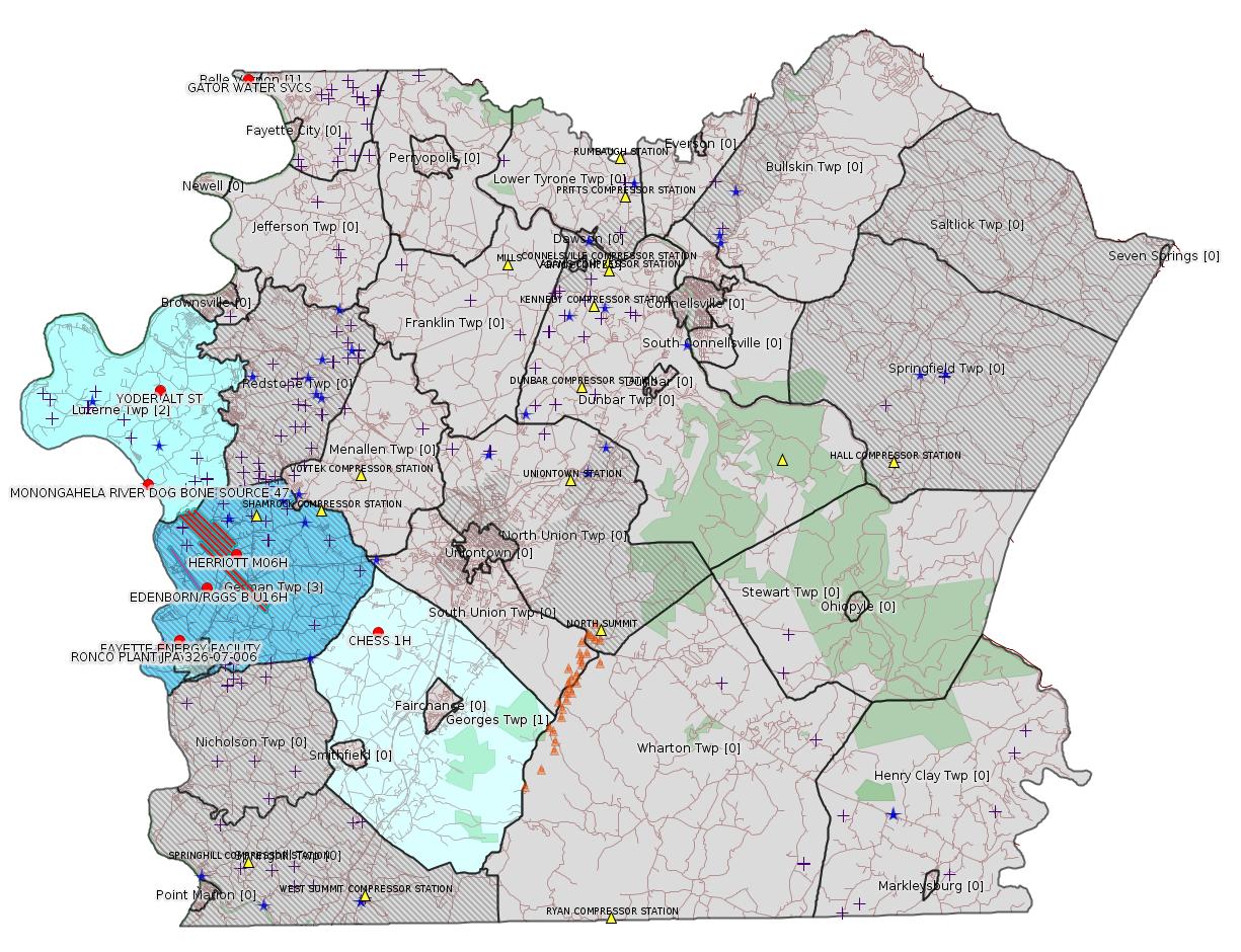
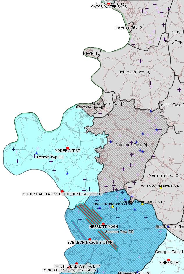
Map
Key
Red dots: items in this permit list with an exact location.
Blue stars: Marcellus Gas Well Water Sources.
Where well laterals are mapped they show in red; a 400-foot buffer surrounding the lateral shows in blue (lavender where it overlaps a mapped mineral tract).
Where mineral tracts are mapped, they show in pink. Mineral tracts can overlap; the overlap will show in red. The precise meaning of "mineral tract" is not clear.
Municipality shading: number of "facilities", with each well counting separately
(includes the red dots):
gray: 0
pale turquoise: 1
turquoise: 2
pale blue: 3
middle blue: 4
dark blue: 5
dark purple: 7
purple: 14
(Color coding may differ from one issue to the next.)
(Note if a project spans multiple municipalities -- e.g. a pipeline -- it will show in the count for each municipality.)
The number of facilities also follows the municipality name in brackets.
Municipality counts are based on the way the permit is listed by DEP; DEP has been known to get a municipality wrong.
Locations in brackets identify a precise location used to locate a surrogate for the actual site being permitted (e.g. locating a well pad or pipeline by the known location of a well.) Locations labeled beginning with "~" and ending in "[?]" are approximate and speculative based on inferences using on-line property and lease records. These are marked in the text as "[Approximate, Speculative]
Cross-hatching: Environmental Justice Areas
Yellow triangles: Compressor Stations
Orange triangles: Storage Field Wells (currently Dominion North Summit Storage Field)
Crosses: SPUD Unconventional well permits
Green: "Natural areas", e.g. state game lands, state forests
Yellow triangles: Compressor Stations
Orange triangles: Storage Field Wells (currently Dominion North Summit Storage Field)
Crosses: SPUD Unconventional well permits
Green: "Natural areas", e.g. state game lands, state forests
More Maps
 |
Source: Pennsylvania Bulletin
26-00535B: Dynegy Fayette II, LLC (100 Energy Drive, Masontown, PA 15461) plan approval extension effective August 28, 2019, with expiration on February 28, 2020, to extend the period of temporary operation of the modified combustion gas turbines (''CGT'') at Fayette Energy Center located in Masontown Borough [see Notes], Fayette County.
<https://www.pabulletin.com/secure/data/vol49/49-35/1323b.html>
Location: 39.857408,-79.913878
Presumed Parcel Id: 1530006703---
[E26-07-006] Appalachian Water Services, 195 Enterprise Lane, Connellsville, PA 15425.
To permit a 14 foot by 17 foot gravel pump pad located within the FEMA floodway of the Monongahela River and the placement of two floating intake structures within the channel of the Monongahela River, a Warm Water Fisheries, in Masontown Borough, Fayette County, Pittsburgh USACE District, (Masontown Quadrangle, Latitude N 39° 51` 14", Longitude W -79° 55` 27.9"). This project will temporarily impact 20 LF of stream and 50 LF of floodway with the installation of the intake and permanently impacts 0.005 acre of FEMA floodway with the constructed gravel pump pad.
<https://www.pabulletin.com/secure/data/vol49/49-36/1368b.html>
Site: RONCO PLANT JPA 326-07-006
Location: 39.853889,-79.924417 <https://osm.org/go/ZWpM3Btl--?m=>
See also Authorization ID: 1274218 below.
-------------------------
Source: eNOTICE
(+ PA
Oil and Gas Mapping, Well
Pad Report.) Well Details via Data
Portal Services: Oil and Gas Wells All (ID: 3).
Please see the Disclaimer below regarding Parcel Id data.
Authorization ID: 1286993
Permit number:
Site: YODER WELL PAD ESCGP-2 EXPEDITED
Client: CHEVRON APPALACHIA LLC
Authorization type: Temporary Storage
Application type: New
Authorization is for: FACILITY
Date received: 09/04/2019
Status: Pending
Permit Decision Guarantee Applies?: No
Sub-Facilities for Authorization:
Sub-Facility ID Sub-Facility Name Description
1293921 YODER ALT ST Temporary Storage Structures
Permit Review Notes:
Date Review Note
9/5/2019 The technical review and decision review are complete and either the permit decision and/or permit issuance are forthcoming.
9/4/2019 The permit application package is complete, has been accepted, and is undergoing technical review.
<https://www.ahs.dep.pa.gov/eFACTSWeb/searchResults_singleAuth.aspx?AuthID=1286993>
Site Programs:
Oil & Gas
Site Municipalities:
Luzerne Twp, Fayette County
The Application is available here:
<https://www.ahs.dep.pa.gov/eSubmissionsDocs/DownloadESubmissionDocument.ashx?enc=MOpmV6IzBtmToVjqF07C9VkQa0rXJryJAZOrrzcb73U%3d>
Location: Latitude 39.9766,-79.9241 <https://osm.org/go/ZWpZzSBJ--?m=>
[See Notes.]
---
Authorization ID: 1285335
Permit number: GP042607219-004
Site: GATOR WATER SVCS
Client: GATOR WATER SVCS
Authorization type: GP-04 Intake & Outfall Structures
Application type: New
Authorization is for: FACILITY
Date received: 08/27/2019
Status: Pending
Permit Decision Guarantee Applies?: No
Sub-Facilities for Authorization:
Sub-Facility ID Sub-Facility Name Description
1290477 WITHDRAWAL DISTRIBUTION Intake Structure
Location: 40.1246,-79.8666
Map URL: <http://www.openstreetmap.org/?mlat=40.1246&mlon=-79.8666#map=15/40.1246/-79.8666>
<https://www.ahs.dep.pa.gov/eFACTSWeb/searchResults_singleAuth.aspx?AuthID=1285335>
Site Programs:
Water Planning and Conservation
Site Municipalities:
Belle Vernon Boro, Fayette County
---
Authorization ID: 1284748
Permit number: 051-24719
Site: CHESS 1H ESCGP-EXPEDITED
Client: INR OPR LLC
Authorization type: Drill & Operate Well Permit (Unconventional)
Application type: New
Authorization is for: FACILITY
Date received: 08/21/2019
Status: Pending
Permit Decision Guarantee Applies?: No
Sub-Facilities for Authorization:
Sub-Facility ID Sub-Facility Name Description
1292918 CHESS 1H Well
Permit Review Notes:
Date Review Note
8/29/2019 Applicant has been issued a deficiency letter. If applicable, this application no longer qualifies for the Permit Decision Guarantee.
<https://www.ahs.dep.pa.gov/eFACTSWeb/searchResults_singleAuth.aspx?AuthID=1284748>
Site Programs:
Oil & Gas
Site Municipalities:
Georges Twp, Fayette County
Well Details:
Permit Number: 051-24719
Well Name: CHESS 1H
Unconventional Well: N
Well Configuration: Vertical Well
Well Type: GAS
Well Status: Active
Coal Association: Coal
Conservation Well: Y
Primary Facility ID: 836896
Site ID: 735899
Site Name: CHESS 1H ESCGP-EXPEDITED
Well Pad ID: 154471
Well Pad Name: CHESS 1
Storage Field:
Operator: INR OPR LLC
Operator Number: OGO-51036
Permit Date:
Permit Date Expires:
SPUD Date:
Date Plugged:
UIC ID:
UIC Type:
Surface Elevation: 1183
County: Fayette
Municipality: Georges Twp
Location: 39.859844,-79.7907
Map URL: <http://www.openstreetmap.org/?mlat=39.859844&mlon=-79.7907#map=15/39.859844/-79.7907>
OG WELLS PERMIT DOCS:
2019-09-06: Initial Submitted Documents, Name: Chess 1H (for Authorization: 1284748):
<http://www.depgis.state.pa.us/pdfHandler/pdFHandler.ashx?Doc=OTEzNDA5&ext=PDF>
---
Authorization ID: 1282037
Permit number: WMGR123SW001
Site: RONCO
Client: SHALLENBERGER CONST INC
Authorization type: Minor Modification to an Existing Fac
Application type: Modification
Authorization is for: FACILITY
Date received: 07/30/2019
Status: Pending
Permit Decision Guarantee Applies?: Yes
Permit Decision Guarantee status: VOID
Permit Review Notes:
Date Review Note
8/15/2019 Applicant has been issued a deficiency letter. If applicable, this application no longer qualifies for the Permit Decision Guarantee.
<https://www.ahs.dep.pa.gov/eFACTSWeb/searchResults_singleAuth.aspx?AuthID=1282037>
Site Programs:
Radiation Protection
Waste Management
Site Municipalities:
Masontown Boro, Fayette County
---
Authorization ID: 1281914
Permit number: GP042607219-003
Site: MONONGAHELA RIVER DOG BONE SOURCE 47 WATER WITHDRAWAL GP04
Client: CHEVRON APPALACHIA LLC
Authorization type: GP-04 Intake & Outfall Structures
Application type: New
Authorization is for: FACILITY
Date received: 07/29/2019
Status: Withdrawn on 8/21/2019
Permit Decision Guarantee Applies?: No
Sub-Facilities for Authorization:
Sub-Facility ID Sub-Facility Name Description
1291208 MONONGAHELA RIVER DOG BONE SOURCE 47 WATER WITHDRAWAL GP04 Intake Structure
Permit Review Notes:
Date Review Note
8/7/2019 DEP's interim review is complete. Final decision review/permit issuance is pending receipt of comments/approvals from other state or federal resources agencies.
8/7/2019 The permit application package is complete, has been accepted, and is undergoing technical review.
<https://www.ahs.dep.pa.gov/eFACTSWeb/searchResults_singleAuth.aspx?AuthID=1281914>
Site Programs:
Water Planning and Conservation
Site Municipalities:
Luzerne Twp, Fayette County
---
Authorization ID: 1274670
Permit number: 051-24708
Site: EDENBORN/RGGS B ESCGP ESX18-051-0003
Client: CHEVRON APPALACHIA LLC
Authorization type: Alt Method of Equipping, Casing, or Venting Well
Application type: New
Authorization is for: FACILITY
Date received: 05/23/2019
Status: Issued on 8/27/2019
Permit Decision Guarantee Applies?: Yes
Permit Decision Guarantee status: ACTIVE
Sub-Facilities for Authorization:
Sub-Facility ID Sub-Facility Name Description
1286626 WELLBORE SIDETRACK Well
1286625 WELLBORE SURFACE HOLE LOCATION Well
Permit Review Notes:
Date Review Note
8/27/2019 The technical review and decision review are complete and either the permit decision and/or permit issuance are forthcoming.
5/28/2019 The permit application package is complete, has been accepted, and is undergoing technical review.
<https://www.ahs.dep.pa.gov/eFACTSWeb/searchResults_singleAuth.aspx?AuthID=1274670>
Site Programs:
Oil & Gas
Site Municipalities:
German Twp [an Environmental Justice Area], Fayette County
Well Details:
Permit Number: 051-24708
Well Name: EDENBORN/RGGS B U16H
Unconventional Well: Y
Well Configuration: Horizontal Well
Well Type: GAS
Well Status: Active
Coal Association: Coal
Conservation Well: Y
Primary Facility ID: 834603
Site ID: 829418
Site Name: EDENBORN/RGGS B ESCGP ESX18-051-0003
Well Pad ID: 155083
Well Pad Name: EDENBORN/RGGS B
Storage Field:
Operator: CHEVRON APPALACHIA LLC
Operator Number: OGO-39307
Permit Date: 2019-06-03
Permit Date Expires: 2020-06-03
SPUD Date:
Date Plugged:
UIC ID:
UIC Type:
Surface Elevation: 1167
County: Fayette
Municipality: German Twp
Location: 39.882056,-79.89625
Map URL: <http://www.openstreetmap.org/?mlat=39.882056&mlon=-79.89625#map=15/39.882056/-79.89625>
OG WELLS PERMIT DOCS:
2019-06-03: Final Permit Documents, Name: auth id 1272783 (for Authorization: 1272783):
<http://www.depgis.state.pa.us/pdfHandler/pdFHandler.ashx?Doc=ODI4MzUw&ext=PDF>
2019-08-27: Other Permit Documents, Name: Alternate Method (for Authorization: 1274670):
<http://www.depgis.state.pa.us/pdfHandler/pdFHandler.ashx?Doc=OTEwOTg1&ext=PDF>
Electronically Submitted Records:
2019-06-03: Submission for Authorization 1272783
Interested Party Notification: Edenbon 16H Affidavit of NonDelivery.pdf
<http://www.depgis.state.pa.us/eWellDocHandler/pdFHandler.ashx?Doc=ODM3MTQ4&ext=PDF>
Coordination of Well Location with Public Resources: Edenborn 16H OG-76.pdf
<http://www.depgis.state.pa.us/eWellDocHandler/pdFHandler.ashx?Doc=ODM3MTUz&ext=PDF>
Pennsylvania Natural Diversity Inventory Form: EdenbornRGGS PNDI.pdf
<http://www.depgis.state.pa.us/eWellDocHandler/pdFHandler.ashx?Doc=ODM3MTU0&ext=PDF>
Location Plat: Edenborn - Final Well Plat U16H - 2019.04.25.dwg
<http://www.depgis.state.pa.us/eWellDocHandler/pdFHandler.ashx?Doc=ODM3MTU1&ext=PDF>
Well Cross-Section Diagram: Edenborn U16H Page 4.pdf
<http://www.depgis.state.pa.us/eWellDocHandler/pdFHandler.ashx?Doc=ODM3MTU2&ext=PDF>
Permit Application to Drill and Operate a Well: 1929952.pdf
<http://www.depgis.state.pa.us/eWellDocHandler/pdFHandler.ashx?Doc=ODM3NDM1&ext=PDF>
---
Authorization ID: 1274218
Permit number: E26-07-006
Site: RONCO PLANT JPA 326-07-006
Client: APPALACHIAN WATER SVC LLC
Authorization type: Water Obstruction & Encroachment Pmt
Application type: New
Authorization is for: FACILITY
Date received: 05/13/2019
Status: Pending
Permit Decision Guarantee Applies?: Yes
Permit Decision Guarantee status: VOID
Sub-Facilities for Authorization:
Sub-Facility ID Sub-Facility Name Description
1287361 RONCO PLANT JPA 326-07-006 Pipeline or Conduit
Permit Review Notes:
Date Review Note
8/21/2019 DEP's interim review is complete. Final decision review/permit issuance is pending receipt of comments/approvals from other state or federal resources agencies.
8/21/2019 DEP's interim review is complete. Final decision review/permit issuance is pending receipt of comments/approvals from other state or federal resources agencies.
7/19/2019 Applicant has been issued a deficiency letter. If applicable, this application no longer qualifies for the Permit Decision Guarantee.
<https://www.ahs.dep.pa.gov/eFACTSWeb/searchResults_singleAuth.aspx?AuthID=1274218>
Site Programs:
Water Planning and Conservation
Site Municipalities:
Masontown Boro, Fayette County
-------------------------
Source: DEP
Oil and Gas Electronic NotificationsPlease see the Disclaimer below regarding Parcel Id data.
Authorization ID: 1286993
Permit number:
Site: YODER WELL PAD ESCGP-2 EXPEDITED
Client: CHEVRON APPALACHIA LLC
Authorization type: Temporary Storage
Application type: New
Authorization is for: FACILITY
Date received: 09/04/2019
Status: Pending
Permit Decision Guarantee Applies?: No
Sub-Facilities for Authorization:
Sub-Facility ID Sub-Facility Name Description
1293921 YODER ALT ST Temporary Storage Structures
Permit Review Notes:
Date Review Note
9/5/2019 The technical review and decision review are complete and either the permit decision and/or permit issuance are forthcoming.
9/4/2019 The permit application package is complete, has been accepted, and is undergoing technical review.
<https://www.ahs.dep.pa.gov/eFACTSWeb/searchResults_singleAuth.aspx?AuthID=1286993>
Site Programs:
Oil & Gas
Site Municipalities:
Luzerne Twp, Fayette County
The Application is available here:
<https://www.ahs.dep.pa.gov/eSubmissionsDocs/DownloadESubmissionDocument.ashx?enc=MOpmV6IzBtmToVjqF07C9VkQa0rXJryJAZOrrzcb73U%3d>
Location: Latitude 39.9766,-79.9241 <https://osm.org/go/ZWpZzSBJ--?m=>
Presumed Parcel Id: 19160034
---
Authorization ID: 1285335
Permit number: GP042607219-004
Site: GATOR WATER SVCS
Client: GATOR WATER SVCS
Authorization type: GP-04 Intake & Outfall Structures
Application type: New
Authorization is for: FACILITY
Date received: 08/27/2019
Status: Pending
Permit Decision Guarantee Applies?: No
Sub-Facilities for Authorization:
Sub-Facility ID Sub-Facility Name Description
1290477 WITHDRAWAL DISTRIBUTION Intake Structure
Location: 40.1246,-79.8666
Map URL: <http://www.openstreetmap.org/?mlat=40.1246&mlon=-79.8666#map=15/40.1246/-79.8666>
<https://www.ahs.dep.pa.gov/eFACTSWeb/searchResults_singleAuth.aspx?AuthID=1285335>
Site Programs:
Water Planning and Conservation
Site Municipalities:
Belle Vernon Boro, Fayette County
---
Authorization ID: 1284748
Permit number: 051-24719
Site: CHESS 1H ESCGP-EXPEDITED
Client: INR OPR LLC
Authorization type: Drill & Operate Well Permit (Unconventional)
Application type: New
Authorization is for: FACILITY
Date received: 08/21/2019
Status: Pending
Permit Decision Guarantee Applies?: No
Sub-Facilities for Authorization:
Sub-Facility ID Sub-Facility Name Description
1292918 CHESS 1H Well
Permit Review Notes:
Date Review Note
8/29/2019 Applicant has been issued a deficiency letter. If applicable, this application no longer qualifies for the Permit Decision Guarantee.
<https://www.ahs.dep.pa.gov/eFACTSWeb/searchResults_singleAuth.aspx?AuthID=1284748>
Site Programs:
Oil & Gas
Site Municipalities:
Georges Twp, Fayette County
Well Details:
Permit Number: 051-24719
Well Name: CHESS 1H
Unconventional Well: N
Well Configuration: Vertical Well
Well Type: GAS
Well Status: Active
Coal Association: Coal
Conservation Well: Y
Primary Facility ID: 836896
Site ID: 735899
Site Name: CHESS 1H ESCGP-EXPEDITED
Well Pad ID: 154471
Well Pad Name: CHESS 1
Storage Field:
Operator: INR OPR LLC
Operator Number: OGO-51036
Permit Date:
Permit Date Expires:
SPUD Date:
Date Plugged:
UIC ID:
UIC Type:
Surface Elevation: 1183
County: Fayette
Municipality: Georges Twp
Location: 39.859844,-79.7907
Map URL: <http://www.openstreetmap.org/?mlat=39.859844&mlon=-79.7907#map=15/39.859844/-79.7907>
OG WELLS PERMIT DOCS:
2019-09-06: Initial Submitted Documents, Name: Chess 1H (for Authorization: 1284748):
<http://www.depgis.state.pa.us/pdfHandler/pdFHandler.ashx?Doc=OTEzNDA5&ext=PDF>
Presumed Parcel Id: 14060098
---
Authorization ID: 1282037
Permit number: WMGR123SW001
Site: RONCO
Client: SHALLENBERGER CONST INC
Authorization type: Minor Modification to an Existing Fac
Application type: Modification
Authorization is for: FACILITY
Date received: 07/30/2019
Status: Pending
Permit Decision Guarantee Applies?: Yes
Permit Decision Guarantee status: VOID
Permit Review Notes:
Date Review Note
8/15/2019 Applicant has been issued a deficiency letter. If applicable, this application no longer qualifies for the Permit Decision Guarantee.
<https://www.ahs.dep.pa.gov/eFACTSWeb/searchResults_singleAuth.aspx?AuthID=1282037>
Site Programs:
Radiation Protection
Waste Management
Site Municipalities:
Masontown Boro, Fayette County
---
Authorization ID: 1281914
Permit number: GP042607219-003
Site: MONONGAHELA RIVER DOG BONE SOURCE 47 WATER WITHDRAWAL GP04
Client: CHEVRON APPALACHIA LLC
Authorization type: GP-04 Intake & Outfall Structures
Application type: New
Authorization is for: FACILITY
Date received: 07/29/2019
Status: Withdrawn on 8/21/2019
Permit Decision Guarantee Applies?: No
Sub-Facilities for Authorization:
Sub-Facility ID Sub-Facility Name Description
1291208 MONONGAHELA RIVER DOG BONE SOURCE 47 WATER WITHDRAWAL GP04 Intake Structure
Permit Review Notes:
Date Review Note
8/7/2019 DEP's interim review is complete. Final decision review/permit issuance is pending receipt of comments/approvals from other state or federal resources agencies.
8/7/2019 The permit application package is complete, has been accepted, and is undergoing technical review.
<https://www.ahs.dep.pa.gov/eFACTSWeb/searchResults_singleAuth.aspx?AuthID=1281914>
Site Programs:
Water Planning and Conservation
Site Municipalities:
Luzerne Twp, Fayette County
Location: 39.932071,-79.932038
---
Authorization ID: 1274670
Permit number: 051-24708
Site: EDENBORN/RGGS B ESCGP ESX18-051-0003
Client: CHEVRON APPALACHIA LLC
Authorization type: Alt Method of Equipping, Casing, or Venting Well
Application type: New
Authorization is for: FACILITY
Date received: 05/23/2019
Status: Issued on 8/27/2019
Permit Decision Guarantee Applies?: Yes
Permit Decision Guarantee status: ACTIVE
Sub-Facilities for Authorization:
Sub-Facility ID Sub-Facility Name Description
1286626 WELLBORE SIDETRACK Well
1286625 WELLBORE SURFACE HOLE LOCATION Well
Permit Review Notes:
Date Review Note
8/27/2019 The technical review and decision review are complete and either the permit decision and/or permit issuance are forthcoming.
5/28/2019 The permit application package is complete, has been accepted, and is undergoing technical review.
<https://www.ahs.dep.pa.gov/eFACTSWeb/searchResults_singleAuth.aspx?AuthID=1274670>
Site Programs:
Oil & Gas
Site Municipalities:
German Twp [an Environmental Justice Area], Fayette County
Well Details:
Permit Number: 051-24708
Well Name: EDENBORN/RGGS B U16H
Unconventional Well: Y
Well Configuration: Horizontal Well
Well Type: GAS
Well Status: Active
Coal Association: Coal
Conservation Well: Y
Primary Facility ID: 834603
Site ID: 829418
Site Name: EDENBORN/RGGS B ESCGP ESX18-051-0003
Well Pad ID: 155083
Well Pad Name: EDENBORN/RGGS B
Storage Field:
Operator: CHEVRON APPALACHIA LLC
Operator Number: OGO-39307
Permit Date: 2019-06-03
Permit Date Expires: 2020-06-03
SPUD Date:
Date Plugged:
UIC ID:
UIC Type:
Surface Elevation: 1167
County: Fayette
Municipality: German Twp
Location: 39.882056,-79.89625
Map URL: <http://www.openstreetmap.org/?mlat=39.882056&mlon=-79.89625#map=15/39.882056/-79.89625>
OG WELLS PERMIT DOCS:
2019-06-03: Final Permit Documents, Name: auth id 1272783 (for Authorization: 1272783):
<http://www.depgis.state.pa.us/pdfHandler/pdFHandler.ashx?Doc=ODI4MzUw&ext=PDF>
2019-08-27: Other Permit Documents, Name: Alternate Method (for Authorization: 1274670):
<http://www.depgis.state.pa.us/pdfHandler/pdFHandler.ashx?Doc=OTEwOTg1&ext=PDF>
Electronically Submitted Records:
2019-06-03: Submission for Authorization 1272783
Interested Party Notification: Edenbon 16H Affidavit of NonDelivery.pdf
<http://www.depgis.state.pa.us/eWellDocHandler/pdFHandler.ashx?Doc=ODM3MTQ4&ext=PDF>
Coordination of Well Location with Public Resources: Edenborn 16H OG-76.pdf
<http://www.depgis.state.pa.us/eWellDocHandler/pdFHandler.ashx?Doc=ODM3MTUz&ext=PDF>
Pennsylvania Natural Diversity Inventory Form: EdenbornRGGS PNDI.pdf
<http://www.depgis.state.pa.us/eWellDocHandler/pdFHandler.ashx?Doc=ODM3MTU0&ext=PDF>
Location Plat: Edenborn - Final Well Plat U16H - 2019.04.25.dwg
<http://www.depgis.state.pa.us/eWellDocHandler/pdFHandler.ashx?Doc=ODM3MTU1&ext=PDF>
Well Cross-Section Diagram: Edenborn U16H Page 4.pdf
<http://www.depgis.state.pa.us/eWellDocHandler/pdFHandler.ashx?Doc=ODM3MTU2&ext=PDF>
Permit Application to Drill and Operate a Well: 1929952.pdf
<http://www.depgis.state.pa.us/eWellDocHandler/pdFHandler.ashx?Doc=ODM3NDM1&ext=PDF>
Presumed Parcel Id: 15220014
---
Authorization ID: 1274218
Permit number: E26-07-006
Site: RONCO PLANT JPA 326-07-006
Client: APPALACHIAN WATER SVC LLC
Authorization type: Water Obstruction & Encroachment Pmt
Application type: New
Authorization is for: FACILITY
Date received: 05/13/2019
Status: Pending
Permit Decision Guarantee Applies?: Yes
Permit Decision Guarantee status: VOID
Sub-Facilities for Authorization:
Sub-Facility ID Sub-Facility Name Description
1287361 RONCO PLANT JPA 326-07-006 Pipeline or Conduit
Permit Review Notes:
Date Review Note
8/21/2019 DEP's interim review is complete. Final decision review/permit issuance is pending receipt of comments/approvals from other state or federal resources agencies.
8/21/2019 DEP's interim review is complete. Final decision review/permit issuance is pending receipt of comments/approvals from other state or federal resources agencies.
7/19/2019 Applicant has been issued a deficiency letter. If applicable, this application no longer qualifies for the Permit Decision Guarantee.
<https://www.ahs.dep.pa.gov/eFACTSWeb/searchResults_singleAuth.aspx?AuthID=1274218>
Site Programs:
Water Planning and Conservation
Site Municipalities:
Masontown Boro, Fayette County
-------------------------
NOTIFICATION_ID: 49662
OGO: 39307
OPERATOR: CHEVRON APPALACHIA LLC
API_PERMIT: 051-24700
SPUD_DATE: 06/20/2019
COUNTY: Fayette
MUNICIPALITY: German [an Environmental Justice Area]
LATITUDE: 39.897847
LONGITUDE: -79.87785
SUBJECT: [NOTIFICATION]: Drilling resumption After Break of 30 days or more notification 58 Pa. C.S. 3211(f)(1) for well API 37-051-24700-00-00
QUESTION: Date and approximate time action is to occur
ANSWER: Date: 09/02/2019 Time: 6:00am
SENT_DATE: 8/30/2019 9:40:48 PM
SENT_SUCCESS: Yes
LAST_RESENT_DATE:
RESENT_SUCCESS:
REGION: EP DOGO SWDO Dstr Off
Well Details:
Permit Number: 051-24700
Well Name: HERRIOTT M06H
Unconventional Well: Y
Well Configuration: Horizontal Well
Well Type: GAS
Well Status: Active
Coal Association: Coal
Conservation Well: N
Primary Facility ID: 832292
Site ID: 829399
Site Name: HERRIOTT PAD A WELL AND TANK SITE ESCGP ESX18-051-0002
Well Pad ID: 155082
Well Pad Name: HERRIOTT
Storage Field:
Operator: CHEVRON APPALACHIA LLC
Operator Number: OGO-39307
Permit Date: 2019-02-22
Permit Date Expires: 2020-02-22
SPUD Date: 2019-06-20
Date Plugged:
UIC ID:
UIC Type:
Surface Elevation: 1265
County: Fayette
Municipality: German Twp
Location: 39.897847,-79.87785
Map URL: <http://www.openstreetmap.org/?mlat=39.897847&mlon=-79.87785#map=15/39.897847/-79.87785>
OG WELLS PERMIT DOCS:
2019-02-22: Final Permit Documents, Name: auth id 1260907 (for Authorization: 1260907):
<http://www.depgis.state.pa.us/pdfHandler/pdFHandler.ashx?Doc=NzU0NDcz&ext=PDF>
2019-07-23: Other Permit Documents, Name: Alternate Method (for Authorization: 1275510):
<http://www.depgis.state.pa.us/pdfHandler/pdFHandler.ashx?Doc=ODgwOTQ3&ext=PDF>
Electronically Submitted Records:
2019-02-22: Submission for Authorization 1260907
Pennsylvania Natural Diversity Inventory Form: Herriott PNDI.pdf
<http://www.depgis.state.pa.us/eWellDocHandler/pdFHandler.ashx?Doc=NzYyOTgz&ext=PDF>
Location Plat: 172-319-Well Plat M06H-pages1-2-3_3702.dwg
<http://www.depgis.state.pa.us/eWellDocHandler/pdFHandler.ashx?Doc=NzYyOTg0&ext=PDF>
Well Cross-Section Diagram: Herriott M06H Page 4.pdf
<http://www.depgis.state.pa.us/eWellDocHandler/pdFHandler.ashx?Doc=NzYyOTg2&ext=PDF>
Coal and Gas Resource Coord Act - Section 7 Exception: Herriott Section 7 Exception.pdf
<http://www.depgis.state.pa.us/eWellDocHandler/pdFHandler.ashx?Doc=NzY4MzQ0&ext=PDF>
Permit Application to Drill and Operate a Well: 1865896.pdf
<http://www.depgis.state.pa.us/eWellDocHandler/pdFHandler.ashx?Doc=NzY4NDkz&ext=PDF>
Presumed Parcel Id: 15220125
---
NOTIFICATION_ID: 49686
OGO: 39307
OPERATOR: CHEVRON APPALACHIA LLC
API_PERMIT: 051-24700
SPUD_DATE: 06/20/2019
COUNTY: Fayette
MUNICIPALITY: German [an Environmental Justice Area]
LATITUDE: 39.897847
LONGITUDE: -79.87785
SUBJECT: [NOTIFICATION]: Casing cementing notification 58 Pa. C.S. 3211(f)(2) for well API 37-051-24700-00-00
QUESTION: Enter the Date and Time for the applicable Casing Types
ANSWER: Coal Protected Casing 1: 9/4/2019 6:00:00 AM
SENT_DATE: 9/2/2019 8:45:28 AM
SENT_SUCCESS: Yes
LAST_RESENT_DATE:
RESENT_SUCCESS:
REGION: EP DOGO SWDO Dstr Off
Well Details above
Well Name: HERRIOTT M06H
-------------------------
| Commodity | Exchange | Currency | Expire | Last Trade | Trade Time | Change | Open | Day's High | Day's Low |
|---|---|---|---|---|---|---|---|---|---|
| NATURAL
GAS CON1 Sep19 |
NYM | USD | 09/26 | 2.60 | 09/10 02:25 | +0.02 | 2.61 | 2.61 | 2.59 |
There is some serious confusion in DEP's understanding of the municipality for the Fayette Energy Facility, permit #
26-00535B. The Site
Record for this permit shows two municipalities, Masontown
Boro and German Twp; DEP's latitude and longitude point to only
German Twp, but the PA Bulletin entry only lists Masontown. Based
on the mapping, it looks like Masontown is incorrect, and the
municipality should be German Twp.
---
The Application for Temporary Storage at the Yoder Well Pad includes the following narrative:
Well pad activities include drilling and completions. The water will be temporarily stored in a 2 tank system provided by Well Water Solutions, a 10k BBL inside a 17k BBL. The tanks will be constructed on the cut side of the tank pad. They will be built on-site by a panel & bolt design, including a leak detection system with electronic tank level monitoring. Freeboard can also be measured by a measuring stick at the tank. The 17k tank will be built from the 20k tank design, but with 1 fewer panel. The tanks will be 11' 8" in height. The 10k tank will hold roughly 8600 BBLS (76BBL x 114" of water) keeping 2' of freeboard. The 17k tank will provide greater than 110% containment. The 10k tank will be double lined with the GSE liner, and the 17k containment tank will be single lined with the GSE liner. The tanks will be supplied by a freshwater pipeline, as well as water trucks hauling reuse, flowback and/or produced water from other well pads or WMGR123 facilities. Duck ponds will be utilized under hose connections while loading/offloading. There will be 8 truck offloading "candy canes", and 2 dewatering "candy canes". Some trucks may already be equipped with drip pans. Temporary water storage and frac will be occurring within the same ESCGP limit of disturbance (LOD). The water will be mixed in the 10k tank and will be piped over to the frac on the adjacent well pad. The piping system will be made of HDPE DR11. Once frac operations are completed on the well site, the tanks will be dewatered by water trucks and cleaned by an approved waste company. 100% of the water brought in (excluding freshwater) to support the frac will be used as per the 100% rule. The pipelines will be removed between the tank pad and well site. The waste generated during the cleaning process will be disposed of at an approved waste facility. The tanks will then be deconstructed. Tank liners and all additional waste associated with deconstruction will also be disposed of at an approved disposal facility. The tanks referenced above have been accepted by PADEP and have a Modular Aboveground Storage System (MASS) approval.
Planned dates to be used, from 09-1-2019 to 8-1-2020
------------------------
DEP defines an environmental justice area as "any census tract where 20 percent or more individuals live in poverty, and/or 30 percent or more of the population is minority". (See:
<http://www.dep.pa.gov/PublicParticipation/OfficeofEnvironmentalJustice/Pages/default.aspx>). There are supposed to be enhanced public participation requirements for permits in environmental justice areas, but news of this actually ever happening is scarce. In Fayette County, the entirety of Redstone, Springhill, Nicholson, and German Townships are environmental justice areas, as well as a large part of Dunbar Township. DEP's policy document on public participation guidelines for environmental justice areas is located here:
<http://www.elibrary.dep.state.pa.us/dsweb/Get/Version-48671/012-0501-002.pdf>
eNOTICE records are likely to list the same permit multiple times, as that permit moves through the DEP process.
Oil & Gas Wells designated with a site a number and the letter H typically designate horizontal wells.
-------------------------
Resources:
Pennsylvania Bulletin: <http://www.pabulletin.com/>
eNOTICE: <http://www.ahs2.dep.state.pa.
DEP Oil and Gas Reports: <http://www.dep.pa.gov/DataandTools/Reports/Oil%20and%20Gas%20Reports/Pages/default.aspx>
DEP Permits Issued Detail Report:
<http://www.depreportingservic
DEP SPUD (drilling started) Report:
<http://www.depreportingservices.state.pa.us/ReportServer/Pages/ReportViewer.aspx?/Oil_Gas/Spud_External_Data>
DEP Oil and Gas Compliance Report:
<http://www.depreportingservices.state.pa.us/ReportServer/Pages/ReportViewer.aspx?/Oil_Gas/OG_Compliance>
DEP PA Oil & Gas Mapping:
<http://www.depgis.state.pa.us/PaOilAndGasMapping>
Data Portal Services Directory [Technical]
<http://www.depgis.state.pa.us/arcgis/rest/services>
Query: Oil and Gas Wells All (ID: 3) [Technical]:
<http://www.depgis.state.pa.us/arcgis/rest/services/OilGas/OilGasAllStrayGasEGSP/MapServer/3/query?where=&text=&objectIds=&time=&geometry=&geometryType=esriGeometryEnvelope&inSR=&spatialRel=esriSpatialRelIntersects&relationParam=&outFields=*&returnGeometry=true&returnTrueCurves=false&maxAllowableOffset=&geometryPrecision=&outSR=&returnIdsOnly=false&returnCountOnly=false&orderByFields=&groupByFieldsForStatistics=&outStatistics=&returnZ=false&returnM=false&gdbVersion=&returnDistinctValues=false&resultOffset=&resultRecordCount=&f=html>
(Be sure to enter a Where clause in SQL format. Dates are in milliseconds since midnight 1/1/1970).
DEP Oil and Gas Electronic Submissions
<http://www.ahs.dep.pa.gov/eSubmissionPublicSearch>
DEP Oil and Gas Electronic Notifications
<http://www.depreportingservices.state.pa.us/ReportServer?/Oil_Gas/OG_Notifications>
DEP Oil and Gas Well Pad Report
<http://www.depreportingservices.state.pa.us/ReportServer?/Oil_Gas/Well_Pads>
Fayette County Assessment Office Search For Tax Records:
<http://property.co.fayette.pa.us/search.aspx>
Pennsylvania Spatial Data Access:
<http://www.pasda.psu.edu/default.asp>
DEP Spatial Data Repository:
<ftp://www.pasda.psu.edu/pub/pasda/dep/>
National Response Center:
<http://www.nrc.uscg.mil/>
EPA-Echo: <http://www.epa-echo.gov/echo/
FERC citizen involvement: <http://www.ferc.gov/for-citiz
To receive E-mail notification of
all documents filed in a FERC docket, see:
<http://www.ferc.gov/docs-filing/esubscription.asp >
<http://www.ferc.gov/docs-fili
Follow the directions and enter the docket number to subscribe to.
Township Supervisors receive information regarding Erosion & Sedimentation permits, and these records may be reviewable at township municipal offices.
DEP permits are reviewable through the File Review process, for application to do file review see: <http://www.portal.state.pa.us/portal/server.pt/community/southwest_regional_office/13775/file_review/593164>
Environmental Hearing Board: <http://ehb.courtapps.com/publ
PA DEP Environmental Policy Comment System:
<http://www.ahs.dep.pa.gov/eComment/>
Federal Register Environment: <https://www.federalregister.g
Browsing of recent comment
opportunities for federal agencies, e.g. EPA. Click "sign up" to
subscribe to daily E-mails of new document listings.
SkyTruth Fayette County Drilling Alerts: <http://frack.skytruth.org/pen
U.S. Army Corps of Engineers, Pittsburgh District, Public Notices:
<http://www.lrp.usace.army.mil/Missions/Regulatory/Public-Notices/>
EPA Pennsylvania Public Notices: <http://www2.epa.gov/aboutepa/epa-pennsylvania#notice>
Marcellus Shale waste disposal
injection wells in Pennsylvania are regulated directly by EPA, not
DEP. Notice of any new permit applications will appear at the
above web address. I'm not aware of any subscription service
to be notified of such applications. I'm not aware of any
Marcellus Shale waste disposal injection wells in Fayette County
(yet ...) but we need to monitor this page for future
applications.
Energy Assurance Daily: <http://www.oe.netl.doe.gov/ead.aspx>
Daily newsletter from the US
Department of Energy about events relating to energy. The Natural
Gas section has information about pipelines.
-------------------------
Disclaimers:
This compilation from the above sources was done in part by hand using copy and paste and in part using automated methods; it may omit relevant permits.
Parcel data is provided via the tax records search web page offered by the Fayette County Assessment Office (http://property.co.fayette.pa.us/). Presumed Parcel Id links are subject to availability provided by that agency and associated web sites. Presumed Parcel Ids are determined as the mapped parcel containing a given latitude and longitude, are a best effort determination which is subject to error, and are not official. In cases where a facility is leased and there is a separate parcel id for the lease, if this parcel id is not separately mapped, the parcel id shown will be the id for the enclosing parcel. Parcel owners may be surface owners only and may or may not have any relationship to oil & gas facilities.
Does not currently include water supply permits. Does not include landfill permits even though many such are for Marcellus Shale waste. (It is not possible at this time to distinguish which landfill permits are for Marcellus Shale waste and which are not without doing File Review for each permit.)
Erosion & Sedimentation permit records do not currently include latitude and longitude. Where I am publishing latitude and longitude with E&S permits it is by inferring an associated well permit and using published latitude and longitude for the well. It is possible I may be inferring the wrong well site.
Municipalities are shown from eFACTS records on the DEP web site. The DEP has been known to list a municipality incorrectly.