The Harmed Success Stories Concepts How To What Is Commentary
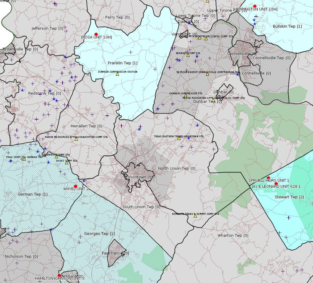
Fayette County Marcellus Shale Permits 9/5/16 - 9/18/16
Click the map to enlarge

Map
Key
Red dots: items in this permit list with an exact location.
Blue stars: Marcellus Gas Well Water Sources.
Municipality shading: number of "facilities", with each well counting separately
(includes the red dots):
Red dots: items in this permit list with an exact location.
Blue stars: Marcellus Gas Well Water Sources.
Municipality shading: number of "facilities", with each well counting separately
(includes the red dots):
gray: 0
pale turquoise: 1
turquoise: 2
pale blue: 3
middle blue: 4
dark blue: 6
dark purple: 11
purple: 19
(Color coding may differ from one issue to the next.)
(Note if a project spans multiple municipalities -- e.g. a pipeline -- it will show in the count for each municipality.)
The number of facilities also follows the municipality name in brackets.
Municipality counts are based on the way the permit is listed by DEP; DEP has been known to get a municipality wrong.
Locations in brackets identify a precise location used to locate a surrogate for the actual site being permitted (e.g. locating a well pad or pipeline by the known location of a well.) Locations labeled beginning with "~" and ending in "[?]" are approximate and speculative based on inferences using on-line property and lease records. These are marked in the text as "[Approximate, Speculative]
Cross-hatching: Environmental Justice Areas
Yellow triangles: Compressor Stations
Crosses: Unconventional well permits (may not have been drilled)
Green: "Natural areas", e.g. state game lands, state forests
Yellow triangles: Compressor Stations
Crosses: Unconventional well permits (may not have been drilled)
Green: "Natural areas", e.g. state game lands, state forests
More Maps
 |
Source: Pennsylvania Bulletin
ESCGP-2 # ESX11-051-0038
Applicant Name Chevron Appalachia, LLC
Contact Person Branden Weimer
Address 800 Mountain View Drive
City, State, Zip Smithfield, PA 15478-8902
County Fayette County
Township(s) Franklin Township
Receiving Stream(s) and Classification(s) UNT to Crabapple Run, Crabapple Run/Middle Monongahela River Watershed (WWF)
<http://www.pabulletin.com/secure/data/vol46/46-38/1604d.html>
Site: ROSA WELL MCLS NO 1511 ESCGP-EXPEDITED
Location [of ROSA UNIT 10H (surrogate)]: 40.035347,-79.773372 <http://osm.org/go/ZWp1Ip5a--?m=>
Municipalities, Franklin Twp
Presumed Parcel Id: 13040083
[See Notes.]
-------------------------
Source: eNOTICE (+ PA Oil and Gas Mapping) Please see the Disclaimer below regarding Parcel Id data.
[Conventional Well]
Authorization ID: 1146844
Permit number: 051-23376
Site: HAMILTON-JOHNSON UNIT 3 OG WELL
Client: RANGE RESOURCES APPALACHIA LLC
Authorization type: Well Plugging Notice Alternate Method
Application type: New
Authorization is for: FACILITY
Date received: 07/25/2016
Status: Pending
Sub-Facility ID Sub-Facility Name Description
926831 HAMILTON-JOHNSON UNIT 3 Well
<http://www.ahs.dep.pa.gov/eFACTSWeb/searchResults_singleAuth.aspx?AuthID=1146844>
Location: 39.803583,-79.823429 <http://osm.org/go/ZWpL8IK_--?m=>
Municipalities: Georges Twp [an Environmental Justice Area]
Presumed Parcel Id: 14240076
[See Notes.]
[Conventional Well]
Authorization ID: 1151251
Permit number: 051-21149
Site: SPRUELL HEIRS UNIT 1 OG WELL
Client: XTO ENERGY INC
Authorization type: Well Plugging Notice Intent to Plug Single Well
Application type: New
Authorization is for: FACILITY
Date received: 07/12/2016
Status: Pending
Sub-Facility ID Sub-Facility Name Description
511400 SPRUELL HEIRS UNIT 1 Well
<http://www.ahs.dep.pa.gov/eFACTSWeb/searchResults_singleAuth.aspx?AuthID=1151251>
Location: 39.894609,-79.560586 <http://osm.org/go/ZWpt8Sz~--?m=>
Municipalities: Stewart Twp
Presumed Parcel Id: 14240076
[See Notes.]
[Conventional Well:]
Authorization ID: 1151252
Permit number: 051-20051
Site: JAY E LEONARD UNIT 1 OG WELL
Client: XTO ENERGY INC
Authorization type: Well Plugging Notice Intent to Plug Single Well
Application type: New
Authorization is for: FACILITY
Date received: 07/12/2016
Status: Pending
Sub-Facility ID Sub-Facility Name Description
56258 JAY E LEONARD UNIT 628 1 Well
<http://www.ahs.dep.pa.gov/eFACTSWeb/searchResults_singleAuth.aspx?AuthID=1151252>
Location: 39.889047,-79.551017 <http://osm.org/go/ZWpt7Qzi--?m=>
Municipalities: Stewart Twp
Presumed Parcel ID: 37060019
[See Notes.]
Authorization ID: 1146884
Permit number: 051-24582
Site: WHYEL UNIT PREVIOUSLY SUMEY 1H ESCGP-EXPEDITED
Client: BURNETT OIL CO INC
Authorization type: Drill & Operate Well Permit
Application type: Renewal
Authorization is for: FACILITY
Date received: 06/30/2016
Status: Pending
<http://www.ahs.dep.pa.gov/eFACTSWeb/searchResults_singleAuth.aspx?AuthID=1146884>
Location: 39.889344,-79.80168 <http://osm.org/go/ZWplRYcV--?m=>
Municipalities: German Twp [an Environmental Justice Area]
Presumed Parcel Id: 15290036
Farm Name: WHYEL UNIT 2
Conservation Well: Y
Unconventional Well: N
Well Configuration: Vertical Well
Anticipated Maximum TVD: 8359 feet
[For more information on a previous renewal for this well, see:
<http://www.faymarwatch.org/happening/permits/080716.shtml#Whyel_Unit_2>.]
Authorization ID: 1152103
Permit number: ESX12-051-0005
Site: HERRINGTON UNIT 16H-20H ESCGP-EXPEDITED
Client: CHEVRON APPALACHIA LLC
Authorization type: Expedited E&S Stormwater General Permit 1
Application type: Notification
Authorization is for: SITE
Date received: 08/02/2016
Status: Pending
<http://www.ahs.dep.pa.gov/eFACTSWeb/searchResults_singleAuth.aspx?AuthID=1152103>
Location [of HERRINGTON UNIT 16H (surrogate):] 40.060144,-79.574089 <http://osm.org/go/ZWp9w7_Y--?m=>
Municipalities: Bullskin Twp
Presumed Parcel Id: 04280072
[See Notes.]
-------------------------
Source: Reuters Commodities: Energy
Natural Gas
| Commodity | Exchange | Currency | Expire | Last Trade | Trade Time | Change | Open | Day's High | Day's Low |
|---|---|---|---|---|---|---|---|---|---|
| NATURAL
GAS CON1 Sep16 |
NYM | USD | 09/28 | 2.94 | 09/17 22:35 | -0.00 | 2.96 | 2.96 | 2.93 |
-------------------------
Notes:
The Site Permit for the Rosa Well pad for permit # ESX11-051-0038 above was originally issued on 1/10/2012.
---
According to the Well Details Report, the Hamilton-Johnson Unit 3 well was never in production.
---
According to the Well Details Report, the SPRUELL HEIRS UNIT 1 well was never in production. This well was SPUD [drilling started] on 6/8/2000.
---
XTO withdrew an earlier application (authorization 1132028) for the JAY E LEONARD UNIT 628 1 well of type
Well Plugging Notice Alternate Method. (See the 7/10/16 issue of this bulletin.)
---
All of the wells Herrington Unit 16H-20H are shown as "Proposed But Never Materialized" in a DEP Facility Search for "Herrington", program Oil & Gas, county Fayette. Readers are reminded that applications of type "Notification" may occur when an operator is finished with a site and do not necessarily indicate new work.
In the case of a permit that was withdrawn before being issued, it is not clear how to search DEP records for an exact location. For Fayette County sites, the easiest method is probably to search the Fayette Marcellus Watch web site -- e.g.
<https://duckduckgo.com/?q=Herrington+site%3Afaymarwatch.org&t=canonical&ia=web>
which gives the 5/27/12 issue of this bulletin. At that time, DEP was publishing locations using the earlier eMapPa system; latitude and longitude could be extracted from eMapPa URLs using an arcane procedure in Firefox. As DEP was planning to transition to the Oil & Gas Mapping site, eMapPa links for oil & gas well authorization records were scrubbed.
------------------------
DEP defines an environmental justice area as "any census tract where 20 percent or more individuals live in poverty, and/or 30 percent or more of the population is minority". (See:
<http://www.portal.state.pa.us/portal/server.pt/community/pa_environmental_justice_areas/20991>
<http://www.portal.state.pa.us/portal/server.pt/community/dep_enhanced_public_participation_policy/20988>
). There are supposed to be enhanced public participation requirements for permits in environmental justice areas, but news of this actually ever happening is scarce. In Fayette County, the entirety of Springhill, Nicholson, German, and Georges Townships are environmental justice areas, as well as a large part of Dunbar Township. DEP's policy document on public participation guidelines for environmental justice areas is located here:
<http://www.elibrary.dep.state.pa.us/dsweb/Get/Version-48671/012-0501-002.pdf>
eNOTICE records are likely to list the same permit multiple times, as that permit moves through the DEP process.
Oil & Gas Wells designated with a site a number and the letter H typically designate horizontal wells.
-------------------------
Resources:
Pennsylvania Bulletin: <http://www.pabulletin.com/>
eNOTICE: <http://www.ahs2.dep.state.pa.
DEP Well Details Report: <https://www.paoilandgasreport
Well Details may not show any
information for new permits and will not show permits which have
not yet been issued. Lookup for Well Details is by permit number.
DEP Permits Issued Detail Report:
<http://www.depreportingservic
DEP SPUD (drilling started) Report:
<http://www.depreportingservices.state.pa.us/ReportServer/Pages/ReportViewer.aspx?/Oil_Gas/Spud_External_Data>
DEP Oil and Gas Compliance Report:
<http://www.depreportingservices.state.pa.us/ReportServer/Pages/ReportViewer.aspx?/Oil_Gas/OG_Compliance>
DEP PA Oil & Gas Mapping:
<http://www.depgis.state.pa.us/PaOilAndGasMapping>
Fayette County Assessment Office Search For Tax Records:
<http://property.co.fayette.pa.us/search.aspx>
Pennsylvania Spatial Data Access:
<http://www.pasda.psu.edu/default.asp>
DEP Spatial Data Repository:
<ftp://www.pasda.psu.edu/pub/pasda/dep/>
National Response Center:
<http://www.nrc.uscg.mil/>
EPA-Echo: <http://www.epa-echo.gov/echo/
FERC citizen involvement: <http://www.ferc.gov/for-citiz
To receive E-mail notification of
all documents filed in a FERC docket, see:
<http://www.ferc.gov/docs-filing/esubscription.asp >
<http://www.ferc.gov/docs-fili
Follow the directions and enter the docket number to subscribe to.
Township Supervisors receive information regarding Erosion & Sedimentation permits, and these records may be reviewable at township municipal offices.
DEP permits are reviewable through the File Review process, for application to do file review see: <http://www.portal.state.pa.us/portal/server.pt/community/southwest_regional_office/13775/file_review/593164>
Environmental Hearing Board: <http://ehb.courtapps.com/publ
PA DEP Environmental Policy Comment System:
<http://www.ahs.dep.pa.gov/eComment/>
Federal Register Environment: <https://www.federalregister.g
Browsing of recent comment
opportunities for federal agencies, e.g. EPA. Click "sign up" to
subscribe to daily E-mails of new document listings.
SkyTruth Fayette County Drilling Alerts: <http://frack.skytruth.org/pen
EPA Pennsylvania Public Notices: <http://www2.epa.gov/aboutepa/epa-pennsylvania#notice>
Marcellus Shale waste disposal
injection wells in Pennsylvania are regulated directly by EPA, not
DEP. Notice of any new permit applications will appear at the
above web address. I'm not aware of any subscription service
to be notified of such applications. I'm not aware of any
Marcellus Shale waste disposal injection wells in Fayette County
(yet ...) but we need to monitor this page for future
applications.
Energy Assurance Daily: <http://www.oe.netl.doe.gov/ead.aspx>
Daily newsletter from the US
Department of Energy about events relating to energy. The Natural
Gas section has information about pipelines.
-------------------------
Disclaimers:
This compilation from the above sources was done by hand using copy and paste and may omit relevant permits.
Parcel data is provided via the tax records search web page offered by the Fayette County Assessment Office (http://property.co.fayette.pa.us/). Presumed Parcel Id links are subject to availability provided by that agency and associated web sites. Presumed Parcel Ids are determined as the mapped parcel containing a given latitude and longitude, are a best effort determination which is subject to error, and are not official. In cases where a facility is leased and there is a separate parcel id for the lease, if this parcel id is not separately mapped, the parcel id shown will be the id for the enclosing parcel. Parcel owners may be surface owners only and may or may not have any relationship to oil & gas facilities.
Does not currently include water supply permits. Does not include landfill permits even though many such are for Marcellus Shale waste. (It is not possible at this time to distinguish which landfill permits are for Marcellus Shale waste and which are not without doing File Review for each permit.)
Erosion & Sedimentation permit records do not currently include latitude and longitude. Where I am publishing latitude and longitude with E&S permits it is by inferring an associated well permit and using published latitude and longitude for the well. It is possible I may be inferring the wrong well site.
Municipalities are shown from eFACTS records on the DEP web site. The DEP has been known to list a municipality incorrectly.