The Harmed Success Stories Concepts How To What Is Commentary
Fayette County Marcellus Shale Permits 9/7/20 - 9/20/20
Contents
Pennsylvania Bulletin Listings
Ronco Industrial Wastewater Treatment Plant General Permit WMGR123 renewal for the processing and beneficial use of oil and gas liquid waste deemed administratively completeeFACTS Listings
Dogbone Centralized Water Facility General Permit WMGR123 renewal for the processing and beneficial use of oil and gas liquid waste deemed administratively complete
Springhill Compressor Station 2 continued operation of the previously installed sources
GANS POWER STATION Major Facility Operating Permit Amendment (New)Price of Natural Gas
CHESTNUT VALLEY LDFL Landfill Permit Form 37(per component) (New)
WHYEL UNIT 1H Drill & Operate Well Permit Inactive Status (New)
WASIL 1 Drill & Operate Well Permit Inactive Status (New)
FIKE UNIT 1H Drill & Operate Well Permit Inactive Status (New)
(SARA GORLEY ML&HCO)A G MILLER EST 963 Well Plugging Notice Intent to Plug Single Well (New)
CHESS 1H Drill & Operate Well Permit (Unconventional) Renewal
DAWSON TP Water Quality Mgmt Part II, Industrial Wastewater Fac Issued 9/14/2020
DAWSON TP Minor IW Facility without ELG Issued 9/14/2020
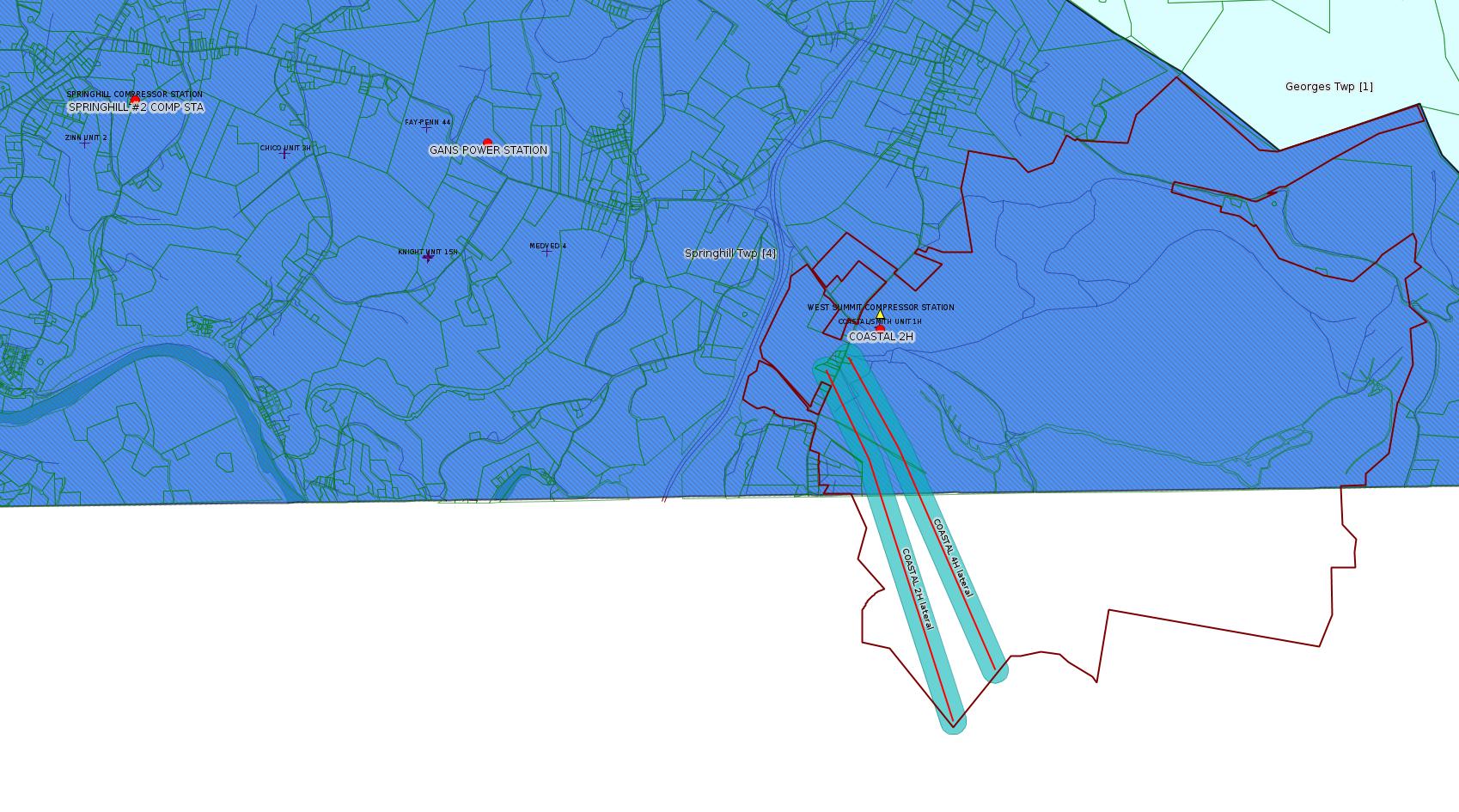
COASTAL 2H Drill & Operate Well Permit (Unconventional) 8/18/2020 deficiency letter
COASTAL 4H Drill & Operate Well Permit (Unconventional) 8/18/2020 deficiency letter
CHESTNUT VALLEY LDFL Landfill Permit Form 37(per component) Issued 9/4/2020
SPRINGHILL #2 COMP STA AQ GP 5 - Natural Gas Compression and/or Processing Facilities Issued 9/3/2020
RONCO Minor Modification to an Existing Fac Issued 9/4/2020
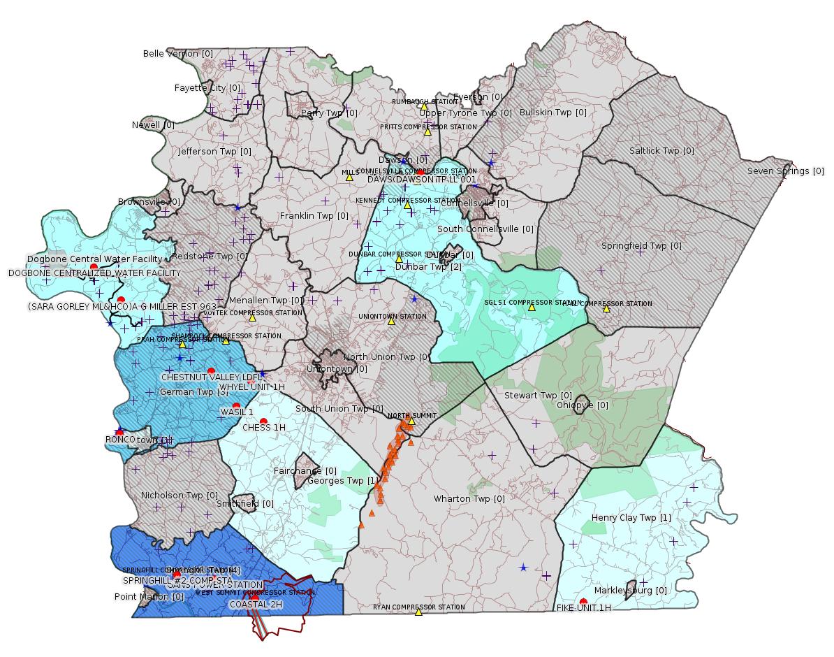
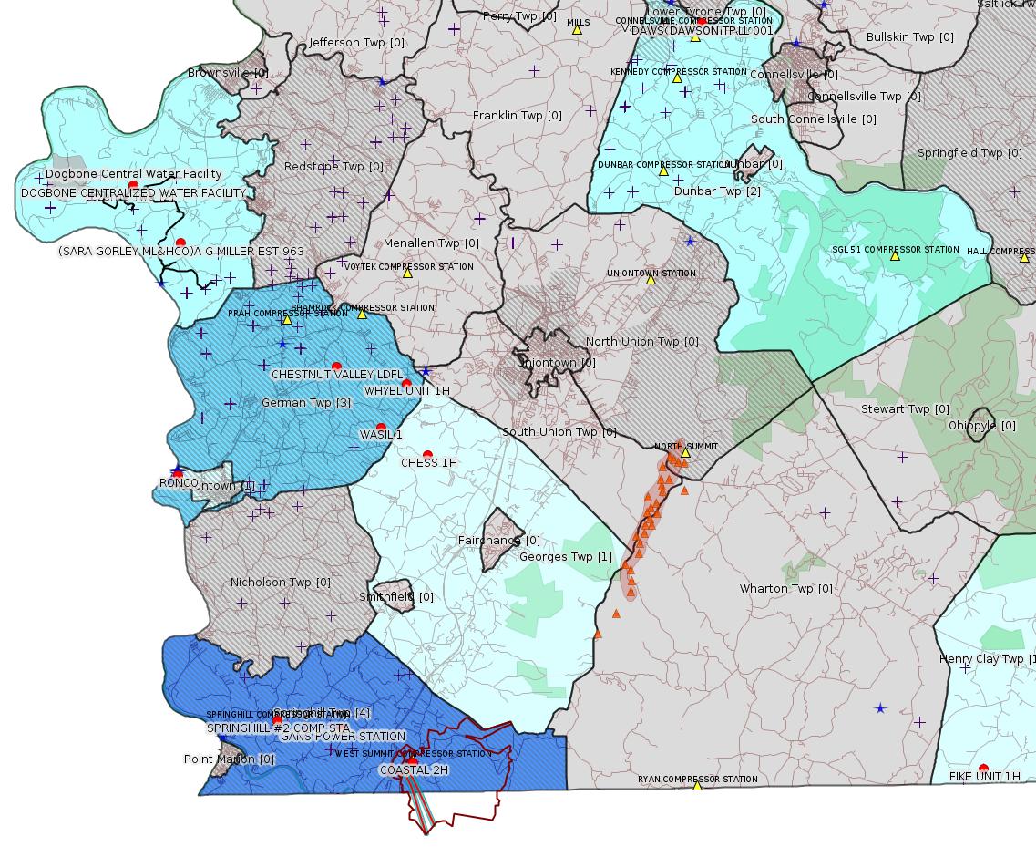
Map
Key
Red dots: items in this permit list with an exact location.
Blue stars: Marcellus Gas Well Water Sources.
Where well laterals are mapped they show in red; a 400-foot buffer surrounding the lateral shows in blue (lavender where it overlaps a mapped mineral tract).
Where mineral tracts are mapped, they show in pink. Mineral tracts can overlap; the overlap will show in red. The precise meaning of "mineral tract" is not clear.
Municipality shading: number of "facilities", with each well counting separately
(includes the red dots):
gray: 0
pale turquoise: 1
turquoise: 2
pale blue: 3
middle blue: 4
dark blue: 5
dark purple: 6
purple: 18
(Color coding may differ from one issue to the next.)
(Note if a project spans multiple municipalities -- e.g. a pipeline -- it will show in the count for each municipality.)
The number of facilities also follows the municipality name in brackets.
Municipality counts are based on the way the permit is listed by DEP; DEP has been known to get a municipality wrong.
Locations in brackets identify a precise location used to locate a surrogate for the actual site being permitted (e.g. locating a well pad or pipeline by the known location of a well.) Locations labeled beginning with "~" and ending in "[?]" are approximate and speculative based on inferences using on-line property and lease records. These are marked in the text as "[Approximate, Speculative]
Cross-hatching: Environmental Justice Areas
Yellow triangles: Compressor Stations
Orange triangles: Storage Field Wells (currently Dominion North Summit Storage Field)
Crosses: SPUD Unconventional well permits
Green: "Natural areas", e.g. state game lands, state forests
Yellow triangles: Compressor Stations
Orange triangles: Storage Field Wells (currently Dominion North Summit Storage Field)
Crosses: SPUD Unconventional well permits
Green: "Natural areas", e.g. state game lands, state forests
More Maps
 |
 |
Source: Pennsylvania Bulletin
General Permit No. WMGR123SW01. Appalachian Water Services, LLC, 2326 McClellandtown Road, Masontown, PA 15461. A permit renewal application for continued coverage under General Permit WMGR123 for the processing and beneficial use of oil and gas liquid waste at the Ronco Industrial Wastewater Treatment Plant, 2326 McClellandtown Road, Masontown, PA 15461 in Masontown Borough, Fayette County, was deemed administratively complete by the Regional Office on August 31, 2020.
Persons interested in reviewing the general permit or the application may contact the Department of Environmental Protection, Regional Files, 400 Waterfront Drive, Pittsburgh, PA 15222-4745, 412-442-4000. TDD users may contact the Department through the Pennsylvania AT&T Relay Service, (800) 654-5984.
<http://www.pacodeandbulletin.gov/Display/pabull?file=/secure/pabulletin/data/vol50/50-38/1279a.html&continued=http://www.pacodeandbulletin.gov/Display/pabull?file=/secure/pabulletin/data/vol50/50-38/1279.html&d=>
Location: 39.852778,-79.924722
<http://osm.org/go/ZWpM2V0y--?m=>
Presumed Parcel Id: 21010001[See Notes.]
---
General Permit No. WMGR123SW025. Chevron Appalachia, LLC, 700 Cherrington Parkway, Coraopolis, PA 15108. A permit renewal application for continued coverage under General Permit WMGR123 for the processing and beneficial use of oil and gas liquid waste at Dogbone Centralized Water Facility, Rush Run Road, Millsboro, PA 15433 in Luzerne Township, Fayette County, was deemed administratively complete by the Regional Office on September 2, 2020.
Persons interested in reviewing the general permit or the application may contact the Department of Environmental Protection, Regional Files, 400 Waterfront Drive, Pittsburgh, PA 15222-4745, 412-442-4000. TDD users may contact the Department through the Pennsylvania AT&T Relay Service, (800) 654-5984.
<http://www.pacodeandbulletin.gov/Display/pabull?file=/secure/pabulletin/data/vol50/50-38/1279a.html&continued=http://www.pacodeandbulletin.gov/Display/pabull?file=/secure/pabulletin/data/vol50/50-38/1279.html&d=>
Location:
39.972496,-79.946939 <http://osm.org/go/ZWpZaULM--?m=>
Presumed Parcel Id: 19160040
Fayette County Act 14 Notification: <http://faymarwatch.org/documents/SKM_554e17050309530.pdf>
Chevron Topographic Map Including "Proposed" Pipelines: <http://faymarwatch.org/documents/ZHB_17-41_121317_topo.pdf>
Presumed Parcel Id: 19160040
Fayette County Act 14 Notification: <http://faymarwatch.org/documents/SKM_554e17050309530.pdf>
Chevron Topographic Map Including "Proposed" Pipelines: <http://faymarwatch.org/documents/ZHB_17-41_121317_topo.pdf>
---
GP5-26-00587E (AG5-26-00004A): Laurel Mountain Midstream Operating, LLC (2000 Commerce Drive, Park Place Corporate Center 2, Pittsburgh, PA 15275) on September 3, 2020, to authorize the continued operation of the previously installed sources which include one (1) 1,380 bhp Caterpillar G3516B 4SLB natural gas-fired compressor engine controlled by oxidation catalyst, four (4) installed produced water tanks, one (1) 25 MMscfd tri-ethylene glycol dehydrator with associated 0.25 MMBtu/hr natural gas-fired reboiler, pneumatic devices, startup/shutdown maintenance (including blowdown) emissions, piping and equipment fugitive emissions, pigging operations, one (1) 1,500 bhp electric motor driven compressor, compressor rod packing and engine crankcase emissions, produced water truck load-out at their Springhill Compressor Station 2 located in Springhill Township, Fayette County.
<http://www.pacodeandbulletin.gov/Display/pabull?file=/secure/pabulletin/data/vol50/50-38/1279c.html&continued=http://www.pacodeandbulletin.gov/Display/pabull?file=/secure/pabulletin/data/vol50/50-38/1279.html&d=reduce>
-------------------------
Source: eNOTICE
(+ PA
Oil and Gas Mapping, Well
Pad Report.) Well Details via Data
Portal Services: Oil and Gas Wells All (ID: 3).
Please see the Disclaimer below regarding Parcel Id data.
Authorization ID: 1327126
Permit number: 26-00495
Site: GANS POWER STATION
Client: GANS ENERGY LLC
Authorization type: Major Facility Operating Permit
Application type: Amendment
Authorization is for: FACILITY
Date received: 09/09/2020
Status: Pending
Permit Decision Guarantee Applies?: No
Permit Review Notes:
Date Review Note
9/15/2020 The permit application package is complete, has been accepted, and is undergoing technical review.
<https://www.ahs.dep.pa.gov/eFACTSWeb/searchResults_singleAuth.aspx?AuthID=1327126>
Site Programs:
Air Quality
Clean Water
Waste Management
Site Municipalities:
Springhill Twp, Fayette County
---
Authorization ID: 1327102
Permit number: 100419
Site: CHESTNUT VALLEY LDFL
Client: ADVANCED DSPL SVC CHESTNUT VALLEY LDFL INC
Authorization type: Landfill Permit Form 37(per component)
Application type: Modification
Authorization is for: FACILITY
Date received: 09/11/2020
Status: Pending
Permit Decision Guarantee Applies?: Yes
Permit Decision Guarantee status: ACTIVE
Permit Review Notes:
Date Review Note
9/11/2020 The permit application package is complete, has been accepted, and is undergoing technical review.
<https://www.ahs.dep.pa.gov/eFACTSWeb/searchResults_singleAuth.aspx?AuthID=1327102>
Site Programs:
Air Quality
Clean Water
Environmental Cleanup & Brownfields
Mining
Radiation Protection
Waste Management
Water Planning and Conservation
Site Municipalities:
German Twp, Fayette County
Authorization ID: 1327013
Permit number: 051-24449
Site: WHYEL UNIT PREVIOUSLY SUMEY 1H ESCGP-EXPEDITED
Client: INR OPR LLC
Authorization type: Drill & Operate Well Permit Inactive Status
Application type: New
Authorization is for: FACILITY
Date received: 09/11/2020
Status: Pending
Permit Decision Guarantee Applies?: No
Sub-Facilities for Authorization:
Sub-Facility ID Sub-Facility Name Description
1079520 WHYEL UNIT 1H Well
1047049 WHYEL UNIT 1H Well
Permit Review Notes:
Date Review Note
9/15/2020 The permit application package is complete, has been accepted, and is undergoing technical review.
<https://www.ahs.dep.pa.gov/eFACTSWeb/searchResults_singleAuth.aspx?AuthID=1327013>
Site Programs:
Oil & Gas
Site Municipalities:
German Twp, Fayette County
Well Details:
Permit Number: 051-24449
Well Name: WHYEL UNIT 1H
Unconventional Well: Y
Well Configuration: Horizontal Well
Well Type: GAS
Well Status: Regulatory Inactive Status
Coal Association: NonCoal
Conservation Well: N
Primary Facility ID: 743725
Site ID: 749115
Site Name: WHYEL UNIT PREVIOUSLY SUMEY 1H ESCGP-EXPEDITED
Well Pad ID: 147078
Well Pad Name: WHYEL WELL PAD
Storage Field:
Operator: INR OPR LLC
Operator Number: OGO-51036
Permit Date: 2011-08-16
Permit Date Expires: 2013-06-29
SPUD Date: 2012-07-12
Date Plugged:
UIC ID:
UIC Type:
Surface Elevation: 1290
County: Fayette
Municipality: German Twp
Location: 39.889344,-79.801681
Map URL: <http://www.openstreetmap.org/?mlat=39.889344&mlon=-79.801681#map=15/39.889344/-79.801681>
OG WELLS PERMIT DOCS:
2019-09-24: Other Permit Documents, Name: Inactive Well Status (for Authorization: 1288324):
<http://www.depgis.state.pa.us/pdfHandler/pdFHandler.ashx?Doc=OTMxODc5&ext=PDF>
---
Authorization ID: 1327010
Permit number: 051-24448
Site: WASIL 1 WELL PAD ESCGP-EXPEDITED
Client: INR OPR LLC
Authorization type: Drill & Operate Well Permit Inactive Status
Application type: New
Authorization is for: FACILITY
Date received: 09/11/2020
Status: Pending
Permit Decision Guarantee Applies?: No
Sub-Facilities for Authorization:
Sub-Facility ID Sub-Facility Name Description
1046766 WASIL 1 Well
Permit Review Notes:
Date Review Note
9/15/2020 The permit application package is complete, has been accepted, and is undergoing technical review.
<https://www.ahs.dep.pa.gov/eFACTSWeb/searchResults_singleAuth.aspx?AuthID=1327010>
Site Programs:
Oil & Gas
Site Municipalities:
German Twp, Fayette County
Well Details:
Permit Number: 051-24448
Well Name: WASIL 1
Unconventional Well: N
Well Configuration: Vertical Well
Well Type: GAS
Well Status: Regulatory Inactive Status
Coal Association: NonCoal
Conservation Well: Y
Primary Facility ID: 743583
Site ID: 749854
Site Name: WASIL 1 WELL PAD ESCGP-EXPEDITED
Well Pad ID: 0
Well Pad Name:
Storage Field:
Operator: INR OPR LLC
Operator Number: OGO-51036
Permit Date: 2011-08-29
Permit Date Expires: 2012-08-29
SPUD Date: 2012-07-20
Date Plugged:
UIC ID:
UIC Type:
Surface Elevation: 1228
County: Fayette
Municipality: German Twp
Location: 39.871472,-79.815522
Map URL: <http://www.openstreetmap.org/?mlat=39.871472&mlon=-79.815522#map=15/39.871472/-79.815522>
OG WELLS PERMIT DOCS:
2019-09-24: Other Permit Documents, Name: Inactive Well Status (for Authorization: 1288323):
<http://www.depgis.state.pa.us/pdfHandler/pdFHandler.ashx?Doc=OTMxODc2&ext=PDF>
---
Authorization ID: 1327004
Permit number: 051-24164
Site: FIKE UNIT 1H OG WELL
Client: LPR ENERGY LLC
Authorization type: Drill & Operate Well Permit Inactive Status
Application type: New
Authorization is for: FACILITY
Date received: 09/02/2020
Status: Pending
Permit Decision Guarantee Applies?: No
Sub-Facilities for Authorization:
Sub-Facility ID Sub-Facility Name Description
983871 FIKE UNIT 1H Well
Permit Review Notes:
Date Review Note
9/15/2020 The permit application package is complete, has been accepted, and is undergoing technical review.
<https://www.ahs.dep.pa.gov/eFACTSWeb/searchResults_singleAuth.aspx?AuthID=1327004>
Site Programs:
Oil & Gas
Site Municipalities:
Henry Clay Twp, Fayette County
Well Details:
Permit Number: 051-24164
Well Name: FIKE UNIT 1H
Unconventional Well: Y
Well Configuration: Horizontal Well
Well Type: GAS
Well Status: Regulatory Inactive Status
Coal Association: NonCoal
Conservation Well: Y
Primary Facility ID: 715064
Site ID: 716179
Site Name: FIKE UNIT 1H OG WELL
Well Pad ID: 146852
Well Pad Name: FIKE UNIT 1H
Storage Field:
Operator: LPR ENERGY LLC
Operator Number: OGO-68579
Permit Date: 2009-02-09
Permit Date Expires: 2010-02-09
SPUD Date: 2009-02-12
Date Plugged:
UIC ID:
UIC Type:
Surface Elevation: 2222
County: Fayette
Municipality: Henry Clay Twp
Location: 39.727028,-79.495752
Map URL: <http://www.openstreetmap.org/?mlat=39.727028&mlon=-79.495752#map=15/39.727028/-79.495752>
OG WELLS PERMIT DOCS:
2016-06-13: Other Permit Documents, Name: PAG104834_3-1-2016_TENNESSEE GAS PIPELINE (for Authorization: 758213):
<http://www.depgis.state.pa.us/pdfHandler/pdFHandler.ashx?Doc=ODY1OTgw&ext=PDF>
2016-06-13: Other Permit Documents, Name: PAG104834_3-1-2017_TENNESEE GAS PIPELINE (for Authorization: 758213):
<http://www.depgis.state.pa.us/pdfHandler/pdFHandler.ashx?Doc=ODY1OTgx&ext=PDF>
2018-04-23: Other Permit Documents, Name: 1149059 (for Authorization: 1149059):
<http://www.depgis.state.pa.us/pdfHandler/pdFHandler.ashx?Doc=NTk4NzYw&ext=PDF>
2019-09-30: Other Permit Documents, Name: Inactive Well Status (for Authorization: 1290096):
<http://www.depgis.state.pa.us/pdfHandler/pdFHandler.ashx?Doc=OTM1NzQ3&ext=PDF>
---
Authorization ID: 1326625
Permit number: 051-20054
Site: SARA GORLEY ML & HCO AG MILL 963 WELL
Client: FORTRESS ENERGY CORP
Authorization type: Well Plugging Notice Intent to Plug Single Well
Application type: New
Authorization is for: FACILITY
Date received: 09/09/2020
Status: Pending
Permit Decision Guarantee Applies?: No
Sub-Facilities for Authorization:
Sub-Facility ID Sub-Facility Name Description
1054667 (SARA GORLEY ML&HCO)A G MILLER EST 963 Well
56261 (SARA GORLEY ML&HCO)A G MILLER EST 963 Well
Permit Review Notes:
Date Review Note
9/10/2020 The permit application package is complete, has been accepted, and is undergoing technical review.
<https://www.ahs.dep.pa.gov/eFACTSWeb/searchResults_singleAuth.aspx?AuthID=1326625>
Site Programs:
Oil & Gas
Site Municipalities:
Luzerne Twp, Fayette County
Well Details:
Permit Number: 051-20054
Well Name: (SARA GORLEY ML&HCO)A G MILLER EST 963
Unconventional Well: N
Well Configuration: Vertical Well
Well Type: GAS
Well Status: Active
Coal Association: Coal
Conservation Well: N
Primary Facility ID: 42731
Site ID: 40979
Site Name: SARA GORLEY ML & HCO AG MILL 963 WELL
Well Pad ID: 0
Well Pad Name:
Storage Field:
Operator: FORTRESS ENERGY CORP
Operator Number: OGO-34106
Permit Date: 1901-01-01
Permit Date Expires:
SPUD Date: 2004-03-09
Date Plugged:
UIC ID:
UIC Type:
Surface Elevation: 1120
County: Fayette
Municipality: Luzerne Twp
Location: 39.948663,-79.921789
Map URL: <http://www.openstreetmap.org/?mlat=39.948663&mlon=-79.921789#map=15/39.948663/-79.921789>
Presumed Parcel Id: 19320011
[See Notes.]
---
Authorization ID: 1325874
Permit number: 051-24719
Site: CHESS 1H ESCGP-EXPEDITED
Client: INR OPR LLC
Authorization type: Drill & Operate Well Permit (Conventional)
Application type: Renewal
Authorization is for: FACILITY
Date received: 09/02/2020
Status: Pending
Permit Decision Guarantee Applies?: Yes
Permit Decision Guarantee status: ACTIVE
Sub-Facilities for Authorization:
Sub-Facility ID Sub-Facility Name Description
1292918 CHESS 1H Well
Permit Review Notes:
Date Review Note
9/8/2020 The technical review and decision review are complete and either the permit decision and/or permit issuance are forthcoming.
9/3/2020 The permit application package is complete, has been accepted, and is undergoing technical review.
<https://www.ahs.dep.pa.gov/eFACTSWeb/searchResults_singleAuth.aspx?AuthID=1325874>
Site Programs:
Oil & Gas
Site Municipalities:
Georges Twp, Fayette County
Well Details:
Permit Number: 051-24719
Well Name: CHESS 1H
Unconventional Well: N
Well Configuration: Vertical Well
Well Type: GAS
Well Status: Active
Coal Association: Coal
Conservation Well: Y
Primary Facility ID: 836896
Site ID: 735899
Site Name: CHESS 1H ESCGP-EXPEDITED
Well Pad ID: 154471
Well Pad Name: CHESS 1
Storage Field:
Operator: INR OPR LLC
Operator Number: OGO-51036
Permit Date: 2019-09-24
Permit Date Expires: 2020-09-24
SPUD Date:
Date Plugged:
UIC ID:
UIC Type:
Surface Elevation: 1183
County: Fayette
Municipality: Georges Twp
Location: 39.859844,-79.7907
Map URL: <http://www.openstreetmap.org/?mlat=39.859844&mlon=-79.7907#map=15/39.859844/-79.7907>
OG WELLS PERMIT DOCS:
2020-02-13: Initial Submitted Documents, Name: 1284748 (for Authorization: 1284748):
<http://www.depgis.state.pa.us/pdfHandler/pdFHandler.ashx?Doc=OTI2ODky&ext=PDF>
2020-02-13: Final Permit Documents, Name: 051-24719 (for Authorization: 1284748):
<http://www.depgis.state.pa.us/pdfHandler/pdFHandler.ashx?Doc=OTQxNjUx&ext=PDF>
2020-09-18: Initial Submitted Documents, Name: 051-24719 (for Authorization: 1325874):
<http://www.depgis.state.pa.us/pdfHandler/pdFHandler.ashx?Doc=MTQxNTk2Mg==&ext=PDF>
2020-09-18: Final Permit Documents, Name: 051_24719_Chess 1H_1325874_signed (for Authorization: 1325874):
<http://www.depgis.state.pa.us/pdfHandler/pdFHandler.ashx?Doc=MTQyMzc0Mw==&ext=PDF>
---
Authorization ID: 1323787
Permit number: 2698201
Site: DAWSON TP
Client: APOLLO RESOURCES LLC
Authorization type: Water Quality Mgmt Part II, Industrial Wastewater Fac
Application type: Transfer
Authorization is for: FACILITY
Date received: 07/24/2020
Status: Issued on 9/14/2020
Permit Decision Guarantee Applies?: No
Sub-Facilities for Authorization:
Sub-Facility ID Sub-Facility Name Description
1025461 TRMT PLANT Treatment Plant
Location: 40.036413,-79.640588
Map URL: <http://www.openstreetmap.org/?mlat=40.036413&mlon=-79.640588#map=15/40.036413/-79.640588>
Permit Review Notes:
Date Review Note
9/14/2020 The technical review and decision review are complete and either the permit decision and/or permit issuance are forthcoming.
8/18/2020 Applicant has been issued a deficiency letter. If applicable, this application no longer qualifies for the Permit Decision Guarantee.
<https://www.ahs.dep.pa.gov/eFACTSWeb/searchResults_singleAuth.aspx?AuthID=1323787>
Site Programs:
Clean Water
Oil & Gas
Site Municipalities:
Dunbar Twp, Fayette County
---
Authorization ID: 1323785
Permit number: PA0217778
Site: DAWSON TP
Client: APOLLO RESOURCES LLC
Authorization type: Minor IW Facility without ELG
Application type: Transfer
Authorization is for: FACILITY
Date received: 07/24/2020
Status: Issued on 9/14/2020
Permit Decision Guarantee Applies?: No
Sub-Facilities for Authorization:
Sub-Facility ID Sub-Facility Name Description
1025459 OUTFALL 001 Discharge Point
Location: 40.036247,-79.640533
Map URL: <http://www.openstreetmap.org/?mlat=40.036247&mlon=-79.640533#map=15/40.036247/-79.640533>
Permit Review Notes:
Date Review Note
9/14/2020 The technical review and decision review are complete and either the permit decision and/or permit issuance are forthcoming.
8/18/2020 Applicant has been issued a deficiency letter. If applicable, this application no longer qualifies for the Permit Decision Guarantee.
<https://www.ahs.dep.pa.gov/eFACTSWeb/searchResults_singleAuth.aspx?AuthID=1323785>
Site Programs:
Clean Water
Oil & Gas
Site Municipalities:
Dunbar Twp, Fayette County
---
Authorization ID: 1322984
Permit number: 051-24722
Site: COASTAL 1H FLOW BACK PIT FRESHWATER PITS ESCGP-EXPEDITED
Client: INR OPR LLC
Authorization type: Drill & Operate Well Permit (Unconventional)
Application type: New
Authorization is for: FACILITY
Date received: 08/11/2020
Status: Pending
Permit Decision Guarantee Applies?: Yes
Permit Decision Guarantee status: VOID
Sub-Facilities for Authorization:
Sub-Facility ID Sub-Facility Name Description
1313193 WELLBORE SURFACE HOLE LOCATION Well
Permit Review Notes:
Date Review Note
8/27/2020 The technical review and decision review are complete and either the permit decision and/or permit issuance are forthcoming.
8/24/2020 Applicant has been issued a deficiency letter. If applicable, this application no longer qualifies for the Permit Decision Guarantee.
8/18/2020 Applicant has been issued a deficiency letter. If applicable, this application no longer qualifies for the Permit Decision Guarantee.
8/12/2020 The permit application package is complete, has been accepted, and is undergoing technical review.
<https://www.ahs.dep.pa.gov/eFACTSWeb/searchResults_singleAuth.aspx?AuthID=1322984>
Site Programs:
Oil & Gas
Site Municipalities:
Springhill Twp, Fayette County
Well Details:
Permit Number: 051-24722
Well Name: COASTAL 2H
Unconventional Well: Y
Well Configuration: Horizontal Well
Well Type: GAS
Well Status: Active
Coal Association: Coal
Conservation Well: N
Primary Facility ID: 843825
Site ID: 739525
Site Name: COASTAL 1H FLOW BACK PIT FRESHWATER PITS ESCGP-EXPEDITED
Well Pad ID: 147971
Well Pad Name: COASTAL WELL PAD
Storage Field:
Operator: INR OPR LLC
Operator Number: OGO-51036
Permit Date:
Permit Date Expires:
SPUD Date:
Date Plugged:
UIC ID:
UIC Type:
Surface Elevation: 1127
County: Fayette
Municipality: Springhill Twp
Location: 39.73315,-79.800903
Map URL: <http://www.openstreetmap.org/?mlat=39.73315&mlon=-79.800903#map=15/39.73315/-79.800903>
OG WELLS PERMIT DOCS:
2020-09-18: Other Permit Documents, Name: Coastal Wells Deficiency Email (for Authorization: 1322984):
<http://www.depgis.state.pa.us/pdfHandler/pdFHandler.ashx?Doc=MTQwNzgyOQ==&ext=PDF>
Electronically Submitted Records:
2020-09-18: Submission for Authorization 1322984
Interested Party Notification: Coastal 2H - Springhill Township - Interested Party Signed Receipt - 08.04.2020.pdf
<http://www.depgis.state.pa.us/eWellDocHandler/pdFHandler.ashx?Doc=MTI1MjgxNw==&ext=PDF>
Coordination of Well Location with Public Resources: INR OPERATING - COASTAL 2H - COORDINATION_OF_WELL_LOCATION_WITH_PUBLIC_RESOURCES.pdf
<http://www.depgis.state.pa.us/eWellDocHandler/pdFHandler.ashx?Doc=MTI2MTg1Mg==&ext=PDF>
Pennsylvania Natural Diversity Inventory Form: INR OPERATING - COASTAL 2H - PNDI INVENTORY 07.21.2020.pdf
<http://www.depgis.state.pa.us/eWellDocHandler/pdFHandler.ashx?Doc=MTI2MTg1Mw==&ext=PDF>
Pennsylvania Natural Diversity Inventory Support Document: INR OPERATING - COASTAL 2H - PNDI SUPPORT 07.21.2020.pdf
<http://www.depgis.state.pa.us/eWellDocHandler/pdFHandler.ashx?Doc=MTI2MTg1NQ==&ext=PDF>
Operator Ownership and Control Information: INR OPERATING - COASTAL 2H - OPERATOR_OWNERSHIP_AND_CONTROL_INFORMATION_FORM 07.21.2020.pdf
<http://www.depgis.state.pa.us/eWellDocHandler/pdFHandler.ashx?Doc=MTI2MTg1Ng==&ext=PDF>
Well Permit Application - Coal Module: INR OPERATING - COASTAL 2H - COAL STATUS REPORT 07.24.2020.pdf
<http://www.depgis.state.pa.us/eWellDocHandler/pdFHandler.ashx?Doc=MTI2MTg1OA==&ext=PDF>
Location Plat: INR OPERATING - COASTAL 2H - LOCATION PLAT 08.25.2020 DEP COMMENT REVISIONS.dwg
<http://www.depgis.state.pa.us/eWellDocHandler/pdFHandler.ashx?Doc=MTI2ODM2Nw==&ext=PDF>
Well Cross-Section Diagram: INR OPERATING - COASTAL 2H - WELL CROSS-SECTION DIAGRAM 08.25.2020 DEP COMMENT REVISIONS.pdf
<http://www.depgis.state.pa.us/eWellDocHandler/pdFHandler.ashx?Doc=MTI2ODM3Mw==&ext=PDF>
Location Plat: INR OPERATING - COASTAL 2H - LOCATION PLAT 08.25.2020 DEP COMMENT REVISIONS.dwg
<http://www.depgis.state.pa.us/eWellDocHandler/pdFHandler.ashx?Doc=MTI2ODM3OA==&ext=PDF>
Permit Application to Drill and Operate a Well: 1958801.pdf
<http://www.depgis.state.pa.us/eWellDocHandler/pdFHandler.ashx?Doc=MTI2ODM4MA==&ext=PDF>
Presumed Parcel Id: 36210048
---
Authorization ID: 1322978
Permit number: 051-24721
Site: COASTAL 1H FLOW BACK PIT FRESHWATER PITS ESCGP-EXPEDITED
Client: INR OPR LLC
Authorization type: Drill & Operate Well Permit (Unconventional)
Application type: New
Authorization is for: FACILITY
Date received: 08/11/2020
Status: Pending
Permit Decision Guarantee Applies?: Yes
Permit Decision Guarantee status: VOID
Sub-Facilities for Authorization:
Sub-Facility ID Sub-Facility Name Description
1313192 WELLBORE SURFACE HOLE LOCATION Well
Permit Review Notes:
Date Review Note
8/27/2020 The technical review and decision review are complete and either the permit decision and/or permit issuance are forthcoming.
8/24/2020 Applicant has been issued a deficiency letter. If applicable, this application no longer qualifies for the Permit Decision Guarantee.
8/18/2020 Applicant has been issued a deficiency letter. If applicable, this application no longer qualifies for the Permit Decision Guarantee.
8/12/2020 The permit application package is complete, has been accepted, and is undergoing technical review.
<https://www.ahs.dep.pa.gov/eFACTSWeb/searchResults_singleAuth.aspx?AuthID=1322978>
Site Programs:
Oil & Gas
Site Municipalities:
Springhill Twp, Fayette County
Well Details:
Permit Number: 051-24721
Well Name: COASTAL 4H
Unconventional Well: Y
Well Configuration: Horizontal Well
Well Type: GAS
Well Status: Active
Coal Association: Coal
Conservation Well: N
Primary Facility ID: 843824
Site ID: 739525
Site Name: COASTAL 1H FLOW BACK PIT FRESHWATER PITS ESCGP-EXPEDITED
Well Pad ID: 147971
Well Pad Name: COASTAL WELL PAD
Storage Field:
Operator: INR OPR LLC
Operator Number: OGO-51036
Permit Date:
Permit Date Expires:
SPUD Date:
Date Plugged:
UIC ID:
UIC Type:
Surface Elevation: 1127
County: Fayette
Municipality: Springhill Twp
Location: 39.733181,-79.800869
Map URL: <http://www.openstreetmap.org/?mlat=39.733181&mlon=-79.800869#map=15/39.733181/-79.800869>
OG WELLS PERMIT DOCS:
2020-09-18: Other Permit Documents, Name: Coastal Wells Deficiency Email (for Authorization: 1322978):
<http://www.depgis.state.pa.us/pdfHandler/pdFHandler.ashx?Doc=MTQwNzk4MQ==&ext=PDF>
Electronically Submitted Records:
2020-09-18: Submission for Authorization 1322978
Pennsylvania Natural Diversity Inventory Form: INR OPERATING - COASTAL 4H - PNDI INVENTORY 07.21.2020.pdf
<http://www.depgis.state.pa.us/eWellDocHandler/pdFHandler.ashx?Doc=MTIzMzcxOQ==&ext=PDF>
Pennsylvania Natural Diversity Inventory Support Document: INR OPERATING - COASTAL 4H - PNDI SUPPORT 07.21.2020.pdf
<http://www.depgis.state.pa.us/eWellDocHandler/pdFHandler.ashx?Doc=MTIzMzcyMQ==&ext=PDF>
Operator Ownership and Control Information: INR OPERATING - COASTAL 4H - OPERATOR_OWNERSHIP_AND_CONTROL_INFORMATION_FORM 07.21.2020.pdf
<http://www.depgis.state.pa.us/eWellDocHandler/pdFHandler.ashx?Doc=MTIzMzcyMg==&ext=PDF>
Coordination of Well Location with Public Resources: INR OPERATING - COASTAL 4H - COORDINATION_OF_WELL_LOCATION_WITH_PUBLIC_RESOURCES.pdf
<http://www.depgis.state.pa.us/eWellDocHandler/pdFHandler.ashx?Doc=MTIzNjcxMQ==&ext=PDF>
Well Permit Application - Coal Module: INR OPERATING - COASTAL 4H - COAL STATUS REPORT 07.24.2020.pdf
<http://www.depgis.state.pa.us/eWellDocHandler/pdFHandler.ashx?Doc=MTIzOTY5MA==&ext=PDF>
Interested Party Notification: Coastal 4H - Springhill Township - Interested Party Signed Receipt - 08.04.2020.pdf
<http://www.depgis.state.pa.us/eWellDocHandler/pdFHandler.ashx?Doc=MTI1MjgyNA==&ext=PDF>
Location Plat: INR OPERATING - COASTAL 4H - LOCATION PLAT 08.25.2020 DEP COMMENT REVISIONS.dwg
<http://www.depgis.state.pa.us/eWellDocHandler/pdFHandler.ashx?Doc=MTI2ODY2Mw==&ext=PDF>
Well Cross-Section Diagram: INR OPERATING - COASTAL 4H - WELL CROSS-SECTION DIAGRAM 08.25.2020 DEP COMMENT REVISIONS.pdf
<http://www.depgis.state.pa.us/eWellDocHandler/pdFHandler.ashx?Doc=MTI2ODY2NA==&ext=PDF>
Location Plat: INR OPERATING - COASTAL 4H - LOCATION PLAT 08.25.2020 DEP COMMENT REVISIONS.dwg
<http://www.depgis.state.pa.us/eWellDocHandler/pdFHandler.ashx?Doc=MTI2ODY2NQ==&ext=PDF>
Permit Application to Drill and Operate a Well: 2141432.pdf
<http://www.depgis.state.pa.us/eWellDocHandler/pdFHandler.ashx?Doc=MTI2ODY3MA==&ext=PDF>
---
Authorization ID: 1320528
Permit number: 100419
Site: CHESTNUT VALLEY LDFL
Client: ADVANCED DSPL SVC CHESTNUT VALLEY LDFL INC
Authorization type: Landfill Permit Form 37(per component)
Application type: Modification
Authorization is for: FACILITY
Date received: 07/17/2020
Status: Issued on 9/4/2020
Permit Decision Guarantee Applies?: Yes
Permit Decision Guarantee status: VOID
Permit Review Notes:
Date Review Note
9/4/2020 The technical review and decision review are complete and either the permit decision and/or permit issuance are forthcoming.
8/21/2020 Applicant has been issued a deficiency letter. If applicable, this application no longer qualifies for the Permit Decision Guarantee.
7/17/2020 The permit application package is complete, has been accepted, and is undergoing technical review.
<https://www.ahs.dep.pa.gov/eFACTSWeb/searchResults_singleAuth.aspx?AuthID=1320528>
Site Programs:
Air Quality
Clean Water
Environmental Cleanup & Brownfields
Mining
Radiation Protection
Waste Management
Water Planning and Conservation
Site Municipalities:
German Twp, Fayette County
---
Authorization ID: 1319045
Permit number: AG5-26-00004A
Site: SPRINGHILL #2 COMP STA
Client: LAUREL MTN MIDSTREAM OPR LLC
Authorization type: AQ GP 5 - Natural Gas Compression and/or Processing Facilities
Application type: New
Authorization is for: FACILITY
Date received: 06/26/2020
Status: Issued on 9/3/2020
Permit Decision Guarantee Applies?: No
Sub-Facilities for Authorization:
Sub-Facility ID Sub-Facility Name Description
1124031 CAT G3516B ENG 4 (1380 BHP) Process
Location: 39.751678,-79.876212
Map URL: <http://www.openstreetmap.org/?mlat=39.751678&mlon=-79.876212#map=15/39.751678/-79.876212>
1181084 DEHY 1 (25 MMSCFD) Process
Location: 39.751678,-79.876212
Map URL: <http://www.openstreetmap.org/?mlat=39.751678&mlon=-79.876212#map=15/39.751678/-79.876212>
1124033 ENGINE 4 OX CAT Air Pollution Control Device
Location: 39.751678,-79.876212
Map URL: <http://www.openstreetmap.org/?mlat=39.751678&mlon=-79.876212#map=15/39.751678/-79.876212>
1185093 FUGITIVES Process
Location: 39.751678,-79.876212
Map URL: <http://www.openstreetmap.org/?mlat=39.751678&mlon=-79.876212#map=15/39.751678/-79.876212>
1185085 HEATERS/REBOILERS Process
Location: 39.751678,-79.876212
Map URL: <http://www.openstreetmap.org/?mlat=39.751678&mlon=-79.876212#map=15/39.751678/-79.876212>
1185080 NATURAL GAS LINE Fuel Material Location
Location: 39.751678,-79.876212
Map URL: <http://www.openstreetmap.org/?mlat=39.751678&mlon=-79.876212#map=15/39.751678/-79.876212>
1195986 PIGGING OPERATIONS Process
Location: 39.751678,-79.876212
Map URL: <http://www.openstreetmap.org/?mlat=39.751678&mlon=-79.876212#map=15/39.751678/-79.876212>
1185089 PNEUMATIC DEVICES Process
Location: 39.751678,-79.876212
Map URL: <http://www.openstreetmap.org/?mlat=39.751678&mlon=-79.876212#map=15/39.751678/-79.876212>
1185087 TANKS/VESSELS Process
Location: 39.751678,-79.876212
Map URL: <http://www.openstreetmap.org/?mlat=39.751678&mlon=-79.876212#map=15/39.751678/-79.876212>
1185091 VENTING/BLOWDOWNS Process
Location: 39.751678,-79.876212
Map URL: <http://www.openstreetmap.org/?mlat=39.751678&mlon=-79.876212#map=15/39.751678/-79.876212>
Permit Review Notes:
Date Review Note
9/3/2020 The technical review and decision review are complete and either the permit decision and/or permit issuance are forthcoming.
7/13/2020 The permit application package is complete, has been accepted, and is undergoing technical review.
<https://www.ahs.dep.pa.gov/eFACTSWeb/searchResults_singleAuth.aspx?AuthID=1319045>
Site Programs:
Air Quality
Site Municipalities:
Springhill Twp, Fayette County
---
Authorization ID: 1300406
Permit number: WMGR123SW001
Site: RONCO
Client: SHALLENBERGER CONST INC
Authorization type: Minor Modification to an Existing Fac
Application type: Modification
Authorization is for: FACILITY
Date received: 12/30/2019
Status: Issued on 9/4/2020
Permit Decision Guarantee Applies?: Yes
Permit Decision Guarantee status: VOID
Permit Review Notes:
Date Review Note
9/4/2020 The technical review and decision review are complete and either the permit decision and/or permit issuance are forthcoming.
4/16/2020 Applicant has been issued a deficiency letter. If applicable, this application no longer qualifies for the Permit Decision Guarantee.
1/22/2020 Applicant has been issued a deficiency letter. If applicable, this application no longer qualifies for the Permit Decision Guarantee.
1/8/2020 The permit application package is complete, has been accepted, and is undergoing technical review.
<https://www.ahs.dep.pa.gov/eFACTSWeb/searchResults_singleAuth.aspx?AuthID=1300406>
Site Programs:
Radiation Protection
Waste Management
Site Municipalities:
Masontown Boro, Fayette County
-------------------------
Please see the Disclaimer below regarding Parcel Id data.
Authorization ID: 1327126
Permit number: 26-00495
Site: GANS POWER STATION
Client: GANS ENERGY LLC
Authorization type: Major Facility Operating Permit
Application type: Amendment
Authorization is for: FACILITY
Date received: 09/09/2020
Status: Pending
Permit Decision Guarantee Applies?: No
Permit Review Notes:
Date Review Note
9/15/2020 The permit application package is complete, has been accepted, and is undergoing technical review.
<https://www.ahs.dep.pa.gov/eFACTSWeb/searchResults_singleAuth.aspx?AuthID=1327126>
Site Programs:
Air Quality
Clean Water
Waste Management
Site Municipalities:
Springhill Twp, Fayette County
---
Authorization ID: 1327102
Permit number: 100419
Site: CHESTNUT VALLEY LDFL
Client: ADVANCED DSPL SVC CHESTNUT VALLEY LDFL INC
Authorization type: Landfill Permit Form 37(per component)
Application type: Modification
Authorization is for: FACILITY
Date received: 09/11/2020
Status: Pending
Permit Decision Guarantee Applies?: Yes
Permit Decision Guarantee status: ACTIVE
Permit Review Notes:
Date Review Note
9/11/2020 The permit application package is complete, has been accepted, and is undergoing technical review.
<https://www.ahs.dep.pa.gov/eFACTSWeb/searchResults_singleAuth.aspx?AuthID=1327102>
Site Programs:
Air Quality
Clean Water
Environmental Cleanup & Brownfields
Mining
Radiation Protection
Waste Management
Water Planning and Conservation
Site Municipalities:
German Twp, Fayette County
Location: 39.896749,-79.838809
Map URL: <http://www.openstreetmap.org/?mlat=39.896749&mlon=-79.838809#map=15/39.896749/-79.838809>
Presumed Parcel Id: 15280012
---Map URL: <http://www.openstreetmap.org/?mlat=39.896749&mlon=-79.838809#map=15/39.896749/-79.838809>
Presumed Parcel Id: 15280012
Authorization ID: 1327013
Permit number: 051-24449
Site: WHYEL UNIT PREVIOUSLY SUMEY 1H ESCGP-EXPEDITED
Client: INR OPR LLC
Authorization type: Drill & Operate Well Permit Inactive Status
Application type: New
Authorization is for: FACILITY
Date received: 09/11/2020
Status: Pending
Permit Decision Guarantee Applies?: No
Sub-Facilities for Authorization:
Sub-Facility ID Sub-Facility Name Description
1079520 WHYEL UNIT 1H Well
1047049 WHYEL UNIT 1H Well
Permit Review Notes:
Date Review Note
9/15/2020 The permit application package is complete, has been accepted, and is undergoing technical review.
<https://www.ahs.dep.pa.gov/eFACTSWeb/searchResults_singleAuth.aspx?AuthID=1327013>
Site Programs:
Oil & Gas
Site Municipalities:
German Twp, Fayette County
Well Details:
Permit Number: 051-24449
Well Name: WHYEL UNIT 1H
Unconventional Well: Y
Well Configuration: Horizontal Well
Well Type: GAS
Well Status: Regulatory Inactive Status
Coal Association: NonCoal
Conservation Well: N
Primary Facility ID: 743725
Site ID: 749115
Site Name: WHYEL UNIT PREVIOUSLY SUMEY 1H ESCGP-EXPEDITED
Well Pad ID: 147078
Well Pad Name: WHYEL WELL PAD
Storage Field:
Operator: INR OPR LLC
Operator Number: OGO-51036
Permit Date: 2011-08-16
Permit Date Expires: 2013-06-29
SPUD Date: 2012-07-12
Date Plugged:
UIC ID:
UIC Type:
Surface Elevation: 1290
County: Fayette
Municipality: German Twp
Location: 39.889344,-79.801681
Map URL: <http://www.openstreetmap.org/?mlat=39.889344&mlon=-79.801681#map=15/39.889344/-79.801681>
OG WELLS PERMIT DOCS:
2019-09-24: Other Permit Documents, Name: Inactive Well Status (for Authorization: 1288324):
<http://www.depgis.state.pa.us/pdfHandler/pdFHandler.ashx?Doc=OTMxODc5&ext=PDF>
---
Authorization ID: 1327010
Permit number: 051-24448
Site: WASIL 1 WELL PAD ESCGP-EXPEDITED
Client: INR OPR LLC
Authorization type: Drill & Operate Well Permit Inactive Status
Application type: New
Authorization is for: FACILITY
Date received: 09/11/2020
Status: Pending
Permit Decision Guarantee Applies?: No
Sub-Facilities for Authorization:
Sub-Facility ID Sub-Facility Name Description
1046766 WASIL 1 Well
Permit Review Notes:
Date Review Note
9/15/2020 The permit application package is complete, has been accepted, and is undergoing technical review.
<https://www.ahs.dep.pa.gov/eFACTSWeb/searchResults_singleAuth.aspx?AuthID=1327010>
Site Programs:
Oil & Gas
Site Municipalities:
German Twp, Fayette County
Well Details:
Permit Number: 051-24448
Well Name: WASIL 1
Unconventional Well: N
Well Configuration: Vertical Well
Well Type: GAS
Well Status: Regulatory Inactive Status
Coal Association: NonCoal
Conservation Well: Y
Primary Facility ID: 743583
Site ID: 749854
Site Name: WASIL 1 WELL PAD ESCGP-EXPEDITED
Well Pad ID: 0
Well Pad Name:
Storage Field:
Operator: INR OPR LLC
Operator Number: OGO-51036
Permit Date: 2011-08-29
Permit Date Expires: 2012-08-29
SPUD Date: 2012-07-20
Date Plugged:
UIC ID:
UIC Type:
Surface Elevation: 1228
County: Fayette
Municipality: German Twp
Location: 39.871472,-79.815522
Map URL: <http://www.openstreetmap.org/?mlat=39.871472&mlon=-79.815522#map=15/39.871472/-79.815522>
OG WELLS PERMIT DOCS:
2019-09-24: Other Permit Documents, Name: Inactive Well Status (for Authorization: 1288323):
<http://www.depgis.state.pa.us/pdfHandler/pdFHandler.ashx?Doc=OTMxODc2&ext=PDF>
---
Authorization ID: 1327004
Permit number: 051-24164
Site: FIKE UNIT 1H OG WELL
Client: LPR ENERGY LLC
Authorization type: Drill & Operate Well Permit Inactive Status
Application type: New
Authorization is for: FACILITY
Date received: 09/02/2020
Status: Pending
Permit Decision Guarantee Applies?: No
Sub-Facilities for Authorization:
Sub-Facility ID Sub-Facility Name Description
983871 FIKE UNIT 1H Well
Permit Review Notes:
Date Review Note
9/15/2020 The permit application package is complete, has been accepted, and is undergoing technical review.
<https://www.ahs.dep.pa.gov/eFACTSWeb/searchResults_singleAuth.aspx?AuthID=1327004>
Site Programs:
Oil & Gas
Site Municipalities:
Henry Clay Twp, Fayette County
Well Details:
Permit Number: 051-24164
Well Name: FIKE UNIT 1H
Unconventional Well: Y
Well Configuration: Horizontal Well
Well Type: GAS
Well Status: Regulatory Inactive Status
Coal Association: NonCoal
Conservation Well: Y
Primary Facility ID: 715064
Site ID: 716179
Site Name: FIKE UNIT 1H OG WELL
Well Pad ID: 146852
Well Pad Name: FIKE UNIT 1H
Storage Field:
Operator: LPR ENERGY LLC
Operator Number: OGO-68579
Permit Date: 2009-02-09
Permit Date Expires: 2010-02-09
SPUD Date: 2009-02-12
Date Plugged:
UIC ID:
UIC Type:
Surface Elevation: 2222
County: Fayette
Municipality: Henry Clay Twp
Location: 39.727028,-79.495752
Map URL: <http://www.openstreetmap.org/?mlat=39.727028&mlon=-79.495752#map=15/39.727028/-79.495752>
OG WELLS PERMIT DOCS:
2016-06-13: Other Permit Documents, Name: PAG104834_3-1-2016_TENNESSEE GAS PIPELINE (for Authorization: 758213):
<http://www.depgis.state.pa.us/pdfHandler/pdFHandler.ashx?Doc=ODY1OTgw&ext=PDF>
2016-06-13: Other Permit Documents, Name: PAG104834_3-1-2017_TENNESEE GAS PIPELINE (for Authorization: 758213):
<http://www.depgis.state.pa.us/pdfHandler/pdFHandler.ashx?Doc=ODY1OTgx&ext=PDF>
2018-04-23: Other Permit Documents, Name: 1149059 (for Authorization: 1149059):
<http://www.depgis.state.pa.us/pdfHandler/pdFHandler.ashx?Doc=NTk4NzYw&ext=PDF>
2019-09-30: Other Permit Documents, Name: Inactive Well Status (for Authorization: 1290096):
<http://www.depgis.state.pa.us/pdfHandler/pdFHandler.ashx?Doc=OTM1NzQ3&ext=PDF>
---
Authorization ID: 1326625
Permit number: 051-20054
Site: SARA GORLEY ML & HCO AG MILL 963 WELL
Client: FORTRESS ENERGY CORP
Authorization type: Well Plugging Notice Intent to Plug Single Well
Application type: New
Authorization is for: FACILITY
Date received: 09/09/2020
Status: Pending
Permit Decision Guarantee Applies?: No
Sub-Facilities for Authorization:
Sub-Facility ID Sub-Facility Name Description
1054667 (SARA GORLEY ML&HCO)A G MILLER EST 963 Well
56261 (SARA GORLEY ML&HCO)A G MILLER EST 963 Well
Permit Review Notes:
Date Review Note
9/10/2020 The permit application package is complete, has been accepted, and is undergoing technical review.
<https://www.ahs.dep.pa.gov/eFACTSWeb/searchResults_singleAuth.aspx?AuthID=1326625>
Site Programs:
Oil & Gas
Site Municipalities:
Luzerne Twp, Fayette County
Well Details:
Permit Number: 051-20054
Well Name: (SARA GORLEY ML&HCO)A G MILLER EST 963
Unconventional Well: N
Well Configuration: Vertical Well
Well Type: GAS
Well Status: Active
Coal Association: Coal
Conservation Well: N
Primary Facility ID: 42731
Site ID: 40979
Site Name: SARA GORLEY ML & HCO AG MILL 963 WELL
Well Pad ID: 0
Well Pad Name:
Storage Field:
Operator: FORTRESS ENERGY CORP
Operator Number: OGO-34106
Permit Date: 1901-01-01
Permit Date Expires:
SPUD Date: 2004-03-09
Date Plugged:
UIC ID:
UIC Type:
Surface Elevation: 1120
County: Fayette
Municipality: Luzerne Twp
Location: 39.948663,-79.921789
Map URL: <http://www.openstreetmap.org/?mlat=39.948663&mlon=-79.921789#map=15/39.948663/-79.921789>
Presumed Parcel Id: 19320011
[See Notes.]
---
Authorization ID: 1325874
Permit number: 051-24719
Site: CHESS 1H ESCGP-EXPEDITED
Client: INR OPR LLC
Authorization type: Drill & Operate Well Permit (Conventional)
Application type: Renewal
Authorization is for: FACILITY
Date received: 09/02/2020
Status: Pending
Permit Decision Guarantee Applies?: Yes
Permit Decision Guarantee status: ACTIVE
Sub-Facilities for Authorization:
Sub-Facility ID Sub-Facility Name Description
1292918 CHESS 1H Well
Permit Review Notes:
Date Review Note
9/8/2020 The technical review and decision review are complete and either the permit decision and/or permit issuance are forthcoming.
9/3/2020 The permit application package is complete, has been accepted, and is undergoing technical review.
<https://www.ahs.dep.pa.gov/eFACTSWeb/searchResults_singleAuth.aspx?AuthID=1325874>
Site Programs:
Oil & Gas
Site Municipalities:
Georges Twp, Fayette County
Well Details:
Permit Number: 051-24719
Well Name: CHESS 1H
Unconventional Well: N
Well Configuration: Vertical Well
Well Type: GAS
Well Status: Active
Coal Association: Coal
Conservation Well: Y
Primary Facility ID: 836896
Site ID: 735899
Site Name: CHESS 1H ESCGP-EXPEDITED
Well Pad ID: 154471
Well Pad Name: CHESS 1
Storage Field:
Operator: INR OPR LLC
Operator Number: OGO-51036
Permit Date: 2019-09-24
Permit Date Expires: 2020-09-24
SPUD Date:
Date Plugged:
UIC ID:
UIC Type:
Surface Elevation: 1183
County: Fayette
Municipality: Georges Twp
Location: 39.859844,-79.7907
Map URL: <http://www.openstreetmap.org/?mlat=39.859844&mlon=-79.7907#map=15/39.859844/-79.7907>
OG WELLS PERMIT DOCS:
2020-02-13: Initial Submitted Documents, Name: 1284748 (for Authorization: 1284748):
<http://www.depgis.state.pa.us/pdfHandler/pdFHandler.ashx?Doc=OTI2ODky&ext=PDF>
2020-02-13: Final Permit Documents, Name: 051-24719 (for Authorization: 1284748):
<http://www.depgis.state.pa.us/pdfHandler/pdFHandler.ashx?Doc=OTQxNjUx&ext=PDF>
2020-09-18: Initial Submitted Documents, Name: 051-24719 (for Authorization: 1325874):
<http://www.depgis.state.pa.us/pdfHandler/pdFHandler.ashx?Doc=MTQxNTk2Mg==&ext=PDF>
2020-09-18: Final Permit Documents, Name: 051_24719_Chess 1H_1325874_signed (for Authorization: 1325874):
<http://www.depgis.state.pa.us/pdfHandler/pdFHandler.ashx?Doc=MTQyMzc0Mw==&ext=PDF>
Presumed Parcel Id: 14060098
[See Notes.]
---
Authorization ID: 1323787
Permit number: 2698201
Site: DAWSON TP
Client: APOLLO RESOURCES LLC
Authorization type: Water Quality Mgmt Part II, Industrial Wastewater Fac
Application type: Transfer
Authorization is for: FACILITY
Date received: 07/24/2020
Status: Issued on 9/14/2020
Permit Decision Guarantee Applies?: No
Sub-Facilities for Authorization:
Sub-Facility ID Sub-Facility Name Description
1025461 TRMT PLANT Treatment Plant
Location: 40.036413,-79.640588
Map URL: <http://www.openstreetmap.org/?mlat=40.036413&mlon=-79.640588#map=15/40.036413/-79.640588>
Permit Review Notes:
Date Review Note
9/14/2020 The technical review and decision review are complete and either the permit decision and/or permit issuance are forthcoming.
8/18/2020 Applicant has been issued a deficiency letter. If applicable, this application no longer qualifies for the Permit Decision Guarantee.
<https://www.ahs.dep.pa.gov/eFACTSWeb/searchResults_singleAuth.aspx?AuthID=1323787>
Site Programs:
Clean Water
Oil & Gas
Site Municipalities:
Dunbar Twp, Fayette County
---
Authorization ID: 1323785
Permit number: PA0217778
Site: DAWSON TP
Client: APOLLO RESOURCES LLC
Authorization type: Minor IW Facility without ELG
Application type: Transfer
Authorization is for: FACILITY
Date received: 07/24/2020
Status: Issued on 9/14/2020
Permit Decision Guarantee Applies?: No
Sub-Facilities for Authorization:
Sub-Facility ID Sub-Facility Name Description
1025459 OUTFALL 001 Discharge Point
Location: 40.036247,-79.640533
Map URL: <http://www.openstreetmap.org/?mlat=40.036247&mlon=-79.640533#map=15/40.036247/-79.640533>
Permit Review Notes:
Date Review Note
9/14/2020 The technical review and decision review are complete and either the permit decision and/or permit issuance are forthcoming.
8/18/2020 Applicant has been issued a deficiency letter. If applicable, this application no longer qualifies for the Permit Decision Guarantee.
<https://www.ahs.dep.pa.gov/eFACTSWeb/searchResults_singleAuth.aspx?AuthID=1323785>
Site Programs:
Clean Water
Oil & Gas
Site Municipalities:
Dunbar Twp, Fayette County
---
Authorization ID: 1322984
Permit number: 051-24722
Site: COASTAL 1H FLOW BACK PIT FRESHWATER PITS ESCGP-EXPEDITED
Client: INR OPR LLC
Authorization type: Drill & Operate Well Permit (Unconventional)
Application type: New
Authorization is for: FACILITY
Date received: 08/11/2020
Status: Pending
Permit Decision Guarantee Applies?: Yes
Permit Decision Guarantee status: VOID
Sub-Facilities for Authorization:
Sub-Facility ID Sub-Facility Name Description
1313193 WELLBORE SURFACE HOLE LOCATION Well
Permit Review Notes:
Date Review Note
8/27/2020 The technical review and decision review are complete and either the permit decision and/or permit issuance are forthcoming.
8/24/2020 Applicant has been issued a deficiency letter. If applicable, this application no longer qualifies for the Permit Decision Guarantee.
8/18/2020 Applicant has been issued a deficiency letter. If applicable, this application no longer qualifies for the Permit Decision Guarantee.
8/12/2020 The permit application package is complete, has been accepted, and is undergoing technical review.
<https://www.ahs.dep.pa.gov/eFACTSWeb/searchResults_singleAuth.aspx?AuthID=1322984>
Site Programs:
Oil & Gas
Site Municipalities:
Springhill Twp, Fayette County
Well Details:
Permit Number: 051-24722
Well Name: COASTAL 2H
Unconventional Well: Y
Well Configuration: Horizontal Well
Well Type: GAS
Well Status: Active
Coal Association: Coal
Conservation Well: N
Primary Facility ID: 843825
Site ID: 739525
Site Name: COASTAL 1H FLOW BACK PIT FRESHWATER PITS ESCGP-EXPEDITED
Well Pad ID: 147971
Well Pad Name: COASTAL WELL PAD
Storage Field:
Operator: INR OPR LLC
Operator Number: OGO-51036
Permit Date:
Permit Date Expires:
SPUD Date:
Date Plugged:
UIC ID:
UIC Type:
Surface Elevation: 1127
County: Fayette
Municipality: Springhill Twp
Location: 39.73315,-79.800903
Map URL: <http://www.openstreetmap.org/?mlat=39.73315&mlon=-79.800903#map=15/39.73315/-79.800903>
OG WELLS PERMIT DOCS:
2020-09-18: Other Permit Documents, Name: Coastal Wells Deficiency Email (for Authorization: 1322984):
<http://www.depgis.state.pa.us/pdfHandler/pdFHandler.ashx?Doc=MTQwNzgyOQ==&ext=PDF>
Electronically Submitted Records:
2020-09-18: Submission for Authorization 1322984
Interested Party Notification: Coastal 2H - Springhill Township - Interested Party Signed Receipt - 08.04.2020.pdf
<http://www.depgis.state.pa.us/eWellDocHandler/pdFHandler.ashx?Doc=MTI1MjgxNw==&ext=PDF>
Coordination of Well Location with Public Resources: INR OPERATING - COASTAL 2H - COORDINATION_OF_WELL_LOCATION_WITH_PUBLIC_RESOURCES.pdf
<http://www.depgis.state.pa.us/eWellDocHandler/pdFHandler.ashx?Doc=MTI2MTg1Mg==&ext=PDF>
Pennsylvania Natural Diversity Inventory Form: INR OPERATING - COASTAL 2H - PNDI INVENTORY 07.21.2020.pdf
<http://www.depgis.state.pa.us/eWellDocHandler/pdFHandler.ashx?Doc=MTI2MTg1Mw==&ext=PDF>
Pennsylvania Natural Diversity Inventory Support Document: INR OPERATING - COASTAL 2H - PNDI SUPPORT 07.21.2020.pdf
<http://www.depgis.state.pa.us/eWellDocHandler/pdFHandler.ashx?Doc=MTI2MTg1NQ==&ext=PDF>
Operator Ownership and Control Information: INR OPERATING - COASTAL 2H - OPERATOR_OWNERSHIP_AND_CONTROL_INFORMATION_FORM 07.21.2020.pdf
<http://www.depgis.state.pa.us/eWellDocHandler/pdFHandler.ashx?Doc=MTI2MTg1Ng==&ext=PDF>
Well Permit Application - Coal Module: INR OPERATING - COASTAL 2H - COAL STATUS REPORT 07.24.2020.pdf
<http://www.depgis.state.pa.us/eWellDocHandler/pdFHandler.ashx?Doc=MTI2MTg1OA==&ext=PDF>
Location Plat: INR OPERATING - COASTAL 2H - LOCATION PLAT 08.25.2020 DEP COMMENT REVISIONS.dwg
<http://www.depgis.state.pa.us/eWellDocHandler/pdFHandler.ashx?Doc=MTI2ODM2Nw==&ext=PDF>
Well Cross-Section Diagram: INR OPERATING - COASTAL 2H - WELL CROSS-SECTION DIAGRAM 08.25.2020 DEP COMMENT REVISIONS.pdf
<http://www.depgis.state.pa.us/eWellDocHandler/pdFHandler.ashx?Doc=MTI2ODM3Mw==&ext=PDF>
Location Plat: INR OPERATING - COASTAL 2H - LOCATION PLAT 08.25.2020 DEP COMMENT REVISIONS.dwg
<http://www.depgis.state.pa.us/eWellDocHandler/pdFHandler.ashx?Doc=MTI2ODM3OA==&ext=PDF>
Permit Application to Drill and Operate a Well: 1958801.pdf
<http://www.depgis.state.pa.us/eWellDocHandler/pdFHandler.ashx?Doc=MTI2ODM4MA==&ext=PDF>
Presumed Parcel Id: 36210048
---
Authorization ID: 1322978
Permit number: 051-24721
Site: COASTAL 1H FLOW BACK PIT FRESHWATER PITS ESCGP-EXPEDITED
Client: INR OPR LLC
Authorization type: Drill & Operate Well Permit (Unconventional)
Application type: New
Authorization is for: FACILITY
Date received: 08/11/2020
Status: Pending
Permit Decision Guarantee Applies?: Yes
Permit Decision Guarantee status: VOID
Sub-Facilities for Authorization:
Sub-Facility ID Sub-Facility Name Description
1313192 WELLBORE SURFACE HOLE LOCATION Well
Permit Review Notes:
Date Review Note
8/27/2020 The technical review and decision review are complete and either the permit decision and/or permit issuance are forthcoming.
8/24/2020 Applicant has been issued a deficiency letter. If applicable, this application no longer qualifies for the Permit Decision Guarantee.
8/18/2020 Applicant has been issued a deficiency letter. If applicable, this application no longer qualifies for the Permit Decision Guarantee.
8/12/2020 The permit application package is complete, has been accepted, and is undergoing technical review.
<https://www.ahs.dep.pa.gov/eFACTSWeb/searchResults_singleAuth.aspx?AuthID=1322978>
Site Programs:
Oil & Gas
Site Municipalities:
Springhill Twp, Fayette County
Well Details:
Permit Number: 051-24721
Well Name: COASTAL 4H
Unconventional Well: Y
Well Configuration: Horizontal Well
Well Type: GAS
Well Status: Active
Coal Association: Coal
Conservation Well: N
Primary Facility ID: 843824
Site ID: 739525
Site Name: COASTAL 1H FLOW BACK PIT FRESHWATER PITS ESCGP-EXPEDITED
Well Pad ID: 147971
Well Pad Name: COASTAL WELL PAD
Storage Field:
Operator: INR OPR LLC
Operator Number: OGO-51036
Permit Date:
Permit Date Expires:
SPUD Date:
Date Plugged:
UIC ID:
UIC Type:
Surface Elevation: 1127
County: Fayette
Municipality: Springhill Twp
Location: 39.733181,-79.800869
Map URL: <http://www.openstreetmap.org/?mlat=39.733181&mlon=-79.800869#map=15/39.733181/-79.800869>
OG WELLS PERMIT DOCS:
2020-09-18: Other Permit Documents, Name: Coastal Wells Deficiency Email (for Authorization: 1322978):
<http://www.depgis.state.pa.us/pdfHandler/pdFHandler.ashx?Doc=MTQwNzk4MQ==&ext=PDF>
Electronically Submitted Records:
2020-09-18: Submission for Authorization 1322978
Pennsylvania Natural Diversity Inventory Form: INR OPERATING - COASTAL 4H - PNDI INVENTORY 07.21.2020.pdf
<http://www.depgis.state.pa.us/eWellDocHandler/pdFHandler.ashx?Doc=MTIzMzcxOQ==&ext=PDF>
Pennsylvania Natural Diversity Inventory Support Document: INR OPERATING - COASTAL 4H - PNDI SUPPORT 07.21.2020.pdf
<http://www.depgis.state.pa.us/eWellDocHandler/pdFHandler.ashx?Doc=MTIzMzcyMQ==&ext=PDF>
Operator Ownership and Control Information: INR OPERATING - COASTAL 4H - OPERATOR_OWNERSHIP_AND_CONTROL_INFORMATION_FORM 07.21.2020.pdf
<http://www.depgis.state.pa.us/eWellDocHandler/pdFHandler.ashx?Doc=MTIzMzcyMg==&ext=PDF>
Coordination of Well Location with Public Resources: INR OPERATING - COASTAL 4H - COORDINATION_OF_WELL_LOCATION_WITH_PUBLIC_RESOURCES.pdf
<http://www.depgis.state.pa.us/eWellDocHandler/pdFHandler.ashx?Doc=MTIzNjcxMQ==&ext=PDF>
Well Permit Application - Coal Module: INR OPERATING - COASTAL 4H - COAL STATUS REPORT 07.24.2020.pdf
<http://www.depgis.state.pa.us/eWellDocHandler/pdFHandler.ashx?Doc=MTIzOTY5MA==&ext=PDF>
Interested Party Notification: Coastal 4H - Springhill Township - Interested Party Signed Receipt - 08.04.2020.pdf
<http://www.depgis.state.pa.us/eWellDocHandler/pdFHandler.ashx?Doc=MTI1MjgyNA==&ext=PDF>
Location Plat: INR OPERATING - COASTAL 4H - LOCATION PLAT 08.25.2020 DEP COMMENT REVISIONS.dwg
<http://www.depgis.state.pa.us/eWellDocHandler/pdFHandler.ashx?Doc=MTI2ODY2Mw==&ext=PDF>
Well Cross-Section Diagram: INR OPERATING - COASTAL 4H - WELL CROSS-SECTION DIAGRAM 08.25.2020 DEP COMMENT REVISIONS.pdf
<http://www.depgis.state.pa.us/eWellDocHandler/pdFHandler.ashx?Doc=MTI2ODY2NA==&ext=PDF>
Location Plat: INR OPERATING - COASTAL 4H - LOCATION PLAT 08.25.2020 DEP COMMENT REVISIONS.dwg
<http://www.depgis.state.pa.us/eWellDocHandler/pdFHandler.ashx?Doc=MTI2ODY2NQ==&ext=PDF>
Permit Application to Drill and Operate a Well: 2141432.pdf
<http://www.depgis.state.pa.us/eWellDocHandler/pdFHandler.ashx?Doc=MTI2ODY3MA==&ext=PDF>
---
Authorization ID: 1320528
Permit number: 100419
Site: CHESTNUT VALLEY LDFL
Client: ADVANCED DSPL SVC CHESTNUT VALLEY LDFL INC
Authorization type: Landfill Permit Form 37(per component)
Application type: Modification
Authorization is for: FACILITY
Date received: 07/17/2020
Status: Issued on 9/4/2020
Permit Decision Guarantee Applies?: Yes
Permit Decision Guarantee status: VOID
Permit Review Notes:
Date Review Note
9/4/2020 The technical review and decision review are complete and either the permit decision and/or permit issuance are forthcoming.
8/21/2020 Applicant has been issued a deficiency letter. If applicable, this application no longer qualifies for the Permit Decision Guarantee.
7/17/2020 The permit application package is complete, has been accepted, and is undergoing technical review.
<https://www.ahs.dep.pa.gov/eFACTSWeb/searchResults_singleAuth.aspx?AuthID=1320528>
Site Programs:
Air Quality
Clean Water
Environmental Cleanup & Brownfields
Mining
Radiation Protection
Waste Management
Water Planning and Conservation
Site Municipalities:
German Twp, Fayette County
---
Authorization ID: 1319045
Permit number: AG5-26-00004A
Site: SPRINGHILL #2 COMP STA
Client: LAUREL MTN MIDSTREAM OPR LLC
Authorization type: AQ GP 5 - Natural Gas Compression and/or Processing Facilities
Application type: New
Authorization is for: FACILITY
Date received: 06/26/2020
Status: Issued on 9/3/2020
Permit Decision Guarantee Applies?: No
Sub-Facilities for Authorization:
Sub-Facility ID Sub-Facility Name Description
1124031 CAT G3516B ENG 4 (1380 BHP) Process
Location: 39.751678,-79.876212
Map URL: <http://www.openstreetmap.org/?mlat=39.751678&mlon=-79.876212#map=15/39.751678/-79.876212>
1181084 DEHY 1 (25 MMSCFD) Process
Location: 39.751678,-79.876212
Map URL: <http://www.openstreetmap.org/?mlat=39.751678&mlon=-79.876212#map=15/39.751678/-79.876212>
1124033 ENGINE 4 OX CAT Air Pollution Control Device
Location: 39.751678,-79.876212
Map URL: <http://www.openstreetmap.org/?mlat=39.751678&mlon=-79.876212#map=15/39.751678/-79.876212>
1185093 FUGITIVES Process
Location: 39.751678,-79.876212
Map URL: <http://www.openstreetmap.org/?mlat=39.751678&mlon=-79.876212#map=15/39.751678/-79.876212>
1185085 HEATERS/REBOILERS Process
Location: 39.751678,-79.876212
Map URL: <http://www.openstreetmap.org/?mlat=39.751678&mlon=-79.876212#map=15/39.751678/-79.876212>
1185080 NATURAL GAS LINE Fuel Material Location
Location: 39.751678,-79.876212
Map URL: <http://www.openstreetmap.org/?mlat=39.751678&mlon=-79.876212#map=15/39.751678/-79.876212>
1195986 PIGGING OPERATIONS Process
Location: 39.751678,-79.876212
Map URL: <http://www.openstreetmap.org/?mlat=39.751678&mlon=-79.876212#map=15/39.751678/-79.876212>
1185089 PNEUMATIC DEVICES Process
Location: 39.751678,-79.876212
Map URL: <http://www.openstreetmap.org/?mlat=39.751678&mlon=-79.876212#map=15/39.751678/-79.876212>
1185087 TANKS/VESSELS Process
Location: 39.751678,-79.876212
Map URL: <http://www.openstreetmap.org/?mlat=39.751678&mlon=-79.876212#map=15/39.751678/-79.876212>
1185091 VENTING/BLOWDOWNS Process
Location: 39.751678,-79.876212
Map URL: <http://www.openstreetmap.org/?mlat=39.751678&mlon=-79.876212#map=15/39.751678/-79.876212>
Permit Review Notes:
Date Review Note
9/3/2020 The technical review and decision review are complete and either the permit decision and/or permit issuance are forthcoming.
7/13/2020 The permit application package is complete, has been accepted, and is undergoing technical review.
<https://www.ahs.dep.pa.gov/eFACTSWeb/searchResults_singleAuth.aspx?AuthID=1319045>
Site Programs:
Air Quality
Site Municipalities:
Springhill Twp, Fayette County
---
Authorization ID: 1300406
Permit number: WMGR123SW001
Site: RONCO
Client: SHALLENBERGER CONST INC
Authorization type: Minor Modification to an Existing Fac
Application type: Modification
Authorization is for: FACILITY
Date received: 12/30/2019
Status: Issued on 9/4/2020
Permit Decision Guarantee Applies?: Yes
Permit Decision Guarantee status: VOID
Permit Review Notes:
Date Review Note
9/4/2020 The technical review and decision review are complete and either the permit decision and/or permit issuance are forthcoming.
4/16/2020 Applicant has been issued a deficiency letter. If applicable, this application no longer qualifies for the Permit Decision Guarantee.
1/22/2020 Applicant has been issued a deficiency letter. If applicable, this application no longer qualifies for the Permit Decision Guarantee.
1/8/2020 The permit application package is complete, has been accepted, and is undergoing technical review.
<https://www.ahs.dep.pa.gov/eFACTSWeb/searchResults_singleAuth.aspx?AuthID=1300406>
Site Programs:
Radiation Protection
Waste Management
Site Municipalities:
Masontown Boro, Fayette County
-------------------------
The PA Bulletin listing for the Ronco OG Wastewater Recycling facility appears to have the wrong permit number. The permit number shown in the eFACTS entry, WMGR123SW001, appears to be correct. The author of the PA Bulletin entry appears to have dropped a zero. This is unfortunate, because the best way to search past PA Bulletin issues is by permit number.
---
[Repeat Note from the 11/3/19 issue of this bulletin:] Inclusion of the documents referring to Tennessee Gas Pipeline for FIKE UNIT 1H is extremely curious and makes no sense. The 2017 document is for something called the "Rose Lake Expansion Project" and refers to a compressor station in Bradford County called "Compressor Station 319", under a FERC docket number CP13–3–000. This project does not appear to involve Pennsylvania at all! Inclusion of this document appears to be an error, but the question is: what is this telling us? Tennessee Gas Pipeline does not appear to have any pipelines in Fayette County. Meanwhile, there is a Columbia Gas transmission line right along the southern Pennsylvania border here. Perhaps Tennessee Gas Pipeline has a pipeline that connects (or is intended to connect) to this Columbia pipeline?? It is strange that FIKE UNIT 1H is the only one of these LPR wells that include that document. The application for the 2019-09-30 document (applying for Regulatory Inactive Status for Fike Unit 1H) includes the following narrative:
"LPR purchased Fike Unit 1H well from Chevron on April 1, 2016. Earlier this year, LPR Energy acquired and equipped for production a midstream facility located approximately 1/2 mile from the Fike Well Pad. LPR is currently in the planning stages of pipeline development from the Fike Pad to this midstream facility. LPR requests additional time to acquire the captial [sic] engineers, contractors, and required permits to construct pipeline for production."
The midstream facility in question has appeared here before as the "Fike Connect" compressor station. It does not currently appear on the mapping because DEP shows it as Inactive. The Site Record for this facility shows no permits and Status " Proposed But Never Materialized". LPR states it has "equipped for production" this compressor station. This appears to be a violation of 25 PA Code which requires an operator to get a permit prior to construction.
Is Tennessee Gas Pipeline going to construct the gathering line from Fike Unit 1H to the Fike Connect compressor station? This is clearly not part of the Rose Lake Expansion Project!
The LPR wells have been bouncing in and out of Regulatory Inactive Status pending (according to their application documents) likelihood of future availability of a pipeline. These wells were originally permitted by Chief Oil and Gas. Chief has abandoned Fayette County; they apparently sold all their leases to Chevron, and now they are in the hands of LPR.
Compared to the rest of Fayette County, "the mountains" have seen very little Marcellus Shale drilling.
---
Note the curious permit date in the Well Details section for the well (SARA GORLEY ML&HCO)A G MILLER EST 963 above: 1901-01-01. This has to be a "magic date". The practice of using magic dates is known to and dreaded by MIS managers everywhere, and is an artifact where a data entry user simply doesn't have the information needed to use a system properly. DEP appears to reserve a blank (actually NULL, to be technical about it) Permit Date for a permit which is still undergoing review and hasn't been "disposed of" (issued / withdrawn / denied) yet. In this case there appears not to be any authorization record for this well. This is not so unusual for really old wells, and there are quite a few such wells with magic dates in the DEP records. What does seem to be unusual here is that the SPUD date only goes back to 2004-03-09. What happened here? Did DEP "lose" the application? How can a well be SPUD in 2004 with no Drill & Operate Well Permit?
---
According to the application for Chess 1H, the target formation is Oriskany. Note this is a vertical well, in spite of having been named Chess 1H by Burnett.
------------------------
<https://www.dep.pa.gov/PublicParticipation/OfficeofEnvironmentalJustice/Pages/default.aspx>). There are supposed to be enhanced public participation requirements for permits in environmental justice areas, but news of this actually ever happening is scarce. In Fayette County, the entirety of Redstone, Springhill, Nicholson, and German Townships are environmental justice areas, as well as a large part of Dunbar Township. DEP's policy document on public participation guidelines for environmental justice areas is located here:
<https://www.elibrary.dep.state.pa.us/dsweb/Get/Version-48671/012-0501-002.pdf>
eNOTICE records are likely to list the same permit multiple times, as that permit moves through the DEP process.
Oil & Gas Wells designated with a site a number and the letter H typically designate horizontal wells.
-------------------------
Resources:
Pennsylvania Bulletin: <https://www.pabulletin.com/>
eNOTICE: <https://www.ahs2.dep.state.pa.
DEP Oil and Gas Reports: <https://www.dep.pa.gov/DataandTools/Reports/Oil%20and%20Gas%20Reports/Pages/default.aspx>
DEP Permits Issued Detail Report:
<http://cedatareporting.pa.gov/Reportserver/Pages/ReportViewer.aspx?/Public/DEP/OG/SSRS/Permits_Issued_Detail>
DEP SPUD (drilling started) Report:
<http://cedatareporting.pa.gov/Reportserver/Pages/ReportViewer.aspx?/Public/DEP/OG/SSRS/Spud_External_Data>
DEP Oil and Gas Compliance Report:
<http://cedatareporting.pa.gov/Reportserver/Pages/ReportViewer.aspx?/Public/DEP/OG/SSRS/OG_Compliance>
DEP PA Oil & Gas Mapping:
<https://www.depgis.state.pa.us/PaOilAndGasMapping>
Data Portal Services Directory [Technical]
<https://www.depgis.state.pa.us/arcgis/rest/services>
Query: Oil and Gas Wells All (ID: 3) [Technical]:
<https://www.depgis.state.pa.us/arcgis/rest/services/OilGas/OilGasAllStrayGasEGSP/MapServer/3/query?where=&text=&objectIds=&time=&geometry=&geometryType=esriGeometryEnvelope&inSR=&spatialRel=esriSpatialRelIntersects&relationParam=&outFields=*&returnGeometry=true&returnTrueCurves=false&maxAllowableOffset=&geometryPrecision=&outSR=&returnIdsOnly=false&returnCountOnly=false&orderByFields=&groupByFieldsForStatistics=&outStatistics=&returnZ=false&returnM=false&gdbVersion=&returnDistinctValues=false&resultOffset=&resultRecordCount=&f=html>
(Be sure to enter a Where clause in SQL format. Dates are in milliseconds since midnight 1/1/1970).
DEP Oil and Gas Electronic Submissions
<https://www.ahs.dep.pa.gov/eSubmissionPublicSearch>
DEP Air Quality Air Emission Plants Facilities Report
<http://cedatareporting.pa.gov/Reportserver/Pages/ReportViewer.aspx?/Public/DEP/AQ/SSRS/AQ_AEP_Facilities>
DEP Oil and Gas Electronic Notifications
<http://cedatareporting.pa.gov/Reportserver/Pages/ReportViewer.aspx?/Public/DEP/OG/SSRS/OG_Notifications>
DEP Oil and Gas Well Pad Report
<http://cedatareporting.pa.gov/Reportserver/Pages/ReportViewer.aspx?/Public/DEP/OG/SSRS/Well_Pads>
Fayette County Assessment Office Search For Tax Records:
<http://property.co.fayette.pa.us/search.aspx>
Pennsylvania Spatial Data Access:
<https://www.pasda.psu.edu/default.asp>
DEP Spatial Data Repository:
<ftp://www.pasda.psu.edu/pub/pasda/dep/>
National Response Center:
<https://www.nrc.uscg.mil/>
EPA-Echo: <https://www.epa-echo.gov/echo/
FERC citizen involvement: <https://www.ferc.gov/for-citiz
To receive E-mail notification of
all documents filed in a FERC docket, see:
<https://www.ferc.gov/docs-filing/esubscription.asp >
<https://www.ferc.gov/docs-fili
Follow the directions and enter the docket number to subscribe to.
Township Supervisors receive information regarding Erosion & Sedimentation permits, and these records may be reviewable at township municipal offices.
DEP permits are reviewable through the File Review process, for application to do file review see: <https://www.portal.state.pa.us/portal/server.pt/community/southwest_regional_office/13775/file_review/593164>
Environmental Hearing Board: <https://ehb.courtapps.com/publ
PA DEP Environmental Policy Comment System:
<https://www.ahs.dep.pa.gov/eComment/>
Federal Register Environment: <https://www.federalregister.g
Browsing of recent comment
opportunities for federal agencies, e.g. EPA. Click "sign up" to
subscribe to daily E-mails of new document listings.
SkyTruth Fayette County Drilling Alerts: <https://frack.skytruth.org/pen
U.S. Army Corps of Engineers, Pittsburgh District, Public Notices:
<https://www.lrp.usace.army.mil/Missions/Regulatory/Public-Notices/>
EPA Pennsylvania Public Notices: <https://www2.epa.gov/aboutepa/epa-pennsylvania#notice>
Marcellus Shale waste disposal
injection wells in Pennsylvania are regulated directly by EPA, not
DEP. Notice of any new permit applications will appear at the
above web address. I'm not aware of any subscription service
to be notified of such applications. I'm not aware of any
Marcellus Shale waste disposal injection wells in Fayette County
(yet ...) but we need to monitor this page for future
applications.
Energy Assurance Daily: <https://www.oe.netl.doe.gov/ead.aspx>
Daily newsletter from the US
Department of Energy about events relating to energy. The Natural
Gas section has information about pipelines.
-------------------------
Disclaimers:
This compilation from the above sources was done in part by hand using copy and paste and in part using automated methods; it may omit relevant permits.
Parcel data is provided via the tax records search web page offered by the Fayette County Assessment Office (http://property.co.fayette.pa.us/). Presumed Parcel Id links are subject to availability provided by that agency and associated web sites. Presumed Parcel Ids are determined as the mapped parcel containing a given latitude and longitude, are a best effort determination which is subject to error, and are not official. In cases where a facility is leased and there is a separate parcel id for the lease, if this parcel id is not separately mapped, the parcel id shown will be the id for the enclosing parcel. Parcel owners may be surface owners only and may or may not have any relationship to oil & gas facilities.
Does not currently include water supply permits. Does not include landfill permits even though many such are for Marcellus Shale waste. (It is not possible at this time to distinguish which landfill permits are for Marcellus Shale waste and which are not without doing File Review for each permit.)
Erosion & Sedimentation permit records do not currently include latitude and longitude. Where I am publishing latitude and longitude with E&S permits it is by inferring an associated well permit and using published latitude and longitude for the well. It is possible I may be inferring the wrong well site.
Municipalities are shown from eFACTS records on the DEP web site. The DEP has been known to list a municipality incorrectly.