The Harmed Success Stories Concepts How To What Is Commentary
Fayette County Marcellus Shale Permits 9/9/19 - 9/22/19
Contents
Pennsylvania Bulletin Listings
[No activity]eFACTS Listings
UNIVAR SOLUTIONS USA INC EVERSON PLANT PAG-03 Discharge of Stormwater Assoc w Industrial Activities Transfer (New)
HALL/HOGSETT UNIT WELL SITES Residual Waste Processing (New)
WHYEL UNIT 1H Drill & Operate Well Permit Inactive Status (New)
WASIL 1 Drill & Operate Well Permit Inactive Status (New)
YODER WELL PAD Temporary Storage
GATOR WATER SVCS GP-04 Intake & Outfall Structures
SIEGEL 7H Drill & Operate Well Permit (Unconventional) Coal Module Modification Issued 9/17/2019 (New)
SIEGEL 6H Drill & Operate Well Permit (Unconventional) Coal Module Modification Issued 9/17/2019 (New)
SIEGEL 5H Drill & Operate Well Permit (Unconventional) Coal Module Modification Issued 9/17/2019 (New)
SIEGEL 8H Drill & Operate Well Permit (Unconventional) Coal Module Modification Issued 9/17/2019 (New)
SIEGEL 9H Drill & Operate Well Permit (Unconventional) Coal Module Modification Issued 9/17/2019 (New)
CHESS 1H Drill & Operate Well Permit (Unconventional)
SNAPP TESLOVICH M03H Drill & Operate Well Permit (Unconventional) Permit Date 2019-09-18
SNAPP TESLOVICH M02H Drill & Operate Well Permit (Unconventional) Permit Date 2019-09-18
SNAPP TESLOVICH M15H Drill & Operate Well Permit (Unconventional) Permit Date 2019-09-18
SNAPP TESLOVICH M12H Drill & Operate Well Permit (Unconventional) Permit Date 2019-09-18
SNAPP TESLOVICH M04H Drill & Operate Well Permit (Unconventional) Permit Date 2019-09-18
SNAPP TESLOVICH M05H Drill & Operate Well Permit (Unconventional) Permit Date 2019-09-18
SNAPP TESLOVICH M09H Drill & Operate Well Permit (Unconventional) Permit Date 2019-09-18
SNAPP TESLOVICH M06H Drill & Operate Well Permit (Unconventional) Permit Date 2019-09-18
SNAPP TESLOVICH M08H Drill & Operate Well Permit (Unconventional) Permit Date 2019-09-18
SNAPP TESLOVICH M07H Drill & Operate Well Permit (Unconventional) Permit Date 2019-09-18
HERRIOTT M07H Drilling resumption After Break of 30 days or more 09/10/2019
HERRIOTT M07H Casing cementing notification Coal Protected Casing 1: 9/12/2019
YODER 4H Pressure test notification 09/18/2019
YODER 9H Pressure test notification 09/18/2019
YODER 10H Pressure test notification 09/18/2019
YODER 1H Pressure test notification 09/18/2019
YODER 2H Pressure test notification 09/18/2019
YODER 3H Pressure test notification 09/18/2019
HERRIOTT M08H Casing cementing notification Coal Protected Casing 1: 9/19/2019
YODER 1H Stimulation [= fracking] notification 09/20/2019
YODER 2H Stimulation notification 09/20/2019
YODER 3H Stimulation notification 09/20/2019
HERRIOTT M09H Drilling resumption After Break of 30 days or more 09/24/2019
HERRIOTT M09H Casing cementing notification Coal Protected Casing 1: 9/25/2019
Inspection
Anomalies (Oil & Gas Compliance Report)
Price of Natural GasYODER 1H 20 gallon spill; In Compliance with Policy
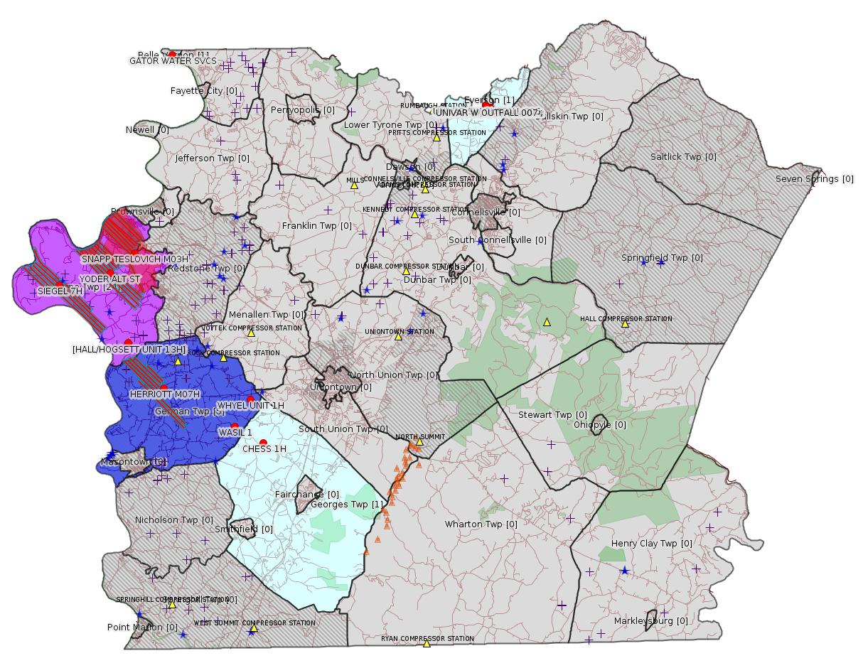
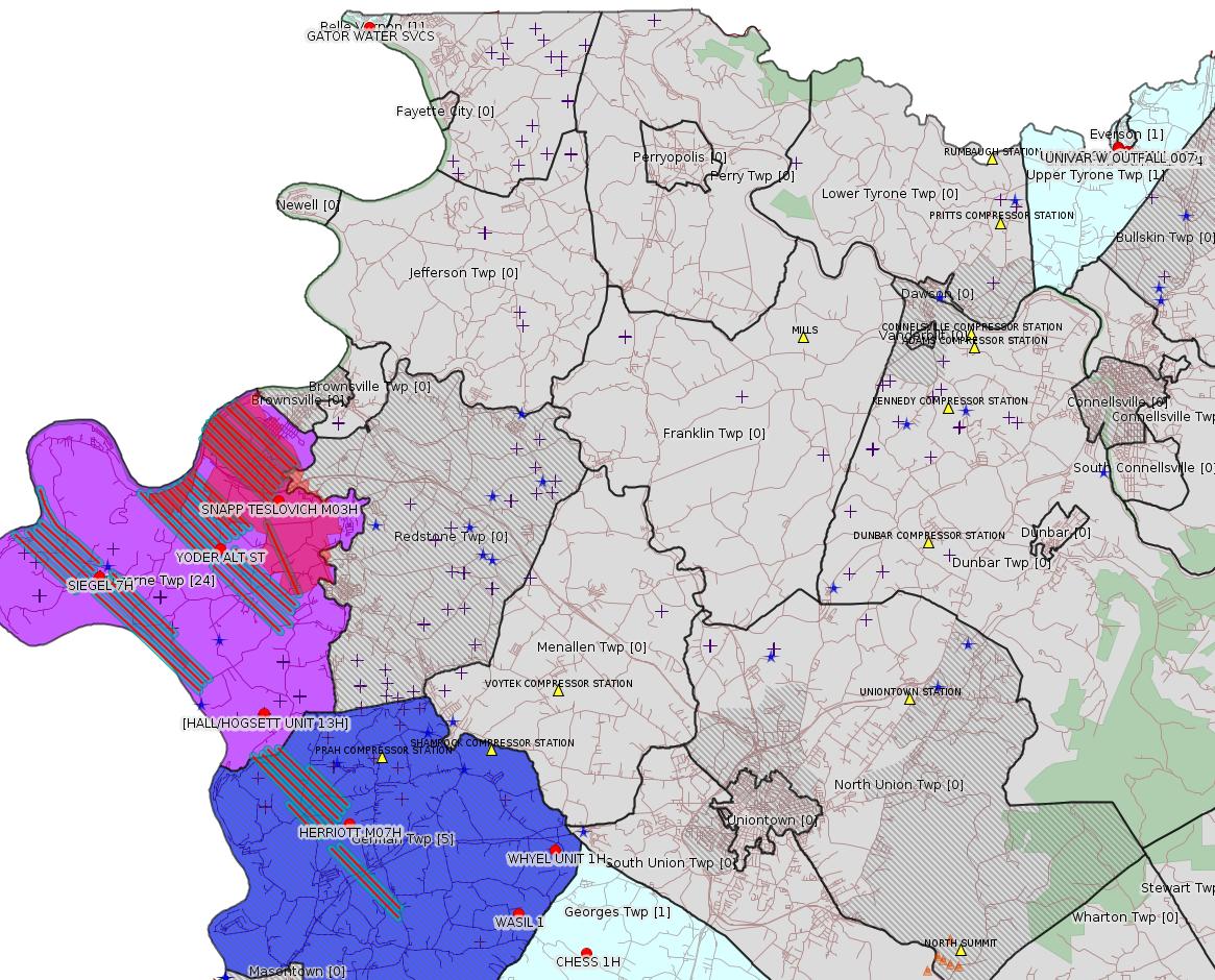
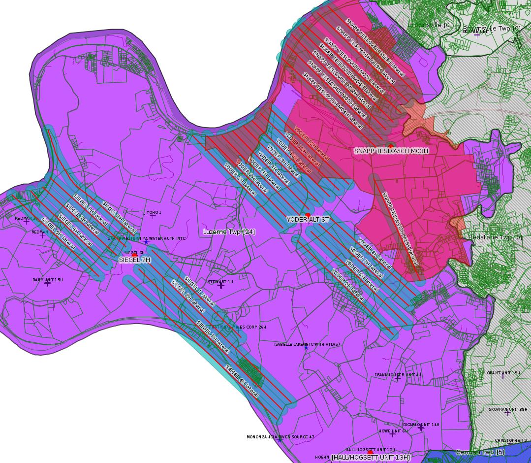
Map
Key
Red dots: items in this permit list with an exact location.
Blue stars: Marcellus Gas Well Water Sources.
Where well laterals are mapped they show in red; a 400-foot buffer surrounding the lateral shows in blue (lavender where it overlaps a mapped mineral tract).
Where mineral tracts are mapped, they show in pink. Mineral tracts can overlap; the overlap will show in red. The precise meaning of "mineral tract" is not clear.
Municipality shading: number of "facilities", with each well counting separately
(includes the red dots):
gray: 0
pale turquoise: 1
turquoise: 2
pale blue: 3
middle blue: 4
dark blue: 5
dark purple: 7
purple: 24
(Color coding may differ from one issue to the next.)
(Note if a project spans multiple municipalities -- e.g. a pipeline -- it will show in the count for each municipality.)
The number of facilities also follows the municipality name in brackets.
Municipality counts are based on the way the permit is listed by DEP; DEP has been known to get a municipality wrong.
Locations in brackets identify a precise location used to locate a surrogate for the actual site being permitted (e.g. locating a well pad or pipeline by the known location of a well.) Locations labeled beginning with "~" and ending in "[?]" are approximate and speculative based on inferences using on-line property and lease records. These are marked in the text as "[Approximate, Speculative]
Cross-hatching: Environmental Justice Areas
Yellow triangles: Compressor Stations
Orange triangles: Storage Field Wells (currently Dominion North Summit Storage Field)
Crosses: SPUD Unconventional well permits
Green: "Natural areas", e.g. state game lands, state forests
Yellow triangles: Compressor Stations
Orange triangles: Storage Field Wells (currently Dominion North Summit Storage Field)
Crosses: SPUD Unconventional well permits
Green: "Natural areas", e.g. state game lands, state forests
More Maps
 |
 |
Source: Pennsylvania Bulletin
[No Activity]
-------------------------
Source: eNOTICE
(+ PA
Oil and Gas Mapping, Well
Pad Report.) Well Details via Data
Portal Services: Oil and Gas Wells All (ID: 3).
Please see the Disclaimer below regarding Parcel Id data.
Authorization ID: 1288638
Permit number: PAR236137
Site: UNIVAR SOLUTIONS USA INC EVERSON PLANT
Client: UNIVAR SOLUTIONS USA INC
Authorization type: PAG-03 Discharge of Stormwater Assoc w Industrial Activities
Application type: Transfer
Authorization is for: FACILITY
Date received: 09/03/2019
Status: Pending
Permit Decision Guarantee Applies?: No
Sub-Facilities for Authorization:
Sub-Facility ID Sub-Facility Name Description
1110331 SW OUTFALL 001 Discharge Point
Location: 40.085978,-79.58585
Map URL: <http://www.openstreetmap.org/?mlat=40.085978&mlon=-79.58585#map=15/40.085978/-79.58585>
1110723 SW OUTFALL 002 Discharge Point
Location: 40.085964,-79.586283
Map URL: <http://www.openstreetmap.org/?mlat=40.085964&mlon=-79.586283#map=15/40.085964/-79.586283>
1110724 SW OUTFALL 003 Discharge Point
Location: 40.085864,-79.587031
Map URL: <http://www.openstreetmap.org/?mlat=40.085864&mlon=-79.587031#map=15/40.085864/-79.587031>
1110725 SW OUTFALL 004 Discharge Point
Location: 40.085828,-79.587653
Map URL: <http://www.openstreetmap.org/?mlat=40.085828&mlon=-79.587653#map=15/40.085828/-79.587653>
1110726 SW OUTFALL 005 Discharge Point
Location: 40.087217,-79.589686
Map URL: <http://www.openstreetmap.org/?mlat=40.087217&mlon=-79.589686#map=15/40.087217/-79.589686>
1110727 SW OUTFALL 006 Discharge Point
Location: 40.087258,-79.589569
Map URL: <http://www.openstreetmap.org/?mlat=40.087258&mlon=-79.589569#map=15/40.087258/-79.589569>
1110728 SW OUTFALL 007 Discharge Point
Location: 40.086547,-79.589419
Map URL: <http://www.openstreetmap.org/?mlat=40.086547&mlon=-79.589419#map=15/40.086547/-79.589419>
Permit Review Notes:
Date Review Note
9/18/2019 The permit application package is complete, has been accepted, and is undergoing technical review.
<https://www.ahs.dep.pa.gov/eFACTSWeb/searchResults_singleAuth.aspx?AuthID=1288638>
Site Programs:
Air Quality
Clean Water
Waste Management
Water Planning and Conservation
Site Municipalities:
Bullskin Twp [Incorrect -jr], Fayette County
Presumed Parcel Ids: 10040079 (outfalls 1-4), 39070208 (outfalls 5-7)
[See Notes.]
---
Authorization ID: 1288451
Permit number:
Site: HALL/HOGSETT UNIT WELL SITES ESCGP-EXPEDITED
Client: CHEVRON APPALACHIA LLC
Authorization type: Residual Waste Processing
Application type: New
Authorization is for: FACILITY
Date received: 09/09/2019
Status: Issued on 9/17/2019
Permit Decision Guarantee Applies?: No
Sub-Facilities for Authorization:
Sub-Facility ID Sub-Facility Name Description
1294762 HALL-HOGSETT ALT RW Residual Waste Processing Locations
Permit Review Notes:
Date Review Note
9/17/2019 The technical review and decision review are complete and either the permit decision and/or permit issuance are forthcoming.
9/17/2019 The permit application package is complete, has been accepted, and is undergoing technical review.
<https://www.ahs.dep.pa.gov/eFACTSWeb/searchResults_singleAuth.aspx?AuthID=1288451>
Site Programs:
Oil & Gas
Site Municipalities:
German Twp [Incorrect -jr], Fayette County
Luzerne Twp, Fayette County
Application Document:
<https://www.ahs.dep.pa.gov/eSubmissionsDocs/DownloadESubmissionDocument.ashx?enc=MOpmV6IzBtmToVjqF07C9dqiAcC2oWVcqFpVSQ3KsOg%3d>
Associated Well API: 051-24580
Original Authorization ID: 1174721
[See Notes.]
Well Details [for HALL/HOGSETT UNIT 13H]:
Permit Number: 051-24580
Well Name: HALL/HOGSETT UNIT 13H
Unconventional Well: Y
Well Configuration: Horizontal Well
Well Type: GAS
Well Status: Regulatory Inactive Status
Coal Association: Coal
Conservation Well: Y
Primary Facility ID: 764261
Site ID: 736604
Site Name: HALL/HOGSETT UNIT WELL SITES ESCGP-EXPEDITED
Well Pad ID: 145470
Well Pad Name: HALL/HOGSETT UNIT
Storage Field:
Operator: CHEVRON APPALACHIA LLC
Operator Number: OGO-39307
Permit Date: 2013-04-30
Permit Date Expires: 2014-04-30
SPUD Date: 2013-05-17
Date Plugged:
UIC ID:
UIC Type:
Surface Elevation: 1006
County: Fayette
Municipality: Luzerne Twp
Location: 39.929328,-79.908822
Map URL: <http://www.openstreetmap.org/?mlat=39.929328&mlon=-79.908822#map=15/39.929328/-79.908822>
Presumed Parcel Id: 19320034
---
Authorization ID: 1288324
Permit number: 051-24449
Site: WHYEL UNIT PREVIOUSLY SUMEY 1H ESCGP-EXPEDITED
Client: INR OPR LLC
Authorization type: Drill & Operate Well Permit Inactive Status
Application type: New
Authorization is for: FACILITY
Date received: 09/12/2019
Status: Pending
Permit Decision Guarantee Applies?: No
Sub-Facilities for Authorization:
Sub-Facility ID Sub-Facility Name Description
1079520 WHYEL UNIT 1H Well
1047049 WHYEL UNIT 1H Well
Permit Review Notes:
Date Review Note
9/16/2019 The permit application package is complete, has been accepted, and is undergoing technical review.
<https://www.ahs.dep.pa.gov/eFACTSWeb/searchResults_singleAuth.aspx?AuthID=1288324>
Site Programs:
Oil & Gas
Site Municipalities:
German Twp, Fayette County
Well Details:
Permit Number: 051-24449
Well Name: WHYEL UNIT 1H
Unconventional Well: Y
Well Configuration: Horizontal Well
Well Type: GAS
Well Status: Regulatory Inactive Status
Coal Association: NonCoal
Conservation Well: N
Primary Facility ID: 743725
Site ID: 749115
Site Name: WHYEL UNIT PREVIOUSLY SUMEY 1H ESCGP-EXPEDITED
Well Pad ID: 147078
Well Pad Name: WHYEL WELL PAD
Storage Field:
Operator: INR OPR LLC
Operator Number: OGO-51036
Permit Date: 2011-08-16
Permit Date Expires: 2013-06-29
SPUD Date: 2012-07-12
Date Plugged:
UIC ID:
UIC Type:
Surface Elevation: 1290
County: Fayette
Municipality: German Twp
Location: 39.889344,-79.801681
Map URL: <http://www.openstreetmap.org/?mlat=39.889344&mlon=-79.801681#map=15/39.889344/-79.801681>
Presumed Parcel Id: 15290036
---
Authorization ID: 1288323
Permit number: 051-24448
Site: WASIL 1 WELL PAD ESCGP-EXPEDITED
Client: INR OPR LLC
Authorization type: Drill & Operate Well Permit Inactive Status
Application type: New
Authorization is for: FACILITY
Date received: 09/12/2019
Status: Pending
Permit Decision Guarantee Applies?: No
Sub-Facilities for Authorization:
Sub-Facility ID Sub-Facility Name Description
1046766 WASIL 1 Well
Permit Review Notes:
Date Review Note
9/16/2019 The permit application package is complete, has been accepted, and is undergoing technical review.
<https://www.ahs.dep.pa.gov/eFACTSWeb/searchResults_singleAuth.aspx?AuthID=1288323>
Site Programs:
Oil & Gas
Site Municipalities:
German Twp, Fayette County
Well Details:
Permit Number: 051-24448
Well Name: WASIL 1
Unconventional Well: N
Well Configuration: Vertical Well
Well Type: GAS
Well Status: Regulatory Inactive Status
Coal Association: NonCoal
Conservation Well: Y
Primary Facility ID: 743583
Site ID: 749854
Site Name: WASIL 1 WELL PAD ESCGP-EXPEDITED
Well Pad ID: 0
Well Pad Name:
Storage Field:
Operator: INR OPR LLC
Operator Number: OGO-51036
Permit Date: 2011-08-29
Permit Date Expires: 2012-08-29
SPUD Date: 2012-07-20
Date Plugged:
UIC ID:
UIC Type:
Surface Elevation: 1228
County: Fayette
Municipality: German Twp
Location: 39.871472,-79.815522
Map URL: <http://www.openstreetmap.org/?mlat=39.871472&mlon=-79.815522#map=15/39.871472/-79.815522>
Presumed Parcel Id: 1536004304
---
Authorization ID: 1286993
Permit number:
Site: YODER WELL PAD ESCGP-2 EXPEDITED
Client: CHEVRON APPALACHIA LLC
Authorization type: Temporary Storage
Application type: New
Authorization is for: FACILITY
Date received: 09/04/2019
Status: Issued on 9/5/2019
Permit Decision Guarantee Applies?: No
Sub-Facilities for Authorization:
Sub-Facility ID Sub-Facility Name Description
1293921 YODER ALT ST Temporary Storage Structures
Permit Review Notes:
Date Review Note
9/5/2019 The technical review and decision review are complete and either the permit decision and/or permit issuance are forthcoming.
9/4/2019 The permit application package is complete, has been accepted, and is undergoing technical review.
<https://www.ahs.dep.pa.gov/eFACTSWeb/searchResults_singleAuth.aspx?AuthID=1286993>
Site Programs:
Oil & Gas
Site Municipalities:
Luzerne Twp, Fayette County
Authorization ID: 1285335
Permit number: GP042607219-004
Site: GATOR WATER SVCS
Client: GATOR WATER SVCS
Authorization type: GP-04 Intake & Outfall Structures
Application type: New
Authorization is for: FACILITY
Date received: 08/27/2019
Status: Pending
Permit Decision Guarantee Applies?: No
Sub-Facilities for Authorization:
Sub-Facility ID Sub-Facility Name Description
1290477 WITHDRAWAL DISTRIBUTION Intake Structure
Location: 40.1246,-79.8666
Map URL: <http://www.openstreetmap.org/?mlat=40.1246&mlon=-79.8666#map=15/40.1246/-79.8666>
<https://www.ahs.dep.pa.gov/eFACTSWeb/searchResults_singleAuth.aspx?AuthID=1285335>
Site Programs:
Water Planning and Conservation
Site Municipalities:
Belle Vernon Boro, Fayette County
Presumed Parcel Id: 01040223
---
Authorization ID: 1285220
Permit number: 051-24646
Site: SIEGEL WELL PAD ESCGP-2 EXPEDITED
Client: CHEVRON APPALACHIA LLC
Authorization type: Drill & Operate Well Permit (Unconventional)
Application type: Modification
Authorization is for: FACILITY
Date received: 08/26/2019
Status: Issued on 9/17/2019
Permit Decision Guarantee Applies?: No
Sub-Facilities for Authorization:
Sub-Facility ID Sub-Facility Name Description
1294702 SIEGEL 7H Well
Permit Review Notes:
Date Review Note
9/11/2019 The technical review and decision review are complete and either the permit decision and/or permit issuance are forthcoming.
8/26/2019 The permit application package is complete, has been accepted, and is undergoing technical review.
<https://www.ahs.dep.pa.gov/eFACTSWeb/searchResults_singleAuth.aspx?AuthID=1285220>
Site Programs:
Environmental Cleanup & Brownfields
Oil & Gas
Site Municipalities:
Luzerne Twp, Fayette County
Well Details:
Permit Number: 051-24646
Well Name: SIEGEL 7H
Unconventional Well: Y
Well Configuration: Horizontal Well
Well Type: GAS
Well Status: Active
Coal Association: Coal
Conservation Well: N
Primary Facility ID: 823794
Site ID: 790384
Site Name: SIEGEL WELL PAD ESCGP-2 EXPEDITED
Well Pad ID: 152926
Well Pad Name: SIEGEL 1
Storage Field:
Operator: CHEVRON APPALACHIA LLC
Operator Number: OGO-39307
Permit Date: 2018-02-23
Permit Date Expires: 2020-09-17
SPUD Date: 2018-04-02
Date Plugged:
UIC ID:
UIC Type:
Surface Elevation: 1173
County: Fayette
Municipality: Luzerne Twp
Location: 39.968956,-79.968994
Map URL: <http://www.openstreetmap.org/?mlat=39.968956&mlon=-79.968994#map=15/39.968956/-79.968994>
OG WELLS PERMIT DOCS:
2018-02-26: Final Permit Documents, Name: 1212440 (for Authorization: 1212440):
<http://www.depgis.state.pa.us/pdfHandler/pdFHandler.ashx?Doc=NTYzOTU3&ext=PDF>
2019-06-11: Final Permit Documents, Name: Auth No. 1270809 (for Authorization: 1270809):
<http://www.depgis.state.pa.us/pdfHandler/pdFHandler.ashx?Doc=ODM4MDUy&ext=PDF>
2019-09-17: Final Permit Documents, Name: Auth No. 1285220 (for Authorization: 1285220):
<http://www.depgis.state.pa.us/pdfHandler/pdFHandler.ashx?Doc=OTI1ODAx&ext=PDF>
Electronically Submitted Records:
2019-06-11: Submission for Authorization 1270809
Pennsylvania Natural Diversity Inventory Form: Siegel PNDI.pdf
<http://www.depgis.state.pa.us/eWellDocHandler/pdFHandler.ashx?Doc=ODIwNzI4&ext=PDF>
Well Cross-Section Diagram: Siegel 7H Page 4.pdf
<http://www.depgis.state.pa.us/eWellDocHandler/pdFHandler.ashx?Doc=ODIwNzMy&ext=PDF>
Well Permit Application - Coal Module: Siegel Coal Module.pdf
<http://www.depgis.state.pa.us/eWellDocHandler/pdFHandler.ashx?Doc=ODIwNzMz&ext=PDF>
Coal and Gas Resource Coord Act - Section 7 Exception: Siegel Waiver Request Section 7.pdf
<http://www.depgis.state.pa.us/eWellDocHandler/pdFHandler.ashx?Doc=ODI0MzMx&ext=PDF>
Permit Application to Drill and Operate a Well: Siegel 7H_Drill Permit Application.pdf
<http://www.depgis.state.pa.us/eWellDocHandler/pdFHandler.ashx?Doc=ODI0NzY4&ext=PDF>
Interested Party Notification: Siegel 7H_Record of Notification.pdf
<http://www.depgis.state.pa.us/eWellDocHandler/pdFHandler.ashx?Doc=ODQwNDcy&ext=PDF>
Location Plat: 143-781-Well Plat 7H-pages1-2-3_3702.dwg
<http://www.depgis.state.pa.us/eWellDocHandler/pdFHandler.ashx?Doc=ODU2MzY1&ext=PDF>
Electronic Submission Docket: 1929165.pdf
<http://www.depgis.state.pa.us/eWellDocHandler/pdFHandler.ashx?Doc=ODU2MzY3&ext=PDF>
2019-09-17: Submission for Authorization 1285220
Pennsylvania Natural Diversity Inventory Form: Siegel PNDI.pdf
<http://www.depgis.state.pa.us/eWellDocHandler/pdFHandler.ashx?Doc=OTI4NTky&ext=PDF>
Permit Application to Drill and Operate a Well: Siegel 7H_Signed application.pdf
<http://www.depgis.state.pa.us/eWellDocHandler/pdFHandler.ashx?Doc=OTI4NTkz&ext=PDF>
Location Plat: 143-781-Well Plat 7H-pages1-2-3_3702.dwg
<http://www.depgis.state.pa.us/eWellDocHandler/pdFHandler.ashx?Doc=OTI4NTk0&ext=PDF>
Coal and Gas Resource Coord Act - Section 7 Exception: Siegel Waiver Request Section 7.pdf
<http://www.depgis.state.pa.us/eWellDocHandler/pdFHandler.ashx?Doc=OTI4NTk2&ext=PDF>
Well Cross-Section Diagram: Siegel Pad A_07H_Page 4.pdf
<http://www.depgis.state.pa.us/eWellDocHandler/pdFHandler.ashx?Doc=OTI4NTk3&ext=PDF>
Well Permit Application - Coal Module: Siegel Coal Module_Modification.pdf
<http://www.depgis.state.pa.us/eWellDocHandler/pdFHandler.ashx?Doc=OTI4NTk4&ext=PDF>
Interested Party Notification: Siegel 7H_Interested Party_Mod.pdf
<http://www.depgis.state.pa.us/eWellDocHandler/pdFHandler.ashx?Doc=OTMwMjUx&ext=PDF>
Electronic Submission Docket: 1999340.pdf
<http://www.depgis.state.pa.us/eWellDocHandler/pdFHandler.ashx?Doc=OTMxMDM5&ext=PDF>
2018-02-26: Submission for Authorization 1212440
Interested Party Notification: Siegel Affidavit of Non-Delivery Foster.pdf
<http://www.depgis.state.pa.us/eWellDocHandler/pdFHandler.ashx?Doc=NDQ5MDI4&ext=PDF>
Interested Party Notification: Siegel Affidavit of Non-Delivery Foster.pdf
<http://www.depgis.state.pa.us/eWellDocHandler/pdFHandler.ashx?Doc=NDQ5MDI5&ext=PDF>
Interested Party Notification: Siegel Affidavit of Non-Delivery Foster.pdf
<http://www.depgis.state.pa.us/eWellDocHandler/pdFHandler.ashx?Doc=NDQ5MDMw&ext=PDF>
Interested Party Notification: Siegel Affidavit of Non-Delivery Foster.pdf
<http://www.depgis.state.pa.us/eWellDocHandler/pdFHandler.ashx?Doc=NDQ5MDMx&ext=PDF>
Interested Party Notification: Siegel Affidavit of Non-Delivery Foster.pdf
<http://www.depgis.state.pa.us/eWellDocHandler/pdFHandler.ashx?Doc=NDQ5MDMy&ext=PDF>
Interested Party Notification: Siegel Affidavit of Non-Delivery Foster.pdf
<http://www.depgis.state.pa.us/eWellDocHandler/pdFHandler.ashx?Doc=NDQ5MDMz&ext=PDF>
Interested Party Notification: Siegel Affidavit of Non-Delivery Foster.pdf
<http://www.depgis.state.pa.us/eWellDocHandler/pdFHandler.ashx?Doc=NDQ5MDM0&ext=PDF>
Interested Party Notification: Siegel Affidavit of Non-Delivery Franks.pdf
<http://www.depgis.state.pa.us/eWellDocHandler/pdFHandler.ashx?Doc=NDQ5MDM1&ext=PDF>
Interested Party Notification: Siegel Affidavit of Non-Delivery Franks.pdf
<http://www.depgis.state.pa.us/eWellDocHandler/pdFHandler.ashx?Doc=NDQ5MDM2&ext=PDF>
Location Plat: 143-781-Well Plat 7H-pages1-2-3_3702.dwg
<http://www.depgis.state.pa.us/eWellDocHandler/pdFHandler.ashx?Doc=NDQ5MDM3&ext=PDF>
Pennsylvania Natural Diversity Inventory Form: Siegel PNDI.pdf
<http://www.depgis.state.pa.us/eWellDocHandler/pdFHandler.ashx?Doc=NDQ5MDM4&ext=PDF>
Coal and Gas Resource Coord Act - Section 7 Exception: Siegel 1H-9H Waiver Request Section 7.pdf
<http://www.depgis.state.pa.us/eWellDocHandler/pdFHandler.ashx?Doc=NDQ5MDM5&ext=PDF>
Well Cross-Section Diagram: Siegel 7H Page 4.pdf
<http://www.depgis.state.pa.us/eWellDocHandler/pdFHandler.ashx?Doc=NDQ5MDQw&ext=PDF>
Permit Application to Drill and Operate a Well: 1640181.pdf
<http://www.depgis.state.pa.us/eWellDocHandler/pdFHandler.ashx?Doc=NDQ5ODIx&ext=PDF>
Presumed Parcel Id: 19240018
---
Authorization ID: 1285219
Permit number: 051-24645
Site: SIEGEL WELL PAD ESCGP-2 EXPEDITED
Client: CHEVRON APPALACHIA LLC
Authorization type: Drill & Operate Well Permit (Unconventional)
Application type: Modification
Authorization is for: FACILITY
Date received: 08/26/2019
Status: Issued on 9/17/2019
Permit Decision Guarantee Applies?: No
Sub-Facilities for Authorization:
Sub-Facility ID Sub-Facility Name Description
1294434 WELLBORE SURFACE HOLE LOCATION Well
Permit Review Notes:
Date Review Note
9/11/2019 The technical review and decision review are complete and either the permit decision and/or permit issuance are forthcoming.
8/26/2019 The permit application package is complete, has been accepted, and is undergoing technical review.
<https://www.ahs.dep.pa.gov/eFACTSWeb/searchResults_singleAuth.aspx?AuthID=1285219>
Site Programs:
Environmental Cleanup & Brownfields
Oil & Gas
Site Municipalities:
Luzerne Twp, Fayette County
Well Details:
Permit Number: 051-24645
Well Name: SIEGEL 6H
Unconventional Well: Y
Well Configuration: Horizontal Well
Well Type: GAS
Well Status: Active
Coal Association: Coal
Conservation Well: N
Primary Facility ID: 823793
Site ID: 790384
Site Name: SIEGEL WELL PAD ESCGP-2 EXPEDITED
Well Pad ID: 152926
Well Pad Name: SIEGEL 1
Storage Field:
Operator: CHEVRON APPALACHIA LLC
Operator Number: OGO-39307
Permit Date: 2018-02-20
Permit Date Expires: 2020-09-17
SPUD Date: 2018-04-02
Date Plugged:
UIC ID:
UIC Type:
Surface Elevation: 1173
County: Fayette
Municipality: Luzerne Twp
Location: 39.968914,-79.969061
Map URL: <http://www.openstreetmap.org/?mlat=39.968914&mlon=-79.969061#map=15/39.968914/-79.969061>
OG WELLS PERMIT DOCS:
2018-02-20: Final Permit Documents, Name: 1212439 (for Authorization: 1212439):
<http://www.depgis.state.pa.us/pdfHandler/pdFHandler.ashx?Doc=NTY1ODUw&ext=PDF>
2019-06-11: Final Permit Documents, Name: Auth No. 1270803 (for Authorization: 1270803):
<http://www.depgis.state.pa.us/pdfHandler/pdFHandler.ashx?Doc=ODM4MDE1&ext=PDF>
2019-09-17: Final Permit Documents, Name: Auth No. 1285219 (for Authorization: 1285219):
<http://www.depgis.state.pa.us/pdfHandler/pdFHandler.ashx?Doc=OTI1ODE4&ext=PDF>
Electronically Submitted Records:
2018-02-20: Submission for Authorization 1212439
Interested Party Notification: Siegel Affidavit of Non-Delivery Foster.pdf
<http://www.depgis.state.pa.us/eWellDocHandler/pdFHandler.ashx?Doc=NDQ5MDA5&ext=PDF>
Interested Party Notification: Siegel Affidavit of Non-Delivery Foster.pdf
<http://www.depgis.state.pa.us/eWellDocHandler/pdFHandler.ashx?Doc=NDQ5MDEw&ext=PDF>
Interested Party Notification: Siegel Affidavit of Non-Delivery Foster.pdf
<http://www.depgis.state.pa.us/eWellDocHandler/pdFHandler.ashx?Doc=NDQ5MDEx&ext=PDF>
Interested Party Notification: Siegel Affidavit of Non-Delivery Foster.pdf
<http://www.depgis.state.pa.us/eWellDocHandler/pdFHandler.ashx?Doc=NDQ5MDEy&ext=PDF>
Interested Party Notification: Siegel Affidavit of Non-Delivery Foster.pdf
<http://www.depgis.state.pa.us/eWellDocHandler/pdFHandler.ashx?Doc=NDQ5MDEz&ext=PDF>
Interested Party Notification: Siegel Affidavit of Non-Delivery Foster.pdf
<http://www.depgis.state.pa.us/eWellDocHandler/pdFHandler.ashx?Doc=NDQ5MDE0&ext=PDF>
Interested Party Notification: Siegel Affidavit of Non-Delivery Foster.pdf
<http://www.depgis.state.pa.us/eWellDocHandler/pdFHandler.ashx?Doc=NDQ5MDE1&ext=PDF>
Interested Party Notification: Siegel Affidavit of Non-Delivery Franks.pdf
<http://www.depgis.state.pa.us/eWellDocHandler/pdFHandler.ashx?Doc=NDQ5MDE2&ext=PDF>
Interested Party Notification: Siegel Affidavit of Non-Delivery Franks.pdf
<http://www.depgis.state.pa.us/eWellDocHandler/pdFHandler.ashx?Doc=NDQ5MDE3&ext=PDF>
Pennsylvania Natural Diversity Inventory Form: Siegel PNDI.pdf
<http://www.depgis.state.pa.us/eWellDocHandler/pdFHandler.ashx?Doc=NDQ5MDIw&ext=PDF>
Location Plat: 143-781-Well Plat 6H-pages1-2-3_3702.dwg
<http://www.depgis.state.pa.us/eWellDocHandler/pdFHandler.ashx?Doc=NDQ5MDIx&ext=PDF>
Coal and Gas Resource Coord Act - Section 7 Exception: Siegel 1H-9H Waiver Request Section 7.pdf
<http://www.depgis.state.pa.us/eWellDocHandler/pdFHandler.ashx?Doc=NDQ5MDIy&ext=PDF>
Well Cross-Section Diagram: Siegel 6H Page 4.pdf
<http://www.depgis.state.pa.us/eWellDocHandler/pdFHandler.ashx?Doc=NDQ5MDIz&ext=PDF>
Permit Application to Drill and Operate a Well: 1640174.pdf
<http://www.depgis.state.pa.us/eWellDocHandler/pdFHandler.ashx?Doc=NDQ5ODE4&ext=PDF>
2019-09-17: Submission for Authorization 1285219
Pennsylvania Natural Diversity Inventory Form: Siegel PNDI.pdf
<http://www.depgis.state.pa.us/eWellDocHandler/pdFHandler.ashx?Doc=OTI0MDY3&ext=PDF>
Well Permit Application - Coal Module: Siegel Coal Module_Modification.pdf
<http://www.depgis.state.pa.us/eWellDocHandler/pdFHandler.ashx?Doc=OTI4NDk0&ext=PDF>
Coal and Gas Resource Coord Act - Section 7 Exception: Siegel Waiver Request Section 7.pdf
<http://www.depgis.state.pa.us/eWellDocHandler/pdFHandler.ashx?Doc=OTI4NTA2&ext=PDF>
Permit Application to Drill and Operate a Well: Siegel 6H_Signed application.pdf
<http://www.depgis.state.pa.us/eWellDocHandler/pdFHandler.ashx?Doc=OTMwMjk4&ext=PDF>
Interested Party Notification: Siegel 6H_Interested Party_Mod.pdf
<http://www.depgis.state.pa.us/eWellDocHandler/pdFHandler.ashx?Doc=OTMwMjk5&ext=PDF>
Well Cross-Section Diagram: Siegel Pad A_06H_Page 4.pdf
<http://www.depgis.state.pa.us/eWellDocHandler/pdFHandler.ashx?Doc=OTMwMzAw&ext=PDF>
Location Plat: 143-781-Well Plat 6H-pages1-2-3_3702.dwg
<http://www.depgis.state.pa.us/eWellDocHandler/pdFHandler.ashx?Doc=OTMwMzAx&ext=PDF>
Electronic Submission Docket: 1998318.pdf
<http://www.depgis.state.pa.us/eWellDocHandler/pdFHandler.ashx?Doc=OTMxMDM0&ext=PDF>
2019-06-11: Submission for Authorization 1270803
Pennsylvania Natural Diversity Inventory Form: Siegel PNDI.pdf
<http://www.depgis.state.pa.us/eWellDocHandler/pdFHandler.ashx?Doc=ODIwNzEw&ext=PDF>
Well Cross-Section Diagram: Siegel 6H Page 4.pdf
<http://www.depgis.state.pa.us/eWellDocHandler/pdFHandler.ashx?Doc=ODIwNzE0&ext=PDF>
Well Permit Application - Coal Module: Siegel Coal Module.pdf
<http://www.depgis.state.pa.us/eWellDocHandler/pdFHandler.ashx?Doc=ODIwNzE1&ext=PDF>
Coal and Gas Resource Coord Act - Section 7 Exception: Siegel Waiver Request Section 7.pdf
<http://www.depgis.state.pa.us/eWellDocHandler/pdFHandler.ashx?Doc=ODI0MzE1&ext=PDF>
Permit Application to Drill and Operate a Well: Siegel 6H_Drill Permit Application.pdf
<http://www.depgis.state.pa.us/eWellDocHandler/pdFHandler.ashx?Doc=ODI0NzY0&ext=PDF>
Interested Party Notification: Siegel 6H_Record of Notification.pdf
<http://www.depgis.state.pa.us/eWellDocHandler/pdFHandler.ashx?Doc=ODQwNDY1&ext=PDF>
Location Plat: 143-781-Well Plat 6H-pages1-2-3_3702.dwg
<http://www.depgis.state.pa.us/eWellDocHandler/pdFHandler.ashx?Doc=ODU2MzYx&ext=PDF>
Electronic Submission Docket: 1929159.pdf
<http://www.depgis.state.pa.us/eWellDocHandler/pdFHandler.ashx?Doc=ODU2MzYz&ext=PDF>
---
Authorization ID: 1285218
Permit number: 051-24644
Site: SIEGEL WELL PAD ESCGP-2 EXPEDITED
Client: CHEVRON APPALACHIA LLC
Authorization type: Drill & Operate Well Permit (Unconventional)
Application type: Modification
Authorization is for: FACILITY
Date received: 08/26/2019
Status: Issued on 9/17/2019
Permit Decision Guarantee Applies?: No
Sub-Facilities for Authorization:
Sub-Facility ID Sub-Facility Name Description
1294491 WELLBORE SURFACE HOLE LOCATION Well
Permit Review Notes:
Date Review Note
9/11/2019 The technical review and decision review are complete and either the permit decision and/or permit issuance are forthcoming.
8/26/2019 The permit application package is complete, has been accepted, and is undergoing technical review.
<https://www.ahs.dep.pa.gov/eFACTSWeb/searchResults_singleAuth.aspx?AuthID=1285218>
Site Programs:
Environmental Cleanup & Brownfields
Oil & Gas
Site Municipalities:
Luzerne Twp, Fayette County
Well Details:
Permit Number: 051-24644
Well Name: SIEGEL 5H
Unconventional Well: Y
Well Configuration: Horizontal Well
Well Type: GAS
Well Status: Active
Coal Association: Coal
Conservation Well: N
Primary Facility ID: 823792
Site ID: 790384
Site Name: SIEGEL WELL PAD ESCGP-2 EXPEDITED
Well Pad ID: 152926
Well Pad Name: SIEGEL 1
Storage Field:
Operator: CHEVRON APPALACHIA LLC
Operator Number: OGO-39307
Permit Date: 2018-02-16
Permit Date Expires: 2020-09-17
SPUD Date: 2018-04-02
Date Plugged:
UIC ID:
UIC Type:
Surface Elevation: 1173
County: Fayette
Municipality: Luzerne Twp
Location: 39.968808,-79.969061
Map URL: <http://www.openstreetmap.org/?mlat=39.968808&mlon=-79.969061#map=15/39.968808/-79.969061>
OG WELLS PERMIT DOCS:
2018-02-20: Final Permit Documents, Name: 1212438 (for Authorization: 1212438):
<http://www.depgis.state.pa.us/pdfHandler/pdFHandler.ashx?Doc=NTY1ODQ4&ext=PDF>
2019-06-11: Final Permit Documents, Name: Auth No. 1270802 (for Authorization: 1270802):
<http://www.depgis.state.pa.us/pdfHandler/pdFHandler.ashx?Doc=ODM4MDAy&ext=PDF>
2019-09-17: Final Permit Documents, Name: Auth No. 1285218 (for Authorization: 1285218):
<http://www.depgis.state.pa.us/pdfHandler/pdFHandler.ashx?Doc=OTI1ODE2&ext=PDF>
Electronically Submitted Records:
2019-06-11: Submission for Authorization 1270802
Pennsylvania Natural Diversity Inventory Form: Siegel PNDI.pdf
<http://www.depgis.state.pa.us/eWellDocHandler/pdFHandler.ashx?Doc=ODIwNjYz&ext=PDF>
Well Cross-Section Diagram: Siegel 5H Page 4.pdf
<http://www.depgis.state.pa.us/eWellDocHandler/pdFHandler.ashx?Doc=ODIwNjY3&ext=PDF>
Well Permit Application - Coal Module: Siegel Coal Module.pdf
<http://www.depgis.state.pa.us/eWellDocHandler/pdFHandler.ashx?Doc=ODIwNjY4&ext=PDF>
Coal and Gas Resource Coord Act - Section 7 Exception: Siegel Waiver Request Section 7.pdf
<http://www.depgis.state.pa.us/eWellDocHandler/pdFHandler.ashx?Doc=ODI0MzA0&ext=PDF>
Permit Application to Drill and Operate a Well: Siegel 5H_Drill Permit Application.pdf
<http://www.depgis.state.pa.us/eWellDocHandler/pdFHandler.ashx?Doc=ODI0NzU5&ext=PDF>
Interested Party Notification: Siegel 5H_Record of Notification.pdf
<http://www.depgis.state.pa.us/eWellDocHandler/pdFHandler.ashx?Doc=ODQwNDYw&ext=PDF>
Location Plat: 143-781-Well Plat 5H-pages1-2-3_3702.dwg
<http://www.depgis.state.pa.us/eWellDocHandler/pdFHandler.ashx?Doc=ODU2MzUz&ext=PDF>
Electronic Submission Docket: 1929157.pdf
<http://www.depgis.state.pa.us/eWellDocHandler/pdFHandler.ashx?Doc=ODU2MzU1&ext=PDF>
2019-09-17: Submission for Authorization 1285218
Pennsylvania Natural Diversity Inventory Form: Siegel PNDI.pdf
<http://www.depgis.state.pa.us/eWellDocHandler/pdFHandler.ashx?Doc=OTI0MDQ5&ext=PDF>
Location Plat: 143-781-Well Plat 5H-pages1-2-3_3702.dwg
<http://www.depgis.state.pa.us/eWellDocHandler/pdFHandler.ashx?Doc=OTI0MDUw&ext=PDF>
Coal and Gas Resource Coord Act - Section 7 Exception: Siegel Waiver Request Section 7.pdf
<http://www.depgis.state.pa.us/eWellDocHandler/pdFHandler.ashx?Doc=OTI0MDUx&ext=PDF>
Permit Application to Drill and Operate a Well: Siegel 5H_Signed application.pdf
<http://www.depgis.state.pa.us/eWellDocHandler/pdFHandler.ashx?Doc=OTI3MzU3&ext=PDF>
Well Cross-Section Diagram: Siegel Pad A_05H_Page 4.pdf
<http://www.depgis.state.pa.us/eWellDocHandler/pdFHandler.ashx?Doc=OTI3MzY5&ext=PDF>
Well Permit Application - Coal Module: Siegel Coal Module_Modification.pdf
<http://www.depgis.state.pa.us/eWellDocHandler/pdFHandler.ashx?Doc=OTI4NDY3&ext=PDF>
Interested Party Notification: Siegel 5H_Interested Party_Mod.pdf
<http://www.depgis.state.pa.us/eWellDocHandler/pdFHandler.ashx?Doc=OTMwMjI3&ext=PDF>
Electronic Submission Docket: 1998317.pdf
<http://www.depgis.state.pa.us/eWellDocHandler/pdFHandler.ashx?Doc=OTMxMDI2&ext=PDF>
2018-02-20: Submission for Authorization 1212438
Interested Party Notification: Siegel Affidavit of Non-Delivery Foster.pdf
<http://www.depgis.state.pa.us/eWellDocHandler/pdFHandler.ashx?Doc=NDQ4OTg4&ext=PDF>
Interested Party Notification: Siegel Affidavit of Non-Delivery Foster.pdf
<http://www.depgis.state.pa.us/eWellDocHandler/pdFHandler.ashx?Doc=NDQ4OTky&ext=PDF>
Interested Party Notification: Siegel Affidavit of Non-Delivery Foster.pdf
<http://www.depgis.state.pa.us/eWellDocHandler/pdFHandler.ashx?Doc=NDQ4OTkz&ext=PDF>
Interested Party Notification: Siegel Affidavit of Non-Delivery Foster.pdf
<http://www.depgis.state.pa.us/eWellDocHandler/pdFHandler.ashx?Doc=NDQ4OTk0&ext=PDF>
Interested Party Notification: Siegel Affidavit of Non-Delivery Foster.pdf
<http://www.depgis.state.pa.us/eWellDocHandler/pdFHandler.ashx?Doc=NDQ4OTk1&ext=PDF>
Interested Party Notification: Siegel Affidavit of Non-Delivery Foster.pdf
<http://www.depgis.state.pa.us/eWellDocHandler/pdFHandler.ashx?Doc=NDQ4OTk2&ext=PDF>
Interested Party Notification: Siegel Affidavit of Non-Delivery Foster.pdf
<http://www.depgis.state.pa.us/eWellDocHandler/pdFHandler.ashx?Doc=NDQ4OTk3&ext=PDF>
Interested Party Notification: Siegel Affidavit of Non-Delivery Franks.pdf
<http://www.depgis.state.pa.us/eWellDocHandler/pdFHandler.ashx?Doc=NDQ4OTk4&ext=PDF>
Interested Party Notification: Siegel Affidavit of Non-Delivery Franks.pdf
<http://www.depgis.state.pa.us/eWellDocHandler/pdFHandler.ashx?Doc=NDQ4OTk5&ext=PDF>
Pennsylvania Natural Diversity Inventory Form: Siegel PNDI.pdf
<http://www.depgis.state.pa.us/eWellDocHandler/pdFHandler.ashx?Doc=NDQ5MDAx&ext=PDF>
Location Plat: 143-781-Well Plat 5H-pages1-2-3_3702.dwg
<http://www.depgis.state.pa.us/eWellDocHandler/pdFHandler.ashx?Doc=NDQ5MDAy&ext=PDF>
Coal and Gas Resource Coord Act - Section 7 Exception: Siegel 1H-9H Waiver Request Section 7.pdf
<http://www.depgis.state.pa.us/eWellDocHandler/pdFHandler.ashx?Doc=NDQ5MDAz&ext=PDF>
Well Cross-Section Diagram: Siegel 5H Page 4.pdf
<http://www.depgis.state.pa.us/eWellDocHandler/pdFHandler.ashx?Doc=NDQ5MDA0&ext=PDF>
Permit Application to Drill and Operate a Well: 1640042.pdf
<http://www.depgis.state.pa.us/eWellDocHandler/pdFHandler.ashx?Doc=NDQ5ODE1&ext=PDF>
---
Authorization ID: 1285217
Permit number: 051-24647
Site: SIEGEL WELL PAD ESCGP-2 EXPEDITED
Client: CHEVRON APPALACHIA LLC
Authorization type: Drill & Operate Well Permit (Unconventional)
Application type: Modification
Authorization is for: FACILITY
Date received: 08/26/2019
Status: Issued on 9/17/2019
Permit Decision Guarantee Applies?: No
Sub-Facilities for Authorization:
Sub-Facility ID Sub-Facility Name Description
1294483 WELLBORE SURFACE HOLE LOCATION Well
Permit Review Notes:
Date Review Note
9/11/2019 The technical review and decision review are complete and either the permit decision and/or permit issuance are forthcoming.
8/26/2019 The permit application package is complete, has been accepted, and is undergoing technical review.
<https://www.ahs.dep.pa.gov/eFACTSWeb/searchResults_singleAuth.aspx?AuthID=1285217>
Site Programs:
Environmental Cleanup & Brownfields
Oil & Gas
Site Municipalities:
Luzerne Twp, Fayette County
Well Details:
Permit Number: 051-24647
Well Name: SIEGEL 8H
Unconventional Well: Y
Well Configuration: Horizontal Well
Well Type: GAS
Well Status: Active
Coal Association: Coal
Conservation Well: N
Primary Facility ID: 823795
Site ID: 790384
Site Name: SIEGEL WELL PAD ESCGP-2 EXPEDITED
Well Pad ID: 152926
Well Pad Name: SIEGEL 1
Storage Field:
Operator: CHEVRON APPALACHIA LLC
Operator Number: OGO-39307
Permit Date: 2018-02-23
Permit Date Expires: 2020-09-17
SPUD Date: 2018-04-02
Date Plugged:
UIC ID:
UIC Type:
Surface Elevation: 1173
County: Fayette
Municipality: Luzerne Twp
Location: 39.968997,-79.968928
Map URL: <http://www.openstreetmap.org/?mlat=39.968997&mlon=-79.968928#map=15/39.968997/-79.968928>
OG WELLS PERMIT DOCS:
2018-02-27: Final Permit Documents, Name: 1212441 (for Authorization: 1212441):
<http://www.depgis.state.pa.us/pdfHandler/pdFHandler.ashx?Doc=NTY0ODc0&ext=PDF>
2019-06-11: Final Permit Documents, Name: Auth No. 1270807 (for Authorization: 1270807):
<http://www.depgis.state.pa.us/pdfHandler/pdFHandler.ashx?Doc=ODM4MDA3&ext=PDF>
2019-09-17: Final Permit Documents, Name: Auth No. 1285217 (for Authorization: 1285217):
<http://www.depgis.state.pa.us/pdfHandler/pdFHandler.ashx?Doc=OTI1ODA3&ext=PDF>
Electronically Submitted Records:
2019-09-17: Submission for Authorization 1285217
Location Plat: 143-781-Well Plat 8H-pages1-2-3_3702.dwg
<http://www.depgis.state.pa.us/eWellDocHandler/pdFHandler.ashx?Doc=OTI0MDgx&ext=PDF>
Pennsylvania Natural Diversity Inventory Form: Siegel PNDI.pdf
<http://www.depgis.state.pa.us/eWellDocHandler/pdFHandler.ashx?Doc=OTI0MDg3&ext=PDF>
Permit Application to Drill and Operate a Well: Siegel 8H_Signed application.pdf
<http://www.depgis.state.pa.us/eWellDocHandler/pdFHandler.ashx?Doc=OTI3NDM5&ext=PDF>
Well Cross-Section Diagram: Siegel Pad A_08H_Page 4.pdf
<http://www.depgis.state.pa.us/eWellDocHandler/pdFHandler.ashx?Doc=OTI3NDQx&ext=PDF>
Coal and Gas Resource Coord Act - Section 7 Exception: Siegel Waiver Request Section 7.pdf
<http://www.depgis.state.pa.us/eWellDocHandler/pdFHandler.ashx?Doc=OTI4NTEz&ext=PDF>
Well Permit Application - Coal Module: Siegel Coal Module_Modification.pdf
<http://www.depgis.state.pa.us/eWellDocHandler/pdFHandler.ashx?Doc=OTI4NTE0&ext=PDF>
Interested Party Notification: Siegel 8H_Interested Party_Mod.pdf
<http://www.depgis.state.pa.us/eWellDocHandler/pdFHandler.ashx?Doc=OTMwMjU5&ext=PDF>
Electronic Submission Docket: 1998323.pdf
<http://www.depgis.state.pa.us/eWellDocHandler/pdFHandler.ashx?Doc=OTMxMDU0&ext=PDF>
2019-06-11: Submission for Authorization 1270807
Pennsylvania Natural Diversity Inventory Form: Siegel PNDI.pdf
<http://www.depgis.state.pa.us/eWellDocHandler/pdFHandler.ashx?Doc=ODIwNzM4&ext=PDF>
Well Cross-Section Diagram: Siegel 8H Page 4.pdf
<http://www.depgis.state.pa.us/eWellDocHandler/pdFHandler.ashx?Doc=ODIwNzQy&ext=PDF>
Well Permit Application - Coal Module: Siegel Coal Module.pdf
<http://www.depgis.state.pa.us/eWellDocHandler/pdFHandler.ashx?Doc=ODIwNzQz&ext=PDF>
Coal and Gas Resource Coord Act - Section 7 Exception: Siegel Waiver Request Section 7.pdf
<http://www.depgis.state.pa.us/eWellDocHandler/pdFHandler.ashx?Doc=ODI0MzQw&ext=PDF>
Permit Application to Drill and Operate a Well: Siegel 8H_Drill Permit Application.pdf
<http://www.depgis.state.pa.us/eWellDocHandler/pdFHandler.ashx?Doc=ODI0Nzcz&ext=PDF>
Interested Party Notification: Siegel 8H_Record of Notification.pdf
<http://www.depgis.state.pa.us/eWellDocHandler/pdFHandler.ashx?Doc=ODQwNDgy&ext=PDF>
Location Plat: 143-781-Well Plat 8H-pages1-2-3_3702.dwg
<http://www.depgis.state.pa.us/eWellDocHandler/pdFHandler.ashx?Doc=ODU2MzY5&ext=PDF>
Electronic Submission Docket: 1929166.pdf
<http://www.depgis.state.pa.us/eWellDocHandler/pdFHandler.ashx?Doc=ODU2Mzc0&ext=PDF>
2018-02-27: Submission for Authorization 1212441
Interested Party Notification: Siegel Affidavit of Non-Delivery Foster.pdf
<http://www.depgis.state.pa.us/eWellDocHandler/pdFHandler.ashx?Doc=NDQ5MDQ0&ext=PDF>
Interested Party Notification: Siegel Affidavit of Non-Delivery Foster.pdf
<http://www.depgis.state.pa.us/eWellDocHandler/pdFHandler.ashx?Doc=NDQ5MDQ1&ext=PDF>
Interested Party Notification: Siegel Affidavit of Non-Delivery Foster.pdf
<http://www.depgis.state.pa.us/eWellDocHandler/pdFHandler.ashx?Doc=NDQ5MDQ2&ext=PDF>
Interested Party Notification: Siegel Affidavit of Non-Delivery Foster.pdf
<http://www.depgis.state.pa.us/eWellDocHandler/pdFHandler.ashx?Doc=NDQ5MDUw&ext=PDF>
Interested Party Notification: Siegel Affidavit of Non-Delivery Foster.pdf
<http://www.depgis.state.pa.us/eWellDocHandler/pdFHandler.ashx?Doc=NDQ5MDUx&ext=PDF>
Interested Party Notification: Siegel Affidavit of Non-Delivery Foster.pdf
<http://www.depgis.state.pa.us/eWellDocHandler/pdFHandler.ashx?Doc=NDQ5MDUy&ext=PDF>
Interested Party Notification: Siegel Affidavit of Non-Delivery Foster.pdf
<http://www.depgis.state.pa.us/eWellDocHandler/pdFHandler.ashx?Doc=NDQ5MDUz&ext=PDF>
Interested Party Notification: Siegel Affidavit of Non-Delivery Franks.pdf
<http://www.depgis.state.pa.us/eWellDocHandler/pdFHandler.ashx?Doc=NDQ5MDU0&ext=PDF>
Interested Party Notification: Siegel Affidavit of Non-Delivery Franks.pdf
<http://www.depgis.state.pa.us/eWellDocHandler/pdFHandler.ashx?Doc=NDQ5MDU1&ext=PDF>
Pennsylvania Natural Diversity Inventory Form: Siegel PNDI.pdf
<http://www.depgis.state.pa.us/eWellDocHandler/pdFHandler.ashx?Doc=NDQ5MDU2&ext=PDF>
Location Plat: 143-781-Well Plat 8H-pages1-2-3_3702.dwg
<http://www.depgis.state.pa.us/eWellDocHandler/pdFHandler.ashx?Doc=NDQ5MDU3&ext=PDF>
Coal and Gas Resource Coord Act - Section 7 Exception: Siegel 1H-9H Waiver Request Section 7.pdf
<http://www.depgis.state.pa.us/eWellDocHandler/pdFHandler.ashx?Doc=NDQ5MDU4&ext=PDF>
Well Cross-Section Diagram: Siegel 8H Page 4.pdf
<http://www.depgis.state.pa.us/eWellDocHandler/pdFHandler.ashx?Doc=NDQ5MDU5&ext=PDF>
Permit Application to Drill and Operate a Well: 1640184.pdf
<http://www.depgis.state.pa.us/eWellDocHandler/pdFHandler.ashx?Doc=NDQ5ODMw&ext=PDF>
---
Authorization ID: 1285215
Permit number: 051-24648
Site: SIEGEL WELL PAD ESCGP-2 EXPEDITED
Client: CHEVRON APPALACHIA LLC
Authorization type: Drill & Operate Well Permit (Unconventional)
Application type: Modification
Authorization is for: FACILITY
Date received: 08/26/2019
Status: Issued on 9/17/2019
Permit Decision Guarantee Applies?: No
Sub-Facilities for Authorization:
Sub-Facility ID Sub-Facility Name Description
1294667 WELLBORE SURFACE HOLE LOCATION Well
Permit Review Notes:
Date Review Note
9/11/2019 The technical review and decision review are complete and either the permit decision and/or permit issuance are forthcoming.
8/26/2019 The permit application package is complete, has been accepted, and is undergoing technical review.
<https://www.ahs.dep.pa.gov/eFACTSWeb/searchResults_singleAuth.aspx?AuthID=1285215>
Site Programs:
Environmental Cleanup & Brownfields
Oil & Gas
Site Municipalities:
Luzerne Twp, Fayette County
Well Details:
Permit Number: 051-24648
Well Name: SIEGEL 9H
Unconventional Well: Y
Well Configuration: Horizontal Well
Well Type: GAS
Well Status: Active
Coal Association: Coal
Conservation Well: N
Primary Facility ID: 823796
Site ID: 790384
Site Name: SIEGEL WELL PAD ESCGP-2 EXPEDITED
Well Pad ID: 152926
Well Pad Name: SIEGEL 1
Storage Field:
Operator: CHEVRON APPALACHIA LLC
Operator Number: OGO-39307
Permit Date: 2018-02-23
Permit Date Expires: 2020-09-17
SPUD Date: 2018-04-02
Date Plugged:
UIC ID:
UIC Type:
Surface Elevation: 1173
County: Fayette
Municipality: Luzerne Twp
Location: 39.969036,-79.968861
Map URL: <http://www.openstreetmap.org/?mlat=39.969036&mlon=-79.968861#map=15/39.969036/-79.968861>
OG WELLS PERMIT DOCS:
2018-02-27: Final Permit Documents, Name: 1212442 (for Authorization: 1212442):
<http://www.depgis.state.pa.us/pdfHandler/pdFHandler.ashx?Doc=NTY0ODc4&ext=PDF>
2019-06-11: Final Permit Documents, Name: Auth No. 1270808 (for Authorization: 1270808):
<http://www.depgis.state.pa.us/pdfHandler/pdFHandler.ashx?Doc=ODM4MTMx&ext=PDF>
2019-09-17: Final Permit Documents, Name: Auth No. 1285215 (for Authorization: 1285215):
<http://www.depgis.state.pa.us/pdfHandler/pdFHandler.ashx?Doc=OTI1ODAz&ext=PDF>
Electronically Submitted Records:
2019-06-11: Submission for Authorization 1270808
Pennsylvania Natural Diversity Inventory Form: Siegel PNDI.pdf
<http://www.depgis.state.pa.us/eWellDocHandler/pdFHandler.ashx?Doc=ODIwNzUw&ext=PDF>
Well Cross-Section Diagram: Siegel 9H Page 4.pdf
<http://www.depgis.state.pa.us/eWellDocHandler/pdFHandler.ashx?Doc=ODIwNzU0&ext=PDF>
Well Permit Application - Coal Module: Siegel Coal Module.pdf
<http://www.depgis.state.pa.us/eWellDocHandler/pdFHandler.ashx?Doc=ODIwNzU1&ext=PDF>
Coal and Gas Resource Coord Act - Section 7 Exception: Siegel Waiver Request Section 7.pdf
<http://www.depgis.state.pa.us/eWellDocHandler/pdFHandler.ashx?Doc=ODI0MzUx&ext=PDF>
Permit Application to Drill and Operate a Well: Siegel 9H_Drill Permit Application.pdf
<http://www.depgis.state.pa.us/eWellDocHandler/pdFHandler.ashx?Doc=ODI0Nzgx&ext=PDF>
Interested Party Notification: Siegel 9H_Record of Notification.pdf
<http://www.depgis.state.pa.us/eWellDocHandler/pdFHandler.ashx?Doc=ODQwNDk2&ext=PDF>
Location Plat: 143-781-Well Plat 9H-pages1-2-3_3702.dwg
<http://www.depgis.state.pa.us/eWellDocHandler/pdFHandler.ashx?Doc=ODU2Mzc2&ext=PDF>
Electronic Submission Docket: 1929167.pdf
<http://www.depgis.state.pa.us/eWellDocHandler/pdFHandler.ashx?Doc=ODU2Mzc4&ext=PDF>
2018-02-27: Submission for Authorization 1212442
Interested Party Notification: Siegel Affidavit of Non-Delivery Foster.pdf
<http://www.depgis.state.pa.us/eWellDocHandler/pdFHandler.ashx?Doc=NDQ5MDY4&ext=PDF>
Interested Party Notification: Siegel Affidavit of Non-Delivery Foster.pdf
<http://www.depgis.state.pa.us/eWellDocHandler/pdFHandler.ashx?Doc=NDQ5MDY5&ext=PDF>
Interested Party Notification: Siegel Affidavit of Non-Delivery Foster.pdf
<http://www.depgis.state.pa.us/eWellDocHandler/pdFHandler.ashx?Doc=NDQ5MDcw&ext=PDF>
Interested Party Notification: Siegel Affidavit of Non-Delivery Foster.pdf
<http://www.depgis.state.pa.us/eWellDocHandler/pdFHandler.ashx?Doc=NDQ5MDcx&ext=PDF>
Interested Party Notification: Siegel Affidavit of Non-Delivery Foster.pdf
<http://www.depgis.state.pa.us/eWellDocHandler/pdFHandler.ashx?Doc=NDQ5MDcy&ext=PDF>
Interested Party Notification: Siegel Affidavit of Non-Delivery Foster.pdf
<http://www.depgis.state.pa.us/eWellDocHandler/pdFHandler.ashx?Doc=NDQ5MDcz&ext=PDF>
Interested Party Notification: Siegel Affidavit of Non-Delivery Foster.pdf
<http://www.depgis.state.pa.us/eWellDocHandler/pdFHandler.ashx?Doc=NDQ5MDc0&ext=PDF>
Interested Party Notification: Siegel Affidavit of Non-Delivery Franks.pdf
<http://www.depgis.state.pa.us/eWellDocHandler/pdFHandler.ashx?Doc=NDQ5MDc1&ext=PDF>
Interested Party Notification: Siegel Affidavit of Non-Delivery Franks.pdf
<http://www.depgis.state.pa.us/eWellDocHandler/pdFHandler.ashx?Doc=NDQ5MDc4&ext=PDF>
Location Plat: 143-781-Well Plat 9H-pages1-2-3_3702.dwg
<http://www.depgis.state.pa.us/eWellDocHandler/pdFHandler.ashx?Doc=NDQ5MDgy&ext=PDF>
Pennsylvania Natural Diversity Inventory Form: Siegel PNDI.pdf
<http://www.depgis.state.pa.us/eWellDocHandler/pdFHandler.ashx?Doc=NDQ5MDgz&ext=PDF>
Coal and Gas Resource Coord Act - Section 7 Exception: Siegel 1H-9H Waiver Request Section 7.pdf
<http://www.depgis.state.pa.us/eWellDocHandler/pdFHandler.ashx?Doc=NDQ5MDg0&ext=PDF>
Well Cross-Section Diagram: Siegel 9H Page 4.pdf
<http://www.depgis.state.pa.us/eWellDocHandler/pdFHandler.ashx?Doc=NDQ5MDg1&ext=PDF>
Permit Application to Drill and Operate a Well: 1640187.pdf
<http://www.depgis.state.pa.us/eWellDocHandler/pdFHandler.ashx?Doc=NDQ5ODMz&ext=PDF>
2019-09-17: Submission for Authorization 1285215
Location Plat: 143-781-Well Plat 9H-pages1-2-3_3702.dwg
<http://www.depgis.state.pa.us/eWellDocHandler/pdFHandler.ashx?Doc=OTI0MTA4&ext=PDF>
Pennsylvania Natural Diversity Inventory Form: Siegel PNDI.pdf
<http://www.depgis.state.pa.us/eWellDocHandler/pdFHandler.ashx?Doc=OTI0MTA5&ext=PDF>
Permit Application to Drill and Operate a Well: Siegel 9H_Signed application.pdf
<http://www.depgis.state.pa.us/eWellDocHandler/pdFHandler.ashx?Doc=OTI3NDUy&ext=PDF>
Well Cross-Section Diagram: Siegel Pad A_09H_Page 4.pdf
<http://www.depgis.state.pa.us/eWellDocHandler/pdFHandler.ashx?Doc=OTI3NDU0&ext=PDF>
Coal and Gas Resource Coord Act - Section 7 Exception: Siegel Waiver Request Section 7.pdf
<http://www.depgis.state.pa.us/eWellDocHandler/pdFHandler.ashx?Doc=OTI4NTIx&ext=PDF>
Well Permit Application - Coal Module: Siegel Coal Module_Modification.pdf
<http://www.depgis.state.pa.us/eWellDocHandler/pdFHandler.ashx?Doc=OTI4NTIy&ext=PDF>
Interested Party Notification: Siegel 9H_Interested Party_Mod.pdf
<http://www.depgis.state.pa.us/eWellDocHandler/pdFHandler.ashx?Doc=OTMwMjcw&ext=PDF>
Electronic Submission Docket: 1998325.pdf
<http://www.depgis.state.pa.us/eWellDocHandler/pdFHandler.ashx?Doc=OTMxMDYz&ext=PDF>
---
Authorization ID: 1284748
Permit number: 051-24719
Site: CHESS 1H ESCGP-EXPEDITED
Client: INR OPR LLC
Authorization type: Drill & Operate Well Permit (Conventional)
Application type: New
Authorization is for: FACILITY
Date received: 08/21/2019
Status: Pending
Permit Decision Guarantee Applies?: No
Sub-Facilities for Authorization:
Sub-Facility ID Sub-Facility Name Description
1292918 CHESS 1H Well
Permit Review Notes:
Date Review Note
9/17/2019 The technical review and decision review are complete and either the permit decision and/or permit issuance are forthcoming.
9/11/2019 Applicant has been issued a deficiency letter. If applicable, this application no longer qualifies for the Permit Decision Guarantee.
8/29/2019 Applicant has been issued a deficiency letter. If applicable, this application no longer qualifies for the Permit Decision Guarantee.
<https://www.ahs.dep.pa.gov/eFACTSWeb/searchResults_singleAuth.aspx?AuthID=1284748>
Site Programs:
Oil & Gas
Site Municipalities:
Georges Twp, Fayette County
Well Details:
Permit Number: 051-24719
Well Name: CHESS 1H
Unconventional Well: N
Well Configuration: Vertical Well
Well Type: GAS
Well Status: Active
Coal Association: Coal
Conservation Well: Y
Primary Facility ID: 836896
Site ID: 735899
Site Name: CHESS 1H ESCGP-EXPEDITED
Well Pad ID: 154471
Well Pad Name: CHESS 1
Storage Field:
Operator: INR OPR LLC
Operator Number: OGO-51036
Permit Date:
Permit Date Expires:
SPUD Date:
Date Plugged:
UIC ID:
UIC Type:
Surface Elevation: 1183
County: Fayette
Municipality: Georges Twp
Location: 39.859844,-79.7907
Map URL: <http://www.openstreetmap.org/?mlat=39.859844&mlon=-79.7907#map=15/39.859844/-79.7907>
OG WELLS PERMIT DOCS:
2019-09-20: Initial Submitted Documents, Name: 1284748 (for Authorization: 1284748):
<http://www.depgis.state.pa.us/pdfHandler/pdFHandler.ashx?Doc=OTI2ODky&ext=PDF>
---
Authorization ID: 1284565
Permit number: 051-24718
Site: SNAPP TESLOVICH WELL PAD A ESCGP3 ESG30705118-002
Client: CHEVRON APPALACHIA LLC
Authorization type: Drill & Operate Well Permit (Unconventional)
Application type: New
Authorization is for: FACILITY
Date received: 08/20/2019
Status: Pending
Permit Decision Guarantee Applies?: No
Sub-Facilities for Authorization:
Sub-Facility ID Sub-Facility Name Description
1292827 WELLBORE SURFACE HOLE LOCATION Well
Permit Review Notes:
Date Review Note
9/12/2019 The technical review and decision review are complete and either the permit decision and/or permit issuance are forthcoming.
8/20/2019 The permit application package is complete, has been accepted, and is undergoing technical review.
<https://www.ahs.dep.pa.gov/eFACTSWeb/searchResults_singleAuth.aspx?AuthID=1284565>
Site Programs:
Oil & Gas
Site Municipalities:
Luzerne Twp, Fayette County
Well Details:
Permit Number: 051-24718
Well Name: SNAPP TESLOVICH M03H
Unconventional Well: Y
Well Configuration: Vertical Well
Well Type: GAS
Well Status: Active
Coal Association: NonCoal
Conservation Well: N
Primary Facility ID: 836867
Site ID: 833740
Site Name: SNAPP TESLOVICH WELL PAD A ESCGP3 ESG30705118-002
Well Pad ID: 155747
Well Pad Name: SNAPP-TESLOVICH PAD A
Storage Field:
Operator: CHEVRON APPALACHIA LLC
Operator Number: OGO-39307
Permit Date: 2019-09-18
Permit Date Expires: 2020-09-18
SPUD Date:
Date Plugged:
UIC ID:
UIC Type:
Surface Elevation: 1100
County: Fayette
Municipality: Luzerne Twp
Location: 39.989956,-79.902525
Map URL: <http://www.openstreetmap.org/?mlat=39.989956&mlon=-79.902525#map=15/39.989956/-79.902525>
OG WELLS PERMIT DOCS:
2019-09-18: Other Permit Documents, Name: SNAPP TESLOVICH Coal Determination (for Authorization: 1284565):
<http://www.depgis.state.pa.us/pdfHandler/pdFHandler.ashx?Doc=OTIzNDc5&ext=PDF>
Electronically Submitted Records:
2019-09-18: Submission for Authorization 1284565
Pennsylvania Natural Diversity Inventory Form: Snapp Teslovich_PNDI.pdf
<http://www.depgis.state.pa.us/eWellDocHandler/pdFHandler.ashx?Doc=OTE4ODk5&ext=PDF>
Justification for Non-Coal Well: Snapp Teslovich Non-Coal Packet.pdf
<http://www.depgis.state.pa.us/eWellDocHandler/pdFHandler.ashx?Doc=OTE4OTAw&ext=PDF>
Location Plat: Snapp Teslovich - M03H Plat - 2019.08.15.dwg
<http://www.depgis.state.pa.us/eWellDocHandler/pdFHandler.ashx?Doc=OTIyMDgw&ext=PDF>
Pennsylvania Natural Diversity Inventory Support Document: PNDI Clearance.pdf
<http://www.depgis.state.pa.us/eWellDocHandler/pdFHandler.ashx?Doc=OTIyMDgx&ext=PDF>
Coordination of Well Location with Public Resources: COORDINATION_OF_A_WELL_LOCATION_WITH_PUBLIC_RESOURCES_Snapp Teslovich - M03H.pdf
<http://www.depgis.state.pa.us/eWellDocHandler/pdFHandler.ashx?Doc=OTIyMDky&ext=PDF>
Permit Application to Drill and Operate a Well: 1995530.pdf
<http://www.depgis.state.pa.us/eWellDocHandler/pdFHandler.ashx?Doc=OTIzODEx&ext=PDF>
Presumed Parcel Id: 19160028
[See Notes.]
---
Authorization ID: 1284564
Permit number: 051-24717
Site: SNAPP TESLOVICH WELL PAD A ESCGP3 ESG30705118-002
Client: CHEVRON APPALACHIA LLC
Authorization type: Drill & Operate Well Permit (Unconventional)
Application type: New
Authorization is for: FACILITY
Date received: 08/20/2019
Status: Pending
Permit Decision Guarantee Applies?: No
Sub-Facilities for Authorization:
Sub-Facility ID Sub-Facility Name Description
1292826 WELLBORE SURFACE HOLE LOCATION Well
Permit Review Notes:
Date Review Note
9/12/2019 The technical review and decision review are complete and either the permit decision and/or permit issuance are forthcoming.
9/9/2019 Applicant has been issued a deficiency letter. If applicable, this application no longer qualifies for the Permit Decision Guarantee.
8/20/2019 The permit application package is complete, has been accepted, and is undergoing technical review.
<https://www.ahs.dep.pa.gov/eFACTSWeb/searchResults_singleAuth.aspx?AuthID=1284564>
Site Programs:
Oil & Gas
Site Municipalities:
Luzerne Twp, Fayette County
Well Details:
Permit Number: 051-24717
Well Name: SNAPP TESLOVICH M02H
Unconventional Well: Y
Well Configuration: Vertical Well
Well Type: GAS
Well Status: Active
Coal Association: NonCoal
Conservation Well: N
Primary Facility ID: 836866
Site ID: 833740
Site Name: SNAPP TESLOVICH WELL PAD A ESCGP3 ESG30705118-002
Well Pad ID: 155747
Well Pad Name: SNAPP-TESLOVICH PAD A
Storage Field:
Operator: CHEVRON APPALACHIA LLC
Operator Number: OGO-39307
Permit Date: 2019-09-18
Permit Date Expires: 2020-09-18
SPUD Date:
Date Plugged:
UIC ID:
UIC Type:
Surface Elevation: 1100
County: Fayette
Municipality: Luzerne Twp
Location: 39.989947,-79.902578
Map URL: <http://www.openstreetmap.org/?mlat=39.989947&mlon=-79.902578#map=15/39.989947/-79.902578>
OG WELLS PERMIT DOCS:
2019-09-18: Final Permit Documents, Name: Authorization ID 1284564 (for Authorization: 1284564):
<http://www.depgis.state.pa.us/pdfHandler/pdFHandler.ashx?Doc=OTI2ODY5&ext=PDF>
2019-09-18: Other Permit Documents, Name: SNAPP TESLOVICH Coal Determination (for Authorization: 1284564):
<http://www.depgis.state.pa.us/pdfHandler/pdFHandler.ashx?Doc=OTIzMzUw&ext=PDF>
Electronically Submitted Records:
2019-09-18: Submission for Authorization 1284564
Pennsylvania Natural Diversity Inventory Form: Snapp Teslovich_PNDI.pdf
<http://www.depgis.state.pa.us/eWellDocHandler/pdFHandler.ashx?Doc=OTE4ODgy&ext=PDF>
Justification for Non-Coal Well: Snapp Teslovich Non-Coal Packet.pdf
<http://www.depgis.state.pa.us/eWellDocHandler/pdFHandler.ashx?Doc=OTE4ODgz&ext=PDF>
Pennsylvania Natural Diversity Inventory Support Document: PNDI Clearance.pdf
<http://www.depgis.state.pa.us/eWellDocHandler/pdFHandler.ashx?Doc=OTE4ODg0&ext=PDF>
Coordination of Well Location with Public Resources: COORDINATION_OF_A_WELL_LOCATION_WITH_PUBLIC_RESOURCES_Snapp Teslovich - M02H.pdf
<http://www.depgis.state.pa.us/eWellDocHandler/pdFHandler.ashx?Doc=OTIyMDYz&ext=PDF>
Location Plat: Snapp Teslovich - M02H Plat - 2019.09.09.dwg
<http://www.depgis.state.pa.us/eWellDocHandler/pdFHandler.ashx?Doc=OTQxNTEz&ext=PDF>
Permit Application to Drill and Operate a Well: 1995152.pdf
<http://www.depgis.state.pa.us/eWellDocHandler/pdFHandler.ashx?Doc=OTQxNTcz&ext=PDF>
Authorization ID: 1284022
Permit number: 051-24716
Site: SNAPP TESLOVICH WELL PAD A ESCGP3 ESG30705118-002
Client: CHEVRON APPALACHIA LLC
Authorization type: Drill & Operate Well Permit (Unconventional)
Application type: New
Authorization is for: FACILITY
Date received: 08/14/2019
Status: Pending
Permit Decision Guarantee Applies?: No
Sub-Facilities for Authorization:
Sub-Facility ID Sub-Facility Name Description
1292500 WELLBORE SURFACE HOLE LOCATION Well
Permit Review Notes:
Date Review Note
9/12/2019 The technical review and decision review are complete and either the permit decision and/or permit issuance are forthcoming.
9/9/2019 Applicant has been issued a deficiency letter. If applicable, this application no longer qualifies for the Permit Decision Guarantee.
8/16/2019 Applicant has been issued a deficiency letter. If applicable, this application no longer qualifies for the Permit Decision Guarantee.
<https://www.ahs.dep.pa.gov/eFACTSWeb/searchResults_singleAuth.aspx?AuthID=1284022>
Site Programs:
Oil & Gas
Site Municipalities:
Luzerne Twp, Fayette County
Well Details:
Permit Number: 051-24716
Well Name: SNAPP TESLOVICH M15H
Unconventional Well: Y
Well Configuration: Horizontal Well
Well Type: GAS
Well Status: Active
Coal Association: NonCoal
Conservation Well: N
Primary Facility ID: 836750
Site ID: 833740
Site Name: SNAPP TESLOVICH WELL PAD A ESCGP3 ESG30705118-002
Well Pad ID: 155747
Well Pad Name: SNAPP-TESLOVICH PAD A
Storage Field:
Operator: CHEVRON APPALACHIA LLC
Operator Number: OGO-39307
Permit Date: 2019-09-18
Permit Date Expires: 2020-09-18
SPUD Date:
Date Plugged:
UIC ID:
UIC Type:
Surface Elevation: 1100
County: Fayette
Municipality: Luzerne Twp
Location: 39.990031,-79.902594
Map URL: <http://www.openstreetmap.org/?mlat=39.990031&mlon=-79.902594#map=15/39.990031/-79.902594>
OG WELLS PERMIT DOCS:
2019-09-18: Final Permit Documents, Name: Authorization ID 1284022 (for Authorization: 1284022):
<http://www.depgis.state.pa.us/pdfHandler/pdFHandler.ashx?Doc=OTI2ODYx&ext=PDF>
2019-09-18: Other Permit Documents, Name: SNAPP TESLOVICH Coal Determination (for Authorization: 1284022):
<http://www.depgis.state.pa.us/pdfHandler/pdFHandler.ashx?Doc=OTIzMzQ4&ext=PDF>
Electronically Submitted Records:
2019-09-18: Submission for Authorization 1284022
Pennsylvania Natural Diversity Inventory Form: Snapp Teslovich_PNDI.pdf
<http://www.depgis.state.pa.us/eWellDocHandler/pdFHandler.ashx?Doc=OTExMTEw&ext=PDF>
Justification for Non-Coal Well: Snapp Teslovich Non-Coal Packet.pdf
<http://www.depgis.state.pa.us/eWellDocHandler/pdFHandler.ashx?Doc=OTExMTEx&ext=PDF>
Coordination of Well Location with Public Resources: COORDINATION_OF_A_WELL_LOCATION_WITH_PUBLIC_RESOURCES_Snapp Teslovich - M15H.pdf
<http://www.depgis.state.pa.us/eWellDocHandler/pdFHandler.ashx?Doc=OTE4NzAz&ext=PDF>
Pennsylvania Natural Diversity Inventory Support Document: PNDI Clearance.pdf
<http://www.depgis.state.pa.us/eWellDocHandler/pdFHandler.ashx?Doc=OTE5MjAy&ext=PDF>
Well Cross-Section Diagram: Page 4_Snapp Teslovich Pad A_M15H.pdf
<http://www.depgis.state.pa.us/eWellDocHandler/pdFHandler.ashx?Doc=OTE5NjY2&ext=PDF>
Location Plat: Snapp Teslovich - M15H Plat - 2019.09.09.dwg
<http://www.depgis.state.pa.us/eWellDocHandler/pdFHandler.ashx?Doc=OTQxNTQ4&ext=PDF>
Permit Application to Drill and Operate a Well: 1985280.pdf
<http://www.depgis.state.pa.us/eWellDocHandler/pdFHandler.ashx?Doc=OTQxNTgy&ext=PDF>
---
Authorization ID: 1284021
Permit number: 051-24715
Site: SNAPP TESLOVICH WELL PAD A ESCGP3 ESG30705118-002
Client: CHEVRON APPALACHIA LLC
Authorization type: Drill & Operate Well Permit (Unconventional)
Application type: New
Authorization is for: FACILITY
Date received: 08/14/2019
Status: Pending
Permit Decision Guarantee Applies?: No
Sub-Facilities for Authorization:
Sub-Facility ID Sub-Facility Name Description
1292499 WELLBORE SURFACE HOLE LOCATION Well
Permit Review Notes:
Date Review Note
9/12/2019 The technical review and decision review are complete and either the permit decision and/or permit issuance are forthcoming.
9/9/2019 Applicant has been issued a deficiency letter. If applicable, this application no longer qualifies for the Permit Decision Guarantee.
8/16/2019 Applicant has been issued a deficiency letter. If applicable, this application no longer qualifies for the Permit Decision Guarantee.
<https://www.ahs.dep.pa.gov/eFACTSWeb/searchResults_singleAuth.aspx?AuthID=1284021>
Site Programs:
Oil & Gas
Site Municipalities:
Luzerne Twp, Fayette County
Well Details:
Permit Number: 051-24715
Well Name: SNAPP TESLOVICH M12H
Unconventional Well: Y
Well Configuration: Horizontal Well
Well Type: GAS
Well Status: Active
Coal Association: NonCoal
Conservation Well: N
Primary Facility ID: 836749
Site ID: 833740
Site Name: SNAPP TESLOVICH WELL PAD A ESCGP3 ESG30705118-002
Well Pad ID: 155747
Well Pad Name: SNAPP-TESLOVICH PAD A
Storage Field:
Operator: CHEVRON APPALACHIA LLC
Operator Number: OGO-39307
Permit Date: 2019-09-18
Permit Date Expires: 2020-09-18
SPUD Date:
Date Plugged:
UIC ID:
UIC Type:
Surface Elevation: 1100
County: Fayette
Municipality: Luzerne Twp
Location: 39.99005,-79.902436
Map URL: <http://www.openstreetmap.org/?mlat=39.99005&mlon=-79.902436#map=15/39.99005/-79.902436>
OG WELLS PERMIT DOCS:
2019-09-18: Final Permit Documents, Name: Authorization ID 1284021 (for Authorization: 1284021):
<http://www.depgis.state.pa.us/pdfHandler/pdFHandler.ashx?Doc=OTI2ODUz&ext=PDF>
2019-09-18: Other Permit Documents, Name: SNAPP TESLOVICH Coal Determination (for Authorization: 1284021):
<http://www.depgis.state.pa.us/pdfHandler/pdFHandler.ashx?Doc=OTIzMzQw&ext=PDF>
Electronically Submitted Records:
2019-09-18: Submission for Authorization 1284021
Pennsylvania Natural Diversity Inventory Form: Snapp Teslovich_PNDI.pdf
<http://www.depgis.state.pa.us/eWellDocHandler/pdFHandler.ashx?Doc=OTExMDk1&ext=PDF>
Justification for Non-Coal Well: Snapp Teslovich Non-Coal Packet.pdf
<http://www.depgis.state.pa.us/eWellDocHandler/pdFHandler.ashx?Doc=OTExMDk2&ext=PDF>
Coordination of Well Location with Public Resources: COORDINATION_OF_A_WELL_LOCATION_WITH_PUBLIC_RESOURCES_Snapp Teslovich - M12H.pdf
<http://www.depgis.state.pa.us/eWellDocHandler/pdFHandler.ashx?Doc=OTE4NzAy&ext=PDF>
Pennsylvania Natural Diversity Inventory Support Document: PNDI Clearance.pdf
<http://www.depgis.state.pa.us/eWellDocHandler/pdFHandler.ashx?Doc=OTE5MTkz&ext=PDF>
Well Cross-Section Diagram: Page 4_Snapp Teslovich Pad A_M12H.pdf
<http://www.depgis.state.pa.us/eWellDocHandler/pdFHandler.ashx?Doc=OTE5NjYw&ext=PDF>
Location Plat: Snapp Teslovich - M12H Plat - 2019.09.09.dwg
<http://www.depgis.state.pa.us/eWellDocHandler/pdFHandler.ashx?Doc=OTQxNTQ0&ext=PDF>
Permit Application to Drill and Operate a Well: 1985276.pdf
<http://www.depgis.state.pa.us/eWellDocHandler/pdFHandler.ashx?Doc=OTQxNTc5&ext=PDF>
---
Authorization ID: 1284015
Permit number: 051-24714
Site: SNAPP TESLOVICH WELL PAD A ESCGP3 ESG30705118-002
Client: CHEVRON APPALACHIA LLC
Authorization type: Drill & Operate Well Permit (Unconventional)
Application type: New
Authorization is for: FACILITY
Date received: 08/14/2019
Status: Pending
Permit Decision Guarantee Applies?: No
Sub-Facilities for Authorization:
Sub-Facility ID Sub-Facility Name Description
1292498 WELLBORE SURFACE HOLE LOCATION Well
Permit Review Notes:
Date Review Note
9/12/2019 The technical review and decision review are complete and either the permit decision and/or permit issuance are forthcoming.
9/9/2019 Applicant has been issued a deficiency letter. If applicable, this application no longer qualifies for the Permit Decision Guarantee.
8/16/2019 Applicant has been issued a deficiency letter. If applicable, this application no longer qualifies for the Permit Decision Guarantee.
<https://www.ahs.dep.pa.gov/eFACTSWeb/searchResults_singleAuth.aspx?AuthID=1284015>
Site Programs:
Oil & Gas
Site Municipalities:
Luzerne Twp, Fayette County
Well Details:
Permit Number: 051-24714
Well Name: SNAPP TESLOVICH M04H
Unconventional Well: Y
Well Configuration: Horizontal Well
Well Type: GAS
Well Status: Active
Coal Association: NonCoal
Conservation Well: N
Primary Facility ID: 836748
Site ID: 833740
Site Name: SNAPP TESLOVICH WELL PAD A ESCGP3 ESG30705118-002
Well Pad ID: 155747
Well Pad Name: SNAPP-TESLOVICH PAD A
Storage Field:
Operator: CHEVRON APPALACHIA LLC
Operator Number: OGO-39307
Permit Date: 2019-09-18
Permit Date Expires: 2020-09-18
SPUD Date:
Date Plugged:
UIC ID:
UIC Type:
Surface Elevation: 1100
County: Fayette
Municipality: Luzerne Twp
Location: 39.989964,-79.902472
Map URL: <http://www.openstreetmap.org/?mlat=39.989964&mlon=-79.902472#map=15/39.989964/-79.902472>
OG WELLS PERMIT DOCS:
2019-09-18: Final Permit Documents, Name: Authorization ID 1284015 (for Authorization: 1284015):
<http://www.depgis.state.pa.us/pdfHandler/pdFHandler.ashx?Doc=OTI2ODUw&ext=PDF>
2019-09-18: Other Permit Documents, Name: SNAPP TESLOVICH Coal Determination (for Authorization: 1284015):
<http://www.depgis.state.pa.us/pdfHandler/pdFHandler.ashx?Doc=OTIzMzM2&ext=PDF>
Electronically Submitted Records:
2019-09-18: Submission for Authorization 1284015
Justification for Non-Coal Well: Snapp Teslovich Non-Coal Packet.pdf
<http://www.depgis.state.pa.us/eWellDocHandler/pdFHandler.ashx?Doc=OTEwOTIw&ext=PDF>
Pennsylvania Natural Diversity Inventory Form: Snapp Teslovich_PNDI.pdf
<http://www.depgis.state.pa.us/eWellDocHandler/pdFHandler.ashx?Doc=OTEwOTIx&ext=PDF>
Coordination of Well Location with Public Resources: COORDINATION_OF_A_WELL_LOCATION_WITH_PUBLIC_RESOURCES_Snapp Teslovich - M04H.pdf
<http://www.depgis.state.pa.us/eWellDocHandler/pdFHandler.ashx?Doc=OTE4Njkw&ext=PDF>
Pennsylvania Natural Diversity Inventory Support Document: PNDI Clearance.pdf
<http://www.depgis.state.pa.us/eWellDocHandler/pdFHandler.ashx?Doc=OTE5MDky&ext=PDF>
Well Cross-Section Diagram: Page 4_Snapp Teslovich Pad A_M04H.pdf
<http://www.depgis.state.pa.us/eWellDocHandler/pdFHandler.ashx?Doc=OTE5NTg5&ext=PDF>
Location Plat: Snapp Teslovich - M04H Plat - 2019.09.09.dwg
<http://www.depgis.state.pa.us/eWellDocHandler/pdFHandler.ashx?Doc=OTQxNTIw&ext=PDF>
Permit Application to Drill and Operate a Well: 1984876.pdf
<http://www.depgis.state.pa.us/eWellDocHandler/pdFHandler.ashx?Doc=OTQxNTU1&ext=PDF>
---
Authorization ID: 1284014
Permit number: 051-24713
Site: SNAPP TESLOVICH WELL PAD A ESCGP3 ESG30705118-002
Client: CHEVRON APPALACHIA LLC
Authorization type: Drill & Operate Well Permit (Unconventional)
Application type: New
Authorization is for: FACILITY
Date received: 08/14/2019
Status: Pending
Permit Decision Guarantee Applies?: No
Sub-Facilities for Authorization:
Sub-Facility ID Sub-Facility Name Description
1292497 WELLBORE SURFACE HOLE LOCATION Well
Permit Review Notes:
Date Review Note
9/12/2019 The technical review and decision review are complete and either the permit decision and/or permit issuance are forthcoming.
9/9/2019 Applicant has been issued a deficiency letter. If applicable, this application no longer qualifies for the Permit Decision Guarantee.
8/16/2019 Applicant has been issued a deficiency letter. If applicable, this application no longer qualifies for the Permit Decision Guarantee.
<https://www.ahs.dep.pa.gov/eFACTSWeb/searchResults_singleAuth.aspx?AuthID=1284014>
Site Programs:
Oil & Gas
Site Municipalities:
Luzerne Twp, Fayette County
Well Details:
Permit Number: 051-24713
Well Name: SNAPP TESLOVICH M05H
Unconventional Well: Y
Well Configuration: Horizontal Well
Well Type: GAS
Well Status: Active
Coal Association: NonCoal
Conservation Well: N
Primary Facility ID: 836747
Site ID: 833740
Site Name: SNAPP TESLOVICH WELL PAD A ESCGP3 ESG30705118-002
Well Pad ID: 155747
Well Pad Name: SNAPP-TESLOVICH PAD A
Storage Field:
Operator: CHEVRON APPALACHIA LLC
Operator Number: OGO-39307
Permit Date: 2019-09-18
Permit Date Expires: 2020-09-18
SPUD Date:
Date Plugged:
UIC ID:
UIC Type:
Surface Elevation: 1100
County: Fayette
Municipality: Luzerne Twp
Location: 39.989969,-79.902417
Map URL: <http://www.openstreetmap.org/?mlat=39.989969&mlon=-79.902417#map=15/39.989969/-79.902417>
OG WELLS PERMIT DOCS:
2019-09-18: Final Permit Documents, Name: Authorization ID 1284014 (for Authorization: 1284014):
<http://www.depgis.state.pa.us/pdfHandler/pdFHandler.ashx?Doc=OTI2ODQ0&ext=PDF>
2019-09-18: Other Permit Documents, Name: SNAPP TESLOVICH Coal Determination (for Authorization: 1284014):
<http://www.depgis.state.pa.us/pdfHandler/pdFHandler.ashx?Doc=OTIzMjMx&ext=PDF>
Electronically Submitted Records:
2019-09-18: Submission for Authorization 1284014
Justification for Non-Coal Well: Snapp Teslovich Non-Coal Packet.pdf
<http://www.depgis.state.pa.us/eWellDocHandler/pdFHandler.ashx?Doc=OTExMDI5&ext=PDF>
Pennsylvania Natural Diversity Inventory Form: Snapp Teslovich_PNDI.pdf
<http://www.depgis.state.pa.us/eWellDocHandler/pdFHandler.ashx?Doc=OTExMDMw&ext=PDF>
Coordination of Well Location with Public Resources: COORDINATION_OF_A_WELL_LOCATION_WITH_PUBLIC_RESOURCES_Snapp Teslovich - M05H.pdf
<http://www.depgis.state.pa.us/eWellDocHandler/pdFHandler.ashx?Doc=OTE4Njkx&ext=PDF>
Pennsylvania Natural Diversity Inventory Support Document: PNDI Clearance.pdf
<http://www.depgis.state.pa.us/eWellDocHandler/pdFHandler.ashx?Doc=OTE5MTA0&ext=PDF>
Well Cross-Section Diagram: Page 4_Snapp Teslovich Pad A_M05H.pdf
<http://www.depgis.state.pa.us/eWellDocHandler/pdFHandler.ashx?Doc=OTE5NjAz&ext=PDF>
Location Plat: Snapp Teslovich - M05H Plat - 2019.09.09.dwg
<http://www.depgis.state.pa.us/eWellDocHandler/pdFHandler.ashx?Doc=OTQxNTI0&ext=PDF>
Permit Application to Drill and Operate a Well: 1984897.pdf
<http://www.depgis.state.pa.us/eWellDocHandler/pdFHandler.ashx?Doc=OTQxNTU4&ext=PDF>
---
Authorization ID: 1284013
Permit number: 051-24712
Site: SNAPP TESLOVICH WELL PAD A ESCGP3 ESG30705118-002
Client: CHEVRON APPALACHIA LLC
Authorization type: Drill & Operate Well Permit (Unconventional)
Application type: New
Authorization is for: FACILITY
Date received: 08/14/2019
Status: Pending
Permit Decision Guarantee Applies?: No
Sub-Facilities for Authorization:
Sub-Facility ID Sub-Facility Name Description
1292496 WELLBORE SURFACE HOLE LOCATION Well
Permit Review Notes:
Date Review Note
9/12/2019 The technical review and decision review are complete and either the permit decision and/or permit issuance are forthcoming.
9/9/2019 Applicant has been issued a deficiency letter. If applicable, this application no longer qualifies for the Permit Decision Guarantee.
8/16/2019 Applicant has been issued a deficiency letter. If applicable, this application no longer qualifies for the Permit Decision Guarantee.
<https://www.ahs.dep.pa.gov/eFACTSWeb/searchResults_singleAuth.aspx?AuthID=1284013>
Site Programs:
Oil & Gas
Site Municipalities:
Luzerne Twp, Fayette County
Well Details:
Permit Number: 051-24712
Well Name: SNAPP TESLOVICH M09H
Unconventional Well: Y
Well Configuration: Horizontal Well
Well Type: GAS
Well Status: Active
Coal Association: NonCoal
Conservation Well: N
Primary Facility ID: 836746
Site ID: 833740
Site Name: SNAPP TESLOVICH WELL PAD A ESCGP3 ESG30705118-002
Well Pad ID: 155747
Well Pad Name: SNAPP-TESLOVICH PAD A
Storage Field:
Operator: CHEVRON APPALACHIA LLC
Operator Number: OGO-39307
Permit Date: 2019-09-18
Permit Date Expires: 2020-09-18
SPUD Date:
Date Plugged:
UIC ID:
UIC Type:
Surface Elevation: 1100
County: Fayette
Municipality: Luzerne Twp
Location: 39.990072,-79.902278
Map URL: <http://www.openstreetmap.org/?mlat=39.990072&mlon=-79.902278#map=15/39.990072/-79.902278>
OG WELLS PERMIT DOCS:
2019-09-18: Final Permit Documents, Name: Authorization ID 1284013 (for Authorization: 1284013):
<http://www.depgis.state.pa.us/pdfHandler/pdFHandler.ashx?Doc=OTI2ODM2&ext=PDF>
2019-09-18: Other Permit Documents, Name: SNAPP TESLOVICH Coal Determination (for Authorization: 1284013):
<http://www.depgis.state.pa.us/pdfHandler/pdFHandler.ashx?Doc=OTIzMzMx&ext=PDF>
Electronically Submitted Records:
2019-09-18: Submission for Authorization 1284013
Justification for Non-Coal Well: Snapp Teslovich Non-Coal Packet.pdf
<http://www.depgis.state.pa.us/eWellDocHandler/pdFHandler.ashx?Doc=OTExMDg5&ext=PDF>
Pennsylvania Natural Diversity Inventory Form: Snapp Teslovich_PNDI.pdf
<http://www.depgis.state.pa.us/eWellDocHandler/pdFHandler.ashx?Doc=OTExMDkw&ext=PDF>
Coordination of Well Location with Public Resources: COORDINATION_OF_A_WELL_LOCATION_WITH_PUBLIC_RESOURCES_Snapp Teslovich - M09H.pdf
<http://www.depgis.state.pa.us/eWellDocHandler/pdFHandler.ashx?Doc=OTE4NzAw&ext=PDF>
Pennsylvania Natural Diversity Inventory Support Document: PNDI Clearance.pdf
<http://www.depgis.state.pa.us/eWellDocHandler/pdFHandler.ashx?Doc=OTE5MTYx&ext=PDF>
Well Cross-Section Diagram: Page 4_Snapp Teslovich Pad A_M09H.pdf
<http://www.depgis.state.pa.us/eWellDocHandler/pdFHandler.ashx?Doc=OTE5NjQ0&ext=PDF>
Location Plat: Snapp Teslovich - M09H Plat - 2019.09.09.dwg
<http://www.depgis.state.pa.us/eWellDocHandler/pdFHandler.ashx?Doc=OTQxNTQw&ext=PDF>
Permit Application to Drill and Operate a Well: 1984953.pdf
<http://www.depgis.state.pa.us/eWellDocHandler/pdFHandler.ashx?Doc=OTQxNTcw&ext=PDF>
---
Authorization ID: 1284011
Permit number: 051-24711
Site: SNAPP TESLOVICH WELL PAD A ESCGP3 ESG30705118-002
Client: CHEVRON APPALACHIA LLC
Authorization type: Drill & Operate Well Permit (Unconventional)
Application type: New
Authorization is for: FACILITY
Date received: 08/14/2019
Status: Pending
Permit Decision Guarantee Applies?: No
Sub-Facilities for Authorization:
Sub-Facility ID Sub-Facility Name Description
1292495 WELLBORE SURFACE HOLE LOCATION Well
Permit Review Notes:
Date Review Note
9/12/2019 The technical review and decision review are complete and either the permit decision and/or permit issuance are forthcoming.
9/9/2019 Applicant has been issued a deficiency letter. If applicable, this application no longer qualifies for the Permit Decision Guarantee.
8/16/2019 Applicant has been issued a deficiency letter. If applicable, this application no longer qualifies for the Permit Decision Guarantee.
<https://www.ahs.dep.pa.gov/eFACTSWeb/searchResults_singleAuth.aspx?AuthID=1284011>
Site Programs:
Oil & Gas
Site Municipalities:
Luzerne Twp, Fayette County
Well Details:
Permit Number: 051-24711
Well Name: SNAPP TESLOVICH M06H
Unconventional Well: Y
Well Configuration: Horizontal Well
Well Type: GAS
Well Status: Active
Coal Association: NonCoal
Conservation Well: N
Primary Facility ID: 836745
Site ID: 833740
Site Name: SNAPP TESLOVICH WELL PAD A ESCGP3 ESG30705118-002
Well Pad ID: 155747
Well Pad Name: SNAPP-TESLOVICH PAD A
Storage Field:
Operator: CHEVRON APPALACHIA LLC
Operator Number: OGO-39307
Permit Date: 2019-09-18
Permit Date Expires: 2020-09-18
SPUD Date:
Date Plugged:
UIC ID:
UIC Type:
Surface Elevation: 1100
County: Fayette
Municipality: Luzerne Twp
Location: 39.989978,-79.902367
Map URL: <http://www.openstreetmap.org/?mlat=39.989978&mlon=-79.902367#map=15/39.989978/-79.902367>
OG WELLS PERMIT DOCS:
2019-09-18: Final Permit Documents, Name: Authorization ID 1284011 (for Authorization: 1284011):
<http://www.depgis.state.pa.us/pdfHandler/pdFHandler.ashx?Doc=OTI2ODIw&ext=PDF>
2019-09-18: Other Permit Documents, Name: SNAPP TESLOVICH Coal Determination (for Authorization: 1284011):
<http://www.depgis.state.pa.us/pdfHandler/pdFHandler.ashx?Doc=OTIyODEz&ext=PDF>
Electronically Submitted Records:
2019-09-18: Submission for Authorization 1284011
Pennsylvania Natural Diversity Inventory Form: Snapp Teslovich_PNDI.pdf
<http://www.depgis.state.pa.us/eWellDocHandler/pdFHandler.ashx?Doc=OTExMDYz&ext=PDF>
Justification for Non-Coal Well: Snapp Teslovich Non-Coal Packet.pdf
<http://www.depgis.state.pa.us/eWellDocHandler/pdFHandler.ashx?Doc=OTExMDY0&ext=PDF>
Coordination of Well Location with Public Resources: COORDINATION_OF_A_WELL_LOCATION_WITH_PUBLIC_RESOURCES_Snapp Teslovich - M06H.pdf
<http://www.depgis.state.pa.us/eWellDocHandler/pdFHandler.ashx?Doc=OTE4Njky&ext=PDF>
Pennsylvania Natural Diversity Inventory Support Document: PNDI Clearance.pdf
<http://www.depgis.state.pa.us/eWellDocHandler/pdFHandler.ashx?Doc=OTE5MTE4&ext=PDF>
Well Cross-Section Diagram: Page 4_Snapp Teslovich Pad A_M06H.pdf
<http://www.depgis.state.pa.us/eWellDocHandler/pdFHandler.ashx?Doc=OTE5NjE1&ext=PDF>
Location Plat: Snapp Teslovich - M06H Plat - 2019.09.09.dwg
<http://www.depgis.state.pa.us/eWellDocHandler/pdFHandler.ashx?Doc=OTQxNTI4&ext=PDF>
Permit Application to Drill and Operate a Well: 1984910.pdf
<http://www.depgis.state.pa.us/eWellDocHandler/pdFHandler.ashx?Doc=OTQxNTYx&ext=PDF>
---
Authorization ID: 1284010
Permit number: 051-24710
Site: SNAPP TESLOVICH WELL PAD A ESCGP3 ESG30705118-002
Client: CHEVRON APPALACHIA LLC
Authorization type: Drill & Operate Well Permit (Unconventional)
Application type: New
Authorization is for: FACILITY
Date received: 08/14/2019
Status: Pending
Permit Decision Guarantee Applies?: No
Sub-Facilities for Authorization:
Sub-Facility ID Sub-Facility Name Description
1292494 WELLBORE SURFACE HOLE LOCATION Well
Permit Review Notes:
Date Review Note
9/12/2019 The technical review and decision review are complete and either the permit decision and/or permit issuance are forthcoming.
9/9/2019 Applicant has been issued a deficiency letter. If applicable, this application no longer qualifies for the Permit Decision Guarantee.
8/16/2019 Applicant has been issued a deficiency letter. If applicable, this application no longer qualifies for the Permit Decision Guarantee.
<https://www.ahs.dep.pa.gov/eFACTSWeb/searchResults_singleAuth.aspx?AuthID=1284010>
Site Programs:
Oil & Gas
Site Municipalities:
Luzerne Twp, Fayette County
Well Details:
Permit Number: 051-24710
Well Name: SNAPP TESLOVICH M08H
Unconventional Well: Y
Well Configuration: Horizontal Well
Well Type: GAS
Well Status: Active
Coal Association: NonCoal
Conservation Well: N
Primary Facility ID: 836744
Site ID: 833740
Site Name: SNAPP TESLOVICH WELL PAD A ESCGP3 ESG30705118-002
Well Pad ID: 155747
Well Pad Name: SNAPP-TESLOVICH PAD A
Storage Field:
Operator: CHEVRON APPALACHIA LLC
Operator Number: OGO-39307
Permit Date: 2019-09-18
Permit Date Expires: 2020-09-18
SPUD Date:
Date Plugged:
UIC ID:
UIC Type:
Surface Elevation: 1100
County: Fayette
Municipality: Luzerne Twp
Location: 39.989992,-79.902261
Map URL: <http://www.openstreetmap.org/?mlat=39.989992&mlon=-79.902261#map=15/39.989992/-79.902261>
OG WELLS PERMIT DOCS:
2019-09-18: Final Permit Documents, Name: Authorization ID 1284010 (for Authorization: 1284010):
<http://www.depgis.state.pa.us/pdfHandler/pdFHandler.ashx?Doc=OTI2ODE5&ext=PDF>
2019-09-18: Other Permit Documents, Name: SNAPP TESLOVICH Coal Determination (for Authorization: 1284010):
<http://www.depgis.state.pa.us/pdfHandler/pdFHandler.ashx?Doc=OTIyNTcz&ext=PDF>
Electronically Submitted Records:
2019-09-18: Submission for Authorization 1284010
Justification for Non-Coal Well: Snapp Teslovich Non-Coal Packet.pdf
<http://www.depgis.state.pa.us/eWellDocHandler/pdFHandler.ashx?Doc=OTExMDg0&ext=PDF>
Pennsylvania Natural Diversity Inventory Form: Snapp Teslovich_PNDI.pdf
<http://www.depgis.state.pa.us/eWellDocHandler/pdFHandler.ashx?Doc=OTExMDg1&ext=PDF>
Coordination of Well Location with Public Resources: COORDINATION_OF_A_WELL_LOCATION_WITH_PUBLIC_RESOURCES_Snapp Teslovich - M08H.pdf
<http://www.depgis.state.pa.us/eWellDocHandler/pdFHandler.ashx?Doc=OTE4Njk4&ext=PDF>
Pennsylvania Natural Diversity Inventory Support Document: PNDI Clearance.pdf
<http://www.depgis.state.pa.us/eWellDocHandler/pdFHandler.ashx?Doc=OTE5MTQ0&ext=PDF>
Well Cross-Section Diagram: Page 4_Snapp Teslovich Pad A_M08H.pdf
<http://www.depgis.state.pa.us/eWellDocHandler/pdFHandler.ashx?Doc=OTE5NjQw&ext=PDF>
Location Plat: Snapp Teslovich - M08H Plat - 2019.09.09.dwg
<http://www.depgis.state.pa.us/eWellDocHandler/pdFHandler.ashx?Doc=OTQxNTM2&ext=PDF>
Permit Application to Drill and Operate a Well: 1984951.pdf
<http://www.depgis.state.pa.us/eWellDocHandler/pdFHandler.ashx?Doc=OTQxNTY0&ext=PDF>
---
Authorization ID: 1284009
Permit number: 051-24709
Site: SNAPP TESLOVICH WELL PAD A ESCGP3 ESG30705118-002
Client: CHEVRON APPALACHIA LLC
Authorization type: Drill & Operate Well Permit (Unconventional)
Application type: New
Authorization is for: FACILITY
Date received: 08/14/2019
Status: Pending
Permit Decision Guarantee Applies?: No
Sub-Facilities for Authorization:
Sub-Facility ID Sub-Facility Name Description
1292493 WELLBORE SURFACE HOLE LOCATION Well
Permit Review Notes:
Date Review Note
9/12/2019 The technical review and decision review are complete and either the permit decision and/or permit issuance are forthcoming.
9/9/2019 Applicant has been issued a deficiency letter. If applicable, this application no longer qualifies for the Permit Decision Guarantee.
8/15/2019 Applicant has been issued a deficiency letter. If applicable, this application no longer qualifies for the Permit Decision Guarantee.
<https://www.ahs.dep.pa.gov/eFACTSWeb/searchResults_singleAuth.aspx?AuthID=1284009>
Site Programs:
Oil & Gas
Site Municipalities:
Luzerne Twp, Fayette County
Well Details:
Permit Number: 051-24709
Well Name: SNAPP TESLOVICH M07H
Unconventional Well: Y
Well Configuration: Horizontal Well
Well Type: GAS
Well Status: Active
Coal Association: NonCoal
Conservation Well: N
Primary Facility ID: 836743
Site ID: 833740
Site Name: SNAPP TESLOVICH WELL PAD A ESCGP3 ESG30705118-002
Well Pad ID: 155747
Well Pad Name: SNAPP-TESLOVICH PAD A
Storage Field:
Operator: CHEVRON APPALACHIA LLC
Operator Number: OGO-39307
Permit Date: 2019-09-18
Permit Date Expires: 2020-09-18
SPUD Date:
Date Plugged:
UIC ID:
UIC Type:
Surface Elevation: 1100
County: Fayette
Municipality: Luzerne Twp
Location: 39.989983,-79.902314
Map URL: <http://www.openstreetmap.org/?mlat=39.989983&mlon=-79.902314#map=15/39.989983/-79.902314>
OG WELLS PERMIT DOCS:
2019-09-18: Final Permit Documents, Name: Authorization ID 1284009 (for Authorization: 1284009):
<http://www.depgis.state.pa.us/pdfHandler/pdFHandler.ashx?Doc=OTI2ODA1&ext=PDF>
2019-09-18: Other Permit Documents, Name: SNAPP TESLOVICH Coal Determination (for Authorization: 1284009):
<http://www.depgis.state.pa.us/pdfHandler/pdFHandler.ashx?Doc=OTIyNTYz&ext=PDF>
Electronically Submitted Records:
2019-09-18: Submission for Authorization 1284009
Pennsylvania Natural Diversity Inventory Form: Snapp Teslovich_PNDI.pdf
<http://www.depgis.state.pa.us/eWellDocHandler/pdFHandler.ashx?Doc=OTExMDgy&ext=PDF>
Justification for Non-Coal Well: Snapp Teslovich Non-Coal Packet.pdf
<http://www.depgis.state.pa.us/eWellDocHandler/pdFHandler.ashx?Doc=OTExMDgz&ext=PDF>
Coordination of Well Location with Public Resources: COORDINATION_OF_A_WELL_LOCATION_WITH_PUBLIC_RESOURCES_Snapp Teslovich - M07H.pdf
<http://www.depgis.state.pa.us/eWellDocHandler/pdFHandler.ashx?Doc=OTE4Njkz&ext=PDF>
Pennsylvania Natural Diversity Inventory Support Document: PNDI Clearance.pdf
<http://www.depgis.state.pa.us/eWellDocHandler/pdFHandler.ashx?Doc=OTE5MTM2&ext=PDF>
Well Cross-Section Diagram: Page 4_Snapp Teslovich Pad A_M07H.pdf
<http://www.depgis.state.pa.us/eWellDocHandler/pdFHandler.ashx?Doc=OTE5NjI1&ext=PDF>
Location Plat: Snapp Teslovich - M07H Plat - 2019.09.09.dwg
<http://www.depgis.state.pa.us/eWellDocHandler/pdFHandler.ashx?Doc=OTQxNTMy&ext=PDF>
Permit Application to Drill and Operate a Well: 1984949.pdf
<http://www.depgis.state.pa.us/eWellDocHandler/pdFHandler.ashx?Doc=OTQxNTc2&ext=PDF>
-------------------------
Source: DEP
Oil and Gas Electronic NotificationsPlease see the Disclaimer below regarding Parcel Id data.
Authorization ID: 1288638
Permit number: PAR236137
Site: UNIVAR SOLUTIONS USA INC EVERSON PLANT
Client: UNIVAR SOLUTIONS USA INC
Authorization type: PAG-03 Discharge of Stormwater Assoc w Industrial Activities
Application type: Transfer
Authorization is for: FACILITY
Date received: 09/03/2019
Status: Pending
Permit Decision Guarantee Applies?: No
Sub-Facilities for Authorization:
Sub-Facility ID Sub-Facility Name Description
1110331 SW OUTFALL 001 Discharge Point
Location: 40.085978,-79.58585
Map URL: <http://www.openstreetmap.org/?mlat=40.085978&mlon=-79.58585#map=15/40.085978/-79.58585>
1110723 SW OUTFALL 002 Discharge Point
Location: 40.085964,-79.586283
Map URL: <http://www.openstreetmap.org/?mlat=40.085964&mlon=-79.586283#map=15/40.085964/-79.586283>
1110724 SW OUTFALL 003 Discharge Point
Location: 40.085864,-79.587031
Map URL: <http://www.openstreetmap.org/?mlat=40.085864&mlon=-79.587031#map=15/40.085864/-79.587031>
1110725 SW OUTFALL 004 Discharge Point
Location: 40.085828,-79.587653
Map URL: <http://www.openstreetmap.org/?mlat=40.085828&mlon=-79.587653#map=15/40.085828/-79.587653>
1110726 SW OUTFALL 005 Discharge Point
Location: 40.087217,-79.589686
Map URL: <http://www.openstreetmap.org/?mlat=40.087217&mlon=-79.589686#map=15/40.087217/-79.589686>
1110727 SW OUTFALL 006 Discharge Point
Location: 40.087258,-79.589569
Map URL: <http://www.openstreetmap.org/?mlat=40.087258&mlon=-79.589569#map=15/40.087258/-79.589569>
1110728 SW OUTFALL 007 Discharge Point
Location: 40.086547,-79.589419
Map URL: <http://www.openstreetmap.org/?mlat=40.086547&mlon=-79.589419#map=15/40.086547/-79.589419>
Permit Review Notes:
Date Review Note
9/18/2019 The permit application package is complete, has been accepted, and is undergoing technical review.
<https://www.ahs.dep.pa.gov/eFACTSWeb/searchResults_singleAuth.aspx?AuthID=1288638>
Site Programs:
Air Quality
Clean Water
Waste Management
Water Planning and Conservation
Site Municipalities:
Bullskin Twp [Incorrect -jr], Fayette County
Presumed Parcel Ids: 10040079 (outfalls 1-4), 39070208 (outfalls 5-7)
[See Notes.]
---
Authorization ID: 1288451
Permit number:
Site: HALL/HOGSETT UNIT WELL SITES ESCGP-EXPEDITED
Client: CHEVRON APPALACHIA LLC
Authorization type: Residual Waste Processing
Application type: New
Authorization is for: FACILITY
Date received: 09/09/2019
Status: Issued on 9/17/2019
Permit Decision Guarantee Applies?: No
Sub-Facilities for Authorization:
Sub-Facility ID Sub-Facility Name Description
1294762 HALL-HOGSETT ALT RW Residual Waste Processing Locations
Permit Review Notes:
Date Review Note
9/17/2019 The technical review and decision review are complete and either the permit decision and/or permit issuance are forthcoming.
9/17/2019 The permit application package is complete, has been accepted, and is undergoing technical review.
<https://www.ahs.dep.pa.gov/eFACTSWeb/searchResults_singleAuth.aspx?AuthID=1288451>
Site Programs:
Oil & Gas
Site Municipalities:
German Twp [Incorrect -jr], Fayette County
Luzerne Twp, Fayette County
Application Document:
<https://www.ahs.dep.pa.gov/eSubmissionsDocs/DownloadESubmissionDocument.ashx?enc=MOpmV6IzBtmToVjqF07C9dqiAcC2oWVcqFpVSQ3KsOg%3d>
Associated Well API: 051-24580
Original Authorization ID: 1174721
[See Notes.]
Well Details [for HALL/HOGSETT UNIT 13H]:
Permit Number: 051-24580
Well Name: HALL/HOGSETT UNIT 13H
Unconventional Well: Y
Well Configuration: Horizontal Well
Well Type: GAS
Well Status: Regulatory Inactive Status
Coal Association: Coal
Conservation Well: Y
Primary Facility ID: 764261
Site ID: 736604
Site Name: HALL/HOGSETT UNIT WELL SITES ESCGP-EXPEDITED
Well Pad ID: 145470
Well Pad Name: HALL/HOGSETT UNIT
Storage Field:
Operator: CHEVRON APPALACHIA LLC
Operator Number: OGO-39307
Permit Date: 2013-04-30
Permit Date Expires: 2014-04-30
SPUD Date: 2013-05-17
Date Plugged:
UIC ID:
UIC Type:
Surface Elevation: 1006
County: Fayette
Municipality: Luzerne Twp
Location: 39.929328,-79.908822
Map URL: <http://www.openstreetmap.org/?mlat=39.929328&mlon=-79.908822#map=15/39.929328/-79.908822>
Presumed Parcel Id: 19320034
---
Authorization ID: 1288324
Permit number: 051-24449
Site: WHYEL UNIT PREVIOUSLY SUMEY 1H ESCGP-EXPEDITED
Client: INR OPR LLC
Authorization type: Drill & Operate Well Permit Inactive Status
Application type: New
Authorization is for: FACILITY
Date received: 09/12/2019
Status: Pending
Permit Decision Guarantee Applies?: No
Sub-Facilities for Authorization:
Sub-Facility ID Sub-Facility Name Description
1079520 WHYEL UNIT 1H Well
1047049 WHYEL UNIT 1H Well
Permit Review Notes:
Date Review Note
9/16/2019 The permit application package is complete, has been accepted, and is undergoing technical review.
<https://www.ahs.dep.pa.gov/eFACTSWeb/searchResults_singleAuth.aspx?AuthID=1288324>
Site Programs:
Oil & Gas
Site Municipalities:
German Twp, Fayette County
Well Details:
Permit Number: 051-24449
Well Name: WHYEL UNIT 1H
Unconventional Well: Y
Well Configuration: Horizontal Well
Well Type: GAS
Well Status: Regulatory Inactive Status
Coal Association: NonCoal
Conservation Well: N
Primary Facility ID: 743725
Site ID: 749115
Site Name: WHYEL UNIT PREVIOUSLY SUMEY 1H ESCGP-EXPEDITED
Well Pad ID: 147078
Well Pad Name: WHYEL WELL PAD
Storage Field:
Operator: INR OPR LLC
Operator Number: OGO-51036
Permit Date: 2011-08-16
Permit Date Expires: 2013-06-29
SPUD Date: 2012-07-12
Date Plugged:
UIC ID:
UIC Type:
Surface Elevation: 1290
County: Fayette
Municipality: German Twp
Location: 39.889344,-79.801681
Map URL: <http://www.openstreetmap.org/?mlat=39.889344&mlon=-79.801681#map=15/39.889344/-79.801681>
Presumed Parcel Id: 15290036
---
Authorization ID: 1288323
Permit number: 051-24448
Site: WASIL 1 WELL PAD ESCGP-EXPEDITED
Client: INR OPR LLC
Authorization type: Drill & Operate Well Permit Inactive Status
Application type: New
Authorization is for: FACILITY
Date received: 09/12/2019
Status: Pending
Permit Decision Guarantee Applies?: No
Sub-Facilities for Authorization:
Sub-Facility ID Sub-Facility Name Description
1046766 WASIL 1 Well
Permit Review Notes:
Date Review Note
9/16/2019 The permit application package is complete, has been accepted, and is undergoing technical review.
<https://www.ahs.dep.pa.gov/eFACTSWeb/searchResults_singleAuth.aspx?AuthID=1288323>
Site Programs:
Oil & Gas
Site Municipalities:
German Twp, Fayette County
Well Details:
Permit Number: 051-24448
Well Name: WASIL 1
Unconventional Well: N
Well Configuration: Vertical Well
Well Type: GAS
Well Status: Regulatory Inactive Status
Coal Association: NonCoal
Conservation Well: Y
Primary Facility ID: 743583
Site ID: 749854
Site Name: WASIL 1 WELL PAD ESCGP-EXPEDITED
Well Pad ID: 0
Well Pad Name:
Storage Field:
Operator: INR OPR LLC
Operator Number: OGO-51036
Permit Date: 2011-08-29
Permit Date Expires: 2012-08-29
SPUD Date: 2012-07-20
Date Plugged:
UIC ID:
UIC Type:
Surface Elevation: 1228
County: Fayette
Municipality: German Twp
Location: 39.871472,-79.815522
Map URL: <http://www.openstreetmap.org/?mlat=39.871472&mlon=-79.815522#map=15/39.871472/-79.815522>
Presumed Parcel Id: 1536004304
---
Authorization ID: 1286993
Permit number:
Site: YODER WELL PAD ESCGP-2 EXPEDITED
Client: CHEVRON APPALACHIA LLC
Authorization type: Temporary Storage
Application type: New
Authorization is for: FACILITY
Date received: 09/04/2019
Status: Issued on 9/5/2019
Permit Decision Guarantee Applies?: No
Sub-Facilities for Authorization:
Sub-Facility ID Sub-Facility Name Description
1293921 YODER ALT ST Temporary Storage Structures
Permit Review Notes:
Date Review Note
9/5/2019 The technical review and decision review are complete and either the permit decision and/or permit issuance are forthcoming.
9/4/2019 The permit application package is complete, has been accepted, and is undergoing technical review.
<https://www.ahs.dep.pa.gov/eFACTSWeb/searchResults_singleAuth.aspx?AuthID=1286993>
Site Programs:
Oil & Gas
Site Municipalities:
Luzerne Twp, Fayette County
The Application is available here:
<https://www.ahs.dep.pa.gov/eSubmissionsDocs/DownloadESubmissionDocument.ashx?enc=MOpmV6IzBtmToVjqF07C9VkQa0rXJryJAZOrrzcb73U%3d>
Location: Latitude 39.9766,-79.9241 <https://osm.org/go/ZWpZzSBJ--?m=>
[See Notes.]
---<https://www.ahs.dep.pa.gov/eSubmissionsDocs/DownloadESubmissionDocument.ashx?enc=MOpmV6IzBtmToVjqF07C9VkQa0rXJryJAZOrrzcb73U%3d>
Location: Latitude 39.9766,-79.9241 <https://osm.org/go/ZWpZzSBJ--?m=>
Presumed Parcel Id: 19160034
Authorization ID: 1285335
Permit number: GP042607219-004
Site: GATOR WATER SVCS
Client: GATOR WATER SVCS
Authorization type: GP-04 Intake & Outfall Structures
Application type: New
Authorization is for: FACILITY
Date received: 08/27/2019
Status: Pending
Permit Decision Guarantee Applies?: No
Sub-Facilities for Authorization:
Sub-Facility ID Sub-Facility Name Description
1290477 WITHDRAWAL DISTRIBUTION Intake Structure
Location: 40.1246,-79.8666
Map URL: <http://www.openstreetmap.org/?mlat=40.1246&mlon=-79.8666#map=15/40.1246/-79.8666>
<https://www.ahs.dep.pa.gov/eFACTSWeb/searchResults_singleAuth.aspx?AuthID=1285335>
Site Programs:
Water Planning and Conservation
Site Municipalities:
Belle Vernon Boro, Fayette County
Presumed Parcel Id: 01040223
---
Authorization ID: 1285220
Permit number: 051-24646
Site: SIEGEL WELL PAD ESCGP-2 EXPEDITED
Client: CHEVRON APPALACHIA LLC
Authorization type: Drill & Operate Well Permit (Unconventional)
Application type: Modification
Authorization is for: FACILITY
Date received: 08/26/2019
Status: Issued on 9/17/2019
Permit Decision Guarantee Applies?: No
Sub-Facilities for Authorization:
Sub-Facility ID Sub-Facility Name Description
1294702 SIEGEL 7H Well
Permit Review Notes:
Date Review Note
9/11/2019 The technical review and decision review are complete and either the permit decision and/or permit issuance are forthcoming.
8/26/2019 The permit application package is complete, has been accepted, and is undergoing technical review.
<https://www.ahs.dep.pa.gov/eFACTSWeb/searchResults_singleAuth.aspx?AuthID=1285220>
Site Programs:
Environmental Cleanup & Brownfields
Oil & Gas
Site Municipalities:
Luzerne Twp, Fayette County
Well Details:
Permit Number: 051-24646
Well Name: SIEGEL 7H
Unconventional Well: Y
Well Configuration: Horizontal Well
Well Type: GAS
Well Status: Active
Coal Association: Coal
Conservation Well: N
Primary Facility ID: 823794
Site ID: 790384
Site Name: SIEGEL WELL PAD ESCGP-2 EXPEDITED
Well Pad ID: 152926
Well Pad Name: SIEGEL 1
Storage Field:
Operator: CHEVRON APPALACHIA LLC
Operator Number: OGO-39307
Permit Date: 2018-02-23
Permit Date Expires: 2020-09-17
SPUD Date: 2018-04-02
Date Plugged:
UIC ID:
UIC Type:
Surface Elevation: 1173
County: Fayette
Municipality: Luzerne Twp
Location: 39.968956,-79.968994
Map URL: <http://www.openstreetmap.org/?mlat=39.968956&mlon=-79.968994#map=15/39.968956/-79.968994>
OG WELLS PERMIT DOCS:
2018-02-26: Final Permit Documents, Name: 1212440 (for Authorization: 1212440):
<http://www.depgis.state.pa.us/pdfHandler/pdFHandler.ashx?Doc=NTYzOTU3&ext=PDF>
2019-06-11: Final Permit Documents, Name: Auth No. 1270809 (for Authorization: 1270809):
<http://www.depgis.state.pa.us/pdfHandler/pdFHandler.ashx?Doc=ODM4MDUy&ext=PDF>
2019-09-17: Final Permit Documents, Name: Auth No. 1285220 (for Authorization: 1285220):
<http://www.depgis.state.pa.us/pdfHandler/pdFHandler.ashx?Doc=OTI1ODAx&ext=PDF>
Electronically Submitted Records:
2019-06-11: Submission for Authorization 1270809
Pennsylvania Natural Diversity Inventory Form: Siegel PNDI.pdf
<http://www.depgis.state.pa.us/eWellDocHandler/pdFHandler.ashx?Doc=ODIwNzI4&ext=PDF>
Well Cross-Section Diagram: Siegel 7H Page 4.pdf
<http://www.depgis.state.pa.us/eWellDocHandler/pdFHandler.ashx?Doc=ODIwNzMy&ext=PDF>
Well Permit Application - Coal Module: Siegel Coal Module.pdf
<http://www.depgis.state.pa.us/eWellDocHandler/pdFHandler.ashx?Doc=ODIwNzMz&ext=PDF>
Coal and Gas Resource Coord Act - Section 7 Exception: Siegel Waiver Request Section 7.pdf
<http://www.depgis.state.pa.us/eWellDocHandler/pdFHandler.ashx?Doc=ODI0MzMx&ext=PDF>
Permit Application to Drill and Operate a Well: Siegel 7H_Drill Permit Application.pdf
<http://www.depgis.state.pa.us/eWellDocHandler/pdFHandler.ashx?Doc=ODI0NzY4&ext=PDF>
Interested Party Notification: Siegel 7H_Record of Notification.pdf
<http://www.depgis.state.pa.us/eWellDocHandler/pdFHandler.ashx?Doc=ODQwNDcy&ext=PDF>
Location Plat: 143-781-Well Plat 7H-pages1-2-3_3702.dwg
<http://www.depgis.state.pa.us/eWellDocHandler/pdFHandler.ashx?Doc=ODU2MzY1&ext=PDF>
Electronic Submission Docket: 1929165.pdf
<http://www.depgis.state.pa.us/eWellDocHandler/pdFHandler.ashx?Doc=ODU2MzY3&ext=PDF>
2019-09-17: Submission for Authorization 1285220
Pennsylvania Natural Diversity Inventory Form: Siegel PNDI.pdf
<http://www.depgis.state.pa.us/eWellDocHandler/pdFHandler.ashx?Doc=OTI4NTky&ext=PDF>
Permit Application to Drill and Operate a Well: Siegel 7H_Signed application.pdf
<http://www.depgis.state.pa.us/eWellDocHandler/pdFHandler.ashx?Doc=OTI4NTkz&ext=PDF>
Location Plat: 143-781-Well Plat 7H-pages1-2-3_3702.dwg
<http://www.depgis.state.pa.us/eWellDocHandler/pdFHandler.ashx?Doc=OTI4NTk0&ext=PDF>
Coal and Gas Resource Coord Act - Section 7 Exception: Siegel Waiver Request Section 7.pdf
<http://www.depgis.state.pa.us/eWellDocHandler/pdFHandler.ashx?Doc=OTI4NTk2&ext=PDF>
Well Cross-Section Diagram: Siegel Pad A_07H_Page 4.pdf
<http://www.depgis.state.pa.us/eWellDocHandler/pdFHandler.ashx?Doc=OTI4NTk3&ext=PDF>
Well Permit Application - Coal Module: Siegel Coal Module_Modification.pdf
<http://www.depgis.state.pa.us/eWellDocHandler/pdFHandler.ashx?Doc=OTI4NTk4&ext=PDF>
Interested Party Notification: Siegel 7H_Interested Party_Mod.pdf
<http://www.depgis.state.pa.us/eWellDocHandler/pdFHandler.ashx?Doc=OTMwMjUx&ext=PDF>
Electronic Submission Docket: 1999340.pdf
<http://www.depgis.state.pa.us/eWellDocHandler/pdFHandler.ashx?Doc=OTMxMDM5&ext=PDF>
2018-02-26: Submission for Authorization 1212440
Interested Party Notification: Siegel Affidavit of Non-Delivery Foster.pdf
<http://www.depgis.state.pa.us/eWellDocHandler/pdFHandler.ashx?Doc=NDQ5MDI4&ext=PDF>
Interested Party Notification: Siegel Affidavit of Non-Delivery Foster.pdf
<http://www.depgis.state.pa.us/eWellDocHandler/pdFHandler.ashx?Doc=NDQ5MDI5&ext=PDF>
Interested Party Notification: Siegel Affidavit of Non-Delivery Foster.pdf
<http://www.depgis.state.pa.us/eWellDocHandler/pdFHandler.ashx?Doc=NDQ5MDMw&ext=PDF>
Interested Party Notification: Siegel Affidavit of Non-Delivery Foster.pdf
<http://www.depgis.state.pa.us/eWellDocHandler/pdFHandler.ashx?Doc=NDQ5MDMx&ext=PDF>
Interested Party Notification: Siegel Affidavit of Non-Delivery Foster.pdf
<http://www.depgis.state.pa.us/eWellDocHandler/pdFHandler.ashx?Doc=NDQ5MDMy&ext=PDF>
Interested Party Notification: Siegel Affidavit of Non-Delivery Foster.pdf
<http://www.depgis.state.pa.us/eWellDocHandler/pdFHandler.ashx?Doc=NDQ5MDMz&ext=PDF>
Interested Party Notification: Siegel Affidavit of Non-Delivery Foster.pdf
<http://www.depgis.state.pa.us/eWellDocHandler/pdFHandler.ashx?Doc=NDQ5MDM0&ext=PDF>
Interested Party Notification: Siegel Affidavit of Non-Delivery Franks.pdf
<http://www.depgis.state.pa.us/eWellDocHandler/pdFHandler.ashx?Doc=NDQ5MDM1&ext=PDF>
Interested Party Notification: Siegel Affidavit of Non-Delivery Franks.pdf
<http://www.depgis.state.pa.us/eWellDocHandler/pdFHandler.ashx?Doc=NDQ5MDM2&ext=PDF>
Location Plat: 143-781-Well Plat 7H-pages1-2-3_3702.dwg
<http://www.depgis.state.pa.us/eWellDocHandler/pdFHandler.ashx?Doc=NDQ5MDM3&ext=PDF>
Pennsylvania Natural Diversity Inventory Form: Siegel PNDI.pdf
<http://www.depgis.state.pa.us/eWellDocHandler/pdFHandler.ashx?Doc=NDQ5MDM4&ext=PDF>
Coal and Gas Resource Coord Act - Section 7 Exception: Siegel 1H-9H Waiver Request Section 7.pdf
<http://www.depgis.state.pa.us/eWellDocHandler/pdFHandler.ashx?Doc=NDQ5MDM5&ext=PDF>
Well Cross-Section Diagram: Siegel 7H Page 4.pdf
<http://www.depgis.state.pa.us/eWellDocHandler/pdFHandler.ashx?Doc=NDQ5MDQw&ext=PDF>
Permit Application to Drill and Operate a Well: 1640181.pdf
<http://www.depgis.state.pa.us/eWellDocHandler/pdFHandler.ashx?Doc=NDQ5ODIx&ext=PDF>
Presumed Parcel Id: 19240018
---
Authorization ID: 1285219
Permit number: 051-24645
Site: SIEGEL WELL PAD ESCGP-2 EXPEDITED
Client: CHEVRON APPALACHIA LLC
Authorization type: Drill & Operate Well Permit (Unconventional)
Application type: Modification
Authorization is for: FACILITY
Date received: 08/26/2019
Status: Issued on 9/17/2019
Permit Decision Guarantee Applies?: No
Sub-Facilities for Authorization:
Sub-Facility ID Sub-Facility Name Description
1294434 WELLBORE SURFACE HOLE LOCATION Well
Permit Review Notes:
Date Review Note
9/11/2019 The technical review and decision review are complete and either the permit decision and/or permit issuance are forthcoming.
8/26/2019 The permit application package is complete, has been accepted, and is undergoing technical review.
<https://www.ahs.dep.pa.gov/eFACTSWeb/searchResults_singleAuth.aspx?AuthID=1285219>
Site Programs:
Environmental Cleanup & Brownfields
Oil & Gas
Site Municipalities:
Luzerne Twp, Fayette County
Well Details:
Permit Number: 051-24645
Well Name: SIEGEL 6H
Unconventional Well: Y
Well Configuration: Horizontal Well
Well Type: GAS
Well Status: Active
Coal Association: Coal
Conservation Well: N
Primary Facility ID: 823793
Site ID: 790384
Site Name: SIEGEL WELL PAD ESCGP-2 EXPEDITED
Well Pad ID: 152926
Well Pad Name: SIEGEL 1
Storage Field:
Operator: CHEVRON APPALACHIA LLC
Operator Number: OGO-39307
Permit Date: 2018-02-20
Permit Date Expires: 2020-09-17
SPUD Date: 2018-04-02
Date Plugged:
UIC ID:
UIC Type:
Surface Elevation: 1173
County: Fayette
Municipality: Luzerne Twp
Location: 39.968914,-79.969061
Map URL: <http://www.openstreetmap.org/?mlat=39.968914&mlon=-79.969061#map=15/39.968914/-79.969061>
OG WELLS PERMIT DOCS:
2018-02-20: Final Permit Documents, Name: 1212439 (for Authorization: 1212439):
<http://www.depgis.state.pa.us/pdfHandler/pdFHandler.ashx?Doc=NTY1ODUw&ext=PDF>
2019-06-11: Final Permit Documents, Name: Auth No. 1270803 (for Authorization: 1270803):
<http://www.depgis.state.pa.us/pdfHandler/pdFHandler.ashx?Doc=ODM4MDE1&ext=PDF>
2019-09-17: Final Permit Documents, Name: Auth No. 1285219 (for Authorization: 1285219):
<http://www.depgis.state.pa.us/pdfHandler/pdFHandler.ashx?Doc=OTI1ODE4&ext=PDF>
Electronically Submitted Records:
2018-02-20: Submission for Authorization 1212439
Interested Party Notification: Siegel Affidavit of Non-Delivery Foster.pdf
<http://www.depgis.state.pa.us/eWellDocHandler/pdFHandler.ashx?Doc=NDQ5MDA5&ext=PDF>
Interested Party Notification: Siegel Affidavit of Non-Delivery Foster.pdf
<http://www.depgis.state.pa.us/eWellDocHandler/pdFHandler.ashx?Doc=NDQ5MDEw&ext=PDF>
Interested Party Notification: Siegel Affidavit of Non-Delivery Foster.pdf
<http://www.depgis.state.pa.us/eWellDocHandler/pdFHandler.ashx?Doc=NDQ5MDEx&ext=PDF>
Interested Party Notification: Siegel Affidavit of Non-Delivery Foster.pdf
<http://www.depgis.state.pa.us/eWellDocHandler/pdFHandler.ashx?Doc=NDQ5MDEy&ext=PDF>
Interested Party Notification: Siegel Affidavit of Non-Delivery Foster.pdf
<http://www.depgis.state.pa.us/eWellDocHandler/pdFHandler.ashx?Doc=NDQ5MDEz&ext=PDF>
Interested Party Notification: Siegel Affidavit of Non-Delivery Foster.pdf
<http://www.depgis.state.pa.us/eWellDocHandler/pdFHandler.ashx?Doc=NDQ5MDE0&ext=PDF>
Interested Party Notification: Siegel Affidavit of Non-Delivery Foster.pdf
<http://www.depgis.state.pa.us/eWellDocHandler/pdFHandler.ashx?Doc=NDQ5MDE1&ext=PDF>
Interested Party Notification: Siegel Affidavit of Non-Delivery Franks.pdf
<http://www.depgis.state.pa.us/eWellDocHandler/pdFHandler.ashx?Doc=NDQ5MDE2&ext=PDF>
Interested Party Notification: Siegel Affidavit of Non-Delivery Franks.pdf
<http://www.depgis.state.pa.us/eWellDocHandler/pdFHandler.ashx?Doc=NDQ5MDE3&ext=PDF>
Pennsylvania Natural Diversity Inventory Form: Siegel PNDI.pdf
<http://www.depgis.state.pa.us/eWellDocHandler/pdFHandler.ashx?Doc=NDQ5MDIw&ext=PDF>
Location Plat: 143-781-Well Plat 6H-pages1-2-3_3702.dwg
<http://www.depgis.state.pa.us/eWellDocHandler/pdFHandler.ashx?Doc=NDQ5MDIx&ext=PDF>
Coal and Gas Resource Coord Act - Section 7 Exception: Siegel 1H-9H Waiver Request Section 7.pdf
<http://www.depgis.state.pa.us/eWellDocHandler/pdFHandler.ashx?Doc=NDQ5MDIy&ext=PDF>
Well Cross-Section Diagram: Siegel 6H Page 4.pdf
<http://www.depgis.state.pa.us/eWellDocHandler/pdFHandler.ashx?Doc=NDQ5MDIz&ext=PDF>
Permit Application to Drill and Operate a Well: 1640174.pdf
<http://www.depgis.state.pa.us/eWellDocHandler/pdFHandler.ashx?Doc=NDQ5ODE4&ext=PDF>
2019-09-17: Submission for Authorization 1285219
Pennsylvania Natural Diversity Inventory Form: Siegel PNDI.pdf
<http://www.depgis.state.pa.us/eWellDocHandler/pdFHandler.ashx?Doc=OTI0MDY3&ext=PDF>
Well Permit Application - Coal Module: Siegel Coal Module_Modification.pdf
<http://www.depgis.state.pa.us/eWellDocHandler/pdFHandler.ashx?Doc=OTI4NDk0&ext=PDF>
Coal and Gas Resource Coord Act - Section 7 Exception: Siegel Waiver Request Section 7.pdf
<http://www.depgis.state.pa.us/eWellDocHandler/pdFHandler.ashx?Doc=OTI4NTA2&ext=PDF>
Permit Application to Drill and Operate a Well: Siegel 6H_Signed application.pdf
<http://www.depgis.state.pa.us/eWellDocHandler/pdFHandler.ashx?Doc=OTMwMjk4&ext=PDF>
Interested Party Notification: Siegel 6H_Interested Party_Mod.pdf
<http://www.depgis.state.pa.us/eWellDocHandler/pdFHandler.ashx?Doc=OTMwMjk5&ext=PDF>
Well Cross-Section Diagram: Siegel Pad A_06H_Page 4.pdf
<http://www.depgis.state.pa.us/eWellDocHandler/pdFHandler.ashx?Doc=OTMwMzAw&ext=PDF>
Location Plat: 143-781-Well Plat 6H-pages1-2-3_3702.dwg
<http://www.depgis.state.pa.us/eWellDocHandler/pdFHandler.ashx?Doc=OTMwMzAx&ext=PDF>
Electronic Submission Docket: 1998318.pdf
<http://www.depgis.state.pa.us/eWellDocHandler/pdFHandler.ashx?Doc=OTMxMDM0&ext=PDF>
2019-06-11: Submission for Authorization 1270803
Pennsylvania Natural Diversity Inventory Form: Siegel PNDI.pdf
<http://www.depgis.state.pa.us/eWellDocHandler/pdFHandler.ashx?Doc=ODIwNzEw&ext=PDF>
Well Cross-Section Diagram: Siegel 6H Page 4.pdf
<http://www.depgis.state.pa.us/eWellDocHandler/pdFHandler.ashx?Doc=ODIwNzE0&ext=PDF>
Well Permit Application - Coal Module: Siegel Coal Module.pdf
<http://www.depgis.state.pa.us/eWellDocHandler/pdFHandler.ashx?Doc=ODIwNzE1&ext=PDF>
Coal and Gas Resource Coord Act - Section 7 Exception: Siegel Waiver Request Section 7.pdf
<http://www.depgis.state.pa.us/eWellDocHandler/pdFHandler.ashx?Doc=ODI0MzE1&ext=PDF>
Permit Application to Drill and Operate a Well: Siegel 6H_Drill Permit Application.pdf
<http://www.depgis.state.pa.us/eWellDocHandler/pdFHandler.ashx?Doc=ODI0NzY0&ext=PDF>
Interested Party Notification: Siegel 6H_Record of Notification.pdf
<http://www.depgis.state.pa.us/eWellDocHandler/pdFHandler.ashx?Doc=ODQwNDY1&ext=PDF>
Location Plat: 143-781-Well Plat 6H-pages1-2-3_3702.dwg
<http://www.depgis.state.pa.us/eWellDocHandler/pdFHandler.ashx?Doc=ODU2MzYx&ext=PDF>
Electronic Submission Docket: 1929159.pdf
<http://www.depgis.state.pa.us/eWellDocHandler/pdFHandler.ashx?Doc=ODU2MzYz&ext=PDF>
---
Authorization ID: 1285218
Permit number: 051-24644
Site: SIEGEL WELL PAD ESCGP-2 EXPEDITED
Client: CHEVRON APPALACHIA LLC
Authorization type: Drill & Operate Well Permit (Unconventional)
Application type: Modification
Authorization is for: FACILITY
Date received: 08/26/2019
Status: Issued on 9/17/2019
Permit Decision Guarantee Applies?: No
Sub-Facilities for Authorization:
Sub-Facility ID Sub-Facility Name Description
1294491 WELLBORE SURFACE HOLE LOCATION Well
Permit Review Notes:
Date Review Note
9/11/2019 The technical review and decision review are complete and either the permit decision and/or permit issuance are forthcoming.
8/26/2019 The permit application package is complete, has been accepted, and is undergoing technical review.
<https://www.ahs.dep.pa.gov/eFACTSWeb/searchResults_singleAuth.aspx?AuthID=1285218>
Site Programs:
Environmental Cleanup & Brownfields
Oil & Gas
Site Municipalities:
Luzerne Twp, Fayette County
Well Details:
Permit Number: 051-24644
Well Name: SIEGEL 5H
Unconventional Well: Y
Well Configuration: Horizontal Well
Well Type: GAS
Well Status: Active
Coal Association: Coal
Conservation Well: N
Primary Facility ID: 823792
Site ID: 790384
Site Name: SIEGEL WELL PAD ESCGP-2 EXPEDITED
Well Pad ID: 152926
Well Pad Name: SIEGEL 1
Storage Field:
Operator: CHEVRON APPALACHIA LLC
Operator Number: OGO-39307
Permit Date: 2018-02-16
Permit Date Expires: 2020-09-17
SPUD Date: 2018-04-02
Date Plugged:
UIC ID:
UIC Type:
Surface Elevation: 1173
County: Fayette
Municipality: Luzerne Twp
Location: 39.968808,-79.969061
Map URL: <http://www.openstreetmap.org/?mlat=39.968808&mlon=-79.969061#map=15/39.968808/-79.969061>
OG WELLS PERMIT DOCS:
2018-02-20: Final Permit Documents, Name: 1212438 (for Authorization: 1212438):
<http://www.depgis.state.pa.us/pdfHandler/pdFHandler.ashx?Doc=NTY1ODQ4&ext=PDF>
2019-06-11: Final Permit Documents, Name: Auth No. 1270802 (for Authorization: 1270802):
<http://www.depgis.state.pa.us/pdfHandler/pdFHandler.ashx?Doc=ODM4MDAy&ext=PDF>
2019-09-17: Final Permit Documents, Name: Auth No. 1285218 (for Authorization: 1285218):
<http://www.depgis.state.pa.us/pdfHandler/pdFHandler.ashx?Doc=OTI1ODE2&ext=PDF>
Electronically Submitted Records:
2019-06-11: Submission for Authorization 1270802
Pennsylvania Natural Diversity Inventory Form: Siegel PNDI.pdf
<http://www.depgis.state.pa.us/eWellDocHandler/pdFHandler.ashx?Doc=ODIwNjYz&ext=PDF>
Well Cross-Section Diagram: Siegel 5H Page 4.pdf
<http://www.depgis.state.pa.us/eWellDocHandler/pdFHandler.ashx?Doc=ODIwNjY3&ext=PDF>
Well Permit Application - Coal Module: Siegel Coal Module.pdf
<http://www.depgis.state.pa.us/eWellDocHandler/pdFHandler.ashx?Doc=ODIwNjY4&ext=PDF>
Coal and Gas Resource Coord Act - Section 7 Exception: Siegel Waiver Request Section 7.pdf
<http://www.depgis.state.pa.us/eWellDocHandler/pdFHandler.ashx?Doc=ODI0MzA0&ext=PDF>
Permit Application to Drill and Operate a Well: Siegel 5H_Drill Permit Application.pdf
<http://www.depgis.state.pa.us/eWellDocHandler/pdFHandler.ashx?Doc=ODI0NzU5&ext=PDF>
Interested Party Notification: Siegel 5H_Record of Notification.pdf
<http://www.depgis.state.pa.us/eWellDocHandler/pdFHandler.ashx?Doc=ODQwNDYw&ext=PDF>
Location Plat: 143-781-Well Plat 5H-pages1-2-3_3702.dwg
<http://www.depgis.state.pa.us/eWellDocHandler/pdFHandler.ashx?Doc=ODU2MzUz&ext=PDF>
Electronic Submission Docket: 1929157.pdf
<http://www.depgis.state.pa.us/eWellDocHandler/pdFHandler.ashx?Doc=ODU2MzU1&ext=PDF>
2019-09-17: Submission for Authorization 1285218
Pennsylvania Natural Diversity Inventory Form: Siegel PNDI.pdf
<http://www.depgis.state.pa.us/eWellDocHandler/pdFHandler.ashx?Doc=OTI0MDQ5&ext=PDF>
Location Plat: 143-781-Well Plat 5H-pages1-2-3_3702.dwg
<http://www.depgis.state.pa.us/eWellDocHandler/pdFHandler.ashx?Doc=OTI0MDUw&ext=PDF>
Coal and Gas Resource Coord Act - Section 7 Exception: Siegel Waiver Request Section 7.pdf
<http://www.depgis.state.pa.us/eWellDocHandler/pdFHandler.ashx?Doc=OTI0MDUx&ext=PDF>
Permit Application to Drill and Operate a Well: Siegel 5H_Signed application.pdf
<http://www.depgis.state.pa.us/eWellDocHandler/pdFHandler.ashx?Doc=OTI3MzU3&ext=PDF>
Well Cross-Section Diagram: Siegel Pad A_05H_Page 4.pdf
<http://www.depgis.state.pa.us/eWellDocHandler/pdFHandler.ashx?Doc=OTI3MzY5&ext=PDF>
Well Permit Application - Coal Module: Siegel Coal Module_Modification.pdf
<http://www.depgis.state.pa.us/eWellDocHandler/pdFHandler.ashx?Doc=OTI4NDY3&ext=PDF>
Interested Party Notification: Siegel 5H_Interested Party_Mod.pdf
<http://www.depgis.state.pa.us/eWellDocHandler/pdFHandler.ashx?Doc=OTMwMjI3&ext=PDF>
Electronic Submission Docket: 1998317.pdf
<http://www.depgis.state.pa.us/eWellDocHandler/pdFHandler.ashx?Doc=OTMxMDI2&ext=PDF>
2018-02-20: Submission for Authorization 1212438
Interested Party Notification: Siegel Affidavit of Non-Delivery Foster.pdf
<http://www.depgis.state.pa.us/eWellDocHandler/pdFHandler.ashx?Doc=NDQ4OTg4&ext=PDF>
Interested Party Notification: Siegel Affidavit of Non-Delivery Foster.pdf
<http://www.depgis.state.pa.us/eWellDocHandler/pdFHandler.ashx?Doc=NDQ4OTky&ext=PDF>
Interested Party Notification: Siegel Affidavit of Non-Delivery Foster.pdf
<http://www.depgis.state.pa.us/eWellDocHandler/pdFHandler.ashx?Doc=NDQ4OTkz&ext=PDF>
Interested Party Notification: Siegel Affidavit of Non-Delivery Foster.pdf
<http://www.depgis.state.pa.us/eWellDocHandler/pdFHandler.ashx?Doc=NDQ4OTk0&ext=PDF>
Interested Party Notification: Siegel Affidavit of Non-Delivery Foster.pdf
<http://www.depgis.state.pa.us/eWellDocHandler/pdFHandler.ashx?Doc=NDQ4OTk1&ext=PDF>
Interested Party Notification: Siegel Affidavit of Non-Delivery Foster.pdf
<http://www.depgis.state.pa.us/eWellDocHandler/pdFHandler.ashx?Doc=NDQ4OTk2&ext=PDF>
Interested Party Notification: Siegel Affidavit of Non-Delivery Foster.pdf
<http://www.depgis.state.pa.us/eWellDocHandler/pdFHandler.ashx?Doc=NDQ4OTk3&ext=PDF>
Interested Party Notification: Siegel Affidavit of Non-Delivery Franks.pdf
<http://www.depgis.state.pa.us/eWellDocHandler/pdFHandler.ashx?Doc=NDQ4OTk4&ext=PDF>
Interested Party Notification: Siegel Affidavit of Non-Delivery Franks.pdf
<http://www.depgis.state.pa.us/eWellDocHandler/pdFHandler.ashx?Doc=NDQ4OTk5&ext=PDF>
Pennsylvania Natural Diversity Inventory Form: Siegel PNDI.pdf
<http://www.depgis.state.pa.us/eWellDocHandler/pdFHandler.ashx?Doc=NDQ5MDAx&ext=PDF>
Location Plat: 143-781-Well Plat 5H-pages1-2-3_3702.dwg
<http://www.depgis.state.pa.us/eWellDocHandler/pdFHandler.ashx?Doc=NDQ5MDAy&ext=PDF>
Coal and Gas Resource Coord Act - Section 7 Exception: Siegel 1H-9H Waiver Request Section 7.pdf
<http://www.depgis.state.pa.us/eWellDocHandler/pdFHandler.ashx?Doc=NDQ5MDAz&ext=PDF>
Well Cross-Section Diagram: Siegel 5H Page 4.pdf
<http://www.depgis.state.pa.us/eWellDocHandler/pdFHandler.ashx?Doc=NDQ5MDA0&ext=PDF>
Permit Application to Drill and Operate a Well: 1640042.pdf
<http://www.depgis.state.pa.us/eWellDocHandler/pdFHandler.ashx?Doc=NDQ5ODE1&ext=PDF>
---
Authorization ID: 1285217
Permit number: 051-24647
Site: SIEGEL WELL PAD ESCGP-2 EXPEDITED
Client: CHEVRON APPALACHIA LLC
Authorization type: Drill & Operate Well Permit (Unconventional)
Application type: Modification
Authorization is for: FACILITY
Date received: 08/26/2019
Status: Issued on 9/17/2019
Permit Decision Guarantee Applies?: No
Sub-Facilities for Authorization:
Sub-Facility ID Sub-Facility Name Description
1294483 WELLBORE SURFACE HOLE LOCATION Well
Permit Review Notes:
Date Review Note
9/11/2019 The technical review and decision review are complete and either the permit decision and/or permit issuance are forthcoming.
8/26/2019 The permit application package is complete, has been accepted, and is undergoing technical review.
<https://www.ahs.dep.pa.gov/eFACTSWeb/searchResults_singleAuth.aspx?AuthID=1285217>
Site Programs:
Environmental Cleanup & Brownfields
Oil & Gas
Site Municipalities:
Luzerne Twp, Fayette County
Well Details:
Permit Number: 051-24647
Well Name: SIEGEL 8H
Unconventional Well: Y
Well Configuration: Horizontal Well
Well Type: GAS
Well Status: Active
Coal Association: Coal
Conservation Well: N
Primary Facility ID: 823795
Site ID: 790384
Site Name: SIEGEL WELL PAD ESCGP-2 EXPEDITED
Well Pad ID: 152926
Well Pad Name: SIEGEL 1
Storage Field:
Operator: CHEVRON APPALACHIA LLC
Operator Number: OGO-39307
Permit Date: 2018-02-23
Permit Date Expires: 2020-09-17
SPUD Date: 2018-04-02
Date Plugged:
UIC ID:
UIC Type:
Surface Elevation: 1173
County: Fayette
Municipality: Luzerne Twp
Location: 39.968997,-79.968928
Map URL: <http://www.openstreetmap.org/?mlat=39.968997&mlon=-79.968928#map=15/39.968997/-79.968928>
OG WELLS PERMIT DOCS:
2018-02-27: Final Permit Documents, Name: 1212441 (for Authorization: 1212441):
<http://www.depgis.state.pa.us/pdfHandler/pdFHandler.ashx?Doc=NTY0ODc0&ext=PDF>
2019-06-11: Final Permit Documents, Name: Auth No. 1270807 (for Authorization: 1270807):
<http://www.depgis.state.pa.us/pdfHandler/pdFHandler.ashx?Doc=ODM4MDA3&ext=PDF>
2019-09-17: Final Permit Documents, Name: Auth No. 1285217 (for Authorization: 1285217):
<http://www.depgis.state.pa.us/pdfHandler/pdFHandler.ashx?Doc=OTI1ODA3&ext=PDF>
Electronically Submitted Records:
2019-09-17: Submission for Authorization 1285217
Location Plat: 143-781-Well Plat 8H-pages1-2-3_3702.dwg
<http://www.depgis.state.pa.us/eWellDocHandler/pdFHandler.ashx?Doc=OTI0MDgx&ext=PDF>
Pennsylvania Natural Diversity Inventory Form: Siegel PNDI.pdf
<http://www.depgis.state.pa.us/eWellDocHandler/pdFHandler.ashx?Doc=OTI0MDg3&ext=PDF>
Permit Application to Drill and Operate a Well: Siegel 8H_Signed application.pdf
<http://www.depgis.state.pa.us/eWellDocHandler/pdFHandler.ashx?Doc=OTI3NDM5&ext=PDF>
Well Cross-Section Diagram: Siegel Pad A_08H_Page 4.pdf
<http://www.depgis.state.pa.us/eWellDocHandler/pdFHandler.ashx?Doc=OTI3NDQx&ext=PDF>
Coal and Gas Resource Coord Act - Section 7 Exception: Siegel Waiver Request Section 7.pdf
<http://www.depgis.state.pa.us/eWellDocHandler/pdFHandler.ashx?Doc=OTI4NTEz&ext=PDF>
Well Permit Application - Coal Module: Siegel Coal Module_Modification.pdf
<http://www.depgis.state.pa.us/eWellDocHandler/pdFHandler.ashx?Doc=OTI4NTE0&ext=PDF>
Interested Party Notification: Siegel 8H_Interested Party_Mod.pdf
<http://www.depgis.state.pa.us/eWellDocHandler/pdFHandler.ashx?Doc=OTMwMjU5&ext=PDF>
Electronic Submission Docket: 1998323.pdf
<http://www.depgis.state.pa.us/eWellDocHandler/pdFHandler.ashx?Doc=OTMxMDU0&ext=PDF>
2019-06-11: Submission for Authorization 1270807
Pennsylvania Natural Diversity Inventory Form: Siegel PNDI.pdf
<http://www.depgis.state.pa.us/eWellDocHandler/pdFHandler.ashx?Doc=ODIwNzM4&ext=PDF>
Well Cross-Section Diagram: Siegel 8H Page 4.pdf
<http://www.depgis.state.pa.us/eWellDocHandler/pdFHandler.ashx?Doc=ODIwNzQy&ext=PDF>
Well Permit Application - Coal Module: Siegel Coal Module.pdf
<http://www.depgis.state.pa.us/eWellDocHandler/pdFHandler.ashx?Doc=ODIwNzQz&ext=PDF>
Coal and Gas Resource Coord Act - Section 7 Exception: Siegel Waiver Request Section 7.pdf
<http://www.depgis.state.pa.us/eWellDocHandler/pdFHandler.ashx?Doc=ODI0MzQw&ext=PDF>
Permit Application to Drill and Operate a Well: Siegel 8H_Drill Permit Application.pdf
<http://www.depgis.state.pa.us/eWellDocHandler/pdFHandler.ashx?Doc=ODI0Nzcz&ext=PDF>
Interested Party Notification: Siegel 8H_Record of Notification.pdf
<http://www.depgis.state.pa.us/eWellDocHandler/pdFHandler.ashx?Doc=ODQwNDgy&ext=PDF>
Location Plat: 143-781-Well Plat 8H-pages1-2-3_3702.dwg
<http://www.depgis.state.pa.us/eWellDocHandler/pdFHandler.ashx?Doc=ODU2MzY5&ext=PDF>
Electronic Submission Docket: 1929166.pdf
<http://www.depgis.state.pa.us/eWellDocHandler/pdFHandler.ashx?Doc=ODU2Mzc0&ext=PDF>
2018-02-27: Submission for Authorization 1212441
Interested Party Notification: Siegel Affidavit of Non-Delivery Foster.pdf
<http://www.depgis.state.pa.us/eWellDocHandler/pdFHandler.ashx?Doc=NDQ5MDQ0&ext=PDF>
Interested Party Notification: Siegel Affidavit of Non-Delivery Foster.pdf
<http://www.depgis.state.pa.us/eWellDocHandler/pdFHandler.ashx?Doc=NDQ5MDQ1&ext=PDF>
Interested Party Notification: Siegel Affidavit of Non-Delivery Foster.pdf
<http://www.depgis.state.pa.us/eWellDocHandler/pdFHandler.ashx?Doc=NDQ5MDQ2&ext=PDF>
Interested Party Notification: Siegel Affidavit of Non-Delivery Foster.pdf
<http://www.depgis.state.pa.us/eWellDocHandler/pdFHandler.ashx?Doc=NDQ5MDUw&ext=PDF>
Interested Party Notification: Siegel Affidavit of Non-Delivery Foster.pdf
<http://www.depgis.state.pa.us/eWellDocHandler/pdFHandler.ashx?Doc=NDQ5MDUx&ext=PDF>
Interested Party Notification: Siegel Affidavit of Non-Delivery Foster.pdf
<http://www.depgis.state.pa.us/eWellDocHandler/pdFHandler.ashx?Doc=NDQ5MDUy&ext=PDF>
Interested Party Notification: Siegel Affidavit of Non-Delivery Foster.pdf
<http://www.depgis.state.pa.us/eWellDocHandler/pdFHandler.ashx?Doc=NDQ5MDUz&ext=PDF>
Interested Party Notification: Siegel Affidavit of Non-Delivery Franks.pdf
<http://www.depgis.state.pa.us/eWellDocHandler/pdFHandler.ashx?Doc=NDQ5MDU0&ext=PDF>
Interested Party Notification: Siegel Affidavit of Non-Delivery Franks.pdf
<http://www.depgis.state.pa.us/eWellDocHandler/pdFHandler.ashx?Doc=NDQ5MDU1&ext=PDF>
Pennsylvania Natural Diversity Inventory Form: Siegel PNDI.pdf
<http://www.depgis.state.pa.us/eWellDocHandler/pdFHandler.ashx?Doc=NDQ5MDU2&ext=PDF>
Location Plat: 143-781-Well Plat 8H-pages1-2-3_3702.dwg
<http://www.depgis.state.pa.us/eWellDocHandler/pdFHandler.ashx?Doc=NDQ5MDU3&ext=PDF>
Coal and Gas Resource Coord Act - Section 7 Exception: Siegel 1H-9H Waiver Request Section 7.pdf
<http://www.depgis.state.pa.us/eWellDocHandler/pdFHandler.ashx?Doc=NDQ5MDU4&ext=PDF>
Well Cross-Section Diagram: Siegel 8H Page 4.pdf
<http://www.depgis.state.pa.us/eWellDocHandler/pdFHandler.ashx?Doc=NDQ5MDU5&ext=PDF>
Permit Application to Drill and Operate a Well: 1640184.pdf
<http://www.depgis.state.pa.us/eWellDocHandler/pdFHandler.ashx?Doc=NDQ5ODMw&ext=PDF>
---
Authorization ID: 1285215
Permit number: 051-24648
Site: SIEGEL WELL PAD ESCGP-2 EXPEDITED
Client: CHEVRON APPALACHIA LLC
Authorization type: Drill & Operate Well Permit (Unconventional)
Application type: Modification
Authorization is for: FACILITY
Date received: 08/26/2019
Status: Issued on 9/17/2019
Permit Decision Guarantee Applies?: No
Sub-Facilities for Authorization:
Sub-Facility ID Sub-Facility Name Description
1294667 WELLBORE SURFACE HOLE LOCATION Well
Permit Review Notes:
Date Review Note
9/11/2019 The technical review and decision review are complete and either the permit decision and/or permit issuance are forthcoming.
8/26/2019 The permit application package is complete, has been accepted, and is undergoing technical review.
<https://www.ahs.dep.pa.gov/eFACTSWeb/searchResults_singleAuth.aspx?AuthID=1285215>
Site Programs:
Environmental Cleanup & Brownfields
Oil & Gas
Site Municipalities:
Luzerne Twp, Fayette County
Well Details:
Permit Number: 051-24648
Well Name: SIEGEL 9H
Unconventional Well: Y
Well Configuration: Horizontal Well
Well Type: GAS
Well Status: Active
Coal Association: Coal
Conservation Well: N
Primary Facility ID: 823796
Site ID: 790384
Site Name: SIEGEL WELL PAD ESCGP-2 EXPEDITED
Well Pad ID: 152926
Well Pad Name: SIEGEL 1
Storage Field:
Operator: CHEVRON APPALACHIA LLC
Operator Number: OGO-39307
Permit Date: 2018-02-23
Permit Date Expires: 2020-09-17
SPUD Date: 2018-04-02
Date Plugged:
UIC ID:
UIC Type:
Surface Elevation: 1173
County: Fayette
Municipality: Luzerne Twp
Location: 39.969036,-79.968861
Map URL: <http://www.openstreetmap.org/?mlat=39.969036&mlon=-79.968861#map=15/39.969036/-79.968861>
OG WELLS PERMIT DOCS:
2018-02-27: Final Permit Documents, Name: 1212442 (for Authorization: 1212442):
<http://www.depgis.state.pa.us/pdfHandler/pdFHandler.ashx?Doc=NTY0ODc4&ext=PDF>
2019-06-11: Final Permit Documents, Name: Auth No. 1270808 (for Authorization: 1270808):
<http://www.depgis.state.pa.us/pdfHandler/pdFHandler.ashx?Doc=ODM4MTMx&ext=PDF>
2019-09-17: Final Permit Documents, Name: Auth No. 1285215 (for Authorization: 1285215):
<http://www.depgis.state.pa.us/pdfHandler/pdFHandler.ashx?Doc=OTI1ODAz&ext=PDF>
Electronically Submitted Records:
2019-06-11: Submission for Authorization 1270808
Pennsylvania Natural Diversity Inventory Form: Siegel PNDI.pdf
<http://www.depgis.state.pa.us/eWellDocHandler/pdFHandler.ashx?Doc=ODIwNzUw&ext=PDF>
Well Cross-Section Diagram: Siegel 9H Page 4.pdf
<http://www.depgis.state.pa.us/eWellDocHandler/pdFHandler.ashx?Doc=ODIwNzU0&ext=PDF>
Well Permit Application - Coal Module: Siegel Coal Module.pdf
<http://www.depgis.state.pa.us/eWellDocHandler/pdFHandler.ashx?Doc=ODIwNzU1&ext=PDF>
Coal and Gas Resource Coord Act - Section 7 Exception: Siegel Waiver Request Section 7.pdf
<http://www.depgis.state.pa.us/eWellDocHandler/pdFHandler.ashx?Doc=ODI0MzUx&ext=PDF>
Permit Application to Drill and Operate a Well: Siegel 9H_Drill Permit Application.pdf
<http://www.depgis.state.pa.us/eWellDocHandler/pdFHandler.ashx?Doc=ODI0Nzgx&ext=PDF>
Interested Party Notification: Siegel 9H_Record of Notification.pdf
<http://www.depgis.state.pa.us/eWellDocHandler/pdFHandler.ashx?Doc=ODQwNDk2&ext=PDF>
Location Plat: 143-781-Well Plat 9H-pages1-2-3_3702.dwg
<http://www.depgis.state.pa.us/eWellDocHandler/pdFHandler.ashx?Doc=ODU2Mzc2&ext=PDF>
Electronic Submission Docket: 1929167.pdf
<http://www.depgis.state.pa.us/eWellDocHandler/pdFHandler.ashx?Doc=ODU2Mzc4&ext=PDF>
2018-02-27: Submission for Authorization 1212442
Interested Party Notification: Siegel Affidavit of Non-Delivery Foster.pdf
<http://www.depgis.state.pa.us/eWellDocHandler/pdFHandler.ashx?Doc=NDQ5MDY4&ext=PDF>
Interested Party Notification: Siegel Affidavit of Non-Delivery Foster.pdf
<http://www.depgis.state.pa.us/eWellDocHandler/pdFHandler.ashx?Doc=NDQ5MDY5&ext=PDF>
Interested Party Notification: Siegel Affidavit of Non-Delivery Foster.pdf
<http://www.depgis.state.pa.us/eWellDocHandler/pdFHandler.ashx?Doc=NDQ5MDcw&ext=PDF>
Interested Party Notification: Siegel Affidavit of Non-Delivery Foster.pdf
<http://www.depgis.state.pa.us/eWellDocHandler/pdFHandler.ashx?Doc=NDQ5MDcx&ext=PDF>
Interested Party Notification: Siegel Affidavit of Non-Delivery Foster.pdf
<http://www.depgis.state.pa.us/eWellDocHandler/pdFHandler.ashx?Doc=NDQ5MDcy&ext=PDF>
Interested Party Notification: Siegel Affidavit of Non-Delivery Foster.pdf
<http://www.depgis.state.pa.us/eWellDocHandler/pdFHandler.ashx?Doc=NDQ5MDcz&ext=PDF>
Interested Party Notification: Siegel Affidavit of Non-Delivery Foster.pdf
<http://www.depgis.state.pa.us/eWellDocHandler/pdFHandler.ashx?Doc=NDQ5MDc0&ext=PDF>
Interested Party Notification: Siegel Affidavit of Non-Delivery Franks.pdf
<http://www.depgis.state.pa.us/eWellDocHandler/pdFHandler.ashx?Doc=NDQ5MDc1&ext=PDF>
Interested Party Notification: Siegel Affidavit of Non-Delivery Franks.pdf
<http://www.depgis.state.pa.us/eWellDocHandler/pdFHandler.ashx?Doc=NDQ5MDc4&ext=PDF>
Location Plat: 143-781-Well Plat 9H-pages1-2-3_3702.dwg
<http://www.depgis.state.pa.us/eWellDocHandler/pdFHandler.ashx?Doc=NDQ5MDgy&ext=PDF>
Pennsylvania Natural Diversity Inventory Form: Siegel PNDI.pdf
<http://www.depgis.state.pa.us/eWellDocHandler/pdFHandler.ashx?Doc=NDQ5MDgz&ext=PDF>
Coal and Gas Resource Coord Act - Section 7 Exception: Siegel 1H-9H Waiver Request Section 7.pdf
<http://www.depgis.state.pa.us/eWellDocHandler/pdFHandler.ashx?Doc=NDQ5MDg0&ext=PDF>
Well Cross-Section Diagram: Siegel 9H Page 4.pdf
<http://www.depgis.state.pa.us/eWellDocHandler/pdFHandler.ashx?Doc=NDQ5MDg1&ext=PDF>
Permit Application to Drill and Operate a Well: 1640187.pdf
<http://www.depgis.state.pa.us/eWellDocHandler/pdFHandler.ashx?Doc=NDQ5ODMz&ext=PDF>
2019-09-17: Submission for Authorization 1285215
Location Plat: 143-781-Well Plat 9H-pages1-2-3_3702.dwg
<http://www.depgis.state.pa.us/eWellDocHandler/pdFHandler.ashx?Doc=OTI0MTA4&ext=PDF>
Pennsylvania Natural Diversity Inventory Form: Siegel PNDI.pdf
<http://www.depgis.state.pa.us/eWellDocHandler/pdFHandler.ashx?Doc=OTI0MTA5&ext=PDF>
Permit Application to Drill and Operate a Well: Siegel 9H_Signed application.pdf
<http://www.depgis.state.pa.us/eWellDocHandler/pdFHandler.ashx?Doc=OTI3NDUy&ext=PDF>
Well Cross-Section Diagram: Siegel Pad A_09H_Page 4.pdf
<http://www.depgis.state.pa.us/eWellDocHandler/pdFHandler.ashx?Doc=OTI3NDU0&ext=PDF>
Coal and Gas Resource Coord Act - Section 7 Exception: Siegel Waiver Request Section 7.pdf
<http://www.depgis.state.pa.us/eWellDocHandler/pdFHandler.ashx?Doc=OTI4NTIx&ext=PDF>
Well Permit Application - Coal Module: Siegel Coal Module_Modification.pdf
<http://www.depgis.state.pa.us/eWellDocHandler/pdFHandler.ashx?Doc=OTI4NTIy&ext=PDF>
Interested Party Notification: Siegel 9H_Interested Party_Mod.pdf
<http://www.depgis.state.pa.us/eWellDocHandler/pdFHandler.ashx?Doc=OTMwMjcw&ext=PDF>
Electronic Submission Docket: 1998325.pdf
<http://www.depgis.state.pa.us/eWellDocHandler/pdFHandler.ashx?Doc=OTMxMDYz&ext=PDF>
---
Authorization ID: 1284748
Permit number: 051-24719
Site: CHESS 1H ESCGP-EXPEDITED
Client: INR OPR LLC
Authorization type: Drill & Operate Well Permit (Conventional)
Application type: New
Authorization is for: FACILITY
Date received: 08/21/2019
Status: Pending
Permit Decision Guarantee Applies?: No
Sub-Facilities for Authorization:
Sub-Facility ID Sub-Facility Name Description
1292918 CHESS 1H Well
Permit Review Notes:
Date Review Note
9/17/2019 The technical review and decision review are complete and either the permit decision and/or permit issuance are forthcoming.
9/11/2019 Applicant has been issued a deficiency letter. If applicable, this application no longer qualifies for the Permit Decision Guarantee.
8/29/2019 Applicant has been issued a deficiency letter. If applicable, this application no longer qualifies for the Permit Decision Guarantee.
<https://www.ahs.dep.pa.gov/eFACTSWeb/searchResults_singleAuth.aspx?AuthID=1284748>
Site Programs:
Oil & Gas
Site Municipalities:
Georges Twp, Fayette County
Well Details:
Permit Number: 051-24719
Well Name: CHESS 1H
Unconventional Well: N
Well Configuration: Vertical Well
Well Type: GAS
Well Status: Active
Coal Association: Coal
Conservation Well: Y
Primary Facility ID: 836896
Site ID: 735899
Site Name: CHESS 1H ESCGP-EXPEDITED
Well Pad ID: 154471
Well Pad Name: CHESS 1
Storage Field:
Operator: INR OPR LLC
Operator Number: OGO-51036
Permit Date:
Permit Date Expires:
SPUD Date:
Date Plugged:
UIC ID:
UIC Type:
Surface Elevation: 1183
County: Fayette
Municipality: Georges Twp
Location: 39.859844,-79.7907
Map URL: <http://www.openstreetmap.org/?mlat=39.859844&mlon=-79.7907#map=15/39.859844/-79.7907>
OG WELLS PERMIT DOCS:
2019-09-20: Initial Submitted Documents, Name: 1284748 (for Authorization: 1284748):
<http://www.depgis.state.pa.us/pdfHandler/pdFHandler.ashx?Doc=OTI2ODky&ext=PDF>
Presumed Parcel Id: 14060098
---
Authorization ID: 1284565
Permit number: 051-24718
Site: SNAPP TESLOVICH WELL PAD A ESCGP3 ESG30705118-002
Client: CHEVRON APPALACHIA LLC
Authorization type: Drill & Operate Well Permit (Unconventional)
Application type: New
Authorization is for: FACILITY
Date received: 08/20/2019
Status: Pending
Permit Decision Guarantee Applies?: No
Sub-Facilities for Authorization:
Sub-Facility ID Sub-Facility Name Description
1292827 WELLBORE SURFACE HOLE LOCATION Well
Permit Review Notes:
Date Review Note
9/12/2019 The technical review and decision review are complete and either the permit decision and/or permit issuance are forthcoming.
8/20/2019 The permit application package is complete, has been accepted, and is undergoing technical review.
<https://www.ahs.dep.pa.gov/eFACTSWeb/searchResults_singleAuth.aspx?AuthID=1284565>
Site Programs:
Oil & Gas
Site Municipalities:
Luzerne Twp, Fayette County
Well Details:
Permit Number: 051-24718
Well Name: SNAPP TESLOVICH M03H
Unconventional Well: Y
Well Configuration: Vertical Well
Well Type: GAS
Well Status: Active
Coal Association: NonCoal
Conservation Well: N
Primary Facility ID: 836867
Site ID: 833740
Site Name: SNAPP TESLOVICH WELL PAD A ESCGP3 ESG30705118-002
Well Pad ID: 155747
Well Pad Name: SNAPP-TESLOVICH PAD A
Storage Field:
Operator: CHEVRON APPALACHIA LLC
Operator Number: OGO-39307
Permit Date: 2019-09-18
Permit Date Expires: 2020-09-18
SPUD Date:
Date Plugged:
UIC ID:
UIC Type:
Surface Elevation: 1100
County: Fayette
Municipality: Luzerne Twp
Location: 39.989956,-79.902525
Map URL: <http://www.openstreetmap.org/?mlat=39.989956&mlon=-79.902525#map=15/39.989956/-79.902525>
OG WELLS PERMIT DOCS:
2019-09-18: Other Permit Documents, Name: SNAPP TESLOVICH Coal Determination (for Authorization: 1284565):
<http://www.depgis.state.pa.us/pdfHandler/pdFHandler.ashx?Doc=OTIzNDc5&ext=PDF>
Electronically Submitted Records:
2019-09-18: Submission for Authorization 1284565
Pennsylvania Natural Diversity Inventory Form: Snapp Teslovich_PNDI.pdf
<http://www.depgis.state.pa.us/eWellDocHandler/pdFHandler.ashx?Doc=OTE4ODk5&ext=PDF>
Justification for Non-Coal Well: Snapp Teslovich Non-Coal Packet.pdf
<http://www.depgis.state.pa.us/eWellDocHandler/pdFHandler.ashx?Doc=OTE4OTAw&ext=PDF>
Location Plat: Snapp Teslovich - M03H Plat - 2019.08.15.dwg
<http://www.depgis.state.pa.us/eWellDocHandler/pdFHandler.ashx?Doc=OTIyMDgw&ext=PDF>
Pennsylvania Natural Diversity Inventory Support Document: PNDI Clearance.pdf
<http://www.depgis.state.pa.us/eWellDocHandler/pdFHandler.ashx?Doc=OTIyMDgx&ext=PDF>
Coordination of Well Location with Public Resources: COORDINATION_OF_A_WELL_LOCATION_WITH_PUBLIC_RESOURCES_Snapp Teslovich - M03H.pdf
<http://www.depgis.state.pa.us/eWellDocHandler/pdFHandler.ashx?Doc=OTIyMDky&ext=PDF>
Permit Application to Drill and Operate a Well: 1995530.pdf
<http://www.depgis.state.pa.us/eWellDocHandler/pdFHandler.ashx?Doc=OTIzODEx&ext=PDF>
Presumed Parcel Id: 19160028
[See Notes.]
---
Authorization ID: 1284564
Permit number: 051-24717
Site: SNAPP TESLOVICH WELL PAD A ESCGP3 ESG30705118-002
Client: CHEVRON APPALACHIA LLC
Authorization type: Drill & Operate Well Permit (Unconventional)
Application type: New
Authorization is for: FACILITY
Date received: 08/20/2019
Status: Pending
Permit Decision Guarantee Applies?: No
Sub-Facilities for Authorization:
Sub-Facility ID Sub-Facility Name Description
1292826 WELLBORE SURFACE HOLE LOCATION Well
Permit Review Notes:
Date Review Note
9/12/2019 The technical review and decision review are complete and either the permit decision and/or permit issuance are forthcoming.
9/9/2019 Applicant has been issued a deficiency letter. If applicable, this application no longer qualifies for the Permit Decision Guarantee.
8/20/2019 The permit application package is complete, has been accepted, and is undergoing technical review.
<https://www.ahs.dep.pa.gov/eFACTSWeb/searchResults_singleAuth.aspx?AuthID=1284564>
Site Programs:
Oil & Gas
Site Municipalities:
Luzerne Twp, Fayette County
Well Details:
Permit Number: 051-24717
Well Name: SNAPP TESLOVICH M02H
Unconventional Well: Y
Well Configuration: Vertical Well
Well Type: GAS
Well Status: Active
Coal Association: NonCoal
Conservation Well: N
Primary Facility ID: 836866
Site ID: 833740
Site Name: SNAPP TESLOVICH WELL PAD A ESCGP3 ESG30705118-002
Well Pad ID: 155747
Well Pad Name: SNAPP-TESLOVICH PAD A
Storage Field:
Operator: CHEVRON APPALACHIA LLC
Operator Number: OGO-39307
Permit Date: 2019-09-18
Permit Date Expires: 2020-09-18
SPUD Date:
Date Plugged:
UIC ID:
UIC Type:
Surface Elevation: 1100
County: Fayette
Municipality: Luzerne Twp
Location: 39.989947,-79.902578
Map URL: <http://www.openstreetmap.org/?mlat=39.989947&mlon=-79.902578#map=15/39.989947/-79.902578>
OG WELLS PERMIT DOCS:
2019-09-18: Final Permit Documents, Name: Authorization ID 1284564 (for Authorization: 1284564):
<http://www.depgis.state.pa.us/pdfHandler/pdFHandler.ashx?Doc=OTI2ODY5&ext=PDF>
2019-09-18: Other Permit Documents, Name: SNAPP TESLOVICH Coal Determination (for Authorization: 1284564):
<http://www.depgis.state.pa.us/pdfHandler/pdFHandler.ashx?Doc=OTIzMzUw&ext=PDF>
Electronically Submitted Records:
2019-09-18: Submission for Authorization 1284564
Pennsylvania Natural Diversity Inventory Form: Snapp Teslovich_PNDI.pdf
<http://www.depgis.state.pa.us/eWellDocHandler/pdFHandler.ashx?Doc=OTE4ODgy&ext=PDF>
Justification for Non-Coal Well: Snapp Teslovich Non-Coal Packet.pdf
<http://www.depgis.state.pa.us/eWellDocHandler/pdFHandler.ashx?Doc=OTE4ODgz&ext=PDF>
Pennsylvania Natural Diversity Inventory Support Document: PNDI Clearance.pdf
<http://www.depgis.state.pa.us/eWellDocHandler/pdFHandler.ashx?Doc=OTE4ODg0&ext=PDF>
Coordination of Well Location with Public Resources: COORDINATION_OF_A_WELL_LOCATION_WITH_PUBLIC_RESOURCES_Snapp Teslovich - M02H.pdf
<http://www.depgis.state.pa.us/eWellDocHandler/pdFHandler.ashx?Doc=OTIyMDYz&ext=PDF>
Location Plat: Snapp Teslovich - M02H Plat - 2019.09.09.dwg
<http://www.depgis.state.pa.us/eWellDocHandler/pdFHandler.ashx?Doc=OTQxNTEz&ext=PDF>
Permit Application to Drill and Operate a Well: 1995152.pdf
<http://www.depgis.state.pa.us/eWellDocHandler/pdFHandler.ashx?Doc=OTQxNTcz&ext=PDF>
Authorization ID: 1284022
Permit number: 051-24716
Site: SNAPP TESLOVICH WELL PAD A ESCGP3 ESG30705118-002
Client: CHEVRON APPALACHIA LLC
Authorization type: Drill & Operate Well Permit (Unconventional)
Application type: New
Authorization is for: FACILITY
Date received: 08/14/2019
Status: Pending
Permit Decision Guarantee Applies?: No
Sub-Facilities for Authorization:
Sub-Facility ID Sub-Facility Name Description
1292500 WELLBORE SURFACE HOLE LOCATION Well
Permit Review Notes:
Date Review Note
9/12/2019 The technical review and decision review are complete and either the permit decision and/or permit issuance are forthcoming.
9/9/2019 Applicant has been issued a deficiency letter. If applicable, this application no longer qualifies for the Permit Decision Guarantee.
8/16/2019 Applicant has been issued a deficiency letter. If applicable, this application no longer qualifies for the Permit Decision Guarantee.
<https://www.ahs.dep.pa.gov/eFACTSWeb/searchResults_singleAuth.aspx?AuthID=1284022>
Site Programs:
Oil & Gas
Site Municipalities:
Luzerne Twp, Fayette County
Well Details:
Permit Number: 051-24716
Well Name: SNAPP TESLOVICH M15H
Unconventional Well: Y
Well Configuration: Horizontal Well
Well Type: GAS
Well Status: Active
Coal Association: NonCoal
Conservation Well: N
Primary Facility ID: 836750
Site ID: 833740
Site Name: SNAPP TESLOVICH WELL PAD A ESCGP3 ESG30705118-002
Well Pad ID: 155747
Well Pad Name: SNAPP-TESLOVICH PAD A
Storage Field:
Operator: CHEVRON APPALACHIA LLC
Operator Number: OGO-39307
Permit Date: 2019-09-18
Permit Date Expires: 2020-09-18
SPUD Date:
Date Plugged:
UIC ID:
UIC Type:
Surface Elevation: 1100
County: Fayette
Municipality: Luzerne Twp
Location: 39.990031,-79.902594
Map URL: <http://www.openstreetmap.org/?mlat=39.990031&mlon=-79.902594#map=15/39.990031/-79.902594>
OG WELLS PERMIT DOCS:
2019-09-18: Final Permit Documents, Name: Authorization ID 1284022 (for Authorization: 1284022):
<http://www.depgis.state.pa.us/pdfHandler/pdFHandler.ashx?Doc=OTI2ODYx&ext=PDF>
2019-09-18: Other Permit Documents, Name: SNAPP TESLOVICH Coal Determination (for Authorization: 1284022):
<http://www.depgis.state.pa.us/pdfHandler/pdFHandler.ashx?Doc=OTIzMzQ4&ext=PDF>
Electronically Submitted Records:
2019-09-18: Submission for Authorization 1284022
Pennsylvania Natural Diversity Inventory Form: Snapp Teslovich_PNDI.pdf
<http://www.depgis.state.pa.us/eWellDocHandler/pdFHandler.ashx?Doc=OTExMTEw&ext=PDF>
Justification for Non-Coal Well: Snapp Teslovich Non-Coal Packet.pdf
<http://www.depgis.state.pa.us/eWellDocHandler/pdFHandler.ashx?Doc=OTExMTEx&ext=PDF>
Coordination of Well Location with Public Resources: COORDINATION_OF_A_WELL_LOCATION_WITH_PUBLIC_RESOURCES_Snapp Teslovich - M15H.pdf
<http://www.depgis.state.pa.us/eWellDocHandler/pdFHandler.ashx?Doc=OTE4NzAz&ext=PDF>
Pennsylvania Natural Diversity Inventory Support Document: PNDI Clearance.pdf
<http://www.depgis.state.pa.us/eWellDocHandler/pdFHandler.ashx?Doc=OTE5MjAy&ext=PDF>
Well Cross-Section Diagram: Page 4_Snapp Teslovich Pad A_M15H.pdf
<http://www.depgis.state.pa.us/eWellDocHandler/pdFHandler.ashx?Doc=OTE5NjY2&ext=PDF>
Location Plat: Snapp Teslovich - M15H Plat - 2019.09.09.dwg
<http://www.depgis.state.pa.us/eWellDocHandler/pdFHandler.ashx?Doc=OTQxNTQ4&ext=PDF>
Permit Application to Drill and Operate a Well: 1985280.pdf
<http://www.depgis.state.pa.us/eWellDocHandler/pdFHandler.ashx?Doc=OTQxNTgy&ext=PDF>
---
Authorization ID: 1284021
Permit number: 051-24715
Site: SNAPP TESLOVICH WELL PAD A ESCGP3 ESG30705118-002
Client: CHEVRON APPALACHIA LLC
Authorization type: Drill & Operate Well Permit (Unconventional)
Application type: New
Authorization is for: FACILITY
Date received: 08/14/2019
Status: Pending
Permit Decision Guarantee Applies?: No
Sub-Facilities for Authorization:
Sub-Facility ID Sub-Facility Name Description
1292499 WELLBORE SURFACE HOLE LOCATION Well
Permit Review Notes:
Date Review Note
9/12/2019 The technical review and decision review are complete and either the permit decision and/or permit issuance are forthcoming.
9/9/2019 Applicant has been issued a deficiency letter. If applicable, this application no longer qualifies for the Permit Decision Guarantee.
8/16/2019 Applicant has been issued a deficiency letter. If applicable, this application no longer qualifies for the Permit Decision Guarantee.
<https://www.ahs.dep.pa.gov/eFACTSWeb/searchResults_singleAuth.aspx?AuthID=1284021>
Site Programs:
Oil & Gas
Site Municipalities:
Luzerne Twp, Fayette County
Well Details:
Permit Number: 051-24715
Well Name: SNAPP TESLOVICH M12H
Unconventional Well: Y
Well Configuration: Horizontal Well
Well Type: GAS
Well Status: Active
Coal Association: NonCoal
Conservation Well: N
Primary Facility ID: 836749
Site ID: 833740
Site Name: SNAPP TESLOVICH WELL PAD A ESCGP3 ESG30705118-002
Well Pad ID: 155747
Well Pad Name: SNAPP-TESLOVICH PAD A
Storage Field:
Operator: CHEVRON APPALACHIA LLC
Operator Number: OGO-39307
Permit Date: 2019-09-18
Permit Date Expires: 2020-09-18
SPUD Date:
Date Plugged:
UIC ID:
UIC Type:
Surface Elevation: 1100
County: Fayette
Municipality: Luzerne Twp
Location: 39.99005,-79.902436
Map URL: <http://www.openstreetmap.org/?mlat=39.99005&mlon=-79.902436#map=15/39.99005/-79.902436>
OG WELLS PERMIT DOCS:
2019-09-18: Final Permit Documents, Name: Authorization ID 1284021 (for Authorization: 1284021):
<http://www.depgis.state.pa.us/pdfHandler/pdFHandler.ashx?Doc=OTI2ODUz&ext=PDF>
2019-09-18: Other Permit Documents, Name: SNAPP TESLOVICH Coal Determination (for Authorization: 1284021):
<http://www.depgis.state.pa.us/pdfHandler/pdFHandler.ashx?Doc=OTIzMzQw&ext=PDF>
Electronically Submitted Records:
2019-09-18: Submission for Authorization 1284021
Pennsylvania Natural Diversity Inventory Form: Snapp Teslovich_PNDI.pdf
<http://www.depgis.state.pa.us/eWellDocHandler/pdFHandler.ashx?Doc=OTExMDk1&ext=PDF>
Justification for Non-Coal Well: Snapp Teslovich Non-Coal Packet.pdf
<http://www.depgis.state.pa.us/eWellDocHandler/pdFHandler.ashx?Doc=OTExMDk2&ext=PDF>
Coordination of Well Location with Public Resources: COORDINATION_OF_A_WELL_LOCATION_WITH_PUBLIC_RESOURCES_Snapp Teslovich - M12H.pdf
<http://www.depgis.state.pa.us/eWellDocHandler/pdFHandler.ashx?Doc=OTE4NzAy&ext=PDF>
Pennsylvania Natural Diversity Inventory Support Document: PNDI Clearance.pdf
<http://www.depgis.state.pa.us/eWellDocHandler/pdFHandler.ashx?Doc=OTE5MTkz&ext=PDF>
Well Cross-Section Diagram: Page 4_Snapp Teslovich Pad A_M12H.pdf
<http://www.depgis.state.pa.us/eWellDocHandler/pdFHandler.ashx?Doc=OTE5NjYw&ext=PDF>
Location Plat: Snapp Teslovich - M12H Plat - 2019.09.09.dwg
<http://www.depgis.state.pa.us/eWellDocHandler/pdFHandler.ashx?Doc=OTQxNTQ0&ext=PDF>
Permit Application to Drill and Operate a Well: 1985276.pdf
<http://www.depgis.state.pa.us/eWellDocHandler/pdFHandler.ashx?Doc=OTQxNTc5&ext=PDF>
---
Authorization ID: 1284015
Permit number: 051-24714
Site: SNAPP TESLOVICH WELL PAD A ESCGP3 ESG30705118-002
Client: CHEVRON APPALACHIA LLC
Authorization type: Drill & Operate Well Permit (Unconventional)
Application type: New
Authorization is for: FACILITY
Date received: 08/14/2019
Status: Pending
Permit Decision Guarantee Applies?: No
Sub-Facilities for Authorization:
Sub-Facility ID Sub-Facility Name Description
1292498 WELLBORE SURFACE HOLE LOCATION Well
Permit Review Notes:
Date Review Note
9/12/2019 The technical review and decision review are complete and either the permit decision and/or permit issuance are forthcoming.
9/9/2019 Applicant has been issued a deficiency letter. If applicable, this application no longer qualifies for the Permit Decision Guarantee.
8/16/2019 Applicant has been issued a deficiency letter. If applicable, this application no longer qualifies for the Permit Decision Guarantee.
<https://www.ahs.dep.pa.gov/eFACTSWeb/searchResults_singleAuth.aspx?AuthID=1284015>
Site Programs:
Oil & Gas
Site Municipalities:
Luzerne Twp, Fayette County
Well Details:
Permit Number: 051-24714
Well Name: SNAPP TESLOVICH M04H
Unconventional Well: Y
Well Configuration: Horizontal Well
Well Type: GAS
Well Status: Active
Coal Association: NonCoal
Conservation Well: N
Primary Facility ID: 836748
Site ID: 833740
Site Name: SNAPP TESLOVICH WELL PAD A ESCGP3 ESG30705118-002
Well Pad ID: 155747
Well Pad Name: SNAPP-TESLOVICH PAD A
Storage Field:
Operator: CHEVRON APPALACHIA LLC
Operator Number: OGO-39307
Permit Date: 2019-09-18
Permit Date Expires: 2020-09-18
SPUD Date:
Date Plugged:
UIC ID:
UIC Type:
Surface Elevation: 1100
County: Fayette
Municipality: Luzerne Twp
Location: 39.989964,-79.902472
Map URL: <http://www.openstreetmap.org/?mlat=39.989964&mlon=-79.902472#map=15/39.989964/-79.902472>
OG WELLS PERMIT DOCS:
2019-09-18: Final Permit Documents, Name: Authorization ID 1284015 (for Authorization: 1284015):
<http://www.depgis.state.pa.us/pdfHandler/pdFHandler.ashx?Doc=OTI2ODUw&ext=PDF>
2019-09-18: Other Permit Documents, Name: SNAPP TESLOVICH Coal Determination (for Authorization: 1284015):
<http://www.depgis.state.pa.us/pdfHandler/pdFHandler.ashx?Doc=OTIzMzM2&ext=PDF>
Electronically Submitted Records:
2019-09-18: Submission for Authorization 1284015
Justification for Non-Coal Well: Snapp Teslovich Non-Coal Packet.pdf
<http://www.depgis.state.pa.us/eWellDocHandler/pdFHandler.ashx?Doc=OTEwOTIw&ext=PDF>
Pennsylvania Natural Diversity Inventory Form: Snapp Teslovich_PNDI.pdf
<http://www.depgis.state.pa.us/eWellDocHandler/pdFHandler.ashx?Doc=OTEwOTIx&ext=PDF>
Coordination of Well Location with Public Resources: COORDINATION_OF_A_WELL_LOCATION_WITH_PUBLIC_RESOURCES_Snapp Teslovich - M04H.pdf
<http://www.depgis.state.pa.us/eWellDocHandler/pdFHandler.ashx?Doc=OTE4Njkw&ext=PDF>
Pennsylvania Natural Diversity Inventory Support Document: PNDI Clearance.pdf
<http://www.depgis.state.pa.us/eWellDocHandler/pdFHandler.ashx?Doc=OTE5MDky&ext=PDF>
Well Cross-Section Diagram: Page 4_Snapp Teslovich Pad A_M04H.pdf
<http://www.depgis.state.pa.us/eWellDocHandler/pdFHandler.ashx?Doc=OTE5NTg5&ext=PDF>
Location Plat: Snapp Teslovich - M04H Plat - 2019.09.09.dwg
<http://www.depgis.state.pa.us/eWellDocHandler/pdFHandler.ashx?Doc=OTQxNTIw&ext=PDF>
Permit Application to Drill and Operate a Well: 1984876.pdf
<http://www.depgis.state.pa.us/eWellDocHandler/pdFHandler.ashx?Doc=OTQxNTU1&ext=PDF>
---
Authorization ID: 1284014
Permit number: 051-24713
Site: SNAPP TESLOVICH WELL PAD A ESCGP3 ESG30705118-002
Client: CHEVRON APPALACHIA LLC
Authorization type: Drill & Operate Well Permit (Unconventional)
Application type: New
Authorization is for: FACILITY
Date received: 08/14/2019
Status: Pending
Permit Decision Guarantee Applies?: No
Sub-Facilities for Authorization:
Sub-Facility ID Sub-Facility Name Description
1292497 WELLBORE SURFACE HOLE LOCATION Well
Permit Review Notes:
Date Review Note
9/12/2019 The technical review and decision review are complete and either the permit decision and/or permit issuance are forthcoming.
9/9/2019 Applicant has been issued a deficiency letter. If applicable, this application no longer qualifies for the Permit Decision Guarantee.
8/16/2019 Applicant has been issued a deficiency letter. If applicable, this application no longer qualifies for the Permit Decision Guarantee.
<https://www.ahs.dep.pa.gov/eFACTSWeb/searchResults_singleAuth.aspx?AuthID=1284014>
Site Programs:
Oil & Gas
Site Municipalities:
Luzerne Twp, Fayette County
Well Details:
Permit Number: 051-24713
Well Name: SNAPP TESLOVICH M05H
Unconventional Well: Y
Well Configuration: Horizontal Well
Well Type: GAS
Well Status: Active
Coal Association: NonCoal
Conservation Well: N
Primary Facility ID: 836747
Site ID: 833740
Site Name: SNAPP TESLOVICH WELL PAD A ESCGP3 ESG30705118-002
Well Pad ID: 155747
Well Pad Name: SNAPP-TESLOVICH PAD A
Storage Field:
Operator: CHEVRON APPALACHIA LLC
Operator Number: OGO-39307
Permit Date: 2019-09-18
Permit Date Expires: 2020-09-18
SPUD Date:
Date Plugged:
UIC ID:
UIC Type:
Surface Elevation: 1100
County: Fayette
Municipality: Luzerne Twp
Location: 39.989969,-79.902417
Map URL: <http://www.openstreetmap.org/?mlat=39.989969&mlon=-79.902417#map=15/39.989969/-79.902417>
OG WELLS PERMIT DOCS:
2019-09-18: Final Permit Documents, Name: Authorization ID 1284014 (for Authorization: 1284014):
<http://www.depgis.state.pa.us/pdfHandler/pdFHandler.ashx?Doc=OTI2ODQ0&ext=PDF>
2019-09-18: Other Permit Documents, Name: SNAPP TESLOVICH Coal Determination (for Authorization: 1284014):
<http://www.depgis.state.pa.us/pdfHandler/pdFHandler.ashx?Doc=OTIzMjMx&ext=PDF>
Electronically Submitted Records:
2019-09-18: Submission for Authorization 1284014
Justification for Non-Coal Well: Snapp Teslovich Non-Coal Packet.pdf
<http://www.depgis.state.pa.us/eWellDocHandler/pdFHandler.ashx?Doc=OTExMDI5&ext=PDF>
Pennsylvania Natural Diversity Inventory Form: Snapp Teslovich_PNDI.pdf
<http://www.depgis.state.pa.us/eWellDocHandler/pdFHandler.ashx?Doc=OTExMDMw&ext=PDF>
Coordination of Well Location with Public Resources: COORDINATION_OF_A_WELL_LOCATION_WITH_PUBLIC_RESOURCES_Snapp Teslovich - M05H.pdf
<http://www.depgis.state.pa.us/eWellDocHandler/pdFHandler.ashx?Doc=OTE4Njkx&ext=PDF>
Pennsylvania Natural Diversity Inventory Support Document: PNDI Clearance.pdf
<http://www.depgis.state.pa.us/eWellDocHandler/pdFHandler.ashx?Doc=OTE5MTA0&ext=PDF>
Well Cross-Section Diagram: Page 4_Snapp Teslovich Pad A_M05H.pdf
<http://www.depgis.state.pa.us/eWellDocHandler/pdFHandler.ashx?Doc=OTE5NjAz&ext=PDF>
Location Plat: Snapp Teslovich - M05H Plat - 2019.09.09.dwg
<http://www.depgis.state.pa.us/eWellDocHandler/pdFHandler.ashx?Doc=OTQxNTI0&ext=PDF>
Permit Application to Drill and Operate a Well: 1984897.pdf
<http://www.depgis.state.pa.us/eWellDocHandler/pdFHandler.ashx?Doc=OTQxNTU4&ext=PDF>
---
Authorization ID: 1284013
Permit number: 051-24712
Site: SNAPP TESLOVICH WELL PAD A ESCGP3 ESG30705118-002
Client: CHEVRON APPALACHIA LLC
Authorization type: Drill & Operate Well Permit (Unconventional)
Application type: New
Authorization is for: FACILITY
Date received: 08/14/2019
Status: Pending
Permit Decision Guarantee Applies?: No
Sub-Facilities for Authorization:
Sub-Facility ID Sub-Facility Name Description
1292496 WELLBORE SURFACE HOLE LOCATION Well
Permit Review Notes:
Date Review Note
9/12/2019 The technical review and decision review are complete and either the permit decision and/or permit issuance are forthcoming.
9/9/2019 Applicant has been issued a deficiency letter. If applicable, this application no longer qualifies for the Permit Decision Guarantee.
8/16/2019 Applicant has been issued a deficiency letter. If applicable, this application no longer qualifies for the Permit Decision Guarantee.
<https://www.ahs.dep.pa.gov/eFACTSWeb/searchResults_singleAuth.aspx?AuthID=1284013>
Site Programs:
Oil & Gas
Site Municipalities:
Luzerne Twp, Fayette County
Well Details:
Permit Number: 051-24712
Well Name: SNAPP TESLOVICH M09H
Unconventional Well: Y
Well Configuration: Horizontal Well
Well Type: GAS
Well Status: Active
Coal Association: NonCoal
Conservation Well: N
Primary Facility ID: 836746
Site ID: 833740
Site Name: SNAPP TESLOVICH WELL PAD A ESCGP3 ESG30705118-002
Well Pad ID: 155747
Well Pad Name: SNAPP-TESLOVICH PAD A
Storage Field:
Operator: CHEVRON APPALACHIA LLC
Operator Number: OGO-39307
Permit Date: 2019-09-18
Permit Date Expires: 2020-09-18
SPUD Date:
Date Plugged:
UIC ID:
UIC Type:
Surface Elevation: 1100
County: Fayette
Municipality: Luzerne Twp
Location: 39.990072,-79.902278
Map URL: <http://www.openstreetmap.org/?mlat=39.990072&mlon=-79.902278#map=15/39.990072/-79.902278>
OG WELLS PERMIT DOCS:
2019-09-18: Final Permit Documents, Name: Authorization ID 1284013 (for Authorization: 1284013):
<http://www.depgis.state.pa.us/pdfHandler/pdFHandler.ashx?Doc=OTI2ODM2&ext=PDF>
2019-09-18: Other Permit Documents, Name: SNAPP TESLOVICH Coal Determination (for Authorization: 1284013):
<http://www.depgis.state.pa.us/pdfHandler/pdFHandler.ashx?Doc=OTIzMzMx&ext=PDF>
Electronically Submitted Records:
2019-09-18: Submission for Authorization 1284013
Justification for Non-Coal Well: Snapp Teslovich Non-Coal Packet.pdf
<http://www.depgis.state.pa.us/eWellDocHandler/pdFHandler.ashx?Doc=OTExMDg5&ext=PDF>
Pennsylvania Natural Diversity Inventory Form: Snapp Teslovich_PNDI.pdf
<http://www.depgis.state.pa.us/eWellDocHandler/pdFHandler.ashx?Doc=OTExMDkw&ext=PDF>
Coordination of Well Location with Public Resources: COORDINATION_OF_A_WELL_LOCATION_WITH_PUBLIC_RESOURCES_Snapp Teslovich - M09H.pdf
<http://www.depgis.state.pa.us/eWellDocHandler/pdFHandler.ashx?Doc=OTE4NzAw&ext=PDF>
Pennsylvania Natural Diversity Inventory Support Document: PNDI Clearance.pdf
<http://www.depgis.state.pa.us/eWellDocHandler/pdFHandler.ashx?Doc=OTE5MTYx&ext=PDF>
Well Cross-Section Diagram: Page 4_Snapp Teslovich Pad A_M09H.pdf
<http://www.depgis.state.pa.us/eWellDocHandler/pdFHandler.ashx?Doc=OTE5NjQ0&ext=PDF>
Location Plat: Snapp Teslovich - M09H Plat - 2019.09.09.dwg
<http://www.depgis.state.pa.us/eWellDocHandler/pdFHandler.ashx?Doc=OTQxNTQw&ext=PDF>
Permit Application to Drill and Operate a Well: 1984953.pdf
<http://www.depgis.state.pa.us/eWellDocHandler/pdFHandler.ashx?Doc=OTQxNTcw&ext=PDF>
---
Authorization ID: 1284011
Permit number: 051-24711
Site: SNAPP TESLOVICH WELL PAD A ESCGP3 ESG30705118-002
Client: CHEVRON APPALACHIA LLC
Authorization type: Drill & Operate Well Permit (Unconventional)
Application type: New
Authorization is for: FACILITY
Date received: 08/14/2019
Status: Pending
Permit Decision Guarantee Applies?: No
Sub-Facilities for Authorization:
Sub-Facility ID Sub-Facility Name Description
1292495 WELLBORE SURFACE HOLE LOCATION Well
Permit Review Notes:
Date Review Note
9/12/2019 The technical review and decision review are complete and either the permit decision and/or permit issuance are forthcoming.
9/9/2019 Applicant has been issued a deficiency letter. If applicable, this application no longer qualifies for the Permit Decision Guarantee.
8/16/2019 Applicant has been issued a deficiency letter. If applicable, this application no longer qualifies for the Permit Decision Guarantee.
<https://www.ahs.dep.pa.gov/eFACTSWeb/searchResults_singleAuth.aspx?AuthID=1284011>
Site Programs:
Oil & Gas
Site Municipalities:
Luzerne Twp, Fayette County
Well Details:
Permit Number: 051-24711
Well Name: SNAPP TESLOVICH M06H
Unconventional Well: Y
Well Configuration: Horizontal Well
Well Type: GAS
Well Status: Active
Coal Association: NonCoal
Conservation Well: N
Primary Facility ID: 836745
Site ID: 833740
Site Name: SNAPP TESLOVICH WELL PAD A ESCGP3 ESG30705118-002
Well Pad ID: 155747
Well Pad Name: SNAPP-TESLOVICH PAD A
Storage Field:
Operator: CHEVRON APPALACHIA LLC
Operator Number: OGO-39307
Permit Date: 2019-09-18
Permit Date Expires: 2020-09-18
SPUD Date:
Date Plugged:
UIC ID:
UIC Type:
Surface Elevation: 1100
County: Fayette
Municipality: Luzerne Twp
Location: 39.989978,-79.902367
Map URL: <http://www.openstreetmap.org/?mlat=39.989978&mlon=-79.902367#map=15/39.989978/-79.902367>
OG WELLS PERMIT DOCS:
2019-09-18: Final Permit Documents, Name: Authorization ID 1284011 (for Authorization: 1284011):
<http://www.depgis.state.pa.us/pdfHandler/pdFHandler.ashx?Doc=OTI2ODIw&ext=PDF>
2019-09-18: Other Permit Documents, Name: SNAPP TESLOVICH Coal Determination (for Authorization: 1284011):
<http://www.depgis.state.pa.us/pdfHandler/pdFHandler.ashx?Doc=OTIyODEz&ext=PDF>
Electronically Submitted Records:
2019-09-18: Submission for Authorization 1284011
Pennsylvania Natural Diversity Inventory Form: Snapp Teslovich_PNDI.pdf
<http://www.depgis.state.pa.us/eWellDocHandler/pdFHandler.ashx?Doc=OTExMDYz&ext=PDF>
Justification for Non-Coal Well: Snapp Teslovich Non-Coal Packet.pdf
<http://www.depgis.state.pa.us/eWellDocHandler/pdFHandler.ashx?Doc=OTExMDY0&ext=PDF>
Coordination of Well Location with Public Resources: COORDINATION_OF_A_WELL_LOCATION_WITH_PUBLIC_RESOURCES_Snapp Teslovich - M06H.pdf
<http://www.depgis.state.pa.us/eWellDocHandler/pdFHandler.ashx?Doc=OTE4Njky&ext=PDF>
Pennsylvania Natural Diversity Inventory Support Document: PNDI Clearance.pdf
<http://www.depgis.state.pa.us/eWellDocHandler/pdFHandler.ashx?Doc=OTE5MTE4&ext=PDF>
Well Cross-Section Diagram: Page 4_Snapp Teslovich Pad A_M06H.pdf
<http://www.depgis.state.pa.us/eWellDocHandler/pdFHandler.ashx?Doc=OTE5NjE1&ext=PDF>
Location Plat: Snapp Teslovich - M06H Plat - 2019.09.09.dwg
<http://www.depgis.state.pa.us/eWellDocHandler/pdFHandler.ashx?Doc=OTQxNTI4&ext=PDF>
Permit Application to Drill and Operate a Well: 1984910.pdf
<http://www.depgis.state.pa.us/eWellDocHandler/pdFHandler.ashx?Doc=OTQxNTYx&ext=PDF>
---
Authorization ID: 1284010
Permit number: 051-24710
Site: SNAPP TESLOVICH WELL PAD A ESCGP3 ESG30705118-002
Client: CHEVRON APPALACHIA LLC
Authorization type: Drill & Operate Well Permit (Unconventional)
Application type: New
Authorization is for: FACILITY
Date received: 08/14/2019
Status: Pending
Permit Decision Guarantee Applies?: No
Sub-Facilities for Authorization:
Sub-Facility ID Sub-Facility Name Description
1292494 WELLBORE SURFACE HOLE LOCATION Well
Permit Review Notes:
Date Review Note
9/12/2019 The technical review and decision review are complete and either the permit decision and/or permit issuance are forthcoming.
9/9/2019 Applicant has been issued a deficiency letter. If applicable, this application no longer qualifies for the Permit Decision Guarantee.
8/16/2019 Applicant has been issued a deficiency letter. If applicable, this application no longer qualifies for the Permit Decision Guarantee.
<https://www.ahs.dep.pa.gov/eFACTSWeb/searchResults_singleAuth.aspx?AuthID=1284010>
Site Programs:
Oil & Gas
Site Municipalities:
Luzerne Twp, Fayette County
Well Details:
Permit Number: 051-24710
Well Name: SNAPP TESLOVICH M08H
Unconventional Well: Y
Well Configuration: Horizontal Well
Well Type: GAS
Well Status: Active
Coal Association: NonCoal
Conservation Well: N
Primary Facility ID: 836744
Site ID: 833740
Site Name: SNAPP TESLOVICH WELL PAD A ESCGP3 ESG30705118-002
Well Pad ID: 155747
Well Pad Name: SNAPP-TESLOVICH PAD A
Storage Field:
Operator: CHEVRON APPALACHIA LLC
Operator Number: OGO-39307
Permit Date: 2019-09-18
Permit Date Expires: 2020-09-18
SPUD Date:
Date Plugged:
UIC ID:
UIC Type:
Surface Elevation: 1100
County: Fayette
Municipality: Luzerne Twp
Location: 39.989992,-79.902261
Map URL: <http://www.openstreetmap.org/?mlat=39.989992&mlon=-79.902261#map=15/39.989992/-79.902261>
OG WELLS PERMIT DOCS:
2019-09-18: Final Permit Documents, Name: Authorization ID 1284010 (for Authorization: 1284010):
<http://www.depgis.state.pa.us/pdfHandler/pdFHandler.ashx?Doc=OTI2ODE5&ext=PDF>
2019-09-18: Other Permit Documents, Name: SNAPP TESLOVICH Coal Determination (for Authorization: 1284010):
<http://www.depgis.state.pa.us/pdfHandler/pdFHandler.ashx?Doc=OTIyNTcz&ext=PDF>
Electronically Submitted Records:
2019-09-18: Submission for Authorization 1284010
Justification for Non-Coal Well: Snapp Teslovich Non-Coal Packet.pdf
<http://www.depgis.state.pa.us/eWellDocHandler/pdFHandler.ashx?Doc=OTExMDg0&ext=PDF>
Pennsylvania Natural Diversity Inventory Form: Snapp Teslovich_PNDI.pdf
<http://www.depgis.state.pa.us/eWellDocHandler/pdFHandler.ashx?Doc=OTExMDg1&ext=PDF>
Coordination of Well Location with Public Resources: COORDINATION_OF_A_WELL_LOCATION_WITH_PUBLIC_RESOURCES_Snapp Teslovich - M08H.pdf
<http://www.depgis.state.pa.us/eWellDocHandler/pdFHandler.ashx?Doc=OTE4Njk4&ext=PDF>
Pennsylvania Natural Diversity Inventory Support Document: PNDI Clearance.pdf
<http://www.depgis.state.pa.us/eWellDocHandler/pdFHandler.ashx?Doc=OTE5MTQ0&ext=PDF>
Well Cross-Section Diagram: Page 4_Snapp Teslovich Pad A_M08H.pdf
<http://www.depgis.state.pa.us/eWellDocHandler/pdFHandler.ashx?Doc=OTE5NjQw&ext=PDF>
Location Plat: Snapp Teslovich - M08H Plat - 2019.09.09.dwg
<http://www.depgis.state.pa.us/eWellDocHandler/pdFHandler.ashx?Doc=OTQxNTM2&ext=PDF>
Permit Application to Drill and Operate a Well: 1984951.pdf
<http://www.depgis.state.pa.us/eWellDocHandler/pdFHandler.ashx?Doc=OTQxNTY0&ext=PDF>
---
Authorization ID: 1284009
Permit number: 051-24709
Site: SNAPP TESLOVICH WELL PAD A ESCGP3 ESG30705118-002
Client: CHEVRON APPALACHIA LLC
Authorization type: Drill & Operate Well Permit (Unconventional)
Application type: New
Authorization is for: FACILITY
Date received: 08/14/2019
Status: Pending
Permit Decision Guarantee Applies?: No
Sub-Facilities for Authorization:
Sub-Facility ID Sub-Facility Name Description
1292493 WELLBORE SURFACE HOLE LOCATION Well
Permit Review Notes:
Date Review Note
9/12/2019 The technical review and decision review are complete and either the permit decision and/or permit issuance are forthcoming.
9/9/2019 Applicant has been issued a deficiency letter. If applicable, this application no longer qualifies for the Permit Decision Guarantee.
8/15/2019 Applicant has been issued a deficiency letter. If applicable, this application no longer qualifies for the Permit Decision Guarantee.
<https://www.ahs.dep.pa.gov/eFACTSWeb/searchResults_singleAuth.aspx?AuthID=1284009>
Site Programs:
Oil & Gas
Site Municipalities:
Luzerne Twp, Fayette County
Well Details:
Permit Number: 051-24709
Well Name: SNAPP TESLOVICH M07H
Unconventional Well: Y
Well Configuration: Horizontal Well
Well Type: GAS
Well Status: Active
Coal Association: NonCoal
Conservation Well: N
Primary Facility ID: 836743
Site ID: 833740
Site Name: SNAPP TESLOVICH WELL PAD A ESCGP3 ESG30705118-002
Well Pad ID: 155747
Well Pad Name: SNAPP-TESLOVICH PAD A
Storage Field:
Operator: CHEVRON APPALACHIA LLC
Operator Number: OGO-39307
Permit Date: 2019-09-18
Permit Date Expires: 2020-09-18
SPUD Date:
Date Plugged:
UIC ID:
UIC Type:
Surface Elevation: 1100
County: Fayette
Municipality: Luzerne Twp
Location: 39.989983,-79.902314
Map URL: <http://www.openstreetmap.org/?mlat=39.989983&mlon=-79.902314#map=15/39.989983/-79.902314>
OG WELLS PERMIT DOCS:
2019-09-18: Final Permit Documents, Name: Authorization ID 1284009 (for Authorization: 1284009):
<http://www.depgis.state.pa.us/pdfHandler/pdFHandler.ashx?Doc=OTI2ODA1&ext=PDF>
2019-09-18: Other Permit Documents, Name: SNAPP TESLOVICH Coal Determination (for Authorization: 1284009):
<http://www.depgis.state.pa.us/pdfHandler/pdFHandler.ashx?Doc=OTIyNTYz&ext=PDF>
Electronically Submitted Records:
2019-09-18: Submission for Authorization 1284009
Pennsylvania Natural Diversity Inventory Form: Snapp Teslovich_PNDI.pdf
<http://www.depgis.state.pa.us/eWellDocHandler/pdFHandler.ashx?Doc=OTExMDgy&ext=PDF>
Justification for Non-Coal Well: Snapp Teslovich Non-Coal Packet.pdf
<http://www.depgis.state.pa.us/eWellDocHandler/pdFHandler.ashx?Doc=OTExMDgz&ext=PDF>
Coordination of Well Location with Public Resources: COORDINATION_OF_A_WELL_LOCATION_WITH_PUBLIC_RESOURCES_Snapp Teslovich - M07H.pdf
<http://www.depgis.state.pa.us/eWellDocHandler/pdFHandler.ashx?Doc=OTE4Njkz&ext=PDF>
Pennsylvania Natural Diversity Inventory Support Document: PNDI Clearance.pdf
<http://www.depgis.state.pa.us/eWellDocHandler/pdFHandler.ashx?Doc=OTE5MTM2&ext=PDF>
Well Cross-Section Diagram: Page 4_Snapp Teslovich Pad A_M07H.pdf
<http://www.depgis.state.pa.us/eWellDocHandler/pdFHandler.ashx?Doc=OTE5NjI1&ext=PDF>
Location Plat: Snapp Teslovich - M07H Plat - 2019.09.09.dwg
<http://www.depgis.state.pa.us/eWellDocHandler/pdFHandler.ashx?Doc=OTQxNTMy&ext=PDF>
Permit Application to Drill and Operate a Well: 1984949.pdf
<http://www.depgis.state.pa.us/eWellDocHandler/pdFHandler.ashx?Doc=OTQxNTc2&ext=PDF>
-------------------------
NOTIFICATION_ID: 49763
OGO: 39307
OPERATOR: CHEVRON APPALACHIA LLC
API_PERMIT: 051-24702
SPUD_DATE: 06/21/2019
COUNTY: Fayette
MUNICIPALITY: German
LATITUDE: 39.897808
LONGITUDE: -79.877833
SUBJECT: [NOTIFICATION]: Drilling resumption After Break of 30 days or more notification 58 Pa. C.S. 3211(f)(1) for well API 37-051-24702-00-00
QUESTION: Date and approximate time action is to occur
ANSWER: Date: 09/10/2019 Time: 06:00 PM
SENT_DATE: 9/9/2019 8:18:11 AM
SENT_SUCCESS: Yes
LAST_RESENT_DATE:
RESENT_SUCCESS:
REGION: EP DOGO SWDO Dstr Off
Well Details:
Permit Number: 051-24702
Well Name: HERRIOTT M07H
Unconventional Well: Y
Well Configuration: Horizontal Well
Well Type: GAS
Well Status: Active
Coal Association: Coal
Conservation Well: N
Primary Facility ID: 832294
Site ID: 829399
Site Name: HERRIOTT PAD A WELL AND TANK SITE ESCGP ESX18-051-0002
Well Pad ID: 155082
Well Pad Name: HERRIOTT
Storage Field:
Operator: CHEVRON APPALACHIA LLC
Operator Number: OGO-39307
Permit Date: 2019-02-22
Permit Date Expires: 2020-02-22
SPUD Date: 2019-06-21
Date Plugged:
UIC ID:
UIC Type:
Surface Elevation: 1265
County: Fayette
Municipality: German Twp
Location: 39.897808,-79.877833
Map URL: <http://www.openstreetmap.org/?mlat=39.897808&mlon=-79.877833#map=15/39.897808/-79.877833>
OG WELLS PERMIT DOCS:
2019-02-22: Final Permit Documents, Name: auth id 1260909 (for Authorization: 1260909):
<http://www.depgis.state.pa.us/pdfHandler/pdFHandler.ashx?Doc=NzU0NDcx&ext=PDF>
2019-07-23: Other Permit Documents, Name: Alternate Method (for Authorization: 1275511):
<http://www.depgis.state.pa.us/pdfHandler/pdFHandler.ashx?Doc=ODgwOTQ4&ext=PDF>
Electronically Submitted Records:
2019-02-22: Submission for Authorization 1260909
Pennsylvania Natural Diversity Inventory Form: Herriott PNDI.pdf
<http://www.depgis.state.pa.us/eWellDocHandler/pdFHandler.ashx?Doc=NzYzMDAz&ext=PDF>
Location Plat: 172-319-Well Plat M07H-pages1-2-3_3702.dwg
<http://www.depgis.state.pa.us/eWellDocHandler/pdFHandler.ashx?Doc=NzYzMDA0&ext=PDF>
Well Cross-Section Diagram: Herriott M07H Page 4.pdf
<http://www.depgis.state.pa.us/eWellDocHandler/pdFHandler.ashx?Doc=NzYzMDA2&ext=PDF>
Coal and Gas Resource Coord Act - Section 7 Exception: Herriott Section 7 Exception.pdf
<http://www.depgis.state.pa.us/eWellDocHandler/pdFHandler.ashx?Doc=NzY4NDc1&ext=PDF>
Permit Application to Drill and Operate a Well: 1865905.pdf
<http://www.depgis.state.pa.us/eWellDocHandler/pdFHandler.ashx?Doc=NzY4NTA1&ext=PDF>
---
NOTIFICATION_ID: 49764
OGO: 39307
OPERATOR: CHEVRON APPALACHIA LLC
API_PERMIT: 051-24702
SPUD_DATE: 06/21/2019
COUNTY: Fayette
MUNICIPALITY: German
LATITUDE: 39.897808
LONGITUDE: -79.877833
SUBJECT: [NOTIFICATION]: Casing cementing notification 58 Pa. C.S. 3211(f)(2) for well API 37-051-24702-00-00
QUESTION: Enter the Date and Time for the applicable Casing Types
ANSWER: Coal Protected Casing 1: 9/12/2019 6:00:00 PM
SENT_DATE: 9/9/2019 8:26:25 AM
SENT_SUCCESS: Yes
LAST_RESENT_DATE:
RESENT_SUCCESS:
REGION: EP DOGO SWDO Dstr Off
Well Details above
Well Name: HERRIOTT M07H
---
NOTIFICATION_ID: 49876
OGO: 39307
OPERATOR: CHEVRON APPALACHIA LLC
API_PERMIT: 051-24655
SPUD_DATE: 05/07/2018
COUNTY: Fayette
MUNICIPALITY: Luzerne
LATITUDE: 39.975564
LONGITUDE: -79.923878
SUBJECT: [NOTIFICATION]: Pressure test notification 58 Pa. C.S. 3211(f)(2) for well API 37-051-24655-00-00
QUESTION: Date and approximate time action is to occur
ANSWER: Date: 09/18/2019 Time: 6:00am
SENT_DATE: 9/16/2019 11:42:55 AM
SENT_SUCCESS: Yes
LAST_RESENT_DATE:
RESENT_SUCCESS:
REGION: EP DOGO SWDO Dstr Off
Well Details:
Permit Number: 051-24655
Well Name: YODER 4H
Unconventional Well: Y
Well Configuration: Horizontal Well
Well Type: GAS
Well Status: Active
Coal Association: NonCoal
Conservation Well: N
Primary Facility ID: 824629
Site ID: 790607
Site Name: YODER WELL PAD ESCGP-2 EXPEDITED
Well Pad ID: 153100
Well Pad Name: YODER
Storage Field:
Operator: CHEVRON APPALACHIA LLC
Operator Number: OGO-39307
Permit Date: 2018-03-06
Permit Date Expires: 2019-03-06
SPUD Date: 2018-05-07
Date Plugged:
UIC ID:
UIC Type:
Surface Elevation: 1118
County: Fayette
Municipality: Luzerne Twp
Location: 39.975564,-79.923878
Map URL: <http://www.openstreetmap.org/?mlat=39.975564&mlon=-79.923878#map=15/39.975564/-79.923878>
OG WELLS PERMIT DOCS:
2018-03-08: Final Permit Documents, Name: 1217023 (for Authorization: 1217023):
<http://www.depgis.state.pa.us/pdfHandler/pdFHandler.ashx?Doc=NTY5Nzg1&ext=PDF>
2018-03-08: Other Permit Documents, Name: Non-Coal Determination 051-24655 (for Authorization: 1217023):
<http://www.depgis.state.pa.us/pdfHandler/pdFHandler.ashx?Doc=NTY3ODAw&ext=PDF>
Electronically Submitted Records:
2018-03-08: Submission for Authorization 1217023
Pennsylvania Natural Diversity Inventory Form: Yoder PNDI.PDF
<http://www.depgis.state.pa.us/eWellDocHandler/pdFHandler.ashx?Doc=NDgyNTg4&ext=PDF>
Location Plat: Yoder Well Plat 4H.dwg
<http://www.depgis.state.pa.us/eWellDocHandler/pdFHandler.ashx?Doc=NDgyNTg5&ext=PDF>
Justification for Non-Coal Well: Yoder Non Coal Packet.pdf
<http://www.depgis.state.pa.us/eWellDocHandler/pdFHandler.ashx?Doc=NDgyNTkw&ext=PDF>
Well Cross-Section Diagram: Yoder 4H_Page 4.pdf
<http://www.depgis.state.pa.us/eWellDocHandler/pdFHandler.ashx?Doc=NDgyNTkx&ext=PDF>
Permit Application to Drill and Operate a Well: 1679408.pdf
<http://www.depgis.state.pa.us/eWellDocHandler/pdFHandler.ashx?Doc=NDgzMjc3&ext=PDF>
---
NOTIFICATION_ID: 49877
OGO: 39307
OPERATOR: CHEVRON APPALACHIA LLC
API_PERMIT: 051-24660
SPUD_DATE: 05/07/2018
COUNTY: Fayette
MUNICIPALITY: Luzerne
LATITUDE: 39.975683
LONGITUDE: -79.923764
SUBJECT: [NOTIFICATION]: Pressure test notification 58 Pa. C.S. 3211(f)(2) for well API 37-051-24660-00-00
QUESTION: Date and approximate time action is to occur
ANSWER: Date: 09/18/2019 Time: 6:00am
SENT_DATE: 9/16/2019 11:43:55 AM
SENT_SUCCESS: Yes
LAST_RESENT_DATE:
RESENT_SUCCESS:
REGION: EP DOGO SWDO Dstr Off
Well Details:
Permit Number: 051-24660
Well Name: YODER 9H
Unconventional Well: Y
Well Configuration: Horizontal Well
Well Type: GAS
Well Status: Active
Coal Association: NonCoal
Conservation Well: N
Primary Facility ID: 824634
Site ID: 790607
Site Name: YODER WELL PAD ESCGP-2 EXPEDITED
Well Pad ID: 153100
Well Pad Name: YODER
Storage Field:
Operator: CHEVRON APPALACHIA LLC
Operator Number: OGO-39307
Permit Date: 2018-03-06
Permit Date Expires: 2019-03-06
SPUD Date: 2018-05-07
Date Plugged:
UIC ID:
UIC Type:
Surface Elevation: 1118
County: Fayette
Municipality: Luzerne Twp
Location: 39.975683,-79.923764
Map URL: <http://www.openstreetmap.org/?mlat=39.975683&mlon=-79.923764#map=15/39.975683/-79.923764>
OG WELLS PERMIT DOCS:
2018-03-08: Other Permit Documents, Name: 1217028 (for Authorization: 1217028):
<http://www.depgis.state.pa.us/pdfHandler/pdFHandler.ashx?Doc=NTY5ODEy&ext=PDF>
2018-03-08: Other Permit Documents, Name: Non-Coal Determination 051-24660 (for Authorization: 1217028):
<http://www.depgis.state.pa.us/pdfHandler/pdFHandler.ashx?Doc=NTY4MTg3&ext=PDF>
Electronically Submitted Records:
2018-03-08: Submission for Authorization 1217028
Pennsylvania Natural Diversity Inventory Form: Yoder PNDI.PDF
<http://www.depgis.state.pa.us/eWellDocHandler/pdFHandler.ashx?Doc=NDgyNzAx&ext=PDF>
Location Plat: Yoder Well Plat 9H.dwg
<http://www.depgis.state.pa.us/eWellDocHandler/pdFHandler.ashx?Doc=NDgyNzAy&ext=PDF>
Justification for Non-Coal Well: Yoder Non Coal Packet.pdf
<http://www.depgis.state.pa.us/eWellDocHandler/pdFHandler.ashx?Doc=NDgyNzAz&ext=PDF>
Well Cross-Section Diagram: Yoder 9H_Page 4.pdf
<http://www.depgis.state.pa.us/eWellDocHandler/pdFHandler.ashx?Doc=NDgyNzA0&ext=PDF>
Permit Application to Drill and Operate a Well: 1679576.pdf
<http://www.depgis.state.pa.us/eWellDocHandler/pdFHandler.ashx?Doc=NDgzMjk1&ext=PDF>
---
NOTIFICATION_ID: 49878
OGO: 39307
OPERATOR: CHEVRON APPALACHIA LLC
API_PERMIT: 051-24661
SPUD_DATE: 05/07/2018
COUNTY: Fayette
MUNICIPALITY: Luzerne
LATITUDE: 39.975644
LONGITUDE: -79.923767
SUBJECT: [NOTIFICATION]: Pressure test notification 58 Pa. C.S. 3211(f)(2) for well API 37-051-24661-00-00
QUESTION: Date and approximate time action is to occur
ANSWER: Date: 09/18/2019 Time: 6:00am
SENT_DATE: 9/16/2019 11:46:25 AM
SENT_SUCCESS: Yes
LAST_RESENT_DATE:
RESENT_SUCCESS:
REGION: EP DOGO SWDO Dstr Off
Well Details:
Permit Number: 051-24661
Well Name: YODER 10H
Unconventional Well: Y
Well Configuration: Horizontal Well
Well Type: GAS
Well Status: Active
Coal Association: NonCoal
Conservation Well: N
Primary Facility ID: 824635
Site ID: 790607
Site Name: YODER WELL PAD ESCGP-2 EXPEDITED
Well Pad ID: 153100
Well Pad Name: YODER
Storage Field:
Operator: CHEVRON APPALACHIA LLC
Operator Number: OGO-39307
Permit Date: 2018-03-06
Permit Date Expires: 2019-03-06
SPUD Date: 2018-05-07
Date Plugged:
UIC ID:
UIC Type:
Surface Elevation: 1118
County: Fayette
Municipality: Luzerne Twp
Location: 39.975644,-79.923767
Map URL: <http://www.openstreetmap.org/?mlat=39.975644&mlon=-79.923767#map=15/39.975644/-79.923767>
OG WELLS PERMIT DOCS:
2018-03-08: Final Permit Documents, Name: 1217029 (for Authorization: 1217029):
<http://www.depgis.state.pa.us/pdfHandler/pdFHandler.ashx?Doc=NTY5ODA3&ext=PDF>
2018-03-08: Other Permit Documents, Name: Non-Coal Determination 051-24661 (for Authorization: 1217029):
<http://www.depgis.state.pa.us/pdfHandler/pdFHandler.ashx?Doc=NTY4MTkx&ext=PDF>
Electronically Submitted Records:
2018-03-08: Submission for Authorization 1217029
Pennsylvania Natural Diversity Inventory Form: Yoder PNDI.PDF
<http://www.depgis.state.pa.us/eWellDocHandler/pdFHandler.ashx?Doc=NDgyNzI4&ext=PDF>
Location Plat: Yoder Well Plat 10H.dwg
<http://www.depgis.state.pa.us/eWellDocHandler/pdFHandler.ashx?Doc=NDgyNzI5&ext=PDF>
Justification for Non-Coal Well: Yoder Non Coal Packet.pdf
<http://www.depgis.state.pa.us/eWellDocHandler/pdFHandler.ashx?Doc=NDgyNzMw&ext=PDF>
Well Cross-Section Diagram: Yoder 10H_Page 4.pdf
<http://www.depgis.state.pa.us/eWellDocHandler/pdFHandler.ashx?Doc=NDgyNzMx&ext=PDF>
Permit Application to Drill and Operate a Well: 1679581.pdf
<http://www.depgis.state.pa.us/eWellDocHandler/pdFHandler.ashx?Doc=NDgzMjk4&ext=PDF>
---
NOTIFICATION_ID: 49879
OGO: 39307
OPERATOR: CHEVRON APPALACHIA LLC
API_PERMIT: 051-24652
SPUD_DATE: 05/07/2018
COUNTY: Fayette
MUNICIPALITY: Luzerne
LATITUDE: 39.975686
LONGITUDE: -79.923872
SUBJECT: [NOTIFICATION]: Pressure test notification 58 Pa. C.S. 3211(f)(2) for well API 37-051-24652-00-00
QUESTION: Date and approximate time action is to occur
ANSWER: Date: 09/18/2019 Time: 6:00am
SENT_DATE: 9/16/2019 11:47:56 AM
SENT_SUCCESS: Yes
LAST_RESENT_DATE:
RESENT_SUCCESS:
REGION: EP DOGO SWDO Dstr Off
Well Details:
Permit Number: 051-24652
Well Name: YODER 1H
Unconventional Well: Y
Well Configuration: Horizontal Well
Well Type: GAS
Well Status: Active
Coal Association: NonCoal
Conservation Well: N
Primary Facility ID: 824625
Site ID: 790607
Site Name: YODER WELL PAD ESCGP-2 EXPEDITED
Well Pad ID: 153100
Well Pad Name: YODER
Storage Field:
Operator: CHEVRON APPALACHIA LLC
Operator Number: OGO-39307
Permit Date: 2018-03-06
Permit Date Expires: 2019-03-06
SPUD Date: 2018-05-07
Date Plugged:
UIC ID:
UIC Type:
Surface Elevation: 1118
County: Fayette
Municipality: Luzerne Twp
Location: 39.975686,-79.923872
Map URL: <http://www.openstreetmap.org/?mlat=39.975686&mlon=-79.923872#map=15/39.975686/-79.923872>
OG WELLS PERMIT DOCS:
2018-03-08: Final Permit Documents, Name: 1217018 (for Authorization: 1217018):
<http://www.depgis.state.pa.us/pdfHandler/pdFHandler.ashx?Doc=NTY5Nzkw&ext=PDF>
2018-03-08: Other Permit Documents, Name: Non-Coal Determination 051-24652 (for Authorization: 1217018):
<http://www.depgis.state.pa.us/pdfHandler/pdFHandler.ashx?Doc=NTY3ODA5&ext=PDF>
Electronically Submitted Records:
2018-03-08: Submission for Authorization 1217018
Pennsylvania Natural Diversity Inventory Form: Yoder PNDI.PDF
<http://www.depgis.state.pa.us/eWellDocHandler/pdFHandler.ashx?Doc=NDgyNDk3&ext=PDF>
Location Plat: Yoder Well Plat 1H.dwg
<http://www.depgis.state.pa.us/eWellDocHandler/pdFHandler.ashx?Doc=NDgyNDk4&ext=PDF>
Justification for Non-Coal Well: Yoder Non Coal Packet.pdf
<http://www.depgis.state.pa.us/eWellDocHandler/pdFHandler.ashx?Doc=NDgyNDk5&ext=PDF>
Well Cross-Section Diagram: Yoder 1H_Page 4.pdf
<http://www.depgis.state.pa.us/eWellDocHandler/pdFHandler.ashx?Doc=NDgyNTAw&ext=PDF>
Permit Application to Drill and Operate a Well: 1679361.pdf
<http://www.depgis.state.pa.us/eWellDocHandler/pdFHandler.ashx?Doc=NDgzMjY1&ext=PDF>
---
NOTIFICATION_ID: 49880
OGO: 39307
OPERATOR: CHEVRON APPALACHIA LLC
API_PERMIT: 051-24653
SPUD_DATE: 05/07/2018
COUNTY: Fayette
MUNICIPALITY: Luzerne
LATITUDE: 39.975647
LONGITUDE: -79.923872
SUBJECT: [NOTIFICATION]: Pressure test notification 58 Pa. C.S. 3211(f)(2) for well API 37-051-24653-00-00
QUESTION: Date and approximate time action is to occur
ANSWER: Date: 09/18/2019 Time: 6:00am
SENT_DATE: 9/16/2019 11:48:44 AM
SENT_SUCCESS: Yes
LAST_RESENT_DATE:
RESENT_SUCCESS:
REGION: EP DOGO SWDO Dstr Off
Well Details:
Permit Number: 051-24653
Well Name: YODER 2H
Unconventional Well: Y
Well Configuration: Horizontal Well
Well Type: GAS
Well Status: Active
Coal Association: NonCoal
Conservation Well: N
Primary Facility ID: 824627
Site ID: 790607
Site Name: YODER WELL PAD ESCGP-2 EXPEDITED
Well Pad ID: 153100
Well Pad Name: YODER
Storage Field:
Operator: CHEVRON APPALACHIA LLC
Operator Number: OGO-39307
Permit Date: 2018-03-06
Permit Date Expires: 2019-03-06
SPUD Date: 2018-05-07
Date Plugged:
UIC ID:
UIC Type:
Surface Elevation: 1118
County: Fayette
Municipality: Luzerne Twp
Location: 39.975647,-79.923872
Map URL: <http://www.openstreetmap.org/?mlat=39.975647&mlon=-79.923872#map=15/39.975647/-79.923872>
OG WELLS PERMIT DOCS:
2018-03-08: Final Permit Documents, Name: 1217021 (for Authorization: 1217021):
<http://www.depgis.state.pa.us/pdfHandler/pdFHandler.ashx?Doc=NTY5Nzg2&ext=PDF>
2018-03-08: Other Permit Documents, Name: Non-Coal Determination 051-24653 (for Authorization: 1217021):
<http://www.depgis.state.pa.us/pdfHandler/pdFHandler.ashx?Doc=NTY3Nzk3&ext=PDF>
Electronically Submitted Records:
2018-03-08: Submission for Authorization 1217021
Justification for Non-Coal Well: Yoder Non Coal Packet.pdf
<http://www.depgis.state.pa.us/eWellDocHandler/pdFHandler.ashx?Doc=NDgyNTEy&ext=PDF>
Location Plat: Yoder Well Plat 2H.dwg
<http://www.depgis.state.pa.us/eWellDocHandler/pdFHandler.ashx?Doc=NDgyNTEz&ext=PDF>
Pennsylvania Natural Diversity Inventory Form: Yoder PNDI.PDF
<http://www.depgis.state.pa.us/eWellDocHandler/pdFHandler.ashx?Doc=NDgyNTE0&ext=PDF>
Well Cross-Section Diagram: Yoder 2H_Page 4.pdf
<http://www.depgis.state.pa.us/eWellDocHandler/pdFHandler.ashx?Doc=NDgyNTE1&ext=PDF>
Permit Application to Drill and Operate a Well: 1679391.pdf
<http://www.depgis.state.pa.us/eWellDocHandler/pdFHandler.ashx?Doc=NDgzMjY4&ext=PDF>
---
NOTIFICATION_ID: 49881
OGO: 39307
OPERATOR: CHEVRON APPALACHIA LLC
API_PERMIT: 051-24654
SPUD_DATE: 05/07/2018
COUNTY: Fayette
MUNICIPALITY: Luzerne
LATITUDE: 39.975606
LONGITUDE: -79.923875
SUBJECT: [NOTIFICATION]: Pressure test notification 58 Pa. C.S. 3211(f)(2) for well API 37-051-24654-00-00
QUESTION: Date and approximate time action is to occur
ANSWER: Date: 09/18/2019 Time: 6:00am
SENT_DATE: 9/16/2019 11:51:01 AM
SENT_SUCCESS: Yes
LAST_RESENT_DATE:
RESENT_SUCCESS:
REGION: EP DOGO SWDO Dstr Off
Well Details:
Permit Number: 051-24654
Well Name: YODER 3H
Unconventional Well: Y
Well Configuration: Horizontal Well
Well Type: GAS
Well Status: Active
Coal Association: NonCoal
Conservation Well: N
Primary Facility ID: 824628
Site ID: 790607
Site Name: YODER WELL PAD ESCGP-2 EXPEDITED
Well Pad ID: 153100
Well Pad Name: YODER
Storage Field:
Operator: CHEVRON APPALACHIA LLC
Operator Number: OGO-39307
Permit Date: 2018-03-12
Permit Date Expires: 2019-03-12
SPUD Date: 2018-05-07
Date Plugged:
UIC ID:
UIC Type:
Surface Elevation: 1118
County: Fayette
Municipality: Luzerne Twp
Location: 39.975606,-79.923875
Map URL: <http://www.openstreetmap.org/?mlat=39.975606&mlon=-79.923875#map=15/39.975606/-79.923875>
OG WELLS PERMIT DOCS:
2018-03-13: Final Permit Documents, Name: 1217022 (for Authorization: 1217022):
<http://www.depgis.state.pa.us/pdfHandler/pdFHandler.ashx?Doc=NTcyMDA5&ext=PDF>
2018-03-13: Other Permit Documents, Name: Non-Coal Determination 051-24654 (for Authorization: 1217022):
<http://www.depgis.state.pa.us/pdfHandler/pdFHandler.ashx?Doc=NTY3Nzk5&ext=PDF>
Electronically Submitted Records:
2018-03-13: Submission for Authorization 1217022
Pennsylvania Natural Diversity Inventory Form: Yoder PNDI.PDF
<http://www.depgis.state.pa.us/eWellDocHandler/pdFHandler.ashx?Doc=NDgyNTI3&ext=PDF>
Location Plat: Yoder Well Plat 3H.dwg
<http://www.depgis.state.pa.us/eWellDocHandler/pdFHandler.ashx?Doc=NDgyNTI4&ext=PDF>
Justification for Non-Coal Well: Yoder Non Coal Packet.pdf
<http://www.depgis.state.pa.us/eWellDocHandler/pdFHandler.ashx?Doc=NDgyNTI5&ext=PDF>
Well Cross-Section Diagram: Yoder 3H_Page 4.pdf
<http://www.depgis.state.pa.us/eWellDocHandler/pdFHandler.ashx?Doc=NDgyNTMw&ext=PDF>
Permit Application to Drill and Operate a Well: 1679401.pdf
<http://www.depgis.state.pa.us/eWellDocHandler/pdFHandler.ashx?Doc=NDgzMjc0&ext=PDF>
---
NOTIFICATION_ID: 49901
OGO: 39307
OPERATOR: CHEVRON APPALACHIA LLC
API_PERMIT: 051-24703
SPUD_DATE: 06/22/2019
COUNTY: Fayette
MUNICIPALITY: German
LATITUDE: 39.897769
LONGITUDE: -79.877817
SUBJECT: [NOTIFICATION]: Casing cementing notification 58 Pa. C.S. 3211(f)(2) for well API 37-051-24703-00-00
QUESTION: Enter the Date and Time for the applicable Casing Types
ANSWER: Coal Protected Casing 1: 9/19/2019 12:00:00 AM
SENT_DATE: 9/17/2019 10:03:04 AM
SENT_SUCCESS: Yes
LAST_RESENT_DATE:
RESENT_SUCCESS:
REGION: EP DOGO SWDO Dstr Off
Well Details:
Permit Number: 051-24703
Well Name: HERRIOTT M08H
Unconventional Well: Y
Well Configuration: Horizontal Well
Well Type: GAS
Well Status: Active
Coal Association: Coal
Conservation Well: N
Primary Facility ID: 832295
Site ID: 829399
Site Name: HERRIOTT PAD A WELL AND TANK SITE ESCGP ESX18-051-0002
Well Pad ID: 155082
Well Pad Name: HERRIOTT
Storage Field:
Operator: CHEVRON APPALACHIA LLC
Operator Number: OGO-39307
Permit Date: 2019-02-22
Permit Date Expires: 2020-02-22
SPUD Date: 2019-06-22
Date Plugged:
UIC ID:
UIC Type:
Surface Elevation: 1265
County: Fayette
Municipality: German Twp
Location: 39.897769,-79.877817
Map URL: <http://www.openstreetmap.org/?mlat=39.897769&mlon=-79.877817#map=15/39.897769/-79.877817>
OG WELLS PERMIT DOCS:
2019-02-22: Final Permit Documents, Name: auth id 1260910 (for Authorization: 1260910):
<http://www.depgis.state.pa.us/pdfHandler/pdFHandler.ashx?Doc=NzU0NDcw&ext=PDF>
2019-07-23: Other Permit Documents, Name: Alternate Method (for Authorization: 1275515):
<http://www.depgis.state.pa.us/pdfHandler/pdFHandler.ashx?Doc=ODgwOTU5&ext=PDF>
Electronically Submitted Records:
2019-02-22: Submission for Authorization 1260910
Location Plat: 172-319-Well Plat M08H-pages1-2-3_3702.dwg
<http://www.depgis.state.pa.us/eWellDocHandler/pdFHandler.ashx?Doc=NzYzMDMw&ext=PDF>
Pennsylvania Natural Diversity Inventory Form: Herriott PNDI.pdf
<http://www.depgis.state.pa.us/eWellDocHandler/pdFHandler.ashx?Doc=NzYzMDMx&ext=PDF>
Well Cross-Section Diagram: Herriott M08H Page 4.pdf
<http://www.depgis.state.pa.us/eWellDocHandler/pdFHandler.ashx?Doc=NzYzMDMz&ext=PDF>
Coal and Gas Resource Coord Act - Section 7 Exception: Herriott Section 7 Exception.pdf
<http://www.depgis.state.pa.us/eWellDocHandler/pdFHandler.ashx?Doc=NzY4NDc2&ext=PDF>
Permit Application to Drill and Operate a Well: 1865928.pdf
<http://www.depgis.state.pa.us/eWellDocHandler/pdFHandler.ashx?Doc=NzY4NTAy&ext=PDF>
---
NOTIFICATION_ID: 49902
OGO: 39307
OPERATOR: CHEVRON APPALACHIA LLC
API_PERMIT: 051-24652
SPUD_DATE: 05/07/2018
COUNTY: Fayette
MUNICIPALITY: Luzerne
LATITUDE: 39.975686
LONGITUDE: -79.923872
SUBJECT: [NOTIFICATION]: Stimulation notification 58 Pa. C.S. 3211(f)(2) for well API 37-051-24652-00-00
QUESTION: Date and approximate time action is to occur
ANSWER: Date: 09/20/2019 Time: 6:00am
SENT_DATE: 9/17/2019 10:09:16 AM
SENT_SUCCESS: Yes
LAST_RESENT_DATE:
RESENT_SUCCESS:
REGION: EP DOGO SWDO Dstr Off
Well Details above
Well Name: YODER 1H
---
NOTIFICATION_ID: 49903
OGO: 39307
OPERATOR: CHEVRON APPALACHIA LLC
API_PERMIT: 051-24653
SPUD_DATE: 05/07/2018
COUNTY: Fayette
MUNICIPALITY: Luzerne
LATITUDE: 39.975647
LONGITUDE: -79.923872
SUBJECT: [NOTIFICATION]: Stimulation notification 58 Pa. C.S. 3211(f)(2) for well API 37-051-24653-00-00
QUESTION: Date and approximate time action is to occur
ANSWER: Date: 09/20/2019 Time: 6:00am
SENT_DATE: 9/17/2019 10:10:03 AM
SENT_SUCCESS: Yes
LAST_RESENT_DATE:
RESENT_SUCCESS:
REGION: EP DOGO SWDO Dstr Off
Well Details above
Well Name: YODER 2H
---
NOTIFICATION_ID: 49904
OGO: 39307
OPERATOR: CHEVRON APPALACHIA LLC
API_PERMIT: 051-24654
SPUD_DATE: 05/07/2018
COUNTY: Fayette
MUNICIPALITY: Luzerne
LATITUDE: 39.975606
LONGITUDE: -79.923875
SUBJECT: [NOTIFICATION]: Stimulation notification 58 Pa. C.S. 3211(f)(2) for well API 37-051-24654-00-00
QUESTION: Date and approximate time action is to occur
ANSWER: Date: 09/20/2019 Time: 6:00am
SENT_DATE: 9/17/2019 10:10:57 AM
SENT_SUCCESS: Yes
LAST_RESENT_DATE:
RESENT_SUCCESS:
REGION: EP DOGO SWDO Dstr Off
Well Details above
Well Name: YODER 3H
---
NOTIFICATION_ID: 49969
OGO: 39307
OPERATOR: CHEVRON APPALACHIA LLC
API_PERMIT: 051-24705
SPUD_DATE: 06/22/2019
COUNTY: Fayette
MUNICIPALITY: German
LATITUDE: 39.897794
LONGITUDE: -79.877717
SUBJECT: [NOTIFICATION]: Drilling resumption After Break of 30 days or more notification 58 Pa. C.S. 3211(f)(1) for well API 37-051-24705-00-00
QUESTION: Date and approximate time action is to occur
ANSWER: Date: 09/24/2019 Time: 12:00pm
SENT_DATE: 9/21/2019 8:34:08 PM
SENT_SUCCESS: Yes
LAST_RESENT_DATE:
RESENT_SUCCESS:
REGION: EP DOGO SWDO Dstr Off
Well Details:
Permit Number: 051-24705
Well Name: HERRIOTT M09H
Unconventional Well: Y
Well Configuration: Horizontal Well
Well Type: GAS
Well Status: Active
Coal Association: Coal
Conservation Well: N
Primary Facility ID: 832297
Site ID: 829399
Site Name: HERRIOTT PAD A WELL AND TANK SITE ESCGP ESX18-051-0002
Well Pad ID: 155082
Well Pad Name: HERRIOTT
Storage Field:
Operator: CHEVRON APPALACHIA LLC
Operator Number: OGO-39307
Permit Date: 2019-02-22
Permit Date Expires: 2020-02-22
SPUD Date: 2019-06-22
Date Plugged:
UIC ID:
UIC Type:
Surface Elevation: 1265
County: Fayette
Municipality: German Twp
Location: 39.897794,-79.877717
Map URL: <http://www.openstreetmap.org/?mlat=39.897794&mlon=-79.877717#map=15/39.897794/-79.877717>
OG WELLS PERMIT DOCS:
2019-02-22: Final Permit Documents, Name: auth id 1260912 (for Authorization: 1260912):
<http://www.depgis.state.pa.us/pdfHandler/pdFHandler.ashx?Doc=NzU0NDY4&ext=PDF>
2019-07-23: Other Permit Documents, Name: Alternate Method (for Authorization: 1275516):
<http://www.depgis.state.pa.us/pdfHandler/pdFHandler.ashx?Doc=ODgwOTYz&ext=PDF>
Electronically Submitted Records:
2019-02-22: Submission for Authorization 1260912
Location Plat: 172-319-Well Plat M09H-pages1-2-3_3702.dwg
<http://www.depgis.state.pa.us/eWellDocHandler/pdFHandler.ashx?Doc=NzYzMDg2&ext=PDF>
Pennsylvania Natural Diversity Inventory Form: Herriott PNDI.pdf
<http://www.depgis.state.pa.us/eWellDocHandler/pdFHandler.ashx?Doc=NzYzMDg3&ext=PDF>
Well Cross-Section Diagram: Herriott M09H Page 4.pdf
<http://www.depgis.state.pa.us/eWellDocHandler/pdFHandler.ashx?Doc=NzYzMDg5&ext=PDF>
Coal and Gas Resource Coord Act - Section 7 Exception: Herriott Section 7 Exception.pdf
<http://www.depgis.state.pa.us/eWellDocHandler/pdFHandler.ashx?Doc=NzY4NDg0&ext=PDF>
Permit Application to Drill and Operate a Well: 1865932.pdf
<http://www.depgis.state.pa.us/eWellDocHandler/pdFHandler.ashx?Doc=NzY4NTEx&ext=PDF>
---
NOTIFICATION_ID: 49970
OGO: 39307
OPERATOR: CHEVRON APPALACHIA LLC
API_PERMIT: 051-24705
SPUD_DATE: 06/22/2019
COUNTY: Fayette
MUNICIPALITY: German
LATITUDE: 39.897794
LONGITUDE: -79.877717
SUBJECT: [NOTIFICATION]: Casing cementing notification 58 Pa. C.S. 3211(f)(2) for well API 37-051-24705-00-00
QUESTION: Enter the Date and Time for the applicable Casing Types
ANSWER: Coal Protected Casing 1: 9/25/2019 12:00:00 PM
SENT_DATE: 9/21/2019 8:35:46 PM
SENT_SUCCESS: Yes
LAST_RESENT_DATE:
RESENT_SUCCESS:
REGION: EP DOGO SWDO Dstr Off
Well Details above
Well Name: HERRIOTT M09H
-------------------------
------------------------- Source:
Oil
and Gas Compliance Report
OPERATOR: CHEVRON APPALACHIA LLC
INSPECTION_ID: 2936242
INSPECTION_DATE: 09/24/2019
INSPECTION_TYPE: Incident- Response to Accident or Event
API_PERMIT: 051-24652
FARM_NAME: YODER 1H
UNCONVENTIONAL: Yes
SITE_ID: 790607
SITE_NAME: YODER WELL PAD ESCGP-2 EXPEDITED
FACILITY_TYPE: Oil & Gas Location
INSPECTION_CATEGORY: Primary Facility
REGION: EP DOGO SWDO Dstr Off
COUNTY: Fayette
MUNICIPALITY: Luzerne Twp
INSPECTOR: EICHENLAUB, KRISTOFER
INSPECTION_SOURCE: SAIR
INSPECTION_RESULT_DESCRIPTION: In Compliance with Policy
INSPECTION_COMMENT: "On 9/24/19 an incident inspection of the Yoder Well Pad was conducted in response to an operator reported produced water spill. The following was observed:
>>The operator reported a 20 gallon spill to pad on 9/23/19. The spill resulted from a hose failure and was immediately caught and contained.
>>At the time of inspection the contaminated pad materials were removed and remediation was complete. Eight barrels of gravel were on site awaiting removal with other site waste materials. No evidence of ongoing impact was found. The situation appears to be in compliance with policy, no violations."
The Univar facility is evidently a chemical mixing plant, and was formerly known as Magnablend. This was first listed in the 7/7/13 issue of this bulletin. (The Magnablend links in the notes for that issue no longer work.) Magnablend advertised that they make drilling fluid.
How DEP came up with a municipality of Bullskin Twp for this facility is a serious puzzle. The facility itself is evidently in Everson Borough, as are outfalls 1-4; outfalls 5-7 are evidently in Upper Tyrone Twp.
---
We have seen quite a few "Alt RW" applications for well sites, like the one for Hall/Hogsett above; as with the others, the permit number field is blank! (How is this allowed???) There is something odd about this one. The application shows 1174721 as the Authorization ID under which this was originally authorized; the well in question for that authorization shows as Shoaf 7, which is a plugged well in Westmoreland County, Sewickley Twp. It is unlikely that in its application for authorization 1174721, Chevron prepared the required Radiation Protection Plan (Form X??) described in 25 PA Code § 78a.58(d). Is this new authorization a deliberate attempt to evade this requirement?
Well Details:
Permit Number: 129-27501
Well Name: SHOAF 7
Unconventional Well: Y
Well Configuration: Vertical Well
Well Type: GAS
Well Status: Plugged OG Well
Coal Association: Coal
Conservation Well: Y
Primary Facility ID: 707058
Site ID: 706600
Site Name: SHOAF 7 OG WELL
Well Pad ID: 146505
Well Pad Name: SHOAF 7
Storage Field:
Operator: CHEVRON APPALACHIA LLC
Operator Number: OGO-39307
Permit Date: 2008-06-13
Permit Date Expires: 2009-06-13
SPUD Date: 2008-07-24
Date Plugged: 2017-04-30
UIC ID:
UIC Type:
Surface Elevation: 1030
County: Westmoreland
Municipality: Sewickley Twp
Location: 40.235106,-79.744313
Map URL: <http://www.openstreetmap.org/?mlat=40.235106&mlon=-79.744313#map=15/40.235106/-79.744313>
---
There is something unimaginably bizarre about the plats for the wells on the Snapp Teslovich Well Pad. Chevron has applied for three vertical wells at almost the exact same location! This makes no sense, and can't be what Chevron intended. Although SNAPP TESLOVICH M03H and SNAPP TESLOVICH M02H would appear to be horizontal wells from the names, they were applied for as vertical wells, without regard to the fact that Chevron has already permitted M01V as an actual vertical well. So we apparently have these 3 wells spaced apart the customary distance for Top Holes on the same well pad, all being drilled straight down as vertical wells, which if fracked will cover virtually identical subsurface areas. Yoo hoo, anybody home? Is no one paying attention to what all these wells look like when viewed on a single plat?
---
The Application for Temporary Storage at the Yoder Well Pad includes the following narrative:
Well pad activities include drilling and completions. The water will be temporarily stored in a 2 tank system provided by Well Water Solutions, a 10k BBL inside a 17k BBL. The tanks will be constructed on the cut side of the tank pad. They will be built on-site by a panel & bolt design, including a leak detection system with electronic tank level monitoring. Freeboard can also be measured by a measuring stick at the tank. The 17k tank will be built from the 20k tank design, but with 1 fewer panel. The tanks will be 11' 8" in height. The 10k tank will hold roughly 8600 BBLS (76BBL x 114" of water) keeping 2' of freeboard. The 17k tank will provide greater than 110% containment. The 10k tank will be double lined with the GSE liner, and the 17k containment tank will be single lined with the GSE liner. The tanks will be supplied by a freshwater pipeline, as well as water trucks hauling reuse, flowback and/or produced water from other well pads or WMGR123 facilities. Duck ponds will be utilized under hose connections while loading/offloading. There will be 8 truck offloading "candy canes", and 2 dewatering "candy canes". Some trucks may already be equipped with drip pans. Temporary water storage and frac will be occurring within the same ESCGP limit of disturbance (LOD). The water will be mixed in the 10k tank and will be piped over to the frac on the adjacent well pad. The piping system will be made of HDPE DR11. Once frac operations are completed on the well site, the tanks will be dewatered by water trucks and cleaned by an approved waste company. 100% of the water brought in (excluding freshwater) to support the frac will be used as per the 100% rule. The pipelines will be removed between the tank pad and well site. The waste generated during the cleaning process will be disposed of at an approved waste facility. The tanks will then be deconstructed. Tank liners and all additional waste associated with deconstruction will also be disposed of at an approved disposal facility. The tanks referenced above have been accepted by PADEP and have a Modular Aboveground Storage System (MASS) approval.
Planned dates to be used, from 09-1-2019 to 8-1-2020
------------------------
DEP defines an environmental justice area as "any census tract where 20 percent or more individuals live in poverty, and/or 30 percent or more of the population is minority". (See:
<http://www.dep.pa.gov/PublicParticipation/OfficeofEnvironmentalJustice/Pages/default.aspx>). There are supposed to be enhanced public participation requirements for permits in environmental justice areas, but news of this actually ever happening is scarce. In Fayette County, the entirety of Redstone, Springhill, Nicholson, and German Townships are environmental justice areas, as well as a large part of Dunbar Township. DEP's policy document on public participation guidelines for environmental justice areas is located here:
<http://www.elibrary.dep.state.pa.us/dsweb/Get/Version-48671/012-0501-002.pdf>
eNOTICE records are likely to list the same permit multiple times, as that permit moves through the DEP process.
Oil & Gas Wells designated with a site a number and the letter H typically designate horizontal wells.
-------------------------
Resources:
Pennsylvania Bulletin: <http://www.pabulletin.com/>
eNOTICE: <http://www.ahs2.dep.state.pa.
DEP Oil and Gas Reports: <http://www.dep.pa.gov/DataandTools/Reports/Oil%20and%20Gas%20Reports/Pages/default.aspx>
DEP Permits Issued Detail Report:
<http://www.depreportingservic
DEP SPUD (drilling started) Report:
<http://www.depreportingservices.state.pa.us/ReportServer/Pages/ReportViewer.aspx?/Oil_Gas/Spud_External_Data>
DEP Oil and Gas Compliance Report:
<http://www.depreportingservices.state.pa.us/ReportServer/Pages/ReportViewer.aspx?/Oil_Gas/OG_Compliance>
DEP PA Oil & Gas Mapping:
<http://www.depgis.state.pa.us/PaOilAndGasMapping>
Data Portal Services Directory [Technical]
<http://www.depgis.state.pa.us/arcgis/rest/services>
Query: Oil and Gas Wells All (ID: 3) [Technical]:
<http://www.depgis.state.pa.us/arcgis/rest/services/OilGas/OilGasAllStrayGasEGSP/MapServer/3/query?where=&text=&objectIds=&time=&geometry=&geometryType=esriGeometryEnvelope&inSR=&spatialRel=esriSpatialRelIntersects&relationParam=&outFields=*&returnGeometry=true&returnTrueCurves=false&maxAllowableOffset=&geometryPrecision=&outSR=&returnIdsOnly=false&returnCountOnly=false&orderByFields=&groupByFieldsForStatistics=&outStatistics=&returnZ=false&returnM=false&gdbVersion=&returnDistinctValues=false&resultOffset=&resultRecordCount=&f=html>
(Be sure to enter a Where clause in SQL format. Dates are in milliseconds since midnight 1/1/1970).
DEP Oil and Gas Electronic Submissions
<http://www.ahs.dep.pa.gov/eSubmissionPublicSearch>
DEP Oil and Gas Electronic Notifications
<http://www.depreportingservices.state.pa.us/ReportServer?/Oil_Gas/OG_Notifications>
DEP Oil and Gas Well Pad Report
<http://www.depreportingservices.state.pa.us/ReportServer?/Oil_Gas/Well_Pads>
Fayette County Assessment Office Search For Tax Records:
<http://property.co.fayette.pa.us/search.aspx>
Pennsylvania Spatial Data Access:
<http://www.pasda.psu.edu/default.asp>
DEP Spatial Data Repository:
<ftp://www.pasda.psu.edu/pub/pasda/dep/>
National Response Center:
<http://www.nrc.uscg.mil/>
EPA-Echo: <http://www.epa-echo.gov/echo/
FERC citizen involvement: <http://www.ferc.gov/for-citiz
To receive E-mail notification of
all documents filed in a FERC docket, see:
<http://www.ferc.gov/docs-filing/esubscription.asp >
<http://www.ferc.gov/docs-fili
Follow the directions and enter the docket number to subscribe to.
Township Supervisors receive information regarding Erosion & Sedimentation permits, and these records may be reviewable at township municipal offices.
DEP permits are reviewable through the File Review process, for application to do file review see: <http://www.portal.state.pa.us/portal/server.pt/community/southwest_regional_office/13775/file_review/593164>
Environmental Hearing Board: <http://ehb.courtapps.com/publ
PA DEP Environmental Policy Comment System:
<http://www.ahs.dep.pa.gov/eComment/>
Federal Register Environment: <https://www.federalregister.g
Browsing of recent comment
opportunities for federal agencies, e.g. EPA. Click "sign up" to
subscribe to daily E-mails of new document listings.
SkyTruth Fayette County Drilling Alerts: <http://frack.skytruth.org/pen
U.S. Army Corps of Engineers, Pittsburgh District, Public Notices:
<http://www.lrp.usace.army.mil/Missions/Regulatory/Public-Notices/>
EPA Pennsylvania Public Notices: <http://www2.epa.gov/aboutepa/epa-pennsylvania#notice>
Marcellus Shale waste disposal
injection wells in Pennsylvania are regulated directly by EPA, not
DEP. Notice of any new permit applications will appear at the
above web address. I'm not aware of any subscription service
to be notified of such applications. I'm not aware of any
Marcellus Shale waste disposal injection wells in Fayette County
(yet ...) but we need to monitor this page for future
applications.
Energy Assurance Daily: <http://www.oe.netl.doe.gov/ead.aspx>
Daily newsletter from the US
Department of Energy about events relating to energy. The Natural
Gas section has information about pipelines.
-------------------------
Disclaimers:
This compilation from the above sources was done in part by hand using copy and paste and in part using automated methods; it may omit relevant permits.
Parcel data is provided via the tax records search web page offered by the Fayette County Assessment Office (http://property.co.fayette.pa.us/). Presumed Parcel Id links are subject to availability provided by that agency and associated web sites. Presumed Parcel Ids are determined as the mapped parcel containing a given latitude and longitude, are a best effort determination which is subject to error, and are not official. In cases where a facility is leased and there is a separate parcel id for the lease, if this parcel id is not separately mapped, the parcel id shown will be the id for the enclosing parcel. Parcel owners may be surface owners only and may or may not have any relationship to oil & gas facilities.
Does not currently include water supply permits. Does not include landfill permits even though many such are for Marcellus Shale waste. (It is not possible at this time to distinguish which landfill permits are for Marcellus Shale waste and which are not without doing File Review for each permit.)
Erosion & Sedimentation permit records do not currently include latitude and longitude. Where I am publishing latitude and longitude with E&S permits it is by inferring an associated well permit and using published latitude and longitude for the well. It is possible I may be inferring the wrong well site.
Municipalities are shown from eFACTS records on the DEP web site. The DEP has been known to list a municipality incorrectly.