The Harmed Success Stories Concepts How To What Is Commentary
Fayette County Marcellus Shale Permits 9/10/18 - 9/23/18
Contents
Pennsylvania Bulletin Listings
Chestnut Valley Landfill NPDES Renewal PermiteFACTS Listings
Fayette Energy Center Major Facility Plan Approval New Source Performance Std Extension
Shamrock Compressor Station Minor Facility Plan Approval New Source Performance Std Extension
Reorganization of the DEP
INDEPENDENT REGULATORY REVIEW COMMISSION Notice of Comments Issued Unconventional Well Permit Application Fee Amendments
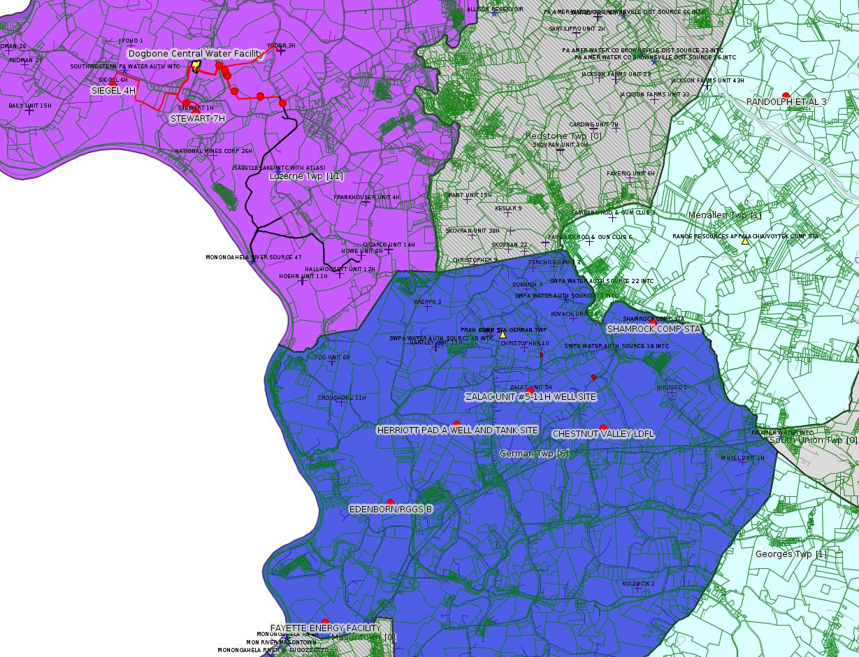
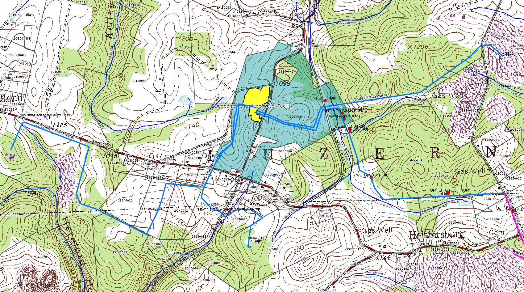
DOGBONE WATER LINE ESCGP ESG18-051-0001
SPROUL 7005 Drill & Operate Well Permit Inactive Status (New)Electronic Notifications
MAWC 7020 3H Drill & Operate Well Permit Inactive Status (New)
MAWC 7020 1H Drill & Operate Well Permit Inactive Status (New)
JOHN HOLT 1H Drill & Operate Well Permit Inactive Status (New)
POLK UNIT 1H Drill & Operate Well Permit Inactive Status (New)
HALL UNIT 1H Drill & Operate Well Permit Inactive Status (New)
BURNWORTH WEST UNIT 1H Drill & Operate Well Permit Inactive Status (New)
MISCOVICH 1 Well Plugging Notice Alternate Method (New)
MISCOVICH 1 Well Plugging Notice Intent to Plug Single Well (New)
HUMBERSTON UNIT 1H Drill & Operate Well Permit Inactive Status (New)
ZALAC UNIT #5-11H WELL SITE Expedited E&S Stormwater General Permit 1 [Termination?] Notification (New)
RANDOLPH ET AL 3 Well Plugging Notice Alternate Method
STEWART 7H Well Plugging Notice Intent to Plug Single Well
YODER WATERLINE GP5 & GP8 GP-08 Temporary Road Crossings
YODER WATERLINE GP-05 Utility Line Stream Crossings
EDENBORN/RGGS B Expedited E&S Stormwater 9/20/2018 deficiency letter
HERRIOTT PAD A WELL AND TANK SITE Expedited E&S Stormwater 9/6/2018 deficiency letter
DOGBONE WATER LINE Erosion and Sediment Control GP-2 Issued on 9/5/2018
DOGBONE WATER LINE SYSTEM GP-08 Temporary Road Crossings Issued on 9/10/2018
DOGBONE WATER LINE SYSTEM GP-05 Utility Line Stream Crossings Issued on 9/10/2018
SIEGEL 4H Drilling resumption After Break of 30 days or more 09/15/2018Inspection Anomalies (Oil & Gas Compliance Report)
SIEGEL 4H Casing cementing notification Surface: 9/17/2018
RANDOLPH ET AL 3 Abandonment or plugging notification 09/14/2018
SIEGEL 4H Casing cementing notification Intermediate: 9/18/2018
SIEGEL 3H Drilling resumption After Break of 30 days or more 09/18/2018
SIEGEL 3H Casing cementing notification Surface: 9/20/2018
MISCOVICH 1 Abandonment or plugging notification 09/19/2018
SIEGEL 3H Casing cementing notification Intermediate: 9/22/2018
SIEGEL 2H Drilling resumption After Break of 30 days or more 09/22/2018
SIEGEL 2H Casing cementing notification Surface: 9/24/2018
SIEGEL 2H Casing cementing notification Intermediate: 9/25/2018
STEWART 7H Drilling resumption After Break of 30 days or more 09/23/2018
SIEGEL 2H Casing cementing notification Surface: 9/23/2018 (amended notification)
SIEGEL 2H Casing cementing notification Intermediate: 9/24/2018 (amended notification)
SIEGEL 1 [Should be Siegel 1H -jr] Drilling resumption After Break of 30 days or more 09/25/2018
COLDREN UNIT 1 Violation(s) Noted failure to collect brine or other fluids, etc.Price of Natural Gas
HATALOWICH 4 Violation(s) Noted Stream flow backed up upslope of a culvert
NEMACOLIN 7008-1H fluid in the secondary containment unit
Notes
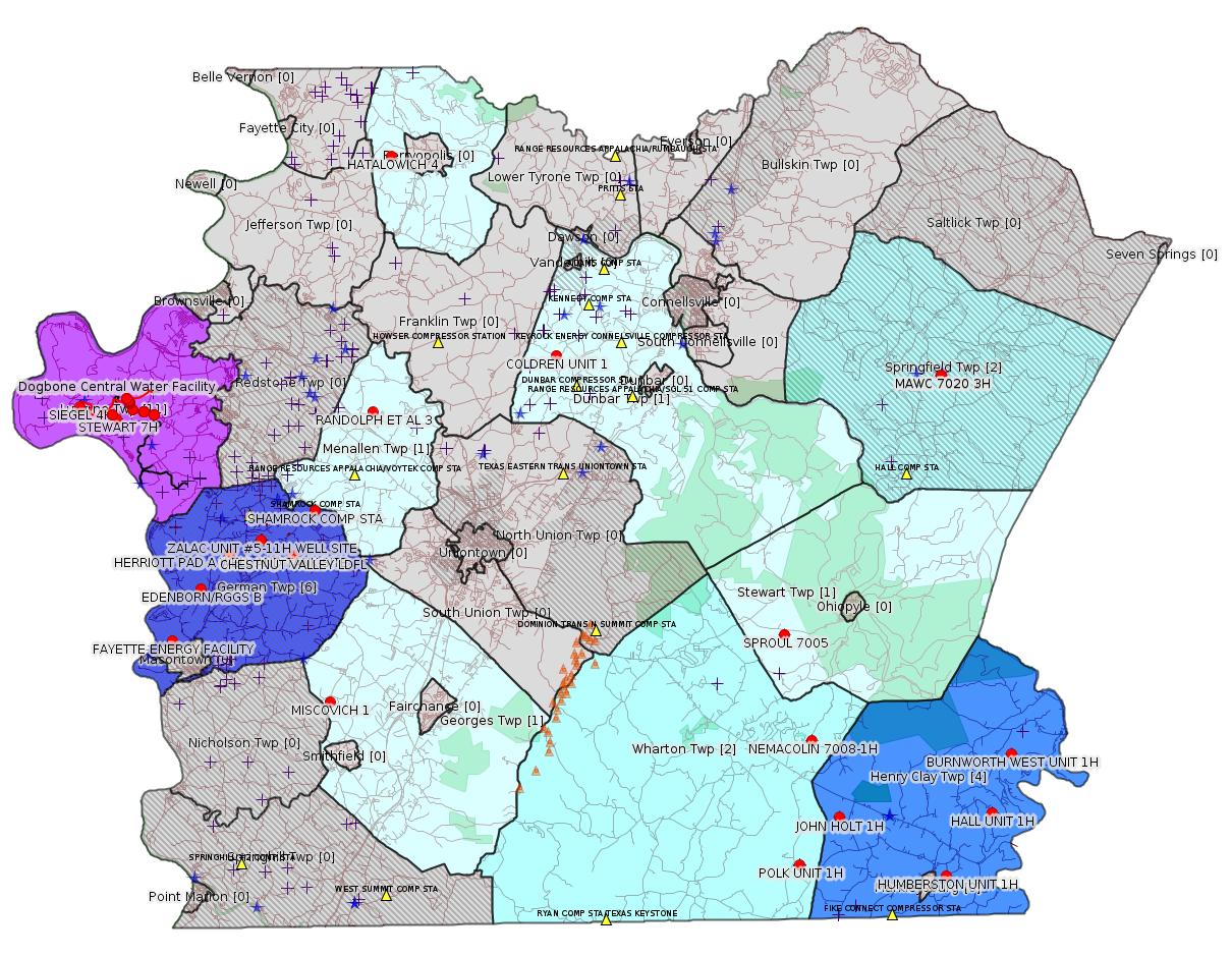
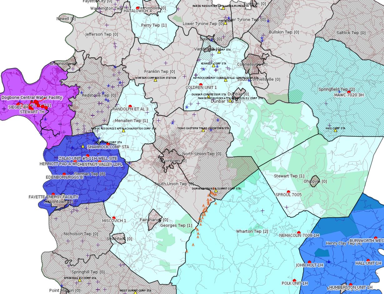
Map
Key
Red dots: items in this permit list with an exact location.
Blue stars: Marcellus Gas Well Water Sources.
Municipality shading: number of "facilities", with each well counting separately
(includes the red dots):
Red dots: items in this permit list with an exact location.
Blue stars: Marcellus Gas Well Water Sources.
Municipality shading: number of "facilities", with each well counting separately
(includes the red dots):
gray: 0
pale turquoise: 1
turquoise: 2
pale blue: 3
middle blue: 4
dark blue: 5
dark purple: 9
purple: 11
(Color coding may differ from one issue to the next.)
(Note if a project spans multiple municipalities -- e.g. a pipeline -- it will show in the count for each municipality.)
The number of facilities also follows the municipality name in brackets.
Municipality counts are based on the way the permit is listed by DEP; DEP has been known to get a municipality wrong.
Locations in brackets identify a precise location used to locate a surrogate for the actual site being permitted (e.g. locating a well pad or pipeline by the known location of a well.) Locations labeled beginning with "~" and ending in "[?]" are approximate and speculative based on inferences using on-line property and lease records. These are marked in the text as "[Approximate, Speculative]
Cross-hatching: Environmental Justice Areas
Yellow triangles: Compressor Stations
Orange triangles: Storage Field Wells (currently Dominion North Summit Storage Field)
Crosses: SPUD Unconventional well permits
Green: "Natural areas", e.g. state game lands, state forests
Yellow triangles: Compressor Stations
Orange triangles: Storage Field Wells (currently Dominion North Summit Storage Field)
Crosses: SPUD Unconventional well permits
Green: "Natural areas", e.g. state game lands, state forests
More Maps
 |
 |
 |
Source: Pennsylvania Bulletin
NPDES Renewal Permit Action
| NPDES No. (Type) |
Facility Name & Address |
County & Municipality |
Stream Name (Watershed No.) | EPA Waived Y/N? |
| PA0090948 (Industrial) |
Chestnut Valley Landfill 1184 McClellandtown Road McClellandtown, PA 15458 |
Fayette County German Township |
Unnamed Tributary of Dunlap Creek (19-C) |
Yes |
Minor IW Facility with ELG
Sub-Facilities for Authorization:
Sub-Facility ID Sub-Facility Name Description
212046 OUTFALL 001 Discharge Point
Location: 39.902222,-79.835
Map URL: <http://www.openstreetmap.org/?mlat=39.902222&mlon=-79.835#map=15/39.902222/-79.835>
568839 OUTFALL 002 Discharge Point
Location: 39.896111,-79.836111
Map URL: <http://www.openstreetmap.org/?mlat=39.896111&mlon=-79.836111#map=15/39.896111/-79.836111>
568840 SW OUTFALL 003 Discharge Point
Location: 39.895833,-79.835833
Map URL: <http://www.openstreetmap.org/?mlat=39.895833&mlon=-79.835833#map=15/39.895833/-79.835833>
---
26-00535B: Dynegy Fayette II, LLC (100 Energy Drive, Masontown, PA 15461) Extension effective August 28, 2018, to allow continued temporary operation of the modified combustion gas turbines (''CGT'') at Fayette Energy Center located in Masontown Borough, Fayette County. Components of the turbine section have been replaced and combustion control logic change to increase combustion air flow.
<https://www.pabulletin.com/secure/data/vol48/48-37/1456c.html>
Location: 39.857408,-79.913878
Map URL: <http://www.openstreetmap.org/?mlat=39.857408&mlon=-79.913878#map=15/39.857408/-79.913878>
Site Municipalities:
German Twp [an Environmental Justice Area], Fayette County
Masontown Boro [Incorrect -jr], Fayette County
Presumed Parcel Id: 1530006703
---
26-00588: Laurel Mountain Midstream Operating, LLC (1550 Coraopolis Heights Road, Suite 140, Moon Township, PA 15108) Extension effective August 28, 2018, to extend the period of temporary operation of the three Caterpillar G3516B natural gas-fired compressor engines rated at 1,380 bhp each and controlled by oxidation catalysts, and a Solar Mars 100 gas-fired turbine rated at 15,525 bhp authorized under plan approval PA-26-00588 at Shamrock Compressor Station located in German Township, Fayette County.
<https://www.pabulletin.com/secure/data/vol48/48-37/1456c.html>
Minor Facility Plan Approval New Source Performance Std
Location: 39.918333,-79.825
Map URL: <http://www.openstreetmap.org/?mlat=39.918333&mlon=-79.825#map=15/39.918333/-79.825>
Parcel ID: 15140026
---
STATEMENTS OF POLICY
Title 4—ADMINISTRATION
PART II. EXECUTIVE BOARD
[ 4 PA. CODE CH. 9 ]
Reorganization of the Department of Environmental Protection
[48 Pa.B. 5866]
[Saturday, September 22, 2018]
The Executive Board approved a reorganization of the Department of Environmental Protection effective August 30, 2018.
The organization chart at 48 Pa.B. 5867 (September 22, 2018) is published at the request of the Joint Committee on Documents under 1 Pa. Code § 3.1(a)(9) (relating to contents of Code).
(Editor's Note: The Joint Committee on Documents has found organization charts to be general and permanent in nature. This document meets the criteria of 45 Pa.C.S. § 702(7) (relating to contents of Pennsylvania Code) as a document general and permanent in nature which shall be codified in the Pennsylvania Code.)

---
NOTICES
INDEPENDENT REGULATORY REVIEW COMMISSION
Notice of Comments Issued
Environmental Quality Board Regulation # 7-542 (IRRC # 3206)
Unconventional Well Permit Application Fee Amendments
September 12, 2018
<https://www.pabulletin.com/secure/data/vol48/48-38/1507.html>
[The comments are fairly extensive. Please follow the link above to read the full comments.]
---
ESCGP-2 # ESG18-051-0001
Applicant Name Chevron Appalachia, LLC
Contact Person Branden Weimer
Address 700 Cherrington Parkway
City, State, Zip Coraopolis, PA 15108
County Fayette County
Township(s) Luzerne Township
Receiving Stream(s) and Classification(s) Trib 41002 to
Monongahela River (WWF), Trib 41011 to Minnow Run
(WWF), Trib 41001 to Hereford Hollow (WWF), Tribs
40253 & 40454 to Rush Run (WWF)
<https://www.pabulletin.com/secure/data/vol48/48-38/1492d.html>
Site: DOGBONE WATER LINE ESCGP ESG18-051-0001
-------------------------
Source: eNOTICE (+ PA Oil and Gas Mapping, Well Pad Report.) Well Details via Data Portal Services: Oil and Gas Wells All (ID: 3).
Please see the Disclaimer below regarding Parcel Id data.
New:
Authorization ID: 1245075
Permit number: 051-24218
Site: SPROUL 7005 OG WELL
Client: TRIANA ENERGY LLC
Authorization type: Drill & Operate Well Permit Inactive Status
Application type: New
Authorization is for: FACILITY
Date received: 09/11/2018
Status: Pending
Permit Decision Guarantee Applies?: No
Sub-Facilities for Authorization:
Sub-Facility ID Sub-Facility Name Description
990150 SPROUL 7005 Well
Permit Review Notes:
Date Review Note
9/17/2018 The permit application package is complete, has been accepted, and is undergoing technical review.
<https://www.ahs.dep.pa.gov/eFACTSWeb/searchResults_singleAuth.aspx?AuthID=1245075>
Site Programs:
Oil & Gas
Site Municipalities:
Stewart Twp, Fayette County
Well Details:
Permit Number: 051-24218
Well Name: SPROUL 7005
Unconventional Well: Y
Well Configuration: Vertical Well
Well Type: GAS
Well Status: Regulatory Inactive Status
Coal Association: NonCoal
Conservation Well: Y
Primary Facility ID: 718708
Site ID: 720238
Site Name: SPROUL 7005 OG WELL
Well Pad ID: 149337
Well Pad Name: SPROUL 7005
Storage Field:
Operator: TRIANA ENERGY LLC
Operator Number: OGO-67530
Permit Date: 2009-05-27
Permit Date Expires: 2010-05-27
SPUD Date: 2009-08-15
Date Plugged:
UIC ID:
UIC Type:
Surface Elevation: 1915
County: Fayette
Municipality: Stewart Twp
Location: 39.856133,-79.53675
Map URL: <http://www.openstreetmap.org/?mlat=39.856133&mlon=-79.53675#map=15/39.856133/-79.53675>
Presumed Parcel Id: 37110072
New:
Authorization ID: 1245074
Permit number: 051-24464
Site: FAYETTE COUNTY PROJECT ESCGP-EXPEDITED MAWC 7020 PAD
Client: TRIANA ENERGY LLC
Authorization type: Drill & Operate Well Permit Inactive Status
Application type: New
Authorization is for: FACILITY
Date received: 09/11/2018
Status: Pending
Permit Decision Guarantee Applies?: No
Sub-Facilities for Authorization:
Sub-Facility ID Sub-Facility Name Description
1049231 MAWC 7020 3H Well
<https://www.ahs.dep.pa.gov/eFACTSWeb/searchResults_singleAuth.aspx?AuthID=1245074>
Site Programs:
Oil & Gas
Site Municipalities:
Dunbar Twp, Fayette County
North Union Twp, Fayette County
Springfield Twp, Fayette County
Stewart Twp, Fayette County
Wharton Twp, Fayette County
Well Details:
Permit Number: 051-24464
Well Name: MAWC 7020 3H
Unconventional Well: Y
Well Configuration: Horizontal Well
Well Type: GAS
Well Status: Regulatory Inactive Status
Coal Association: NonCoal
Conservation Well: N
Primary Facility ID: 744754
Site ID: 721520
Site Name: FAYETTE COUNTY PROJECT ESCGP-EXPEDITED MAWC 7020 PAD
Well Pad ID: 148846
Well Pad Name: MAWC 7020
Storage Field:
Operator: TRIANA ENERGY LLC
Operator Number: OGO-67530
Permit Date: 2011-09-23
Permit Date Expires: 2012-09-23
SPUD Date: 2011-10-03
Date Plugged:
UIC ID:
UIC Type:
Surface Elevation: 1427
County: Fayette
Municipality: Springfield Twp
Location: 39.977814,-79.437242
Map URL: <http://www.openstreetmap.org/?mlat=39.977814&mlon=-79.437242#map=15/39.977814/-79.437242>
Presumed Parcel Id: 35130001
New:
Authorization ID: 1245073
Permit number: 051-24303
Site: FAYETTE COUNTY PROJECT ESCGP-EXPEDITED MAWC 7020 PAD
Client: TRIANA ENERGY LLC
Authorization type: Drill & Operate Well Permit Inactive Status
Application type: New
Authorization is for: FACILITY
Date received: 09/11/2018
Status: Pending
Permit Decision Guarantee Applies?: No
Sub-Facilities for Authorization:
Sub-Facility ID Sub-Facility Name Description
1005069 MAWC 7020 1H Well
1086615 MAWC 7020 1H Well
1051380 MAWC 7020 1H Well
1049302 MAWC 7020 1H Well
Permit Review Notes:
Date Review Note
9/17/2018 The permit application package is complete, has been accepted, and is undergoing technical review.
<https://www.ahs.dep.pa.gov/eFACTSWeb/searchResults_singleAuth.aspx?AuthID=1245073>
Site Programs:
Oil & Gas
Site Municipalities:
Dunbar Twp, Fayette County
North Union Twp, Fayette County
Springfield Twp, Fayette County
Stewart Twp, Fayette County
Wharton Twp, Fayette County
Well Details:
Permit Number: 051-24303
Well Name: MAWC 7020 1H
Unconventional Well: Y
Well Configuration: Horizontal Well
Well Type: GAS
Well Status: Regulatory Inactive Status
Coal Association: NonCoal
Conservation Well: N
Primary Facility ID: 725920
Site ID: 721520
Site Name: FAYETTE COUNTY PROJECT ESCGP-EXPEDITED MAWC 7020 PAD
Well Pad ID: 148846
Well Pad Name: MAWC 7020
Storage Field:
Operator: TRIANA ENERGY LLC
Operator Number: OGO-67530
Permit Date: 2009-12-24
Permit Date Expires: 2013-11-06
SPUD Date: 2010-06-25
Date Plugged:
UIC ID:
UIC Type:
Surface Elevation: 1427
County: Fayette
Municipality: Springfield Twp
Location: 39.977794,-79.437139
Map URL: <http://www.openstreetmap.org/?mlat=39.977794&mlon=-79.437139#map=15/39.977794/-79.437139>
Presumed Parcel Id: 35130001
New:
Authorization ID: 1245068
Permit number: 051-24140
Site: JOHN HOLT 1H OG WEL
Client: LPR ENERGY LLC
Authorization type: Drill & Operate Well Permit Inactive Status
Application type: New
Authorization is for: FACILITY
Date received: 09/04/2018
Status: Pending
Permit Decision Guarantee Applies?: No
Sub-Facilities for Authorization:
Sub-Facility ID Sub-Facility Name Description
981790 JOHN HOLT 1H Well
Permit Review Notes:
Date Review Note
9/17/2018 The permit application package is complete, has been accepted, and is undergoing technical review.
<https://www.ahs.dep.pa.gov/eFACTSWeb/searchResults_singleAuth.aspx?AuthID=1245068>
Site Programs:
Oil & Gas
Site Municipalities:
Henry Clay Twp, Fayette County
Well Details:
Permit Number: 051-24140
Well Name: JOHN HOLT 1H
Unconventional Well: Y
Well Configuration: Vertical Well
Well Type: GAS
Well Status: Regulatory Inactive Status
Coal Association: NonCoal
Conservation Well: Y
Primary Facility ID: 713811
Site ID: 714731
Site Name: JOHN HOLT 1H OG WEL
Well Pad ID: 146975
Well Pad Name: JOHN HOLT 1H
Storage Field:
Operator: LPR ENERGY LLC
Operator Number: OGO-68579
Permit Date: 2008-12-24
Permit Date Expires: 2009-12-24
SPUD Date: 2009-04-02
Date Plugged:
UIC ID:
UIC Type:
Surface Elevation: 2325
County: Fayette
Municipality: Henry Clay Twp
Location: 39.768936,-79.504661
Map URL: <http://www.openstreetmap.org/?mlat=39.768936&mlon=-79.504661#map=15/39.768936/-79.504661>
Presumed Parcel Id: 16100009
New:
Authorization ID: 1245067
Permit number: 051-24428
Site: POLK 1H OG WELL
Client: LPR ENERGY LLC
Authorization type: Drill & Operate Well Permit Inactive Status
Application type: New
Authorization is for: FACILITY
Date received: 09/04/2018
Status: Pending
Permit Decision Guarantee Applies?: No
Sub-Facilities for Authorization:
Sub-Facility ID Sub-Facility Name Description
1035649 POLK UNIT 1H Well
1035648 POLK UNIT 1H Well
<https://www.ahs.dep.pa.gov/eFACTSWeb/searchResults_singleAuth.aspx?AuthID=1245067>
Site Programs:
Oil & Gas
Site Municipalities:
Wharton Twp, Fayette County
Well Details:
Permit Number: 051-24428
Well Name: POLK UNIT 1H
Unconventional Well: Y
Well Configuration: Horizontal Well
Well Type: GAS
Well Status: Regulatory Inactive Status
Coal Association: NonCoal
Conservation Well: N
Primary Facility ID: 738671
Site ID: 739411
Site Name: POLK 1H OG WELL
Well Pad ID: 149075
Well Pad Name: POLK UNIT 1H
Storage Field:
Operator: LPR ENERGY LLC
Operator Number: OGO-68579
Permit Date: 2011-02-28
Permit Date Expires: 2012-02-28
SPUD Date: 2011-03-24
Date Plugged:
UIC ID:
UIC Type:
Surface Elevation: 2310
County: Fayette
Municipality: Wharton Twp
Location: 39.746494,-79.529567
Map URL: <http://www.openstreetmap.org/?mlat=39.746494&mlon=-79.529567#map=15/39.746494/-79.529567>
Presumed Parcel Id: 4233000106
New:
Authorization ID: 1245065
Permit number: 051-24403
Site: HALL UNIT 1H OG WELL
Client: LPR ENERGY LLC
Authorization type: Drill & Operate Well Permit Inactive Status
Application type: New
Authorization is for: FACILITY
Date received: 09/04/2018
Status: Pending
Permit Decision Guarantee Applies?: No
Sub-Facilities for Authorization:
Sub-Facility ID Sub-Facility Name Description
1023640 HALL UNIT 1H Well
Permit Review Notes:
Date Review Note
9/17/2018 The permit application package is complete, has been accepted, and is undergoing technical review.
<https://www.ahs.dep.pa.gov/eFACTSWeb/searchResults_singleAuth.aspx?AuthID=1245065>
Site Programs:
Oil & Gas
Site Municipalities:
Henry Clay Twp, Fayette County
Well Details:
Permit Number: 051-24403
Well Name: HALL UNIT 1H
Unconventional Well: Y
Well Configuration: Horizontal Well
Well Type: GAS
Well Status: Regulatory Inactive Status
Coal Association: NonCoal
Conservation Well: N
Primary Facility ID: 735848
Site ID: 741195
Site Name: HALL UNIT 1H OG WELL
Well Pad ID: 148468
Well Pad Name: HALL UNIT 1H
Storage Field:
Operator: LPR ENERGY LLC
Operator Number: OGO-68579
Permit Date: 2010-11-24
Permit Date Expires: 2011-11-24
SPUD Date: 2011-03-21
Date Plugged:
UIC ID:
UIC Type:
Surface Elevation: 1965
County: Fayette
Municipality: Henry Clay Twp
Location: 39.769889,-79.410881
Map URL: <http://www.openstreetmap.org/?mlat=39.769889&mlon=-79.410881#map=15/39.769889/-79.410881>
Presumed Parcel Id: 16130134
New:
Authorization ID: 1245063
Permit number: 051-24400
Site: BURNWORTH WEST UNIT 1H OG WELL
Client: LPR ENERGY LLC
Authorization type: Drill & Operate Well Permit Inactive Status
Application type: New
Authorization is for: FACILITY
Date received: 09/04/2018
Status: Pending
Permit Decision Guarantee Applies?: No
Sub-Facilities for Authorization:
Sub-Facility ID Sub-Facility Name Description
1023091 BURNWORTH WEST UNIT 1H Well
Permit Review Notes:
Date Review Note
9/17/2018 The permit application package is complete, has been accepted, and is undergoing technical review.
<https://www.ahs.dep.pa.gov/eFACTSWeb/searchResults_singleAuth.aspx?AuthID=1245063>
Site Programs:
Oil & Gas
Site Municipalities:
Henry Clay Twp, Fayette County
Well Details:
Permit Number: 051-24400
Well Name: BURNWORTH WEST UNIT 1H
Unconventional Well: Y
Well Configuration: Horizontal Well
Well Type: GAS
Well Status: Regulatory Inactive Status
Coal Association: NonCoal
Conservation Well: N
Primary Facility ID: 735586
Site ID: 740856
Site Name: BURNWORTH WEST UNIT 1H OG WELL
Well Pad ID: 147087
Well Pad Name: BURNWORTH WEST UNIT 1H
Storage Field:
Operator: LPR ENERGY LLC
Operator Number: OGO-68579
Permit Date: 2010-11-24
Permit Date Expires: 2011-11-24
SPUD Date: 2011-03-01
Date Plugged:
UIC ID:
UIC Type:
Surface Elevation: 1950
County: Fayette
Municipality: Henry Clay Twp
Location: 39.797503,-79.398014
Map URL: <http://www.openstreetmap.org/?mlat=39.797503&mlon=-79.398014#map=15/39.797503/-79.398014>
Presumed Parcel Id: 16090032
New:
Authorization ID: 1244719
Permit number: 051-23289
Site: MISCOVICH 1 OG WELL
Client: RANGE RESOURCES APPALACHIA LLC
Authorization type: Well Plugging Notice Alternate Method
Application type: New
Authorization is for: FACILITY
Date received: 09/12/2018
Status: Pending
Permit Decision Guarantee Applies?: No
Sub-Facilities for Authorization:
Sub-Facility ID Sub-Facility Name Description
921218 MISCOVICH 1 Well
Permit Review Notes:
Date Review Note
9/19/2018 The technical review and decision review are complete and either the permit decision and/or permit issuance are forthcoming.
9/12/2018 The permit application package is complete, has been accepted, and is undergoing technical review.
<https://www.ahs.dep.pa.gov/eFACTSWeb/searchResults_singleAuth.aspx?AuthID=1244719>
Site Programs:
Oil & Gas
Site Municipalities:
Georges Twp, Fayette County
Well Details:
Permit Number: 051-23289
Well Name: MISCOVICH 1
Unconventional Well: N
Well Configuration: Vertical Well
Well Type: COMB. OIL&GAS
Well Status: Active
Coal Association: Coal
Conservation Well: N
Primary Facility ID: 680422
Site ID: 672183
Site Name: MISCOVICH 1 OG WELL
Well Pad ID: 0
Well Pad Name:
Storage Field:
Operator: RANGE RESOURCES APPALACHIA LLC
Operator Number: OGO-60915
Permit Date: 2006-06-05
Permit Date Expires: 2007-06-05
SPUD Date: 2006-10-19
Date Plugged:
UIC ID:
UIC Type:
Surface Elevation: 1170
County: Fayette
Municipality: Georges Twp
Location: 39.827222,-79.817345
Map URL: <http://www.openstreetmap.org/?mlat=39.827222&mlon=-79.817345#map=15/39.827222/-79.817345>
Presumed Parcel Id: 14110062
New:
Authorization ID: 1244709
Permit number: 051-23289
Site: MISCOVICH 1 OG WELL
Client: RANGE RESOURCES APPALACHIA LLC
Authorization type: Well Plugging Notice Intent to Plug Single Well
Application type: New
Authorization is for: FACILITY
Date received: 09/12/2018
Status: Issued on 9/12/2018
Permit Decision Guarantee Applies?: No
Sub-Facilities for Authorization:
Sub-Facility ID Sub-Facility Name Description
921218 MISCOVICH 1 Well
Permit Review Notes:
Date Review Note
9/12/2018 The technical review and decision review are complete and either the permit decision and/or permit issuance are forthcoming.
9/12/2018 The permit application package is complete, has been accepted, and is undergoing technical review.
<https://www.ahs.dep.pa.gov/eFACTSWeb/searchResults_singleAuth.aspx?AuthID=1244709>
Site Programs:
Oil & Gas
Site Municipalities:
Georges Twp, Fayette County
Well Details:
Permit Number: 051-23289
Well Name: MISCOVICH 1
Unconventional Well: N
Well Configuration: Vertical Well
Well Type: COMB. OIL&GAS
Well Status: Active
Coal Association: Coal
Conservation Well: N
Primary Facility ID: 680422
Site ID: 672183
Site Name: MISCOVICH 1 OG WELL
Well Pad ID: 0
Well Pad Name:
Storage Field:
Operator: RANGE RESOURCES APPALACHIA LLC
Operator Number: OGO-60915
Permit Date: 2006-06-05
Permit Date Expires: 2007-06-05
SPUD Date: 2006-10-19
Date Plugged:
UIC ID:
UIC Type:
Surface Elevation: 1170
County: Fayette
Municipality: Georges Twp
Location: 39.827222,-79.817345
Map URL: <http://www.openstreetmap.org/?mlat=39.827222&mlon=-79.817345#map=15/39.827222/-79.817345>
New:
Authorization ID: 1244257
Permit number: 051-24367
Site: HUMBERSTON UNIT 1H OG WELL
Client: LPR ENERGY LLC
Authorization type: Drill & Operate Well Permit Inactive Status
Application type: New
Authorization is for: FACILITY
Date received: 09/04/2018
Status: Pending
Permit Decision Guarantee Applies?: No
Sub-Facilities for Authorization:
Sub-Facility ID Sub-Facility Name Description
1015955 HUMBERSTON UNIT 1H Well
Permit Review Notes:
Date Review Note
9/10/2018 The permit application package is complete, has been accepted, and is undergoing technical review.
<https://www.ahs.dep.pa.gov/eFACTSWeb/searchResults_singleAuth.aspx?AuthID=1244257>
Site Programs:
Oil & Gas
Site Municipalities:
Henry Clay Twp, Fayette County
Well Details:
Permit Number: 051-24367
Well Name: HUMBERSTON UNIT 1H
Unconventional Well: Y
Well Configuration: Horizontal Well
Well Type: GAS
Well Status: Regulatory Inactive Status
Coal Association: Coal
Conservation Well: N
Primary Facility ID: 731775
Site ID: 735895
Site Name: HUMBERSTON UNIT 1H OG WELL
Well Pad ID: 146309
Well Pad Name: HUMBERSTON UNIT 1H
Storage Field:
Operator: LPR ENERGY LLC
Operator Number: OGO-68579
Permit Date: 2010-07-13
Permit Date Expires: 2011-07-13
SPUD Date: 2011-01-28
Date Plugged:
UIC ID:
UIC Type:
Surface Elevation: 2000
County: Fayette
Municipality: Henry Clay Twp
Location: 39.740383,-79.439622
Map URL: <http://www.openstreetmap.org/?mlat=39.740383&mlon=-79.439622#map=15/39.740383/-79.439622>
Presumed Parcel Id: 16160099
New:
Authorization ID: 1244201
Permit number: ESX14-051-0014
Site: ZALAC UNIT #5-11H WELL SITE ESCGP-2 EXPEDITED
Client: CHEVRON APPALACHIA LLC
Authorization type: Expedited E&S Stormwater General Permit 1
Application type: Notification
Authorization is for: SITE
Date received: 09/06/2018
Status: Issued on 9/6/2018
Permit Decision Guarantee Applies?: No
Permit Review Notes:
Date Review Note
9/6/2018 The technical review and decision review are complete and either the permit decision and/or permit issuance are forthcoming.
9/6/2018 The permit application package is complete, has been accepted, and is undergoing technical review.
<https://www.ahs.dep.pa.gov/eFACTSWeb/searchResults_singleAuth.aspx?AuthID=1244201>
Site Programs:
Oil & Gas
Site Municipalities:
German Twp [an Environmental Justice Area], Fayette County
Location: 39.904611,-79.858172 <https://osm.org/go/ZWpaKHEP--?m=>
Presumed Parcel Id: 15110064
Well Pad ID: 152252
Wells on this pad:
051-24617 ZALAC UNIT 10H
051-24622 ZALAC UNIT 5H
051-24623 ZALAC UNIT 6H
051-24624 ZALAC UNIT 7H
051-24625 ZALAC UNIT 8H
051-24626 ZALAC UNIT 9H
051-24627 ZALAC UNIT 11H
Zalac Pad A_Restoration Report:
<http://www.ahs.dep.pa.gov/eSubmissionsDoc
/DownloadESubmissionDocument.ashx?enc=MOpmV6IzBtmToVjqF07C9fgHc4eBXWkGcfT%2f9PEZzeQ%3d>
(Available via DEP Oil and Gas Electronic Submissions, <http://www.ahs.dep.pa.gov/eSubmissionPublicSearch>)
Authorization ID: 1243124
Permit number: 051-21618
Site: RANDOLPH ET AL 3 OG WELL
Client: RANGE RESOURCES APPALACHIA LLC
Authorization type: Well Plugging Notice Alternate Method
Application type: New
Authorization is for: FACILITY
Date received: 08/31/2018
Status: Pending
Permit Decision Guarantee Applies?: No
Sub-Facilities for Authorization:
Sub-Facility ID Sub-Facility Name Description
758003 RANDOLPH ET AL 3 Well
Permit Review Notes:
Date Review Note
9/19/2018 The technical review and decision review are complete and either the permit decision and/or permit issuance are forthcoming.
9/4/2018 The permit application package is complete, has been accepted, and is undergoing technical review.
<https://www.ahs.dep.pa.gov/eFACTSWeb/searchResults_singleAuth.aspx?AuthID=1243124>
Site Programs:
Oil & Gas
Site Municipalities:
Menallen Twp, Fayette County
Well Details:
Permit Number: 051-21618
Well Name: RANDOLPH ET AL 3
Unconventional Well: N
Well Configuration: Vertical Well
Well Type: GAS
Well Status: Active
Coal Association: Coal
Conservation Well: N
Primary Facility ID: 631098
Site ID: 607330
Site Name: RANDOLPH ET AL 3 OG WELL
Well Pad ID: 0
Well Pad Name:
Storage Field:
Operator: RANGE RESOURCES APPALACHIA LLC
Operator Number: OGO-60915
Permit Date: 2002-12-06
Permit Date Expires: 2003-12-06
SPUD Date: 2002-12-11
Date Plugged:
UIC ID:
UIC Type:
Surface Elevation: 1035
County: Fayette
Municipality: Menallen Twp
Location: 39.964748,-79.788649
Map URL: <http://www.openstreetmap.org/?mlat=39.964748&mlon=-79.788649#map=15/39.964748/-79.788649>
Presumed Parcel Id: 22060031
Authorization ID: 1241684
Permit number: 051-24639
Site: STEWART WELL SITE ESCGP-2 EXPEDITED
Client: CHEVRON APPALACHIA LLC
Authorization type: Well Plugging Notice Intent to Plug Single Well
Application type: New
Authorization is for: FACILITY
Date received: 08/16/2018
Status: Issued on 9/17/2018
Permit Decision Guarantee Applies?: No
Sub-Facilities for Authorization:
Sub-Facility ID Sub-Facility Name Description
1246056 WELLBORE SURFACE HOLE LOCATION Well
Permit Review Notes:
Date Review Note
9/17/2018 The technical review and decision review are complete and either the permit decision and/or permit issuance are forthcoming.
8/16/2018 The permit application package is complete, has been accepted, and is undergoing technical review.
<https://www.ahs.dep.pa.gov/eFACTSWeb/searchResults_singleAuth.aspx?AuthID=1241684>
Site Programs:
Oil & Gas
Site Municipalities:
Luzerne Twp, Fayette County
Well Details:
Permit Number: 051-24639
Well Name: STEWART 7H
Unconventional Well: Y
Well Configuration: Horizontal Well
Well Type: GAS
Well Status: Active
Coal Association: Coal
Conservation Well: N
Primary Facility ID: 822072
Site ID: 788124
Site Name: STEWART WELL SITE ESCGP-2 EXPEDITED
Well Pad ID: 152396
Well Pad Name: STEWART
Storage Field:
Operator: CHEVRON APPALACHIA LLC
Operator Number: OGO-39307
Permit Date: 2018-01-26
Permit Date Expires: 2019-01-26
SPUD Date: 2018-07-31
Date Plugged:
UIC ID:
UIC Type:
Surface Elevation: 1140
County: Fayette
Municipality: Luzerne Twp
Location: 39.962917,-79.946617
Map URL: <http://www.openstreetmap.org/?mlat=39.962917&mlon=-79.946617#map=15/39.962917/-79.946617>
Presumed Property Id: 19250010
[See Notes.]
OG WELLS PERMIT DOCS:
2018-01-26: Other Permit Documents, Name: Approval of Surface Locations by Landowners (for Authorization: 1203103):
<http://www.depgis.state.pa.us/pdfHandler/pdFHandler.ashx?Doc=NTQ5NzEz&ext=PDF>
2018-01-26: Final Permit Documents, Name: 1203103 (for Authorization: 1203103):
<http://www.depgis.state.pa.us/pdfHandler/pdFHandler.ashx?Doc=NTUxMTMw&ext=PDF>
2018-01-17: Other Permit Documents, Name: 051-24639 Alt Method (for Authorization: 1212314):
<http://www.depgis.state.pa.us/pdfHandler/pdFHandler.ashx?Doc=NTQ2MTgw&ext=PDF>
Electronically Submitted Records:
2018-01-26: Submission for Authorization 1203103
Pennsylvania Natural Diversity Inventory Form: Stewart Pad A PNDI 8-22-17.pdf
<http://www.depgis.state.pa.us/eWellDocHandler/pdFHandler.ashx?Doc=MzcwNTYy&ext=PDF>
Location Plat: Stewart Well Plats 7H.dwg
<http://www.depgis.state.pa.us/eWellDocHandler/pdFHandler.ashx?Doc=MzkxMTE3&ext=PDF>
Coal and Gas Resource Coord Act - Section 7 Exception: Stewart 1H-7H Waiver Request Section 7.pdf
<http://www.depgis.state.pa.us/eWellDocHandler/pdFHandler.ashx?Doc=MzkxMTE4&ext=PDF>
Well Cross-Section Diagram: Stewart 7H Page 4.pdf
<http://www.depgis.state.pa.us/eWellDocHandler/pdFHandler.ashx?Doc=MzkxMTE5&ext=PDF>
Well Permit Application - Coal Module: Stewart 1H-7H 2017 Coal Module.pdf
<http://www.depgis.state.pa.us/eWellDocHandler/pdFHandler.ashx?Doc=MzkxMTIw&ext=PDF>
Interested Party Notification: Stewart 1H-7H Affidavit of Non-Delivery.pdf
<http://www.depgis.state.pa.us/eWellDocHandler/pdFHandler.ashx?Doc=MzkxMTI5&ext=PDF>
Interested Party Notification: Stewart 1H-7H Affidavit of Non-Delivery.pdf
<http://www.depgis.state.pa.us/eWellDocHandler/pdFHandler.ashx?Doc=MzkxMTM4&ext=PDF>
Interested Party Notification: Stewart 1H-7H Affidavit of Non-Delivery.pdf
<http://www.depgis.state.pa.us/eWellDocHandler/pdFHandler.ashx?Doc=MzkxMTM5&ext=PDF>
Interested Party Notification: Stewart 1H-7H Affidavit of Non-Delivery.pdf
<http://www.depgis.state.pa.us/eWellDocHandler/pdFHandler.ashx?Doc=MzkxMTQw&ext=PDF>
Interested Party Notification: Stewart 1H-7H Affidavit of Non-Delivery.pdf
<http://www.depgis.state.pa.us/eWellDocHandler/pdFHandler.ashx?Doc=MzkxMTQx&ext=PDF>
Interested Party Notification: Stewart 1H-7H Affidavit of Non-Delivery.pdf
<http://www.depgis.state.pa.us/eWellDocHandler/pdFHandler.ashx?Doc=MzkxMTQ2&ext=PDF>
Permit Application to Drill and Operate a Well: 1609175.pdf
<http://www.depgis.state.pa.us/eWellDocHandler/pdFHandler.ashx?Doc=MzkyODA2&ext=PDF>
Authorization ID: 1234130
Permit number: GP08260718002
Site: YODER WATERLINE GP5 & GP8
Client: CHEVRON APPALACHIA LLC
Authorization type: GP-08 Temporary Road Crossings
Application type: New
Authorization is for: FACILITY
Date received: 06/21/2018
Status: Pending
Permit Decision Guarantee Applies?: No
Sub-Facilities for Authorization:
Sub-Facility ID Sub-Facility Name Description
1264105 RUSH RUN Bridge
Location: 39.972594,-79.94053
Map URL: <http://www.openstreetmap.org/?mlat=39.972594&mlon=-79.94053#map=15/39.972594/-79.94053>
1261250 YODER WATERLINE GP08260718-002 Bridge
Permit Review Notes:
Date Review Note
6/28/2018 The permit application package is complete, has been accepted, and is undergoing technical review.
<https://www.ahs.dep.pa.gov/eFACTSWeb/searchResults_singleAuth.aspx?AuthID=1234130>
Site Programs:
Water Planning and Conservation
Site Municipalities:
Luzerne Twp, Fayette County
Authorization ID: 1234125
Permit number: GP05260718002
Site: YODER WATERLINE GP5 & GP8
Client: CHEVRON APPALACHIA LLC
Authorization type: GP-05 Utility Line Stream Crossings
Application type: New
Authorization is for: FACILITY
Date received: 06/21/2018
Status: Pending
Permit Decision Guarantee Applies?: Yes
Permit Decision Guarantee status: ACTIVE
Sub-Facilities for Authorization:
Sub-Facility ID Sub-Facility Name Description
1261249 RUSH RUN Pipeline or Conduit
Location: 39.972594,-79.94053
Map URL: <http://www.openstreetmap.org/?mlat=39.972594&mlon=-79.94053#map=15/39.972594/-79.94053>
Permit Review Notes:
Date Review Note
6/28/2018 The permit application package is complete, has been accepted, and is undergoing technical review.
<https://www.ahs.dep.pa.gov/eFACTSWeb/searchResults_singleAuth.aspx?AuthID=1234125>
Site Programs:
Water Planning and Conservation
Site Municipalities:
Luzerne Twp, Fayette County
Authorization ID: 1227101
Permit number: ESX18-051-0003
Site: EDENBORN/RGGS B ESCGP ESX18-051-0003
Client: CHEVRON APPALACHIA LLC
Authorization type: Expedited E&S Stormwater General Permit 1
Application type: New
Authorization is for: SITE
Date received: 05/03/2018
Status: Pending
Permit Decision Guarantee Applies?: Yes
Permit Decision Guarantee status: VOID
Permit Review Notes:
Date Review Note
9/20/2018 Applicant has been issued a deficiency letter. If applicable, this application no longer qualifies for the Permit Decision Guarantee.
8/6/2018 Applicant has been issued a deficiency letter. If applicable, this application no longer qualifies for the Permit Decision Guarantee.
6/6/2018 Applicant has been issued a deficiency letter. If applicable, this application no longer qualifies for the Permit Decision Guarantee.
5/14/2018 The permit application package is complete, has been accepted, and is undergoing technical review.
<https://www.ahs.dep.pa.gov/eFACTSWeb/searchResults_singleAuth.aspx?AuthID=1227101>
Site Programs:
Oil & Gas
Site Municipalities:
German Twp [an Environmental Justice Area], Fayette County
Well Pad ID: 155083
Location: 39.881931,-79.896106 <https://osm.org/go/ZWpN6mOL--?m=>
Wells on this Pad:
051-24651 EDENBORN/RGGS B 1
Presumed Parcel Id: 15220014
Authorization ID: 1226967
Permit number: ESX18-051-0002
Site: HERRIOTT PAD A WELL AND TANK SITE ESCGP ESX18-051-0002
Client: CHEVRON APPALACHIA LLC
Authorization type: Expedited E&S Stormwater General Permit 1
Application type: New
Authorization is for: SITE
Date received: 05/01/2018
Status: Pending
Permit Decision Guarantee Applies?: Yes
Permit Decision Guarantee status: VOID
Permit Review Notes:
Date Review Note
9/6/2018 Applicant has been issued a deficiency letter. If applicable, this application no longer qualifies for the Permit Decision Guarantee.
7/27/2018 Applicant has been issued a deficiency letter. If applicable, this application no longer qualifies for the Permit Decision Guarantee.
7/16/2018 Applicant has been issued a deficiency letter. If applicable, this application no longer qualifies for the Permit Decision Guarantee.
<https://www.ahs.dep.pa.gov/eFACTSWeb/searchResults_singleAuth.aspx?AuthID=1226967>
Site Programs:
Oil & Gas
Site Municipalities:
German Twp [an Environmental Justice Area], Fayette County
Well Pad ID: 155082
Location: 39.897981,-79.878003 <https://osm.org/go/ZWpPXJxr--?m=>
Wells on this Pad:
051-24649 HERRIOTT 1
Presumed Parcel Id: 15220125
Authorization ID: 1221795
Permit number: ESG18-051-0001
Site: DOGBONE WATER LINE ESCGP ESG18-051-0001
Client: CHEVRON APPALACHIA LLC
Authorization type: Erosion and Sediment Control GP-2
Application type: New
Authorization is for: SITE
Date received: 03/22/2018
Status: Issued on 9/5/2018
Permit Decision Guarantee Applies?: Yes
Permit Decision Guarantee status: VOID
Permit Review Notes:
Date Review Note
9/5/2018 The technical review and decision review are complete and either the permit decision and/or permit issuance are forthcoming.
8/23/2018 Applicant has been issued a deficiency letter. If applicable, this application no longer qualifies for the Permit Decision Guarantee.
7/11/2018 Applicant has been issued a deficiency letter. If applicable, this application no longer qualifies for the Permit Decision Guarantee.
6/15/2018 Applicant has been issued a deficiency letter. If applicable, this application no longer qualifies for the Permit Decision Guarantee.
<https://www.ahs.dep.pa.gov/eFACTSWeb/searchResults_singleAuth.aspx?AuthID=1221795>
Site Programs:
Site Municipalities:
Luzerne Twp, Fayette County
Authorization ID: 1219473
Permit number: GP08260718001
Site: DOGBONE WATER LINE SYSTEM GP5 & GP8
Client: CHEVRON APPALACHIA LLC
Authorization type: GP-08 Temporary Road Crossings
Application type: New
Authorization is for: FACILITY
Date received: 02/26/2018
Status: Issued on 9/10/2018
Permit Decision Guarantee Applies?: No
Sub-Facilities for Authorization:
Sub-Facility ID Sub-Facility Name Description
1255183 DOGBONE WATER LINE SYSTEM GP08260718-001 Bridge
1263383 RUSH RUN Bridge
Location: 39.972594,-79.94053
Map URL: <http://www.openstreetmap.org/?mlat=39.972594&mlon=-79.94053#map=15/39.972594/-79.94053>
1263344 UNT 1 TO RUSH RUN Bridge
Location: 39.966089,-79.929451
Map URL: <http://www.openstreetmap.org/?mlat=39.966089&mlon=-79.929451#map=15/39.966089/-79.929451>
1263387 UNT 11 TO MONONGAHELA RIVER Bridge
Location: 39.964927,-79.949358
Map URL: <http://www.openstreetmap.org/?mlat=39.964927&mlon=-79.949358#map=15/39.964927/-79.949358>
1263345 UNT 2 TO RUSH RUN Bridge
Location: 39.966133,-79.929546
Map URL: <http://www.openstreetmap.org/?mlat=39.966133&mlon=-79.929546#map=15/39.966133/-79.929546>
1263355 UNT 3 TO RUSH RUN Bridge
Location: 39.970406,-79.938318
Map URL: <http://www.openstreetmap.org/?mlat=39.970406&mlon=-79.938318#map=15/39.970406/-79.938318>
1263381 UNT 5 TO RUSH RUN Bridge
Location: 39.97171,-79.939012
Map URL: <http://www.openstreetmap.org/?mlat=39.97171&mlon=-79.939012#map=15/39.97171/-79.939012>
1263342 WETLAND 1 PEM Temporary Wetland Impact
Location: 39.964732,-79.923644
Map URL: <http://www.openstreetmap.org/?mlat=39.964732&mlon=-79.923644#map=15/39.964732/-79.923644>
1263341 WETLAND 1 PEM Bridge
Location: 39.964732,-79.923644
Map URL: <http://www.openstreetmap.org/?mlat=39.964732&mlon=-79.923644#map=15/39.964732/-79.923644>
1263349 WETLAND 2 PEM Bridge
Location: 39.966029,-79.929549
Map URL: <http://www.openstreetmap.org/?mlat=39.966029&mlon=-79.929549#map=15/39.966029/-79.929549>
1263350 WETLAND 2 PEM Temporary Wetland Impact
Location: 39.966029,-79.929549
Map URL: <http://www.openstreetmap.org/?mlat=39.966029&mlon=-79.929549#map=15/39.966029/-79.929549>
1263353 WETLAND 4 PEM Temporary Wetland Impact
Location: 39.967206,-79.936459
Map URL: <http://www.openstreetmap.org/?mlat=39.967206&mlon=-79.936459#map=15/39.967206/-79.936459>
1263352 WETLAND 4 PEM Bridge
Location: 39.967206,-79.936459
Map URL: <http://www.openstreetmap.org/?mlat=39.967206&mlon=-79.936459#map=15/39.967206/-79.936459>
1263362 WETLAND 6 Temporary Wetland Impact
Location: 39.970569,-79.93838
Map URL: <http://www.openstreetmap.org/?mlat=39.970569&mlon=-79.93838#map=15/39.970569/-79.93838>
1263356 WETLAND 6 PEM Bridge
Location: 39.970622,-79.938392
Map URL: <http://www.openstreetmap.org/?mlat=39.970622&mlon=-79.938392#map=15/39.970622/-79.938392>
1263361 WETLAND 6 PFO Bridge
Location: 39.970569,-79.93838
Map URL: <http://www.openstreetmap.org/?mlat=39.970569&mlon=-79.93838#map=15/39.970569/-79.93838>
1263371 WETLAND 7 PEM Temporary Wetland Impact
Location: 39.9713,-79.938846
Map URL: <http://www.openstreetmap.org/?mlat=39.9713&mlon=-79.938846#map=15/39.9713/-79.938846>
1263368 WETLAND 7 PEM Bridge
Location: 39.9713,-79.938846
Map URL: <http://www.openstreetmap.org/?mlat=39.9713&mlon=-79.938846#map=15/39.9713/-79.938846>
Permit Review Notes:
Date Review Note
9/10/2018 The technical review and decision review are complete and either the permit decision and/or permit issuance are forthcoming.
5/2/2018 Applicant has been issued a deficiency letter. If applicable, this application no longer qualifies for the Permit Decision Guarantee.
4/20/2018 Applicant has been issued a deficiency letter. If applicable, this application no longer qualifies for the Permit Decision Guarantee.
<https://www.ahs.dep.pa.gov/eFACTSWeb/searchResults_singleAuth.aspx?AuthID=1219473>
Site Programs:
Water Planning and Conservation
Site Municipalities:
Luzerne Twp, Fayette County
Authorization ID: 1219469
Permit number: GP05260718001
Site: DOGBONE WATER LINE SYSTEM GP5 & GP8
Client: CHEVRON APPALACHIA LLC
Authorization type: GP-05 Utility Line Stream Crossings
Application type: New
Authorization is for: FACILITY
Date received: 02/26/2018
Status: Issued on 9/10/2018
Permit Decision Guarantee Applies?: Yes
Permit Decision Guarantee status: VOID
Sub-Facilities for Authorization:
Sub-Facility ID Sub-Facility Name Description
1263384 RUSH RUN Pipeline or Conduit
Location: 39.972594,-79.94053
Map URL: <http://www.openstreetmap.org/?mlat=39.972594&mlon=-79.94053#map=15/39.972594/-79.94053>
1263343 UNT 1 TO RUSH RUN Pipeline or Conduit
Location: 39.966089,-79.929451
Map URL: <http://www.openstreetmap.org/?mlat=39.966089&mlon=-79.929451#map=15/39.966089/-79.929451>
1263386 UNT 11 TO MONONGAHELA RIVER Pipeline or Conduit
Location: 39.964927,-79.949358
Map URL: <http://www.openstreetmap.org/?mlat=39.964927&mlon=-79.949358#map=15/39.964927/-79.949358>
1263346 UNT 2 TO RUSH RUN Pipeline or Conduit
Location: 39.966133,-79.929546
Map URL: <http://www.openstreetmap.org/?mlat=39.966133&mlon=-79.929546#map=15/39.966133/-79.929546>
1263354 UNT 3 TO RUSH RUN Pipeline or Conduit
Location: 39.970406,-79.938318
Map URL: <http://www.openstreetmap.org/?mlat=39.970406&mlon=-79.938318#map=15/39.970406/-79.938318>
1263374 UNT 5 TO RUSH RUN Pipeline or Conduit
Location: 39.97171,-79.939012
Map URL: <http://www.openstreetmap.org/?mlat=39.97171&mlon=-79.939012#map=15/39.97171/-79.939012>
1255180 WETLAND 1 PEM Pipeline or Conduit
Location: 39.964732,-79.923644
Map URL: <http://www.openstreetmap.org/?mlat=39.964732&mlon=-79.923644#map=15/39.964732/-79.923644>
1263342 WETLAND 1 PEM Temporary Wetland Impact
Location: 39.964732,-79.923644
Map URL: <http://www.openstreetmap.org/?mlat=39.964732&mlon=-79.923644#map=15/39.964732/-79.923644>
1263350 WETLAND 2 PEM Temporary Wetland Impact
Location: 39.966029,-79.929549
Map URL: <http://www.openstreetmap.org/?mlat=39.966029&mlon=-79.929549#map=15/39.966029/-79.929549>
1263353 WETLAND 4 PEM Temporary Wetland Impact
Location: 39.967206,-79.936459
Map URL: <http://www.openstreetmap.org/?mlat=39.967206&mlon=-79.936459#map=15/39.967206/-79.936459>
1263362 WETLAND 6 Temporary Wetland Impact
Location: 39.970569,-79.93838
Map URL: <http://www.openstreetmap.org/?mlat=39.970569&mlon=-79.93838#map=15/39.970569/-79.93838>
1263358 WETLAND 6 PFO Pipeline or Conduit
Location: 39.970569,-79.93838
Map URL: <http://www.openstreetmap.org/?mlat=39.970569&mlon=-79.93838#map=15/39.970569/-79.93838>
1263371 WETLAND 7 PEM Temporary Wetland Impact
Location: 39.9713,-79.938846
Map URL: <http://www.openstreetmap.org/?mlat=39.9713&mlon=-79.938846#map=15/39.9713/-79.938846>
1263366 WETLAND 7 PEM Pipeline or Conduit
Location: 39.9713,-79.938846
Map URL: <http://www.openstreetmap.org/?mlat=39.9713&mlon=-79.938846#map=15/39.9713/-79.938846>
Permit Review Notes:
Date Review Note
9/10/2018 The technical review and decision review are complete and either the permit decision and/or permit issuance are forthcoming.
5/2/2018 Applicant has been issued a deficiency letter. If applicable, this application no longer qualifies for the Permit Decision Guarantee.
4/20/2018 Applicant has been issued a deficiency letter. If applicable, this application no longer qualifies for the Permit Decision Guarantee.
<https://www.ahs.dep.pa.gov/eFACTSWeb/searchResults_singleAuth.aspx?AuthID=1219469>
Site Programs:
Water Planning and Conservation
Site Municipalities:
Luzerne Twp, Fayette County
-------------------------
Source: DEP Oil and Gas Electronic Notifications
NOTIFICATION_ID: 43398
OGO: 39307
OPERATOR: CHEVRON APPALACHIA LLC
API_PERMIT: 051-24642
SPUD_DATE: 04/02/2018
COUNTY: Fayette
MUNICIPALITY: Luzerne
LATITUDE: 39.96885
LONGITUDE: -79.968994
SUBJECT: [NOTIFICATION]: Drilling resumption After Break of 30 days or more notification 58 Pa. C.S. 3211(f)(1) for well API 37-051-24642-00-00
QUESTION: Date and approximate time action is to occur
ANSWER: Date: 09/15/2018 Time: 6:00am
SENT_DATE: 9/13/2018 7:01:18 AM
SENT_SUCCESS: Yes
LAST_RESENT_DATE:
RESENT_SUCCESS:
Well Details:
Permit Number: 051-24642
Well Name: SIEGEL 4H
Unconventional Well: Y
Well Configuration: Horizontal Well
Well Type: GAS
Well Status: Active
Coal Association: Coal
Conservation Well: N
Primary Facility ID: 823790
Site ID: 790384
Site Name: SIEGEL WELL PAD ESCGP-2 EXPEDITED
Well Pad ID: 152926
Well Pad Name: SIEGEL 1
Storage Field:
Operator: CHEVRON APPALACHIA LLC
Operator Number: OGO-39307
Permit Date: 2018-02-15
Permit Date Expires: 2019-02-15
SPUD Date: 2018-04-02
Date Plugged:
UIC ID:
UIC Type:
Surface Elevation: 1173
County: Fayette
Municipality: Luzerne Twp
Location: 39.96885,-79.968994
Map URL: <http://www.openstreetmap.org/?mlat=39.96885&mlon=-79.968994#map=15/39.96885/-79.968994>
OG WELLS PERMIT DOCS:
2018-02-16: Final Permit Documents, Name: 1212436 (for Authorization: 1212436):
<http://www.depgis.state.pa.us/pdfHandler/pdFHandler.ashx?Doc=NTY1ODQ3&ext=PDF>
Electronically Submitted Records:
2018-02-16: Submission for Authorization 1212436
Interested Party Notification: Siegel Affidavit of Non-Delivery Foster.pdf
<http://www.depgis.state.pa.us/eWellDocHandler/pdFHandler.ashx?Doc=NDQ4OTQ4&ext=PDF>
Interested Party Notification: Siegel Affidavit of Non-Delivery Foster.pdf
<http://www.depgis.state.pa.us/eWellDocHandler/pdFHandler.ashx?Doc=NDQ4OTUz&ext=PDF>
Interested Party Notification: Siegel Affidavit of Non-Delivery Foster.pdf
<http://www.depgis.state.pa.us/eWellDocHandler/pdFHandler.ashx?Doc=NDQ4OTU0&ext=PDF>
Interested Party Notification: Siegel Affidavit of Non-Delivery Foster.pdf
<http://www.depgis.state.pa.us/eWellDocHandler/pdFHandler.ashx?Doc=NDQ4OTU1&ext=PDF>
Interested Party Notification: Siegel Affidavit of Non-Delivery Foster.pdf
<http://www.depgis.state.pa.us/eWellDocHandler/pdFHandler.ashx?Doc=NDQ4OTU2&ext=PDF>
Interested Party Notification: Siegel Affidavit of Non-Delivery Foster.pdf
<http://www.depgis.state.pa.us/eWellDocHandler/pdFHandler.ashx?Doc=NDQ4OTU3&ext=PDF>
Interested Party Notification: Siegel Affidavit of Non-Delivery Foster.pdf
<http://www.depgis.state.pa.us/eWellDocHandler/pdFHandler.ashx?Doc=NDQ4OTU4&ext=PDF>
Interested Party Notification: Siegel Affidavit of Non-Delivery Franks.pdf
<http://www.depgis.state.pa.us/eWellDocHandler/pdFHandler.ashx?Doc=NDQ4OTYz&ext=PDF>
Interested Party Notification: Siegel Affidavit of Non-Delivery Franks.pdf
<http://www.depgis.state.pa.us/eWellDocHandler/pdFHandler.ashx?Doc=NDQ4OTY3&ext=PDF>
Location Plat: 143-781-Well Plat 4H-pages1-2-3_3702.dwg
<http://www.depgis.state.pa.us/eWellDocHandler/pdFHandler.ashx?Doc=NDQ4OTc2&ext=PDF>
Pennsylvania Natural Diversity Inventory Form: Siegel PNDI.pdf
<http://www.depgis.state.pa.us/eWellDocHandler/pdFHandler.ashx?Doc=NDQ4OTc3&ext=PDF>
Coal and Gas Resource Coord Act - Section 7 Exception: Siegel 1H-9H Waiver Request Section 7.pdf
<http://www.depgis.state.pa.us/eWellDocHandler/pdFHandler.ashx?Doc=NDQ4OTc4&ext=PDF>
Well Cross-Section Diagram: Siegel 4H Page 4.pdf
<http://www.depgis.state.pa.us/eWellDocHandler/pdFHandler.ashx?Doc=NDQ4OTc5&ext=PDF>
Permit Application to Drill and Operate a Well: 1640040.pdf
<http://www.depgis.state.pa.us/eWellDocHandler/pdFHandler.ashx?Doc=NDQ5ODEy&ext=PDF>
---
NOTIFICATION_ID: 43400
OGO: 39307
OPERATOR: CHEVRON APPALACHIA LLC
API_PERMIT: 051-24642
SPUD_DATE: 04/02/2018
COUNTY: Fayette
MUNICIPALITY: Luzerne
LATITUDE: 39.96885
LONGITUDE: -79.968994
SUBJECT: [NOTIFICATION]: Casing cementing notification 58 Pa. C.S. 3211(f)(2) for well API 37-051-24642-00-00
QUESTION: Enter the Date and Time for the applicable Casing Types
ANSWER: Surface: 9/17/2018 4:00:00 AM
SENT_DATE: 9/13/2018 7:04:24 AM
SENT_SUCCESS: Yes
LAST_RESENT_DATE:
RESENT_SUCCESS:
Well Name: SIEGEL 4H
---
NOTIFICATION_ID: 43404
OGO: 60915
OPERATOR: RANGE RESOURCES APPALACHIA LLC
API_PERMIT: 051-21618
SPUD_DATE: 12/11/2002
COUNTY: Fayette
MUNICIPALITY: Menallen
LATITUDE: 39.964748
LONGITUDE: -79.788649
SUBJECT: [NOTIFICATION]: Abandonment or plugging notification 58 Pa. C.S. 3211(f)(2) for well API 37-051-21618-00-00
QUESTION: Date and approximate time action is to occur
ANSWER: Date: 09/14/2018 Time: 8:15 am
SENT_DATE: 9/13/2018 8:05:17 AM
SENT_SUCCESS: Yes
LAST_RESENT_DATE:
RESENT_SUCCESS:
Well Name: RANDOLPH ET AL 3
---
NOTIFICATION_ID: 43463
OGO: 39307
OPERATOR: CHEVRON APPALACHIA LLC
API_PERMIT: 051-24642
SPUD_DATE: 04/02/2018
COUNTY: Fayette
MUNICIPALITY: Luzerne
LATITUDE: 39.96885
LONGITUDE: -79.968994
SUBJECT: [NOTIFICATION]: Casing cementing notification 58 Pa. C.S. 3211(f)(2) for well API 37-051-24642-00-00
QUESTION: Enter the Date and Time for the applicable Casing Types
ANSWER: Intermediate: 9/18/2018 2:00:00 PM
SENT_DATE: 9/17/2018 6:20:56 AM
SENT_SUCCESS: Yes
LAST_RESENT_DATE:
RESENT_SUCCESS:
Well Name: SIEGEL 4H
---
NOTIFICATION_ID: 43464
OGO: 39307
OPERATOR: CHEVRON APPALACHIA LLC
API_PERMIT: 051-24643
SPUD_DATE: 04/02/2018
COUNTY: Fayette
MUNICIPALITY: Luzerne
LATITUDE: 39.968892
LONGITUDE: -79.968928
SUBJECT: [NOTIFICATION]: Drilling resumption After Break of 30 days or more notification 58 Pa. C.S. 3211(f)(1) for well API 37-051-24643-00-00
QUESTION: Date and approximate time action is to occur
ANSWER: Date: 09/18/2018 Time: 5:00pm
SENT_DATE: 9/17/2018 6:21:39 AM
SENT_SUCCESS: Yes
LAST_RESENT_DATE:
RESENT_SUCCESS:
Well Details:
Permit Number: 051-24643
Well Name: SIEGEL 3H
Unconventional Well: Y
Well Configuration: Horizontal Well
Well Type: GAS
Well Status: Active
Coal Association: Coal
Conservation Well: N
Primary Facility ID: 823791
Site ID: 790384
Site Name: SIEGEL WELL PAD ESCGP-2 EXPEDITED
Well Pad ID: 152926
Well Pad Name: SIEGEL 1
Storage Field:
Operator: CHEVRON APPALACHIA LLC
Operator Number: OGO-39307
Permit Date: 2018-02-13
Permit Date Expires: 2019-02-13
SPUD Date: 2018-04-02
Date Plugged:
UIC ID:
UIC Type:
Surface Elevation: 1173
County: Fayette
Municipality: Luzerne Twp
Location: 39.968892,-79.968928
Map URL: <http://www.openstreetmap.org/?mlat=39.968892&mlon=-79.968928#map=15/39.968892/-79.968928>
OG WELLS PERMIT DOCS:
2018-02-14: Final Permit Documents, Name: 1212437 (for Authorization: 1212437):
<http://www.depgis.state.pa.us/pdfHandler/pdFHandler.ashx?Doc=NTU5MjE5&ext=PDF>
Electronically Submitted Records:
2018-02-14: Submission for Authorization 1212437
Interested Party Notification: Siegel Affidavit of Non-Delivery Foster.pdf
<http://www.depgis.state.pa.us/eWellDocHandler/pdFHandler.ashx?Doc=NDQ4OTE1&ext=PDF>
Interested Party Notification: Siegel Affidavit of Non-Delivery Franks.pdf
<http://www.depgis.state.pa.us/eWellDocHandler/pdFHandler.ashx?Doc=NDQ4OTIx&ext=PDF>
Interested Party Notification: Siegel Affidavit of Non-Delivery Franks.pdf
<http://www.depgis.state.pa.us/eWellDocHandler/pdFHandler.ashx?Doc=NDQ4OTIy&ext=PDF>
Pennsylvania Natural Diversity Inventory Form: Siegel PNDI.pdf
<http://www.depgis.state.pa.us/eWellDocHandler/pdFHandler.ashx?Doc=NDQ4OTIz&ext=PDF>
Location Plat: 143-781-Well Plat 3H-pages1-2-3_3702.dwg
<http://www.depgis.state.pa.us/eWellDocHandler/pdFHandler.ashx?Doc=NDQ4OTI0&ext=PDF>
Coal and Gas Resource Coord Act - Section 7 Exception: Siegel 1H-9H Waiver Request Section 7.pdf
<http://www.depgis.state.pa.us/eWellDocHandler/pdFHandler.ashx?Doc=NDQ4OTI1&ext=PDF>
Well Cross-Section Diagram: Siegel 3H Page 4.pdf
<http://www.depgis.state.pa.us/eWellDocHandler/pdFHandler.ashx?Doc=NDQ4OTI2&ext=PDF>
Permit Application to Drill and Operate a Well: 1640037.pdf
<http://www.depgis.state.pa.us/eWellDocHandler/pdFHandler.ashx?Doc=NDQ5ODAz&ext=PDF>
---
NOTIFICATION_ID: 43465
OGO: 39307
OPERATOR: CHEVRON APPALACHIA LLC
API_PERMIT: 051-24643
SPUD_DATE: 04/02/2018
COUNTY: Fayette
MUNICIPALITY: Luzerne
LATITUDE: 39.968892
LONGITUDE: -79.968928
SUBJECT: [NOTIFICATION]: Casing cementing notification 58 Pa. C.S. 3211(f)(2) for well API 37-051-24643-00-00
QUESTION: Enter the Date and Time for the applicable Casing Types
ANSWER: Surface: 9/20/2018 5:00:00 PM
SENT_DATE: 9/17/2018 6:22:18 AM
SENT_SUCCESS: Yes
LAST_RESENT_DATE:
RESENT_SUCCESS:
Well Name: SIEGEL 3H
---
NOTIFICATION_ID: 43487
OGO: 60915
OPERATOR: RANGE RESOURCES APPALACHIA LLC
API_PERMIT: 051-23289
SPUD_DATE: 10/19/2006
COUNTY: Fayette
MUNICIPALITY: Georges
LATITUDE: 39.827222
LONGITUDE: -79.817345
SUBJECT: [NOTIFICATION]: Abandonment or plugging notification 58 Pa. C.S. 3211(f)(2) for well API 37-051-23289-00-00
QUESTION: Date and approximate time action is to occur
ANSWER: Date: 09/19/2018 Time: 08:00 am
SENT_DATE: 9/18/2018 7:41:41 AM
SENT_SUCCESS: Yes
LAST_RESENT_DATE:
RESENT_SUCCESS:
Well Name: MISCOVICH 1
---
NOTIFICATION_ID: 43506
OGO: 39307
OPERATOR: CHEVRON APPALACHIA LLC
API_PERMIT: 051-24643
SPUD_DATE: 04/02/2018
COUNTY: Fayette
MUNICIPALITY: Luzerne
LATITUDE: 39.968892
LONGITUDE: -79.968928
SUBJECT: [NOTIFICATION]: Casing cementing notification 58 Pa. C.S. 3211(f)(2) for well API 37-051-24643-00-00
QUESTION: Enter the Date and Time for the applicable Casing Types
ANSWER: Intermediate: 9/22/2018 5:00:00 AM
SENT_DATE: 9/19/2018 8:26:31 AM
SENT_SUCCESS: Yes
LAST_RESENT_DATE:
RESENT_SUCCESS:
Well Name: SIEGEL 3H
---
NOTIFICATION_ID: 43507
OGO: 39307
OPERATOR: CHEVRON APPALACHIA LLC
API_PERMIT: 051-24641
SPUD_DATE: 04/02/2018
COUNTY: Fayette
MUNICIPALITY: Luzerne
LATITUDE: 39.968931
LONGITUDE: -79.968861
SUBJECT: [NOTIFICATION]: Drilling resumption After Break of 30 days or more notification 58 Pa. C.S. 3211(f)(1) for well API 37-051-24641-00-00
QUESTION: Date and approximate time action is to occur
ANSWER: Date: 09/22/2018 Time: 5:00am
SENT_DATE: 9/19/2018 8:27:29 AM
SENT_SUCCESS: Yes
LAST_RESENT_DATE:
RESENT_SUCCESS:
Well Details:
Permit Number: 051-24641
Well Name: SIEGEL 2H
Unconventional Well: Y
Well Configuration: Horizontal Well
Well Type: GAS
Well Status: Active
Coal Association: Coal
Conservation Well: N
Primary Facility ID: 823789
Site ID: 790384
Site Name: SIEGEL WELL PAD ESCGP-2 EXPEDITED
Well Pad ID: 152926
Well Pad Name: SIEGEL 1
Storage Field:
Operator: CHEVRON APPALACHIA LLC
Operator Number: OGO-39307
Permit Date: 2018-02-13
Permit Date Expires: 2019-02-13
SPUD Date: 2018-04-02
Date Plugged:
UIC ID:
UIC Type:
Surface Elevation: 1173
County: Fayette
Municipality: Luzerne Twp
Location: 39.968931,-79.968861
Map URL: <http://www.openstreetmap.org/?mlat=39.968931&mlon=-79.968861#map=15/39.968931/-79.968861>
OG WELLS PERMIT DOCS:
2018-02-14: Final Permit Documents, Name: 1212435 (for Authorization: 1212435):
<http://www.depgis.state.pa.us/pdfHandler/pdFHandler.ashx?Doc=NTU5MjIw&ext=PDF>
Electronically Submitted Records:
2018-02-14: Submission for Authorization 1212435
Pennsylvania Natural Diversity Inventory Form: Siegel PNDI.pdf
<http://www.depgis.state.pa.us/eWellDocHandler/pdFHandler.ashx?Doc=NDQ4NjQ4&ext=PDF>
Location Plat: 143-781-Well Plat 2H-pages1-2-3_3702.dwg
<http://www.depgis.state.pa.us/eWellDocHandler/pdFHandler.ashx?Doc=NDQ4NjQ5&ext=PDF>
Well Cross-Section Diagram: Siegel 2H Page 4.pdf
<http://www.depgis.state.pa.us/eWellDocHandler/pdFHandler.ashx?Doc=NDQ4NjUw&ext=PDF>
Interested Party Notification: Siegel Affidavit of Non-Delivery Foster.pdf
<http://www.depgis.state.pa.us/eWellDocHandler/pdFHandler.ashx?Doc=NDQ4ODgw&ext=PDF>
Interested Party Notification: Siegel Affidavit of Non-Delivery Foster.pdf
<http://www.depgis.state.pa.us/eWellDocHandler/pdFHandler.ashx?Doc=NDQ4ODg0&ext=PDF>
Interested Party Notification: Siegel Affidavit of Non-Delivery Foster.pdf
<http://www.depgis.state.pa.us/eWellDocHandler/pdFHandler.ashx?Doc=NDQ4ODg1&ext=PDF>
Interested Party Notification: Siegel Affidavit of Non-Delivery Foster.pdf
<http://www.depgis.state.pa.us/eWellDocHandler/pdFHandler.ashx?Doc=NDQ4ODg2&ext=PDF>
Interested Party Notification: Siegel Affidavit of Non-Delivery Foster.pdf
<http://www.depgis.state.pa.us/eWellDocHandler/pdFHandler.ashx?Doc=NDQ4ODg3&ext=PDF>
Interested Party Notification: Siegel Affidavit of Non-Delivery Foster.pdf
<http://www.depgis.state.pa.us/eWellDocHandler/pdFHandler.ashx?Doc=NDQ4ODg4&ext=PDF>
Interested Party Notification: Siegel Affidavit of Non-Delivery Foster.pdf
<http://www.depgis.state.pa.us/eWellDocHandler/pdFHandler.ashx?Doc=NDQ4ODg5&ext=PDF>
Interested Party Notification: Siegel Affidavit of Non-Delivery Franks.pdf
<http://www.depgis.state.pa.us/eWellDocHandler/pdFHandler.ashx?Doc=NDQ4ODkw&ext=PDF>
Interested Party Notification: Siegel Affidavit of Non-Delivery Franks.pdf
<http://www.depgis.state.pa.us/eWellDocHandler/pdFHandler.ashx?Doc=NDQ4ODkx&ext=PDF>
Coal and Gas Resource Coord Act - Section 7 Exception: Siegel 1H-9H Waiver Request Section 7.pdf
<http://www.depgis.state.pa.us/eWellDocHandler/pdFHandler.ashx?Doc=NDQ4ODky&ext=PDF>
Permit Application to Drill and Operate a Well: 1634165.pdf
<http://www.depgis.state.pa.us/eWellDocHandler/pdFHandler.ashx?Doc=NDQ5Nzk5&ext=PDF>
---
NOTIFICATION_ID: 43508
OGO: 39307
OPERATOR: CHEVRON APPALACHIA LLC
API_PERMIT: 051-24641
SPUD_DATE: 04/02/2018
COUNTY: Fayette
MUNICIPALITY: Luzerne
LATITUDE: 39.968931
LONGITUDE: -79.968861
SUBJECT: [NOTIFICATION]: Casing cementing notification 58 Pa. C.S. 3211(f)(2) for well API 37-051-24641-00-00
QUESTION: Enter the Date and Time for the applicable Casing Types
ANSWER: Surface: 9/24/2018 8:00:00 AM
SENT_DATE: 9/19/2018 8:29:06 AM
SENT_SUCCESS: Yes
LAST_RESENT_DATE:
RESENT_SUCCESS:
Well Name: SIEGEL 2H
---
NOTIFICATION_ID: 43559
OGO: 39307
OPERATOR: CHEVRON APPALACHIA LLC
API_PERMIT: 051-24641
SPUD_DATE: 04/02/2018
COUNTY: Fayette
MUNICIPALITY: Luzerne
LATITUDE: 39.968931
LONGITUDE: -79.968861
SUBJECT: [NOTIFICATION]: Casing cementing notification 58 Pa. C.S. 3211(f)(2) for well API 37-051-24641-00-00
QUESTION: Enter the Date and Time for the applicable Casing Types
ANSWER: Intermediate: 9/25/2018 12:00:00 AM
SENT_DATE: 9/21/2018 9:43:14 AM
SENT_SUCCESS: Yes
LAST_RESENT_DATE:
RESENT_SUCCESS:
Well Name: SIEGEL 2H
---
NOTIFICATION_ID: 43562
OGO: 39307
OPERATOR: CHEVRON APPALACHIA LLC
API_PERMIT: 051-24639
SPUD_DATE: 07/31/2018
COUNTY: Fayette
MUNICIPALITY: Luzerne
LATITUDE: 39.962917
LONGITUDE: -79.946617
SUBJECT: [NOTIFICATION]: Drilling resumption After Break of 30 days or more notification 58 Pa. C.S. 3211(f)(1) for well API 37-051-24639-00-00
QUESTION: Date and approximate time action is to occur
ANSWER: Date: 09/23/2018 Time: 12:00am
SENT_DATE: 9/21/2018 10:11:27 AM
SENT_SUCCESS: Yes
LAST_RESENT_DATE:
RESENT_SUCCESS:
[See Notes]
Well Details:
Permit Number: 051-24639
Well Name: STEWART 7H
Unconventional Well: Y
Well Configuration: Horizontal Well
Well Type: GAS
Well Status: Active
Coal Association: Coal
Conservation Well: N
Primary Facility ID: 822072
Site ID: 788124
Site Name: STEWART WELL SITE ESCGP-2 EXPEDITED
Well Pad ID: 152396
Well Pad Name: STEWART
Storage Field:
Operator: CHEVRON APPALACHIA LLC
Operator Number: OGO-39307
Permit Date: 2018-01-26
Permit Date Expires: 2019-01-26
SPUD Date: 2018-07-31
Date Plugged:
UIC ID:
UIC Type:
Surface Elevation: 1140
County: Fayette
Municipality: Luzerne Twp
Location: 39.962917,-79.946617
Map URL: <http://www.openstreetmap.org/?mlat=39.962917&mlon=-79.946617#map=15/39.962917/-79.946617>
OG WELLS PERMIT DOCS:
2018-01-26: Other Permit Documents, Name: Approval of Surface Locations by Landowners (for Authorization: 1203103):
<http://www.depgis.state.pa.us/pdfHandler/pdFHandler.ashx?Doc=NTQ5NzEz&ext=PDF>
2018-01-26: Final Permit Documents, Name: 1203103 (for Authorization: 1203103):
<http://www.depgis.state.pa.us/pdfHandler/pdFHandler.ashx?Doc=NTUxMTMw&ext=PDF>
2018-01-17: Other Permit Documents, Name: 051-24639 Alt Method (for Authorization: 1212314):
<http://www.depgis.state.pa.us/pdfHandler/pdFHandler.ashx?Doc=NTQ2MTgw&ext=PDF>
Electronically Submitted Records:
2018-01-26: Submission for Authorization 1203103
Pennsylvania Natural Diversity Inventory Form: Stewart Pad A PNDI 8-22-17.pdf
<http://www.depgis.state.pa.us/eWellDocHandler/pdFHandler.ashx?Doc=MzcwNTYy&ext=PDF>
Location Plat: Stewart Well Plats 7H.dwg
<http://www.depgis.state.pa.us/eWellDocHandler/pdFHandler.ashx?Doc=MzkxMTE3&ext=PDF>
Coal and Gas Resource Coord Act - Section 7 Exception: Stewart 1H-7H Waiver Request Section 7.pdf
<http://www.depgis.state.pa.us/eWellDocHandler/pdFHandler.ashx?Doc=MzkxMTE4&ext=PDF>
Well Cross-Section Diagram: Stewart 7H Page 4.pdf
<http://www.depgis.state.pa.us/eWellDocHandler/pdFHandler.ashx?Doc=MzkxMTE5&ext=PDF>
Well Permit Application - Coal Module: Stewart 1H-7H 2017 Coal Module.pdf
<http://www.depgis.state.pa.us/eWellDocHandler/pdFHandler.ashx?Doc=MzkxMTIw&ext=PDF>
Interested Party Notification: Stewart 1H-7H Affidavit of Non-Delivery.pdf
<http://www.depgis.state.pa.us/eWellDocHandler/pdFHandler.ashx?Doc=MzkxMTI5&ext=PDF>
Interested Party Notification: Stewart 1H-7H Affidavit of Non-Delivery.pdf
<http://www.depgis.state.pa.us/eWellDocHandler/pdFHandler.ashx?Doc=MzkxMTM4&ext=PDF>
Interested Party Notification: Stewart 1H-7H Affidavit of Non-Delivery.pdf
<http://www.depgis.state.pa.us/eWellDocHandler/pdFHandler.ashx?Doc=MzkxMTM5&ext=PDF>
Interested Party Notification: Stewart 1H-7H Affidavit of Non-Delivery.pdf
<http://www.depgis.state.pa.us/eWellDocHandler/pdFHandler.ashx?Doc=MzkxMTQw&ext=PDF>
Interested Party Notification: Stewart 1H-7H Affidavit of Non-Delivery.pdf
<http://www.depgis.state.pa.us/eWellDocHandler/pdFHandler.ashx?Doc=MzkxMTQx&ext=PDF>
Interested Party Notification: Stewart 1H-7H Affidavit of Non-Delivery.pdf
<http://www.depgis.state.pa.us/eWellDocHandler/pdFHandler.ashx?Doc=MzkxMTQ2&ext=PDF>
Permit Application to Drill and Operate a Well: 1609175.pdf
<http://www.depgis.state.pa.us/eWellDocHandler/pdFHandler.ashx?Doc=MzkyODA2&ext=PDF>
---
NOTIFICATION_ID: 43595
OGO: 39307
OPERATOR: CHEVRON APPALACHIA LLC
API_PERMIT: 051-24641
SPUD_DATE: 04/02/2018
COUNTY: Fayette
MUNICIPALITY: Luzerne
LATITUDE: 39.968931
LONGITUDE: -79.968861
SUBJECT: [NOTIFICATION]: Casing cementing notification 58 Pa. C.S. 3211(f)(2) for well API 37-051-24641-00-00
QUESTION: Enter the Date and Time for the applicable Casing Types
ANSWER: Surface: 9/23/2018 6:00:00 PM
SENT_DATE: 9/22/2018 5:31:34 PM
SENT_SUCCESS: Yes
LAST_RESENT_DATE:
RESENT_SUCCESS:
Comments: This is an amended notification
Well Name: SIEGEL 2H
---
NOTIFICATION_ID: 43600
OGO: 39307
OPERATOR: CHEVRON APPALACHIA LLC
API_PERMIT: 051-24641
SPUD_DATE: 04/02/2018
COUNTY: Fayette
MUNICIPALITY: Luzerne
LATITUDE: 39.968931
LONGITUDE: -79.968861
SUBJECT: [NOTIFICATION]: Casing cementing notification 58 Pa. C.S. 3211(f)(2) for well API 37-051-24641-00-00
QUESTION: Enter the Date and Time for the applicable Casing Types
ANSWER: Intermediate: 9/24/2018 10:00:00 AM
SENT_DATE: 9/22/2018 9:36:36 PM
SENT_SUCCESS: Yes
LAST_RESENT_DATE:
RESENT_SUCCESS:
Comments: This is an amended notification
Well Name: SIEGEL 2H
---
NOTIFICATION_ID: 43601
OGO: 39307
OPERATOR: CHEVRON APPALACHIA LLC
API_PERMIT: 051-24633
SPUD_DATE: 04/02/2018
COUNTY: Fayette
MUNICIPALITY: Luzerne
LATITUDE: 39.968972
LONGITUDE: -79.968794
SUBJECT: [NOTIFICATION]: Drilling resumption After Break of 30 days or more notification 58 Pa. C.S. 3211(f)(1) for well API 37-051-24633-00-00
QUESTION: Date and approximate time action is to occur
ANSWER: Date: 09/25/2018 Time: 4:00am
SENT_DATE: 9/22/2018 9:42:38 PM
SENT_SUCCESS: Yes
LAST_RESENT_DATE:
RESENT_SUCCESS:
Well Details:
Permit Number: 051-24633
Well Name: SIEGEL 1 [Should be Siegel 1H -jr]
Unconventional Well: Y
Well Configuration: Horizontal Well
Well Type: GAS
Well Status: Active
Coal Association: Coal
Conservation Well: N
Primary Facility ID: 803337
Site ID: 790384
Site Name: SIEGEL WELL PAD ESCGP-2 EXPEDITED
Well Pad ID: 152926
Well Pad Name: SIEGEL 1
Storage Field:
Operator: CHEVRON APPALACHIA LLC
Operator Number: OGO-39307
Permit Date: 2015-08-12
Permit Date Expires: 2019-02-12
SPUD Date: 2018-04-02
Date Plugged:
UIC ID:
UIC Type:
Surface Elevation: 1173
County: Fayette
Municipality: Luzerne Twp
Location: 39.968972,-79.968794
Map URL: <http://www.openstreetmap.org/?mlat=39.968972&mlon=-79.968794#map=15/39.968972/-79.968794>
OG WELLS PERMIT DOCS:
2015-08-12: Final Permit Documents, Name: 051-24633-00-00 1082707 (for Authorization: 1082707):
<http://www.depgis.state.pa.us/pdfHandler/pdFHandler.ashx?Doc=MjE0NjU4&ext=PDF>
2017-07-28: Final Permit Documents, Name: Authorization ID 1170979 (for Authorization: 1170979):
<http://www.depgis.state.pa.us/pdfHandler/pdFHandler.ashx?Doc=NDc0MjUx&ext=PDF>
2018-02-12: Final Permit Documents, Name: 1212434 (for Authorization: 1212434):
<http://www.depgis.state.pa.us/pdfHandler/pdFHandler.ashx?Doc=NTU4NjY3&ext=PDF>
Electronically Submitted Records:
2017-07-28: Submission for Authorization 1170979
Record of Notification to Interested Parties: Siegel 1 Re-Permit Record of Notification.pdf
<http://www.depgis.state.pa.us/eWellDocHandler/pdFHandler.ashx?Doc=MjI5NzY2&ext=PDF>
Well Permit Application - Coal Module: Siegel Re-Permit Coal Module.pdf
<http://www.depgis.state.pa.us/eWellDocHandler/pdFHandler.ashx?Doc=MjI5NzY3&ext=PDF>
Pennsylvania Natural Diversity Inventory Form: Siegel 1 PNDI.pdf
<http://www.depgis.state.pa.us/eWellDocHandler/pdFHandler.ashx?Doc=MjI5ODMw&ext=PDF>
Permit Application to Drill and Operate a Well: Siegel 1 Re-Permit Application.pdf
<http://www.depgis.state.pa.us/eWellDocHandler/pdFHandler.ashx?Doc=MjM0NTE1&ext=PDF>
Coal and Gas Resource Coord Act - Section 7 Exception: Siegel 1 Waiver Request Section 7.pdf
<http://www.depgis.state.pa.us/eWellDocHandler/pdFHandler.ashx?Doc=MjM0NTE5&ext=PDF>
Operator Ownership and Control Information: Siegel 1 Re-Permit OG-118.pdf
<http://www.depgis.state.pa.us/eWellDocHandler/pdFHandler.ashx?Doc=MjM0NTI2&ext=PDF>
Location Plat: Siegel 1 Re-Permit Plat 7-21-17.dwg
<http://www.depgis.state.pa.us/eWellDocHandler/pdFHandler.ashx?Doc=MzM1OTky&ext=PDF>
Electronic Submission Docket: 1405595.pdf
<http://www.depgis.state.pa.us/eWellDocHandler/pdFHandler.ashx?Doc=MzM1OTk0&ext=PDF>
2018-02-12: Submission for Authorization 1212434
Location Plat: 143-781-Well Plat 1H-pages1-2-3_3702.dwg
<http://www.depgis.state.pa.us/eWellDocHandler/pdFHandler.ashx?Doc=NDQ4NTg4&ext=PDF>
Pennsylvania Natural Diversity Inventory Form: Siegel PNDI.pdf
<http://www.depgis.state.pa.us/eWellDocHandler/pdFHandler.ashx?Doc=NDQ4NTg5&ext=PDF>
Permit Application to Drill and Operate a Well: Siegel 1H Drill Permit Application.pdf
<http://www.depgis.state.pa.us/eWellDocHandler/pdFHandler.ashx?Doc=NDQ5MDk1&ext=PDF>
Coal and Gas Resource Coord Act - Section 7 Exception: Siegel 1H-9H Waiver Request Section 7.pdf
<http://www.depgis.state.pa.us/eWellDocHandler/pdFHandler.ashx?Doc=NDQ5MDk2&ext=PDF>
Well Cross-Section Diagram: Siegel 1H Page 4.pdf
<http://www.depgis.state.pa.us/eWellDocHandler/pdFHandler.ashx?Doc=NDQ5MDk3&ext=PDF>
Well Permit Application - Coal Module: Siegel 1H Coal Module.pdf
<http://www.depgis.state.pa.us/eWellDocHandler/pdFHandler.ashx?Doc=NDQ5MDk4&ext=PDF>
Interested Party Notification: Siegel 1H Interested Parties.pdf
<http://www.depgis.state.pa.us/eWellDocHandler/pdFHandler.ashx?Doc=NDQ5MTAw&ext=PDF>
Electronic Submission Docket: 1661897.pdf
<http://www.depgis.state.pa.us/eWellDocHandler/pdFHandler.ashx?Doc=NDQ5Nzk2&ext=PDF>
-------------------------
Source: Oil and Gas Compliance Report
OPERATOR: DIVERSIFIED OIL & GAS LLC
INSPECTION_ID: 2774833
INSPECTION_DATE: 09/11/2018
INSPECTION_TYPE: Incident- Response to Accident or Event
API_PERMIT: 051-20824
FARM_NAME: COLDREN UNIT 1
UNCONVENTIONAL: No
SITE_ID: 241984
SITE_NAME: COLDREN UNIT 1 WELL
FACILITY_TYPE: Oil & Gas Location
INSPECTION_CATEGORY: Primary Facility
REGION: EP DOGO SWDO Dstr Off
COUNTY: Fayette
MUNICIPALITY: Dunbar Twp
INSPECTOR: WITHAM, CYNTHIA
INSPECTION_SOURCE: SAIR
INSPECTION_RESULT_DESCRIPTION: Violation(s) Noted
INSPECTION_COMMENT: "Inspection conducted in response to an operator reported release of 15 bbl of brine on 9-5-18.
At time of inspection brine tank valve struck by farmer (see inspection record #2771092) has been replaced with a plug (photo #1). It appears when the release occurred the brine flowed down-gradient (NNW), off site, and into a nearby wooded area. An area of stressed vegetation is observed starting at the brine tank (photo #2) and continuing approximately 60' into the wooded area (photo #3). No temporary BMP's are installed at this time. It does not appear that remediation efforts have begun at this time.
Department contacted operator rep Kirk Elkin by phone. Mr. Elkin states he feels the brine soaked into the ground and BMP's are not needed. Mr. Elkin also states clean-up has been delayed due to contractor being delayed due to flooding in the area but excavation will take place soon. Department recommends operator begin site remediation as soon as possible to prevent migration of production fluids. Department also recommends operator ensure entire area impacted by release is remediated per current regulations.
Violations are being issued for failure to collect brine or other fluids and for disposal of residual waste inconsistent with the rules and regulations of DEP. A follow up inspection will be conducted at a later date."
VIOLATION_ID: 827961
VIOLATION_DATE: 09/11/2018
VIOLATION_CODE: 78.57(a) - CONTROL, STORAGE AND DISPOSAL OF PRODUCTION FLUIDS - Operator failed to collect the brine and other fluids produced during operation, service and plugging of the well in a tank, pit or a series of pits or tanks, or other device approved by the Department or Operator discharged brine or other fluids on or into the ground or into waters of the Commonwealth.
VIOLATION_TYPE: Environmental Health & Safety
VIOLATION_COMMENT:
RESOLVED_DATE:
RESOLUTION_REASON_CODE_DESCRIPTION:
CONTINUING_VIOLATION:
ENFORCEMENT_ID: 367461
ENFORCEMENT_CODE_DESCRIPTION: NOV - Notice of Violation
DATE_EXECUTED: 09/11/2018
ENFORCEMENT_FINAL_DATE:
ENFORCEMENT_FINAL_STATUS:
PENALTY_FINAL_DATE:
PENALTY_FINAL_STATUS_CODE_DESCRIPTION:
PENALTY_AMOUNT:
TOTAL_AMOUNT_COLLECTED:
VIOLATION_ID: 827962
VIOLATION_DATE: 09/11/2018
VIOLATION_CODE: SWMA 301 - MANAGEMENT OF RESIDUAL WASTE - Person operated a residual waste processing or disposal facility without obtaining a permit for such facility from DEP. Person stored, transported, processed, or disposed of residual waste inconsistent with or unauthorized by the rules and regulations of DEP.
VIOLATION_TYPE: Environmental Health & Safety
VIOLATION_COMMENT:
RESOLVED_DATE:
RESOLUTION_REASON_CODE_DESCRIPTION:
CONTINUING_VIOLATION:
ENFORCEMENT_ID: 367461
ENFORCEMENT_CODE_DESCRIPTION: NOV - Notice of Violation
DATE_EXECUTED: 09/11/2018
ENFORCEMENT_FINAL_DATE:
ENFORCEMENT_FINAL_STATUS:
PENALTY_FINAL_DATE:
PENALTY_FINAL_STATUS_CODE_DESCRIPTION:
PENALTY_AMOUNT:
TOTAL_AMOUNT_COLLECTED:
Well Details:
Permit Number: 051-20824
Well Name: COLDREN UNIT 1
Unconventional Well: N
Well Configuration: Vertical Well
Well Type: GAS
Well Status: Active
Coal Association: Coal
Conservation Well: N
Primary Facility ID: 245980
Site ID: 241984
Site Name: COLDREN UNIT 1 WELL
Well Pad ID: 0
Well Pad Name:
Storage Field:
Operator: DIVERSIFIED OIL & GAS LLC
Operator Number: OGO-68792
Permit Date: 1996-06-11
Permit Date Expires: 1997-06-11
SPUD Date: 1996-06-11
Date Plugged:
UIC ID:
UIC Type:
Surface Elevation: 1160
County: Fayette
Municipality: Dunbar Twp
Location: 39.990307,-79.674563
Map URL: <http://www.openstreetmap.org/?mlat=39.990307&mlon=-79.674563#map=15/39.990307/-79.674563>
Presumed Parcel Id: 09200063
---
OPERATOR: DIVERSIFIED OIL & GAS LLC
INSPECTION_ID: 2775382
INSPECTION_DATE: 09/12/2018
INSPECTION_TYPE: Routine/Complete Inspection
API_PERMIT: 051-22382
FARM_NAME: HATALOWICH 4
UNCONVENTIONAL: No
SITE_ID: 638793
SITE_NAME: HATALOWICH 4 OG WELL
FACILITY_TYPE: Oil & Gas Location
INSPECTION_CATEGORY: Primary Facility
REGION: EP DOGO SWDO Dstr Off
COUNTY: Fayette
MUNICIPALITY: Perry Twp
INSPECTOR: NAJEWICZ, JUSTIN
INSPECTION_SOURCE: SAIR
INSPECTION_RESULT_DESCRIPTION: Violation(s) Noted
INSPECTION_COMMENT: "The Department had previously received an erosion complaint regarding the Hatalowich #2 well site. At that time the complainant also indicated the Hatalowich #4 had a culvert that was not properly maintained and was not conveying stream flow.
On 09/12/18 at approximately 0735 hours I conducted an inspection of the site. Stream flow was backed up on the upslope side of an 18"" culvert under the access road. The backed up stream was ponding then flowing over the access road and along a fence line. Where the water flow met the fence an approximately 2' erosion channel was observed. It is highly recommended the culvert be maintained to return the flow to the stream bed and that the erosion caused by its diversion is repaired."
VIOLATION_ID: 828413
VIOLATION_DATE: 09/12/2018
VIOLATION_CODE: 105.171(a) - Maintenance – Owner or permittee of a culvert or bridge failed to maintain the structure opening in good repair and assure that flood carrying capacity of the structure is maintained.
VIOLATION_TYPE: Environmental Health & Safety
VIOLATION_COMMENT:
RESOLVED_DATE:
RESOLUTION_REASON_CODE_DESCRIPTION:
CONTINUING_VIOLATION:
ENFORCEMENT_ID: 367602
ENFORCEMENT_CODE_DESCRIPTION: NOV - Notice of Violation
DATE_EXECUTED: 09/20/2018
ENFORCEMENT_FINAL_DATE:
ENFORCEMENT_FINAL_STATUS:
PENALTY_FINAL_DATE:
PENALTY_FINAL_STATUS_CODE_DESCRIPTION:
PENALTY_AMOUNT:
TOTAL_AMOUNT_COLLECTED:
VIOLATION_ID: 828414
VIOLATION_DATE: 09/12/2018
VIOLATION_CODE: 102.11(a)1 - GENERAL REQUIREMENTS – BMP AND DESIGN STANDARDS - Person failed to design, implement and maintain E & S BMPs to minimize the potential for accelerated erosion and sedimentation to protect, maintain, reclaim and restore water quality and existing and designated uses.
VIOLATION_TYPE: Environmental Health & Safety
VIOLATION_COMMENT:
RESOLVED_DATE:
RESOLUTION_REASON_CODE_DESCRIPTION:
CONTINUING_VIOLATION:
ENFORCEMENT_ID: 367602
ENFORCEMENT_CODE_DESCRIPTION: NOV - Notice of Violation
DATE_EXECUTED: 09/20/2018
ENFORCEMENT_FINAL_DATE:
ENFORCEMENT_FINAL_STATUS:
PENALTY_FINAL_DATE:
PENALTY_FINAL_STATUS_CODE_DESCRIPTION:
PENALTY_AMOUNT:
TOTAL_AMOUNT_COLLECTED:
Well Details:
Permit Number: 051-22382
Well Name: HATALOWICH 4
Unconventional Well: N
Well Configuration: Vertical Well
Well Type: GAS
Well Status: Active
Coal Association: NonCoal
Conservation Well: N
Primary Facility ID: 654169
Site ID: 638793
Site Name: HATALOWICH 4 OG WELL
Well Pad ID: 0
Well Pad Name:
Storage Field:
Operator: DIVERSIFIED OIL & GAS LLC
Operator Number: OGO-68792
Permit Date: 2004-09-24
Permit Date Expires: 2005-09-24
SPUD Date: 2005-03-01
Date Plugged:
UIC ID:
UIC Type:
Surface Elevation: 1110
County: Fayette
Municipality: Perry Twp
Location: 40.085952,-79.774784
Map URL: <http://www.openstreetmap.org/?mlat=40.085952&mlon=-79.774784#map=15/40.085952/-79.774784>
Presumed Parcel Id: 2710002001
---
OPERATOR: T & F EXPLORATION LP
INSPECTION_ID: 2778485
INSPECTION_DATE: 09/19/2018
INSPECTION_TYPE: Routine/Complete Inspection
API_PERMIT: 051-24398
FARM_NAME: NEMACOLIN 7008-1H
UNCONVENTIONAL: Yes
SITE_ID: 721008
SITE_NAME: NEMACOLIN 7008 OG WELL
FACILITY_TYPE: Oil & Gas Location
INSPECTION_CATEGORY: Primary Facility
REGION: EP DOGO SWDO Dstr Off
COUNTY: Fayette
MUNICIPALITY: Wharton Twp
INSPECTOR: WITHAM, CYNTHIA
INSPECTION_SOURCE: SAIR
INSPECTION_RESULT_DESCRIPTION: In Compliance with Policy
INSPECTION_COMMENT: "According to Department records, well is in Regulatory Inactive status.
At time of inspection well pad surrounded by security fence and padlocked. Department observes a bbl on the northern corner of well pad. This bbl appears unlabeled and is not on secondary containment. Department also observes fluid in brine tank secondary containment unit. In addition, a hole is cut in the security fence on the SW side of the well pad.
Department contacted operator rep by phone from site. Operator rep states he believes the bbl on the northern corner of the site is empty. Department recommends removing items not necessary for the production of the well from the site. Operator rep states that the wells are not in production and the fluid in the secondary containment unit is rainwater. Department recommends operator monitor fluid in the secondary containment unit and dispose of according to current regulations. Operator rep states he is aware of the compromised security fence and will address the issue.
Operator appears in compliance with policy at this time."
Well Details:
Permit Number: 051-24398
Well Name: NEMACOLIN 7008-1H
Unconventional Well: Y
Well Configuration: Horizontal Well
Well Type: GAS
Well Status: Regulatory Inactive Status
Coal Association: NonCoal
Conservation Well: N
Primary Facility ID: 735305
Site ID: 721008
Site Name: NEMACOLIN 7008 OG WELL
Well Pad ID: 148948
Well Pad Name: NEMACOLIN 7008
Storage Field:
Operator: T & F EXPLORATION LP
Operator Number: OGO-37694
Permit Date: 2010-12-03
Permit Date Expires: 2011-12-03
SPUD Date: 2011-08-29
Date Plugged:
UIC ID:
UIC Type:
Surface Elevation: 1934
County: Fayette
Municipality: Wharton Twp
Location: 39.805667,-79.520969
Map URL: <http://www.openstreetmap.org/?mlat=39.805667&mlon=-79.520969#map=15/39.805667/-79.520969>
Presumed Parcel Id: 4222003602
------------------------
Source: Reuters Commodities: Energy
| Commodity | Exchange | Currency | Expire | Last Trade | Trade Time | Change | Open | Day's High | Day's Low |
|---|---|---|---|---|---|---|---|---|---|
| NATURAL
GAS CON1 Sep18 |
NYM | USD | 09/26 | 3.07 | 09/25 23:07 | -0.01 | 3.08 | 3.08 | 3.07 |
-------------------------
Notes:
What exactly is going on with Stewart 7H? In this bulletin we seem to have contradictory indications. DEP issued a permit to plug it on 9/17/2018. Meanwhile Chevron issued an electronic notification showing a resumption of drilling for 9/23/2018. We've seen many cases where e.g. a cementing problem caused a well drilling "redo", for which Chevron applied for a "Drill & Operate Well Permit Drill Deeper" permit. "Deeper" to be taken with a grain of salt. There has been no such permit application for Stewart 7H.
At this well pad we have seen the following problems:
o Loss of circulation during cementing. See Inspection ID 2419580 in the 11/1/15 Issue of this Bulletin.
o Gas above the mine. See Inspection ID 2752603 in the 7/29/18 Issue of this Bulletin
o Short coal string. When they attempted to pull it they could not. See Inspection IDs 2761586, 2762201 in the 8/12/18 Issue of this Bulletin.
This is a very high risk dangerous well pad.
------------------------
DEP defines an environmental justice area as "any census tract where 20 percent or more individuals live in poverty, and/or 30 percent or more of the population is minority". (See:
<http://www.dep.pa.gov/PublicParticipation/OfficeofEnvironmentalJustice/Pages/default.aspx>). There are supposed to be enhanced public participation requirements for permits in environmental justice areas, but news of this actually ever happening is scarce. In Fayette County, the entirety of Springhill, Nicholson, German, and Georges Townships are environmental justice areas, as well as a large part of Dunbar Township. DEP's policy document on public participation guidelines for environmental justice areas is located here:
<http://www.elibrary.dep.state.pa.us/dsweb/Get/Version-48671/012-0501-002.pdf>
eNOTICE records are likely to list the same permit multiple times, as that permit moves through the DEP process.
Oil & Gas Wells designated with a site a number and the letter H typically designate horizontal wells.
-------------------------
Resources:
Pennsylvania Bulletin: <http://www.pabulletin.com/>
eNOTICE: <http://www.ahs2.dep.state.pa.
DEP Oil and Gas Reports: <http://www.dep.pa.gov/DataandTools/Reports/Oil%20and%20Gas%20Reports/Pages/default.aspx>
DEP Permits Issued Detail Report:
<http://www.depreportingservic
DEP SPUD (drilling started) Report:
<http://www.depreportingservices.state.pa.us/ReportServer/Pages/ReportViewer.aspx?/Oil_Gas/Spud_External_Data>
DEP Oil and Gas Compliance Report:
<http://www.depreportingservices.state.pa.us/ReportServer/Pages/ReportViewer.aspx?/Oil_Gas/OG_Compliance>
DEP PA Oil & Gas Mapping:
<http://www.depgis.state.pa.us/PaOilAndGasMapping>
Data Portal Services Directory [Technical]
<http://www.depgis.state.pa.us/arcgis/rest/services>
Query: Oil and Gas Wells All (ID: 3) [Technical]:
<http://www.depgis.state.pa.us/arcgis/rest/services/OilGas/OilGasAllStrayGasEGSP/MapServer/3/query?where=&text=&objectIds=&time=&geometry=&geometryType=esriGeometryEnvelope&inSR=&spatialRel=esriSpatialRelIntersects&relationParam=&outFields=*&returnGeometry=true&returnTrueCurves=false&maxAllowableOffset=&geometryPrecision=&outSR=&returnIdsOnly=false&returnCountOnly=false&orderByFields=&groupByFieldsForStatistics=&outStatistics=&returnZ=false&returnM=false&gdbVersion=&returnDistinctValues=false&resultOffset=&resultRecordCount=&f=html>
(Be sure to enter a Where clause in SQL format. Dates are in milliseconds since midnight 1/1/1970).
New:
DEP Oil and Gas Electronic Submissions
<http://www.ahs.dep.pa.gov/eSubmissionPublicSearch>
DEP Oil and Gas Electronic Notifications
<http://www.depreportingservices.state.pa.us/ReportServer?/Oil_Gas/OG_Notifications>
DEP Oil and Gas Well Pad Report
<http://www.depreportingservices.state.pa.us/ReportServer?/Oil_Gas/Well_Pads>
Fayette County Assessment Office Search For Tax Records:
<http://property.co.fayette.pa.us/search.aspx>
Pennsylvania Spatial Data Access:
<http://www.pasda.psu.edu/default.asp>
DEP Spatial Data Repository:
<ftp://www.pasda.psu.edu/pub/pasda/dep/>
National Response Center:
<http://www.nrc.uscg.mil/>
EPA-Echo: <http://www.epa-echo.gov/echo/
FERC citizen involvement: <http://www.ferc.gov/for-citiz
To receive E-mail notification of
all documents filed in a FERC docket, see:
<http://www.ferc.gov/docs-filing/esubscription.asp >
<http://www.ferc.gov/docs-fili
Follow the directions and enter the docket number to subscribe to.
Township Supervisors receive information regarding Erosion & Sedimentation permits, and these records may be reviewable at township municipal offices.
DEP permits are reviewable through the File Review process, for application to do file review see: <http://www.portal.state.pa.us/portal/server.pt/community/southwest_regional_office/13775/file_review/593164>
Environmental Hearing Board: <http://ehb.courtapps.com/publ
PA DEP Environmental Policy Comment System:
<http://www.ahs.dep.pa.gov/eComment/>
Federal Register Environment: <https://www.federalregister.g
Browsing of recent comment
opportunities for federal agencies, e.g. EPA. Click "sign up" to
subscribe to daily E-mails of new document listings.
SkyTruth Fayette County Drilling Alerts: <http://frack.skytruth.org/pen
U.S. Army Corps of Engineers, Pittsburgh District, Public Notices:
<http://www.lrp.usace.army.mil/Missions/Regulatory/Public-Notices/>
EPA Pennsylvania Public Notices: <http://www2.epa.gov/aboutepa/epa-pennsylvania#notice>
Marcellus Shale waste disposal
injection wells in Pennsylvania are regulated directly by EPA, not
DEP. Notice of any new permit applications will appear at the
above web address. I'm not aware of any subscription service
to be notified of such applications. I'm not aware of any
Marcellus Shale waste disposal injection wells in Fayette County
(yet ...) but we need to monitor this page for future
applications.
Energy Assurance Daily: <http://www.oe.netl.doe.gov/ead.aspx>
Daily newsletter from the US
Department of Energy about events relating to energy. The Natural
Gas section has information about pipelines.
-------------------------
Disclaimers:
This compilation from the above sources was done in part by hand using copy and paste and in part using automated methods; it may omit relevant permits.
Parcel data is provided via the tax records search web page offered by the Fayette County Assessment Office (http://property.co.fayette.pa.us/). Presumed Parcel Id links are subject to availability provided by that agency and associated web sites. Presumed Parcel Ids are determined as the mapped parcel containing a given latitude and longitude, are a best effort determination which is subject to error, and are not official. In cases where a facility is leased and there is a separate parcel id for the lease, if this parcel id is not separately mapped, the parcel id shown will be the id for the enclosing parcel. Parcel owners may be surface owners only and may or may not have any relationship to oil & gas facilities.
Does not currently include water supply permits. Does not include landfill permits even though many such are for Marcellus Shale waste. (It is not possible at this time to distinguish which landfill permits are for Marcellus Shale waste and which are not without doing File Review for each permit.)
Erosion & Sedimentation permit records do not currently include latitude and longitude. Where I am publishing latitude and longitude with E&S permits it is by inferring an associated well permit and using published latitude and longitude for the well. It is possible I may be inferring the wrong well site.
Municipalities are shown from eFACTS records on the DEP web site. The DEP has been known to list a municipality incorrectly.