The Harmed Success Stories Concepts How To What Is Commentary
Fayette County Marcellus Shale Permits 7/12/21 - 9/26/21
Contents
Pennsylvania Bulletin Listings
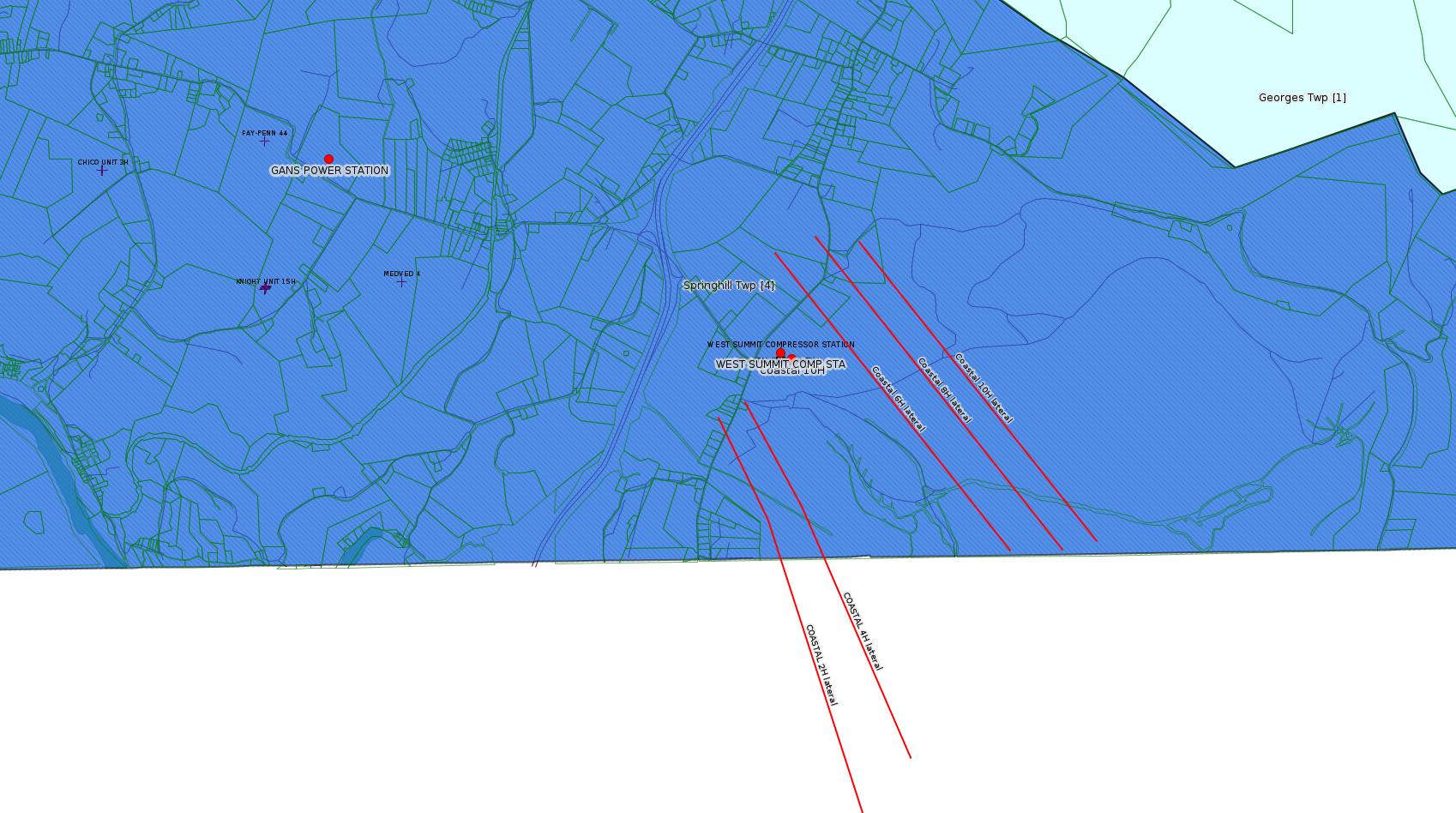
Coastal Smith Well Pad and West Summit Compressor Station to authorize construction and operation of 1-Caterpillar compressor rated at 1,380 bhp and allow continue operation of existing sourceseFACTS Listings
Fayette Energy Center plan approval extension
COASTAL 1H FLOW BACK PIT FRESHWATER PITS ESCGP-EXPEDITED ESCGP-3 Amendment
Prioritized Review Process Under the Erosion and Sediment Control General Permit for Earth Disturbance Associated with Oil and Gas Exploration, Production, Processing, or Treatment Operations or Transmission Facilities (ESCGP)
Guidelines for Implementing Area of Review Regulatory Requirement for Unconventional Wells
TEXAS EASTERN TRANS LP 2021 INTEGRITY PROGRAM – FAYETTE COUNTY 8 (21-16809) BWM-GP-11 Maintenance, Testing, Repair, Rehabilitation or Replacement General Pmt Issued 9/17/2021 (New)
Dogbone Water Line System GP-08 Temporary Road Crossings (New)
GANS POWER STATION Major Facility Plan Approval New Source Performance Std (New)
EDENBORN/RGGS B ESCGP ESX18-051-0003 Expedited E&S Stormwater General Permit 1 [Termination?] Notification (New)
FRAZEE LUMBER CO 603923 Well Plugging Notice Intent to Plug Single Well (New)
Coastal 10H Drill & Operate Well Permit (Unconventional) Issued 8/30/2021 (New)
DYNEGY FAYETTE II LLC Major Facility Plan Approval New Source Performance Std Extension Issued 8/2/2021
TEXAS EASTERN TRANS 2021 INTEGRITY PROGRAM - FAYETTE COUNTY GP-08 Temporary Road Crossings Issued 8/4/2021 (New)
MAKE PIGGALBE HOLB-UNIO 15C GP-07 Minor Road Crossings
WEST SUMMIT COMP STA AQ GP 5 - Natural Gas Compression and/or Processing Facilities
FAYETTE ENERGY FAC Minor IW Facility with ELG Renewal
COASTAL 1H FLOW BACK PIT FRESHWATER PITS ESCGP-EXPEDITED Erosion and Sediment Control GP-2 Amendment Issued 7/28/2021
HALL UNIT 2H Drill & Operate Well Permit Inactive Status Withdrawn 9/1/2021
HALL UNIT 3H Drill & Operate Well Permit Inactive Status Withdrawn 9/1/2021
POLK UNIT 1H Drill & Operate Well Permit Inactive Status Withdrawn 9/1/2021
POLK UNIT 2H Drill & Operate Well Permit Inactive Status Withdrawn 9/1/2021
HUMBERSTON UNIT 1H Drill & Operate Well Permit Inactive Status Withdrawn 9/1/2021
HALL UNIT 1H Drill & Operate Well Permit Inactive Status Withdrawn on 9/1/2021
GANS POWER STATION Major Facility Operating Permit Amendment
WHYEL UNIT 1H Drill & Operate Well Permit Inactive Status Withdrawn 8/27/2021
WASIL 1 Drill & Operate Well Permit Inactive Status Withdrawn 8/27/2021
CHESTNUT VALLEY LDFL Landfill Permit Renewal Issued 9/16/2021
Coastal 6H Casing cementing notification Surface: 8/29/2021
Coastal 6H Casing cementing notification Surface: 9/2/2021
Coastal 10H Casing cementing notification Surface: 9/4/2021 Intermediate: 9/5/2021
Coastal 8H Casing cementing notification Intermediate: 9/9/2021
FRAZEE LUMBER CO 603923 Abandonment or plugging notification 09/10/2021
Coastal 6H Casing cementing notification Intermediate: 9/11/2021
Coastal 6H Disposal of drill cuttings (unconventional wells) 09/15/2021
Coastal 8H Disposal of drill cuttings (unconventional wells) 09/15/2021
Coastal 10H Disposal of drill cuttings (unconventional wells) 09/15/2021
Coastal 6H Casing cementing notification Production Casing: 10/3/2021
Inspection
Issues
WATERS 10 Erosion and sedimentation issues Violation(s) Noted
RELL CORPORATION 1 Failure to remove production equipment after restoration of site Outstanding Violations - Viols Req'd
G PRODEN 1 the wellhead was found to be leaking gas Violation(s) Noted
F NUTT 1 has an order to plug but has yet to be plugged Outstanding Violations - Viols Req'd
Environmental
Hearing Board Appeals
Price of Natural GasCase # 2021022 WMGR123SW025 renewal, DOGBONE CENTRALIZED WATER FACILITY Appeal Withdrawn
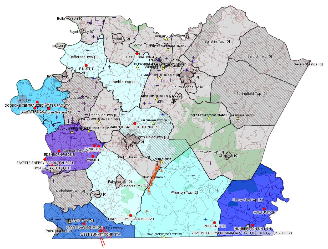
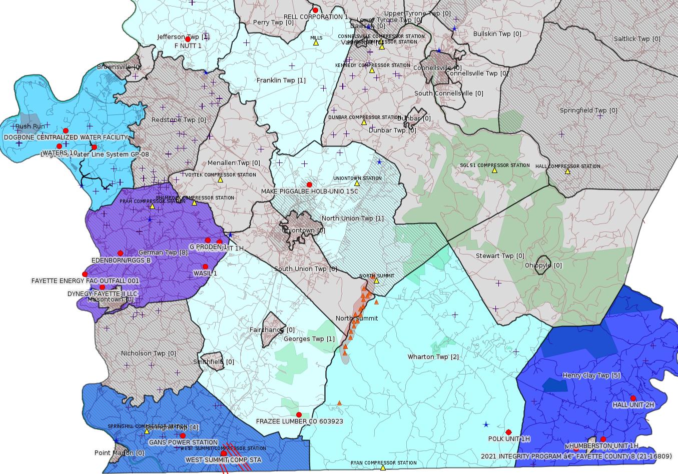
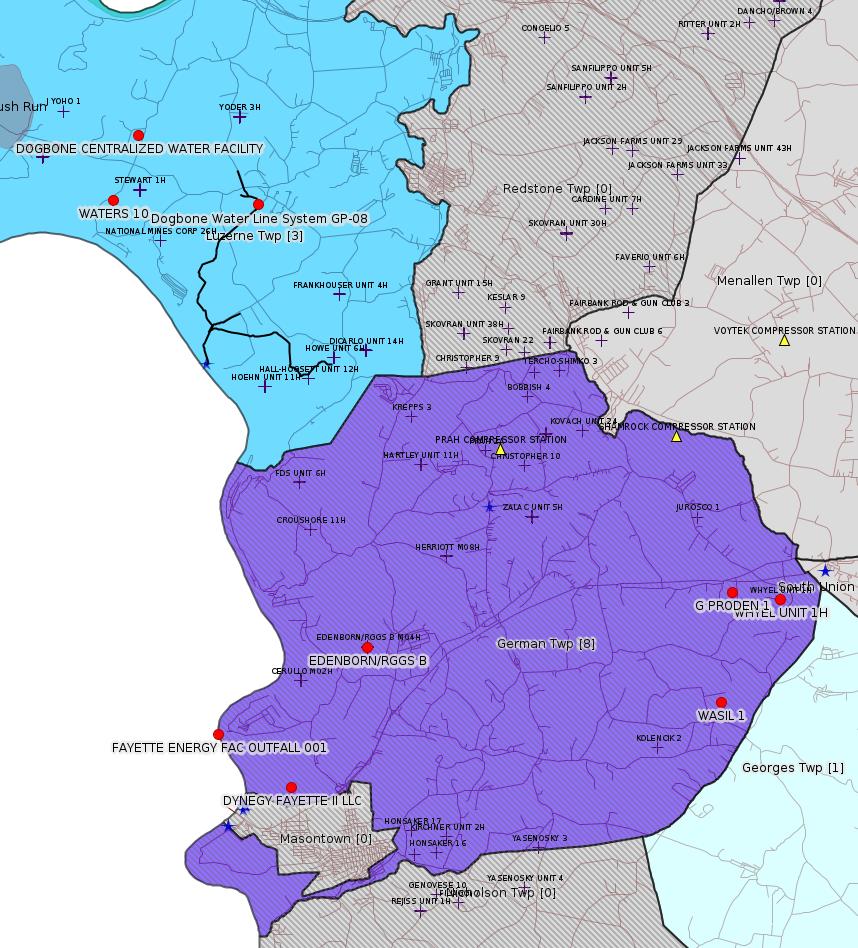
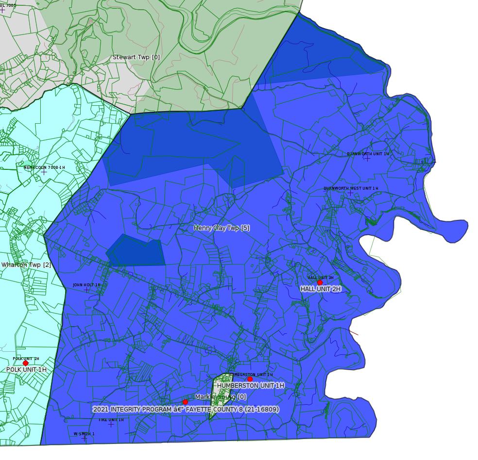
Map
Key
Red dots: items in this permit list with an exact location.
Blue stars: Marcellus Gas Well Water Sources.
Where well laterals are mapped they show in red; a 400-foot buffer surrounding the lateral shows in blue (lavender where it overlaps a mapped mineral tract).
Where mineral tracts are mapped, they show in pink. Mineral tracts can overlap; the overlap will show in red. The precise meaning of "mineral tract" is not clear.
Municipality shading: number of "facilities", with each well counting separately
(includes the red dots):
gray: 0
pale turquoise: 1
turquoise: 2
pale blue: 3
middle blue: 4
dark blue: 5
dark purple: 8
purple: 9
(Color coding may differ from one issue to the next.)
(Note if a project spans multiple municipalities -- e.g. a pipeline -- it will show in the count for each municipality.)
The number of facilities also follows the municipality name in brackets.
Municipality counts are based on the way the permit is listed by DEP; DEP has been known to get a municipality wrong.
Locations in brackets identify a precise location used to locate a surrogate for the actual site being permitted (e.g. locating a well pad or pipeline by the known location of a well.) Locations labeled beginning with "~" and ending in "[?]" are approximate and speculative based on inferences using on-line property and lease records. These are marked in the text as "[Approximate, Speculative]
Cross-hatching: Environmental Justice Areas
Yellow triangles: Compressor Stations
Orange triangles: Storage Field Wells (currently Dominion North Summit Storage Field)
Crosses: SPUD Unconventional well permits
Green: "Natural areas", e.g. state game lands, state forests
Yellow triangles: Compressor Stations
Orange triangles: Storage Field Wells (currently Dominion North Summit Storage Field)
Crosses: SPUD Unconventional well permits
Green: "Natural areas", e.g. state game lands, state forests
More Maps
 |
 |
 |
 |
Source: Pennsylvania Bulletin
GP5-26-00614A/AG5-26-00005A Coastal Smith Well Pad and West Summit Compressor Station: INR Operating, LLC (2605 Cranberry Square, Morgantown, WV 26508) on July 28, 2021, to authorize construction and operation of 1-Caterpillar compressor rated at 1,380 bhp and allow continue operation of existing sources which include 1-400 bhp Waukesha engine, 1-dehydrator rated at 25 MMscfd i/c 1.0 MMBtu/hr reboiler and a flash tank, 9-produced water tanks, 36-intermittent bleeders rated at 13.5 scfd, truck load-out operations, blowdowns, pigging and fugitive operations, and line heaters at Coastal Smith Well Pad Site and West Summit Compressor Station located in Springhill Township, Fayette County.
<http://www.pacodeandbulletin.gov/Display/pabull?file=/secure/pabulletin/data/vol51/51-33/1279c.html&continued=http://www.pacodeandbulletin.gov/Display/pabull?file=/secure/pabulletin/data/vol51/51-33/1279.html&d=reduce>
AQ AEP Details:
CLIENT_ID: 360521
CLIENT: INR MIDSTREAM LLC
CLIENT_TYPE: NON-GOVERNMENT
CLIENT_ADDRESS1: 2605 CRANBERRY SQUARE
CLIENT_ADDRESS2:
CLIENT_CITY: MORGANTOWN
CLIENT_STATE: WV
CLIENT_ZIP: 26508-9201
SITE_ID: 739878
PRIMARY_FACILITY_ID: 734851
PRIMARY_FACILITY_NAME: INR MIDSTREAM LLC/WEST SUMMIT COMP STA
NAICS_CODE: 211130
NAICS_DESCRIPTION: Natural Gas Extraction
PRIMARY_FACILITY_STATUS: Active
FACILITY_TYPE: Other
REGION: Southwest Regional Office
COUNTY: Fayette
MUNICIPALITY: Springhill Twp
LATITUDE: 39.73437
LONGITUDE: -79.80091
LOCATION_ADDRESS1: GANS RD
LOCATION_ADDRESS2: SPRINGHILL FURNACE RD
LOCATION_CITY: LAKE LYNN
LOCATION_STATE: PA
LOCATION_ZIP: 15451
Location: 39.73437,-79.80091
Map URL: <http://www.openstreetmap.org/?mlat=39.73437&mlon=-79.80091#map=15/39.73437/-79.80091>
Presumed Parcel Id: 36210048
---
26-00535B: Dynegy Fayette II, LLC (100 Energy Drive, Masontown, PA 15461-2588) plan approval extension effective August 28, 2021, with expiration on February 28, 2022, to extend the period of temporary operation of the modified combustion gas turbines (CGT) at Fayette Energy Center located in German Township, Fayette County.
<http://www.pacodeandbulletin.gov/Display/pabull?file=/secure/pabulletin/data/vol51/51-33/1279c.html&continued=http://www.pacodeandbulletin.gov/Display/pabull?file=/secure/pabulletin/data/vol51/51-33/1279.html&d=reduce>
Location: 39.857408,-79.913878
Map URL: <http://www.openstreetmap.org/?mlat=39.857408&mlon=-79.913878#map=15/39.857408/-79.913878>
Map URL: <http://www.openstreetmap.org/?mlat=39.857408&mlon=-79.913878#map=15/39.857408/-79.913878>
Presumed Parcel Id: 1530006703
---
ESCGP-3 # ESX10-051-0035
Applicant Name INR Operating, LLC
Contact Person Ian Costello
Address 2605 Cranberry Square
City, State, Zip Morgantown, WV 26508
County Fayette
Township(s) Springhill Twp
Receiving Stream(s) and Classification(s) UNT to Rubbles Run (CWF), Rubbles Run (CWF)/Cheat River (WWF)
<http://www.pacodeandbulletin.gov/Display/pabull?file=/secure/pabulletin/data/vol51/51-33/1279c.html&continued=http://www.pacodeandbulletin.gov/Display/pabull?file=/secure/pabulletin/data/vol51/51-33/1279.html&d=reduce>
<https://www.ahs.dep.pa.gov/eSubmissionsDocs/DownloadESubmissionDocument.ashx?enc=MOpmV6IzBtmToVjqF07C9WdKYxRCgcjmE1buypYBlyw%3d>
Coastal Well Pad Expansion Geotechnical Report 02.26.2021:
<https://www.ahs.dep.pa.gov/eSubmissionsDocs/DownloadESubmissionDocument.ashx?enc=MOpmV6IzBtmToVjqF07C9ZdGBDJ3Pkup1CNdrCFixHQ%3d>
Well Pad ID: 147971
Well Pad Name: COASTAL WELL PAD
Primary Facility ID: 726470
Wells on this Pad:
Location: 39.733294,-79.801028
Presumed Parcel Id: 36210048
---
Draft TGD
DEP ID: 800-2100-001. Title: Prioritized Review Process Under the Erosion and Sediment Control General Permit for Earth Disturbance Associated with Oil and Gas Exploration, Production, Processing, or Treatment Operations or Transmission Facilities (ESCGP). Description: This draft TGD establishes a Prioritized Review Process for certain authorizations approved by the Department's Office of Oil and Gas Management (OOGM). The Prioritized Review Process contained in this draft technical guidance seeks to encourage persons preparing Notices of Intent (NOI) for Authorizations of Coverage under the Erosion and Sediment Control General Permit issued by OOGM to voluntarily develop and implement superior environmental enhancements to proposed projects by providing priority status in the NOI review process to qualifying applicants.
Written Comments: Interested persons may submit written comments on this draft TGD through Monday, September 27, 2021. Comments, including comments submitted by e-mail must include the commentator's name and address. Commentators must submit comments using the Department's online eComment for Policies at www.ahs.dep.pa.gov/eComment or by e-mail to ecomment@pa.gov. Written comments can be mailed to the Technical Guidance Coordinator, Department of Environmental Protection, Policy Office, Rachel Carson State Office Building, P.O. Box 2063, Harrisburg, PA 17105-2063.
Contact: Questions regarding this TGD can be directed to Kurt Klapkowski at kklapkowsk@pa.gov or (717) 772-2199.
Effective Date: Upon publication of notice as final in the Pennsylvania Bulletin.
<http://www.pacodeandbulletin.gov/Display/pabull?file=/secure/pabulletin/data/vol51/51-35/1386.html>
The Technical Guidance Document (TGD) is available here:
<http://www.depgreenport.state.pa.us/elibrary/GetDocument?docId=3884675&DocName=PRIORITIZED%20REVIEW%20PROCESS%20UNDER%20EROSION%20SEDIMENT%20CTRL%20GP%20EARTH%20DISTURBANCE%20ASSOC%20OIL%20%20GAS%20EXPLORATION%2C%20PRODUCTION%2C%20PROCESS%2C%20TREATMENT%20OPERATIONS%20TRANSMISSION%20FACILITIES%20(ESCGP).PDF>
---
Final TGD
DEP ID: 800-0810-001. Title: Guidelines for Implementing Area of Review Regulatory Requirement for Unconventional Wells. Description: This final TGD informs unconventional well operators engaged in hydraulic fracturing activities how to comply with the requirements of The Clean Streams Law (35 P.S. �� 691.1�691.1001), the 2012 Oil and Gas Act (58 Pa.C.S. �� 2301�3504), 25 Pa. Code Chapter 78a (relating to unconventional wells) and other applicable laws. The Department developed this final guidance to facilitate appropriate risk mitigation for unconventional well operators. The final TGD includes a risk-based classification scheme for offset well locations and commensurate levels of monitoring; communication incident management, reporting and resolution; and operational alternatives and technical considerations for different anticipated incident scenarios. This final guidance also provides an overview of the Department's well adoption permitting process.
The Department published the interim final guidance document in the Pennsylvania Bulletin at 46 Pa.B. 6392 (October 8, 2016). Based on the approximately 55 comments from 10 commenters received during the 60-day comment period, the Department made several editorial and substantive changes to the guidelines. These changes included clarifying the ability for operators to survey an area that extends beyond the prescriptive area of review regulatory language, removing language assigning responsibility for recently plugged offset wells to the operator who had completed the plugging, relocating language pertaining to briefing the hydraulic fracturing operations team about adjacent operator coordination, updating incident reporting language and modifying operator coordination with Department field inspection staff ahead of hydraulic fracturing.
Contact: Questions regarding this TGD can be directed to Seth Pelepko at mipelepko@pa.gov or (717) 772-2199.
Effective Date: September 4, 2021
PATRICK McDONNELL,
Secretary
<http://www.pacodeandbulletin.gov/Display/pabull?file=/secure/pabulletin/data/vol51/51-36/1475.html>
---
ESCGP-3 # ESX10-051-0035
Applicant Name INR Operating, LLC
Contact Person Ian Costello
Address 2605 Cranberry Square
City, State, Zip Morgantown, WV 26508
County Fayette
Township(s) Springhill Twp
Receiving Stream(s) and Classification(s) UNT to Rubbles Run (CWF), Rubbles Run (CWF)/Cheat River (WWF)
<http://www.pacodeandbulletin.gov/Display/pabull?file=/secure/pabulletin/data/vol51/51-33/1279c.html&continued=http://www.pacodeandbulletin.gov/Display/pabull?file=/secure/pabulletin/data/vol51/51-33/1279.html&d=reduce>
Site: COASTAL 1H FLOW BACK PIT FRESHWATER PITS
ESCGP-EXPEDITED
Impoundment Registration Application:<https://www.ahs.dep.pa.gov/eSubmissionsDocs/DownloadESubmissionDocument.ashx?enc=MOpmV6IzBtmToVjqF07C9WdKYxRCgcjmE1buypYBlyw%3d>
Coastal Well Pad Expansion Geotechnical Report 02.26.2021:
<https://www.ahs.dep.pa.gov/eSubmissionsDocs/DownloadESubmissionDocument.ashx?enc=MOpmV6IzBtmToVjqF07C9ZdGBDJ3Pkup1CNdrCFixHQ%3d>
Well Pad ID: 147971
Well Pad Name: COASTAL WELL PAD
Primary Facility ID: 726470
Wells on this Pad:
051-24318 COASTAL 1H
051-24382 COASTAL/SMITH UNIT 1H
051-24721 COASTAL 4H
051-24722 COASTAL 2H
Location: 39.733294,-79.801028
Presumed Parcel Id: 36210048
---
Draft TGD
DEP ID: 800-2100-001. Title: Prioritized Review Process Under the Erosion and Sediment Control General Permit for Earth Disturbance Associated with Oil and Gas Exploration, Production, Processing, or Treatment Operations or Transmission Facilities (ESCGP). Description: This draft TGD establishes a Prioritized Review Process for certain authorizations approved by the Department's Office of Oil and Gas Management (OOGM). The Prioritized Review Process contained in this draft technical guidance seeks to encourage persons preparing Notices of Intent (NOI) for Authorizations of Coverage under the Erosion and Sediment Control General Permit issued by OOGM to voluntarily develop and implement superior environmental enhancements to proposed projects by providing priority status in the NOI review process to qualifying applicants.
Written Comments: Interested persons may submit written comments on this draft TGD through Monday, September 27, 2021. Comments, including comments submitted by e-mail must include the commentator's name and address. Commentators must submit comments using the Department's online eComment for Policies at www.ahs.dep.pa.gov/eComment or by e-mail to ecomment@pa.gov. Written comments can be mailed to the Technical Guidance Coordinator, Department of Environmental Protection, Policy Office, Rachel Carson State Office Building, P.O. Box 2063, Harrisburg, PA 17105-2063.
Contact: Questions regarding this TGD can be directed to Kurt Klapkowski at kklapkowsk@pa.gov or (717) 772-2199.
Effective Date: Upon publication of notice as final in the Pennsylvania Bulletin.
<http://www.pacodeandbulletin.gov/Display/pabull?file=/secure/pabulletin/data/vol51/51-35/1386.html>
The Technical Guidance Document (TGD) is available here:
<http://www.depgreenport.state.pa.us/elibrary/GetDocument?docId=3884675&DocName=PRIORITIZED%20REVIEW%20PROCESS%20UNDER%20EROSION%20SEDIMENT%20CTRL%20GP%20EARTH%20DISTURBANCE%20ASSOC%20OIL%20%20GAS%20EXPLORATION%2C%20PRODUCTION%2C%20PROCESS%2C%20TREATMENT%20OPERATIONS%20TRANSMISSION%20FACILITIES%20(ESCGP).PDF>
Final TGD
DEP ID: 800-0810-001. Title: Guidelines for Implementing Area of Review Regulatory Requirement for Unconventional Wells. Description: This final TGD informs unconventional well operators engaged in hydraulic fracturing activities how to comply with the requirements of The Clean Streams Law (35 P.S. �� 691.1�691.1001), the 2012 Oil and Gas Act (58 Pa.C.S. �� 2301�3504), 25 Pa. Code Chapter 78a (relating to unconventional wells) and other applicable laws. The Department developed this final guidance to facilitate appropriate risk mitigation for unconventional well operators. The final TGD includes a risk-based classification scheme for offset well locations and commensurate levels of monitoring; communication incident management, reporting and resolution; and operational alternatives and technical considerations for different anticipated incident scenarios. This final guidance also provides an overview of the Department's well adoption permitting process.
The Department published the interim final guidance document in the Pennsylvania Bulletin at 46 Pa.B. 6392 (October 8, 2016). Based on the approximately 55 comments from 10 commenters received during the 60-day comment period, the Department made several editorial and substantive changes to the guidelines. These changes included clarifying the ability for operators to survey an area that extends beyond the prescriptive area of review regulatory language, removing language assigning responsibility for recently plugged offset wells to the operator who had completed the plugging, relocating language pertaining to briefing the hydraulic fracturing operations team about adjacent operator coordination, updating incident reporting language and modifying operator coordination with Department field inspection staff ahead of hydraulic fracturing.
Contact: Questions regarding this TGD can be directed to Seth Pelepko at mipelepko@pa.gov or (717) 772-2199.
Effective Date: September 4, 2021
PATRICK McDONNELL,
Secretary
<http://www.pacodeandbulletin.gov/Display/pabull?file=/secure/pabulletin/data/vol51/51-36/1475.html>
<http://www.depgreenport.state.pa.us/elibrary/GetDocument?docId=3895833&DocName=GUIDELINES%20FOR%20IMPLEMENTING%20AREA%20OF%20REVIEW%20(AOR)%20REGULATORY%20REQUIREMENT%20FOR%20UNCONVENTIONAL%20WELLS.PDF>
-------------------------
Please see the Disclaimer below regarding Parcel Id data.
Authorization ID: 1368190
Permit number: GP112683221-026
Site: 2021 INTEGRITY PROGRAM – FAYETTE COUNTY 8 (21-16809)
Client: TEXAS EASTERN TRANS LP
Authorization type: BWM-GP-11 Maintenance, Testing, Repair, Rehabilitation or Replacement General Pmt
Application type: New
Authorization is for: FACILITY
Date received: 09/02/2021
Status: Issued on 9/17/2021
Permit Decision Guarantee Applies: Yes
Permit Decision Guarantee status: ACTIVE
Sub-Facilities for Authorization:
Sub-Facility ID Sub-Facility Name Description
1338755 2021 INTEGRITY PROGRAM – FAYETTE COUNTY 8 (21-16809) PIPE Pipeline or Conduit
Location: 39.733556,-79.465726
Map URL: <http://www.openstreetmap.org/?mlat=39.733556&mlon=-79.465726#map=15/39.733556/-79.465726>
Permit Review Notes:
Date Review Note
9/17/2021 The technical review and decision review are complete and either the permit decision and/or permit issuance are forthcoming.
9/7/2021 The permit application package is complete, has been accepted, and is undergoing technical review.
<https://www.ahs.dep.pa.gov/eFACTSWeb/searchResults_singleAuth.aspx?AuthID=1368190>
Site Programs:
Water Planning and Conservation
Site Municipalities:
Henry Clay Twp, Fayette County
Presumed Parcel Id: 16190039
---
Authorization ID: 1367959
Permit number: GP082605121-005
Site: Dogbone Water Line System
Client: EQT CHAP LLC
Authorization type: GP-08 Temporary Road Crossings
Application type: New
Authorization is for: FACILITY
Date received: 09/02/2021
Status: Pending
Public_Permit_Review:
<http://www.ahs.dep.pa.gov/ePermitPublicAccess/Public/PublicAuthOverview?q=YanvhUb%2fnzLVsf19zgaYglKGeuFMKBZdUspLmVjuAXI%3d>
Permit Decision Guarantee Applies: No
Sub-Facilities for Authorization:
Sub-Facility ID Sub-Facility Name Description
1338624 Wetland 4 Mat/Pads
Location: 39.9601,-79.91976
Map URL: <http://www.openstreetmap.org/?mlat=39.9601&mlon=-79.91976#map=15/39.9601/-79.91976>
1338618 Wetland 7 Mat/Pads
Location: 39.9601,-79.91976
Map URL: <http://www.openstreetmap.org/?mlat=39.9601&mlon=-79.91976#map=15/39.9601/-79.91976>
1338620 UNT 5 Mat/Pads
Location: 39.9601,-79.91976
Map URL: <http://www.openstreetmap.org/?mlat=39.9601&mlon=-79.91976#map=15/39.9601/-79.91976>
1338621 UNT 2 Mat/Pads
Location: 39.9601,-79.91976
Map URL: <http://www.openstreetmap.org/?mlat=39.9601&mlon=-79.91976#map=15/39.9601/-79.91976>
1338622 UNT 8 Mat/Pads
Location: 39.9601,-79.91976
Map URL: <http://www.openstreetmap.org/?mlat=39.9601&mlon=-79.91976#map=15/39.9601/-79.91976>
1338623 Wetland 6 (2) Mat/Pads
Location: 39.9601,-79.91976
Map URL: <http://www.openstreetmap.org/?mlat=39.9601&mlon=-79.91976#map=15/39.9601/-79.91976>
1338619 UNT 3 Mat/Pads
Location: 39.9601,-79.91976
Map URL: <http://www.openstreetmap.org/?mlat=39.9601&mlon=-79.91976#map=15/39.9601/-79.91976>
1338625 Total Floodway Impacts Temporary Floodway Impact
Location: 39.9601,-79.91976
Map URL: <http://www.openstreetmap.org/?mlat=39.9601&mlon=-79.91976#map=15/39.9601/-79.91976>
1338626 Total Stream Impacts Temporary Stream Impact
Location: 39.9601,-79.91976
Map URL: <http://www.openstreetmap.org/?mlat=39.9601&mlon=-79.91976#map=15/39.9601/-79.91976>
1338615 Rush Run Mat/Pads
Location: 39.9601,-79.91976
Map URL: <http://www.openstreetmap.org/?mlat=39.9601&mlon=-79.91976#map=15/39.9601/-79.91976>
1338614 UNT 1 Mat/Pads
Location: 39.9601,-79.91976
Map URL: <http://www.openstreetmap.org/?mlat=39.9601&mlon=-79.91976#map=15/39.9601/-79.91976>
1338617 Wetland 2 Mat/Pads
Location: 39.9601,-79.91976
Map URL: <http://www.openstreetmap.org/?mlat=39.9601&mlon=-79.91976#map=15/39.9601/-79.91976>
1338616 Wetland 6 (1) Mat/Pads
Location: 39.9601,-79.91976
Map URL: <http://www.openstreetmap.org/?mlat=39.9601&mlon=-79.91976#map=15/39.9601/-79.91976>
1338613 Total PEM Wetland Impacts Temporary Wetland Impact
Location: 39.9601,-79.91976
Map URL: <http://www.openstreetmap.org/?mlat=39.9601&mlon=-79.91976#map=15/39.9601/-79.91976>
1338612 Total PFO Wetland Impacts Temporary Wetland Impact
Location: 39.9601,-79.91976
Map URL: <http://www.openstreetmap.org/?mlat=39.9601&mlon=-79.91976#map=15/39.9601/-79.91976>
Permit Review Notes:
Date Review Note
9/21/2021 Applicant has been issued a deficiency letter. If applicable, this application no longer qualifies for the Permit Decision Guarantee.
<https://www.ahs.dep.pa.gov/eFACTSWeb/searchResults_singleAuth.aspx?AuthID=1367959>
Site Programs:
Water Planning and Conservation
Site Municipalities:
Luzerne Twp, Fayette County
[See Notes.]
---
Authorization ID: 1367183
Permit number: 26-00495B
Site: GANS POWER STATION
Client: GANS ENERGY LLC
Authorization type: Major Facility Plan Approval New Source Performance Std
Application type: New
Authorization is for: FACILITY
Date received: 08/16/2021
Status: Pending
Permit Decision Guarantee Applies: Yes
Permit Decision Guarantee status: VOID
Permit Review Notes:
Date Review Note
9/2/2021 Applicant has been issued a deficiency letter. If applicable, this application no longer qualifies for the Permit Decision Guarantee.
<https://www.ahs.dep.pa.gov/eFACTSWeb/searchResults_singleAuth.aspx?AuthID=1367183>
Site Programs:
Air Quality
Clean Water
Waste Management
Site Municipalities:
Springhill Twp, Fayette County
AQ AEP Details:
CLIENT_ID: 336060
CLIENT: GANS ENERGY LLC
CLIENT_TYPE: NON-GOVERNMENT
CLIENT_ADDRESS1: 1700 BROADWAY
CLIENT_ADDRESS2: 35TH FLOOR
CLIENT_CITY: NEW YORK
CLIENT_STATE: NY
CLIENT_ZIP: 10019
SITE_ID: 531375
PRIMARY_FACILITY_ID: 552958
PRIMARY_FACILITY_NAME: GANS ENERGY LLC/GANS POWER STA
NAICS_CODE: 221112
NAICS_DESCRIPTION: Fossil Fuel Electric Power Generation
PRIMARY_FACILITY_STATUS: Active
FACILITY_TYPE: Title V Facility
REGION: Southwest Regional Office
COUNTY: Fayette
MUNICIPALITY: Springhill Twp
LATITUDE: 39.7475
LONGITUDE: -79.839167
LOCATION_ADDRESS1: STATE ROUTE 3002
LOCATION_ADDRESS2:
LOCATION_CITY: GANS
LOCATION_STATE: PA
LOCATION_ZIP: 15439
CONTACT_NAME:
CONTACT_PHONE:
CONTACT_EMAIL:
Map URL: <http://www.openstreetmap.org/?mlat=39.7475&mlon=-79.839167#map=15/39.7475/-79.839167>
Presumed Parcel Id: 36180001
---
Authorization ID: 1367026
Permit number: ESX18-051-0003
Site: EDENBORN/RGGS B ESCGP ESX18-051-0003
Client: EQT CHAP LLC
Authorization type: Expedited E&S Stormwater General Permit 1
Application type: Notification
Authorization is for: SITE
Date received: 08/30/2021
Status: Pending
Permit Decision Guarantee Applies: No
Permit Review Notes:
Date Review Note
8/30/2021 The permit application package is complete, has been accepted, and is undergoing technical review.
<https://www.ahs.dep.pa.gov/eFACTSWeb/searchResults_singleAuth.aspx?AuthID=1367026>
Site Programs:
Oil & Gas
Site Municipalities:
German Twp, Fayette County
Well
Pad Details:
Presumed Parcel Id: 15220014
[See Notes.]
---OPERATOR: CHEVRON APPALACHIA LLCWells on this pad:
OGO: OGO-39307
CLIENT_ID: 279986
WELL_PAD: EDENBORN/RGGS B
WELL_PAD_ID: 155083
SITE_NAME: EDENBORN/RGGS B ESCGP ESX18-051-0003
SITE_ID: 829418
ADDRESS_TYPE: 911WL
ADDRESS1: 392 GATES ROAD
ADDRESS2:
CITY: ADAH
STATE: PA
ZIP: 15410
WELL_PAD_REFERENCE_POINT: WSGPS
WELL_PAD_LATITUDE: 39.881931
WELL_PAD_LONGITUDE: -79.896106
WELL_PAD_DATUM: NAD83
WELL_PAD_COLLECTION_METHOD: GPS
ACCESS_ROAD_REFERENCE_POINT: LACRD
ACCESS_ROAD_LATITUDE: 39.877033
ACCESS_ROAD_LONGITUDE: -79.89575
ACCESS_ROAD_DATUM: NAD83
ACCESS_ROAD_COLLECTION_METHOD: GPS
REGION: EP DOGO SWDO Dstr Off
COUNTY: Fayette
MUNICIPALITY: German Twp
CHAPTER_93_WATER_QUALITY:
051-24675 EDENBORN/RGGS B M01H
051-24676 EDENBORN/RGGS B M03H
051-24678 EDENBORN/RGGS B M02H
051-24681 EDENBORN/RGGS B M04H
051-24682 EDENBORN/RGGS B M05H
051-24688 EDENBORN/RGGS B M14H
051-24689 EDENBORN/RGGS B M15H
Presumed Parcel Id: 15220014
[See Notes.]
Authorization ID: 1365131
Permit number: 051-00128
Site: FRAZEE LUMBER 603923 WELL
Client: EQT PROD CO
Authorization type: Well Plugging Notice Intent to Plug Single Well
Application type: New
Authorization is for: FACILITY
Date received: 08/12/2021
Status: Issued on 8/23/2021
Permit Decision Guarantee Applies: No
Sub-Facilities for Authorization:
Sub-Facility ID Sub-Facility Name Description
56088 FRAZEE LUMBER CO 603923 Well
Permit Review Notes:
Date Review Note
8/23/2021 The technical review and decision review are complete and either the permit decision and/or permit issuance are forthcoming.
8/13/2021 The permit application package is complete, has been accepted, and is undergoing technical review.
<https://www.ahs.dep.pa.gov/eFACTSWeb/searchResults_singleAuth.aspx?AuthID=1365131>
Site Programs:
Oil & Gas
Site Municipalities:
Georges Twp, Fayette County
Well Details:
Permit Number: 051-00128
Well Name: FRAZEE LUMBER CO 603923
Unconventional Well: N
Well Configuration: Vertical Well
Well Type: GAS
Well Status: Active
Coal Association: Coal
Conservation Well: N
Primary Facility ID: 42558
Site ID: 40806
Site Name: FRAZEE LUMBER 603923 WELL
Well Pad ID: 0
Well Pad Name:
Storage Field:
Operator: EQT PROD CO
Operator Number: OGO-61555
Permit Date: 1986-07-18
Permit Date Expires:
SPUD Date: 1947-08-27
Date Plugged:
UIC ID:
UIC Type:
Surface Elevation: 0
County: Fayette
Municipality: Georges Twp
Location: 39.76177,-79.728367
Map URL: <http://www.openstreetmap.org/?mlat=39.76177&mlon=-79.728367#map=15/39.76177/-79.728367>
OG WELLS PERMIT DOCS:
2021-08-23: Final Permit Documents, Name: 051-00128, NOI (for Authorization: 1365131.0):
<http://www.depgis.state.pa.us/pdfHandler/pdFHandler.ashx?Doc=MTk2ODI4MS4w&ext=PDF>
Presumed Parcel Id: 14410014
---
Authorization ID: 1364766
Permit number: 051-24726
Site: COASTAL 1H FLOW BACK PIT FRESHWATER PITS ESCGP-EXPEDITED
Client: INR OPR LLC
Authorization type: Drill & Operate Well Permit (Unconventional)
Application type: New
Authorization is for: FACILITY
Date received: 08/11/2021
Status: Issued on 8/30/2021
Public_Permit_Review:
<http://www.ahs.dep.pa.gov/ePermitPublicAccess/Public/PublicAuthOverview?q=sTiGadFJyxmbA5kpg6QPphxkBOb7y3AiApei5U5GDCk%3d>
Plat:
<https://www.ahs.dep.pa.gov/ePermitPublicAccess/Public/DownloadFileFromWebServer/95307?onBaseDocId=3883030>
Permit Decision Guarantee Applies: Yes
Permit Decision Guarantee status: VOID
Sub-Facilities for Authorization:
Sub-Facility ID Sub-Facility Name Description
1336589 Deviated MARCELLUS Well
Permit Review Notes:
Date Review Note
8/30/2021 The technical review and decision review are complete and either the permit decision and/or permit issuance are forthcoming.
8/27/2021 Applicant has been issued a deficiency letter. If applicable, this application no longer qualifies for the Permit Decision Guarantee.
8/24/2021 Applicant has been issued a deficiency letter. If applicable, this application no longer qualifies for the Permit Decision Guarantee.
8/23/2021 The permit application package is complete, has been accepted, and is undergoing technical review.
<https://www.ahs.dep.pa.gov/eFACTSWeb/searchResults_singleAuth.aspx?AuthID=1364766>
Site Programs:
Oil & Gas
Site Municipalities:
Springhill Twp, Fayette County
Well Details:
Permit Number: 051-24726
Well Name: Coastal 10H
Unconventional Well: Y
Well Configuration: Deviated Well
Well Type: GAS
Well Status: Active
Coal Association: NonCoal
Conservation Well: N
Primary Facility ID: 851454
Site ID: 739525
Site Name: COASTAL 1H FLOW BACK PIT FRESHWATER PITS ESCGP-EXPEDITED
Well Pad ID: 147971
Well Pad Name: COASTAL WELL PAD
Storage Field:
Operator: INR OPR LLC
Operator Number: OGO-51036
Permit Date: 2021-08-30
Permit Date Expires: 2022-08-30
SPUD Date: 2021-09-01
Date Plugged:
UIC ID:
UIC Type:
Surface Elevation: 1138
County: Fayette
Municipality: Springhill Twp
Location: 39.73399,-79.79996
Map URL: <http://www.openstreetmap.org/?mlat=39.73399&mlon=-79.79996#map=15/39.73399/-79.79996>
LANDING POINT: 39.741658,-79.794074
BOTTOM HOLE: 39.721647, -79.774119
Presumed Parcel Id: 36210048
---
Authorization ID: 1363461
Permit number: 26-00535B
Site: DYNEGY FAYETTE II LLC
Client: FAYETTE POWER CO LLC
Authorization type: Major Facility Plan Approval New Source Performance Std
Application type: Extension
Authorization is for: FACILITY
Date received: 07/23/2021
Status: Issued on 8/2/2021
Permit Decision Guarantee Applies: No
Sub-Facilities for Authorization:
Sub-Facility ID Sub-Facility Name Description
805962 CGT STACK 2 Point of Air Emission
805959 CGT TRAIN 2 COMBINED CYCLE TURBINE Process
805961 CGT STACK 1 Point of Air Emission
805954 CGT TRAIN 1 COMBINED CYCLE TURBINE Process
1095706 OXIDATION CATALYST UNIT 2 Air Pollution Control Device
1095705 OXIDATION CATALYST UNIT 1 Air Pollution Control Device
1095702 SCR UNIT 2 Air Pollution Control Device
1095701 SCR UNIT 1 Air Pollution Control Device
Permit Review Notes:
Date Review Note
8/2/2021 The technical review and decision review are complete and either the permit decision and/or permit issuance are forthcoming.
8/2/2021 The permit application package is complete, has been accepted, and is undergoing technical review.
<https://www.ahs.dep.pa.gov/eFACTSWeb/searchResults_singleAuth.aspx?AuthID=1363461>
Site Programs:
Air Quality
Waste Management
Water Planning and Conservation
Site Municipalities:
German Twp, Fayette County
Masontown Boro, Fayette County [apparently incorrect -jr]
Location:
39.857408,-79.913878
Map URL: <http://www.openstreetmap.org/?mlat=39.857408&mlon=-79.913878#map=15/39.857408/-79.913878>
Map URL: <http://www.openstreetmap.org/?mlat=39.857408&mlon=-79.913878#map=15/39.857408/-79.913878>
Presumed Parcel Id: 1530006703
---
Authorization ID: 1361033
Permit number: GP082683221-003
Site: 2021 INTEGRITY PROGRAM - FAYETTE COUNTY LP
Client: TEXAS EASTERN TRANS LP
Authorization type: GP-08 Temporary Road Crossings
Application type: New
Authorization is for: FACILITY
Date received: 07/02/2021
Status: Issued on 8/4/2021
Permit Decision Guarantee Applies: No
Sub-Facilities for Authorization:
Sub-Facility ID Sub-Facility Name Description
1334456 2021 INTEGRITY PROGRAM – FAYETTE COUNTY 7 MATS Mat/Pads
Permit Review Notes:
Date Review Note
8/4/2021 The technical review and decision review are complete and either the permit decision and/or permit issuance are forthcoming.
7/13/2021 The permit application package is complete, has been accepted, and is undergoing technical review.
<https://www.ahs.dep.pa.gov/eFACTSWeb/searchResults_singleAuth.aspx?AuthID=1361033>
Site Programs:
Water Planning and Conservation
Site Municipalities:
German Twp, Fayette County
---
Authorization ID: 1360982
Permit number: GP072683221-005
Site: MAKE PIGGALBE HOLB-UNIO 15C
Client: TEXAS EASTERN TRANS LP
Authorization type: GP-07 Minor Road Crossings
Application type: New
Authorization is for: FACILITY
Date received: 07/01/2021
Status: Issued on 7/30/2021
Permit Decision Guarantee Applies: No
Sub-Facilities for Authorization:
Sub-Facility ID Sub-Facility Name Description
1335868 W-MRK-021--WTDIM Wetland Direct Impact
Location: 39.930629,-79.715388
Map URL: <http://www.openstreetmap.org/?mlat=39.930629&mlon=-79.715388#map=15/39.930629/-79.715388>
1334437 MAKE PIGGABLE HOLB-UNIO 15C OTHER Other Activities
Location: 39.930629,-79.715388
Map URL: <http://www.openstreetmap.org/?mlat=39.930629&mlon=-79.715388#map=15/39.930629/-79.715388>
Permit Review Notes:
Date Review Note
7/30/2021 The technical review and decision review are complete and either the permit decision and/or permit issuance are forthcoming.
7/22/2021 Applicant has been issued a deficiency letter. If applicable, this application no longer qualifies for the Permit Decision Guarantee.
7/14/2021 The permit application package is complete, has been accepted, and is undergoing technical review.
<https://www.ahs.dep.pa.gov/eFACTSWeb/searchResults_singleAuth.aspx?AuthID=1360982>
Site Programs:
Water Planning and Conservation
Site Municipalities:
North Union Twp, Fayette County
---
Authorization ID: 1360627
Permit number: AG5-26-00005A
Site: WEST SUMMIT COMP STA
Client: INR OPR LLC
Authorization type: AQ GP 5 - Natural Gas Compression and/or Processing Facilities
Application type: New
Authorization is for: FACILITY
Date received: 05/25/2021
Status: Pending
Permit Decision Guarantee Applies: No
Sub-Facilities for Authorization:
Sub-Facility ID Sub-Facility Name Description
1186818 HEATER/REBOILER Process
Location: 39.735,-79.784167
Map URL: <http://www.openstreetmap.org/?mlat=39.735&mlon=-79.784167#map=15/39.735/-79.784167>
1186826 VENTING/BLOWDOWNS Process
Location: 39.735,-79.784167
Map URL: <http://www.openstreetmap.org/?mlat=39.735&mlon=-79.784167#map=15/39.735/-79.784167>
1186820 FIVE (5) TANKS/VESSELS AT CS Process
Location: 39.735,-79.784167
Map URL: <http://www.openstreetmap.org/?mlat=39.735&mlon=-79.784167#map=15/39.735/-79.784167>
1186822 GLYCOL DEHY UNIT 1 Process
Location: 39.735,-79.784167
Map URL: <http://www.openstreetmap.org/?mlat=39.735&mlon=-79.784167#map=15/39.735/-79.784167>
1253786 WAUKESHA COMPRESSOR ENGINE RATED 400 BHP Process
Location: 39.73437,-79.80091
Map URL: <http://www.openstreetmap.org/?mlat=39.73437&mlon=-79.80091#map=15/39.73437/-79.80091>
1049059 FUGITIVES AT CS Process
Location: 39.735,-79.784167
Map URL: <http://www.openstreetmap.org/?mlat=39.735&mlon=-79.784167#map=15/39.735/-79.784167>
1025054 CATERPILLAR ENGINE G3516B ENGINE #1 Process
Location: 39.735,-79.784167
Map URL: <http://www.openstreetmap.org/?mlat=39.735&mlon=-79.784167#map=15/39.735/-79.784167>
1195514 PIGGING OPERATIONS Process
Location: 39.735,-79.784167
Map URL: <http://www.openstreetmap.org/?mlat=39.735&mlon=-79.784167#map=15/39.735/-79.784167>
1340039 CATERPILLAR ENGINE RATED AT 1,380 BHP Process
1340025 FOUR (4) PRODUCED WATER TANKS AT PAD Process
1340033 FUGITIVES PAD Process
1340027 INTERMITTENT PNEUMATIC CONTROLLERS AT PAD (16) Process
1186817 NATURAL GAS LINE Fuel Material Location
Location: 39.735,-79.784167
Map URL: <http://www.openstreetmap.org/?mlat=39.735&mlon=-79.784167#map=15/39.735/-79.784167>
1186824 INTERMITTENT PNEUMATIC DEVICES AT CS (20) Process
Location: 39.735,-79.784167
Map URL: <http://www.openstreetmap.org/?mlat=39.735&mlon=-79.784167#map=15/39.735/-79.784167>
Permit Review Notes:
Date Review Note
7/27/2021 The technical review and decision review are complete and either the permit decision and/or permit issuance are forthcoming.
5/27/2021 The permit application package is complete, has been accepted, and is undergoing technical review.
<https://www.ahs.dep.pa.gov/eFACTSWeb/searchResults_singleAuth.aspx?AuthID=1360627>
Site Programs:
Air Quality
Site Municipalities:
Springhill Twp, Fayette County
---
Authorization ID: 1345998
Permit number: PA0218863
Site: FAYETTE ENERGY FAC
Client: FAYETTE POWER CO LLC
Authorization type: Minor IW Facility with ELG
Application type: Renewal
Authorization is for: FACILITY
Date received: 01/30/2012
Status: Pending
Permit Decision Guarantee Applies: No
Sub-Facilities for Authorization:
Sub-Facility ID Sub-Facility Name Description
556326 OUTFALL 501 Discharge Point
556325 OUTFALL 401 Discharge Point
Location: 39.866944,-79.930278
Map URL: <http://www.openstreetmap.org/?mlat=39.866944&mlon=-79.930278#map=15/39.866944/-79.930278>
556324 OUTFALL 301 Discharge Point
556323 OUTFALL 201 Discharge Point
556322 OUTFALL 101 Discharge Point
556321 OUTFALL 001 Discharge Point
932927 OUTFALL 002 Discharge Point
<https://www.ahs.dep.pa.gov/eFACTSWeb/searchResults_singleAuth.aspx?AuthID=1345998>
Site Programs:
Clean Water
Site Municipalities:
German Twp, Fayette County
---
Authorization ID: 1343873
Permit number: ESX10-051-0035
Site: COASTAL 1H FLOW BACK PIT FRESHWATER PITS ESCGP-EXPEDITED
Client: INR OPR LLC
Authorization type: Erosion and Sediment Control GP-2
Application type: Amendment
Authorization is for: SITE
Date received: 02/19/2021
Status: Issued on 7/28/2021
Permit Decision Guarantee Applies: Yes
Permit Decision Guarantee status: VOID
Permit Review Notes:
Date Review Note
7/26/2021 The technical review and decision review are complete and either the permit decision and/or permit issuance are forthcoming.
6/30/2021 Applicant has been issued a deficiency letter. If applicable, this application no longer qualifies for the Permit Decision Guarantee.
5/5/2021 Applicant has been issued a deficiency letter. If applicable, this application no longer qualifies for the Permit Decision Guarantee.
4/9/2021 Applicant has been issued a deficiency letter. If applicable, this application no longer qualifies for the Permit Decision Guarantee.
3/17/2021 The permit application package is complete, has been accepted, and is undergoing technical review.
<https://www.ahs.dep.pa.gov/eFACTSWeb/searchResults_singleAuth.aspx?AuthID=1343873>
Site Programs:
Oil & Gas
Site Municipalities:
Springhill Twp, Fayette County
Impoundment Registration
Application:
<https://www.ahs.dep.pa.gov/eSubmissionsDocs/DownloadESubmissionDocument.ashx?enc=MOpmV6IzBtmToVjqF07C9WdKYxRCgcjmE1buypYBlyw%3d>
Coastal Well Pad Expansion Geotechnical Report 02.26.2021:
<https://www.ahs.dep.pa.gov/eSubmissionsDocs/DownloadESubmissionDocument.ashx?enc=MOpmV6IzBtmToVjqF07C9ZdGBDJ3Pkup1CNdrCFixHQ%3d>
Well Pad ID: 147971
Well Pad Name: COASTAL WELL PAD
Primary Facility ID: 726470
Wells on this Pad:
Location: 39.733294,-79.801028
Presumed Parcel Id: 36210048
<https://www.ahs.dep.pa.gov/eSubmissionsDocs/DownloadESubmissionDocument.ashx?enc=MOpmV6IzBtmToVjqF07C9WdKYxRCgcjmE1buypYBlyw%3d>
Coastal Well Pad Expansion Geotechnical Report 02.26.2021:
<https://www.ahs.dep.pa.gov/eSubmissionsDocs/DownloadESubmissionDocument.ashx?enc=MOpmV6IzBtmToVjqF07C9ZdGBDJ3Pkup1CNdrCFixHQ%3d>
Well Pad ID: 147971
Well Pad Name: COASTAL WELL PAD
Primary Facility ID: 726470
Wells on this Pad:
051-24318 COASTAL 1H
051-24382 COASTAL/SMITH UNIT 1H
051-24721 COASTAL 4H
051-24722 COASTAL 2H
051-24726 COASTAL 10H
Location: 39.733294,-79.801028
Presumed Parcel Id: 36210048
Authorization ID: 1339513
Permit number: 051-24441
Site: HALL UNIT 1H OG WELL
Client: LPR ENERGY LLC
Authorization type: Drill & Operate Well Permit Inactive Status
Application type: New
Authorization is for: FACILITY
Date received: 12/21/2020
Status: Withdrawn on 9/1/2021
Permit Decision Guarantee Applies: No
Sub-Facilities for Authorization:
Sub-Facility ID Sub-Facility Name Description
1041976 HALL UNIT 2H Well
Permit Review Notes:
Date Review Note
1/19/2021 The permit application package is complete, has been accepted, and is undergoing technical review.
<https://www.ahs.dep.pa.gov/eFACTSWeb/searchResults_singleAuth.aspx?AuthID=1339513>
Site Programs:
Oil & Gas
Site Municipalities:
Henry Clay Twp, Fayette County
Well Details:
Permit Number: 051-24441
Well Name: HALL UNIT 2H
Unconventional Well: Y
Well Configuration: Horizontal Well
Well Type: GAS
Well Status: Regulatory Inactive Status
Coal Association: NonCoal
Conservation Well: N
Primary Facility ID: 741438
Site ID: 741195
Site Name: HALL UNIT 1H OG WELL
Well Pad ID: 148468
Well Pad Name: HALL UNIT 1H
Storage Field:
Operator: LPR ENERGY LLC
Operator Number: OGO-68579
Permit Date: 2011-06-10
Permit Date Expires: 2012-06-10
SPUD Date: 2011-06-22
Date Plugged:
UIC ID:
UIC Type:
Surface Elevation: 1965
County: Fayette
Municipality: Henry Clay Twp
Location: 39.769931,-79.410864
Map URL: <http://www.openstreetmap.org/?mlat=39.769931&mlon=-79.410864#map=15/39.769931/-79.410864>
Presumed Parcel Id: 16130134
---
Authorization ID: 1339509
Permit number: 051-24442
Site: HALL UNIT 1H OG WELL
Client: LPR ENERGY LLC
Authorization type: Drill & Operate Well Permit Inactive Status
Application type: New
Authorization is for: FACILITY
Date received: 12/21/2020
Status: Withdrawn on 9/1/2021
Permit Decision Guarantee Applies: No
Sub-Facilities for Authorization:
Sub-Facility ID Sub-Facility Name Description
1041985 HALL UNIT 3H Well
Permit Review Notes:
Date Review Note
1/19/2021 The permit application package is complete, has been accepted, and is undergoing technical review.
<https://www.ahs.dep.pa.gov/eFACTSWeb/searchResults_singleAuth.aspx?AuthID=1339509>
Site Programs:
Oil & Gas
Site Municipalities:
Henry Clay Twp, Fayette County
Well Details:
Permit Number: 051-24442
Well Name: HALL UNIT 3H
Unconventional Well: Y
Well Configuration: Horizontal Well
Well Type: GAS
Well Status: Regulatory Inactive Status
Coal Association: NonCoal
Conservation Well: N
Primary Facility ID: 741446
Site ID: 741195
Site Name: HALL UNIT 1H OG WELL
Well Pad ID: 148468
Well Pad Name: HALL UNIT 1H
Storage Field:
Operator: LPR ENERGY LLC
Operator Number: OGO-68579
Permit Date: 2011-06-10
Permit Date Expires: 2012-06-10
SPUD Date: 2011-07-04
Date Plugged:
UIC ID:
UIC Type:
Surface Elevation: 1965
County: Fayette
Municipality: Henry Clay Twp
Location: 39.769969,-79.410847
Map URL: <http://www.openstreetmap.org/?mlat=39.769969&mlon=-79.410847#map=15/39.769969/-79.410847>
OG WELLS PERMIT DOCS:
2018-09-27: Other Permit Documents, Name: 1237071 (for Authorization: 1237071.0):
<http://www.depgis.state.pa.us/pdfHandler/pdFHandler.ashx?Doc=NjkwOTg0LjA=&ext=PDF>
2019-12-17: Other Permit Documents, Name: Inactive Well Status (for Authorization: 1298513.0):
<http://www.depgis.state.pa.us/pdfHandler/pdFHandler.ashx?Doc=OTk3MjA3LjA=&ext=PDF>
---
Authorization ID: 1339500
Permit number: 051-24428
Site: POLK 1H OG WELL
Client: LPR ENERGY LLC
Authorization type: Drill & Operate Well Permit Inactive Status
Application type: New
Authorization is for: FACILITY
Date received: 12/21/2020
Status: Withdrawn on 9/1/2021
Permit Decision Guarantee Applies: No
Sub-Facilities for Authorization:
Sub-Facility ID Sub-Facility Name Description
1035648 POLK UNIT 1H Well
1035649 POLK UNIT 1H Well
Permit Review Notes:
Date Review Note
1/19/2021 The permit application package is complete, has been accepted, and is undergoing technical review.
<https://www.ahs.dep.pa.gov/eFACTSWeb/searchResults_singleAuth.aspx?AuthID=1339500>
Site Programs:
Oil & Gas
Site Municipalities:
Wharton Twp, Fayette County
Well Details:
Permit Number: 051-24428
Well Name: POLK UNIT 1H
Unconventional Well: Y
Well Configuration: Horizontal Well
Well Type: GAS
Well Status: Regulatory Inactive Status
Coal Association: NonCoal
Conservation Well: N
Primary Facility ID: 738671
Site ID: 739411
Site Name: POLK 1H OG WELL
Well Pad ID: 149075
Well Pad Name: POLK UNIT 1H
Storage Field:
Operator: LPR ENERGY LLC
Operator Number: OGO-68579
Permit Date: 2011-02-28
Permit Date Expires: 2012-02-28
SPUD Date: 2011-03-24
Date Plugged:
UIC ID:
UIC Type:
Surface Elevation: 2310
County: Fayette
Municipality: Wharton Twp
Location: 39.746494,-79.529567
Map URL: <http://www.openstreetmap.org/?mlat=39.746494&mlon=-79.529567#map=15/39.746494/-79.529567>
OG WELLS PERMIT DOCS:
2018-10-11: Other Permit Documents, Name: 1245067 (for Authorization: 1245067.0):
<http://www.depgis.state.pa.us/pdfHandler/pdFHandler.ashx?Doc=NjkxMDUwLjA=&ext=PDF>
2019-12-17: Other Permit Documents, Name: Inactive Well Status (for Authorization: 1298509.0):
<http://www.depgis.state.pa.us/pdfHandler/pdFHandler.ashx?Doc=OTk3MjAxLjA=&ext=PDF>
Presumed Parcel Id: 4233000106
---
Authorization ID: 1339498
Permit number: 051-24429
Site: POLK 1H OG WELL
Client: LPR ENERGY LLC
Authorization type: Drill & Operate Well Permit Inactive Status
Application type: New
Authorization is for: FACILITY
Date received: 12/21/2020
Status: Withdrawn on 9/1/2021
Permit Decision Guarantee Applies: No
Sub-Facilities for Authorization:
Sub-Facility ID Sub-Facility Name Description
1035637 POLK UNIT 2H Well
1035636 POLK UNIT 2H Well
Permit Review Notes:
Date Review Note
1/19/2021 The permit application package is complete, has been accepted, and is undergoing technical review.
<https://www.ahs.dep.pa.gov/eFACTSWeb/searchResults_singleAuth.aspx?AuthID=1339498>
Site Programs:
Oil & Gas
Site Municipalities:
Wharton Twp, Fayette County
Well Details:
Permit Number: 051-24429
Well Name: POLK UNIT 2H
Unconventional Well: Y
Well Configuration: Horizontal Well
Well Type: GAS
Well Status: Regulatory Inactive Status
Coal Association: NonCoal
Conservation Well: N
Primary Facility ID: 738664
Site ID: 739411
Site Name: POLK 1H OG WELL
Well Pad ID: 149075
Well Pad Name: POLK UNIT 1H
Storage Field:
Operator: LPR ENERGY LLC
Operator Number: OGO-68579
Permit Date: 2011-02-28
Permit Date Expires: 2012-02-28
SPUD Date: 2011-08-26
Date Plugged:
UIC ID:
UIC Type:
Surface Elevation: 2310
County: Fayette
Municipality: Wharton Twp
Location: 39.746419,-79.529614
Map URL: <http://www.openstreetmap.org/?mlat=39.746419&mlon=-79.529614#map=15/39.746419/-79.529614>
OG WELLS PERMIT DOCS:
2017-11-30: Other Permit Documents, Name: Inactive 051-24429 (for Authorization: 1206221.0):
<http://www.depgis.state.pa.us/pdfHandler/pdFHandler.ashx?Doc=NTI2NDI1LjA=&ext=PDF>
2019-04-02: Other Permit Documents, Name: Inactive Well Status (for Authorization: 1267460.0):
<http://www.depgis.state.pa.us/pdfHandler/pdFHandler.ashx?Doc=Nzc5NzkyLjA=&ext=PDF>
2019-12-17: Other Permit Documents, Name: Inactive Well Status (for Authorization: 1298508.0):
<http://www.depgis.state.pa.us/pdfHandler/pdFHandler.ashx?Doc=OTk3MjA2LjA=&ext=PDF>
---
Authorization ID: 1339494
Permit number: 051-24367
Site: HUMBERSTON UNIT 1H OG WELL
Client: LPR ENERGY LLC
Authorization type: Drill & Operate Well Permit Inactive Status
Application type: New
Authorization is for: FACILITY
Date received: 12/21/2020
Status: Withdrawn on 9/1/2021
Permit Decision Guarantee Applies: No
Sub-Facilities for Authorization:
Sub-Facility ID Sub-Facility Name Description
1015955 HUMBERSTON UNIT 1H Well
Permit Review Notes:
Date Review Note
1/19/2021 The permit application package is complete, has been accepted, and is undergoing technical review.
<https://www.ahs.dep.pa.gov/eFACTSWeb/searchResults_singleAuth.aspx?AuthID=1339494>
Site Programs:
Oil & Gas
Site Municipalities:
Henry Clay Twp, Fayette County
Well Details:
Permit Number: 051-24367
Well Name: HUMBERSTON UNIT 1H
Unconventional Well: Y
Well Configuration: Horizontal Well
Well Type: GAS
Well Status: Regulatory Inactive Status
Coal Association: Coal
Conservation Well: N
Primary Facility ID: 731775
Site ID: 735895
Site Name: HUMBERSTON UNIT 1H OG WELL
Well Pad ID: 146309
Well Pad Name: HUMBERSTON UNIT 1H
Storage Field:
Operator: LPR ENERGY LLC
Operator Number: OGO-68579
Permit Date: 2010-07-13
Permit Date Expires: 2011-07-13
SPUD Date: 2011-01-28
Date Plugged:
UIC ID:
UIC Type:
Surface Elevation: 2000
County: Fayette
Municipality: Henry Clay Twp
Location: 39.740383,-79.439622
Map URL: <http://www.openstreetmap.org/?mlat=39.740383&mlon=-79.439622#map=15/39.740383/-79.439622>
OG WELLS PERMIT DOCS:
2018-10-11: Other Permit Documents, Name: 1244257 (for Authorization: 1244257.0):
<http://www.depgis.state.pa.us/pdfHandler/pdFHandler.ashx?Doc=NjkxMDQ1LjA=&ext=PDF>
2019-12-17: Other Permit Documents, Name: Inactive Well Status (for Authorization: 1298510.0):
<http://www.depgis.state.pa.us/pdfHandler/pdFHandler.ashx?Doc=OTk3MTk4LjA=&ext=PDF>
Presumed Parcel Id: 16160099
---
Authorization ID: 1339490
Permit number: 051-24403
Site: HALL UNIT 1H OG WELL
Client: LPR ENERGY LLC
Authorization type: Drill & Operate Well Permit Inactive Status
Application type: New
Authorization is for: FACILITY
Date received: 12/21/2020
Status: Withdrawn on 9/1/2021
Permit Decision Guarantee Applies: No
Sub-Facilities for Authorization:
Sub-Facility ID Sub-Facility Name Description
1023640 HALL UNIT 1H Well
Permit Review Notes:
Date Review Note
1/19/2021 The permit application package is complete, has been accepted, and is undergoing technical review.
<https://www.ahs.dep.pa.gov/eFACTSWeb/searchResults_singleAuth.aspx?AuthID=1339490>
Site Programs:
Oil & Gas
Site Municipalities:
Henry Clay Twp, Fayette County
Well Details:
Permit Number: 051-24403
Well Name: HALL UNIT 1H
Unconventional Well: Y
Well Configuration: Horizontal Well
Well Type: GAS
Well Status: Regulatory Inactive Status
Coal Association: NonCoal
Conservation Well: N
Primary Facility ID: 735848
Site ID: 741195
Site Name: HALL UNIT 1H OG WELL
Well Pad ID: 148468
Well Pad Name: HALL UNIT 1H
Storage Field:
Operator: LPR ENERGY LLC
Operator Number: OGO-68579
Permit Date: 2010-11-24
Permit Date Expires: 2011-11-24
SPUD Date: 2011-03-21
Date Plugged:
UIC ID:
UIC Type:
Surface Elevation: 1965
County: Fayette
Municipality: Henry Clay Twp
Location: 39.769889,-79.410881
Map URL: <http://www.openstreetmap.org/?mlat=39.769889&mlon=-79.410881#map=15/39.769889/-79.410881>
OG WELLS PERMIT DOCS:
2018-10-11: Other Permit Documents, Name: 1245065 (for Authorization: 1245065.0):
<http://www.depgis.state.pa.us/pdfHandler/pdFHandler.ashx?Doc=NjkxMDQ5LjA=&ext=PDF>
2019-12-17: Other Permit Documents, Name: Inactive Well Status (for Authorization: 1298515.0):
<http://www.depgis.state.pa.us/pdfHandler/pdFHandler.ashx?Doc=OTk3MjA1LjA=&ext=PDF>
---
Authorization ID: 1327126
Permit number: 26-00495
Site: GANS POWER STATION
Client: GANS ENERGY LLC
Authorization type: Major Facility Operating Permit
Application type: Amendment
Authorization is for: FACILITY
Date received: 09/09/2020
Status: Pending
Permit Decision Guarantee Applies: No
Permit Review Notes:
Date Review Note
9/15/2020 The permit application package is complete, has been accepted, and is undergoing technical review.
<https://www.ahs.dep.pa.gov/eFACTSWeb/searchResults_singleAuth.aspx?AuthID=1327126>
Site Programs:
Air Quality
Clean Water
Waste Management
Site Municipalities:
Springhill Twp, Fayette County
---
Authorization ID: 1327013
Permit number: 051-24449
Site: WHYEL UNIT PREVIOUSLY SUMEY 1H ESCGP-EXPEDITED
Client: INR OPR LLC
Authorization type: Drill & Operate Well Permit Inactive Status
Application type: New
Authorization is for: FACILITY
Date received: 09/11/2020
Status: Withdrawn on 8/27/2021
Permit Decision Guarantee Applies: No
Sub-Facilities for Authorization:
Sub-Facility ID Sub-Facility Name Description
1047049 WHYEL UNIT 1H Well
1079520 WHYEL UNIT 1H Well
Permit Review Notes:
Date Review Note
9/15/2020 The permit application package is complete, has been accepted, and is undergoing technical review.
<https://www.ahs.dep.pa.gov/eFACTSWeb/searchResults_singleAuth.aspx?AuthID=1327013>
Site Programs:
Oil & Gas
Site Municipalities:
German Twp, Fayette County
Well Details:
Permit Number: 051-24449
Well Name: WHYEL UNIT 1H
Unconventional Well: Y
Well Configuration: Horizontal Well
Well Type: GAS
Well Status: Active
Coal Association: NonCoal
Conservation Well: N
Primary Facility ID: 743725
Site ID: 749115
Site Name: WHYEL UNIT PREVIOUSLY SUMEY 1H ESCGP-EXPEDITED
Well Pad ID: 147078
Well Pad Name: WHYEL WELL PAD
Storage Field:
Operator: BIG DOG ENERGY LLC
Operator Number: OGO-69247
Permit Date: 2011-08-16
Permit Date Expires: 2013-06-29
SPUD Date: 2012-07-12
Date Plugged:
UIC ID:
UIC Type:
Surface Elevation: 1290
County: Fayette
Municipality: German Twp
Location: 39.889344,-79.801681
Map URL: <http://www.openstreetmap.org/?mlat=39.889344&mlon=-79.801681#map=15/39.889344/-79.801681>
OG WELLS PERMIT DOCS:
2021-04-19: Other Permit Documents, Name: Inactive Well Status (for Authorization: 1288324.0):
<http://www.depgis.state.pa.us/pdfHandler/pdFHandler.ashx?Doc=OTMxODc5LjA=&ext=PDF>
2021-08-31: Other Permit Documents, Name: 051-24449 WITHDRAWL (for Authorization: 1327013.0):
<http://www.depgis.state.pa.us/pdfHandler/pdFHandler.ashx?Doc=MTk3ODU4Mi4w&ext=PDF>
Presumed Parcel Id: 15290036
---
Authorization ID: 1327010
Permit number: 051-24448
Site: WASIL 1 WELL PAD ESCGP-EXPEDITED
Client: INR OPR LLC
Authorization type: Drill & Operate Well Permit Inactive Status
Application type: New
Authorization is for: FACILITY
Date received: 09/11/2020
Status: Withdrawn on 8/27/2021
Permit Decision Guarantee Applies: No
Sub-Facilities for Authorization:
Sub-Facility ID Sub-Facility Name Description
1046766 WASIL 1 Well
Permit Review Notes:
Date Review Note
9/15/2020 The permit application package is complete, has been accepted, and is undergoing technical review.
<https://www.ahs.dep.pa.gov/eFACTSWeb/searchResults_singleAuth.aspx?AuthID=1327010>
Site Programs:
Oil & Gas
Site Municipalities:
German Twp, Fayette County
Well Details:
Permit Number: 051-24448
Well Name: WASIL 1
Unconventional Well: N
Well Configuration: Vertical Well
Well Type: GAS
Well Status: Active
Coal Association: NonCoal
Conservation Well: Y
Primary Facility ID: 743583
Site ID: 749854
Site Name: WASIL 1 WELL PAD ESCGP-EXPEDITED
Well Pad ID: 0
Well Pad Name:
Storage Field:
Operator: BIG DOG ENERGY LLC
Operator Number: OGO-69247
Permit Date: 2011-08-29
Permit Date Expires: 2012-08-29
SPUD Date: 2012-07-20
Date Plugged:
UIC ID:
UIC Type:
Surface Elevation: 1228
County: Fayette
Municipality: German Twp
Location: 39.871472,-79.815522
Map URL: <http://www.openstreetmap.org/?mlat=39.871472&mlon=-79.815522#map=15/39.871472/-79.815522>
OG WELLS PERMIT DOCS:
2021-04-19: Other Permit Documents, Name: Inactive Well Status (for Authorization: 1288323.0):
<http://www.depgis.state.pa.us/pdfHandler/pdFHandler.ashx?Doc=OTMxODc2LjA=&ext=PDF>
2021-08-31: Other Permit Documents, Name: 051-24448 WITHDRAWL (for Authorization: 1327010.0):
<http://www.depgis.state.pa.us/pdfHandler/pdFHandler.ashx?Doc=MTk3ODU2OC4w&ext=PDF>
Presumed Parcel Id: 1536004304
---
Authorization ID: 1326739
Permit number: 100419
Site: CHESTNUT VALLEY LDFL
Client: CHESTNUT VALLEY LDFL LLC
Authorization type: Landfill Permit
Application type: Renewal
Authorization is for: FACILITY
Date received: 09/10/2020
Status: Issued on 9/16/2021
Permit Decision Guarantee Applies: No
Permit Review Notes:
Date Review Note
9/16/2021 The technical review and decision review are complete and either the permit decision and/or permit issuance are forthcoming.
11/16/2020 The permit application package is complete, has been accepted, and is undergoing technical review.
<https://www.ahs.dep.pa.gov/eFACTSWeb/searchResults_singleAuth.aspx?AuthID=1326739>
Site Programs:
Air Quality
Clean Water
Environmental Cleanup & Brownfields
Mining
Radiation Protection
Waste Management
Water Planning and Conservation
Site Municipalities:
German Twp, Fayette County
Location: 39.896749,-79.838809
Map URL: <http://www.openstreetmap.org/?mlat=39.896749&mlon=-79.838809#map=15/39.896749/-79.838809>
Presumed Parcel Id: 15280012
Map URL: <http://www.openstreetmap.org/?mlat=39.896749&mlon=-79.838809#map=15/39.896749/-79.838809>
Presumed Parcel Id: 15280012
-------------------------
Source: DEP Electronic Notifications
NOTIFICATION_ID: 57517
OGO: 51036
OPERATOR: INR OPR LLC
API_PERMIT: 051-24724
SPUD_DATE: 08/13/2021
COUNTY: Fayette
MUNICIPALITY: Springhill
LATITUDE: 39.73393
LONGITUDE: -79.80003
SUBJECT: [NOTIFICATION]: Casing cementing notification 58 Pa. C.S. 3211(f)(2) for well API 37-051-24724-00-00
QUESTION: Enter the Date and Time for the applicable Casing Types
ANSWER: Surface: 8/29/2021 7:00:00 AM
SENT_DATE: 8/26/2021 3:31:19 PM
SENT_SUCCESS: Yes
LAST_RESENT_DATE:
RESENT_SUCCESS:
REGION: EP DOGO SWDO Dstr Off
Well Details:
Permit Number: 051-24724
Well Name: Coastal 6H
Unconventional Well: Y
Well Configuration: Horizontal Well
Well Type: GAS
Well Status: Active
Coal Association: NonCoal
Conservation Well: N
Primary Facility ID: 848117
Site ID: 739525
Site Name: COASTAL 1H FLOW BACK PIT FRESHWATER PITS ESCGP-EXPEDITED
Well Pad ID: 147971
Well Pad Name: COASTAL WELL PAD
Storage Field:
Operator: INR OPR LLC
Operator Number: OGO-51036
Permit Date: 2021-03-26
Permit Date Expires: 2022-03-26
SPUD Date: 2021-08-13
Date Plugged:
UIC ID:
UIC Type:
Surface Elevation: 1138
County: Fayette
Municipality: Springhill Twp
Location: 39.73393,-79.80003
Map URL: <http://www.openstreetmap.org/?mlat=39.73393&mlon=-79.80003#map=15/39.73393/-79.80003>
Public Permit Review:
<http://www.ahs.dep.pa.gov/ePermitPublicAccess/Public/PublicAuthOverview?q=k1dzq9uRT9GEr1XB4syWd4c1UvFXDA4gPu%2fLv08k6kE%3d>
Plat:
<https://www.ahs.dep.pa.gov/ePermitPublicAccess/Public/DownloadFileFromWebServer/62965?onBaseDocId=3588973>
---
NOTIFICATION_ID: 57569
OGO: 51036
OPERATOR: INR OPR LLC
API_PERMIT: 051-24724
SPUD_DATE: 08/13/2021
COUNTY: Fayette
MUNICIPALITY: Springhill
LATITUDE: 39.73393
LONGITUDE: -79.80003
SUBJECT: [NOTIFICATION]: Casing cementing notification 58 Pa. C.S. 3211(f)(2) for well API 37-051-24724-00-00
QUESTION: Enter the Date and Time for the applicable Casing Types
ANSWER: Surface: 9/2/2021 6:00:00 PM
SENT_DATE: 9/1/2021 5:02:18 PM
SENT_SUCCESS: Yes
LAST_RESENT_DATE:
RESENT_SUCCESS:
REGION: EP DOGO SWDO Dstr Off
Well Details above
Well Name: Coastal 6H
---
NOTIFICATION_ID: 57570
OGO: 51036
OPERATOR: INR OPR LLC
API_PERMIT: 051-24726
SPUD_DATE: 09/01/2021
COUNTY: Fayette
MUNICIPALITY: Springhill
LATITUDE: 39.73399
LONGITUDE: -79.79996
SUBJECT: [NOTIFICATION]: Casing cementing notification 58 Pa. C.S. 3211(f)(2) for well API 37-051-24726-00-00
QUESTION: Enter the Date and Time for the applicable Casing Types
ANSWER: Surface: 9/4/2021 7:00:00 AM; Intermediate: 9/5/2021 7:00:00 AM
SENT_DATE: 9/1/2021 5:07:58 PM
SENT_SUCCESS: Yes
LAST_RESENT_DATE:
RESENT_SUCCESS:
REGION: EP DOGO SWDO Dstr Off
Well Details above
Well Name: Coastal 10H
---
NOTIFICATION_ID: 57611
OGO: 51036
OPERATOR: INR OPR LLC
API_PERMIT: 051-24725
SPUD_DATE: 08/13/2021
COUNTY: Fayette
MUNICIPALITY: Springhill
LATITUDE: 39.73396
LONGITUDE: -79.79999
SUBJECT: [NOTIFICATION]: Casing cementing notification 58 Pa. C.S. 3211(f)(2) for well API 37-051-24725-00-00
QUESTION: Enter the Date and Time for the applicable Casing Types
ANSWER: Intermediate: 9/9/2021 7:00:00 AM
SENT_DATE: 9/7/2021 10:47:08 AM
SENT_SUCCESS: Yes
LAST_RESENT_DATE:
RESENT_SUCCESS:
REGION: EP DOGO SWDO Dstr Off
Well Details:
Permit Number: 051-24725
Well Name: Coastal 8H
Unconventional Well: Y
Well Configuration: Horizontal Well
Well Type: GAS
Well Status: Active
Coal Association: NonCoal
Conservation Well: N
Primary Facility ID: 848119
Site ID: 739525
Site Name: COASTAL 1H FLOW BACK PIT FRESHWATER PITS ESCGP-EXPEDITED
Well Pad ID: 147971
Well Pad Name: COASTAL WELL PAD
Storage Field:
Operator: INR OPR LLC
Operator Number: OGO-51036
Permit Date: 2021-03-26
Permit Date Expires: 2022-03-26
SPUD Date: 2021-08-13
Date Plugged:
UIC ID:
UIC Type:
Surface Elevation: 1138
County: Fayette
Municipality: Springhill Twp
Location: 39.73396,-79.79999
Map URL: <http://www.openstreetmap.org/?mlat=39.73396&mlon=-79.79999#map=15/39.73396/-79.79999>
---
NOTIFICATION_ID: 57614
OGO: 61555
OPERATOR: EQT PROD CO
API_PERMIT: 051-00128
SPUD_DATE: 08/27/1947
COUNTY: Fayette
MUNICIPALITY: Georges
LATITUDE: 39.76177
LONGITUDE: -79.728367
SUBJECT: [NOTIFICATION]: Abandonment or plugging notification 58 Pa. C.S. 3211(f)(2) for well API 37-051-00128-00-00
QUESTION: Date and approximate time action is to occur
ANSWER: Date: 09/10/2021 Time: 8:00am
SENT_DATE: 9/8/2021 7:31:00 AM
SENT_SUCCESS: Yes
LAST_RESENT_DATE:
RESENT_SUCCESS:
REGION: EP DOGO SWDO Dstr Off
Well Details:
Permit Number: 051-00128
Well Name: FRAZEE LUMBER CO 603923
Unconventional Well: N
Well Configuration: Vertical Well
Well Type: GAS
Well Status: Active
Coal Association: Coal
Conservation Well: N
Primary Facility ID: 42558
Site ID: 40806
Site Name: FRAZEE LUMBER 603923 WELL
Well Pad ID: 0
Well Pad Name:
Storage Field:
Operator: EQT PROD CO
Operator Number: OGO-61555
Permit Date: 1986-07-18
Permit Date Expires:
SPUD Date: 1947-08-27
Date Plugged:
UIC ID:
UIC Type:
Surface Elevation: 0
County: Fayette
Municipality: Georges Twp
Location: 39.76177,-79.728367
Map URL: <http://www.openstreetmap.org/?mlat=39.76177&mlon=-79.728367#map=15/39.76177/-79.728367>
OG WELLS PERMIT DOCS:
2021-08-23: Final Permit Documents, Name: 051-00128, NOI (for Authorization: 1365131.0):
<http://www.depgis.state.pa.us/pdfHandler/pdFHandler.ashx?Doc=MTk2ODI4MS4w&ext=PDF>
---
NOTIFICATION_ID: 57651
OGO: 51036
OPERATOR: INR OPR LLC
API_PERMIT: 051-24724
SPUD_DATE: 08/13/2021
COUNTY: Fayette
MUNICIPALITY: Springhill
LATITUDE: 39.73393
LONGITUDE: -79.80003
SUBJECT: [NOTIFICATION]: Casing cementing notification 58 Pa. C.S. 3211(f)(2) for well API 37-051-24724-00-00
QUESTION: Enter the Date and Time for the applicable Casing Types
ANSWER: Intermediate: 9/11/2021 1:00:00 PM
SENT_DATE: 9/10/2021 12:57:56 PM
SENT_SUCCESS: Yes
LAST_RESENT_DATE:
RESENT_SUCCESS:
REGION: EP DOGO SWDO Dstr Off
Well Details above
Well Name: Coastal 6H
---
NOTIFICATION_ID: 57701
OGO: 51036
OPERATOR: INR OPR LLC
API_PERMIT: 051-24724
SPUD_DATE: 08/13/2021
COUNTY: Fayette
MUNICIPALITY: Springhill
LATITUDE: 39.73393
LONGITUDE: -79.80003
SUBJECT: [NOTIFICATION]: Disposal of drill cuttings (unconventional wells) 78a.61(e) for well API 37-051-24724-00-00
QUESTION: Proposed date/time
ANSWER: Date: 09/15/2021 Time: 12:00 PM
SENT_DATE: 9/14/2021 4:04:40 PM
SENT_SUCCESS: Yes
LAST_RESENT_DATE:
RESENT_SUCCESS:
REGION: EP DOGO SWDO Dstr Off
Well Details above
Well Name: Coastal 6H
---
NOTIFICATION_ID: 57702
OGO: 51036
OPERATOR: INR OPR LLC
API_PERMIT: 051-24725
SPUD_DATE: 08/13/2021
COUNTY: Fayette
MUNICIPALITY: Springhill
LATITUDE: 39.73396
LONGITUDE: -79.79999
SUBJECT: [NOTIFICATION]: Disposal of drill cuttings (unconventional wells) 78a.61(e) for well API 37-051-24725-00-00
QUESTION: Proposed date/time
ANSWER: Date: 09/15/2021 Time: 12:00 PM
SENT_DATE: 9/14/2021 4:06:52 PM
SENT_SUCCESS: Yes
LAST_RESENT_DATE:
RESENT_SUCCESS:
REGION: EP DOGO SWDO Dstr Off
Well Details above
Well Name: Coastal 8H
---
NOTIFICATION_ID: 57703
OGO: 51036
OPERATOR: INR OPR LLC
API_PERMIT: 051-24726
SPUD_DATE: 09/01/2021
COUNTY: Fayette
MUNICIPALITY: Springhill
LATITUDE: 39.73399
LONGITUDE: -79.79996
SUBJECT: [NOTIFICATION]: Disposal of drill cuttings (unconventional wells) 78a.61(e) for well API 37-051-24726-00-00
QUESTION: Proposed date/time
ANSWER: Date: 09/15/2021 Time: 12:00 PM
SENT_DATE: 9/14/2021 4:07:37 PM
SENT_SUCCESS: Yes
LAST_RESENT_DATE:
RESENT_SUCCESS:
REGION: EP DOGO SWDO Dstr Off
Well Details above
Well Name: Coastal 10H
---
NOTIFICATION_ID: 57918
OGO: 51036
OPERATOR: INR OPR LLC
API_PERMIT: 051-24724
SPUD_DATE: 08/13/2021
COUNTY: Fayette
MUNICIPALITY: Springhill
LATITUDE: 39.73393
LONGITUDE: -79.80003
SUBJECT: [NOTIFICATION]: Casing cementing notification 58 Pa. C.S. 3211(f)(2) for well API 37-051-24724-00-00
QUESTION: Enter the Date and Time for the applicable Casing Types
ANSWER: Production Casing: 10/3/2021 7:00:00 AM
SENT_DATE: 9/30/2021 1:52:24 PM
SENT_SUCCESS: Yes
LAST_RESENT_DATE:
RESENT_SUCCESS:
REGION: EP DOGO SWDO Dstr Off
Well Details above
Well Name: Coastal 6H
Permit Number: 051-23818
Well Name: WATERS 10
Unconventional Well: N
Well Configuration: Vertical Well
Well Type: GAS
Well Status: Active
Coal Association: Coal
Conservation Well: N
Primary Facility ID: 699074
Site ID: 696614
Site Name: WATERS 10 OG WELL
Well Pad ID: 0
Well Pad Name:
Storage Field:
Operator: DIVERSIFIED PROD LLC
Operator Number: OGO-65675
Permit Date: 2007-11-07
Permit Date Expires: 2008-11-07
SPUD Date: 2008-01-04
Date Plugged:
UIC ID:
UIC Type:
Surface Elevation: 1041
County: Fayette
Municipality: Luzerne Twp
Location: 39.961126,-79.952916
Map URL: <http://www.openstreetmap.org/?mlat=39.961126&mlon=-79.952916#map=15/39.961126/-79.952916>
Presumed Parcel Id: 19240064
---
OPERATOR: THE PRODUCTION CO LLC
INSPECTION_ID: 3233591
INSPECTION_DATE: 8/09/2021
INSPECTION_TYPE: Follow-up Inspection
API_PERMIT: 051-20128
FARM_NAME: RELL CORPORATION 1
UNCONVENTIONAL: No
SITE_ID: 41026
SITE_NAME: RELL CORPORATION 1 WELL
FACILITY_TYPE: Oil & Gas Location
INSPECTION_CATEGORY: Primary Facility
REGION: EP DOGO SWDO Dstr Off
COUNTY: Fayette
MUNICIPALITY: Franklin Twp
INSPECTOR: CISLO, JOHN
INSPECTION_SOURCE: SAIR
INSPECTION_RESULT_DESCRIPTION: Outstanding Violations - Viols Req'd
INSPECTION_COMMENT: Follow-up inspection conducted in response to violation cited during the 01/20/21 inspection (IR#3136493). According to IR#3123628, the Department contacted Operator representative Mark Kenny about status of well. Mr. Kenny indicated that the well was plugged approx. 5 years ago. Well site is shown in Photos 1 & 2. Site is permanently stabilized, permanent ground-cover meets the regulatory standards. No erosion or sedimentation issues were observed during inspection. Plugged well head was vented (Photo 1 & 4). Recommend Operator affix permanent monument with Operator's name, date well was plugged, and permit number onto well vent. Production equipment was not removed after restoration of site (Photos 3/5/6). Violations from inspection #3123628 remain outstanding.
VIOLATION_ID: 926303
VIOLATION_DATE: 8/09/2021
VIOLATION_CODE: OGA3216(D) - WELL SITE RESTORATIONS - ITEMS RELATED TO PRODUCTION OR STORAGE - Failure to remove production/storage facilities, supplies and equipment and restore the well site within 9 months of plugging a well.
VIOLATION_TYPE: Environmental Health & Safety
VIOLATION_COMMENT:
RESOLVED_DATE:
RESOLUTION_REASON_CODE_DESC:
CONTINUING_VIOLATION: Yes
ENFORCEMENT_ID:
ENFORCEMENT_CODE_DESCRIPTION:
DATE_EXECUTED:
ENFORCEMENT_FINAL_DATE:
ENFORCEMENT_FINAL_STATUS:
PENALTY_FINAL_DATE:
PENALTY_FINAL_STATUS_CODE_DESC:
PENALTY_AMOUNT:
TOTAL_AMOUNT_COLLECTED:
Well Details:
Permit Number: 051-20128
Well Name: RELL CORPORATION 1
Unconventional Well: N
Well Configuration: Vertical Well
Well Type: GAS
Well Status: Active
Coal Association: Coal
Conservation Well: N
Primary Facility ID: 42778
Site ID: 41026
Site Name: RELL CORPORATION 1 WELL
Well Pad ID: 0
Well Pad Name:
Storage Field:
Operator: THE PRODUCTION CO LLC
Operator Number: OGO-39567
Permit Date: 1972-06-23
Permit Date Expires: 1973-06-23
SPUD Date: 1972-08-16
Date Plugged:
UIC ID:
UIC Type:
Surface Elevation: 1218
County: Fayette
Municipality: Franklin Twp
Location: 40.058498,-79.706929
Map URL: <http://www.openstreetmap.org/?mlat=40.058498&mlon=-79.706929#map=15/40.058498/-79.706929>
---
OPERATOR: THE PRODUCTION CO LLC
INSPECTION_ID: 3244999
INSPECTION_DATE: 9/03/2021
INSPECTION_TYPE: Routine/Complete Inspection
API_PERMIT: 051-23522
FARM_NAME: G PRODEN 1
UNCONVENTIONAL: No
SITE_ID: 681298
SITE_NAME: G PRODEN 1 OG WELL
FACILITY_TYPE: Oil & Gas Location
INSPECTION_CATEGORY: Primary Facility
REGION: EP DOGO SWDO Dstr Off
COUNTY: Fayette
MUNICIPALITY: German Twp
INSPECTOR: VIRRUET, IVAN
INSPECTION_SOURCE: SUBSAIR
INSPECTION_RESULT_DESCRIPTION: Violation(s) Noted
INSPECTION_COMMENT: On 09/03/2021 at 11:47 I arrived on location to conduct a routine inspection. The wellhead was free of corrosion; however, the wellhead was found to be leaking gas. I attempted to call the number on the well tag to no avail. There were no leaks detected around the production equipment. The brine tank was free of leaks. The last MIA submitted to the department was for the year 2015. The Department request that the operator submit the report. The last APR for this well is from the year 2017. The Department request this information also be submitted. The GPS coordinates were updated during this inspection.
VIOLATION_ID: 932353
VIOLATION_DATE: 9/03/2021
VIOLATION_CODE: 78.73(a) - GENERAL PROVISION FOR WELL CONSTRUCTION AND OPERATION - Operator failed to construct and operate the well in accordance with 25 Pa. Code Chapter 78 and ensure that the integrity of the well is maintained and health, safety, environment and property are protected.
VIOLATION_TYPE: Environmental Health & Safety
VIOLATION_COMMENT: See General Comments
RESOLVED_DATE:
RESOLUTION_REASON_CODE_DESC:
CONTINUING_VIOLATION:
ENFORCEMENT_ID:
ENFORCEMENT_CODE_DESCRIPTION:
DATE_EXECUTED:
ENFORCEMENT_FINAL_DATE:
ENFORCEMENT_FINAL_STATUS:
PENALTY_FINAL_DATE:
PENALTY_FINAL_STATUS_CODE_DESC:
PENALTY_AMOUNT:
TOTAL_AMOUNT_COLLECTED:
Well Details:
Permit Number: 051-23522
Well Name: G PRODEN 1
Unconventional Well: N
Well Configuration: Vertical Well
Well Type: GAS
Well Status: Active
Coal Association: NonCoal
Conservation Well: N
Primary Facility ID: 687405
Site ID: 681298
Site Name: G PRODEN 1 OG WELL
Well Pad ID: 0
Well Pad Name:
Storage Field:
Operator: THE PRODUCTION CO LLC
Operator Number: OGO-39567
Permit Date: 2006-12-05
Permit Date Expires: 2007-12-05
SPUD Date: 2007-03-22
Date Plugged:
UIC ID:
UIC Type:
Surface Elevation: 1254
County: Fayette
Municipality: German Twp
Location: 39.89077,-79.812646
Map URL: <http://www.openstreetmap.org/?mlat=39.89077&mlon=-79.812646#map=15/39.89077/-79.812646>
Presumed Parcel Id: 15280158
---
OPERATOR: THE PRODUCTION CO LLC
INSPECTION_ID: 3245633
INSPECTION_DATE: 9/07/2021
INSPECTION_TYPE: Routine/Complete Inspection
API_PERMIT: 051-24067
FARM_NAME: F NUTT 1
UNCONVENTIONAL: No
SITE_ID: 710268
SITE_NAME: F NUTT 1 OG WELL
FACILITY_TYPE: Oil & Gas Location
INSPECTION_CATEGORY: Primary Facility
REGION: EP DOGO SWDO Dstr Off
COUNTY: Fayette
MUNICIPALITY: Jefferson Twp
INSPECTOR: VIRRUET, IVAN
INSPECTION_SOURCE: SUBSAIR
INSPECTION_RESULT_DESCRIPTION: Outstanding Violations - Viols Req'd
INSPECTION_COMMENT: On 9/7/2021 at 12:34 I arrived on location to conduct a routine inspection. This well is currently inactive and has an order to plug. At the time of this inspection the well has yet to be plugged. This lease road was overgrown with vegetation and the well site has also become overgrown. This well site is missing posting with well information and well tag.
VIOLATION_ID: 930321
VIOLATION_DATE: 9/07/2021
VIOLATION_CODE: 78.91(a) - PLUGGING - GENERAL PROVISIONS - Upon abandoning a well, the owner or operator failed to plug the well to stop the vertical flow of fluids or gas within the well bore under 25 Pa. Code �� 78.92�78.98 or an approved alternate method.
VIOLATION_TYPE: Environmental Health & Safety
VIOLATION_COMMENT: See remarks
RESOLVED_DATE:
RESOLUTION_REASON_CODE_DESC:
CONTINUING_VIOLATION: Yes
ENFORCEMENT_ID:
ENFORCEMENT_CODE_DESCRIPTION:
DATE_EXECUTED:
ENFORCEMENT_FINAL_DATE:
ENFORCEMENT_FINAL_STATUS:
PENALTY_FINAL_DATE:
PENALTY_FINAL_STATUS_CODE_DESC:
PENALTY_AMOUNT:
TOTAL_AMOUNT_COLLECTED:
Well Details:
Permit Number: 051-24067
Well Name: F NUTT 1
Unconventional Well: N
Well Configuration: Vertical Well
Well Type: GAS
Well Status: Regulatory Inactive Status
Coal Association: NonCoal
Conservation Well: N
Primary Facility ID: 710063
Site ID: 710268
Site Name: F NUTT 1 OG WELL
Well Pad ID: 0
Well Pad Name:
Storage Field:
Operator: THE PRODUCTION CO LLC
Operator Number: OGO-39567
Permit Date: 2008-08-29
Permit Date Expires: 2009-08-29
SPUD Date: 2008-09-06
Date Plugged:
UIC ID:
UIC Type:
Surface Elevation: 1161
County: Fayette
Municipality: Jefferson Twp
Location: 40.038407,-79.82968
Map URL: <http://www.openstreetmap.org/?mlat=40.038407&mlon=-79.82968#map=15/40.038407/-79.82968>
OG WELLS PERMIT DOCS:
2021-02-04: Final Permit Documents, Name: 051-24067 - NOI (for Authorization: 1338078.0):
<http://www.depgis.state.pa.us/pdfHandler/pdFHandler.ashx?Doc=MTY3NDA3NC4w&ext=PDF>
2021-01-07: Other Permit Documents, Name: 051-24067_William Burkland_F. Nutt_Alt Method_12-21-20 (for Authorization: 1338080.0):
<http://www.depgis.state.pa.us/pdfHandler/pdFHandler.ashx?Doc=MTY0NDUyNi4w&ext=PDF>
NOTIFICATION_ID: 57517
OGO: 51036
OPERATOR: INR OPR LLC
API_PERMIT: 051-24724
SPUD_DATE: 08/13/2021
COUNTY: Fayette
MUNICIPALITY: Springhill
LATITUDE: 39.73393
LONGITUDE: -79.80003
SUBJECT: [NOTIFICATION]: Casing cementing notification 58 Pa. C.S. 3211(f)(2) for well API 37-051-24724-00-00
QUESTION: Enter the Date and Time for the applicable Casing Types
ANSWER: Surface: 8/29/2021 7:00:00 AM
SENT_DATE: 8/26/2021 3:31:19 PM
SENT_SUCCESS: Yes
LAST_RESENT_DATE:
RESENT_SUCCESS:
REGION: EP DOGO SWDO Dstr Off
Well Details:
Permit Number: 051-24724
Well Name: Coastal 6H
Unconventional Well: Y
Well Configuration: Horizontal Well
Well Type: GAS
Well Status: Active
Coal Association: NonCoal
Conservation Well: N
Primary Facility ID: 848117
Site ID: 739525
Site Name: COASTAL 1H FLOW BACK PIT FRESHWATER PITS ESCGP-EXPEDITED
Well Pad ID: 147971
Well Pad Name: COASTAL WELL PAD
Storage Field:
Operator: INR OPR LLC
Operator Number: OGO-51036
Permit Date: 2021-03-26
Permit Date Expires: 2022-03-26
SPUD Date: 2021-08-13
Date Plugged:
UIC ID:
UIC Type:
Surface Elevation: 1138
County: Fayette
Municipality: Springhill Twp
Location: 39.73393,-79.80003
Map URL: <http://www.openstreetmap.org/?mlat=39.73393&mlon=-79.80003#map=15/39.73393/-79.80003>
Public Permit Review:
<http://www.ahs.dep.pa.gov/ePermitPublicAccess/Public/PublicAuthOverview?q=k1dzq9uRT9GEr1XB4syWd4c1UvFXDA4gPu%2fLv08k6kE%3d>
Plat:
<https://www.ahs.dep.pa.gov/ePermitPublicAccess/Public/DownloadFileFromWebServer/62965?onBaseDocId=3588973>
---
NOTIFICATION_ID: 57569
OGO: 51036
OPERATOR: INR OPR LLC
API_PERMIT: 051-24724
SPUD_DATE: 08/13/2021
COUNTY: Fayette
MUNICIPALITY: Springhill
LATITUDE: 39.73393
LONGITUDE: -79.80003
SUBJECT: [NOTIFICATION]: Casing cementing notification 58 Pa. C.S. 3211(f)(2) for well API 37-051-24724-00-00
QUESTION: Enter the Date and Time for the applicable Casing Types
ANSWER: Surface: 9/2/2021 6:00:00 PM
SENT_DATE: 9/1/2021 5:02:18 PM
SENT_SUCCESS: Yes
LAST_RESENT_DATE:
RESENT_SUCCESS:
REGION: EP DOGO SWDO Dstr Off
Well Details above
Well Name: Coastal 6H
---
NOTIFICATION_ID: 57570
OGO: 51036
OPERATOR: INR OPR LLC
API_PERMIT: 051-24726
SPUD_DATE: 09/01/2021
COUNTY: Fayette
MUNICIPALITY: Springhill
LATITUDE: 39.73399
LONGITUDE: -79.79996
SUBJECT: [NOTIFICATION]: Casing cementing notification 58 Pa. C.S. 3211(f)(2) for well API 37-051-24726-00-00
QUESTION: Enter the Date and Time for the applicable Casing Types
ANSWER: Surface: 9/4/2021 7:00:00 AM; Intermediate: 9/5/2021 7:00:00 AM
SENT_DATE: 9/1/2021 5:07:58 PM
SENT_SUCCESS: Yes
LAST_RESENT_DATE:
RESENT_SUCCESS:
REGION: EP DOGO SWDO Dstr Off
Well Details above
Well Name: Coastal 10H
---
NOTIFICATION_ID: 57611
OGO: 51036
OPERATOR: INR OPR LLC
API_PERMIT: 051-24725
SPUD_DATE: 08/13/2021
COUNTY: Fayette
MUNICIPALITY: Springhill
LATITUDE: 39.73396
LONGITUDE: -79.79999
SUBJECT: [NOTIFICATION]: Casing cementing notification 58 Pa. C.S. 3211(f)(2) for well API 37-051-24725-00-00
QUESTION: Enter the Date and Time for the applicable Casing Types
ANSWER: Intermediate: 9/9/2021 7:00:00 AM
SENT_DATE: 9/7/2021 10:47:08 AM
SENT_SUCCESS: Yes
LAST_RESENT_DATE:
RESENT_SUCCESS:
REGION: EP DOGO SWDO Dstr Off
Well Details:
Permit Number: 051-24725
Well Name: Coastal 8H
Unconventional Well: Y
Well Configuration: Horizontal Well
Well Type: GAS
Well Status: Active
Coal Association: NonCoal
Conservation Well: N
Primary Facility ID: 848119
Site ID: 739525
Site Name: COASTAL 1H FLOW BACK PIT FRESHWATER PITS ESCGP-EXPEDITED
Well Pad ID: 147971
Well Pad Name: COASTAL WELL PAD
Storage Field:
Operator: INR OPR LLC
Operator Number: OGO-51036
Permit Date: 2021-03-26
Permit Date Expires: 2022-03-26
SPUD Date: 2021-08-13
Date Plugged:
UIC ID:
UIC Type:
Surface Elevation: 1138
County: Fayette
Municipality: Springhill Twp
Location: 39.73396,-79.79999
Map URL: <http://www.openstreetmap.org/?mlat=39.73396&mlon=-79.79999#map=15/39.73396/-79.79999>
---
NOTIFICATION_ID: 57614
OGO: 61555
OPERATOR: EQT PROD CO
API_PERMIT: 051-00128
SPUD_DATE: 08/27/1947
COUNTY: Fayette
MUNICIPALITY: Georges
LATITUDE: 39.76177
LONGITUDE: -79.728367
SUBJECT: [NOTIFICATION]: Abandonment or plugging notification 58 Pa. C.S. 3211(f)(2) for well API 37-051-00128-00-00
QUESTION: Date and approximate time action is to occur
ANSWER: Date: 09/10/2021 Time: 8:00am
SENT_DATE: 9/8/2021 7:31:00 AM
SENT_SUCCESS: Yes
LAST_RESENT_DATE:
RESENT_SUCCESS:
REGION: EP DOGO SWDO Dstr Off
Well Details:
Permit Number: 051-00128
Well Name: FRAZEE LUMBER CO 603923
Unconventional Well: N
Well Configuration: Vertical Well
Well Type: GAS
Well Status: Active
Coal Association: Coal
Conservation Well: N
Primary Facility ID: 42558
Site ID: 40806
Site Name: FRAZEE LUMBER 603923 WELL
Well Pad ID: 0
Well Pad Name:
Storage Field:
Operator: EQT PROD CO
Operator Number: OGO-61555
Permit Date: 1986-07-18
Permit Date Expires:
SPUD Date: 1947-08-27
Date Plugged:
UIC ID:
UIC Type:
Surface Elevation: 0
County: Fayette
Municipality: Georges Twp
Location: 39.76177,-79.728367
Map URL: <http://www.openstreetmap.org/?mlat=39.76177&mlon=-79.728367#map=15/39.76177/-79.728367>
OG WELLS PERMIT DOCS:
2021-08-23: Final Permit Documents, Name: 051-00128, NOI (for Authorization: 1365131.0):
<http://www.depgis.state.pa.us/pdfHandler/pdFHandler.ashx?Doc=MTk2ODI4MS4w&ext=PDF>
---
NOTIFICATION_ID: 57651
OGO: 51036
OPERATOR: INR OPR LLC
API_PERMIT: 051-24724
SPUD_DATE: 08/13/2021
COUNTY: Fayette
MUNICIPALITY: Springhill
LATITUDE: 39.73393
LONGITUDE: -79.80003
SUBJECT: [NOTIFICATION]: Casing cementing notification 58 Pa. C.S. 3211(f)(2) for well API 37-051-24724-00-00
QUESTION: Enter the Date and Time for the applicable Casing Types
ANSWER: Intermediate: 9/11/2021 1:00:00 PM
SENT_DATE: 9/10/2021 12:57:56 PM
SENT_SUCCESS: Yes
LAST_RESENT_DATE:
RESENT_SUCCESS:
REGION: EP DOGO SWDO Dstr Off
Well Details above
Well Name: Coastal 6H
---
NOTIFICATION_ID: 57701
OGO: 51036
OPERATOR: INR OPR LLC
API_PERMIT: 051-24724
SPUD_DATE: 08/13/2021
COUNTY: Fayette
MUNICIPALITY: Springhill
LATITUDE: 39.73393
LONGITUDE: -79.80003
SUBJECT: [NOTIFICATION]: Disposal of drill cuttings (unconventional wells) 78a.61(e) for well API 37-051-24724-00-00
QUESTION: Proposed date/time
ANSWER: Date: 09/15/2021 Time: 12:00 PM
SENT_DATE: 9/14/2021 4:04:40 PM
SENT_SUCCESS: Yes
LAST_RESENT_DATE:
RESENT_SUCCESS:
REGION: EP DOGO SWDO Dstr Off
Well Details above
Well Name: Coastal 6H
---
NOTIFICATION_ID: 57702
OGO: 51036
OPERATOR: INR OPR LLC
API_PERMIT: 051-24725
SPUD_DATE: 08/13/2021
COUNTY: Fayette
MUNICIPALITY: Springhill
LATITUDE: 39.73396
LONGITUDE: -79.79999
SUBJECT: [NOTIFICATION]: Disposal of drill cuttings (unconventional wells) 78a.61(e) for well API 37-051-24725-00-00
QUESTION: Proposed date/time
ANSWER: Date: 09/15/2021 Time: 12:00 PM
SENT_DATE: 9/14/2021 4:06:52 PM
SENT_SUCCESS: Yes
LAST_RESENT_DATE:
RESENT_SUCCESS:
REGION: EP DOGO SWDO Dstr Off
Well Details above
Well Name: Coastal 8H
---
NOTIFICATION_ID: 57703
OGO: 51036
OPERATOR: INR OPR LLC
API_PERMIT: 051-24726
SPUD_DATE: 09/01/2021
COUNTY: Fayette
MUNICIPALITY: Springhill
LATITUDE: 39.73399
LONGITUDE: -79.79996
SUBJECT: [NOTIFICATION]: Disposal of drill cuttings (unconventional wells) 78a.61(e) for well API 37-051-24726-00-00
QUESTION: Proposed date/time
ANSWER: Date: 09/15/2021 Time: 12:00 PM
SENT_DATE: 9/14/2021 4:07:37 PM
SENT_SUCCESS: Yes
LAST_RESENT_DATE:
RESENT_SUCCESS:
REGION: EP DOGO SWDO Dstr Off
Well Details above
Well Name: Coastal 10H
---
NOTIFICATION_ID: 57918
OGO: 51036
OPERATOR: INR OPR LLC
API_PERMIT: 051-24724
SPUD_DATE: 08/13/2021
COUNTY: Fayette
MUNICIPALITY: Springhill
LATITUDE: 39.73393
LONGITUDE: -79.80003
SUBJECT: [NOTIFICATION]: Casing cementing notification 58 Pa. C.S. 3211(f)(2) for well API 37-051-24724-00-00
QUESTION: Enter the Date and Time for the applicable Casing Types
ANSWER: Production Casing: 10/3/2021 7:00:00 AM
SENT_DATE: 9/30/2021 1:52:24 PM
SENT_SUCCESS: Yes
LAST_RESENT_DATE:
RESENT_SUCCESS:
REGION: EP DOGO SWDO Dstr Off
Well Details above
Well Name: Coastal 6H
-------------------------
Inspection Issues Source: DEP Oil and Gas Compliance Report
OPERATOR: DIVERSIFIED PROD LLC
INSPECTION_ID: 3251580
INSPECTION_DATE: 7/22/2021
INSPECTION_TYPE: Complaint Inspection
API_PERMIT: 051-23818
FARM_NAME: WATERS 10
UNCONVENTIONAL: No
SITE_ID: 696614
SITE_NAME: WATERS 10 OG WELL
FACILITY_TYPE: Oil & Gas Location
INSPECTION_CATEGORY: Primary Facility
REGION: EP DOGO SWDO Dstr Off
COUNTY: Fayette
MUNICIPALITY: Luzerne Twp
INSPECTOR: STEINGRABE, SAMUEL
INSPECTION_SOURCE: SAIR
INSPECTION_RESULT_DESCRIPTION: Violation(s) Noted
INSPECTION_COMMENT: On July 22, 2021, I conduced an inspection of the Waters 10 OG well in Luzerne Township, Fayette County. The inspection was conducted in response to a complaint (CTS 357895) received on July 12, 2021. Previously the complaint has been investigated on 6/18/2018 (CTS335029). At the time of inspection, the well appeared to be drilled and equipped for production with a well tag affixed to the well head. The access road showed sign of significant erosion and sedimentation with material being washed onto the township road. Additionally, the slope adjacent to the access road and well pad did not appear to have sufficient vegetative coverage capable of resisting accelerated erosion or sedimentation. I�m requesting copies of the ES plan associated with the construction of the well site and the approved well site restoration report associated with the well. Violations are being issued based on the observation of accelerated erosion and sedimentation and lack of permanent vegetative coverage.
VIOLATION_ID: 930160
VIOLATION_DATE: 7/22/2021
VIOLATION_CODE: 102.22(a) - SITE STABILIZATION � PERMANENT STABILIZATION � Permitee failed to have site permanently stabilized and protected from accelerated erosion and sedimentation upon final completion of earth disturbance activity.
VIOLATION_TYPE: Environmental Health & Safety
VIOLATION_COMMENT: Failure to permanently stabilize to patent accelerated erosion and sedimentation
RESOLVED_DATE:
RESOLUTION_REASON_CODE_DESC:
CONTINUING_VIOLATION:
ENFORCEMENT_ID:
ENFORCEMENT_CODE_DESCRIPTION:
DATE_EXECUTED:
ENFORCEMENT_FINAL_DATE:
ENFORCEMENT_FINAL_STATUS:
PENALTY_FINAL_DATE:
PENALTY_FINAL_STATUS_CODE_DESC:
PENALTY_AMOUNT:
TOTAL_AMOUNT_COLLECTED:
Well
Details:Inspection Issues Source: DEP Oil and Gas Compliance Report
OPERATOR: DIVERSIFIED PROD LLC
INSPECTION_ID: 3251580
INSPECTION_DATE: 7/22/2021
INSPECTION_TYPE: Complaint Inspection
API_PERMIT: 051-23818
FARM_NAME: WATERS 10
UNCONVENTIONAL: No
SITE_ID: 696614
SITE_NAME: WATERS 10 OG WELL
FACILITY_TYPE: Oil & Gas Location
INSPECTION_CATEGORY: Primary Facility
REGION: EP DOGO SWDO Dstr Off
COUNTY: Fayette
MUNICIPALITY: Luzerne Twp
INSPECTOR: STEINGRABE, SAMUEL
INSPECTION_SOURCE: SAIR
INSPECTION_RESULT_DESCRIPTION: Violation(s) Noted
INSPECTION_COMMENT: On July 22, 2021, I conduced an inspection of the Waters 10 OG well in Luzerne Township, Fayette County. The inspection was conducted in response to a complaint (CTS 357895) received on July 12, 2021. Previously the complaint has been investigated on 6/18/2018 (CTS335029). At the time of inspection, the well appeared to be drilled and equipped for production with a well tag affixed to the well head. The access road showed sign of significant erosion and sedimentation with material being washed onto the township road. Additionally, the slope adjacent to the access road and well pad did not appear to have sufficient vegetative coverage capable of resisting accelerated erosion or sedimentation. I�m requesting copies of the ES plan associated with the construction of the well site and the approved well site restoration report associated with the well. Violations are being issued based on the observation of accelerated erosion and sedimentation and lack of permanent vegetative coverage.
VIOLATION_ID: 930160
VIOLATION_DATE: 7/22/2021
VIOLATION_CODE: 102.22(a) - SITE STABILIZATION � PERMANENT STABILIZATION � Permitee failed to have site permanently stabilized and protected from accelerated erosion and sedimentation upon final completion of earth disturbance activity.
VIOLATION_TYPE: Environmental Health & Safety
VIOLATION_COMMENT: Failure to permanently stabilize to patent accelerated erosion and sedimentation
RESOLVED_DATE:
RESOLUTION_REASON_CODE_DESC:
CONTINUING_VIOLATION:
ENFORCEMENT_ID:
ENFORCEMENT_CODE_DESCRIPTION:
DATE_EXECUTED:
ENFORCEMENT_FINAL_DATE:
ENFORCEMENT_FINAL_STATUS:
PENALTY_FINAL_DATE:
PENALTY_FINAL_STATUS_CODE_DESC:
PENALTY_AMOUNT:
TOTAL_AMOUNT_COLLECTED:
Permit Number: 051-23818
Well Name: WATERS 10
Unconventional Well: N
Well Configuration: Vertical Well
Well Type: GAS
Well Status: Active
Coal Association: Coal
Conservation Well: N
Primary Facility ID: 699074
Site ID: 696614
Site Name: WATERS 10 OG WELL
Well Pad ID: 0
Well Pad Name:
Storage Field:
Operator: DIVERSIFIED PROD LLC
Operator Number: OGO-65675
Permit Date: 2007-11-07
Permit Date Expires: 2008-11-07
SPUD Date: 2008-01-04
Date Plugged:
UIC ID:
UIC Type:
Surface Elevation: 1041
County: Fayette
Municipality: Luzerne Twp
Location: 39.961126,-79.952916
Map URL: <http://www.openstreetmap.org/?mlat=39.961126&mlon=-79.952916#map=15/39.961126/-79.952916>
Presumed Parcel Id: 19240064
---
OPERATOR: THE PRODUCTION CO LLC
INSPECTION_ID: 3233591
INSPECTION_DATE: 8/09/2021
INSPECTION_TYPE: Follow-up Inspection
API_PERMIT: 051-20128
FARM_NAME: RELL CORPORATION 1
UNCONVENTIONAL: No
SITE_ID: 41026
SITE_NAME: RELL CORPORATION 1 WELL
FACILITY_TYPE: Oil & Gas Location
INSPECTION_CATEGORY: Primary Facility
REGION: EP DOGO SWDO Dstr Off
COUNTY: Fayette
MUNICIPALITY: Franklin Twp
INSPECTOR: CISLO, JOHN
INSPECTION_SOURCE: SAIR
INSPECTION_RESULT_DESCRIPTION: Outstanding Violations - Viols Req'd
INSPECTION_COMMENT: Follow-up inspection conducted in response to violation cited during the 01/20/21 inspection (IR#3136493). According to IR#3123628, the Department contacted Operator representative Mark Kenny about status of well. Mr. Kenny indicated that the well was plugged approx. 5 years ago. Well site is shown in Photos 1 & 2. Site is permanently stabilized, permanent ground-cover meets the regulatory standards. No erosion or sedimentation issues were observed during inspection. Plugged well head was vented (Photo 1 & 4). Recommend Operator affix permanent monument with Operator's name, date well was plugged, and permit number onto well vent. Production equipment was not removed after restoration of site (Photos 3/5/6). Violations from inspection #3123628 remain outstanding.
VIOLATION_ID: 926303
VIOLATION_DATE: 8/09/2021
VIOLATION_CODE: OGA3216(D) - WELL SITE RESTORATIONS - ITEMS RELATED TO PRODUCTION OR STORAGE - Failure to remove production/storage facilities, supplies and equipment and restore the well site within 9 months of plugging a well.
VIOLATION_TYPE: Environmental Health & Safety
VIOLATION_COMMENT:
RESOLVED_DATE:
RESOLUTION_REASON_CODE_DESC:
CONTINUING_VIOLATION: Yes
ENFORCEMENT_ID:
ENFORCEMENT_CODE_DESCRIPTION:
DATE_EXECUTED:
ENFORCEMENT_FINAL_DATE:
ENFORCEMENT_FINAL_STATUS:
PENALTY_FINAL_DATE:
PENALTY_FINAL_STATUS_CODE_DESC:
PENALTY_AMOUNT:
TOTAL_AMOUNT_COLLECTED:
Well Details:
Permit Number: 051-20128
Well Name: RELL CORPORATION 1
Unconventional Well: N
Well Configuration: Vertical Well
Well Type: GAS
Well Status: Active
Coal Association: Coal
Conservation Well: N
Primary Facility ID: 42778
Site ID: 41026
Site Name: RELL CORPORATION 1 WELL
Well Pad ID: 0
Well Pad Name:
Storage Field:
Operator: THE PRODUCTION CO LLC
Operator Number: OGO-39567
Permit Date: 1972-06-23
Permit Date Expires: 1973-06-23
SPUD Date: 1972-08-16
Date Plugged:
UIC ID:
UIC Type:
Surface Elevation: 1218
County: Fayette
Municipality: Franklin Twp
Location: 40.058498,-79.706929
Map URL: <http://www.openstreetmap.org/?mlat=40.058498&mlon=-79.706929#map=15/40.058498/-79.706929>
---
OPERATOR: THE PRODUCTION CO LLC
INSPECTION_ID: 3244999
INSPECTION_DATE: 9/03/2021
INSPECTION_TYPE: Routine/Complete Inspection
API_PERMIT: 051-23522
FARM_NAME: G PRODEN 1
UNCONVENTIONAL: No
SITE_ID: 681298
SITE_NAME: G PRODEN 1 OG WELL
FACILITY_TYPE: Oil & Gas Location
INSPECTION_CATEGORY: Primary Facility
REGION: EP DOGO SWDO Dstr Off
COUNTY: Fayette
MUNICIPALITY: German Twp
INSPECTOR: VIRRUET, IVAN
INSPECTION_SOURCE: SUBSAIR
INSPECTION_RESULT_DESCRIPTION: Violation(s) Noted
INSPECTION_COMMENT: On 09/03/2021 at 11:47 I arrived on location to conduct a routine inspection. The wellhead was free of corrosion; however, the wellhead was found to be leaking gas. I attempted to call the number on the well tag to no avail. There were no leaks detected around the production equipment. The brine tank was free of leaks. The last MIA submitted to the department was for the year 2015. The Department request that the operator submit the report. The last APR for this well is from the year 2017. The Department request this information also be submitted. The GPS coordinates were updated during this inspection.
VIOLATION_ID: 932353
VIOLATION_DATE: 9/03/2021
VIOLATION_CODE: 78.73(a) - GENERAL PROVISION FOR WELL CONSTRUCTION AND OPERATION - Operator failed to construct and operate the well in accordance with 25 Pa. Code Chapter 78 and ensure that the integrity of the well is maintained and health, safety, environment and property are protected.
VIOLATION_TYPE: Environmental Health & Safety
VIOLATION_COMMENT: See General Comments
RESOLVED_DATE:
RESOLUTION_REASON_CODE_DESC:
CONTINUING_VIOLATION:
ENFORCEMENT_ID:
ENFORCEMENT_CODE_DESCRIPTION:
DATE_EXECUTED:
ENFORCEMENT_FINAL_DATE:
ENFORCEMENT_FINAL_STATUS:
PENALTY_FINAL_DATE:
PENALTY_FINAL_STATUS_CODE_DESC:
PENALTY_AMOUNT:
TOTAL_AMOUNT_COLLECTED:
Well Details:
Permit Number: 051-23522
Well Name: G PRODEN 1
Unconventional Well: N
Well Configuration: Vertical Well
Well Type: GAS
Well Status: Active
Coal Association: NonCoal
Conservation Well: N
Primary Facility ID: 687405
Site ID: 681298
Site Name: G PRODEN 1 OG WELL
Well Pad ID: 0
Well Pad Name:
Storage Field:
Operator: THE PRODUCTION CO LLC
Operator Number: OGO-39567
Permit Date: 2006-12-05
Permit Date Expires: 2007-12-05
SPUD Date: 2007-03-22
Date Plugged:
UIC ID:
UIC Type:
Surface Elevation: 1254
County: Fayette
Municipality: German Twp
Location: 39.89077,-79.812646
Map URL: <http://www.openstreetmap.org/?mlat=39.89077&mlon=-79.812646#map=15/39.89077/-79.812646>
Presumed Parcel Id: 15280158
---
OPERATOR: THE PRODUCTION CO LLC
INSPECTION_ID: 3245633
INSPECTION_DATE: 9/07/2021
INSPECTION_TYPE: Routine/Complete Inspection
API_PERMIT: 051-24067
FARM_NAME: F NUTT 1
UNCONVENTIONAL: No
SITE_ID: 710268
SITE_NAME: F NUTT 1 OG WELL
FACILITY_TYPE: Oil & Gas Location
INSPECTION_CATEGORY: Primary Facility
REGION: EP DOGO SWDO Dstr Off
COUNTY: Fayette
MUNICIPALITY: Jefferson Twp
INSPECTOR: VIRRUET, IVAN
INSPECTION_SOURCE: SUBSAIR
INSPECTION_RESULT_DESCRIPTION: Outstanding Violations - Viols Req'd
INSPECTION_COMMENT: On 9/7/2021 at 12:34 I arrived on location to conduct a routine inspection. This well is currently inactive and has an order to plug. At the time of this inspection the well has yet to be plugged. This lease road was overgrown with vegetation and the well site has also become overgrown. This well site is missing posting with well information and well tag.
VIOLATION_ID: 930321
VIOLATION_DATE: 9/07/2021
VIOLATION_CODE: 78.91(a) - PLUGGING - GENERAL PROVISIONS - Upon abandoning a well, the owner or operator failed to plug the well to stop the vertical flow of fluids or gas within the well bore under 25 Pa. Code �� 78.92�78.98 or an approved alternate method.
VIOLATION_TYPE: Environmental Health & Safety
VIOLATION_COMMENT: See remarks
RESOLVED_DATE:
RESOLUTION_REASON_CODE_DESC:
CONTINUING_VIOLATION: Yes
ENFORCEMENT_ID:
ENFORCEMENT_CODE_DESCRIPTION:
DATE_EXECUTED:
ENFORCEMENT_FINAL_DATE:
ENFORCEMENT_FINAL_STATUS:
PENALTY_FINAL_DATE:
PENALTY_FINAL_STATUS_CODE_DESC:
PENALTY_AMOUNT:
TOTAL_AMOUNT_COLLECTED:
Well Details:
Permit Number: 051-24067
Well Name: F NUTT 1
Unconventional Well: N
Well Configuration: Vertical Well
Well Type: GAS
Well Status: Regulatory Inactive Status
Coal Association: NonCoal
Conservation Well: N
Primary Facility ID: 710063
Site ID: 710268
Site Name: F NUTT 1 OG WELL
Well Pad ID: 0
Well Pad Name:
Storage Field:
Operator: THE PRODUCTION CO LLC
Operator Number: OGO-39567
Permit Date: 2008-08-29
Permit Date Expires: 2009-08-29
SPUD Date: 2008-09-06
Date Plugged:
UIC ID:
UIC Type:
Surface Elevation: 1161
County: Fayette
Municipality: Jefferson Twp
Location: 40.038407,-79.82968
Map URL: <http://www.openstreetmap.org/?mlat=40.038407&mlon=-79.82968#map=15/40.038407/-79.82968>
OG WELLS PERMIT DOCS:
2021-02-04: Final Permit Documents, Name: 051-24067 - NOI (for Authorization: 1338078.0):
<http://www.depgis.state.pa.us/pdfHandler/pdFHandler.ashx?Doc=MTY3NDA3NC4w&ext=PDF>
2021-01-07: Other Permit Documents, Name: 051-24067_William Burkland_F. Nutt_Alt Method_12-21-20 (for Authorization: 1338080.0):
<http://www.depgis.state.pa.us/pdfHandler/pdFHandler.ashx?Doc=MTY0NDUyNi4w&ext=PDF>
Presumed Parcel Id: 1710000508
-------------------------
Source: Environmental Hearing Board Docket Search
Case # 2021022
CLOSED CASE
General Information
Presiding Judge: Bernard A. Labuskes, Jr
Commonwealth Counsel: John H Herman
George Jugovic, Jr.
Other Commonwealth Counsel:
Program Area: Oil and Gas
Program Type: Orders
Is this case being initiated by a complaint?
Date Format: yyyy-mm-dd
Date Appeal Filed: 2021-02-22
Date of Action Being Appealed: 2021-01-04
Date Appealed to Commonwealth Court:
Date Certified to Commonwealth Court:
Date Certified Record Due to Commonwealth Court:
Counties
County 1: Fayette County
Docket Sheet:
<https://ehb.courtapps.com/public/document_shower_pub.php?csNameID=5978>
APPELLANT�S WITHDRAWAL OF APPEAL:
<https://ehb.courtapps.com/efile/documentViewer.php?documentID=53571>
EQT CHAP, LLC's response to Public Comments on reopening of WMGR123SW025:
Notice of Appeal:
<https://ehb.courtapps.com/efile/documentViewer.php?documentID=51720>
Exhibit A: WMGR123 Permit Renewal, Dogbone Centralized Water� WMGR123SW025, Luzerne Township, Fayette County:
<https://ehb.courtapps.com/efile/documentViewer.php?documentID=51721>
Stipulation of Settlement:
<https://environmentalintegrity.org/wp-content/uploads/2021/02/Stipulation-of-Settlement-Executed-by-EIP_DEP.pdf>
Attachment 1:
<https://environmentalintegrity.org/wp-content/uploads/2021/02/Attachment-1.pdf>
Letter from EIP et al to DEP:
<https://environmentalintegrity.org/wp-content/uploads/2021/02/EIP-letter-to-DEP-on-2.4.21.pdf>
EIP News Release: "Environmental Groups Work With PA DEP On Settlement To Allow Public Input On Shale Gas Wastewater Permits":
<https://environmentalintegrity.org/news/environmental-organizations-settle-pa-dep-shale-gas-wastewater-permits/>
DEP Comment Response Document to the Revision of WMGR123:
<http://www.depgreenport.state.pa.us/elibrary/GetDocument?docId=3480119&DocName=PROCESSING%20AND%20BENEFICIAL%20USE%20OF%20OIL%20AND%20GAS%20LIQUID%20WASTE%20CR%20DOCUMENT.PDF>
-------------------------<https://ehb.courtapps.com/public/document_shower_pub.php?csNameID=5978>
APPELLANT�S WITHDRAWAL OF APPEAL:
<https://ehb.courtapps.com/efile/documentViewer.php?documentID=53571>
EQT CHAP, LLC's response to Public Comments on reopening of WMGR123SW025:
<https://www.faymarwatch.org/documents/WMGR123%20Dogbone%20Response%20to%20Comments%20August%206,%202021(11970888.1).pdf>
[See Notes.]
<https://www.faymarwatch.org/documents/OIL_AND_GAS_OPERATOR_OWNERSHIP_AND_CONTROL_INFORMATION_-_FORM.pdf>
Notice of Appeal:
<https://ehb.courtapps.com/efile/documentViewer.php?documentID=51720>
Exhibit A: WMGR123 Permit Renewal, Dogbone Centralized Water� WMGR123SW025, Luzerne Township, Fayette County:
<https://ehb.courtapps.com/efile/documentViewer.php?documentID=51721>
Stipulation of Settlement:
<https://environmentalintegrity.org/wp-content/uploads/2021/02/Stipulation-of-Settlement-Executed-by-EIP_DEP.pdf>
Attachment 1:
<https://environmentalintegrity.org/wp-content/uploads/2021/02/Attachment-1.pdf>
Letter from EIP et al to DEP:
<https://environmentalintegrity.org/wp-content/uploads/2021/02/EIP-letter-to-DEP-on-2.4.21.pdf>
EIP News Release: "Environmental Groups Work With PA DEP On Settlement To Allow Public Input On Shale Gas Wastewater Permits":
<https://environmentalintegrity.org/news/environmental-organizations-settle-pa-dep-shale-gas-wastewater-permits/>
DEP Comment Response Document to the Revision of WMGR123:
<http://www.depgreenport.state.pa.us/elibrary/GetDocument?docId=3480119&DocName=PROCESSING%20AND%20BENEFICIAL%20USE%20OF%20OIL%20AND%20GAS%20LIQUID%20WASTE%20CR%20DOCUMENT.PDF>
The application for the Dogbone Water Line System GP-08 Temporary Road Crossings includes the following narrative:
"The proposed Dogbone Water Line System project contains approximately 25.62 acres within a seventy-five (75) foot wide limits-of-disturbance (LOD). The project will involve the installation of approximately 2.23 miles of sixteen (16) inch high-density polyethylene (HDPE) permanent freshwater line and approximately 0.96 miles of twelve (12) inch HDPE water line. The proposed project will serve as an extension of Chevron�s existing water transfer infrastructure which provides raw water to be used in natural gas exploration, production, and operation activities at existing and proposed Chevron�s natural gas well sites located within Fayette County, PA. The proposed project will reduce the utilization of trucks for water transport, eliminating safety and nuisance concerns of the surrounding communities.
The origin of the proposed water line is located at the existing Dogbone Tie-In at approximately 39.960107�N, 79.919763�W. The 25.62-acre LOD extends a total of 16,855 linear feet to its termination point at the existing Stewart Pad A located at 39.963358�N, 79.947377�W. The sixteen (16) inch HDPE water line, which terminates at the proposed Central Water Tank Facility at approximate coordinates 39.971765�N, 79.947449�W, will only transport fresh water; while the twelve (12) inch HDPE water line, which begins at the proposed Central Water Tank Facility at approximate coordinates 39.971771�N, 79.947519�W and will transport flowback and produced water."
---
An earlier Notification application for the EDENBORN/RGGS B well pad was actually denied by DEP on 3/4/2021. Outright denials don't happen very often.
---
There are two major takeaways from EQT CHAP's response to Public Comments on reopening of WMGR123SW025:
(1) EQT repeats the assertion made in the last hearing before Fayette County Court of Common Pleas Judge Leskinen in Freedom From Fracking's appeal of the Deemed Approval for the Dogbone Centralized Water Facility in Zoning Hearing Board's case ZHB 17-41 that EQT CHAP, LLC is "the same company" as Chevron Appalachia and has merely changed its name.
(2) EQT CHAP contends that the Dogbone Centralized Water Facility has never been constructed. They assert that the "fresh" water storage tanks constructed on that site are "something else".
------------------------
<https://www.dep.pa.gov/PublicParticipation/OfficeofEnvironmentalJustice/Pages/default.aspx>). There are supposed to be enhanced public participation requirements for permits in environmental justice areas, but news of this actually ever happening is scarce. In Fayette County, the entirety of Redstone, Springhill, Nicholson, and German Townships are environmental justice areas, as well as a large part of Dunbar Township. DEP's policy document on public participation guidelines for environmental justice areas is located here:
<https://www.elibrary.dep.state.pa.us/dsweb/Get/Version-48671/012-0501-002.pdf>
eNOTICE records are likely to list the same permit multiple times, as that permit moves through the DEP process.
Oil & Gas Wells designated with a site a number and the letter H typically designate horizontal wells.
-------------------------
Resources:
Pennsylvania Bulletin: <https://www.pabulletin.com/>
eNOTICE: <https://www.ahs2.dep.state.pa.
DEP Oil and Gas Reports: <https://www.dep.pa.gov/DataandTools/Reports/Oil%20and%20Gas%20Reports/Pages/default.aspx>
DEP Permits Issued Detail Report:
<http://cedatareporting.pa.gov/Reportserver/Pages/ReportViewer.aspx?/Public/DEP/OG/SSRS/Permits_Issued_Detail>
DEP SPUD (drilling started) Report:
<http://cedatareporting.pa.gov/Reportserver/Pages/ReportViewer.aspx?/Public/DEP/OG/SSRS/Spud_External_Data>
DEP Oil and Gas Compliance Report:
<http://cedatareporting.pa.gov/Reportserver/Pages/ReportViewer.aspx?/Public/DEP/OG/SSRS/OG_Compliance>
DEP PA Oil & Gas Mapping:
<https://www.depgis.state.pa.us/PaOilAndGasMapping>
Data Portal Services Directory [Technical]
<https://www.depgis.state.pa.us/arcgis/rest/services>
Query: Oil and Gas Wells All (ID: 3) [Technical]:
<https://www.depgis.state.pa.us/arcgis/rest/services/OilGas/OilGasAllStrayGasEGSP/MapServer/3/query?where=&text=&objectIds=&time=&geometry=&geometryType=esriGeometryEnvelope&inSR=&spatialRel=esriSpatialRelIntersects&relationParam=&outFields=*&returnGeometry=true&returnTrueCurves=false&maxAllowableOffset=&geometryPrecision=&outSR=&returnIdsOnly=false&returnCountOnly=false&orderByFields=&groupByFieldsForStatistics=&outStatistics=&returnZ=false&returnM=false&gdbVersion=&returnDistinctValues=false&resultOffset=&resultRecordCount=&f=html>
(Be sure to enter a Where clause in SQL format. Dates are in milliseconds since midnight 1/1/1970).
DEP Oil and Gas Electronic Submissions
<https://www.ahs.dep.pa.gov/eSubmissionPublicSearch>
DEP Air Quality Air Emission Plants Facilities Report
<http://cedatareporting.pa.gov/Reportserver/Pages/ReportViewer.aspx?/Public/DEP/AQ/SSRS/AQ_AEP_Facilities>
DEP Oil and Gas Electronic Notifications
<http://cedatareporting.pa.gov/Reportserver/Pages/ReportViewer.aspx?/Public/DEP/OG/SSRS/OG_Notifications>
DEP Oil and Gas Well Pad Report
<http://cedatareporting.pa.gov/Reportserver/Pages/ReportViewer.aspx?/Public/DEP/OG/SSRS/Well_Pads>
Fayette County Assessment Office Search For Tax Records:
<http://property.co.fayette.pa.us/search.aspx>
Pennsylvania Spatial Data Access:
<https://www.pasda.psu.edu/default.asp>
DEP Spatial Data Repository:
<ftp://www.pasda.psu.edu/pub/pasda/dep/>
National Response Center:
<https://www.nrc.uscg.mil/>
EPA-Echo: <https://www.epa-echo.gov/echo/
FERC citizen involvement: <https://www.ferc.gov/for-citiz
To receive E-mail notification of
all documents filed in a FERC docket, see:
<https://www.ferc.gov/docs-filing/esubscription.asp >
<https://www.ferc.gov/docs-fili
Follow the directions and enter the docket number to subscribe to.
Township Supervisors receive information regarding Erosion & Sedimentation permits, and these records may be reviewable at township municipal offices.
DEP permits are reviewable through the File Review process, for application to do file review see: <https://www.portal.state.pa.us/portal/server.pt/community/southwest_regional_office/13775/file_review/593164>
Environmental Hearing Board: <https://ehb.courtapps.com/publ
PA DEP Environmental Policy Comment System:
<https://www.ahs.dep.pa.gov/eComment/>
Federal Register Environment: <https://www.federalregister.g
Browsing of recent comment
opportunities for federal agencies, e.g. EPA. Click "sign up" to
subscribe to daily E-mails of new document listings.
SkyTruth Fayette County Drilling Alerts: <https://frack.skytruth.org/pen
U.S. Army Corps of Engineers, Pittsburgh District, Public Notices:
<https://www.lrp.usace.army.mil/Missions/Regulatory/Public-Notices/>
EPA Pennsylvania Public Notices: <https://www2.epa.gov/aboutepa/epa-pennsylvania#notice>
Marcellus Shale waste disposal
injection wells in Pennsylvania are regulated directly by EPA, not
DEP. Notice of any new permit applications will appear at the
above web address. I'm not aware of any subscription service
to be notified of such applications. I'm not aware of any
Marcellus Shale waste disposal injection wells in Fayette County
(yet ...) but we need to monitor this page for future
applications.
Energy Assurance Daily: <https://www.oe.netl.doe.gov/ead.aspx>
Daily newsletter from the US
Department of Energy about events relating to energy. The Natural
Gas section has information about pipelines.
-------------------------
Disclaimers:
This compilation from the above sources was done in part by hand using copy and paste and in part using automated methods; it may omit relevant permits.
Parcel data is provided via the tax records search web page offered by the Fayette County Assessment Office (http://property.co.fayette.pa.us/). Presumed Parcel Id links are subject to availability provided by that agency and associated web sites. Presumed Parcel Ids are determined as the mapped parcel containing a given latitude and longitude, are a best effort determination which is subject to error, and are not official. In cases where a facility is leased and there is a separate parcel id for the lease, if this parcel id is not separately mapped, the parcel id shown will be the id for the enclosing parcel. Parcel owners may be surface owners only and may or may not have any relationship to oil & gas facilities.
Does not currently include water supply permits. Does not include landfill permits even though many such are for Marcellus Shale waste. (It is not possible at this time to distinguish which landfill permits are for Marcellus Shale waste and which are not without doing File Review for each permit.)
Erosion & Sedimentation permit records do not currently include latitude and longitude. Where I am publishing latitude and longitude with E&S permits it is by inferring an associated well permit and using published latitude and longitude for the well. It is possible I may be inferring the wrong well site.
Municipalities are shown from eFACTS records on the DEP web site. The DEP has been known to list a municipality incorrectly.