The Harmed Success Stories Concepts How To What Is Commentary
Fayette County Marcellus Shale Permits 9/27/21 - 10/17/21
Contents
Pennsylvania Bulletin Listings
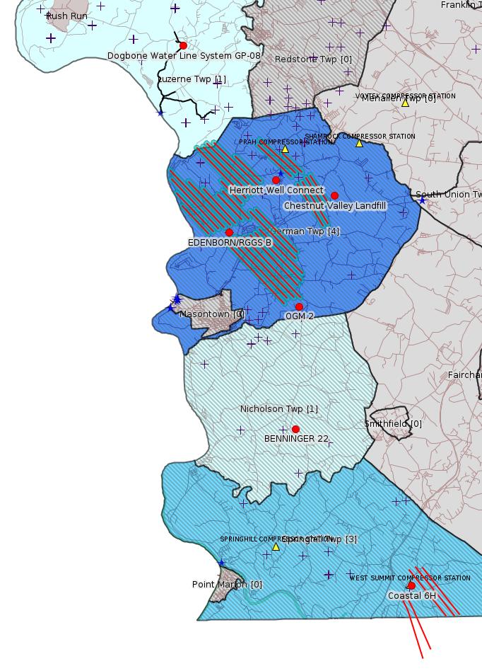
Chestnut Valley Landfill Municipal waste disposal facility permit RenewaleFACTS Listings
Guidance on Notification Requirements for Spills, Discharges, and other Incidents of a Substance Causing or Threatening Pollution to Waters of the Commonwealth
Herriott Well Connect GP-08 Temporary Road Crossings (New)
Herriott Well Connect GP-05 Utility Line Stream Crossings (New)
Herriott Well Connect Erosion and Sediment Control General Permit 3 (New)
Dogbone Water Line System GP-08 Temporary Road Crossings
EDENBORN/RGGS B ESCGP ESX18-051-0003 Expedited E&S Stormwater General Permit 1 [Termination?] Notification Issued 10/1/2021
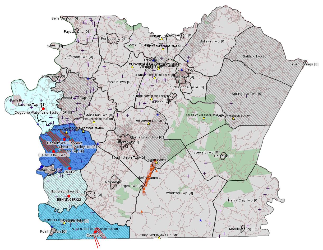
Map
Key
Red dots: items in this permit list with an exact location.
Blue stars: Marcellus Gas Well Water Sources.
Where well laterals are mapped they show in red; a 400-foot buffer surrounding the lateral shows in blue (lavender where it overlaps a mapped mineral tract).
Where mineral tracts are mapped, they show in pink. Mineral tracts can overlap; the overlap will show in red. The precise meaning of "mineral tract" is not clear.
Municipality shading: number of "facilities", with each well counting separately
(includes the red dots):
gray: 0
pale turquoise: 1
turquoise: 2
pale blue: 3
middle blue: 4
dark blue: 5
dark purple: 8
purple: 9
(Color coding may differ from one issue to the next.)
(Note if a project spans multiple municipalities -- e.g. a pipeline -- it will show in the count for each municipality.)
The number of facilities also follows the municipality name in brackets.
Municipality counts are based on the way the permit is listed by DEP; DEP has been known to get a municipality wrong.
Locations in brackets identify a precise location used to locate a surrogate for the actual site being permitted (e.g. locating a well pad or pipeline by the known location of a well.) Locations labeled beginning with "~" and ending in "[?]" are approximate and speculative based on inferences using on-line property and lease records. These are marked in the text as "[Approximate, Speculative]
Cross-hatching: Environmental Justice Areas
Yellow triangles: Compressor Stations
Orange triangles: Storage Field Wells (currently Dominion North Summit Storage Field)
Crosses: SPUD Unconventional well permits
Green: "Natural areas", e.g. state game lands, state forests
Yellow triangles: Compressor Stations
Orange triangles: Storage Field Wells (currently Dominion North Summit Storage Field)
Crosses: SPUD Unconventional well permits
Green: "Natural areas", e.g. state game lands, state forests
More Maps
 |
 |
Source: Pennsylvania Bulletin
Permit No. 100419. Advanced Disposal Services Chestnut Valley Landfill, LLC, 1184 McClellandtown Road, McClellandtown, PA 15458. Renewal of municipal waste disposal facility permit for the operation of the Chestnut Valley Landfill located at 1184 McClellandtown Road, McClellandtown, PA 15458 in German Township, Fayette County. The permit renewal was issued by the Regional Office on September 16, 2021.
Persons interested in reviewing the permit may contact Sharon Svitek, Program Manager, Waste Management, 400 Waterfront Drive, Pittsburgh, PA 15222-1475, 412-442-4000. TDD users may contact the Department through the Pennsylvania Hamilton Relay Service, (800) 654-5984.
<http://www.pacodeandbulletin.gov/Display/pabull?file=/secure/pabulletin/data/vol51/51-40/1660c.html&continued=http://www.pacodeandbulletin.gov/Display/pabull?file=/secure/pabulletin/data/vol51/51-40/1660.html&d=reduce>
Location: 39.896749,-79.838809
Map URL: <http://www.openstreetmap.org/?mlat=39.896749&mlon=-79.838809#map=15/39.896749/-79.838809>
Presumed Parcel Id: 15280012
---
DEP ID: 383-4200-003. Title: Guidance on Notification Requirements for Spills, Discharges, and other Incidents of a Substance Causing or Threatening Pollution to Waters of the Commonwealth Under Pennsylvania's Clean Streams Law. Description: The purpose of this document is to provide guidance on the immediate notification requirements for spills, discharges and other incidents of a substance causing or threatening pollution to waters of this Commonwealth. This document is a redraft of the draft TGD of the same title published at 50 Pa.B. 4091 (August 8, 2020).
Written Comments: Interested persons may submit written comments on this draft TGD through Wednesday, December 15, 2021. Comments, including comments submitted by e-mail must include the commentator's name and address. Commentators are encouraged to submit comments using the Department's online eComment tool at www.ahs.dep.pa.gov/eComment or by e-mail to ecomment@pa.gov. Written comments can be mailed to the Technical Guidance Coordinator, Department of Environmental Protection, Policy Office, Rachel Carson State Office Building, P.O. Box 2063, Harrisburg, PA 17105-2063.
Contact: Questions regarding this TGD can be directed to Bob Kachonik at rkachonik@pa.gov or (717) 783-3863.
Effective Date: Upon publication of notice as final in the Pennsylvania Bulletin.
Draft TGD: Withdrawal
DEP ID: 383-4200-003. Title: Guidance on Notification Requirements for Spills, Discharges, and other Incidents of a Substance Causing or Threatening Pollution to Waters of the Commonwealth Under Pennsylvania's Clean Streams Law. Description: In response to comments received on this draft TGD as published at 50 Pa.B. 4091, the Department has redrafted the TGD, which is being published as previously noted concurrently with the withdrawal of the previous draft.
Contact: Questions regarding this TGD can be directed to Bob Kachonik at rkachonik@pa.gov or (717) 783-3863.
Effective Date: October 16, 2021
<http://www.pacodeandbulletin.gov/Display/pabull?file=/secure/pabulletin/data/vol51/51-42/1730.html>
The actual Technical Guidance Document is available here:Map URL: <http://www.openstreetmap.org/?mlat=39.896749&mlon=-79.838809#map=15/39.896749/-79.838809>
Presumed Parcel Id: 15280012
---
DEP ID: 383-4200-003. Title: Guidance on Notification Requirements for Spills, Discharges, and other Incidents of a Substance Causing or Threatening Pollution to Waters of the Commonwealth Under Pennsylvania's Clean Streams Law. Description: The purpose of this document is to provide guidance on the immediate notification requirements for spills, discharges and other incidents of a substance causing or threatening pollution to waters of this Commonwealth. This document is a redraft of the draft TGD of the same title published at 50 Pa.B. 4091 (August 8, 2020).
Written Comments: Interested persons may submit written comments on this draft TGD through Wednesday, December 15, 2021. Comments, including comments submitted by e-mail must include the commentator's name and address. Commentators are encouraged to submit comments using the Department's online eComment tool at www.ahs.dep.pa.gov/eComment or by e-mail to ecomment@pa.gov. Written comments can be mailed to the Technical Guidance Coordinator, Department of Environmental Protection, Policy Office, Rachel Carson State Office Building, P.O. Box 2063, Harrisburg, PA 17105-2063.
Contact: Questions regarding this TGD can be directed to Bob Kachonik at rkachonik@pa.gov or (717) 783-3863.
Effective Date: Upon publication of notice as final in the Pennsylvania Bulletin.
Draft TGD: Withdrawal
DEP ID: 383-4200-003. Title: Guidance on Notification Requirements for Spills, Discharges, and other Incidents of a Substance Causing or Threatening Pollution to Waters of the Commonwealth Under Pennsylvania's Clean Streams Law. Description: In response to comments received on this draft TGD as published at 50 Pa.B. 4091, the Department has redrafted the TGD, which is being published as previously noted concurrently with the withdrawal of the previous draft.
Contact: Questions regarding this TGD can be directed to Bob Kachonik at rkachonik@pa.gov or (717) 783-3863.
Effective Date: October 16, 2021
<http://www.pacodeandbulletin.gov/Display/pabull?file=/secure/pabulletin/data/vol51/51-42/1730.html>
<https://www.depgreenport.state.pa.us/elibrary/GetDocument?docId=3963581&DocName=GUIDANCE%20ON%20NOTIFICATION%20REQS.%20FOR%20SPILLS%2C%20DISCHARGES%2C%20%26amp%3B%20OTHER%20INCIDENTS%20OF%20A%20SUBSTANCE%20CAUSING%20OR%20THREATENING%20POLLUTION%20TO%20WATERS%20OF%20THE%20COMMONWEALTH%20UNDER%20PA%26%2339%3BS%20CLEAN%20STREAMS%20LAW.PDF>
-------------------------
Please see the Disclaimer below regarding Parcel Id data.
Authorization ID: 1372024
Permit number: GP082607121-008
Site: Herriott Well Connect
Client: LAUREL MTN MIDSTREAM OPR LLC
Authorization type: GP-08 Temporary Road Crossings
Application type: New
Authorization is for: FACILITY
Date received: 10/07/2021
Status: Pending
Public_Permit_Review:
<http://www.ahs.dep.pa.gov/ePermitPublicAccess/Public/PublicAuthOverview?q=KnC8cgiGZTTDKnoa3rt1T7abfe089vsoqaRDeyFcJH4%3d>
Permit Decision Guarantee Applies: No
Sub-Facilities for Authorization:
Sub-Facility ID Sub-Facility Name Description
1341347 UNT 2 to TRIB 41110 of Middle Run (GP-8) Bridge
1341346 UNT 1 to TRIB 41110 of Middle Run (GP-8) Bridge
1341349 Stream Impacts (GP-8) Temporary Stream Impact
1341348 Floodway Impacts (GP-8) Temporary Floodway Impact
Permit Review Notes:
Date Review Note
10/20/2021 The permit application package is complete, has been accepted, and is undergoing technical review.
<https://www.ahs.dep.pa.gov/eFACTSWeb/searchResults_singleAuth.aspx?AuthID=1372024>
Site Programs:
Water Planning and Conservation
Site Municipalities:
German Twp, Fayette County
Location: 39.90345,-79.87054
Location (Herriott end): 39.898098, -79.879368
Location (Zalac end): 39.905296, 79.857525
Project Map:
<https://www.ahs.dep.pa.gov/ePermitPublicAccess/Public/DownloadFileFromWebServer/102186?onBaseDocId=3958369>
[See Notes.]
---
Authorization ID: 1372023
Permit number: GP052607121-009
Site: Herriott Well Connect
Client: LAUREL MTN MIDSTREAM OPR LLC
Authorization type: GP-05 Utility Line Stream Crossings
Application type: New
Authorization is for: FACILITY
Date received: 10/07/2021
Status: Pending
Public_Permit_Review:
<http://www.ahs.dep.pa.gov/ePermitPublicAccess/Public/PublicAuthOverview?q=QGfwGihjSDvAydoeQhtYk9O7I36i1HdDkLO5vZS7oAk%3d>
Permit Decision Guarantee Applies: Yes
Permit Decision Guarantee status: ACTIVE
Sub-Facilities for Authorization:
Sub-Facility ID Sub-Facility Name Description
1341350 UNT 1 to TRIB 41110 of Middle Run (GP-5) Pipeline or Conduit
1341351 UNT 2 to TRIB 41110 of Middle Run (GP-5) Pipeline or Conduit
1341352 Stream Impacts (GP-5) Stream Direct Impact
1341353 Floodway Impacts (GP-5) Floodway Direct Impact
Permit Review Notes:
Date Review Note
10/20/2021 The permit application package is complete, has been accepted, and is undergoing technical review.
<https://www.ahs.dep.pa.gov/eFACTSWeb/searchResults_singleAuth.aspx?AuthID=1372023>
Site Programs:
Water Planning and Conservation
Site Municipalities:
German Twp, Fayette County
---
Authorization ID: 1372022
Permit number: ESG072621001-00
Site: Herriott Well Connect
Client: LAUREL MTN MIDSTREAM OPR LLC
Authorization type: Erosion and Sediment Control General Permit 3
Application type: New
Authorization is for: SITE
Date received: 10/07/2021
Status: Pending
Public_Permit_Review:
<http://www.ahs.dep.pa.gov/ePermitPublicAccess/Public/PublicAuthOverview?q=0%2fuRzoDEGxJ4kcvQUxPFBJ31NP4A97GtfVvm7q8Less%3d>
Permit Decision Guarantee Applies: Yes
Permit Decision Guarantee status: VOID
Permit Review Notes:
Date Review Note
10/19/2021 Applicant has been issued a deficiency letter. If applicable, this application no longer qualifies for the Permit Decision Guarantee.
10/18/2021 Applicant has been issued a deficiency letter. If applicable, this application no longer qualifies for the Permit Decision Guarantee.
<https://www.ahs.dep.pa.gov/eFACTSWeb/searchResults_singleAuth.aspx?AuthID=1372022>
Site Programs:
Site Municipalities:
German Twp, Fayette County
---
Authorization ID: 1367959
Permit number: GP082605121-005
Site: Dogbone Water Line System
Client: EQT CHAP LLC
Authorization type: GP-08 Temporary Road Crossings
Application type: New
Authorization is for: FACILITY
Date received: 09/02/2021
Status: Pending
Public_Permit_Review:
<http://www.ahs.dep.pa.gov/ePermitPublicAccess/Public/PublicAuthOverview?q=G0XEBjkI04V64EgtBZULbJZD01EcQekdbdCIDanbRrg%3d>
Permit Decision Guarantee Applies: No
Sub-Facilities for Authorization:
Sub-Facility ID Sub-Facility Name Description
1338624 Wetland 4 Mat/Pads
Location: 39.9601,-79.91976
Map URL: <http://www.openstreetmap.org/?mlat=39.9601&mlon=-79.91976#map=15/39.9601/-79.91976>
1338618 Wetland 7 Mat/Pads
Location: 39.9601,-79.91976
Map URL: <http://www.openstreetmap.org/?mlat=39.9601&mlon=-79.91976#map=15/39.9601/-79.91976>
1338620 UNT 5 Mat/Pads
Location: 39.9601,-79.91976
Map URL: <http://www.openstreetmap.org/?mlat=39.9601&mlon=-79.91976#map=15/39.9601/-79.91976>
1338621 UNT 2 Mat/Pads
Location: 39.9601,-79.91976
Map URL: <http://www.openstreetmap.org/?mlat=39.9601&mlon=-79.91976#map=15/39.9601/-79.91976>
1338622 UNT 8 Mat/Pads
Location: 39.9601,-79.91976
Map URL: <http://www.openstreetmap.org/?mlat=39.9601&mlon=-79.91976#map=15/39.9601/-79.91976>
1338623 Wetland 6 (2) Mat/Pads
Location: 39.9601,-79.91976
Map URL: <http://www.openstreetmap.org/?mlat=39.9601&mlon=-79.91976#map=15/39.9601/-79.91976>
1338619 UNT 3 Mat/Pads
Location: 39.9601,-79.91976
Map URL: <http://www.openstreetmap.org/?mlat=39.9601&mlon=-79.91976#map=15/39.9601/-79.91976>
1338625 Total Floodway Impacts Temporary Floodway Impact
Location: 39.9601,-79.91976
Map URL: <http://www.openstreetmap.org/?mlat=39.9601&mlon=-79.91976#map=15/39.9601/-79.91976>
1338626 Total Stream Impacts Temporary Stream Impact
Location: 39.9601,-79.91976
Map URL: <http://www.openstreetmap.org/?mlat=39.9601&mlon=-79.91976#map=15/39.9601/-79.91976>
1338615 Rush Run Mat/Pads
Location: 39.9601,-79.91976
Map URL: <http://www.openstreetmap.org/?mlat=39.9601&mlon=-79.91976#map=15/39.9601/-79.91976>
1338614 UNT 1 Mat/Pads
Location: 39.9601,-79.91976
Map URL: <http://www.openstreetmap.org/?mlat=39.9601&mlon=-79.91976#map=15/39.9601/-79.91976>
1338617 Wetland 2 Mat/Pads
Location: 39.9601,-79.91976
Map URL: <http://www.openstreetmap.org/?mlat=39.9601&mlon=-79.91976#map=15/39.9601/-79.91976>
1338616 Wetland 6 (1) Mat/Pads
Location: 39.9601,-79.91976
Map URL: <http://www.openstreetmap.org/?mlat=39.9601&mlon=-79.91976#map=15/39.9601/-79.91976>
1338613 Total PEM Wetland Impacts Temporary Wetland Impact
Location: 39.9601,-79.91976
Map URL: <http://www.openstreetmap.org/?mlat=39.9601&mlon=-79.91976#map=15/39.9601/-79.91976>
1338612 Total PFO Wetland Impacts Temporary Wetland Impact
Location: 39.9601,-79.91976
Map URL: <http://www.openstreetmap.org/?mlat=39.9601&mlon=-79.91976#map=15/39.9601/-79.91976>
Permit Review Notes:
Date Review Note
9/21/2021 Applicant has been issued a deficiency letter. If applicable, this application no longer qualifies for the Permit Decision Guarantee.
<https://www.ahs.dep.pa.gov/eFACTSWeb/searchResults_singleAuth.aspx?AuthID=1367959>
Site Programs:
Water Planning and Conservation
Site Municipalities:
Luzerne Twp, Fayette County
---
Authorization ID: 1367026
Permit number: ESX18-051-0003
Site: EDENBORN/RGGS B ESCGP ESX18-051-0003
Client: EQT CHAP LLC
Authorization type: Expedited E&S Stormwater General Permit 1
Application type: Notification
Authorization is for: SITE
Date received: 08/30/2021
Status: Issued on 10/1/2021
Permit Decision Guarantee Applies: No
Permit Review Notes:
Date Review Note
10/1/2021 The technical review and decision review are complete and either the permit decision and/or permit issuance are forthcoming.
8/30/2021 The permit application package is complete, has been accepted, and is undergoing technical review.
<https://www.ahs.dep.pa.gov/eFACTSWeb/searchResults_singleAuth.aspx?AuthID=1367026>
Site Programs:
Oil & Gas
Site Municipalities:
German Twp, Fayette County
Well
Pad Details:
Presumed Parcel Id: 15220014
OPERATOR: CHEVRON APPALACHIA LLCWells on this pad:
OGO: OGO-39307
CLIENT_ID: 279986
WELL_PAD: EDENBORN/RGGS B
WELL_PAD_ID: 155083
SITE_NAME: EDENBORN/RGGS B ESCGP ESX18-051-0003
SITE_ID: 829418
ADDRESS_TYPE: 911WL
ADDRESS1: 392 GATES ROAD
ADDRESS2:
CITY: ADAH
STATE: PA
ZIP: 15410
WELL_PAD_REFERENCE_POINT: WSGPS
WELL_PAD_LATITUDE: 39.881931
WELL_PAD_LONGITUDE: -79.896106
WELL_PAD_DATUM: NAD83
WELL_PAD_COLLECTION_METHOD: GPS
ACCESS_ROAD_REFERENCE_POINT: LACRD
ACCESS_ROAD_LATITUDE: 39.877033
ACCESS_ROAD_LONGITUDE: -79.89575
ACCESS_ROAD_DATUM: NAD83
ACCESS_ROAD_COLLECTION_METHOD: GPS
REGION: EP DOGO SWDO Dstr Off
COUNTY: Fayette
MUNICIPALITY: German Twp
CHAPTER_93_WATER_QUALITY:
051-24675 EDENBORN/RGGS B M01H
051-24676 EDENBORN/RGGS B M03H
051-24678 EDENBORN/RGGS B M02H
051-24681 EDENBORN/RGGS B M04H
051-24682 EDENBORN/RGGS B M05H
051-24688 EDENBORN/RGGS B M14H
051-24689 EDENBORN/RGGS B M15H
Presumed Parcel Id: 15220014
-------------------------
Source: DEP Electronic Notifications
NOTIFICATION_ID: 57918
OGO: 51036
OPERATOR: INR OPR LLC
API_PERMIT: 051-24724
SPUD_DATE: 08/13/2021
COUNTY: Fayette
MUNICIPALITY: Springhill
LATITUDE: 39.73393
LONGITUDE: -79.80003
SUBJECT: [NOTIFICATION]: Casing cementing notification 58 Pa. C.S. 3211(f)(2) for well API 37-051-24724-00-00
QUESTION: Enter the Date and Time for the applicable Casing Types
ANSWER: Production Casing: 10/3/2021 7:00:00 AM
SENT_DATE: 9/30/2021 1:52:24 PM
SENT_SUCCESS: Yes
LAST_RESENT_DATE:
RESENT_SUCCESS:
REGION: EP DOGO SWDO Dstr Off
Well
Details:
Permit Number: 051-24724
Well Name: Coastal 6H
Unconventional Well: Y
Well Configuration: Horizontal Well
Well Type: GAS
Well Status: Active
Coal Association: NonCoal
Conservation Well: N
Primary Facility ID: 848117
Site ID: 739525
Site Name: COASTAL 1H FLOW BACK PIT FRESHWATER PITS ESCGP-EXPEDITED
Well Pad ID: 147971
Well Pad Name: COASTAL WELL PAD
Storage Field:
Operator: INR OPR LLC
Operator Number: OGO-51036
Permit Date: 2021-03-26
Permit Date Expires: 2022-03-26
SPUD Date: 2021-08-13
Date Plugged:
UIC ID:
UIC Type:
Surface Elevation: 1138
County: Fayette
Municipality: Springhill Twp
Location: 39.73393,-79.80003
Map URL: <http://www.openstreetmap.org/?mlat=39.73393&mlon=-79.80003#map=15/39.73393/-79.80003>
Public Permit Review:
<http://www.ahs.dep.pa.gov/ePermitPublicAccess/Public/PublicAuthOverview?q=k1dzq9uRT9GEr1XB4syWd4c1UvFXDA4gPu%2fLv08k6kE%3d>
Plat:
<https://www.ahs.dep.pa.gov/ePermitPublicAccess/Public/DownloadFileFromWebServer/62965?onBaseDocId=3588973>
---
NOTIFICATION_ID: 57989
OGO: 51036
OPERATOR: INR OPR LLC
API_PERMIT: 051-24725
SPUD_DATE: 08/13/2021
COUNTY: Fayette
MUNICIPALITY: Springhill
LATITUDE: 39.73396
LONGITUDE: -79.79999
SUBJECT: [NOTIFICATION]: Casing cementing notification 58 Pa. C.S. 3211(f)(2) for well API 37-051-24725-00-00
QUESTION: Enter the Date and Time for the applicable Casing Types
ANSWER: Production Casing: 10/11/2021 7:00:00 AM
SENT_DATE: 10/8/2021 10:37:02 AM
SENT_SUCCESS: Yes
LAST_RESENT_DATE:
RESENT_SUCCESS:
REGION: EP DOGO SWDO Dstr Off
Well
Details:
Permit Number: 051-24725
Well Name: Coastal 8H
Unconventional Well: Y
Well Configuration: Horizontal Well
Well Type: GAS
Well Status: Active
Coal Association: NonCoal
Conservation Well: N
Primary Facility ID: 848119
Site ID: 739525
Site Name: COASTAL 1H FLOW BACK PIT FRESHWATER PITS ESCGP-EXPEDITED
Well Pad ID: 147971
Well Pad Name: COASTAL WELL PAD
Storage Field:
Operator: INR OPR LLC
Operator Number: OGO-51036
Permit Date: 2021-03-26
Permit Date Expires: 2022-03-26
SPUD Date: 2021-08-13
Date Plugged:
UIC ID:
UIC Type:
Surface Elevation: 1138
County: Fayette
Municipality: Springhill Twp
Location: 39.73396,-79.79999
Map URL: <http://www.openstreetmap.org/?mlat=39.73396&mlon=-79.79999#map=15/39.73396/-79.79999>
---
NOTIFICATION_ID: 58066
OGO: 51036
OPERATOR: INR OPR LLC
API_PERMIT: 051-24726
SPUD_DATE: 09/01/2021
COUNTY: Fayette
MUNICIPALITY: Springhill
LATITUDE: 39.73399
LONGITUDE: -79.79996
SUBJECT: [NOTIFICATION]: Casing cementing notification 58 Pa. C.S. 3211(f)(2) for well API 37-051-24726-00-00
QUESTION: Enter the Date and Time for the applicable Casing Types
ANSWER: Production Casing: 10/17/2021 7:00:00 AM
SENT_DATE: 10/15/2021 3:27:11 PM
SENT_SUCCESS: Yes
LAST_RESENT_DATE:
RESENT_SUCCESS:
REGION: EP DOGO SWDO Dstr Off
Inspection Issues Source: DEP Oil and Gas Compliance Report
OPERATOR: BIG DOG ENERGY LLC
INSPECTION_ID: 3265130
INSPECTION_DATE: 9/27/2021
INSPECTION_TYPE: Routine/Complete Inspection
API_PERMIT: 051-24271
FARM_NAME: OGM 2
UNCONVENTIONAL: No
SITE_ID: 725258
SITE_NAME: OGM 2 OG WELL
FACILITY_TYPE: Oil & Gas Location
INSPECTION_CATEGORY: Primary Facility
REGION: EP DOGO SWDO Dstr Off
COUNTY: Fayette
MUNICIPALITY: German Twp
INSPECTOR: CISLO, JOHN
INSPECTION_SOURCE: SAIR
INSPECTION_RESULT_DESCRIPTION: Violation(s) Noted
INSPECTION_COMMENT: Complete inspection conducted in response to OGI referral concerning frac tanks on location and corrosion issues with production tanks. Act 9 sign posted at site entrance (Photo 1). ERP and PPC plan were on site (Photo 2). Recommend replacing all plans to reflect change in ownership. Well appears to be equipped for production. Well label is in place on well head. (Photos 5/6/14/16) Production tanks are showing signs of corrosion, specifically around access panel on production tank 2. Conductance reading taking directly below corroded area (Photo 10) indicates possible leakage of brine/production fluids (9960 microsiemens). Recommend repairing/maintenance/or replacing tank. Standing water within secondary containment has conductance readings (9680 microsiemens) indicative of brine/production fluid (Photo 16). Tear in secondary containment synthetic liner (Photo 11) discovered. Recommend Operator inspect entire liner and repair/replace to ensure adequate containment of brine/production fluids. There appeared to be a small area of discolored soils north of secondary containment structure (Photos 7 & 8). Conductance reading taken in this area (Photo 7) was 1500 microsiemens. Additional area of concern was located along drainage swale east of secondary containment (Photo 9). Conductance reading in this area was 1270 microsiemens. These conductance readings would suggest migration of brine/production fluid outside secondary containment. Recommend Operator remediate these areas of contaminated soils and stabilize by revegetating the area with perennial grasses. The final area of concern is located between the production tank area and well head (Photo 13). Conductance readings taken in this area showed a reading of 1410 microsiemens (Photo 12). This appears to be the area where frac tanks were previously stored (documented in IR 3246073). Recommend Operator remediate this area of all contaminated soil/gravel and place clean gravel to eliminate low spot. Additionally, the Department is requesting information concerning frac tanks that were observed on this site on 09/03/2021 and documented in IR 3246073. Information should include what was being stored in these tanks, the purpose of the tanks on this site, how long they were on site, and when they were removed from site. Information concerning the frack tanks can be submitted with Operator's NOV response. Request Operator determine and provide quantity of release, how quantity was determined, what was released, and duration of release in their NOV response. The Department requests all waste manifests for contaminated soils that are removed during remediation be provided electronically upon availability. Violations are being cited for discharge of production fluids to the ground and failure to update ERP. Pending Operator's response, more violations may be forthcoming.
VIOLATION_ID: 933227
VIOLATION_DATE: 9/27/2021
VIOLATION_CODE: 78A57(A)___ - CONTROL, STORAGE AND DISPOSAL OF PRODUCTION FLUIDS - Operator discharged brine and other fluids on or into the ground or into the waters of this Commonwealth.
VIOLATION_TYPE: Environmental Health & Safety
VIOLATION_COMMENT:
RESOLVED_DATE:
RESOLUTION_REASON_CODE_DESC:
CONTINUING_VIOLATION:
ENFORCEMENT_ID:
ENFORCEMENT_CODE_DESCRIPTION:
DATE_EXECUTED:
ENFORCEMENT_FINAL_DATE:
ENFORCEMENT_FINAL_STATUS:
PENALTY_FINAL_DATE:
PENALTY_FINAL_STATUS_CODE_DESC:
PENALTY_AMOUNT:
TOTAL_AMOUNT_COLLECTED:
VIOLATION_ID: 933226
VIOLATION_DATE: 9/27/2021
VIOLATION_CODE: 91.34(A) - ACTIVITIES UTILIZING POLLUTANTS - Failure to take necessary measures to prevent the substances from directly or indirectly reaching waters of this Commonwealth, through accident, carelessness, maliciousness, hazards of weather or from another cause.
VIOLATION_TYPE: Environmental Health & Safety
VIOLATION_COMMENT:
RESOLVED_DATE:
RESOLUTION_REASON_CODE_DESC:
CONTINUING_VIOLATION:
ENFORCEMENT_ID:
ENFORCEMENT_CODE_DESCRIPTION:
DATE_EXECUTED:
ENFORCEMENT_FINAL_DATE:
ENFORCEMENT_FINAL_STATUS:
PENALTY_FINAL_DATE:
PENALTY_FINAL_STATUS_CODE_DESC:
PENALTY_AMOUNT:
TOTAL_AMOUNT_COLLECTED:
VIOLATION_ID: 933225
VIOLATION_DATE: 9/27/2021
VIOLATION_CODE: 78a55(i)5iv - EMERGNCY RESPONSE – Planning - Failure of the operator to review and submit an annual update of the emergency response plan on or before March 1st.
VIOLATION_TYPE: Environmental Health & Safety
VIOLATION_COMMENT: Request updated ERP be provided to the Department electronically within 10 business days of receipt of this inspection.
RESOLVED_DATE:
RESOLUTION_REASON_CODE_DESC:
CONTINUING_VIOLATION:
ENFORCEMENT_ID:
ENFORCEMENT_CODE_DESCRIPTION:
DATE_EXECUTED:
ENFORCEMENT_FINAL_DATE:
ENFORCEMENT_FINAL_STATUS:
PENALTY_FINAL_DATE:
PENALTY_FINAL_STATUS_CODE_DESC:
PENALTY_AMOUNT:
TOTAL_AMOUNT_COLLECTED:
VIOLATION_ID: 933228
VIOLATION_DATE: 9/27/2021
VIOLATION_CODE: SWMA 301 - MANAGEMENT OF RESIDUAL WASTE - Person operated a residual waste processing or disposal facility without obtaining a permit for such facility from DEP. Person stored, transported, processed, or disposed of residual waste inconsistent with or unauthorized by the rules and regulations of DEP.
VIOLATION_TYPE: Environmental Health & Safety
VIOLATION_COMMENT:
RESOLVED_DATE:
RESOLUTION_REASON_CODE_DESC:
CONTINUING_VIOLATION:
ENFORCEMENT_ID:
ENFORCEMENT_CODE_DESCRIPTION:
DATE_EXECUTED:
ENFORCEMENT_FINAL_DATE:
ENFORCEMENT_FINAL_STATUS:
PENALTY_FINAL_DATE:
PENALTY_FINAL_STATUS_CODE_DESC:
PENALTY_AMOUNT:
TOTAL_AMOUNT_COLLECTED:
VIOLATION_ID: 933229
VIOLATION_DATE: 9/27/2021
VIOLATION_CODE: 78A64A(E)_ - SECONDARY CONTAINMENT – Operator failed to repair damaged or compromised secondary containment as soon as practicable.
VIOLATION_TYPE: Environmental Health & Safety
VIOLATION_COMMENT: Operator failed to identify and repair tear in secondary containment synthetic liner.
RESOLVED_DATE:
RESOLUTION_REASON_CODE_DESC:
CONTINUING_VIOLATION:
ENFORCEMENT_ID:
ENFORCEMENT_CODE_DESCRIPTION:
DATE_EXECUTED:
ENFORCEMENT_FINAL_DATE:
ENFORCEMENT_FINAL_STATUS:
PENALTY_FINAL_DATE:
PENALTY_FINAL_STATUS_CODE_DESC:
PENALTY_AMOUNT:
TOTAL_AMOUNT_COLLECTED:
Well Details:
Permit Number: 051-24271
Well Name: OGM 2
Unconventional Well: N
Well Configuration: Vertical Well
Well Type: GAS
Well Status: Active
Coal Association: NonCoal
Conservation Well: Y
Primary Facility ID: 723193
Site ID: 725258
Site Name: OGM 2 OG WELL
Well Pad ID: 0
Well Pad Name:
Storage Field:
Operator: BIG DOG ENERGY LLC
Operator Number: OGO-69247
Permit Date: 2009-10-09
Permit Date Expires: 2010-10-09
SPUD Date: 2009-10-29
Date Plugged:
UIC ID:
UIC Type:
Surface Elevation: 1197
County: Fayette
Municipality: German Twp
Location: 39.850655,-79.858849
Map URL: <http://www.openstreetmap.org/?mlat=39.850655&mlon=-79.858849#map=15/39.850655/-79.858849>
Full inspection report, including photos:
<https://www.depgreenport.state.pa.us/eWellDocs/download/DocsZipFile/?P_DER_CODE=9&P_ENTITY_TYPE=2&S=4&P_ID=3265130>
Presumed Parcel Id: 15350159
[See Notes.]
---
OPERATOR: DIVERSIFIED PROD LLC
INSPECTION_ID: 3266161
INSPECTION_DATE: 10/13/2021
INSPECTION_TYPE: Complaint Inspection
API_PERMIT: 051-23196
FARM_NAME: BENNINGER 22
UNCONVENTIONAL: No
SITE_ID: 668483
SITE_NAME: BENNINGER 22 OG WELL
FACILITY_TYPE: Oil & Gas Location
INSPECTION_CATEGORY: Primary Facility
REGION: EP DOGO SWDO Dstr Off
COUNTY: Fayette
MUNICIPALITY: Nicholson Twp
INSPECTOR: CISLO, JOHN
INSPECTION_SOURCE: SAIR
INSPECTION_RESULT_DESCRIPTION: Violation(s) Noted
INSPECTION_COMMENT: Inspection conducted in response to a complaint received by the Department of corroded production tanks and possible leak. Arrived on-site at approx. 1130 to conduct investigation. Well appeared equipped for production. No well label was observed on any of the production equipment on site. Recommend Operator affix permanent well label IAW the regulations. Well posting was present but has the wrong permit number on posting (Photo 3). Recommend Operator re-post with the appropriate and correct information for this well. Background conductance reading was taken in a field west of well pad (Photo 1). Conductance value in this location was 170 micro Siemens. Heavy corrosion was observed on production tanks. Holes have developed along the south and west sides of tank (Photos 2/4/5/8/9/10). A large hole (2'x2') has developed on the west side of tank. Production fluid/brine observed approx. 3" below large hole (Photo 5). Conductance of liquid in tank was 14,500 micro Siemens (Photo 6). Tank was located within earthen berm. Conductance readings were taken along the ground on the south and south-west sides of tank (Photos 4 & 8). Values were 3,740 & 4,510 micro Siemens respectively. These values were well above the background conductance reading and indicate a release of production fluid/brine onto the ground. Request Operator determine and provide quantity of release, the method how the quantity was determined, and the duration of the release. Recommend the Operator immediately remove all production fluid/brine from the production tank for proper disposal. It is also recommended that this production tank be removed and impacted soils beneath/adjacent to tank be delineated and areas impacted remediated. Production tank should be replaced once remediation is completed and confirmed by both the Operator and Department. NOTE: Conductance readings taken along the earthen berm were at background. It does not appear at this time that the release has migrated laterally. Violations are being cited related to the release of fluids to the ground and well label/posting. Pending Operator's response, additional violations may be cited.
VIOLATION_ID: 933245
VIOLATION_DATE: 10/13/2021
VIOLATION_CODE: 78.54 - GENERAL REQUIREMENTS - Operator failed to control and dispose of fluids, residual waste and drill cuttings, including tophole water, brines, drilling fluids, drilling muds, stimulation fluids, well servicing fluids, oil, and production fluids in a manner that prevents pollution of the waters of the Commonwealth.
VIOLATION_TYPE: Environmental Health & Safety
VIOLATION_COMMENT: Operator failed to control and dispose of production fluid/brine within corroded production tank which allowed fluid to lead onto the ground and potentially pollute WOC.
RESOLVED_DATE:
RESOLUTION_REASON_CODE_DESC:
CONTINUING_VIOLATION:
ENFORCEMENT_ID:
ENFORCEMENT_CODE_DESCRIPTION:
DATE_EXECUTED:
ENFORCEMENT_FINAL_DATE:
ENFORCEMENT_FINAL_STATUS:
PENALTY_FINAL_DATE:
PENALTY_FINAL_STATUS_CODE_DESC:
PENALTY_AMOUNT:
TOTAL_AMOUNT_COLLECTED:
VIOLATION_ID: 933244
VIOLATION_DATE: 10/13/2021
VIOLATION_CODE: 78.57(a) - CONTROL, STORAGE AND DISPOSAL OF PRODUCTION FLUIDS - Operator failed to collect the brine and other fluids produced during operation, service and plugging of the well in a tank, pit or a series of pits or tanks, or other device approved by the Department or Operator discharged brine or other fluids on or into the ground or into waters of the Commonwealth.
VIOLATION_TYPE: Environmental Health & Safety
VIOLATION_COMMENT: Operator failed to collect brine during the operation of this well. Brine was observed leaking from corroded tanks and onto the ground at base of tank (south/southwest side).
RESOLVED_DATE:
RESOLUTION_REASON_CODE_DESC:
CONTINUING_VIOLATION:
ENFORCEMENT_ID:
ENFORCEMENT_CODE_DESCRIPTION:
DATE_EXECUTED:
ENFORCEMENT_FINAL_DATE:
ENFORCEMENT_FINAL_STATUS:
PENALTY_FINAL_DATE:
PENALTY_FINAL_STATUS_CODE_DESC:
PENALTY_AMOUNT:
TOTAL_AMOUNT_COLLECTED:
VIOLATION_ID: 933249
VIOLATION_DATE: 10/13/2021
VIOLATION_CODE: 91.34(A) - ACTIVITIES UTILIZING POLLUTANTS - Failure to take necessary measures to prevent the substances from directly or indirectly reaching waters of this Commonwealth, through accident, carelessness, maliciousness, hazards of weather or from another cause.
VIOLATION_TYPE: Environmental Health & Safety
VIOLATION_COMMENT:
RESOLVED_DATE:
RESOLUTION_REASON_CODE_DESC:
CONTINUING_VIOLATION:
ENFORCEMENT_ID:
ENFORCEMENT_CODE_DESCRIPTION:
DATE_EXECUTED:
ENFORCEMENT_FINAL_DATE:
ENFORCEMENT_FINAL_STATUS:
PENALTY_FINAL_DATE:
PENALTY_FINAL_STATUS_CODE_DESC:
PENALTY_AMOUNT:
TOTAL_AMOUNT_COLLECTED:
VIOLATION_ID: 933246
VIOLATION_DATE: 10/13/2021
VIOLATION_CODE: SWMA 301 - MANAGEMENT OF RESIDUAL WASTE - Person operated a residual waste processing or disposal facility without obtaining a permit for such facility from DEP. Person stored, transported, processed, or disposed of residual waste inconsistent with or unauthorized by the rules and regulations of DEP.
VIOLATION_TYPE: Environmental Health & Safety
VIOLATION_COMMENT: Operator failed to control and dispose of production fluid/brine within corroded production tank resulting in disposal of production fluid/brine onto the ground which is inconsistent with the rules and regulations of the Department.
RESOLVED_DATE:
RESOLUTION_REASON_CODE_DESC:
CONTINUING_VIOLATION:
ENFORCEMENT_ID:
ENFORCEMENT_CODE_DESCRIPTION:
DATE_EXECUTED:
ENFORCEMENT_FINAL_DATE:
ENFORCEMENT_FINAL_STATUS:
PENALTY_FINAL_DATE:
PENALTY_FINAL_STATUS_CODE_DESC:
PENALTY_AMOUNT:
TOTAL_AMOUNT_COLLECTED:
Well Details:
Permit Number: 051-23196
Well Name: BENNINGER 22
Unconventional Well: N
Well Configuration: Vertical Well
Well Type: GAS
Well Status: Active
Coal Association: NonCoal
Conservation Well: N
Primary Facility ID: 677636
Site ID: 668483
Site Name: BENNINGER 22 OG WELL
Well Pad ID: 0
Well Pad Name:
Storage Field:
Operator: DIVERSIFIED PROD LLC
Operator Number: OGO-65675
Permit Date: 2006-05-10
Permit Date Expires: 2007-05-10
SPUD Date: 2006-06-03
Date Plugged:
UIC ID:
UIC Type:
Surface Elevation: 1184
County: Fayette
Municipality: Nicholson Twp
Location: 39.799733,-79.861638
Map URL: <http://www.openstreetmap.org/?mlat=39.799733&mlon=-79.861638#map=15/39.799733/-79.861638>
Presumed Parcel Id: 24120101
-------------------------
Permit Number: 051-24725
Well Name: Coastal 8H
Unconventional Well: Y
Well Configuration: Horizontal Well
Well Type: GAS
Well Status: Active
Coal Association: NonCoal
Conservation Well: N
Primary Facility ID: 848119
Site ID: 739525
Site Name: COASTAL 1H FLOW BACK PIT FRESHWATER PITS ESCGP-EXPEDITED
Well Pad ID: 147971
Well Pad Name: COASTAL WELL PAD
Storage Field:
Operator: INR OPR LLC
Operator Number: OGO-51036
Permit Date: 2021-03-26
Permit Date Expires: 2022-03-26
SPUD Date: 2021-08-13
Date Plugged:
UIC ID:
UIC Type:
Surface Elevation: 1138
County: Fayette
Municipality: Springhill Twp
Location: 39.73396,-79.79999
Map URL: <http://www.openstreetmap.org/?mlat=39.73396&mlon=-79.79999#map=15/39.73396/-79.79999>
---
NOTIFICATION_ID: 58066
OGO: 51036
OPERATOR: INR OPR LLC
API_PERMIT: 051-24726
SPUD_DATE: 09/01/2021
COUNTY: Fayette
MUNICIPALITY: Springhill
LATITUDE: 39.73399
LONGITUDE: -79.79996
SUBJECT: [NOTIFICATION]: Casing cementing notification 58 Pa. C.S. 3211(f)(2) for well API 37-051-24726-00-00
QUESTION: Enter the Date and Time for the applicable Casing Types
ANSWER: Production Casing: 10/17/2021 7:00:00 AM
SENT_DATE: 10/15/2021 3:27:11 PM
SENT_SUCCESS: Yes
LAST_RESENT_DATE:
RESENT_SUCCESS:
REGION: EP DOGO SWDO Dstr Off
Well
Details:
Permit Number: 051-24726
Well Name: Coastal 10H
Unconventional Well: Y
Well Configuration: Deviated Well
Well Type: GAS
Well Status: Active
Coal Association: NonCoal
Conservation Well: N
Primary Facility ID: 851454
Site ID: 739525
Site Name: COASTAL 1H FLOW BACK PIT FRESHWATER PITS ESCGP-EXPEDITED
Well Pad ID: 147971
Well Pad Name: COASTAL WELL PAD
Storage Field:
Operator: INR OPR LLC
Operator Number: OGO-51036
Permit Date: 2021-08-30
Permit Date Expires: 2022-08-30
SPUD Date: 2021-09-01
Date Plugged:
UIC ID:
UIC Type:
Surface Elevation: 1138
County: Fayette
Municipality: Springhill Twp
Location: 39.73399,-79.79996
Map URL: <http://www.openstreetmap.org/?mlat=39.73399&mlon=-79.79996#map=15/39.73399/-79.79996>
-------------------------Permit Number: 051-24726
Well Name: Coastal 10H
Unconventional Well: Y
Well Configuration: Deviated Well
Well Type: GAS
Well Status: Active
Coal Association: NonCoal
Conservation Well: N
Primary Facility ID: 851454
Site ID: 739525
Site Name: COASTAL 1H FLOW BACK PIT FRESHWATER PITS ESCGP-EXPEDITED
Well Pad ID: 147971
Well Pad Name: COASTAL WELL PAD
Storage Field:
Operator: INR OPR LLC
Operator Number: OGO-51036
Permit Date: 2021-08-30
Permit Date Expires: 2022-08-30
SPUD Date: 2021-09-01
Date Plugged:
UIC ID:
UIC Type:
Surface Elevation: 1138
County: Fayette
Municipality: Springhill Twp
Location: 39.73399,-79.79996
Map URL: <http://www.openstreetmap.org/?mlat=39.73399&mlon=-79.79996#map=15/39.73399/-79.79996>
Inspection Issues Source: DEP Oil and Gas Compliance Report
OPERATOR: BIG DOG ENERGY LLC
INSPECTION_ID: 3265130
INSPECTION_DATE: 9/27/2021
INSPECTION_TYPE: Routine/Complete Inspection
API_PERMIT: 051-24271
FARM_NAME: OGM 2
UNCONVENTIONAL: No
SITE_ID: 725258
SITE_NAME: OGM 2 OG WELL
FACILITY_TYPE: Oil & Gas Location
INSPECTION_CATEGORY: Primary Facility
REGION: EP DOGO SWDO Dstr Off
COUNTY: Fayette
MUNICIPALITY: German Twp
INSPECTOR: CISLO, JOHN
INSPECTION_SOURCE: SAIR
INSPECTION_RESULT_DESCRIPTION: Violation(s) Noted
INSPECTION_COMMENT: Complete inspection conducted in response to OGI referral concerning frac tanks on location and corrosion issues with production tanks. Act 9 sign posted at site entrance (Photo 1). ERP and PPC plan were on site (Photo 2). Recommend replacing all plans to reflect change in ownership. Well appears to be equipped for production. Well label is in place on well head. (Photos 5/6/14/16) Production tanks are showing signs of corrosion, specifically around access panel on production tank 2. Conductance reading taking directly below corroded area (Photo 10) indicates possible leakage of brine/production fluids (9960 microsiemens). Recommend repairing/maintenance/or replacing tank. Standing water within secondary containment has conductance readings (9680 microsiemens) indicative of brine/production fluid (Photo 16). Tear in secondary containment synthetic liner (Photo 11) discovered. Recommend Operator inspect entire liner and repair/replace to ensure adequate containment of brine/production fluids. There appeared to be a small area of discolored soils north of secondary containment structure (Photos 7 & 8). Conductance reading taken in this area (Photo 7) was 1500 microsiemens. Additional area of concern was located along drainage swale east of secondary containment (Photo 9). Conductance reading in this area was 1270 microsiemens. These conductance readings would suggest migration of brine/production fluid outside secondary containment. Recommend Operator remediate these areas of contaminated soils and stabilize by revegetating the area with perennial grasses. The final area of concern is located between the production tank area and well head (Photo 13). Conductance readings taken in this area showed a reading of 1410 microsiemens (Photo 12). This appears to be the area where frac tanks were previously stored (documented in IR 3246073). Recommend Operator remediate this area of all contaminated soil/gravel and place clean gravel to eliminate low spot. Additionally, the Department is requesting information concerning frac tanks that were observed on this site on 09/03/2021 and documented in IR 3246073. Information should include what was being stored in these tanks, the purpose of the tanks on this site, how long they were on site, and when they were removed from site. Information concerning the frack tanks can be submitted with Operator's NOV response. Request Operator determine and provide quantity of release, how quantity was determined, what was released, and duration of release in their NOV response. The Department requests all waste manifests for contaminated soils that are removed during remediation be provided electronically upon availability. Violations are being cited for discharge of production fluids to the ground and failure to update ERP. Pending Operator's response, more violations may be forthcoming.
VIOLATION_ID: 933227
VIOLATION_DATE: 9/27/2021
VIOLATION_CODE: 78A57(A)___ - CONTROL, STORAGE AND DISPOSAL OF PRODUCTION FLUIDS - Operator discharged brine and other fluids on or into the ground or into the waters of this Commonwealth.
VIOLATION_TYPE: Environmental Health & Safety
VIOLATION_COMMENT:
RESOLVED_DATE:
RESOLUTION_REASON_CODE_DESC:
CONTINUING_VIOLATION:
ENFORCEMENT_ID:
ENFORCEMENT_CODE_DESCRIPTION:
DATE_EXECUTED:
ENFORCEMENT_FINAL_DATE:
ENFORCEMENT_FINAL_STATUS:
PENALTY_FINAL_DATE:
PENALTY_FINAL_STATUS_CODE_DESC:
PENALTY_AMOUNT:
TOTAL_AMOUNT_COLLECTED:
VIOLATION_ID: 933226
VIOLATION_DATE: 9/27/2021
VIOLATION_CODE: 91.34(A) - ACTIVITIES UTILIZING POLLUTANTS - Failure to take necessary measures to prevent the substances from directly or indirectly reaching waters of this Commonwealth, through accident, carelessness, maliciousness, hazards of weather or from another cause.
VIOLATION_TYPE: Environmental Health & Safety
VIOLATION_COMMENT:
RESOLVED_DATE:
RESOLUTION_REASON_CODE_DESC:
CONTINUING_VIOLATION:
ENFORCEMENT_ID:
ENFORCEMENT_CODE_DESCRIPTION:
DATE_EXECUTED:
ENFORCEMENT_FINAL_DATE:
ENFORCEMENT_FINAL_STATUS:
PENALTY_FINAL_DATE:
PENALTY_FINAL_STATUS_CODE_DESC:
PENALTY_AMOUNT:
TOTAL_AMOUNT_COLLECTED:
VIOLATION_ID: 933225
VIOLATION_DATE: 9/27/2021
VIOLATION_CODE: 78a55(i)5iv - EMERGNCY RESPONSE – Planning - Failure of the operator to review and submit an annual update of the emergency response plan on or before March 1st.
VIOLATION_TYPE: Environmental Health & Safety
VIOLATION_COMMENT: Request updated ERP be provided to the Department electronically within 10 business days of receipt of this inspection.
RESOLVED_DATE:
RESOLUTION_REASON_CODE_DESC:
CONTINUING_VIOLATION:
ENFORCEMENT_ID:
ENFORCEMENT_CODE_DESCRIPTION:
DATE_EXECUTED:
ENFORCEMENT_FINAL_DATE:
ENFORCEMENT_FINAL_STATUS:
PENALTY_FINAL_DATE:
PENALTY_FINAL_STATUS_CODE_DESC:
PENALTY_AMOUNT:
TOTAL_AMOUNT_COLLECTED:
VIOLATION_ID: 933228
VIOLATION_DATE: 9/27/2021
VIOLATION_CODE: SWMA 301 - MANAGEMENT OF RESIDUAL WASTE - Person operated a residual waste processing or disposal facility without obtaining a permit for such facility from DEP. Person stored, transported, processed, or disposed of residual waste inconsistent with or unauthorized by the rules and regulations of DEP.
VIOLATION_TYPE: Environmental Health & Safety
VIOLATION_COMMENT:
RESOLVED_DATE:
RESOLUTION_REASON_CODE_DESC:
CONTINUING_VIOLATION:
ENFORCEMENT_ID:
ENFORCEMENT_CODE_DESCRIPTION:
DATE_EXECUTED:
ENFORCEMENT_FINAL_DATE:
ENFORCEMENT_FINAL_STATUS:
PENALTY_FINAL_DATE:
PENALTY_FINAL_STATUS_CODE_DESC:
PENALTY_AMOUNT:
TOTAL_AMOUNT_COLLECTED:
VIOLATION_ID: 933229
VIOLATION_DATE: 9/27/2021
VIOLATION_CODE: 78A64A(E)_ - SECONDARY CONTAINMENT – Operator failed to repair damaged or compromised secondary containment as soon as practicable.
VIOLATION_TYPE: Environmental Health & Safety
VIOLATION_COMMENT: Operator failed to identify and repair tear in secondary containment synthetic liner.
RESOLVED_DATE:
RESOLUTION_REASON_CODE_DESC:
CONTINUING_VIOLATION:
ENFORCEMENT_ID:
ENFORCEMENT_CODE_DESCRIPTION:
DATE_EXECUTED:
ENFORCEMENT_FINAL_DATE:
ENFORCEMENT_FINAL_STATUS:
PENALTY_FINAL_DATE:
PENALTY_FINAL_STATUS_CODE_DESC:
PENALTY_AMOUNT:
TOTAL_AMOUNT_COLLECTED:
Well Details:
Permit Number: 051-24271
Well Name: OGM 2
Unconventional Well: N
Well Configuration: Vertical Well
Well Type: GAS
Well Status: Active
Coal Association: NonCoal
Conservation Well: Y
Primary Facility ID: 723193
Site ID: 725258
Site Name: OGM 2 OG WELL
Well Pad ID: 0
Well Pad Name:
Storage Field:
Operator: BIG DOG ENERGY LLC
Operator Number: OGO-69247
Permit Date: 2009-10-09
Permit Date Expires: 2010-10-09
SPUD Date: 2009-10-29
Date Plugged:
UIC ID:
UIC Type:
Surface Elevation: 1197
County: Fayette
Municipality: German Twp
Location: 39.850655,-79.858849
Map URL: <http://www.openstreetmap.org/?mlat=39.850655&mlon=-79.858849#map=15/39.850655/-79.858849>
Full inspection report, including photos:
<https://www.depgreenport.state.pa.us/eWellDocs/download/DocsZipFile/?P_DER_CODE=9&P_ENTITY_TYPE=2&S=4&P_ID=3265130>
Presumed Parcel Id: 15350159
[See Notes.]
---
OPERATOR: DIVERSIFIED PROD LLC
INSPECTION_ID: 3266161
INSPECTION_DATE: 10/13/2021
INSPECTION_TYPE: Complaint Inspection
API_PERMIT: 051-23196
FARM_NAME: BENNINGER 22
UNCONVENTIONAL: No
SITE_ID: 668483
SITE_NAME: BENNINGER 22 OG WELL
FACILITY_TYPE: Oil & Gas Location
INSPECTION_CATEGORY: Primary Facility
REGION: EP DOGO SWDO Dstr Off
COUNTY: Fayette
MUNICIPALITY: Nicholson Twp
INSPECTOR: CISLO, JOHN
INSPECTION_SOURCE: SAIR
INSPECTION_RESULT_DESCRIPTION: Violation(s) Noted
INSPECTION_COMMENT: Inspection conducted in response to a complaint received by the Department of corroded production tanks and possible leak. Arrived on-site at approx. 1130 to conduct investigation. Well appeared equipped for production. No well label was observed on any of the production equipment on site. Recommend Operator affix permanent well label IAW the regulations. Well posting was present but has the wrong permit number on posting (Photo 3). Recommend Operator re-post with the appropriate and correct information for this well. Background conductance reading was taken in a field west of well pad (Photo 1). Conductance value in this location was 170 micro Siemens. Heavy corrosion was observed on production tanks. Holes have developed along the south and west sides of tank (Photos 2/4/5/8/9/10). A large hole (2'x2') has developed on the west side of tank. Production fluid/brine observed approx. 3" below large hole (Photo 5). Conductance of liquid in tank was 14,500 micro Siemens (Photo 6). Tank was located within earthen berm. Conductance readings were taken along the ground on the south and south-west sides of tank (Photos 4 & 8). Values were 3,740 & 4,510 micro Siemens respectively. These values were well above the background conductance reading and indicate a release of production fluid/brine onto the ground. Request Operator determine and provide quantity of release, the method how the quantity was determined, and the duration of the release. Recommend the Operator immediately remove all production fluid/brine from the production tank for proper disposal. It is also recommended that this production tank be removed and impacted soils beneath/adjacent to tank be delineated and areas impacted remediated. Production tank should be replaced once remediation is completed and confirmed by both the Operator and Department. NOTE: Conductance readings taken along the earthen berm were at background. It does not appear at this time that the release has migrated laterally. Violations are being cited related to the release of fluids to the ground and well label/posting. Pending Operator's response, additional violations may be cited.
VIOLATION_ID: 933245
VIOLATION_DATE: 10/13/2021
VIOLATION_CODE: 78.54 - GENERAL REQUIREMENTS - Operator failed to control and dispose of fluids, residual waste and drill cuttings, including tophole water, brines, drilling fluids, drilling muds, stimulation fluids, well servicing fluids, oil, and production fluids in a manner that prevents pollution of the waters of the Commonwealth.
VIOLATION_TYPE: Environmental Health & Safety
VIOLATION_COMMENT: Operator failed to control and dispose of production fluid/brine within corroded production tank which allowed fluid to lead onto the ground and potentially pollute WOC.
RESOLVED_DATE:
RESOLUTION_REASON_CODE_DESC:
CONTINUING_VIOLATION:
ENFORCEMENT_ID:
ENFORCEMENT_CODE_DESCRIPTION:
DATE_EXECUTED:
ENFORCEMENT_FINAL_DATE:
ENFORCEMENT_FINAL_STATUS:
PENALTY_FINAL_DATE:
PENALTY_FINAL_STATUS_CODE_DESC:
PENALTY_AMOUNT:
TOTAL_AMOUNT_COLLECTED:
VIOLATION_ID: 933244
VIOLATION_DATE: 10/13/2021
VIOLATION_CODE: 78.57(a) - CONTROL, STORAGE AND DISPOSAL OF PRODUCTION FLUIDS - Operator failed to collect the brine and other fluids produced during operation, service and plugging of the well in a tank, pit or a series of pits or tanks, or other device approved by the Department or Operator discharged brine or other fluids on or into the ground or into waters of the Commonwealth.
VIOLATION_TYPE: Environmental Health & Safety
VIOLATION_COMMENT: Operator failed to collect brine during the operation of this well. Brine was observed leaking from corroded tanks and onto the ground at base of tank (south/southwest side).
RESOLVED_DATE:
RESOLUTION_REASON_CODE_DESC:
CONTINUING_VIOLATION:
ENFORCEMENT_ID:
ENFORCEMENT_CODE_DESCRIPTION:
DATE_EXECUTED:
ENFORCEMENT_FINAL_DATE:
ENFORCEMENT_FINAL_STATUS:
PENALTY_FINAL_DATE:
PENALTY_FINAL_STATUS_CODE_DESC:
PENALTY_AMOUNT:
TOTAL_AMOUNT_COLLECTED:
VIOLATION_ID: 933249
VIOLATION_DATE: 10/13/2021
VIOLATION_CODE: 91.34(A) - ACTIVITIES UTILIZING POLLUTANTS - Failure to take necessary measures to prevent the substances from directly or indirectly reaching waters of this Commonwealth, through accident, carelessness, maliciousness, hazards of weather or from another cause.
VIOLATION_TYPE: Environmental Health & Safety
VIOLATION_COMMENT:
RESOLVED_DATE:
RESOLUTION_REASON_CODE_DESC:
CONTINUING_VIOLATION:
ENFORCEMENT_ID:
ENFORCEMENT_CODE_DESCRIPTION:
DATE_EXECUTED:
ENFORCEMENT_FINAL_DATE:
ENFORCEMENT_FINAL_STATUS:
PENALTY_FINAL_DATE:
PENALTY_FINAL_STATUS_CODE_DESC:
PENALTY_AMOUNT:
TOTAL_AMOUNT_COLLECTED:
VIOLATION_ID: 933246
VIOLATION_DATE: 10/13/2021
VIOLATION_CODE: SWMA 301 - MANAGEMENT OF RESIDUAL WASTE - Person operated a residual waste processing or disposal facility without obtaining a permit for such facility from DEP. Person stored, transported, processed, or disposed of residual waste inconsistent with or unauthorized by the rules and regulations of DEP.
VIOLATION_TYPE: Environmental Health & Safety
VIOLATION_COMMENT: Operator failed to control and dispose of production fluid/brine within corroded production tank resulting in disposal of production fluid/brine onto the ground which is inconsistent with the rules and regulations of the Department.
RESOLVED_DATE:
RESOLUTION_REASON_CODE_DESC:
CONTINUING_VIOLATION:
ENFORCEMENT_ID:
ENFORCEMENT_CODE_DESCRIPTION:
DATE_EXECUTED:
ENFORCEMENT_FINAL_DATE:
ENFORCEMENT_FINAL_STATUS:
PENALTY_FINAL_DATE:
PENALTY_FINAL_STATUS_CODE_DESC:
PENALTY_AMOUNT:
TOTAL_AMOUNT_COLLECTED:
Well Details:
Permit Number: 051-23196
Well Name: BENNINGER 22
Unconventional Well: N
Well Configuration: Vertical Well
Well Type: GAS
Well Status: Active
Coal Association: NonCoal
Conservation Well: N
Primary Facility ID: 677636
Site ID: 668483
Site Name: BENNINGER 22 OG WELL
Well Pad ID: 0
Well Pad Name:
Storage Field:
Operator: DIVERSIFIED PROD LLC
Operator Number: OGO-65675
Permit Date: 2006-05-10
Permit Date Expires: 2007-05-10
SPUD Date: 2006-06-03
Date Plugged:
UIC ID:
UIC Type:
Surface Elevation: 1184
County: Fayette
Municipality: Nicholson Twp
Location: 39.799733,-79.861638
Map URL: <http://www.openstreetmap.org/?mlat=39.799733&mlon=-79.861638#map=15/39.799733/-79.861638>
Presumed Parcel Id: 24120101
-------------------------
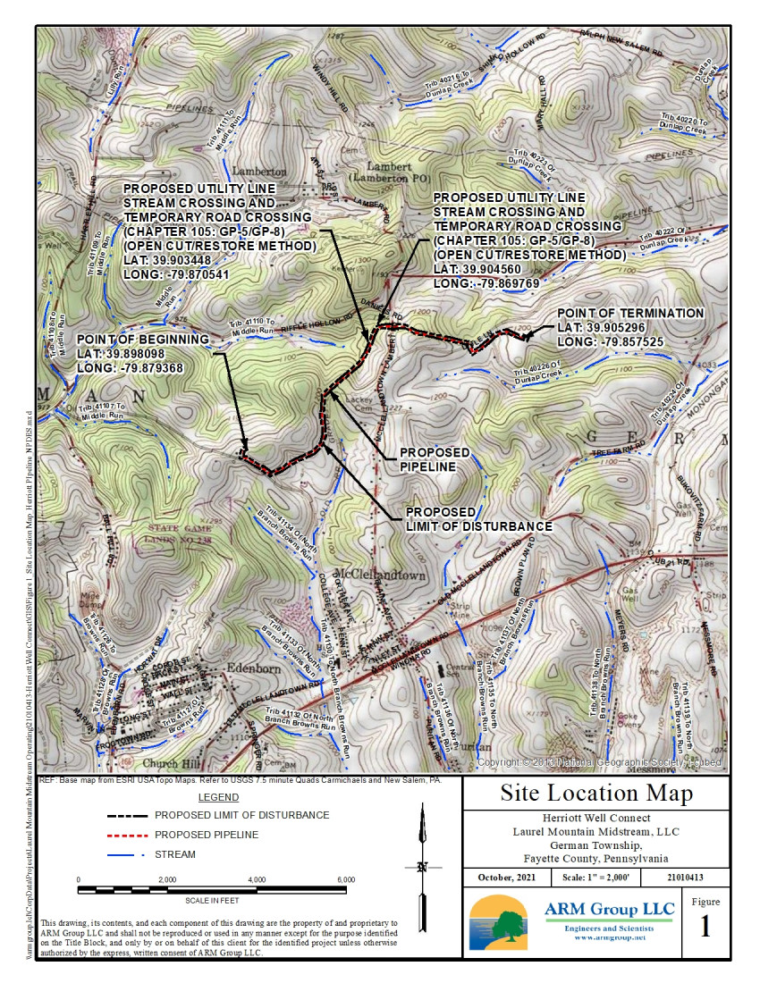
The Project Description in the Project Information Page for the Herriott Well Connect project states:
Laurel Mountain Midstream, LLC (LMM) intends to construct an approximate 8,943-foot long, 16-inch diameter underground steel natural gas pipeline. The purpose of the project is to support LMM’s natural gas operations from the Marcellus shale formation, which provides a key source of energy for the United States. The Herriott Well Connect will begin at the existing Herriott Well Pad at 39.898098°, -79.879368° and extend to the northeast to the existing Zalac Well Pad at 39.905296°, 79.857525°. The total project area and limit of disturbance for the Herriott Well Connect consists of approximately 16.3 acres.
---
The well OGM 2 was originally drilled by Burnett Oil.
------------------------
<https://www.dep.pa.gov/PublicParticipation/OfficeofEnvironmentalJustice/Pages/default.aspx>). There are supposed to be enhanced public participation requirements for permits in environmental justice areas, but news of this actually ever happening is scarce. In Fayette County, the entirety of Redstone, Springhill, Nicholson, and German Townships are environmental justice areas, as well as a large part of Dunbar Township. DEP's policy document on public participation guidelines for environmental justice areas is located here:
<https://www.elibrary.dep.state.pa.us/dsweb/Get/Version-48671/012-0501-002.pdf>
eNOTICE records are likely to list the same permit multiple times, as that permit moves through the DEP process.
Oil & Gas Wells designated with a site a number and the letter H typically designate horizontal wells.
-------------------------
Resources:
Pennsylvania Bulletin: <https://www.pabulletin.com/>
eNOTICE: <https://www.ahs2.dep.state.pa.
DEP Oil and Gas Reports: <https://www.dep.pa.gov/DataandTools/Reports/Oil%20and%20Gas%20Reports/Pages/default.aspx>
DEP Permits Issued Detail Report:
<http://cedatareporting.pa.gov/Reportserver/Pages/ReportViewer.aspx?/Public/DEP/OG/SSRS/Permits_Issued_Detail>
DEP SPUD (drilling started) Report:
<http://cedatareporting.pa.gov/Reportserver/Pages/ReportViewer.aspx?/Public/DEP/OG/SSRS/Spud_External_Data>
DEP Oil and Gas Compliance Report:
<http://cedatareporting.pa.gov/Reportserver/Pages/ReportViewer.aspx?/Public/DEP/OG/SSRS/OG_Compliance>
DEP PA Oil & Gas Mapping:
<https://www.depgis.state.pa.us/PaOilAndGasMapping>
Data Portal Services Directory [Technical]
<https://www.depgis.state.pa.us/arcgis/rest/services>
Query: Oil and Gas Wells All (ID: 3) [Technical]:
<https://www.depgis.state.pa.us/arcgis/rest/services/OilGas/OilGasAllStrayGasEGSP/MapServer/3/query?where=&text=&objectIds=&time=&geometry=&geometryType=esriGeometryEnvelope&inSR=&spatialRel=esriSpatialRelIntersects&relationParam=&outFields=*&returnGeometry=true&returnTrueCurves=false&maxAllowableOffset=&geometryPrecision=&outSR=&returnIdsOnly=false&returnCountOnly=false&orderByFields=&groupByFieldsForStatistics=&outStatistics=&returnZ=false&returnM=false&gdbVersion=&returnDistinctValues=false&resultOffset=&resultRecordCount=&f=html>
(Be sure to enter a Where clause in SQL format. Dates are in milliseconds since midnight 1/1/1970).
DEP Oil and Gas Electronic Submissions
<https://www.ahs.dep.pa.gov/eSubmissionPublicSearch>
DEP Air Quality Air Emission Plants Facilities Report
<http://cedatareporting.pa.gov/Reportserver/Pages/ReportViewer.aspx?/Public/DEP/AQ/SSRS/AQ_AEP_Facilities>
DEP Oil and Gas Electronic Notifications
<http://cedatareporting.pa.gov/Reportserver/Pages/ReportViewer.aspx?/Public/DEP/OG/SSRS/OG_Notifications>
DEP Oil and Gas Well Pad Report
<http://cedatareporting.pa.gov/Reportserver/Pages/ReportViewer.aspx?/Public/DEP/OG/SSRS/Well_Pads>
Fayette County Assessment Office Search For Tax Records:
<http://property.co.fayette.pa.us/search.aspx>
Pennsylvania Spatial Data Access:
<https://www.pasda.psu.edu/default.asp>
DEP Spatial Data Repository:
<ftp://www.pasda.psu.edu/pub/pasda/dep/>
National Response Center:
<https://www.nrc.uscg.mil/>
EPA-Echo: <https://www.epa-echo.gov/echo/
FERC citizen involvement: <https://www.ferc.gov/for-citiz
To receive E-mail notification of
all documents filed in a FERC docket, see:
<https://www.ferc.gov/docs-filing/esubscription.asp >
<https://www.ferc.gov/docs-fili
Follow the directions and enter the docket number to subscribe to.
Township Supervisors receive information regarding Erosion & Sedimentation permits, and these records may be reviewable at township municipal offices.
DEP permits are reviewable through the File Review process, for application to do file review see: <https://www.portal.state.pa.us/portal/server.pt/community/southwest_regional_office/13775/file_review/593164>
Environmental Hearing Board: <https://ehb.courtapps.com/publ
PA DEP Environmental Policy Comment System:
<https://www.ahs.dep.pa.gov/eComment/>
Federal Register Environment: <https://www.federalregister.g
Browsing of recent comment
opportunities for federal agencies, e.g. EPA. Click "sign up" to
subscribe to daily E-mails of new document listings.
SkyTruth Fayette County Drilling Alerts: <https://frack.skytruth.org/pen
U.S. Army Corps of Engineers, Pittsburgh District, Public Notices:
<https://www.lrp.usace.army.mil/Missions/Regulatory/Public-Notices/>
EPA Pennsylvania Public Notices: <https://www2.epa.gov/aboutepa/epa-pennsylvania#notice>
Marcellus Shale waste disposal
injection wells in Pennsylvania are regulated directly by EPA, not
DEP. Notice of any new permit applications will appear at the
above web address. I'm not aware of any subscription service
to be notified of such applications. I'm not aware of any
Marcellus Shale waste disposal injection wells in Fayette County
(yet ...) but we need to monitor this page for future
applications.
Energy Assurance Daily: <https://www.oe.netl.doe.gov/ead.aspx>
Daily newsletter from the US
Department of Energy about events relating to energy. The Natural
Gas section has information about pipelines.
-------------------------
Disclaimers:
This compilation from the above sources was done in part by hand using copy and paste and in part using automated methods; it may omit relevant permits.
Parcel data is provided via the tax records search web page offered by the Fayette County Assessment Office (http://property.co.fayette.pa.us/). Presumed Parcel Id links are subject to availability provided by that agency and associated web sites. Presumed Parcel Ids are determined as the mapped parcel containing a given latitude and longitude, are a best effort determination which is subject to error, and are not official. In cases where a facility is leased and there is a separate parcel id for the lease, if this parcel id is not separately mapped, the parcel id shown will be the id for the enclosing parcel. Parcel owners may be surface owners only and may or may not have any relationship to oil & gas facilities.
Does not currently include water supply permits. Does not include landfill permits even though many such are for Marcellus Shale waste. (It is not possible at this time to distinguish which landfill permits are for Marcellus Shale waste and which are not without doing File Review for each permit.)
Erosion & Sedimentation permit records do not currently include latitude and longitude. Where I am publishing latitude and longitude with E&S permits it is by inferring an associated well permit and using published latitude and longitude for the well. It is possible I may be inferring the wrong well site.
Municipalities are shown from eFACTS records on the DEP web site. The DEP has been known to list a municipality incorrectly.