The Harmed Success Stories Concepts How To What Is Commentary
Fayette County Marcellus Shale Permits 10/5/20 - 10/18/20
Contents
Pennsylvania Bulletin Listings
[No activity]eFACTS Listings
CHESTNUT VALLEY LDFL Landfill Permit Form 37(per component) Issued 10/1/2020Inspection Issues
TEXAS EASTERN TRANS FAYETTE CNTY GP-05 Utility Line Stream Crossings 10/14/2020 deficiency letter
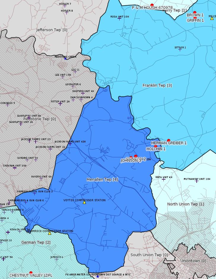
HERMAN GREIBER 1 No Production or Mechanical Integrity Reports filed Violation(s) Noted
JOHNSON 2 No Production or Mechanical Integrity Reports filed Violation(s) NotedPrice of Natural Gas
JOHNSON 3 No Production or Mechanical Integrity Reports filed Violation(s) Noted
HOLCHIN 1 No well tag or label; No Production or Mechanical Integrity Reports filed Violation(s) Noted
P & M HOUGH 670978 No Production or Mechanical Integrity Reports filed Violation(s) Noted
GRIFFIN 1 No well tag or label; No Production or Mechanical Integrity Reports filed since 2016 Violation(s) Noted
BROWN 1 No Production or Mechanical Integrity Reports filed since 2016 Violation(s) Noted
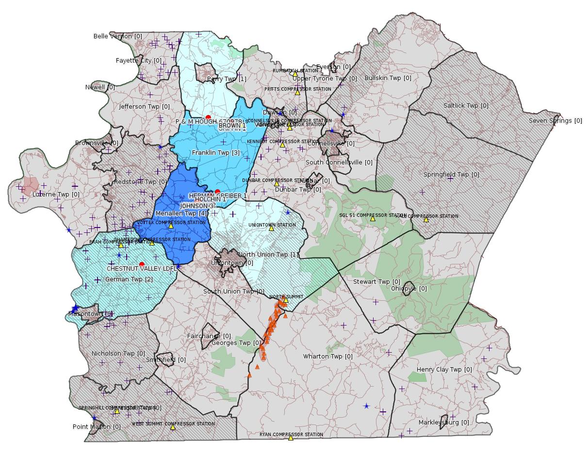
Map
Key
Red dots: items in this permit list with an exact location.
Blue stars: Marcellus Gas Well Water Sources.
Where well laterals are mapped they show in red; a 400-foot buffer surrounding the lateral shows in blue (lavender where it overlaps a mapped mineral tract).
Where mineral tracts are mapped, they show in pink. Mineral tracts can overlap; the overlap will show in red. The precise meaning of "mineral tract" is not clear.
Municipality shading: number of "facilities", with each well counting separately
(includes the red dots):
gray: 0
pale turquoise: 1
turquoise: 2
pale blue: 3
middle blue: 4
dark blue: 5
dark purple: 6
purple: 18
(Color coding may differ from one issue to the next.)
(Note if a project spans multiple municipalities -- e.g. a pipeline -- it will show in the count for each municipality.)
The number of facilities also follows the municipality name in brackets.
Municipality counts are based on the way the permit is listed by DEP; DEP has been known to get a municipality wrong.
Locations in brackets identify a precise location used to locate a surrogate for the actual site being permitted (e.g. locating a well pad or pipeline by the known location of a well.) Locations labeled beginning with "~" and ending in "[?]" are approximate and speculative based on inferences using on-line property and lease records. These are marked in the text as "[Approximate, Speculative]
Cross-hatching: Environmental Justice Areas
Yellow triangles: Compressor Stations
Orange triangles: Storage Field Wells (currently Dominion North Summit Storage Field)
Crosses: SPUD Unconventional well permits
Green: "Natural areas", e.g. state game lands, state forests
Yellow triangles: Compressor Stations
Orange triangles: Storage Field Wells (currently Dominion North Summit Storage Field)
Crosses: SPUD Unconventional well permits
Green: "Natural areas", e.g. state game lands, state forests
More Maps
 |
Source: Pennsylvania Bulletin
[No activity]
-------------------------
Source: eNOTICE
(+ PA
Oil and Gas Mapping, Well
Pad Report.) Well Details via Data
Portal Services: Oil and Gas Wells All (ID: 3).
Please see the Disclaimer below regarding Parcel Id data.
Authorization ID: 1327102
Permit number: 100419
Site: CHESTNUT VALLEY LDFL
Client: ADVANCED DSPL SVC CHESTNUT VALLEY LDFL INC
Authorization type: Landfill Permit Form 37(per component)
Application type: Modification
Authorization is for: FACILITY
Date received: 09/11/2020
Status: Issued on 10/1/2020
Permit Decision Guarantee Applies?: Yes
Permit Decision Guarantee status: ACTIVE
Permit Review Notes:
Date Review Note
10/1/2020 The technical review and decision review are complete and either the permit decision and/or permit issuance are forthcoming.
9/11/2020 The permit application package is complete, has been accepted, and is undergoing technical review.
<https://www.ahs.dep.pa.gov/eFACTSWeb/searchResults_singleAuth.aspx?AuthID=1327102>
Site Programs:
Air Quality
Clean Water
Environmental Cleanup & Brownfields
Mining
Radiation Protection
Waste Management
Water Planning and Conservation
Site Municipalities:
German Twp, Fayette County
Authorization ID: 1321905
Permit number: GP052605220-025
Site: TEXAS EASTERN TRANS FAYETTE CNTY
Client: TEXAS EASTERN TRANS LP
Authorization type: GP-05 Utility Line Stream Crossings
Application type: New
Authorization is for: FACILITY
Date received: 07/27/2020
Status: Pending
Permit Decision Guarantee Applies?: Yes
Permit Decision Guarantee status: VOID
Permit Review Notes:
Date Review Note
10/14/2020 Applicant has been issued a deficiency letter. If applicable, this application no longer qualifies for the Permit Decision Guarantee.
8/14/2020 Applicant has been issued a deficiency letter. If applicable, this application no longer qualifies for the Permit Decision Guarantee.
<https://www.ahs.dep.pa.gov/eFACTSWeb/searchResults_singleAuth.aspx?AuthID=1321905>
Site Programs:
Water Planning and Conservation
Site Municipalities:
German Twp, Fayette County
Menallen Twp, Fayette County
North Union Twp, Fayette County
OPERATOR: THE PRODUCTION CO LLC
INSPECTION_ID: 3090375
INSPECTION_DATE: 10/07/2020
INSPECTION_TYPE: Routine/Complete Inspection
API_PERMIT: 051-20207
FARM_NAME: HERMAN GREIBER 1
UNCONVENTIONAL: No
SITE_ID: 41105
SITE_NAME: HERMAN GREIBER 1 WELL
FACILITY_TYPE: Oil & Gas Location
INSPECTION_CATEGORY: Primary Facility
REGION: EP DOGO SWDO Dstr Off
COUNTY: Fayette
MUNICIPALITY: Franklin Twp
INSPECTOR: WOODS, MATTHEW
INSPECTION_SOURCE: SUBSAIR
INSPECTION_RESULT_DESCRIPTION: Violation(s) Noted
INSPECTION_COMMENT: "Well is in production.
No MIA or APR submit for he past year."
VIOLATION_ID: 896569
VIOLATION_DATE: 10/07/2020
VIOLATION_CODE: 78.88(e) - OPERATING WELLS - MECHANICAL INTEGRITY OF OPERATING WELLS - Operator failed to submit an annual report to the Department identifying the compliance status of each well with the mechanical integrity requirements for structurally sound wells in compliance with 25 Pa. Code Section 78.73(c).
VIOLATION_TYPE: Administrative
VIOLATION_COMMENT:
RESOLVED_DATE:
RESOLUTION_REASON_CODE_DESCRIPTION:
CONTINUING_VIOLATION:
ENFORCEMENT_ID: 389257
ENFORCEMENT_CODE_DESCRIPTION: NOV - Notice of Violation
DATE_EXECUTED: 10/02/2020
ENFORCEMENT_FINAL_DATE:
ENFORCEMENT_FINAL_STATUS:
PENALTY_FINAL_DATE:
PENALTY_FINAL_STATUS_CODE_DESCRIPTION:
PENALTY_AMOUNT:
TOTAL_AMOUNT_COLLECTED:
VIOLATION_ID: 896570
VIOLATION_DATE: 10/07/2020
VIOLATION_CODE: 78.121(A) - WELL REPORTING – PRODUCTION REPORTING – Conventional operator failed to submit annual conventional production and status report for permitted or registered well.
VIOLATION_TYPE: Administrative
VIOLATION_COMMENT:
RESOLVED_DATE:
RESOLUTION_REASON_CODE_DESCRIPTION:
CONTINUING_VIOLATION:
ENFORCEMENT_ID: 389257
ENFORCEMENT_CODE_DESCRIPTION: NOV - Notice of Violation
DATE_EXECUTED: 10/02/2020
ENFORCEMENT_FINAL_DATE:
ENFORCEMENT_FINAL_STATUS:
PENALTY_FINAL_DATE:
PENALTY_FINAL_STATUS_CODE_DESCRIPTION:
PENALTY_AMOUNT:
TOTAL_AMOUNT_COLLECTED:
Well Details:
Permit Number: 051-20207
Well Name: HERMAN GREIBER 1
Unconventional Well: N
Well Configuration: Vertical Well
Well Type: GAS
Well Status: Active
Coal Association: Coal
Conservation Well: N
Primary Facility ID: 42857
Site ID: 41105
Site Name: HERMAN GREIBER 1 WELL
Well Pad ID: 0
Well Pad Name:
Storage Field:
Operator: THE PRODUCTION CO LLC
Operator Number: OGO-39567
Permit Date: 1978-06-22
Permit Date Expires: 1979-06-22
SPUD Date: 1978-07-25
Date Plugged:
UIC ID:
UIC Type:
Surface Elevation: 1080
County: Fayette
Municipality: Franklin Twp
Location: 39.968089,-79.739419
Map URL: <http://www.openstreetmap.org/?mlat=39.968089&mlon=-79.739419#map=15/39.968089/-79.739419>
Presumed Parcel Id: 13200007
---
OPERATOR: THE PRODUCTION CO LLC
INSPECTION_ID: 3090395
INSPECTION_DATE: 10/07/2020
INSPECTION_TYPE: Routine/Complete Inspection
API_PERMIT: 051-00216
FARM_NAME: JOHNSON 2
UNCONVENTIONAL: No
SITE_ID: 40894
SITE_NAME: JOHNSON 2 WELL
FACILITY_TYPE: Oil & Gas Location
INSPECTION_CATEGORY: Primary Facility
REGION: EP DOGO SWDO Dstr Off
COUNTY: Fayette
MUNICIPALITY: Menallen Twp
INSPECTOR: WOODS, MATTHEW
INSPECTION_SOURCE: SUBSAIR
INSPECTION_RESULT_DESCRIPTION: Violation(s) Noted
INSPECTION_COMMENT: "Well head is at the top of the hill, take the new lease road to the Diversified pad to get to well head.
Chart and production lines are next to Rutter Road at the bottom of the hill.
Well is active.
No MIA or APR submitted in the past year."
VIOLATION_ID: 897110
VIOLATION_DATE: 10/07/2020
VIOLATION_CODE: 78.88(e) - OPERATING WELLS - MECHANICAL INTEGRITY OF OPERATING WELLS - Operator failed to submit an annual report to the Department identifying the compliance status of each well with the mechanical integrity requirements for structurally sound wells in compliance with 25 Pa. Code Section 78.73(c).
VIOLATION_TYPE: Administrative
VIOLATION_COMMENT:
RESOLVED_DATE:
RESOLUTION_REASON_CODE_DESCRIPTION:
CONTINUING_VIOLATION:
ENFORCEMENT_ID: 389257
ENFORCEMENT_CODE_DESCRIPTION: NOV - Notice of Violation
DATE_EXECUTED: 10/02/2020
ENFORCEMENT_FINAL_DATE:
ENFORCEMENT_FINAL_STATUS:
PENALTY_FINAL_DATE:
PENALTY_FINAL_STATUS_CODE_DESCRIPTION:
PENALTY_AMOUNT:
TOTAL_AMOUNT_COLLECTED:
VIOLATION_ID: 897111
VIOLATION_DATE: 10/07/2020
VIOLATION_CODE: 78.121(A) - WELL REPORTING – PRODUCTION REPORTING – Conventional operator failed to submit annual conventional production and status report for permitted or registered well.
VIOLATION_TYPE: Administrative
VIOLATION_COMMENT:
RESOLVED_DATE:
RESOLUTION_REASON_CODE_DESCRIPTION:
CONTINUING_VIOLATION:
ENFORCEMENT_ID: 389257
ENFORCEMENT_CODE_DESCRIPTION: NOV - Notice of Violation
DATE_EXECUTED: 10/02/2020
ENFORCEMENT_FINAL_DATE:
ENFORCEMENT_FINAL_STATUS:
PENALTY_FINAL_DATE:
PENALTY_FINAL_STATUS_CODE_DESCRIPTION:
PENALTY_AMOUNT:
TOTAL_AMOUNT_COLLECTED:
Well Details:
Permit Number: 051-00216
Well Name: JOHNSON 2
Unconventional Well: N
Well Configuration: Vertical Well
Well Type: GAS
Well Status: Active
Coal Association: Coal
Conservation Well: N
Primary Facility ID: 42646
Site ID: 40894
Site Name: JOHNSON 2 WELL
Well Pad ID: 0
Well Pad Name:
Storage Field:
Operator: THE PRODUCTION CO LLC
Operator Number: OGO-39567
Permit Date: 1989-06-21
Permit Date Expires:
SPUD Date: 1800-01-01
Date Plugged:
UIC ID:
UIC Type:
Surface Elevation: 0
County: Fayette
Municipality: Menallen Twp
Location: 39.95974,-79.763108
Map URL: <http://www.openstreetmap.org/?mlat=39.95974&mlon=-79.763108#map=15/39.95974/-79.763108>
Presumed Parcel Id: 22060119
---
OPERATOR: THE PRODUCTION CO LLC
INSPECTION_ID: 3090400
INSPECTION_DATE: 10/07/2020
INSPECTION_TYPE: Routine/Complete Inspection
API_PERMIT: 051-00217
FARM_NAME: JOHNSON 3
UNCONVENTIONAL: No
SITE_ID: 40895
SITE_NAME: JOHNSON 3 WELL
FACILITY_TYPE: Oil & Gas Location
INSPECTION_CATEGORY: Primary Facility
REGION: EP DOGO SWDO Dstr Off
COUNTY: Fayette
MUNICIPALITY: Menallen Twp
INSPECTOR: WOODS, MATTHEW
INSPECTION_SOURCE: SUBSAIR
INSPECTION_RESULT_DESCRIPTION: Violation(s) Noted
INSPECTION_COMMENT: "Well is active meter box is next to Rutter Road.
No MIA or APR submitted in the past year.
There is no lease road to the well, it is located in a field off Cannan Valley Rd."
VIOLATION_ID: 896573
VIOLATION_DATE: 10/07/2020
VIOLATION_CODE: 78.121(A) - WELL REPORTING – PRODUCTION REPORTING – Conventional operator failed to submit annual conventional production and status report for permitted or registered well.
VIOLATION_TYPE: Administrative
VIOLATION_COMMENT:
RESOLVED_DATE:
RESOLUTION_REASON_CODE_DESCRIPTION:
CONTINUING_VIOLATION:
ENFORCEMENT_ID: 389257
ENFORCEMENT_CODE_DESCRIPTION: NOV - Notice of Violation
DATE_EXECUTED: 10/02/2020
ENFORCEMENT_FINAL_DATE:
ENFORCEMENT_FINAL_STATUS:
PENALTY_FINAL_DATE:
PENALTY_FINAL_STATUS_CODE_DESCRIPTION:
PENALTY_AMOUNT:
TOTAL_AMOUNT_COLLECTED:
VIOLATION_ID: 896572
VIOLATION_DATE: 10/07/2020
VIOLATION_CODE: 78.88(e) - OPERATING WELLS - MECHANICAL INTEGRITY OF OPERATING WELLS - Operator failed to submit an annual report to the Department identifying the compliance status of each well with the mechanical integrity requirements for structurally sound wells in compliance with 25 Pa. Code Section 78.73(c).
VIOLATION_TYPE: Administrative
VIOLATION_COMMENT:
RESOLVED_DATE:
RESOLUTION_REASON_CODE_DESCRIPTION:
CONTINUING_VIOLATION:
ENFORCEMENT_ID: 389257
ENFORCEMENT_CODE_DESCRIPTION: NOV - Notice of Violation
DATE_EXECUTED: 10/02/2020
ENFORCEMENT_FINAL_DATE:
ENFORCEMENT_FINAL_STATUS:
PENALTY_FINAL_DATE:
PENALTY_FINAL_STATUS_CODE_DESCRIPTION:
PENALTY_AMOUNT:
TOTAL_AMOUNT_COLLECTED:
Well Details:
Permit Number: 051-00217
Well Name: JOHNSON 3
Unconventional Well: N
Well Configuration: Vertical Well
Well Type: GAS
Well Status: Active
Coal Association: Coal
Conservation Well: N
Primary Facility ID: 42647
Site ID: 40895
Site Name: JOHNSON 3 WELL
Well Pad ID: 0
Well Pad Name:
Storage Field:
Operator: THE PRODUCTION CO LLC
Operator Number: OGO-39567
Permit Date: 1989-06-21
Permit Date Expires:
SPUD Date: 1800-01-01
Date Plugged:
UIC ID:
UIC Type:
Surface Elevation: 0
County: Fayette
Municipality: Menallen Twp
Location: 39.959022,-79.766403
Map URL: <http://www.openstreetmap.org/?mlat=39.959022&mlon=-79.766403#map=15/39.959022/-79.766403>
Presumed Parcel Id: 22060119
---
OPERATOR: THE PRODUCTION CO LLC
INSPECTION_ID: 3090411
INSPECTION_DATE: 10/07/2020
INSPECTION_TYPE: Routine/Complete Inspection
API_PERMIT: 051-00213
FARM_NAME: HOLCHIN 1
UNCONVENTIONAL: No
SITE_ID: 40891
SITE_NAME: HOLCHIN 1 WELL
FACILITY_TYPE: Oil & Gas Location
INSPECTION_CATEGORY: Primary Facility
REGION: EP DOGO SWDO Dstr Off
COUNTY: Fayette
MUNICIPALITY: Menallen Twp
INSPECTOR: WOODS, MATTHEW
INSPECTION_SOURCE: SUBSAIR
INSPECTION_RESULT_DESCRIPTION: Violation(s) Noted
INSPECTION_COMMENT: "No well tag or label.
Well is active.
No MIA or APR submitted for the past year."
VIOLATION_ID: 897126
VIOLATION_DATE: 10/07/2020
VIOLATION_CODE: 78.121(A) - WELL REPORTING – PRODUCTION REPORTING – Conventional operator failed to submit annual conventional production and status report for permitted or registered well.
VIOLATION_TYPE: Administrative
VIOLATION_COMMENT:
RESOLVED_DATE:
RESOLUTION_REASON_CODE_DESCRIPTION:
CONTINUING_VIOLATION:
ENFORCEMENT_ID: 389257
ENFORCEMENT_CODE_DESCRIPTION: NOV - Notice of Violation
DATE_EXECUTED: 10/02/2020
ENFORCEMENT_FINAL_DATE:
ENFORCEMENT_FINAL_STATUS:
PENALTY_FINAL_DATE:
PENALTY_FINAL_STATUS_CODE_DESCRIPTION:
PENALTY_AMOUNT:
TOTAL_AMOUNT_COLLECTED:
VIOLATION_ID: 897125
VIOLATION_DATE: 10/07/2020
VIOLATION_CODE: 78.88(e) - OPERATING WELLS - MECHANICAL INTEGRITY OF OPERATING WELLS - Operator failed to submit an annual report to the Department identifying the compliance status of each well with the mechanical integrity requirements for structurally sound wells in compliance with 25 Pa. Code Section 78.73(c).
VIOLATION_TYPE: Administrative
VIOLATION_COMMENT:
RESOLVED_DATE:
RESOLUTION_REASON_CODE_DESCRIPTION:
CONTINUING_VIOLATION:
ENFORCEMENT_ID: 389257
ENFORCEMENT_CODE_DESCRIPTION: NOV - Notice of Violation
DATE_EXECUTED: 10/02/2020
ENFORCEMENT_FINAL_DATE:
ENFORCEMENT_FINAL_STATUS:
PENALTY_FINAL_DATE:
PENALTY_FINAL_STATUS_CODE_DESCRIPTION:
PENALTY_AMOUNT:
TOTAL_AMOUNT_COLLECTED:
VIOLATION_ID: 897123
VIOLATION_DATE: 10/07/2020
VIOLATION_CODE: OGA3211(G) - WELL PERMITS - POSTING - Failure to post the well permit number and the operator's name, address and phone number at the well site during construction of the access road, site preparation and during drilling, operating or alteration of well.
VIOLATION_TYPE: Administrative
VIOLATION_COMMENT:
RESOLVED_DATE:
RESOLUTION_REASON_CODE_DESCRIPTION:
CONTINUING_VIOLATION:
ENFORCEMENT_ID: 389257
ENFORCEMENT_CODE_DESCRIPTION: NOV - Notice of Violation
DATE_EXECUTED: 10/02/2020
ENFORCEMENT_FINAL_DATE:
ENFORCEMENT_FINAL_STATUS:
PENALTY_FINAL_DATE:
PENALTY_FINAL_STATUS_CODE_DESCRIPTION:
PENALTY_AMOUNT:
TOTAL_AMOUNT_COLLECTED:
VIOLATION_ID: 897124
VIOLATION_DATE: 10/07/2020
VIOLATION_CODE: OGA3211(H) - WELL PERMITS - LABELING - Failure to install, in a permanent manner, the permit number on a completed well.
VIOLATION_TYPE: Administrative
VIOLATION_COMMENT:
RESOLVED_DATE:
RESOLUTION_REASON_CODE_DESCRIPTION:
CONTINUING_VIOLATION:
ENFORCEMENT_ID: 389257
ENFORCEMENT_CODE_DESCRIPTION: NOV - Notice of Violation
DATE_EXECUTED: 10/02/2020
ENFORCEMENT_FINAL_DATE:
ENFORCEMENT_FINAL_STATUS:
PENALTY_FINAL_DATE:
PENALTY_FINAL_STATUS_CODE_DESCRIPTION:
PENALTY_AMOUNT:
TOTAL_AMOUNT_COLLECTED:
Well Details:
Permit Number: 051-00213
Well Name: HOLCHIN 1
Unconventional Well: N
Well Configuration: Vertical Well
Well Type: GAS
Well Status: Active
Coal Association: Coal
Conservation Well: N
Primary Facility ID: 42643
Site ID: 40891
Site Name: HOLCHIN 1 WELL
Well Pad ID: 0
Well Pad Name:
Storage Field:
Operator: THE PRODUCTION CO LLC
Operator Number: OGO-39567
Permit Date: 1989-06-21
Permit Date Expires:
SPUD Date: 1800-01-01
Date Plugged:
UIC ID:
UIC Type:
Surface Elevation: 0
County: Fayette
Municipality: Menallen Twp
Location: 39.964922,-79.748813
Map URL: <http://www.openstreetmap.org/?mlat=39.964922&mlon=-79.748813#map=15/39.964922/-79.748813>
Presumed Parcel Id: 2208001801
---
OPERATOR: THE PRODUCTION CO LLC
INSPECTION_ID: 3091235
INSPECTION_DATE: 10/08/2020
INSPECTION_TYPE: Routine/Complete Inspection
API_PERMIT: 051-00133
FARM_NAME: P & M HOUGH 670978
UNCONVENTIONAL: No
SITE_ID: 40811
SITE_NAME: P & M HOUGH 670978 WELL
FACILITY_TYPE: Oil & Gas Location
INSPECTION_CATEGORY: Primary Facility
REGION: EP DOGO SWDO Dstr Off
COUNTY: Fayette
MUNICIPALITY: Perry Twp
INSPECTOR: WOODS, MATTHEW
INSPECTION_SOURCE: SUBSAIR
INSPECTION_RESULT_DESCRIPTION: Violation(s) Noted
INSPECTION_COMMENT: "Well is shut in. Chart appears to not have been changed for some time.
No MIA or APR submitted since 2016."
VIOLATION_ID: 897127
VIOLATION_DATE: 10/08/2020
VIOLATION_CODE: 78.88(e) - OPERATING WELLS - MECHANICAL INTEGRITY OF OPERATING WELLS - Operator failed to submit an annual report to the Department identifying the compliance status of each well with the mechanical integrity requirements for structurally sound wells in compliance with 25 Pa. Code Section 78.73(c).
VIOLATION_TYPE: Administrative
VIOLATION_COMMENT:
RESOLVED_DATE:
RESOLUTION_REASON_CODE_DESCRIPTION:
CONTINUING_VIOLATION:
ENFORCEMENT_ID: 389257
ENFORCEMENT_CODE_DESCRIPTION: NOV - Notice of Violation
DATE_EXECUTED: 10/02/2020
ENFORCEMENT_FINAL_DATE:
ENFORCEMENT_FINAL_STATUS:
PENALTY_FINAL_DATE:
PENALTY_FINAL_STATUS_CODE_DESCRIPTION:
PENALTY_AMOUNT:
TOTAL_AMOUNT_COLLECTED:
VIOLATION_ID: 897128
VIOLATION_DATE: 10/08/2020
VIOLATION_CODE: 78.121(A) - WELL REPORTING – PRODUCTION REPORTING – Conventional operator failed to submit annual conventional production and status report for permitted or registered well.
VIOLATION_TYPE: Administrative
VIOLATION_COMMENT:
RESOLVED_DATE:
RESOLUTION_REASON_CODE_DESCRIPTION:
CONTINUING_VIOLATION:
ENFORCEMENT_ID: 389257
ENFORCEMENT_CODE_DESCRIPTION: NOV - Notice of Violation
DATE_EXECUTED: 10/02/2020
ENFORCEMENT_FINAL_DATE:
ENFORCEMENT_FINAL_STATUS:
PENALTY_FINAL_DATE:
PENALTY_FINAL_STATUS_CODE_DESCRIPTION:
PENALTY_AMOUNT:
TOTAL_AMOUNT_COLLECTED:
Well Details:
Permit Number: 051-00133
Well Name: P & M HOUGH 670978
Unconventional Well: N
Well Configuration: Vertical Well
Well Type: GAS
Well Status: Active
Coal Association: Coal
Conservation Well: N
Primary Facility ID: 42563
Site ID: 40811
Site Name: P & M HOUGH 670978 WELL
Well Pad ID: 0
Well Pad Name:
Storage Field:
Operator: THE PRODUCTION CO LLC
Operator Number: OGO-39567
Permit Date: 1986-07-18
Permit Date Expires:
SPUD Date: 1800-01-01
Date Plugged:
UIC ID:
UIC Type:
Surface Elevation: 0
County: Fayette
Municipality: Perry Twp
Location: 40.042288,-79.749947
Map URL: <http://www.openstreetmap.org/?mlat=40.042288&mlon=-79.749947#map=15/40.042288/-79.749947>
Presumed Parcel Id: 2720000902
---
OPERATOR: THE PRODUCTION CO LLC
INSPECTION_ID: 3091237
INSPECTION_DATE: 10/08/2020
INSPECTION_TYPE: Routine/Complete Inspection
API_PERMIT: 051-00104
FARM_NAME: GRIFFIN 1
UNCONVENTIONAL: No
SITE_ID: 40782
SITE_NAME: GRIFFIN 1 WELL
FACILITY_TYPE: Oil & Gas Location
INSPECTION_CATEGORY: Primary Facility
REGION: EP DOGO SWDO Dstr Off
COUNTY: Fayette
MUNICIPALITY: Franklin Twp
INSPECTOR: WOODS, MATTHEW
INSPECTION_SOURCE: SUBSAIR
INSPECTION_RESULT_DESCRIPTION: Violation(s) Noted
INSPECTION_COMMENT: "Well is in production.
No MIA or APR submitted since 2016."
VIOLATION_ID: 896614
VIOLATION_DATE: 10/08/2020
VIOLATION_CODE: 78.121(A) - WELL REPORTING – PRODUCTION REPORTING – Conventional operator failed to submit annual conventional production and status report for permitted or registered well.
VIOLATION_TYPE: Administrative
VIOLATION_COMMENT:
RESOLVED_DATE:
RESOLUTION_REASON_CODE_DESCRIPTION:
CONTINUING_VIOLATION:
ENFORCEMENT_ID: 389257
ENFORCEMENT_CODE_DESCRIPTION: NOV - Notice of Violation
DATE_EXECUTED: 10/02/2020
ENFORCEMENT_FINAL_DATE:
ENFORCEMENT_FINAL_STATUS:
PENALTY_FINAL_DATE:
PENALTY_FINAL_STATUS_CODE_DESCRIPTION:
PENALTY_AMOUNT:
TOTAL_AMOUNT_COLLECTED:
VIOLATION_ID: 896613
VIOLATION_DATE: 10/08/2020
VIOLATION_CODE: 78.88(e) - OPERATING WELLS - MECHANICAL INTEGRITY OF OPERATING WELLS - Operator failed to submit an annual report to the Department identifying the compliance status of each well with the mechanical integrity requirements for structurally sound wells in compliance with 25 Pa. Code Section 78.73(c).
VIOLATION_TYPE: Administrative
VIOLATION_COMMENT:
RESOLVED_DATE:
RESOLUTION_REASON_CODE_DESCRIPTION:
CONTINUING_VIOLATION:
ENFORCEMENT_ID: 389257
ENFORCEMENT_CODE_DESCRIPTION: NOV - Notice of Violation
DATE_EXECUTED: 10/02/2020
ENFORCEMENT_FINAL_DATE:
ENFORCEMENT_FINAL_STATUS:
PENALTY_FINAL_DATE:
PENALTY_FINAL_STATUS_CODE_DESCRIPTION:
PENALTY_AMOUNT:
TOTAL_AMOUNT_COLLECTED:
Well Details:
Permit Number: 051-00104
Well Name: GRIFFIN 1
Unconventional Well: N
Well Configuration: Vertical Well
Well Type: GAS
Well Status: Active
Coal Association: Coal
Conservation Well: N
Primary Facility ID: 42534
Site ID: 40782
Site Name: GRIFFIN 1 WELL
Well Pad ID: 0
Well Pad Name:
Storage Field:
Operator: THE PRODUCTION CO LLC
Operator Number: OGO-39567
Permit Date: 1986-02-25
Permit Date Expires:
SPUD Date: 1800-01-01
Date Plugged:
UIC ID:
UIC Type:
Surface Elevation: 0
County: Fayette
Municipality: Franklin Twp
Location: 40.035052,-79.719368
Map URL: <http://www.openstreetmap.org/?mlat=40.035052&mlon=-79.719368#map=15/40.035052/-79.719368>
Presumed Parcel Id: 13050115
---
OPERATOR: THE PRODUCTION CO LLC
INSPECTION_ID: 3091249
INSPECTION_DATE: 10/08/2020
INSPECTION_TYPE: Routine/Complete Inspection
API_PERMIT: 051-00103
FARM_NAME: BROWN 1
UNCONVENTIONAL: No
SITE_ID: 40781
SITE_NAME: BROWN 1 WELL
FACILITY_TYPE: Oil & Gas Location
INSPECTION_CATEGORY: Primary Facility
REGION: EP DOGO SWDO Dstr Off
COUNTY: Fayette
MUNICIPALITY: Franklin Twp
INSPECTOR: WOODS, MATTHEW
INSPECTION_SOURCE: SUBSAIR
INSPECTION_RESULT_DESCRIPTION: Violation(s) Noted
INSPECTION_COMMENT: "Well is in production.
Meter and production equipment near Lake Rd.
No MIA or APR submitted since 2016.
Associated equipment across Lake Rd no longer in use and needs to be removed."
VIOLATION_ID: 896616
VIOLATION_DATE: 10/08/2020
VIOLATION_CODE: 78.88(e) - OPERATING WELLS - MECHANICAL INTEGRITY OF OPERATING WELLS - Operator failed to submit an annual report to the Department identifying the compliance status of each well with the mechanical integrity requirements for structurally sound wells in compliance with 25 Pa. Code Section 78.73(c).
VIOLATION_TYPE: Administrative
VIOLATION_COMMENT:
RESOLVED_DATE:
RESOLUTION_REASON_CODE_DESCRIPTION:
CONTINUING_VIOLATION:
ENFORCEMENT_ID: 389257
ENFORCEMENT_CODE_DESCRIPTION: NOV - Notice of Violation
DATE_EXECUTED: 10/02/2020
ENFORCEMENT_FINAL_DATE:
ENFORCEMENT_FINAL_STATUS:
PENALTY_FINAL_DATE:
PENALTY_FINAL_STATUS_CODE_DESCRIPTION:
PENALTY_AMOUNT:
TOTAL_AMOUNT_COLLECTED:
VIOLATION_ID: 896617
VIOLATION_DATE: 10/08/2020
VIOLATION_CODE: 78.121(A) - WELL REPORTING – PRODUCTION REPORTING – Conventional operator failed to submit annual conventional production and status report for permitted or registered well.
VIOLATION_TYPE: Administrative
VIOLATION_COMMENT:
RESOLVED_DATE:
RESOLUTION_REASON_CODE_DESCRIPTION:
CONTINUING_VIOLATION:
ENFORCEMENT_ID: 389257
ENFORCEMENT_CODE_DESCRIPTION: NOV - Notice of Violation
DATE_EXECUTED: 10/02/2020
ENFORCEMENT_FINAL_DATE:
ENFORCEMENT_FINAL_STATUS:
PENALTY_FINAL_DATE:
PENALTY_FINAL_STATUS_CODE_DESCRIPTION:
PENALTY_AMOUNT:
TOTAL_AMOUNT_COLLECTED:
Well Details:
Permit Number: 051-00103
Well Name: BROWN 1
Unconventional Well: N
Well Configuration: Vertical Well
Well Type: GAS
Well Status: Active
Coal Association: Coal
Conservation Well: N
Primary Facility ID: 42533
Site ID: 40781
Site Name: BROWN 1 WELL
Well Pad ID: 0
Well Pad Name:
Storage Field:
Operator: THE PRODUCTION CO LLC
Operator Number: OGO-39567
Permit Date: 1986-02-25
Permit Date Expires:
SPUD Date: 1800-01-01
Date Plugged:
UIC ID:
UIC Type:
Surface Elevation: 0
County: Fayette
Municipality: Franklin Twp
Location: 40.037907,-79.719562
Map URL: <http://www.openstreetmap.org/?mlat=40.037907&mlon=-79.719562#map=15/40.037907/-79.719562>
Presumed Parcel Id: 13050117
-------------------------
Please see the Disclaimer below regarding Parcel Id data.
Authorization ID: 1327102
Permit number: 100419
Site: CHESTNUT VALLEY LDFL
Client: ADVANCED DSPL SVC CHESTNUT VALLEY LDFL INC
Authorization type: Landfill Permit Form 37(per component)
Application type: Modification
Authorization is for: FACILITY
Date received: 09/11/2020
Status: Issued on 10/1/2020
Permit Decision Guarantee Applies?: Yes
Permit Decision Guarantee status: ACTIVE
Permit Review Notes:
Date Review Note
10/1/2020 The technical review and decision review are complete and either the permit decision and/or permit issuance are forthcoming.
9/11/2020 The permit application package is complete, has been accepted, and is undergoing technical review.
<https://www.ahs.dep.pa.gov/eFACTSWeb/searchResults_singleAuth.aspx?AuthID=1327102>
Site Programs:
Air Quality
Clean Water
Environmental Cleanup & Brownfields
Mining
Radiation Protection
Waste Management
Water Planning and Conservation
Site Municipalities:
German Twp, Fayette County
Location: 39.896749,-79.838809
Map URL: <http://www.openstreetmap.org/?mlat=39.896749&mlon=-79.838809#map=15/39.896749/-79.838809>
Presumed Parcel Id: 15280012
---Map URL: <http://www.openstreetmap.org/?mlat=39.896749&mlon=-79.838809#map=15/39.896749/-79.838809>
Presumed Parcel Id: 15280012
Authorization ID: 1321905
Permit number: GP052605220-025
Site: TEXAS EASTERN TRANS FAYETTE CNTY
Client: TEXAS EASTERN TRANS LP
Authorization type: GP-05 Utility Line Stream Crossings
Application type: New
Authorization is for: FACILITY
Date received: 07/27/2020
Status: Pending
Permit Decision Guarantee Applies?: Yes
Permit Decision Guarantee status: VOID
Permit Review Notes:
Date Review Note
10/14/2020 Applicant has been issued a deficiency letter. If applicable, this application no longer qualifies for the Permit Decision Guarantee.
8/14/2020 Applicant has been issued a deficiency letter. If applicable, this application no longer qualifies for the Permit Decision Guarantee.
<https://www.ahs.dep.pa.gov/eFACTSWeb/searchResults_singleAuth.aspx?AuthID=1321905>
Site Programs:
Water Planning and Conservation
Site Municipalities:
German Twp, Fayette County
Menallen Twp, Fayette County
North Union Twp, Fayette County
OPERATOR: THE PRODUCTION CO LLC
INSPECTION_ID: 3090375
INSPECTION_DATE: 10/07/2020
INSPECTION_TYPE: Routine/Complete Inspection
API_PERMIT: 051-20207
FARM_NAME: HERMAN GREIBER 1
UNCONVENTIONAL: No
SITE_ID: 41105
SITE_NAME: HERMAN GREIBER 1 WELL
FACILITY_TYPE: Oil & Gas Location
INSPECTION_CATEGORY: Primary Facility
REGION: EP DOGO SWDO Dstr Off
COUNTY: Fayette
MUNICIPALITY: Franklin Twp
INSPECTOR: WOODS, MATTHEW
INSPECTION_SOURCE: SUBSAIR
INSPECTION_RESULT_DESCRIPTION: Violation(s) Noted
INSPECTION_COMMENT: "Well is in production.
No MIA or APR submit for he past year."
VIOLATION_ID: 896569
VIOLATION_DATE: 10/07/2020
VIOLATION_CODE: 78.88(e) - OPERATING WELLS - MECHANICAL INTEGRITY OF OPERATING WELLS - Operator failed to submit an annual report to the Department identifying the compliance status of each well with the mechanical integrity requirements for structurally sound wells in compliance with 25 Pa. Code Section 78.73(c).
VIOLATION_TYPE: Administrative
VIOLATION_COMMENT:
RESOLVED_DATE:
RESOLUTION_REASON_CODE_DESCRIPTION:
CONTINUING_VIOLATION:
ENFORCEMENT_ID: 389257
ENFORCEMENT_CODE_DESCRIPTION: NOV - Notice of Violation
DATE_EXECUTED: 10/02/2020
ENFORCEMENT_FINAL_DATE:
ENFORCEMENT_FINAL_STATUS:
PENALTY_FINAL_DATE:
PENALTY_FINAL_STATUS_CODE_DESCRIPTION:
PENALTY_AMOUNT:
TOTAL_AMOUNT_COLLECTED:
VIOLATION_ID: 896570
VIOLATION_DATE: 10/07/2020
VIOLATION_CODE: 78.121(A) - WELL REPORTING – PRODUCTION REPORTING – Conventional operator failed to submit annual conventional production and status report for permitted or registered well.
VIOLATION_TYPE: Administrative
VIOLATION_COMMENT:
RESOLVED_DATE:
RESOLUTION_REASON_CODE_DESCRIPTION:
CONTINUING_VIOLATION:
ENFORCEMENT_ID: 389257
ENFORCEMENT_CODE_DESCRIPTION: NOV - Notice of Violation
DATE_EXECUTED: 10/02/2020
ENFORCEMENT_FINAL_DATE:
ENFORCEMENT_FINAL_STATUS:
PENALTY_FINAL_DATE:
PENALTY_FINAL_STATUS_CODE_DESCRIPTION:
PENALTY_AMOUNT:
TOTAL_AMOUNT_COLLECTED:
Well Details:
Permit Number: 051-20207
Well Name: HERMAN GREIBER 1
Unconventional Well: N
Well Configuration: Vertical Well
Well Type: GAS
Well Status: Active
Coal Association: Coal
Conservation Well: N
Primary Facility ID: 42857
Site ID: 41105
Site Name: HERMAN GREIBER 1 WELL
Well Pad ID: 0
Well Pad Name:
Storage Field:
Operator: THE PRODUCTION CO LLC
Operator Number: OGO-39567
Permit Date: 1978-06-22
Permit Date Expires: 1979-06-22
SPUD Date: 1978-07-25
Date Plugged:
UIC ID:
UIC Type:
Surface Elevation: 1080
County: Fayette
Municipality: Franklin Twp
Location: 39.968089,-79.739419
Map URL: <http://www.openstreetmap.org/?mlat=39.968089&mlon=-79.739419#map=15/39.968089/-79.739419>
Presumed Parcel Id: 13200007
---
OPERATOR: THE PRODUCTION CO LLC
INSPECTION_ID: 3090395
INSPECTION_DATE: 10/07/2020
INSPECTION_TYPE: Routine/Complete Inspection
API_PERMIT: 051-00216
FARM_NAME: JOHNSON 2
UNCONVENTIONAL: No
SITE_ID: 40894
SITE_NAME: JOHNSON 2 WELL
FACILITY_TYPE: Oil & Gas Location
INSPECTION_CATEGORY: Primary Facility
REGION: EP DOGO SWDO Dstr Off
COUNTY: Fayette
MUNICIPALITY: Menallen Twp
INSPECTOR: WOODS, MATTHEW
INSPECTION_SOURCE: SUBSAIR
INSPECTION_RESULT_DESCRIPTION: Violation(s) Noted
INSPECTION_COMMENT: "Well head is at the top of the hill, take the new lease road to the Diversified pad to get to well head.
Chart and production lines are next to Rutter Road at the bottom of the hill.
Well is active.
No MIA or APR submitted in the past year."
VIOLATION_ID: 897110
VIOLATION_DATE: 10/07/2020
VIOLATION_CODE: 78.88(e) - OPERATING WELLS - MECHANICAL INTEGRITY OF OPERATING WELLS - Operator failed to submit an annual report to the Department identifying the compliance status of each well with the mechanical integrity requirements for structurally sound wells in compliance with 25 Pa. Code Section 78.73(c).
VIOLATION_TYPE: Administrative
VIOLATION_COMMENT:
RESOLVED_DATE:
RESOLUTION_REASON_CODE_DESCRIPTION:
CONTINUING_VIOLATION:
ENFORCEMENT_ID: 389257
ENFORCEMENT_CODE_DESCRIPTION: NOV - Notice of Violation
DATE_EXECUTED: 10/02/2020
ENFORCEMENT_FINAL_DATE:
ENFORCEMENT_FINAL_STATUS:
PENALTY_FINAL_DATE:
PENALTY_FINAL_STATUS_CODE_DESCRIPTION:
PENALTY_AMOUNT:
TOTAL_AMOUNT_COLLECTED:
VIOLATION_ID: 897111
VIOLATION_DATE: 10/07/2020
VIOLATION_CODE: 78.121(A) - WELL REPORTING – PRODUCTION REPORTING – Conventional operator failed to submit annual conventional production and status report for permitted or registered well.
VIOLATION_TYPE: Administrative
VIOLATION_COMMENT:
RESOLVED_DATE:
RESOLUTION_REASON_CODE_DESCRIPTION:
CONTINUING_VIOLATION:
ENFORCEMENT_ID: 389257
ENFORCEMENT_CODE_DESCRIPTION: NOV - Notice of Violation
DATE_EXECUTED: 10/02/2020
ENFORCEMENT_FINAL_DATE:
ENFORCEMENT_FINAL_STATUS:
PENALTY_FINAL_DATE:
PENALTY_FINAL_STATUS_CODE_DESCRIPTION:
PENALTY_AMOUNT:
TOTAL_AMOUNT_COLLECTED:
Well Details:
Permit Number: 051-00216
Well Name: JOHNSON 2
Unconventional Well: N
Well Configuration: Vertical Well
Well Type: GAS
Well Status: Active
Coal Association: Coal
Conservation Well: N
Primary Facility ID: 42646
Site ID: 40894
Site Name: JOHNSON 2 WELL
Well Pad ID: 0
Well Pad Name:
Storage Field:
Operator: THE PRODUCTION CO LLC
Operator Number: OGO-39567
Permit Date: 1989-06-21
Permit Date Expires:
SPUD Date: 1800-01-01
Date Plugged:
UIC ID:
UIC Type:
Surface Elevation: 0
County: Fayette
Municipality: Menallen Twp
Location: 39.95974,-79.763108
Map URL: <http://www.openstreetmap.org/?mlat=39.95974&mlon=-79.763108#map=15/39.95974/-79.763108>
Presumed Parcel Id: 22060119
---
OPERATOR: THE PRODUCTION CO LLC
INSPECTION_ID: 3090400
INSPECTION_DATE: 10/07/2020
INSPECTION_TYPE: Routine/Complete Inspection
API_PERMIT: 051-00217
FARM_NAME: JOHNSON 3
UNCONVENTIONAL: No
SITE_ID: 40895
SITE_NAME: JOHNSON 3 WELL
FACILITY_TYPE: Oil & Gas Location
INSPECTION_CATEGORY: Primary Facility
REGION: EP DOGO SWDO Dstr Off
COUNTY: Fayette
MUNICIPALITY: Menallen Twp
INSPECTOR: WOODS, MATTHEW
INSPECTION_SOURCE: SUBSAIR
INSPECTION_RESULT_DESCRIPTION: Violation(s) Noted
INSPECTION_COMMENT: "Well is active meter box is next to Rutter Road.
No MIA or APR submitted in the past year.
There is no lease road to the well, it is located in a field off Cannan Valley Rd."
VIOLATION_ID: 896573
VIOLATION_DATE: 10/07/2020
VIOLATION_CODE: 78.121(A) - WELL REPORTING – PRODUCTION REPORTING – Conventional operator failed to submit annual conventional production and status report for permitted or registered well.
VIOLATION_TYPE: Administrative
VIOLATION_COMMENT:
RESOLVED_DATE:
RESOLUTION_REASON_CODE_DESCRIPTION:
CONTINUING_VIOLATION:
ENFORCEMENT_ID: 389257
ENFORCEMENT_CODE_DESCRIPTION: NOV - Notice of Violation
DATE_EXECUTED: 10/02/2020
ENFORCEMENT_FINAL_DATE:
ENFORCEMENT_FINAL_STATUS:
PENALTY_FINAL_DATE:
PENALTY_FINAL_STATUS_CODE_DESCRIPTION:
PENALTY_AMOUNT:
TOTAL_AMOUNT_COLLECTED:
VIOLATION_ID: 896572
VIOLATION_DATE: 10/07/2020
VIOLATION_CODE: 78.88(e) - OPERATING WELLS - MECHANICAL INTEGRITY OF OPERATING WELLS - Operator failed to submit an annual report to the Department identifying the compliance status of each well with the mechanical integrity requirements for structurally sound wells in compliance with 25 Pa. Code Section 78.73(c).
VIOLATION_TYPE: Administrative
VIOLATION_COMMENT:
RESOLVED_DATE:
RESOLUTION_REASON_CODE_DESCRIPTION:
CONTINUING_VIOLATION:
ENFORCEMENT_ID: 389257
ENFORCEMENT_CODE_DESCRIPTION: NOV - Notice of Violation
DATE_EXECUTED: 10/02/2020
ENFORCEMENT_FINAL_DATE:
ENFORCEMENT_FINAL_STATUS:
PENALTY_FINAL_DATE:
PENALTY_FINAL_STATUS_CODE_DESCRIPTION:
PENALTY_AMOUNT:
TOTAL_AMOUNT_COLLECTED:
Well Details:
Permit Number: 051-00217
Well Name: JOHNSON 3
Unconventional Well: N
Well Configuration: Vertical Well
Well Type: GAS
Well Status: Active
Coal Association: Coal
Conservation Well: N
Primary Facility ID: 42647
Site ID: 40895
Site Name: JOHNSON 3 WELL
Well Pad ID: 0
Well Pad Name:
Storage Field:
Operator: THE PRODUCTION CO LLC
Operator Number: OGO-39567
Permit Date: 1989-06-21
Permit Date Expires:
SPUD Date: 1800-01-01
Date Plugged:
UIC ID:
UIC Type:
Surface Elevation: 0
County: Fayette
Municipality: Menallen Twp
Location: 39.959022,-79.766403
Map URL: <http://www.openstreetmap.org/?mlat=39.959022&mlon=-79.766403#map=15/39.959022/-79.766403>
Presumed Parcel Id: 22060119
---
OPERATOR: THE PRODUCTION CO LLC
INSPECTION_ID: 3090411
INSPECTION_DATE: 10/07/2020
INSPECTION_TYPE: Routine/Complete Inspection
API_PERMIT: 051-00213
FARM_NAME: HOLCHIN 1
UNCONVENTIONAL: No
SITE_ID: 40891
SITE_NAME: HOLCHIN 1 WELL
FACILITY_TYPE: Oil & Gas Location
INSPECTION_CATEGORY: Primary Facility
REGION: EP DOGO SWDO Dstr Off
COUNTY: Fayette
MUNICIPALITY: Menallen Twp
INSPECTOR: WOODS, MATTHEW
INSPECTION_SOURCE: SUBSAIR
INSPECTION_RESULT_DESCRIPTION: Violation(s) Noted
INSPECTION_COMMENT: "No well tag or label.
Well is active.
No MIA or APR submitted for the past year."
VIOLATION_ID: 897126
VIOLATION_DATE: 10/07/2020
VIOLATION_CODE: 78.121(A) - WELL REPORTING – PRODUCTION REPORTING – Conventional operator failed to submit annual conventional production and status report for permitted or registered well.
VIOLATION_TYPE: Administrative
VIOLATION_COMMENT:
RESOLVED_DATE:
RESOLUTION_REASON_CODE_DESCRIPTION:
CONTINUING_VIOLATION:
ENFORCEMENT_ID: 389257
ENFORCEMENT_CODE_DESCRIPTION: NOV - Notice of Violation
DATE_EXECUTED: 10/02/2020
ENFORCEMENT_FINAL_DATE:
ENFORCEMENT_FINAL_STATUS:
PENALTY_FINAL_DATE:
PENALTY_FINAL_STATUS_CODE_DESCRIPTION:
PENALTY_AMOUNT:
TOTAL_AMOUNT_COLLECTED:
VIOLATION_ID: 897125
VIOLATION_DATE: 10/07/2020
VIOLATION_CODE: 78.88(e) - OPERATING WELLS - MECHANICAL INTEGRITY OF OPERATING WELLS - Operator failed to submit an annual report to the Department identifying the compliance status of each well with the mechanical integrity requirements for structurally sound wells in compliance with 25 Pa. Code Section 78.73(c).
VIOLATION_TYPE: Administrative
VIOLATION_COMMENT:
RESOLVED_DATE:
RESOLUTION_REASON_CODE_DESCRIPTION:
CONTINUING_VIOLATION:
ENFORCEMENT_ID: 389257
ENFORCEMENT_CODE_DESCRIPTION: NOV - Notice of Violation
DATE_EXECUTED: 10/02/2020
ENFORCEMENT_FINAL_DATE:
ENFORCEMENT_FINAL_STATUS:
PENALTY_FINAL_DATE:
PENALTY_FINAL_STATUS_CODE_DESCRIPTION:
PENALTY_AMOUNT:
TOTAL_AMOUNT_COLLECTED:
VIOLATION_ID: 897123
VIOLATION_DATE: 10/07/2020
VIOLATION_CODE: OGA3211(G) - WELL PERMITS - POSTING - Failure to post the well permit number and the operator's name, address and phone number at the well site during construction of the access road, site preparation and during drilling, operating or alteration of well.
VIOLATION_TYPE: Administrative
VIOLATION_COMMENT:
RESOLVED_DATE:
RESOLUTION_REASON_CODE_DESCRIPTION:
CONTINUING_VIOLATION:
ENFORCEMENT_ID: 389257
ENFORCEMENT_CODE_DESCRIPTION: NOV - Notice of Violation
DATE_EXECUTED: 10/02/2020
ENFORCEMENT_FINAL_DATE:
ENFORCEMENT_FINAL_STATUS:
PENALTY_FINAL_DATE:
PENALTY_FINAL_STATUS_CODE_DESCRIPTION:
PENALTY_AMOUNT:
TOTAL_AMOUNT_COLLECTED:
VIOLATION_ID: 897124
VIOLATION_DATE: 10/07/2020
VIOLATION_CODE: OGA3211(H) - WELL PERMITS - LABELING - Failure to install, in a permanent manner, the permit number on a completed well.
VIOLATION_TYPE: Administrative
VIOLATION_COMMENT:
RESOLVED_DATE:
RESOLUTION_REASON_CODE_DESCRIPTION:
CONTINUING_VIOLATION:
ENFORCEMENT_ID: 389257
ENFORCEMENT_CODE_DESCRIPTION: NOV - Notice of Violation
DATE_EXECUTED: 10/02/2020
ENFORCEMENT_FINAL_DATE:
ENFORCEMENT_FINAL_STATUS:
PENALTY_FINAL_DATE:
PENALTY_FINAL_STATUS_CODE_DESCRIPTION:
PENALTY_AMOUNT:
TOTAL_AMOUNT_COLLECTED:
Well Details:
Permit Number: 051-00213
Well Name: HOLCHIN 1
Unconventional Well: N
Well Configuration: Vertical Well
Well Type: GAS
Well Status: Active
Coal Association: Coal
Conservation Well: N
Primary Facility ID: 42643
Site ID: 40891
Site Name: HOLCHIN 1 WELL
Well Pad ID: 0
Well Pad Name:
Storage Field:
Operator: THE PRODUCTION CO LLC
Operator Number: OGO-39567
Permit Date: 1989-06-21
Permit Date Expires:
SPUD Date: 1800-01-01
Date Plugged:
UIC ID:
UIC Type:
Surface Elevation: 0
County: Fayette
Municipality: Menallen Twp
Location: 39.964922,-79.748813
Map URL: <http://www.openstreetmap.org/?mlat=39.964922&mlon=-79.748813#map=15/39.964922/-79.748813>
Presumed Parcel Id: 2208001801
---
OPERATOR: THE PRODUCTION CO LLC
INSPECTION_ID: 3091235
INSPECTION_DATE: 10/08/2020
INSPECTION_TYPE: Routine/Complete Inspection
API_PERMIT: 051-00133
FARM_NAME: P & M HOUGH 670978
UNCONVENTIONAL: No
SITE_ID: 40811
SITE_NAME: P & M HOUGH 670978 WELL
FACILITY_TYPE: Oil & Gas Location
INSPECTION_CATEGORY: Primary Facility
REGION: EP DOGO SWDO Dstr Off
COUNTY: Fayette
MUNICIPALITY: Perry Twp
INSPECTOR: WOODS, MATTHEW
INSPECTION_SOURCE: SUBSAIR
INSPECTION_RESULT_DESCRIPTION: Violation(s) Noted
INSPECTION_COMMENT: "Well is shut in. Chart appears to not have been changed for some time.
No MIA or APR submitted since 2016."
VIOLATION_ID: 897127
VIOLATION_DATE: 10/08/2020
VIOLATION_CODE: 78.88(e) - OPERATING WELLS - MECHANICAL INTEGRITY OF OPERATING WELLS - Operator failed to submit an annual report to the Department identifying the compliance status of each well with the mechanical integrity requirements for structurally sound wells in compliance with 25 Pa. Code Section 78.73(c).
VIOLATION_TYPE: Administrative
VIOLATION_COMMENT:
RESOLVED_DATE:
RESOLUTION_REASON_CODE_DESCRIPTION:
CONTINUING_VIOLATION:
ENFORCEMENT_ID: 389257
ENFORCEMENT_CODE_DESCRIPTION: NOV - Notice of Violation
DATE_EXECUTED: 10/02/2020
ENFORCEMENT_FINAL_DATE:
ENFORCEMENT_FINAL_STATUS:
PENALTY_FINAL_DATE:
PENALTY_FINAL_STATUS_CODE_DESCRIPTION:
PENALTY_AMOUNT:
TOTAL_AMOUNT_COLLECTED:
VIOLATION_ID: 897128
VIOLATION_DATE: 10/08/2020
VIOLATION_CODE: 78.121(A) - WELL REPORTING – PRODUCTION REPORTING – Conventional operator failed to submit annual conventional production and status report for permitted or registered well.
VIOLATION_TYPE: Administrative
VIOLATION_COMMENT:
RESOLVED_DATE:
RESOLUTION_REASON_CODE_DESCRIPTION:
CONTINUING_VIOLATION:
ENFORCEMENT_ID: 389257
ENFORCEMENT_CODE_DESCRIPTION: NOV - Notice of Violation
DATE_EXECUTED: 10/02/2020
ENFORCEMENT_FINAL_DATE:
ENFORCEMENT_FINAL_STATUS:
PENALTY_FINAL_DATE:
PENALTY_FINAL_STATUS_CODE_DESCRIPTION:
PENALTY_AMOUNT:
TOTAL_AMOUNT_COLLECTED:
Well Details:
Permit Number: 051-00133
Well Name: P & M HOUGH 670978
Unconventional Well: N
Well Configuration: Vertical Well
Well Type: GAS
Well Status: Active
Coal Association: Coal
Conservation Well: N
Primary Facility ID: 42563
Site ID: 40811
Site Name: P & M HOUGH 670978 WELL
Well Pad ID: 0
Well Pad Name:
Storage Field:
Operator: THE PRODUCTION CO LLC
Operator Number: OGO-39567
Permit Date: 1986-07-18
Permit Date Expires:
SPUD Date: 1800-01-01
Date Plugged:
UIC ID:
UIC Type:
Surface Elevation: 0
County: Fayette
Municipality: Perry Twp
Location: 40.042288,-79.749947
Map URL: <http://www.openstreetmap.org/?mlat=40.042288&mlon=-79.749947#map=15/40.042288/-79.749947>
Presumed Parcel Id: 2720000902
---
OPERATOR: THE PRODUCTION CO LLC
INSPECTION_ID: 3091237
INSPECTION_DATE: 10/08/2020
INSPECTION_TYPE: Routine/Complete Inspection
API_PERMIT: 051-00104
FARM_NAME: GRIFFIN 1
UNCONVENTIONAL: No
SITE_ID: 40782
SITE_NAME: GRIFFIN 1 WELL
FACILITY_TYPE: Oil & Gas Location
INSPECTION_CATEGORY: Primary Facility
REGION: EP DOGO SWDO Dstr Off
COUNTY: Fayette
MUNICIPALITY: Franklin Twp
INSPECTOR: WOODS, MATTHEW
INSPECTION_SOURCE: SUBSAIR
INSPECTION_RESULT_DESCRIPTION: Violation(s) Noted
INSPECTION_COMMENT: "Well is in production.
No MIA or APR submitted since 2016."
VIOLATION_ID: 896614
VIOLATION_DATE: 10/08/2020
VIOLATION_CODE: 78.121(A) - WELL REPORTING – PRODUCTION REPORTING – Conventional operator failed to submit annual conventional production and status report for permitted or registered well.
VIOLATION_TYPE: Administrative
VIOLATION_COMMENT:
RESOLVED_DATE:
RESOLUTION_REASON_CODE_DESCRIPTION:
CONTINUING_VIOLATION:
ENFORCEMENT_ID: 389257
ENFORCEMENT_CODE_DESCRIPTION: NOV - Notice of Violation
DATE_EXECUTED: 10/02/2020
ENFORCEMENT_FINAL_DATE:
ENFORCEMENT_FINAL_STATUS:
PENALTY_FINAL_DATE:
PENALTY_FINAL_STATUS_CODE_DESCRIPTION:
PENALTY_AMOUNT:
TOTAL_AMOUNT_COLLECTED:
VIOLATION_ID: 896613
VIOLATION_DATE: 10/08/2020
VIOLATION_CODE: 78.88(e) - OPERATING WELLS - MECHANICAL INTEGRITY OF OPERATING WELLS - Operator failed to submit an annual report to the Department identifying the compliance status of each well with the mechanical integrity requirements for structurally sound wells in compliance with 25 Pa. Code Section 78.73(c).
VIOLATION_TYPE: Administrative
VIOLATION_COMMENT:
RESOLVED_DATE:
RESOLUTION_REASON_CODE_DESCRIPTION:
CONTINUING_VIOLATION:
ENFORCEMENT_ID: 389257
ENFORCEMENT_CODE_DESCRIPTION: NOV - Notice of Violation
DATE_EXECUTED: 10/02/2020
ENFORCEMENT_FINAL_DATE:
ENFORCEMENT_FINAL_STATUS:
PENALTY_FINAL_DATE:
PENALTY_FINAL_STATUS_CODE_DESCRIPTION:
PENALTY_AMOUNT:
TOTAL_AMOUNT_COLLECTED:
Well Details:
Permit Number: 051-00104
Well Name: GRIFFIN 1
Unconventional Well: N
Well Configuration: Vertical Well
Well Type: GAS
Well Status: Active
Coal Association: Coal
Conservation Well: N
Primary Facility ID: 42534
Site ID: 40782
Site Name: GRIFFIN 1 WELL
Well Pad ID: 0
Well Pad Name:
Storage Field:
Operator: THE PRODUCTION CO LLC
Operator Number: OGO-39567
Permit Date: 1986-02-25
Permit Date Expires:
SPUD Date: 1800-01-01
Date Plugged:
UIC ID:
UIC Type:
Surface Elevation: 0
County: Fayette
Municipality: Franklin Twp
Location: 40.035052,-79.719368
Map URL: <http://www.openstreetmap.org/?mlat=40.035052&mlon=-79.719368#map=15/40.035052/-79.719368>
Presumed Parcel Id: 13050115
---
OPERATOR: THE PRODUCTION CO LLC
INSPECTION_ID: 3091249
INSPECTION_DATE: 10/08/2020
INSPECTION_TYPE: Routine/Complete Inspection
API_PERMIT: 051-00103
FARM_NAME: BROWN 1
UNCONVENTIONAL: No
SITE_ID: 40781
SITE_NAME: BROWN 1 WELL
FACILITY_TYPE: Oil & Gas Location
INSPECTION_CATEGORY: Primary Facility
REGION: EP DOGO SWDO Dstr Off
COUNTY: Fayette
MUNICIPALITY: Franklin Twp
INSPECTOR: WOODS, MATTHEW
INSPECTION_SOURCE: SUBSAIR
INSPECTION_RESULT_DESCRIPTION: Violation(s) Noted
INSPECTION_COMMENT: "Well is in production.
Meter and production equipment near Lake Rd.
No MIA or APR submitted since 2016.
Associated equipment across Lake Rd no longer in use and needs to be removed."
VIOLATION_ID: 896616
VIOLATION_DATE: 10/08/2020
VIOLATION_CODE: 78.88(e) - OPERATING WELLS - MECHANICAL INTEGRITY OF OPERATING WELLS - Operator failed to submit an annual report to the Department identifying the compliance status of each well with the mechanical integrity requirements for structurally sound wells in compliance with 25 Pa. Code Section 78.73(c).
VIOLATION_TYPE: Administrative
VIOLATION_COMMENT:
RESOLVED_DATE:
RESOLUTION_REASON_CODE_DESCRIPTION:
CONTINUING_VIOLATION:
ENFORCEMENT_ID: 389257
ENFORCEMENT_CODE_DESCRIPTION: NOV - Notice of Violation
DATE_EXECUTED: 10/02/2020
ENFORCEMENT_FINAL_DATE:
ENFORCEMENT_FINAL_STATUS:
PENALTY_FINAL_DATE:
PENALTY_FINAL_STATUS_CODE_DESCRIPTION:
PENALTY_AMOUNT:
TOTAL_AMOUNT_COLLECTED:
VIOLATION_ID: 896617
VIOLATION_DATE: 10/08/2020
VIOLATION_CODE: 78.121(A) - WELL REPORTING – PRODUCTION REPORTING – Conventional operator failed to submit annual conventional production and status report for permitted or registered well.
VIOLATION_TYPE: Administrative
VIOLATION_COMMENT:
RESOLVED_DATE:
RESOLUTION_REASON_CODE_DESCRIPTION:
CONTINUING_VIOLATION:
ENFORCEMENT_ID: 389257
ENFORCEMENT_CODE_DESCRIPTION: NOV - Notice of Violation
DATE_EXECUTED: 10/02/2020
ENFORCEMENT_FINAL_DATE:
ENFORCEMENT_FINAL_STATUS:
PENALTY_FINAL_DATE:
PENALTY_FINAL_STATUS_CODE_DESCRIPTION:
PENALTY_AMOUNT:
TOTAL_AMOUNT_COLLECTED:
Well Details:
Permit Number: 051-00103
Well Name: BROWN 1
Unconventional Well: N
Well Configuration: Vertical Well
Well Type: GAS
Well Status: Active
Coal Association: Coal
Conservation Well: N
Primary Facility ID: 42533
Site ID: 40781
Site Name: BROWN 1 WELL
Well Pad ID: 0
Well Pad Name:
Storage Field:
Operator: THE PRODUCTION CO LLC
Operator Number: OGO-39567
Permit Date: 1986-02-25
Permit Date Expires:
SPUD Date: 1800-01-01
Date Plugged:
UIC ID:
UIC Type:
Surface Elevation: 0
County: Fayette
Municipality: Franklin Twp
Location: 40.037907,-79.719562
Map URL: <http://www.openstreetmap.org/?mlat=40.037907&mlon=-79.719562#map=15/40.037907/-79.719562>
Presumed Parcel Id: 13050117
-------------------------
[None]
------------------------
<https://www.dep.pa.gov/PublicParticipation/OfficeofEnvironmentalJustice/Pages/default.aspx>). There are supposed to be enhanced public participation requirements for permits in environmental justice areas, but news of this actually ever happening is scarce. In Fayette County, the entirety of Redstone, Springhill, Nicholson, and German Townships are environmental justice areas, as well as a large part of Dunbar Township. DEP's policy document on public participation guidelines for environmental justice areas is located here:
<https://www.elibrary.dep.state.pa.us/dsweb/Get/Version-48671/012-0501-002.pdf>
eNOTICE records are likely to list the same permit multiple times, as that permit moves through the DEP process.
Oil & Gas Wells designated with a site a number and the letter H typically designate horizontal wells.
-------------------------
Resources:
Pennsylvania Bulletin: <https://www.pabulletin.com/>
eNOTICE: <https://www.ahs2.dep.state.pa.
DEP Oil and Gas Reports: <https://www.dep.pa.gov/DataandTools/Reports/Oil%20and%20Gas%20Reports/Pages/default.aspx>
DEP Permits Issued Detail Report:
<http://cedatareporting.pa.gov/Reportserver/Pages/ReportViewer.aspx?/Public/DEP/OG/SSRS/Permits_Issued_Detail>
DEP SPUD (drilling started) Report:
<http://cedatareporting.pa.gov/Reportserver/Pages/ReportViewer.aspx?/Public/DEP/OG/SSRS/Spud_External_Data>
DEP Oil and Gas Compliance Report:
<http://cedatareporting.pa.gov/Reportserver/Pages/ReportViewer.aspx?/Public/DEP/OG/SSRS/OG_Compliance>
DEP PA Oil & Gas Mapping:
<https://www.depgis.state.pa.us/PaOilAndGasMapping>
Data Portal Services Directory [Technical]
<https://www.depgis.state.pa.us/arcgis/rest/services>
Query: Oil and Gas Wells All (ID: 3) [Technical]:
<https://www.depgis.state.pa.us/arcgis/rest/services/OilGas/OilGasAllStrayGasEGSP/MapServer/3/query?where=&text=&objectIds=&time=&geometry=&geometryType=esriGeometryEnvelope&inSR=&spatialRel=esriSpatialRelIntersects&relationParam=&outFields=*&returnGeometry=true&returnTrueCurves=false&maxAllowableOffset=&geometryPrecision=&outSR=&returnIdsOnly=false&returnCountOnly=false&orderByFields=&groupByFieldsForStatistics=&outStatistics=&returnZ=false&returnM=false&gdbVersion=&returnDistinctValues=false&resultOffset=&resultRecordCount=&f=html>
(Be sure to enter a Where clause in SQL format. Dates are in milliseconds since midnight 1/1/1970).
DEP Oil and Gas Electronic Submissions
<https://www.ahs.dep.pa.gov/eSubmissionPublicSearch>
DEP Air Quality Air Emission Plants Facilities Report
<http://cedatareporting.pa.gov/Reportserver/Pages/ReportViewer.aspx?/Public/DEP/AQ/SSRS/AQ_AEP_Facilities>
DEP Oil and Gas Electronic Notifications
<http://cedatareporting.pa.gov/Reportserver/Pages/ReportViewer.aspx?/Public/DEP/OG/SSRS/OG_Notifications>
DEP Oil and Gas Well Pad Report
<http://cedatareporting.pa.gov/Reportserver/Pages/ReportViewer.aspx?/Public/DEP/OG/SSRS/Well_Pads>
Fayette County Assessment Office Search For Tax Records:
<http://property.co.fayette.pa.us/search.aspx>
Pennsylvania Spatial Data Access:
<https://www.pasda.psu.edu/default.asp>
DEP Spatial Data Repository:
<ftp://www.pasda.psu.edu/pub/pasda/dep/>
National Response Center:
<https://www.nrc.uscg.mil/>
EPA-Echo: <https://www.epa-echo.gov/echo/
FERC citizen involvement: <https://www.ferc.gov/for-citiz
To receive E-mail notification of
all documents filed in a FERC docket, see:
<https://www.ferc.gov/docs-filing/esubscription.asp >
<https://www.ferc.gov/docs-fili
Follow the directions and enter the docket number to subscribe to.
Township Supervisors receive information regarding Erosion & Sedimentation permits, and these records may be reviewable at township municipal offices.
DEP permits are reviewable through the File Review process, for application to do file review see: <https://www.portal.state.pa.us/portal/server.pt/community/southwest_regional_office/13775/file_review/593164>
Environmental Hearing Board: <https://ehb.courtapps.com/publ
PA DEP Environmental Policy Comment System:
<https://www.ahs.dep.pa.gov/eComment/>
Federal Register Environment: <https://www.federalregister.g
Browsing of recent comment
opportunities for federal agencies, e.g. EPA. Click "sign up" to
subscribe to daily E-mails of new document listings.
SkyTruth Fayette County Drilling Alerts: <https://frack.skytruth.org/pen
U.S. Army Corps of Engineers, Pittsburgh District, Public Notices:
<https://www.lrp.usace.army.mil/Missions/Regulatory/Public-Notices/>
EPA Pennsylvania Public Notices: <https://www2.epa.gov/aboutepa/epa-pennsylvania#notice>
Marcellus Shale waste disposal
injection wells in Pennsylvania are regulated directly by EPA, not
DEP. Notice of any new permit applications will appear at the
above web address. I'm not aware of any subscription service
to be notified of such applications. I'm not aware of any
Marcellus Shale waste disposal injection wells in Fayette County
(yet ...) but we need to monitor this page for future
applications.
Energy Assurance Daily: <https://www.oe.netl.doe.gov/ead.aspx>
Daily newsletter from the US
Department of Energy about events relating to energy. The Natural
Gas section has information about pipelines.
-------------------------
Disclaimers:
This compilation from the above sources was done in part by hand using copy and paste and in part using automated methods; it may omit relevant permits.
Parcel data is provided via the tax records search web page offered by the Fayette County Assessment Office (http://property.co.fayette.pa.us/). Presumed Parcel Id links are subject to availability provided by that agency and associated web sites. Presumed Parcel Ids are determined as the mapped parcel containing a given latitude and longitude, are a best effort determination which is subject to error, and are not official. In cases where a facility is leased and there is a separate parcel id for the lease, if this parcel id is not separately mapped, the parcel id shown will be the id for the enclosing parcel. Parcel owners may be surface owners only and may or may not have any relationship to oil & gas facilities.
Does not currently include water supply permits. Does not include landfill permits even though many such are for Marcellus Shale waste. (It is not possible at this time to distinguish which landfill permits are for Marcellus Shale waste and which are not without doing File Review for each permit.)
Erosion & Sedimentation permit records do not currently include latitude and longitude. Where I am publishing latitude and longitude with E&S permits it is by inferring an associated well permit and using published latitude and longitude for the well. It is possible I may be inferring the wrong well site.
Municipalities are shown from eFACTS records on the DEP web site. The DEP has been known to list a municipality incorrectly.