The Harmed Success Stories Concepts How To What Is Commentary
Fayette County Marcellus Shale Permits 10/8/18 - 10/21/18
Contents
Pennsylvania Bulletin Listings
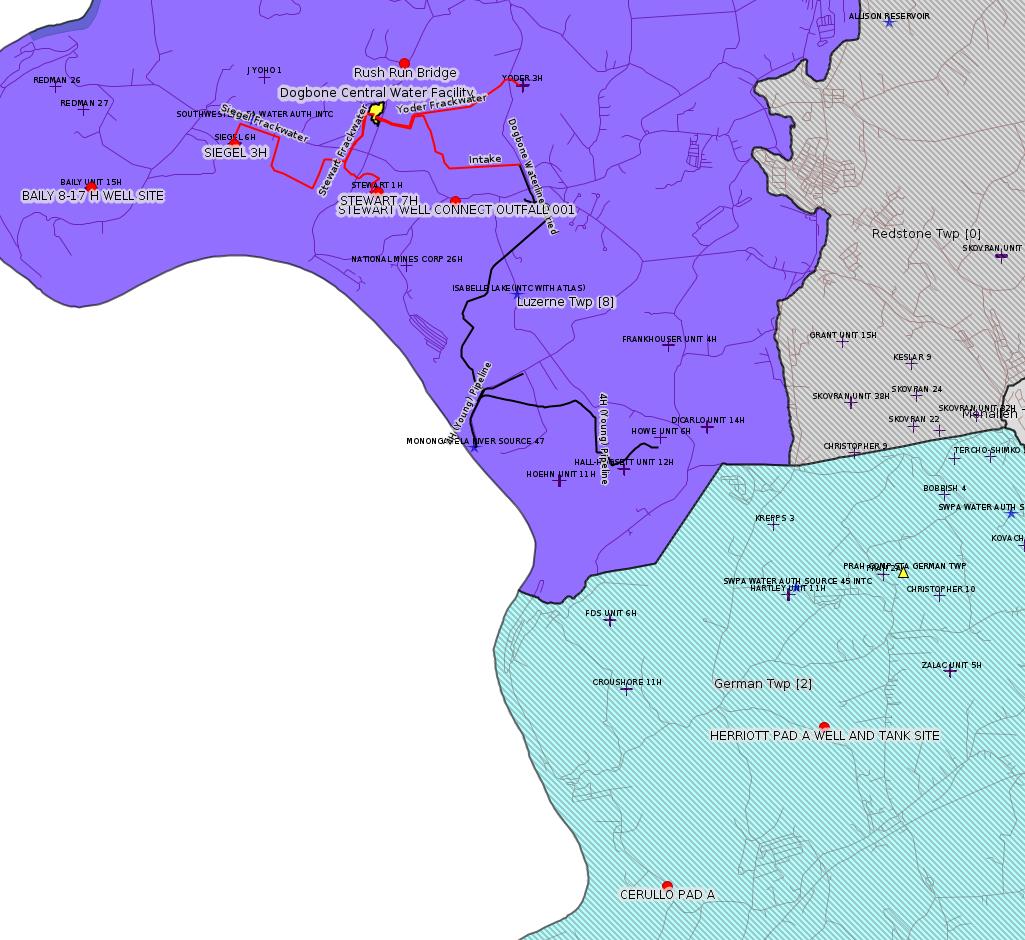
Rush Run Road Bridge ReplacementeFACTS Listings
HERRIOTT PAD A WELL AND TANK SITE ESCGP ESX18-051-0002
BAILY 8-17 H WELL SITE Expedited E&S Stormwater [Termination?] Notification (New)Electronic Notifications
SPROUL 7005 Drill & Operate Well Permit Inactive Status Issued 10/10/2018
MAWC 7020 3H Drill & Operate Well Permit Inactive StatusIssued 10/10/2018
MAWC 7020 1H Drill & Operate Well Permit Inactive Status Issued 10/10/2018
JOHN HOLT 1H Drill & Operate Well Permit Inactive Status Issued 10/10/2018
POLK UNIT 1H Drill & Operate Well Permit Inactive Status Issued 10/10/2018
HALL UNIT 1H Drill & Operate Well Permit Inactive Status Issued 10/10/2018
BURNWORTH WEST UNIT 1H Drill & Operate Well Permit Inactive Status Issued 10/10/2018
HUMBERSTON UNIT 1H Drill & Operate Well Permit Inactive Status Issued 10/10/2018
STEWART WELL CONNECT Expedited E&S Stormwater Issued 10/11/2018
CERULLO PAD A ESCGP Expedited E&S Stormwater 10/11/2018 deficiency letter
STEWART 7H Casing cementing notification Production Casing: 10/10/2018Price of Natural Gas
SIEGEL 3H Casing cementing notification Coal Protected Casing 1: 10/14/2018
STEWART 4H Drilling resumption After Break of 30 days or more 10/12/2018
POLK UNIT 3H Stimulation [i.e. Fracking] notification 10/15/2018
POLK UNIT 4H Stimulation notification 10/15/2018
POLK UNIT 5H Stimulation notification10/15/2018
STEWART 4H Casing cementing notification Production Casing: 10/19/2018
SIEGEL 4H Drilling resumption After Break of 30 days or more 10/19/2018
SIEGEL 4H Casing cementing notification Coal Protected Casing 1: 10/21/2018
SIEGEL 5H Drilling resumption After Break of 30 days or more 10/23/2018
SIEGEL 5H Casing cementing notification Coal Protected Casing 1: 10/25/2018
STEWART 5H Drilling resumption After Break of 30 days or more 10/23/2018
Notes
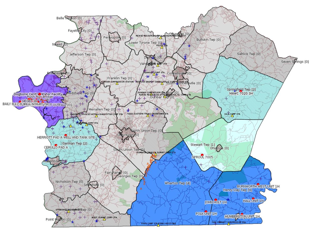
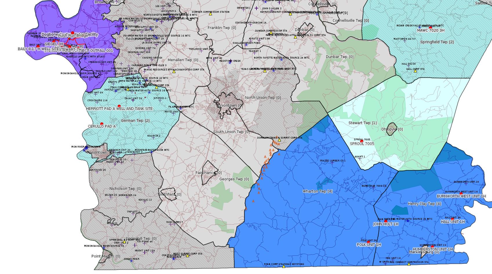
Map
Key
Red dots: items in this permit list with an exact location.
Blue stars: Marcellus Gas Well Water Sources.
Municipality shading: number of "facilities", with each well counting separately
(includes the red dots):
Red dots: items in this permit list with an exact location.
Blue stars: Marcellus Gas Well Water Sources.
Municipality shading: number of "facilities", with each well counting separately
(includes the red dots):
gray: 0
pale turquoise: 1
turquoise: 2
pale blue: 3
middle blue: 4
dark blue: 5
dark purple: 9
purple: 11
(Color coding may differ from one issue to the next.)
(Note if a project spans multiple municipalities -- e.g. a pipeline -- it will show in the count for each municipality.)
The number of facilities also follows the municipality name in brackets.
Municipality counts are based on the way the permit is listed by DEP; DEP has been known to get a municipality wrong.
Locations in brackets identify a precise location used to locate a surrogate for the actual site being permitted (e.g. locating a well pad or pipeline by the known location of a well.) Locations labeled beginning with "~" and ending in "[?]" are approximate and speculative based on inferences using on-line property and lease records. These are marked in the text as "[Approximate, Speculative]
Cross-hatching: Environmental Justice Areas
Yellow triangles: Compressor Stations
Orange triangles: Storage Field Wells (currently Dominion North Summit Storage Field)
Crosses: SPUD Unconventional well permits
Green: "Natural areas", e.g. state game lands, state forests
Yellow triangles: Compressor Stations
Orange triangles: Storage Field Wells (currently Dominion North Summit Storage Field)
Crosses: SPUD Unconventional well permits
Green: "Natural areas", e.g. state game lands, state forests
More Maps
 |
 |
Source: Pennsylvania Bulletin
[Only marginally on-topic:]
E26-383, PennDOT District 12-0, 825 North Gallatin Avenue, Uniontown, PA 15401, Luzerne Township, Fayette County; Pittsburgh ACOE District.
The applicant is proposing to:
Remove the existing 15` long, 32.9` wide, 25 SF opening, slab bridge carrying SR 4001 over Rush Run (WWF) with a drainage area of 1.23 square mile; construct and maintain a replacement 22` long, 39.5` wide, 3.5` underclearance box culvert on existing alignment; place and maintain fill in 78` of Rush Run and construct and maintain 63` of replacement relocated channel to align with the culvert replacement and road improvement work; regrade 53` of Rush Run to maintain the hydraulic opening at the proposed culvert outlet; construct and maintain 141` of rip-rap streambank stabilization. In addition, place and maintain fill in a de minimis 0.032 acre of PEM wetlands, construct and maintain associated stormwater facilities, and temporarily impact 0.065 acre of PEM wetlands and 551` of stream for the purpose of constructing these encroachments. The project results in a total permanent stream impact of 455`. Stream impacts will be mitigated onsite via construction of a mudsill along Rush Run, and removal of two abandoned railroad abutments which are currently restricting streamflow. The project site is located approximately one half mile south of the intersection of SR 4001 (Rush Run Road) and Telegraph Road (Carmichaels PA Quadrangle; Latitude: 39° 58` 42"; Longitude: -79° 56` 32"; Sub-basin 19C; USACE Pittsburgh District) in Luzerne Township, Fayette County.
<https://www.pabulletin.com/secure/data/vol48/48-42/1620a.html>
[See Notes.]
---
ESCGP-2 # ESX18-051-0002
Applicant Name Chevron Appalachia, LLC
Contact Person Branden Weimer
Address 700 Cherrington Parkway
City, State, Zip Coraopolis, PA 15108
County Fayette County
Township(s) German Township
Receiving Stream(s) and Classification(s) UNTs to Trib 41110 to Middle Run (WWF), Trib 41130 to North Branch Browns Run (WWF), Trib 41134 to North Branch Browns Run (WWF)/Monongahela River Watershed
Secondary Receiving Water—Monongahela River (WWF)
<https://www.pabulletin.com/secure/data/vol48/48-42/1620c.html>
Site: HERRIOTT PAD A WELL AND TANK SITE ESCGP ESX18-051-0002
Site Municipalities:
German Twp [an Environmental Justice Area], Fayette County
Well Pad ID: 155082
Location: 39.897981,-79.878003 <https://osm.org/go/ZWpPXJxr--?m=>
Wells on this Pad:
051-24649 HERRIOTT 1
Presumed Parcel Id: 15220125
-------------------------
Source: eNOTICE (+ PA Oil and Gas Mapping, Well Pad Report.) Well Details via Data Portal Services: Oil and Gas Wells All (ID: 3).
Please see the Disclaimer below regarding Parcel Id data.
Authorization ID: 1248904
Permit number: ESX13-051-0005
Site: BAILY 8-17 H WELL SITE ESCGP-2 EXPEDITED
Client: CHEVRON APPALACHIA LLC
Authorization type: Expedited E&S Stormwater General Permit 1
Application type: Notification
Authorization is for: SITE
Date received: 10/04/2018
Status: Pending
Permit Decision Guarantee Applies?: No
<https://www.ahs.dep.pa.gov/eFACTSWeb/searchResults_singleAuth.aspx?AuthID=1248904>
Site Programs:
Oil & Gas
Site Municipalities:
Luzerne Twp, Fayette County
Well Pad ID: 150665
Location: 39.963828,-79.991344 <https://osm.org/go/ZWpTvBQm--?m=>
Wells on this Pad:
051-24592 BAILY UNIT 8H
051-24593 BAILY UNIT 9H
051-24594 BAILY UNIT 10H
051-24595 BAILY UNIT 11H
051-24596 BAILY UNIT 12H
051-24597 BAILY UNIT 13H
051-24598 BAILY UNIT 14H
051-24599 BAILY UNIT 15H
051-24600 BAILY UNIT 16H
051-24601 BAILY UNIT 17H
Presumed Parcel Id: 19240004
Authorization ID: 1245075
Permit number: 051-24218
Site: SPROUL 7005 OG WELL
Client: TRIANA ENERGY LLC
Authorization type: Drill & Operate Well Permit Inactive Status
Application type: New
Authorization is for: FACILITY
Date received: 09/11/2018
Status: Issued on 10/10/2018
Permit Decision Guarantee Applies?: No
Sub-Facilities for Authorization:
Sub-Facility ID Sub-Facility Name Description
990150 SPROUL 7005 Well
Permit Review Notes:
Date Review Note
10/10/2018 The technical review and decision review are complete and either the permit decision and/or permit issuance are forthcoming.
9/17/2018 The permit application package is complete, has been accepted, and is undergoing technical review.
<https://www.ahs.dep.pa.gov/eFACTSWeb/searchResults_singleAuth.aspx?AuthID=1245075>
Site Programs:
Oil & Gas
Site Municipalities:
Stewart Twp, Fayette County
Well Details:
Permit Number: 051-24218
Well Name: SPROUL 7005
Unconventional Well: Y
Well Configuration: Vertical Well
Well Type: GAS
Well Status: Regulatory Inactive Status
Coal Association: NonCoal
Conservation Well: Y
Primary Facility ID: 718708
Site ID: 720238
Site Name: SPROUL 7005 OG WELL
Well Pad ID: 149337
Well Pad Name: SPROUL 7005
Storage Field:
Operator: TRIANA ENERGY LLC
Operator Number: OGO-67530
Permit Date: 2009-05-27
Permit Date Expires: 2010-05-27
SPUD Date: 2009-08-15
Date Plugged:
UIC ID:
UIC Type:
Surface Elevation: 1915
County: Fayette
Municipality: Stewart Twp
Location: 39.856133,-79.53675
Map URL: <http://www.openstreetmap.org/?mlat=39.856133&mlon=-79.53675#map=15/39.856133/-79.53675>
Presumed Parcel Id: 37110072
Authorization ID: 1245074
Permit number: 051-24464
Site: FAYETTE COUNTY PROJECT ESCGP-EXPEDITED MAWC 7020 PAD
Client: TRIANA ENERGY LLC
Authorization type: Drill & Operate Well Permit Inactive Status
Application type: New
Authorization is for: FACILITY
Date received: 09/11/2018
Status: Issued on 10/10/2018
Permit Decision Guarantee Applies?: No
Sub-Facilities for Authorization:
Sub-Facility ID Sub-Facility Name Description
1049231 MAWC 7020 3H Well
Permit Review Notes:
Date Review Note
10/10/2018 The technical review and decision review are complete and either the permit decision and/or permit issuance are forthcoming.
10/10/2018 The permit application package is complete, has been accepted, and is undergoing technical review.
<https://www.ahs.dep.pa.gov/eFACTSWeb/searchResults_singleAuth.aspx?AuthID=1245074>
Site Programs:
Oil & Gas
Site Municipalities:
Dunbar Twp, Fayette County
North Union Twp, Fayette County
Springfield Twp, Fayette County
Stewart Twp, Fayette County
Wharton Twp, Fayette County
Well Details:
Permit Number: 051-24464
Well Name: MAWC 7020 3H
Unconventional Well: Y
Well Configuration: Horizontal Well
Well Type: GAS
Well Status: Regulatory Inactive Status
Coal Association: NonCoal
Conservation Well: N
Primary Facility ID: 744754
Site ID: 721520
Site Name: FAYETTE COUNTY PROJECT ESCGP-EXPEDITED MAWC 7020 PAD
Well Pad ID: 148846
Well Pad Name: MAWC 7020
Storage Field:
Operator: TRIANA ENERGY LLC
Operator Number: OGO-67530
Permit Date: 2011-09-23
Permit Date Expires: 2012-09-23
SPUD Date: 2011-10-03
Date Plugged:
UIC ID:
UIC Type:
Surface Elevation: 1427
County: Fayette
Municipality: Springfield Twp
Location: 39.977814,-79.437242
Map URL: <http://www.openstreetmap.org/?mlat=39.977814&mlon=-79.437242#map=15/39.977814/-79.437242>
Presumed Parcel Id: 35130001
Authorization ID: 1245073
Permit number: 051-24303
Site: FAYETTE COUNTY PROJECT ESCGP-EXPEDITED MAWC 7020 PAD
Client: TRIANA ENERGY LLC
Authorization type: Drill & Operate Well Permit Inactive Status
Application type: New
Authorization is for: FACILITY
Date received: 09/11/2018
Status: Issued on 10/10/2018
Permit Decision Guarantee Applies?: No
Sub-Facilities for Authorization:
Sub-Facility ID Sub-Facility Name Description
1005069 MAWC 7020 1H Well
1086615 MAWC 7020 1H Well
1051380 MAWC 7020 1H Well
1049302 MAWC 7020 1H Well
Permit Review Notes:
Date Review Note
10/10/2018 The technical review and decision review are complete and either the permit decision and/or permit issuance are forthcoming.
9/17/2018 The permit application package is complete, has been accepted, and is undergoing technical review.
<https://www.ahs.dep.pa.gov/eFACTSWeb/searchResults_singleAuth.aspx?AuthID=1245073>
Site Programs:
Oil & Gas
Site Municipalities:
Dunbar Twp, Fayette County
North Union Twp, Fayette County
Springfield Twp, Fayette County
Stewart Twp, Fayette County
Wharton Twp, Fayette County
Well Details:
Permit Number: 051-24303
Well Name: MAWC 7020 1H
Unconventional Well: Y
Well Configuration: Horizontal Well
Well Type: GAS
Well Status: Regulatory Inactive Status
Coal Association: NonCoal
Conservation Well: N
Primary Facility ID: 725920
Site ID: 721520
Site Name: FAYETTE COUNTY PROJECT ESCGP-EXPEDITED MAWC 7020 PAD
Well Pad ID: 148846
Well Pad Name: MAWC 7020
Storage Field:
Operator: TRIANA ENERGY LLC
Operator Number: OGO-67530
Permit Date: 2009-12-24
Permit Date Expires: 2013-11-06
SPUD Date: 2010-06-25
Date Plugged:
UIC ID:
UIC Type:
Surface Elevation: 1427
County: Fayette
Municipality: Springfield Twp
Location: 39.977794,-79.437139
Map URL: <http://www.openstreetmap.org/?mlat=39.977794&mlon=-79.437139#map=15/39.977794/-79.437139>
Authorization ID: 1245068
Permit number: 051-24140
Site: JOHN HOLT 1H OG WEL
Client: LPR ENERGY LLC
Authorization type: Drill & Operate Well Permit Inactive Status
Application type: New
Authorization is for: FACILITY
Date received: 09/04/2018
Status: Issued on 10/10/2018
Permit Decision Guarantee Applies?: No
Sub-Facilities for Authorization:
Sub-Facility ID Sub-Facility Name Description
981790 JOHN HOLT 1H Well
Permit Review Notes:
Date Review Note
10/10/2018 The technical review and decision review are complete and either the permit decision and/or permit issuance are forthcoming.
9/17/2018 The permit application package is complete, has been accepted, and is undergoing technical review.
<https://www.ahs.dep.pa.gov/eFACTSWeb/searchResults_singleAuth.aspx?AuthID=1245068>
Site Programs:
Oil & Gas
Site Municipalities:
Henry Clay Twp, Fayette County
Well Details:
Permit Number: 051-24140
Well Name: JOHN HOLT 1H
Unconventional Well: Y
Well Configuration: Vertical Well
Well Type: GAS
Well Status: Regulatory Inactive Status
Coal Association: NonCoal
Conservation Well: Y
Primary Facility ID: 713811
Site ID: 714731
Site Name: JOHN HOLT 1H OG WEL
Well Pad ID: 146975
Well Pad Name: JOHN HOLT 1H
Storage Field:
Operator: LPR ENERGY LLC
Operator Number: OGO-68579
Permit Date: 2008-12-24
Permit Date Expires: 2009-12-24
SPUD Date: 2009-04-02
Date Plugged:
UIC ID:
UIC Type:
Surface Elevation: 2325
County: Fayette
Municipality: Henry Clay Twp
Location: 39.768936,-79.504661
Map URL: <http://www.openstreetmap.org/?mlat=39.768936&mlon=-79.504661#map=15/39.768936/-79.504661>
Presumed Parcel Id: 16100009
Authorization ID: 1245067
Permit number: 051-24428
Site: POLK 1H OG WELL
Client: LPR ENERGY LLC
Authorization type: Drill & Operate Well Permit Inactive Status
Application type: New
Authorization is for: FACILITY
Date received: 09/04/2018
Status: Issued on 10/10/2018
Permit Decision Guarantee Applies?: No
Sub-Facilities for Authorization:
Sub-Facility ID Sub-Facility Name Description
1035649 POLK UNIT 1H Well
1035648 POLK UNIT 1H Well
Permit Review Notes:
Date Review Note
9/17/2018 The technical review and decision review are complete and either the permit decision and/or permit issuance are forthcoming.
9/17/2018 The permit application package is complete, has been accepted, and is undergoing technical review.
<https://www.ahs.dep.pa.gov/eFACTSWeb/searchResults_singleAuth.aspx?AuthID=1245067>
Site Programs:
Oil & Gas
Site Municipalities:
Wharton Twp, Fayette County
Well Details:
Permit Number: 051-24428
Well Name: POLK UNIT 1H
Unconventional Well: Y
Well Configuration: Horizontal Well
Well Type: GAS
Well Status: Regulatory Inactive Status
Coal Association: NonCoal
Conservation Well: N
Primary Facility ID: 738671
Site ID: 739411
Site Name: POLK 1H OG WELL
Well Pad ID: 149075
Well Pad Name: POLK UNIT 1H
Storage Field:
Operator: LPR ENERGY LLC
Operator Number: OGO-68579
Permit Date: 2011-02-28
Permit Date Expires: 2012-02-28
SPUD Date: 2011-03-24
Date Plugged:
UIC ID:
UIC Type:
Surface Elevation: 2310
County: Fayette
Municipality: Wharton Twp
Location: 39.746494,-79.529567
Map URL: <http://www.openstreetmap.org/?mlat=39.746494&mlon=-79.529567#map=15/39.746494/-79.529567>
Presumed Parcel Id: 4233000106
Authorization ID: 1245065
Permit number: 051-24403
Site: HALL UNIT 1H OG WELL
Client: LPR ENERGY LLC
Authorization type: Drill & Operate Well Permit Inactive Status
Application type: New
Authorization is for: FACILITY
Date received: 09/04/2018
Status: Issued on 10/10/2018
Permit Decision Guarantee Applies?: No
Sub-Facilities for Authorization:
Sub-Facility ID Sub-Facility Name Description
1023640 HALL UNIT 1H Well
Permit Review Notes:
Date Review Note
10/10/2018 The technical review and decision review are complete and either the permit decision and/or permit issuance are forthcoming.
9/17/2018 The permit application package is complete, has been accepted, and is undergoing technical review.
<https://www.ahs.dep.pa.gov/eFACTSWeb/searchResults_singleAuth.aspx?AuthID=1245065>
Site Programs:
Oil & Gas
Site Municipalities:
Henry Clay Twp, Fayette County
Well Details:
Permit Number: 051-24403
Well Name: HALL UNIT 1H
Unconventional Well: Y
Well Configuration: Horizontal Well
Well Type: GAS
Well Status: Regulatory Inactive Status
Coal Association: NonCoal
Conservation Well: N
Primary Facility ID: 735848
Site ID: 741195
Site Name: HALL UNIT 1H OG WELL
Well Pad ID: 148468
Well Pad Name: HALL UNIT 1H
Storage Field:
Operator: LPR ENERGY LLC
Operator Number: OGO-68579
Permit Date: 2010-11-24
Permit Date Expires: 2011-11-24
SPUD Date: 2011-03-21
Date Plugged:
UIC ID:
UIC Type:
Surface Elevation: 1965
County: Fayette
Municipality: Henry Clay Twp
Location: 39.769889,-79.410881
Map URL: <http://www.openstreetmap.org/?mlat=39.769889&mlon=-79.410881#map=15/39.769889/-79.410881>
Presumed Parcel Id: 16130134
Authorization ID: 1245063
Permit number: 051-24400
Site: BURNWORTH WEST UNIT 1H OG WELL
Client: LPR ENERGY LLC
Authorization type: Drill & Operate Well Permit Inactive Status
Application type: New
Authorization is for: FACILITY
Date received: 09/04/2018
Status: Issued on 10/10/2018
Permit Decision Guarantee Applies?: No
Sub-Facilities for Authorization:
Sub-Facility ID Sub-Facility Name Description
1023091 BURNWORTH WEST UNIT 1H Well
Permit Review Notes:
Date Review Note
10/10/2018 The technical review and decision review are complete and either the permit decision and/or permit issuance are forthcoming.
9/17/2018 The permit application package is complete, has been accepted, and is undergoing technical review.
<https://www.ahs.dep.pa.gov/eFACTSWeb/searchResults_singleAuth.aspx?AuthID=1245063>
Site Programs:
Oil & Gas
Site Municipalities:
Henry Clay Twp, Fayette County
Well Details:
Permit Number: 051-24400
Well Name: BURNWORTH WEST UNIT 1H
Unconventional Well: Y
Well Configuration: Horizontal Well
Well Type: GAS
Well Status: Regulatory Inactive Status
Coal Association: NonCoal
Conservation Well: N
Primary Facility ID: 735586
Site ID: 740856
Site Name: BURNWORTH WEST UNIT 1H OG WELL
Well Pad ID: 147087
Well Pad Name: BURNWORTH WEST UNIT 1H
Storage Field:
Operator: LPR ENERGY LLC
Operator Number: OGO-68579
Permit Date: 2010-11-24
Permit Date Expires: 2011-11-24
SPUD Date: 2011-03-01
Date Plugged:
UIC ID:
UIC Type:
Surface Elevation: 1950
County: Fayette
Municipality: Henry Clay Twp
Location: 39.797503,-79.398014
Map URL: <http://www.openstreetmap.org/?mlat=39.797503&mlon=-79.398014#map=15/39.797503/-79.398014>
Presumed Parcel Id: 16090032
Authorization ID: 1244257
Permit number: 051-24367
Site: HUMBERSTON UNIT 1H OG WELL
Client: LPR ENERGY LLC
Authorization type: Drill & Operate Well Permit Inactive Status
Application type: New
Authorization is for: FACILITY
Date received: 09/04/2018
Status: Issued on 10/10/2018
Permit Decision Guarantee Applies?: No
Sub-Facilities for Authorization:
Sub-Facility ID Sub-Facility Name Description
1015955 HUMBERSTON UNIT 1H Well
Permit Review Notes:
Date Review Note
10/10/2018 The technical review and decision review are complete and either the permit decision and/or permit issuance are forthcoming.
9/10/2018 The permit application package is complete, has been accepted, and is undergoing technical review.
<https://www.ahs.dep.pa.gov/eFACTSWeb/searchResults_singleAuth.aspx?AuthID=1244257>
Site Programs:
Oil & Gas
Site Municipalities:
Henry Clay Twp, Fayette County
Well Details:
Permit Number: 051-24367
Well Name: HUMBERSTON UNIT 1H
Unconventional Well: Y
Well Configuration: Horizontal Well
Well Type: GAS
Well Status: Regulatory Inactive Status
Coal Association: Coal
Conservation Well: N
Primary Facility ID: 731775
Site ID: 735895
Site Name: HUMBERSTON UNIT 1H OG WELL
Well Pad ID: 146309
Well Pad Name: HUMBERSTON UNIT 1H
Storage Field:
Operator: LPR ENERGY LLC
Operator Number: OGO-68579
Permit Date: 2010-07-13
Permit Date Expires: 2011-07-13
SPUD Date: 2011-01-28
Date Plugged:
UIC ID:
UIC Type:
Surface Elevation: 2000
County: Fayette
Municipality: Henry Clay Twp
Location: 39.740383,-79.439622
Map URL: <http://www.openstreetmap.org/?mlat=39.740383&mlon=-79.439622#map=15/39.740383/-79.439622>
Presumed Parcel Id: 16160099
Authorization ID: 1237602
Permit number: ESX18-051-0007
Site: STEWART WELL CONNECT PIPELINE PROJECT ESCGP ESX18-051-0007
Client: LAUREL MTN MIDSTREAM OPR LLC
Authorization type: Expedited E&S Stormwater General Permit 1
Application type: New
Authorization is for: SITE
Date received: 06/08/2018
Status: Issued on 10/11/2018
Permit Decision Guarantee Applies?: Yes
Permit Decision Guarantee status: VOID
Permit Review Notes:
Date Review Note
10/11/2018 The technical review and decision review are complete and either the permit decision and/or permit issuance are forthcoming.
8/15/2018 Applicant has been issued a deficiency letter. If applicable, this application no longer qualifies for the Permit Decision Guarantee.
7/30/2018 The permit application package is complete, has been accepted, and is undergoing technical review.
<https://www.ahs.dep.pa.gov/eFACTSWeb/searchResults_singleAuth.aspx?AuthID=1237602>
Site Programs:
Site Municipalities:
Luzerne Twp, Fayette County
Location [of Authorization 1238283 Hydrostatic Testing Outfall 001]: 39.961653,-79.934522
Map URL: <http://www.openstreetmap.org/?mlat=39.961653&mlon=-79.934522#map=15/39.961653/-79.934522>
Authorization ID: 1230405
Permit number: ESX18-051-0004
Site: CERULLO PAD A ESCGP ESX18-051-0004
Client: CHEVRON APPALACHIA LLC
Authorization type: Expedited E&S Stormwater General Permit 1
Application type: New
Authorization is for: SITE
Date received: 05/24/2018
Status: Pending
Permit Decision Guarantee Applies?: Yes
Permit Decision Guarantee status: VOID
Permit Review Notes:
Date Review Note
10/11/2018 Applicant has been issued a deficiency letter. If applicable, this application no longer qualifies for the Permit Decision Guarantee.
8/13/2018 Applicant has been issued a deficiency letter. If applicable, this application no longer qualifies for the Permit Decision Guarantee.
6/13/2018 Applicant has been issued a deficiency letter. If applicable, this application no longer qualifies for the Permit Decision Guarantee.
<https://www.ahs.dep.pa.gov/eFACTSWeb/searchResults_singleAuth.aspx?AuthID=1230405>
Site Programs:
Oil & Gas
Site Municipalities:
German Twp [an Environmental Justice Area], Fayette County
Well Pad Id: 155068
Wells on this Pad:
051-24650 CERULLO 1
Location: 39.879083,-79.902789 <https://osm.org/go/ZWpNvUhQ--?m=>
Presumed Parcel Id: 15190070
-------------------------
Source: DEP Oil and Gas Electronic Notifications
NOTIFICATION_ID: 43877
OGO: 39307
OPERATOR: CHEVRON APPALACHIA LLC
API_PERMIT:
SPUD_DATE: 07/31/2018
COUNTY: Fayette
MUNICIPALITY: Luzerne
LATITUDE: 39.962917
LONGITUDE: -79.946617
SUBJECT: [NOTIFICATION]: Casing cementing notification 58 Pa. C.S. 3211(f)(2) for well API 37-051-24639-00-00
QUESTION: Enter the Date and Time for the applicable Casing Types
ANSWER: Production Casing: 10/10/2018 10:00:00 PM
SENT_DATE: 10/8/2018 7:48:42 AM
SENT_SUCCESS: Yes
LAST_RESENT_DATE:
RESENT_SUCCESS:
Well Details:
Permit Number: 051-24639
Well Name: STEWART 7H
Unconventional Well: Y
Well Configuration: Horizontal Well
Well Type: GAS
Well Status: Active
Coal Association: Coal
Conservation Well: N
Primary Facility ID: 822072
Site ID: 788124
Site Name: STEWART WELL SITE ESCGP-2 EXPEDITED
Well Pad ID: 152396
Well Pad Name: STEWART
Storage Field:
Operator: CHEVRON APPALACHIA LLC
Operator Number: OGO-39307
Permit Date: 2018-01-26
Permit Date Expires: 2019-01-26
SPUD Date: 2018-07-31
Date Plugged:
UIC ID:
UIC Type:
Surface Elevation: 1140
County: Fayette
Municipality: Luzerne Twp
Location: 39.962917,-79.946617
Map URL: <http://www.openstreetmap.org/?mlat=39.962917&mlon=-79.946617#map=15/39.962917/-79.946617>
Presumed Property Id: 19250010
OG WELLS PERMIT DOCS:
2018-01-26: Other Permit Documents, Name: Approval of Surface Locations by Landowners (for Authorization: 1203103):
<http://www.depgis.state.pa.us/pdfHandler/pdFHandler.ashx?Doc=NTQ5NzEz&ext=PDF>
2018-01-26: Final Permit Documents, Name: 1203103 (for Authorization: 1203103):
<http://www.depgis.state.pa.us/pdfHandler/pdFHandler.ashx?Doc=NTUxMTMw&ext=PDF>
2018-01-17: Other Permit Documents, Name: 051-24639 Alt Method (for Authorization: 1212314):
<http://www.depgis.state.pa.us/pdfHandler/pdFHandler.ashx?Doc=NTQ2MTgw&ext=PDF>
Electronically Submitted Records:
2018-01-26: Submission for Authorization 1203103
Pennsylvania Natural Diversity Inventory Form: Stewart Pad A PNDI 8-22-17.pdf
<http://www.depgis.state.pa.us/eWellDocHandler/pdFHandler.ashx?Doc=MzcwNTYy&ext=PDF>
Location Plat: Stewart Well Plats 7H.dwg
<http://www.depgis.state.pa.us/eWellDocHandler/pdFHandler.ashx?Doc=MzkxMTE3&ext=PDF>
Coal and Gas Resource Coord Act - Section 7 Exception: Stewart 1H-7H Waiver Request Section 7.pdf
<http://www.depgis.state.pa.us/eWellDocHandler/pdFHandler.ashx?Doc=MzkxMTE4&ext=PDF>
Well Cross-Section Diagram: Stewart 7H Page 4.pdf
<http://www.depgis.state.pa.us/eWellDocHandler/pdFHandler.ashx?Doc=MzkxMTE5&ext=PDF>
Well Permit Application - Coal Module: Stewart 1H-7H 2017 Coal Module.pdf
<http://www.depgis.state.pa.us/eWellDocHandler/pdFHandler.ashx?Doc=MzkxMTIw&ext=PDF>
Permit Application to Drill and Operate a Well: 1609175.pdf
<http://www.depgis.state.pa.us/eWellDocHandler/pdFHandler.ashx?Doc=MzkyODA2&ext=PDF>
---
NOTIFICATION_ID: 43896
OGO: 39307
OPERATOR: CHEVRON APPALACHIA LLC
API_PERMIT: 051-24643
SPUD_DATE: 04/02/2018
COUNTY: Fayette
MUNICIPALITY: Luzerne
LATITUDE: 39.968892
LONGITUDE: -79.968928
SUBJECT: [NOTIFICATION]: Casing cementing notification 58 Pa. C.S. 3211(f)(2) for well API 37-051-24643-00-00
QUESTION: Enter the Date and Time for the applicable Casing Types
ANSWER: Coal Protected Casing 1: 10/14/2018 12:00:00 AM
SENT_DATE: 10/10/2018 6:51:02 AM
SENT_SUCCESS: Yes
LAST_RESENT_DATE:
RESENT_SUCCESS:
Well Details:
Permit Number: 051-24643
Well Name: SIEGEL 3H
Unconventional Well: Y
Well Configuration: Horizontal Well
Well Type: GAS
Well Status: Active
Coal Association: Coal
Conservation Well: N
Primary Facility ID: 823791
Site ID: 790384
Site Name: SIEGEL WELL PAD ESCGP-2 EXPEDITED
Well Pad ID: 152926
Well Pad Name: SIEGEL 1
Storage Field:
Operator: CHEVRON APPALACHIA LLC
Operator Number: OGO-39307
Permit Date: 2018-02-13
Permit Date Expires: 2019-02-13
SPUD Date: 2018-04-02
Date Plugged:
UIC ID:
UIC Type:
Surface Elevation: 1173
County: Fayette
Municipality: Luzerne Twp
Location: 39.968892,-79.968928
Map URL: <http://www.openstreetmap.org/?mlat=39.968892&mlon=-79.968928#map=15/39.968892/-79.968928>
Presumed Parcel Id: 19240018
OG WELLS PERMIT DOCS:
2018-02-14: Final Permit Documents, Name: 1212437 (for Authorization: 1212437):
<http://www.depgis.state.pa.us/pdfHandler/pdFHandler.ashx?Doc=NTU5MjE5&ext=PDF>
Electronically Submitted Records:
2018-02-14: Submission for Authorization 1212437
Pennsylvania Natural Diversity Inventory Form: Siegel PNDI.pdf
<http://www.depgis.state.pa.us/eWellDocHandler/pdFHandler.ashx?Doc=NDQ4OTIz&ext=PDF>
Location Plat: 143-781-Well Plat 3H-pages1-2-3_3702.dwg
<http://www.depgis.state.pa.us/eWellDocHandler/pdFHandler.ashx?Doc=NDQ4OTI0&ext=PDF>
Coal and Gas Resource Coord Act - Section 7 Exception: Siegel 1H-9H Waiver Request Section 7.pdf
<http://www.depgis.state.pa.us/eWellDocHandler/pdFHandler.ashx?Doc=NDQ4OTI1&ext=PDF>
Well Cross-Section Diagram: Siegel 3H Page 4.pdf
<http://www.depgis.state.pa.us/eWellDocHandler/pdFHandler.ashx?Doc=NDQ4OTI2&ext=PDF>
Permit Application to Drill and Operate a Well: 1640037.pdf
<http://www.depgis.state.pa.us/eWellDocHandler/pdFHandler.ashx?Doc=NDQ5ODAz&ext=PDF>
---
NOTIFICATION_ID: 43919
OGO: 39307
OPERATOR: CHEVRON APPALACHIA LLC
API_PERMIT: 051-24630
SPUD_DATE: 09/01/2015
COUNTY: Fayette
MUNICIPALITY: Luzerne
LATITUDE: 39.96285
LONGITUDE: -79.946747
SUBJECT: [NOTIFICATION]: Drilling resumption After Break of 30 days or more notification 58 Pa. C.S. 3211(f)(1) for well API 37-051-24630-00-00
QUESTION: Date and approximate time action is to occur
ANSWER: Date: 10/12/2018 Time: 6:00am
SENT_DATE: 10/11/2018 5:39:31 AM
SENT_SUCCESS: Yes
LAST_RESENT_DATE:
RESENT_SUCCESS:
Well Details:
Permit Number: 051-24630
Well Name: STEWART 4H
Unconventional Well: Y
Well Configuration: Horizontal Well
Well Type: GAS
Well Status: Active
Coal Association: Coal
Conservation Well: N
Primary Facility ID: 794416
Site ID: 788124
Site Name: STEWART WELL SITE ESCGP-2 EXPEDITED
Well Pad ID: 152396
Well Pad Name: STEWART
Storage Field:
Operator: CHEVRON APPALACHIA LLC
Operator Number: OGO-39307
Permit Date: 2015-07-17
Permit Date Expires: 2019-01-26
SPUD Date: 2015-09-01
Date Plugged:
UIC ID:
UIC Type:
Surface Elevation: 1145
County: Fayette
Municipality: Luzerne Twp
Location: 39.96285,-79.946747
Map URL: <http://www.openstreetmap.org/?mlat=39.96285&mlon=-79.946747#map=15/39.96285/-79.946747>
OG WELLS PERMIT DOCS:
2015-07-17: Final Permit Documents, Name: 051-24630-00-00 1077198 (for Authorization: 1077198):
<http://www.depgis.state.pa.us/pdfHandler/pdFHandler.ashx?Doc=MjExNjEy&ext=PDF>
2018-01-26: Other Permit Documents, Name: Approval of Surface Locations by Landowners (for Authorization: 1203100):
<http://www.depgis.state.pa.us/pdfHandler/pdFHandler.ashx?Doc=NTQ5NzA5&ext=PDF>
2018-01-26: Final Permit Documents, Name: 1203100 (for Authorization: 1203100):
<http://www.depgis.state.pa.us/pdfHandler/pdFHandler.ashx?Doc=NTUxMTI0&ext=PDF>
Electronically Submitted Records:
2018-01-26: Submission for Authorization 1203100
Permit Application to Drill and Operate a Well: Stewart 4H Mod Application 2017.pdf
<http://www.depgis.state.pa.us/eWellDocHandler/pdFHandler.ashx?Doc=MzkwODgz&ext=PDF>
Pennsylvania Natural Diversity Inventory Form: Stewart Pad A PNDI 8-22-17.pdf
<http://www.depgis.state.pa.us/eWellDocHandler/pdFHandler.ashx?Doc=MzkwODg0&ext=PDF>
Location Plat: Stewart Well Plats 4H.dwg
<http://www.depgis.state.pa.us/eWellDocHandler/pdFHandler.ashx?Doc=MzkwODg1&ext=PDF>
Coal and Gas Resource Coord Act - Section 7 Exception: Stewart 1H-7H Waiver Request Section 7.pdf
<http://www.depgis.state.pa.us/eWellDocHandler/pdFHandler.ashx?Doc=MzkwODg2&ext=PDF>
Well Cross-Section Diagram: Stewart 4H Page 4.pdf
<http://www.depgis.state.pa.us/eWellDocHandler/pdFHandler.ashx?Doc=MzkwODg3&ext=PDF>
Record of Notification to Interested Parties: Stewart 4H Notification of Interested Parties.pdf
<http://www.depgis.state.pa.us/eWellDocHandler/pdFHandler.ashx?Doc=MzkwODg4&ext=PDF>
Well Permit Application - Coal Module: Stewart 1H-7H 2017 Coal Module.pdf
<http://www.depgis.state.pa.us/eWellDocHandler/pdFHandler.ashx?Doc=MzkwODg5&ext=PDF>
Electronic Submission Docket: 1628612.pdf
<http://www.depgis.state.pa.us/eWellDocHandler/pdFHandler.ashx?Doc=MzkyNzc1&ext=PDF>
---
NOTIFICATION_ID: 43982
OGO: 68579
OPERATOR: LPR ENERGY LLC
API_PERMIT: 051-24514
SPUD_DATE: 09/04/2012
COUNTY: Fayette
MUNICIPALITY: Wharton
LATITUDE: 39.746414
LONGITUDE: -79.529608
SUBJECT: [NOTIFICATION]: Stimulation notification 58 Pa. C.S. 3211(f)(2) for well API 37-051-24514-00-00
QUESTION: Date and approximate time action is to occur
ANSWER: Date: 10/15/2018 Time: 06:00 AM
SENT_DATE: 10/14/2018 12:14:15 AM
SENT_SUCCESS: Yes
LAST_RESENT_DATE:
RESENT_SUCCESS:
Well Details:
Permit Number: 051-24514
Well Name: POLK UNIT 3H
Unconventional Well: Y
Well Configuration: Horizontal Well
Well Type: GAS
Well Status: Regulatory Inactive Status
Coal Association: NonCoal
Conservation Well: Y
Primary Facility ID: 753736
Site ID: 739411
Site Name: POLK 1H OG WELL
Well Pad ID: 149075
Well Pad Name: POLK UNIT 1H
Storage Field:
Operator: LPR ENERGY LLC
Operator Number: OGO-68579
Permit Date: 2012-07-27
Permit Date Expires: 2013-07-27
SPUD Date: 2012-09-04
Date Plugged:
UIC ID:
UIC Type:
Surface Elevation: 2315
County: Fayette
Municipality: Wharton Twp
Location: 39.746414,-79.529608
Map URL: <http://www.openstreetmap.org/?mlat=39.746414&mlon=-79.529608#map=15/39.746414/-79.529608>
[See Notes.]
---
NOTIFICATION_ID: 43983
OGO: 68579
OPERATOR: LPR ENERGY LLC
API_PERMIT: 051-24431
SPUD_DATE: 12/03/2011
COUNTY: Fayette
MUNICIPALITY: Wharton
LATITUDE: 39.746531
LONGITUDE: -79.529544
SUBJECT: [NOTIFICATION]: Stimulation notification 58 Pa. C.S. 3211(f)(2) for well API 37-051-24431-00-00
QUESTION: Date and approximate time action is to occur
ANSWER: Date: 10/15/2018 Time: 06:00 AM
SENT_DATE: 10/14/2018 12:16:41 AM
SENT_SUCCESS: Yes
LAST_RESENT_DATE:
RESENT_SUCCESS:
Well Details:
Permit Number: 051-24431
Well Name: POLK UNIT 4H
Unconventional Well: Y
Well Configuration: Horizontal Well
Well Type: GAS
Well Status: Regulatory Inactive Status
Coal Association: NonCoal
Conservation Well: N
Primary Facility ID: 738667
Site ID: 739411
Site Name: POLK 1H OG WELL
Well Pad ID: 149075
Well Pad Name: POLK UNIT 1H
Storage Field:
Operator: LPR ENERGY LLC
Operator Number: OGO-68579
Permit Date: 2011-02-28
Permit Date Expires: 2012-02-28
SPUD Date: 2011-12-03
Date Plugged:
UIC ID:
UIC Type:
Surface Elevation: 2310
County: Fayette
Municipality: Wharton Twp
Location: 39.746531,-79.529544
Map URL: <http://www.openstreetmap.org/?mlat=39.746531&mlon=-79.529544#map=15/39.746531/-79.529544>
---
NOTIFICATION_ID: 43984
OGO: 68579
OPERATOR: LPR ENERGY LLC
API_PERMIT: 051-24432
SPUD_DATE: 12/01/2011
COUNTY: Fayette
MUNICIPALITY: Wharton
LATITUDE: 39.746569
LONGITUDE: -79.529519
SUBJECT: [NOTIFICATION]: Stimulation notification 58 Pa. C.S. 3211(f)(2) for well API 37-051-24432-00-00
QUESTION: Date and approximate time action is to occur
ANSWER: Date: 10/15/2018 Time: 06:00 AM
SENT_DATE: 10/14/2018 12:17:50 AM
SENT_SUCCESS: Yes
LAST_RESENT_DATE:
RESENT_SUCCESS:
Well Details:
Permit Number: 051-24432
Well Name: POLK UNIT 5H
Unconventional Well: Y
Well Configuration: Horizontal Well
Well Type: GAS
Well Status: Regulatory Inactive Status
Coal Association: NonCoal
Conservation Well: N
Primary Facility ID: 738669
Site ID: 739411
Site Name: POLK 1H OG WELL
Well Pad ID: 149075
Well Pad Name: POLK UNIT 1H
Storage Field:
Operator: LPR ENERGY LLC
Operator Number: OGO-68579
Permit Date: 2011-02-28
Permit Date Expires: 2012-02-28
SPUD Date: 2011-12-01
Date Plugged:
UIC ID:
UIC Type:
Surface Elevation: 2310
County: Fayette
Municipality: Wharton Twp
Location: 39.746569,-79.529519
Map URL: <http://www.openstreetmap.org/?mlat=39.746569&mlon=-79.529519#map=15/39.746569/-79.529519>
---
NOTIFICATION_ID: 44007
OGO: 39307
OPERATOR: CHEVRON APPALACHIA LLC
API_PERMIT: 051-24630
SPUD_DATE: 09/01/2015
COUNTY: Fayette
MUNICIPALITY: Luzerne
LATITUDE: 39.96285
LONGITUDE: -79.946747
SUBJECT: [NOTIFICATION]: Casing cementing notification 58 Pa. C.S. 3211(f)(2) for well API 37-051-24630-00-00
QUESTION: Enter the Date and Time for the applicable Casing Types
ANSWER: Production Casing: 10/19/2018 12:00:00 PM
SENT_DATE: 10/16/2018 9:08:21 AM
SENT_SUCCESS: Yes
LAST_RESENT_DATE:
RESENT_SUCCESS:
Well Details:
Permit Number: 051-24630
Well Name: STEWART 4H
Unconventional Well: Y
Well Configuration: Horizontal Well
Well Type: GAS
Well Status: Active
Coal Association: Coal
Conservation Well: N
Primary Facility ID: 794416
Site ID: 788124
Site Name: STEWART WELL SITE ESCGP-2 EXPEDITED
Well Pad ID: 152396
Well Pad Name: STEWART
Storage Field:
Operator: CHEVRON APPALACHIA LLC
Operator Number: OGO-39307
Permit Date: 2015-07-17
Permit Date Expires: 2019-01-26
SPUD Date: 2015-09-01
Date Plugged:
UIC ID:
UIC Type:
Surface Elevation: 1145
County: Fayette
Municipality: Luzerne Twp
Location: 39.96285,-79.946747
Map URL: <http://www.openstreetmap.org/?mlat=39.96285&mlon=-79.946747#map=15/39.96285/-79.946747>
OG WELLS PERMIT DOCS:
2015-07-17: Final Permit Documents, Name: 051-24630-00-00 1077198 (for Authorization: 1077198):
<http://www.depgis.state.pa.us/pdfHandler/pdFHandler.ashx?Doc=MjExNjEy&ext=PDF>
2018-01-26: Other Permit Documents, Name: Approval of Surface Locations by Landowners (for Authorization: 1203100):
<http://www.depgis.state.pa.us/pdfHandler/pdFHandler.ashx?Doc=NTQ5NzA5&ext=PDF>
2018-01-26: Final Permit Documents, Name: 1203100 (for Authorization: 1203100):
<http://www.depgis.state.pa.us/pdfHandler/pdFHandler.ashx?Doc=NTUxMTI0&ext=PDF>
Electronically Submitted Records:
2018-01-26: Submission for Authorization 1203100
Permit Application to Drill and Operate a Well: Stewart 4H Mod Application 2017.pdf
<http://www.depgis.state.pa.us/eWellDocHandler/pdFHandler.ashx?Doc=MzkwODgz&ext=PDF>
Pennsylvania Natural Diversity Inventory Form: Stewart Pad A PNDI 8-22-17.pdf
<http://www.depgis.state.pa.us/eWellDocHandler/pdFHandler.ashx?Doc=MzkwODg0&ext=PDF>
Location Plat: Stewart Well Plats 4H.dwg
<http://www.depgis.state.pa.us/eWellDocHandler/pdFHandler.ashx?Doc=MzkwODg1&ext=PDF>
Coal and Gas Resource Coord Act - Section 7 Exception: Stewart 1H-7H Waiver Request Section 7.pdf
<http://www.depgis.state.pa.us/eWellDocHandler/pdFHandler.ashx?Doc=MzkwODg2&ext=PDF>
Well Cross-Section Diagram: Stewart 4H Page 4.pdf
<http://www.depgis.state.pa.us/eWellDocHandler/pdFHandler.ashx?Doc=MzkwODg3&ext=PDF>
Record of Notification to Interested Parties: Stewart 4H Notification of Interested Parties.pdf
<http://www.depgis.state.pa.us/eWellDocHandler/pdFHandler.ashx?Doc=MzkwODg4&ext=PDF>
Well Permit Application - Coal Module: Stewart 1H-7H 2017 Coal Module.pdf
<http://www.depgis.state.pa.us/eWellDocHandler/pdFHandler.ashx?Doc=MzkwODg5&ext=PDF>
Electronic Submission Docket: 1628612.pdf
<http://www.depgis.state.pa.us/eWellDocHandler/pdFHandler.ashx?Doc=MzkyNzc1&ext=PDF>
---
NOTIFICATION_ID: 44025
OGO: 39307
OPERATOR: CHEVRON APPALACHIA LLC
API_PERMIT: 051-24642
SPUD_DATE: 04/02/2018
COUNTY: Fayette
MUNICIPALITY: Luzerne
LATITUDE: 39.96885
LONGITUDE: -79.968994
SUBJECT: [NOTIFICATION]: Drilling resumption After Break of 30 days or more notification 58 Pa. C.S. 3211(f)(1) for well API 37-051-24642-00-00
QUESTION: Date and approximate time action is to occur
ANSWER: Date: 10/19/2018 Time: 12:00pm
SENT_DATE: 10/17/2018 6:17:25 AM
SENT_SUCCESS: Yes
LAST_RESENT_DATE:
RESENT_SUCCESS:
Well Details:
Permit Number: 051-24642
Well Name: SIEGEL 4H
Unconventional Well: Y
Well Configuration: Horizontal Well
Well Type: GAS
Well Status: Active
Coal Association: Coal
Conservation Well: N
Primary Facility ID: 823790
Site ID: 790384
Site Name: SIEGEL WELL PAD ESCGP-2 EXPEDITED
Well Pad ID: 152926
Well Pad Name: SIEGEL 1
Storage Field:
Operator: CHEVRON APPALACHIA LLC
Operator Number: OGO-39307
Permit Date: 2018-02-15
Permit Date Expires: 2019-02-15
SPUD Date: 2018-04-02
Date Plugged:
UIC ID:
UIC Type:
Surface Elevation: 1173
County: Fayette
Municipality: Luzerne Twp
Location: 39.96885,-79.968994
Map URL: <http://www.openstreetmap.org/?mlat=39.96885&mlon=-79.968994#map=15/39.96885/-79.968994>
OG WELLS PERMIT DOCS:
2018-02-16: Final Permit Documents, Name: 1212436 (for Authorization: 1212436):
<http://www.depgis.state.pa.us/pdfHandler/pdFHandler.ashx?Doc=NTY1ODQ3&ext=PDF>
Electronically Submitted Records:
2018-02-16: Submission for Authorization 1212436
Location Plat: 143-781-Well Plat 4H-pages1-2-3_3702.dwg
<http://www.depgis.state.pa.us/eWellDocHandler/pdFHandler.ashx?Doc=NDQ4OTc2&ext=PDF>
Pennsylvania Natural Diversity Inventory Form: Siegel PNDI.pdf
<http://www.depgis.state.pa.us/eWellDocHandler/pdFHandler.ashx?Doc=NDQ4OTc3&ext=PDF>
Coal and Gas Resource Coord Act - Section 7 Exception: Siegel 1H-9H Waiver Request Section 7.pdf
<http://www.depgis.state.pa.us/eWellDocHandler/pdFHandler.ashx?Doc=NDQ4OTc4&ext=PDF>
Well Cross-Section Diagram: Siegel 4H Page 4.pdf
<http://www.depgis.state.pa.us/eWellDocHandler/pdFHandler.ashx?Doc=NDQ4OTc5&ext=PDF>
Permit Application to Drill and Operate a Well: 1640040.pdf
<http://www.depgis.state.pa.us/eWellDocHandler/pdFHandler.ashx?Doc=NDQ5ODEy&ext=PDF>
---
NOTIFICATION_ID: 44026
OGO: 39307
OPERATOR: CHEVRON APPALACHIA LLC
API_PERMIT: 051-24642
SPUD_DATE: 04/02/2018
COUNTY: Fayette
MUNICIPALITY: Luzerne
LATITUDE: 39.96885
LONGITUDE: -79.968994
SUBJECT: [NOTIFICATION]: Casing cementing notification 58 Pa. C.S. 3211(f)(2) for well API 37-051-24642-00-00
QUESTION: Enter the Date and Time for the applicable Casing Types
ANSWER: Coal Protected Casing 1: 10/21/2018 12:00:00 PM
SENT_DATE: 10/17/2018 6:18:09 AM
SENT_SUCCESS: Yes
LAST_RESENT_DATE:
RESENT_SUCCESS:
Well Name: SIEGEL 4H
---
NOTIFICATION_ID: 44118
OGO: 39307
OPERATOR: CHEVRON APPALACHIA LLC
API_PERMIT: 051-24644
SPUD_DATE: 04/02/2018
COUNTY: Fayette
MUNICIPALITY: Luzerne
LATITUDE: 39.968808
LONGITUDE: -79.969061
SUBJECT: [NOTIFICATION]: Drilling resumption After Break of 30 days or more notification 58 Pa. C.S. 3211(f)(1) for well API 37-051-24644-00-00
QUESTION: Date and approximate time action is to occur
ANSWER: Date: 10/23/2018 Time: 4:00pm
SENT_DATE: 10/21/2018 8:43:50 PM
SENT_SUCCESS: Yes
LAST_RESENT_DATE:
RESENT_SUCCESS:
Well Details:
Permit Number: 051-24644
Well Name: SIEGEL 5H
Unconventional Well: Y
Well Configuration: Horizontal Well
Well Type: GAS
Well Status: Active
Coal Association: Coal
Conservation Well: N
Primary Facility ID: 823792
Site ID: 790384
Site Name: SIEGEL WELL PAD ESCGP-2 EXPEDITED
Well Pad ID: 152926
Well Pad Name: SIEGEL 1
Storage Field:
Operator: CHEVRON APPALACHIA LLC
Operator Number: OGO-39307
Permit Date: 2018-02-16
Permit Date Expires: 2019-02-16
SPUD Date: 2018-04-02
Date Plugged:
UIC ID:
UIC Type:
Surface Elevation: 1173
County: Fayette
Municipality: Luzerne Twp
Location: 39.968808,-79.969061
Map URL: <http://www.openstreetmap.org/?mlat=39.968808&mlon=-79.969061#map=15/39.968808/-79.969061>
OG WELLS PERMIT DOCS:
2018-02-20: Final Permit Documents, Name: 1212438 (for Authorization: 1212438):
<http://www.depgis.state.pa.us/pdfHandler/pdFHandler.ashx?Doc=NTY1ODQ4&ext=PDF>
Electronically Submitted Records:
2018-02-20: Submission for Authorization 1212438
Pennsylvania Natural Diversity Inventory Form: Siegel PNDI.pdf
<http://www.depgis.state.pa.us/eWellDocHandler/pdFHandler.ashx?Doc=NDQ5MDAx&ext=PDF>
Location Plat: 143-781-Well Plat 5H-pages1-2-3_3702.dwg
<http://www.depgis.state.pa.us/eWellDocHandler/pdFHandler.ashx?Doc=NDQ5MDAy&ext=PDF>
Coal and Gas Resource Coord Act - Section 7 Exception: Siegel 1H-9H Waiver Request Section 7.pdf
<http://www.depgis.state.pa.us/eWellDocHandler/pdFHandler.ashx?Doc=NDQ5MDAz&ext=PDF>
Well Cross-Section Diagram: Siegel 5H Page 4.pdf
<http://www.depgis.state.pa.us/eWellDocHandler/pdFHandler.ashx?Doc=NDQ5MDA0&ext=PDF>
Permit Application to Drill and Operate a Well: 1640042.pdf
<http://www.depgis.state.pa.us/eWellDocHandler/pdFHandler.ashx?Doc=NDQ5ODE1&ext=PDF>
---
NOTIFICATION_ID: 44119
OGO: 39307
OPERATOR: CHEVRON APPALACHIA LLC
API_PERMIT: 051-24644
SPUD_DATE: 04/02/2018
COUNTY: Fayette
MUNICIPALITY: Luzerne
LATITUDE: 39.968808
LONGITUDE: -79.969061
SUBJECT: [NOTIFICATION]: Casing cementing notification 58 Pa. C.S. 3211(f)(2) for well API 37-051-24644-00-00
QUESTION: Enter the Date and Time for the applicable Casing Types
ANSWER: Coal Protected Casing 1: 10/25/2018 6:00:00 PM
SENT_DATE: 10/21/2018 8:45:05 PM
SENT_SUCCESS: Yes
LAST_RESENT_DATE:
RESENT_SUCCESS:
Well Name: SIEGEL 5H
---
NOTIFICATION_ID: 44120
OGO: 39307
OPERATOR: CHEVRON APPALACHIA LLC
API_PERMIT: 051-24631
SPUD_DATE: 09/01/2015
COUNTY: Fayette
MUNICIPALITY: Luzerne
LATITUDE: 39.962867
LONGITUDE: -79.946861
SUBJECT: [NOTIFICATION]: Drilling resumption After Break of 30 days or more notification 58 Pa. C.S. 3211(f)(1) for well API 37-051-24631-00-00
QUESTION: Date and approximate time action is to occur
ANSWER: Date: 10/23/2018 Time: 10:00pm
SENT_DATE: 10/21/2018 8:47:17 PM
SENT_SUCCESS: Yes
LAST_RESENT_DATE:
RESENT_SUCCESS:
Well Details:
Permit Number: 051-24631
Well Name: STEWART 5H
Unconventional Well: Y
Well Configuration: Horizontal Well
Well Type: GAS
Well Status: Active
Coal Association: Coal
Conservation Well: N
Primary Facility ID: 794419
Site ID: 788124
Site Name: STEWART WELL SITE ESCGP-2 EXPEDITED
Well Pad ID: 152396
Well Pad Name: STEWART
Storage Field:
Operator: CHEVRON APPALACHIA LLC
Operator Number: OGO-39307
Permit Date: 2015-07-17
Permit Date Expires: 2019-01-26
SPUD Date: 2015-09-01
Date Plugged:
UIC ID:
UIC Type:
Surface Elevation: 1145
County: Fayette
Municipality: Luzerne Twp
Location: 39.962867,-79.946861
Map URL: <http://www.openstreetmap.org/?mlat=39.962867&mlon=-79.946861#map=15/39.962867/-79.946861>
OG WELLS PERMIT DOCS:
2015-07-17: Final Permit Documents, Name: 051-24631-00-00 1077201 (for Authorization: 1077201):
<http://www.depgis.state.pa.us/pdfHandler/pdFHandler.ashx?Doc=MjExNjA3&ext=PDF>
2018-01-26: Other Permit Documents, Name: Approval of Surface Locations by Landowners (for Authorization: 1203102):
<http://www.depgis.state.pa.us/pdfHandler/pdFHandler.ashx?Doc=NTQ5NzEx&ext=PDF>
2018-01-26: Final Permit Documents, Name: 1203102 (for Authorization: 1203102):
<http://www.depgis.state.pa.us/pdfHandler/pdFHandler.ashx?Doc=NTUxMTI4&ext=PDF>
Electronically Submitted Records:
2018-01-26: Submission for Authorization 1203102
Pennsylvania Natural Diversity Inventory Form: Stewart Pad A PNDI 8-22-17.pdf
<http://www.depgis.state.pa.us/eWellDocHandler/pdFHandler.ashx?Doc=MzkwOTEw&ext=PDF>
Permit Application to Drill and Operate a Well: Stewart 5H Mod Application 2017.pdf
<http://www.depgis.state.pa.us/eWellDocHandler/pdFHandler.ashx?Doc=MzkwOTEx&ext=PDF>
Location Plat: Stewart Well Plats 5H.dwg
<http://www.depgis.state.pa.us/eWellDocHandler/pdFHandler.ashx?Doc=MzkwOTEy&ext=PDF>
Coal and Gas Resource Coord Act - Section 7 Exception: Stewart 1H-7H Waiver Request Section 7.pdf
<http://www.depgis.state.pa.us/eWellDocHandler/pdFHandler.ashx?Doc=MzkwOTEz&ext=PDF>
Well Cross-Section Diagram: Stewart 5H Page 4.pdf
<http://www.depgis.state.pa.us/eWellDocHandler/pdFHandler.ashx?Doc=MzkwOTE0&ext=PDF>
Record of Notification to Interested Parties: Stewart 5H Notification of Interested Parties.pdf
<http://www.depgis.state.pa.us/eWellDocHandler/pdFHandler.ashx?Doc=MzkwOTE1&ext=PDF>
Well Permit Application - Coal Module: Stewart 1H-7H 2017 Coal Module.pdf
<http://www.depgis.state.pa.us/eWellDocHandler/pdFHandler.ashx?Doc=MzkwOTE2&ext=PDF>
Electronic Submission Docket: 1628615.pdf
<http://www.depgis.state.pa.us/eWellDocHandler/pdFHandler.ashx?Doc=MzkyNzg3&ext=PDF>
------------------------
Source: Reuters Commodities: Energy
| Commodity | Exchange | Currency | Expire | Last Trade | Trade Time | Change | Open | Day's High | Day's Low |
|---|---|---|---|---|---|---|---|---|---|
| NATURAL
GAS CON1 Oct18 |
NYM | USD | 10/29 | 3.15 | 10/23 01:15 | +0.01 | 3.13 | 3.15 | 3.13 |
-------------------------
Notes:
The PennDOT project labeled above as permit E26-383 (which shows on the map as "Rush Run Bridge") is at best peripherally related to Marcellus Shale issues. Chevron testified at one or both of the zoning hearings regarding the Dogbone Centralized Water Facility (ZHB 17-41) -- in response to objections from Chris Konopka -- that no traffic related to the Dogbone Centralized Water facility would go north past the Konopka house. So why is PennDOT engaging in this Rush Run Road "improvement" north of the Dogbone Centralized Water Facility? Was Chevron being "forthcoming" in its testimony regarding northward traffic?
---
The Polk wells were originally permitted by Chief Oil & Gas. Those assets were subsequenly acquired by Chevron, and are now owned by LPR Energy, LLC. Stimulation notifications are used to notify about fracking. DEP only requires 24 hours notification, but for a "new" well the Pressure Test notification can serve as a notification that fracking will happen "soon" with perhaps more advance notice than the Stimulation notification. There is a serious irregularity here in that the wells being notified, Polk 3H, 4H, and 5H, are showing as Regulatory Inactive Status. What is a well that is Regulatory Inactive doing being fracked?
"The Mountains" have shown a remarkable lack of Marcellus Shale activity compared to the area west of Chestnut Ridge. It is notable that Chevron first acquired these resources from Chief, and then dumped them. We will have to see what the productivity figures show.
------------------------
DEP defines an environmental justice area as "any census tract where 20 percent or more individuals live in poverty, and/or 30 percent or more of the population is minority". (See:
<http://www.dep.pa.gov/PublicParticipation/OfficeofEnvironmentalJustice/Pages/default.aspx>). There are supposed to be enhanced public participation requirements for permits in environmental justice areas, but news of this actually ever happening is scarce. In Fayette County, the entirety of Springhill, Nicholson, German, and Georges Townships are environmental justice areas, as well as a large part of Dunbar Township. DEP's policy document on public participation guidelines for environmental justice areas is located here:
<http://www.elibrary.dep.state.pa.us/dsweb/Get/Version-48671/012-0501-002.pdf>
eNOTICE records are likely to list the same permit multiple times, as that permit moves through the DEP process.
Oil & Gas Wells designated with a site a number and the letter H typically designate horizontal wells.
-------------------------
Resources:
Pennsylvania Bulletin: <http://www.pabulletin.com/>
eNOTICE: <http://www.ahs2.dep.state.pa.
DEP Oil and Gas Reports: <http://www.dep.pa.gov/DataandTools/Reports/Oil%20and%20Gas%20Reports/Pages/default.aspx>
DEP Permits Issued Detail Report:
<http://www.depreportingservic
DEP SPUD (drilling started) Report:
<http://www.depreportingservices.state.pa.us/ReportServer/Pages/ReportViewer.aspx?/Oil_Gas/Spud_External_Data>
DEP Oil and Gas Compliance Report:
<http://www.depreportingservices.state.pa.us/ReportServer/Pages/ReportViewer.aspx?/Oil_Gas/OG_Compliance>
DEP PA Oil & Gas Mapping:
<http://www.depgis.state.pa.us/PaOilAndGasMapping>
Data Portal Services Directory [Technical]
<http://www.depgis.state.pa.us/arcgis/rest/services>
Query: Oil and Gas Wells All (ID: 3) [Technical]:
<http://www.depgis.state.pa.us/arcgis/rest/services/OilGas/OilGasAllStrayGasEGSP/MapServer/3/query?where=&text=&objectIds=&time=&geometry=&geometryType=esriGeometryEnvelope&inSR=&spatialRel=esriSpatialRelIntersects&relationParam=&outFields=*&returnGeometry=true&returnTrueCurves=false&maxAllowableOffset=&geometryPrecision=&outSR=&returnIdsOnly=false&returnCountOnly=false&orderByFields=&groupByFieldsForStatistics=&outStatistics=&returnZ=false&returnM=false&gdbVersion=&returnDistinctValues=false&resultOffset=&resultRecordCount=&f=html>
(Be sure to enter a Where clause in SQL format. Dates are in milliseconds since midnight 1/1/1970).
New:
DEP Oil and Gas Electronic Submissions
<http://www.ahs.dep.pa.gov/eSubmissionPublicSearch>
DEP Oil and Gas Electronic Notifications
<http://www.depreportingservices.state.pa.us/ReportServer?/Oil_Gas/OG_Notifications>
DEP Oil and Gas Well Pad Report
<http://www.depreportingservices.state.pa.us/ReportServer?/Oil_Gas/Well_Pads>
Fayette County Assessment Office Search For Tax Records:
<http://property.co.fayette.pa.us/search.aspx>
Pennsylvania Spatial Data Access:
<http://www.pasda.psu.edu/default.asp>
DEP Spatial Data Repository:
<ftp://www.pasda.psu.edu/pub/pasda/dep/>
National Response Center:
<http://www.nrc.uscg.mil/>
EPA-Echo: <http://www.epa-echo.gov/echo/
FERC citizen involvement: <http://www.ferc.gov/for-citiz
To receive E-mail notification of
all documents filed in a FERC docket, see:
<http://www.ferc.gov/docs-filing/esubscription.asp >
<http://www.ferc.gov/docs-fili
Follow the directions and enter the docket number to subscribe to.
Township Supervisors receive information regarding Erosion & Sedimentation permits, and these records may be reviewable at township municipal offices.
DEP permits are reviewable through the File Review process, for application to do file review see: <http://www.portal.state.pa.us/portal/server.pt/community/southwest_regional_office/13775/file_review/593164>
Environmental Hearing Board: <http://ehb.courtapps.com/publ
PA DEP Environmental Policy Comment System:
<http://www.ahs.dep.pa.gov/eComment/>
Federal Register Environment: <https://www.federalregister.g
Browsing of recent comment
opportunities for federal agencies, e.g. EPA. Click "sign up" to
subscribe to daily E-mails of new document listings.
SkyTruth Fayette County Drilling Alerts: <http://frack.skytruth.org/pen
U.S. Army Corps of Engineers, Pittsburgh District, Public Notices:
<http://www.lrp.usace.army.mil/Missions/Regulatory/Public-Notices/>
EPA Pennsylvania Public Notices: <http://www2.epa.gov/aboutepa/epa-pennsylvania#notice>
Marcellus Shale waste disposal
injection wells in Pennsylvania are regulated directly by EPA, not
DEP. Notice of any new permit applications will appear at the
above web address. I'm not aware of any subscription service
to be notified of such applications. I'm not aware of any
Marcellus Shale waste disposal injection wells in Fayette County
(yet ...) but we need to monitor this page for future
applications.
Energy Assurance Daily: <http://www.oe.netl.doe.gov/ead.aspx>
Daily newsletter from the US
Department of Energy about events relating to energy. The Natural
Gas section has information about pipelines.
-------------------------
Disclaimers:
This compilation from the above sources was done in part by hand using copy and paste and in part using automated methods; it may omit relevant permits.
Parcel data is provided via the tax records search web page offered by the Fayette County Assessment Office (http://property.co.fayette.pa.us/). Presumed Parcel Id links are subject to availability provided by that agency and associated web sites. Presumed Parcel Ids are determined as the mapped parcel containing a given latitude and longitude, are a best effort determination which is subject to error, and are not official. In cases where a facility is leased and there is a separate parcel id for the lease, if this parcel id is not separately mapped, the parcel id shown will be the id for the enclosing parcel. Parcel owners may be surface owners only and may or may not have any relationship to oil & gas facilities.
Does not currently include water supply permits. Does not include landfill permits even though many such are for Marcellus Shale waste. (It is not possible at this time to distinguish which landfill permits are for Marcellus Shale waste and which are not without doing File Review for each permit.)
Erosion & Sedimentation permit records do not currently include latitude and longitude. Where I am publishing latitude and longitude with E&S permits it is by inferring an associated well permit and using published latitude and longitude for the well. It is possible I may be inferring the wrong well site.
Municipalities are shown from eFACTS records on the DEP web site. The DEP has been known to list a municipality incorrectly.