The Harmed Success Stories Concepts How To What Is Commentary
Fayette County Marcellus Shale Permits 10/21/19 - 11/3/19
Contents
Pennsylvania Bulletin Listings
GOVERNOR'S OFFICE EXECUTIVE ORDER NO. 2019-07: Commonwealth Leadership in Addressing Climate Change through Electric Sector Emissions ReductionseFACTS Listings
North Summit Compressor Station Title V Operating Permit presumptive RACT requirements for NOx and VOC
ROSA WELL MCLS NO 1511 ESCGP-EXPEDITED Expedited E&S Stormwater General Permit 1 [Termination?] Notification (New)
STEWART WELL CONNECT PIPELINE PROJECT Expedited E&S Stormwater General Permit 1 Notification (New)
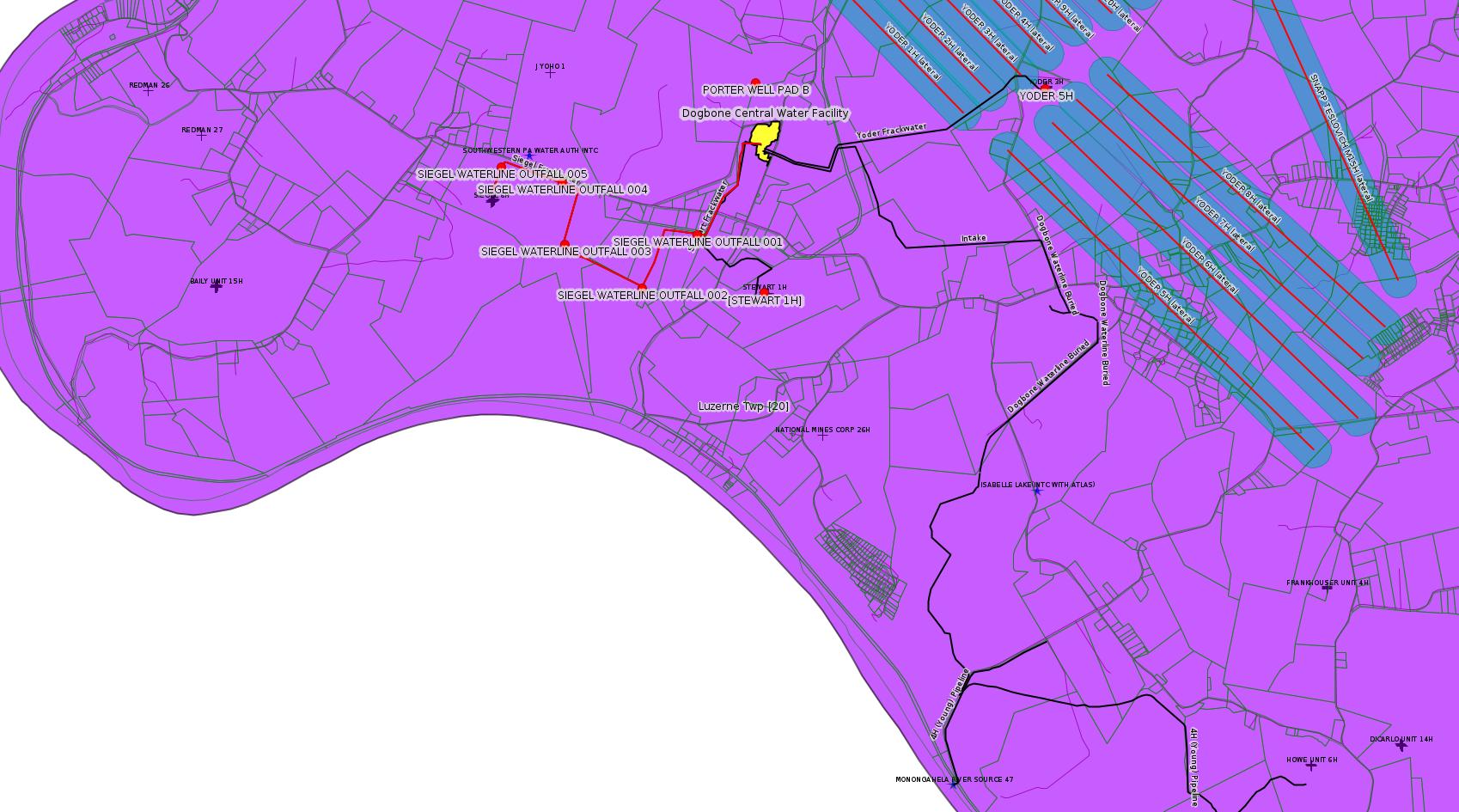
SIEGEL WATERLINE ESCGP ESX18-051-0005 PAG-10 Discharge Resulting from Hydrostatic Testing of Tanks & Pipelines (New)
Kovach Well Connect Pipeline Project Erosion and Sediment Control General Permit 3 Expedited (New)
DOMINION ENERGY TRANS INC NORTH SUMMIT COMP STA Major Facility Operating Permit (New)
PORTER WELL PAD B Erosion and Sediment Control General Permit 3
GEORGE WALTERS 2 Well Plugging Notice Intent to Plug Single Well
SNAPP TESLOVICH M15H Alt Method of Equipping, Casing, or Venting Well
SNAPP TESLOVICH M12H Alt Method of Equipping, Casing, or Venting Well
SNAPP TESLOVICH M09H Alt Method of Equipping, Casing, or Venting Well
SNAPP TESLOVICH M08H Alt Method of Equipping, Casing, or Venting Well
SNAPP TESLOVICH M07H Alt Method of Equipping, Casing, or Venting Well
SNAPP TESLOVICH M06H Alt Method of Equipping, Casing, or Venting Well
SNAPP TESLOVICH M05H Alt Method of Equipping, Casing, or Venting Well
SNAPP TESLOVICH M04H Alt Method of Equipping, Casing, or Venting Well
SNAPP TESLOVICH M03H Alt Method of Equipping, Casing, or Venting Well
SNAPP TESLOVICH M02H Alt Method of Equipping, Casing, or Venting Well
SNAPP TESLOVICH M01V Alt Method of Equipping, Casing, or Venting Well
BRAZZON 15 ACCESS RD CULVERT REPLACEMENT BWM-GP-11 Maintenance, Testing, Repair, Rehabilitation or Replacement General Pmt
RONCO PLANT JPA 326-07-006 Water Obstruction & Encroachment Pmt Issued 10/17/2019
FAYETTE ENERGY FAC Minor IW Facility with ELG
UNIVAR USA INC EVERSON PLANT Minor Source Operating Permit
FAYETTE ENERGY FAC Minor IW Facility with ELG Renewal
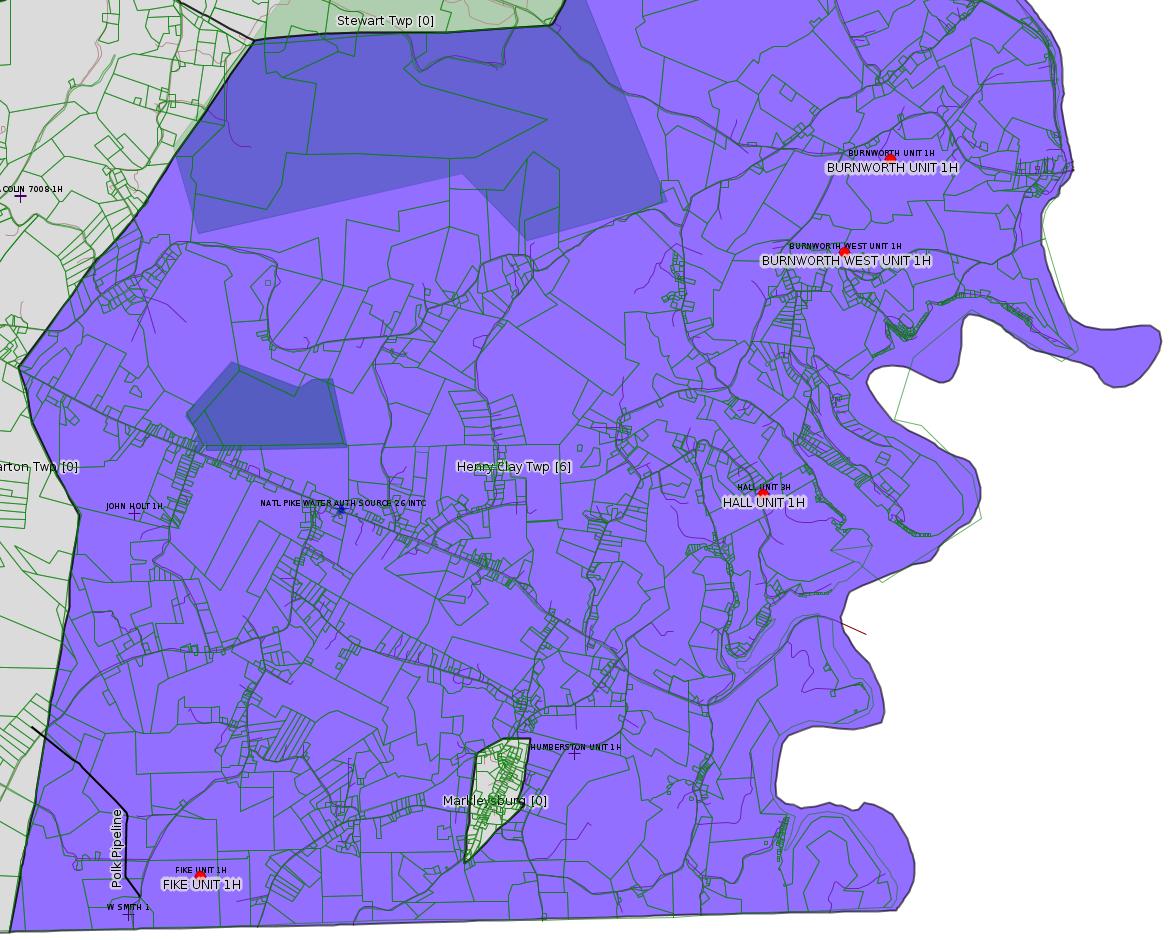
FIKE UNIT 1H Pressure test notification 10/30/2019
HALL UNIT 1H Pressure test notification 10/30/2019
HALL UNIT 2H Pressure test notification 10/30/2019
HALL UNIT 3H Pressure test notification 10/30/2019
BURNWORTH UNIT 1H Pressure test notification 10/30/2019
BURNWORTH WEST UNIT 1H Pressure test notification 10/30/2019
YODER 5H Pressure test notification 11/05/2019
YODER 6H Pressure test notification 11/05/2019
YODER 7H Pressure test notification 11/05/2019
YODER 8H Pressure test notification 11/05/2019
YODER 11H Pressure test notification 11/05/2019
YODER 12H Pressure test notification 11/05/2019
YODER 5H Stimulation [=Fracking] notification 11/05/2019
YODER 11H Stimulation notification 11/05/2019
YODER 12H Stimulation notification 11/05/2019
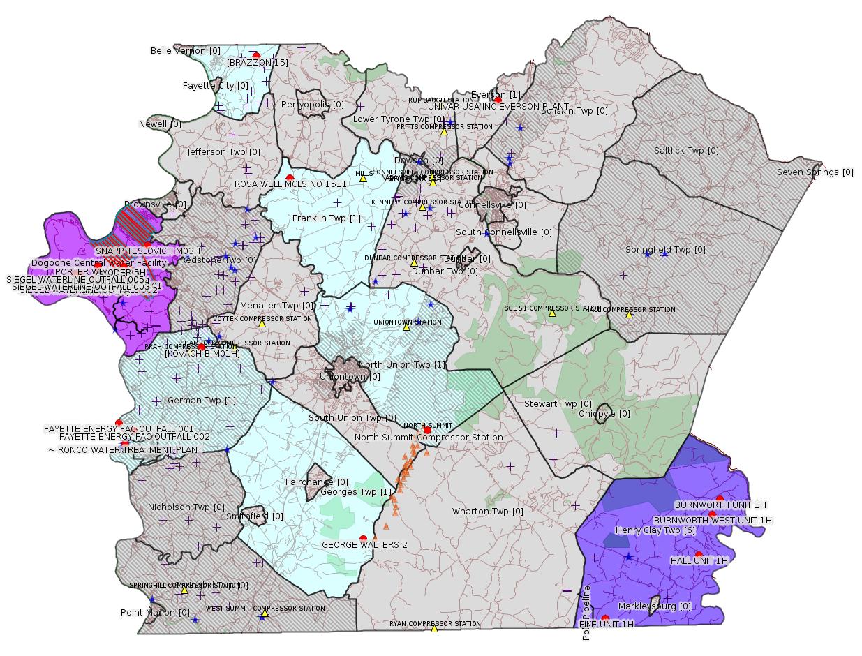
Map
Key
Red dots: items in this permit list with an exact location.
Blue stars: Marcellus Gas Well Water Sources.
Where well laterals are mapped they show in red; a 400-foot buffer surrounding the lateral shows in blue (lavender where it overlaps a mapped mineral tract).
Where mineral tracts are mapped, they show in pink. Mineral tracts can overlap; the overlap will show in red. The precise meaning of "mineral tract" is not clear.
Municipality shading: number of "facilities", with each well counting separately
(includes the red dots):
gray: 0
pale turquoise: 1
turquoise: 2
pale blue: 3
middle blue: 4
dark blue: 5
dark purple: 7
purple: 14
(Color coding may differ from one issue to the next.)
(Note if a project spans multiple municipalities -- e.g. a pipeline -- it will show in the count for each municipality.)
The number of facilities also follows the municipality name in brackets.
Municipality counts are based on the way the permit is listed by DEP; DEP has been known to get a municipality wrong.
Locations in brackets identify a precise location used to locate a surrogate for the actual site being permitted (e.g. locating a well pad or pipeline by the known location of a well.) Locations labeled beginning with "~" and ending in "[?]" are approximate and speculative based on inferences using on-line property and lease records. These are marked in the text as "[Approximate, Speculative]
Cross-hatching: Environmental Justice Areas
Yellow triangles: Compressor Stations
Orange triangles: Storage Field Wells (currently Dominion North Summit Storage Field)
Crosses: SPUD Unconventional well permits
Green: "Natural areas", e.g. state game lands, state forests
Yellow triangles: Compressor Stations
Orange triangles: Storage Field Wells (currently Dominion North Summit Storage Field)
Crosses: SPUD Unconventional well permits
Green: "Natural areas", e.g. state game lands, state forests
More Maps
 |
 |
 |
Source: Pennsylvania Bulletin
THE GOVERNOR
Title 4—ADMINISTRATION
[49 Pa.B. 6376]
[Saturday, October 26, 2019]
PART I. GOVERNOR'S OFFICE
[ 4 PA. CODE CH. 7a ]
[ EXECUTIVE ORDER NO. 2019-07 ]
Commonwealth Leadership in Addressing Climate Change through Electric Sector Emissions Reductions
October 3, 2019
Whereas, the laws of the Commonwealth of Pennsylvania mandate that we protect the Commonwealth's air resources for the protection of public health, safety and well-being of our citizens; prevent injury to plant and animal life and to property; protect the comfort and convenience of the public and Commonwealth recreational resources; and develop, attract and expand industry, commerce and agriculture; and,
Whereas, globally, there is a scientific consensus that climate change is occurring and there is wide agreement amongst scientific organizations that the cause is increased concentrations of greenhouse gasses (GHG) from anthropogenic activities; and
Whereas, in 2015, the Pennsylvania Climate Impacts Assessment Update found that Pennsylvania has undergone a long-term warming of more than 1.8 degrees Fahrenheit over the prior 110 years, and that current warming trends are expected to increase at an accelerated rate with average temperatures projected to increase an additional 5.4 degrees by 2050; and
Whereas, average annual precipitation has increased by approximately 10 percent over the past 100 years and, by 2050, is expected to increase by an additional 8 percent; and
Whereas, Pennsylvania is experiencing the numerous negative effects of these trends. 2018 was the wettest year on record in the Commonwealth. The increased rainfall resulted in extreme weather events and flooding throughout the state costing residents an estimated $144 million in reported damages, and costing the Commonwealth at least $125 million in damages to state-maintained infrastructure; and
Whereas, heat-related illness and death are significant public health problems in the Northeastern United States. Projected temperature increases are expected to increase air pollution and diminish water quality, leading to more premature deaths, hospital admissions, and emergency department visits from heat stress such as exacerbated asthma and increased water-borne illnesses; and
Whereas, Executive Order 2019-01, Commonwealth Leadership in Addressing Climate Change and Promoting Energy Conservation and Sustainable Governance, committed the Commonwealth to strive to reduce net GHG emissions by 26 percent from 2005 levels, and to further reduce net GHG emissions by 80 percent by 2050; and
Whereas, on April 29, 2019, the Department of Environmental Protection (DEP) issued a Pennsylvania Climate Action Plan that identifies GHG emission trends and baselines in the Commonwealth, recommends cost-effective strategies for reducing or offsetting GHG emissions, quantifies costs and benefits of these strategies, and recommends limiting carbon emissions through an electricity sector cap and trade program; and
Whereas, based upon data contained in Pennsylvania's GHG Inventory, 30 percent of Pennsylvania's total GHG emissions are produced by Pennsylvania's electricity generation sector; and
Whereas, cap and trade programs have an established track record as economically efficient, market-driven mechanisms for reducing pollution in a variety of contexts; and
Whereas, the Regional Greenhouse Gas Initiative (RGGI) is a cooperative effort of Nine East Coast states to reduce GHG emissions from the power sector. The RGGI participating states have collectively reduced power sector carbon dioxide pollution by over 45 percent since 2005, while experiencing per capita Gross Domestic Product growth and reducing energy costs for businesses; and
Whereas, given the urgency of the climate crisis facing Pennsylvania, the Commonwealth must take concrete, economically sound and immediate steps to reduce GHG emissions.
Now, Therefore, I, Tom Wolf, Governor of the Commonwealth of Pennsylvania, by virtue of the authority vested in me by the Constitution of the Commonwealth of Pennsylvania and other laws, do order and direct the DEP as follows:
Governor
(Editor's Note: Executive Order 2019-01, Commonwealth Leadership in Addressing Climate Change and Promoting Energy Conservation and Sustainable Governance is codified in 4 Pa. Code §§ 5.1001—5.1009.)
Fiscal Note: GOV-2019-07. No fiscal impact; (8) recommends adoption.
Annex A
TITLE 4. ADMINISTRATION
PART I. GOVERNOR'S OFFICE
CHAPTER 7a. ADDITIONAL MISCELLANEOUS PROVISIONS
Subchapter Q. COMMONWEALTH LEADERSHIP IN ADDRESSING CLIMATE CHANGE THROUGH ELECTRIC SECTOR EMISSIONS REDUCTIONS
Sec.
7a.181. Rulemaking.
7a.182. Interaction with regional transmission organization.
7a.183. Effective date.
§ 7a.181. Rulemaking.
By no later than July 31, 2020, the Department of Environmental Protection shall develop and present to the Environmental Quality Board a proposed rulemaking package to abate, control or limit carbon dioxide emissions from fossil-fuel-fired electric power generators. This proposed rulemaking package will be authorized by the act of January 8, 1960 ((1959) P.L. 2119, No. 787), known as the Air Pollution Control Act (35 P.S. §§ 4001—4015). This proposed rulemaking must:
(a) Include a robust public outreach effort working with the business community, energy producers, energy suppliers, organized labor, environmental groups and others to ensure that the development and implementation of this electricity sector cap and trade program results in reduced emissions, economic gains and consumer savings;
(b) Establish a carbon dioxide budget consistent in stringency to that established in the Regional Greenhouse Gas Initiative (RGGI) participating states;
(c) Provide for the annual or more frequent auction of carbon dioxide emissions allowances through a market-based mechanism; and
(d) Be sufficiently consistent with the RGGI Model Rule so that allowances may be traded with holders of allowances from other states.
§ 7a.182. Interaction with regional transmission organization.
The Department of Environmental Protection in conjunction with the Pennsylvania Public Utility Commission shall engage with PJM Interconnection to promote the integration of this electricity sector cap and trade program in a manner that preserves orderly and competitive economic dispatch within PJM Interconnection and minimizes emissions leakage.
§ 7a.183. Effective date.
This subchapter shall take effect immediately and shall remain in effect until amended or rescinded by the Governor.
<https://www.pabulletin.com/secure/data/vol49/49-43/1576.html>
---
26-00405: Dominion Energy Transmission Inc. (5000 Dominion Boulevard, Glen Allen, VA 23060). In accordance with 25 Pa. Code §§ 127.424, 127.425 and 127.521, the Department of Environmental Protection (DEP) is providing notice that it intends to modify Title V Operating Permit (TVOP-26-00405) to incorporate the Reasonably Available Control Technology II (RACT II) requirements of 25 Pa. Code §§ 129.96—129.100 for the continued operation of a natural gas compressor station for their North Summit Compressor Station in North Union Township, Fayette County. The facility is subject to presumptive RACT requirements for NOx and VOC, which have been evaluated during this review. The facility's main sources include two (2) 25 MMBtu/hr Tulpro Heaters (Source IDs 034 and 035), one (1) 10.5 MMBtu/hr Natco DeHy Heater (Source ID 036), one (1) 3.57 MMBtu/hr Peerless Boiler (Source ID 037), two (2) 3,200 bhp natural gas-fired engines (Source IDs 101 and 102), and one (1) 610 bhp natural gas-fired auxiliary generator (Source ID 103).
Actual facility emissions for 2018 were reported as follows: 19.57 TPY NOx; 14.64 TPY CO; 5.55 TPY VOC; 0.05 TPY SOx; 1.33 TPY PM-10/2.5; 1.75 TPY HAP total; and 6,472 TPY for CO2e.
Those who wish to provide the Department with additional written information that they believe should be considered prior to the issuance of the Title V Operating Permit may submit the information to Thomas Joseph, Facilities Permit Chief, Department of Environmental Protection, Southwest Regional Office, 400 Waterfront Drive, Pittsburgh, PA 15222. Written comments must contain the name, address and telephone number of the person submitting the comments, identification of the proposed Operating Permit (26-00405) and concise statements regarding the relevancy of the information or objections to issuance of the Operating Permit.
A public hearing may be held, if the Department, in its discretion, decides that such a hearing is warranted based on the information received. All persons submitting comments or requesting a hearing will be notified of the decision to hold a hearing by publication in the newspaper or by the Pennsylvania Bulletin, or by telephone, where the Department determines such notification by telephone is sufficient. Written comments or requests for a public hearing should be directed to Thomas Joseph, Facilities Permit Chief, at the previously listed address. For additional information concerning the permit or the issuance procedure, contact Thomas Joseph at the same address previously listed or phone at (412) 442-4336.
All comments must be received prior to the close of business 30 days after the date of this publication.
<https://www.pabulletin.com/secure/data/vol49/49-44/1635a.html>
-------------------------
Source: eNOTICE
(+ PA
Oil and Gas Mapping, Well
Pad Report.) Well Details via Data
Portal Services: Oil and Gas Wells All (ID: 3).
Please see the Disclaimer below regarding Parcel Id data.
Authorization ID: 1294295
Permit number: ESX11-051-0038
Site: ROSA WELL MCLS NO 1511 ESCGP-EXPEDITED
Client: CHEVRON APPALACHIA LLC
Authorization type: Expedited E&S Stormwater General Permit 1
Application type: Notification
Authorization is for: SITE
Date received: 10/30/2019
Status: Pending
Permit Decision Guarantee Applies?: No
Permit Review Notes:
Date Review Note
10/31/2019 The permit application package is complete, has been accepted, and is undergoing technical review.
<https://www.ahs.dep.pa.gov/eFACTSWeb/searchResults_singleAuth.aspx?AuthID=1294295>
Site Programs:
Oil & Gas
Site Municipalities:
Franklin Twp, Fayette County
---
Authorization ID: 1294272
Permit number: ESX18-051-0007
Site: STEWART WELL CONNECT PIPELINE PROJECT ESCGP ESX18-051-0007
Client: LAUREL MTN MIDSTREAM OPR LLC
Authorization type: Expedited E&S Stormwater General Permit 1
Application type: Notification
Authorization is for: SITE
Date received: 10/29/2019
Status: Pending
Permit Decision Guarantee Applies?: No
Permit Review Notes:
Date Review Note
10/31/2019 The permit application package is complete, has been accepted, and is undergoing technical review.
<https://www.ahs.dep.pa.gov/eFACTSWeb/searchResults_singleAuth.aspx?AuthID=1294272>
Site Programs:
Site Municipalities:
Luzerne Twp, Fayette County
Location [of STEWART 1H]: 39.962961,-79.946956
Map URL: <http://www.openstreetmap.org/?mlat=39.962961&mlon=-79.946956#map=15/39.962961/-79.946956>
---
Authorization ID: 1293737
Permit number: PAG106223
Site: SIEGEL WATERLINE ESCGP ESX18-051-0005
Client: CHEVRON APPALACHIA LLC
Authorization type: PAG-10 Discharge Resulting from Hydrostatic Testing of Tanks & Pipelines
Application type: New
Authorization is for: FACILITY
Date received: 10/28/2019
Status: Pending
Permit Decision Guarantee Applies?: Yes
Permit Decision Guarantee status: ACTIVE
Sub-Facilities for Authorization:
Sub-Facility ID Sub-Facility Name Description
1297035 OUTFALL 001 Discharge Point
Location: 39.966631,-79.952311
Map URL: <http://www.openstreetmap.org/?mlat=39.966631&mlon=-79.952311#map=15/39.966631/-79.952311>
1297036 OUTFALL 002 Discharge Point
Location: 39.963367,-79.956869
Map URL: <http://www.openstreetmap.org/?mlat=39.963367&mlon=-79.956869#map=15/39.963367/-79.956869>
1297037 OUTFALL 003 Discharge Point
Location: 39.966136,-79.963086
Map URL: <http://www.openstreetmap.org/?mlat=39.966136&mlon=-79.963086#map=15/39.966136/-79.963086>
1297038 OUTFALL 004 Discharge Point
Location: 39.970019,-79.963247
Map URL: <http://www.openstreetmap.org/?mlat=39.970019&mlon=-79.963247#map=15/39.970019/-79.963247>
1297039 OUTFALL 005 Discharge Point
Location: 39.971014,-79.968156
Map URL: <http://www.openstreetmap.org/?mlat=39.971014&mlon=-79.968156#map=15/39.971014/-79.968156>
Permit Review Notes:
Date Review Note
10/29/2019 The permit application package is complete, has been accepted, and is undergoing technical review.
<https://www.ahs.dep.pa.gov/eFACTSWeb/searchResults_singleAuth.aspx?AuthID=1293737>
Site Programs:
Clean Water
Site Municipalities:
Luzerne Twp, Fayette County
---
Authorization ID: 1293147
Permit number: ESG072619004-00
Site: Kovach Well Connect Pipeline Project
Client: LAUREL MTN MIDSTREAM OPR LLC
Authorization type: Erosion and Sediment Control General Permit 3 Expedited
Application type: New
Authorization is for: SITE
Date received: 10/23/2019
Status: Pending
Permit Decision Guarantee Applies?: Yes
Permit Decision Guarantee status: ACTIVE
<https://www.ahs.dep.pa.gov/eFACTSWeb/searchResults_singleAuth.aspx?AuthID=1293147>
Site Programs:
Site Municipalities:
German Twp, Fayette County
---
Authorization ID: 1292889
Permit number: 26-00405
Site: DOMINION ENERGY TRANS INC NORTH SUMMIT COMP STA
Client: DOMINION ENERGY TRANS INC
Authorization type: Major Facility Operating Permit
Application type: Amendment
Authorization is for: FACILITY
Date received: 10/15/2019
Status: Pending
Permit Decision Guarantee Applies?: No
Permit Review Notes:
Date Review Note
10/22/2019 The permit application package is complete, has been accepted, and is undergoing technical review.
<https://www.ahs.dep.pa.gov/eFACTSWeb/searchResults_singleAuth.aspx?AuthID=1292889>
Site Programs:
Air Quality
Clean Water
Waste Management
Site Municipalities:
North Union Twp, Fayette County
---
Authorization ID: 1290728
Permit number: ESG072619003-00
Site: PORTER WELL PAD B ESCGP ESG072619003-00
Client: CHEVRON APPALACHIA LLC
Authorization type: Erosion and Sediment Control General Permit 3
Application type: New
Authorization is for: SITE
Date received: 10/02/2019
Status: Pending
Permit Decision Guarantee Applies?: Yes
Permit Decision Guarantee status: ACTIVE
Permit Review Notes:
Date Review Note
10/22/2019 The permit application package is complete, has been accepted, and is undergoing technical review.
<https://www.ahs.dep.pa.gov/eFACTSWeb/searchResults_singleAuth.aspx?AuthID=1290728>
Site Programs:
Site Municipalities:
Luzerne Twp, Fayette County
---
Authorization ID: 1289874
Permit number: 051-00116
Site: GEORGE WALTERS 2 WELL
Client: DOMINION ENERGY TRANS INC
Authorization type: Well Plugging Notice Intent to Plug Single Well
Application type: New
Authorization is for: FACILITY
Date received: 09/27/2019
Status: Pending
Permit Decision Guarantee Applies?: No
Sub-Facilities for Authorization:
Sub-Facility ID Sub-Facility Name Description
56076 GEORGE WALTERS 2 Well
Permit Review Notes:
Date Review Note
10/16/2019 The technical review and decision review are complete and either the permit decision and/or permit issuance are forthcoming.
9/27/2019 The permit application package is complete, has been accepted, and is undergoing technical review.
<https://www.ahs.dep.pa.gov/eFACTSWeb/searchResults_singleAuth.aspx?AuthID=1289874>
Site Programs:
Oil & Gas
Site Municipalities:
Georges Twp, Fayette County
Well Details:
Permit Number: 051-00116
Well Name: GEORGE WALTERS 2
Unconventional Well: N
Well Configuration: Vertical Well
Well Type: GAS
Well Status: Active
Coal Association: Coal
Conservation Well: N
Primary Facility ID: 42546
Site ID: 40794
Site Name: GEORGE WALTERS 2 WELL
Well Pad ID: 0
Well Pad Name:
Storage Field:
Operator: DOMINION ENERGY TRANS INC
Operator Number: OGO-2239
Permit Date: 1986-02-25
Permit Date Expires:
SPUD Date: 1800-01-01
Date Plugged:
UIC ID:
UIC Type:
Surface Elevation: 0
County: Fayette
Municipality: Georges Twp
Location: 39.785,-79.711278
Map URL: <http://www.openstreetmap.org/?mlat=39.785&mlon=-79.711278#map=15/39.785/-79.711278>
---
Authorization ID: 1285047
Permit number: 051-24716
Site: SNAPP TESLOVICH WELL PAD A ESCGP3 ESG30705118-002
Client: CHEVRON APPALACHIA LLC
Authorization type: Alt Method of Equipping, Casing, or Venting Well
Application type: New
Authorization is for: FACILITY
Date received: 08/22/2019
Status: Pending
Permit Decision Guarantee Applies?: Yes
Permit Decision Guarantee status: ACTIVE
Sub-Facilities for Authorization:
Sub-Facility ID Sub-Facility Name Description
1292500 WELLBORE SURFACE HOLE LOCATION Well
Permit Review Notes:
Date Review Note
10/30/2019 The technical review and decision review are complete and either the permit decision and/or permit issuance are forthcoming.
8/23/2019 The permit application package is complete, has been accepted, and is undergoing technical review.
<https://www.ahs.dep.pa.gov/eFACTSWeb/searchResults_singleAuth.aspx?AuthID=1285047>
Site Programs:
Oil & Gas
Site Municipalities:
Luzerne Twp, Fayette County
Well Details:
Permit Number: 051-24716
Well Name: SNAPP TESLOVICH M15H
Unconventional Well: Y
Well Configuration: Horizontal Well
Well Type: GAS
Well Status: Active
Coal Association: NonCoal
Conservation Well: N
Primary Facility ID: 836750
Site ID: 833740
Site Name: SNAPP TESLOVICH WELL PAD A ESCGP3 ESG30705118-002
Well Pad ID: 155747
Well Pad Name: SNAPP-TESLOVICH PAD A
Storage Field:
Operator: CHEVRON APPALACHIA LLC
Operator Number: OGO-39307
Permit Date: 2019-09-18
Permit Date Expires: 2020-09-18
SPUD Date:
Date Plugged:
UIC ID:
UIC Type:
Surface Elevation: 1100
County: Fayette
Municipality: Luzerne Twp
Location: 39.990031,-79.902594
Map URL: <http://www.openstreetmap.org/?mlat=39.990031&mlon=-79.902594#map=15/39.990031/-79.902594>
OG WELLS PERMIT DOCS:
2019-09-18: Other Permit Documents, Name: SNAPP TESLOVICH Coal Determination (for Authorization: 1284022):
<http://www.depgis.state.pa.us/pdfHandler/pdFHandler.ashx?Doc=OTIzMzQ4&ext=PDF>
2019-09-18: Final Permit Documents, Name: Authorization ID 1284022 (for Authorization: 1284022):
<http://www.depgis.state.pa.us/pdfHandler/pdFHandler.ashx?Doc=OTI2ODYx&ext=PDF>
2019-10-31: Other Permit Documents, Name: Alternate Method (for Authorization: 1285047):
<http://www.depgis.state.pa.us/pdfHandler/pdFHandler.ashx?Doc=OTYxMTM4&ext=PDF>
Electronically Submitted Records:
2019-09-18: Submission for Authorization 1284022
Pennsylvania Natural Diversity Inventory Form: Snapp Teslovich_PNDI.pdf
<http://www.depgis.state.pa.us/eWellDocHandler/pdFHandler.ashx?Doc=OTExMTEw&ext=PDF>
Justification for Non-Coal Well: Snapp Teslovich Non-Coal Packet.pdf
<http://www.depgis.state.pa.us/eWellDocHandler/pdFHandler.ashx?Doc=OTExMTEx&ext=PDF>
Coordination of Well Location with Public Resources: COORDINATION_OF_A_WELL_LOCATION_WITH_PUBLIC_RESOURCES_Snapp Teslovich - M15H.pdf
<http://www.depgis.state.pa.us/eWellDocHandler/pdFHandler.ashx?Doc=OTE4NzAz&ext=PDF>
Pennsylvania Natural Diversity Inventory Support Document: PNDI Clearance.pdf
<http://www.depgis.state.pa.us/eWellDocHandler/pdFHandler.ashx?Doc=OTE5MjAy&ext=PDF>
Well Cross-Section Diagram: Page 4_Snapp Teslovich Pad A_M15H.pdf
<http://www.depgis.state.pa.us/eWellDocHandler/pdFHandler.ashx?Doc=OTE5NjY2&ext=PDF>
Location Plat: Snapp Teslovich - M15H Plat - 2019.09.09.dwg
<http://www.depgis.state.pa.us/eWellDocHandler/pdFHandler.ashx?Doc=OTQxNTQ4&ext=PDF>
Permit Application to Drill and Operate a Well: 1985280.pdf
<http://www.depgis.state.pa.us/eWellDocHandler/pdFHandler.ashx?Doc=OTQxNTgy&ext=PDF>
---
Authorization ID: 1285046
Permit number: 051-24715
Site: SNAPP TESLOVICH WELL PAD A ESCGP3 ESG30705118-002
Client: CHEVRON APPALACHIA LLC
Authorization type: Alt Method of Equipping, Casing, or Venting Well
Application type: New
Authorization is for: FACILITY
Date received: 08/22/2019
Status: Pending
Permit Decision Guarantee Applies?: Yes
Permit Decision Guarantee status: ACTIVE
Sub-Facilities for Authorization:
Sub-Facility ID Sub-Facility Name Description
1292499 WELLBORE SURFACE HOLE LOCATION Well
Permit Review Notes:
Date Review Note
10/30/2019 The technical review and decision review are complete and either the permit decision and/or permit issuance are forthcoming.
8/23/2019 The permit application package is complete, has been accepted, and is undergoing technical review.
<https://www.ahs.dep.pa.gov/eFACTSWeb/searchResults_singleAuth.aspx?AuthID=1285046>
Site Programs:
Oil & Gas
Site Municipalities:
Luzerne Twp, Fayette County
Well Details:
Permit Number: 051-24715
Well Name: SNAPP TESLOVICH M12H
Unconventional Well: Y
Well Configuration: Horizontal Well
Well Type: GAS
Well Status: Active
Coal Association: NonCoal
Conservation Well: N
Primary Facility ID: 836749
Site ID: 833740
Site Name: SNAPP TESLOVICH WELL PAD A ESCGP3 ESG30705118-002
Well Pad ID: 155747
Well Pad Name: SNAPP-TESLOVICH PAD A
Storage Field:
Operator: CHEVRON APPALACHIA LLC
Operator Number: OGO-39307
Permit Date: 2019-09-18
Permit Date Expires: 2020-09-18
SPUD Date:
Date Plugged:
UIC ID:
UIC Type:
Surface Elevation: 1100
County: Fayette
Municipality: Luzerne Twp
Location: 39.99005,-79.902436
Map URL: <http://www.openstreetmap.org/?mlat=39.99005&mlon=-79.902436#map=15/39.99005/-79.902436>
OG WELLS PERMIT DOCS:
2019-09-18: Other Permit Documents, Name: SNAPP TESLOVICH Coal Determination (for Authorization: 1284021):
<http://www.depgis.state.pa.us/pdfHandler/pdFHandler.ashx?Doc=OTIzMzQw&ext=PDF>
2019-09-18: Final Permit Documents, Name: Authorization ID 1284021 (for Authorization: 1284021):
<http://www.depgis.state.pa.us/pdfHandler/pdFHandler.ashx?Doc=OTI2ODUz&ext=PDF>
2019-10-31: Other Permit Documents, Name: Alternate Method (for Authorization: 1285046):
<http://www.depgis.state.pa.us/pdfHandler/pdFHandler.ashx?Doc=OTYxMTQx&ext=PDF>
Electronically Submitted Records:
2019-09-18: Submission for Authorization 1284021
Pennsylvania Natural Diversity Inventory Form: Snapp Teslovich_PNDI.pdf
<http://www.depgis.state.pa.us/eWellDocHandler/pdFHandler.ashx?Doc=OTExMDk1&ext=PDF>
Justification for Non-Coal Well: Snapp Teslovich Non-Coal Packet.pdf
<http://www.depgis.state.pa.us/eWellDocHandler/pdFHandler.ashx?Doc=OTExMDk2&ext=PDF>
Coordination of Well Location with Public Resources: COORDINATION_OF_A_WELL_LOCATION_WITH_PUBLIC_RESOURCES_Snapp Teslovich - M12H.pdf
<http://www.depgis.state.pa.us/eWellDocHandler/pdFHandler.ashx?Doc=OTE4NzAy&ext=PDF>
Pennsylvania Natural Diversity Inventory Support Document: PNDI Clearance.pdf
<http://www.depgis.state.pa.us/eWellDocHandler/pdFHandler.ashx?Doc=OTE5MTkz&ext=PDF>
Well Cross-Section Diagram: Page 4_Snapp Teslovich Pad A_M12H.pdf
<http://www.depgis.state.pa.us/eWellDocHandler/pdFHandler.ashx?Doc=OTE5NjYw&ext=PDF>
Location Plat: Snapp Teslovich - M12H Plat - 2019.09.09.dwg
<http://www.depgis.state.pa.us/eWellDocHandler/pdFHandler.ashx?Doc=OTQxNTQ0&ext=PDF>
Permit Application to Drill and Operate a Well: 1985276.pdf
<http://www.depgis.state.pa.us/eWellDocHandler/pdFHandler.ashx?Doc=OTQxNTc5&ext=PDF>
---
Authorization ID: 1285044
Permit number: 051-24712
Site: SNAPP TESLOVICH WELL PAD A ESCGP3 ESG30705118-002
Client: CHEVRON APPALACHIA LLC
Authorization type: Alt Method of Equipping, Casing, or Venting Well
Application type: New
Authorization is for: FACILITY
Date received: 08/22/2019
Status: Pending
Permit Decision Guarantee Applies?: Yes
Permit Decision Guarantee status: ACTIVE
Sub-Facilities for Authorization:
Sub-Facility ID Sub-Facility Name Description
1292496 WELLBORE SURFACE HOLE LOCATION Well
Permit Review Notes:
Date Review Note
10/30/2019 The technical review and decision review are complete and either the permit decision and/or permit issuance are forthcoming.
8/23/2019 The permit application package is complete, has been accepted, and is undergoing technical review.
<https://www.ahs.dep.pa.gov/eFACTSWeb/searchResults_singleAuth.aspx?AuthID=1285044>
Site Programs:
Oil & Gas
Site Municipalities:
Luzerne Twp, Fayette County
Well Details:
Permit Number: 051-24712
Well Name: SNAPP TESLOVICH M09H
Unconventional Well: Y
Well Configuration: Horizontal Well
Well Type: GAS
Well Status: Active
Coal Association: NonCoal
Conservation Well: N
Primary Facility ID: 836746
Site ID: 833740
Site Name: SNAPP TESLOVICH WELL PAD A ESCGP3 ESG30705118-002
Well Pad ID: 155747
Well Pad Name: SNAPP-TESLOVICH PAD A
Storage Field:
Operator: CHEVRON APPALACHIA LLC
Operator Number: OGO-39307
Permit Date: 2019-09-18
Permit Date Expires: 2020-09-18
SPUD Date:
Date Plugged:
UIC ID:
UIC Type:
Surface Elevation: 1100
County: Fayette
Municipality: Luzerne Twp
Location: 39.990072,-79.902278
Map URL: <http://www.openstreetmap.org/?mlat=39.990072&mlon=-79.902278#map=15/39.990072/-79.902278>
OG WELLS PERMIT DOCS:
2019-09-18: Other Permit Documents, Name: SNAPP TESLOVICH Coal Determination (for Authorization: 1284013):
<http://www.depgis.state.pa.us/pdfHandler/pdFHandler.ashx?Doc=OTIzMzMx&ext=PDF>
2019-09-18: Final Permit Documents, Name: Authorization ID 1284013 (for Authorization: 1284013):
<http://www.depgis.state.pa.us/pdfHandler/pdFHandler.ashx?Doc=OTI2ODM2&ext=PDF>
2019-10-31: Other Permit Documents, Name: Alternate Method (for Authorization: 1285044):
<http://www.depgis.state.pa.us/pdfHandler/pdFHandler.ashx?Doc=OTYxMTQ0&ext=PDF>
Electronically Submitted Records:
2019-09-18: Submission for Authorization 1284013
Justification for Non-Coal Well: Snapp Teslovich Non-Coal Packet.pdf
<http://www.depgis.state.pa.us/eWellDocHandler/pdFHandler.ashx?Doc=OTExMDg5&ext=PDF>
Pennsylvania Natural Diversity Inventory Form: Snapp Teslovich_PNDI.pdf
<http://www.depgis.state.pa.us/eWellDocHandler/pdFHandler.ashx?Doc=OTExMDkw&ext=PDF>
Coordination of Well Location with Public Resources: COORDINATION_OF_A_WELL_LOCATION_WITH_PUBLIC_RESOURCES_Snapp Teslovich - M09H.pdf
<http://www.depgis.state.pa.us/eWellDocHandler/pdFHandler.ashx?Doc=OTE4NzAw&ext=PDF>
Pennsylvania Natural Diversity Inventory Support Document: PNDI Clearance.pdf
<http://www.depgis.state.pa.us/eWellDocHandler/pdFHandler.ashx?Doc=OTE5MTYx&ext=PDF>
Well Cross-Section Diagram: Page 4_Snapp Teslovich Pad A_M09H.pdf
<http://www.depgis.state.pa.us/eWellDocHandler/pdFHandler.ashx?Doc=OTE5NjQ0&ext=PDF>
Location Plat: Snapp Teslovich - M09H Plat - 2019.09.09.dwg
<http://www.depgis.state.pa.us/eWellDocHandler/pdFHandler.ashx?Doc=OTQxNTQw&ext=PDF>
Permit Application to Drill and Operate a Well: 1984953.pdf
<http://www.depgis.state.pa.us/eWellDocHandler/pdFHandler.ashx?Doc=OTQxNTcw&ext=PDF>
---
Authorization ID: 1285042
Permit number: 051-24710
Site: SNAPP TESLOVICH WELL PAD A ESCGP3 ESG30705118-002
Client: CHEVRON APPALACHIA LLC
Authorization type: Alt Method of Equipping, Casing, or Venting Well
Application type: New
Authorization is for: FACILITY
Date received: 08/22/2019
Status: Pending
Permit Decision Guarantee Applies?: Yes
Permit Decision Guarantee status: ACTIVE
Sub-Facilities for Authorization:
Sub-Facility ID Sub-Facility Name Description
1292494 WELLBORE SURFACE HOLE LOCATION Well
Permit Review Notes:
Date Review Note
10/30/2019 The technical review and decision review are complete and either the permit decision and/or permit issuance are forthcoming.
8/23/2019 The permit application package is complete, has been accepted, and is undergoing technical review.
<https://www.ahs.dep.pa.gov/eFACTSWeb/searchResults_singleAuth.aspx?AuthID=1285042>
Site Programs:
Oil & Gas
Site Municipalities:
Luzerne Twp, Fayette County
Well Details:
Permit Number: 051-24710
Well Name: SNAPP TESLOVICH M08H
Unconventional Well: Y
Well Configuration: Horizontal Well
Well Type: GAS
Well Status: Active
Coal Association: NonCoal
Conservation Well: N
Primary Facility ID: 836744
Site ID: 833740
Site Name: SNAPP TESLOVICH WELL PAD A ESCGP3 ESG30705118-002
Well Pad ID: 155747
Well Pad Name: SNAPP-TESLOVICH PAD A
Storage Field:
Operator: CHEVRON APPALACHIA LLC
Operator Number: OGO-39307
Permit Date: 2019-09-18
Permit Date Expires: 2020-09-18
SPUD Date:
Date Plugged:
UIC ID:
UIC Type:
Surface Elevation: 1100
County: Fayette
Municipality: Luzerne Twp
Location: 39.989992,-79.902261
Map URL: <http://www.openstreetmap.org/?mlat=39.989992&mlon=-79.902261#map=15/39.989992/-79.902261>
OG WELLS PERMIT DOCS:
2019-09-18: Other Permit Documents, Name: SNAPP TESLOVICH Coal Determination (for Authorization: 1284010):
<http://www.depgis.state.pa.us/pdfHandler/pdFHandler.ashx?Doc=OTIyNTcz&ext=PDF>
2019-09-18: Final Permit Documents, Name: Authorization ID 1284010 (for Authorization: 1284010):
<http://www.depgis.state.pa.us/pdfHandler/pdFHandler.ashx?Doc=OTI2ODE5&ext=PDF>
2019-10-31: Other Permit Documents, Name: Alternate Method (for Authorization: 1285042):
<http://www.depgis.state.pa.us/pdfHandler/pdFHandler.ashx?Doc=OTYxMTUy&ext=PDF>
Electronically Submitted Records:
2019-09-18: Submission for Authorization 1284010
Justification for Non-Coal Well: Snapp Teslovich Non-Coal Packet.pdf
<http://www.depgis.state.pa.us/eWellDocHandler/pdFHandler.ashx?Doc=OTExMDg0&ext=PDF>
Pennsylvania Natural Diversity Inventory Form: Snapp Teslovich_PNDI.pdf
<http://www.depgis.state.pa.us/eWellDocHandler/pdFHandler.ashx?Doc=OTExMDg1&ext=PDF>
Coordination of Well Location with Public Resources: COORDINATION_OF_A_WELL_LOCATION_WITH_PUBLIC_RESOURCES_Snapp Teslovich - M08H.pdf
<http://www.depgis.state.pa.us/eWellDocHandler/pdFHandler.ashx?Doc=OTE4Njk4&ext=PDF>
Pennsylvania Natural Diversity Inventory Support Document: PNDI Clearance.pdf
<http://www.depgis.state.pa.us/eWellDocHandler/pdFHandler.ashx?Doc=OTE5MTQ0&ext=PDF>
Well Cross-Section Diagram: Page 4_Snapp Teslovich Pad A_M08H.pdf
<http://www.depgis.state.pa.us/eWellDocHandler/pdFHandler.ashx?Doc=OTE5NjQw&ext=PDF>
Location Plat: Snapp Teslovich - M08H Plat - 2019.09.09.dwg
<http://www.depgis.state.pa.us/eWellDocHandler/pdFHandler.ashx?Doc=OTQxNTM2&ext=PDF>
Permit Application to Drill and Operate a Well: 1984951.pdf
<http://www.depgis.state.pa.us/eWellDocHandler/pdFHandler.ashx?Doc=OTQxNTY0&ext=PDF>
---
Authorization ID: 1285040
Permit number: 051-24709
Site: SNAPP TESLOVICH WELL PAD A ESCGP3 ESG30705118-002
Client: CHEVRON APPALACHIA LLC
Authorization type: Alt Method of Equipping, Casing, or Venting Well
Application type: New
Authorization is for: FACILITY
Date received: 08/22/2019
Status: Pending
Permit Decision Guarantee Applies?: Yes
Permit Decision Guarantee status: ACTIVE
Sub-Facilities for Authorization:
Sub-Facility ID Sub-Facility Name Description
1292493 WELLBORE SURFACE HOLE LOCATION Well
Permit Review Notes:
Date Review Note
10/30/2019 The technical review and decision review are complete and either the permit decision and/or permit issuance are forthcoming.
8/23/2019 The permit application package is complete, has been accepted, and is undergoing technical review.
<https://www.ahs.dep.pa.gov/eFACTSWeb/searchResults_singleAuth.aspx?AuthID=1285040>
Site Programs:
Oil & Gas
Site Municipalities:
Luzerne Twp, Fayette County
Well Details:
Permit Number: 051-24709
Well Name: SNAPP TESLOVICH M07H
Unconventional Well: Y
Well Configuration: Horizontal Well
Well Type: GAS
Well Status: Active
Coal Association: NonCoal
Conservation Well: N
Primary Facility ID: 836743
Site ID: 833740
Site Name: SNAPP TESLOVICH WELL PAD A ESCGP3 ESG30705118-002
Well Pad ID: 155747
Well Pad Name: SNAPP-TESLOVICH PAD A
Storage Field:
Operator: CHEVRON APPALACHIA LLC
Operator Number: OGO-39307
Permit Date: 2019-09-18
Permit Date Expires: 2020-09-18
SPUD Date:
Date Plugged:
UIC ID:
UIC Type:
Surface Elevation: 1100
County: Fayette
Municipality: Luzerne Twp
Location: 39.989983,-79.902314
Map URL: <http://www.openstreetmap.org/?mlat=39.989983&mlon=-79.902314#map=15/39.989983/-79.902314>
OG WELLS PERMIT DOCS:
2019-09-18: Other Permit Documents, Name: SNAPP TESLOVICH Coal Determination (for Authorization: 1284009):
<http://www.depgis.state.pa.us/pdfHandler/pdFHandler.ashx?Doc=OTIyNTYz&ext=PDF>
2019-09-18: Final Permit Documents, Name: Authorization ID 1284009 (for Authorization: 1284009):
<http://www.depgis.state.pa.us/pdfHandler/pdFHandler.ashx?Doc=OTI2ODA1&ext=PDF>
2019-10-31: Other Permit Documents, Name: Alternate Method (for Authorization: 1285040):
<http://www.depgis.state.pa.us/pdfHandler/pdFHandler.ashx?Doc=OTYxMTU5&ext=PDF>
Electronically Submitted Records:
2019-09-18: Submission for Authorization 1284009
Pennsylvania Natural Diversity Inventory Form: Snapp Teslovich_PNDI.pdf
<http://www.depgis.state.pa.us/eWellDocHandler/pdFHandler.ashx?Doc=OTExMDgy&ext=PDF>
Justification for Non-Coal Well: Snapp Teslovich Non-Coal Packet.pdf
<http://www.depgis.state.pa.us/eWellDocHandler/pdFHandler.ashx?Doc=OTExMDgz&ext=PDF>
Coordination of Well Location with Public Resources: COORDINATION_OF_A_WELL_LOCATION_WITH_PUBLIC_RESOURCES_Snapp Teslovich - M07H.pdf
<http://www.depgis.state.pa.us/eWellDocHandler/pdFHandler.ashx?Doc=OTE4Njkz&ext=PDF>
Pennsylvania Natural Diversity Inventory Support Document: PNDI Clearance.pdf
<http://www.depgis.state.pa.us/eWellDocHandler/pdFHandler.ashx?Doc=OTE5MTM2&ext=PDF>
Well Cross-Section Diagram: Page 4_Snapp Teslovich Pad A_M07H.pdf
<http://www.depgis.state.pa.us/eWellDocHandler/pdFHandler.ashx?Doc=OTE5NjI1&ext=PDF>
Location Plat: Snapp Teslovich - M07H Plat - 2019.09.09.dwg
<http://www.depgis.state.pa.us/eWellDocHandler/pdFHandler.ashx?Doc=OTQxNTMy&ext=PDF>
Permit Application to Drill and Operate a Well: 1984949.pdf
<http://www.depgis.state.pa.us/eWellDocHandler/pdFHandler.ashx?Doc=OTQxNTc2&ext=PDF>
---
Authorization ID: 1285039
Permit number: 051-24711
Site: SNAPP TESLOVICH WELL PAD A ESCGP3 ESG30705118-002
Client: CHEVRON APPALACHIA LLC
Authorization type: Alt Method of Equipping, Casing, or Venting Well
Application type: New
Authorization is for: FACILITY
Date received: 08/22/2019
Status: Pending
Permit Decision Guarantee Applies?: Yes
Permit Decision Guarantee status: ACTIVE
Sub-Facilities for Authorization:
Sub-Facility ID Sub-Facility Name Description
1292495 WELLBORE SURFACE HOLE LOCATION Well
Permit Review Notes:
Date Review Note
10/30/2019 The technical review and decision review are complete and either the permit decision and/or permit issuance are forthcoming.
8/23/2019 The permit application package is complete, has been accepted, and is undergoing technical review.
<https://www.ahs.dep.pa.gov/eFACTSWeb/searchResults_singleAuth.aspx?AuthID=1285039>
Site Programs:
Oil & Gas
Site Municipalities:
Luzerne Twp, Fayette County
Well Details:
Permit Number: 051-24711
Well Name: SNAPP TESLOVICH M06H
Unconventional Well: Y
Well Configuration: Horizontal Well
Well Type: GAS
Well Status: Active
Coal Association: NonCoal
Conservation Well: N
Primary Facility ID: 836745
Site ID: 833740
Site Name: SNAPP TESLOVICH WELL PAD A ESCGP3 ESG30705118-002
Well Pad ID: 155747
Well Pad Name: SNAPP-TESLOVICH PAD A
Storage Field:
Operator: CHEVRON APPALACHIA LLC
Operator Number: OGO-39307
Permit Date: 2019-09-18
Permit Date Expires: 2020-09-18
SPUD Date:
Date Plugged:
UIC ID:
UIC Type:
Surface Elevation: 1100
County: Fayette
Municipality: Luzerne Twp
Location: 39.989978,-79.902367
Map URL: <http://www.openstreetmap.org/?mlat=39.989978&mlon=-79.902367#map=15/39.989978/-79.902367>
OG WELLS PERMIT DOCS:
2019-09-18: Other Permit Documents, Name: SNAPP TESLOVICH Coal Determination (for Authorization: 1284011):
<http://www.depgis.state.pa.us/pdfHandler/pdFHandler.ashx?Doc=OTIyODEz&ext=PDF>
2019-09-18: Final Permit Documents, Name: Authorization ID 1284011 (for Authorization: 1284011):
<http://www.depgis.state.pa.us/pdfHandler/pdFHandler.ashx?Doc=OTI2ODIw&ext=PDF>
2019-10-31: Other Permit Documents, Name: Alternate Method (for Authorization: 1285039):
<http://www.depgis.state.pa.us/pdfHandler/pdFHandler.ashx?Doc=OTYxMTQ5&ext=PDF>
Electronically Submitted Records:
2019-09-18: Submission for Authorization 1284011
Pennsylvania Natural Diversity Inventory Form: Snapp Teslovich_PNDI.pdf
<http://www.depgis.state.pa.us/eWellDocHandler/pdFHandler.ashx?Doc=OTExMDYz&ext=PDF>
Justification for Non-Coal Well: Snapp Teslovich Non-Coal Packet.pdf
<http://www.depgis.state.pa.us/eWellDocHandler/pdFHandler.ashx?Doc=OTExMDY0&ext=PDF>
Coordination of Well Location with Public Resources: COORDINATION_OF_A_WELL_LOCATION_WITH_PUBLIC_RESOURCES_Snapp Teslovich - M06H.pdf
<http://www.depgis.state.pa.us/eWellDocHandler/pdFHandler.ashx?Doc=OTE4Njky&ext=PDF>
Pennsylvania Natural Diversity Inventory Support Document: PNDI Clearance.pdf
<http://www.depgis.state.pa.us/eWellDocHandler/pdFHandler.ashx?Doc=OTE5MTE4&ext=PDF>
Well Cross-Section Diagram: Page 4_Snapp Teslovich Pad A_M06H.pdf
<http://www.depgis.state.pa.us/eWellDocHandler/pdFHandler.ashx?Doc=OTE5NjE1&ext=PDF>
Location Plat: Snapp Teslovich - M06H Plat - 2019.09.09.dwg
<http://www.depgis.state.pa.us/eWellDocHandler/pdFHandler.ashx?Doc=OTQxNTI4&ext=PDF>
Permit Application to Drill and Operate a Well: 1984910.pdf
<http://www.depgis.state.pa.us/eWellDocHandler/pdFHandler.ashx?Doc=OTQxNTYx&ext=PDF>
---
Authorization ID: 1285036
Permit number: 051-24713
Site: SNAPP TESLOVICH WELL PAD A ESCGP3 ESG30705118-002
Client: CHEVRON APPALACHIA LLC
Authorization type: Alt Method of Equipping, Casing, or Venting Well
Application type: New
Authorization is for: FACILITY
Date received: 08/22/2019
Status: Pending
Permit Decision Guarantee Applies?: Yes
Permit Decision Guarantee status: ACTIVE
Sub-Facilities for Authorization:
Sub-Facility ID Sub-Facility Name Description
1292497 WELLBORE SURFACE HOLE LOCATION Well
Permit Review Notes:
Date Review Note
10/30/2019 The technical review and decision review are complete and either the permit decision and/or permit issuance are forthcoming.
8/23/2019 The permit application package is complete, has been accepted, and is undergoing technical review.
<https://www.ahs.dep.pa.gov/eFACTSWeb/searchResults_singleAuth.aspx?AuthID=1285036>
Site Programs:
Oil & Gas
Site Municipalities:
Luzerne Twp, Fayette County
Well Details:
Permit Number: 051-24713
Well Name: SNAPP TESLOVICH M05H
Unconventional Well: Y
Well Configuration: Horizontal Well
Well Type: GAS
Well Status: Active
Coal Association: NonCoal
Conservation Well: N
Primary Facility ID: 836747
Site ID: 833740
Site Name: SNAPP TESLOVICH WELL PAD A ESCGP3 ESG30705118-002
Well Pad ID: 155747
Well Pad Name: SNAPP-TESLOVICH PAD A
Storage Field:
Operator: CHEVRON APPALACHIA LLC
Operator Number: OGO-39307
Permit Date: 2019-09-18
Permit Date Expires: 2020-09-18
SPUD Date:
Date Plugged:
UIC ID:
UIC Type:
Surface Elevation: 1100
County: Fayette
Municipality: Luzerne Twp
Location: 39.989969,-79.902417
Map URL: <http://www.openstreetmap.org/?mlat=39.989969&mlon=-79.902417#map=15/39.989969/-79.902417>
OG WELLS PERMIT DOCS:
2019-09-18: Other Permit Documents, Name: SNAPP TESLOVICH Coal Determination (for Authorization: 1284014):
<http://www.depgis.state.pa.us/pdfHandler/pdFHandler.ashx?Doc=OTIzMjMx&ext=PDF>
2019-09-18: Final Permit Documents, Name: Authorization ID 1284014 (for Authorization: 1284014):
<http://www.depgis.state.pa.us/pdfHandler/pdFHandler.ashx?Doc=OTI2ODQ0&ext=PDF>
2019-10-31: Other Permit Documents, Name: Alternate Method (for Authorization: 1285036):
<http://www.depgis.state.pa.us/pdfHandler/pdFHandler.ashx?Doc=OTYxMTM2&ext=PDF>
Electronically Submitted Records:
2019-09-18: Submission for Authorization 1284014
Justification for Non-Coal Well: Snapp Teslovich Non-Coal Packet.pdf
<http://www.depgis.state.pa.us/eWellDocHandler/pdFHandler.ashx?Doc=OTExMDI5&ext=PDF>
Pennsylvania Natural Diversity Inventory Form: Snapp Teslovich_PNDI.pdf
<http://www.depgis.state.pa.us/eWellDocHandler/pdFHandler.ashx?Doc=OTExMDMw&ext=PDF>
Coordination of Well Location with Public Resources: COORDINATION_OF_A_WELL_LOCATION_WITH_PUBLIC_RESOURCES_Snapp Teslovich - M05H.pdf
<http://www.depgis.state.pa.us/eWellDocHandler/pdFHandler.ashx?Doc=OTE4Njkx&ext=PDF>
Pennsylvania Natural Diversity Inventory Support Document: PNDI Clearance.pdf
<http://www.depgis.state.pa.us/eWellDocHandler/pdFHandler.ashx?Doc=OTE5MTA0&ext=PDF>
Well Cross-Section Diagram: Page 4_Snapp Teslovich Pad A_M05H.pdf
<http://www.depgis.state.pa.us/eWellDocHandler/pdFHandler.ashx?Doc=OTE5NjAz&ext=PDF>
Location Plat: Snapp Teslovich - M05H Plat - 2019.09.09.dwg
<http://www.depgis.state.pa.us/eWellDocHandler/pdFHandler.ashx?Doc=OTQxNTI0&ext=PDF>
Permit Application to Drill and Operate a Well: 1984897.pdf
<http://www.depgis.state.pa.us/eWellDocHandler/pdFHandler.ashx?Doc=OTQxNTU4&ext=PDF>
---
Authorization ID: 1285035
Permit number: 051-24714
Site: SNAPP TESLOVICH WELL PAD A ESCGP3 ESG30705118-002
Client: CHEVRON APPALACHIA LLC
Authorization type: Alt Method of Equipping, Casing, or Venting Well
Application type: New
Authorization is for: FACILITY
Date received: 08/22/2019
Status: Pending
Permit Decision Guarantee Applies?: Yes
Permit Decision Guarantee status: ACTIVE
Sub-Facilities for Authorization:
Sub-Facility ID Sub-Facility Name Description
1292498 WELLBORE SURFACE HOLE LOCATION Well
Permit Review Notes:
Date Review Note
10/30/2019 The technical review and decision review are complete and either the permit decision and/or permit issuance are forthcoming.
8/23/2019 The permit application package is complete, has been accepted, and is undergoing technical review.
<https://www.ahs.dep.pa.gov/eFACTSWeb/searchResults_singleAuth.aspx?AuthID=1285035>
Site Programs:
Oil & Gas
Site Municipalities:
Luzerne Twp, Fayette County
Well Details:
Permit Number: 051-24714
Well Name: SNAPP TESLOVICH M04H
Unconventional Well: Y
Well Configuration: Horizontal Well
Well Type: GAS
Well Status: Active
Coal Association: NonCoal
Conservation Well: N
Primary Facility ID: 836748
Site ID: 833740
Site Name: SNAPP TESLOVICH WELL PAD A ESCGP3 ESG30705118-002
Well Pad ID: 155747
Well Pad Name: SNAPP-TESLOVICH PAD A
Storage Field:
Operator: CHEVRON APPALACHIA LLC
Operator Number: OGO-39307
Permit Date: 2019-09-18
Permit Date Expires: 2020-09-18
SPUD Date:
Date Plugged:
UIC ID:
UIC Type:
Surface Elevation: 1100
County: Fayette
Municipality: Luzerne Twp
Location: 39.989964,-79.902472
Map URL: <http://www.openstreetmap.org/?mlat=39.989964&mlon=-79.902472#map=15/39.989964/-79.902472>
OG WELLS PERMIT DOCS:
2019-09-18: Other Permit Documents, Name: SNAPP TESLOVICH Coal Determination (for Authorization: 1284015):
<http://www.depgis.state.pa.us/pdfHandler/pdFHandler.ashx?Doc=OTIzMzM2&ext=PDF>
2019-09-18: Final Permit Documents, Name: Authorization ID 1284015 (for Authorization: 1284015):
<http://www.depgis.state.pa.us/pdfHandler/pdFHandler.ashx?Doc=OTI2ODUw&ext=PDF>
2019-10-31: Other Permit Documents, Name: Alternate Method (for Authorization: 1285035):
<http://www.depgis.state.pa.us/pdfHandler/pdFHandler.ashx?Doc=OTYxMTQz&ext=PDF>
Electronically Submitted Records:
2019-09-18: Submission for Authorization 1284015
Justification for Non-Coal Well: Snapp Teslovich Non-Coal Packet.pdf
<http://www.depgis.state.pa.us/eWellDocHandler/pdFHandler.ashx?Doc=OTEwOTIw&ext=PDF>
Pennsylvania Natural Diversity Inventory Form: Snapp Teslovich_PNDI.pdf
<http://www.depgis.state.pa.us/eWellDocHandler/pdFHandler.ashx?Doc=OTEwOTIx&ext=PDF>
Coordination of Well Location with Public Resources: COORDINATION_OF_A_WELL_LOCATION_WITH_PUBLIC_RESOURCES_Snapp Teslovich - M04H.pdf
<http://www.depgis.state.pa.us/eWellDocHandler/pdFHandler.ashx?Doc=OTE4Njkw&ext=PDF>
Pennsylvania Natural Diversity Inventory Support Document: PNDI Clearance.pdf
<http://www.depgis.state.pa.us/eWellDocHandler/pdFHandler.ashx?Doc=OTE5MDky&ext=PDF>
Well Cross-Section Diagram: Page 4_Snapp Teslovich Pad A_M04H.pdf
<http://www.depgis.state.pa.us/eWellDocHandler/pdFHandler.ashx?Doc=OTE5NTg5&ext=PDF>
Location Plat: Snapp Teslovich - M04H Plat - 2019.09.09.dwg
<http://www.depgis.state.pa.us/eWellDocHandler/pdFHandler.ashx?Doc=OTQxNTIw&ext=PDF>
Permit Application to Drill and Operate a Well: 1984876.pdf
<http://www.depgis.state.pa.us/eWellDocHandler/pdFHandler.ashx?Doc=OTQxNTU1&ext=PDF>
---
Authorization ID: 1285032
Permit number: 051-24718
Site: SNAPP TESLOVICH WELL PAD A ESCGP3 ESG30705118-002
Client: CHEVRON APPALACHIA LLC
Authorization type: Alt Method of Equipping, Casing, or Venting Well
Application type: New
Authorization is for: FACILITY
Date received: 08/22/2019
Status: Pending
Permit Decision Guarantee Applies?: Yes
Permit Decision Guarantee status: ACTIVE
Sub-Facilities for Authorization:
Sub-Facility ID Sub-Facility Name Description
1292827 WELLBORE SURFACE HOLE LOCATION Well
Permit Review Notes:
Date Review Note
10/30/2019 The technical review and decision review are complete and either the permit decision and/or permit issuance are forthcoming.
8/23/2019 The permit application package is complete, has been accepted, and is undergoing technical review.
<https://www.ahs.dep.pa.gov/eFACTSWeb/searchResults_singleAuth.aspx?AuthID=1285032>
Site Programs:
Oil & Gas
Site Municipalities:
Luzerne Twp, Fayette County
Well Details:
Permit Number: 051-24718
Well Name: SNAPP TESLOVICH M03H
Unconventional Well: Y
Well Configuration: Vertical Well
Well Type: GAS
Well Status: Active
Coal Association: NonCoal
Conservation Well: N
Primary Facility ID: 836867
Site ID: 833740
Site Name: SNAPP TESLOVICH WELL PAD A ESCGP3 ESG30705118-002
Well Pad ID: 155747
Well Pad Name: SNAPP-TESLOVICH PAD A
Storage Field:
Operator: CHEVRON APPALACHIA LLC
Operator Number: OGO-39307
Permit Date: 2019-09-18
Permit Date Expires: 2020-09-18
SPUD Date:
Date Plugged:
UIC ID:
UIC Type:
Surface Elevation: 1100
County: Fayette
Municipality: Luzerne Twp
Location: 39.989956,-79.902525
Map URL: <http://www.openstreetmap.org/?mlat=39.989956&mlon=-79.902525#map=15/39.989956/-79.902525>
OG WELLS PERMIT DOCS:
2019-09-18: Other Permit Documents, Name: SNAPP TESLOVICH Coal Determination (for Authorization: 1284565):
<http://www.depgis.state.pa.us/pdfHandler/pdFHandler.ashx?Doc=OTIzNDc5&ext=PDF>
2019-10-31: Other Permit Documents, Name: Alternate Method (for Authorization: 1285032):
<http://www.depgis.state.pa.us/pdfHandler/pdFHandler.ashx?Doc=OTYxMTY2&ext=PDF>
Electronically Submitted Records:
2019-09-18: Submission for Authorization 1284565
Pennsylvania Natural Diversity Inventory Form: Snapp Teslovich_PNDI.pdf
<http://www.depgis.state.pa.us/eWellDocHandler/pdFHandler.ashx?Doc=OTE4ODk5&ext=PDF>
Justification for Non-Coal Well: Snapp Teslovich Non-Coal Packet.pdf
<http://www.depgis.state.pa.us/eWellDocHandler/pdFHandler.ashx?Doc=OTE4OTAw&ext=PDF>
Location Plat: Snapp Teslovich - M03H Plat - 2019.08.15.dwg
<http://www.depgis.state.pa.us/eWellDocHandler/pdFHandler.ashx?Doc=OTIyMDgw&ext=PDF>
Pennsylvania Natural Diversity Inventory Support Document: PNDI Clearance.pdf
<http://www.depgis.state.pa.us/eWellDocHandler/pdFHandler.ashx?Doc=OTIyMDgx&ext=PDF>
Coordination of Well Location with Public Resources: COORDINATION_OF_A_WELL_LOCATION_WITH_PUBLIC_RESOURCES_Snapp Teslovich - M03H.pdf
<http://www.depgis.state.pa.us/eWellDocHandler/pdFHandler.ashx?Doc=OTIyMDky&ext=PDF>
Permit Application to Drill and Operate a Well: 1995530.pdf
<http://www.depgis.state.pa.us/eWellDocHandler/pdFHandler.ashx?Doc=OTIzODEx&ext=PDF>
---
Authorization ID: 1285031
Permit number: 051-24717
Site: SNAPP TESLOVICH WELL PAD A ESCGP3 ESG30705118-002
Client: CHEVRON APPALACHIA LLC
Authorization type: Alt Method of Equipping, Casing, or Venting Well
Application type: New
Authorization is for: FACILITY
Date received: 08/22/2019
Status: Pending
Permit Decision Guarantee Applies?: Yes
Permit Decision Guarantee status: ACTIVE
Sub-Facilities for Authorization:
Sub-Facility ID Sub-Facility Name Description
1292826 WELLBORE SURFACE HOLE LOCATION Well
Permit Review Notes:
Date Review Note
10/30/2019 The technical review and decision review are complete and either the permit decision and/or permit issuance are forthcoming.
8/23/2019 The permit application package is complete, has been accepted, and is undergoing technical review.
<https://www.ahs.dep.pa.gov/eFACTSWeb/searchResults_singleAuth.aspx?AuthID=1285031>
Site Programs:
Oil & Gas
Site Municipalities:
Luzerne Twp, Fayette County
Well Details:
Permit Number: 051-24717
Well Name: SNAPP TESLOVICH M02H
Unconventional Well: Y
Well Configuration: Vertical Well
Well Type: GAS
Well Status: Active
Coal Association: NonCoal
Conservation Well: N
Primary Facility ID: 836866
Site ID: 833740
Site Name: SNAPP TESLOVICH WELL PAD A ESCGP3 ESG30705118-002
Well Pad ID: 155747
Well Pad Name: SNAPP-TESLOVICH PAD A
Storage Field:
Operator: CHEVRON APPALACHIA LLC
Operator Number: OGO-39307
Permit Date: 2019-09-18
Permit Date Expires: 2020-09-18
SPUD Date:
Date Plugged:
UIC ID:
UIC Type:
Surface Elevation: 1100
County: Fayette
Municipality: Luzerne Twp
Location: 39.989947,-79.902578
Map URL: <http://www.openstreetmap.org/?mlat=39.989947&mlon=-79.902578#map=15/39.989947/-79.902578>
OG WELLS PERMIT DOCS:
2019-09-18: Other Permit Documents, Name: SNAPP TESLOVICH Coal Determination (for Authorization: 1284564):
<http://www.depgis.state.pa.us/pdfHandler/pdFHandler.ashx?Doc=OTIzMzUw&ext=PDF>
2019-09-18: Final Permit Documents, Name: Authorization ID 1284564 (for Authorization: 1284564):
<http://www.depgis.state.pa.us/pdfHandler/pdFHandler.ashx?Doc=OTI2ODY5&ext=PDF>
2019-10-31: Other Permit Documents, Name: Alternate Method (for Authorization: 1285031):
<http://www.depgis.state.pa.us/pdfHandler/pdFHandler.ashx?Doc=OTYxMTQw&ext=PDF>
Electronically Submitted Records:
2019-09-18: Submission for Authorization 1284564
Pennsylvania Natural Diversity Inventory Form: Snapp Teslovich_PNDI.pdf
<http://www.depgis.state.pa.us/eWellDocHandler/pdFHandler.ashx?Doc=OTE4ODgy&ext=PDF>
Justification for Non-Coal Well: Snapp Teslovich Non-Coal Packet.pdf
<http://www.depgis.state.pa.us/eWellDocHandler/pdFHandler.ashx?Doc=OTE4ODgz&ext=PDF>
Pennsylvania Natural Diversity Inventory Support Document: PNDI Clearance.pdf
<http://www.depgis.state.pa.us/eWellDocHandler/pdFHandler.ashx?Doc=OTE4ODg0&ext=PDF>
Coordination of Well Location with Public Resources: COORDINATION_OF_A_WELL_LOCATION_WITH_PUBLIC_RESOURCES_Snapp Teslovich - M02H.pdf
<http://www.depgis.state.pa.us/eWellDocHandler/pdFHandler.ashx?Doc=OTIyMDYz&ext=PDF>
Location Plat: Snapp Teslovich - M02H Plat - 2019.09.09.dwg
<http://www.depgis.state.pa.us/eWellDocHandler/pdFHandler.ashx?Doc=OTQxNTEz&ext=PDF>
Permit Application to Drill and Operate a Well: 1995152.pdf
<http://www.depgis.state.pa.us/eWellDocHandler/pdFHandler.ashx?Doc=OTQxNTcz&ext=PDF>
---
Authorization ID: 1285029
Permit number: 051-24706
Site: SNAPP TESLOVICH WELL PAD A ESCGP3 ESG30705118-002
Client: CHEVRON APPALACHIA LLC
Authorization type: Alt Method of Equipping, Casing, or Venting Well
Application type: New
Authorization is for: FACILITY
Date received: 08/22/2019
Status: Pending
Permit Decision Guarantee Applies?: Yes
Permit Decision Guarantee status: ACTIVE
Sub-Facilities for Authorization:
Sub-Facility ID Sub-Facility Name Description
1284291 WELLBORE SURFACE HOLE LOCATION Well
Permit Review Notes:
Date Review Note
10/30/2019 The technical review and decision review are complete and either the permit decision and/or permit issuance are forthcoming.
8/23/2019 The permit application package is complete, has been accepted, and is undergoing technical review.
<https://www.ahs.dep.pa.gov/eFACTSWeb/searchResults_singleAuth.aspx?AuthID=1285029>
Site Programs:
Oil & Gas
Site Municipalities:
Luzerne Twp, Fayette County
Well Details:
Permit Number: 051-24706
Well Name: SNAPP TESLOVICH M01V
Unconventional Well: Y
Well Configuration: Vertical Well
Well Type: GAS
Well Status: Active
Coal Association: NonCoal
Conservation Well: N
Primary Facility ID: 833681
Site ID: 833740
Site Name: SNAPP TESLOVICH WELL PAD A ESCGP3 ESG30705118-002
Well Pad ID: 155747
Well Pad Name: SNAPP-TESLOVICH PAD A
Storage Field:
Operator: CHEVRON APPALACHIA LLC
Operator Number: OGO-39307
Permit Date: 2019-05-08
Permit Date Expires: 2020-05-08
SPUD Date:
Date Plugged:
UIC ID:
UIC Type:
Surface Elevation: 1100
County: Fayette
Municipality: Luzerne Twp
Location: 39.989942,-79.902631
Map URL: <http://www.openstreetmap.org/?mlat=39.989942&mlon=-79.902631#map=15/39.989942/-79.902631>
OG WELLS PERMIT DOCS:
2019-05-08: Other Permit Documents, Name: 1267676_Snapp Teslovich_M01V_Non-Coal Determination (for Authorization: 1267676):
<http://www.depgis.state.pa.us/pdfHandler/pdFHandler.ashx?Doc=NzkxNzk1&ext=PDF>
2019-05-08: Other Permit Documents, Name: 1267676_Snapp Teslovich_Explanation of Depth of Onondaga (for Authorization: 1267676):
<http://www.depgis.state.pa.us/pdfHandler/pdFHandler.ashx?Doc=ODA0MjA1&ext=PDF>
2019-05-08: Final Permit Documents, Name: Authorization ID 1267676 (for Authorization: 1267676):
<http://www.depgis.state.pa.us/pdfHandler/pdFHandler.ashx?Doc=ODA3NzY0&ext=PDF>
2019-10-31: Other Permit Documents, Name: Alternate Method (for Authorization: 1285029):
<http://www.depgis.state.pa.us/pdfHandler/pdFHandler.ashx?Doc=OTYxMTcz&ext=PDF>
Electronically Submitted Records:
2019-05-08: Submission for Authorization 1267676
Pennsylvania Natural Diversity Inventory Support Document: PNDI Clearance.pdf
<http://www.depgis.state.pa.us/eWellDocHandler/pdFHandler.ashx?Doc=ODA4NTMw&ext=PDF>
Pennsylvania Natural Diversity Inventory Form: Snapp Teslovich_PNDI.pdf
<http://www.depgis.state.pa.us/eWellDocHandler/pdFHandler.ashx?Doc=ODA4NTMx&ext=PDF>
Coordination of Well Location with Public Resources: Snapp Teslovich For OOGM0076U.pdf
<http://www.depgis.state.pa.us/eWellDocHandler/pdFHandler.ashx?Doc=ODA4NzM1&ext=PDF>
Justification for Non-Coal Well: Snapp Teslovich Non-Coal Packet.pdf
<http://www.depgis.state.pa.us/eWellDocHandler/pdFHandler.ashx?Doc=ODMyODkz&ext=PDF>
Location Plat: Snapp Teslovich - Final V Well Plat M01V - 2019.05.01.dwg
<http://www.depgis.state.pa.us/eWellDocHandler/pdFHandler.ashx?Doc=ODMzNjUw&ext=PDF>
Interested Party Notification: Snapp Teslovich_Affidavit of Non-Delivery_M Cochrane.pdf
<http://www.depgis.state.pa.us/eWellDocHandler/pdFHandler.ashx?Doc=ODM1MDEz&ext=PDF>
Permit Application to Drill and Operate a Well: 1886282.pdf
<http://www.depgis.state.pa.us/eWellDocHandler/pdFHandler.ashx?Doc=ODM1MDE2&ext=PDF>
---
Authorization ID: 1281403
Permit number: GP112607219-016
Site: BRAZZON 15 ACCESS RD CULVERT REPLACEMENT PROJ GP11
Client: DIVERSIFIED OIL & GAS LLC
Authorization type: BWM-GP-11 Maintenance, Testing, Repair, Rehabilitation or Replacement General Pmt
Application type: New
Authorization is for: FACILITY
Date received: 07/23/2019
Status: Withdrawn on 10/16/2019
Permit Decision Guarantee Applies?: Yes
Permit Decision Guarantee status: VOID
Sub-Facilities for Authorization:
Sub-Facility ID Sub-Facility Name Description
1291040 BRAZZON 15 ACCESS RD CULVERT REPLACEMENT GP11 Other Activities
<https://www.ahs.dep.pa.gov/eFACTSWeb/searchResults_singleAuth.aspx?AuthID=1281403>
Site Programs:
Water Planning and Conservation
Site Municipalities:
Washington Twp, Fayette County
Authorization ID: 1274218
Permit number: E26-07-006
Site: RONCO PLANT JPA 326-07-006
Client: APPALACHIAN WATER SVC LLC
Authorization type: Water Obstruction & Encroachment Pmt
Application type: New
Authorization is for: FACILITY
Date received: 05/13/2019
Status: Issued on 10/17/2019
Permit Decision Guarantee Applies?: Yes
Permit Decision Guarantee status: VOID
Sub-Facilities for Authorization:
Sub-Facility ID Sub-Facility Name Description
1287361 RONCO PLANT JPA 326-07-006 Pipeline or Conduit
1294699 WATER INTAKE STRUCTURE - MONONGAHELA RIVER Submerged Lands License Agreement
Location: 39.854167,-79.924578
Map URL: <http://www.openstreetmap.org/?mlat=39.854167&mlon=-79.924578#map=15/39.854167/-79.924578>
Permit Review Notes:
Date Review Note
10/17/2019 The technical review and decision review are complete and either the permit decision and/or permit issuance are forthcoming.
8/21/2019 DEP's interim review is complete. Final decision review/permit issuance is pending receipt of comments/approvals from other state or federal resources agencies.
8/21/2019 DEP's interim review is complete. Final decision review/permit issuance is pending receipt of comments/approvals from other state or federal resources agencies.
7/19/2019 Applicant has been issued a deficiency letter. If applicable, this application no longer qualifies for the Permit Decision Guarantee.
<https://www.ahs.dep.pa.gov/eFACTSWeb/searchResults_singleAuth.aspx?AuthID=1274218>
Site Programs:
Water Planning and Conservation
Site Municipalities:
Masontown Boro, Fayette County
Presumed Parcel Id: 21010001
---
Authorization ID: 1094420
Permit number: PA0218863
Site: FAYETTE ENERGY FAC
Client: DYNEGY FAYETTE II LLC
Authorization type: Minor IW Facility with ELG
Application type: Amendment, Minor
Authorization is for: FACILITY
Date received: 10/22/2015
Status: Pending
Permit Decision Guarantee Applies?: No
Sub-Facilities for Authorization:
Sub-Facility ID Sub-Facility Name Description
556321 OUTFALL 001 Discharge Point
Location: 39.866944,-79.930278
Map URL: <http://www.openstreetmap.org/?mlat=39.866944&mlon=-79.930278#map=15/39.866944/-79.930278>
932927 OUTFALL 002 Discharge Point
Location: 39.861667,-79.916667
Map URL: <http://www.openstreetmap.org/?mlat=39.861667&mlon=-79.916667#map=15/39.861667/-79.916667>
556322 OUTFALL 101 Discharge Point
Location: 39.866944,-79.930278
Map URL: <http://www.openstreetmap.org/?mlat=39.866944&mlon=-79.930278#map=15/39.866944/-79.930278>
556323 OUTFALL 201 Discharge Point
Location: 39.866944,-79.930278
Map URL: <http://www.openstreetmap.org/?mlat=39.866944&mlon=-79.930278#map=15/39.866944/-79.930278>
556324 OUTFALL 301 Discharge Point
Location: 39.866944,-79.930278
Map URL: <http://www.openstreetmap.org/?mlat=39.866944&mlon=-79.930278#map=15/39.866944/-79.930278>
556325 OUTFALL 401 Discharge Point
Location: 39.866944,-79.930278
Map URL: <http://www.openstreetmap.org/?mlat=39.866944&mlon=-79.930278#map=15/39.866944/-79.930278>
556326 OUTFALL 501 Discharge Point
Location: 39.866944,-79.930278
Map URL: <http://www.openstreetmap.org/?mlat=39.866944&mlon=-79.930278#map=15/39.866944/-79.930278>
Permit Review Notes:
Date Review Note
5/2/2019 The permit application package is complete, has been accepted, and is undergoing technical review.
<https://www.ahs.dep.pa.gov/eFACTSWeb/searchResults_singleAuth.aspx?AuthID=1094420>
Site Programs:
Clean Water
Site Municipalities:
German Twp, Fayette County
---
Authorization ID: 1061896
Permit number: 26-00595
Site: UNIVAR SOLUTIONS USA INC EVERSON PLANT
Client: UNIVAR SOLUTIONS USA INC
Authorization type: Minor Source Operating Permit
Application type: New
Authorization is for: FACILITY
Date received: 02/18/2015
Status: Pending
Permit Decision Guarantee Applies?: No
Sub-Facilities for Authorization:
Sub-Facility ID Sub-Facility Name Description
1289953 FERTILIZER PRODUCTION BAGHOUSE (2,000 SCFM) Air Pollution Control Device
Location: 40.08681,-79.58443
Map URL: <http://www.openstreetmap.org/?mlat=40.08681&mlon=-79.58443#map=15/40.08681/-79.58443>
1289954 FERTILIZER PRODUCTION MULTICYCLONE Air Pollution Control Device
Location: 40.08681,-79.58443
Map URL: <http://www.openstreetmap.org/?mlat=40.08681&mlon=-79.58443#map=15/40.08681/-79.58443>
1289952 FERTILIZER PRODUCTION/MIXING PROCESS Process
Location: 40.08681,-79.58443
Map URL: <http://www.openstreetmap.org/?mlat=40.08681&mlon=-79.58443#map=15/40.08681/-79.58443>
1289955 GUAR PRODUCTION Process
Location: 40.08681,-79.58443
Map URL: <http://www.openstreetmap.org/?mlat=40.08681&mlon=-79.58443#map=15/40.08681/-79.58443>
1289957 GUAR PRODUCTION BAGHOUSE Air Pollution Control Device
Location: 40.08681,-79.58443
Map URL: <http://www.openstreetmap.org/?mlat=40.08681&mlon=-79.58443#map=15/40.08681/-79.58443>
1289964 HYDROCHLORIC ACID (HCL) TRANSLOADING Process
Location: 40.08681,-79.58443
Map URL: <http://www.openstreetmap.org/?mlat=40.08681&mlon=-79.58443#map=15/40.08681/-79.58443>
1289962 KOHLER 75-HP EMERGENCY GENERATOR Process
Location: 40.08681,-79.58443
Map URL: <http://www.openstreetmap.org/?mlat=40.08681&mlon=-79.58443#map=15/40.08681/-79.58443>
1289960 LIQUID BAY Process
Location: 40.08681,-79.58443
Map URL: <http://www.openstreetmap.org/?mlat=40.08681&mlon=-79.58443#map=15/40.08681/-79.58443>
1064910 NATURAL GAS-FIRED BOILER 9.975 MMBTU/HR Combustion Unit
1289967 VAPOR RECOVERY UNIT Air Pollution Control Device
Location: 40.08681,-79.58443
Map URL: <http://www.openstreetmap.org/?mlat=40.08681&mlon=-79.58443#map=15/40.08681/-79.58443>
1289965 WET SCRUBBER Air Pollution Control Device
Location: 40.08681,-79.58443
Map URL: <http://www.openstreetmap.org/?mlat=40.08681&mlon=-79.58443#map=15/40.08681/-79.58443>
Permit Review Notes:
Date Review Note
4/15/2019 The permit application package is complete, has been accepted, and is undergoing technical review.
<https://www.ahs.dep.pa.gov/eFACTSWeb/searchResults_singleAuth.aspx?AuthID=1061896>
Site Programs:
Air Quality
Clean Water
Waste Management
Water Planning and Conservation
Municipalities: Bullskin Twp [Apparently Incorrect -jr], Everson Boro
---
Authorization ID: 912346
Permit number: PA0218863
Site: FAYETTE ENERGY FAC
Client: DYNEGY FAYETTE II LLC
Authorization type: Minor IW Facility with ELG
Application type: Renewal
Authorization is for: FACILITY
Date received: 01/30/2012
Status: Pending
Permit Decision Guarantee Applies?: No
Sub-Facilities for Authorization:
Sub-Facility ID Sub-Facility Name Description
556321 OUTFALL 001 Discharge Point
Location: 39.866944,-79.930278
Map URL: <http://www.openstreetmap.org/?mlat=39.866944&mlon=-79.930278#map=15/39.866944/-79.930278>
932927 OUTFALL 002 Discharge Point
Location: 39.861667,-79.916667
Map URL: <http://www.openstreetmap.org/?mlat=39.861667&mlon=-79.916667#map=15/39.861667/-79.916667>
556322 OUTFALL 101 Discharge Point
Location: 39.866944,-79.930278
Map URL: <http://www.openstreetmap.org/?mlat=39.866944&mlon=-79.930278#map=15/39.866944/-79.930278>
556323 OUTFALL 201 Discharge Point
Location: 39.866944,-79.930278
Map URL: <http://www.openstreetmap.org/?mlat=39.866944&mlon=-79.930278#map=15/39.866944/-79.930278>
556324 OUTFALL 301 Discharge Point
Location: 39.866944,-79.930278
Map URL: <http://www.openstreetmap.org/?mlat=39.866944&mlon=-79.930278#map=15/39.866944/-79.930278>
556325 OUTFALL 401 Discharge Point
Location: 39.866944,-79.930278
Map URL: <http://www.openstreetmap.org/?mlat=39.866944&mlon=-79.930278#map=15/39.866944/-79.930278>
556326 OUTFALL 501 Discharge Point
Location: 39.866944,-79.930278
Map URL: <http://www.openstreetmap.org/?mlat=39.866944&mlon=-79.930278#map=15/39.866944/-79.930278>
<https://www.ahs.dep.pa.gov/eFACTSWeb/searchResults_singleAuth.aspx?AuthID=912346>
Site Programs:
Clean Water
Site Municipalities:
German Twp, Fayette County
-------------------------
Source: DEP
Oil and Gas Electronic NotificationsPlease see the Disclaimer below regarding Parcel Id data.
Authorization ID: 1294295
Permit number: ESX11-051-0038
Site: ROSA WELL MCLS NO 1511 ESCGP-EXPEDITED
Client: CHEVRON APPALACHIA LLC
Authorization type: Expedited E&S Stormwater General Permit 1
Application type: Notification
Authorization is for: SITE
Date received: 10/30/2019
Status: Pending
Permit Decision Guarantee Applies?: No
Permit Review Notes:
Date Review Note
10/31/2019 The permit application package is complete, has been accepted, and is undergoing technical review.
<https://www.ahs.dep.pa.gov/eFACTSWeb/searchResults_singleAuth.aspx?AuthID=1294295>
Site Programs:
Oil & Gas
Site Municipalities:
Franklin Twp, Fayette County
Well Pad Id: 146724
Wells on this pad:
051-24519 ROSA UNIT 6H
051-24520 ROSA UNIT 7H
051-24521 ROSA UNIT 8H
051-24522 ROSA UNIT 9H
051-24523 ROSA UNIT 10H
051-24524 ROSA UNIT 11H
Location: 40.035386,-79.773394 <http://osm.org/go/ZWp1Ip8I--?m=>
Presumed Parcel Id: 13040083
Wells on this pad:
051-24519 ROSA UNIT 6H
051-24520 ROSA UNIT 7H
051-24521 ROSA UNIT 8H
051-24522 ROSA UNIT 9H
051-24523 ROSA UNIT 10H
051-24524 ROSA UNIT 11H
Location: 40.035386,-79.773394 <http://osm.org/go/ZWp1Ip8I--?m=>
Presumed Parcel Id: 13040083
---
Authorization ID: 1294272
Permit number: ESX18-051-0007
Site: STEWART WELL CONNECT PIPELINE PROJECT ESCGP ESX18-051-0007
Client: LAUREL MTN MIDSTREAM OPR LLC
Authorization type: Expedited E&S Stormwater General Permit 1
Application type: Notification
Authorization is for: SITE
Date received: 10/29/2019
Status: Pending
Permit Decision Guarantee Applies?: No
Permit Review Notes:
Date Review Note
10/31/2019 The permit application package is complete, has been accepted, and is undergoing technical review.
<https://www.ahs.dep.pa.gov/eFACTSWeb/searchResults_singleAuth.aspx?AuthID=1294272>
Site Programs:
Site Municipalities:
Luzerne Twp, Fayette County
Location [of STEWART 1H]: 39.962961,-79.946956
Map URL: <http://www.openstreetmap.org/?mlat=39.962961&mlon=-79.946956#map=15/39.962961/-79.946956>
---
Authorization ID: 1293737
Permit number: PAG106223
Site: SIEGEL WATERLINE ESCGP ESX18-051-0005
Client: CHEVRON APPALACHIA LLC
Authorization type: PAG-10 Discharge Resulting from Hydrostatic Testing of Tanks & Pipelines
Application type: New
Authorization is for: FACILITY
Date received: 10/28/2019
Status: Pending
Permit Decision Guarantee Applies?: Yes
Permit Decision Guarantee status: ACTIVE
Sub-Facilities for Authorization:
Sub-Facility ID Sub-Facility Name Description
1297035 OUTFALL 001 Discharge Point
Location: 39.966631,-79.952311
Map URL: <http://www.openstreetmap.org/?mlat=39.966631&mlon=-79.952311#map=15/39.966631/-79.952311>
1297036 OUTFALL 002 Discharge Point
Location: 39.963367,-79.956869
Map URL: <http://www.openstreetmap.org/?mlat=39.963367&mlon=-79.956869#map=15/39.963367/-79.956869>
1297037 OUTFALL 003 Discharge Point
Location: 39.966136,-79.963086
Map URL: <http://www.openstreetmap.org/?mlat=39.966136&mlon=-79.963086#map=15/39.966136/-79.963086>
1297038 OUTFALL 004 Discharge Point
Location: 39.970019,-79.963247
Map URL: <http://www.openstreetmap.org/?mlat=39.970019&mlon=-79.963247#map=15/39.970019/-79.963247>
1297039 OUTFALL 005 Discharge Point
Location: 39.971014,-79.968156
Map URL: <http://www.openstreetmap.org/?mlat=39.971014&mlon=-79.968156#map=15/39.971014/-79.968156>
Permit Review Notes:
Date Review Note
10/29/2019 The permit application package is complete, has been accepted, and is undergoing technical review.
<https://www.ahs.dep.pa.gov/eFACTSWeb/searchResults_singleAuth.aspx?AuthID=1293737>
Site Programs:
Clean Water
Site Municipalities:
Luzerne Twp, Fayette County
---
Authorization ID: 1293147
Permit number: ESG072619004-00
Site: Kovach Well Connect Pipeline Project
Client: LAUREL MTN MIDSTREAM OPR LLC
Authorization type: Erosion and Sediment Control General Permit 3 Expedited
Application type: New
Authorization is for: SITE
Date received: 10/23/2019
Status: Pending
Permit Decision Guarantee Applies?: Yes
Permit Decision Guarantee status: ACTIVE
<https://www.ahs.dep.pa.gov/eFACTSWeb/searchResults_singleAuth.aspx?AuthID=1293147>
Site Programs:
Site Municipalities:
German Twp, Fayette County
Location [of KOVACH B M01H]: 39.918933,-79.854808
---
Authorization ID: 1292889
Permit number: 26-00405
Site: DOMINION ENERGY TRANS INC NORTH SUMMIT COMP STA
Client: DOMINION ENERGY TRANS INC
Authorization type: Major Facility Operating Permit
Application type: Amendment
Authorization is for: FACILITY
Date received: 10/15/2019
Status: Pending
Permit Decision Guarantee Applies?: No
Permit Review Notes:
Date Review Note
10/22/2019 The permit application package is complete, has been accepted, and is undergoing technical review.
<https://www.ahs.dep.pa.gov/eFACTSWeb/searchResults_singleAuth.aspx?AuthID=1292889>
Site Programs:
Air Quality
Clean Water
Waste Management
Site Municipalities:
North Union Twp, Fayette County
---
Authorization ID: 1290728
Permit number: ESG072619003-00
Site: PORTER WELL PAD B ESCGP ESG072619003-00
Client: CHEVRON APPALACHIA LLC
Authorization type: Erosion and Sediment Control General Permit 3
Application type: New
Authorization is for: SITE
Date received: 10/02/2019
Status: Pending
Permit Decision Guarantee Applies?: Yes
Permit Decision Guarantee status: ACTIVE
Permit Review Notes:
Date Review Note
10/22/2019 The permit application package is complete, has been accepted, and is undergoing technical review.
<https://www.ahs.dep.pa.gov/eFACTSWeb/searchResults_singleAuth.aspx?AuthID=1290728>
Site Programs:
Site Municipalities:
Luzerne Twp, Fayette County
Location: 39.976089,-79.947444
Map URL: <http://www.openstreetmap.org/?mlat=39.976089&mlon=-79.947444#map=15/39.976089/-79.947444>
Presumed Parcel Id: 19160044
Act 14 Notification: <https://www.faymarwatch.org/documents/SKM_554e19100809140.pdf>
Map URL: <http://www.openstreetmap.org/?mlat=39.976089&mlon=-79.947444#map=15/39.976089/-79.947444>
Presumed Parcel Id: 19160044
Act 14 Notification: <https://www.faymarwatch.org/documents/SKM_554e19100809140.pdf>
---
Authorization ID: 1289874
Permit number: 051-00116
Site: GEORGE WALTERS 2 WELL
Client: DOMINION ENERGY TRANS INC
Authorization type: Well Plugging Notice Intent to Plug Single Well
Application type: New
Authorization is for: FACILITY
Date received: 09/27/2019
Status: Pending
Permit Decision Guarantee Applies?: No
Sub-Facilities for Authorization:
Sub-Facility ID Sub-Facility Name Description
56076 GEORGE WALTERS 2 Well
Permit Review Notes:
Date Review Note
10/16/2019 The technical review and decision review are complete and either the permit decision and/or permit issuance are forthcoming.
9/27/2019 The permit application package is complete, has been accepted, and is undergoing technical review.
<https://www.ahs.dep.pa.gov/eFACTSWeb/searchResults_singleAuth.aspx?AuthID=1289874>
Site Programs:
Oil & Gas
Site Municipalities:
Georges Twp, Fayette County
Well Details:
Permit Number: 051-00116
Well Name: GEORGE WALTERS 2
Unconventional Well: N
Well Configuration: Vertical Well
Well Type: GAS
Well Status: Active
Coal Association: Coal
Conservation Well: N
Primary Facility ID: 42546
Site ID: 40794
Site Name: GEORGE WALTERS 2 WELL
Well Pad ID: 0
Well Pad Name:
Storage Field:
Operator: DOMINION ENERGY TRANS INC
Operator Number: OGO-2239
Permit Date: 1986-02-25
Permit Date Expires:
SPUD Date: 1800-01-01
Date Plugged:
UIC ID:
UIC Type:
Surface Elevation: 0
County: Fayette
Municipality: Georges Twp
Location: 39.785,-79.711278
Map URL: <http://www.openstreetmap.org/?mlat=39.785&mlon=-79.711278#map=15/39.785/-79.711278>
Presumed Parcel Id: 14370012
---
Authorization ID: 1285047
Permit number: 051-24716
Site: SNAPP TESLOVICH WELL PAD A ESCGP3 ESG30705118-002
Client: CHEVRON APPALACHIA LLC
Authorization type: Alt Method of Equipping, Casing, or Venting Well
Application type: New
Authorization is for: FACILITY
Date received: 08/22/2019
Status: Pending
Permit Decision Guarantee Applies?: Yes
Permit Decision Guarantee status: ACTIVE
Sub-Facilities for Authorization:
Sub-Facility ID Sub-Facility Name Description
1292500 WELLBORE SURFACE HOLE LOCATION Well
Permit Review Notes:
Date Review Note
10/30/2019 The technical review and decision review are complete and either the permit decision and/or permit issuance are forthcoming.
8/23/2019 The permit application package is complete, has been accepted, and is undergoing technical review.
<https://www.ahs.dep.pa.gov/eFACTSWeb/searchResults_singleAuth.aspx?AuthID=1285047>
Site Programs:
Oil & Gas
Site Municipalities:
Luzerne Twp, Fayette County
Well Details:
Permit Number: 051-24716
Well Name: SNAPP TESLOVICH M15H
Unconventional Well: Y
Well Configuration: Horizontal Well
Well Type: GAS
Well Status: Active
Coal Association: NonCoal
Conservation Well: N
Primary Facility ID: 836750
Site ID: 833740
Site Name: SNAPP TESLOVICH WELL PAD A ESCGP3 ESG30705118-002
Well Pad ID: 155747
Well Pad Name: SNAPP-TESLOVICH PAD A
Storage Field:
Operator: CHEVRON APPALACHIA LLC
Operator Number: OGO-39307
Permit Date: 2019-09-18
Permit Date Expires: 2020-09-18
SPUD Date:
Date Plugged:
UIC ID:
UIC Type:
Surface Elevation: 1100
County: Fayette
Municipality: Luzerne Twp
Location: 39.990031,-79.902594
Map URL: <http://www.openstreetmap.org/?mlat=39.990031&mlon=-79.902594#map=15/39.990031/-79.902594>
OG WELLS PERMIT DOCS:
2019-09-18: Other Permit Documents, Name: SNAPP TESLOVICH Coal Determination (for Authorization: 1284022):
<http://www.depgis.state.pa.us/pdfHandler/pdFHandler.ashx?Doc=OTIzMzQ4&ext=PDF>
2019-09-18: Final Permit Documents, Name: Authorization ID 1284022 (for Authorization: 1284022):
<http://www.depgis.state.pa.us/pdfHandler/pdFHandler.ashx?Doc=OTI2ODYx&ext=PDF>
2019-10-31: Other Permit Documents, Name: Alternate Method (for Authorization: 1285047):
<http://www.depgis.state.pa.us/pdfHandler/pdFHandler.ashx?Doc=OTYxMTM4&ext=PDF>
Electronically Submitted Records:
2019-09-18: Submission for Authorization 1284022
Pennsylvania Natural Diversity Inventory Form: Snapp Teslovich_PNDI.pdf
<http://www.depgis.state.pa.us/eWellDocHandler/pdFHandler.ashx?Doc=OTExMTEw&ext=PDF>
Justification for Non-Coal Well: Snapp Teslovich Non-Coal Packet.pdf
<http://www.depgis.state.pa.us/eWellDocHandler/pdFHandler.ashx?Doc=OTExMTEx&ext=PDF>
Coordination of Well Location with Public Resources: COORDINATION_OF_A_WELL_LOCATION_WITH_PUBLIC_RESOURCES_Snapp Teslovich - M15H.pdf
<http://www.depgis.state.pa.us/eWellDocHandler/pdFHandler.ashx?Doc=OTE4NzAz&ext=PDF>
Pennsylvania Natural Diversity Inventory Support Document: PNDI Clearance.pdf
<http://www.depgis.state.pa.us/eWellDocHandler/pdFHandler.ashx?Doc=OTE5MjAy&ext=PDF>
Well Cross-Section Diagram: Page 4_Snapp Teslovich Pad A_M15H.pdf
<http://www.depgis.state.pa.us/eWellDocHandler/pdFHandler.ashx?Doc=OTE5NjY2&ext=PDF>
Location Plat: Snapp Teslovich - M15H Plat - 2019.09.09.dwg
<http://www.depgis.state.pa.us/eWellDocHandler/pdFHandler.ashx?Doc=OTQxNTQ4&ext=PDF>
Permit Application to Drill and Operate a Well: 1985280.pdf
<http://www.depgis.state.pa.us/eWellDocHandler/pdFHandler.ashx?Doc=OTQxNTgy&ext=PDF>
Presumed Parcel Id: 19160028
---
Authorization ID: 1285046
Permit number: 051-24715
Site: SNAPP TESLOVICH WELL PAD A ESCGP3 ESG30705118-002
Client: CHEVRON APPALACHIA LLC
Authorization type: Alt Method of Equipping, Casing, or Venting Well
Application type: New
Authorization is for: FACILITY
Date received: 08/22/2019
Status: Pending
Permit Decision Guarantee Applies?: Yes
Permit Decision Guarantee status: ACTIVE
Sub-Facilities for Authorization:
Sub-Facility ID Sub-Facility Name Description
1292499 WELLBORE SURFACE HOLE LOCATION Well
Permit Review Notes:
Date Review Note
10/30/2019 The technical review and decision review are complete and either the permit decision and/or permit issuance are forthcoming.
8/23/2019 The permit application package is complete, has been accepted, and is undergoing technical review.
<https://www.ahs.dep.pa.gov/eFACTSWeb/searchResults_singleAuth.aspx?AuthID=1285046>
Site Programs:
Oil & Gas
Site Municipalities:
Luzerne Twp, Fayette County
Well Details:
Permit Number: 051-24715
Well Name: SNAPP TESLOVICH M12H
Unconventional Well: Y
Well Configuration: Horizontal Well
Well Type: GAS
Well Status: Active
Coal Association: NonCoal
Conservation Well: N
Primary Facility ID: 836749
Site ID: 833740
Site Name: SNAPP TESLOVICH WELL PAD A ESCGP3 ESG30705118-002
Well Pad ID: 155747
Well Pad Name: SNAPP-TESLOVICH PAD A
Storage Field:
Operator: CHEVRON APPALACHIA LLC
Operator Number: OGO-39307
Permit Date: 2019-09-18
Permit Date Expires: 2020-09-18
SPUD Date:
Date Plugged:
UIC ID:
UIC Type:
Surface Elevation: 1100
County: Fayette
Municipality: Luzerne Twp
Location: 39.99005,-79.902436
Map URL: <http://www.openstreetmap.org/?mlat=39.99005&mlon=-79.902436#map=15/39.99005/-79.902436>
OG WELLS PERMIT DOCS:
2019-09-18: Other Permit Documents, Name: SNAPP TESLOVICH Coal Determination (for Authorization: 1284021):
<http://www.depgis.state.pa.us/pdfHandler/pdFHandler.ashx?Doc=OTIzMzQw&ext=PDF>
2019-09-18: Final Permit Documents, Name: Authorization ID 1284021 (for Authorization: 1284021):
<http://www.depgis.state.pa.us/pdfHandler/pdFHandler.ashx?Doc=OTI2ODUz&ext=PDF>
2019-10-31: Other Permit Documents, Name: Alternate Method (for Authorization: 1285046):
<http://www.depgis.state.pa.us/pdfHandler/pdFHandler.ashx?Doc=OTYxMTQx&ext=PDF>
Electronically Submitted Records:
2019-09-18: Submission for Authorization 1284021
Pennsylvania Natural Diversity Inventory Form: Snapp Teslovich_PNDI.pdf
<http://www.depgis.state.pa.us/eWellDocHandler/pdFHandler.ashx?Doc=OTExMDk1&ext=PDF>
Justification for Non-Coal Well: Snapp Teslovich Non-Coal Packet.pdf
<http://www.depgis.state.pa.us/eWellDocHandler/pdFHandler.ashx?Doc=OTExMDk2&ext=PDF>
Coordination of Well Location with Public Resources: COORDINATION_OF_A_WELL_LOCATION_WITH_PUBLIC_RESOURCES_Snapp Teslovich - M12H.pdf
<http://www.depgis.state.pa.us/eWellDocHandler/pdFHandler.ashx?Doc=OTE4NzAy&ext=PDF>
Pennsylvania Natural Diversity Inventory Support Document: PNDI Clearance.pdf
<http://www.depgis.state.pa.us/eWellDocHandler/pdFHandler.ashx?Doc=OTE5MTkz&ext=PDF>
Well Cross-Section Diagram: Page 4_Snapp Teslovich Pad A_M12H.pdf
<http://www.depgis.state.pa.us/eWellDocHandler/pdFHandler.ashx?Doc=OTE5NjYw&ext=PDF>
Location Plat: Snapp Teslovich - M12H Plat - 2019.09.09.dwg
<http://www.depgis.state.pa.us/eWellDocHandler/pdFHandler.ashx?Doc=OTQxNTQ0&ext=PDF>
Permit Application to Drill and Operate a Well: 1985276.pdf
<http://www.depgis.state.pa.us/eWellDocHandler/pdFHandler.ashx?Doc=OTQxNTc5&ext=PDF>
---
Authorization ID: 1285044
Permit number: 051-24712
Site: SNAPP TESLOVICH WELL PAD A ESCGP3 ESG30705118-002
Client: CHEVRON APPALACHIA LLC
Authorization type: Alt Method of Equipping, Casing, or Venting Well
Application type: New
Authorization is for: FACILITY
Date received: 08/22/2019
Status: Pending
Permit Decision Guarantee Applies?: Yes
Permit Decision Guarantee status: ACTIVE
Sub-Facilities for Authorization:
Sub-Facility ID Sub-Facility Name Description
1292496 WELLBORE SURFACE HOLE LOCATION Well
Permit Review Notes:
Date Review Note
10/30/2019 The technical review and decision review are complete and either the permit decision and/or permit issuance are forthcoming.
8/23/2019 The permit application package is complete, has been accepted, and is undergoing technical review.
<https://www.ahs.dep.pa.gov/eFACTSWeb/searchResults_singleAuth.aspx?AuthID=1285044>
Site Programs:
Oil & Gas
Site Municipalities:
Luzerne Twp, Fayette County
Well Details:
Permit Number: 051-24712
Well Name: SNAPP TESLOVICH M09H
Unconventional Well: Y
Well Configuration: Horizontal Well
Well Type: GAS
Well Status: Active
Coal Association: NonCoal
Conservation Well: N
Primary Facility ID: 836746
Site ID: 833740
Site Name: SNAPP TESLOVICH WELL PAD A ESCGP3 ESG30705118-002
Well Pad ID: 155747
Well Pad Name: SNAPP-TESLOVICH PAD A
Storage Field:
Operator: CHEVRON APPALACHIA LLC
Operator Number: OGO-39307
Permit Date: 2019-09-18
Permit Date Expires: 2020-09-18
SPUD Date:
Date Plugged:
UIC ID:
UIC Type:
Surface Elevation: 1100
County: Fayette
Municipality: Luzerne Twp
Location: 39.990072,-79.902278
Map URL: <http://www.openstreetmap.org/?mlat=39.990072&mlon=-79.902278#map=15/39.990072/-79.902278>
OG WELLS PERMIT DOCS:
2019-09-18: Other Permit Documents, Name: SNAPP TESLOVICH Coal Determination (for Authorization: 1284013):
<http://www.depgis.state.pa.us/pdfHandler/pdFHandler.ashx?Doc=OTIzMzMx&ext=PDF>
2019-09-18: Final Permit Documents, Name: Authorization ID 1284013 (for Authorization: 1284013):
<http://www.depgis.state.pa.us/pdfHandler/pdFHandler.ashx?Doc=OTI2ODM2&ext=PDF>
2019-10-31: Other Permit Documents, Name: Alternate Method (for Authorization: 1285044):
<http://www.depgis.state.pa.us/pdfHandler/pdFHandler.ashx?Doc=OTYxMTQ0&ext=PDF>
Electronically Submitted Records:
2019-09-18: Submission for Authorization 1284013
Justification for Non-Coal Well: Snapp Teslovich Non-Coal Packet.pdf
<http://www.depgis.state.pa.us/eWellDocHandler/pdFHandler.ashx?Doc=OTExMDg5&ext=PDF>
Pennsylvania Natural Diversity Inventory Form: Snapp Teslovich_PNDI.pdf
<http://www.depgis.state.pa.us/eWellDocHandler/pdFHandler.ashx?Doc=OTExMDkw&ext=PDF>
Coordination of Well Location with Public Resources: COORDINATION_OF_A_WELL_LOCATION_WITH_PUBLIC_RESOURCES_Snapp Teslovich - M09H.pdf
<http://www.depgis.state.pa.us/eWellDocHandler/pdFHandler.ashx?Doc=OTE4NzAw&ext=PDF>
Pennsylvania Natural Diversity Inventory Support Document: PNDI Clearance.pdf
<http://www.depgis.state.pa.us/eWellDocHandler/pdFHandler.ashx?Doc=OTE5MTYx&ext=PDF>
Well Cross-Section Diagram: Page 4_Snapp Teslovich Pad A_M09H.pdf
<http://www.depgis.state.pa.us/eWellDocHandler/pdFHandler.ashx?Doc=OTE5NjQ0&ext=PDF>
Location Plat: Snapp Teslovich - M09H Plat - 2019.09.09.dwg
<http://www.depgis.state.pa.us/eWellDocHandler/pdFHandler.ashx?Doc=OTQxNTQw&ext=PDF>
Permit Application to Drill and Operate a Well: 1984953.pdf
<http://www.depgis.state.pa.us/eWellDocHandler/pdFHandler.ashx?Doc=OTQxNTcw&ext=PDF>
---
Authorization ID: 1285042
Permit number: 051-24710
Site: SNAPP TESLOVICH WELL PAD A ESCGP3 ESG30705118-002
Client: CHEVRON APPALACHIA LLC
Authorization type: Alt Method of Equipping, Casing, or Venting Well
Application type: New
Authorization is for: FACILITY
Date received: 08/22/2019
Status: Pending
Permit Decision Guarantee Applies?: Yes
Permit Decision Guarantee status: ACTIVE
Sub-Facilities for Authorization:
Sub-Facility ID Sub-Facility Name Description
1292494 WELLBORE SURFACE HOLE LOCATION Well
Permit Review Notes:
Date Review Note
10/30/2019 The technical review and decision review are complete and either the permit decision and/or permit issuance are forthcoming.
8/23/2019 The permit application package is complete, has been accepted, and is undergoing technical review.
<https://www.ahs.dep.pa.gov/eFACTSWeb/searchResults_singleAuth.aspx?AuthID=1285042>
Site Programs:
Oil & Gas
Site Municipalities:
Luzerne Twp, Fayette County
Well Details:
Permit Number: 051-24710
Well Name: SNAPP TESLOVICH M08H
Unconventional Well: Y
Well Configuration: Horizontal Well
Well Type: GAS
Well Status: Active
Coal Association: NonCoal
Conservation Well: N
Primary Facility ID: 836744
Site ID: 833740
Site Name: SNAPP TESLOVICH WELL PAD A ESCGP3 ESG30705118-002
Well Pad ID: 155747
Well Pad Name: SNAPP-TESLOVICH PAD A
Storage Field:
Operator: CHEVRON APPALACHIA LLC
Operator Number: OGO-39307
Permit Date: 2019-09-18
Permit Date Expires: 2020-09-18
SPUD Date:
Date Plugged:
UIC ID:
UIC Type:
Surface Elevation: 1100
County: Fayette
Municipality: Luzerne Twp
Location: 39.989992,-79.902261
Map URL: <http://www.openstreetmap.org/?mlat=39.989992&mlon=-79.902261#map=15/39.989992/-79.902261>
OG WELLS PERMIT DOCS:
2019-09-18: Other Permit Documents, Name: SNAPP TESLOVICH Coal Determination (for Authorization: 1284010):
<http://www.depgis.state.pa.us/pdfHandler/pdFHandler.ashx?Doc=OTIyNTcz&ext=PDF>
2019-09-18: Final Permit Documents, Name: Authorization ID 1284010 (for Authorization: 1284010):
<http://www.depgis.state.pa.us/pdfHandler/pdFHandler.ashx?Doc=OTI2ODE5&ext=PDF>
2019-10-31: Other Permit Documents, Name: Alternate Method (for Authorization: 1285042):
<http://www.depgis.state.pa.us/pdfHandler/pdFHandler.ashx?Doc=OTYxMTUy&ext=PDF>
Electronically Submitted Records:
2019-09-18: Submission for Authorization 1284010
Justification for Non-Coal Well: Snapp Teslovich Non-Coal Packet.pdf
<http://www.depgis.state.pa.us/eWellDocHandler/pdFHandler.ashx?Doc=OTExMDg0&ext=PDF>
Pennsylvania Natural Diversity Inventory Form: Snapp Teslovich_PNDI.pdf
<http://www.depgis.state.pa.us/eWellDocHandler/pdFHandler.ashx?Doc=OTExMDg1&ext=PDF>
Coordination of Well Location with Public Resources: COORDINATION_OF_A_WELL_LOCATION_WITH_PUBLIC_RESOURCES_Snapp Teslovich - M08H.pdf
<http://www.depgis.state.pa.us/eWellDocHandler/pdFHandler.ashx?Doc=OTE4Njk4&ext=PDF>
Pennsylvania Natural Diversity Inventory Support Document: PNDI Clearance.pdf
<http://www.depgis.state.pa.us/eWellDocHandler/pdFHandler.ashx?Doc=OTE5MTQ0&ext=PDF>
Well Cross-Section Diagram: Page 4_Snapp Teslovich Pad A_M08H.pdf
<http://www.depgis.state.pa.us/eWellDocHandler/pdFHandler.ashx?Doc=OTE5NjQw&ext=PDF>
Location Plat: Snapp Teslovich - M08H Plat - 2019.09.09.dwg
<http://www.depgis.state.pa.us/eWellDocHandler/pdFHandler.ashx?Doc=OTQxNTM2&ext=PDF>
Permit Application to Drill and Operate a Well: 1984951.pdf
<http://www.depgis.state.pa.us/eWellDocHandler/pdFHandler.ashx?Doc=OTQxNTY0&ext=PDF>
---
Authorization ID: 1285040
Permit number: 051-24709
Site: SNAPP TESLOVICH WELL PAD A ESCGP3 ESG30705118-002
Client: CHEVRON APPALACHIA LLC
Authorization type: Alt Method of Equipping, Casing, or Venting Well
Application type: New
Authorization is for: FACILITY
Date received: 08/22/2019
Status: Pending
Permit Decision Guarantee Applies?: Yes
Permit Decision Guarantee status: ACTIVE
Sub-Facilities for Authorization:
Sub-Facility ID Sub-Facility Name Description
1292493 WELLBORE SURFACE HOLE LOCATION Well
Permit Review Notes:
Date Review Note
10/30/2019 The technical review and decision review are complete and either the permit decision and/or permit issuance are forthcoming.
8/23/2019 The permit application package is complete, has been accepted, and is undergoing technical review.
<https://www.ahs.dep.pa.gov/eFACTSWeb/searchResults_singleAuth.aspx?AuthID=1285040>
Site Programs:
Oil & Gas
Site Municipalities:
Luzerne Twp, Fayette County
Well Details:
Permit Number: 051-24709
Well Name: SNAPP TESLOVICH M07H
Unconventional Well: Y
Well Configuration: Horizontal Well
Well Type: GAS
Well Status: Active
Coal Association: NonCoal
Conservation Well: N
Primary Facility ID: 836743
Site ID: 833740
Site Name: SNAPP TESLOVICH WELL PAD A ESCGP3 ESG30705118-002
Well Pad ID: 155747
Well Pad Name: SNAPP-TESLOVICH PAD A
Storage Field:
Operator: CHEVRON APPALACHIA LLC
Operator Number: OGO-39307
Permit Date: 2019-09-18
Permit Date Expires: 2020-09-18
SPUD Date:
Date Plugged:
UIC ID:
UIC Type:
Surface Elevation: 1100
County: Fayette
Municipality: Luzerne Twp
Location: 39.989983,-79.902314
Map URL: <http://www.openstreetmap.org/?mlat=39.989983&mlon=-79.902314#map=15/39.989983/-79.902314>
OG WELLS PERMIT DOCS:
2019-09-18: Other Permit Documents, Name: SNAPP TESLOVICH Coal Determination (for Authorization: 1284009):
<http://www.depgis.state.pa.us/pdfHandler/pdFHandler.ashx?Doc=OTIyNTYz&ext=PDF>
2019-09-18: Final Permit Documents, Name: Authorization ID 1284009 (for Authorization: 1284009):
<http://www.depgis.state.pa.us/pdfHandler/pdFHandler.ashx?Doc=OTI2ODA1&ext=PDF>
2019-10-31: Other Permit Documents, Name: Alternate Method (for Authorization: 1285040):
<http://www.depgis.state.pa.us/pdfHandler/pdFHandler.ashx?Doc=OTYxMTU5&ext=PDF>
Electronically Submitted Records:
2019-09-18: Submission for Authorization 1284009
Pennsylvania Natural Diversity Inventory Form: Snapp Teslovich_PNDI.pdf
<http://www.depgis.state.pa.us/eWellDocHandler/pdFHandler.ashx?Doc=OTExMDgy&ext=PDF>
Justification for Non-Coal Well: Snapp Teslovich Non-Coal Packet.pdf
<http://www.depgis.state.pa.us/eWellDocHandler/pdFHandler.ashx?Doc=OTExMDgz&ext=PDF>
Coordination of Well Location with Public Resources: COORDINATION_OF_A_WELL_LOCATION_WITH_PUBLIC_RESOURCES_Snapp Teslovich - M07H.pdf
<http://www.depgis.state.pa.us/eWellDocHandler/pdFHandler.ashx?Doc=OTE4Njkz&ext=PDF>
Pennsylvania Natural Diversity Inventory Support Document: PNDI Clearance.pdf
<http://www.depgis.state.pa.us/eWellDocHandler/pdFHandler.ashx?Doc=OTE5MTM2&ext=PDF>
Well Cross-Section Diagram: Page 4_Snapp Teslovich Pad A_M07H.pdf
<http://www.depgis.state.pa.us/eWellDocHandler/pdFHandler.ashx?Doc=OTE5NjI1&ext=PDF>
Location Plat: Snapp Teslovich - M07H Plat - 2019.09.09.dwg
<http://www.depgis.state.pa.us/eWellDocHandler/pdFHandler.ashx?Doc=OTQxNTMy&ext=PDF>
Permit Application to Drill and Operate a Well: 1984949.pdf
<http://www.depgis.state.pa.us/eWellDocHandler/pdFHandler.ashx?Doc=OTQxNTc2&ext=PDF>
---
Authorization ID: 1285039
Permit number: 051-24711
Site: SNAPP TESLOVICH WELL PAD A ESCGP3 ESG30705118-002
Client: CHEVRON APPALACHIA LLC
Authorization type: Alt Method of Equipping, Casing, or Venting Well
Application type: New
Authorization is for: FACILITY
Date received: 08/22/2019
Status: Pending
Permit Decision Guarantee Applies?: Yes
Permit Decision Guarantee status: ACTIVE
Sub-Facilities for Authorization:
Sub-Facility ID Sub-Facility Name Description
1292495 WELLBORE SURFACE HOLE LOCATION Well
Permit Review Notes:
Date Review Note
10/30/2019 The technical review and decision review are complete and either the permit decision and/or permit issuance are forthcoming.
8/23/2019 The permit application package is complete, has been accepted, and is undergoing technical review.
<https://www.ahs.dep.pa.gov/eFACTSWeb/searchResults_singleAuth.aspx?AuthID=1285039>
Site Programs:
Oil & Gas
Site Municipalities:
Luzerne Twp, Fayette County
Well Details:
Permit Number: 051-24711
Well Name: SNAPP TESLOVICH M06H
Unconventional Well: Y
Well Configuration: Horizontal Well
Well Type: GAS
Well Status: Active
Coal Association: NonCoal
Conservation Well: N
Primary Facility ID: 836745
Site ID: 833740
Site Name: SNAPP TESLOVICH WELL PAD A ESCGP3 ESG30705118-002
Well Pad ID: 155747
Well Pad Name: SNAPP-TESLOVICH PAD A
Storage Field:
Operator: CHEVRON APPALACHIA LLC
Operator Number: OGO-39307
Permit Date: 2019-09-18
Permit Date Expires: 2020-09-18
SPUD Date:
Date Plugged:
UIC ID:
UIC Type:
Surface Elevation: 1100
County: Fayette
Municipality: Luzerne Twp
Location: 39.989978,-79.902367
Map URL: <http://www.openstreetmap.org/?mlat=39.989978&mlon=-79.902367#map=15/39.989978/-79.902367>
OG WELLS PERMIT DOCS:
2019-09-18: Other Permit Documents, Name: SNAPP TESLOVICH Coal Determination (for Authorization: 1284011):
<http://www.depgis.state.pa.us/pdfHandler/pdFHandler.ashx?Doc=OTIyODEz&ext=PDF>
2019-09-18: Final Permit Documents, Name: Authorization ID 1284011 (for Authorization: 1284011):
<http://www.depgis.state.pa.us/pdfHandler/pdFHandler.ashx?Doc=OTI2ODIw&ext=PDF>
2019-10-31: Other Permit Documents, Name: Alternate Method (for Authorization: 1285039):
<http://www.depgis.state.pa.us/pdfHandler/pdFHandler.ashx?Doc=OTYxMTQ5&ext=PDF>
Electronically Submitted Records:
2019-09-18: Submission for Authorization 1284011
Pennsylvania Natural Diversity Inventory Form: Snapp Teslovich_PNDI.pdf
<http://www.depgis.state.pa.us/eWellDocHandler/pdFHandler.ashx?Doc=OTExMDYz&ext=PDF>
Justification for Non-Coal Well: Snapp Teslovich Non-Coal Packet.pdf
<http://www.depgis.state.pa.us/eWellDocHandler/pdFHandler.ashx?Doc=OTExMDY0&ext=PDF>
Coordination of Well Location with Public Resources: COORDINATION_OF_A_WELL_LOCATION_WITH_PUBLIC_RESOURCES_Snapp Teslovich - M06H.pdf
<http://www.depgis.state.pa.us/eWellDocHandler/pdFHandler.ashx?Doc=OTE4Njky&ext=PDF>
Pennsylvania Natural Diversity Inventory Support Document: PNDI Clearance.pdf
<http://www.depgis.state.pa.us/eWellDocHandler/pdFHandler.ashx?Doc=OTE5MTE4&ext=PDF>
Well Cross-Section Diagram: Page 4_Snapp Teslovich Pad A_M06H.pdf
<http://www.depgis.state.pa.us/eWellDocHandler/pdFHandler.ashx?Doc=OTE5NjE1&ext=PDF>
Location Plat: Snapp Teslovich - M06H Plat - 2019.09.09.dwg
<http://www.depgis.state.pa.us/eWellDocHandler/pdFHandler.ashx?Doc=OTQxNTI4&ext=PDF>
Permit Application to Drill and Operate a Well: 1984910.pdf
<http://www.depgis.state.pa.us/eWellDocHandler/pdFHandler.ashx?Doc=OTQxNTYx&ext=PDF>
---
Authorization ID: 1285036
Permit number: 051-24713
Site: SNAPP TESLOVICH WELL PAD A ESCGP3 ESG30705118-002
Client: CHEVRON APPALACHIA LLC
Authorization type: Alt Method of Equipping, Casing, or Venting Well
Application type: New
Authorization is for: FACILITY
Date received: 08/22/2019
Status: Pending
Permit Decision Guarantee Applies?: Yes
Permit Decision Guarantee status: ACTIVE
Sub-Facilities for Authorization:
Sub-Facility ID Sub-Facility Name Description
1292497 WELLBORE SURFACE HOLE LOCATION Well
Permit Review Notes:
Date Review Note
10/30/2019 The technical review and decision review are complete and either the permit decision and/or permit issuance are forthcoming.
8/23/2019 The permit application package is complete, has been accepted, and is undergoing technical review.
<https://www.ahs.dep.pa.gov/eFACTSWeb/searchResults_singleAuth.aspx?AuthID=1285036>
Site Programs:
Oil & Gas
Site Municipalities:
Luzerne Twp, Fayette County
Well Details:
Permit Number: 051-24713
Well Name: SNAPP TESLOVICH M05H
Unconventional Well: Y
Well Configuration: Horizontal Well
Well Type: GAS
Well Status: Active
Coal Association: NonCoal
Conservation Well: N
Primary Facility ID: 836747
Site ID: 833740
Site Name: SNAPP TESLOVICH WELL PAD A ESCGP3 ESG30705118-002
Well Pad ID: 155747
Well Pad Name: SNAPP-TESLOVICH PAD A
Storage Field:
Operator: CHEVRON APPALACHIA LLC
Operator Number: OGO-39307
Permit Date: 2019-09-18
Permit Date Expires: 2020-09-18
SPUD Date:
Date Plugged:
UIC ID:
UIC Type:
Surface Elevation: 1100
County: Fayette
Municipality: Luzerne Twp
Location: 39.989969,-79.902417
Map URL: <http://www.openstreetmap.org/?mlat=39.989969&mlon=-79.902417#map=15/39.989969/-79.902417>
OG WELLS PERMIT DOCS:
2019-09-18: Other Permit Documents, Name: SNAPP TESLOVICH Coal Determination (for Authorization: 1284014):
<http://www.depgis.state.pa.us/pdfHandler/pdFHandler.ashx?Doc=OTIzMjMx&ext=PDF>
2019-09-18: Final Permit Documents, Name: Authorization ID 1284014 (for Authorization: 1284014):
<http://www.depgis.state.pa.us/pdfHandler/pdFHandler.ashx?Doc=OTI2ODQ0&ext=PDF>
2019-10-31: Other Permit Documents, Name: Alternate Method (for Authorization: 1285036):
<http://www.depgis.state.pa.us/pdfHandler/pdFHandler.ashx?Doc=OTYxMTM2&ext=PDF>
Electronically Submitted Records:
2019-09-18: Submission for Authorization 1284014
Justification for Non-Coal Well: Snapp Teslovich Non-Coal Packet.pdf
<http://www.depgis.state.pa.us/eWellDocHandler/pdFHandler.ashx?Doc=OTExMDI5&ext=PDF>
Pennsylvania Natural Diversity Inventory Form: Snapp Teslovich_PNDI.pdf
<http://www.depgis.state.pa.us/eWellDocHandler/pdFHandler.ashx?Doc=OTExMDMw&ext=PDF>
Coordination of Well Location with Public Resources: COORDINATION_OF_A_WELL_LOCATION_WITH_PUBLIC_RESOURCES_Snapp Teslovich - M05H.pdf
<http://www.depgis.state.pa.us/eWellDocHandler/pdFHandler.ashx?Doc=OTE4Njkx&ext=PDF>
Pennsylvania Natural Diversity Inventory Support Document: PNDI Clearance.pdf
<http://www.depgis.state.pa.us/eWellDocHandler/pdFHandler.ashx?Doc=OTE5MTA0&ext=PDF>
Well Cross-Section Diagram: Page 4_Snapp Teslovich Pad A_M05H.pdf
<http://www.depgis.state.pa.us/eWellDocHandler/pdFHandler.ashx?Doc=OTE5NjAz&ext=PDF>
Location Plat: Snapp Teslovich - M05H Plat - 2019.09.09.dwg
<http://www.depgis.state.pa.us/eWellDocHandler/pdFHandler.ashx?Doc=OTQxNTI0&ext=PDF>
Permit Application to Drill and Operate a Well: 1984897.pdf
<http://www.depgis.state.pa.us/eWellDocHandler/pdFHandler.ashx?Doc=OTQxNTU4&ext=PDF>
---
Authorization ID: 1285035
Permit number: 051-24714
Site: SNAPP TESLOVICH WELL PAD A ESCGP3 ESG30705118-002
Client: CHEVRON APPALACHIA LLC
Authorization type: Alt Method of Equipping, Casing, or Venting Well
Application type: New
Authorization is for: FACILITY
Date received: 08/22/2019
Status: Pending
Permit Decision Guarantee Applies?: Yes
Permit Decision Guarantee status: ACTIVE
Sub-Facilities for Authorization:
Sub-Facility ID Sub-Facility Name Description
1292498 WELLBORE SURFACE HOLE LOCATION Well
Permit Review Notes:
Date Review Note
10/30/2019 The technical review and decision review are complete and either the permit decision and/or permit issuance are forthcoming.
8/23/2019 The permit application package is complete, has been accepted, and is undergoing technical review.
<https://www.ahs.dep.pa.gov/eFACTSWeb/searchResults_singleAuth.aspx?AuthID=1285035>
Site Programs:
Oil & Gas
Site Municipalities:
Luzerne Twp, Fayette County
Well Details:
Permit Number: 051-24714
Well Name: SNAPP TESLOVICH M04H
Unconventional Well: Y
Well Configuration: Horizontal Well
Well Type: GAS
Well Status: Active
Coal Association: NonCoal
Conservation Well: N
Primary Facility ID: 836748
Site ID: 833740
Site Name: SNAPP TESLOVICH WELL PAD A ESCGP3 ESG30705118-002
Well Pad ID: 155747
Well Pad Name: SNAPP-TESLOVICH PAD A
Storage Field:
Operator: CHEVRON APPALACHIA LLC
Operator Number: OGO-39307
Permit Date: 2019-09-18
Permit Date Expires: 2020-09-18
SPUD Date:
Date Plugged:
UIC ID:
UIC Type:
Surface Elevation: 1100
County: Fayette
Municipality: Luzerne Twp
Location: 39.989964,-79.902472
Map URL: <http://www.openstreetmap.org/?mlat=39.989964&mlon=-79.902472#map=15/39.989964/-79.902472>
OG WELLS PERMIT DOCS:
2019-09-18: Other Permit Documents, Name: SNAPP TESLOVICH Coal Determination (for Authorization: 1284015):
<http://www.depgis.state.pa.us/pdfHandler/pdFHandler.ashx?Doc=OTIzMzM2&ext=PDF>
2019-09-18: Final Permit Documents, Name: Authorization ID 1284015 (for Authorization: 1284015):
<http://www.depgis.state.pa.us/pdfHandler/pdFHandler.ashx?Doc=OTI2ODUw&ext=PDF>
2019-10-31: Other Permit Documents, Name: Alternate Method (for Authorization: 1285035):
<http://www.depgis.state.pa.us/pdfHandler/pdFHandler.ashx?Doc=OTYxMTQz&ext=PDF>
Electronically Submitted Records:
2019-09-18: Submission for Authorization 1284015
Justification for Non-Coal Well: Snapp Teslovich Non-Coal Packet.pdf
<http://www.depgis.state.pa.us/eWellDocHandler/pdFHandler.ashx?Doc=OTEwOTIw&ext=PDF>
Pennsylvania Natural Diversity Inventory Form: Snapp Teslovich_PNDI.pdf
<http://www.depgis.state.pa.us/eWellDocHandler/pdFHandler.ashx?Doc=OTEwOTIx&ext=PDF>
Coordination of Well Location with Public Resources: COORDINATION_OF_A_WELL_LOCATION_WITH_PUBLIC_RESOURCES_Snapp Teslovich - M04H.pdf
<http://www.depgis.state.pa.us/eWellDocHandler/pdFHandler.ashx?Doc=OTE4Njkw&ext=PDF>
Pennsylvania Natural Diversity Inventory Support Document: PNDI Clearance.pdf
<http://www.depgis.state.pa.us/eWellDocHandler/pdFHandler.ashx?Doc=OTE5MDky&ext=PDF>
Well Cross-Section Diagram: Page 4_Snapp Teslovich Pad A_M04H.pdf
<http://www.depgis.state.pa.us/eWellDocHandler/pdFHandler.ashx?Doc=OTE5NTg5&ext=PDF>
Location Plat: Snapp Teslovich - M04H Plat - 2019.09.09.dwg
<http://www.depgis.state.pa.us/eWellDocHandler/pdFHandler.ashx?Doc=OTQxNTIw&ext=PDF>
Permit Application to Drill and Operate a Well: 1984876.pdf
<http://www.depgis.state.pa.us/eWellDocHandler/pdFHandler.ashx?Doc=OTQxNTU1&ext=PDF>
---
Authorization ID: 1285032
Permit number: 051-24718
Site: SNAPP TESLOVICH WELL PAD A ESCGP3 ESG30705118-002
Client: CHEVRON APPALACHIA LLC
Authorization type: Alt Method of Equipping, Casing, or Venting Well
Application type: New
Authorization is for: FACILITY
Date received: 08/22/2019
Status: Pending
Permit Decision Guarantee Applies?: Yes
Permit Decision Guarantee status: ACTIVE
Sub-Facilities for Authorization:
Sub-Facility ID Sub-Facility Name Description
1292827 WELLBORE SURFACE HOLE LOCATION Well
Permit Review Notes:
Date Review Note
10/30/2019 The technical review and decision review are complete and either the permit decision and/or permit issuance are forthcoming.
8/23/2019 The permit application package is complete, has been accepted, and is undergoing technical review.
<https://www.ahs.dep.pa.gov/eFACTSWeb/searchResults_singleAuth.aspx?AuthID=1285032>
Site Programs:
Oil & Gas
Site Municipalities:
Luzerne Twp, Fayette County
Well Details:
Permit Number: 051-24718
Well Name: SNAPP TESLOVICH M03H
Unconventional Well: Y
Well Configuration: Vertical Well
Well Type: GAS
Well Status: Active
Coal Association: NonCoal
Conservation Well: N
Primary Facility ID: 836867
Site ID: 833740
Site Name: SNAPP TESLOVICH WELL PAD A ESCGP3 ESG30705118-002
Well Pad ID: 155747
Well Pad Name: SNAPP-TESLOVICH PAD A
Storage Field:
Operator: CHEVRON APPALACHIA LLC
Operator Number: OGO-39307
Permit Date: 2019-09-18
Permit Date Expires: 2020-09-18
SPUD Date:
Date Plugged:
UIC ID:
UIC Type:
Surface Elevation: 1100
County: Fayette
Municipality: Luzerne Twp
Location: 39.989956,-79.902525
Map URL: <http://www.openstreetmap.org/?mlat=39.989956&mlon=-79.902525#map=15/39.989956/-79.902525>
OG WELLS PERMIT DOCS:
2019-09-18: Other Permit Documents, Name: SNAPP TESLOVICH Coal Determination (for Authorization: 1284565):
<http://www.depgis.state.pa.us/pdfHandler/pdFHandler.ashx?Doc=OTIzNDc5&ext=PDF>
2019-10-31: Other Permit Documents, Name: Alternate Method (for Authorization: 1285032):
<http://www.depgis.state.pa.us/pdfHandler/pdFHandler.ashx?Doc=OTYxMTY2&ext=PDF>
Electronically Submitted Records:
2019-09-18: Submission for Authorization 1284565
Pennsylvania Natural Diversity Inventory Form: Snapp Teslovich_PNDI.pdf
<http://www.depgis.state.pa.us/eWellDocHandler/pdFHandler.ashx?Doc=OTE4ODk5&ext=PDF>
Justification for Non-Coal Well: Snapp Teslovich Non-Coal Packet.pdf
<http://www.depgis.state.pa.us/eWellDocHandler/pdFHandler.ashx?Doc=OTE4OTAw&ext=PDF>
Location Plat: Snapp Teslovich - M03H Plat - 2019.08.15.dwg
<http://www.depgis.state.pa.us/eWellDocHandler/pdFHandler.ashx?Doc=OTIyMDgw&ext=PDF>
Pennsylvania Natural Diversity Inventory Support Document: PNDI Clearance.pdf
<http://www.depgis.state.pa.us/eWellDocHandler/pdFHandler.ashx?Doc=OTIyMDgx&ext=PDF>
Coordination of Well Location with Public Resources: COORDINATION_OF_A_WELL_LOCATION_WITH_PUBLIC_RESOURCES_Snapp Teslovich - M03H.pdf
<http://www.depgis.state.pa.us/eWellDocHandler/pdFHandler.ashx?Doc=OTIyMDky&ext=PDF>
Permit Application to Drill and Operate a Well: 1995530.pdf
<http://www.depgis.state.pa.us/eWellDocHandler/pdFHandler.ashx?Doc=OTIzODEx&ext=PDF>
---
Authorization ID: 1285031
Permit number: 051-24717
Site: SNAPP TESLOVICH WELL PAD A ESCGP3 ESG30705118-002
Client: CHEVRON APPALACHIA LLC
Authorization type: Alt Method of Equipping, Casing, or Venting Well
Application type: New
Authorization is for: FACILITY
Date received: 08/22/2019
Status: Pending
Permit Decision Guarantee Applies?: Yes
Permit Decision Guarantee status: ACTIVE
Sub-Facilities for Authorization:
Sub-Facility ID Sub-Facility Name Description
1292826 WELLBORE SURFACE HOLE LOCATION Well
Permit Review Notes:
Date Review Note
10/30/2019 The technical review and decision review are complete and either the permit decision and/or permit issuance are forthcoming.
8/23/2019 The permit application package is complete, has been accepted, and is undergoing technical review.
<https://www.ahs.dep.pa.gov/eFACTSWeb/searchResults_singleAuth.aspx?AuthID=1285031>
Site Programs:
Oil & Gas
Site Municipalities:
Luzerne Twp, Fayette County
Well Details:
Permit Number: 051-24717
Well Name: SNAPP TESLOVICH M02H
Unconventional Well: Y
Well Configuration: Vertical Well
Well Type: GAS
Well Status: Active
Coal Association: NonCoal
Conservation Well: N
Primary Facility ID: 836866
Site ID: 833740
Site Name: SNAPP TESLOVICH WELL PAD A ESCGP3 ESG30705118-002
Well Pad ID: 155747
Well Pad Name: SNAPP-TESLOVICH PAD A
Storage Field:
Operator: CHEVRON APPALACHIA LLC
Operator Number: OGO-39307
Permit Date: 2019-09-18
Permit Date Expires: 2020-09-18
SPUD Date:
Date Plugged:
UIC ID:
UIC Type:
Surface Elevation: 1100
County: Fayette
Municipality: Luzerne Twp
Location: 39.989947,-79.902578
Map URL: <http://www.openstreetmap.org/?mlat=39.989947&mlon=-79.902578#map=15/39.989947/-79.902578>
OG WELLS PERMIT DOCS:
2019-09-18: Other Permit Documents, Name: SNAPP TESLOVICH Coal Determination (for Authorization: 1284564):
<http://www.depgis.state.pa.us/pdfHandler/pdFHandler.ashx?Doc=OTIzMzUw&ext=PDF>
2019-09-18: Final Permit Documents, Name: Authorization ID 1284564 (for Authorization: 1284564):
<http://www.depgis.state.pa.us/pdfHandler/pdFHandler.ashx?Doc=OTI2ODY5&ext=PDF>
2019-10-31: Other Permit Documents, Name: Alternate Method (for Authorization: 1285031):
<http://www.depgis.state.pa.us/pdfHandler/pdFHandler.ashx?Doc=OTYxMTQw&ext=PDF>
Electronically Submitted Records:
2019-09-18: Submission for Authorization 1284564
Pennsylvania Natural Diversity Inventory Form: Snapp Teslovich_PNDI.pdf
<http://www.depgis.state.pa.us/eWellDocHandler/pdFHandler.ashx?Doc=OTE4ODgy&ext=PDF>
Justification for Non-Coal Well: Snapp Teslovich Non-Coal Packet.pdf
<http://www.depgis.state.pa.us/eWellDocHandler/pdFHandler.ashx?Doc=OTE4ODgz&ext=PDF>
Pennsylvania Natural Diversity Inventory Support Document: PNDI Clearance.pdf
<http://www.depgis.state.pa.us/eWellDocHandler/pdFHandler.ashx?Doc=OTE4ODg0&ext=PDF>
Coordination of Well Location with Public Resources: COORDINATION_OF_A_WELL_LOCATION_WITH_PUBLIC_RESOURCES_Snapp Teslovich - M02H.pdf
<http://www.depgis.state.pa.us/eWellDocHandler/pdFHandler.ashx?Doc=OTIyMDYz&ext=PDF>
Location Plat: Snapp Teslovich - M02H Plat - 2019.09.09.dwg
<http://www.depgis.state.pa.us/eWellDocHandler/pdFHandler.ashx?Doc=OTQxNTEz&ext=PDF>
Permit Application to Drill and Operate a Well: 1995152.pdf
<http://www.depgis.state.pa.us/eWellDocHandler/pdFHandler.ashx?Doc=OTQxNTcz&ext=PDF>
---
Authorization ID: 1285029
Permit number: 051-24706
Site: SNAPP TESLOVICH WELL PAD A ESCGP3 ESG30705118-002
Client: CHEVRON APPALACHIA LLC
Authorization type: Alt Method of Equipping, Casing, or Venting Well
Application type: New
Authorization is for: FACILITY
Date received: 08/22/2019
Status: Pending
Permit Decision Guarantee Applies?: Yes
Permit Decision Guarantee status: ACTIVE
Sub-Facilities for Authorization:
Sub-Facility ID Sub-Facility Name Description
1284291 WELLBORE SURFACE HOLE LOCATION Well
Permit Review Notes:
Date Review Note
10/30/2019 The technical review and decision review are complete and either the permit decision and/or permit issuance are forthcoming.
8/23/2019 The permit application package is complete, has been accepted, and is undergoing technical review.
<https://www.ahs.dep.pa.gov/eFACTSWeb/searchResults_singleAuth.aspx?AuthID=1285029>
Site Programs:
Oil & Gas
Site Municipalities:
Luzerne Twp, Fayette County
Well Details:
Permit Number: 051-24706
Well Name: SNAPP TESLOVICH M01V
Unconventional Well: Y
Well Configuration: Vertical Well
Well Type: GAS
Well Status: Active
Coal Association: NonCoal
Conservation Well: N
Primary Facility ID: 833681
Site ID: 833740
Site Name: SNAPP TESLOVICH WELL PAD A ESCGP3 ESG30705118-002
Well Pad ID: 155747
Well Pad Name: SNAPP-TESLOVICH PAD A
Storage Field:
Operator: CHEVRON APPALACHIA LLC
Operator Number: OGO-39307
Permit Date: 2019-05-08
Permit Date Expires: 2020-05-08
SPUD Date:
Date Plugged:
UIC ID:
UIC Type:
Surface Elevation: 1100
County: Fayette
Municipality: Luzerne Twp
Location: 39.989942,-79.902631
Map URL: <http://www.openstreetmap.org/?mlat=39.989942&mlon=-79.902631#map=15/39.989942/-79.902631>
OG WELLS PERMIT DOCS:
2019-05-08: Other Permit Documents, Name: 1267676_Snapp Teslovich_M01V_Non-Coal Determination (for Authorization: 1267676):
<http://www.depgis.state.pa.us/pdfHandler/pdFHandler.ashx?Doc=NzkxNzk1&ext=PDF>
2019-05-08: Other Permit Documents, Name: 1267676_Snapp Teslovich_Explanation of Depth of Onondaga (for Authorization: 1267676):
<http://www.depgis.state.pa.us/pdfHandler/pdFHandler.ashx?Doc=ODA0MjA1&ext=PDF>
2019-05-08: Final Permit Documents, Name: Authorization ID 1267676 (for Authorization: 1267676):
<http://www.depgis.state.pa.us/pdfHandler/pdFHandler.ashx?Doc=ODA3NzY0&ext=PDF>
2019-10-31: Other Permit Documents, Name: Alternate Method (for Authorization: 1285029):
<http://www.depgis.state.pa.us/pdfHandler/pdFHandler.ashx?Doc=OTYxMTcz&ext=PDF>
Electronically Submitted Records:
2019-05-08: Submission for Authorization 1267676
Pennsylvania Natural Diversity Inventory Support Document: PNDI Clearance.pdf
<http://www.depgis.state.pa.us/eWellDocHandler/pdFHandler.ashx?Doc=ODA4NTMw&ext=PDF>
Pennsylvania Natural Diversity Inventory Form: Snapp Teslovich_PNDI.pdf
<http://www.depgis.state.pa.us/eWellDocHandler/pdFHandler.ashx?Doc=ODA4NTMx&ext=PDF>
Coordination of Well Location with Public Resources: Snapp Teslovich For OOGM0076U.pdf
<http://www.depgis.state.pa.us/eWellDocHandler/pdFHandler.ashx?Doc=ODA4NzM1&ext=PDF>
Justification for Non-Coal Well: Snapp Teslovich Non-Coal Packet.pdf
<http://www.depgis.state.pa.us/eWellDocHandler/pdFHandler.ashx?Doc=ODMyODkz&ext=PDF>
Location Plat: Snapp Teslovich - Final V Well Plat M01V - 2019.05.01.dwg
<http://www.depgis.state.pa.us/eWellDocHandler/pdFHandler.ashx?Doc=ODMzNjUw&ext=PDF>
Interested Party Notification: Snapp Teslovich_Affidavit of Non-Delivery_M Cochrane.pdf
<http://www.depgis.state.pa.us/eWellDocHandler/pdFHandler.ashx?Doc=ODM1MDEz&ext=PDF>
Permit Application to Drill and Operate a Well: 1886282.pdf
<http://www.depgis.state.pa.us/eWellDocHandler/pdFHandler.ashx?Doc=ODM1MDE2&ext=PDF>
---
Authorization ID: 1281403
Permit number: GP112607219-016
Site: BRAZZON 15 ACCESS RD CULVERT REPLACEMENT PROJ GP11
Client: DIVERSIFIED OIL & GAS LLC
Authorization type: BWM-GP-11 Maintenance, Testing, Repair, Rehabilitation or Replacement General Pmt
Application type: New
Authorization is for: FACILITY
Date received: 07/23/2019
Status: Withdrawn on 10/16/2019
Permit Decision Guarantee Applies?: Yes
Permit Decision Guarantee status: VOID
Sub-Facilities for Authorization:
Sub-Facility ID Sub-Facility Name Description
1291040 BRAZZON 15 ACCESS RD CULVERT REPLACEMENT GP11 Other Activities
<https://www.ahs.dep.pa.gov/eFACTSWeb/searchResults_singleAuth.aspx?AuthID=1281403>
Site Programs:
Water Planning and Conservation
Site Municipalities:
Washington Twp, Fayette County
Well
Details [of BRAZZON 15]:
Permit Number: 051-23977
Well Name: BRAZZON 15
Unconventional Well: Y
Well Configuration: Vertical Well
Well Type: GAS
Well Status: Active
Coal Association: Coal
Conservation Well: Y
Primary Facility ID: 705611
Site ID: 704775
Site Name: BRAZZON 15 OG WELL
Well Pad ID: 147068
Well Pad Name: BRAZZON 15
Storage Field:
Operator: DIVERSIFIED OIL & GAS LLC
Operator Number: OGO-68792
Permit Date: 2008-05-09
Permit Date Expires: 2009-05-09
SPUD Date: 2008-06-02
Date Plugged:
UIC ID:
UIC Type:
Surface Elevation: 1015
County: Fayette
Municipality: Washington Twp
Location: 40.120332,-79.801974
Map URL: <http://www.openstreetmap.org/?mlat=40.120332&mlon=-79.801974#map=15/40.120332/-79.801974>
---Permit Number: 051-23977
Well Name: BRAZZON 15
Unconventional Well: Y
Well Configuration: Vertical Well
Well Type: GAS
Well Status: Active
Coal Association: Coal
Conservation Well: Y
Primary Facility ID: 705611
Site ID: 704775
Site Name: BRAZZON 15 OG WELL
Well Pad ID: 147068
Well Pad Name: BRAZZON 15
Storage Field:
Operator: DIVERSIFIED OIL & GAS LLC
Operator Number: OGO-68792
Permit Date: 2008-05-09
Permit Date Expires: 2009-05-09
SPUD Date: 2008-06-02
Date Plugged:
UIC ID:
UIC Type:
Surface Elevation: 1015
County: Fayette
Municipality: Washington Twp
Location: 40.120332,-79.801974
Map URL: <http://www.openstreetmap.org/?mlat=40.120332&mlon=-79.801974#map=15/40.120332/-79.801974>
Presumed Parcel Id: 41090004
Authorization ID: 1274218
Permit number: E26-07-006
Site: RONCO PLANT JPA 326-07-006
Client: APPALACHIAN WATER SVC LLC
Authorization type: Water Obstruction & Encroachment Pmt
Application type: New
Authorization is for: FACILITY
Date received: 05/13/2019
Status: Issued on 10/17/2019
Permit Decision Guarantee Applies?: Yes
Permit Decision Guarantee status: VOID
Sub-Facilities for Authorization:
Sub-Facility ID Sub-Facility Name Description
1287361 RONCO PLANT JPA 326-07-006 Pipeline or Conduit
1294699 WATER INTAKE STRUCTURE - MONONGAHELA RIVER Submerged Lands License Agreement
Location: 39.854167,-79.924578
Map URL: <http://www.openstreetmap.org/?mlat=39.854167&mlon=-79.924578#map=15/39.854167/-79.924578>
Permit Review Notes:
Date Review Note
10/17/2019 The technical review and decision review are complete and either the permit decision and/or permit issuance are forthcoming.
8/21/2019 DEP's interim review is complete. Final decision review/permit issuance is pending receipt of comments/approvals from other state or federal resources agencies.
8/21/2019 DEP's interim review is complete. Final decision review/permit issuance is pending receipt of comments/approvals from other state or federal resources agencies.
7/19/2019 Applicant has been issued a deficiency letter. If applicable, this application no longer qualifies for the Permit Decision Guarantee.
<https://www.ahs.dep.pa.gov/eFACTSWeb/searchResults_singleAuth.aspx?AuthID=1274218>
Site Programs:
Water Planning and Conservation
Site Municipalities:
Masontown Boro, Fayette County
Location [approximate]:
39.852778,-79.924722 <http://osm.org/go/ZWpM2V0y--?m=>
Presumed Parcel Id: 21010001
---
Authorization ID: 1094420
Permit number: PA0218863
Site: FAYETTE ENERGY FAC
Client: DYNEGY FAYETTE II LLC
Authorization type: Minor IW Facility with ELG
Application type: Amendment, Minor
Authorization is for: FACILITY
Date received: 10/22/2015
Status: Pending
Permit Decision Guarantee Applies?: No
Sub-Facilities for Authorization:
Sub-Facility ID Sub-Facility Name Description
556321 OUTFALL 001 Discharge Point
Location: 39.866944,-79.930278
Map URL: <http://www.openstreetmap.org/?mlat=39.866944&mlon=-79.930278#map=15/39.866944/-79.930278>
932927 OUTFALL 002 Discharge Point
Location: 39.861667,-79.916667
Map URL: <http://www.openstreetmap.org/?mlat=39.861667&mlon=-79.916667#map=15/39.861667/-79.916667>
556322 OUTFALL 101 Discharge Point
Location: 39.866944,-79.930278
Map URL: <http://www.openstreetmap.org/?mlat=39.866944&mlon=-79.930278#map=15/39.866944/-79.930278>
556323 OUTFALL 201 Discharge Point
Location: 39.866944,-79.930278
Map URL: <http://www.openstreetmap.org/?mlat=39.866944&mlon=-79.930278#map=15/39.866944/-79.930278>
556324 OUTFALL 301 Discharge Point
Location: 39.866944,-79.930278
Map URL: <http://www.openstreetmap.org/?mlat=39.866944&mlon=-79.930278#map=15/39.866944/-79.930278>
556325 OUTFALL 401 Discharge Point
Location: 39.866944,-79.930278
Map URL: <http://www.openstreetmap.org/?mlat=39.866944&mlon=-79.930278#map=15/39.866944/-79.930278>
556326 OUTFALL 501 Discharge Point
Location: 39.866944,-79.930278
Map URL: <http://www.openstreetmap.org/?mlat=39.866944&mlon=-79.930278#map=15/39.866944/-79.930278>
Permit Review Notes:
Date Review Note
5/2/2019 The permit application package is complete, has been accepted, and is undergoing technical review.
<https://www.ahs.dep.pa.gov/eFACTSWeb/searchResults_singleAuth.aspx?AuthID=1094420>
Site Programs:
Clean Water
Site Municipalities:
German Twp, Fayette County
---
Authorization ID: 1061896
Permit number: 26-00595
Site: UNIVAR SOLUTIONS USA INC EVERSON PLANT
Client: UNIVAR SOLUTIONS USA INC
Authorization type: Minor Source Operating Permit
Application type: New
Authorization is for: FACILITY
Date received: 02/18/2015
Status: Pending
Permit Decision Guarantee Applies?: No
Sub-Facilities for Authorization:
Sub-Facility ID Sub-Facility Name Description
1289953 FERTILIZER PRODUCTION BAGHOUSE (2,000 SCFM) Air Pollution Control Device
Location: 40.08681,-79.58443
Map URL: <http://www.openstreetmap.org/?mlat=40.08681&mlon=-79.58443#map=15/40.08681/-79.58443>
1289954 FERTILIZER PRODUCTION MULTICYCLONE Air Pollution Control Device
Location: 40.08681,-79.58443
Map URL: <http://www.openstreetmap.org/?mlat=40.08681&mlon=-79.58443#map=15/40.08681/-79.58443>
1289952 FERTILIZER PRODUCTION/MIXING PROCESS Process
Location: 40.08681,-79.58443
Map URL: <http://www.openstreetmap.org/?mlat=40.08681&mlon=-79.58443#map=15/40.08681/-79.58443>
1289955 GUAR PRODUCTION Process
Location: 40.08681,-79.58443
Map URL: <http://www.openstreetmap.org/?mlat=40.08681&mlon=-79.58443#map=15/40.08681/-79.58443>
1289957 GUAR PRODUCTION BAGHOUSE Air Pollution Control Device
Location: 40.08681,-79.58443
Map URL: <http://www.openstreetmap.org/?mlat=40.08681&mlon=-79.58443#map=15/40.08681/-79.58443>
1289964 HYDROCHLORIC ACID (HCL) TRANSLOADING Process
Location: 40.08681,-79.58443
Map URL: <http://www.openstreetmap.org/?mlat=40.08681&mlon=-79.58443#map=15/40.08681/-79.58443>
1289962 KOHLER 75-HP EMERGENCY GENERATOR Process
Location: 40.08681,-79.58443
Map URL: <http://www.openstreetmap.org/?mlat=40.08681&mlon=-79.58443#map=15/40.08681/-79.58443>
1289960 LIQUID BAY Process
Location: 40.08681,-79.58443
Map URL: <http://www.openstreetmap.org/?mlat=40.08681&mlon=-79.58443#map=15/40.08681/-79.58443>
1064910 NATURAL GAS-FIRED BOILER 9.975 MMBTU/HR Combustion Unit
1289967 VAPOR RECOVERY UNIT Air Pollution Control Device
Location: 40.08681,-79.58443
Map URL: <http://www.openstreetmap.org/?mlat=40.08681&mlon=-79.58443#map=15/40.08681/-79.58443>
1289965 WET SCRUBBER Air Pollution Control Device
Location: 40.08681,-79.58443
Map URL: <http://www.openstreetmap.org/?mlat=40.08681&mlon=-79.58443#map=15/40.08681/-79.58443>
Permit Review Notes:
Date Review Note
4/15/2019 The permit application package is complete, has been accepted, and is undergoing technical review.
<https://www.ahs.dep.pa.gov/eFACTSWeb/searchResults_singleAuth.aspx?AuthID=1061896>
Site Programs:
Air Quality
Clean Water
Waste Management
Water Planning and Conservation
Municipalities: Bullskin Twp [Apparently Incorrect -jr], Everson Boro
Presumed Parcel Id: 10040079
---
Authorization ID: 912346
Permit number: PA0218863
Site: FAYETTE ENERGY FAC
Client: DYNEGY FAYETTE II LLC
Authorization type: Minor IW Facility with ELG
Application type: Renewal
Authorization is for: FACILITY
Date received: 01/30/2012
Status: Pending
Permit Decision Guarantee Applies?: No
Sub-Facilities for Authorization:
Sub-Facility ID Sub-Facility Name Description
556321 OUTFALL 001 Discharge Point
Location: 39.866944,-79.930278
Map URL: <http://www.openstreetmap.org/?mlat=39.866944&mlon=-79.930278#map=15/39.866944/-79.930278>
932927 OUTFALL 002 Discharge Point
Location: 39.861667,-79.916667
Map URL: <http://www.openstreetmap.org/?mlat=39.861667&mlon=-79.916667#map=15/39.861667/-79.916667>
556322 OUTFALL 101 Discharge Point
Location: 39.866944,-79.930278
Map URL: <http://www.openstreetmap.org/?mlat=39.866944&mlon=-79.930278#map=15/39.866944/-79.930278>
556323 OUTFALL 201 Discharge Point
Location: 39.866944,-79.930278
Map URL: <http://www.openstreetmap.org/?mlat=39.866944&mlon=-79.930278#map=15/39.866944/-79.930278>
556324 OUTFALL 301 Discharge Point
Location: 39.866944,-79.930278
Map URL: <http://www.openstreetmap.org/?mlat=39.866944&mlon=-79.930278#map=15/39.866944/-79.930278>
556325 OUTFALL 401 Discharge Point
Location: 39.866944,-79.930278
Map URL: <http://www.openstreetmap.org/?mlat=39.866944&mlon=-79.930278#map=15/39.866944/-79.930278>
556326 OUTFALL 501 Discharge Point
Location: 39.866944,-79.930278
Map URL: <http://www.openstreetmap.org/?mlat=39.866944&mlon=-79.930278#map=15/39.866944/-79.930278>
<https://www.ahs.dep.pa.gov/eFACTSWeb/searchResults_singleAuth.aspx?AuthID=912346>
Site Programs:
Clean Water
Site Municipalities:
German Twp, Fayette County
-------------------------
NOTIFICATION_ID: 50488
OGO: 68579
OPERATOR: LPR ENERGY LLC
API_PERMIT: 051-24164
SPUD_DATE: 02/12/2009
COUNTY: Fayette
MUNICIPALITY: Henry Clay
LATITUDE: 39.727028
LONGITUDE: -79.495752
SUBJECT: [NOTIFICATION]: Pressure test notification 58 Pa. C.S. 3211(f)(2) for well API 37-051-24164-00-00
QUESTION: Date and approximate time action is to occur
ANSWER: Date: 10/30/2019 Time: 11:00 AM
SENT_DATE: 10/29/2019 9:47:38 AM
SENT_SUCCESS: Yes
LAST_RESENT_DATE:
RESENT_SUCCESS:
REGION: EP DOGO SWDO Dstr Off
Well Details:
Permit Number: 051-24164
Well Name: FIKE UNIT 1H
Unconventional Well: Y
Well Configuration: Horizontal Well
Well Type: GAS
Well Status: Regulatory Inactive Status
Coal Association: NonCoal
Conservation Well: Y
Primary Facility ID: 715064
Site ID: 716179
Site Name: FIKE UNIT 1H OG WELL
Well Pad ID: 146852
Well Pad Name: FIKE UNIT 1H
Storage Field:
Operator: LPR ENERGY LLC
Operator Number: OGO-68579
Permit Date: 2009-02-09
Permit Date Expires: 2010-02-09
SPUD Date: 2009-02-12
Date Plugged:
UIC ID:
UIC Type:
Surface Elevation: 2222
County: Fayette
Municipality: Henry Clay Twp
Location: 39.727028,-79.495752
Map URL: <http://www.openstreetmap.org/?mlat=39.727028&mlon=-79.495752#map=15/39.727028/-79.495752>
OG WELLS PERMIT DOCS:
2016-06-13: Other Permit Documents, Name: PAG104834_3-1-2016_TENNESSEE GAS PIPELINE (for Authorization: 758213):
<http://www.depgis.state.pa.us/pdfHandler/pdFHandler.ashx?Doc=ODY1OTgw&ext=PDF>
2016-06-13: Other Permit Documents, Name: PAG104834_3-1-2017_TENNESEE GAS PIPELINE (for Authorization: 758213):
<http://www.depgis.state.pa.us/pdfHandler/pdFHandler.ashx?Doc=ODY1OTgx&ext=PDF>
2018-04-23: Other Permit Documents, Name: 1149059 (for Authorization: 1149059):
<http://www.depgis.state.pa.us/pdfHandler/pdFHandler.ashx?Doc=NTk4NzYw&ext=PDF>
2019-09-30: Other Permit Documents, Name: Inactive Well Status (for Authorization: 1290096):
<http://www.depgis.state.pa.us/pdfHandler/pdFHandler.ashx?Doc=OTM1NzQ3&ext=PDF>
Presumed Parcel Id: 16190003
[See Notes.]
---
NOTIFICATION_ID: 50489
OGO: 68579
OPERATOR: LPR ENERGY LLC
API_PERMIT: 051-24403
SPUD_DATE: 03/21/2011
COUNTY: Fayette
MUNICIPALITY: Henry Clay
LATITUDE: 39.769889
LONGITUDE: -79.410881
SUBJECT: [NOTIFICATION]: Pressure test notification 58 Pa. C.S. 3211(f)(2) for well API 37-051-24403-00-00
QUESTION: Date and approximate time action is to occur
ANSWER: Date: 10/30/2019 Time: 11:30 AM
SENT_DATE: 10/29/2019 9:48:12 AM
SENT_SUCCESS: Yes
LAST_RESENT_DATE:
RESENT_SUCCESS:
REGION: EP DOGO SWDO Dstr Off
Well Details:
Permit Number: 051-24403
Well Name: HALL UNIT 1H
Unconventional Well: Y
Well Configuration: Horizontal Well
Well Type: GAS
Well Status: Regulatory Inactive Status
Coal Association: NonCoal
Conservation Well: N
Primary Facility ID: 735848
Site ID: 741195
Site Name: HALL UNIT 1H OG WELL
Well Pad ID: 148468
Well Pad Name: HALL UNIT 1H
Storage Field:
Operator: LPR ENERGY LLC
Operator Number: OGO-68579
Permit Date: 2010-11-24
Permit Date Expires: 2011-11-24
SPUD Date: 2011-03-21
Date Plugged:
UIC ID:
UIC Type:
Surface Elevation: 1965
County: Fayette
Municipality: Henry Clay Twp
Location: 39.769889,-79.410881
Map URL: <http://www.openstreetmap.org/?mlat=39.769889&mlon=-79.410881#map=15/39.769889/-79.410881>
OG WELLS PERMIT DOCS:
2018-10-11: Other Permit Documents, Name: 1245065 (for Authorization: 1245065):
<http://www.depgis.state.pa.us/pdfHandler/pdFHandler.ashx?Doc=NjkxMDQ5&ext=PDF>
Presumed Parcel Id: 16130134
---
NOTIFICATION_ID: 50490
OGO: 68579
OPERATOR: LPR ENERGY LLC
API_PERMIT: 051-24441
SPUD_DATE: 06/22/2011
COUNTY: Fayette
MUNICIPALITY: Henry Clay
LATITUDE: 39.769931
LONGITUDE: -79.410864
SUBJECT: [NOTIFICATION]: Pressure test notification 58 Pa. C.S. 3211(f)(2) for well API 37-051-24441-00-00
QUESTION: Date and approximate time action is to occur
ANSWER: Date: 10/30/2019 Time: 11:30 AM
SENT_DATE: 10/29/2019 9:48:38 AM
SENT_SUCCESS: Yes
LAST_RESENT_DATE:
RESENT_SUCCESS:
REGION: EP DOGO SWDO Dstr Off
Well Details:
Permit Number: 051-24441
Well Name: HALL UNIT 2H
Unconventional Well: Y
Well Configuration: Horizontal Well
Well Type: GAS
Well Status: Regulatory Inactive Status
Coal Association: NonCoal
Conservation Well: N
Primary Facility ID: 741438
Site ID: 741195
Site Name: HALL UNIT 1H OG WELL
Well Pad ID: 148468
Well Pad Name: HALL UNIT 1H
Storage Field:
Operator: LPR ENERGY LLC
Operator Number: OGO-68579
Permit Date: 2011-06-10
Permit Date Expires: 2012-06-10
SPUD Date: 2011-06-22
Date Plugged:
UIC ID:
UIC Type:
Surface Elevation: 1965
County: Fayette
Municipality: Henry Clay Twp
Location: 39.769931,-79.410864
Map URL: <http://www.openstreetmap.org/?mlat=39.769931&mlon=-79.410864#map=15/39.769931/-79.410864>
---
NOTIFICATION_ID: 50491
OGO: 68579
OPERATOR: LPR ENERGY LLC
API_PERMIT: 051-24442
SPUD_DATE: 07/04/2011
COUNTY: Fayette
MUNICIPALITY: Henry Clay
LATITUDE: 39.769969
LONGITUDE: -79.410847
SUBJECT: [NOTIFICATION]: Pressure test notification 58 Pa. C.S. 3211(f)(2) for well API 37-051-24442-00-00
QUESTION: Date and approximate time action is to occur
ANSWER: Date: 10/30/2019 Time: 11:30 AM
SENT_DATE: 10/29/2019 9:49:01 AM
SENT_SUCCESS: Yes
LAST_RESENT_DATE:
RESENT_SUCCESS:
REGION: EP DOGO SWDO Dstr Off
Well Details:
Permit Number: 051-24442
Well Name: HALL UNIT 3H
Unconventional Well: Y
Well Configuration: Horizontal Well
Well Type: GAS
Well Status: Regulatory Inactive Status
Coal Association: NonCoal
Conservation Well: N
Primary Facility ID: 741446
Site ID: 741195
Site Name: HALL UNIT 1H OG WELL
Well Pad ID: 148468
Well Pad Name: HALL UNIT 1H
Storage Field:
Operator: LPR ENERGY LLC
Operator Number: OGO-68579
Permit Date: 2011-06-10
Permit Date Expires: 2012-06-10
SPUD Date: 2011-07-04
Date Plugged:
UIC ID:
UIC Type:
Surface Elevation: 1965
County: Fayette
Municipality: Henry Clay Twp
Location: 39.769969,-79.410847
Map URL: <http://www.openstreetmap.org/?mlat=39.769969&mlon=-79.410847#map=15/39.769969/-79.410847>
OG WELLS PERMIT DOCS:
2018-09-27: Other Permit Documents, Name: 1237071 (for Authorization: 1237071):
<http://www.depgis.state.pa.us/pdfHandler/pdFHandler.ashx?Doc=NjkwOTg0&ext=PDF>
---
NOTIFICATION_ID: 50493
OGO: 68579
OPERATOR: LPR ENERGY LLC
API_PERMIT: 051-24325
SPUD_DATE: 05/10/2010
COUNTY: Fayette
MUNICIPALITY: Henry Clay
LATITUDE: 39.808139
LONGITUDE: -79.390917
SUBJECT: [NOTIFICATION]: Pressure test notification 58 Pa. C.S. 3211(f)(2) for well API 37-051-24325-00-00
QUESTION: Date and approximate time action is to occur
ANSWER: Date: 10/30/2019 Time: 10:45 AM
SENT_DATE: 10/29/2019 9:50:37 AM
SENT_SUCCESS: Yes
LAST_RESENT_DATE:
RESENT_SUCCESS:
REGION: EP DOGO SWDO Dstr Off
Well Details:
Permit Number: 051-24325
Well Name: BURNWORTH UNIT 1H
Unconventional Well: Y
Well Configuration: Horizontal Well
Well Type: GAS
Well Status: Regulatory Inactive Status
Coal Association: NonCoal
Conservation Well: N
Primary Facility ID: 727542
Site ID: 730706
Site Name: BURNWORTH UNIT 1H OG WELL
Well Pad ID: 146187
Well Pad Name: BURNWORTH UNIT 1H
Storage Field:
Operator: LPR ENERGY LLC
Operator Number: OGO-68579
Permit Date: 2010-03-05
Permit Date Expires: 2011-03-05
SPUD Date: 2010-05-10
Date Plugged:
UIC ID:
UIC Type:
Surface Elevation: 1890
County: Fayette
Municipality: Henry Clay Twp
Location: 39.808139,-79.390917
Map URL: <http://www.openstreetmap.org/?mlat=39.808139&mlon=-79.390917#map=15/39.808139/-79.390917>
OG WELLS PERMIT DOCS:
2018-09-27: Other Permit Documents, Name: 1237070 (for Authorization: 1237070):
<http://www.depgis.state.pa.us/pdfHandler/pdFHandler.ashx?Doc=NjkwOTgz&ext=PDF>
Presumed Parcel Id: 16090033
---
NOTIFICATION_ID: 50494
OGO: 68579
OPERATOR: LPR ENERGY LLC
API_PERMIT: 051-24400
SPUD_DATE: 03/01/2011
COUNTY: Fayette
MUNICIPALITY: Henry Clay
LATITUDE: 39.797503
LONGITUDE: -79.398014
SUBJECT: [NOTIFICATION]: Pressure test notification 58 Pa. C.S. 3211(f)(2) for well API 37-051-24400-00-00
QUESTION: Date and approximate time action is to occur
ANSWER: Date: 10/30/2019 Time: 12:00 PM
SENT_DATE: 10/29/2019 9:51:42 AM
SENT_SUCCESS: Yes
LAST_RESENT_DATE:
RESENT_SUCCESS:
REGION: EP DOGO SWDO Dstr Off
Well Details:
Permit Number: 051-24400
Well Name: BURNWORTH WEST UNIT 1H
Unconventional Well: Y
Well Configuration: Horizontal Well
Well Type: GAS
Well Status: Regulatory Inactive Status
Coal Association: NonCoal
Conservation Well: N
Primary Facility ID: 735586
Site ID: 740856
Site Name: BURNWORTH WEST UNIT 1H OG WELL
Well Pad ID: 147087
Well Pad Name: BURNWORTH WEST UNIT 1H
Storage Field:
Operator: LPR ENERGY LLC
Operator Number: OGO-68579
Permit Date: 2010-11-24
Permit Date Expires: 2011-11-24
SPUD Date: 2011-03-01
Date Plugged:
UIC ID:
UIC Type:
Surface Elevation: 1950
County: Fayette
Municipality: Henry Clay Twp
Location: 39.797503,-79.398014
Map URL: <http://www.openstreetmap.org/?mlat=39.797503&mlon=-79.398014#map=15/39.797503/-79.398014>
OG WELLS PERMIT DOCS:
2018-10-11: Other Permit Documents, Name: 1245063 (for Authorization: 1245063):
<http://www.depgis.state.pa.us/pdfHandler/pdFHandler.ashx?Doc=NjkxMDQ3&ext=PDF>
Presumed Parcel Id: 16090032
---
NOTIFICATION_ID: 50542
OGO: 39307
OPERATOR: CHEVRON APPALACHIA LLC
API_PERMIT: 051-24656
SPUD_DATE: 05/07/2018
COUNTY: Fayette
MUNICIPALITY: Luzerne
LATITUDE: 39.975522
LONGITUDE: -79.923878
SUBJECT: [NOTIFICATION]: Pressure test notification 58 Pa. C.S. 3211(f)(2) for well API 37-051-24656-00-00
QUESTION: Date and approximate time action is to occur
ANSWER: Date: 11/05/2019 Time: 6:00am
SENT_DATE: 11/2/2019 9:01:12 PM
SENT_SUCCESS: Yes
LAST_RESENT_DATE:
RESENT_SUCCESS:
REGION: EP DOGO SWDO Dstr Off
Well Details:
Permit Number: 051-24656
Well Name: YODER 5H
Unconventional Well: Y
Well Configuration: Horizontal Well
Well Type: GAS
Well Status: Active
Coal Association: NonCoal
Conservation Well: N
Primary Facility ID: 824630
Site ID: 790607
Site Name: YODER WELL PAD ESCGP-2 EXPEDITED
Well Pad ID: 153100
Well Pad Name: YODER
Storage Field:
Operator: CHEVRON APPALACHIA LLC
Operator Number: OGO-39307
Permit Date: 2018-03-06
Permit Date Expires: 2019-03-06
SPUD Date: 2018-05-07
Date Plugged:
UIC ID:
UIC Type:
Surface Elevation: 1118
County: Fayette
Municipality: Luzerne Twp
Location: 39.975522,-79.923878
Map URL: <http://www.openstreetmap.org/?mlat=39.975522&mlon=-79.923878#map=15/39.975522/-79.923878>
OG WELLS PERMIT DOCS:
2018-03-08: Final Permit Documents, Name: 1217024 (for Authorization: 1217024):
<http://www.depgis.state.pa.us/pdfHandler/pdFHandler.ashx?Doc=NTY5Nzgx&ext=PDF>
2018-03-08: Other Permit Documents, Name: Non-Coal Determination 051-24656 (for Authorization: 1217024):
<http://www.depgis.state.pa.us/pdfHandler/pdFHandler.ashx?Doc=NTY3ODA3&ext=PDF>
Electronically Submitted Records:
2018-03-08: Submission for Authorization 1217024
Pennsylvania Natural Diversity Inventory Form: Yoder PNDI.PDF
<http://www.depgis.state.pa.us/eWellDocHandler/pdFHandler.ashx?Doc=NDgyNjE2&ext=PDF>
Location Plat: Yoder Well Plat 5H.dwg
<http://www.depgis.state.pa.us/eWellDocHandler/pdFHandler.ashx?Doc=NDgyNjE3&ext=PDF>
Justification for Non-Coal Well: Yoder Non Coal Packet.pdf
<http://www.depgis.state.pa.us/eWellDocHandler/pdFHandler.ashx?Doc=NDgyNjE4&ext=PDF>
Well Cross-Section Diagram: Yoder 5H_Page 4.pdf
<http://www.depgis.state.pa.us/eWellDocHandler/pdFHandler.ashx?Doc=NDgyNjE5&ext=PDF>
Permit Application to Drill and Operate a Well: 1679421.pdf
<http://www.depgis.state.pa.us/eWellDocHandler/pdFHandler.ashx?Doc=NDgzMjgw&ext=PDF>
---
NOTIFICATION_ID: 50543
OGO: 39307
OPERATOR: CHEVRON APPALACHIA LLC
API_PERMIT: 051-24657
SPUD_DATE: 05/07/2018
COUNTY: Fayette
MUNICIPALITY: Luzerne
LATITUDE: 39.975481
LONGITUDE: -79.923881
SUBJECT: [NOTIFICATION]: Pressure test notification 58 Pa. C.S. 3211(f)(2) for well API 37-051-24657-00-00
QUESTION: Date and approximate time action is to occur
ANSWER: Date: 11/05/2019 Time: 6:00am
SENT_DATE: 11/2/2019 9:03:02 PM
SENT_SUCCESS: Yes
LAST_RESENT_DATE:
RESENT_SUCCESS:
REGION: EP DOGO SWDO Dstr Off
Well Details:
Permit Number: 051-24657
Well Name: YODER 6H
Unconventional Well: Y
Well Configuration: Horizontal Well
Well Type: GAS
Well Status: Active
Coal Association: NonCoal
Conservation Well: N
Primary Facility ID: 824631
Site ID: 790607
Site Name: YODER WELL PAD ESCGP-2 EXPEDITED
Well Pad ID: 153100
Well Pad Name: YODER
Storage Field:
Operator: CHEVRON APPALACHIA LLC
Operator Number: OGO-39307
Permit Date: 2018-03-06
Permit Date Expires: 2019-03-06
SPUD Date: 2018-05-07
Date Plugged:
UIC ID:
UIC Type:
Surface Elevation: 1118
County: Fayette
Municipality: Luzerne Twp
Location: 39.975481,-79.923881
Map URL: <http://www.openstreetmap.org/?mlat=39.975481&mlon=-79.923881#map=15/39.975481/-79.923881>
OG WELLS PERMIT DOCS:
2018-03-08: Final Permit Documents, Name: 1217025 (for Authorization: 1217025):
<http://www.depgis.state.pa.us/pdfHandler/pdFHandler.ashx?Doc=NTY5ODg2&ext=PDF>
2018-03-08: Other Permit Documents, Name: Non-Coal Determination 051-24657 (for Authorization: 1217025):
<http://www.depgis.state.pa.us/pdfHandler/pdFHandler.ashx?Doc=NTY3ODE4&ext=PDF>
Electronically Submitted Records:
2018-03-08: Submission for Authorization 1217025
Pennsylvania Natural Diversity Inventory Form: Yoder PNDI.PDF
<http://www.depgis.state.pa.us/eWellDocHandler/pdFHandler.ashx?Doc=NDgyNjM3&ext=PDF>
Location Plat: Yoder Well Plat 6H.dwg
<http://www.depgis.state.pa.us/eWellDocHandler/pdFHandler.ashx?Doc=NDgyNjM4&ext=PDF>
Justification for Non-Coal Well: Yoder Non Coal Packet.pdf
<http://www.depgis.state.pa.us/eWellDocHandler/pdFHandler.ashx?Doc=NDgyNjM5&ext=PDF>
Well Cross-Section Diagram: Yoder 6H_Page 4.pdf
<http://www.depgis.state.pa.us/eWellDocHandler/pdFHandler.ashx?Doc=NDgyNjQw&ext=PDF>
Permit Application to Drill and Operate a Well: 1679547.pdf
<http://www.depgis.state.pa.us/eWellDocHandler/pdFHandler.ashx?Doc=NDgzMjgz&ext=PDF>
---
NOTIFICATION_ID: 50544
OGO: 39307
OPERATOR: CHEVRON APPALACHIA LLC
API_PERMIT: 051-24658
SPUD_DATE: 05/07/2018
COUNTY: Fayette
MUNICIPALITY: Luzerne
LATITUDE: 39.975442
LONGITUDE: -79.923883
SUBJECT: [NOTIFICATION]: Pressure test notification 58 Pa. C.S. 3211(f)(2) for well API 37-051-24658-00-00
QUESTION: Date and approximate time action is to occur
ANSWER: Date: 11/05/2019 Time: 6:00am
SENT_DATE: 11/2/2019 9:04:47 PM
SENT_SUCCESS: Yes
LAST_RESENT_DATE:
RESENT_SUCCESS:
REGION: EP DOGO SWDO Dstr Off
Well Details:
Permit Number: 051-24658
Well Name: YODER 7H
Unconventional Well: Y
Well Configuration: Horizontal Well
Well Type: GAS
Well Status: Active
Coal Association: NonCoal
Conservation Well: N
Primary Facility ID: 824632
Site ID: 790607
Site Name: YODER WELL PAD ESCGP-2 EXPEDITED
Well Pad ID: 153100
Well Pad Name: YODER
Storage Field:
Operator: CHEVRON APPALACHIA LLC
Operator Number: OGO-39307
Permit Date: 2018-03-06
Permit Date Expires: 2019-03-06
SPUD Date: 2018-05-07
Date Plugged:
UIC ID:
UIC Type:
Surface Elevation: 1118
County: Fayette
Municipality: Luzerne Twp
Location: 39.975442,-79.923883
Map URL: <http://www.openstreetmap.org/?mlat=39.975442&mlon=-79.923883#map=15/39.975442/-79.923883>
OG WELLS PERMIT DOCS:
2018-03-08: Final Permit Documents, Name: 1217026 (for Authorization: 1217026):
<http://www.depgis.state.pa.us/pdfHandler/pdFHandler.ashx?Doc=NTY5ODgy&ext=PDF>
2018-03-08: Other Permit Documents, Name: Non-Coal Determination 051-24658 (for Authorization: 1217026):
<http://www.depgis.state.pa.us/pdfHandler/pdFHandler.ashx?Doc=NTY3ODIw&ext=PDF>
Electronically Submitted Records:
2018-03-08: Submission for Authorization 1217026
Pennsylvania Natural Diversity Inventory Form: Yoder PNDI.PDF
<http://www.depgis.state.pa.us/eWellDocHandler/pdFHandler.ashx?Doc=NDgyNjc0&ext=PDF>
Location Plat: Yoder Well Plat 7H.dwg
<http://www.depgis.state.pa.us/eWellDocHandler/pdFHandler.ashx?Doc=NDgyNjc1&ext=PDF>
Justification for Non-Coal Well: Yoder Non Coal Packet.pdf
<http://www.depgis.state.pa.us/eWellDocHandler/pdFHandler.ashx?Doc=NDgyNjc2&ext=PDF>
Well Cross-Section Diagram: Yoder 7H_Page 4.pdf
<http://www.depgis.state.pa.us/eWellDocHandler/pdFHandler.ashx?Doc=NDgyNjc3&ext=PDF>
Permit Application to Drill and Operate a Well: 1679561.pdf
<http://www.depgis.state.pa.us/eWellDocHandler/pdFHandler.ashx?Doc=NDgzMjg5&ext=PDF>
---
NOTIFICATION_ID: 50545
OGO: 39307
OPERATOR: CHEVRON APPALACHIA LLC
API_PERMIT: 051-24659
SPUD_DATE: 05/07/2018
COUNTY: Fayette
MUNICIPALITY: Luzerne
LATITUDE: 39.9754
LONGITUDE: -79.923886
SUBJECT: [NOTIFICATION]: Pressure test notification 58 Pa. C.S. 3211(f)(2) for well API 37-051-24659-00-00
QUESTION: Date and approximate time action is to occur
ANSWER: Date: 11/05/2019 Time: 6:00am
SENT_DATE: 11/2/2019 9:06:12 PM
SENT_SUCCESS: Yes
LAST_RESENT_DATE:
RESENT_SUCCESS:
REGION: EP DOGO SWDO Dstr Off
Well Details:
Permit Number: 051-24659
Well Name: YODER 8H
Unconventional Well: Y
Well Configuration: Horizontal Well
Well Type: GAS
Well Status: Active
Coal Association: NonCoal
Conservation Well: N
Primary Facility ID: 824633
Site ID: 790607
Site Name: YODER WELL PAD ESCGP-2 EXPEDITED
Well Pad ID: 153100
Well Pad Name: YODER
Storage Field:
Operator: CHEVRON APPALACHIA LLC
Operator Number: OGO-39307
Permit Date: 2018-03-06
Permit Date Expires: 2019-03-06
SPUD Date: 2018-05-07
Date Plugged:
UIC ID:
UIC Type:
Surface Elevation: 1118
County: Fayette
Municipality: Luzerne Twp
Location: 39.9754,-79.923886
Map URL: <http://www.openstreetmap.org/?mlat=39.9754&mlon=-79.923886#map=15/39.9754/-79.923886>
OG WELLS PERMIT DOCS:
2018-03-08: Final Permit Documents, Name: 1217027 (for Authorization: 1217027):
<http://www.depgis.state.pa.us/pdfHandler/pdFHandler.ashx?Doc=NTY5NzY3&ext=PDF>
2018-03-08: Other Permit Documents, Name: Non-Coal Determination 051-24659 (for Authorization: 1217027):
<http://www.depgis.state.pa.us/pdfHandler/pdFHandler.ashx?Doc=NTY3ODI1&ext=PDF>
Electronically Submitted Records:
2018-03-08: Submission for Authorization 1217027
Pennsylvania Natural Diversity Inventory Form: Yoder PNDI.PDF
<http://www.depgis.state.pa.us/eWellDocHandler/pdFHandler.ashx?Doc=NDgyNjg4&ext=PDF>
Location Plat: Yoder Well Plat 8H.dwg
<http://www.depgis.state.pa.us/eWellDocHandler/pdFHandler.ashx?Doc=NDgyNjg5&ext=PDF>
Justification for Non-Coal Well: Yoder Non Coal Packet.pdf
<http://www.depgis.state.pa.us/eWellDocHandler/pdFHandler.ashx?Doc=NDgyNjkw&ext=PDF>
Well Cross-Section Diagram: Yoder 8H_Page 4.pdf
<http://www.depgis.state.pa.us/eWellDocHandler/pdFHandler.ashx?Doc=NDgyNjkx&ext=PDF>
Permit Application to Drill and Operate a Well: 1679568.pdf
<http://www.depgis.state.pa.us/eWellDocHandler/pdFHandler.ashx?Doc=NDgzMjky&ext=PDF>
---
NOTIFICATION_ID: 50546
OGO: 39307
OPERATOR: CHEVRON APPALACHIA LLC
API_PERMIT: 051-24662
SPUD_DATE: 05/07/2018
COUNTY: Fayette
MUNICIPALITY: Luzerne
LATITUDE: 39.975603
LONGITUDE: -79.923769
SUBJECT: [NOTIFICATION]: Pressure test notification 58 Pa. C.S. 3211(f)(2) for well API 37-051-24662-00-00
QUESTION: Date and approximate time action is to occur
ANSWER: Date: 11/05/2019 Time: 6:00am
SENT_DATE: 11/2/2019 9:11:17 PM
SENT_SUCCESS: Yes
LAST_RESENT_DATE:
RESENT_SUCCESS:
REGION: EP DOGO SWDO Dstr Off
Well Details:
Permit Number: 051-24662
Well Name: YODER 11H
Unconventional Well: Y
Well Configuration: Horizontal Well
Well Type: GAS
Well Status: Active
Coal Association: NonCoal
Conservation Well: N
Primary Facility ID: 824636
Site ID: 790607
Site Name: YODER WELL PAD ESCGP-2 EXPEDITED
Well Pad ID: 153100
Well Pad Name: YODER
Storage Field:
Operator: CHEVRON APPALACHIA LLC
Operator Number: OGO-39307
Permit Date: 2018-03-06
Permit Date Expires: 2019-03-06
SPUD Date: 2018-05-07
Date Plugged:
UIC ID:
UIC Type:
Surface Elevation: 1118
County: Fayette
Municipality: Luzerne Twp
Location: 39.975603,-79.923769
Map URL: <http://www.openstreetmap.org/?mlat=39.975603&mlon=-79.923769#map=15/39.975603/-79.923769>
OG WELLS PERMIT DOCS:
2018-03-08: Final Permit Documents, Name: 1217030 (for Authorization: 1217030):
<http://www.depgis.state.pa.us/pdfHandler/pdFHandler.ashx?Doc=NTY5ODA0&ext=PDF>
2018-03-08: Other Permit Documents, Name: Non-Coal Determination 051-24662 (for Authorization: 1217030):
<http://www.depgis.state.pa.us/pdfHandler/pdFHandler.ashx?Doc=NTY4MjEz&ext=PDF>
Electronically Submitted Records:
2018-03-08: Submission for Authorization 1217030
Pennsylvania Natural Diversity Inventory Form: Yoder PNDI.PDF
<http://www.depgis.state.pa.us/eWellDocHandler/pdFHandler.ashx?Doc=NDgyNzQ5&ext=PDF>
Location Plat: Yoder Well Plat 11H.dwg
<http://www.depgis.state.pa.us/eWellDocHandler/pdFHandler.ashx?Doc=NDgyNzUw&ext=PDF>
Justification for Non-Coal Well: Yoder Non Coal Packet.pdf
<http://www.depgis.state.pa.us/eWellDocHandler/pdFHandler.ashx?Doc=NDgyNzUx&ext=PDF>
Well Cross-Section Diagram: Yoder 11H_Page 4.pdf
<http://www.depgis.state.pa.us/eWellDocHandler/pdFHandler.ashx?Doc=NDgyNzUy&ext=PDF>
Permit Application to Drill and Operate a Well: 1679587.pdf
<http://www.depgis.state.pa.us/eWellDocHandler/pdFHandler.ashx?Doc=NDgzMzA3&ext=PDF>
---
NOTIFICATION_ID: 50547
OGO: 39307
OPERATOR: CHEVRON APPALACHIA LLC
API_PERMIT: 051-24663
SPUD_DATE: 05/07/2018
COUNTY: Fayette
MUNICIPALITY: Luzerne
LATITUDE: 39.975561
LONGITUDE: -79.923769
SUBJECT: [NOTIFICATION]: Pressure test notification 58 Pa. C.S. 3211(f)(2) for well API 37-051-24663-00-00
QUESTION: Date and approximate time action is to occur
ANSWER: Date: 11/05/2019 Time: 6:00am
SENT_DATE: 11/2/2019 9:13:23 PM
SENT_SUCCESS: Yes
LAST_RESENT_DATE:
RESENT_SUCCESS:
REGION: EP DOGO SWDO Dstr Off
Well Details:
Permit Number: 051-24663
Well Name: YODER 12H
Unconventional Well: Y
Well Configuration: Horizontal Well
Well Type: GAS
Well Status: Active
Coal Association: NonCoal
Conservation Well: N
Primary Facility ID: 824637
Site ID: 790607
Site Name: YODER WELL PAD ESCGP-2 EXPEDITED
Well Pad ID: 153100
Well Pad Name: YODER
Storage Field:
Operator: CHEVRON APPALACHIA LLC
Operator Number: OGO-39307
Permit Date: 2018-03-06
Permit Date Expires: 2019-03-06
SPUD Date: 2018-05-07
Date Plugged:
UIC ID:
UIC Type:
Surface Elevation: 1118
County: Fayette
Municipality: Luzerne Twp
Location: 39.975561,-79.923769
Map URL: <http://www.openstreetmap.org/?mlat=39.975561&mlon=-79.923769#map=15/39.975561/-79.923769>
OG WELLS PERMIT DOCS:
2018-03-08: Final Permit Documents, Name: 1217031 (for Authorization: 1217031):
<http://www.depgis.state.pa.us/pdfHandler/pdFHandler.ashx?Doc=NTY5ODAz&ext=PDF>
2018-03-08: Other Permit Documents, Name: Non-Coal Determination 051-24663 (for Authorization: 1217031):
<http://www.depgis.state.pa.us/pdfHandler/pdFHandler.ashx?Doc=NTY4MjIx&ext=PDF>
Electronically Submitted Records:
2018-03-08: Submission for Authorization 1217031
Justification for Non-Coal Well: Yoder Non Coal Packet.pdf
<http://www.depgis.state.pa.us/eWellDocHandler/pdFHandler.ashx?Doc=NDgyNzg1&ext=PDF>
Location Plat: Yoder Well Plat 12H.dwg
<http://www.depgis.state.pa.us/eWellDocHandler/pdFHandler.ashx?Doc=NDgyNzg2&ext=PDF>
Pennsylvania Natural Diversity Inventory Form: Yoder PNDI.PDF
<http://www.depgis.state.pa.us/eWellDocHandler/pdFHandler.ashx?Doc=NDgyNzg3&ext=PDF>
Well Cross-Section Diagram: Yoder 12H_Page 4.pdf
<http://www.depgis.state.pa.us/eWellDocHandler/pdFHandler.ashx?Doc=NDgyNzg4&ext=PDF>
Permit Application to Drill and Operate a Well: 1679589.pdf
<http://www.depgis.state.pa.us/eWellDocHandler/pdFHandler.ashx?Doc=NDgzMzEz&ext=PDF>
---
NOTIFICATION_ID: 50548
OGO: 39307
OPERATOR: CHEVRON APPALACHIA LLC
API_PERMIT: 051-24656
SPUD_DATE: 05/07/2018
COUNTY: Fayette
MUNICIPALITY: Luzerne
LATITUDE: 39.975522
LONGITUDE: -79.923878
SUBJECT: [NOTIFICATION]: Stimulation notification 58 Pa. C.S. 3211(f)(2) for well API 37-051-24656-00-00
QUESTION: Date and approximate time action is to occur
ANSWER: Date: 11/05/2019 Time: 6:00am
SENT_DATE: 11/2/2019 9:14:37 PM
SENT_SUCCESS: Yes
LAST_RESENT_DATE:
RESENT_SUCCESS:
REGION: EP DOGO SWDO Dstr Off
Well Details above
Well Name: YODER 5H
---
NOTIFICATION_ID: 50549
OGO: 39307
OPERATOR: CHEVRON APPALACHIA LLC
API_PERMIT: 051-24662
SPUD_DATE: 05/07/2018
COUNTY: Fayette
MUNICIPALITY: Luzerne
LATITUDE: 39.975603
LONGITUDE: -79.923769
SUBJECT: [NOTIFICATION]: Stimulation notification 58 Pa. C.S. 3211(f)(2) for well API 37-051-24662-00-00
QUESTION: Date and approximate time action is to occur
ANSWER: Date: 11/05/2019 Time: 6:00am
SENT_DATE: 11/2/2019 9:15:56 PM
SENT_SUCCESS: Yes
LAST_RESENT_DATE:
RESENT_SUCCESS:
REGION: EP DOGO SWDO Dstr Off
Well Details above
Well Name: YODER 11H
---
NOTIFICATION_ID: 50550
OGO: 39307
OPERATOR: CHEVRON APPALACHIA LLC
API_PERMIT: 051-24663
SPUD_DATE: 05/07/2018
COUNTY: Fayette
MUNICIPALITY: Luzerne
LATITUDE: 39.975561
LONGITUDE: -79.923769
SUBJECT: [NOTIFICATION]: Stimulation notification 58 Pa. C.S. 3211(f)(2) for well API 37-051-24663-00-00
QUESTION: Date and approximate time action is to occur
ANSWER: Date: 11/05/2019 Time: 6:00am
SENT_DATE: 11/2/2019 9:16:59 PM
SENT_SUCCESS: Yes
LAST_RESENT_DATE:
RESENT_SUCCESS:
REGION: EP DOGO SWDO Dstr Off
Well Details above
Well Name: YODER 12H
-------------------------
| Commodity | Exchange | Currency | Expire | Last Trade | Trade Time | Change | Open | Day's High | Day's Low |
|---|---|---|---|---|---|---|---|---|---|
| NATURAL
GAS CON1 Nov19 |
NYM | USD | 11/26 | 2.79 | 11/08 16:59 | +0.00 | 0.00 | 0.00 | 0.00 |
Inclusion of the documents referring to Tennessee Gas Pipeline for FIKE UNIT 1H is extremely curious and makes no sense. The 2017 document is for something called the "Rose Lake Expansion Project" and refers to a compressor station in Bradford County called "Compressor Station 319", under a FERC docket number CP13–3–000. This project does not appear to involve Pennsylvania at all! Inclusion of this document appears to be an error, but the question is: what is this telling us? Tennessee Gas Pipeline does not appear to have any pipelines in Fayette County. Meanwhile, there is a Columbia Gas transmission line right along the southern Pennsylvania border here. Perhaps Tennessee Gas Pipeline has a pipeline that connects (or is intended to connect) to this Columbia pipeline?? It is strange that FIKE UNIT 1H is the only one of these LPR wells that include that document. The application for the 2019-09-30 document (applying for Regulatory Inactive Status for Fike Unit 1H) includes the following narrative:
"LPR purchased Fike Unit 1H well from Chevron on April 1, 2016. Earlier this year, LPR Energy acquired and equipped for production a midstream facility located approximately 1/2 mile from the Fike Well Pad. LPR is currently in the planning stages of pipeline development from the Fike Pad to this midstream facility. LPR requests additional time to acquire the captial [sic] engineers, contractors, and required permits to construct pipeline for production."
The midstream facility in question has appeared here before as the "Fike Connect" compressor station. It does not currently appear on the mapping because DEP shows it as Inactive. The Site Record for this facility shows no permits and Status " Proposed But Never Materialized". LPR states it has "equipped for production" this compressor station. This appears to be a violation of 25 PA Code which requires an operator to get a permit prior to construction.
Is Tennessee Gas Pipeline going to construct the gathering line from Fike Unit 1H to the Fike Connect compressor station? This is clearly not part of the Rose Lake Expansion Project!
The LPR wells have been bouncing in and out of Regulatory Inactive Status pending (according to their application documents) likelihood of future availability of a pipeline. These wells were originally permitted by Chief Oil and Gas. Chief has abandoned Fayette County; they apparently sold all their leases to Chevron, and now they are in the hands of LPR.
Compared to the rest of Fayette County, "the mountains" have seen very little Marcellus Shale drilling.
------------------------
DEP defines an environmental justice area as "any census tract where 20 percent or more individuals live in poverty, and/or 30 percent or more of the population is minority". (See:
<http://www.dep.pa.gov/PublicParticipation/OfficeofEnvironmentalJustice/Pages/default.aspx>). There are supposed to be enhanced public participation requirements for permits in environmental justice areas, but news of this actually ever happening is scarce. In Fayette County, the entirety of Redstone, Springhill, Nicholson, and German Townships are environmental justice areas, as well as a large part of Dunbar Township. DEP's policy document on public participation guidelines for environmental justice areas is located here:
<http://www.elibrary.dep.state.pa.us/dsweb/Get/Version-48671/012-0501-002.pdf>
eNOTICE records are likely to list the same permit multiple times, as that permit moves through the DEP process.
Oil & Gas Wells designated with a site a number and the letter H typically designate horizontal wells.
-------------------------
Resources:
Pennsylvania Bulletin: <http://www.pabulletin.com/>
eNOTICE: <http://www.ahs2.dep.state.pa.
DEP Oil and Gas Reports: <http://www.dep.pa.gov/DataandTools/Reports/Oil%20and%20Gas%20Reports/Pages/default.aspx>
DEP Permits Issued Detail Report:
<http://www.depreportingservic
DEP SPUD (drilling started) Report:
<http://www.depreportingservices.state.pa.us/ReportServer/Pages/ReportViewer.aspx?/Oil_Gas/Spud_External_Data>
DEP Oil and Gas Compliance Report:
<http://www.depreportingservices.state.pa.us/ReportServer/Pages/ReportViewer.aspx?/Oil_Gas/OG_Compliance>
DEP PA Oil & Gas Mapping:
<http://www.depgis.state.pa.us/PaOilAndGasMapping>
Data Portal Services Directory [Technical]
<http://www.depgis.state.pa.us/arcgis/rest/services>
Query: Oil and Gas Wells All (ID: 3) [Technical]:
<http://www.depgis.state.pa.us/arcgis/rest/services/OilGas/OilGasAllStrayGasEGSP/MapServer/3/query?where=&text=&objectIds=&time=&geometry=&geometryType=esriGeometryEnvelope&inSR=&spatialRel=esriSpatialRelIntersects&relationParam=&outFields=*&returnGeometry=true&returnTrueCurves=false&maxAllowableOffset=&geometryPrecision=&outSR=&returnIdsOnly=false&returnCountOnly=false&orderByFields=&groupByFieldsForStatistics=&outStatistics=&returnZ=false&returnM=false&gdbVersion=&returnDistinctValues=false&resultOffset=&resultRecordCount=&f=html>
(Be sure to enter a Where clause in SQL format. Dates are in milliseconds since midnight 1/1/1970).
DEP Oil and Gas Electronic Submissions
<http://www.ahs.dep.pa.gov/eSubmissionPublicSearch>
DEP Oil and Gas Electronic Notifications
<http://www.depreportingservices.state.pa.us/ReportServer?/Oil_Gas/OG_Notifications>
DEP Oil and Gas Well Pad Report
<http://www.depreportingservices.state.pa.us/ReportServer?/Oil_Gas/Well_Pads>
Fayette County Assessment Office Search For Tax Records:
<http://property.co.fayette.pa.us/search.aspx>
Pennsylvania Spatial Data Access:
<http://www.pasda.psu.edu/default.asp>
DEP Spatial Data Repository:
<ftp://www.pasda.psu.edu/pub/pasda/dep/>
National Response Center:
<http://www.nrc.uscg.mil/>
EPA-Echo: <http://www.epa-echo.gov/echo/
FERC citizen involvement: <http://www.ferc.gov/for-citiz
To receive E-mail notification of
all documents filed in a FERC docket, see:
<http://www.ferc.gov/docs-filing/esubscription.asp >
<http://www.ferc.gov/docs-fili
Follow the directions and enter the docket number to subscribe to.
Township Supervisors receive information regarding Erosion & Sedimentation permits, and these records may be reviewable at township municipal offices.
DEP permits are reviewable through the File Review process, for application to do file review see: <http://www.portal.state.pa.us/portal/server.pt/community/southwest_regional_office/13775/file_review/593164>
Environmental Hearing Board: <http://ehb.courtapps.com/publ
PA DEP Environmental Policy Comment System:
<http://www.ahs.dep.pa.gov/eComment/>
Federal Register Environment: <https://www.federalregister.g
Browsing of recent comment
opportunities for federal agencies, e.g. EPA. Click "sign up" to
subscribe to daily E-mails of new document listings.
SkyTruth Fayette County Drilling Alerts: <http://frack.skytruth.org/pen
U.S. Army Corps of Engineers, Pittsburgh District, Public Notices:
<http://www.lrp.usace.army.mil/Missions/Regulatory/Public-Notices/>
EPA Pennsylvania Public Notices: <http://www2.epa.gov/aboutepa/epa-pennsylvania#notice>
Marcellus Shale waste disposal
injection wells in Pennsylvania are regulated directly by EPA, not
DEP. Notice of any new permit applications will appear at the
above web address. I'm not aware of any subscription service
to be notified of such applications. I'm not aware of any
Marcellus Shale waste disposal injection wells in Fayette County
(yet ...) but we need to monitor this page for future
applications.
Energy Assurance Daily: <http://www.oe.netl.doe.gov/ead.aspx>
Daily newsletter from the US
Department of Energy about events relating to energy. The Natural
Gas section has information about pipelines.
-------------------------
Disclaimers:
This compilation from the above sources was done in part by hand using copy and paste and in part using automated methods; it may omit relevant permits.
Parcel data is provided via the tax records search web page offered by the Fayette County Assessment Office (http://property.co.fayette.pa.us/). Presumed Parcel Id links are subject to availability provided by that agency and associated web sites. Presumed Parcel Ids are determined as the mapped parcel containing a given latitude and longitude, are a best effort determination which is subject to error, and are not official. In cases where a facility is leased and there is a separate parcel id for the lease, if this parcel id is not separately mapped, the parcel id shown will be the id for the enclosing parcel. Parcel owners may be surface owners only and may or may not have any relationship to oil & gas facilities.
Does not currently include water supply permits. Does not include landfill permits even though many such are for Marcellus Shale waste. (It is not possible at this time to distinguish which landfill permits are for Marcellus Shale waste and which are not without doing File Review for each permit.)
Erosion & Sedimentation permit records do not currently include latitude and longitude. Where I am publishing latitude and longitude with E&S permits it is by inferring an associated well permit and using published latitude and longitude for the well. It is possible I may be inferring the wrong well site.
Municipalities are shown from eFACTS records on the DEP web site. The DEP has been known to list a municipality incorrectly.