The Harmed Success Stories Concepts How To What Is Commentary
Fayette County Marcellus Shale Permits 10/18/21 - 11/7/21
Contents
Pennsylvania Bulletin Listings
Draft National Pollutant Discharge Elimination System (NPDES) General Permit for Discharges from Hydrostatic Testing of Tanks and Pipelines (PAG-10)eFACTS Listings
Fayette Energy Facility Title V Operating Permit and Phase II Acid Rain Permit Renewal
SHAMROCK COMP STA Minor Facility Plan Approval New Source Performance Std Extension (New)
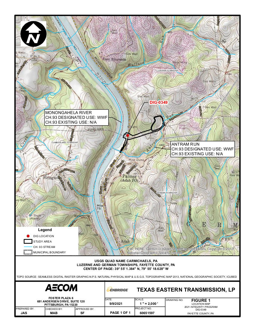
TEXAS EASTERN TRANS LP 2021 Integrity Program Fayette County 9 DIG-0349 GP-08 Temporary Road Crossings (New)
TEXAS EASTERN TRANS LP 2021 Integrity Program Fayette County 9 DIG-0349 BWM-GP-11 Maintenance, Testing, Repair, Rehabilitation or Replacement General Pmt (New)
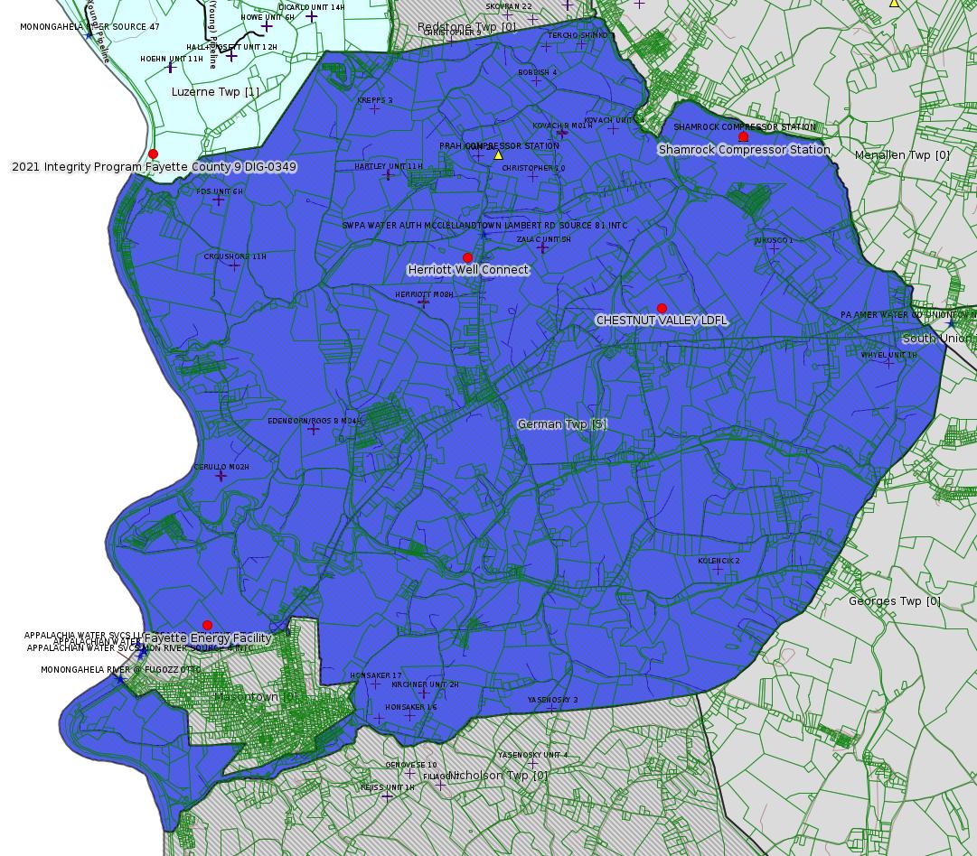
CHESTNUT VALLEY LDFL Landfill Permit Renewal (New)
APOLLO RESOURCES LLC/RUMBAUGH STA AQ GP 5 - Natural Gas Compression and/or Processing Facilities (New)
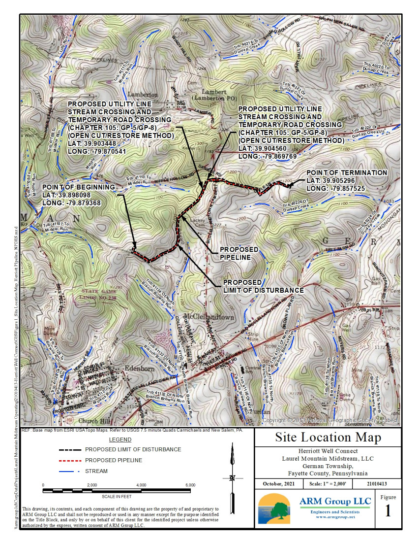
Herriott Well Connect GP-08 Temporary Road Crossings Issued 11/5/2021
Herriott Well Connect GP-05 Utility Line Stream Crossings Issued 11/5/2021
Herriott Well Connect Erosion and Sediment Control General Permit 3
CHESTNUT VALLEY LDFL Landfill Permit Reissue Withdrawn 11/2/2021
CHESTNUT VALLEY LDFL Major Facility Operating Permit Replaced 10/26/2021
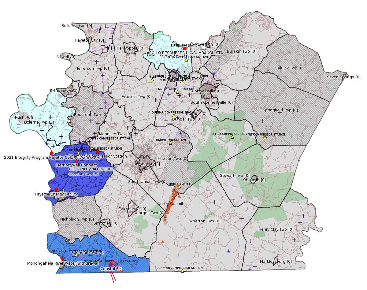
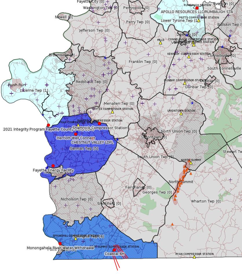
Red dots: items in this permit list with an exact location.
Blue stars: Marcellus Gas Well Water Sources.
Where well laterals are mapped they show in red; a 400-foot buffer surrounding the lateral shows in blue (lavender where it overlaps a mapped mineral tract).
Where mineral tracts are mapped, they show in pink. Mineral tracts can overlap; the overlap will show in red. The precise meaning of "mineral tract" is not clear.
Municipality shading: number of "facilities", with each well counting separately
(includes the red dots):
pale turquoise: 1
turquoise: 2
pale blue: 3
middle blue: 4
dark blue: 5
dark purple: 8
purple: 9
(Color coding may differ from one issue to the next.)
(Note if a project spans multiple municipalities -- e.g. a pipeline -- it will show in the count for each municipality.)
The number of facilities also follows the municipality name in brackets.
Municipality counts are based on the way the permit is listed by DEP; DEP has been known to get a municipality wrong.
Locations in brackets identify a precise location used to locate a surrogate for the actual site being permitted (e.g. locating a well pad or pipeline by the known location of a well.) Locations labeled beginning with "~" and ending in "[?]" are approximate and speculative based on inferences using on-line property and lease records. These are marked in the text as "[Approximate, Speculative]
Yellow triangles: Compressor Stations
Orange triangles: Storage Field Wells (currently Dominion North Summit Storage Field)
Crosses: SPUD Unconventional well permits
Green: "Natural areas", e.g. state game lands, state forests
More Maps
 |
 |
 |
 |
 |
Source: Pennsylvania Bulletin
NOTICES
DEPARTMENT OF
ENVIRONMENTAL PROTECTION
Public Notice of Draft NPDES General Permit for Discharges from Hydrostatic Testing of Tanks and Pipelines (PAG-10)
[51 Pa.B. 6706]
[Saturday, October 23, 2021]
The Department of Environmental Protection (Department) is announcing the availability of a draft National Pollutant Discharge Elimination System (NPDES) General Permit for Discharges from Hydrostatic Testing of Tanks and Pipelines (PAG-10). The draft General Permit and related documents are available on the Department's eLibrary at www.depgreenport.state.pa.us/elibrary/ (select ''Permit and Authorization Packages,'' then ''Clean Water,'' then ''PAG-10 NPDES General Permit for Discharges from Hydrostatic Testing of Tanks and Pipelines (NOI) 3800-PM-BCW0173'').
The PAG-10 General Permit is intended to provide NPDES permit coverage for the discharge of water used for the hydrostatic testing of existing or proposed tanks or pipelines, regardless of the contents of the tanks or pipelines. The General Permit may not be used to cover other types of discharges. The proposed Notice of Intent (NOI) fee is $2,500, to be paid in $500 annual increments.
The following substantive changes are proposed in the draft PAG-10 General Permit in comparison to the PAG-10 General Permit that is currently in effect, which has been administratively extended to July 10, 2022:
• Existing permittees must submit an NOI for continued coverage under the General Permit; the annual report will no longer be used to renew coverage.
• Permittees may opt to use best management practices other than those identified in the General Permit for preventing accelerated erosion from hydrostatic test water discharges if approved by the Department.
Written Comments
Interested persons are invited to submit written comments regarding the draft PAG-10 General Permit and associated documents through Monday, November 22, 2021. Comments submitted by facsimile will not be accepted. Comments, including comments submitted by e-mail, must include the commentator's name and address. Commentators are encouraged to submit comments using the Department's online eComment system at www.ahs.dep.pa.gov/eComment or by e-mail to ecomment@pa.gov. Written comments can be mailed to the Department of Environmental Protection, Policy Office, Rachel Carson State Office Building, P.O. Box 2063, Harrisburg, PA 17105-2063.
Written comments submitted during the 30-day comment period will be retained by the Department and considered when finalizing the General Permit. The Department will provide an opportunity for any interested person or group of persons, any affected state, any affected interstate agency, the United States Environmental Protection Agency or any interested agency, to request or petition for a public hearing with respect to the draft PAG-10 General Permit. The request or petition for public hearing, which must be filed within the 30-day period allowed for filing of written comments, must indicate the interest of the party filing the request and the reasons why a hearing is warranted. A hearing will be held if there is significant public interest.
Questions regarding the draft PAG-10 General Permit can be directed to Sean Furjanic at sefurjanic@pa.gov or (717) 787-2137.
PATRICK McDONNELL,
Secretary
<http://www.pacodeandbulletin.gov/Display/pabull?file=/secure/pabulletin/data/vol51/51-43/1767.html>
Documents are available here:
<http://www.depgreenport.state.pa.us/elibrary/GetFolder?FolderID=280685>
Draft Sample Permit:
<http://www.depgreenport.state.pa.us/elibrary/GetDocument?docId=3979487&DocName=04%20DRAFT%20-%20PAG-10%20PERMIT%20SAMPLE.PDF>
Fact Sheet:
<http://www.depgreenport.state.pa.us/elibrary/GetDocument?docId=3979560&DocName=09%20DRAFT%20-%20PAG-10%20FACT%20SHEET.PDF>
---
26-00535: Fayette Power Company, LLC (100 Energy Drive, Masontown, PA 15461), the Department intends to renew the Title V Operating Permit and Phase II Acid Rain Permit for the operation of a natural gas-fired power plant, known as the Fayette Energy Facility, located in German Township, Fayette County. The facility's air emission sources include: two (2) General Electric, Frame 7, natural gas-fired combined cycle combustion turbines (CCCT), rated at 1,920 MMBtu/hr maximum capacity, each, and controlled by oxidation catalysts and selective catalytic reduction (SCR). Each combined cycle gas turbine (CTG1, CTG2) is equipped with heat recovery steam generators (HRSG) which include a natural gas-fired duct burner and heat recovery steam rated at 589 MMBtu/hr each are part of each combined cycle train [total maximum heat input capacity of 2,509 MMBtu/hr, for each CGT], one (1) natural gas-fired auxiliary boiler, 30.6 MMBtu/hr; one (1) diesel-fired firewater pump engine, 265 hp; one (1) diesel-fired emergency generator engine, 489 hp and one (1) cooling tower. Turbine exhaust gases are treated with selective catalytic reduction (SCR) for NOx control, and an oxidation catalyst for VOC and CO control. The facility is limited to a maximum opacity from any processing equipment of 10 percent. The facility is a major stationary source as defined in Title I, Part D of the Clean Air Act Amendments due to its potential to emit (PTE) Nitrogen Oxide (NOx), Volatile Organic Compounds (VOC), Particulate Matter less than 10 microns (PM10), Particulate Matter less than 2.5 microns (PM2.5), Sulfur Oxides (SOx), and Carbon Monoxide (CO) emissions. This facility has the potential to emit the following type and quantity of pollutants (not including startup and shutdown emissions): 313 tons per year of PM10, 308 tons per year of PM2.5, 296.1 tons per year of NOx, 581 tons per year of CO, 90 tons per year of VOC, 128.9 tons per year of SOx, 9.6 tons per year of formaldehyde, 16.9 tons per year of HAPs, 166 tons per year of ammonia, and 2,590,616 tons of CO2e greenhouse gases. The permit includes emission limitations and operational, monitoring, testing, recordkeeping, work practices, and reporting requirements for the facility. This renewal action includes the incorporation of newly applicable regulations and the applicable changes authorized through Plan Approval 26-00535B for the Advanced Gas Path (AGP) project that involved select component replacement and changes to combustion control logic to increase the exhaust flow and increase efficiency. The facility is subject to the following regulatory provisions: 25 Pa. Code § 129.93, presumptive RACT requirements and 25 Pa. Code §§ 129.96—129.100 Additional Reasonably Available Control Technology (RACT) Requirements for Major Sources of NOx and VOC, Subpart KKKK—Standards of Performance for Stationary Combustion Turbines, Subpart ZZZZ—National Emissions Standards for Hazardous Air Pollutants for Stationary Reciprocating Internal Combustion Engines, 40 CFR 60, Subpart Dc—Standards of Performance for Small Industrial-Commercial-Institutional Steam Generating Units, 40 CFR 64—Compliance Assurance Monitoring, 40 CFR 72 EPA Acid Rain Permit Program Application, 40 CFR Part 97 Cross-State Air Pollution Rule (CSAPR)-Related Subparts that include: Subpart AAAAA, Subpart CCCCC, and 97 Subpart GGGGG, and State requirements. The 40 CFR 60, Subpart GG—Standards of Performance for Standards of Performance for Stationary Gas Turbines, 40 CFR 60, Subpart Da—Standards of Performance for Electric Utility Steam Generating Units and the 40 CFR 97 Subparts AA, AAA, and AAAA CAIR provisions no longer apply and have been removed from the permit.
All comments must be received prior to the close of business 30 days after the date of this publication. Each written comment must contain the name, address and telephone number of the person submitting the comments, identification of the proposed Operating Permit (specify Operating Permit OP-26-00535) and concise statements regarding the relevancy of the information or objections to issuance of the Operating Permit.
Comments or questions on this permit should be directed to Matthew Williams, Facilities Permitting Chief, NWRO Air Quality Program, at 814.332.6940. Those who wish to provide the Department with additional written information that they believe should be considered prior to the issuance of this Major Source Operating Permit may submit the information to Sheri L. Guerrieri, P.E. at shguerrier@pa.gov or Pennsylvania Department of Environmental Protection, 121 N. Mill Street, New Castle, PA 16101.
<http://www.pacodeandbulletin.gov/Display/pabull?file=/secure/pabulletin/data/vol51/51-44/1803a.html&continued=http://www.pacodeandbulletin.gov/Display/pabull?file=/secure/pabulletin/data/vol51/51-44/1803.html&d=>
Map URL: <http://www.openstreetmap.org/?mlat=39.857408&mlon=-79.913878#map=15/39.857408/-79.913878>
-------------------------
Please see the Disclaimer below regarding Parcel Id data.
Authorization ID: 1376617
Permit number: 26-00588B
Site: SHAMROCK COMP STA
Client: LAUREL MTN MIDSTREAM OPR LLC
Authorization type: Minor Facility Plan Approval New Source Performance Std
Application type: Extension
Authorization is for: FACILITY
Date received: 10/28/2021
Status: Pending
Permit Decision Guarantee Applies?: No
Sub-Facilities for Authorization:
Sub-Facility ID Sub-Facility Name Description
1288253 TSS - TURBINE SSM Process
Location: 39.918333,-79.825
Map URL: <http://www.openstreetmap.org/?mlat=39.918333&mlon=-79.825#map=15/39.918333/-79.825>
1284691 CAT 3516J CE-03 CAT OX Air Pollution Control Device
1284699 CAT 3516J CE-04 CAT OX Air Pollution Control Device
1284685 CAT G3516J COMPRESSOR ENGINE (CE-03) (1380 HP) Process
1284687 CAT G3516J COMPRESSOR ENGINE (CE-04) (1380 HP) Process
Location: 39.918333,-79.825
Map URL: <http://www.openstreetmap.org/?mlat=39.918333&mlon=-79.825#map=15/39.918333/-79.825>
1024427 CATERPILLAR G3516B COMPRESSOR ENGINE (CE-06) (1380 BHP) Process
Location: 39.918333,-79.825
Map URL: <http://www.openstreetmap.org/?mlat=39.918333&mlon=-79.825#map=15/39.918333/-79.825>
1087412 CATERPILLAR G3516B EMERGENCY GENERATOR (1,818 BHP)(EG-01) Process
1087413 CATERPILLAR G3516B EMERGENCY GENERATOR OXIDATION CATALYST Air Pollution Control Device
1185238 CBD - COMPRESSOR /FACILITY VENTING/BLOWDOWNS Process
1288248 CRP - COMPRESSOR ROD PACKING EMISSIONS Process
1288244 DGS - COMPRESSOR DRY GAS SEAL LEAKS Process
1288242 ECC - ENGINE CRANK CASE EMISSIONS Process
Location: 39.918333,-79.825
Map URL: <http://www.openstreetmap.org/?mlat=39.918333&mlon=-79.825#map=15/39.918333/-79.825>
1024438 ENGINE #6 OXIDATION CATALYST Air Pollution Control Device
1288250 ESU - ENGINE START UP Process
1185240 FUG SITE COMPONENT FUGITIVE EMISSIONS Process
1284697 GLYCOL PURIFICATION UNIT (GPU-ENG, GPU-HTR) Process
1185234 HEATERS/REBOILERS Process
1195984 PIG - PIGGING OPERATIONS Process
1024428 SOLAR MARS 100-16000S TURBINE (15,252 HP) (CT-01) Process
Location: 39.918333,-79.825
Map URL: <http://www.openstreetmap.org/?mlat=39.918333&mlon=-79.825#map=15/39.918333/-79.825>
1284695 SOLAR TITAN 130 -23502S (21,158 HP)(CT-02) Process
1284700 SOLAR TITAN SOLONOX COMBUSTION CONTROL Air Pollution Control Device
1045809 TANKS/VESSELS Process
Location: 39.918333,-79.825
Map URL: <http://www.openstreetmap.org/?mlat=39.918333&mlon=-79.825#map=15/39.918333/-79.825>
1024431 TEG DEHYDRATOR 1 (200 MMSCF/DAY) (DHY-01) Process
Location: 39.918333,-79.825
Map URL: <http://www.openstreetmap.org/?mlat=39.918333&mlon=-79.825#map=15/39.918333/-79.825>
1087369 TEG DEHYDRATOR 2 (200 MMSCF/DAY)(DHY-02) Process
Location: 39.918333,-79.825
Map URL: <http://www.openstreetmap.org/?mlat=39.918333&mlon=-79.825#map=15/39.918333/-79.825>
1288255 TLO - TRUCK LOADOUT Process
Permit Review Notes:
Date Review Note
11/18/2021 The technical review and decision review are complete and either the permit decision and/or permit issuance are forthcoming.
11/18/2021 The permit application package is complete, has been accepted, and is undergoing technical review.
<https://www.ahs.dep.pa.gov/eFACTSWeb/searchResults_singleAuth.aspx?AuthID=1376617>
Site Programs:
Air Quality
Site Municipalities:
German Twp, Fayette County
Map URL: <http://www.openstreetmap.org/?mlat=39.918333&mlon=-79.825#map=15/39.918333/-79.825>
Parcel ID: 15140026
---
Authorization ID: 1375594
Permit number: GP082605121-011
Site: 2021 Integrity Program Fayette County 9
Client: TEXAS EASTERN TRANS LP
Authorization type: GP-08 Temporary Road Crossings
Application type: New
Authorization is for: FACILITY
Date received: 11/09/2021
Status: Pending
Public_Permit_Review:
<http://www.ahs.dep.pa.gov/ePermitPublicAccess/Public/PublicAuthOverview?q=HXoM5N%2f%2bhD%2beIdcU7JU4RpPGgwWkzhZqKE27MCrhMxI%3d>
Permit Decision Guarantee Applies: No
Sub-Facilities for Authorization:
Sub-Facility ID Sub-Facility Name Description
1343662 Access Road Temporary Wetland Impact
Location: 39.91705,-79.9219
Map URL: <http://www.openstreetmap.org/?mlat=39.91705&mlon=-79.9219#map=15/39.91705/-79.9219>
1343663 W-MRK-087 Mat/Pads
Location: 39.91705,-79.9219
Map URL: <http://www.openstreetmap.org/?mlat=39.91705&mlon=-79.9219#map=15/39.91705/-79.9219>
1343661 S-MRK-045 Bridge
Location: 39.91705,-79.9219
Map URL: <http://www.openstreetmap.org/?mlat=39.91705&mlon=-79.9219#map=15/39.91705/-79.9219>
1343666 River Street Temporary Stream Impact
Location: 39.91705,-79.9219
Map URL: <http://www.openstreetmap.org/?mlat=39.91705&mlon=-79.9219#map=15/39.91705/-79.9219>
1343664 W-MRK-088 Mat/Pads
Location: 39.91705,-79.9219
Map URL: <http://www.openstreetmap.org/?mlat=39.91705&mlon=-79.9219#map=15/39.91705/-79.9219>
1343665 River Street Temporary Floodway Impact
Location: 39.91705,-79.9219
Map URL: <http://www.openstreetmap.org/?mlat=39.91705&mlon=-79.9219#map=15/39.91705/-79.9219>
<https://www.ahs.dep.pa.gov/eFACTSWeb/searchResults_singleAuth.aspx?AuthID=1375594>
Site Programs:
Water Planning and Conservation
Site Municipalities:
German Twp, Fayette County
Luzerne Twp, Fayette County
Project Map:
<https://www.ahs.dep.pa.gov/ePermitPublicAccess/Public/DownloadFileFromWebServer/105120?onBaseDocId=4003532>
Project Description:
<https://www.ahs.dep.pa.gov/ePermitPublicAccess/Public/DownloadFileFromWebServer/105121?onBaseDocId=4003887>
Presumed Parcel Id: 19360002
[See Notes.]
---
Authorization ID: 1375593
Permit number: GP112605121-032
Site: 2021 Integrity Program Fayette County 9
Client: TEXAS EASTERN TRANS LP
Authorization type: BWM-GP-11 Maintenance, Testing, Repair, Rehabilitation or Replacement General Pmt
Application type: New
Authorization is for: FACILITY
Date received: 11/09/2021
Status: Pending
Public_Permit_Review:
<http://www.ahs.dep.pa.gov/ePermitPublicAccess/Public/PublicAuthOverview?q=AaQsb4Fxue5zBj8KhK%2fsmzuaep4KqnbdhhgCu0r7n6k%3d>
Permit Decision Guarantee Applies: Yes
Permit Decision Guarantee status: ACTIVE
Sub-Facilities for Authorization:
Sub-Facility ID Sub-Facility Name Description
1343668 S-MRK-042 Floodway Activity
Location: 39.91705,-79.9219
Map URL: <http://www.openstreetmap.org/?mlat=39.91705&mlon=-79.9219#map=15/39.91705/-79.9219>
1343669 Access Road Stream Direct Impact
Location: 39.91705,-79.9219
Map URL: <http://www.openstreetmap.org/?mlat=39.91705&mlon=-79.9219#map=15/39.91705/-79.9219>
1343670 Access and workspace Temporary Floodway Impact
Location: 39.91705,-79.9219
Map URL: <http://www.openstreetmap.org/?mlat=39.91705&mlon=-79.9219#map=15/39.91705/-79.9219>
1343667 S-MRK-039 Bridge
Location: 39.91705,-79.9219
Map URL: <http://www.openstreetmap.org/?mlat=39.91705&mlon=-79.9219#map=15/39.91705/-79.9219>
<https://www.ahs.dep.pa.gov/eFACTSWeb/searchResults_singleAuth.aspx?AuthID=1375593>
Site Programs:
Water Planning and Conservation
Site Municipalities:
German Twp, Fayette County
Luzerne Twp, Fayette County
---
Authorization ID: 1375249
Permit number: 100419
Site: CHESTNUT VALLEY LDFL
Client: CHESTNUT VALLEY LDFL LLC
Authorization type: Landfill Permit
Application type: Renewal
Authorization is for: FACILITY
Date received: 11/05/2021
Status: Pending
Permit Decision Guarantee Applies: No
<https://www.ahs.dep.pa.gov/eFACTSWeb/searchResults_singleAuth.aspx?AuthID=1375249>
Site Programs:
Air Quality
Clean Water
Environmental Cleanup & Brownfields
Mining
Radiation Protection
Waste Management
Water Planning and Conservation
Site Municipalities:
German Twp, Fayette County
Map URL: <http://www.openstreetmap.org/?mlat=39.896749&mlon=-79.838809#map=15/39.896749/-79.838809>
Presumed Parcel Id: 15280012
---
Authorization ID: 1373400
Permit number: GP5-26-00483E
Site: APOLLO RESOURCES LLC/RUMBAUGH STA
Client: APOLLO RESOURCES LLC
Authorization type: AQ GP 5 - Natural Gas Compression and/or Processing Facilities
Application type: New
Authorization is for: FACILITY
Date received: 10/08/2021
Status: Pending
Permit Decision Guarantee Applies: No
<https://www.ahs.dep.pa.gov/eFACTSWeb/searchResults_singleAuth.aspx?AuthID=1373400>
Site Programs:
Air Quality
Site Municipalities:
Lower Tyrone Twp, Fayette County
AQ_AEP Details:
CLIENT_ID: 306576
CLIENT: APOLLO RESOURCES LLC
CLIENT_TYPE: NON-GOVERNMENT
CLIENT_ADDRESS1: PO BOX 423
CLIENT_ADDRESS2: 187 SECOND ST
CLIENT_CITY: VINTONDALE
CLIENT_STATE: PA
CLIENT_ZIP: 15961-0423
SITE_ID: 522629
PRIMARY_FACILITY_ID: 562423
PRIMARY_FACILITY_NAME: APOLLO RESOURCES LLC/RUMBAUGH COMP STA
NAICS_CODE: 211130
NAICS_DESCRIPTION: Natural Gas Extraction
PRIMARY_FACILITY_STATUS: Active
FACILITY_TYPE: 80% Synthetic Minor
REGION: Southwest Regional Office
COUNTY: Fayette
MUNICIPALITY: Lower Tyrone Twp
LATITUDE: 40.084722
LONGITUDE: -79.636667
LOCATION_ADDRESS1: 1177 CUNNINGHAM BRIDGE RD
LOCATION_ADDRESS2:
LOCATION_CITY: DAWSON
LOCATION_STATE: PA
LOCATION_ZIP: 15428-1198
CONTACT_NAME:
CONTACT_PHONE:
CONTACT_EMAIL:
Location: 40.084722,-79.636667
Map URL: <http://www.openstreetmap.org/?mlat=40.084722&mlon=-79.636667#map=15/40.084722/-79.636667>
Presumed Parcel Id: 18050023
---
Authorization ID: 1372024
Permit number: GP082607121-008
Site: Herriott Well Connect
Client: LAUREL MTN MIDSTREAM OPR LLC
Authorization type: GP-08 Temporary Road Crossings
Application type: New
Authorization is for: FACILITY
Date received: 10/07/2021
Status: Issued on 11/5/2021
Public_Permit_Review:
<http://www.ahs.dep.pa.gov/ePermitPublicAccess/Public/PublicAuthOverview?q=Eivk%2fDRwXe%2b5mMbKkq3AFXQpOfFjsneQWVwEqZDPbZM%3d>
Permit Decision Guarantee Applies: No
Sub-Facilities for Authorization:
Sub-Facility ID Sub-Facility Name Description
1341347 UNT 2 to TRIB 41110 of Middle Run (GP-8) Bridge
1341346 UNT 1 to TRIB 41110 of Middle Run (GP-8) Bridge
1341349 Stream Impacts (GP-8) Temporary Stream Impact
1341348 Floodway Impacts (GP-8) Temporary Floodway Impact
Permit Review Notes:
Date Review Note
11/5/2021 The technical review and decision review are complete and either the permit decision and/or permit issuance are forthcoming.
10/20/2021 The permit application package is complete, has been accepted, and is undergoing technical review.
<https://www.ahs.dep.pa.gov/eFACTSWeb/searchResults_singleAuth.aspx?AuthID=1372024>
Site Programs:
Water Planning and Conservation
Site Municipalities:
German Twp, Fayette County
Location (Herriott end): 39.898098, -79.879368
Location (Zalac end): 39.905296, 79.857525
Project Map:
<https://www.ahs.dep.pa.gov/ePermitPublicAccess/Public/DownloadFileFromWebServer/102186?onBaseDocId=3958369>
[See Notes.]
Authorization ID: 1372023
Permit number: GP052607121-009
Site: Herriott Well Connect
Client: LAUREL MTN MIDSTREAM OPR LLC
Authorization type: GP-05 Utility Line Stream Crossings
Application type: New
Authorization is for: FACILITY
Date received: 10/07/2021
Status: Issued on 11/5/2021
Public_Permit_Review:
<http://www.ahs.dep.pa.gov/ePermitPublicAccess/Public/PublicAuthOverview?q=8EopiOhP44PelqtfuJD%2fwP5SF8BEUYgxg%2f6OlquFtn8%3d>
Permit Decision Guarantee Applies: Yes
Permit Decision Guarantee status: ACTIVE
Sub-Facilities for Authorization:
Sub-Facility ID Sub-Facility Name Description
1341350 UNT 1 to TRIB 41110 of Middle Run (GP-5) Pipeline or Conduit
1341351 UNT 2 to TRIB 41110 of Middle Run (GP-5) Pipeline or Conduit
1341352 Stream Impacts (GP-5) Stream Direct Impact
1341353 Floodway Impacts (GP-5) Floodway Direct Impact
Permit Review Notes:
Date Review Note
11/5/2021 The technical review and decision review are complete and either the permit decision and/or permit issuance are forthcoming.
10/20/2021 The permit application package is complete, has been accepted, and is undergoing technical review.
<https://www.ahs.dep.pa.gov/eFACTSWeb/searchResults_singleAuth.aspx?AuthID=1372023>
Site Programs:
Water Planning and Conservation
Site Municipalities:
German Twp, Fayette County
---
Authorization ID: 1372022
Permit number: ESG072621001-00
Site: Herriott Well Connect
Client: LAUREL MTN MIDSTREAM OPR LLC
Authorization type: Erosion and Sediment Control General Permit 3
Application type: New
Authorization is for: SITE
Date received: 10/07/2021
Status: Pending
Public_Permit_Review:
<http://www.ahs.dep.pa.gov/ePermitPublicAccess/Public/PublicAuthOverview?q=X2uMsUwt38YWEDPOFF1G0F0gYgkCAvs6LUmWSsrQcW8%3d>
Permit Decision Guarantee Applies: Yes
Permit Decision Guarantee status: VOID
Permit Review Notes:
Date Review Note
10/19/2021 Applicant has been issued a deficiency letter. If applicable, this application no longer qualifies for the Permit Decision Guarantee.
10/18/2021 Applicant has been issued a deficiency letter. If applicable, this application no longer qualifies for the Permit Decision Guarantee.
<https://www.ahs.dep.pa.gov/eFACTSWeb/searchResults_singleAuth.aspx?AuthID=1372022>
Site Programs:
Site Municipalities:
German Twp, Fayette County
---
Authorization ID: 1343740
Permit number: 100419
Site: CHESTNUT VALLEY LDFL
Client: CHESTNUT VALLEY LDFL LLC
Authorization type: Landfill Permit
Application type: Reissue
Authorization is for: FACILITY
Date received: 02/23/2021
Status: Withdrawn on 11/2/2021
Permit Decision Guarantee Applies: No
Sub-Facilities for Authorization:
Sub-Facility ID Sub-Facility Name Description
212043 J&J LANDFILL Landfill
Location: 39.896749,-79.838809
Map URL: <http://www.openstreetmap.org/?mlat=39.896749&mlon=-79.838809#map=15/39.896749/-79.838809>
<https://www.ahs.dep.pa.gov/eFACTSWeb/searchResults_singleAuth.aspx?AuthID=1343740>
Site Programs:
Air Quality
Clean Water
Environmental Cleanup & Brownfields
Mining
Radiation Protection
Waste Management
Water Planning and Conservation
Site Municipalities:
German Twp, Fayette County
Authorization ID: 1309840
Permit number: 26-00402
Site: CHESTNUT VALLEY LDFL
Client: CHESTNUT VALLEY LDFL LLC
Authorization type: Major Facility Operating Permit
Application type: Amendment
Authorization is for: FACILITY
Date received: 01/27/2020
Status: Replaced on 10/26/2021
Permit Decision Guarantee Applies: No
Permit Review Notes:
Date Review Note
3/20/2020 Applicant has been issued a deficiency letter. If applicable, this application no longer qualifies for the Permit Decision Guarantee.
3/20/2020 Applicant has been issued a deficiency letter. If applicable, this application no longer qualifies for the Permit Decision Guarantee.
<https://www.ahs.dep.pa.gov/eFACTSWeb/searchResults_singleAuth.aspx?AuthID=1309840>
Site Programs:
Air Quality
Clean Water
Environmental Cleanup & Brownfields
Mining
Radiation Protection
Waste Management
Water Planning and Conservation
Site Municipalities:
German Twp, Fayette County
-------------------------
NOTIFICATION_ID: 58261
OGO: 51036
OPERATOR: INR OPR LLC
API_PERMIT: 051-24724
SPUD_DATE: 08/13/2021
COUNTY: Fayette
MUNICIPALITY: Springhill
LATITUDE: 39.73393
LONGITUDE: -79.80003
SUBJECT: [NOTIFICATION]: Stimulation notification 58 Pa. C.S. 3211(f)(2) for well API 37-051-24724-00-00
QUESTION: Date and approximate time action is to occur
ANSWER: Date: 11/02/2021 Time: 07:00 AM
SENT_DATE: 10/29/2021 2:49:23 PM
SENT_SUCCESS: Yes
LAST_RESENT_DATE:
RESENT_SUCCESS:
REGION: EP DOGO SWDO Dstr Off
Well Details:
Permit Number: 051-24724
Well Name: Coastal 6H
Unconventional Well: Y
Well Configuration: Horizontal Well
Well Type: GAS
Well Status: Active
Coal Association: NonCoal
Conservation Well: N
Primary Facility ID: 848117
Site ID: 739525
Site Name: COASTAL 1H FLOW BACK PIT FRESHWATER PITS ESCGP-EXPEDITED
Well Pad ID: 147971
Well Pad Name: COASTAL WELL PAD
Storage Field:
Operator: INR OPR LLC
Operator Number: OGO-51036
Permit Date: 2021-03-26
Permit Date Expires: 2022-03-26
SPUD Date: 2021-08-13
Date Plugged:
UIC ID:
UIC Type:
Surface Elevation: 1138
County: Fayette
Municipality: Springhill Twp
Location: 39.73393,-79.80003
Map URL: <http://www.openstreetmap.org/?mlat=39.73393&mlon=-79.80003#map=15/39.73393/-79.80003>
[See Notes.]
---
NOTIFICATION_ID: 58262
OGO: 51036
OPERATOR: INR OPR LLC
API_PERMIT: 051-24725
SPUD_DATE: 08/13/2021
COUNTY: Fayette
MUNICIPALITY: Springhill
LATITUDE: 39.73396
LONGITUDE: -79.79999
SUBJECT: [NOTIFICATION]: Stimulation notification 58 Pa. C.S. 3211(f)(2) for well API 37-051-24725-00-00
QUESTION: Date and approximate time action is to occur
ANSWER: Date: 11/02/2021 Time: 07:00 AM
SENT_DATE: 10/29/2021 2:50:06 PM
SENT_SUCCESS: Yes
LAST_RESENT_DATE:
RESENT_SUCCESS:
REGION: EP DOGO SWDO Dstr Off
Permit Number: 051-24725
Well Name: Coastal 8H
Unconventional Well: Y
Well Configuration: Horizontal Well
Well Type: GAS
Well Status: Active
Coal Association: NonCoal
Conservation Well: N
Primary Facility ID: 848119
Site ID: 739525
Site Name: COASTAL 1H FLOW BACK PIT FRESHWATER PITS ESCGP-EXPEDITED
Well Pad ID: 147971
Well Pad Name: COASTAL WELL PAD
Storage Field:
Operator: INR OPR LLC
Operator Number: OGO-51036
Permit Date: 2021-03-26
Permit Date Expires: 2022-03-26
SPUD Date: 2021-08-13
Date Plugged:
UIC ID:
UIC Type:
Surface Elevation: 1138
County: Fayette
Municipality: Springhill Twp
Location: 39.73396,-79.79999
Map URL: <http://www.openstreetmap.org/?mlat=39.73396&mlon=-79.79999#map=15/39.73396/-79.79999>
---
NOTIFICATION_ID: 58263
OGO: 51036
OPERATOR: INR OPR LLC
API_PERMIT: 051-24726
SPUD_DATE: 09/01/2021
COUNTY: Fayette
MUNICIPALITY: Springhill
LATITUDE: 39.73399
LONGITUDE: -79.79996
SUBJECT: [NOTIFICATION]: Stimulation notification 58 Pa. C.S. 3211(f)(2) for well API 37-051-24726-00-00
QUESTION: Date and approximate time action is to occur
ANSWER: Date: 11/02/2021 Time: 07:00 AM
SENT_DATE: 10/29/2021 2:56:18 PM
SENT_SUCCESS: Yes
LAST_RESENT_DATE:
RESENT_SUCCESS:
REGION: EP DOGO SWDO Dstr Off
Permit Number: 051-24726
Well Name: Coastal 10H
Unconventional Well: Y
Well Configuration: Deviated Well
Well Type: GAS
Well Status: Active
Coal Association: NonCoal
Conservation Well: N
Primary Facility ID: 851454
Site ID: 739525
Site Name: COASTAL 1H FLOW BACK PIT FRESHWATER PITS ESCGP-EXPEDITED
Well Pad ID: 147971
Well Pad Name: COASTAL WELL PAD
Storage Field:
Operator: INR OPR LLC
Operator Number: OGO-51036
Permit Date: 2021-08-30
Permit Date Expires: 2022-08-30
SPUD Date: 2021-09-01
Date Plugged:
UIC ID:
UIC Type:
Surface Elevation: 1138
County: Fayette
Municipality: Springhill Twp
Location: 39.73399,-79.79996
Map URL: <http://www.openstreetmap.org/?mlat=39.73399&mlon=-79.79996#map=15/39.73399/-79.79996>
OPERATOR: INR OPR LLC
INSPECTION_ID: 3274473
INSPECTION_DATE: 10/29/2021
INSPECTION_TYPE: Administrative/File Review
API_PERMIT: 051-24726
FARM_NAME: Coastal 10H
UNCONVENTIONAL: Yes
SITE_ID: 739525
SITE_NAME: COASTAL 1H FLOW BACK PIT FRESHWATER PITS ESCGP-EXPEDITED
FACILITY_TYPE: Oil & Gas Location
INSPECTION_CATEGORY: Primary Facility
REGION: EP DOGO SWDO Dstr Off
COUNTY: Fayette
MUNICIPALITY: Springhill Twp
INSPECTOR: CISLO, JOHN
INSPECTION_SOURCE: SAIR
INSPECTION_RESULT_DESCRIPTION: Viol(s) Noted & Immediately Corrected
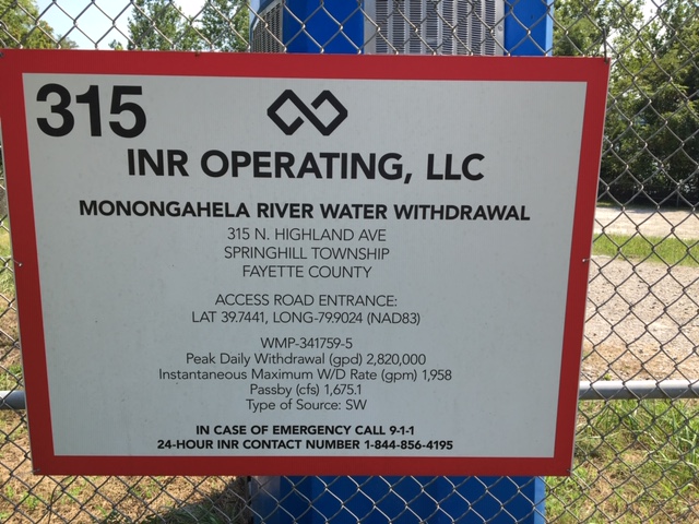
INSPECTION_COMMENT: Administrative inspection conducted to document information received from the Operator concerning WMP-341759-5 which supports operations at INR Operating's Coastal Wells. Operator reported that this withdrawal point has been utilized once this year (2021). Operator reported 32,340 gallons of water was withdrawn on 08/13/2021 which was within the conditions set forth WMP-341759-5. The Operator reported the passby (cfs) of the Monongahela River was at 703 cfs at time of withdrawal on 08/13/2021. The permitted passby level of the river is 1,675 cfs. This is a violation of WMP-341759-5 and special condition 1 of Unconventional Well Permit 051-24726 which is supported by WMP-341759-5. Notice of violation is being cited and closed for violation of 25 Pa Code 78a12, 78a69(e) and 78a69(e)2. Operator was reminded to conduct instream flow monitoring and measuring to ensure they are meeting the requirements of Well Permit 051-24726 and WMP-341759-5 in the future.
VIOLATION_ID: 935139
VIOLATION_DATE: 10/29/2021
VIOLATION_CODE: 78.12 - COMPLIANCE WITH PERMITS - Failure to comply with terms and conditions of permit or registration while drilling, altering or operating an oil or gas well.
VIOLATION_TYPE: Administrative
VIOLATION_COMMENT: Failure to comply with the terms and conditions of permit; specifically, special condition #1.
RESOLVED_DATE: 11/01/2021
RESOLUTION_REASON_CODE_DESC: CRCTD - Corrected/Abated
CONTINUING_VIOLATION:
ENFORCEMENT_ID:
ENFORCEMENT_CODE_DESCRIPTION:
DATE_EXECUTED:
ENFORCEMENT_FINAL_DATE:
ENFORCEMENT_FINAL_STATUS:
PENALTY_FINAL_DATE:
PENALTY_FINAL_STATUS_CODE_DESC:
PENALTY_AMOUNT:
TOTAL_AMOUNT_COLLECTED:
VIOLATION_ID: 935137
VIOLATION_DATE: 10/29/2021
VIOLATION_CODE: 78a69(e) - WATER MANAGEMENT PLANS - Operational Requirements - Person failed to comply with Department approved water management plan.
VIOLATION_TYPE: Environmental Health & Safety
VIOLATION_COMMENT:
RESOLVED_DATE: 11/01/2021
RESOLUTION_REASON_CODE_DESC: CRCTD - Corrected/Abated
CONTINUING_VIOLATION:
ENFORCEMENT_ID:
ENFORCEMENT_CODE_DESCRIPTION:
DATE_EXECUTED:
ENFORCEMENT_FINAL_DATE:
ENFORCEMENT_FINAL_STATUS:
PENALTY_FINAL_DATE:
PENALTY_FINAL_STATUS_CODE_DESC:
PENALTY_AMOUNT:
TOTAL_AMOUNT_COLLECTED:
VIOLATION_ID: 935138
VIOLATION_DATE: 10/29/2021
VIOLATION_CODE: 78A69(E)2_ - WATER MANAGEMENT PLANS - Operational Requirements – Person failed to conduct instream flow monitoring and measuring for passby flows using methods acceptable to the Department.
VIOLATION_TYPE: Environmental Health & Safety
VIOLATION_COMMENT:
RESOLVED_DATE: 11/01/2021
RESOLUTION_REASON_CODE_DESC: CRCTD - Corrected/Abated
CONTINUING_VIOLATION:
ENFORCEMENT_ID:
ENFORCEMENT_CODE_DESCRIPTION:
DATE_EXECUTED:
ENFORCEMENT_FINAL_DATE:
ENFORCEMENT_FINAL_STATUS:
PENALTY_FINAL_DATE:
PENALTY_FINAL_STATUS_CODE_DESC:
PENALTY_AMOUNT:
TOTAL_AMOUNT_COLLECTED:
Water withdrawal Intake Structure Details:
[See Notes.]Authorization ID: 1328463
Permit number: GP042607120-028
Site: Monongahela River Water Withdrawal
Client: INR OPR LLC
Authorization type: GP-04 Intake & Outfall Structures
Application type: New
Authorization is for: FACILITY
Date received: 09/22/2020
Status: Issued on 11/20/2020
Public_Permit_Review:
<http://www.ahs.dep.pa.gov/ePermitPublicAccess/Public/PublicAuthOverview?q=fXP%2bJj7SNtsF5Ap9Gxa%2fX%2fS5Lm4K0gxSLYGLYl1EfOo%3d>
Permit Decision Guarantee Applies: No
Permit Review Notes:
Date Review Note
11/20/2020 The technical review and decision review are complete and either the permit decision and/or permit issuance are forthcoming.
10/20/2020 Applicant has been issued a deficiency letter. If applicable, this application no longer qualifies for the Permit Decision Guarantee.
10/9/2020 The permit application package is complete, has been accepted, and is undergoing technical review.
<https://www.ahs.dep.pa.gov/eFACTSWeb/searchResults_singleAuth.aspx?AuthID=1328463>
Site Programs:
Water Planning and Conservation
Site Municipalities:
Springhill Twp, Fayette County
Location: 39.744139,-79.902410
Map URL: <http://www.openstreetmap.org/?mlat=39.744139&mlon=-79.90241#map=15/39.744139/-79.90241>
Presumed Parcel Id: 36100015
-------------------------
The Project Description for the 2021 Integrity Program Fayette County 9 project includes the following introduction:
"During recent integrity inspections conducted as part of a maintenance program, Texas Eastern Transmission, LP (Texas Eastern or TETLP), a wholly-owned subsidiary of Enbridge Energy Company, Inc. (Enbridge), identified anomalies along existing transmission pipelines extending from Delmont, Pennsylvania (PA) to the PA/New Jersey border and southwest to the PA/West Virginia border. These identified anomaly locations must be excavated to determine the nature of the anomalies and to determine if repair or replacement is necessary. The proposed program includes anomaly excavations and repairs throughout PA.
Construction activities associated with this maintenance program may entail temporary impact to regulated wetlands and watercourses. Due to the location of the anomalies within existing pipeline right-of-ways (ROWs), avoidance of resource impacts is not always possible. In the design of the maintenance program, Texas Eastern attempted to minimize these and other environmental impacts to the greatest extent practicable. The proposed construction activities associated with the repair and replacement of Dig 0349 will be conducted on a 36-inch pipe at an existing railroad crossing and adjacent additional new ROW that is surrounded primarily by mixed forest land use in Fayette County."
The phrase "identified anomalies" probably refers to corrosion discovered by use of a device known as a "Smart Pig".
The full project description is fairly extensive and worth reading.
---
Laurel Mountain Midstream, LLC (LMM) intends to construct an approximate 8,943-foot long, 16-inch diameter underground steel natural gas pipeline. The purpose of the project is to support LMM’s natural gas operations from the Marcellus shale formation, which provides a key source of energy for the United States. The Herriott Well Connect will begin at the existing Herriott Well Pad at 39.898098°, -79.879368° and extend to the northeast to the existing Zalac Well Pad at 39.905296°, 79.857525°. The total project area and limit of disturbance for the Herriott Well Connect consists of approximately 16.3 acres.
---
INR seems not to have sent any pressure test notifications to DEP prior to fracking the wells Coastal 6H, 8H, 10H. It is not clear whether this was simply a notification failure or whether they didn't actually do any pressure testing. Fracking without pressure testing would be at best outrageously irresponsible.
---
Duane Nichols sends the following recent photograph of the water withdrawal location associated with Inspection ID 3274473 above:
------------------------
<https://www.dep.pa.gov/PublicParticipation/OfficeofEnvironmentalJustice/Pages/default.aspx>). There are supposed to be enhanced public participation requirements for permits in environmental justice areas, but news of this actually ever happening is scarce. In Fayette County, the entirety of Redstone, Springhill, Nicholson, and German Townships are environmental justice areas, as well as a large part of Dunbar Township. DEP's policy document on public participation guidelines for environmental justice areas is located here:
<https://www.elibrary.dep.state.pa.us/dsweb/Get/Version-48671/012-0501-002.pdf>
eNOTICE records are likely to list the same permit multiple times, as that permit moves through the DEP process.
Oil & Gas Wells designated with a site a number and the letter H typically designate horizontal wells.
-------------------------
Resources:
Pennsylvania Bulletin: <https://www.pabulletin.com/>
eNOTICE: <https://www.ahs2.dep.state.pa.
DEP Oil and Gas Reports: <https://www.dep.pa.gov/DataandTools/Reports/Oil%20and%20Gas%20Reports/Pages/default.aspx>
DEP Permits Issued Detail Report:
<http://cedatareporting.pa.gov/Reportserver/Pages/ReportViewer.aspx?/Public/DEP/OG/SSRS/Permits_Issued_Detail>
DEP SPUD (drilling started) Report:
<http://cedatareporting.pa.gov/Reportserver/Pages/ReportViewer.aspx?/Public/DEP/OG/SSRS/Spud_External_Data>
DEP Oil and Gas Compliance Report:
<http://cedatareporting.pa.gov/Reportserver/Pages/ReportViewer.aspx?/Public/DEP/OG/SSRS/OG_Compliance>
DEP PA Oil & Gas Mapping:
<https://www.depgis.state.pa.us/PaOilAndGasMapping>
Data Portal Services Directory [Technical]
<https://www.depgis.state.pa.us/arcgis/rest/services>
Query: Oil and Gas Wells All (ID: 3) [Technical]:
<https://www.depgis.state.pa.us/arcgis/rest/services/OilGas/OilGasAllStrayGasEGSP/MapServer/3/query?where=&text=&objectIds=&time=&geometry=&geometryType=esriGeometryEnvelope&inSR=&spatialRel=esriSpatialRelIntersects&relationParam=&outFields=*&returnGeometry=true&returnTrueCurves=false&maxAllowableOffset=&geometryPrecision=&outSR=&returnIdsOnly=false&returnCountOnly=false&orderByFields=&groupByFieldsForStatistics=&outStatistics=&returnZ=false&returnM=false&gdbVersion=&returnDistinctValues=false&resultOffset=&resultRecordCount=&f=html>
(Be sure to enter a Where clause in SQL format. Dates are in milliseconds since midnight 1/1/1970).
DEP Oil and Gas Electronic Submissions
<https://www.ahs.dep.pa.gov/eSubmissionPublicSearch>
DEP Air Quality Air Emission Plants Facilities Report
<http://cedatareporting.pa.gov/Reportserver/Pages/ReportViewer.aspx?/Public/DEP/AQ/SSRS/AQ_AEP_Facilities>
DEP Oil and Gas Electronic Notifications
<http://cedatareporting.pa.gov/Reportserver/Pages/ReportViewer.aspx?/Public/DEP/OG/SSRS/OG_Notifications>
DEP Oil and Gas Well Pad Report
<http://cedatareporting.pa.gov/Reportserver/Pages/ReportViewer.aspx?/Public/DEP/OG/SSRS/Well_Pads>
Fayette County Assessment Office Search For Tax Records:
<http://property.co.fayette.pa.us/search.aspx>
Pennsylvania Spatial Data Access:
<https://www.pasda.psu.edu/default.asp>
DEP Spatial Data Repository:
<ftp://www.pasda.psu.edu/pub/pasda/dep/>
National Response Center:
<https://www.nrc.uscg.mil/>
EPA-Echo: <https://www.epa-echo.gov/echo/
FERC citizen involvement: <https://www.ferc.gov/for-citiz
<https://www.ferc.gov/docs-fili
Follow the directions and enter the docket number to subscribe to.
Township Supervisors receive information regarding Erosion & Sedimentation permits, and these records may be reviewable at township municipal offices.
DEP permits are reviewable through the File Review process, for application to do file review see: <https://www.portal.state.pa.us/portal/server.pt/community/southwest_regional_office/13775/file_review/593164>
Environmental Hearing Board: <https://ehb.courtapps.com/publ
PA DEP Environmental Policy Comment System:
<https://www.ahs.dep.pa.gov/eComment/>
Federal Register Environment: <https://www.federalregister.g
SkyTruth Fayette County Drilling Alerts: <https://frack.skytruth.org/pen
U.S. Army Corps of Engineers, Pittsburgh District, Public Notices:
<https://www.lrp.usace.army.mil/Missions/Regulatory/Public-Notices/>
EPA Pennsylvania Public Notices: <https://www2.epa.gov/aboutepa/epa-pennsylvania#notice>
Energy Assurance Daily: <https://www.oe.netl.doe.gov/ead.aspx>
-------------------------
Disclaimers:
This compilation from the above sources was done in part by hand using copy and paste and in part using automated methods; it may omit relevant permits.
Parcel data is provided via the tax records search web page offered by the Fayette County Assessment Office (http://property.co.fayette.pa.us/). Presumed Parcel Id links are subject to availability provided by that agency and associated web sites. Presumed Parcel Ids are determined as the mapped parcel containing a given latitude and longitude, are a best effort determination which is subject to error, and are not official. In cases where a facility is leased and there is a separate parcel id for the lease, if this parcel id is not separately mapped, the parcel id shown will be the id for the enclosing parcel. Parcel owners may be surface owners only and may or may not have any relationship to oil & gas facilities.
Does not currently include water supply permits. Does not include landfill permits even though many such are for Marcellus Shale waste. (It is not possible at this time to distinguish which landfill permits are for Marcellus Shale waste and which are not without doing File Review for each permit.)
Erosion & Sedimentation permit records do not currently include latitude and longitude. Where I am publishing latitude and longitude with E&S permits it is by inferring an associated well permit and using published latitude and longitude for the well. It is possible I may be inferring the wrong well site.
Municipalities are shown from eFACTS records on the DEP web site. The DEP has been known to list a municipality incorrectly.