The Harmed Success Stories Concepts How To What Is Commentary
Fayette County Marcellus Shale Permits 11/2/20 - 11/15/20
Contents
Pennsylvania Bulletin Listings
[No Activity]eFACTS Listings
SHAMROCK COMP STA Minor Facility Plan Approval New Source Performance Std Extension (New)Oil and Gas Electronic Notifications
YODER WELL PAD Expedited E&S Stormwater General Permit 1 [Termination?] Notification Issued 10/29/2020
WHYEL UNIT 1H Drill & Operate Well Permit Inactive Status
WASIL 1 Drill & Operate Well Permit Inactive Status
FIKE UNIT 1H Drill & Operate Well Permit Inactive Status
COASTAL 4H Casing cementing notification Production Casing: 11/11/2020Inspection Issues
STATE GAME LANDS 51B 3 Fluid near top of secondary containment; equipment should have been removed; Violation(s) NotedPrice of Natural Gas
STATE GAME LANDS 51B 1 Fluid near top of secondary containment
ROWAN H. HEYN 3 Stained brine tank may indicate prior spill
R.E. EBERLY FMLY INDIANA CREEK 1 Stained brine tank may indicate prior spill
G.E. KLAYER 1 Small leak
G.E. KLAYER 2 Valve with excessive rust
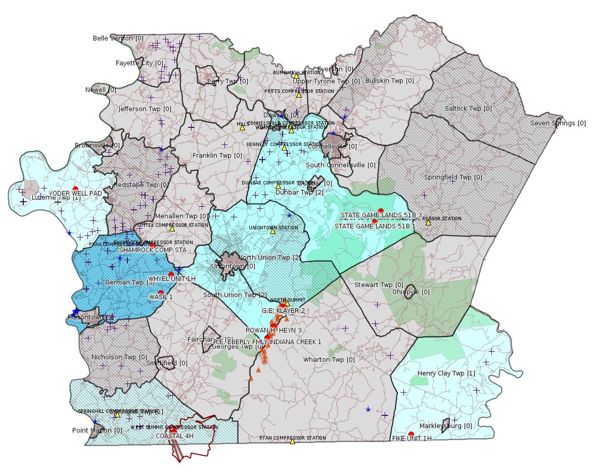
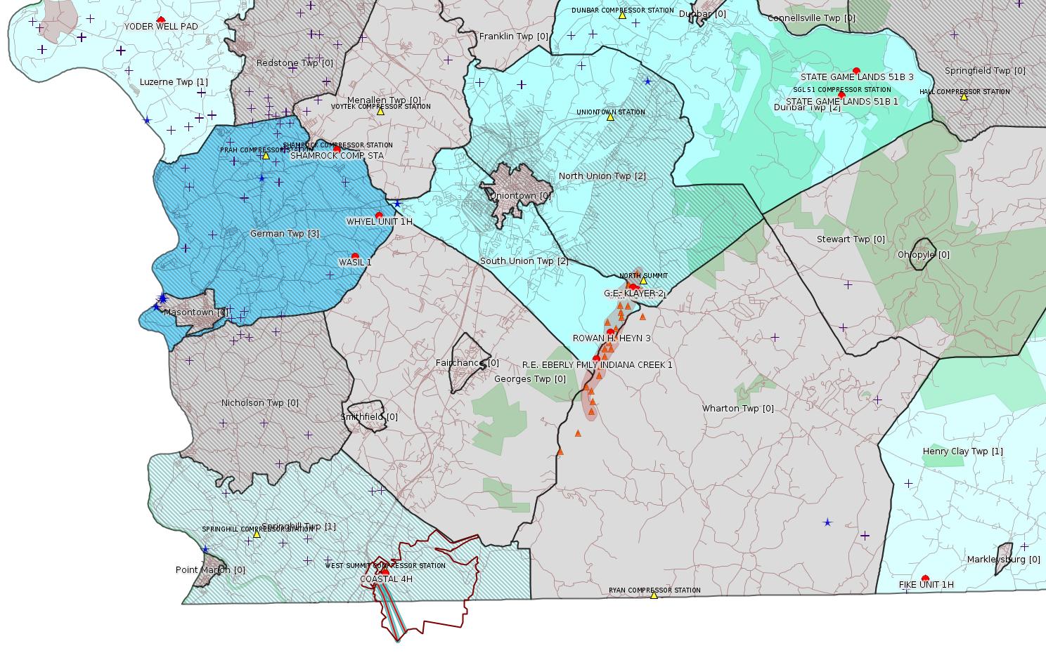
Map
Key
Red dots: items in this permit list with an exact location.
Blue stars: Marcellus Gas Well Water Sources.
Where well laterals are mapped they show in red; a 400-foot buffer surrounding the lateral shows in blue (lavender where it overlaps a mapped mineral tract).
Where mineral tracts are mapped, they show in pink. Mineral tracts can overlap; the overlap will show in red. The precise meaning of "mineral tract" is not clear.
Municipality shading: number of "facilities", with each well counting separately
(includes the red dots):
gray: 0
pale turquoise: 1
turquoise: 2
pale blue: 3
middle blue: 4
dark blue: 5
dark purple: 6
purple: 18
(Color coding may differ from one issue to the next.)
(Note if a project spans multiple municipalities -- e.g. a pipeline -- it will show in the count for each municipality.)
The number of facilities also follows the municipality name in brackets.
Municipality counts are based on the way the permit is listed by DEP; DEP has been known to get a municipality wrong.
Locations in brackets identify a precise location used to locate a surrogate for the actual site being permitted (e.g. locating a well pad or pipeline by the known location of a well.) Locations labeled beginning with "~" and ending in "[?]" are approximate and speculative based on inferences using on-line property and lease records. These are marked in the text as "[Approximate, Speculative]
Cross-hatching: Environmental Justice Areas
Yellow triangles: Compressor Stations
Orange triangles: Storage Field Wells (currently Dominion North Summit Storage Field)
Crosses: SPUD Unconventional well permits
Green: "Natural areas", e.g. state game lands, state forests
Yellow triangles: Compressor Stations
Orange triangles: Storage Field Wells (currently Dominion North Summit Storage Field)
Crosses: SPUD Unconventional well permits
Green: "Natural areas", e.g. state game lands, state forests
More Maps
 |
Source: Pennsylvania Bulletin
[No Activity]
-------------------------
Source: eNOTICE
(+ PA
Oil and Gas Mapping, Well
Pad Report.) Well Details via Data
Portal Services: Oil and Gas Wells All (ID: 3).
Please see the Disclaimer below regarding Parcel Id data.
Authorization ID: 1332934
Permit number: 26-00588B
Site: SHAMROCK COMP STA
Client: LAUREL MTN MIDSTREAM OPR LLC
Authorization type: Minor Facility Plan Approval New Source Performance Std
Application type: Extension
Authorization is for: FACILITY
Date received: 11/04/2020
Status: Pending
Permit Decision Guarantee Applies?: No
Sub-Facilities for Authorization:
Sub-Facility ID Sub-Facility Name Description
1288253 TSS - TURBINE SSM Process
1284691 CAT 3516J CE-03 CAT OX Air Pollution Control Device
1284699 CAT 3516J CE-04 CAT OX Air Pollution Control Device
1284685 CAT G3516J COMPRESSOR ENGINE (CE-03) (1380 HP) Process
1284687 CAT G3516J COMPRESSOR ENGINE (CE-04) (1380 HP) Process
1024427 CATERPILLAR G3516B COMPRESSOR ENGINE (CE-06) (1380 BHP) Process
1087412 CATERPILLAR G3516B EMERGENCY GENERATOR (1,818 BHP)(EG-01) Process
1087413 CATERPILLAR G3516B EMERGENCY GENERATOR OXIDATION CATALYST Air Pollution Control Device
1185238 CBD - COMPRESSOR /FACILITY VENTING/BLOWDOWNS Process
1288248 CRP - COMPRESSOR ROD PACKING EMISSIONS Process
1288244 DGS - COMPRESSOR DRY GAS SEAL LEAKS Process
1288242 ECC - ENGINE CRANK CASE EMISSIONS Process
1024438 ENGINE #6 OXIDATION CATALYST Air Pollution Control Device
1288250 ESU - ENGINE START UP Process
1185240 FUG SITE COMPONENT FUGITIVE EMISSIONS Process
1284697 GLYCOL PURIFICATION UNIT (GPU-ENG, GPU-HTR) Process
1185234 HEATERS/REBOILERS Process
1195984 PIG - PIGGING OPERATIONS Process
1024428 SOLAR MARS 100-16000S TURBINE (15,252 HP) (CT-01) Process
1284695 SOLAR TITAN 130 -23502S (21,158 HP)(CT-02) Process
1284700 SOLAR TITAN SOLONOX COMBUSTION CONTROL Air Pollution Control Device
1045809 TANKS/VESSELS Process
1024431 TEG DEHYDRATOR 1 (200 MMSCF/DAY) (DHY-01) Process
1087369 TEG DEHYDRATOR 2 (200 MMSCF/DAY)(DHY-02) Process
1288255 TLO - TRUCK LOADOUT Process
Permit Review Notes:
Date Review Note
11/13/2020 The technical review and decision review are complete and either the permit decision and/or permit issuance are forthcoming.
11/4/2020 The permit application package is complete, has been accepted, and is undergoing technical review.
<https://www.ahs.dep.pa.gov/eFACTSWeb/searchResults_singleAuth.aspx?AuthID=1332934>
Site Programs:
Air Quality
Site Municipalities:
German Twp, Fayette County
---
Authorization ID: 1328735
Permit number: ESX15-051-0007
Site: YODER WELL PAD ESCGP-2 EXPEDITED
Client: CHEVRON APPALACHIA LLC
Authorization type: Expedited E&S Stormwater General Permit 1
Application type: Notification
Authorization is for: SITE
Date received: 09/30/2020
Status: Issued on 10/29/2020
Permit Decision Guarantee Applies?: No
Permit Review Notes:
Date Review Note
10/29/2020 The technical review and decision review are complete and either the permit decision and/or permit issuance are forthcoming.
9/30/2020 The permit application package is complete, has been accepted, and is undergoing technical review.
<https://www.ahs.dep.pa.gov/eFACTSWeb/searchResults_singleAuth.aspx?AuthID=1328735>
Site Programs:
Oil & Gas
Site Municipalities:
Luzerne Twp, Fayette County
Authorization ID: 1327013
Permit number: 051-24449
Site: WHYEL UNIT PREVIOUSLY SUMEY 1H ESCGP-EXPEDITED
Client: INR OPR LLC
Authorization type: Drill & Operate Well Permit Inactive Status
Application type: New
Authorization is for: FACILITY
Date received: 09/11/2020
Status: Pending
Permit Decision Guarantee Applies?: No
Sub-Facilities for Authorization:
Sub-Facility ID Sub-Facility Name Description
1079520 WHYEL UNIT 1H Well
1047049 WHYEL UNIT 1H Well
Permit Review Notes:
Date Review Note
9/15/2020 The permit application package is complete, has been accepted, and is undergoing technical review.
<https://www.ahs.dep.pa.gov/eFACTSWeb/searchResults_singleAuth.aspx?AuthID=1327013>
Site Programs:
Oil & Gas
Site Municipalities:
German Twp, Fayette County
Well Details:
Permit Number: 051-24449
Well Name: WHYEL UNIT 1H
Unconventional Well: Y
Well Configuration: Horizontal Well
Well Type: GAS
Well Status: Regulatory Inactive Status
Coal Association: NonCoal
Conservation Well: N
Primary Facility ID: 743725
Site ID: 749115
Site Name: WHYEL UNIT PREVIOUSLY SUMEY 1H ESCGP-EXPEDITED
Well Pad ID: 147078
Well Pad Name: WHYEL WELL PAD
Storage Field:
Operator: INR OPR LLC
Operator Number: OGO-51036
Permit Date: 2011-08-16
Permit Date Expires: 2013-06-29
SPUD Date: 2012-07-12
Date Plugged:
UIC ID:
UIC Type:
Surface Elevation: 1290
County: Fayette
Municipality: German Twp
Location: 39.889344,-79.801681
Map URL: <http://www.openstreetmap.org/?mlat=39.889344&mlon=-79.801681#map=15/39.889344/-79.801681>
OG WELLS PERMIT DOCS:
2019-09-24: Other Permit Documents, Name: Inactive Well Status (for Authorization: 1288324):
<http://www.depgis.state.pa.us/pdfHandler/pdFHandler.ashx?Doc=OTMxODc5&ext=PDF>
---
Authorization ID: 1327010
Permit number: 051-24448
Site: WASIL 1 WELL PAD ESCGP-EXPEDITED
Client: INR OPR LLC
Authorization type: Drill & Operate Well Permit Inactive Status
Application type: New
Authorization is for: FACILITY
Date received: 09/11/2020
Status: Pending
Permit Decision Guarantee Applies?: No
Sub-Facilities for Authorization:
Sub-Facility ID Sub-Facility Name Description
1046766 WASIL 1 Well
Permit Review Notes:
Date Review Note
9/15/2020 The permit application package is complete, has been accepted, and is undergoing technical review.
<https://www.ahs.dep.pa.gov/eFACTSWeb/searchResults_singleAuth.aspx?AuthID=1327010>
Site Programs:
Oil & Gas
Site Municipalities:
German Twp, Fayette County
Well Details:
Permit Number: 051-24448
Well Name: WASIL 1
Unconventional Well: N
Well Configuration: Vertical Well
Well Type: GAS
Well Status: Regulatory Inactive Status
Coal Association: NonCoal
Conservation Well: Y
Primary Facility ID: 743583
Site ID: 749854
Site Name: WASIL 1 WELL PAD ESCGP-EXPEDITED
Well Pad ID: 0
Well Pad Name:
Storage Field:
Operator: INR OPR LLC
Operator Number: OGO-51036
Permit Date: 2011-08-29
Permit Date Expires: 2012-08-29
SPUD Date: 2012-07-20
Date Plugged:
UIC ID:
UIC Type:
Surface Elevation: 1228
County: Fayette
Municipality: German Twp
Location: 39.871472,-79.815522
Map URL: <http://www.openstreetmap.org/?mlat=39.871472&mlon=-79.815522#map=15/39.871472/-79.815522>
OG WELLS PERMIT DOCS:
2019-09-24: Other Permit Documents, Name: Inactive Well Status (for Authorization: 1288323):
<http://www.depgis.state.pa.us/pdfHandler/pdFHandler.ashx?Doc=OTMxODc2&ext=PDF>
---
Authorization ID: 1327004
Permit number: 051-24164
Site: FIKE UNIT 1H OG WELL
Client: LPR ENERGY LLC
Authorization type: Drill & Operate Well Permit Inactive Status
Application type: New
Authorization is for: FACILITY
Date received: 09/02/2020
Status: Pending
Permit Decision Guarantee Applies?: No
Sub-Facilities for Authorization:
Sub-Facility ID Sub-Facility Name Description
983871 FIKE UNIT 1H Well
Permit Review Notes:
Date Review Note
9/15/2020 The permit application package is complete, has been accepted, and is undergoing technical review.
<https://www.ahs.dep.pa.gov/eFACTSWeb/searchResults_singleAuth.aspx?AuthID=1327004>
Site Programs:
Oil & Gas
Site Municipalities:
Henry Clay Twp, Fayette County
Well Details:
Permit Number: 051-24164
Well Name: FIKE UNIT 1H
Unconventional Well: Y
Well Configuration: Horizontal Well
Well Type: GAS
Well Status: Regulatory Inactive Status
Coal Association: NonCoal
Conservation Well: Y
Primary Facility ID: 715064
Site ID: 716179
Site Name: FIKE UNIT 1H OG WELL
Well Pad ID: 146852
Well Pad Name: FIKE UNIT 1H
Storage Field:
Operator: LPR ENERGY LLC
Operator Number: OGO-68579
Permit Date: 2009-02-09
Permit Date Expires: 2010-02-09
SPUD Date: 2009-02-12
Date Plugged:
UIC ID:
UIC Type:
Surface Elevation: 2222
County: Fayette
Municipality: Henry Clay Twp
Location: 39.727028,-79.495752
Map URL: <http://www.openstreetmap.org/?mlat=39.727028&mlon=-79.495752#map=15/39.727028/-79.495752>
OG WELLS PERMIT DOCS:
2016-06-13: Other Permit Documents, Name: PAG104834_3-1-2016_TENNESSEE GAS PIPELINE (for Authorization: 758213):
<http://www.depgis.state.pa.us/pdfHandler/pdFHandler.ashx?Doc=ODY1OTgw&ext=PDF>
2016-06-13: Other Permit Documents, Name: PAG104834_3-1-2017_TENNESEE GAS PIPELINE (for Authorization: 758213):
<http://www.depgis.state.pa.us/pdfHandler/pdFHandler.ashx?Doc=ODY1OTgx&ext=PDF>
2018-04-23: Other Permit Documents, Name: 1149059 (for Authorization: 1149059):
<http://www.depgis.state.pa.us/pdfHandler/pdFHandler.ashx?Doc=NTk4NzYw&ext=PDF>
2019-09-30: Other Permit Documents, Name: Inactive Well Status (for Authorization: 1290096):
<http://www.depgis.state.pa.us/pdfHandler/pdFHandler.ashx?Doc=OTM1NzQ3&ext=PDF>
-------------------------
Source: DEP
Oil and Gas Electronic Notifications
NOTIFICATION_ID: 54560
OGO: 51036
OPERATOR: INR OPR LLC
API_PERMIT: 051-24721
SPUD_DATE: 09/29/2020
COUNTY: Fayette
MUNICIPALITY: Springhill
LATITUDE: 39.733181
LONGITUDE: -79.800869
SUBJECT: [NOTIFICATION]: Casing cementing notification 58 Pa. C.S. 3211(f)(2) for well API 37-051-24721-00-00
QUESTION: Enter the Date and Time for the applicable Casing Types
ANSWER: Production Casing: 11/11/2020 6:00:00 PM
SENT_DATE: 11/9/2020 10:13:37 AM
SENT_SUCCESS: Yes
LAST_RESENT_DATE:
RESENT_SUCCESS:
REGION: EP DOGO SWDO Dstr Off
Well Details:
Permit Number: 051-24721
Well Name: COASTAL 4H
Unconventional Well: Y
Well Configuration: Horizontal Well
Well Type: GAS
Well Status: Active
Coal Association: Coal
Conservation Well: N
Primary Facility ID: 843824
Site ID: 739525
Site Name: COASTAL 1H FLOW BACK PIT FRESHWATER PITS ESCGP-EXPEDITED
Well Pad ID: 147971
Well Pad Name: COASTAL WELL PAD
Storage Field:
Operator: INR OPR LLC
Operator Number: OGO-51036
Permit Date: 2020-09-22
Permit Date Expires: 2021-09-22
SPUD Date: 2020-09-29
Date Plugged:
UIC ID:
UIC Type:
Surface Elevation: 1127
County: Fayette
Municipality: Springhill Twp
Location: 39.733181,-79.800869
Map URL: <http://www.openstreetmap.org/?mlat=39.733181&mlon=-79.800869#map=15/39.733181/-79.800869>
OG WELLS PERMIT DOCS:
2020-09-22: Final Permit Documents, Name: Auth 1322978 051-24721 (for Authorization: 1322978):
<http://www.depgis.state.pa.us/pdfHandler/pdFHandler.ashx?Doc=MTQ1NTA3OQ==&ext=PDF>
2020-09-22: Other Permit Documents, Name: Coastal Wells Deficiency Email (for Authorization: 1322978):
<http://www.depgis.state.pa.us/pdfHandler/pdFHandler.ashx?Doc=MTQwNzk4MQ==&ext=PDF>
Electronically Submitted Records:
2020-09-22: Submission for Authorization 1322978
Pennsylvania Natural Diversity Inventory Form: INR OPERATING - COASTAL 4H - PNDI INVENTORY 07.21.2020.pdf
<http://www.depgis.state.pa.us/eWellDocHandler/pdFHandler.ashx?Doc=MTIzMzcxOQ==&ext=PDF>
Pennsylvania Natural Diversity Inventory Support Document: INR OPERATING - COASTAL 4H - PNDI SUPPORT 07.21.2020.pdf
<http://www.depgis.state.pa.us/eWellDocHandler/pdFHandler.ashx?Doc=MTIzMzcyMQ==&ext=PDF>
Operator Ownership and Control Information: INR OPERATING - COASTAL 4H - OPERATOR_OWNERSHIP_AND_CONTROL_INFORMATION_FORM 07.21.2020.pdf
<http://www.depgis.state.pa.us/eWellDocHandler/pdFHandler.ashx?Doc=MTIzMzcyMg==&ext=PDF>
Coordination of Well Location with Public Resources: INR OPERATING - COASTAL 4H - COORDINATION_OF_WELL_LOCATION_WITH_PUBLIC_RESOURCES.pdf
<http://www.depgis.state.pa.us/eWellDocHandler/pdFHandler.ashx?Doc=MTIzNjcxMQ==&ext=PDF>
Well Permit Application - Coal Module: INR OPERATING - COASTAL 4H - COAL STATUS REPORT 07.24.2020.pdf
<http://www.depgis.state.pa.us/eWellDocHandler/pdFHandler.ashx?Doc=MTIzOTY5MA==&ext=PDF>
Interested Party Notification: Coastal 4H - Springhill Township - Interested Party Signed Receipt - 08.04.2020.pdf
<http://www.depgis.state.pa.us/eWellDocHandler/pdFHandler.ashx?Doc=MTI1MjgyNA==&ext=PDF>
Location Plat: INR OPERATING - COASTAL 4H - LOCATION PLAT 08.25.2020 DEP COMMENT REVISIONS.dwg
<http://www.depgis.state.pa.us/eWellDocHandler/pdFHandler.ashx?Doc=MTI2ODY2Mw==&ext=PDF>
Well Cross-Section Diagram: INR OPERATING - COASTAL 4H - WELL CROSS-SECTION DIAGRAM 08.25.2020 DEP COMMENT REVISIONS.pdf
<http://www.depgis.state.pa.us/eWellDocHandler/pdFHandler.ashx?Doc=MTI2ODY2NA==&ext=PDF>
Location Plat: INR OPERATING - COASTAL 4H - LOCATION PLAT 08.25.2020 DEP COMMENT REVISIONS.dwg
<http://www.depgis.state.pa.us/eWellDocHandler/pdFHandler.ashx?Doc=MTI2ODY2NQ==&ext=PDF>
Permit Application to Drill and Operate a Well: 2141432.pdf
<http://www.depgis.state.pa.us/eWellDocHandler/pdFHandler.ashx?Doc=MTI2ODY3MA==&ext=PDF>
OPERATOR: APOLLO RESOURCES LLC
INSPECTION_ID: 3101679
INSPECTION_DATE: 10/28/2020
INSPECTION_TYPE: Complaint Inspection
API_PERMIT: 051-21146
FARM_NAME: STATE GAME LANDS 51B 3
UNCONVENTIONAL: No
SITE_ID: 532427
SITE_NAME: STATE GAME LANDS 51B 3 OG WELL
FACILITY_TYPE: Oil & Gas Location
INSPECTION_CATEGORY: Primary Facility
REGION: EP DOGO SWDO Dstr Off
COUNTY: Fayette
MUNICIPALITY: Dunbar Twp
INSPECTOR: ZADZILKO, ANDREW
INSPECTION_SOURCE: SAIR
INSPECTION_RESULT_DESCRIPTION: Violation(s) Noted
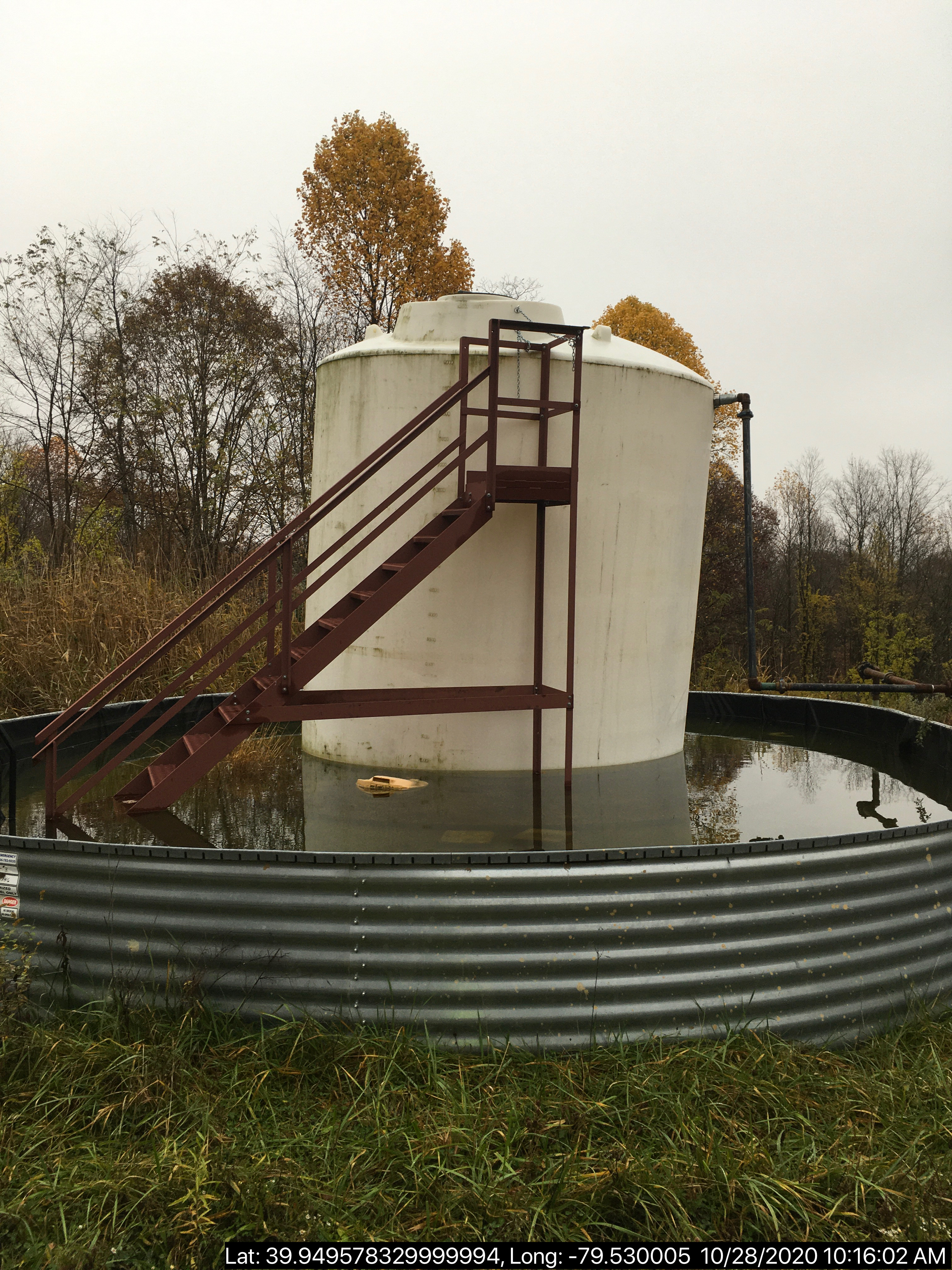
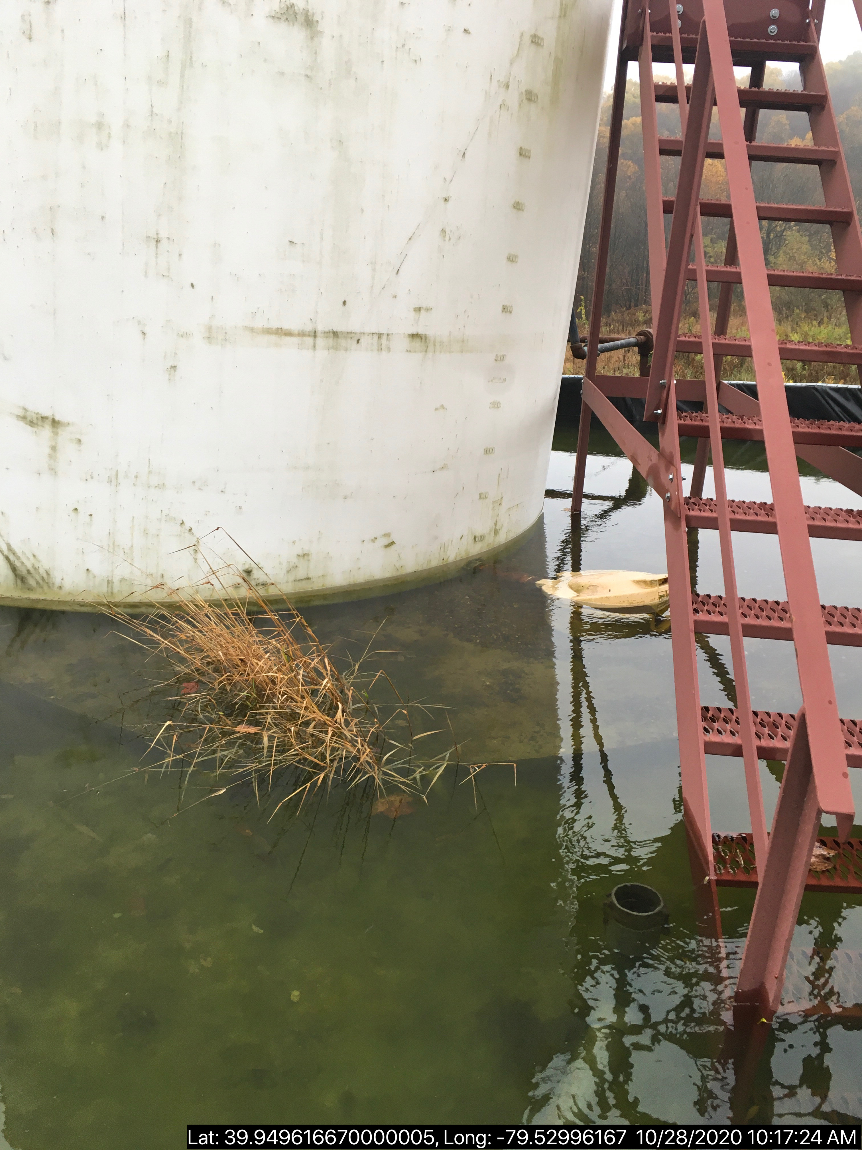
INSPECTION_COMMENT: "Inspection conducted in response to complaint #353269.
No E&S issues apparent on access road and site.
Well site is shown in Photo 1. Well label, well posting present. Well Appears to be equipped for production (Photo 2). Brine tank next to well head is shown in Photo 3. Production equipment shown in Photo 4.
Brine tank in secondary containment is shown in Photo 5. Fluid appears to have accumulated within 1' of the top of the freeboard. Brine tank appears to be dislodged from its base (Photo 6). A conductivity reading was taken of the fluid in secondary containment. Conductivity meter showed a reading of 0.07 mS (Photo 7). At this time there there does not appear to be any signs of a release.
The Department recommends operator remove and dispose of the fluid within the secondary containment in accordance with current regulations in order to ensure the functionality of the secondary containment is maintained.
A brine tank with large holes is also on site (Photo 8). Brine tank does not appear to be in use at this time. The Department requests information regarding wether or not the storage tank in Photo 8 is currently holding production fluid.
Additional violations may be forthcoming based on further investigation."
VIOLATION_ID: 898887
VIOLATION_DATE: 10/28/2020
VIOLATION_CODE: OGA3216(C) - WELL SITE RESTORATIONS - PITS, DRILLING SUPPLIES AND EQUIPMENT - Failure to fill all pits used to contain produced fluids or industrial wastes and remove unnecessary drilling supplies/equipment not needed for production within 9 months from completion of drilling of well.
VIOLATION_TYPE: Environmental Health & Safety
VIOLATION_COMMENT:
RESOLVED_DATE:
RESOLUTION_REASON_CODE_DESCRIPTION:
CONTINUING_VIOLATION:
ENFORCEMENT_ID: 389866
ENFORCEMENT_CODE_DESCRIPTION: NOV - Notice of Violation
DATE_EXECUTED: 10/28/2020
ENFORCEMENT_FINAL_DATE:
ENFORCEMENT_FINAL_STATUS:
PENALTY_FINAL_DATE:
PENALTY_FINAL_STATUS_CODE_DESCRIPTION:
PENALTY_AMOUNT:
TOTAL_AMOUNT_COLLECTED:
Well Details:
Permit Number: 051-21146
Well Name: STATE GAME LANDS 51B 3
Unconventional Well: N
Well Configuration: Vertical Well
Well Type: GAS
Well Status: Active
Coal Association: Coal
Conservation Well: N
Primary Facility ID: 553738
Site ID: 532427
Site Name: STATE GAME LANDS 51B 3 OG WELL
Well Pad ID: 0
Well Pad Name:
Storage Field:
Operator: APOLLO RESOURCES LLC
Operator Number: OGO-39623
Permit Date: 2000-03-15
Permit Date Expires: 2001-03-15
SPUD Date: 2000-05-30
Date Plugged:
UIC ID:
UIC Type:
Surface Elevation: 1830
County: Fayette
Municipality: Dunbar Twp
Location: 39.949359,-79.530113
Map URL: <http://www.openstreetmap.org/?mlat=39.949359&mlon=-79.530113#map=15/39.949359/-79.530113>
Presumed Parcel Id: 09370021
Full Inspection Report, including photos (Source Oil and Gas Inspection Reports Viewer ):
<https://www.depgreenport.state.pa.us/eWellDocs/download/DocsZipFile/?P_DER_CODE=9&P_ENTITY_TYPE=2&S=4&P_ID=3101679>
---
OPERATOR: APOLLO RESOURCES LLC
INSPECTION_ID: 3101686
INSPECTION_DATE: 10/28/2020
INSPECTION_TYPE: Complaint Inspection
API_PERMIT: 051-21047
FARM_NAME: STATE GAME LANDS 51B 1
UNCONVENTIONAL: No
SITE_ID: 495777
SITE_NAME: STATE GAME LANDS 51B 1 OG WELL
FACILITY_TYPE: Oil & Gas Location
INSPECTION_CATEGORY: Primary Facility
REGION: EP DOGO SWDO Dstr Off
COUNTY: Fayette
MUNICIPALITY: Dunbar Boro
INSPECTOR: ZADZILKO, ANDREW
INSPECTION_SOURCE: SAIR
INSPECTION_RESULT_DESCRIPTION: No Violations Noted
INSPECTION_COMMENT: "Inspection conducted in response to complaint #353269. The Department only conducted an on site inspection of the gathering line associated with well 051-21047. No E&S issues apparent at this location along the gathering line.
Gathering line equipment shown in Photo 1. Brine tank in secondary containment is shown in Photo 2. Fluid appears to have accumulated within 8"" of the top of the freeboard. At this time there there does not appear to be any signs of a release.
A conductivity reading was taken of the fluid in secondary containment. Conductivity meter showed a reading of 0.28 mS (Photo 3).
The Department recommends operator remove and dispose of the fluid within the secondary containment in accordance with current regulations in order to ensure the functionality of the secondary containment is maintained."
Well Details:
Permit Number: 051-21047
Well Name: STATE GAME LANDS 51B 1
Unconventional Well: N
Well Configuration: Vertical Well
Well Type: GAS
Well Status: Active
Coal Association: Coal
Conservation Well: N
Primary Facility ID: 523035
Site ID: 495777
Site Name: STATE GAME LANDS 51B 1 OG WELL
Well Pad ID: 0
Well Pad Name:
Storage Field:
Operator: APOLLO RESOURCES LLC
Operator Number: OGO-39623
Permit Date: 1998-11-18
Permit Date Expires: 1999-11-18
SPUD Date: 1998-12-03
Date Plugged:
UIC ID:
UIC Type:
Surface Elevation: 2158
County: Fayette
Municipality: Dunbar Boro
Location: 39.938813,-79.538565
Map URL: <http://www.openstreetmap.org/?mlat=39.938813&mlon=-79.538565#map=15/39.938813/-79.538565>
Presumed Parcel Id: 09370021
Full Inspection Report, including photos (Source Oil and Gas Inspection Reports Viewer ):
<https://www.depgreenport.state.pa.us/eWellDocs/download/DocsZipFile/?P_DER_CODE=9&P_ENTITY_TYPE=2&S=4&P_ID=3101686>
---
OPERATOR: DOMINION ENERGY TRANS INC
INSPECTION_ID: 3101670
INSPECTION_DATE: 11/02/2020
INSPECTION_TYPE: Routine/Complete Inspection
API_PERMIT: 051-00097
FARM_NAME: ROWAN H. HEYN 3
UNCONVENTIONAL: No
SITE_ID: 40775
SITE_NAME: ROWAN H HEYN 3 WELL
FACILITY_TYPE: Oil & Gas Location
INSPECTION_CATEGORY: Primary Facility
REGION: EP DOGO SWDO Dstr Off
COUNTY: Fayette
MUNICIPALITY: South Union Twp
INSPECTOR: VIRRUET, IVAN
INSPECTION_SOURCE: SUBSAIR
INSPECTION_RESULT_DESCRIPTION: No Violations Noted
INSPECTION_COMMENT: On 11/2/2020 at 11:50 I arrived on location to conduct a routine inspection. Wellhead looked to be in good working order. There were no visible signs of leaks and no rust was observed at the time of this inspection. The wellhead was chained. Pressure reading was unknown at the time of inspection. No gauges were seen on location. A plastic brine tank was observed on site that appeared to be stained, indicating a release may have previously occurred. DEP WQS follow up is requested.
Well Details:
Permit Number: 051-00097
Well Name: ROWAN H. HEYN 3
Unconventional Well: N
Well Configuration: Vertical Well
Well Type: GAS
Well Status: Active
Coal Association: Coal
Conservation Well: N
Primary Facility ID: 42527
Site ID: 40775
Site Name: ROWAN H HEYN 3 WELL
Well Pad ID: 0
Well Pad Name:
Storage Field:
Operator: DOMINION ENERGY TRANS INC
Operator Number: OGO-2239
Permit Date: 1985-01-09
Permit Date Expires:
SPUD Date: 1800-01-01
Date Plugged:
UIC ID:
UIC Type:
Surface Elevation: 0
County: Fayette
Municipality: South Union Twp
Location: 39.836879,-79.671514
Map URL: <http://www.openstreetmap.org/?mlat=39.836879&mlon=-79.671514#map=15/39.836879/-79.671514>
Presumed Parcel Id: 34430002
[See Notes.]
---
OPERATOR: DOMINION ENERGY TRANS INC
INSPECTION_ID: 3101682
INSPECTION_DATE: 11/02/2020
INSPECTION_TYPE: Routine/Complete Inspection
API_PERMIT: 051-00093
FARM_NAME: R.E. EBERLY FMLY INDIANA CREEK 1
UNCONVENTIONAL: No
SITE_ID: 40771
SITE_NAME: RE EBERLY FORMERLY INDIANA CRE 1 WELL
FACILITY_TYPE: Oil & Gas Location
INSPECTION_CATEGORY: Primary Facility
REGION: EP DOGO SWDO Dstr Off
COUNTY: Fayette
MUNICIPALITY: South Union Twp
INSPECTOR: VIRRUET, IVAN
INSPECTION_SOURCE: SUBSAIR
INSPECTION_RESULT_DESCRIPTION: No Violations Noted
INSPECTION_COMMENT: On 11/02/2020 at 12:20 I arrived on location to conduct a routine inspection. Wellhead looks to be in good working order and was chained. No rust was noted and paint looked good. Pressure on the well is unknown at the time of inspection. There were no pressure gauges seen on the well. A plastic brine tank was observed on site that appeared to be stained, indicating a release may have previously occurred. Follow up inspection by a WQS is requested.
Well Details:
Permit Number: 051-00093
Well Name: R.E. EBERLY FMLY INDIANA CREEK 1
Unconventional Well: N
Well Configuration: Vertical Well
Well Type: GAS
Well Status: Active
Coal Association: Coal
Conservation Well: N
Primary Facility ID: 42523
Site ID: 40771
Site Name: RE EBERLY FORMERLY INDIANA CRE 1 WELL
Well Pad ID: 0
Well Pad Name:
Storage Field:
Operator: DOMINION ENERGY TRANS INC
Operator Number: OGO-2239
Permit Date: 1985-01-09
Permit Date Expires:
SPUD Date: 1800-01-01
Date Plugged:
UIC ID:
UIC Type:
Surface Elevation: 2631
County: Fayette
Municipality: South Union Twp
Location: 39.825412,-79.679633
Map URL: <http://www.openstreetmap.org/?mlat=39.825412&mlon=-79.679633#map=15/39.825412/-79.679633>
Presumed Parcel Id: 34380091
---
OPERATOR: DOMINION ENERGY TRANS INC
INSPECTION_ID: 3103836
INSPECTION_DATE: 11/05/2020
INSPECTION_TYPE: Routine/Complete Inspection
API_PERMIT: 051-20520
FARM_NAME: G.E. KLAYER 1
UNCONVENTIONAL: No
SITE_ID: 41418
SITE_NAME: GE KLAYER 1 OG WELL
FACILITY_TYPE: Oil & Gas Location
INSPECTION_CATEGORY: Primary Facility
REGION: EP DOGO SWDO Dstr Off
COUNTY: Fayette
MUNICIPALITY: North Union Twp
INSPECTOR: VIRRUET, IVAN
INSPECTION_SOURCE: SUBSAIR
INSPECTION_RESULT_DESCRIPTION: No Violations Noted
INSPECTION_COMMENT: On 11/5/2020 at 13:00 I arrived on location to conduct a routine inspection. Wellhead was chained and appeared to be in good order with no visible leaks or corrosion. One small leak was found as seen in picture #4. The department request that the operator investigate the leak and report their findings within 14 days of receiving this report.
Well Details:
Permit Number: 051-20520
Well Name: G.E. KLAYER 1
Unconventional Well: N
Well Configuration: Vertical Well
Well Type: GAS
Well Status: Active
Coal Association: Coal
Conservation Well: N
Primary Facility ID: 43170
Site ID: 41418
Site Name: GE KLAYER 1 OG WELL
Well Pad ID: 0
Well Pad Name:
Storage Field:
Operator: DOMINION ENERGY TRANS INC
Operator Number: OGO-2239
Permit Date:
Permit Date Expires:
SPUD Date: 1991-02-18
Date Plugged:
UIC ID:
UIC Type:
Surface Elevation: 2581
County: Fayette
Municipality: North Union Twp
Location: 39.855351,-79.656143
Map URL: <http://www.openstreetmap.org/?mlat=39.855351&mlon=-79.656143#map=15/39.855351/-79.656143>
Presumed Parcel Id: 25550036
---
OPERATOR: DOMINION ENERGY TRANS INC
INSPECTION_ID: 3103869
INSPECTION_DATE: 11/05/2020
INSPECTION_TYPE: Routine/Complete Inspection
API_PERMIT: 051-20524
FARM_NAME: G.E. KLAYER 2
UNCONVENTIONAL: No
SITE_ID: 41422
SITE_NAME: GE KLAYER 2 OG WELL
FACILITY_TYPE: Oil & Gas Location
INSPECTION_CATEGORY: Primary Facility
REGION: EP DOGO SWDO Dstr Off
COUNTY: Fayette
MUNICIPALITY: North Union Twp
INSPECTOR: VIRRUET, IVAN
INSPECTION_SOURCE: SUBSAIR
INSPECTION_RESULT_DESCRIPTION: No Violations Noted
INSPECTION_COMMENT: On 11/5/2020 at 13:35 I arrived on location to conduct a routine inspection. At the time of inspection wellhead looked to be in good order, was chained and locked. The wellhead showed no visible leaks and was free of rust. One valve on the side with the methanol tank showed excessive rust, picture #4. The department request that the operator investigate and report their findings within 14 days of receiving this report.
Well Details:
Permit Number: 051-20524
Well Name: G.E. KLAYER 2
Unconventional Well: N
Well Configuration: Vertical Well
Well Type: GAS
Well Status: Active
Coal Association: Coal
Conservation Well: N
Primary Facility ID: 43174
Site ID: 41422
Site Name: GE KLAYER 2 OG WELL
Well Pad ID: 0
Well Pad Name:
Storage Field:
Operator: DOMINION ENERGY TRANS INC
Operator Number: OGO-2239
Permit Date:
Permit Date Expires:
SPUD Date: 1991-08-20
Date Plugged:
UIC ID:
UIC Type:
Surface Elevation: 2500
County: Fayette
Municipality: North Union Twp
Location: 39.856409,-79.658546
Map URL: <http://www.openstreetmap.org/?mlat=39.856409&mlon=-79.658546#map=15/39.856409/-79.658546>
Presumed Parcel Id: 25550036
-------------------------
Please see the Disclaimer below regarding Parcel Id data.
Authorization ID: 1332934
Permit number: 26-00588B
Site: SHAMROCK COMP STA
Client: LAUREL MTN MIDSTREAM OPR LLC
Authorization type: Minor Facility Plan Approval New Source Performance Std
Application type: Extension
Authorization is for: FACILITY
Date received: 11/04/2020
Status: Pending
Permit Decision Guarantee Applies?: No
Sub-Facilities for Authorization:
Sub-Facility ID Sub-Facility Name Description
1288253 TSS - TURBINE SSM Process
1284691 CAT 3516J CE-03 CAT OX Air Pollution Control Device
1284699 CAT 3516J CE-04 CAT OX Air Pollution Control Device
1284685 CAT G3516J COMPRESSOR ENGINE (CE-03) (1380 HP) Process
1284687 CAT G3516J COMPRESSOR ENGINE (CE-04) (1380 HP) Process
1024427 CATERPILLAR G3516B COMPRESSOR ENGINE (CE-06) (1380 BHP) Process
1087412 CATERPILLAR G3516B EMERGENCY GENERATOR (1,818 BHP)(EG-01) Process
1087413 CATERPILLAR G3516B EMERGENCY GENERATOR OXIDATION CATALYST Air Pollution Control Device
1185238 CBD - COMPRESSOR /FACILITY VENTING/BLOWDOWNS Process
1288248 CRP - COMPRESSOR ROD PACKING EMISSIONS Process
1288244 DGS - COMPRESSOR DRY GAS SEAL LEAKS Process
1288242 ECC - ENGINE CRANK CASE EMISSIONS Process
1024438 ENGINE #6 OXIDATION CATALYST Air Pollution Control Device
1288250 ESU - ENGINE START UP Process
1185240 FUG SITE COMPONENT FUGITIVE EMISSIONS Process
1284697 GLYCOL PURIFICATION UNIT (GPU-ENG, GPU-HTR) Process
1185234 HEATERS/REBOILERS Process
1195984 PIG - PIGGING OPERATIONS Process
1024428 SOLAR MARS 100-16000S TURBINE (15,252 HP) (CT-01) Process
1284695 SOLAR TITAN 130 -23502S (21,158 HP)(CT-02) Process
1284700 SOLAR TITAN SOLONOX COMBUSTION CONTROL Air Pollution Control Device
1045809 TANKS/VESSELS Process
1024431 TEG DEHYDRATOR 1 (200 MMSCF/DAY) (DHY-01) Process
1087369 TEG DEHYDRATOR 2 (200 MMSCF/DAY)(DHY-02) Process
1288255 TLO - TRUCK LOADOUT Process
Permit Review Notes:
Date Review Note
11/13/2020 The technical review and decision review are complete and either the permit decision and/or permit issuance are forthcoming.
11/4/2020 The permit application package is complete, has been accepted, and is undergoing technical review.
<https://www.ahs.dep.pa.gov/eFACTSWeb/searchResults_singleAuth.aspx?AuthID=1332934>
Site Programs:
Air Quality
Site Municipalities:
German Twp, Fayette County
Location: 39.918333,-79.825
Map URL: <http://www.openstreetmap.org/?mlat=39.918333&mlon=-79.825#map=15/39.918333/-79.825>
Parcel ID: 15140026
Map URL: <http://www.openstreetmap.org/?mlat=39.918333&mlon=-79.825#map=15/39.918333/-79.825>
Parcel ID: 15140026
Authorization ID: 1328735
Permit number: ESX15-051-0007
Site: YODER WELL PAD ESCGP-2 EXPEDITED
Client: CHEVRON APPALACHIA LLC
Authorization type: Expedited E&S Stormwater General Permit 1
Application type: Notification
Authorization is for: SITE
Date received: 09/30/2020
Status: Issued on 10/29/2020
Permit Decision Guarantee Applies?: No
Permit Review Notes:
Date Review Note
10/29/2020 The technical review and decision review are complete and either the permit decision and/or permit issuance are forthcoming.
9/30/2020 The permit application package is complete, has been accepted, and is undergoing technical review.
<https://www.ahs.dep.pa.gov/eFACTSWeb/searchResults_singleAuth.aspx?AuthID=1328735>
Site Programs:
Oil & Gas
Site Municipalities:
Luzerne Twp, Fayette County
Well Pad Id: 153100
Location: 39.975683, -79.923763
Wells on this Pad:
Presumed Parcel Id: 19160034
---Location: 39.975683, -79.923763
Wells on this Pad:
051-24652 YODER 1HPost Drill Restoration Report Yoder Pad A.pdf
051-24653 YODER 2H
051-24654 YODER 3H
051-24655 YODER 4H
051-24656 YODER 5H
051-24657 YODER 6H
051-24658 YODER 7H
051-24659 YODER 8H
051-24660 YODER 9H
051-24661 YODER 10H
051-24662 YODER 11H
051-24663 YODER 12H
Presumed Parcel Id: 19160034
Authorization ID: 1327013
Permit number: 051-24449
Site: WHYEL UNIT PREVIOUSLY SUMEY 1H ESCGP-EXPEDITED
Client: INR OPR LLC
Authorization type: Drill & Operate Well Permit Inactive Status
Application type: New
Authorization is for: FACILITY
Date received: 09/11/2020
Status: Pending
Permit Decision Guarantee Applies?: No
Sub-Facilities for Authorization:
Sub-Facility ID Sub-Facility Name Description
1079520 WHYEL UNIT 1H Well
1047049 WHYEL UNIT 1H Well
Permit Review Notes:
Date Review Note
9/15/2020 The permit application package is complete, has been accepted, and is undergoing technical review.
<https://www.ahs.dep.pa.gov/eFACTSWeb/searchResults_singleAuth.aspx?AuthID=1327013>
Site Programs:
Oil & Gas
Site Municipalities:
German Twp, Fayette County
Well Details:
Permit Number: 051-24449
Well Name: WHYEL UNIT 1H
Unconventional Well: Y
Well Configuration: Horizontal Well
Well Type: GAS
Well Status: Regulatory Inactive Status
Coal Association: NonCoal
Conservation Well: N
Primary Facility ID: 743725
Site ID: 749115
Site Name: WHYEL UNIT PREVIOUSLY SUMEY 1H ESCGP-EXPEDITED
Well Pad ID: 147078
Well Pad Name: WHYEL WELL PAD
Storage Field:
Operator: INR OPR LLC
Operator Number: OGO-51036
Permit Date: 2011-08-16
Permit Date Expires: 2013-06-29
SPUD Date: 2012-07-12
Date Plugged:
UIC ID:
UIC Type:
Surface Elevation: 1290
County: Fayette
Municipality: German Twp
Location: 39.889344,-79.801681
Map URL: <http://www.openstreetmap.org/?mlat=39.889344&mlon=-79.801681#map=15/39.889344/-79.801681>
OG WELLS PERMIT DOCS:
2019-09-24: Other Permit Documents, Name: Inactive Well Status (for Authorization: 1288324):
<http://www.depgis.state.pa.us/pdfHandler/pdFHandler.ashx?Doc=OTMxODc5&ext=PDF>
---
Authorization ID: 1327010
Permit number: 051-24448
Site: WASIL 1 WELL PAD ESCGP-EXPEDITED
Client: INR OPR LLC
Authorization type: Drill & Operate Well Permit Inactive Status
Application type: New
Authorization is for: FACILITY
Date received: 09/11/2020
Status: Pending
Permit Decision Guarantee Applies?: No
Sub-Facilities for Authorization:
Sub-Facility ID Sub-Facility Name Description
1046766 WASIL 1 Well
Permit Review Notes:
Date Review Note
9/15/2020 The permit application package is complete, has been accepted, and is undergoing technical review.
<https://www.ahs.dep.pa.gov/eFACTSWeb/searchResults_singleAuth.aspx?AuthID=1327010>
Site Programs:
Oil & Gas
Site Municipalities:
German Twp, Fayette County
Well Details:
Permit Number: 051-24448
Well Name: WASIL 1
Unconventional Well: N
Well Configuration: Vertical Well
Well Type: GAS
Well Status: Regulatory Inactive Status
Coal Association: NonCoal
Conservation Well: Y
Primary Facility ID: 743583
Site ID: 749854
Site Name: WASIL 1 WELL PAD ESCGP-EXPEDITED
Well Pad ID: 0
Well Pad Name:
Storage Field:
Operator: INR OPR LLC
Operator Number: OGO-51036
Permit Date: 2011-08-29
Permit Date Expires: 2012-08-29
SPUD Date: 2012-07-20
Date Plugged:
UIC ID:
UIC Type:
Surface Elevation: 1228
County: Fayette
Municipality: German Twp
Location: 39.871472,-79.815522
Map URL: <http://www.openstreetmap.org/?mlat=39.871472&mlon=-79.815522#map=15/39.871472/-79.815522>
OG WELLS PERMIT DOCS:
2019-09-24: Other Permit Documents, Name: Inactive Well Status (for Authorization: 1288323):
<http://www.depgis.state.pa.us/pdfHandler/pdFHandler.ashx?Doc=OTMxODc2&ext=PDF>
---
Authorization ID: 1327004
Permit number: 051-24164
Site: FIKE UNIT 1H OG WELL
Client: LPR ENERGY LLC
Authorization type: Drill & Operate Well Permit Inactive Status
Application type: New
Authorization is for: FACILITY
Date received: 09/02/2020
Status: Pending
Permit Decision Guarantee Applies?: No
Sub-Facilities for Authorization:
Sub-Facility ID Sub-Facility Name Description
983871 FIKE UNIT 1H Well
Permit Review Notes:
Date Review Note
9/15/2020 The permit application package is complete, has been accepted, and is undergoing technical review.
<https://www.ahs.dep.pa.gov/eFACTSWeb/searchResults_singleAuth.aspx?AuthID=1327004>
Site Programs:
Oil & Gas
Site Municipalities:
Henry Clay Twp, Fayette County
Well Details:
Permit Number: 051-24164
Well Name: FIKE UNIT 1H
Unconventional Well: Y
Well Configuration: Horizontal Well
Well Type: GAS
Well Status: Regulatory Inactive Status
Coal Association: NonCoal
Conservation Well: Y
Primary Facility ID: 715064
Site ID: 716179
Site Name: FIKE UNIT 1H OG WELL
Well Pad ID: 146852
Well Pad Name: FIKE UNIT 1H
Storage Field:
Operator: LPR ENERGY LLC
Operator Number: OGO-68579
Permit Date: 2009-02-09
Permit Date Expires: 2010-02-09
SPUD Date: 2009-02-12
Date Plugged:
UIC ID:
UIC Type:
Surface Elevation: 2222
County: Fayette
Municipality: Henry Clay Twp
Location: 39.727028,-79.495752
Map URL: <http://www.openstreetmap.org/?mlat=39.727028&mlon=-79.495752#map=15/39.727028/-79.495752>
OG WELLS PERMIT DOCS:
2016-06-13: Other Permit Documents, Name: PAG104834_3-1-2016_TENNESSEE GAS PIPELINE (for Authorization: 758213):
<http://www.depgis.state.pa.us/pdfHandler/pdFHandler.ashx?Doc=ODY1OTgw&ext=PDF>
2016-06-13: Other Permit Documents, Name: PAG104834_3-1-2017_TENNESEE GAS PIPELINE (for Authorization: 758213):
<http://www.depgis.state.pa.us/pdfHandler/pdFHandler.ashx?Doc=ODY1OTgx&ext=PDF>
2018-04-23: Other Permit Documents, Name: 1149059 (for Authorization: 1149059):
<http://www.depgis.state.pa.us/pdfHandler/pdFHandler.ashx?Doc=NTk4NzYw&ext=PDF>
2019-09-30: Other Permit Documents, Name: Inactive Well Status (for Authorization: 1290096):
<http://www.depgis.state.pa.us/pdfHandler/pdFHandler.ashx?Doc=OTM1NzQ3&ext=PDF>
-------------------------
NOTIFICATION_ID: 54560
OGO: 51036
OPERATOR: INR OPR LLC
API_PERMIT: 051-24721
SPUD_DATE: 09/29/2020
COUNTY: Fayette
MUNICIPALITY: Springhill
LATITUDE: 39.733181
LONGITUDE: -79.800869
SUBJECT: [NOTIFICATION]: Casing cementing notification 58 Pa. C.S. 3211(f)(2) for well API 37-051-24721-00-00
QUESTION: Enter the Date and Time for the applicable Casing Types
ANSWER: Production Casing: 11/11/2020 6:00:00 PM
SENT_DATE: 11/9/2020 10:13:37 AM
SENT_SUCCESS: Yes
LAST_RESENT_DATE:
RESENT_SUCCESS:
REGION: EP DOGO SWDO Dstr Off
Well Details:
Permit Number: 051-24721
Well Name: COASTAL 4H
Unconventional Well: Y
Well Configuration: Horizontal Well
Well Type: GAS
Well Status: Active
Coal Association: Coal
Conservation Well: N
Primary Facility ID: 843824
Site ID: 739525
Site Name: COASTAL 1H FLOW BACK PIT FRESHWATER PITS ESCGP-EXPEDITED
Well Pad ID: 147971
Well Pad Name: COASTAL WELL PAD
Storage Field:
Operator: INR OPR LLC
Operator Number: OGO-51036
Permit Date: 2020-09-22
Permit Date Expires: 2021-09-22
SPUD Date: 2020-09-29
Date Plugged:
UIC ID:
UIC Type:
Surface Elevation: 1127
County: Fayette
Municipality: Springhill Twp
Location: 39.733181,-79.800869
Map URL: <http://www.openstreetmap.org/?mlat=39.733181&mlon=-79.800869#map=15/39.733181/-79.800869>
OG WELLS PERMIT DOCS:
2020-09-22: Final Permit Documents, Name: Auth 1322978 051-24721 (for Authorization: 1322978):
<http://www.depgis.state.pa.us/pdfHandler/pdFHandler.ashx?Doc=MTQ1NTA3OQ==&ext=PDF>
2020-09-22: Other Permit Documents, Name: Coastal Wells Deficiency Email (for Authorization: 1322978):
<http://www.depgis.state.pa.us/pdfHandler/pdFHandler.ashx?Doc=MTQwNzk4MQ==&ext=PDF>
Electronically Submitted Records:
2020-09-22: Submission for Authorization 1322978
Pennsylvania Natural Diversity Inventory Form: INR OPERATING - COASTAL 4H - PNDI INVENTORY 07.21.2020.pdf
<http://www.depgis.state.pa.us/eWellDocHandler/pdFHandler.ashx?Doc=MTIzMzcxOQ==&ext=PDF>
Pennsylvania Natural Diversity Inventory Support Document: INR OPERATING - COASTAL 4H - PNDI SUPPORT 07.21.2020.pdf
<http://www.depgis.state.pa.us/eWellDocHandler/pdFHandler.ashx?Doc=MTIzMzcyMQ==&ext=PDF>
Operator Ownership and Control Information: INR OPERATING - COASTAL 4H - OPERATOR_OWNERSHIP_AND_CONTROL_INFORMATION_FORM 07.21.2020.pdf
<http://www.depgis.state.pa.us/eWellDocHandler/pdFHandler.ashx?Doc=MTIzMzcyMg==&ext=PDF>
Coordination of Well Location with Public Resources: INR OPERATING - COASTAL 4H - COORDINATION_OF_WELL_LOCATION_WITH_PUBLIC_RESOURCES.pdf
<http://www.depgis.state.pa.us/eWellDocHandler/pdFHandler.ashx?Doc=MTIzNjcxMQ==&ext=PDF>
Well Permit Application - Coal Module: INR OPERATING - COASTAL 4H - COAL STATUS REPORT 07.24.2020.pdf
<http://www.depgis.state.pa.us/eWellDocHandler/pdFHandler.ashx?Doc=MTIzOTY5MA==&ext=PDF>
Interested Party Notification: Coastal 4H - Springhill Township - Interested Party Signed Receipt - 08.04.2020.pdf
<http://www.depgis.state.pa.us/eWellDocHandler/pdFHandler.ashx?Doc=MTI1MjgyNA==&ext=PDF>
Location Plat: INR OPERATING - COASTAL 4H - LOCATION PLAT 08.25.2020 DEP COMMENT REVISIONS.dwg
<http://www.depgis.state.pa.us/eWellDocHandler/pdFHandler.ashx?Doc=MTI2ODY2Mw==&ext=PDF>
Well Cross-Section Diagram: INR OPERATING - COASTAL 4H - WELL CROSS-SECTION DIAGRAM 08.25.2020 DEP COMMENT REVISIONS.pdf
<http://www.depgis.state.pa.us/eWellDocHandler/pdFHandler.ashx?Doc=MTI2ODY2NA==&ext=PDF>
Location Plat: INR OPERATING - COASTAL 4H - LOCATION PLAT 08.25.2020 DEP COMMENT REVISIONS.dwg
<http://www.depgis.state.pa.us/eWellDocHandler/pdFHandler.ashx?Doc=MTI2ODY2NQ==&ext=PDF>
Permit Application to Drill and Operate a Well: 2141432.pdf
<http://www.depgis.state.pa.us/eWellDocHandler/pdFHandler.ashx?Doc=MTI2ODY3MA==&ext=PDF>
OPERATOR: APOLLO RESOURCES LLC
INSPECTION_ID: 3101679
INSPECTION_DATE: 10/28/2020
INSPECTION_TYPE: Complaint Inspection
API_PERMIT: 051-21146
FARM_NAME: STATE GAME LANDS 51B 3
UNCONVENTIONAL: No
SITE_ID: 532427
SITE_NAME: STATE GAME LANDS 51B 3 OG WELL
FACILITY_TYPE: Oil & Gas Location
INSPECTION_CATEGORY: Primary Facility
REGION: EP DOGO SWDO Dstr Off
COUNTY: Fayette
MUNICIPALITY: Dunbar Twp
INSPECTOR: ZADZILKO, ANDREW
INSPECTION_SOURCE: SAIR
INSPECTION_RESULT_DESCRIPTION: Violation(s) Noted
INSPECTION_COMMENT: "Inspection conducted in response to complaint #353269.
No E&S issues apparent on access road and site.
Well site is shown in Photo 1. Well label, well posting present. Well Appears to be equipped for production (Photo 2). Brine tank next to well head is shown in Photo 3. Production equipment shown in Photo 4.
Brine tank in secondary containment is shown in Photo 5. Fluid appears to have accumulated within 1' of the top of the freeboard. Brine tank appears to be dislodged from its base (Photo 6). A conductivity reading was taken of the fluid in secondary containment. Conductivity meter showed a reading of 0.07 mS (Photo 7). At this time there there does not appear to be any signs of a release.
The Department recommends operator remove and dispose of the fluid within the secondary containment in accordance with current regulations in order to ensure the functionality of the secondary containment is maintained.
A brine tank with large holes is also on site (Photo 8). Brine tank does not appear to be in use at this time. The Department requests information regarding wether or not the storage tank in Photo 8 is currently holding production fluid.
Additional violations may be forthcoming based on further investigation."
VIOLATION_ID: 898887
VIOLATION_DATE: 10/28/2020
VIOLATION_CODE: OGA3216(C) - WELL SITE RESTORATIONS - PITS, DRILLING SUPPLIES AND EQUIPMENT - Failure to fill all pits used to contain produced fluids or industrial wastes and remove unnecessary drilling supplies/equipment not needed for production within 9 months from completion of drilling of well.
VIOLATION_TYPE: Environmental Health & Safety
VIOLATION_COMMENT:
RESOLVED_DATE:
RESOLUTION_REASON_CODE_DESCRIPTION:
CONTINUING_VIOLATION:
ENFORCEMENT_ID: 389866
ENFORCEMENT_CODE_DESCRIPTION: NOV - Notice of Violation
DATE_EXECUTED: 10/28/2020
ENFORCEMENT_FINAL_DATE:
ENFORCEMENT_FINAL_STATUS:
PENALTY_FINAL_DATE:
PENALTY_FINAL_STATUS_CODE_DESCRIPTION:
PENALTY_AMOUNT:
TOTAL_AMOUNT_COLLECTED:
Well Details:
Permit Number: 051-21146
Well Name: STATE GAME LANDS 51B 3
Unconventional Well: N
Well Configuration: Vertical Well
Well Type: GAS
Well Status: Active
Coal Association: Coal
Conservation Well: N
Primary Facility ID: 553738
Site ID: 532427
Site Name: STATE GAME LANDS 51B 3 OG WELL
Well Pad ID: 0
Well Pad Name:
Storage Field:
Operator: APOLLO RESOURCES LLC
Operator Number: OGO-39623
Permit Date: 2000-03-15
Permit Date Expires: 2001-03-15
SPUD Date: 2000-05-30
Date Plugged:
UIC ID:
UIC Type:
Surface Elevation: 1830
County: Fayette
Municipality: Dunbar Twp
Location: 39.949359,-79.530113
Map URL: <http://www.openstreetmap.org/?mlat=39.949359&mlon=-79.530113#map=15/39.949359/-79.530113>
Presumed Parcel Id: 09370021
Full Inspection Report, including photos (Source Oil and Gas Inspection Reports Viewer ):
<https://www.depgreenport.state.pa.us/eWellDocs/download/DocsZipFile/?P_DER_CODE=9&P_ENTITY_TYPE=2&S=4&P_ID=3101679>
 |
 |
---
OPERATOR: APOLLO RESOURCES LLC
INSPECTION_ID: 3101686
INSPECTION_DATE: 10/28/2020
INSPECTION_TYPE: Complaint Inspection
API_PERMIT: 051-21047
FARM_NAME: STATE GAME LANDS 51B 1
UNCONVENTIONAL: No
SITE_ID: 495777
SITE_NAME: STATE GAME LANDS 51B 1 OG WELL
FACILITY_TYPE: Oil & Gas Location
INSPECTION_CATEGORY: Primary Facility
REGION: EP DOGO SWDO Dstr Off
COUNTY: Fayette
MUNICIPALITY: Dunbar Boro
INSPECTOR: ZADZILKO, ANDREW
INSPECTION_SOURCE: SAIR
INSPECTION_RESULT_DESCRIPTION: No Violations Noted
INSPECTION_COMMENT: "Inspection conducted in response to complaint #353269. The Department only conducted an on site inspection of the gathering line associated with well 051-21047. No E&S issues apparent at this location along the gathering line.
Gathering line equipment shown in Photo 1. Brine tank in secondary containment is shown in Photo 2. Fluid appears to have accumulated within 8"" of the top of the freeboard. At this time there there does not appear to be any signs of a release.
A conductivity reading was taken of the fluid in secondary containment. Conductivity meter showed a reading of 0.28 mS (Photo 3).
The Department recommends operator remove and dispose of the fluid within the secondary containment in accordance with current regulations in order to ensure the functionality of the secondary containment is maintained."
Well Details:
Permit Number: 051-21047
Well Name: STATE GAME LANDS 51B 1
Unconventional Well: N
Well Configuration: Vertical Well
Well Type: GAS
Well Status: Active
Coal Association: Coal
Conservation Well: N
Primary Facility ID: 523035
Site ID: 495777
Site Name: STATE GAME LANDS 51B 1 OG WELL
Well Pad ID: 0
Well Pad Name:
Storage Field:
Operator: APOLLO RESOURCES LLC
Operator Number: OGO-39623
Permit Date: 1998-11-18
Permit Date Expires: 1999-11-18
SPUD Date: 1998-12-03
Date Plugged:
UIC ID:
UIC Type:
Surface Elevation: 2158
County: Fayette
Municipality: Dunbar Boro
Location: 39.938813,-79.538565
Map URL: <http://www.openstreetmap.org/?mlat=39.938813&mlon=-79.538565#map=15/39.938813/-79.538565>
Presumed Parcel Id: 09370021
Full Inspection Report, including photos (Source Oil and Gas Inspection Reports Viewer ):
<https://www.depgreenport.state.pa.us/eWellDocs/download/DocsZipFile/?P_DER_CODE=9&P_ENTITY_TYPE=2&S=4&P_ID=3101686>
---
OPERATOR: DOMINION ENERGY TRANS INC
INSPECTION_ID: 3101670
INSPECTION_DATE: 11/02/2020
INSPECTION_TYPE: Routine/Complete Inspection
API_PERMIT: 051-00097
FARM_NAME: ROWAN H. HEYN 3
UNCONVENTIONAL: No
SITE_ID: 40775
SITE_NAME: ROWAN H HEYN 3 WELL
FACILITY_TYPE: Oil & Gas Location
INSPECTION_CATEGORY: Primary Facility
REGION: EP DOGO SWDO Dstr Off
COUNTY: Fayette
MUNICIPALITY: South Union Twp
INSPECTOR: VIRRUET, IVAN
INSPECTION_SOURCE: SUBSAIR
INSPECTION_RESULT_DESCRIPTION: No Violations Noted
INSPECTION_COMMENT: On 11/2/2020 at 11:50 I arrived on location to conduct a routine inspection. Wellhead looked to be in good working order. There were no visible signs of leaks and no rust was observed at the time of this inspection. The wellhead was chained. Pressure reading was unknown at the time of inspection. No gauges were seen on location. A plastic brine tank was observed on site that appeared to be stained, indicating a release may have previously occurred. DEP WQS follow up is requested.
Well Details:
Permit Number: 051-00097
Well Name: ROWAN H. HEYN 3
Unconventional Well: N
Well Configuration: Vertical Well
Well Type: GAS
Well Status: Active
Coal Association: Coal
Conservation Well: N
Primary Facility ID: 42527
Site ID: 40775
Site Name: ROWAN H HEYN 3 WELL
Well Pad ID: 0
Well Pad Name:
Storage Field:
Operator: DOMINION ENERGY TRANS INC
Operator Number: OGO-2239
Permit Date: 1985-01-09
Permit Date Expires:
SPUD Date: 1800-01-01
Date Plugged:
UIC ID:
UIC Type:
Surface Elevation: 0
County: Fayette
Municipality: South Union Twp
Location: 39.836879,-79.671514
Map URL: <http://www.openstreetmap.org/?mlat=39.836879&mlon=-79.671514#map=15/39.836879/-79.671514>
Presumed Parcel Id: 34430002
[See Notes.]
---
OPERATOR: DOMINION ENERGY TRANS INC
INSPECTION_ID: 3101682
INSPECTION_DATE: 11/02/2020
INSPECTION_TYPE: Routine/Complete Inspection
API_PERMIT: 051-00093
FARM_NAME: R.E. EBERLY FMLY INDIANA CREEK 1
UNCONVENTIONAL: No
SITE_ID: 40771
SITE_NAME: RE EBERLY FORMERLY INDIANA CRE 1 WELL
FACILITY_TYPE: Oil & Gas Location
INSPECTION_CATEGORY: Primary Facility
REGION: EP DOGO SWDO Dstr Off
COUNTY: Fayette
MUNICIPALITY: South Union Twp
INSPECTOR: VIRRUET, IVAN
INSPECTION_SOURCE: SUBSAIR
INSPECTION_RESULT_DESCRIPTION: No Violations Noted
INSPECTION_COMMENT: On 11/02/2020 at 12:20 I arrived on location to conduct a routine inspection. Wellhead looks to be in good working order and was chained. No rust was noted and paint looked good. Pressure on the well is unknown at the time of inspection. There were no pressure gauges seen on the well. A plastic brine tank was observed on site that appeared to be stained, indicating a release may have previously occurred. Follow up inspection by a WQS is requested.
Well Details:
Permit Number: 051-00093
Well Name: R.E. EBERLY FMLY INDIANA CREEK 1
Unconventional Well: N
Well Configuration: Vertical Well
Well Type: GAS
Well Status: Active
Coal Association: Coal
Conservation Well: N
Primary Facility ID: 42523
Site ID: 40771
Site Name: RE EBERLY FORMERLY INDIANA CRE 1 WELL
Well Pad ID: 0
Well Pad Name:
Storage Field:
Operator: DOMINION ENERGY TRANS INC
Operator Number: OGO-2239
Permit Date: 1985-01-09
Permit Date Expires:
SPUD Date: 1800-01-01
Date Plugged:
UIC ID:
UIC Type:
Surface Elevation: 2631
County: Fayette
Municipality: South Union Twp
Location: 39.825412,-79.679633
Map URL: <http://www.openstreetmap.org/?mlat=39.825412&mlon=-79.679633#map=15/39.825412/-79.679633>
Presumed Parcel Id: 34380091
---
OPERATOR: DOMINION ENERGY TRANS INC
INSPECTION_ID: 3103836
INSPECTION_DATE: 11/05/2020
INSPECTION_TYPE: Routine/Complete Inspection
API_PERMIT: 051-20520
FARM_NAME: G.E. KLAYER 1
UNCONVENTIONAL: No
SITE_ID: 41418
SITE_NAME: GE KLAYER 1 OG WELL
FACILITY_TYPE: Oil & Gas Location
INSPECTION_CATEGORY: Primary Facility
REGION: EP DOGO SWDO Dstr Off
COUNTY: Fayette
MUNICIPALITY: North Union Twp
INSPECTOR: VIRRUET, IVAN
INSPECTION_SOURCE: SUBSAIR
INSPECTION_RESULT_DESCRIPTION: No Violations Noted
INSPECTION_COMMENT: On 11/5/2020 at 13:00 I arrived on location to conduct a routine inspection. Wellhead was chained and appeared to be in good order with no visible leaks or corrosion. One small leak was found as seen in picture #4. The department request that the operator investigate the leak and report their findings within 14 days of receiving this report.
Well Details:
Permit Number: 051-20520
Well Name: G.E. KLAYER 1
Unconventional Well: N
Well Configuration: Vertical Well
Well Type: GAS
Well Status: Active
Coal Association: Coal
Conservation Well: N
Primary Facility ID: 43170
Site ID: 41418
Site Name: GE KLAYER 1 OG WELL
Well Pad ID: 0
Well Pad Name:
Storage Field:
Operator: DOMINION ENERGY TRANS INC
Operator Number: OGO-2239
Permit Date:
Permit Date Expires:
SPUD Date: 1991-02-18
Date Plugged:
UIC ID:
UIC Type:
Surface Elevation: 2581
County: Fayette
Municipality: North Union Twp
Location: 39.855351,-79.656143
Map URL: <http://www.openstreetmap.org/?mlat=39.855351&mlon=-79.656143#map=15/39.855351/-79.656143>
Presumed Parcel Id: 25550036
---
OPERATOR: DOMINION ENERGY TRANS INC
INSPECTION_ID: 3103869
INSPECTION_DATE: 11/05/2020
INSPECTION_TYPE: Routine/Complete Inspection
API_PERMIT: 051-20524
FARM_NAME: G.E. KLAYER 2
UNCONVENTIONAL: No
SITE_ID: 41422
SITE_NAME: GE KLAYER 2 OG WELL
FACILITY_TYPE: Oil & Gas Location
INSPECTION_CATEGORY: Primary Facility
REGION: EP DOGO SWDO Dstr Off
COUNTY: Fayette
MUNICIPALITY: North Union Twp
INSPECTOR: VIRRUET, IVAN
INSPECTION_SOURCE: SUBSAIR
INSPECTION_RESULT_DESCRIPTION: No Violations Noted
INSPECTION_COMMENT: On 11/5/2020 at 13:35 I arrived on location to conduct a routine inspection. At the time of inspection wellhead looked to be in good order, was chained and locked. The wellhead showed no visible leaks and was free of rust. One valve on the side with the methanol tank showed excessive rust, picture #4. The department request that the operator investigate and report their findings within 14 days of receiving this report.
Well Details:
Permit Number: 051-20524
Well Name: G.E. KLAYER 2
Unconventional Well: N
Well Configuration: Vertical Well
Well Type: GAS
Well Status: Active
Coal Association: Coal
Conservation Well: N
Primary Facility ID: 43174
Site ID: 41422
Site Name: GE KLAYER 2 OG WELL
Well Pad ID: 0
Well Pad Name:
Storage Field:
Operator: DOMINION ENERGY TRANS INC
Operator Number: OGO-2239
Permit Date:
Permit Date Expires:
SPUD Date: 1991-08-20
Date Plugged:
UIC ID:
UIC Type:
Surface Elevation: 2500
County: Fayette
Municipality: North Union Twp
Location: 39.856409,-79.658546
Map URL: <http://www.openstreetmap.org/?mlat=39.856409&mlon=-79.658546#map=15/39.856409/-79.658546>
Presumed Parcel Id: 25550036
-------------------------
The well ROWAN H HEYN 3 WELL, listed above under Inspection Issues, appears to be located in the Dominion North Summit Storage Field. However, the Storage Field shows as blank in the Well Details. This is possibly an error.
Well site inspections seem to be of two kinds: SAIR, which apparently stands for "Surface Activity Inspection Report", and SUBSAIR, which apparently stands for Subsurface Activity Inspection Report. Apparently, SAIR covers erosion and sedimentation issues and issues like spills relating to the Clean Streams Law; SUBSAIR apparently covers the actual well equipment. Apparently, SAIR inspections are done by different people than SUBSAIR, and they cannot write violations for issues that should be covered by the other kind of inspection. This may explain why we see inspection issues that would seem to be violations, but the Inspection Result Description shows No Violation(s) Noted. In this case the inspector seems to be calling for the other kind of inspection ("WQS", which evidently stands for Water Quality Standards) to happen. It is worth noting that there appears to be a Pending result code which can be applied if the inspector feels the result should be contingent on a subsequent inspection, but we don't see this code very often.
Over the years we've seen quite a few kinds of anomalies fall into this "other guy needs to write the violation" hole.
------------------------
<https://www.dep.pa.gov/PublicParticipation/OfficeofEnvironmentalJustice/Pages/default.aspx>). There are supposed to be enhanced public participation requirements for permits in environmental justice areas, but news of this actually ever happening is scarce. In Fayette County, the entirety of Redstone, Springhill, Nicholson, and German Townships are environmental justice areas, as well as a large part of Dunbar Township. DEP's policy document on public participation guidelines for environmental justice areas is located here:
<https://www.elibrary.dep.state.pa.us/dsweb/Get/Version-48671/012-0501-002.pdf>
eNOTICE records are likely to list the same permit multiple times, as that permit moves through the DEP process.
Oil & Gas Wells designated with a site a number and the letter H typically designate horizontal wells.
-------------------------
Resources:
Pennsylvania Bulletin: <https://www.pabulletin.com/>
eNOTICE: <https://www.ahs2.dep.state.pa.
DEP Oil and Gas Reports: <https://www.dep.pa.gov/DataandTools/Reports/Oil%20and%20Gas%20Reports/Pages/default.aspx>
DEP Permits Issued Detail Report:
<http://cedatareporting.pa.gov/Reportserver/Pages/ReportViewer.aspx?/Public/DEP/OG/SSRS/Permits_Issued_Detail>
DEP SPUD (drilling started) Report:
<http://cedatareporting.pa.gov/Reportserver/Pages/ReportViewer.aspx?/Public/DEP/OG/SSRS/Spud_External_Data>
DEP Oil and Gas Compliance Report:
<http://cedatareporting.pa.gov/Reportserver/Pages/ReportViewer.aspx?/Public/DEP/OG/SSRS/OG_Compliance>
DEP PA Oil & Gas Mapping:
<https://www.depgis.state.pa.us/PaOilAndGasMapping>
Data Portal Services Directory [Technical]
<https://www.depgis.state.pa.us/arcgis/rest/services>
Query: Oil and Gas Wells All (ID: 3) [Technical]:
<https://www.depgis.state.pa.us/arcgis/rest/services/OilGas/OilGasAllStrayGasEGSP/MapServer/3/query?where=&text=&objectIds=&time=&geometry=&geometryType=esriGeometryEnvelope&inSR=&spatialRel=esriSpatialRelIntersects&relationParam=&outFields=*&returnGeometry=true&returnTrueCurves=false&maxAllowableOffset=&geometryPrecision=&outSR=&returnIdsOnly=false&returnCountOnly=false&orderByFields=&groupByFieldsForStatistics=&outStatistics=&returnZ=false&returnM=false&gdbVersion=&returnDistinctValues=false&resultOffset=&resultRecordCount=&f=html>
(Be sure to enter a Where clause in SQL format. Dates are in milliseconds since midnight 1/1/1970).
DEP Oil and Gas Electronic Submissions
<https://www.ahs.dep.pa.gov/eSubmissionPublicSearch>
DEP Air Quality Air Emission Plants Facilities Report
<http://cedatareporting.pa.gov/Reportserver/Pages/ReportViewer.aspx?/Public/DEP/AQ/SSRS/AQ_AEP_Facilities>
DEP Oil and Gas Electronic Notifications
<http://cedatareporting.pa.gov/Reportserver/Pages/ReportViewer.aspx?/Public/DEP/OG/SSRS/OG_Notifications>
DEP Oil and Gas Well Pad Report
<http://cedatareporting.pa.gov/Reportserver/Pages/ReportViewer.aspx?/Public/DEP/OG/SSRS/Well_Pads>
Fayette County Assessment Office Search For Tax Records:
<http://property.co.fayette.pa.us/search.aspx>
Pennsylvania Spatial Data Access:
<https://www.pasda.psu.edu/default.asp>
DEP Spatial Data Repository:
<ftp://www.pasda.psu.edu/pub/pasda/dep/>
National Response Center:
<https://www.nrc.uscg.mil/>
EPA-Echo: <https://www.epa-echo.gov/echo/
FERC citizen involvement: <https://www.ferc.gov/for-citiz
To receive E-mail notification of
all documents filed in a FERC docket, see:
<https://www.ferc.gov/docs-filing/esubscription.asp >
<https://www.ferc.gov/docs-fili
Follow the directions and enter the docket number to subscribe to.
Township Supervisors receive information regarding Erosion & Sedimentation permits, and these records may be reviewable at township municipal offices.
DEP permits are reviewable through the File Review process, for application to do file review see: <https://www.portal.state.pa.us/portal/server.pt/community/southwest_regional_office/13775/file_review/593164>
Environmental Hearing Board: <https://ehb.courtapps.com/publ
PA DEP Environmental Policy Comment System:
<https://www.ahs.dep.pa.gov/eComment/>
Federal Register Environment: <https://www.federalregister.g
Browsing of recent comment
opportunities for federal agencies, e.g. EPA. Click "sign up" to
subscribe to daily E-mails of new document listings.
SkyTruth Fayette County Drilling Alerts: <https://frack.skytruth.org/pen
U.S. Army Corps of Engineers, Pittsburgh District, Public Notices:
<https://www.lrp.usace.army.mil/Missions/Regulatory/Public-Notices/>
EPA Pennsylvania Public Notices: <https://www2.epa.gov/aboutepa/epa-pennsylvania#notice>
Marcellus Shale waste disposal
injection wells in Pennsylvania are regulated directly by EPA, not
DEP. Notice of any new permit applications will appear at the
above web address. I'm not aware of any subscription service
to be notified of such applications. I'm not aware of any
Marcellus Shale waste disposal injection wells in Fayette County
(yet ...) but we need to monitor this page for future
applications.
Energy Assurance Daily: <https://www.oe.netl.doe.gov/ead.aspx>
Daily newsletter from the US
Department of Energy about events relating to energy. The Natural
Gas section has information about pipelines.
-------------------------
Disclaimers:
This compilation from the above sources was done in part by hand using copy and paste and in part using automated methods; it may omit relevant permits.
Parcel data is provided via the tax records search web page offered by the Fayette County Assessment Office (http://property.co.fayette.pa.us/). Presumed Parcel Id links are subject to availability provided by that agency and associated web sites. Presumed Parcel Ids are determined as the mapped parcel containing a given latitude and longitude, are a best effort determination which is subject to error, and are not official. In cases where a facility is leased and there is a separate parcel id for the lease, if this parcel id is not separately mapped, the parcel id shown will be the id for the enclosing parcel. Parcel owners may be surface owners only and may or may not have any relationship to oil & gas facilities.
Does not currently include water supply permits. Does not include landfill permits even though many such are for Marcellus Shale waste. (It is not possible at this time to distinguish which landfill permits are for Marcellus Shale waste and which are not without doing File Review for each permit.)
Erosion & Sedimentation permit records do not currently include latitude and longitude. Where I am publishing latitude and longitude with E&S permits it is by inferring an associated well permit and using published latitude and longitude for the well. It is possible I may be inferring the wrong well site.
Municipalities are shown from eFACTS records on the DEP web site. The DEP has been known to list a municipality incorrectly.