The Harmed Success Stories Concepts How To What Is Commentary
Fayette County Marcellus Shale Permits 11/4/19 - 11/17/19
Contents
Pennsylvania Bulletin Listings
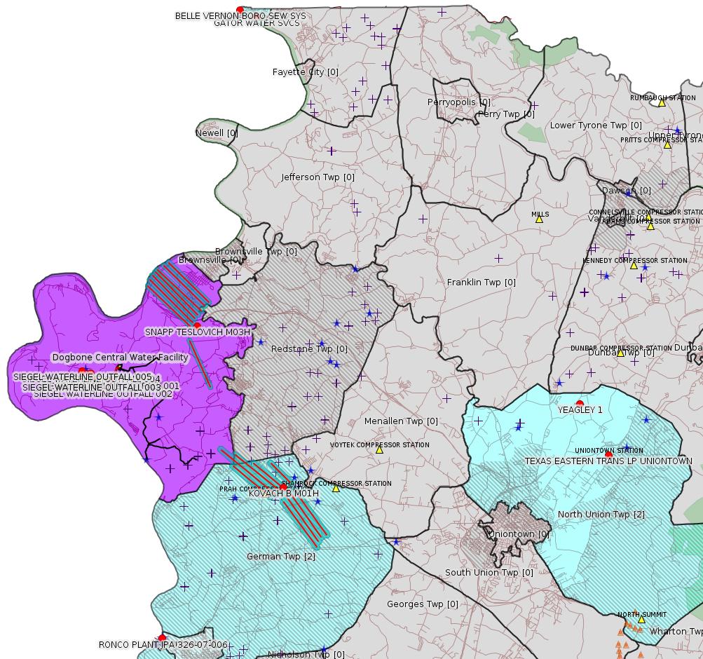
RONCO PLANT JPA 326-07-006 pump pad and two floating intake structureseFACTS Listings
TEXAS EASTERN TRANS LP UNIONTOWN Minor Source Operating Permit (New)
KOVACH B M01H Drill & Operate Well Permit (Unconventional) Modification [of schedule] (New)
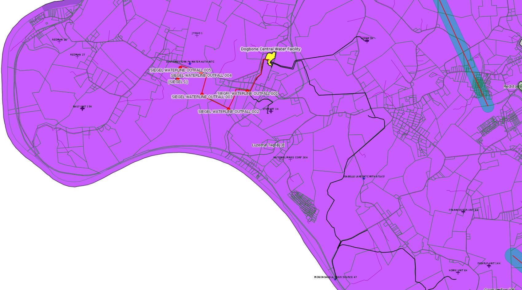
SIEGEL WATERLINE ESCGP ESX18-051-0005 PAG-10 Discharge Resulting from Hydrostatic Testing of Tanks & Pipelines
Kovach Well Connect Pipeline Project Erosion and Sediment Control General Permit 3 Expedited
Siegel Well Connect Pipeline Project Erosion and Sediment Control General Permit 3 Expedited
GATOR WATER SVCS GP-04 Intake & Outfall Structures Withdrawn 11/13/2019
SNAPP TESLOVICH M15H Alt Method of Equipping, Casing, or Venting Well Issued 10/30/2019
SNAPP TESLOVICH M12H Alt Method of Equipping, Casing, or Venting Well Issued 10/30/2019
SNAPP TESLOVICH M09H Alt Method of Equipping, Casing, or Venting Well Issued 10/30/2019
SNAPP TESLOVICH M08H Alt Method of Equipping, Casing, or Venting Well Issued 10/30/2019
SNAPP TESLOVICH M07H Alt Method of Equipping, Casing, or Venting Well Issued 10/30/2019
SNAPP TESLOVICH M06H Alt Method of Equipping, Casing, or Venting Well Issued 10/30/2019
SNAPP TESLOVICH M05H Alt Method of Equipping, Casing, or Venting Well Issued 10/30/2019
SNAPP TESLOVICH M04H Alt Method of Equipping, Casing, or Venting Well Issued 10/30/2019
SNAPP TESLOVICH M03H Alt Method of Equipping, Casing, or Venting Well Issued 10/30/2019
SNAPP TESLOVICH M02H Alt Method of Equipping, Casing, or Venting Well Issued 10/30/2019
SNAPP TESLOVICH M01V Alt Method of Equipping, Casing, or Venting Well Issued 10/30/2019
Inspection Anomalies (Oil & Gas
Compliance Report)
YEAGLEY 1 Spill through one of several brine tank holes Violation(s) Noted
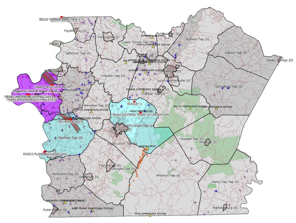
Map
Key
Red dots: items in this permit list with an exact location.
Blue stars: Marcellus Gas Well Water Sources.
Where well laterals are mapped they show in red; a 400-foot buffer surrounding the lateral shows in blue (lavender where it overlaps a mapped mineral tract).
Where mineral tracts are mapped, they show in pink. Mineral tracts can overlap; the overlap will show in red. The precise meaning of "mineral tract" is not clear.
Municipality shading: number of "facilities", with each well counting separately
(includes the red dots):
gray: 0
pale turquoise: 1
turquoise: 2
pale blue: 3
middle blue: 4
dark blue: 5
dark purple: 7
purple: 14
(Color coding may differ from one issue to the next.)
(Note if a project spans multiple municipalities -- e.g. a pipeline -- it will show in the count for each municipality.)
The number of facilities also follows the municipality name in brackets.
Municipality counts are based on the way the permit is listed by DEP; DEP has been known to get a municipality wrong.
Locations in brackets identify a precise location used to locate a surrogate for the actual site being permitted (e.g. locating a well pad or pipeline by the known location of a well.) Locations labeled beginning with "~" and ending in "[?]" are approximate and speculative based on inferences using on-line property and lease records. These are marked in the text as "[Approximate, Speculative]
Cross-hatching: Environmental Justice Areas
Yellow triangles: Compressor Stations
Orange triangles: Storage Field Wells (currently Dominion North Summit Storage Field)
Crosses: SPUD Unconventional well permits
Green: "Natural areas", e.g. state game lands, state forests
Yellow triangles: Compressor Stations
Orange triangles: Storage Field Wells (currently Dominion North Summit Storage Field)
Crosses: SPUD Unconventional well permits
Green: "Natural areas", e.g. state game lands, state forests
More Maps
 |
 |
Source: Pennsylvania Bulletin
E26-07-006: Appalachian Water Services, 195 Enterprise Lane, Connellsville, PA 15425.
Appalachian Water Services permitted their 14 foot by 17 foot gravel pump pad located within the FEMA floodway of the Monongahela River and the placement of two floating intake structures within the channel of the Monongahela River, a Warm Water Fisheries, in Masontown Borough, Fayette County, Pittsburgh USACE District, (Masontown Quadrangle, Latitude N 39° 51` 14", Longitude W -79° 55` 27.9"). This project temporarily impacts 20 LF of stream and 50 LF of floodway with the installation of the intake and permanently impacts 0.005 acre of FEMA floodway with the constructed gravel pump pad.
<http://www.pacodeandbulletin.gov/Display/pabull?file=/secure/pabulletin/data/vol49/49-45/1673c.html&continued=http://www.pacodeandbulletin.gov/Display/pabull?file=/secure/pabulletin/data/vol49/49-45/1673.html&d=reduce#>
Site: RONCO PLANT JPA 326-07-006
Location: 39.853889,-79.924417
Presumed Parcel Id: 21010001
-------------------------
Source: eNOTICE
(+ PA
Oil and Gas Mapping, Well
Pad Report.) Well Details via Data
Portal Services: Oil and Gas Wells All (ID: 3).
Please see the Disclaimer below regarding Parcel Id data.
Authorization ID: 1295805
Permit number: 26-00413
Site: TEXAS EASTERN TRANS LP UNIONTOWN
Client: TEXAS EASTERN TRANS LP
Authorization type: Minor Source Operating Permit
Application type: New
Authorization is for: FACILITY
Date received: 11/12/2019
Status: Pending
Permit Decision Guarantee Applies?: No
Permit Review Notes:
Date Review Note
11/14/2019 The permit application package is complete, has been accepted, and is undergoing technical review.
<https://www.ahs.dep.pa.gov/eFACTSWeb/searchResults_singleAuth.aspx?AuthID=1295805>
Site Programs:
Air Quality
Waste Management
Site Municipalities:
North Union Twp, Fayette County
Uniontown [Incorrect -jr], Fayette County
---
Authorization ID: 1295697
Permit number: PAG136376
Site: BELLE VERNON BORO SEW SYS
Client: BELLE VERNON BORO FAYETTE CNTY
Authorization type: PAG-13 Stormwater Discharges from Small Muni Separate Storm Sewer Sys MS4
Application type: Renewal
Authorization is for: FACILITY
Date received: 11/13/2019
Status: Pending
Permit Decision Guarantee Applies?: No
Sub-Facilities for Authorization:
Sub-Facility ID Sub-Facility Name Description
1116517 SW OUTFALL 001 Discharge Point
Location: 40.127642,-79.875944
Map URL: <http://www.openstreetmap.org/?mlat=40.127642&mlon=-79.875944#map=15/40.127642/-79.875944>
Permit Review Notes:
Date Review Note
11/14/2019 The permit application package is complete, has been accepted, and is undergoing technical review.
<https://www.ahs.dep.pa.gov/eFACTSWeb/searchResults_singleAuth.aspx?AuthID=1295697>
Site Programs:
Clean Water
Site Municipalities:
Belle Vernon Boro, Fayette County
---
Authorization ID: 1295303
Permit number: 051-24671
Site: KOVACH B WELL SITE AND TANK SITE ESCGP ESX17-051-0003
Client: CHEVRON APPALACHIA LLC
Authorization type: Drill & Operate Well Permit (Unconventional)
Application type: Modification
Authorization is for: FACILITY
Date received: 11/11/2019
Status: Pending
Permit Decision Guarantee Applies?: No
Sub-Facilities for Authorization:
Sub-Facility ID Sub-Facility Name Description
1263129 WELLBORE SURFACE HOLE LOCATION Well
Permit Review Notes:
Date Review Note
11/12/2019 The permit application package is complete, has been accepted, and is undergoing technical review.
<https://www.ahs.dep.pa.gov/eFACTSWeb/searchResults_singleAuth.aspx?AuthID=1295303>
Site Programs:
Oil & Gas
Site Municipalities:
German Twp, Fayette County
Well Details:
Permit Number: 051-24671
Well Name: KOVACH B M01H
Unconventional Well: Y
Well Configuration: Horizontal Well
Well Type: GAS
Well Status: Active
Coal Association: Coal
Conservation Well: N
Primary Facility ID: 828037
Site ID: 826949
Site Name: KOVACH B WELL SITE AND TANK SITE ESCGP ESX17-051-0003
Well Pad ID: 155005
Well Pad Name: KOVACH B
Storage Field:
Operator: CHEVRON APPALACHIA LLC
Operator Number: OGO-39307
Permit Date: 2018-08-08
Permit Date Expires: 2019-08-08
SPUD Date: 2018-10-23
Date Plugged:
UIC ID:
UIC Type:
Surface Elevation: 1278
County: Fayette
Municipality: German Twp
Location: 39.918933,-79.854808
Map URL: <http://www.openstreetmap.org/?mlat=39.918933&mlon=-79.854808#map=15/39.918933/-79.854808>
OG WELLS PERMIT DOCS:
2018-08-08: Final Permit Documents, Name: 1237727 (for Authorization: 1237727):
<http://www.depgis.state.pa.us/pdfHandler/pdFHandler.ashx?Doc=NjQ2Nzc2&ext=PDF>
2018-08-31: Other Permit Documents, Name: 051-24671 (for Authorization: 1240662):
<http://www.depgis.state.pa.us/pdfHandler/pdFHandler.ashx?Doc=NzgxMDI3&ext=PDF>
2019-01-07: Other Permit Documents, Name: 051-24671 (for Authorization: 1256817):
<http://www.depgis.state.pa.us/pdfHandler/pdFHandler.ashx?Doc=NzI3OTEy&ext=PDF>
2019-11-15: Initial Submitted Documents, Name: Kovach B M01H (for Authorization: 1295303):
<http://www.depgis.state.pa.us/pdfHandler/pdFHandler.ashx?Doc=OTY5OTQx&ext=PDF>
Electronically Submitted Records:
2018-08-08: Submission for Authorization 1237727
Pennsylvania Natural Diversity Inventory Form: Kovach B PNDI.pdf
<http://www.depgis.state.pa.us/eWellDocHandler/pdFHandler.ashx?Doc=NjAxNjky&ext=PDF>
Coal and Gas Resource Coord Act - Section 7 Exception: Kovach B Horizontals Section 7 Exception.pdf
<http://www.depgis.state.pa.us/eWellDocHandler/pdFHandler.ashx?Doc=NjAxNjkz&ext=PDF>
Well Cross-Section Diagram: Kovach B M01H Page 4.pdf
<http://www.depgis.state.pa.us/eWellDocHandler/pdFHandler.ashx?Doc=NjAxODA2&ext=PDF>
Interested Party Notification: Kovach B Affidavit of Non-Delivery Venere.pdf
<http://www.depgis.state.pa.us/eWellDocHandler/pdFHandler.ashx?Doc=NjAxODE4&ext=PDF>
Location Plat: Kovach B M01H Plat.dwg
<http://www.depgis.state.pa.us/eWellDocHandler/pdFHandler.ashx?Doc=NjAxODI5&ext=PDF>
Permit Application to Drill and Operate a Well: 1747807.pdf
<http://www.depgis.state.pa.us/eWellDocHandler/pdFHandler.ashx?Doc=NjAzODE3&ext=PDF>
2019-11-15: Submission for Authorization 1295303
Pennsylvania Natural Diversity Inventory Form: Kovach B PNDI.pdf
<http://www.depgis.state.pa.us/eWellDocHandler/pdFHandler.ashx?Doc=OTk1MzIy&ext=PDF>
Location Plat: Kovach B M01H Plat.dwg
<http://www.depgis.state.pa.us/eWellDocHandler/pdFHandler.ashx?Doc=OTk1MzIz&ext=PDF>
Permit Application to Drill and Operate a Well: Kovach B M01H Drill Application.pdf
<http://www.depgis.state.pa.us/eWellDocHandler/pdFHandler.ashx?Doc=OTk1NjUx&ext=PDF>
Interested Party Notification: Kovach B M01H Interested Parties.pdf
<http://www.depgis.state.pa.us/eWellDocHandler/pdFHandler.ashx?Doc=OTk1NjUy&ext=PDF>
Coal and Gas Resource Coord Act - Section 7 Exception: Kovach B Section 7 Exception.pdf
<http://www.depgis.state.pa.us/eWellDocHandler/pdFHandler.ashx?Doc=OTk1NjUz&ext=PDF>
Well Cross-Section Diagram: Kovach B M01H Page 4.pdf
<http://www.depgis.state.pa.us/eWellDocHandler/pdFHandler.ashx?Doc=OTk1NjU0&ext=PDF>
Well Permit Application - Coal Module: Kovach B Coal Module w Record of Notification.pdf
<http://www.depgis.state.pa.us/eWellDocHandler/pdFHandler.ashx?Doc=OTk1NjU1&ext=PDF>
Electronic Submission Docket: 2037232.pdf
<http://www.depgis.state.pa.us/eWellDocHandler/pdFHandler.ashx?Doc=OTk2NzE1&ext=PDF>
Presumed Parcel Id: 1511002301
[See Notes.]
---
Authorization ID: 1293737
Permit number: PAG106223
Site: SIEGEL WATERLINE ESCGP ESX18-051-0005
Client: CHEVRON APPALACHIA LLC
Authorization type: PAG-10 Discharge Resulting from Hydrostatic Testing of Tanks & Pipelines
Application type: New
Authorization is for: FACILITY
Date received: 10/28/2019
Status: Pending
Permit Decision Guarantee Applies?: Yes
Permit Decision Guarantee status: ACTIVE
Sub-Facilities for Authorization:
Sub-Facility ID Sub-Facility Name Description
1297035 OUTFALL 001 Discharge Point
Location: 39.966631,-79.952311
Map URL: <http://www.openstreetmap.org/?mlat=39.966631&mlon=-79.952311#map=15/39.966631/-79.952311>
1297036 OUTFALL 002 Discharge Point
Location: 39.963367,-79.956869
Map URL: <http://www.openstreetmap.org/?mlat=39.963367&mlon=-79.956869#map=15/39.963367/-79.956869>
1297037 OUTFALL 003 Discharge Point
Location: 39.966136,-79.963086
Map URL: <http://www.openstreetmap.org/?mlat=39.966136&mlon=-79.963086#map=15/39.966136/-79.963086>
1297038 OUTFALL 004 Discharge Point
Location: 39.970019,-79.963247
Map URL: <http://www.openstreetmap.org/?mlat=39.970019&mlon=-79.963247#map=15/39.970019/-79.963247>
1297039 OUTFALL 005 Discharge Point
Location: 39.971014,-79.968156
Map URL: <http://www.openstreetmap.org/?mlat=39.971014&mlon=-79.968156#map=15/39.971014/-79.968156>
Permit Review Notes:
Date Review Note
10/29/2019 The permit application package is complete, has been accepted, and is undergoing technical review.
<https://www.ahs.dep.pa.gov/eFACTSWeb/searchResults_singleAuth.aspx?AuthID=1293737>
Site Programs:
Clean Water
Site Municipalities:
Luzerne Twp, Fayette County
---
Authorization ID: 1293147
Permit number: ESG072619004-00
Site: Kovach Well Connect Pipeline Project
Client: LAUREL MTN MIDSTREAM OPR LLC
Authorization type: Erosion and Sediment Control General Permit 3 Expedited
Application type: New
Authorization is for: SITE
Date received: 10/23/2019
Status: Pending
Permit Decision Guarantee Applies?: Yes
Permit Decision Guarantee status: VOID
Permit Review Notes:
Date Review Note
11/5/2019 Applicant has been issued a deficiency letter. If applicable, this application no longer qualifies for the Permit Decision Guarantee.
11/5/2019 The permit application package is complete, has been accepted, and is undergoing technical review.
<https://www.ahs.dep.pa.gov/eFACTSWeb/searchResults_singleAuth.aspx?AuthID=1293147>
Site Programs:
Site Municipalities:
German Twp, Fayette County
---
Authorization ID: 1289255
Permit number: ESG072619002-00
Site: Siegel Well Connect Pipeline Project
Client: LAUREL MTN MIDSTREAM OPR LLC
Authorization type: Erosion and Sediment Control General Permit 3 Expedited
Application type: New
Authorization is for: SITE
Date received: 09/23/2019
Status: Issued on 11/4/2019
Permit Decision Guarantee Applies?: Yes
Permit Decision Guarantee status: ACTIVE
Permit Review Notes:
Date Review Note
11/4/2019 The technical review and decision review are complete and either the permit decision and/or permit issuance are forthcoming.
10/17/2019 The permit application package is complete, has been accepted, and is undergoing technical review.
<https://www.ahs.dep.pa.gov/eFACTSWeb/searchResults_singleAuth.aspx?AuthID=1289255>
Site Programs:
Site Municipalities:
Luzerne Twp, Fayette County
Location [of Siegel 1]: 39.968972;-79.968794
---
Authorization ID: 1285335
Permit number: GP042607219-004
Site: GATOR WATER SVCS
Client: GATOR WATER SVCS
Authorization type: GP-04 Intake & Outfall Structures
Application type: New
Authorization is for: FACILITY
Date received: 08/27/2019
Status: Withdrawn on 11/13/2019
Permit Decision Guarantee Applies?: No
Sub-Facilities for Authorization:
Sub-Facility ID Sub-Facility Name Description
1290477 WITHDRAWAL DISTRIBUTION Intake Structure
Location: 40.1246,-79.8666
Map URL: <http://www.openstreetmap.org/?mlat=40.1246&mlon=-79.8666#map=15/40.1246/-79.8666>
<https://www.ahs.dep.pa.gov/eFACTSWeb/searchResults_singleAuth.aspx?AuthID=1285335>
Site Programs:
Water Planning and Conservation
Site Municipalities:
Belle Vernon Boro, Fayette County
---
Authorization ID: 1285047
Permit number: 051-24716
Site: SNAPP TESLOVICH WELL PAD A ESCGP3 ESG30705118-002
Client: CHEVRON APPALACHIA LLC
Authorization type: Alt Method of Equipping, Casing, or Venting Well
Application type: New
Authorization is for: FACILITY
Date received: 08/22/2019
Status: Issued on 10/30/2019
Permit Decision Guarantee Applies?: Yes
Permit Decision Guarantee status: ACTIVE
Sub-Facilities for Authorization:
Sub-Facility ID Sub-Facility Name Description
1292500 WELLBORE SURFACE HOLE LOCATION Well
Permit Review Notes:
Date Review Note
10/30/2019 The technical review and decision review are complete and either the permit decision and/or permit issuance are forthcoming.
8/23/2019 The permit application package is complete, has been accepted, and is undergoing technical review.
<https://www.ahs.dep.pa.gov/eFACTSWeb/searchResults_singleAuth.aspx?AuthID=1285047>
Site Programs:
Oil & Gas
Site Municipalities:
Luzerne Twp, Fayette County
Well Details:
Permit Number: 051-24716
Well Name: SNAPP TESLOVICH M15H
Unconventional Well: Y
Well Configuration: Horizontal Well
Well Type: GAS
Well Status: Active
Coal Association: NonCoal
Conservation Well: N
Primary Facility ID: 836750
Site ID: 833740
Site Name: SNAPP TESLOVICH WELL PAD A ESCGP3 ESG30705118-002
Well Pad ID: 155747
Well Pad Name: SNAPP-TESLOVICH PAD A
Storage Field:
Operator: CHEVRON APPALACHIA LLC
Operator Number: OGO-39307
Permit Date: 2019-09-18
Permit Date Expires: 2020-09-18
SPUD Date:
Date Plugged:
UIC ID:
UIC Type:
Surface Elevation: 1100
County: Fayette
Municipality: Luzerne Twp
Location: 39.990031,-79.902594
Map URL: <http://www.openstreetmap.org/?mlat=39.990031&mlon=-79.902594#map=15/39.990031/-79.902594>
OG WELLS PERMIT DOCS:
2019-09-18: Other Permit Documents, Name: SNAPP TESLOVICH Coal Determination (for Authorization: 1284022):
<http://www.depgis.state.pa.us/pdfHandler/pdFHandler.ashx?Doc=OTIzMzQ4&ext=PDF>
2019-09-18: Final Permit Documents, Name: Authorization ID 1284022 (for Authorization: 1284022):
<http://www.depgis.state.pa.us/pdfHandler/pdFHandler.ashx?Doc=OTI2ODYx&ext=PDF>
2019-10-31: Other Permit Documents, Name: Alternate Method (for Authorization: 1285047):
<http://www.depgis.state.pa.us/pdfHandler/pdFHandler.ashx?Doc=OTYxMTM4&ext=PDF>
Electronically Submitted Records:
2019-09-18: Submission for Authorization 1284022
Pennsylvania Natural Diversity Inventory Form: Snapp Teslovich_PNDI.pdf
<http://www.depgis.state.pa.us/eWellDocHandler/pdFHandler.ashx?Doc=OTExMTEw&ext=PDF>
Justification for Non-Coal Well: Snapp Teslovich Non-Coal Packet.pdf
<http://www.depgis.state.pa.us/eWellDocHandler/pdFHandler.ashx?Doc=OTExMTEx&ext=PDF>
Coordination of Well Location with Public Resources: COORDINATION_OF_A_WELL_LOCATION_WITH_PUBLIC_RESOURCES_Snapp Teslovich - M15H.pdf
<http://www.depgis.state.pa.us/eWellDocHandler/pdFHandler.ashx?Doc=OTE4NzAz&ext=PDF>
Pennsylvania Natural Diversity Inventory Support Document: PNDI Clearance.pdf
<http://www.depgis.state.pa.us/eWellDocHandler/pdFHandler.ashx?Doc=OTE5MjAy&ext=PDF>
Well Cross-Section Diagram: Page 4_Snapp Teslovich Pad A_M15H.pdf
<http://www.depgis.state.pa.us/eWellDocHandler/pdFHandler.ashx?Doc=OTE5NjY2&ext=PDF>
Location Plat: Snapp Teslovich - M15H Plat - 2019.09.09.dwg
<http://www.depgis.state.pa.us/eWellDocHandler/pdFHandler.ashx?Doc=OTQxNTQ4&ext=PDF>
Permit Application to Drill and Operate a Well: 1985280.pdf
<http://www.depgis.state.pa.us/eWellDocHandler/pdFHandler.ashx?Doc=OTQxNTgy&ext=PDF>
---
Authorization ID: 1285046
Permit number: 051-24715
Site: SNAPP TESLOVICH WELL PAD A ESCGP3 ESG30705118-002
Client: CHEVRON APPALACHIA LLC
Authorization type: Alt Method of Equipping, Casing, or Venting Well
Application type: New
Authorization is for: FACILITY
Date received: 08/22/2019
Status: Issued on 10/30/2019
Permit Decision Guarantee Applies?: Yes
Permit Decision Guarantee status: ACTIVE
Sub-Facilities for Authorization:
Sub-Facility ID Sub-Facility Name Description
1292499 WELLBORE SURFACE HOLE LOCATION Well
Permit Review Notes:
Date Review Note
10/30/2019 The technical review and decision review are complete and either the permit decision and/or permit issuance are forthcoming.
8/23/2019 The permit application package is complete, has been accepted, and is undergoing technical review.
<https://www.ahs.dep.pa.gov/eFACTSWeb/searchResults_singleAuth.aspx?AuthID=1285046>
Site Programs:
Oil & Gas
Site Municipalities:
Luzerne Twp, Fayette County
Well Details:
Permit Number: 051-24715
Well Name: SNAPP TESLOVICH M12H
Unconventional Well: Y
Well Configuration: Horizontal Well
Well Type: GAS
Well Status: Active
Coal Association: NonCoal
Conservation Well: N
Primary Facility ID: 836749
Site ID: 833740
Site Name: SNAPP TESLOVICH WELL PAD A ESCGP3 ESG30705118-002
Well Pad ID: 155747
Well Pad Name: SNAPP-TESLOVICH PAD A
Storage Field:
Operator: CHEVRON APPALACHIA LLC
Operator Number: OGO-39307
Permit Date: 2019-09-18
Permit Date Expires: 2020-09-18
SPUD Date:
Date Plugged:
UIC ID:
UIC Type:
Surface Elevation: 1100
County: Fayette
Municipality: Luzerne Twp
Location: 39.99005,-79.902436
Map URL: <http://www.openstreetmap.org/?mlat=39.99005&mlon=-79.902436#map=15/39.99005/-79.902436>
OG WELLS PERMIT DOCS:
2019-09-18: Other Permit Documents, Name: SNAPP TESLOVICH Coal Determination (for Authorization: 1284021):
<http://www.depgis.state.pa.us/pdfHandler/pdFHandler.ashx?Doc=OTIzMzQw&ext=PDF>
2019-09-18: Final Permit Documents, Name: Authorization ID 1284021 (for Authorization: 1284021):
<http://www.depgis.state.pa.us/pdfHandler/pdFHandler.ashx?Doc=OTI2ODUz&ext=PDF>
2019-10-31: Other Permit Documents, Name: Alternate Method (for Authorization: 1285046):
<http://www.depgis.state.pa.us/pdfHandler/pdFHandler.ashx?Doc=OTYxMTQx&ext=PDF>
Electronically Submitted Records:
2019-09-18: Submission for Authorization 1284021
Pennsylvania Natural Diversity Inventory Form: Snapp Teslovich_PNDI.pdf
<http://www.depgis.state.pa.us/eWellDocHandler/pdFHandler.ashx?Doc=OTExMDk1&ext=PDF>
Justification for Non-Coal Well: Snapp Teslovich Non-Coal Packet.pdf
<http://www.depgis.state.pa.us/eWellDocHandler/pdFHandler.ashx?Doc=OTExMDk2&ext=PDF>
Coordination of Well Location with Public Resources: COORDINATION_OF_A_WELL_LOCATION_WITH_PUBLIC_RESOURCES_Snapp Teslovich - M12H.pdf
<http://www.depgis.state.pa.us/eWellDocHandler/pdFHandler.ashx?Doc=OTE4NzAy&ext=PDF>
Pennsylvania Natural Diversity Inventory Support Document: PNDI Clearance.pdf
<http://www.depgis.state.pa.us/eWellDocHandler/pdFHandler.ashx?Doc=OTE5MTkz&ext=PDF>
Well Cross-Section Diagram: Page 4_Snapp Teslovich Pad A_M12H.pdf
<http://www.depgis.state.pa.us/eWellDocHandler/pdFHandler.ashx?Doc=OTE5NjYw&ext=PDF>
Location Plat: Snapp Teslovich - M12H Plat - 2019.09.09.dwg
<http://www.depgis.state.pa.us/eWellDocHandler/pdFHandler.ashx?Doc=OTQxNTQ0&ext=PDF>
Permit Application to Drill and Operate a Well: 1985276.pdf
<http://www.depgis.state.pa.us/eWellDocHandler/pdFHandler.ashx?Doc=OTQxNTc5&ext=PDF>
---
Authorization ID: 1285044
Permit number: 051-24712
Site: SNAPP TESLOVICH WELL PAD A ESCGP3 ESG30705118-002
Client: CHEVRON APPALACHIA LLC
Authorization type: Alt Method of Equipping, Casing, or Venting Well
Application type: New
Authorization is for: FACILITY
Date received: 08/22/2019
Status: Issued on 10/30/2019
Permit Decision Guarantee Applies?: Yes
Permit Decision Guarantee status: ACTIVE
Sub-Facilities for Authorization:
Sub-Facility ID Sub-Facility Name Description
1292496 WELLBORE SURFACE HOLE LOCATION Well
Permit Review Notes:
Date Review Note
10/30/2019 The technical review and decision review are complete and either the permit decision and/or permit issuance are forthcoming.
8/23/2019 The permit application package is complete, has been accepted, and is undergoing technical review.
<https://www.ahs.dep.pa.gov/eFACTSWeb/searchResults_singleAuth.aspx?AuthID=1285044>
Site Programs:
Oil & Gas
Site Municipalities:
Luzerne Twp, Fayette County
Well Details:
Permit Number: 051-24712
Well Name: SNAPP TESLOVICH M09H
Unconventional Well: Y
Well Configuration: Horizontal Well
Well Type: GAS
Well Status: Active
Coal Association: NonCoal
Conservation Well: N
Primary Facility ID: 836746
Site ID: 833740
Site Name: SNAPP TESLOVICH WELL PAD A ESCGP3 ESG30705118-002
Well Pad ID: 155747
Well Pad Name: SNAPP-TESLOVICH PAD A
Storage Field:
Operator: CHEVRON APPALACHIA LLC
Operator Number: OGO-39307
Permit Date: 2019-09-18
Permit Date Expires: 2020-09-18
SPUD Date:
Date Plugged:
UIC ID:
UIC Type:
Surface Elevation: 1100
County: Fayette
Municipality: Luzerne Twp
Location: 39.990072,-79.902278
Map URL: <http://www.openstreetmap.org/?mlat=39.990072&mlon=-79.902278#map=15/39.990072/-79.902278>
OG WELLS PERMIT DOCS:
2019-09-18: Other Permit Documents, Name: SNAPP TESLOVICH Coal Determination (for Authorization: 1284013):
<http://www.depgis.state.pa.us/pdfHandler/pdFHandler.ashx?Doc=OTIzMzMx&ext=PDF>
2019-09-18: Final Permit Documents, Name: Authorization ID 1284013 (for Authorization: 1284013):
<http://www.depgis.state.pa.us/pdfHandler/pdFHandler.ashx?Doc=OTI2ODM2&ext=PDF>
2019-10-31: Other Permit Documents, Name: Alternate Method (for Authorization: 1285044):
<http://www.depgis.state.pa.us/pdfHandler/pdFHandler.ashx?Doc=OTYxMTQ0&ext=PDF>
Electronically Submitted Records:
2019-09-18: Submission for Authorization 1284013
Justification for Non-Coal Well: Snapp Teslovich Non-Coal Packet.pdf
<http://www.depgis.state.pa.us/eWellDocHandler/pdFHandler.ashx?Doc=OTExMDg5&ext=PDF>
Pennsylvania Natural Diversity Inventory Form: Snapp Teslovich_PNDI.pdf
<http://www.depgis.state.pa.us/eWellDocHandler/pdFHandler.ashx?Doc=OTExMDkw&ext=PDF>
Coordination of Well Location with Public Resources: COORDINATION_OF_A_WELL_LOCATION_WITH_PUBLIC_RESOURCES_Snapp Teslovich - M09H.pdf
<http://www.depgis.state.pa.us/eWellDocHandler/pdFHandler.ashx?Doc=OTE4NzAw&ext=PDF>
Pennsylvania Natural Diversity Inventory Support Document: PNDI Clearance.pdf
<http://www.depgis.state.pa.us/eWellDocHandler/pdFHandler.ashx?Doc=OTE5MTYx&ext=PDF>
Well Cross-Section Diagram: Page 4_Snapp Teslovich Pad A_M09H.pdf
<http://www.depgis.state.pa.us/eWellDocHandler/pdFHandler.ashx?Doc=OTE5NjQ0&ext=PDF>
Location Plat: Snapp Teslovich - M09H Plat - 2019.09.09.dwg
<http://www.depgis.state.pa.us/eWellDocHandler/pdFHandler.ashx?Doc=OTQxNTQw&ext=PDF>
Permit Application to Drill and Operate a Well: 1984953.pdf
<http://www.depgis.state.pa.us/eWellDocHandler/pdFHandler.ashx?Doc=OTQxNTcw&ext=PDF>
---
Authorization ID: 1285042
Permit number: 051-24710
Site: SNAPP TESLOVICH WELL PAD A ESCGP3 ESG30705118-002
Client: CHEVRON APPALACHIA LLC
Authorization type: Alt Method of Equipping, Casing, or Venting Well
Application type: New
Authorization is for: FACILITY
Date received: 08/22/2019
Status: Issued on 10/30/2019
Permit Decision Guarantee Applies?: Yes
Permit Decision Guarantee status: ACTIVE
Sub-Facilities for Authorization:
Sub-Facility ID Sub-Facility Name Description
1292494 WELLBORE SURFACE HOLE LOCATION Well
Permit Review Notes:
Date Review Note
10/30/2019 The technical review and decision review are complete and either the permit decision and/or permit issuance are forthcoming.
8/23/2019 The permit application package is complete, has been accepted, and is undergoing technical review.
<https://www.ahs.dep.pa.gov/eFACTSWeb/searchResults_singleAuth.aspx?AuthID=1285042>
Site Programs:
Oil & Gas
Site Municipalities:
Luzerne Twp, Fayette County
Well Details:
Permit Number: 051-24710
Well Name: SNAPP TESLOVICH M08H
Unconventional Well: Y
Well Configuration: Horizontal Well
Well Type: GAS
Well Status: Active
Coal Association: NonCoal
Conservation Well: N
Primary Facility ID: 836744
Site ID: 833740
Site Name: SNAPP TESLOVICH WELL PAD A ESCGP3 ESG30705118-002
Well Pad ID: 155747
Well Pad Name: SNAPP-TESLOVICH PAD A
Storage Field:
Operator: CHEVRON APPALACHIA LLC
Operator Number: OGO-39307
Permit Date: 2019-09-18
Permit Date Expires: 2020-09-18
SPUD Date:
Date Plugged:
UIC ID:
UIC Type:
Surface Elevation: 1100
County: Fayette
Municipality: Luzerne Twp
Location: 39.989992,-79.902261
Map URL: <http://www.openstreetmap.org/?mlat=39.989992&mlon=-79.902261#map=15/39.989992/-79.902261>
OG WELLS PERMIT DOCS:
2019-09-18: Other Permit Documents, Name: SNAPP TESLOVICH Coal Determination (for Authorization: 1284010):
<http://www.depgis.state.pa.us/pdfHandler/pdFHandler.ashx?Doc=OTIyNTcz&ext=PDF>
2019-09-18: Final Permit Documents, Name: Authorization ID 1284010 (for Authorization: 1284010):
<http://www.depgis.state.pa.us/pdfHandler/pdFHandler.ashx?Doc=OTI2ODE5&ext=PDF>
2019-10-31: Other Permit Documents, Name: Alternate Method (for Authorization: 1285042):
<http://www.depgis.state.pa.us/pdfHandler/pdFHandler.ashx?Doc=OTYxMTUy&ext=PDF>
Electronically Submitted Records:
2019-09-18: Submission for Authorization 1284010
Justification for Non-Coal Well: Snapp Teslovich Non-Coal Packet.pdf
<http://www.depgis.state.pa.us/eWellDocHandler/pdFHandler.ashx?Doc=OTExMDg0&ext=PDF>
Pennsylvania Natural Diversity Inventory Form: Snapp Teslovich_PNDI.pdf
<http://www.depgis.state.pa.us/eWellDocHandler/pdFHandler.ashx?Doc=OTExMDg1&ext=PDF>
Coordination of Well Location with Public Resources: COORDINATION_OF_A_WELL_LOCATION_WITH_PUBLIC_RESOURCES_Snapp Teslovich - M08H.pdf
<http://www.depgis.state.pa.us/eWellDocHandler/pdFHandler.ashx?Doc=OTE4Njk4&ext=PDF>
Pennsylvania Natural Diversity Inventory Support Document: PNDI Clearance.pdf
<http://www.depgis.state.pa.us/eWellDocHandler/pdFHandler.ashx?Doc=OTE5MTQ0&ext=PDF>
Well Cross-Section Diagram: Page 4_Snapp Teslovich Pad A_M08H.pdf
<http://www.depgis.state.pa.us/eWellDocHandler/pdFHandler.ashx?Doc=OTE5NjQw&ext=PDF>
Location Plat: Snapp Teslovich - M08H Plat - 2019.09.09.dwg
<http://www.depgis.state.pa.us/eWellDocHandler/pdFHandler.ashx?Doc=OTQxNTM2&ext=PDF>
Permit Application to Drill and Operate a Well: 1984951.pdf
<http://www.depgis.state.pa.us/eWellDocHandler/pdFHandler.ashx?Doc=OTQxNTY0&ext=PDF>
---
Authorization ID: 1285040
Permit number: 051-24709
Site: SNAPP TESLOVICH WELL PAD A ESCGP3 ESG30705118-002
Client: CHEVRON APPALACHIA LLC
Authorization type: Alt Method of Equipping, Casing, or Venting Well
Application type: New
Authorization is for: FACILITY
Date received: 08/22/2019
Status: Issued on 10/30/2019
Permit Decision Guarantee Applies?: Yes
Permit Decision Guarantee status: ACTIVE
Sub-Facilities for Authorization:
Sub-Facility ID Sub-Facility Name Description
1292493 WELLBORE SURFACE HOLE LOCATION Well
Permit Review Notes:
Date Review Note
10/30/2019 The technical review and decision review are complete and either the permit decision and/or permit issuance are forthcoming.
8/23/2019 The permit application package is complete, has been accepted, and is undergoing technical review.
<https://www.ahs.dep.pa.gov/eFACTSWeb/searchResults_singleAuth.aspx?AuthID=1285040>
Site Programs:
Oil & Gas
Site Municipalities:
Luzerne Twp, Fayette County
Well Details:
Permit Number: 051-24709
Well Name: SNAPP TESLOVICH M07H
Unconventional Well: Y
Well Configuration: Horizontal Well
Well Type: GAS
Well Status: Active
Coal Association: NonCoal
Conservation Well: N
Primary Facility ID: 836743
Site ID: 833740
Site Name: SNAPP TESLOVICH WELL PAD A ESCGP3 ESG30705118-002
Well Pad ID: 155747
Well Pad Name: SNAPP-TESLOVICH PAD A
Storage Field:
Operator: CHEVRON APPALACHIA LLC
Operator Number: OGO-39307
Permit Date: 2019-09-18
Permit Date Expires: 2020-09-18
SPUD Date:
Date Plugged:
UIC ID:
UIC Type:
Surface Elevation: 1100
County: Fayette
Municipality: Luzerne Twp
Location: 39.989983,-79.902314
Map URL: <http://www.openstreetmap.org/?mlat=39.989983&mlon=-79.902314#map=15/39.989983/-79.902314>
OG WELLS PERMIT DOCS:
2019-09-18: Other Permit Documents, Name: SNAPP TESLOVICH Coal Determination (for Authorization: 1284009):
<http://www.depgis.state.pa.us/pdfHandler/pdFHandler.ashx?Doc=OTIyNTYz&ext=PDF>
2019-09-18: Final Permit Documents, Name: Authorization ID 1284009 (for Authorization: 1284009):
<http://www.depgis.state.pa.us/pdfHandler/pdFHandler.ashx?Doc=OTI2ODA1&ext=PDF>
2019-10-31: Other Permit Documents, Name: Alternate Method (for Authorization: 1285040):
<http://www.depgis.state.pa.us/pdfHandler/pdFHandler.ashx?Doc=OTYxMTU5&ext=PDF>
Electronically Submitted Records:
2019-09-18: Submission for Authorization 1284009
Pennsylvania Natural Diversity Inventory Form: Snapp Teslovich_PNDI.pdf
<http://www.depgis.state.pa.us/eWellDocHandler/pdFHandler.ashx?Doc=OTExMDgy&ext=PDF>
Justification for Non-Coal Well: Snapp Teslovich Non-Coal Packet.pdf
<http://www.depgis.state.pa.us/eWellDocHandler/pdFHandler.ashx?Doc=OTExMDgz&ext=PDF>
Coordination of Well Location with Public Resources: COORDINATION_OF_A_WELL_LOCATION_WITH_PUBLIC_RESOURCES_Snapp Teslovich - M07H.pdf
<http://www.depgis.state.pa.us/eWellDocHandler/pdFHandler.ashx?Doc=OTE4Njkz&ext=PDF>
Pennsylvania Natural Diversity Inventory Support Document: PNDI Clearance.pdf
<http://www.depgis.state.pa.us/eWellDocHandler/pdFHandler.ashx?Doc=OTE5MTM2&ext=PDF>
Well Cross-Section Diagram: Page 4_Snapp Teslovich Pad A_M07H.pdf
<http://www.depgis.state.pa.us/eWellDocHandler/pdFHandler.ashx?Doc=OTE5NjI1&ext=PDF>
Location Plat: Snapp Teslovich - M07H Plat - 2019.09.09.dwg
<http://www.depgis.state.pa.us/eWellDocHandler/pdFHandler.ashx?Doc=OTQxNTMy&ext=PDF>
Permit Application to Drill and Operate a Well: 1984949.pdf
<http://www.depgis.state.pa.us/eWellDocHandler/pdFHandler.ashx?Doc=OTQxNTc2&ext=PDF>
---
Authorization ID: 1285039
Permit number: 051-24711
Site: SNAPP TESLOVICH WELL PAD A ESCGP3 ESG30705118-002
Client: CHEVRON APPALACHIA LLC
Authorization type: Alt Method of Equipping, Casing, or Venting Well
Application type: New
Authorization is for: FACILITY
Date received: 08/22/2019
Status: Issued on 10/30/2019
Permit Decision Guarantee Applies?: Yes
Permit Decision Guarantee status: ACTIVE
Sub-Facilities for Authorization:
Sub-Facility ID Sub-Facility Name Description
1292495 WELLBORE SURFACE HOLE LOCATION Well
Permit Review Notes:
Date Review Note
10/30/2019 The technical review and decision review are complete and either the permit decision and/or permit issuance are forthcoming.
8/23/2019 The permit application package is complete, has been accepted, and is undergoing technical review.
<https://www.ahs.dep.pa.gov/eFACTSWeb/searchResults_singleAuth.aspx?AuthID=1285039>
Site Programs:
Oil & Gas
Site Municipalities:
Luzerne Twp, Fayette County
Well Details:
Permit Number: 051-24711
Well Name: SNAPP TESLOVICH M06H
Unconventional Well: Y
Well Configuration: Horizontal Well
Well Type: GAS
Well Status: Active
Coal Association: NonCoal
Conservation Well: N
Primary Facility ID: 836745
Site ID: 833740
Site Name: SNAPP TESLOVICH WELL PAD A ESCGP3 ESG30705118-002
Well Pad ID: 155747
Well Pad Name: SNAPP-TESLOVICH PAD A
Storage Field:
Operator: CHEVRON APPALACHIA LLC
Operator Number: OGO-39307
Permit Date: 2019-09-18
Permit Date Expires: 2020-09-18
SPUD Date:
Date Plugged:
UIC ID:
UIC Type:
Surface Elevation: 1100
County: Fayette
Municipality: Luzerne Twp
Location: 39.989978,-79.902367
Map URL: <http://www.openstreetmap.org/?mlat=39.989978&mlon=-79.902367#map=15/39.989978/-79.902367>
OG WELLS PERMIT DOCS:
2019-09-18: Other Permit Documents, Name: SNAPP TESLOVICH Coal Determination (for Authorization: 1284011):
<http://www.depgis.state.pa.us/pdfHandler/pdFHandler.ashx?Doc=OTIyODEz&ext=PDF>
2019-09-18: Final Permit Documents, Name: Authorization ID 1284011 (for Authorization: 1284011):
<http://www.depgis.state.pa.us/pdfHandler/pdFHandler.ashx?Doc=OTI2ODIw&ext=PDF>
2019-10-31: Other Permit Documents, Name: Alternate Method (for Authorization: 1285039):
<http://www.depgis.state.pa.us/pdfHandler/pdFHandler.ashx?Doc=OTYxMTQ5&ext=PDF>
Electronically Submitted Records:
2019-09-18: Submission for Authorization 1284011
Pennsylvania Natural Diversity Inventory Form: Snapp Teslovich_PNDI.pdf
<http://www.depgis.state.pa.us/eWellDocHandler/pdFHandler.ashx?Doc=OTExMDYz&ext=PDF>
Justification for Non-Coal Well: Snapp Teslovich Non-Coal Packet.pdf
<http://www.depgis.state.pa.us/eWellDocHandler/pdFHandler.ashx?Doc=OTExMDY0&ext=PDF>
Coordination of Well Location with Public Resources: COORDINATION_OF_A_WELL_LOCATION_WITH_PUBLIC_RESOURCES_Snapp Teslovich - M06H.pdf
<http://www.depgis.state.pa.us/eWellDocHandler/pdFHandler.ashx?Doc=OTE4Njky&ext=PDF>
Pennsylvania Natural Diversity Inventory Support Document: PNDI Clearance.pdf
<http://www.depgis.state.pa.us/eWellDocHandler/pdFHandler.ashx?Doc=OTE5MTE4&ext=PDF>
Well Cross-Section Diagram: Page 4_Snapp Teslovich Pad A_M06H.pdf
<http://www.depgis.state.pa.us/eWellDocHandler/pdFHandler.ashx?Doc=OTE5NjE1&ext=PDF>
Location Plat: Snapp Teslovich - M06H Plat - 2019.09.09.dwg
<http://www.depgis.state.pa.us/eWellDocHandler/pdFHandler.ashx?Doc=OTQxNTI4&ext=PDF>
Permit Application to Drill and Operate a Well: 1984910.pdf
<http://www.depgis.state.pa.us/eWellDocHandler/pdFHandler.ashx?Doc=OTQxNTYx&ext=PDF>
---
Authorization ID: 1285036
Permit number: 051-24713
Site: SNAPP TESLOVICH WELL PAD A ESCGP3 ESG30705118-002
Client: CHEVRON APPALACHIA LLC
Authorization type: Alt Method of Equipping, Casing, or Venting Well
Application type: New
Authorization is for: FACILITY
Date received: 08/22/2019
Status: Issued on 10/30/2019
Permit Decision Guarantee Applies?: Yes
Permit Decision Guarantee status: ACTIVE
Sub-Facilities for Authorization:
Sub-Facility ID Sub-Facility Name Description
1292497 WELLBORE SURFACE HOLE LOCATION Well
Permit Review Notes:
Date Review Note
10/30/2019 The technical review and decision review are complete and either the permit decision and/or permit issuance are forthcoming.
8/23/2019 The permit application package is complete, has been accepted, and is undergoing technical review.
<https://www.ahs.dep.pa.gov/eFACTSWeb/searchResults_singleAuth.aspx?AuthID=1285036>
Site Programs:
Oil & Gas
Site Municipalities:
Luzerne Twp, Fayette County
Well Details:
Permit Number: 051-24713
Well Name: SNAPP TESLOVICH M05H
Unconventional Well: Y
Well Configuration: Horizontal Well
Well Type: GAS
Well Status: Active
Coal Association: NonCoal
Conservation Well: N
Primary Facility ID: 836747
Site ID: 833740
Site Name: SNAPP TESLOVICH WELL PAD A ESCGP3 ESG30705118-002
Well Pad ID: 155747
Well Pad Name: SNAPP-TESLOVICH PAD A
Storage Field:
Operator: CHEVRON APPALACHIA LLC
Operator Number: OGO-39307
Permit Date: 2019-09-18
Permit Date Expires: 2020-09-18
SPUD Date:
Date Plugged:
UIC ID:
UIC Type:
Surface Elevation: 1100
County: Fayette
Municipality: Luzerne Twp
Location: 39.989969,-79.902417
Map URL: <http://www.openstreetmap.org/?mlat=39.989969&mlon=-79.902417#map=15/39.989969/-79.902417>
OG WELLS PERMIT DOCS:
2019-09-18: Other Permit Documents, Name: SNAPP TESLOVICH Coal Determination (for Authorization: 1284014):
<http://www.depgis.state.pa.us/pdfHandler/pdFHandler.ashx?Doc=OTIzMjMx&ext=PDF>
2019-09-18: Final Permit Documents, Name: Authorization ID 1284014 (for Authorization: 1284014):
<http://www.depgis.state.pa.us/pdfHandler/pdFHandler.ashx?Doc=OTI2ODQ0&ext=PDF>
2019-10-31: Other Permit Documents, Name: Alternate Method (for Authorization: 1285036):
<http://www.depgis.state.pa.us/pdfHandler/pdFHandler.ashx?Doc=OTYxMTM2&ext=PDF>
Electronically Submitted Records:
2019-09-18: Submission for Authorization 1284014
Justification for Non-Coal Well: Snapp Teslovich Non-Coal Packet.pdf
<http://www.depgis.state.pa.us/eWellDocHandler/pdFHandler.ashx?Doc=OTExMDI5&ext=PDF>
Pennsylvania Natural Diversity Inventory Form: Snapp Teslovich_PNDI.pdf
<http://www.depgis.state.pa.us/eWellDocHandler/pdFHandler.ashx?Doc=OTExMDMw&ext=PDF>
Coordination of Well Location with Public Resources: COORDINATION_OF_A_WELL_LOCATION_WITH_PUBLIC_RESOURCES_Snapp Teslovich - M05H.pdf
<http://www.depgis.state.pa.us/eWellDocHandler/pdFHandler.ashx?Doc=OTE4Njkx&ext=PDF>
Pennsylvania Natural Diversity Inventory Support Document: PNDI Clearance.pdf
<http://www.depgis.state.pa.us/eWellDocHandler/pdFHandler.ashx?Doc=OTE5MTA0&ext=PDF>
Well Cross-Section Diagram: Page 4_Snapp Teslovich Pad A_M05H.pdf
<http://www.depgis.state.pa.us/eWellDocHandler/pdFHandler.ashx?Doc=OTE5NjAz&ext=PDF>
Location Plat: Snapp Teslovich - M05H Plat - 2019.09.09.dwg
<http://www.depgis.state.pa.us/eWellDocHandler/pdFHandler.ashx?Doc=OTQxNTI0&ext=PDF>
Permit Application to Drill and Operate a Well: 1984897.pdf
<http://www.depgis.state.pa.us/eWellDocHandler/pdFHandler.ashx?Doc=OTQxNTU4&ext=PDF>
---
Authorization ID: 1285035
Permit number: 051-24714
Site: SNAPP TESLOVICH WELL PAD A ESCGP3 ESG30705118-002
Client: CHEVRON APPALACHIA LLC
Authorization type: Alt Method of Equipping, Casing, or Venting Well
Application type: New
Authorization is for: FACILITY
Date received: 08/22/2019
Status: Issued on 10/30/2019
Permit Decision Guarantee Applies?: Yes
Permit Decision Guarantee status: ACTIVE
Sub-Facilities for Authorization:
Sub-Facility ID Sub-Facility Name Description
1292498 WELLBORE SURFACE HOLE LOCATION Well
Permit Review Notes:
Date Review Note
10/30/2019 The technical review and decision review are complete and either the permit decision and/or permit issuance are forthcoming.
8/23/2019 The permit application package is complete, has been accepted, and is undergoing technical review.
<https://www.ahs.dep.pa.gov/eFACTSWeb/searchResults_singleAuth.aspx?AuthID=1285035>
Site Programs:
Oil & Gas
Site Municipalities:
Luzerne Twp, Fayette County
Well Details:
Permit Number: 051-24714
Well Name: SNAPP TESLOVICH M04H
Unconventional Well: Y
Well Configuration: Horizontal Well
Well Type: GAS
Well Status: Active
Coal Association: NonCoal
Conservation Well: N
Primary Facility ID: 836748
Site ID: 833740
Site Name: SNAPP TESLOVICH WELL PAD A ESCGP3 ESG30705118-002
Well Pad ID: 155747
Well Pad Name: SNAPP-TESLOVICH PAD A
Storage Field:
Operator: CHEVRON APPALACHIA LLC
Operator Number: OGO-39307
Permit Date: 2019-09-18
Permit Date Expires: 2020-09-18
SPUD Date:
Date Plugged:
UIC ID:
UIC Type:
Surface Elevation: 1100
County: Fayette
Municipality: Luzerne Twp
Location: 39.989964,-79.902472
Map URL: <http://www.openstreetmap.org/?mlat=39.989964&mlon=-79.902472#map=15/39.989964/-79.902472>
OG WELLS PERMIT DOCS:
2019-09-18: Other Permit Documents, Name: SNAPP TESLOVICH Coal Determination (for Authorization: 1284015):
<http://www.depgis.state.pa.us/pdfHandler/pdFHandler.ashx?Doc=OTIzMzM2&ext=PDF>
2019-09-18: Final Permit Documents, Name: Authorization ID 1284015 (for Authorization: 1284015):
<http://www.depgis.state.pa.us/pdfHandler/pdFHandler.ashx?Doc=OTI2ODUw&ext=PDF>
2019-10-31: Other Permit Documents, Name: Alternate Method (for Authorization: 1285035):
<http://www.depgis.state.pa.us/pdfHandler/pdFHandler.ashx?Doc=OTYxMTQz&ext=PDF>
Electronically Submitted Records:
2019-09-18: Submission for Authorization 1284015
Justification for Non-Coal Well: Snapp Teslovich Non-Coal Packet.pdf
<http://www.depgis.state.pa.us/eWellDocHandler/pdFHandler.ashx?Doc=OTEwOTIw&ext=PDF>
Pennsylvania Natural Diversity Inventory Form: Snapp Teslovich_PNDI.pdf
<http://www.depgis.state.pa.us/eWellDocHandler/pdFHandler.ashx?Doc=OTEwOTIx&ext=PDF>
Coordination of Well Location with Public Resources: COORDINATION_OF_A_WELL_LOCATION_WITH_PUBLIC_RESOURCES_Snapp Teslovich - M04H.pdf
<http://www.depgis.state.pa.us/eWellDocHandler/pdFHandler.ashx?Doc=OTE4Njkw&ext=PDF>
Pennsylvania Natural Diversity Inventory Support Document: PNDI Clearance.pdf
<http://www.depgis.state.pa.us/eWellDocHandler/pdFHandler.ashx?Doc=OTE5MDky&ext=PDF>
Well Cross-Section Diagram: Page 4_Snapp Teslovich Pad A_M04H.pdf
<http://www.depgis.state.pa.us/eWellDocHandler/pdFHandler.ashx?Doc=OTE5NTg5&ext=PDF>
Location Plat: Snapp Teslovich - M04H Plat - 2019.09.09.dwg
<http://www.depgis.state.pa.us/eWellDocHandler/pdFHandler.ashx?Doc=OTQxNTIw&ext=PDF>
Permit Application to Drill and Operate a Well: 1984876.pdf
<http://www.depgis.state.pa.us/eWellDocHandler/pdFHandler.ashx?Doc=OTQxNTU1&ext=PDF>
---
Authorization ID: 1285032
Permit number: 051-24718
Site: SNAPP TESLOVICH WELL PAD A ESCGP3 ESG30705118-002
Client: CHEVRON APPALACHIA LLC
Authorization type: Alt Method of Equipping, Casing, or Venting Well
Application type: New
Authorization is for: FACILITY
Date received: 08/22/2019
Status: Issued on 10/30/2019
Permit Decision Guarantee Applies?: Yes
Permit Decision Guarantee status: ACTIVE
Sub-Facilities for Authorization:
Sub-Facility ID Sub-Facility Name Description
1292827 WELLBORE SURFACE HOLE LOCATION Well
Permit Review Notes:
Date Review Note
10/30/2019 The technical review and decision review are complete and either the permit decision and/or permit issuance are forthcoming.
8/23/2019 The permit application package is complete, has been accepted, and is undergoing technical review.
<https://www.ahs.dep.pa.gov/eFACTSWeb/searchResults_singleAuth.aspx?AuthID=1285032>
Site Programs:
Oil & Gas
Site Municipalities:
Luzerne Twp, Fayette County
Well Details:
Permit Number: 051-24718
Well Name: SNAPP TESLOVICH M03H
Unconventional Well: Y
Well Configuration: Vertical Well
Well Type: GAS
Well Status: Active
Coal Association: NonCoal
Conservation Well: N
Primary Facility ID: 836867
Site ID: 833740
Site Name: SNAPP TESLOVICH WELL PAD A ESCGP3 ESG30705118-002
Well Pad ID: 155747
Well Pad Name: SNAPP-TESLOVICH PAD A
Storage Field:
Operator: CHEVRON APPALACHIA LLC
Operator Number: OGO-39307
Permit Date: 2019-09-18
Permit Date Expires: 2020-09-18
SPUD Date:
Date Plugged:
UIC ID:
UIC Type:
Surface Elevation: 1100
County: Fayette
Municipality: Luzerne Twp
Location: 39.989956,-79.902525
Map URL: <http://www.openstreetmap.org/?mlat=39.989956&mlon=-79.902525#map=15/39.989956/-79.902525>
OG WELLS PERMIT DOCS:
2019-09-18: Other Permit Documents, Name: SNAPP TESLOVICH Coal Determination (for Authorization: 1284565):
<http://www.depgis.state.pa.us/pdfHandler/pdFHandler.ashx?Doc=OTIzNDc5&ext=PDF>
2019-10-31: Other Permit Documents, Name: Alternate Method (for Authorization: 1285032):
<http://www.depgis.state.pa.us/pdfHandler/pdFHandler.ashx?Doc=OTYxMTY2&ext=PDF>
Electronically Submitted Records:
2019-09-18: Submission for Authorization 1284565
Pennsylvania Natural Diversity Inventory Form: Snapp Teslovich_PNDI.pdf
<http://www.depgis.state.pa.us/eWellDocHandler/pdFHandler.ashx?Doc=OTE4ODk5&ext=PDF>
Justification for Non-Coal Well: Snapp Teslovich Non-Coal Packet.pdf
<http://www.depgis.state.pa.us/eWellDocHandler/pdFHandler.ashx?Doc=OTE4OTAw&ext=PDF>
Location Plat: Snapp Teslovich - M03H Plat - 2019.08.15.dwg
<http://www.depgis.state.pa.us/eWellDocHandler/pdFHandler.ashx?Doc=OTIyMDgw&ext=PDF>
Pennsylvania Natural Diversity Inventory Support Document: PNDI Clearance.pdf
<http://www.depgis.state.pa.us/eWellDocHandler/pdFHandler.ashx?Doc=OTIyMDgx&ext=PDF>
Coordination of Well Location with Public Resources: COORDINATION_OF_A_WELL_LOCATION_WITH_PUBLIC_RESOURCES_Snapp Teslovich - M03H.pdf
<http://www.depgis.state.pa.us/eWellDocHandler/pdFHandler.ashx?Doc=OTIyMDky&ext=PDF>
Permit Application to Drill and Operate a Well: 1995530.pdf
<http://www.depgis.state.pa.us/eWellDocHandler/pdFHandler.ashx?Doc=OTIzODEx&ext=PDF>
---
Authorization ID: 1285031
Permit number: 051-24717
Site: SNAPP TESLOVICH WELL PAD A ESCGP3 ESG30705118-002
Client: CHEVRON APPALACHIA LLC
Authorization type: Alt Method of Equipping, Casing, or Venting Well
Application type: New
Authorization is for: FACILITY
Date received: 08/22/2019
Status: Issued on 10/30/2019
Permit Decision Guarantee Applies?: Yes
Permit Decision Guarantee status: ACTIVE
Sub-Facilities for Authorization:
Sub-Facility ID Sub-Facility Name Description
1292826 WELLBORE SURFACE HOLE LOCATION Well
Permit Review Notes:
Date Review Note
10/30/2019 The technical review and decision review are complete and either the permit decision and/or permit issuance are forthcoming.
8/23/2019 The permit application package is complete, has been accepted, and is undergoing technical review.
<https://www.ahs.dep.pa.gov/eFACTSWeb/searchResults_singleAuth.aspx?AuthID=1285031>
Site Programs:
Oil & Gas
Site Municipalities:
Luzerne Twp, Fayette County
Well Details:
Permit Number: 051-24717
Well Name: SNAPP TESLOVICH M02H
Unconventional Well: Y
Well Configuration: Vertical Well
Well Type: GAS
Well Status: Active
Coal Association: NonCoal
Conservation Well: N
Primary Facility ID: 836866
Site ID: 833740
Site Name: SNAPP TESLOVICH WELL PAD A ESCGP3 ESG30705118-002
Well Pad ID: 155747
Well Pad Name: SNAPP-TESLOVICH PAD A
Storage Field:
Operator: CHEVRON APPALACHIA LLC
Operator Number: OGO-39307
Permit Date: 2019-09-18
Permit Date Expires: 2020-09-18
SPUD Date:
Date Plugged:
UIC ID:
UIC Type:
Surface Elevation: 1100
County: Fayette
Municipality: Luzerne Twp
Location: 39.989947,-79.902578
Map URL: <http://www.openstreetmap.org/?mlat=39.989947&mlon=-79.902578#map=15/39.989947/-79.902578>
OG WELLS PERMIT DOCS:
2019-09-18: Other Permit Documents, Name: SNAPP TESLOVICH Coal Determination (for Authorization: 1284564):
<http://www.depgis.state.pa.us/pdfHandler/pdFHandler.ashx?Doc=OTIzMzUw&ext=PDF>
2019-09-18: Final Permit Documents, Name: Authorization ID 1284564 (for Authorization: 1284564):
<http://www.depgis.state.pa.us/pdfHandler/pdFHandler.ashx?Doc=OTI2ODY5&ext=PDF>
2019-10-31: Other Permit Documents, Name: Alternate Method (for Authorization: 1285031):
<http://www.depgis.state.pa.us/pdfHandler/pdFHandler.ashx?Doc=OTYxMTQw&ext=PDF>
Electronically Submitted Records:
2019-09-18: Submission for Authorization 1284564
Pennsylvania Natural Diversity Inventory Form: Snapp Teslovich_PNDI.pdf
<http://www.depgis.state.pa.us/eWellDocHandler/pdFHandler.ashx?Doc=OTE4ODgy&ext=PDF>
Justification for Non-Coal Well: Snapp Teslovich Non-Coal Packet.pdf
<http://www.depgis.state.pa.us/eWellDocHandler/pdFHandler.ashx?Doc=OTE4ODgz&ext=PDF>
Pennsylvania Natural Diversity Inventory Support Document: PNDI Clearance.pdf
<http://www.depgis.state.pa.us/eWellDocHandler/pdFHandler.ashx?Doc=OTE4ODg0&ext=PDF>
Coordination of Well Location with Public Resources: COORDINATION_OF_A_WELL_LOCATION_WITH_PUBLIC_RESOURCES_Snapp Teslovich - M02H.pdf
<http://www.depgis.state.pa.us/eWellDocHandler/pdFHandler.ashx?Doc=OTIyMDYz&ext=PDF>
Location Plat: Snapp Teslovich - M02H Plat - 2019.09.09.dwg
<http://www.depgis.state.pa.us/eWellDocHandler/pdFHandler.ashx?Doc=OTQxNTEz&ext=PDF>
Permit Application to Drill and Operate a Well: 1995152.pdf
<http://www.depgis.state.pa.us/eWellDocHandler/pdFHandler.ashx?Doc=OTQxNTcz&ext=PDF>
---
Authorization ID: 1285029
Permit number: 051-24706
Site: SNAPP TESLOVICH WELL PAD A ESCGP3 ESG30705118-002
Client: CHEVRON APPALACHIA LLC
Authorization type: Alt Method of Equipping, Casing, or Venting Well
Application type: New
Authorization is for: FACILITY
Date received: 08/22/2019
Status: Issued on 10/30/2019
Permit Decision Guarantee Applies?: Yes
Permit Decision Guarantee status: ACTIVE
Sub-Facilities for Authorization:
Sub-Facility ID Sub-Facility Name Description
1284291 WELLBORE SURFACE HOLE LOCATION Well
Permit Review Notes:
Date Review Note
10/30/2019 The technical review and decision review are complete and either the permit decision and/or permit issuance are forthcoming.
8/23/2019 The permit application package is complete, has been accepted, and is undergoing technical review.
<https://www.ahs.dep.pa.gov/eFACTSWeb/searchResults_singleAuth.aspx?AuthID=1285029>
Site Programs:
Oil & Gas
Site Municipalities:
Luzerne Twp, Fayette County
Well Details:
Permit Number: 051-24706
Well Name: SNAPP TESLOVICH M01V
Unconventional Well: Y
Well Configuration: Vertical Well
Well Type: GAS
Well Status: Active
Coal Association: NonCoal
Conservation Well: N
Primary Facility ID: 833681
Site ID: 833740
Site Name: SNAPP TESLOVICH WELL PAD A ESCGP3 ESG30705118-002
Well Pad ID: 155747
Well Pad Name: SNAPP-TESLOVICH PAD A
Storage Field:
Operator: CHEVRON APPALACHIA LLC
Operator Number: OGO-39307
Permit Date: 2019-05-08
Permit Date Expires: 2020-05-08
SPUD Date:
Date Plugged:
UIC ID:
UIC Type:
Surface Elevation: 1100
County: Fayette
Municipality: Luzerne Twp
Location: 39.989942,-79.902631
Map URL: <http://www.openstreetmap.org/?mlat=39.989942&mlon=-79.902631#map=15/39.989942/-79.902631>
OG WELLS PERMIT DOCS:
2019-05-08: Other Permit Documents, Name: 1267676_Snapp Teslovich_M01V_Non-Coal Determination (for Authorization: 1267676):
<http://www.depgis.state.pa.us/pdfHandler/pdFHandler.ashx?Doc=NzkxNzk1&ext=PDF>
2019-05-08: Other Permit Documents, Name: 1267676_Snapp Teslovich_Explanation of Depth of Onondaga (for Authorization: 1267676):
<http://www.depgis.state.pa.us/pdfHandler/pdFHandler.ashx?Doc=ODA0MjA1&ext=PDF>
2019-05-08: Final Permit Documents, Name: Authorization ID 1267676 (for Authorization: 1267676):
<http://www.depgis.state.pa.us/pdfHandler/pdFHandler.ashx?Doc=ODA3NzY0&ext=PDF>
2019-10-31: Other Permit Documents, Name: Alternate Method (for Authorization: 1285029):
<http://www.depgis.state.pa.us/pdfHandler/pdFHandler.ashx?Doc=OTYxMTcz&ext=PDF>
Electronically Submitted Records:
2019-05-08: Submission for Authorization 1267676
Pennsylvania Natural Diversity Inventory Support Document: PNDI Clearance.pdf
<http://www.depgis.state.pa.us/eWellDocHandler/pdFHandler.ashx?Doc=ODA4NTMw&ext=PDF>
Pennsylvania Natural Diversity Inventory Form: Snapp Teslovich_PNDI.pdf
<http://www.depgis.state.pa.us/eWellDocHandler/pdFHandler.ashx?Doc=ODA4NTMx&ext=PDF>
Coordination of Well Location with Public Resources: Snapp Teslovich For OOGM0076U.pdf
<http://www.depgis.state.pa.us/eWellDocHandler/pdFHandler.ashx?Doc=ODA4NzM1&ext=PDF>
Justification for Non-Coal Well: Snapp Teslovich Non-Coal Packet.pdf
<http://www.depgis.state.pa.us/eWellDocHandler/pdFHandler.ashx?Doc=ODMyODkz&ext=PDF>
Location Plat: Snapp Teslovich - Final V Well Plat M01V - 2019.05.01.dwg
<http://www.depgis.state.pa.us/eWellDocHandler/pdFHandler.ashx?Doc=ODMzNjUw&ext=PDF>
Interested Party Notification: Snapp Teslovich_Affidavit of Non-Delivery_M Cochrane.pdf
<http://www.depgis.state.pa.us/eWellDocHandler/pdFHandler.ashx?Doc=ODM1MDEz&ext=PDF>
Permit Application to Drill and Operate a Well: 1886282.pdf
<http://www.depgis.state.pa.us/eWellDocHandler/pdFHandler.ashx?Doc=ODM1MDE2&ext=PDF>
-------------------------
Presumed Parcel Id: 25020029Please see the Disclaimer below regarding Parcel Id data.
Authorization ID: 1295805
Permit number: 26-00413
Site: TEXAS EASTERN TRANS LP UNIONTOWN
Client: TEXAS EASTERN TRANS LP
Authorization type: Minor Source Operating Permit
Application type: New
Authorization is for: FACILITY
Date received: 11/12/2019
Status: Pending
Permit Decision Guarantee Applies?: No
Permit Review Notes:
Date Review Note
11/14/2019 The permit application package is complete, has been accepted, and is undergoing technical review.
<https://www.ahs.dep.pa.gov/eFACTSWeb/searchResults_singleAuth.aspx?AuthID=1295805>
Site Programs:
Air Quality
Waste Management
Site Municipalities:
North Union Twp, Fayette County
Uniontown [Incorrect -jr], Fayette County
Location: 39.93111,-79.67
Map URL: <https://www.openstreetmap.org/?mlat=39.93111&mlon=-79.67#map=15/39.93111/-79.67>
Presumed Parcel Id: 25120168
[See Notes.]Map URL: <https://www.openstreetmap.org/?mlat=39.93111&mlon=-79.67#map=15/39.93111/-79.67>
Presumed Parcel Id: 25120168
---
Authorization ID: 1295697
Permit number: PAG136376
Site: BELLE VERNON BORO SEW SYS
Client: BELLE VERNON BORO FAYETTE CNTY
Authorization type: PAG-13 Stormwater Discharges from Small Muni Separate Storm Sewer Sys MS4
Application type: Renewal
Authorization is for: FACILITY
Date received: 11/13/2019
Status: Pending
Permit Decision Guarantee Applies?: No
Sub-Facilities for Authorization:
Sub-Facility ID Sub-Facility Name Description
1116517 SW OUTFALL 001 Discharge Point
Location: 40.127642,-79.875944
Map URL: <http://www.openstreetmap.org/?mlat=40.127642&mlon=-79.875944#map=15/40.127642/-79.875944>
Permit Review Notes:
Date Review Note
11/14/2019 The permit application package is complete, has been accepted, and is undergoing technical review.
<https://www.ahs.dep.pa.gov/eFACTSWeb/searchResults_singleAuth.aspx?AuthID=1295697>
Site Programs:
Clean Water
Site Municipalities:
Belle Vernon Boro, Fayette County
---
Authorization ID: 1295303
Permit number: 051-24671
Site: KOVACH B WELL SITE AND TANK SITE ESCGP ESX17-051-0003
Client: CHEVRON APPALACHIA LLC
Authorization type: Drill & Operate Well Permit (Unconventional)
Application type: Modification
Authorization is for: FACILITY
Date received: 11/11/2019
Status: Pending
Permit Decision Guarantee Applies?: No
Sub-Facilities for Authorization:
Sub-Facility ID Sub-Facility Name Description
1263129 WELLBORE SURFACE HOLE LOCATION Well
Permit Review Notes:
Date Review Note
11/12/2019 The permit application package is complete, has been accepted, and is undergoing technical review.
<https://www.ahs.dep.pa.gov/eFACTSWeb/searchResults_singleAuth.aspx?AuthID=1295303>
Site Programs:
Oil & Gas
Site Municipalities:
German Twp, Fayette County
Well Details:
Permit Number: 051-24671
Well Name: KOVACH B M01H
Unconventional Well: Y
Well Configuration: Horizontal Well
Well Type: GAS
Well Status: Active
Coal Association: Coal
Conservation Well: N
Primary Facility ID: 828037
Site ID: 826949
Site Name: KOVACH B WELL SITE AND TANK SITE ESCGP ESX17-051-0003
Well Pad ID: 155005
Well Pad Name: KOVACH B
Storage Field:
Operator: CHEVRON APPALACHIA LLC
Operator Number: OGO-39307
Permit Date: 2018-08-08
Permit Date Expires: 2019-08-08
SPUD Date: 2018-10-23
Date Plugged:
UIC ID:
UIC Type:
Surface Elevation: 1278
County: Fayette
Municipality: German Twp
Location: 39.918933,-79.854808
Map URL: <http://www.openstreetmap.org/?mlat=39.918933&mlon=-79.854808#map=15/39.918933/-79.854808>
OG WELLS PERMIT DOCS:
2018-08-08: Final Permit Documents, Name: 1237727 (for Authorization: 1237727):
<http://www.depgis.state.pa.us/pdfHandler/pdFHandler.ashx?Doc=NjQ2Nzc2&ext=PDF>
2018-08-31: Other Permit Documents, Name: 051-24671 (for Authorization: 1240662):
<http://www.depgis.state.pa.us/pdfHandler/pdFHandler.ashx?Doc=NzgxMDI3&ext=PDF>
2019-01-07: Other Permit Documents, Name: 051-24671 (for Authorization: 1256817):
<http://www.depgis.state.pa.us/pdfHandler/pdFHandler.ashx?Doc=NzI3OTEy&ext=PDF>
2019-11-15: Initial Submitted Documents, Name: Kovach B M01H (for Authorization: 1295303):
<http://www.depgis.state.pa.us/pdfHandler/pdFHandler.ashx?Doc=OTY5OTQx&ext=PDF>
Electronically Submitted Records:
2018-08-08: Submission for Authorization 1237727
Pennsylvania Natural Diversity Inventory Form: Kovach B PNDI.pdf
<http://www.depgis.state.pa.us/eWellDocHandler/pdFHandler.ashx?Doc=NjAxNjky&ext=PDF>
Coal and Gas Resource Coord Act - Section 7 Exception: Kovach B Horizontals Section 7 Exception.pdf
<http://www.depgis.state.pa.us/eWellDocHandler/pdFHandler.ashx?Doc=NjAxNjkz&ext=PDF>
Well Cross-Section Diagram: Kovach B M01H Page 4.pdf
<http://www.depgis.state.pa.us/eWellDocHandler/pdFHandler.ashx?Doc=NjAxODA2&ext=PDF>
Interested Party Notification: Kovach B Affidavit of Non-Delivery Venere.pdf
<http://www.depgis.state.pa.us/eWellDocHandler/pdFHandler.ashx?Doc=NjAxODE4&ext=PDF>
Location Plat: Kovach B M01H Plat.dwg
<http://www.depgis.state.pa.us/eWellDocHandler/pdFHandler.ashx?Doc=NjAxODI5&ext=PDF>
Permit Application to Drill and Operate a Well: 1747807.pdf
<http://www.depgis.state.pa.us/eWellDocHandler/pdFHandler.ashx?Doc=NjAzODE3&ext=PDF>
2019-11-15: Submission for Authorization 1295303
Pennsylvania Natural Diversity Inventory Form: Kovach B PNDI.pdf
<http://www.depgis.state.pa.us/eWellDocHandler/pdFHandler.ashx?Doc=OTk1MzIy&ext=PDF>
Location Plat: Kovach B M01H Plat.dwg
<http://www.depgis.state.pa.us/eWellDocHandler/pdFHandler.ashx?Doc=OTk1MzIz&ext=PDF>
Permit Application to Drill and Operate a Well: Kovach B M01H Drill Application.pdf
<http://www.depgis.state.pa.us/eWellDocHandler/pdFHandler.ashx?Doc=OTk1NjUx&ext=PDF>
Interested Party Notification: Kovach B M01H Interested Parties.pdf
<http://www.depgis.state.pa.us/eWellDocHandler/pdFHandler.ashx?Doc=OTk1NjUy&ext=PDF>
Coal and Gas Resource Coord Act - Section 7 Exception: Kovach B Section 7 Exception.pdf
<http://www.depgis.state.pa.us/eWellDocHandler/pdFHandler.ashx?Doc=OTk1NjUz&ext=PDF>
Well Cross-Section Diagram: Kovach B M01H Page 4.pdf
<http://www.depgis.state.pa.us/eWellDocHandler/pdFHandler.ashx?Doc=OTk1NjU0&ext=PDF>
Well Permit Application - Coal Module: Kovach B Coal Module w Record of Notification.pdf
<http://www.depgis.state.pa.us/eWellDocHandler/pdFHandler.ashx?Doc=OTk1NjU1&ext=PDF>
Electronic Submission Docket: 2037232.pdf
<http://www.depgis.state.pa.us/eWellDocHandler/pdFHandler.ashx?Doc=OTk2NzE1&ext=PDF>
Presumed Parcel Id: 1511002301
[See Notes.]
---
Authorization ID: 1293737
Permit number: PAG106223
Site: SIEGEL WATERLINE ESCGP ESX18-051-0005
Client: CHEVRON APPALACHIA LLC
Authorization type: PAG-10 Discharge Resulting from Hydrostatic Testing of Tanks & Pipelines
Application type: New
Authorization is for: FACILITY
Date received: 10/28/2019
Status: Pending
Permit Decision Guarantee Applies?: Yes
Permit Decision Guarantee status: ACTIVE
Sub-Facilities for Authorization:
Sub-Facility ID Sub-Facility Name Description
1297035 OUTFALL 001 Discharge Point
Location: 39.966631,-79.952311
Map URL: <http://www.openstreetmap.org/?mlat=39.966631&mlon=-79.952311#map=15/39.966631/-79.952311>
1297036 OUTFALL 002 Discharge Point
Location: 39.963367,-79.956869
Map URL: <http://www.openstreetmap.org/?mlat=39.963367&mlon=-79.956869#map=15/39.963367/-79.956869>
1297037 OUTFALL 003 Discharge Point
Location: 39.966136,-79.963086
Map URL: <http://www.openstreetmap.org/?mlat=39.966136&mlon=-79.963086#map=15/39.966136/-79.963086>
1297038 OUTFALL 004 Discharge Point
Location: 39.970019,-79.963247
Map URL: <http://www.openstreetmap.org/?mlat=39.970019&mlon=-79.963247#map=15/39.970019/-79.963247>
1297039 OUTFALL 005 Discharge Point
Location: 39.971014,-79.968156
Map URL: <http://www.openstreetmap.org/?mlat=39.971014&mlon=-79.968156#map=15/39.971014/-79.968156>
Permit Review Notes:
Date Review Note
10/29/2019 The permit application package is complete, has been accepted, and is undergoing technical review.
<https://www.ahs.dep.pa.gov/eFACTSWeb/searchResults_singleAuth.aspx?AuthID=1293737>
Site Programs:
Clean Water
Site Municipalities:
Luzerne Twp, Fayette County
---
Authorization ID: 1293147
Permit number: ESG072619004-00
Site: Kovach Well Connect Pipeline Project
Client: LAUREL MTN MIDSTREAM OPR LLC
Authorization type: Erosion and Sediment Control General Permit 3 Expedited
Application type: New
Authorization is for: SITE
Date received: 10/23/2019
Status: Pending
Permit Decision Guarantee Applies?: Yes
Permit Decision Guarantee status: VOID
Permit Review Notes:
Date Review Note
11/5/2019 Applicant has been issued a deficiency letter. If applicable, this application no longer qualifies for the Permit Decision Guarantee.
11/5/2019 The permit application package is complete, has been accepted, and is undergoing technical review.
<https://www.ahs.dep.pa.gov/eFACTSWeb/searchResults_singleAuth.aspx?AuthID=1293147>
Site Programs:
Site Municipalities:
German Twp, Fayette County
Location [of KOVACH B M01H]:
39.918933,-79.854808
---
Authorization ID: 1289255
Permit number: ESG072619002-00
Site: Siegel Well Connect Pipeline Project
Client: LAUREL MTN MIDSTREAM OPR LLC
Authorization type: Erosion and Sediment Control General Permit 3 Expedited
Application type: New
Authorization is for: SITE
Date received: 09/23/2019
Status: Issued on 11/4/2019
Permit Decision Guarantee Applies?: Yes
Permit Decision Guarantee status: ACTIVE
Permit Review Notes:
Date Review Note
11/4/2019 The technical review and decision review are complete and either the permit decision and/or permit issuance are forthcoming.
10/17/2019 The permit application package is complete, has been accepted, and is undergoing technical review.
<https://www.ahs.dep.pa.gov/eFACTSWeb/searchResults_singleAuth.aspx?AuthID=1289255>
Site Programs:
Site Municipalities:
Luzerne Twp, Fayette County
Location [of Siegel 1]: 39.968972;-79.968794
---
Authorization ID: 1285335
Permit number: GP042607219-004
Site: GATOR WATER SVCS
Client: GATOR WATER SVCS
Authorization type: GP-04 Intake & Outfall Structures
Application type: New
Authorization is for: FACILITY
Date received: 08/27/2019
Status: Withdrawn on 11/13/2019
Permit Decision Guarantee Applies?: No
Sub-Facilities for Authorization:
Sub-Facility ID Sub-Facility Name Description
1290477 WITHDRAWAL DISTRIBUTION Intake Structure
Location: 40.1246,-79.8666
Map URL: <http://www.openstreetmap.org/?mlat=40.1246&mlon=-79.8666#map=15/40.1246/-79.8666>
<https://www.ahs.dep.pa.gov/eFACTSWeb/searchResults_singleAuth.aspx?AuthID=1285335>
Site Programs:
Water Planning and Conservation
Site Municipalities:
Belle Vernon Boro, Fayette County
---
Authorization ID: 1285047
Permit number: 051-24716
Site: SNAPP TESLOVICH WELL PAD A ESCGP3 ESG30705118-002
Client: CHEVRON APPALACHIA LLC
Authorization type: Alt Method of Equipping, Casing, or Venting Well
Application type: New
Authorization is for: FACILITY
Date received: 08/22/2019
Status: Issued on 10/30/2019
Permit Decision Guarantee Applies?: Yes
Permit Decision Guarantee status: ACTIVE
Sub-Facilities for Authorization:
Sub-Facility ID Sub-Facility Name Description
1292500 WELLBORE SURFACE HOLE LOCATION Well
Permit Review Notes:
Date Review Note
10/30/2019 The technical review and decision review are complete and either the permit decision and/or permit issuance are forthcoming.
8/23/2019 The permit application package is complete, has been accepted, and is undergoing technical review.
<https://www.ahs.dep.pa.gov/eFACTSWeb/searchResults_singleAuth.aspx?AuthID=1285047>
Site Programs:
Oil & Gas
Site Municipalities:
Luzerne Twp, Fayette County
Well Details:
Permit Number: 051-24716
Well Name: SNAPP TESLOVICH M15H
Unconventional Well: Y
Well Configuration: Horizontal Well
Well Type: GAS
Well Status: Active
Coal Association: NonCoal
Conservation Well: N
Primary Facility ID: 836750
Site ID: 833740
Site Name: SNAPP TESLOVICH WELL PAD A ESCGP3 ESG30705118-002
Well Pad ID: 155747
Well Pad Name: SNAPP-TESLOVICH PAD A
Storage Field:
Operator: CHEVRON APPALACHIA LLC
Operator Number: OGO-39307
Permit Date: 2019-09-18
Permit Date Expires: 2020-09-18
SPUD Date:
Date Plugged:
UIC ID:
UIC Type:
Surface Elevation: 1100
County: Fayette
Municipality: Luzerne Twp
Location: 39.990031,-79.902594
Map URL: <http://www.openstreetmap.org/?mlat=39.990031&mlon=-79.902594#map=15/39.990031/-79.902594>
OG WELLS PERMIT DOCS:
2019-09-18: Other Permit Documents, Name: SNAPP TESLOVICH Coal Determination (for Authorization: 1284022):
<http://www.depgis.state.pa.us/pdfHandler/pdFHandler.ashx?Doc=OTIzMzQ4&ext=PDF>
2019-09-18: Final Permit Documents, Name: Authorization ID 1284022 (for Authorization: 1284022):
<http://www.depgis.state.pa.us/pdfHandler/pdFHandler.ashx?Doc=OTI2ODYx&ext=PDF>
2019-10-31: Other Permit Documents, Name: Alternate Method (for Authorization: 1285047):
<http://www.depgis.state.pa.us/pdfHandler/pdFHandler.ashx?Doc=OTYxMTM4&ext=PDF>
Electronically Submitted Records:
2019-09-18: Submission for Authorization 1284022
Pennsylvania Natural Diversity Inventory Form: Snapp Teslovich_PNDI.pdf
<http://www.depgis.state.pa.us/eWellDocHandler/pdFHandler.ashx?Doc=OTExMTEw&ext=PDF>
Justification for Non-Coal Well: Snapp Teslovich Non-Coal Packet.pdf
<http://www.depgis.state.pa.us/eWellDocHandler/pdFHandler.ashx?Doc=OTExMTEx&ext=PDF>
Coordination of Well Location with Public Resources: COORDINATION_OF_A_WELL_LOCATION_WITH_PUBLIC_RESOURCES_Snapp Teslovich - M15H.pdf
<http://www.depgis.state.pa.us/eWellDocHandler/pdFHandler.ashx?Doc=OTE4NzAz&ext=PDF>
Pennsylvania Natural Diversity Inventory Support Document: PNDI Clearance.pdf
<http://www.depgis.state.pa.us/eWellDocHandler/pdFHandler.ashx?Doc=OTE5MjAy&ext=PDF>
Well Cross-Section Diagram: Page 4_Snapp Teslovich Pad A_M15H.pdf
<http://www.depgis.state.pa.us/eWellDocHandler/pdFHandler.ashx?Doc=OTE5NjY2&ext=PDF>
Location Plat: Snapp Teslovich - M15H Plat - 2019.09.09.dwg
<http://www.depgis.state.pa.us/eWellDocHandler/pdFHandler.ashx?Doc=OTQxNTQ4&ext=PDF>
Permit Application to Drill and Operate a Well: 1985280.pdf
<http://www.depgis.state.pa.us/eWellDocHandler/pdFHandler.ashx?Doc=OTQxNTgy&ext=PDF>
---
Authorization ID: 1285046
Permit number: 051-24715
Site: SNAPP TESLOVICH WELL PAD A ESCGP3 ESG30705118-002
Client: CHEVRON APPALACHIA LLC
Authorization type: Alt Method of Equipping, Casing, or Venting Well
Application type: New
Authorization is for: FACILITY
Date received: 08/22/2019
Status: Issued on 10/30/2019
Permit Decision Guarantee Applies?: Yes
Permit Decision Guarantee status: ACTIVE
Sub-Facilities for Authorization:
Sub-Facility ID Sub-Facility Name Description
1292499 WELLBORE SURFACE HOLE LOCATION Well
Permit Review Notes:
Date Review Note
10/30/2019 The technical review and decision review are complete and either the permit decision and/or permit issuance are forthcoming.
8/23/2019 The permit application package is complete, has been accepted, and is undergoing technical review.
<https://www.ahs.dep.pa.gov/eFACTSWeb/searchResults_singleAuth.aspx?AuthID=1285046>
Site Programs:
Oil & Gas
Site Municipalities:
Luzerne Twp, Fayette County
Well Details:
Permit Number: 051-24715
Well Name: SNAPP TESLOVICH M12H
Unconventional Well: Y
Well Configuration: Horizontal Well
Well Type: GAS
Well Status: Active
Coal Association: NonCoal
Conservation Well: N
Primary Facility ID: 836749
Site ID: 833740
Site Name: SNAPP TESLOVICH WELL PAD A ESCGP3 ESG30705118-002
Well Pad ID: 155747
Well Pad Name: SNAPP-TESLOVICH PAD A
Storage Field:
Operator: CHEVRON APPALACHIA LLC
Operator Number: OGO-39307
Permit Date: 2019-09-18
Permit Date Expires: 2020-09-18
SPUD Date:
Date Plugged:
UIC ID:
UIC Type:
Surface Elevation: 1100
County: Fayette
Municipality: Luzerne Twp
Location: 39.99005,-79.902436
Map URL: <http://www.openstreetmap.org/?mlat=39.99005&mlon=-79.902436#map=15/39.99005/-79.902436>
OG WELLS PERMIT DOCS:
2019-09-18: Other Permit Documents, Name: SNAPP TESLOVICH Coal Determination (for Authorization: 1284021):
<http://www.depgis.state.pa.us/pdfHandler/pdFHandler.ashx?Doc=OTIzMzQw&ext=PDF>
2019-09-18: Final Permit Documents, Name: Authorization ID 1284021 (for Authorization: 1284021):
<http://www.depgis.state.pa.us/pdfHandler/pdFHandler.ashx?Doc=OTI2ODUz&ext=PDF>
2019-10-31: Other Permit Documents, Name: Alternate Method (for Authorization: 1285046):
<http://www.depgis.state.pa.us/pdfHandler/pdFHandler.ashx?Doc=OTYxMTQx&ext=PDF>
Electronically Submitted Records:
2019-09-18: Submission for Authorization 1284021
Pennsylvania Natural Diversity Inventory Form: Snapp Teslovich_PNDI.pdf
<http://www.depgis.state.pa.us/eWellDocHandler/pdFHandler.ashx?Doc=OTExMDk1&ext=PDF>
Justification for Non-Coal Well: Snapp Teslovich Non-Coal Packet.pdf
<http://www.depgis.state.pa.us/eWellDocHandler/pdFHandler.ashx?Doc=OTExMDk2&ext=PDF>
Coordination of Well Location with Public Resources: COORDINATION_OF_A_WELL_LOCATION_WITH_PUBLIC_RESOURCES_Snapp Teslovich - M12H.pdf
<http://www.depgis.state.pa.us/eWellDocHandler/pdFHandler.ashx?Doc=OTE4NzAy&ext=PDF>
Pennsylvania Natural Diversity Inventory Support Document: PNDI Clearance.pdf
<http://www.depgis.state.pa.us/eWellDocHandler/pdFHandler.ashx?Doc=OTE5MTkz&ext=PDF>
Well Cross-Section Diagram: Page 4_Snapp Teslovich Pad A_M12H.pdf
<http://www.depgis.state.pa.us/eWellDocHandler/pdFHandler.ashx?Doc=OTE5NjYw&ext=PDF>
Location Plat: Snapp Teslovich - M12H Plat - 2019.09.09.dwg
<http://www.depgis.state.pa.us/eWellDocHandler/pdFHandler.ashx?Doc=OTQxNTQ0&ext=PDF>
Permit Application to Drill and Operate a Well: 1985276.pdf
<http://www.depgis.state.pa.us/eWellDocHandler/pdFHandler.ashx?Doc=OTQxNTc5&ext=PDF>
---
Authorization ID: 1285044
Permit number: 051-24712
Site: SNAPP TESLOVICH WELL PAD A ESCGP3 ESG30705118-002
Client: CHEVRON APPALACHIA LLC
Authorization type: Alt Method of Equipping, Casing, or Venting Well
Application type: New
Authorization is for: FACILITY
Date received: 08/22/2019
Status: Issued on 10/30/2019
Permit Decision Guarantee Applies?: Yes
Permit Decision Guarantee status: ACTIVE
Sub-Facilities for Authorization:
Sub-Facility ID Sub-Facility Name Description
1292496 WELLBORE SURFACE HOLE LOCATION Well
Permit Review Notes:
Date Review Note
10/30/2019 The technical review and decision review are complete and either the permit decision and/or permit issuance are forthcoming.
8/23/2019 The permit application package is complete, has been accepted, and is undergoing technical review.
<https://www.ahs.dep.pa.gov/eFACTSWeb/searchResults_singleAuth.aspx?AuthID=1285044>
Site Programs:
Oil & Gas
Site Municipalities:
Luzerne Twp, Fayette County
Well Details:
Permit Number: 051-24712
Well Name: SNAPP TESLOVICH M09H
Unconventional Well: Y
Well Configuration: Horizontal Well
Well Type: GAS
Well Status: Active
Coal Association: NonCoal
Conservation Well: N
Primary Facility ID: 836746
Site ID: 833740
Site Name: SNAPP TESLOVICH WELL PAD A ESCGP3 ESG30705118-002
Well Pad ID: 155747
Well Pad Name: SNAPP-TESLOVICH PAD A
Storage Field:
Operator: CHEVRON APPALACHIA LLC
Operator Number: OGO-39307
Permit Date: 2019-09-18
Permit Date Expires: 2020-09-18
SPUD Date:
Date Plugged:
UIC ID:
UIC Type:
Surface Elevation: 1100
County: Fayette
Municipality: Luzerne Twp
Location: 39.990072,-79.902278
Map URL: <http://www.openstreetmap.org/?mlat=39.990072&mlon=-79.902278#map=15/39.990072/-79.902278>
OG WELLS PERMIT DOCS:
2019-09-18: Other Permit Documents, Name: SNAPP TESLOVICH Coal Determination (for Authorization: 1284013):
<http://www.depgis.state.pa.us/pdfHandler/pdFHandler.ashx?Doc=OTIzMzMx&ext=PDF>
2019-09-18: Final Permit Documents, Name: Authorization ID 1284013 (for Authorization: 1284013):
<http://www.depgis.state.pa.us/pdfHandler/pdFHandler.ashx?Doc=OTI2ODM2&ext=PDF>
2019-10-31: Other Permit Documents, Name: Alternate Method (for Authorization: 1285044):
<http://www.depgis.state.pa.us/pdfHandler/pdFHandler.ashx?Doc=OTYxMTQ0&ext=PDF>
Electronically Submitted Records:
2019-09-18: Submission for Authorization 1284013
Justification for Non-Coal Well: Snapp Teslovich Non-Coal Packet.pdf
<http://www.depgis.state.pa.us/eWellDocHandler/pdFHandler.ashx?Doc=OTExMDg5&ext=PDF>
Pennsylvania Natural Diversity Inventory Form: Snapp Teslovich_PNDI.pdf
<http://www.depgis.state.pa.us/eWellDocHandler/pdFHandler.ashx?Doc=OTExMDkw&ext=PDF>
Coordination of Well Location with Public Resources: COORDINATION_OF_A_WELL_LOCATION_WITH_PUBLIC_RESOURCES_Snapp Teslovich - M09H.pdf
<http://www.depgis.state.pa.us/eWellDocHandler/pdFHandler.ashx?Doc=OTE4NzAw&ext=PDF>
Pennsylvania Natural Diversity Inventory Support Document: PNDI Clearance.pdf
<http://www.depgis.state.pa.us/eWellDocHandler/pdFHandler.ashx?Doc=OTE5MTYx&ext=PDF>
Well Cross-Section Diagram: Page 4_Snapp Teslovich Pad A_M09H.pdf
<http://www.depgis.state.pa.us/eWellDocHandler/pdFHandler.ashx?Doc=OTE5NjQ0&ext=PDF>
Location Plat: Snapp Teslovich - M09H Plat - 2019.09.09.dwg
<http://www.depgis.state.pa.us/eWellDocHandler/pdFHandler.ashx?Doc=OTQxNTQw&ext=PDF>
Permit Application to Drill and Operate a Well: 1984953.pdf
<http://www.depgis.state.pa.us/eWellDocHandler/pdFHandler.ashx?Doc=OTQxNTcw&ext=PDF>
---
Authorization ID: 1285042
Permit number: 051-24710
Site: SNAPP TESLOVICH WELL PAD A ESCGP3 ESG30705118-002
Client: CHEVRON APPALACHIA LLC
Authorization type: Alt Method of Equipping, Casing, or Venting Well
Application type: New
Authorization is for: FACILITY
Date received: 08/22/2019
Status: Issued on 10/30/2019
Permit Decision Guarantee Applies?: Yes
Permit Decision Guarantee status: ACTIVE
Sub-Facilities for Authorization:
Sub-Facility ID Sub-Facility Name Description
1292494 WELLBORE SURFACE HOLE LOCATION Well
Permit Review Notes:
Date Review Note
10/30/2019 The technical review and decision review are complete and either the permit decision and/or permit issuance are forthcoming.
8/23/2019 The permit application package is complete, has been accepted, and is undergoing technical review.
<https://www.ahs.dep.pa.gov/eFACTSWeb/searchResults_singleAuth.aspx?AuthID=1285042>
Site Programs:
Oil & Gas
Site Municipalities:
Luzerne Twp, Fayette County
Well Details:
Permit Number: 051-24710
Well Name: SNAPP TESLOVICH M08H
Unconventional Well: Y
Well Configuration: Horizontal Well
Well Type: GAS
Well Status: Active
Coal Association: NonCoal
Conservation Well: N
Primary Facility ID: 836744
Site ID: 833740
Site Name: SNAPP TESLOVICH WELL PAD A ESCGP3 ESG30705118-002
Well Pad ID: 155747
Well Pad Name: SNAPP-TESLOVICH PAD A
Storage Field:
Operator: CHEVRON APPALACHIA LLC
Operator Number: OGO-39307
Permit Date: 2019-09-18
Permit Date Expires: 2020-09-18
SPUD Date:
Date Plugged:
UIC ID:
UIC Type:
Surface Elevation: 1100
County: Fayette
Municipality: Luzerne Twp
Location: 39.989992,-79.902261
Map URL: <http://www.openstreetmap.org/?mlat=39.989992&mlon=-79.902261#map=15/39.989992/-79.902261>
OG WELLS PERMIT DOCS:
2019-09-18: Other Permit Documents, Name: SNAPP TESLOVICH Coal Determination (for Authorization: 1284010):
<http://www.depgis.state.pa.us/pdfHandler/pdFHandler.ashx?Doc=OTIyNTcz&ext=PDF>
2019-09-18: Final Permit Documents, Name: Authorization ID 1284010 (for Authorization: 1284010):
<http://www.depgis.state.pa.us/pdfHandler/pdFHandler.ashx?Doc=OTI2ODE5&ext=PDF>
2019-10-31: Other Permit Documents, Name: Alternate Method (for Authorization: 1285042):
<http://www.depgis.state.pa.us/pdfHandler/pdFHandler.ashx?Doc=OTYxMTUy&ext=PDF>
Electronically Submitted Records:
2019-09-18: Submission for Authorization 1284010
Justification for Non-Coal Well: Snapp Teslovich Non-Coal Packet.pdf
<http://www.depgis.state.pa.us/eWellDocHandler/pdFHandler.ashx?Doc=OTExMDg0&ext=PDF>
Pennsylvania Natural Diversity Inventory Form: Snapp Teslovich_PNDI.pdf
<http://www.depgis.state.pa.us/eWellDocHandler/pdFHandler.ashx?Doc=OTExMDg1&ext=PDF>
Coordination of Well Location with Public Resources: COORDINATION_OF_A_WELL_LOCATION_WITH_PUBLIC_RESOURCES_Snapp Teslovich - M08H.pdf
<http://www.depgis.state.pa.us/eWellDocHandler/pdFHandler.ashx?Doc=OTE4Njk4&ext=PDF>
Pennsylvania Natural Diversity Inventory Support Document: PNDI Clearance.pdf
<http://www.depgis.state.pa.us/eWellDocHandler/pdFHandler.ashx?Doc=OTE5MTQ0&ext=PDF>
Well Cross-Section Diagram: Page 4_Snapp Teslovich Pad A_M08H.pdf
<http://www.depgis.state.pa.us/eWellDocHandler/pdFHandler.ashx?Doc=OTE5NjQw&ext=PDF>
Location Plat: Snapp Teslovich - M08H Plat - 2019.09.09.dwg
<http://www.depgis.state.pa.us/eWellDocHandler/pdFHandler.ashx?Doc=OTQxNTM2&ext=PDF>
Permit Application to Drill and Operate a Well: 1984951.pdf
<http://www.depgis.state.pa.us/eWellDocHandler/pdFHandler.ashx?Doc=OTQxNTY0&ext=PDF>
---
Authorization ID: 1285040
Permit number: 051-24709
Site: SNAPP TESLOVICH WELL PAD A ESCGP3 ESG30705118-002
Client: CHEVRON APPALACHIA LLC
Authorization type: Alt Method of Equipping, Casing, or Venting Well
Application type: New
Authorization is for: FACILITY
Date received: 08/22/2019
Status: Issued on 10/30/2019
Permit Decision Guarantee Applies?: Yes
Permit Decision Guarantee status: ACTIVE
Sub-Facilities for Authorization:
Sub-Facility ID Sub-Facility Name Description
1292493 WELLBORE SURFACE HOLE LOCATION Well
Permit Review Notes:
Date Review Note
10/30/2019 The technical review and decision review are complete and either the permit decision and/or permit issuance are forthcoming.
8/23/2019 The permit application package is complete, has been accepted, and is undergoing technical review.
<https://www.ahs.dep.pa.gov/eFACTSWeb/searchResults_singleAuth.aspx?AuthID=1285040>
Site Programs:
Oil & Gas
Site Municipalities:
Luzerne Twp, Fayette County
Well Details:
Permit Number: 051-24709
Well Name: SNAPP TESLOVICH M07H
Unconventional Well: Y
Well Configuration: Horizontal Well
Well Type: GAS
Well Status: Active
Coal Association: NonCoal
Conservation Well: N
Primary Facility ID: 836743
Site ID: 833740
Site Name: SNAPP TESLOVICH WELL PAD A ESCGP3 ESG30705118-002
Well Pad ID: 155747
Well Pad Name: SNAPP-TESLOVICH PAD A
Storage Field:
Operator: CHEVRON APPALACHIA LLC
Operator Number: OGO-39307
Permit Date: 2019-09-18
Permit Date Expires: 2020-09-18
SPUD Date:
Date Plugged:
UIC ID:
UIC Type:
Surface Elevation: 1100
County: Fayette
Municipality: Luzerne Twp
Location: 39.989983,-79.902314
Map URL: <http://www.openstreetmap.org/?mlat=39.989983&mlon=-79.902314#map=15/39.989983/-79.902314>
OG WELLS PERMIT DOCS:
2019-09-18: Other Permit Documents, Name: SNAPP TESLOVICH Coal Determination (for Authorization: 1284009):
<http://www.depgis.state.pa.us/pdfHandler/pdFHandler.ashx?Doc=OTIyNTYz&ext=PDF>
2019-09-18: Final Permit Documents, Name: Authorization ID 1284009 (for Authorization: 1284009):
<http://www.depgis.state.pa.us/pdfHandler/pdFHandler.ashx?Doc=OTI2ODA1&ext=PDF>
2019-10-31: Other Permit Documents, Name: Alternate Method (for Authorization: 1285040):
<http://www.depgis.state.pa.us/pdfHandler/pdFHandler.ashx?Doc=OTYxMTU5&ext=PDF>
Electronically Submitted Records:
2019-09-18: Submission for Authorization 1284009
Pennsylvania Natural Diversity Inventory Form: Snapp Teslovich_PNDI.pdf
<http://www.depgis.state.pa.us/eWellDocHandler/pdFHandler.ashx?Doc=OTExMDgy&ext=PDF>
Justification for Non-Coal Well: Snapp Teslovich Non-Coal Packet.pdf
<http://www.depgis.state.pa.us/eWellDocHandler/pdFHandler.ashx?Doc=OTExMDgz&ext=PDF>
Coordination of Well Location with Public Resources: COORDINATION_OF_A_WELL_LOCATION_WITH_PUBLIC_RESOURCES_Snapp Teslovich - M07H.pdf
<http://www.depgis.state.pa.us/eWellDocHandler/pdFHandler.ashx?Doc=OTE4Njkz&ext=PDF>
Pennsylvania Natural Diversity Inventory Support Document: PNDI Clearance.pdf
<http://www.depgis.state.pa.us/eWellDocHandler/pdFHandler.ashx?Doc=OTE5MTM2&ext=PDF>
Well Cross-Section Diagram: Page 4_Snapp Teslovich Pad A_M07H.pdf
<http://www.depgis.state.pa.us/eWellDocHandler/pdFHandler.ashx?Doc=OTE5NjI1&ext=PDF>
Location Plat: Snapp Teslovich - M07H Plat - 2019.09.09.dwg
<http://www.depgis.state.pa.us/eWellDocHandler/pdFHandler.ashx?Doc=OTQxNTMy&ext=PDF>
Permit Application to Drill and Operate a Well: 1984949.pdf
<http://www.depgis.state.pa.us/eWellDocHandler/pdFHandler.ashx?Doc=OTQxNTc2&ext=PDF>
---
Authorization ID: 1285039
Permit number: 051-24711
Site: SNAPP TESLOVICH WELL PAD A ESCGP3 ESG30705118-002
Client: CHEVRON APPALACHIA LLC
Authorization type: Alt Method of Equipping, Casing, or Venting Well
Application type: New
Authorization is for: FACILITY
Date received: 08/22/2019
Status: Issued on 10/30/2019
Permit Decision Guarantee Applies?: Yes
Permit Decision Guarantee status: ACTIVE
Sub-Facilities for Authorization:
Sub-Facility ID Sub-Facility Name Description
1292495 WELLBORE SURFACE HOLE LOCATION Well
Permit Review Notes:
Date Review Note
10/30/2019 The technical review and decision review are complete and either the permit decision and/or permit issuance are forthcoming.
8/23/2019 The permit application package is complete, has been accepted, and is undergoing technical review.
<https://www.ahs.dep.pa.gov/eFACTSWeb/searchResults_singleAuth.aspx?AuthID=1285039>
Site Programs:
Oil & Gas
Site Municipalities:
Luzerne Twp, Fayette County
Well Details:
Permit Number: 051-24711
Well Name: SNAPP TESLOVICH M06H
Unconventional Well: Y
Well Configuration: Horizontal Well
Well Type: GAS
Well Status: Active
Coal Association: NonCoal
Conservation Well: N
Primary Facility ID: 836745
Site ID: 833740
Site Name: SNAPP TESLOVICH WELL PAD A ESCGP3 ESG30705118-002
Well Pad ID: 155747
Well Pad Name: SNAPP-TESLOVICH PAD A
Storage Field:
Operator: CHEVRON APPALACHIA LLC
Operator Number: OGO-39307
Permit Date: 2019-09-18
Permit Date Expires: 2020-09-18
SPUD Date:
Date Plugged:
UIC ID:
UIC Type:
Surface Elevation: 1100
County: Fayette
Municipality: Luzerne Twp
Location: 39.989978,-79.902367
Map URL: <http://www.openstreetmap.org/?mlat=39.989978&mlon=-79.902367#map=15/39.989978/-79.902367>
OG WELLS PERMIT DOCS:
2019-09-18: Other Permit Documents, Name: SNAPP TESLOVICH Coal Determination (for Authorization: 1284011):
<http://www.depgis.state.pa.us/pdfHandler/pdFHandler.ashx?Doc=OTIyODEz&ext=PDF>
2019-09-18: Final Permit Documents, Name: Authorization ID 1284011 (for Authorization: 1284011):
<http://www.depgis.state.pa.us/pdfHandler/pdFHandler.ashx?Doc=OTI2ODIw&ext=PDF>
2019-10-31: Other Permit Documents, Name: Alternate Method (for Authorization: 1285039):
<http://www.depgis.state.pa.us/pdfHandler/pdFHandler.ashx?Doc=OTYxMTQ5&ext=PDF>
Electronically Submitted Records:
2019-09-18: Submission for Authorization 1284011
Pennsylvania Natural Diversity Inventory Form: Snapp Teslovich_PNDI.pdf
<http://www.depgis.state.pa.us/eWellDocHandler/pdFHandler.ashx?Doc=OTExMDYz&ext=PDF>
Justification for Non-Coal Well: Snapp Teslovich Non-Coal Packet.pdf
<http://www.depgis.state.pa.us/eWellDocHandler/pdFHandler.ashx?Doc=OTExMDY0&ext=PDF>
Coordination of Well Location with Public Resources: COORDINATION_OF_A_WELL_LOCATION_WITH_PUBLIC_RESOURCES_Snapp Teslovich - M06H.pdf
<http://www.depgis.state.pa.us/eWellDocHandler/pdFHandler.ashx?Doc=OTE4Njky&ext=PDF>
Pennsylvania Natural Diversity Inventory Support Document: PNDI Clearance.pdf
<http://www.depgis.state.pa.us/eWellDocHandler/pdFHandler.ashx?Doc=OTE5MTE4&ext=PDF>
Well Cross-Section Diagram: Page 4_Snapp Teslovich Pad A_M06H.pdf
<http://www.depgis.state.pa.us/eWellDocHandler/pdFHandler.ashx?Doc=OTE5NjE1&ext=PDF>
Location Plat: Snapp Teslovich - M06H Plat - 2019.09.09.dwg
<http://www.depgis.state.pa.us/eWellDocHandler/pdFHandler.ashx?Doc=OTQxNTI4&ext=PDF>
Permit Application to Drill and Operate a Well: 1984910.pdf
<http://www.depgis.state.pa.us/eWellDocHandler/pdFHandler.ashx?Doc=OTQxNTYx&ext=PDF>
---
Authorization ID: 1285036
Permit number: 051-24713
Site: SNAPP TESLOVICH WELL PAD A ESCGP3 ESG30705118-002
Client: CHEVRON APPALACHIA LLC
Authorization type: Alt Method of Equipping, Casing, or Venting Well
Application type: New
Authorization is for: FACILITY
Date received: 08/22/2019
Status: Issued on 10/30/2019
Permit Decision Guarantee Applies?: Yes
Permit Decision Guarantee status: ACTIVE
Sub-Facilities for Authorization:
Sub-Facility ID Sub-Facility Name Description
1292497 WELLBORE SURFACE HOLE LOCATION Well
Permit Review Notes:
Date Review Note
10/30/2019 The technical review and decision review are complete and either the permit decision and/or permit issuance are forthcoming.
8/23/2019 The permit application package is complete, has been accepted, and is undergoing technical review.
<https://www.ahs.dep.pa.gov/eFACTSWeb/searchResults_singleAuth.aspx?AuthID=1285036>
Site Programs:
Oil & Gas
Site Municipalities:
Luzerne Twp, Fayette County
Well Details:
Permit Number: 051-24713
Well Name: SNAPP TESLOVICH M05H
Unconventional Well: Y
Well Configuration: Horizontal Well
Well Type: GAS
Well Status: Active
Coal Association: NonCoal
Conservation Well: N
Primary Facility ID: 836747
Site ID: 833740
Site Name: SNAPP TESLOVICH WELL PAD A ESCGP3 ESG30705118-002
Well Pad ID: 155747
Well Pad Name: SNAPP-TESLOVICH PAD A
Storage Field:
Operator: CHEVRON APPALACHIA LLC
Operator Number: OGO-39307
Permit Date: 2019-09-18
Permit Date Expires: 2020-09-18
SPUD Date:
Date Plugged:
UIC ID:
UIC Type:
Surface Elevation: 1100
County: Fayette
Municipality: Luzerne Twp
Location: 39.989969,-79.902417
Map URL: <http://www.openstreetmap.org/?mlat=39.989969&mlon=-79.902417#map=15/39.989969/-79.902417>
OG WELLS PERMIT DOCS:
2019-09-18: Other Permit Documents, Name: SNAPP TESLOVICH Coal Determination (for Authorization: 1284014):
<http://www.depgis.state.pa.us/pdfHandler/pdFHandler.ashx?Doc=OTIzMjMx&ext=PDF>
2019-09-18: Final Permit Documents, Name: Authorization ID 1284014 (for Authorization: 1284014):
<http://www.depgis.state.pa.us/pdfHandler/pdFHandler.ashx?Doc=OTI2ODQ0&ext=PDF>
2019-10-31: Other Permit Documents, Name: Alternate Method (for Authorization: 1285036):
<http://www.depgis.state.pa.us/pdfHandler/pdFHandler.ashx?Doc=OTYxMTM2&ext=PDF>
Electronically Submitted Records:
2019-09-18: Submission for Authorization 1284014
Justification for Non-Coal Well: Snapp Teslovich Non-Coal Packet.pdf
<http://www.depgis.state.pa.us/eWellDocHandler/pdFHandler.ashx?Doc=OTExMDI5&ext=PDF>
Pennsylvania Natural Diversity Inventory Form: Snapp Teslovich_PNDI.pdf
<http://www.depgis.state.pa.us/eWellDocHandler/pdFHandler.ashx?Doc=OTExMDMw&ext=PDF>
Coordination of Well Location with Public Resources: COORDINATION_OF_A_WELL_LOCATION_WITH_PUBLIC_RESOURCES_Snapp Teslovich - M05H.pdf
<http://www.depgis.state.pa.us/eWellDocHandler/pdFHandler.ashx?Doc=OTE4Njkx&ext=PDF>
Pennsylvania Natural Diversity Inventory Support Document: PNDI Clearance.pdf
<http://www.depgis.state.pa.us/eWellDocHandler/pdFHandler.ashx?Doc=OTE5MTA0&ext=PDF>
Well Cross-Section Diagram: Page 4_Snapp Teslovich Pad A_M05H.pdf
<http://www.depgis.state.pa.us/eWellDocHandler/pdFHandler.ashx?Doc=OTE5NjAz&ext=PDF>
Location Plat: Snapp Teslovich - M05H Plat - 2019.09.09.dwg
<http://www.depgis.state.pa.us/eWellDocHandler/pdFHandler.ashx?Doc=OTQxNTI0&ext=PDF>
Permit Application to Drill and Operate a Well: 1984897.pdf
<http://www.depgis.state.pa.us/eWellDocHandler/pdFHandler.ashx?Doc=OTQxNTU4&ext=PDF>
---
Authorization ID: 1285035
Permit number: 051-24714
Site: SNAPP TESLOVICH WELL PAD A ESCGP3 ESG30705118-002
Client: CHEVRON APPALACHIA LLC
Authorization type: Alt Method of Equipping, Casing, or Venting Well
Application type: New
Authorization is for: FACILITY
Date received: 08/22/2019
Status: Issued on 10/30/2019
Permit Decision Guarantee Applies?: Yes
Permit Decision Guarantee status: ACTIVE
Sub-Facilities for Authorization:
Sub-Facility ID Sub-Facility Name Description
1292498 WELLBORE SURFACE HOLE LOCATION Well
Permit Review Notes:
Date Review Note
10/30/2019 The technical review and decision review are complete and either the permit decision and/or permit issuance are forthcoming.
8/23/2019 The permit application package is complete, has been accepted, and is undergoing technical review.
<https://www.ahs.dep.pa.gov/eFACTSWeb/searchResults_singleAuth.aspx?AuthID=1285035>
Site Programs:
Oil & Gas
Site Municipalities:
Luzerne Twp, Fayette County
Well Details:
Permit Number: 051-24714
Well Name: SNAPP TESLOVICH M04H
Unconventional Well: Y
Well Configuration: Horizontal Well
Well Type: GAS
Well Status: Active
Coal Association: NonCoal
Conservation Well: N
Primary Facility ID: 836748
Site ID: 833740
Site Name: SNAPP TESLOVICH WELL PAD A ESCGP3 ESG30705118-002
Well Pad ID: 155747
Well Pad Name: SNAPP-TESLOVICH PAD A
Storage Field:
Operator: CHEVRON APPALACHIA LLC
Operator Number: OGO-39307
Permit Date: 2019-09-18
Permit Date Expires: 2020-09-18
SPUD Date:
Date Plugged:
UIC ID:
UIC Type:
Surface Elevation: 1100
County: Fayette
Municipality: Luzerne Twp
Location: 39.989964,-79.902472
Map URL: <http://www.openstreetmap.org/?mlat=39.989964&mlon=-79.902472#map=15/39.989964/-79.902472>
OG WELLS PERMIT DOCS:
2019-09-18: Other Permit Documents, Name: SNAPP TESLOVICH Coal Determination (for Authorization: 1284015):
<http://www.depgis.state.pa.us/pdfHandler/pdFHandler.ashx?Doc=OTIzMzM2&ext=PDF>
2019-09-18: Final Permit Documents, Name: Authorization ID 1284015 (for Authorization: 1284015):
<http://www.depgis.state.pa.us/pdfHandler/pdFHandler.ashx?Doc=OTI2ODUw&ext=PDF>
2019-10-31: Other Permit Documents, Name: Alternate Method (for Authorization: 1285035):
<http://www.depgis.state.pa.us/pdfHandler/pdFHandler.ashx?Doc=OTYxMTQz&ext=PDF>
Electronically Submitted Records:
2019-09-18: Submission for Authorization 1284015
Justification for Non-Coal Well: Snapp Teslovich Non-Coal Packet.pdf
<http://www.depgis.state.pa.us/eWellDocHandler/pdFHandler.ashx?Doc=OTEwOTIw&ext=PDF>
Pennsylvania Natural Diversity Inventory Form: Snapp Teslovich_PNDI.pdf
<http://www.depgis.state.pa.us/eWellDocHandler/pdFHandler.ashx?Doc=OTEwOTIx&ext=PDF>
Coordination of Well Location with Public Resources: COORDINATION_OF_A_WELL_LOCATION_WITH_PUBLIC_RESOURCES_Snapp Teslovich - M04H.pdf
<http://www.depgis.state.pa.us/eWellDocHandler/pdFHandler.ashx?Doc=OTE4Njkw&ext=PDF>
Pennsylvania Natural Diversity Inventory Support Document: PNDI Clearance.pdf
<http://www.depgis.state.pa.us/eWellDocHandler/pdFHandler.ashx?Doc=OTE5MDky&ext=PDF>
Well Cross-Section Diagram: Page 4_Snapp Teslovich Pad A_M04H.pdf
<http://www.depgis.state.pa.us/eWellDocHandler/pdFHandler.ashx?Doc=OTE5NTg5&ext=PDF>
Location Plat: Snapp Teslovich - M04H Plat - 2019.09.09.dwg
<http://www.depgis.state.pa.us/eWellDocHandler/pdFHandler.ashx?Doc=OTQxNTIw&ext=PDF>
Permit Application to Drill and Operate a Well: 1984876.pdf
<http://www.depgis.state.pa.us/eWellDocHandler/pdFHandler.ashx?Doc=OTQxNTU1&ext=PDF>
---
Authorization ID: 1285032
Permit number: 051-24718
Site: SNAPP TESLOVICH WELL PAD A ESCGP3 ESG30705118-002
Client: CHEVRON APPALACHIA LLC
Authorization type: Alt Method of Equipping, Casing, or Venting Well
Application type: New
Authorization is for: FACILITY
Date received: 08/22/2019
Status: Issued on 10/30/2019
Permit Decision Guarantee Applies?: Yes
Permit Decision Guarantee status: ACTIVE
Sub-Facilities for Authorization:
Sub-Facility ID Sub-Facility Name Description
1292827 WELLBORE SURFACE HOLE LOCATION Well
Permit Review Notes:
Date Review Note
10/30/2019 The technical review and decision review are complete and either the permit decision and/or permit issuance are forthcoming.
8/23/2019 The permit application package is complete, has been accepted, and is undergoing technical review.
<https://www.ahs.dep.pa.gov/eFACTSWeb/searchResults_singleAuth.aspx?AuthID=1285032>
Site Programs:
Oil & Gas
Site Municipalities:
Luzerne Twp, Fayette County
Well Details:
Permit Number: 051-24718
Well Name: SNAPP TESLOVICH M03H
Unconventional Well: Y
Well Configuration: Vertical Well
Well Type: GAS
Well Status: Active
Coal Association: NonCoal
Conservation Well: N
Primary Facility ID: 836867
Site ID: 833740
Site Name: SNAPP TESLOVICH WELL PAD A ESCGP3 ESG30705118-002
Well Pad ID: 155747
Well Pad Name: SNAPP-TESLOVICH PAD A
Storage Field:
Operator: CHEVRON APPALACHIA LLC
Operator Number: OGO-39307
Permit Date: 2019-09-18
Permit Date Expires: 2020-09-18
SPUD Date:
Date Plugged:
UIC ID:
UIC Type:
Surface Elevation: 1100
County: Fayette
Municipality: Luzerne Twp
Location: 39.989956,-79.902525
Map URL: <http://www.openstreetmap.org/?mlat=39.989956&mlon=-79.902525#map=15/39.989956/-79.902525>
OG WELLS PERMIT DOCS:
2019-09-18: Other Permit Documents, Name: SNAPP TESLOVICH Coal Determination (for Authorization: 1284565):
<http://www.depgis.state.pa.us/pdfHandler/pdFHandler.ashx?Doc=OTIzNDc5&ext=PDF>
2019-10-31: Other Permit Documents, Name: Alternate Method (for Authorization: 1285032):
<http://www.depgis.state.pa.us/pdfHandler/pdFHandler.ashx?Doc=OTYxMTY2&ext=PDF>
Electronically Submitted Records:
2019-09-18: Submission for Authorization 1284565
Pennsylvania Natural Diversity Inventory Form: Snapp Teslovich_PNDI.pdf
<http://www.depgis.state.pa.us/eWellDocHandler/pdFHandler.ashx?Doc=OTE4ODk5&ext=PDF>
Justification for Non-Coal Well: Snapp Teslovich Non-Coal Packet.pdf
<http://www.depgis.state.pa.us/eWellDocHandler/pdFHandler.ashx?Doc=OTE4OTAw&ext=PDF>
Location Plat: Snapp Teslovich - M03H Plat - 2019.08.15.dwg
<http://www.depgis.state.pa.us/eWellDocHandler/pdFHandler.ashx?Doc=OTIyMDgw&ext=PDF>
Pennsylvania Natural Diversity Inventory Support Document: PNDI Clearance.pdf
<http://www.depgis.state.pa.us/eWellDocHandler/pdFHandler.ashx?Doc=OTIyMDgx&ext=PDF>
Coordination of Well Location with Public Resources: COORDINATION_OF_A_WELL_LOCATION_WITH_PUBLIC_RESOURCES_Snapp Teslovich - M03H.pdf
<http://www.depgis.state.pa.us/eWellDocHandler/pdFHandler.ashx?Doc=OTIyMDky&ext=PDF>
Permit Application to Drill and Operate a Well: 1995530.pdf
<http://www.depgis.state.pa.us/eWellDocHandler/pdFHandler.ashx?Doc=OTIzODEx&ext=PDF>
---
Authorization ID: 1285031
Permit number: 051-24717
Site: SNAPP TESLOVICH WELL PAD A ESCGP3 ESG30705118-002
Client: CHEVRON APPALACHIA LLC
Authorization type: Alt Method of Equipping, Casing, or Venting Well
Application type: New
Authorization is for: FACILITY
Date received: 08/22/2019
Status: Issued on 10/30/2019
Permit Decision Guarantee Applies?: Yes
Permit Decision Guarantee status: ACTIVE
Sub-Facilities for Authorization:
Sub-Facility ID Sub-Facility Name Description
1292826 WELLBORE SURFACE HOLE LOCATION Well
Permit Review Notes:
Date Review Note
10/30/2019 The technical review and decision review are complete and either the permit decision and/or permit issuance are forthcoming.
8/23/2019 The permit application package is complete, has been accepted, and is undergoing technical review.
<https://www.ahs.dep.pa.gov/eFACTSWeb/searchResults_singleAuth.aspx?AuthID=1285031>
Site Programs:
Oil & Gas
Site Municipalities:
Luzerne Twp, Fayette County
Well Details:
Permit Number: 051-24717
Well Name: SNAPP TESLOVICH M02H
Unconventional Well: Y
Well Configuration: Vertical Well
Well Type: GAS
Well Status: Active
Coal Association: NonCoal
Conservation Well: N
Primary Facility ID: 836866
Site ID: 833740
Site Name: SNAPP TESLOVICH WELL PAD A ESCGP3 ESG30705118-002
Well Pad ID: 155747
Well Pad Name: SNAPP-TESLOVICH PAD A
Storage Field:
Operator: CHEVRON APPALACHIA LLC
Operator Number: OGO-39307
Permit Date: 2019-09-18
Permit Date Expires: 2020-09-18
SPUD Date:
Date Plugged:
UIC ID:
UIC Type:
Surface Elevation: 1100
County: Fayette
Municipality: Luzerne Twp
Location: 39.989947,-79.902578
Map URL: <http://www.openstreetmap.org/?mlat=39.989947&mlon=-79.902578#map=15/39.989947/-79.902578>
OG WELLS PERMIT DOCS:
2019-09-18: Other Permit Documents, Name: SNAPP TESLOVICH Coal Determination (for Authorization: 1284564):
<http://www.depgis.state.pa.us/pdfHandler/pdFHandler.ashx?Doc=OTIzMzUw&ext=PDF>
2019-09-18: Final Permit Documents, Name: Authorization ID 1284564 (for Authorization: 1284564):
<http://www.depgis.state.pa.us/pdfHandler/pdFHandler.ashx?Doc=OTI2ODY5&ext=PDF>
2019-10-31: Other Permit Documents, Name: Alternate Method (for Authorization: 1285031):
<http://www.depgis.state.pa.us/pdfHandler/pdFHandler.ashx?Doc=OTYxMTQw&ext=PDF>
Electronically Submitted Records:
2019-09-18: Submission for Authorization 1284564
Pennsylvania Natural Diversity Inventory Form: Snapp Teslovich_PNDI.pdf
<http://www.depgis.state.pa.us/eWellDocHandler/pdFHandler.ashx?Doc=OTE4ODgy&ext=PDF>
Justification for Non-Coal Well: Snapp Teslovich Non-Coal Packet.pdf
<http://www.depgis.state.pa.us/eWellDocHandler/pdFHandler.ashx?Doc=OTE4ODgz&ext=PDF>
Pennsylvania Natural Diversity Inventory Support Document: PNDI Clearance.pdf
<http://www.depgis.state.pa.us/eWellDocHandler/pdFHandler.ashx?Doc=OTE4ODg0&ext=PDF>
Coordination of Well Location with Public Resources: COORDINATION_OF_A_WELL_LOCATION_WITH_PUBLIC_RESOURCES_Snapp Teslovich - M02H.pdf
<http://www.depgis.state.pa.us/eWellDocHandler/pdFHandler.ashx?Doc=OTIyMDYz&ext=PDF>
Location Plat: Snapp Teslovich - M02H Plat - 2019.09.09.dwg
<http://www.depgis.state.pa.us/eWellDocHandler/pdFHandler.ashx?Doc=OTQxNTEz&ext=PDF>
Permit Application to Drill and Operate a Well: 1995152.pdf
<http://www.depgis.state.pa.us/eWellDocHandler/pdFHandler.ashx?Doc=OTQxNTcz&ext=PDF>
---
Authorization ID: 1285029
Permit number: 051-24706
Site: SNAPP TESLOVICH WELL PAD A ESCGP3 ESG30705118-002
Client: CHEVRON APPALACHIA LLC
Authorization type: Alt Method of Equipping, Casing, or Venting Well
Application type: New
Authorization is for: FACILITY
Date received: 08/22/2019
Status: Issued on 10/30/2019
Permit Decision Guarantee Applies?: Yes
Permit Decision Guarantee status: ACTIVE
Sub-Facilities for Authorization:
Sub-Facility ID Sub-Facility Name Description
1284291 WELLBORE SURFACE HOLE LOCATION Well
Permit Review Notes:
Date Review Note
10/30/2019 The technical review and decision review are complete and either the permit decision and/or permit issuance are forthcoming.
8/23/2019 The permit application package is complete, has been accepted, and is undergoing technical review.
<https://www.ahs.dep.pa.gov/eFACTSWeb/searchResults_singleAuth.aspx?AuthID=1285029>
Site Programs:
Oil & Gas
Site Municipalities:
Luzerne Twp, Fayette County
Well Details:
Permit Number: 051-24706
Well Name: SNAPP TESLOVICH M01V
Unconventional Well: Y
Well Configuration: Vertical Well
Well Type: GAS
Well Status: Active
Coal Association: NonCoal
Conservation Well: N
Primary Facility ID: 833681
Site ID: 833740
Site Name: SNAPP TESLOVICH WELL PAD A ESCGP3 ESG30705118-002
Well Pad ID: 155747
Well Pad Name: SNAPP-TESLOVICH PAD A
Storage Field:
Operator: CHEVRON APPALACHIA LLC
Operator Number: OGO-39307
Permit Date: 2019-05-08
Permit Date Expires: 2020-05-08
SPUD Date:
Date Plugged:
UIC ID:
UIC Type:
Surface Elevation: 1100
County: Fayette
Municipality: Luzerne Twp
Location: 39.989942,-79.902631
Map URL: <http://www.openstreetmap.org/?mlat=39.989942&mlon=-79.902631#map=15/39.989942/-79.902631>
OG WELLS PERMIT DOCS:
2019-05-08: Other Permit Documents, Name: 1267676_Snapp Teslovich_M01V_Non-Coal Determination (for Authorization: 1267676):
<http://www.depgis.state.pa.us/pdfHandler/pdFHandler.ashx?Doc=NzkxNzk1&ext=PDF>
2019-05-08: Other Permit Documents, Name: 1267676_Snapp Teslovich_Explanation of Depth of Onondaga (for Authorization: 1267676):
<http://www.depgis.state.pa.us/pdfHandler/pdFHandler.ashx?Doc=ODA0MjA1&ext=PDF>
2019-05-08: Final Permit Documents, Name: Authorization ID 1267676 (for Authorization: 1267676):
<http://www.depgis.state.pa.us/pdfHandler/pdFHandler.ashx?Doc=ODA3NzY0&ext=PDF>
2019-10-31: Other Permit Documents, Name: Alternate Method (for Authorization: 1285029):
<http://www.depgis.state.pa.us/pdfHandler/pdFHandler.ashx?Doc=OTYxMTcz&ext=PDF>
Electronically Submitted Records:
2019-05-08: Submission for Authorization 1267676
Pennsylvania Natural Diversity Inventory Support Document: PNDI Clearance.pdf
<http://www.depgis.state.pa.us/eWellDocHandler/pdFHandler.ashx?Doc=ODA4NTMw&ext=PDF>
Pennsylvania Natural Diversity Inventory Form: Snapp Teslovich_PNDI.pdf
<http://www.depgis.state.pa.us/eWellDocHandler/pdFHandler.ashx?Doc=ODA4NTMx&ext=PDF>
Coordination of Well Location with Public Resources: Snapp Teslovich For OOGM0076U.pdf
<http://www.depgis.state.pa.us/eWellDocHandler/pdFHandler.ashx?Doc=ODA4NzM1&ext=PDF>
Justification for Non-Coal Well: Snapp Teslovich Non-Coal Packet.pdf
<http://www.depgis.state.pa.us/eWellDocHandler/pdFHandler.ashx?Doc=ODMyODkz&ext=PDF>
Location Plat: Snapp Teslovich - Final V Well Plat M01V - 2019.05.01.dwg
<http://www.depgis.state.pa.us/eWellDocHandler/pdFHandler.ashx?Doc=ODMzNjUw&ext=PDF>
Interested Party Notification: Snapp Teslovich_Affidavit of Non-Delivery_M Cochrane.pdf
<http://www.depgis.state.pa.us/eWellDocHandler/pdFHandler.ashx?Doc=ODM1MDEz&ext=PDF>
Permit Application to Drill and Operate a Well: 1886282.pdf
<http://www.depgis.state.pa.us/eWellDocHandler/pdFHandler.ashx?Doc=ODM1MDE2&ext=PDF>
-------------------------
Source:
Oil
and Gas Compliance Report
OPERATOR: DIVERSIFIED OIL & GAS LLC
INSPECTION_ID: 2957153
INSPECTION_DATE: 10/24/2019
INSPECTION_TYPE: Incident- Response to Accident or Event
API_PERMIT: 051-24200
FARM_NAME: YEAGLEY 1
UNCONVENTIONAL: Yes
SITE_ID: 719003
SITE_NAME: YEAGLEY 1 OG WELL
FACILITY_TYPE: Oil & Gas Location
INSPECTION_CATEGORY: Primary Facility
REGION: EP DOGO SWDO Dstr Off
COUNTY: Fayette
MUNICIPALITY: North Union Twp
INSPECTOR: NAJEWICZ, JUSTIN
INSPECTION_SOURCE: SAIR
INSPECTION_RESULT_DESCRIPTION: Violation(s) Noted
INSPECTION_COMMENT: "On 10/24/19 at 1020 the Department received a spill report from Eric Staul of Diversified. Staul indicated a spill of approximately 30 gallons of brine had been released into the earthen containment dike at the Yeagley #1 well site due to a control valve malfunction. Staul indicated cleanup was underway and no waterways were affected.
On 10/24/19 at approximately 1300 I conducted an incident response inspection. The brine tanks were heavily corroded and several large holes were observed in each of the two tanks. Site remediation was not apparent, nor was standing fluid observed. I contacted Staul, who indicated the spill occurred from brine tank 1 when production fluid leaked out from a hole in the side of the tank. Staul also indicated the spill was approximately 1 barrel.
I utilized a conductivity pen and observed readings of 12.25 mS immediately below the lowest observable hole in brine tank 1. Sample 3402-064 was taken from this location (see photographs). Sample 3402-065 was taken from unimpacted soil on top of the berm.
The Department requests 12 months of brine tank inspections. The Department requests Diversified provide an explanation for the reporting discrepancies. Specifically, why the spill was reportedly caused by a failed control valve when the fluid was actually spilled through a hole in the brine tank and why remediation had not been conducted, despite indication cleanup was underway when the spill was reported."
VIOLATION_ID: 868034
VIOLATION_DATE: 10/24/2019
VIOLATION_CODE: SWMA 301 - MANAGEMENT OF RESIDUAL WASTE - Person operated a residual waste processing or disposal facility without obtaining a permit for such facility from DEP. Person stored, transported, processed, or disposed of residual waste inconsistent with or unauthorized by the rules and regulations of DEP.
VIOLATION_TYPE: Environmental Health & Safety
VIOLATION_COMMENT:
RESOLVED_DATE:
RESOLUTION_REASON_CODE_DESCRIPTION:
CONTINUING_VIOLATION:
ENFORCEMENT_ID: 380859
ENFORCEMENT_CODE_DESCRIPTION: NOV - Notice of Violation
DATE_EXECUTED: 11/16/2019
ENFORCEMENT_FINAL_DATE:
ENFORCEMENT_FINAL_STATUS:
PENALTY_FINAL_DATE:
PENALTY_FINAL_STATUS_CODE_DESCRIPTION:
PENALTY_AMOUNT:
TOTAL_AMOUNT_COLLECTED:
VIOLATION_ID: 868033
VIOLATION_DATE: 10/24/2019
VIOLATION_CODE: 78A57(I)___ - CONTROL, STORAGE AND DISPOSAL OF PRODUCTION FLUIDS – Operator failed to address and remedy deficiencies noted during an inspection prior to continued use of the tank. Substantial modification(s) to correct deficiencies are not in accordance with manufacturer’s specifications and applicable engineering design criteria.
VIOLATION_TYPE: Environmental Health & Safety
VIOLATION_COMMENT:
RESOLVED_DATE:
RESOLUTION_REASON_CODE_DESCRIPTION:
CONTINUING_VIOLATION:
ENFORCEMENT_ID: 380859
ENFORCEMENT_CODE_DESCRIPTION: NOV - Notice of Violation
DATE_EXECUTED: 11/16/2019
ENFORCEMENT_FINAL_DATE:
ENFORCEMENT_FINAL_STATUS:
PENALTY_FINAL_DATE:
PENALTY_FINAL_STATUS_CODE_DESCRIPTION:
PENALTY_AMOUNT:
TOTAL_AMOUNT_COLLECTED:
VIOLATION_ID: 868035
VIOLATION_DATE: 10/24/2019
VIOLATION_CODE: 78a54 - GENERAL REQUIREMENTS - Operator failed to control and dispose of fluids, residual waste and drill cuttings, including tophole water, brines, drilling fluids, drilling muds, stimulation fluids, well servicing fluids, oil, and production fluids in a manner that prevents pollution of the waters of the Commonwealth and in accordance with 25 Pa. Code §§ 78a.55 – 78a.58 and 78a.60 – 78a.63.
VIOLATION_TYPE: Environmental Health & Safety
VIOLATION_COMMENT:
RESOLVED_DATE:
RESOLUTION_REASON_CODE_DESCRIPTION:
CONTINUING_VIOLATION:
ENFORCEMENT_ID: 380859
ENFORCEMENT_CODE_DESCRIPTION: NOV - Notice of Violation
DATE_EXECUTED: 11/16/2019
ENFORCEMENT_FINAL_DATE:
ENFORCEMENT_FINAL_STATUS:
PENALTY_FINAL_DATE:
PENALTY_FINAL_STATUS_CODE_DESCRIPTION:
PENALTY_AMOUNT:
TOTAL_AMOUNT_COLLECTED:
VIOLATION_ID: 868032
VIOLATION_DATE: 10/24/2019
VIOLATION_CODE: 78A57(I)__ - CONTROL, STORAGE AND DISPOSAL OF PRODUCTION FLUIDS – Operator failed to report tank deficiencies identified during the inspection to the within 3 days of the inspection.
VIOLATION_TYPE: Administrative
VIOLATION_COMMENT:
RESOLVED_DATE:
RESOLUTION_REASON_CODE_DESCRIPTION:
CONTINUING_VIOLATION:
ENFORCEMENT_ID: 380859
ENFORCEMENT_CODE_DESCRIPTION: NOV - Notice of Violation
DATE_EXECUTED: 11/16/2019
ENFORCEMENT_FINAL_DATE:
ENFORCEMENT_FINAL_STATUS:
PENALTY_FINAL_DATE:
PENALTY_FINAL_STATUS_CODE_DESCRIPTION:
PENALTY_AMOUNT:
TOTAL_AMOUNT_COLLECTED:
VIOLATION_ID: 868030
VIOLATION_DATE: 10/24/2019
VIOLATION_CODE: 91.34(A) - ACTIVITIES UTILIZING POLLUTANTS - Failure to take necessary measures to prevent the substances from directly or indirectly reaching waters of this Commonwealth, through accident, carelessness, maliciousness, hazards of weather or from another cause.
VIOLATION_TYPE: Environmental Health & Safety
VIOLATION_COMMENT:
RESOLVED_DATE:
RESOLUTION_REASON_CODE_DESCRIPTION:
CONTINUING_VIOLATION:
ENFORCEMENT_ID: 380859
ENFORCEMENT_CODE_DESCRIPTION: NOV - Notice of Violation
DATE_EXECUTED: 11/16/2019
ENFORCEMENT_FINAL_DATE:
ENFORCEMENT_FINAL_STATUS:
PENALTY_FINAL_DATE:
PENALTY_FINAL_STATUS_CODE_DESCRIPTION:
PENALTY_AMOUNT:
TOTAL_AMOUNT_COLLECTED:
VIOLATION_ID: 868031
VIOLATION_DATE: 10/24/2019
VIOLATION_CODE: 78A57(A)___ - CONTROL, STORAGE AND DISPOSAL OF PRODUCTION FLUIDS - Operator discharged brine and other fluids on or into the ground or into the waters of this Commonwealth.
VIOLATION_TYPE: Environmental Health & Safety
VIOLATION_COMMENT:
RESOLVED_DATE:
RESOLUTION_REASON_CODE_DESCRIPTION:
CONTINUING_VIOLATION:
ENFORCEMENT_ID: 380859
ENFORCEMENT_CODE_DESCRIPTION: NOV - Notice of Violation
DATE_EXECUTED: 11/16/2019
ENFORCEMENT_FINAL_DATE:
ENFORCEMENT_FINAL_STATUS:
PENALTY_FINAL_DATE:
PENALTY_FINAL_STATUS_CODE_DESCRIPTION:
PENALTY_AMOUNT:
TOTAL_AMOUNT_COLLECTED:
Well Details:
Permit Number: 051-24200
Well Name: YEAGLEY 1
Unconventional Well: Y
Well Configuration: Vertical Well
Well Type: GAS
Well Status: Active
Coal Association: Coal
Conservation Well: Y
Primary Facility ID: 717561
Site ID: 719003
Site Name: YEAGLEY 1 OG WELL
Well Pad ID: 145954
Well Pad Name: YEAGLEY 1
Storage Field:
Operator: DIVERSIFIED OIL & GAS LLC
Operator Number: OGO-68792
Permit Date: 2009-04-14
Permit Date Expires: 2010-04-14
SPUD Date: 2009-05-18
Date Plugged:
UIC ID:
UIC Type:
Surface Elevation: 1165
County: Fayette
Municipality: North Union Twp
Location: 39.953759,-79.685815
Map URL: <http://www.openstreetmap.org/?mlat=39.953759&mlon=-79.685815#map=15/39.953759/-79.685815>
-------------------------
| Commodity | Exchange | Currency | Expire | Last Trade | Trade Time | Change | Open | Day's High | Day's Low |
|---|---|---|---|---|---|---|---|---|---|
| NATURAL
GAS CON1 Nov19 |
NYM | USD | 11/26 | 2.58 | 11/20 23:28 | +0.02 | 2.57 | 2.58 | 2.56 |
There is something very confusing about the authorization listing above for the Texas Eastern Uniontown Compressor Station. On 06/19/2019, DEP received authorization id 1291761 for the same permit number (26-00413); that earlier authorization was for a Major Facility Operating Permit, but the one above is for a Minor Source Operating Permit. Was equipment removed? If so, the permit number should change. (The Bureau of Air Quality changes the permit number when a site is modified. A modification should result in permit number 26-00413A.)
---
The document submitted by Chevron in conjunction with the application above for Kovach B M01H is a letter, which reads in part: "There are no modifications to this permit. We are re-permitting due to drilling schedule changes."
------------------------
DEP defines an environmental justice area as "any census tract where 20 percent or more individuals live in poverty, and/or 30 percent or more of the population is minority". (See:
<http://www.dep.pa.gov/PublicParticipation/OfficeofEnvironmentalJustice/Pages/default.aspx>). There are supposed to be enhanced public participation requirements for permits in environmental justice areas, but news of this actually ever happening is scarce. In Fayette County, the entirety of Redstone, Springhill, Nicholson, and German Townships are environmental justice areas, as well as a large part of Dunbar Township. DEP's policy document on public participation guidelines for environmental justice areas is located here:
<http://www.elibrary.dep.state.pa.us/dsweb/Get/Version-48671/012-0501-002.pdf>
eNOTICE records are likely to list the same permit multiple times, as that permit moves through the DEP process.
Oil & Gas Wells designated with a site a number and the letter H typically designate horizontal wells.
-------------------------
Resources:
Pennsylvania Bulletin: <http://www.pabulletin.com/>
eNOTICE: <http://www.ahs2.dep.state.pa.
DEP Oil and Gas Reports: <http://www.dep.pa.gov/DataandTools/Reports/Oil%20and%20Gas%20Reports/Pages/default.aspx>
DEP Permits Issued Detail Report:
<http://www.depreportingservic
DEP SPUD (drilling started) Report:
<http://www.depreportingservices.state.pa.us/ReportServer/Pages/ReportViewer.aspx?/Oil_Gas/Spud_External_Data>
DEP Oil and Gas Compliance Report:
<http://www.depreportingservices.state.pa.us/ReportServer/Pages/ReportViewer.aspx?/Oil_Gas/OG_Compliance>
DEP PA Oil & Gas Mapping:
<http://www.depgis.state.pa.us/PaOilAndGasMapping>
Data Portal Services Directory [Technical]
<http://www.depgis.state.pa.us/arcgis/rest/services>
Query: Oil and Gas Wells All (ID: 3) [Technical]:
<http://www.depgis.state.pa.us/arcgis/rest/services/OilGas/OilGasAllStrayGasEGSP/MapServer/3/query?where=&text=&objectIds=&time=&geometry=&geometryType=esriGeometryEnvelope&inSR=&spatialRel=esriSpatialRelIntersects&relationParam=&outFields=*&returnGeometry=true&returnTrueCurves=false&maxAllowableOffset=&geometryPrecision=&outSR=&returnIdsOnly=false&returnCountOnly=false&orderByFields=&groupByFieldsForStatistics=&outStatistics=&returnZ=false&returnM=false&gdbVersion=&returnDistinctValues=false&resultOffset=&resultRecordCount=&f=html>
(Be sure to enter a Where clause in SQL format. Dates are in milliseconds since midnight 1/1/1970).
DEP Oil and Gas Electronic Submissions
<http://www.ahs.dep.pa.gov/eSubmissionPublicSearch>
DEP Oil and Gas Electronic Notifications
<http://www.depreportingservices.state.pa.us/ReportServer?/Oil_Gas/OG_Notifications>
DEP Oil and Gas Well Pad Report
<http://www.depreportingservices.state.pa.us/ReportServer?/Oil_Gas/Well_Pads>
Fayette County Assessment Office Search For Tax Records:
<http://property.co.fayette.pa.us/search.aspx>
Pennsylvania Spatial Data Access:
<http://www.pasda.psu.edu/default.asp>
DEP Spatial Data Repository:
<ftp://www.pasda.psu.edu/pub/pasda/dep/>
National Response Center:
<http://www.nrc.uscg.mil/>
EPA-Echo: <http://www.epa-echo.gov/echo/
FERC citizen involvement: <http://www.ferc.gov/for-citiz
To receive E-mail notification of
all documents filed in a FERC docket, see:
<http://www.ferc.gov/docs-filing/esubscription.asp >
<http://www.ferc.gov/docs-fili
Follow the directions and enter the docket number to subscribe to.
Township Supervisors receive information regarding Erosion & Sedimentation permits, and these records may be reviewable at township municipal offices.
DEP permits are reviewable through the File Review process, for application to do file review see: <http://www.portal.state.pa.us/portal/server.pt/community/southwest_regional_office/13775/file_review/593164>
Environmental Hearing Board: <http://ehb.courtapps.com/publ
PA DEP Environmental Policy Comment System:
<http://www.ahs.dep.pa.gov/eComment/>
Federal Register Environment: <https://www.federalregister.g
Browsing of recent comment
opportunities for federal agencies, e.g. EPA. Click "sign up" to
subscribe to daily E-mails of new document listings.
SkyTruth Fayette County Drilling Alerts: <http://frack.skytruth.org/pen
U.S. Army Corps of Engineers, Pittsburgh District, Public Notices:
<http://www.lrp.usace.army.mil/Missions/Regulatory/Public-Notices/>
EPA Pennsylvania Public Notices: <http://www2.epa.gov/aboutepa/epa-pennsylvania#notice>
Marcellus Shale waste disposal
injection wells in Pennsylvania are regulated directly by EPA, not
DEP. Notice of any new permit applications will appear at the
above web address. I'm not aware of any subscription service
to be notified of such applications. I'm not aware of any
Marcellus Shale waste disposal injection wells in Fayette County
(yet ...) but we need to monitor this page for future
applications.
Energy Assurance Daily: <http://www.oe.netl.doe.gov/ead.aspx>
Daily newsletter from the US
Department of Energy about events relating to energy. The Natural
Gas section has information about pipelines.
-------------------------
Disclaimers:
This compilation from the above sources was done in part by hand using copy and paste and in part using automated methods; it may omit relevant permits.
Parcel data is provided via the tax records search web page offered by the Fayette County Assessment Office (http://property.co.fayette.pa.us/). Presumed Parcel Id links are subject to availability provided by that agency and associated web sites. Presumed Parcel Ids are determined as the mapped parcel containing a given latitude and longitude, are a best effort determination which is subject to error, and are not official. In cases where a facility is leased and there is a separate parcel id for the lease, if this parcel id is not separately mapped, the parcel id shown will be the id for the enclosing parcel. Parcel owners may be surface owners only and may or may not have any relationship to oil & gas facilities.
Does not currently include water supply permits. Does not include landfill permits even though many such are for Marcellus Shale waste. (It is not possible at this time to distinguish which landfill permits are for Marcellus Shale waste and which are not without doing File Review for each permit.)
Erosion & Sedimentation permit records do not currently include latitude and longitude. Where I am publishing latitude and longitude with E&S permits it is by inferring an associated well permit and using published latitude and longitude for the well. It is possible I may be inferring the wrong well site.
Municipalities are shown from eFACTS records on the DEP web site. The DEP has been known to list a municipality incorrectly.