The Harmed Success Stories Concepts How To What Is Commentary
Fayette County Marcellus Shale Permits 11/16/20 - 11/29/20
Contents
Pennsylvania Bulletin Listings
Texas Eastern Transmission Uniontown crossover: Install full crossover from Texas Eastern Lines 30/25 to Texas Eastern Lines 10/15eFACTS Listings
DOGBONE WATER LINE Erosion and Sediment Control GP-2 [Termination?] Notification (New)Oil and Gas Electronic Notifications
SIEGEL WELL PAD Expedited E&S Stormwater General Permit 1 [Termination?] Notification (New)
Yoder Well Connect Erosion and Sediment Control General Permit 3 [Termination?] Notification (New)
KOVACH B M01H Drill & Operate Well Permit (Unconventional) Modification [of drilling schedule only]
SHAMROCK COMP STA Minor Facility Plan Approval New Source Performance Std Extension Issued 11/13/2020
PORTER WELL PAD B Erosion and Sediment Control GP-2 [Termination?] Notification Issued 11/15/2020
CHRISTOFEL WELL PAD A Erosion and Sediment Control GP-2 [Termination?] Notification Issued 11/15/2020
CHESTNUT VALLEY LDFL Minor Modification to an Existing Fac (New)
APOLLO RESOURCES LLC/CONNELSVILLE COMPRESSOR STA AQ GP 5 - Natural Gas Compression and/or Processing Facilities
COASTAL 2H Casing cementing notification Production Casing: 11/20/2020Price of Natural Gas
COASTAL 2H Pressure test notification 12/03/2020
COASTAL 4H Pressure test notification 12/03/2020
COASTAL 2H Stimulation [=Fracking] notification 12/02/2020
COASTAL 4H Stimulation notification 12/02/2020
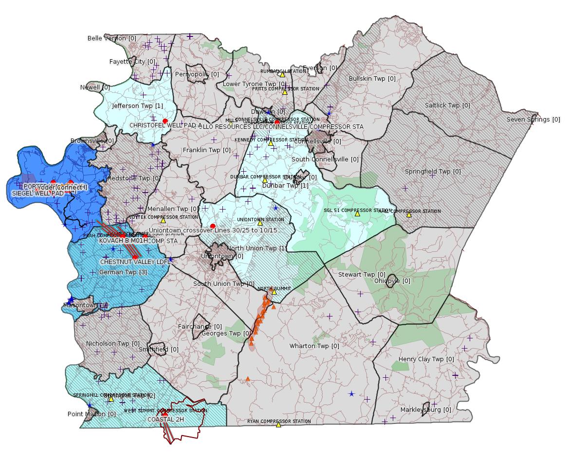
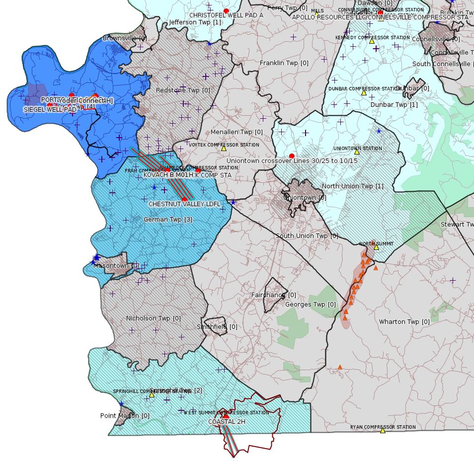
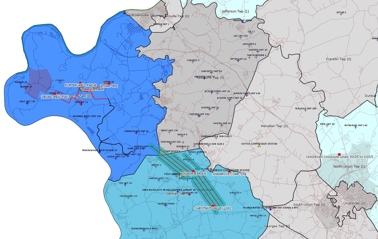
Map
Key
Red dots: items in this permit list with an exact location.
Blue stars: Marcellus Gas Well Water Sources.
Where well laterals are mapped they show in red; a 400-foot buffer surrounding the lateral shows in blue (lavender where it overlaps a mapped mineral tract).
Where mineral tracts are mapped, they show in pink. Mineral tracts can overlap; the overlap will show in red. The precise meaning of "mineral tract" is not clear.
Municipality shading: number of "facilities", with each well counting separately
(includes the red dots):
gray: 0
pale turquoise: 1
turquoise: 2
pale blue: 3
middle blue: 4
dark blue: 5
dark purple: 6
purple: 18
(Color coding may differ from one issue to the next.)
(Note if a project spans multiple municipalities -- e.g. a pipeline -- it will show in the count for each municipality.)
The number of facilities also follows the municipality name in brackets.
Municipality counts are based on the way the permit is listed by DEP; DEP has been known to get a municipality wrong.
Locations in brackets identify a precise location used to locate a surrogate for the actual site being permitted (e.g. locating a well pad or pipeline by the known location of a well.) Locations labeled beginning with "~" and ending in "[?]" are approximate and speculative based on inferences using on-line property and lease records. These are marked in the text as "[Approximate, Speculative]
Cross-hatching: Environmental Justice Areas
Yellow triangles: Compressor Stations
Orange triangles: Storage Field Wells (currently Dominion North Summit Storage Field)
Crosses: SPUD Unconventional well permits
Green: "Natural areas", e.g. state game lands, state forests
Yellow triangles: Compressor Stations
Orange triangles: Storage Field Wells (currently Dominion North Summit Storage Field)
Crosses: SPUD Unconventional well permits
Green: "Natural areas", e.g. state game lands, state forests
More Maps
 |
 |
 |
| [See Notes] |
Source: Pennsylvania Bulletin
WQ6583220-002, Texas Eastern Transmission, LP, 890 Winter Street, Suite 300, Waltham, MA 02451. Appalachia to Market Project, in North Union Township of Fayette County, Salem Township of Westmoreland County, Pike Township of Berks County, Philadelphia and Pittsburgh Corps Districts. The proposed project will involve the following system modifications:
• Bechtelsville crossover: Install full crossover from Texas Eastern Lines 28/27 to Texas Eastern Lines 19/12 at milepost (MP) 218.81 (beginning of Line 28 loop) in Berks County, PA (Coordinates: 40° 24` 50.54", -75° 42` 27.03");
• Uniontown crossover: Install full crossover from Texas Eastern Lines 30/25 to Texas Eastern Lines 10/15 at MP 771.05 (end of Line 30 loop) in Fayette County, PA (Coordinates: 39° 55` 42.75", -79° 44` 01.41"); and
• Delmont loop: Install approximately 0.8 mile of 30-inch diameter pipeline in same trench as abandoned 30-inch diameter Line 27 downstream from the Delmont Compressor Station in Westmoreland County, PA (Project Center Coordinates: 40° 23` 18.55", -79° 32` 08.62").
On May 1, 2020, Applicant filed an application with the Federal Energy Regulatory Commission (FERC) under Section 7 of the Natural Gas Act (15 U.S.C.A. § 717f) seeking a certificate of public convenience and necessity to construct and operate its Project (FERC Docket No. CP20-436-000), which was issued on September 30, 2020. The FERC Environmental Assessment for the Project, which was issued on September 15, 2020, may be viewed on FERC's website at www.ferc.gov (search eLibrary; Docket Search; CP20-436-000).
On July 1, 2020, Applicant requested a state water quality certification (SWQC) from the Pennsylvania De-partment of Environmental Protection (PADEP), as required by Section 401 of the Clean Water Act (33 U.S.C.A. § 1341), to ensure that the construction, operation and maintenance of the Project will protect water quality in Pennsylvania consistent with the requirements of State law and the Clean Water Act.
The Project, as proposed, will provide necessary pipeline infrastructure to enhance and increase the capacity and allow for incremental growth to residential and commercial customers; the project will deliver 18,000 Dth/d of supply to an existing delivery point. The Project, as proposed, will require approximately 16.16 acres of earth disturbance, and impacts to 81 linear feet of a UNT to Beaver Run (HQ-CWF), 0.07 acre of a UNT to Beaver Run (HQ-CWF) floodway, 0.04 acre of a UNT to Pine Creek (EV, MF) floodway, 0.01 acre of temporary impacts to Exceptional Value (EV) Palustrine Emergent (PEM) wetlands, 0.23 acre of temporary impacts to Other (O) PEM wetlands, and 0.26 acre of permanent impacts to O PEM wetlands.
PADEP, by this notice, is proposing to issue a SWQC to Texas Eastern Transmission, LP for the Appalachia to Market Project. PADEP is proposing to certify that construction, operation and maintenance of the Appalachia to Market Project complies with the applicable provisions of sections 301—303, 306 and 307 of the Federal Clean Water Act (33 U.S.C.A. §§ 1311—1313, 1316 and 1317). The PADEP is proposing to further certify that the construction, operation and maintenance of the Appalachia to Market Project complies with Pennsylvania water quality standards and will maintain and protect applicable Commonwealth water quality standards provided that the construction, operation and maintenance of the project complies with the following PADEP water quality permitting programs, criteria and conditions established pursuant to Pennsylvania law:
1. Discharge of Hydrostatic Test Water—Applicant shall obtain and comply with a National Pollutant Discharge Elimination System (NPDES) permit(s) for the discharge of water from the hydrostatic testing of the pipeline associated with the Project pursuant to Pennsylvania's Clean Streams Law (35 P.S. §§ 691.1—691.1001), 25 Pa. Code Chapter 92a (relating to NPDES permitting, monitoring and compliance), and all other applicable regulations.
2. Erosion and Sediment Control and Stormwater Management—All projects proposing earth disturbance must implement best management practices (BMPs) to protect and maintain water quality pursuant to Pennsylvania's Clean Streams Law (35 P.S. §§ 691.1—691.1001) and Storm Water Management Act (32 P.S. §§ 680.1—680.17), 25 Pa. Code Chapter 102 (relating to erosion and sediment control), and all other applicable regulations. Applicant shall obtain and comply with an Erosion and Sediment Control Permit(s) for earth disturbance associated with the Project as provided in 25 Pa. Code § 102.5.
3. Water Obstruction and Encroachment Permits—Applicant shall obtain and comply with a Water Obstruction and Encroachment Permit(s) for the construction, operation and maintenance of all stream and wetland crossings associated with the Project pursuant to Pennsylvania's Clean Streams Law, Dam Safety and Encroach-ments Act (32 P.S. §§ 693.1—693.27), and Flood Plain Management Act (32 P.S. §§ 679.101—679.601), 25 Pa. Code Chapter 105 (relating to dam safety and waterway management), 25 Pa. Code Chapter 106 (relating to floodplain management) and all other applicable regulations.
4. Other Water Quality Requirements—Applicant shall obtain any other permits, authorizations or approvals required to construct, operate, and maintain the Project from any interstate or international agency as required by an interstate compact or international agreement that has established water quality standards applicable to surface waters of this Commonwealth, including wetlands.
5. Water Quality Monitoring—PADEP retains the right to specify additional studies or monitoring to ensure that water quality in the receiving waters associated with the Project is not adversely impacted by any operational and construction process that may be employed by Applicant.
6. Operation—Applicant shall properly operate and maintain at all times all Project facilities and systems of treatment and control (and related appurtenances) installed to achieve compliance with the terms and conditions of this SWQC and all required permits, authorizations and approvals. Proper operation and maintenance includes adequate laboratory controls, appropriate quality assurance procedures, and the operation of backup or auxiliary facilities or similar systems installed by Applicant.
7. Inspection—The Project, including all relevant records, are subject to inspection at reasonable hours and intervals by an authorized representative of PADEP or the delegated County Conservation District to determine compliance with this SWQC, including all permits, authorizations or approvals which ensure the project shall maintain and protect state water quality standards as required by this SWQC. The Applicant shall provide a copy of this SWQC to an authorized representative conducting an inspection of the Project.
8. Transfer of Projects—If Applicant intends to transfer any legal or equitable interest in the Project or any portion(s) thereof, the Applicant shall provide a copy of this SWQC and copies of any permits, authorizations or approvals obtained to comply with the SWQC upon the prospective transferee of the legal and equitable interest at least thirty (30) days prior to the contemplated transfer and shall simultaneously inform the appropriate PADEP Office of such intent. Notice to PADEP shall include a transfer agreement signed by the existing and new owners containing a specific date for transfer of responsibility, coverage, and liability under the SWQC and any permits, authorizations and approvals obtained to comply with the SWQC. The new owner shall submit to PADEP a new application form for the SWQC and any permits, authorizations and approvals required to comply with the SWQC signed by the new owner.
9. Correspondence—All correspondence with and submittals to PADEP concerning this SWQC shall be addressed to the Department of Environmental Protection, Regional Permit Coordination Office, Domenic Rocco, PE, Director, 400 Market Street, Harrisburg, PA 17101, RA-EPREGIONALPERMIT@pa.gov.
10. Reservation of Rights—PADEP may modify, suspend, or revoke this SWQC if (i) PADEP becomes aware of new facts about the Project that warrant such action; or (ii) PADEP determines that the Applicant has not complied with the terms and conditions of the SWQC. PADEP may require additional measures to achieve compliance with any applicable law or regulation.
11. Other Laws—Nothing in this SWQC shall be construed to preclude the institution of any legal action or to relieve Applicant from any responsibilities, liabilities, or penalties established pursuant to any applicable law or regulation.
12. Severability—The provisions of this SWQC are severable and should any provision of this SWQC be declared invalid or unenforceable, the remainder of this SWQC shall not be affected thereby.
<http://www.pacodeandbulletin.gov/Display/pabull?file=/secure/pabulletin/data/vol50/50-47/1611b.html&continued=http://www.pacodeandbulletin.gov/Display/pabull?file=/secure/pabulletin/data/vol50/50-47/1611.html&d=reduce>
Location: 39.928542,-79.733725
Municipality: North Union Twp
Presumed Parcel Id: 25060136
ESG836520002-00. The Department of Environmental Protection (Department) provides notice of receipt of an application for a Chapter 102, Erosion and Sediment Control General Permit for Earth Disturbance Associated with Oil and Gas Exploration, Production, Processing or Treatment Operations or Transmission Facilities. The application is currently under technical review for Appalachia to Market—Delmont Loop. The proposed facilities for the Project include two crossovers and one pick-up and relay and related appurtenances, all of which will be located within or adjacent to Texas Eastern's current right-of-way. In Salem Township, Westmoreland County the Delmont loop pick-up and relay is proposed which is a 0.8-mile segment of existing Line 27 that will be replaced with a 30-inch outside diameter pipeline. The proposed Delmont loop starts at MP 0.76, located west of Crooked Run Road (Latitude: 40.385011o; Longitude -79.541961o), and extending to MP 1.60, located East of Boggs Hollow Road (Latitude: 40.39135o; Longitude -79.529261o). New pig launcher/receiver facilities and other related appurtenances will be installed at the beginning and end of the loop. Permanent impervious land cover is proposed at the launcher and receiver cross over sites. One cross over is in Berks County and the other in Fayette County, for which each have less than 5 acres of earth disturbance.
This authorization is required for earth disturbance activities associated with oil and gas exploration, production, processing or treatment operations or transmission facilities when earth disturbance is 5 acres or greater. Review of this application is being coordinated among the Department and the associated county conservation districts.
The application under review is as follows:
Permit No. Applicant Name & Address: Counties: DEP Office:
ESG836520002-00 Texas Eastern Transmission, LP
5400 Westheimer Ct.
Houston, TX 77056 Westmoreland County
Berks County
Fayette County Regional Permit
Coordination Office
Public Comments for Water Obstructions and Encroachments, State Water Quality Certification And Erosion And Sediment Control.
A person wishing to comment on a proposed permit are invited to submit a statement to the appropriate Department office listed before the application within 30 days of this public notice. Comments reviewed within this 30-day period will be considered in the formulation of the final determinations regarding this application. Responses should include the name, address and telephone number of the writer and a concise statement to inform the Department of the exact basis of a comment and relevant facts upon which it is based. A public hearing may be held after consideration of comments received by the appropriate Department office during the 30-day public comment period.
Following the 30-day comment period, the program manager from the appropriate Department office will make a final determination regarding the proposed permit. Notice of this determination will be published in the Pennsylvania Bulletin at which time this determination may be appealed to United States Court of Appeals for the 3rd Circuit, 21400 U.S. Courthouse, 601 Market Street, Philadelphia, PA 19106-1790.
More information regarding the permit applications related to this proposed project may be available online (dep.pa.gov/pipelines) or in the Department's Regional Permit Coordination Office. The Department's Regional Permit Coordination Office can be contacted at 717-772-5987 or RA-EPREGIONALPERMIT@pa.gov.
Comments on the applications can be emailed or sent via postal mail to the Department of Environmental Protection, Regional Permit Coordination Office, Rachel Carson Building, 400 Market Street, 10th Floor, Harrisburg, PA 17101, RA-EPREGIONALPERMIT@pa.gov.
Persons with a disability that require an auxiliary aid, service or other accommodation to participate during the 30-day public comment period should contact the specified Department office. TDD users may contact the Department through the Pennsylvania AT&T Relay Service at (800) 654-5984.
[See Notes.]
-------------------------
Source: eNOTICE
(+ PA
Oil and Gas Mapping, Well
Pad Report.) Well Details via Data
Portal Services: Oil and Gas Wells All (ID: 3).
Please see the Disclaimer below regarding Parcel Id data.
Authorization ID: 1334546
Permit number: ESG18-051-0001
Site: DOGBONE WATER LINE ESCGP ESG18-051-0001
Client: CHEVRON APPALACHIA LLC
Authorization type: Erosion and Sediment Control GP-2
Application type: Notification
Authorization is for: SITE
Date received: 11/24/2020
Status: Pending
Permit Decision Guarantee Applies?: No
Permit Review Notes:
Date Review Note
11/24/2020 The permit application package is complete, has been accepted, and is undergoing technical review.
<https://www.ahs.dep.pa.gov/eFACTSWeb/searchResults_singleAuth.aspx?AuthID=1334546>
Site Programs:
Site Municipalities:
Luzerne Twp, Fayette County
---
Authorization ID: 1334261
Permit number: ESX15-051-0005
Site: SIEGEL WELL PAD ESCGP-2 EXPEDITED
Client: CHEVRON APPALACHIA LLC
Authorization type: Expedited E&S Stormwater General Permit 1
Application type: Notification
Authorization is for: SITE
Date received: 11/23/2020
Status: Pending
Permit Decision Guarantee Applies?: No
Permit Review Notes:
Date Review Note
11/23/2020 The permit application package is complete, has been accepted, and is undergoing technical review.
<https://www.ahs.dep.pa.gov/eFACTSWeb/searchResults_singleAuth.aspx?AuthID=1334261>
Site Programs:
Environmental Cleanup & Brownfields
Oil & Gas
Site Municipalities:
Luzerne Twp, Fayette County
Well Pad ID: 152926
Location: 39.968972,-79.968794
Primary Facility ID: 803337
Wells on this Pad:
Presumed Property Id: 19240018
---
Authorization ID: 1333788
Permit number: ESG072619001-00
Site: Yoder Well Connect
Client: LAUREL MTN MIDSTREAM OPR LLC
Authorization type: Erosion and Sediment Control General Permit 3
Application type: Notification
Authorization is for: SITE
Date received: 11/16/2020
Status: Pending
Permit Decision Guarantee Applies?: No
Permit Review Notes:
Date Review Note
11/16/2020 The permit application package is complete, has been accepted, and is undergoing technical review.
<https://www.ahs.dep.pa.gov/eFACTSWeb/searchResults_singleAuth.aspx?AuthID=1333788>
Site Programs:
Site Municipalities:
Luzerne Twp, Fayette County
---
Authorization ID: 1333580
Permit number: 051-24671
Site: KOVACH B WELL SITE AND TANK SITE ESCGP ESX17-051-0003
Client: CHEVRON APPALACHIA LLC
Authorization type: Drill & Operate Well Permit (Unconventional)
Application type: Modification [of drilling schedule only -jr]
Authorization is for: FACILITY
Date received: 11/16/2020
Status: Pending
Permit Decision Guarantee Applies?: Yes
Permit Decision Guarantee status: VOID
Sub-Facilities for Authorization:
Sub-Facility ID Sub-Facility Name Description
1263129 WELLBORE SURFACE HOLE LOCATION Well
Permit Review Notes:
Date Review Note
11/23/2020 The technical review and decision review are complete and either the permit decision and/or permit issuance are forthcoming.
11/19/2020 Applicant has been issued a deficiency letter. If applicable, this application no longer qualifies for the Permit Decision Guarantee.
11/18/2020 The permit application package is complete, has been accepted, and is undergoing technical review.
<https://www.ahs.dep.pa.gov/eFACTSWeb/searchResults_singleAuth.aspx?AuthID=1333580>
Site Programs:
Oil & Gas
Site Municipalities:
German Twp, Fayette County
Well Details:
Permit Number: 051-24671
Well Name: KOVACH B M01H
Unconventional Well: Y
Well Configuration: Horizontal Well
Well Type: GAS
Well Status: Active
Coal Association: Coal
Conservation Well: N
Primary Facility ID: 828037
Site ID: 826949
Site Name: KOVACH B WELL SITE AND TANK SITE ESCGP ESX17-051-0003
Well Pad ID: 155005
Well Pad Name: KOVACH B
Storage Field:
Operator: CHEVRON APPALACHIA LLC
Operator Number: OGO-39307
Permit Date: 2018-08-08
Permit Date Expires: 2020-12-05
SPUD Date: 2018-10-23
Date Plugged:
UIC ID:
UIC Type:
Surface Elevation: 1278
County: Fayette
Municipality: German Twp
Location: 39.918933,-79.854808
Map URL: <http://www.openstreetmap.org/?mlat=39.918933&mlon=-79.854808#map=15/39.918933/-79.854808>
OG WELLS PERMIT DOCS:
2020-02-13: Final Permit Documents, Name: 1237727 (for Authorization: 1237727):
<http://www.depgis.state.pa.us/pdfHandler/pdFHandler.ashx?Doc=NjQ2Nzc2&ext=PDF>
2018-08-31: Other Permit Documents, Name: 051-24671 (for Authorization: 1240662):
<http://www.depgis.state.pa.us/pdfHandler/pdFHandler.ashx?Doc=NzgxMDI3&ext=PDF>
2019-01-07: Other Permit Documents, Name: 051-24671 (for Authorization: 1256817):
<http://www.depgis.state.pa.us/pdfHandler/pdFHandler.ashx?Doc=NzI3OTEy&ext=PDF>
2020-02-13: Initial Submitted Documents, Name: Kovach B M01H (for Authorization: 1295303):
<http://www.depgis.state.pa.us/pdfHandler/pdFHandler.ashx?Doc=OTY5OTQx&ext=PDF>
2020-02-13: Other Permit Documents, Name: EJA Notification (for Authorization: 1295303):
<http://www.depgis.state.pa.us/pdfHandler/pdFHandler.ashx?Doc=OTgzMDg3&ext=PDF>
2020-02-13: Final Permit Documents, Name: Authorization ID 1295303 (for Authorization: 1295303):
<http://www.depgis.state.pa.us/pdfHandler/pdFHandler.ashx?Doc=OTg4MjQ2&ext=PDF>
Electronically Submitted Records:
2020-02-13: Submission for Authorization 1237727
Pennsylvania Natural Diversity Inventory Form: Kovach B PNDI.pdf
<http://www.depgis.state.pa.us/eWellDocHandler/pdFHandler.ashx?Doc=NjAxNjky&ext=PDF>
Coal and Gas Resource Coord Act - Section 7 Exception: Kovach B Horizontals Section 7 Exception.pdf
<http://www.depgis.state.pa.us/eWellDocHandler/pdFHandler.ashx?Doc=NjAxNjkz&ext=PDF>
Well Cross-Section Diagram: Kovach B M01H Page 4.pdf
<http://www.depgis.state.pa.us/eWellDocHandler/pdFHandler.ashx?Doc=NjAxODA2&ext=PDF>
Interested Party Notification: Kovach B Affidavit of Non-Delivery Venere.pdf
<http://www.depgis.state.pa.us/eWellDocHandler/pdFHandler.ashx?Doc=NjAxODE4&ext=PDF>
Location Plat: Kovach B M01H Plat.dwg
<http://www.depgis.state.pa.us/eWellDocHandler/pdFHandler.ashx?Doc=NjAxODI5&ext=PDF>
Permit Application to Drill and Operate a Well: 1747807.pdf
<http://www.depgis.state.pa.us/eWellDocHandler/pdFHandler.ashx?Doc=NjAzODE3&ext=PDF>
2020-11-30: Submission for Authorization 1333580
Pennsylvania Natural Diversity Inventory Form: Kovach B PNDI 1-7-20.pdf
<http://www.depgis.state.pa.us/eWellDocHandler/pdFHandler.ashx?Doc=MTMzODkzMA==&ext=PDF>
Interested Party Notification: Kovach B M01H Interested Parties.pdf
<http://www.depgis.state.pa.us/eWellDocHandler/pdFHandler.ashx?Doc=MTMzODkzMw==&ext=PDF>
Coal and Gas Resource Coord Act - Section 7 Exception: Kovach B Section 7 Exception.pdf
<http://www.depgis.state.pa.us/eWellDocHandler/pdFHandler.ashx?Doc=MTMzODkzNA==&ext=PDF>
Well Cross-Section Diagram: Kovach B M01H Page 4.pdf
<http://www.depgis.state.pa.us/eWellDocHandler/pdFHandler.ashx?Doc=MTMzODkzNQ==&ext=PDF>
Well Permit Application - Coal Module: Kovach B Coal Module w Record of Notification 2020.pdf
<http://www.depgis.state.pa.us/eWellDocHandler/pdFHandler.ashx?Doc=MTMzODk3Mg==&ext=PDF>
Permit Application to Drill and Operate a Well: Kovach B M01H RePermit Application.pdf
<http://www.depgis.state.pa.us/eWellDocHandler/pdFHandler.ashx?Doc=MTM0NDA2NQ==&ext=PDF>
Location Plat: 172-318-Well Plat 1H-pages1-2-3_3702.dwg
<http://www.depgis.state.pa.us/eWellDocHandler/pdFHandler.ashx?Doc=MTM0NDA2Ng==&ext=PDF>
Electronic Submission Docket: 2232607.pdf
<http://www.depgis.state.pa.us/eWellDocHandler/pdFHandler.ashx?Doc=MTM0NDA4MA==&ext=PDF>
2020-02-13: Submission for Authorization 1295303
Pennsylvania Natural Diversity Inventory Form: Kovach B PNDI.pdf
<http://www.depgis.state.pa.us/eWellDocHandler/pdFHandler.ashx?Doc=OTk1MzIy&ext=PDF>
Location Plat: Kovach B M01H Plat.dwg
<http://www.depgis.state.pa.us/eWellDocHandler/pdFHandler.ashx?Doc=OTk1MzIz&ext=PDF>
Permit Application to Drill and Operate a Well: Kovach B M01H Drill Application.pdf
<http://www.depgis.state.pa.us/eWellDocHandler/pdFHandler.ashx?Doc=OTk1NjUx&ext=PDF>
Interested Party Notification: Kovach B M01H Interested Parties.pdf
<http://www.depgis.state.pa.us/eWellDocHandler/pdFHandler.ashx?Doc=OTk1NjUy&ext=PDF>
Coal and Gas Resource Coord Act - Section 7 Exception: Kovach B Section 7 Exception.pdf
<http://www.depgis.state.pa.us/eWellDocHandler/pdFHandler.ashx?Doc=OTk1NjUz&ext=PDF>
Well Cross-Section Diagram: Kovach B M01H Page 4.pdf
<http://www.depgis.state.pa.us/eWellDocHandler/pdFHandler.ashx?Doc=OTk1NjU0&ext=PDF>
Well Permit Application - Coal Module: Kovach B Coal Module w Record of Notification.pdf
<http://www.depgis.state.pa.us/eWellDocHandler/pdFHandler.ashx?Doc=OTk1NjU1&ext=PDF>
Electronic Submission Docket: 2037232.pdf
<http://www.depgis.state.pa.us/eWellDocHandler/pdFHandler.ashx?Doc=OTk2NzE1&ext=PDF>
---
Authorization ID: 1332934
Permit number: 26-00588B
Site: SHAMROCK COMP STA
Client: LAUREL MTN MIDSTREAM OPR LLC
Authorization type: Minor Facility Plan Approval New Source Performance Std
Application type: Extension
Authorization is for: FACILITY
Date received: 11/04/2020
Status: Issued on 11/13/2020
Permit Decision Guarantee Applies?: No
Sub-Facilities for Authorization:
Sub-Facility ID Sub-Facility Name Description
1288253 TSS - TURBINE SSM Process
1284691 CAT 3516J CE-03 CAT OX Air Pollution Control Device
1284699 CAT 3516J CE-04 CAT OX Air Pollution Control Device
1284685 CAT G3516J COMPRESSOR ENGINE (CE-03) (1380 HP) Process
1284687 CAT G3516J COMPRESSOR ENGINE (CE-04) (1380 HP) Process
1024427 CATERPILLAR G3516B COMPRESSOR ENGINE (CE-06) (1380 BHP) Process
1087412 CATERPILLAR G3516B EMERGENCY GENERATOR (1,818 BHP)(EG-01) Process
1087413 CATERPILLAR G3516B EMERGENCY GENERATOR OXIDATION CATALYST Air Pollution Control Device
1185238 CBD - COMPRESSOR /FACILITY VENTING/BLOWDOWNS Process
1288248 CRP - COMPRESSOR ROD PACKING EMISSIONS Process
1288244 DGS - COMPRESSOR DRY GAS SEAL LEAKS Process
1288242 ECC - ENGINE CRANK CASE EMISSIONS Process
1024438 ENGINE #6 OXIDATION CATALYST Air Pollution Control Device
1288250 ESU - ENGINE START UP Process
1185240 FUG SITE COMPONENT FUGITIVE EMISSIONS Process
1284697 GLYCOL PURIFICATION UNIT (GPU-ENG, GPU-HTR) Process
1185234 HEATERS/REBOILERS Process
1195984 PIG - PIGGING OPERATIONS Process
1024428 SOLAR MARS 100-16000S TURBINE (15,252 HP) (CT-01) Process
1284695 SOLAR TITAN 130 -23502S (21,158 HP)(CT-02) Process
1284700 SOLAR TITAN SOLONOX COMBUSTION CONTROL Air Pollution Control Device
1045809 TANKS/VESSELS Process
1024431 TEG DEHYDRATOR 1 (200 MMSCF/DAY) (DHY-01) Process
1087369 TEG DEHYDRATOR 2 (200 MMSCF/DAY)(DHY-02) Process
1288255 TLO - TRUCK LOADOUT Process
Permit Review Notes:
Date Review Note
11/13/2020 The technical review and decision review are complete and either the permit decision and/or permit issuance are forthcoming.
11/4/2020 The permit application package is complete, has been accepted, and is undergoing technical review.
<https://www.ahs.dep.pa.gov/eFACTSWeb/searchResults_singleAuth.aspx?AuthID=1332934>
Site Programs:
Air Quality
Site Municipalities:
German Twp, Fayette County
---
Authorization ID: 1332011
Permit number: ESG072619003-00
Site: PORTER WELL PAD B ESCGP ESG072619003-00
Client: CHEVRON APPALACHIA LLC
Authorization type: Erosion and Sediment Control GP-2
Application type: Notification
Authorization is for: SITE
Date received: 10/23/2020
Status: Issued on 11/15/2020
Permit Decision Guarantee Applies?: No
Permit Review Notes:
Date Review Note
11/12/2020 The technical review and decision review are complete and either the permit decision and/or permit issuance are forthcoming.
10/29/2020 The permit application package is complete, has been accepted, and is undergoing technical review.
<https://www.ahs.dep.pa.gov/eFACTSWeb/searchResults_singleAuth.aspx?AuthID=1332011>
Site Programs:
Site Municipalities:
Luzerne Twp, Fayette County
---
Authorization ID: 1332006
Permit number: ESG072618001-00
Site: CHRISTOFEL WELL PAD A PROJECT ESG30705118-001
Client: CHEVRON APPALACHIA LLC
Authorization type: Erosion and Sediment Control GP-2
Application type: Notification
Authorization is for: SITE
Date received: 10/23/2020
Status: Issued on 11/15/2020
Permit Decision Guarantee Applies?: No
Permit Review Notes:
Date Review Note
11/12/2020 The technical review and decision review are complete and either the permit decision and/or permit issuance are forthcoming.
10/29/2020 The permit application package is complete, has been accepted, and is undergoing technical review.
<https://www.ahs.dep.pa.gov/eFACTSWeb/searchResults_singleAuth.aspx?AuthID=1332006>
Site Programs:
Oil & Gas
Site Municipalities:
Jefferson Twp, Fayette County
---
Authorization ID: 1326739
Permit number: 100419
Site: CHESTNUT VALLEY LDFL
Client: ADVANCED DSPL SVC CHESTNUT VALLEY LDFL INC
Authorization type: Minor Modification to an Existing Fac
Application type: Modification
Authorization is for: FACILITY
Date received: 09/10/2020
Status: Pending
Permit Decision Guarantee Applies?: Yes
Permit Decision Guarantee status: ACTIVE
Permit Review Notes:
Date Review Note
11/16/2020 The permit application package is complete, has been accepted, and is undergoing technical review.
<https://www.ahs.dep.pa.gov/eFACTSWeb/searchResults_singleAuth.aspx?AuthID=1326739>
Site Programs:
Air Quality
Clean Water
Environmental Cleanup & Brownfields
Mining
Radiation Protection
Waste Management
Water Planning and Conservation
Site Municipalities:
German Twp, Fayette County
Authorization ID: 1323030
Permit number: AG5-26-00003B
Site: APOLLO RESOURCES LLC/CONNELSVILLE COMPRESSOR STA
Client: APOLLO RESOURCES LLC
Authorization type: AQ GP 5 - Natural Gas Compression and/or Processing Facilities
Application type: New
Authorization is for: FACILITY
Date received: 07/23/2020
Status: Issued on 11/17/2020
Permit Decision Guarantee Applies?: No
Sub-Facilities for Authorization:
Sub-Facility ID Sub-Facility Name Description
1197569 CATERPILLAR G 3306 #1 NSCR Air Pollution Control Device
1197570 CATERPILLAR G 3306 #2 NSCR Air Pollution Control Device
1138905 CATERPILLAR G 3306 NA 4SRB,RATED @ 145 BHP, CBM GAS FIRED Process
1189454 FUGITIVES Process
1189443 NATURAL GAS LINE Fuel Material Location
1189446 TANKS/VESSELS Process
Permit Review Notes:
Date Review Note
11/17/2020 The technical review and decision review are complete and either the permit decision and/or permit issuance are forthcoming.
11/4/2020 Applicant has been issued a deficiency letter. If applicable, this application no longer qualifies for the Permit Decision Guarantee.
<https://www.ahs.dep.pa.gov/eFACTSWeb/searchResults_singleAuth.aspx?AuthID=1323030>
Site Programs:
Air Quality
Site Municipalities:
Dunbar Twp, Fayette County
-------------------------
Source: DEP
Oil and Gas Electronic Notifications
NOTIFICATION_ID: 54606
OGO: 51036
OPERATOR: INR OPR LLC
API_PERMIT: 051-24722
SPUD_DATE: 09/29/2020
COUNTY: Fayette
MUNICIPALITY: Springhill
LATITUDE: 39.73315
LONGITUDE: -79.800903
SUBJECT: [NOTIFICATION]: Casing cementing notification 58 Pa. C.S. 3211(f)(2) for well API 37-051-24722-00-00
QUESTION: Enter the Date and Time for the applicable Casing Types
ANSWER: Production Casing: 11/20/2020 5:00:00 PM
SENT_DATE: 11/16/2020 1:22:08 PM
SENT_SUCCESS: Yes
LAST_RESENT_DATE:
RESENT_SUCCESS:
REGION: EP DOGO SWDO Dstr Off
Well Details:
Permit Number: 051-24722
Well Name: COASTAL 2H
Unconventional Well: Y
Well Configuration: Horizontal Well
Well Type: GAS
Well Status: Active
Coal Association: Coal
Conservation Well: N
Primary Facility ID: 843825
Site ID: 739525
Site Name: COASTAL 1H FLOW BACK PIT FRESHWATER PITS ESCGP-EXPEDITED
Well Pad ID: 147971
Well Pad Name: COASTAL WELL PAD
Storage Field:
Operator: INR OPR LLC
Operator Number: OGO-51036
Permit Date: 2020-09-22
Permit Date Expires: 2021-09-22
SPUD Date: 2020-09-29
Date Plugged:
UIC ID:
UIC Type:
Surface Elevation: 1127
County: Fayette
Municipality: Springhill Twp
Location: 39.73315,-79.800903
Map URL: <http://www.openstreetmap.org/?mlat=39.73315&mlon=-79.800903#map=15/39.73315/-79.800903>
OG WELLS PERMIT DOCS:
2020-09-22: Final Permit Documents, Name: Auth 1322984 051-24722 (for Authorization: 1322984):
<http://www.depgis.state.pa.us/pdfHandler/pdFHandler.ashx?Doc=MTQ1NTA4Mg==&ext=PDF>
2020-09-22: Other Permit Documents, Name: Coastal Wells Deficiency Email (for Authorization: 1322984):
<http://www.depgis.state.pa.us/pdfHandler/pdFHandler.ashx?Doc=MTQwNzgyOQ==&ext=PDF>
Electronically Submitted Records:
2020-09-22: Submission for Authorization 1322984
Interested Party Notification: Coastal 2H - Springhill Township - Interested Party Signed Receipt - 08.04.2020.pdf
<http://www.depgis.state.pa.us/eWellDocHandler/pdFHandler.ashx?Doc=MTI1MjgxNw==&ext=PDF>
Coordination of Well Location with Public Resources: INR OPERATING - COASTAL 2H - COORDINATION_OF_WELL_LOCATION_WITH_PUBLIC_RESOURCES.pdf
<http://www.depgis.state.pa.us/eWellDocHandler/pdFHandler.ashx?Doc=MTI2MTg1Mg==&ext=PDF>
Pennsylvania Natural Diversity Inventory Form: INR OPERATING - COASTAL 2H - PNDI INVENTORY 07.21.2020.pdf
<http://www.depgis.state.pa.us/eWellDocHandler/pdFHandler.ashx?Doc=MTI2MTg1Mw==&ext=PDF>
Pennsylvania Natural Diversity Inventory Support Document: INR OPERATING - COASTAL 2H - PNDI SUPPORT 07.21.2020.pdf
<http://www.depgis.state.pa.us/eWellDocHandler/pdFHandler.ashx?Doc=MTI2MTg1NQ==&ext=PDF>
Operator Ownership and Control Information: INR OPERATING - COASTAL 2H - OPERATOR_OWNERSHIP_AND_CONTROL_INFORMATION_FORM 07.21.2020.pdf
<http://www.depgis.state.pa.us/eWellDocHandler/pdFHandler.ashx?Doc=MTI2MTg1Ng==&ext=PDF>
Well Permit Application - Coal Module: INR OPERATING - COASTAL 2H - COAL STATUS REPORT 07.24.2020.pdf
<http://www.depgis.state.pa.us/eWellDocHandler/pdFHandler.ashx?Doc=MTI2MTg1OA==&ext=PDF>
Location Plat: INR OPERATING - COASTAL 2H - LOCATION PLAT 08.25.2020 DEP COMMENT REVISIONS.dwg
<http://www.depgis.state.pa.us/eWellDocHandler/pdFHandler.ashx?Doc=MTI2ODM2Nw==&ext=PDF>
Well Cross-Section Diagram: INR OPERATING - COASTAL 2H - WELL CROSS-SECTION DIAGRAM 08.25.2020 DEP COMMENT REVISIONS.pdf
<http://www.depgis.state.pa.us/eWellDocHandler/pdFHandler.ashx?Doc=MTI2ODM3Mw==&ext=PDF>
Location Plat: INR OPERATING - COASTAL 2H - LOCATION PLAT 08.25.2020 DEP COMMENT REVISIONS.dwg
<http://www.depgis.state.pa.us/eWellDocHandler/pdFHandler.ashx?Doc=MTI2ODM3OA==&ext=PDF>
Permit Application to Drill and Operate a Well: 1958801.pdf
<http://www.depgis.state.pa.us/eWellDocHandler/pdFHandler.ashx?Doc=MTI2ODM4MA==&ext=PDF>
---
NOTIFICATION_ID: 54685
OGO: 51036
OPERATOR: INR OPR LLC
API_PERMIT: 051-24722
SPUD_DATE: 09/29/2020
COUNTY: Fayette
MUNICIPALITY: Springhill
LATITUDE: 39.73315
LONGITUDE: -79.800903
SUBJECT: [NOTIFICATION]: Pressure test notification 58 Pa. C.S. 3211(f)(2) for well API 37-051-24722-00-00
QUESTION: Date and approximate time action is to occur
ANSWER: Date: 12/03/2020 Time: 08:00 AM
SENT_DATE: 11/30/2020 2:17:17 PM
SENT_SUCCESS: Yes
LAST_RESENT_DATE:
RESENT_SUCCESS:
REGION: EP DOGO SWDO Dstr Off
Well Details above
Well Name: COASTAL 2H
---
NOTIFICATION_ID: 54686
OGO: 51036
OPERATOR: INR OPR LLC
API_PERMIT: 051-24721
SPUD_DATE: 09/29/2020
COUNTY: Fayette
MUNICIPALITY: Springhill
LATITUDE: 39.733181
LONGITUDE: -79.800869
SUBJECT: [NOTIFICATION]: Pressure test notification 58 Pa. C.S. 3211(f)(2) for well API 37-051-24721-00-00
QUESTION: Date and approximate time action is to occur
ANSWER: Date: 12/03/2020 Time: 09:00 AM
SENT_DATE: 11/30/2020 2:17:49 PM
SENT_SUCCESS: Yes
LAST_RESENT_DATE:
RESENT_SUCCESS:
REGION: EP DOGO SWDO Dstr Off
Well Details:
Permit Number: 051-24721
Well Name: COASTAL 4H
Unconventional Well: Y
Well Configuration: Horizontal Well
Well Type: GAS
Well Status: Active
Coal Association: Coal
Conservation Well: N
Primary Facility ID: 843824
Site ID: 739525
Site Name: COASTAL 1H FLOW BACK PIT FRESHWATER PITS ESCGP-EXPEDITED
Well Pad ID: 147971
Well Pad Name: COASTAL WELL PAD
Storage Field:
Operator: INR OPR LLC
Operator Number: OGO-51036
Permit Date: 2020-09-22
Permit Date Expires: 2021-09-22
SPUD Date: 2020-09-29
Date Plugged:
UIC ID:
UIC Type:
Surface Elevation: 1127
County: Fayette
Municipality: Springhill Twp
Location: 39.733181,-79.800869
Map URL: <http://www.openstreetmap.org/?mlat=39.733181&mlon=-79.800869#map=15/39.733181/-79.800869>
OG WELLS PERMIT DOCS:
2020-09-22: Final Permit Documents, Name: Auth 1322978 051-24721 (for Authorization: 1322978):
<http://www.depgis.state.pa.us/pdfHandler/pdFHandler.ashx?Doc=MTQ1NTA3OQ==&ext=PDF>
2020-09-22: Other Permit Documents, Name: Coastal Wells Deficiency Email (for Authorization: 1322978):
<http://www.depgis.state.pa.us/pdfHandler/pdFHandler.ashx?Doc=MTQwNzk4MQ==&ext=PDF>
Electronically Submitted Records:
2020-09-22: Submission for Authorization 1322978
Pennsylvania Natural Diversity Inventory Form: INR OPERATING - COASTAL 4H - PNDI INVENTORY 07.21.2020.pdf
<http://www.depgis.state.pa.us/eWellDocHandler/pdFHandler.ashx?Doc=MTIzMzcxOQ==&ext=PDF>
Pennsylvania Natural Diversity Inventory Support Document: INR OPERATING - COASTAL 4H - PNDI SUPPORT 07.21.2020.pdf
<http://www.depgis.state.pa.us/eWellDocHandler/pdFHandler.ashx?Doc=MTIzMzcyMQ==&ext=PDF>
Operator Ownership and Control Information: INR OPERATING - COASTAL 4H - OPERATOR_OWNERSHIP_AND_CONTROL_INFORMATION_FORM 07.21.2020.pdf
<http://www.depgis.state.pa.us/eWellDocHandler/pdFHandler.ashx?Doc=MTIzMzcyMg==&ext=PDF>
Coordination of Well Location with Public Resources: INR OPERATING - COASTAL 4H - COORDINATION_OF_WELL_LOCATION_WITH_PUBLIC_RESOURCES.pdf
<http://www.depgis.state.pa.us/eWellDocHandler/pdFHandler.ashx?Doc=MTIzNjcxMQ==&ext=PDF>
Well Permit Application - Coal Module: INR OPERATING - COASTAL 4H - COAL STATUS REPORT 07.24.2020.pdf
<http://www.depgis.state.pa.us/eWellDocHandler/pdFHandler.ashx?Doc=MTIzOTY5MA==&ext=PDF>
Interested Party Notification: Coastal 4H - Springhill Township - Interested Party Signed Receipt - 08.04.2020.pdf
<http://www.depgis.state.pa.us/eWellDocHandler/pdFHandler.ashx?Doc=MTI1MjgyNA==&ext=PDF>
Location Plat: INR OPERATING - COASTAL 4H - LOCATION PLAT 08.25.2020 DEP COMMENT REVISIONS.dwg
<http://www.depgis.state.pa.us/eWellDocHandler/pdFHandler.ashx?Doc=MTI2ODY2Mw==&ext=PDF>
Well Cross-Section Diagram: INR OPERATING - COASTAL 4H - WELL CROSS-SECTION DIAGRAM 08.25.2020 DEP COMMENT REVISIONS.pdf
<http://www.depgis.state.pa.us/eWellDocHandler/pdFHandler.ashx?Doc=MTI2ODY2NA==&ext=PDF>
Location Plat: INR OPERATING - COASTAL 4H - LOCATION PLAT 08.25.2020 DEP COMMENT REVISIONS.dwg
<http://www.depgis.state.pa.us/eWellDocHandler/pdFHandler.ashx?Doc=MTI2ODY2NQ==&ext=PDF>
Permit Application to Drill and Operate a Well: 2141432.pdf
<http://www.depgis.state.pa.us/eWellDocHandler/pdFHandler.ashx?Doc=MTI2ODY3MA==&ext=PDF>
---
NOTIFICATION_ID: 54687
OGO: 51036
OPERATOR: INR OPR LLC
API_PERMIT: 051-24722
SPUD_DATE: 09/29/2020
COUNTY: Fayette
MUNICIPALITY: Springhill
LATITUDE: 39.73315
LONGITUDE: -79.800903
SUBJECT: [NOTIFICATION]: Stimulation notification 58 Pa. C.S. 3211(f)(2) for well API 37-051-24722-00-00
QUESTION: Date and approximate time action is to occur
ANSWER: Date: 12/02/2020 Time: 08:00 AM
SENT_DATE: 11/30/2020 2:41:13 PM
SENT_SUCCESS: Yes
LAST_RESENT_DATE:
RESENT_SUCCESS:
REGION: EP DOGO SWDO Dstr Off
Well Details above
Well Name: COASTAL 2H
[See Notes.]
---
NOTIFICATION_ID: 54688
OGO: 51036
OPERATOR: INR OPR LLC
API_PERMIT: 051-24721
SPUD_DATE: 09/29/2020
COUNTY: Fayette
MUNICIPALITY: Springhill
LATITUDE: 39.733181
LONGITUDE: -79.800869
SUBJECT: [NOTIFICATION]: Stimulation notification 58 Pa. C.S. 3211(f)(2) for well API 37-051-24721-00-00
QUESTION: Date and approximate time action is to occur
ANSWER: Date: 12/02/2020 Time: 08:00 AM
SENT_DATE: 11/30/2020 2:41:38 PM
SENT_SUCCESS: Yes
LAST_RESENT_DATE:
RESENT_SUCCESS:
REGION: EP DOGO SWDO Dstr Off
Well Details above
Well Name: COASTAL 4H
-------------------------
Please see the Disclaimer below regarding Parcel Id data.
Authorization ID: 1334546
Permit number: ESG18-051-0001
Site: DOGBONE WATER LINE ESCGP ESG18-051-0001
Client: CHEVRON APPALACHIA LLC
Authorization type: Erosion and Sediment Control GP-2
Application type: Notification
Authorization is for: SITE
Date received: 11/24/2020
Status: Pending
Permit Decision Guarantee Applies?: No
Permit Review Notes:
Date Review Note
11/24/2020 The permit application package is complete, has been accepted, and is undergoing technical review.
<https://www.ahs.dep.pa.gov/eFACTSWeb/searchResults_singleAuth.aspx?AuthID=1334546>
Site Programs:
Site Municipalities:
Luzerne Twp, Fayette County
---
Authorization ID: 1334261
Permit number: ESX15-051-0005
Site: SIEGEL WELL PAD ESCGP-2 EXPEDITED
Client: CHEVRON APPALACHIA LLC
Authorization type: Expedited E&S Stormwater General Permit 1
Application type: Notification
Authorization is for: SITE
Date received: 11/23/2020
Status: Pending
Permit Decision Guarantee Applies?: No
Permit Review Notes:
Date Review Note
11/23/2020 The permit application package is complete, has been accepted, and is undergoing technical review.
<https://www.ahs.dep.pa.gov/eFACTSWeb/searchResults_singleAuth.aspx?AuthID=1334261>
Site Programs:
Environmental Cleanup & Brownfields
Oil & Gas
Site Municipalities:
Luzerne Twp, Fayette County
Well Pad ID: 152926
Location: 39.968972,-79.968794
Primary Facility ID: 803337
Wells on this Pad:
051-24633 SIEGEL 1
051-24641 SIEGEL 2H
051-24642 SIEGEL 4H
051-24643 SIEGEL 3H
051-24644 SIEGEL 5H
051-24645 SIEGEL 6H
051-24646 SIEGEL 7H
051-24647 SIEGEL 8H
051-24648 SIEGEL 9H
Presumed Property Id: 19240018
---
Authorization ID: 1333788
Permit number: ESG072619001-00
Site: Yoder Well Connect
Client: LAUREL MTN MIDSTREAM OPR LLC
Authorization type: Erosion and Sediment Control General Permit 3
Application type: Notification
Authorization is for: SITE
Date received: 11/16/2020
Status: Pending
Permit Decision Guarantee Applies?: No
Permit Review Notes:
Date Review Note
11/16/2020 The permit application package is complete, has been accepted, and is undergoing technical review.
<https://www.ahs.dep.pa.gov/eFACTSWeb/searchResults_singleAuth.aspx?AuthID=1333788>
Site Programs:
Site Municipalities:
Luzerne Twp, Fayette County
Location [of Yoder 4H]: 39.975564,-79.923878
Original Permit Public Permit Review:
<http://www.ahs.dep.pa.gov/ePermitPublicAccess/Public/PublicAuthOverview?q=IaU%2f3WrsAk6%2bDzk7TzVSzQ%3d%3d>
Project Topographic Map:
<http://www.ahs.dep.pa.gov/ePermitPublicAccess/Permit/DownloadFileFromOnBase/13039>
Original Permit Project Information:
Laurel Mountain Midstream Operating LLC (Williams) is proposing the Yoder Well Connect Pipeline Project, which consists of construction of one (1) approximately 6,266-LF 16-inch steel gas line to link the existing Yoder Well Pad (ESX15-051-0007) to the existing Williams West Dogbone pipeline (ESX10-051-0041). A vegetated surface site is also proposed at the tie-in to the West Dogbone Pipeline.
---
Authorization ID: 1333580
Permit number: 051-24671
Site: KOVACH B WELL SITE AND TANK SITE ESCGP ESX17-051-0003
Client: CHEVRON APPALACHIA LLC
Authorization type: Drill & Operate Well Permit (Unconventional)
Application type: Modification [of drilling schedule only -jr]
Authorization is for: FACILITY
Date received: 11/16/2020
Status: Pending
Permit Decision Guarantee Applies?: Yes
Permit Decision Guarantee status: VOID
Sub-Facilities for Authorization:
Sub-Facility ID Sub-Facility Name Description
1263129 WELLBORE SURFACE HOLE LOCATION Well
Permit Review Notes:
Date Review Note
11/23/2020 The technical review and decision review are complete and either the permit decision and/or permit issuance are forthcoming.
11/19/2020 Applicant has been issued a deficiency letter. If applicable, this application no longer qualifies for the Permit Decision Guarantee.
11/18/2020 The permit application package is complete, has been accepted, and is undergoing technical review.
<https://www.ahs.dep.pa.gov/eFACTSWeb/searchResults_singleAuth.aspx?AuthID=1333580>
Site Programs:
Oil & Gas
Site Municipalities:
German Twp, Fayette County
Well Details:
Permit Number: 051-24671
Well Name: KOVACH B M01H
Unconventional Well: Y
Well Configuration: Horizontal Well
Well Type: GAS
Well Status: Active
Coal Association: Coal
Conservation Well: N
Primary Facility ID: 828037
Site ID: 826949
Site Name: KOVACH B WELL SITE AND TANK SITE ESCGP ESX17-051-0003
Well Pad ID: 155005
Well Pad Name: KOVACH B
Storage Field:
Operator: CHEVRON APPALACHIA LLC
Operator Number: OGO-39307
Permit Date: 2018-08-08
Permit Date Expires: 2020-12-05
SPUD Date: 2018-10-23
Date Plugged:
UIC ID:
UIC Type:
Surface Elevation: 1278
County: Fayette
Municipality: German Twp
Location: 39.918933,-79.854808
Map URL: <http://www.openstreetmap.org/?mlat=39.918933&mlon=-79.854808#map=15/39.918933/-79.854808>
OG WELLS PERMIT DOCS:
2020-02-13: Final Permit Documents, Name: 1237727 (for Authorization: 1237727):
<http://www.depgis.state.pa.us/pdfHandler/pdFHandler.ashx?Doc=NjQ2Nzc2&ext=PDF>
2018-08-31: Other Permit Documents, Name: 051-24671 (for Authorization: 1240662):
<http://www.depgis.state.pa.us/pdfHandler/pdFHandler.ashx?Doc=NzgxMDI3&ext=PDF>
2019-01-07: Other Permit Documents, Name: 051-24671 (for Authorization: 1256817):
<http://www.depgis.state.pa.us/pdfHandler/pdFHandler.ashx?Doc=NzI3OTEy&ext=PDF>
2020-02-13: Initial Submitted Documents, Name: Kovach B M01H (for Authorization: 1295303):
<http://www.depgis.state.pa.us/pdfHandler/pdFHandler.ashx?Doc=OTY5OTQx&ext=PDF>
2020-02-13: Other Permit Documents, Name: EJA Notification (for Authorization: 1295303):
<http://www.depgis.state.pa.us/pdfHandler/pdFHandler.ashx?Doc=OTgzMDg3&ext=PDF>
2020-02-13: Final Permit Documents, Name: Authorization ID 1295303 (for Authorization: 1295303):
<http://www.depgis.state.pa.us/pdfHandler/pdFHandler.ashx?Doc=OTg4MjQ2&ext=PDF>
Electronically Submitted Records:
2020-02-13: Submission for Authorization 1237727
Pennsylvania Natural Diversity Inventory Form: Kovach B PNDI.pdf
<http://www.depgis.state.pa.us/eWellDocHandler/pdFHandler.ashx?Doc=NjAxNjky&ext=PDF>
Coal and Gas Resource Coord Act - Section 7 Exception: Kovach B Horizontals Section 7 Exception.pdf
<http://www.depgis.state.pa.us/eWellDocHandler/pdFHandler.ashx?Doc=NjAxNjkz&ext=PDF>
Well Cross-Section Diagram: Kovach B M01H Page 4.pdf
<http://www.depgis.state.pa.us/eWellDocHandler/pdFHandler.ashx?Doc=NjAxODA2&ext=PDF>
Interested Party Notification: Kovach B Affidavit of Non-Delivery Venere.pdf
<http://www.depgis.state.pa.us/eWellDocHandler/pdFHandler.ashx?Doc=NjAxODE4&ext=PDF>
Location Plat: Kovach B M01H Plat.dwg
<http://www.depgis.state.pa.us/eWellDocHandler/pdFHandler.ashx?Doc=NjAxODI5&ext=PDF>
Permit Application to Drill and Operate a Well: 1747807.pdf
<http://www.depgis.state.pa.us/eWellDocHandler/pdFHandler.ashx?Doc=NjAzODE3&ext=PDF>
2020-11-30: Submission for Authorization 1333580
Pennsylvania Natural Diversity Inventory Form: Kovach B PNDI 1-7-20.pdf
<http://www.depgis.state.pa.us/eWellDocHandler/pdFHandler.ashx?Doc=MTMzODkzMA==&ext=PDF>
Interested Party Notification: Kovach B M01H Interested Parties.pdf
<http://www.depgis.state.pa.us/eWellDocHandler/pdFHandler.ashx?Doc=MTMzODkzMw==&ext=PDF>
Coal and Gas Resource Coord Act - Section 7 Exception: Kovach B Section 7 Exception.pdf
<http://www.depgis.state.pa.us/eWellDocHandler/pdFHandler.ashx?Doc=MTMzODkzNA==&ext=PDF>
Well Cross-Section Diagram: Kovach B M01H Page 4.pdf
<http://www.depgis.state.pa.us/eWellDocHandler/pdFHandler.ashx?Doc=MTMzODkzNQ==&ext=PDF>
Well Permit Application - Coal Module: Kovach B Coal Module w Record of Notification 2020.pdf
<http://www.depgis.state.pa.us/eWellDocHandler/pdFHandler.ashx?Doc=MTMzODk3Mg==&ext=PDF>
Permit Application to Drill and Operate a Well: Kovach B M01H RePermit Application.pdf
<http://www.depgis.state.pa.us/eWellDocHandler/pdFHandler.ashx?Doc=MTM0NDA2NQ==&ext=PDF>
Location Plat: 172-318-Well Plat 1H-pages1-2-3_3702.dwg
<http://www.depgis.state.pa.us/eWellDocHandler/pdFHandler.ashx?Doc=MTM0NDA2Ng==&ext=PDF>
Electronic Submission Docket: 2232607.pdf
<http://www.depgis.state.pa.us/eWellDocHandler/pdFHandler.ashx?Doc=MTM0NDA4MA==&ext=PDF>
2020-02-13: Submission for Authorization 1295303
Pennsylvania Natural Diversity Inventory Form: Kovach B PNDI.pdf
<http://www.depgis.state.pa.us/eWellDocHandler/pdFHandler.ashx?Doc=OTk1MzIy&ext=PDF>
Location Plat: Kovach B M01H Plat.dwg
<http://www.depgis.state.pa.us/eWellDocHandler/pdFHandler.ashx?Doc=OTk1MzIz&ext=PDF>
Permit Application to Drill and Operate a Well: Kovach B M01H Drill Application.pdf
<http://www.depgis.state.pa.us/eWellDocHandler/pdFHandler.ashx?Doc=OTk1NjUx&ext=PDF>
Interested Party Notification: Kovach B M01H Interested Parties.pdf
<http://www.depgis.state.pa.us/eWellDocHandler/pdFHandler.ashx?Doc=OTk1NjUy&ext=PDF>
Coal and Gas Resource Coord Act - Section 7 Exception: Kovach B Section 7 Exception.pdf
<http://www.depgis.state.pa.us/eWellDocHandler/pdFHandler.ashx?Doc=OTk1NjUz&ext=PDF>
Well Cross-Section Diagram: Kovach B M01H Page 4.pdf
<http://www.depgis.state.pa.us/eWellDocHandler/pdFHandler.ashx?Doc=OTk1NjU0&ext=PDF>
Well Permit Application - Coal Module: Kovach B Coal Module w Record of Notification.pdf
<http://www.depgis.state.pa.us/eWellDocHandler/pdFHandler.ashx?Doc=OTk1NjU1&ext=PDF>
Electronic Submission Docket: 2037232.pdf
<http://www.depgis.state.pa.us/eWellDocHandler/pdFHandler.ashx?Doc=OTk2NzE1&ext=PDF>
Presumed Parcel Id: 1511002301
---
Authorization ID: 1332934
Permit number: 26-00588B
Site: SHAMROCK COMP STA
Client: LAUREL MTN MIDSTREAM OPR LLC
Authorization type: Minor Facility Plan Approval New Source Performance Std
Application type: Extension
Authorization is for: FACILITY
Date received: 11/04/2020
Status: Issued on 11/13/2020
Permit Decision Guarantee Applies?: No
Sub-Facilities for Authorization:
Sub-Facility ID Sub-Facility Name Description
1288253 TSS - TURBINE SSM Process
1284691 CAT 3516J CE-03 CAT OX Air Pollution Control Device
1284699 CAT 3516J CE-04 CAT OX Air Pollution Control Device
1284685 CAT G3516J COMPRESSOR ENGINE (CE-03) (1380 HP) Process
1284687 CAT G3516J COMPRESSOR ENGINE (CE-04) (1380 HP) Process
1024427 CATERPILLAR G3516B COMPRESSOR ENGINE (CE-06) (1380 BHP) Process
1087412 CATERPILLAR G3516B EMERGENCY GENERATOR (1,818 BHP)(EG-01) Process
1087413 CATERPILLAR G3516B EMERGENCY GENERATOR OXIDATION CATALYST Air Pollution Control Device
1185238 CBD - COMPRESSOR /FACILITY VENTING/BLOWDOWNS Process
1288248 CRP - COMPRESSOR ROD PACKING EMISSIONS Process
1288244 DGS - COMPRESSOR DRY GAS SEAL LEAKS Process
1288242 ECC - ENGINE CRANK CASE EMISSIONS Process
1024438 ENGINE #6 OXIDATION CATALYST Air Pollution Control Device
1288250 ESU - ENGINE START UP Process
1185240 FUG SITE COMPONENT FUGITIVE EMISSIONS Process
1284697 GLYCOL PURIFICATION UNIT (GPU-ENG, GPU-HTR) Process
1185234 HEATERS/REBOILERS Process
1195984 PIG - PIGGING OPERATIONS Process
1024428 SOLAR MARS 100-16000S TURBINE (15,252 HP) (CT-01) Process
1284695 SOLAR TITAN 130 -23502S (21,158 HP)(CT-02) Process
1284700 SOLAR TITAN SOLONOX COMBUSTION CONTROL Air Pollution Control Device
1045809 TANKS/VESSELS Process
1024431 TEG DEHYDRATOR 1 (200 MMSCF/DAY) (DHY-01) Process
1087369 TEG DEHYDRATOR 2 (200 MMSCF/DAY)(DHY-02) Process
1288255 TLO - TRUCK LOADOUT Process
Permit Review Notes:
Date Review Note
11/13/2020 The technical review and decision review are complete and either the permit decision and/or permit issuance are forthcoming.
11/4/2020 The permit application package is complete, has been accepted, and is undergoing technical review.
<https://www.ahs.dep.pa.gov/eFACTSWeb/searchResults_singleAuth.aspx?AuthID=1332934>
Site Programs:
Air Quality
Site Municipalities:
German Twp, Fayette County
Location: 39.918333,-79.825
Map URL: <http://www.openstreetmap.org/?mlat=39.918333&mlon=-79.825#map=15/39.918333/-79.825>
Parcel ID: 15140026
Map URL: <http://www.openstreetmap.org/?mlat=39.918333&mlon=-79.825#map=15/39.918333/-79.825>
Parcel ID: 15140026
Authorization ID: 1332011
Permit number: ESG072619003-00
Site: PORTER WELL PAD B ESCGP ESG072619003-00
Client: CHEVRON APPALACHIA LLC
Authorization type: Erosion and Sediment Control GP-2
Application type: Notification
Authorization is for: SITE
Date received: 10/23/2020
Status: Issued on 11/15/2020
Permit Decision Guarantee Applies?: No
Permit Review Notes:
Date Review Note
11/12/2020 The technical review and decision review are complete and either the permit decision and/or permit issuance are forthcoming.
10/29/2020 The permit application package is complete, has been accepted, and is undergoing technical review.
<https://www.ahs.dep.pa.gov/eFACTSWeb/searchResults_singleAuth.aspx?AuthID=1332011>
Site Programs:
Site Municipalities:
Luzerne Twp, Fayette County
Location: 39.976089,-79.947444
Map URL: <http://www.openstreetmap.org/?mlat=39.976089&mlon=-79.947444#map=15/39.976089/-79.947444>
Presumed Parcel Id: 19160044
Act 14 Notification: <https://www.faymarwatch.org/documents/SKM_554e19100809140.pdf>
[See Notes.]
Map URL: <http://www.openstreetmap.org/?mlat=39.976089&mlon=-79.947444#map=15/39.976089/-79.947444>
Presumed Parcel Id: 19160044
Act 14 Notification: <https://www.faymarwatch.org/documents/SKM_554e19100809140.pdf>
[See Notes.]
---
Authorization ID: 1332006
Permit number: ESG072618001-00
Site: CHRISTOFEL WELL PAD A PROJECT ESG30705118-001
Client: CHEVRON APPALACHIA LLC
Authorization type: Erosion and Sediment Control GP-2
Application type: Notification
Authorization is for: SITE
Date received: 10/23/2020
Status: Issued on 11/15/2020
Permit Decision Guarantee Applies?: No
Permit Review Notes:
Date Review Note
11/12/2020 The technical review and decision review are complete and either the permit decision and/or permit issuance are forthcoming.
10/29/2020 The permit application package is complete, has been accepted, and is undergoing technical review.
<https://www.ahs.dep.pa.gov/eFACTSWeb/searchResults_singleAuth.aspx?AuthID=1332006>
Site Programs:
Oil & Gas
Site Municipalities:
Jefferson Twp, Fayette County
Location: 40.0380,-79.7956 <https://osm.org/go/ZWp1A5yF--?m=>
Presumed Parcel Id: 17130025
Act 14 Notification:
<https://www.faymarwatch.org/documents/Christofel_Well_Pad_A_Act_14_NOI.pdf>
Presumed Parcel Id: 17130025
Act 14 Notification:
<https://www.faymarwatch.org/documents/Christofel_Well_Pad_A_Act_14_NOI.pdf>
Authorization ID: 1326739
Permit number: 100419
Site: CHESTNUT VALLEY LDFL
Client: ADVANCED DSPL SVC CHESTNUT VALLEY LDFL INC
Authorization type: Minor Modification to an Existing Fac
Application type: Modification
Authorization is for: FACILITY
Date received: 09/10/2020
Status: Pending
Permit Decision Guarantee Applies?: Yes
Permit Decision Guarantee status: ACTIVE
Permit Review Notes:
Date Review Note
11/16/2020 The permit application package is complete, has been accepted, and is undergoing technical review.
<https://www.ahs.dep.pa.gov/eFACTSWeb/searchResults_singleAuth.aspx?AuthID=1326739>
Site Programs:
Air Quality
Clean Water
Environmental Cleanup & Brownfields
Mining
Radiation Protection
Waste Management
Water Planning and Conservation
Site Municipalities:
German Twp, Fayette County
Location: 39.896749,-79.838809
Map URL: <http://www.openstreetmap.org/?mlat=39.896749&mlon=-79.838809#map=15/39.896749/-79.838809>
Presumed Parcel Id: 15280012
---Map URL: <http://www.openstreetmap.org/?mlat=39.896749&mlon=-79.838809#map=15/39.896749/-79.838809>
Presumed Parcel Id: 15280012
Authorization ID: 1323030
Permit number: AG5-26-00003B
Site: APOLLO RESOURCES LLC/CONNELSVILLE COMPRESSOR STA
Client: APOLLO RESOURCES LLC
Authorization type: AQ GP 5 - Natural Gas Compression and/or Processing Facilities
Application type: New
Authorization is for: FACILITY
Date received: 07/23/2020
Status: Issued on 11/17/2020
Permit Decision Guarantee Applies?: No
Sub-Facilities for Authorization:
Sub-Facility ID Sub-Facility Name Description
1197569 CATERPILLAR G 3306 #1 NSCR Air Pollution Control Device
1197570 CATERPILLAR G 3306 #2 NSCR Air Pollution Control Device
1138905 CATERPILLAR G 3306 NA 4SRB,RATED @ 145 BHP, CBM GAS FIRED Process
1189454 FUGITIVES Process
1189443 NATURAL GAS LINE Fuel Material Location
1189446 TANKS/VESSELS Process
Permit Review Notes:
Date Review Note
11/17/2020 The technical review and decision review are complete and either the permit decision and/or permit issuance are forthcoming.
11/4/2020 Applicant has been issued a deficiency letter. If applicable, this application no longer qualifies for the Permit Decision Guarantee.
<https://www.ahs.dep.pa.gov/eFACTSWeb/searchResults_singleAuth.aspx?AuthID=1323030>
Site Programs:
Air Quality
Site Municipalities:
Dunbar Twp, Fayette County
Location: 40.03491,-79.64521
Map URL: <https://www.openstreetmap.org/?mlat=40.03491&mlon=-79.64521#map=15/40.03491/-79.64521>
Presumed Parcel Id: 0905001404
Map URL: <https://www.openstreetmap.org/?mlat=40.03491&mlon=-79.64521#map=15/40.03491/-79.64521>
Presumed Parcel Id: 0905001404
NOTIFICATION_ID: 54606
OGO: 51036
OPERATOR: INR OPR LLC
API_PERMIT: 051-24722
SPUD_DATE: 09/29/2020
COUNTY: Fayette
MUNICIPALITY: Springhill
LATITUDE: 39.73315
LONGITUDE: -79.800903
SUBJECT: [NOTIFICATION]: Casing cementing notification 58 Pa. C.S. 3211(f)(2) for well API 37-051-24722-00-00
QUESTION: Enter the Date and Time for the applicable Casing Types
ANSWER: Production Casing: 11/20/2020 5:00:00 PM
SENT_DATE: 11/16/2020 1:22:08 PM
SENT_SUCCESS: Yes
LAST_RESENT_DATE:
RESENT_SUCCESS:
REGION: EP DOGO SWDO Dstr Off
Well Details:
Permit Number: 051-24722
Well Name: COASTAL 2H
Unconventional Well: Y
Well Configuration: Horizontal Well
Well Type: GAS
Well Status: Active
Coal Association: Coal
Conservation Well: N
Primary Facility ID: 843825
Site ID: 739525
Site Name: COASTAL 1H FLOW BACK PIT FRESHWATER PITS ESCGP-EXPEDITED
Well Pad ID: 147971
Well Pad Name: COASTAL WELL PAD
Storage Field:
Operator: INR OPR LLC
Operator Number: OGO-51036
Permit Date: 2020-09-22
Permit Date Expires: 2021-09-22
SPUD Date: 2020-09-29
Date Plugged:
UIC ID:
UIC Type:
Surface Elevation: 1127
County: Fayette
Municipality: Springhill Twp
Location: 39.73315,-79.800903
Map URL: <http://www.openstreetmap.org/?mlat=39.73315&mlon=-79.800903#map=15/39.73315/-79.800903>
OG WELLS PERMIT DOCS:
2020-09-22: Final Permit Documents, Name: Auth 1322984 051-24722 (for Authorization: 1322984):
<http://www.depgis.state.pa.us/pdfHandler/pdFHandler.ashx?Doc=MTQ1NTA4Mg==&ext=PDF>
2020-09-22: Other Permit Documents, Name: Coastal Wells Deficiency Email (for Authorization: 1322984):
<http://www.depgis.state.pa.us/pdfHandler/pdFHandler.ashx?Doc=MTQwNzgyOQ==&ext=PDF>
Electronically Submitted Records:
2020-09-22: Submission for Authorization 1322984
Interested Party Notification: Coastal 2H - Springhill Township - Interested Party Signed Receipt - 08.04.2020.pdf
<http://www.depgis.state.pa.us/eWellDocHandler/pdFHandler.ashx?Doc=MTI1MjgxNw==&ext=PDF>
Coordination of Well Location with Public Resources: INR OPERATING - COASTAL 2H - COORDINATION_OF_WELL_LOCATION_WITH_PUBLIC_RESOURCES.pdf
<http://www.depgis.state.pa.us/eWellDocHandler/pdFHandler.ashx?Doc=MTI2MTg1Mg==&ext=PDF>
Pennsylvania Natural Diversity Inventory Form: INR OPERATING - COASTAL 2H - PNDI INVENTORY 07.21.2020.pdf
<http://www.depgis.state.pa.us/eWellDocHandler/pdFHandler.ashx?Doc=MTI2MTg1Mw==&ext=PDF>
Pennsylvania Natural Diversity Inventory Support Document: INR OPERATING - COASTAL 2H - PNDI SUPPORT 07.21.2020.pdf
<http://www.depgis.state.pa.us/eWellDocHandler/pdFHandler.ashx?Doc=MTI2MTg1NQ==&ext=PDF>
Operator Ownership and Control Information: INR OPERATING - COASTAL 2H - OPERATOR_OWNERSHIP_AND_CONTROL_INFORMATION_FORM 07.21.2020.pdf
<http://www.depgis.state.pa.us/eWellDocHandler/pdFHandler.ashx?Doc=MTI2MTg1Ng==&ext=PDF>
Well Permit Application - Coal Module: INR OPERATING - COASTAL 2H - COAL STATUS REPORT 07.24.2020.pdf
<http://www.depgis.state.pa.us/eWellDocHandler/pdFHandler.ashx?Doc=MTI2MTg1OA==&ext=PDF>
Location Plat: INR OPERATING - COASTAL 2H - LOCATION PLAT 08.25.2020 DEP COMMENT REVISIONS.dwg
<http://www.depgis.state.pa.us/eWellDocHandler/pdFHandler.ashx?Doc=MTI2ODM2Nw==&ext=PDF>
Well Cross-Section Diagram: INR OPERATING - COASTAL 2H - WELL CROSS-SECTION DIAGRAM 08.25.2020 DEP COMMENT REVISIONS.pdf
<http://www.depgis.state.pa.us/eWellDocHandler/pdFHandler.ashx?Doc=MTI2ODM3Mw==&ext=PDF>
Location Plat: INR OPERATING - COASTAL 2H - LOCATION PLAT 08.25.2020 DEP COMMENT REVISIONS.dwg
<http://www.depgis.state.pa.us/eWellDocHandler/pdFHandler.ashx?Doc=MTI2ODM3OA==&ext=PDF>
Permit Application to Drill and Operate a Well: 1958801.pdf
<http://www.depgis.state.pa.us/eWellDocHandler/pdFHandler.ashx?Doc=MTI2ODM4MA==&ext=PDF>
---
NOTIFICATION_ID: 54685
OGO: 51036
OPERATOR: INR OPR LLC
API_PERMIT: 051-24722
SPUD_DATE: 09/29/2020
COUNTY: Fayette
MUNICIPALITY: Springhill
LATITUDE: 39.73315
LONGITUDE: -79.800903
SUBJECT: [NOTIFICATION]: Pressure test notification 58 Pa. C.S. 3211(f)(2) for well API 37-051-24722-00-00
QUESTION: Date and approximate time action is to occur
ANSWER: Date: 12/03/2020 Time: 08:00 AM
SENT_DATE: 11/30/2020 2:17:17 PM
SENT_SUCCESS: Yes
LAST_RESENT_DATE:
RESENT_SUCCESS:
REGION: EP DOGO SWDO Dstr Off
Well Details above
Well Name: COASTAL 2H
---
NOTIFICATION_ID: 54686
OGO: 51036
OPERATOR: INR OPR LLC
API_PERMIT: 051-24721
SPUD_DATE: 09/29/2020
COUNTY: Fayette
MUNICIPALITY: Springhill
LATITUDE: 39.733181
LONGITUDE: -79.800869
SUBJECT: [NOTIFICATION]: Pressure test notification 58 Pa. C.S. 3211(f)(2) for well API 37-051-24721-00-00
QUESTION: Date and approximate time action is to occur
ANSWER: Date: 12/03/2020 Time: 09:00 AM
SENT_DATE: 11/30/2020 2:17:49 PM
SENT_SUCCESS: Yes
LAST_RESENT_DATE:
RESENT_SUCCESS:
REGION: EP DOGO SWDO Dstr Off
Well Details:
Permit Number: 051-24721
Well Name: COASTAL 4H
Unconventional Well: Y
Well Configuration: Horizontal Well
Well Type: GAS
Well Status: Active
Coal Association: Coal
Conservation Well: N
Primary Facility ID: 843824
Site ID: 739525
Site Name: COASTAL 1H FLOW BACK PIT FRESHWATER PITS ESCGP-EXPEDITED
Well Pad ID: 147971
Well Pad Name: COASTAL WELL PAD
Storage Field:
Operator: INR OPR LLC
Operator Number: OGO-51036
Permit Date: 2020-09-22
Permit Date Expires: 2021-09-22
SPUD Date: 2020-09-29
Date Plugged:
UIC ID:
UIC Type:
Surface Elevation: 1127
County: Fayette
Municipality: Springhill Twp
Location: 39.733181,-79.800869
Map URL: <http://www.openstreetmap.org/?mlat=39.733181&mlon=-79.800869#map=15/39.733181/-79.800869>
OG WELLS PERMIT DOCS:
2020-09-22: Final Permit Documents, Name: Auth 1322978 051-24721 (for Authorization: 1322978):
<http://www.depgis.state.pa.us/pdfHandler/pdFHandler.ashx?Doc=MTQ1NTA3OQ==&ext=PDF>
2020-09-22: Other Permit Documents, Name: Coastal Wells Deficiency Email (for Authorization: 1322978):
<http://www.depgis.state.pa.us/pdfHandler/pdFHandler.ashx?Doc=MTQwNzk4MQ==&ext=PDF>
Electronically Submitted Records:
2020-09-22: Submission for Authorization 1322978
Pennsylvania Natural Diversity Inventory Form: INR OPERATING - COASTAL 4H - PNDI INVENTORY 07.21.2020.pdf
<http://www.depgis.state.pa.us/eWellDocHandler/pdFHandler.ashx?Doc=MTIzMzcxOQ==&ext=PDF>
Pennsylvania Natural Diversity Inventory Support Document: INR OPERATING - COASTAL 4H - PNDI SUPPORT 07.21.2020.pdf
<http://www.depgis.state.pa.us/eWellDocHandler/pdFHandler.ashx?Doc=MTIzMzcyMQ==&ext=PDF>
Operator Ownership and Control Information: INR OPERATING - COASTAL 4H - OPERATOR_OWNERSHIP_AND_CONTROL_INFORMATION_FORM 07.21.2020.pdf
<http://www.depgis.state.pa.us/eWellDocHandler/pdFHandler.ashx?Doc=MTIzMzcyMg==&ext=PDF>
Coordination of Well Location with Public Resources: INR OPERATING - COASTAL 4H - COORDINATION_OF_WELL_LOCATION_WITH_PUBLIC_RESOURCES.pdf
<http://www.depgis.state.pa.us/eWellDocHandler/pdFHandler.ashx?Doc=MTIzNjcxMQ==&ext=PDF>
Well Permit Application - Coal Module: INR OPERATING - COASTAL 4H - COAL STATUS REPORT 07.24.2020.pdf
<http://www.depgis.state.pa.us/eWellDocHandler/pdFHandler.ashx?Doc=MTIzOTY5MA==&ext=PDF>
Interested Party Notification: Coastal 4H - Springhill Township - Interested Party Signed Receipt - 08.04.2020.pdf
<http://www.depgis.state.pa.us/eWellDocHandler/pdFHandler.ashx?Doc=MTI1MjgyNA==&ext=PDF>
Location Plat: INR OPERATING - COASTAL 4H - LOCATION PLAT 08.25.2020 DEP COMMENT REVISIONS.dwg
<http://www.depgis.state.pa.us/eWellDocHandler/pdFHandler.ashx?Doc=MTI2ODY2Mw==&ext=PDF>
Well Cross-Section Diagram: INR OPERATING - COASTAL 4H - WELL CROSS-SECTION DIAGRAM 08.25.2020 DEP COMMENT REVISIONS.pdf
<http://www.depgis.state.pa.us/eWellDocHandler/pdFHandler.ashx?Doc=MTI2ODY2NA==&ext=PDF>
Location Plat: INR OPERATING - COASTAL 4H - LOCATION PLAT 08.25.2020 DEP COMMENT REVISIONS.dwg
<http://www.depgis.state.pa.us/eWellDocHandler/pdFHandler.ashx?Doc=MTI2ODY2NQ==&ext=PDF>
Permit Application to Drill and Operate a Well: 2141432.pdf
<http://www.depgis.state.pa.us/eWellDocHandler/pdFHandler.ashx?Doc=MTI2ODY3MA==&ext=PDF>
---
NOTIFICATION_ID: 54687
OGO: 51036
OPERATOR: INR OPR LLC
API_PERMIT: 051-24722
SPUD_DATE: 09/29/2020
COUNTY: Fayette
MUNICIPALITY: Springhill
LATITUDE: 39.73315
LONGITUDE: -79.800903
SUBJECT: [NOTIFICATION]: Stimulation notification 58 Pa. C.S. 3211(f)(2) for well API 37-051-24722-00-00
QUESTION: Date and approximate time action is to occur
ANSWER: Date: 12/02/2020 Time: 08:00 AM
SENT_DATE: 11/30/2020 2:41:13 PM
SENT_SUCCESS: Yes
LAST_RESENT_DATE:
RESENT_SUCCESS:
REGION: EP DOGO SWDO Dstr Off
Well Details above
Well Name: COASTAL 2H
[See Notes.]
---
NOTIFICATION_ID: 54688
OGO: 51036
OPERATOR: INR OPR LLC
API_PERMIT: 051-24721
SPUD_DATE: 09/29/2020
COUNTY: Fayette
MUNICIPALITY: Springhill
LATITUDE: 39.733181
LONGITUDE: -79.800869
SUBJECT: [NOTIFICATION]: Stimulation notification 58 Pa. C.S. 3211(f)(2) for well API 37-051-24721-00-00
QUESTION: Date and approximate time action is to occur
ANSWER: Date: 12/02/2020 Time: 08:00 AM
SENT_DATE: 11/30/2020 2:41:38 PM
SENT_SUCCESS: Yes
LAST_RESENT_DATE:
RESENT_SUCCESS:
REGION: EP DOGO SWDO Dstr Off
Well Details above
Well Name: COASTAL 4H
-------------------------
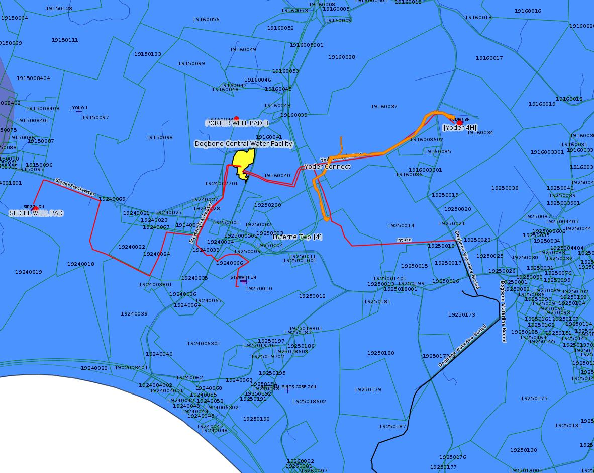
The detail map shown above for the Dogbone area of Luzerne Twp (which shows the Yoder Connect pipeline in orange) shows in red the routing of the waterlines connecting to the Dogbone Centralized Water Facility in red. This is the routing provided by Chevron to the Fayette County Zoning Hearing Board for the hearings on case ZHB 17-41. This may not reflect the exact routing for the Dogbone Waterline listed above.
---
The Erosion & Sedimentation Permit for the Delmont Loop (see the PA Bulletin Entry for WQ6583220-002 above does not list Fayette County because there is less than 5 acres of earth disturbance for the Uniontown Crossover. That application shows as follows:
Authorization ID: 1319615
Permit number: ESG836520002-00
Site: APPALACHIA TO MARKET DELMONT LOOP
Client: TEXAS EASTERN TRANS LP
Authorization type: Erosion & Sediment Control Plan Approval
Application type: New
Authorization is for: FACILITY
Date received: 06/23/2020
Status: Pending
Permit Decision Guarantee Applies?: No
Permit Review Notes:
Date Review Note
10/19/2020 The permit application package is complete, has been accepted, and is undergoing technical review.
<https://www.ahs.dep.pa.gov/eFACTSWeb/searchResults_singleAuth.aspx?AuthID=1319615>
Site Programs:
Clean Water
Site Municipalities:
Salem Twp, Westmoreland County
---
The
landowner for the Porter
Well Pad B entry above reports that construction of this
well pad never started. Most of the "Notification" applications
for well pad Erosion & Sedimentation permits are probably
termination notifications. That is probably what this application
is also, but without seeing the actual application it's hard to be
certain. Given that no construction actually occurred, a
reasonable guess is that Chevron is leaving to EQT to figure out
where it wants to put a well pad to access the gas that this well
pad was intended to reach.
---
Something looks wrong in the Pressure Test / Stimulation notifications for Coastal 2H above. The pressure test is noticed for 12/3, and the stimulation for 12/2. Pressure test should happen before stimulation. Why is stimulation noticed for a day earlier than pressure test? (Same for the notifications for Coastal 4H.)
------------------------
<https://www.dep.pa.gov/PublicParticipation/OfficeofEnvironmentalJustice/Pages/default.aspx>). There are supposed to be enhanced public participation requirements for permits in environmental justice areas, but news of this actually ever happening is scarce. In Fayette County, the entirety of Redstone, Springhill, Nicholson, and German Townships are environmental justice areas, as well as a large part of Dunbar Township. DEP's policy document on public participation guidelines for environmental justice areas is located here:
<https://www.elibrary.dep.state.pa.us/dsweb/Get/Version-48671/012-0501-002.pdf>
eNOTICE records are likely to list the same permit multiple times, as that permit moves through the DEP process.
Oil & Gas Wells designated with a site a number and the letter H typically designate horizontal wells.
-------------------------
Resources:
Pennsylvania Bulletin: <https://www.pabulletin.com/>
eNOTICE: <https://www.ahs2.dep.state.pa.
DEP Oil and Gas Reports: <https://www.dep.pa.gov/DataandTools/Reports/Oil%20and%20Gas%20Reports/Pages/default.aspx>
DEP Permits Issued Detail Report:
<http://cedatareporting.pa.gov/Reportserver/Pages/ReportViewer.aspx?/Public/DEP/OG/SSRS/Permits_Issued_Detail>
DEP SPUD (drilling started) Report:
<http://cedatareporting.pa.gov/Reportserver/Pages/ReportViewer.aspx?/Public/DEP/OG/SSRS/Spud_External_Data>
DEP Oil and Gas Compliance Report:
<http://cedatareporting.pa.gov/Reportserver/Pages/ReportViewer.aspx?/Public/DEP/OG/SSRS/OG_Compliance>
DEP PA Oil & Gas Mapping:
<https://www.depgis.state.pa.us/PaOilAndGasMapping>
Data Portal Services Directory [Technical]
<https://www.depgis.state.pa.us/arcgis/rest/services>
Query: Oil and Gas Wells All (ID: 3) [Technical]:
<https://www.depgis.state.pa.us/arcgis/rest/services/OilGas/OilGasAllStrayGasEGSP/MapServer/3/query?where=&text=&objectIds=&time=&geometry=&geometryType=esriGeometryEnvelope&inSR=&spatialRel=esriSpatialRelIntersects&relationParam=&outFields=*&returnGeometry=true&returnTrueCurves=false&maxAllowableOffset=&geometryPrecision=&outSR=&returnIdsOnly=false&returnCountOnly=false&orderByFields=&groupByFieldsForStatistics=&outStatistics=&returnZ=false&returnM=false&gdbVersion=&returnDistinctValues=false&resultOffset=&resultRecordCount=&f=html>
(Be sure to enter a Where clause in SQL format. Dates are in milliseconds since midnight 1/1/1970).
DEP Oil and Gas Electronic Submissions
<https://www.ahs.dep.pa.gov/eSubmissionPublicSearch>
DEP Air Quality Air Emission Plants Facilities Report
<http://cedatareporting.pa.gov/Reportserver/Pages/ReportViewer.aspx?/Public/DEP/AQ/SSRS/AQ_AEP_Facilities>
DEP Oil and Gas Electronic Notifications
<http://cedatareporting.pa.gov/Reportserver/Pages/ReportViewer.aspx?/Public/DEP/OG/SSRS/OG_Notifications>
DEP Oil and Gas Well Pad Report
<http://cedatareporting.pa.gov/Reportserver/Pages/ReportViewer.aspx?/Public/DEP/OG/SSRS/Well_Pads>
Fayette County Assessment Office Search For Tax Records:
<http://property.co.fayette.pa.us/search.aspx>
Pennsylvania Spatial Data Access:
<https://www.pasda.psu.edu/default.asp>
DEP Spatial Data Repository:
<ftp://www.pasda.psu.edu/pub/pasda/dep/>
National Response Center:
<https://www.nrc.uscg.mil/>
EPA-Echo: <https://www.epa-echo.gov/echo/
FERC citizen involvement: <https://www.ferc.gov/for-citiz
To receive E-mail notification of
all documents filed in a FERC docket, see:
<https://www.ferc.gov/docs-filing/esubscription.asp >
<https://www.ferc.gov/docs-fili
Follow the directions and enter the docket number to subscribe to.
Township Supervisors receive information regarding Erosion & Sedimentation permits, and these records may be reviewable at township municipal offices.
DEP permits are reviewable through the File Review process, for application to do file review see: <https://www.portal.state.pa.us/portal/server.pt/community/southwest_regional_office/13775/file_review/593164>
Environmental Hearing Board: <https://ehb.courtapps.com/publ
PA DEP Environmental Policy Comment System:
<https://www.ahs.dep.pa.gov/eComment/>
Federal Register Environment: <https://www.federalregister.g
Browsing of recent comment
opportunities for federal agencies, e.g. EPA. Click "sign up" to
subscribe to daily E-mails of new document listings.
SkyTruth Fayette County Drilling Alerts: <https://frack.skytruth.org/pen
U.S. Army Corps of Engineers, Pittsburgh District, Public Notices:
<https://www.lrp.usace.army.mil/Missions/Regulatory/Public-Notices/>
EPA Pennsylvania Public Notices: <https://www2.epa.gov/aboutepa/epa-pennsylvania#notice>
Marcellus Shale waste disposal
injection wells in Pennsylvania are regulated directly by EPA, not
DEP. Notice of any new permit applications will appear at the
above web address. I'm not aware of any subscription service
to be notified of such applications. I'm not aware of any
Marcellus Shale waste disposal injection wells in Fayette County
(yet ...) but we need to monitor this page for future
applications.
Energy Assurance Daily: <https://www.oe.netl.doe.gov/ead.aspx>
Daily newsletter from the US
Department of Energy about events relating to energy. The Natural
Gas section has information about pipelines.
-------------------------
Disclaimers:
This compilation from the above sources was done in part by hand using copy and paste and in part using automated methods; it may omit relevant permits.
Parcel data is provided via the tax records search web page offered by the Fayette County Assessment Office (http://property.co.fayette.pa.us/). Presumed Parcel Id links are subject to availability provided by that agency and associated web sites. Presumed Parcel Ids are determined as the mapped parcel containing a given latitude and longitude, are a best effort determination which is subject to error, and are not official. In cases where a facility is leased and there is a separate parcel id for the lease, if this parcel id is not separately mapped, the parcel id shown will be the id for the enclosing parcel. Parcel owners may be surface owners only and may or may not have any relationship to oil & gas facilities.
Does not currently include water supply permits. Does not include landfill permits even though many such are for Marcellus Shale waste. (It is not possible at this time to distinguish which landfill permits are for Marcellus Shale waste and which are not without doing File Review for each permit.)
Erosion & Sedimentation permit records do not currently include latitude and longitude. Where I am publishing latitude and longitude with E&S permits it is by inferring an associated well permit and using published latitude and longitude for the well. It is possible I may be inferring the wrong well site.
Municipalities are shown from eFACTS records on the DEP web site. The DEP has been known to list a municipality incorrectly.