The Harmed Success Stories Concepts How To What Is Commentary
Fayette County Marcellus Shale Permits 11/17/14 - 11/30/14
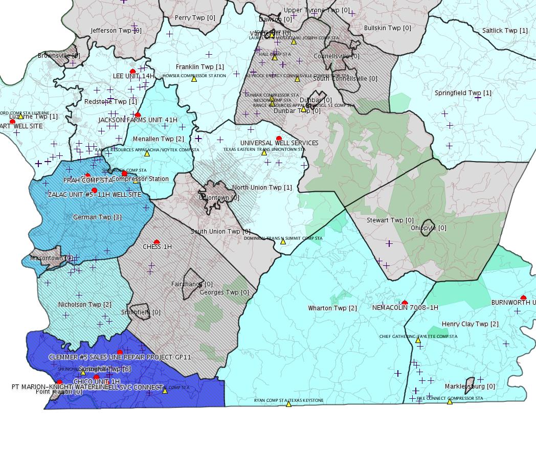
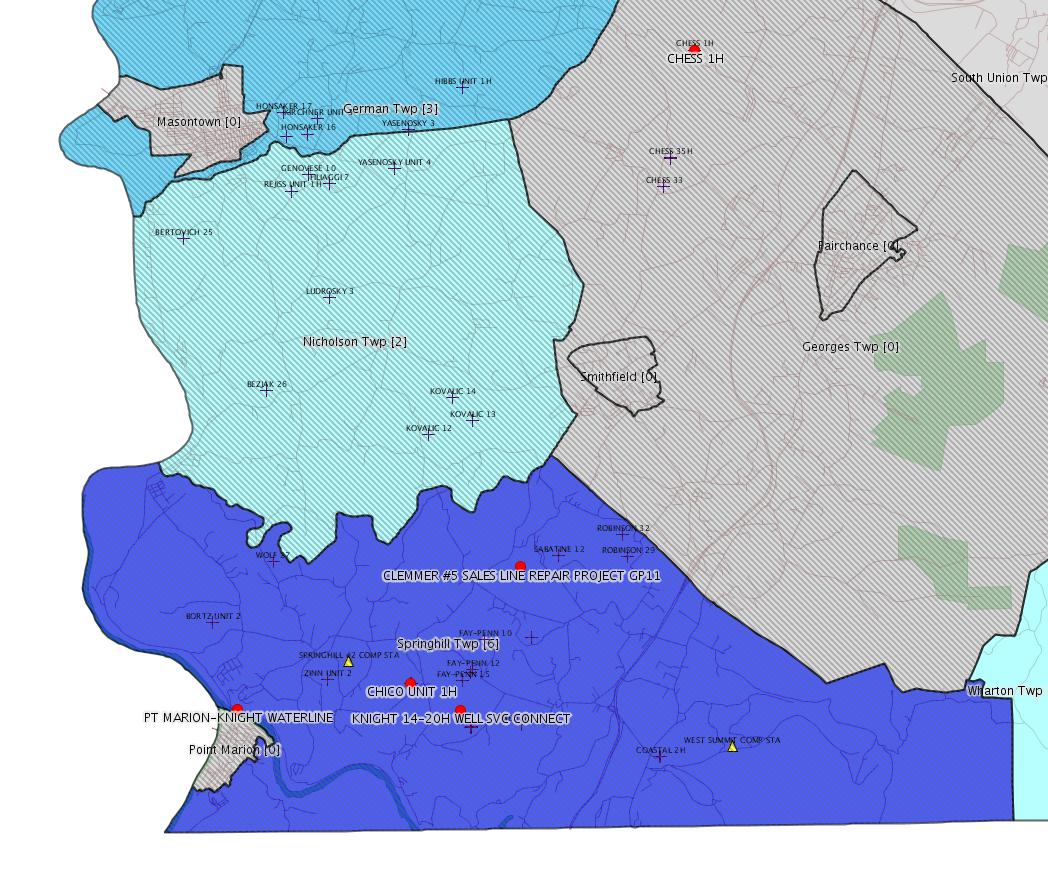
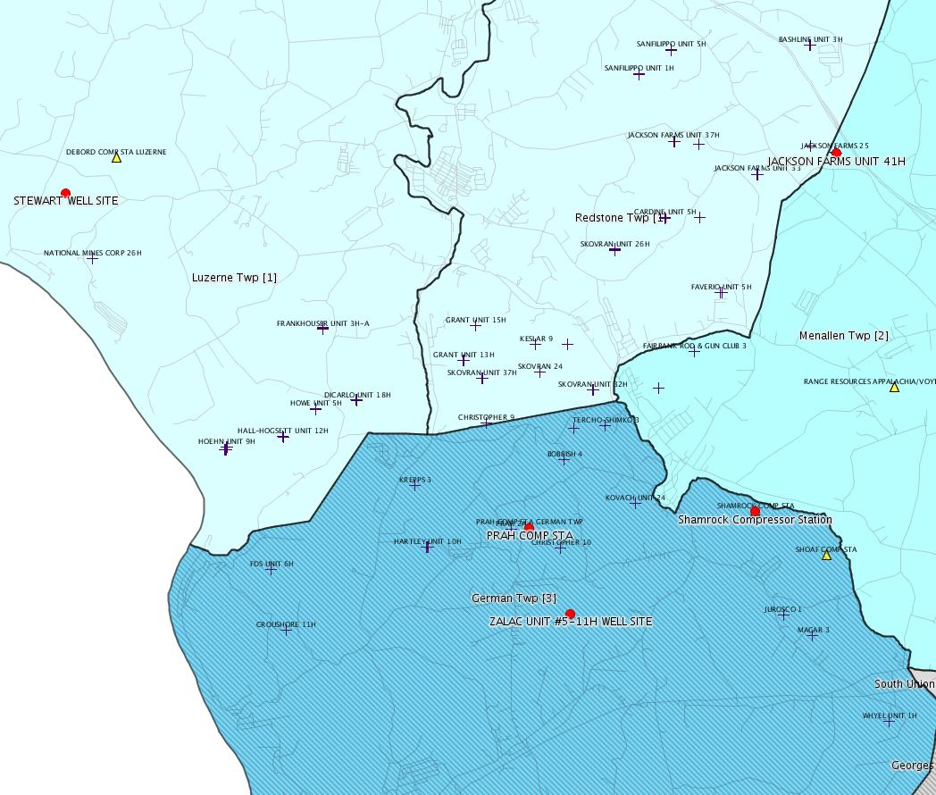
Click the map to enlarge
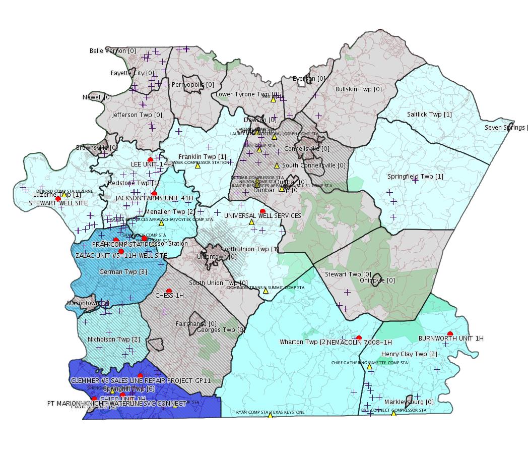
Map
Key
Red dots: items in this permit list with an exact location.
Orange triangles: Notifications in this permit list with an exact location.
Municipality shading: number of "facilities", with each well counting separately
(includes the red dots):
Red dots: items in this permit list with an exact location.
Orange triangles: Notifications in this permit list with an exact location.
Municipality shading: number of "facilities", with each well counting separately
(includes the red dots):
gray: 0
pale turquoise: 1
turquoise: 2
pale blue: 3
middle blue: 4
dark blue: 6
dark purple: 7
purple: 11
(Color coding may differ from one issue to the next.)
(Note if a project spans multiple municipalities -- e.g. a pipeline -- it will show in the count for each municipality.)
The number of facilities also follows the municipality name in brackets.
Municipality counts are based on the way the permit is listed by DEP; DEP has been known to get a municipality wrong.
Locations labeled beginning with "~" and ending in "[?]" are approximate and speculative based on inferences using on-line property and lease records. These are marked in the text as "[Approximate, Speculative]
eFACTS/eNOTICE applications of type Notification are not mapped.
Cross-hatching: Environmental
Justice
Areas
Yellow triangles: Compressor Stations
Crosses: Unconventional well permits (may not have been drilled)
Green: "Natural areas", e.g. state game lands, state forests
Yellow triangles: Compressor Stations
Crosses: Unconventional well permits (may not have been drilled)
Green: "Natural areas", e.g. state game lands, state forests
More Maps
 |  |
 |
Source: Pennsylvania Bulletin
26-00588: Laurel Mountain Midstream, LLC (1550 Coraopolis Heights Road, Suite 140, Moon Township, PA 15108) On November 10, 2014, to extend the period of temporary operation of the three new ultra lean burn natural gas-fired compressor engines rated at 1,380 bhp each and controlled by oxidation catalysts, and the natural gas-fired turbine rated at 15,525 bhp covered under plan approval PA-26-00588 until May 16, 2015, at Shamrock Compressor Station located in German Township, Fayette County.
<http://www.pabulletin.com/secure/data/vol44/44-48/2464c.html>
Location: 39.918333,-79.825 <http://osm.org/go/ZWpasXGm--?m=>
-------------------------
Source: eNOTICE
Authorization ID: 1044308
Permit number: GP112614207
Site: COLUMBIA GAS TRANS FAYETTE CNTY
Client: COLUMBIA GAS TRANS LLC
Authorization type: BWM-GP-11 Maintenance, Testing, Repair, Rehabilitation or Replacement General Pmt
Application type: New
Authorization is for: FACILITY
Date received: 09/05/2014
Status: Issued on 11/12/2014
Sub-Facility ID Sub-Facility Name Description
1145203 LINE 7906 REPLACEMENT Pipeline or Conduit
<http://www.ahs.dep.pa.gov/eFACTSWeb/searchResults_singleAuth.aspx?AuthID=1044308>
Location: 39.84061,-79.85887 <http://osm.org/go/ZWpOaUgZ--?m=> [??? See Notes.]
Municipalities: Franklin Twp, Henry Clay Twp, Menallen Twp, Nicholson Twp, Springhill Twp, Wharton Twp
Authorization ID: 1050588
Permit number: SPGP
Site: COLUMBIA GAS TRANS FAYETTE CNTY
Client: COLUMBIA GAS TRANS LLC
Authorization type: SPGP Category 1
Application type: New
Authorization is for: FACILITY
Date received: 09/05/2014
Status: Issued on 11/12/2014
Sub-Facility ID Sub-Facility Name Description
1145203 LINE 7906 REPLACEMENT Pipeline or Conduit
<http://www.ahs.dep.pa.gov/eFACTSWeb/searchResults_singleAuth.aspx?AuthID=1050588>
Authorization ID: 1050673
Permit number: 051-24525
Site: CHESS 1H ESCGP-EXPEDITED
Client: BURNETT OIL CO INC
Authorization type: Drill & Operate Well Permit
Application type: Renewal
Authorization is for: FACILITY
Date received: 10/20/2014
Status: Pending
<http://www.ahs.dep.pa.gov/eFACTSWeb/searchResults_singleAuth.aspx?AuthID=1050673>
Location: 39.859844,-79.7907 <http://osm.org/go/ZWplCMCe--?m=>
Municipalities: Georges Twp [an Environmental Justice Area]
Authorization ID: 1051213
Permit number: ESX11-051-0013
Site: CHICO UNIT WELL ESCGP-EXPEDITED
Client: CHEVRON APPALACHIA LLC
Authorization type: Expedited E&S Stormwater General Permit 1
Application type: Notification
Authorization is for: SITE
Date received: 11/17/2014
Status: Pending
<http://www.ahs.dep.pa.gov/eFACTSWeb/searchResults_singleAuth.aspx?AuthID=1051213>
Location [of CHICO UNIT 1H]: 39.746956,-79.858581 <http://osm.org/go/ZWpKPR5Q--?m=>
Municipalities: Springhill Twp [an Environmental Justice Area]
Authorization ID: 1051238
Permit number: ESX11-051-0002
Site: SPRINGHILL CS TO BEZJAK PIPELINE ESGPX-EXPEDITED
Client: LAUREL MTN MIDSTREAM OPR LLC
Authorization type: Expedited E&S Stormwater General Permit 1
Application type: Notification
Authorization is for: SITE
Date received: 11/17/2014
Status: Pending
<http://www.ahs.dep.pa.gov/eFACTSWeb/searchResults_singleAuth.aspx?AuthID=1051238>
Municipalities: Nicholson Twp, Springhill Twp
Authorization ID: 1049354
Permit number: ESG14-051-0015
Site: NEMACOLIN 7008 PIPELINE PROJECT ESGP-2
Client: T & F EXPLORATION LP
Authorization type: Erosion and Sediment Control GP-2
Application type: New
Authorization is for: SITE
Date received: 10/31/2014
Status: Issued on 11/18/2014
<http://www.ahs.dep.pa.gov/eFACTSWeb/searchResults_singleAuth.aspx?AuthID=1049354>
Location [of NEMACOLIN 7008-1H]: 39.805666,-79.520969 <http://osm.org/go/ZWprWtju--?m=>
Municipalities: Wharton Twp
Authorization ID: 1050186
Permit number: ESX14-051-0016
Site: STEWART WELL SITE ESCGP-2 EXPEDITED
Client: CHEVRON APPALACHIA LLC
Authorization type: Expedited E&S Stormwater General Permit 1
Application type: New
Authorization is for: SITE
Date received: 11/07/2014
Status: Pending
<http://www.ahs.dep.pa.gov/eFACTSWeb/searchResults_singleAuth.aspx?AuthID=1050186>
Location: 39.962961,-79.946956 <http://osm.org/go/ZWpZPAOD--?m=>
Municipalities: Luzerne Twp
[Conventional Well Pipeline]
Authorization ID: 1051451
Permit number: GP11260714001
Site: CLEMMER #5 SALES LINE REPAIR PROJECT GP11
Client: ATLAS RESOURCES LLC
Authorization type: BWM-GP-11 Maintenance, Testing, Repair, Rehabilitation or Replacement General Pmt
Application type: New
Authorization is for: FACILITY
Date received: 11/12/2014
Status: Pending
Sub-Facility ID Sub-Facility Name Description
1148962 STREAM 1 Pipeline or Conduit
<http://www.ahs.dep.pa.gov/eFACTSWeb/searchResults_singleAuth.aspx?AuthID=1051451>
Location: 39.76764,-79.832775 <http://osm.org/go/ZWpK3Pe7--?m=>
Municipalities: Springhill Twp
Authorization ID: 1047018
Permit number: ESX10-129-0032
Site: DONEGAL SOUTH PIPELINE - PHASE 1 ESCGP-EXPEDITED
Client: WPX ENERGY APPALACHIA LLC
Authorization type: Expedited E&S Stormwater General Permit 1
Application type: Notification
Authorization is for: SITE
Date received: 10/16/2014
Status: Issued on 11/20/2014
<http://www.ahs.dep.pa.gov/eFACTSWeb/searchResults_singleAuth.aspx?AuthID=1047018>
Municipalities/Counties
Donegal Twp, Westmoreland County, Saltlick Twp, Springfield Twp
Authorization ID: 1051756
Permit number: ESX11-051-0031
Site: LEE WELL SITE ESCGP-EXPEDITED
Client: CHEVRON APPALACHIA LLC
Authorization type: Expedited E&S Stormwater General Permit 1
Application type: Notification
Authorization is for: SITE
Date received: 11/20/2014
Status: Pending
<http://www.ahs.dep.pa.gov/eFACTSWeb/searchResults_singleAuth.aspx?AuthID=1051756>
Location [of LEE UNIT 14H]: 40.003889,-79.814303 <http://osm.org/go/ZWpeuF~q--?m=>
Municipalities: Redstone Twp
Authorization ID: 1041322
Permit number: ESX14-051-0014
Site: ZALAC UNIT #5-11H WELL SITE ESCGP-2 EXPEDITED
Client: CHEVRON APPALACHIA LLC
Authorization type: Expedited E&S Stormwater General Permit 1
Application type: New
Authorization is for: SITE
Date received: 09/08/2014
Status: Pending
<http://www.ahs.dep.pa.gov/eFACTSWeb/searchResults_singleAuth.aspx?AuthID=1041322>
Location: 39.904511,-79.858119 <http://osm.org/go/ZWpaKFq~--?m=>
Municipalities: German Twp [an Environmental Justice Area]
Authorization ID: 1042365
Permit number: GP08260714002
Site: KNIGHT 14-20H WELL SERVICE CONNECT GP5 & GP8
Client: CHEVRON APPALACHIA LLC
Authorization type: GP-08 Temporary Road Crossings
Application type: New
Authorization is for: FACILITY
Date received: 09/10/2014
Status: Pending
Sub-Facility ID Sub-Facility Name Description eMap PA Location
1144115 WETLAND CROSSING #1 Temporary Wetland Impact
<http://www.ahs.dep.pa.gov/eFACTSWeb/searchResults_singleAuth.aspx?AuthID=1042365>
Location: 39.742075,-79.847166 <http://osm.org/go/ZWpKkWQx--?m=>
Municipalities: Springhill Twp [an Environmental Justice Area]
Authorization ID: 1051811
Permit number: GP5-26-00546B
Site: PRAH COMP STA GERMAN TWP
Client: LAUREL MTN MIDSTREAM OPR LLC
Authorization type: AQ General Permit
Application type: New
Authorization is for: FACILITY
Date received: 11/21/2014
Status: Pending
<http://www.ahs.dep.pa.gov/eFACTSWeb/searchResults_singleAuth.aspx?AuthID=1051811>
Location: 39.916422,-79.865258 <http://osm.org/go/ZWpaMa6C--?m=>
Municipalities: German Twp [an Environmental Justice Area]
Fayette County Parcel ID 15-11-0031
[See Notes.]
Authorization ID: 1047312
Permit number: PAG036123
Site: UNIVERSAL WELL SERVICES, INC - MT. BRADDOCK FACILITY
Client: UNIVERSAL WELL SERVICES INC
Authorization type: PAG-03 Discharge of Stormwater Assoc w Industrial Activities
Application type: New
Authorization is for: FACILITY
Date received: 10/03/2014
Status: Issued on 11/21/2014
Sub-Facility ID Sub-Facility Name Description
1146585 OUTFALL SO1 Discharge Point
1147275 OUTFALL SO2 Discharge Point
<http://www.ahs.dep.pa.gov/eFACTSWeb/searchResults_singleAuth.aspx?AuthID=1047312>
Location 39.94585,-79.655403 <http://osm.org/go/ZWpy31m3--?m=>
Municipalities: North Union Twp
[See Notes.]
Authorization ID: 1050853
Permit number: GP08260714003
Site: POINT MARION TO KNIGHT WATERLINE GP5 & GP8
Client: KEYSTONE CLEARWATER SOLUTIONS LLC
Authorization type: GP-08 Temporary Road Crossings
Application type: New
Authorization is for: FACILITY
Date received: 11/12/2014
Status: Pending
Sub-Facility ID Sub-Facility Name Description
1148466 UNT 1 TO MONONGAHELA RIVER Floodway Activity
<http://www.ahs.dep.pa.gov/eFACTSWeb/searchResults_singleAuth.aspx?AuthID=1050853>
Location: 39.7428,-79.898961 <http://osm.org/go/ZWpIufZQ--?m=>
Municipalities: Springhill Twp
[See Notes.]
Authorization ID: 1050850
Permit number: GP05260714006
Site: POINT MARION TO KNIGHT WATERLINE GP5 & GP8
Client: KEYSTONE CLEARWATER SOLUTIONS LLC
Authorization type: GP-05 Utility Line Stream Crossings
Application type: New
Authorization is for: FACILITY
Date received: 11/12/2014
Status: Pending
<http://www.ahs.dep.pa.gov/eFACTSWeb/searchResults_singleAuth.aspx?AuthID=1050850>
Authorization ID: 1051951
Permit number: ESX10-051-0028
Site: BURNWORTH FRESHWATER IMPOUNDMENT ESCGP-EXPEDITED
Client: CHIEF OIL & GAS LLC
Authorization type: Expedited E&S Stormwater General Permit 1
Application type: Notification
Authorization is for: SITE
Date received: 11/24/2014
Status: Pending
<http://www.ahs.dep.pa.gov/eFACTSWeb/searchResults_singleAuth.aspx?AuthID=1051951>
Location [of BURNWORTH UNIT 1H]: 39.808139,-79.390917 <http://osm.org/go/ZWrB22cP--?m=>
Municipalities: Henry Clay Twp
Authorization ID: 1051956
Permit number: ESX11-051-0028
Site: JACKSON FARMS WELL SITE ESCGP-EXPEDITED
Client: CHEVRON APPALACHIA LLC
Authorization type: Expedited E&S Stormwater General Permit 1
Application type: Notification
Authorization is for: SITE
Date received: 11/24/2014
Status: Pending
<http://www.ahs.dep.pa.gov/eFACTSWeb/searchResults_singleAuth.aspx?AuthID=1051956>
Location [of JACKSON FARMS UNIT 41H]: 39.967181,-79.809758 <http://osm.org/go/ZWpbv0NP--?m=>
Municipalities: Redstone Twp [??? Menallen Twp may be correct -jr, see Notes]
-------------------------
Source: Reuters Commodities: Energy
Natural Gas
| Commodity | Exch | Currency | Expire | Last | Trade Date/Time |
Net Chg | Open | High | Low |
|---|---|---|---|---|---|---|---|---|---|
|
NATURAL GAS CON1 Dec14 |
NYM | USD | 12/29 | 4.01 | 11/30 21:05 | +0.00 | 4.02 | 4.03 | 4.01 |
-------------------------
Notes:
The exact latitude and longitude for the Columbia Gas LINE 7906 REPLACEMENT project above were derived from the eMapPA link embedded in the authorization record on eFACTS. A single "pinpoint location" is obviously not consistent with the large number of townships listed in the Site record. It's not clear what that exact latitude and longitude are marking -- perhaps the "center" of the project. For this reason, I am not showing this exact latitude/longitude on the map.
---
According to the Facility Record for the Prah Compressor Station, the equipment installed consists of:
CATERPILLAR G3516TALE 1340 BHP ENGINE 1 Process
CATERPILLAR G3516TALE 1340 BHP ENGINE 2 Process
DEHYDRATOR 0.50 MMBTU/HR Process
FLARE 6.75 MMBTU/HR FOR 0.50 DEHYDRATOR Air Pollution Control Device
OX CATALYST FOR CAT ENGINE 1 Air Pollution Control Device
OX CATALYST FOR CAT ENGINE 2 Air Pollution Control Device
STACK FOR CAT ENGINE 1 Point of Air Emission
STACK FOR CAT ENGINE 2 Point of Air Emission
This facility has several violations from when it was owned by Atlas, for not having proper air quality permits.
---
According to their web site, "Universal Pressure Pumping, Inc. and Universal Well Services, Inc. are subsidiaries of Patterson-UTI Energy, Inc."
---
One infers from the site name that the project POINT MARION TO KNIGHT WATERLINE GP5 & GP8 is a waterline from the confluence of the Cheat & Mon Rivers to the KNIGHT 14-20H well site. The location published above is the Point Marion end; Knight 14H is located here: 39.738978,-79.844828 <http://osm.org/go/ZWpKkMoT--?m=>. Keystone Clearwater Solutions advertises itself on its web site as: "Keystone Clearwater Solutions serves natural gas industry operators and midstream companies by providing total water management solutions."
---
There are several Jackson Farms well sites. DEP does not make it easy to get latitude / longitude for a well pad. For the Jackson Farms Well Site notification above, the Site Record is linked to Inspection ID 2185767 on 07/24/2013; searching the Oil and Gas Compliance Report for Fayette County inspections on 07/24/2013 yields inspections 2185751, Compliance Evaluation, for JACKSON FARMS UNIT 43H; 2185754, Site Restoration, for JACKSON FARMS UNIT 41H; and 2185759, Site Restoration, for JACKSON FARMS UNIT 42H. So in spite of the fact there is no match for Inspection ID, I'm assuming JACKSON FARMS UNIT 41H gives the correct location. The records for this well indicate Menallen Twp, so I am mapping it that way. The eFACTS site record indicates Redstone Twp. DEP site record municipalities have been known to be incorrect in several instances. All these data inconsistencies are extremely frustrating.
------------------------
DEP defines an environmental justice area as "any census tract where 20 percent or more individuals live in poverty, and/or 30 percent or more of the population is minority". (See:
<http://www.portal.state.pa.us/portal/server.pt/community/pa_environmental_justice_areas/20991>
<http://www.portal.state.pa.us/portal/server.pt/community/dep_enhanced_public_participation_policy/20988>
). There are supposed to be enhanced public participation requirements for permits in environmental justice areas, but news of this actually ever happening is scarce. In Fayette County, the entirety of Springhill, Nicholson, German, and Georges Townships are environmental justice areas, as well as a large part of Dunbar Township. DEP's policy document on public participation guidelines for environmental justice areas is located here:
<http://www.elibrary.dep.state.pa.us/dsweb/Get/Version-48671/012-0501-002.pdf>
eNOTICE records are likely to list the same permit multiple times, as that permit moves through the DEP process.
Oil & Gas Wells designated with a site a number and the letter H typically designate horizontal wells.
The eMapPa web site does not work in web browsers other than Internet Explorer. For instructions on how to view eMapPa data in Firefox send me E-mail.
-------------------------
Resources:
Pennsylvania Bulletin: <http://www.pabulletin.com/>
eNOTICE: <http://www.ahs2.dep.state.pa.
DEP Well Details Report: <https://www.paoilandgasreport
Well Details may not show any
information for new permits and will not
show permits which have not yet been issued. Lookup for Well Details is
by permit number.
DEP Permits Issued Detail Report:
<http://www.depreportingservic
DEP SPUD (drilling started) Report:
<http://www.depreportingservices.state.pa.us/ReportServer/Pages/ReportViewer.aspx?/Oil_Gas/Spud_External_Data>
DEP Oil and Gas Compliance Report:
<http://www.depreportingservices.state.pa.us/ReportServer/Pages/ReportViewer.aspx?/Oil_Gas/OG_Compliance>
National Response Center:
<http://www.nrc.uscg.mil/>
EPA-Echo: <http://www.epa-echo.gov/echo/
FERC citizen involvement: <http://www.ferc.gov/for-citiz
To receive E-mail notification of all
documents filed in a FERC docket,
see:
<http://www.ferc.gov/docs-filing/esubscription.asp >
<http://www.ferc.gov/docs-fili
Follow the directions and enter the docket number to subscribe to.
Township Supervisors receive information regarding Erosion & Sedimentation permits, and these records may be reviewable at township municipal offices.
DEP permits are reviewable through the File Review process, for application to do file review see: <http://www.portal.state.pa.us/portal/server.pt/community/southwest_regional_office/13775/file_review/593164>
Environmental Hearing Board: <http://ehb.courtapps.com/publ
PA DEP Public Participation Center Proposals Currently Open for Comment:
<http://www.portal.state.pa.us
This location contains links for open
public comment periods.
Federal Register Environment: <https://www.federalregister.g
Browsing of recent comment
opportunities for federal agencies, e.g.
EPA. Click "sign up" to subscribe to daily E-mails of new document
listings.
SkyTruth Fayette County Drilling Alerts: <http://frack.skytruth.org/pen
EPA Region 3 Water Protection Public Notices: <http://www.epa.gov/reg3wapd/p
Marcellus Shale waste disposal
injection wells in Pennsylvania are
regulated directly by EPA, not DEP. Notice of any new permit
applications will appear at the above web address. I'm not aware
of any subscription service to be notified of such applications. I'm
not aware of any Marcellus Shale waste disposal injection wells in
Fayette County (yet ...) but we need to monitor this page for future
applications.
Energy Assurance Daily: <http://www.oe.netl.doe.gov/ead.aspx>
Daily newsletter from the US Department
of Energy about events relating to energy. The Natural Gas section has
information about pipelines.
-------------------------
Disclaimers:
This compilation from the above sources was done by hand using copy and paste and may omit relevant permits.
Does not currently include water supply permits. Does not include landfill permits even though many such are for Marcellus Shale waste. (It is not possible at this time to distinguish which landfill permits are for Marcellus Shale waste and which are not without doing File Review for each permit.)
Erosion & Sedimentation permit records do not currently include latitude and longitude. Where I am publishing latitude and longitude with E&S permits it is by inferring an associated well permit and using published latitude and longitude for the well. It is possible I may be inferring the wrong well site.
Municipalities are shown from eFACTS records on the DEP web site. The DEP has been known to list a municipality incorrectly.