The Harmed Success Stories Concepts How To What Is Commentary
Fayette County Marcellus Shale Permits 11/18/19 - 12/1/19
Contents
Pennsylvania Bulletin Listings
Siegel Well Connect Pipeline Project Erosion and Sediment Control General Permit 3 ExpeditedeFACTS Listings
KOVACH B M02H Drill & Operate Well Permit Inactive Status (New)
KOVACH B M08H Drill & Operate Well Permit Inactive Status (New)
KOVACH B M07H Drill & Operate Well Permit Inactive Status (New)
KOVACH B M03H Drill & Operate Well Permit Inactive Status (New)
KOVACH B M06H Drill & Operate Well Permit Inactive Status (New)
KOVACH B M09H Drill & Operate Well Permit Inactive Status (New)
KOVACH B M04H Drill & Operate Well Permit Inactive Status (New)
KOVACH B M05H Drill & Operate Well Permit Inactive Status (New)
KOVACH B M01H Drill & Operate Well Permit (Unconventional) Modification [of schedule]
SIEGEL WATERLINE ESCGP ESX18-051-0005 PAG-10 Discharge Resulting from Hydrostatic Testing of Tanks & Pipelines Issued 11/19/2019
HALL/HOGSETT UNIT 13H Well Plugging Notice Intent to Plug Single Well
RUPPERT WELL PAD Expedited E&S Stormwater General Permit 1 [Termination?] Notification Issued 11/26/2019
SHAMROCK COMP STA Minor Facility Plan Approval New Source Performance Std Extension Issued 11/20/2019
GATOR WATER SVCS GP-04 Intake & Outfall Structures Withdrawn 11/13/2019
Yoder Well Connect Erosion and Sediment Control General Permit 3 Issued 11/13/2019
Electronic Notifications
POLK UNIT 3H Pressure test notification 11/20/2019Price of Natural Gas
POLK UNIT 4H Pressure test notification 11/20/2019
POLK UNIT 5H Pressure test notification 11/20/2019
YODER 6H Stimulation notification 11/24/2019
YODER 7H Stimulation notification 11/24/2019
YODER 8H Stimulation notification 11/24/2019
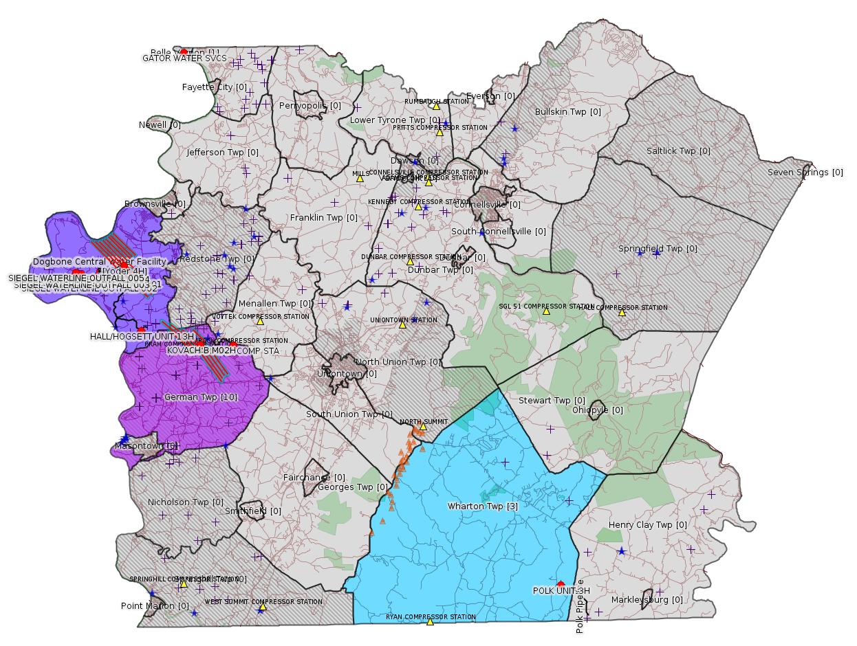
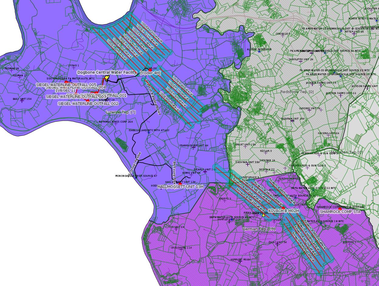
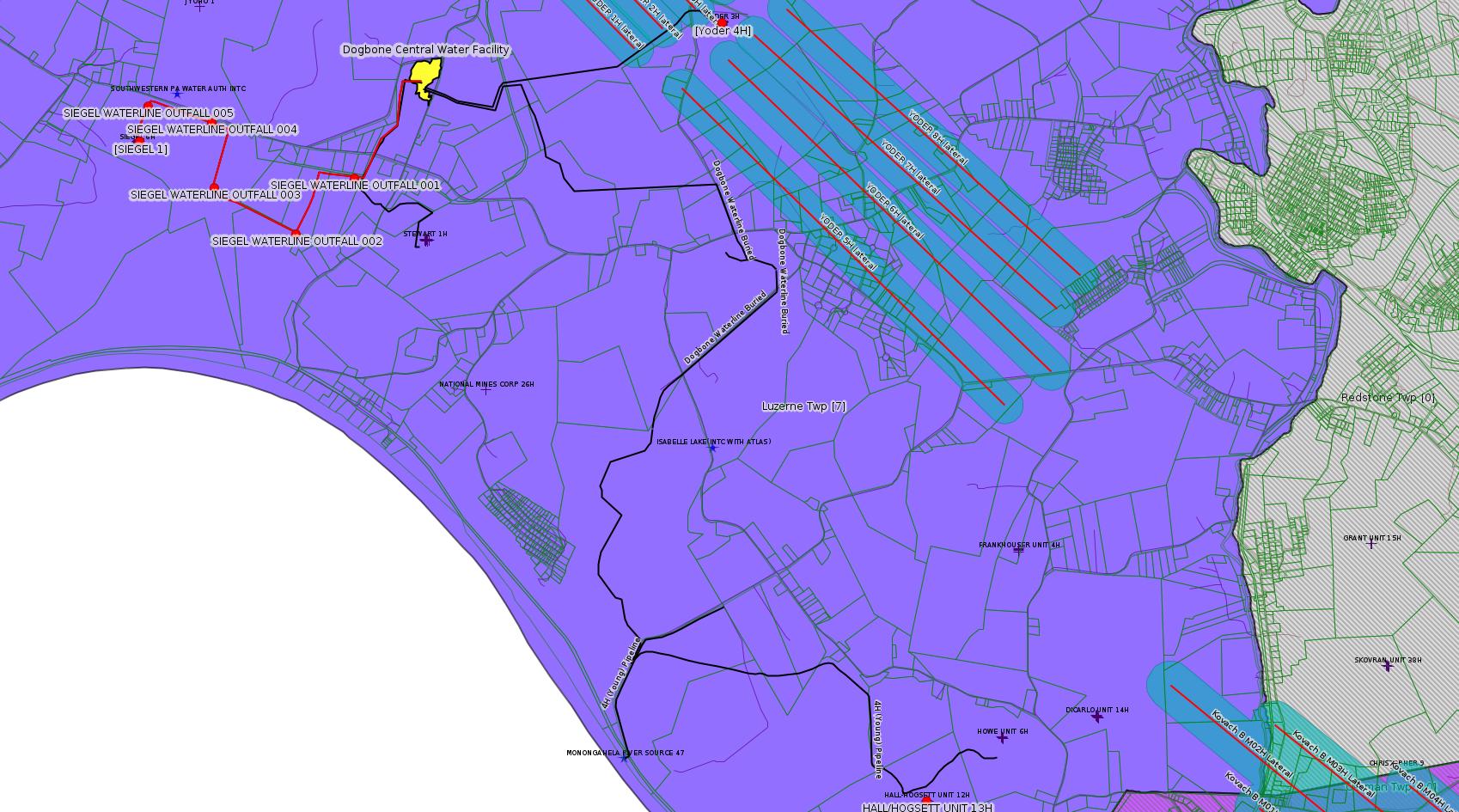
Map
Key
Red dots: items in this permit list with an exact location.
Blue stars: Marcellus Gas Well Water Sources.
Where well laterals are mapped they show in red; a 400-foot buffer surrounding the lateral shows in blue (lavender where it overlaps a mapped mineral tract).
Where mineral tracts are mapped, they show in pink. Mineral tracts can overlap; the overlap will show in red. The precise meaning of "mineral tract" is not clear.
Municipality shading: number of "facilities", with each well counting separately
(includes the red dots):
gray: 0
pale turquoise: 1
turquoise: 2
pale blue: 3
middle blue: 4
dark blue: 5
dark purple: 7
purple: 14
(Color coding may differ from one issue to the next.)
(Note if a project spans multiple municipalities -- e.g. a pipeline -- it will show in the count for each municipality.)
The number of facilities also follows the municipality name in brackets.
Municipality counts are based on the way the permit is listed by DEP; DEP has been known to get a municipality wrong.
Locations in brackets identify a precise location used to locate a surrogate for the actual site being permitted (e.g. locating a well pad or pipeline by the known location of a well.) Locations labeled beginning with "~" and ending in "[?]" are approximate and speculative based on inferences using on-line property and lease records. These are marked in the text as "[Approximate, Speculative]
Cross-hatching: Environmental Justice Areas
Yellow triangles: Compressor Stations
Orange triangles: Storage Field Wells (currently Dominion North Summit Storage Field)
Crosses: SPUD Unconventional well permits
Green: "Natural areas", e.g. state game lands, state forests
Yellow triangles: Compressor Stations
Orange triangles: Storage Field Wells (currently Dominion North Summit Storage Field)
Crosses: SPUD Unconventional well permits
Green: "Natural areas", e.g. state game lands, state forests
More Maps
 |
 |
Source: Pennsylvania Bulletin
ESCGP-3 # ESG072619002-00
Applicant Name Laurel Mountain Midstream OPR LLC
Contact Person Kristy Grigas
Address 1605 Coraopolis Heights Rd, Westpointe CTR 3
City, State, Zip Moon Township, PA 15108-4310
County Fayette
Township(s) Luzerne Township
Receiving Stream(s) and Classification(s) UNTs to Monongahela River (WWF), Monongahela River (WWF)
<http://www.pacodeandbulletin.gov/Display/pabull?file=/secure/pabulletin/data/vol49/49-47/1739c.html&continued=http://www.pacodeandbulletin.gov/Display/pabull?file=/secure/pabulletin/data/vol49/49-47/1739.html&d=reduce>
Site: Siegel Well Connect Pipeline Project
Location [of Siegel 1]: 39.968972,-79.968794 <https://osm.org/go/ZWpZSBgE--?m=>-------------------------
Source: eNOTICE
(+ PA
Oil and Gas Mapping, Well
Pad Report.) Well Details via Data
Portal Services: Oil and Gas Wells All (ID: 3).
Please see the Disclaimer below regarding Parcel Id data.
Authorization ID: 1296554
Permit number: 051-24672
Site: KOVACH B WELL SITE AND TANK SITE ESCGP ESX17-051-0003
Client: CHEVRON APPALACHIA LLC
Authorization type: Drill & Operate Well Permit Inactive Status
Application type: New
Authorization is for: FACILITY
Date received: 11/20/2019
Status: Pending
Permit Decision Guarantee Applies?: No
Sub-Facilities for Authorization:
Sub-Facility ID Sub-Facility Name Description
1263130 WELLBORE SURFACE HOLE LOCATION Well
Permit Review Notes:
Date Review Note
11/20/2019 The permit application package is complete, has been accepted, and is undergoing technical review.
<https://www.ahs.dep.pa.gov/eFACTSWeb/searchResults_singleAuth.aspx?AuthID=1296554>
Site Programs:
Oil & Gas
Site Municipalities:
German Twp, Fayette County
Well Details:
Permit Number: 051-24672
Well Name: KOVACH B M02H
Unconventional Well: Y
Well Configuration: Horizontal Well
Well Type: GAS
Well Status: Active
Coal Association: Coal
Conservation Well: N
Primary Facility ID: 828038
Site ID: 826949
Site Name: KOVACH B WELL SITE AND TANK SITE ESCGP ESX17-051-0003
Well Pad ID: 155005
Well Pad Name: KOVACH B
Storage Field:
Operator: CHEVRON APPALACHIA LLC
Operator Number: OGO-39307
Permit Date: 2018-08-08
Permit Date Expires: 2019-08-08
SPUD Date: 2018-10-23
Date Plugged:
UIC ID:
UIC Type:
Surface Elevation: 1278
County: Fayette
Municipality: German Twp
Location: 39.918972,-79.854786
Map URL: <http://www.openstreetmap.org/?mlat=39.918972&mlon=-79.854786#map=15/39.918972/-79.854786>
OG WELLS PERMIT DOCS:
2018-08-08: Final Permit Documents, Name: 1237728 (for Authorization: 1237728):
<http://www.depgis.state.pa.us/pdfHandler/pdFHandler.ashx?Doc=NjQ2Nzc4&ext=PDF>
2018-08-31: Other Permit Documents, Name: 051-24672 (for Authorization: 1240676):
<http://www.depgis.state.pa.us/pdfHandler/pdFHandler.ashx?Doc=NzgxMDU2&ext=PDF>
2019-01-07: Other Permit Documents, Name: 051-24672 (for Authorization: 1256826):
<http://www.depgis.state.pa.us/pdfHandler/pdFHandler.ashx?Doc=NzI3ODUz&ext=PDF>
Electronically Submitted Records:
2018-08-08: Submission for Authorization 1237728
Interested Party Notification: Kovach B Affidavit of Non-Delivery Venere.pdf
<http://www.depgis.state.pa.us/eWellDocHandler/pdFHandler.ashx?Doc=NjAxODc1&ext=PDF>
Pennsylvania Natural Diversity Inventory Form: Kovach B PNDI.pdf
<http://www.depgis.state.pa.us/eWellDocHandler/pdFHandler.ashx?Doc=NjAxODc5&ext=PDF>
Location Plat: Kovach B M02H Plat.dwg
<http://www.depgis.state.pa.us/eWellDocHandler/pdFHandler.ashx?Doc=NjAxODgw&ext=PDF>
Well Cross-Section Diagram: Kovach B M02H Page 4.pdf
<http://www.depgis.state.pa.us/eWellDocHandler/pdFHandler.ashx?Doc=NjAxODgy&ext=PDF>
Coal and Gas Resource Coord Act - Section 7 Exception: Kovach B Horizontals Section 7 Exception.pdf
<http://www.depgis.state.pa.us/eWellDocHandler/pdFHandler.ashx?Doc=NjAxODkz&ext=PDF>
Permit Application to Drill and Operate a Well: 1753234.pdf
<http://www.depgis.state.pa.us/eWellDocHandler/pdFHandler.ashx?Doc=NjAzODI3&ext=PDF>
---
Authorization ID: 1296553
Permit number: 051-24669
Site: KOVACH B WELL SITE AND TANK SITE ESCGP ESX17-051-0003
Client: CHEVRON APPALACHIA LLC
Authorization type: Drill & Operate Well Permit Inactive Status
Application type: New
Authorization is for: FACILITY
Date received: 11/20/2019
Status: Pending
Permit Decision Guarantee Applies?: No
Sub-Facilities for Authorization:
Sub-Facility ID Sub-Facility Name Description
1263127 WELLBORE SURFACE HOLE LOCATION Well
<https://www.ahs.dep.pa.gov/eFACTSWeb/searchResults_singleAuth.aspx?AuthID=1296553>
Site Programs:
Oil & Gas
Site Municipalities:
German Twp, Fayette County
Well Details:
Permit Number: 051-24669
Well Name: KOVACH B M08H
Unconventional Well: Y
Well Configuration: Horizontal Well
Well Type: GAS
Well Status: Active
Coal Association: Coal
Conservation Well: N
Primary Facility ID: 828035
Site ID: 826949
Site Name: KOVACH B WELL SITE AND TANK SITE ESCGP ESX17-051-0003
Well Pad ID: 155005
Well Pad Name: KOVACH B
Storage Field:
Operator: CHEVRON APPALACHIA LLC
Operator Number: OGO-39307
Permit Date: 2018-08-08
Permit Date Expires: 2019-08-08
SPUD Date: 2018-10-23
Date Plugged:
UIC ID:
UIC Type:
Surface Elevation: 1278
County: Fayette
Municipality: German Twp
Location: 39.919197,-79.854658
Map URL: <http://www.openstreetmap.org/?mlat=39.919197&mlon=-79.854658#map=15/39.919197/-79.854658>
OG WELLS PERMIT DOCS:
2018-08-08: Final Permit Documents, Name: 1237725 (for Authorization: 1237725):
<http://www.depgis.state.pa.us/pdfHandler/pdFHandler.ashx?Doc=NjQ2Nzc0&ext=PDF>
2018-08-31: Other Permit Documents, Name: 051-24669 (for Authorization: 1240734):
<http://www.depgis.state.pa.us/pdfHandler/pdFHandler.ashx?Doc=NzgxMDk5&ext=PDF>
2019-01-09: Other Permit Documents, Name: 051-24669 (for Authorization: 1256801):
<http://www.depgis.state.pa.us/pdfHandler/pdFHandler.ashx?Doc=NzI5MDIz&ext=PDF>
Electronically Submitted Records:
2018-08-08: Submission for Authorization 1237725
Interested Party Notification: Kovach B Affidavit of Non-Delivery Venere.pdf
<http://www.depgis.state.pa.us/eWellDocHandler/pdFHandler.ashx?Doc=NjAyNjA5&ext=PDF>
Coal and Gas Resource Coord Act - Section 7 Exception: Kovach B Horizontals Section 7 Exception.pdf
<http://www.depgis.state.pa.us/eWellDocHandler/pdFHandler.ashx?Doc=NjAyNjE1&ext=PDF>
Pennsylvania Natural Diversity Inventory Form: Kovach B PNDI.pdf
<http://www.depgis.state.pa.us/eWellDocHandler/pdFHandler.ashx?Doc=NjAyNjE2&ext=PDF>
Location Plat: Kovach B M08H Plat.dwg
<http://www.depgis.state.pa.us/eWellDocHandler/pdFHandler.ashx?Doc=NjAyNjE3&ext=PDF>
Well Cross-Section Diagram: Kovach B M08H Page 4.pdf
<http://www.depgis.state.pa.us/eWellDocHandler/pdFHandler.ashx?Doc=NjAyNjE4&ext=PDF>
Permit Application to Drill and Operate a Well: 1753555.pdf
<http://www.depgis.state.pa.us/eWellDocHandler/pdFHandler.ashx?Doc=NjAzODgz&ext=PDF>
---
Authorization ID: 1296550
Permit number: 051-24668
Site: KOVACH B WELL SITE AND TANK SITE ESCGP ESX17-051-0003
Client: CHEVRON APPALACHIA LLC
Authorization type: Drill & Operate Well Permit Inactive Status
Application type: New
Authorization is for: FACILITY
Date received: 11/20/2019
Status: Pending
Permit Decision Guarantee Applies?: No
Sub-Facilities for Authorization:
Sub-Facility ID Sub-Facility Name Description
1263126 WELLBORE SURFACE HOLE LOCATION Well
Permit Review Notes:
Date Review Note
11/20/2019 The permit application package is complete, has been accepted, and is undergoing technical review.
<https://www.ahs.dep.pa.gov/eFACTSWeb/searchResults_singleAuth.aspx?AuthID=1296550>
Site Programs:
Oil & Gas
Site Municipalities:
German Twp, Fayette County
Well Details:
Permit Number: 051-24668
Well Name: KOVACH B M07H
Unconventional Well: Y
Well Configuration: Horizontal Well
Well Type: GAS
Well Status: Active
Coal Association: Coal
Conservation Well: N
Primary Facility ID: 828034
Site ID: 826949
Site Name: KOVACH B WELL SITE AND TANK SITE ESCGP ESX17-051-0003
Well Pad ID: 155005
Well Pad Name: KOVACH B
Storage Field:
Operator: CHEVRON APPALACHIA LLC
Operator Number: OGO-39307
Permit Date: 2018-08-08
Permit Date Expires: 2019-08-08
SPUD Date: 2018-10-23
Date Plugged:
UIC ID:
UIC Type:
Surface Elevation: 1278
County: Fayette
Municipality: German Twp
Location: 39.919161,-79.854681
Map URL: <http://www.openstreetmap.org/?mlat=39.919161&mlon=-79.854681#map=15/39.919161/-79.854681>
OG WELLS PERMIT DOCS:
2018-08-08: Final Permit Documents, Name: 1237724 (for Authorization: 1237724):
<http://www.depgis.state.pa.us/pdfHandler/pdFHandler.ashx?Doc=NjQ2Nzcz&ext=PDF>
2018-08-31: Other Permit Documents, Name: 051-24668 (for Authorization: 1240732):
<http://www.depgis.state.pa.us/pdfHandler/pdFHandler.ashx?Doc=NzgxMDk2&ext=PDF>
2019-01-09: Other Permit Documents, Name: 051-24668 (for Authorization: 1256785):
<http://www.depgis.state.pa.us/pdfHandler/pdFHandler.ashx?Doc=NzI5MDgy&ext=PDF>
Electronically Submitted Records:
2018-08-08: Submission for Authorization 1237724
Interested Party Notification: Kovach B Affidavit of Non-Delivery Venere.pdf
<http://www.depgis.state.pa.us/eWellDocHandler/pdFHandler.ashx?Doc=NjAyNTUw&ext=PDF>
Coal and Gas Resource Coord Act - Section 7 Exception: Kovach B Horizontals Section 7 Exception.pdf
<http://www.depgis.state.pa.us/eWellDocHandler/pdFHandler.ashx?Doc=NjAyNTY1&ext=PDF>
Pennsylvania Natural Diversity Inventory Form: Kovach B PNDI.pdf
<http://www.depgis.state.pa.us/eWellDocHandler/pdFHandler.ashx?Doc=NjAyNTY2&ext=PDF>
Location Plat: Kovach B M07H Plat.dwg
<http://www.depgis.state.pa.us/eWellDocHandler/pdFHandler.ashx?Doc=NjAyNTY3&ext=PDF>
Well Cross-Section Diagram: Kovach B M07H Page 4.pdf
<http://www.depgis.state.pa.us/eWellDocHandler/pdFHandler.ashx?Doc=NjAyNTY4&ext=PDF>
Permit Application to Drill and Operate a Well: 1753553.pdf
<http://www.depgis.state.pa.us/eWellDocHandler/pdFHandler.ashx?Doc=NjAzODcy&ext=PDF>
---
Authorization ID: 1296547
Permit number: 051-24674
Site: KOVACH B WELL SITE AND TANK SITE ESCGP ESX17-051-0003
Client: CHEVRON APPALACHIA LLC
Authorization type: Drill & Operate Well Permit Inactive Status
Application type: New
Authorization is for: FACILITY
Date received: 11/20/2019
Status: Pending
Permit Decision Guarantee Applies?: No
Sub-Facilities for Authorization:
Sub-Facility ID Sub-Facility Name Description
1263132 WELLBORE SURFACE HOLE LOCATION Well
<https://www.ahs.dep.pa.gov/eFACTSWeb/searchResults_singleAuth.aspx?AuthID=1296547>
Site Programs:
Oil & Gas
Site Municipalities:
German Twp, Fayette County
Well Details:
Permit Number: 051-24674
Well Name: KOVACH B M03H
Unconventional Well: Y
Well Configuration: Horizontal Well
Well Type: GAS
Well Status: Active
Coal Association: Coal
Conservation Well: N
Primary Facility ID: 828040
Site ID: 826949
Site Name: KOVACH B WELL SITE AND TANK SITE ESCGP ESX17-051-0003
Well Pad ID: 155005
Well Pad Name: KOVACH B
Storage Field:
Operator: CHEVRON APPALACHIA LLC
Operator Number: OGO-39307
Permit Date: 2018-08-08
Permit Date Expires: 2019-08-08
SPUD Date: 2018-10-23
Date Plugged:
UIC ID:
UIC Type:
Surface Elevation: 1278
County: Fayette
Municipality: German Twp
Location: 39.919008,-79.854764
Map URL: <http://www.openstreetmap.org/?mlat=39.919008&mlon=-79.854764#map=15/39.919008/-79.854764>
OG WELLS PERMIT DOCS:
2018-08-08: Final Permit Documents, Name: 1237730 (for Authorization: 1237730):
<http://www.depgis.state.pa.us/pdfHandler/pdFHandler.ashx?Doc=NjQ2Nzgz&ext=PDF>
2018-08-31: Other Permit Documents, Name: 051-24674 (for Authorization: 1240685):
<http://www.depgis.state.pa.us/pdfHandler/pdFHandler.ashx?Doc=NzgxMDY2&ext=PDF>
2019-01-07: Other Permit Documents, Name: 051-24674 (for Authorization: 1256836):
<http://www.depgis.state.pa.us/pdfHandler/pdFHandler.ashx?Doc=NzI3OTc0&ext=PDF>
Electronically Submitted Records:
2018-08-08: Submission for Authorization 1237730
Interested Party Notification: Kovach B Affidavit of Non-Delivery Venere.pdf
<http://www.depgis.state.pa.us/eWellDocHandler/pdFHandler.ashx?Doc=NjAxOTgy&ext=PDF>
Pennsylvania Natural Diversity Inventory Form: Kovach B PNDI.pdf
<http://www.depgis.state.pa.us/eWellDocHandler/pdFHandler.ashx?Doc=NjAyMDAy&ext=PDF>
Location Plat: Kovach B M03H Plat.dwg
<http://www.depgis.state.pa.us/eWellDocHandler/pdFHandler.ashx?Doc=NjAyMDAz&ext=PDF>
Coal and Gas Resource Coord Act - Section 7 Exception: Kovach B Horizontals Section 7 Exception.pdf
<http://www.depgis.state.pa.us/eWellDocHandler/pdFHandler.ashx?Doc=NjAyMDA0&ext=PDF>
Well Cross-Section Diagram: Kovach B M03H Page 4.pdf
<http://www.depgis.state.pa.us/eWellDocHandler/pdFHandler.ashx?Doc=NjAyMDA1&ext=PDF>
Permit Application to Drill and Operate a Well: 1753252.pdf
<http://www.depgis.state.pa.us/eWellDocHandler/pdFHandler.ashx?Doc=NjAzODM4&ext=PDF>
---
Authorization ID: 1296543
Permit number: 051-24673
Site: KOVACH B WELL SITE AND TANK SITE ESCGP ESX17-051-0003
Client: CHEVRON APPALACHIA LLC
Authorization type: Drill & Operate Well Permit Inactive Status
Application type: New
Authorization is for: FACILITY
Date received: 11/20/2019
Status: Pending
Permit Decision Guarantee Applies?: No
Sub-Facilities for Authorization:
Sub-Facility ID Sub-Facility Name Description
1263131 WELLBORE SURFACE HOLE LOCATION Well
<https://www.ahs.dep.pa.gov/eFACTSWeb/searchResults_singleAuth.aspx?AuthID=1296543>
Site Programs:
Oil & Gas
Site Municipalities:
German Twp, Fayette County
Well Details:
Permit Number: 051-24673
Well Name: KOVACH B M06H
Unconventional Well: Y
Well Configuration: Horizontal Well
Well Type: GAS
Well Status: Active
Coal Association: Coal
Conservation Well: N
Primary Facility ID: 828039
Site ID: 826949
Site Name: KOVACH B WELL SITE AND TANK SITE ESCGP ESX17-051-0003
Well Pad ID: 155005
Well Pad Name: KOVACH B
Storage Field:
Operator: CHEVRON APPALACHIA LLC
Operator Number: OGO-39307
Permit Date: 2018-08-08
Permit Date Expires: 2019-08-08
SPUD Date: 2018-10-23
Date Plugged:
UIC ID:
UIC Type:
Surface Elevation: 1278
County: Fayette
Municipality: German Twp
Location: 39.919122,-79.8547
Map URL: <http://www.openstreetmap.org/?mlat=39.919122&mlon=-79.8547#map=15/39.919122/-79.8547>
OG WELLS PERMIT DOCS:
2018-08-08: Final Permit Documents, Name: 1237729 (for Authorization: 1237729):
<http://www.depgis.state.pa.us/pdfHandler/pdFHandler.ashx?Doc=NjQ2Nzgx&ext=PDF>
2018-08-31: Other Permit Documents, Name: 051-24673 (for Authorization: 1240727):
<http://www.depgis.state.pa.us/pdfHandler/pdFHandler.ashx?Doc=NzgxMDg1&ext=PDF>
2019-01-09: Other Permit Documents, Name: 051-24673 (for Authorization: 1256831):
<http://www.depgis.state.pa.us/pdfHandler/pdFHandler.ashx?Doc=NzI5MDE3&ext=PDF>
Electronically Submitted Records:
2018-08-08: Submission for Authorization 1237729
Interested Party Notification: Kovach B Affidavit of Non-Delivery Venere.pdf
<http://www.depgis.state.pa.us/eWellDocHandler/pdFHandler.ashx?Doc=NjAyNTE3&ext=PDF>
Pennsylvania Natural Diversity Inventory Form: Kovach B PNDI.pdf
<http://www.depgis.state.pa.us/eWellDocHandler/pdFHandler.ashx?Doc=NjAyNTI1&ext=PDF>
Location Plat: Kovach B M06H Plat.dwg
<http://www.depgis.state.pa.us/eWellDocHandler/pdFHandler.ashx?Doc=NjAyNTI2&ext=PDF>
Coal and Gas Resource Coord Act - Section 7 Exception: Kovach B Horizontals Section 7 Exception.pdf
<http://www.depgis.state.pa.us/eWellDocHandler/pdFHandler.ashx?Doc=NjAyNTI3&ext=PDF>
Well Cross-Section Diagram: Kovach B M06H Page 4.pdf
<http://www.depgis.state.pa.us/eWellDocHandler/pdFHandler.ashx?Doc=NjAyNTI4&ext=PDF>
Permit Application to Drill and Operate a Well: 1753541.pdf
<http://www.depgis.state.pa.us/eWellDocHandler/pdFHandler.ashx?Doc=NjAzODY5&ext=PDF>
---
Authorization ID: 1296540
Permit number: 051-24670
Site: KOVACH B WELL SITE AND TANK SITE ESCGP ESX17-051-0003
Client: CHEVRON APPALACHIA LLC
Authorization type: Drill & Operate Well Permit Inactive Status
Application type: New
Authorization is for: FACILITY
Date received: 11/20/2019
Status: Pending
Permit Decision Guarantee Applies?: No
Sub-Facilities for Authorization:
Sub-Facility ID Sub-Facility Name Description
1263128 WELLBORE SURFACE HOLE LOCATION Well
Permit Review Notes:
Date Review Note
11/20/2019 The permit application package is complete, has been accepted, and is undergoing technical review.
<https://www.ahs.dep.pa.gov/eFACTSWeb/searchResults_singleAuth.aspx?AuthID=1296540>
Site Programs:
Oil & Gas
Site Municipalities:
German Twp, Fayette County
Well Details:
Permit Number: 051-24670
Well Name: KOVACH B M09H
Unconventional Well: Y
Well Configuration: Horizontal Well
Well Type: GAS
Well Status: Active
Coal Association: Coal
Conservation Well: N
Primary Facility ID: 828036
Site ID: 826949
Site Name: KOVACH B WELL SITE AND TANK SITE ESCGP ESX17-051-0003
Well Pad ID: 155005
Well Pad Name: KOVACH B
Storage Field:
Operator: CHEVRON APPALACHIA LLC
Operator Number: OGO-39307
Permit Date: 2018-08-08
Permit Date Expires: 2019-08-08
SPUD Date: 2018-10-23
Date Plugged:
UIC ID:
UIC Type:
Surface Elevation: 1278
County: Fayette
Municipality: German Twp
Location: 39.919231,-79.854758
Map URL: <http://www.openstreetmap.org/?mlat=39.919231&mlon=-79.854758#map=15/39.919231/-79.854758>
OG WELLS PERMIT DOCS:
2018-08-08: Final Permit Documents, Name: 1237726 (for Authorization: 1237726):
<http://www.depgis.state.pa.us/pdfHandler/pdFHandler.ashx?Doc=NjQ2Nzc1&ext=PDF>
2018-08-31: Other Permit Documents, Name: 051-24670 (for Authorization: 1240755):
<http://www.depgis.state.pa.us/pdfHandler/pdFHandler.ashx?Doc=NzgxMTAy&ext=PDF>
2019-01-07: Other Permit Documents, Name: 051-24670 (for Authorization: 1256805):
<http://www.depgis.state.pa.us/pdfHandler/pdFHandler.ashx?Doc=NzI3OTkx&ext=PDF>
Electronically Submitted Records:
2018-08-08: Submission for Authorization 1237726
Interested Party Notification: Kovach B Affidavit of Non-Delivery Venere.pdf
<http://www.depgis.state.pa.us/eWellDocHandler/pdFHandler.ashx?Doc=NjAyNjM1&ext=PDF>
Coal and Gas Resource Coord Act - Section 7 Exception: Kovach B Horizontals Section 7 Exception.pdf
<http://www.depgis.state.pa.us/eWellDocHandler/pdFHandler.ashx?Doc=NjAyNjQw&ext=PDF>
Pennsylvania Natural Diversity Inventory Form: Kovach B PNDI.pdf
<http://www.depgis.state.pa.us/eWellDocHandler/pdFHandler.ashx?Doc=NjAyNjQx&ext=PDF>
Location Plat: Kovach B M09H Plat.dwg
<http://www.depgis.state.pa.us/eWellDocHandler/pdFHandler.ashx?Doc=NjAyNjQy&ext=PDF>
Well Cross-Section Diagram: Kovach B M09H Page 4.pdf
<http://www.depgis.state.pa.us/eWellDocHandler/pdFHandler.ashx?Doc=NjAyNjQz&ext=PDF>
Permit Application to Drill and Operate a Well: 1753557.pdf
<http://www.depgis.state.pa.us/eWellDocHandler/pdFHandler.ashx?Doc=NjAzODg3&ext=PDF>
---
Authorization ID: 1296539
Permit number: 051-24666
Site: KOVACH B WELL SITE AND TANK SITE ESCGP ESX17-051-0003
Client: CHEVRON APPALACHIA LLC
Authorization type: Drill & Operate Well Permit Inactive Status
Application type: New
Authorization is for: FACILITY
Date received: 11/20/2019
Status: Pending
Permit Decision Guarantee Applies?: No
Sub-Facilities for Authorization:
Sub-Facility ID Sub-Facility Name Description
1263124 WELLBORE SURFACE HOLE LOCATION Well
Permit Review Notes:
Date Review Note
11/20/2019 The permit application package is complete, has been accepted, and is undergoing technical review.
<https://www.ahs.dep.pa.gov/eFACTSWeb/searchResults_singleAuth.aspx?AuthID=1296539>
Site Programs:
Oil & Gas
Site Municipalities:
German Twp, Fayette County
Well Details:
Permit Number: 051-24666
Well Name: KOVACH B M04H
Unconventional Well: Y
Well Configuration: Horizontal Well
Well Type: GAS
Well Status: Active
Coal Association: Coal
Conservation Well: N
Primary Facility ID: 828032
Site ID: 826949
Site Name: KOVACH B WELL SITE AND TANK SITE ESCGP ESX17-051-0003
Well Pad ID: 155005
Well Pad Name: KOVACH B
Storage Field:
Operator: CHEVRON APPALACHIA LLC
Operator Number: OGO-39307
Permit Date: 2018-08-08
Permit Date Expires: 2019-08-08
SPUD Date: 2018-10-23
Date Plugged:
UIC ID:
UIC Type:
Surface Elevation: 1278
County: Fayette
Municipality: German Twp
Location: 39.919047,-79.854742
Map URL: <http://www.openstreetmap.org/?mlat=39.919047&mlon=-79.854742#map=15/39.919047/-79.854742>
OG WELLS PERMIT DOCS:
2018-08-08: Final Permit Documents, Name: 1237722 (for Authorization: 1237722):
<http://www.depgis.state.pa.us/pdfHandler/pdFHandler.ashx?Doc=NjQ2NzY1&ext=PDF>
2018-08-31: Other Permit Documents, Name: 051-24666 (for Authorization: 1240701):
<http://www.depgis.state.pa.us/pdfHandler/pdFHandler.ashx?Doc=NzgxMDc0&ext=PDF>
2019-01-09: Other Permit Documents, Name: 051-24666 (for Authorization: 1256724):
<http://www.depgis.state.pa.us/pdfHandler/pdFHandler.ashx?Doc=NzI5MTE0&ext=PDF>
Electronically Submitted Records:
2018-08-08: Submission for Authorization 1237722
Interested Party Notification: Kovach B Affidavit of Non-Delivery Venere.pdf
<http://www.depgis.state.pa.us/eWellDocHandler/pdFHandler.ashx?Doc=NjAyMDMz&ext=PDF>
Coal and Gas Resource Coord Act - Section 7 Exception: Kovach B Horizontals Section 7 Exception.pdf
<http://www.depgis.state.pa.us/eWellDocHandler/pdFHandler.ashx?Doc=NjAyMDQx&ext=PDF>
Pennsylvania Natural Diversity Inventory Form: Kovach B PNDI.pdf
<http://www.depgis.state.pa.us/eWellDocHandler/pdFHandler.ashx?Doc=NjAyMDQy&ext=PDF>
Location Plat: Kovach B M04H Plat.dwg
<http://www.depgis.state.pa.us/eWellDocHandler/pdFHandler.ashx?Doc=NjAyMDQz&ext=PDF>
Well Cross-Section Diagram: Kovach B M04H Page 4.pdf
<http://www.depgis.state.pa.us/eWellDocHandler/pdFHandler.ashx?Doc=NjAyMDQ0&ext=PDF>
Permit Application to Drill and Operate a Well: 1753263.pdf
<http://www.depgis.state.pa.us/eWellDocHandler/pdFHandler.ashx?Doc=NjAzODU0&ext=PDF>
---
Authorization ID: 1296535
Permit number: 051-24667
Site: KOVACH B WELL SITE AND TANK SITE ESCGP ESX17-051-0003
Client: CHEVRON APPALACHIA LLC
Authorization type: Drill & Operate Well Permit Inactive Status
Application type: New
Authorization is for: FACILITY
Date received: 11/20/2019
Status: Pending
Permit Decision Guarantee Applies?: No
Sub-Facilities for Authorization:
Sub-Facility ID Sub-Facility Name Description
1263125 WELLBORE SURFACE HOLE LOCATION Well
Permit Review Notes:
Date Review Note
11/20/2019 The permit application package is complete, has been accepted, and is undergoing technical review.
<https://www.ahs.dep.pa.gov/eFACTSWeb/searchResults_singleAuth.aspx?AuthID=1296535>
Site Programs:
Oil & Gas
Site Municipalities:
German Twp, Fayette County
Well Details:
Permit Number: 051-24667
Well Name: KOVACH B M05H
Unconventional Well: Y
Well Configuration: Horizontal Well
Well Type: GAS
Well Status: Active
Coal Association: Coal
Conservation Well: N
Primary Facility ID: 828033
Site ID: 826949
Site Name: KOVACH B WELL SITE AND TANK SITE ESCGP ESX17-051-0003
Well Pad ID: 155005
Well Pad Name: KOVACH B
Storage Field:
Operator: CHEVRON APPALACHIA LLC
Operator Number: OGO-39307
Permit Date: 2018-08-08
Permit Date Expires: 2019-08-08
SPUD Date: 2018-10-23
Date Plugged:
UIC ID:
UIC Type:
Surface Elevation: 1278
County: Fayette
Municipality: German Twp
Location: 39.919086,-79.854722
Map URL: <http://www.openstreetmap.org/?mlat=39.919086&mlon=-79.854722#map=15/39.919086/-79.854722>
OG WELLS PERMIT DOCS:
2018-08-08: Final Permit Documents, Name: 1237723 (for Authorization: 1237723):
<http://www.depgis.state.pa.us/pdfHandler/pdFHandler.ashx?Doc=NjQ2Nzcw&ext=PDF>
2018-08-31: Other Permit Documents, Name: 051-24667 (for Authorization: 1240706):
<http://www.depgis.state.pa.us/pdfHandler/pdFHandler.ashx?Doc=NzgxMDc2&ext=PDF>
2019-01-09: Other Permit Documents, Name: 051-24667 (for Authorization: 1256748):
<http://www.depgis.state.pa.us/pdfHandler/pdFHandler.ashx?Doc=NzI5MDg4&ext=PDF>
Electronically Submitted Records:
2018-08-08: Submission for Authorization 1237723
Interested Party Notification: Kovach B Affidavit of Non-Delivery Venere.pdf
<http://www.depgis.state.pa.us/eWellDocHandler/pdFHandler.ashx?Doc=NjAyNDYz&ext=PDF>
Pennsylvania Natural Diversity Inventory Form: Kovach B PNDI.pdf
<http://www.depgis.state.pa.us/eWellDocHandler/pdFHandler.ashx?Doc=NjAyNDY5&ext=PDF>
Location Plat: Kovach B M05H Plat.dwg
<http://www.depgis.state.pa.us/eWellDocHandler/pdFHandler.ashx?Doc=NjAyNDcw&ext=PDF>
Coal and Gas Resource Coord Act - Section 7 Exception: Kovach B Horizontals Section 7 Exception.pdf
<http://www.depgis.state.pa.us/eWellDocHandler/pdFHandler.ashx?Doc=NjAyNDcx&ext=PDF>
Well Cross-Section Diagram: Kovach B M05H Page 4.pdf
<http://www.depgis.state.pa.us/eWellDocHandler/pdFHandler.ashx?Doc=NjAyNDcy&ext=PDF>
Permit Application to Drill and Operate a Well: 1753273.pdf
<http://www.depgis.state.pa.us/eWellDocHandler/pdFHandler.ashx?Doc=NjAzODYx&ext=PDF>
---
Authorization ID: 1295303
Permit number: 051-24671
Site: KOVACH B WELL SITE AND TANK SITE ESCGP ESX17-051-0003
Client: CHEVRON APPALACHIA LLC
Authorization type: Drill & Operate Well Permit (Unconventional)
Application type: Modification
Authorization is for: FACILITY
Date received: 11/11/2019
Status: Pending
Permit Decision Guarantee Applies?: No
Sub-Facilities for Authorization:
Sub-Facility ID Sub-Facility Name Description
1263129 WELLBORE SURFACE HOLE LOCATION Well
Permit Review Notes:
Date Review Note
11/27/2019 The technical review and decision review are complete and either the permit decision and/or permit issuance are forthcoming.
11/12/2019 The permit application package is complete, has been accepted, and is undergoing technical review.
<https://www.ahs.dep.pa.gov/eFACTSWeb/searchResults_singleAuth.aspx?AuthID=1295303>
Site Programs:
Oil & Gas
Site Municipalities:
German Twp, Fayette County
Well Details:
Permit Number: 051-24671
Well Name: KOVACH B M01H
Unconventional Well: Y
Well Configuration: Horizontal Well
Well Type: GAS
Well Status: Active
Coal Association: Coal
Conservation Well: N
Primary Facility ID: 828037
Site ID: 826949
Site Name: KOVACH B WELL SITE AND TANK SITE ESCGP ESX17-051-0003
Well Pad ID: 155005
Well Pad Name: KOVACH B
Storage Field:
Operator: CHEVRON APPALACHIA LLC
Operator Number: OGO-39307
Permit Date: 2018-08-08
Permit Date Expires: 2019-08-08
SPUD Date: 2018-10-23
Date Plugged:
UIC ID:
UIC Type:
Surface Elevation: 1278
County: Fayette
Municipality: German Twp
Location: 39.918933,-79.854808
Map URL: <http://www.openstreetmap.org/?mlat=39.918933&mlon=-79.854808#map=15/39.918933/-79.854808>
OG WELLS PERMIT DOCS:
2018-08-08: Final Permit Documents, Name: 1237727 (for Authorization: 1237727):
<http://www.depgis.state.pa.us/pdfHandler/pdFHandler.ashx?Doc=NjQ2Nzc2&ext=PDF>
2018-08-31: Other Permit Documents, Name: 051-24671 (for Authorization: 1240662):
<http://www.depgis.state.pa.us/pdfHandler/pdFHandler.ashx?Doc=NzgxMDI3&ext=PDF>
2019-01-07: Other Permit Documents, Name: 051-24671 (for Authorization: 1256817):
<http://www.depgis.state.pa.us/pdfHandler/pdFHandler.ashx?Doc=NzI3OTEy&ext=PDF>
2019-11-27: Initial Submitted Documents, Name: Kovach B M01H (for Authorization: 1295303):
<http://www.depgis.state.pa.us/pdfHandler/pdFHandler.ashx?Doc=OTY5OTQx&ext=PDF>
2019-11-27: Other Permit Documents, Name: EJA Notification (for Authorization: 1295303):
<http://www.depgis.state.pa.us/pdfHandler/pdFHandler.ashx?Doc=OTgzMDg3&ext=PDF>
Electronically Submitted Records:
2019-11-27: Submission for Authorization 1295303
Pennsylvania Natural Diversity Inventory Form: Kovach B PNDI.pdf
<http://www.depgis.state.pa.us/eWellDocHandler/pdFHandler.ashx?Doc=OTk1MzIy&ext=PDF>
Location Plat: Kovach B M01H Plat.dwg
<http://www.depgis.state.pa.us/eWellDocHandler/pdFHandler.ashx?Doc=OTk1MzIz&ext=PDF>
Permit Application to Drill and Operate a Well: Kovach B M01H Drill Application.pdf
<http://www.depgis.state.pa.us/eWellDocHandler/pdFHandler.ashx?Doc=OTk1NjUx&ext=PDF>
Interested Party Notification: Kovach B M01H Interested Parties.pdf
<http://www.depgis.state.pa.us/eWellDocHandler/pdFHandler.ashx?Doc=OTk1NjUy&ext=PDF>
Coal and Gas Resource Coord Act - Section 7 Exception: Kovach B Section 7 Exception.pdf
<http://www.depgis.state.pa.us/eWellDocHandler/pdFHandler.ashx?Doc=OTk1NjUz&ext=PDF>
Well Cross-Section Diagram: Kovach B M01H Page 4.pdf
<http://www.depgis.state.pa.us/eWellDocHandler/pdFHandler.ashx?Doc=OTk1NjU0&ext=PDF>
Well Permit Application - Coal Module: Kovach B Coal Module w Record of Notification.pdf
<http://www.depgis.state.pa.us/eWellDocHandler/pdFHandler.ashx?Doc=OTk1NjU1&ext=PDF>
Electronic Submission Docket: 2037232.pdf
<http://www.depgis.state.pa.us/eWellDocHandler/pdFHandler.ashx?Doc=OTk2NzE1&ext=PDF>
2018-08-08: Submission for Authorization 1237727
Pennsylvania Natural Diversity Inventory Form: Kovach B PNDI.pdf
<http://www.depgis.state.pa.us/eWellDocHandler/pdFHandler.ashx?Doc=NjAxNjky&ext=PDF>
Coal and Gas Resource Coord Act - Section 7 Exception: Kovach B Horizontals Section 7 Exception.pdf
<http://www.depgis.state.pa.us/eWellDocHandler/pdFHandler.ashx?Doc=NjAxNjkz&ext=PDF>
Well Cross-Section Diagram: Kovach B M01H Page 4.pdf
<http://www.depgis.state.pa.us/eWellDocHandler/pdFHandler.ashx?Doc=NjAxODA2&ext=PDF>
Interested Party Notification: Kovach B Affidavit of Non-Delivery Venere.pdf
<http://www.depgis.state.pa.us/eWellDocHandler/pdFHandler.ashx?Doc=NjAxODE4&ext=PDF>
Location Plat: Kovach B M01H Plat.dwg
<http://www.depgis.state.pa.us/eWellDocHandler/pdFHandler.ashx?Doc=NjAxODI5&ext=PDF>
Permit Application to Drill and Operate a Well: 1747807.pdf
<http://www.depgis.state.pa.us/eWellDocHandler/pdFHandler.ashx?Doc=NjAzODE3&ext=PDF>
---
Authorization ID: 1293737
Permit number: PAG106223
Site: SIEGEL WATERLINE ESCGP ESX18-051-0005
Client: CHEVRON APPALACHIA LLC
Authorization type: PAG-10 Discharge Resulting from Hydrostatic Testing of Tanks & Pipelines
Application type: New
Authorization is for: FACILITY
Date received: 10/28/2019
Status: Issued on 11/19/2019
Permit Decision Guarantee Applies?: Yes
Permit Decision Guarantee status: ACTIVE
Sub-Facilities for Authorization:
Sub-Facility ID Sub-Facility Name Description
1297035 OUTFALL 001 Discharge Point
Location: 39.966631,-79.952311
Map URL: <http://www.openstreetmap.org/?mlat=39.966631&mlon=-79.952311#map=15/39.966631/-79.952311>
1297036 OUTFALL 002 Discharge Point
Location: 39.963367,-79.956869
Map URL: <http://www.openstreetmap.org/?mlat=39.963367&mlon=-79.956869#map=15/39.963367/-79.956869>
1297037 OUTFALL 003 Discharge Point
Location: 39.966136,-79.963086
Map URL: <http://www.openstreetmap.org/?mlat=39.966136&mlon=-79.963086#map=15/39.966136/-79.963086>
1297038 OUTFALL 004 Discharge Point
Location: 39.970019,-79.963247
Map URL: <http://www.openstreetmap.org/?mlat=39.970019&mlon=-79.963247#map=15/39.970019/-79.963247>
1297039 OUTFALL 005 Discharge Point
Location: 39.971014,-79.968156
Map URL: <http://www.openstreetmap.org/?mlat=39.971014&mlon=-79.968156#map=15/39.971014/-79.968156>
Permit Review Notes:
Date Review Note
11/18/2019 The technical review and decision review are complete and either the permit decision and/or permit issuance are forthcoming.
10/29/2019 The permit application package is complete, has been accepted, and is undergoing technical review.
<https://www.ahs.dep.pa.gov/eFACTSWeb/searchResults_singleAuth.aspx?AuthID=1293737>
Site Programs:
Clean Water
Site Municipalities:
Luzerne Twp, Fayette County
---
Authorization ID: 1292572
Permit number: 051-24580
Site: HALL/HOGSETT UNIT WELL SITES ESCGP-EXPEDITED
Client: CHEVRON APPALACHIA LLC
Authorization type: Well Plugging Notice Intent to Plug Single Well
Application type: New
Authorization is for: FACILITY
Date received: 10/18/2019
Status: Pending
Permit Decision Guarantee Applies?: No
Sub-Facilities for Authorization:
Sub-Facility ID Sub-Facility Name Description
1104887 HALL/HOGSETT UNIT 13H Well
1104886 HALL/HOGSETT UNIT 13H Well
Permit Review Notes:
Date Review Note
10/18/2019 The permit application package is complete, has been accepted, and is undergoing technical review.
<https://www.ahs.dep.pa.gov/eFACTSWeb/searchResults_singleAuth.aspx?AuthID=1292572>
Site Programs:
Oil & Gas
Site Municipalities:
German Twp, Fayette County
Luzerne Twp, Fayette County
Well Details:
Permit Number: 051-24580
Well Name: HALL/HOGSETT UNIT 13H
Unconventional Well: Y
Well Configuration: Horizontal Well
Well Type: GAS
Well Status: Regulatory Inactive Status
Coal Association: Coal
Conservation Well: Y
Primary Facility ID: 764261
Site ID: 736604
Site Name: HALL/HOGSETT UNIT WELL SITES ESCGP-EXPEDITED
Well Pad ID: 145470
Well Pad Name: HALL/HOGSETT UNIT
Storage Field:
Operator: CHEVRON APPALACHIA LLC
Operator Number: OGO-39307
Permit Date: 2013-04-30
Permit Date Expires: 2014-04-30
SPUD Date: 2013-05-17
Date Plugged:
UIC ID:
UIC Type:
Surface Elevation: 1006
County: Fayette
Municipality: Luzerne Twp
Location: 39.929328,-79.908822
Map URL: <http://www.openstreetmap.org/?mlat=39.929328&mlon=-79.908822#map=15/39.929328/-79.908822>
---
Authorization ID: 1291565
Permit number: ESX17-051-0002
Site: RUPPERT WELL PAD ESCGP ESX17-051-0002
Client: CHEVRON APPALACHIA LLC
Authorization type: Expedited E&S Stormwater General Permit 1
Application type: Notification
Authorization is for: SITE
Date received: 10/08/2019
Status: Issued on 11/26/2019
Permit Decision Guarantee Applies?: No
Permit Review Notes:
Date Review Note
11/4/2019 The technical review and decision review are complete and either the permit decision and/or permit issuance are forthcoming.
10/9/2019 The permit application package is complete, has been accepted, and is undergoing technical review.
<https://www.ahs.dep.pa.gov/eFACTSWeb/searchResults_singleAuth.aspx?AuthID=1291565>
Site Programs:
Site Municipalities:
Luzerne Twp, Fayette County
---
Authorization ID: 1291380
Permit number: 26-00588B
Site: SHAMROCK COMP STA
Client: LAUREL MTN MIDSTREAM OPR LLC
Authorization type: Minor Facility Plan Approval New Source Performance Std
Application type: Extension
Authorization is for: FACILITY
Date received: 10/08/2019
Status: Issued on 11/20/2019
Permit Decision Guarantee Applies?: No
Sub-Facilities for Authorization:
Sub-Facility ID Sub-Facility Name Description
1288253 TSS - TURBINE SSM Process
Location: 39.918333,-79.825
Map URL: <http://www.openstreetmap.org/?mlat=39.918333&mlon=-79.825#map=15/39.918333/-79.825>
1284691 CAT 3516J CE-03 CAT OX Air Pollution Control Device
Location: 39.918333,-79.825
Map URL: <http://www.openstreetmap.org/?mlat=39.918333&mlon=-79.825#map=15/39.918333/-79.825>
1284699 CAT 3516J CE-04 CAT OX Air Pollution Control Device
Location: 39.918333,-79.825
Map URL: <http://www.openstreetmap.org/?mlat=39.918333&mlon=-79.825#map=15/39.918333/-79.825>
1284685 CAT G3516J COMPRESSOR ENGINE (CE-03) (1380 HP) Process
Location: 39.918333,-79.825
Map URL: <http://www.openstreetmap.org/?mlat=39.918333&mlon=-79.825#map=15/39.918333/-79.825>
1284687 CAT G3516J COMPRESSOR ENGINE (CE-04) (1380 HP) Process
Location: 39.918333,-79.825
Map URL: <http://www.openstreetmap.org/?mlat=39.918333&mlon=-79.825#map=15/39.918333/-79.825>
1024427 CATERPILLAR G3516B COMPRESSOR ENGINE (CE-06) (1380 BHP) Process
Location: 39.918333,-79.825
Map URL: <http://www.openstreetmap.org/?mlat=39.918333&mlon=-79.825#map=15/39.918333/-79.825>
1087412 CATERPILLAR G3516B EMERGENCY GENERATOR (1,818 BHP)(EG-01) Process
Location: 39.918333,-79.825
Map URL: <http://www.openstreetmap.org/?mlat=39.918333&mlon=-79.825#map=15/39.918333/-79.825>
1087413 CATERPILLAR G3516B EMERGENCY GENERATOR OXIDATION CATALYST Air Pollution Control Device
Location: 39.918333,-79.825
Map URL: <http://www.openstreetmap.org/?mlat=39.918333&mlon=-79.825#map=15/39.918333/-79.825>
1185238 CBD - COMPRESSOR /FACILITY VENTING/BLOWDOWNS Process
Location: 39.918333,-79.825
Map URL: <http://www.openstreetmap.org/?mlat=39.918333&mlon=-79.825#map=15/39.918333/-79.825>
1288248 CRP - COMPRESSOR ROD PACKING EMISSIONS Process
Location: 39.918333,-79.825
Map URL: <http://www.openstreetmap.org/?mlat=39.918333&mlon=-79.825#map=15/39.918333/-79.825>
1288244 DGS - COMPRESSOR DRY GAS SEAL LEAKS Process
Location: 39.918333,-79.825
Map URL: <http://www.openstreetmap.org/?mlat=39.918333&mlon=-79.825#map=15/39.918333/-79.825>
1288242 ECC - ENGINE CRANK CASE EMISSIONS Process
Location: 39.918333,-79.825
Map URL: <http://www.openstreetmap.org/?mlat=39.918333&mlon=-79.825#map=15/39.918333/-79.825>
1024438 ENGINE #6 OXIDATION CATALYST Air Pollution Control Device
Location: 39.918333,-79.825
Map URL: <http://www.openstreetmap.org/?mlat=39.918333&mlon=-79.825#map=15/39.918333/-79.825>
1288250 ESU - ENGINE START UP Process
Location: 39.918333,-79.825
Map URL: <http://www.openstreetmap.org/?mlat=39.918333&mlon=-79.825#map=15/39.918333/-79.825>
1185240 FUG SITE COMPONENT FUGITIVE EMISSIONS Process
Location: 39.918333,-79.825
Map URL: <http://www.openstreetmap.org/?mlat=39.918333&mlon=-79.825#map=15/39.918333/-79.825>
1284697 GLYCOL PURIFICATION UNIT (GPU-ENG, GPU-HTR) Process
Location: 39.918333,-79.825
Map URL: <http://www.openstreetmap.org/?mlat=39.918333&mlon=-79.825#map=15/39.918333/-79.825>
1185234 HEATERS/REBOILERS Process
Location: 39.918333,-79.825
Map URL: <http://www.openstreetmap.org/?mlat=39.918333&mlon=-79.825#map=15/39.918333/-79.825>
1195984 PIG - PIGGING OPERATIONS Process
Location: 39.918333,-79.825
Map URL: <http://www.openstreetmap.org/?mlat=39.918333&mlon=-79.825#map=15/39.918333/-79.825>
1024428 SOLAR MARS 100-16000S TURBINE (15,252 HP) (CT-01) Process
Location: 39.918333,-79.825
Map URL: <http://www.openstreetmap.org/?mlat=39.918333&mlon=-79.825#map=15/39.918333/-79.825>
1284695 SOLAR TITAN 130 -23502S (21,158 HP)(CT-02) Process
Location: 39.918333,-79.825
Map URL: <http://www.openstreetmap.org/?mlat=39.918333&mlon=-79.825#map=15/39.918333/-79.825>
1284700 SOLAR TITAN SOLONOX COMBUSTION CONTROL Air Pollution Control Device
Location: 39.918333,-79.825
Map URL: <http://www.openstreetmap.org/?mlat=39.918333&mlon=-79.825#map=15/39.918333/-79.825>
1045809 TANKS/VESSELS Process
Location: 39.918333,-79.825
Map URL: <http://www.openstreetmap.org/?mlat=39.918333&mlon=-79.825#map=15/39.918333/-79.825>
1024431 TEG DEHYDRATOR 1 (200 MMSCF/DAY) (DHY-01) Process
Location: 39.918333,-79.825
Map URL: <http://www.openstreetmap.org/?mlat=39.918333&mlon=-79.825#map=15/39.918333/-79.825>
1087369 TEG DEHYDRATOR 2 (200 MMSCF/DAY)(DHY-02) Process
Location: 39.918333,-79.825
Map URL: <http://www.openstreetmap.org/?mlat=39.918333&mlon=-79.825#map=15/39.918333/-79.825>
1288255 TLO - TRUCK LOADOUT Process
Location: 39.918333,-79.825
Map URL: <http://www.openstreetmap.org/?mlat=39.918333&mlon=-79.825#map=15/39.918333/-79.825>
Permit Review Notes:
Date Review Note
11/20/2019 The technical review and decision review are complete and either the permit decision and/or permit issuance are forthcoming.
10/9/2019 The permit application package is complete, has been accepted, and is undergoing technical review.
<https://www.ahs.dep.pa.gov/eFACTSWeb/searchResults_singleAuth.aspx?AuthID=1291380>
Site Programs:
Air Quality
Site Municipalities:
German Twp, Fayette County
---
Authorization ID: 1285335
Permit number: GP042607219-004
Site: GATOR WATER SVCS
Client: GATOR WATER SVCS
Authorization type: GP-04 Intake & Outfall Structures
Application type: New
Authorization is for: FACILITY
Date received: 08/27/2019
Status: Withdrawn on 11/13/2019
Permit Decision Guarantee Applies?: No
Sub-Facilities for Authorization:
Sub-Facility ID Sub-Facility Name Description
1290477 WITHDRAWAL DISTRIBUTION Intake Structure
Location: 40.1246,-79.8666
Map URL: <http://www.openstreetmap.org/?mlat=40.1246&mlon=-79.8666#map=15/40.1246/-79.8666>
<https://www.ahs.dep.pa.gov/eFACTSWeb/searchResults_singleAuth.aspx?AuthID=1285335>
Site Programs:
Water Planning and Conservation
Site Municipalities:
Belle Vernon Boro, Fayette County
---
Authorization ID: 1278892
Permit number: ESG072619001-00
Site: Yoder Well Connect
Client: LAUREL MTN MIDSTREAM OPR LLC
Authorization type: Erosion and Sediment Control General Permit 3
Application type: New
Authorization is for: SITE
Date received: 06/27/2019
Status: Issued on 11/13/2019
Permit Decision Guarantee Applies?: Yes
Permit Decision Guarantee status: VOID
Permit Review Notes:
Date Review Note
11/13/2019 The technical review and decision review are complete and either the permit decision and/or permit issuance are forthcoming.
8/2/2019 Applicant has been issued a deficiency letter. If applicable, this application no longer qualifies for the Permit Decision Guarantee.
<https://www.ahs.dep.pa.gov/eFACTSWeb/searchResults_singleAuth.aspx?AuthID=1278892>
Site Programs:
Site Municipalities:
Luzerne Twp, Fayette County
<http://www.ahs.dep.pa.gov/ePermitPublicAccess/Public/PublicAuthOverview?q=IaU%2f3WrsAk6%2bDzk7TzVSzQ%3d%3d>
Project Topographic Map:
<http://www.ahs.dep.pa.gov/ePermitPublicAccess/Permit/DownloadFileFromOnBase/13039>
Project Information:
Laurel Mountain Midstream Operating LLC (Williams) is proposing the Yoder Well Connect Pipeline Project, which consists of construction of one (1) approximately 6,266-LF 16-inch steel gas line to link the existing Yoder Well Pad (ESX15-051-0007) to the existing Williams West Dogbone pipeline (ESX10-051-0041). A vegetated surface site is also proposed at the tie-in to the West Dogbone Pipeline.
NOTIFICATION_ID: 50722
OGO: 68579
OPERATOR: LPR ENERGY LLC
API_PERMIT: 051-24514
SPUD_DATE: 09/04/2012
COUNTY: Fayette
MUNICIPALITY: Wharton
LATITUDE: 39.746414
LONGITUDE: -79.529608
SUBJECT: [NOTIFICATION]: Pressure test notification 58 Pa. C.S. 3211(f)(2) for well API 37-051-24514-00-00
QUESTION: Date and approximate time action is to occur
ANSWER: Date: 11/20/2019 Time: 4:40 PM
SENT_DATE: 11/19/2019 3:41:55 PM
SENT_SUCCESS: Yes
LAST_RESENT_DATE:
RESENT_SUCCESS:
REGION: EP DOGO SWDO Dstr Off
Well Details:
Permit Number: 051-24514
Well Name: POLK UNIT 3H
Unconventional Well: Y
Well Configuration: Horizontal Well
Well Type: GAS
Well Status: Active
Coal Association: NonCoal
Conservation Well: Y
Primary Facility ID: 753736
Site ID: 739411
Site Name: POLK 1H OG WELL
Well Pad ID: 149075
Well Pad Name: POLK UNIT 1H
Storage Field:
Operator: LPR ENERGY LLC
Operator Number: OGO-68579
Permit Date: 2012-07-27
Permit Date Expires: 2013-07-27
SPUD Date: 2012-09-04
Date Plugged:
UIC ID:
UIC Type:
Surface Elevation: 2315
County: Fayette
Municipality: Wharton Twp
Location: 39.746414,-79.529608
Map URL: <http://www.openstreetmap.org/?mlat=39.746414&mlon=-79.529608#map=15/39.746414/-79.529608>
Presumed Parcel ID: 4233000106
---
NOTIFICATION_ID: 50723
OGO: 68579
OPERATOR: LPR ENERGY LLC
API_PERMIT: 051-24431
SPUD_DATE: 12/03/2011
COUNTY: Fayette
MUNICIPALITY: Wharton
LATITUDE: 39.746531
LONGITUDE: -79.529544
SUBJECT: [NOTIFICATION]: Pressure test notification 58 Pa. C.S. 3211(f)(2) for well API 37-051-24431-00-00
QUESTION: Date and approximate time action is to occur
ANSWER: Date: 11/20/2019 Time: 4:40 PM
SENT_DATE: 11/19/2019 3:42:28 PM
SENT_SUCCESS: Yes
LAST_RESENT_DATE:
RESENT_SUCCESS:
REGION: EP DOGO SWDO Dstr Off
Well Details:
Permit Number: 051-24431
Well Name: POLK UNIT 4H
Unconventional Well: Y
Well Configuration: Horizontal Well
Well Type: GAS
Well Status: Active
Coal Association: NonCoal
Conservation Well: N
Primary Facility ID: 738667
Site ID: 739411
Site Name: POLK 1H OG WELL
Well Pad ID: 149075
Well Pad Name: POLK UNIT 1H
Storage Field:
Operator: LPR ENERGY LLC
Operator Number: OGO-68579
Permit Date: 2011-02-28
Permit Date Expires: 2012-02-28
SPUD Date: 2011-12-03
Date Plugged:
UIC ID:
UIC Type:
Surface Elevation: 2310
County: Fayette
Municipality: Wharton Twp
Location: 39.746531,-79.529544
Map URL: <http://www.openstreetmap.org/?mlat=39.746531&mlon=-79.529544#map=15/39.746531/-79.529544>
---
NOTIFICATION_ID: 50724
OGO: 68579
OPERATOR: LPR ENERGY LLC
API_PERMIT: 051-24432
SPUD_DATE: 12/01/2011
COUNTY: Fayette
MUNICIPALITY: Wharton
LATITUDE: 39.746569
LONGITUDE: -79.529519
SUBJECT: [NOTIFICATION]: Pressure test notification 58 Pa. C.S. 3211(f)(2) for well API 37-051-24432-00-00
QUESTION: Date and approximate time action is to occur
ANSWER: Date: 11/20/2019 Time: 4:40 PM
SENT_DATE: 11/19/2019 3:42:59 PM
SENT_SUCCESS: Yes
LAST_RESENT_DATE:
RESENT_SUCCESS:
REGION: EP DOGO SWDO Dstr Off
Well Details:
Permit Number: 051-24432
Well Name: POLK UNIT 5H
Unconventional Well: Y
Well Configuration: Horizontal Well
Well Type: GAS
Well Status: Active
Coal Association: NonCoal
Conservation Well: N
Primary Facility ID: 738669
Site ID: 739411
Site Name: POLK 1H OG WELL
Well Pad ID: 149075
Well Pad Name: POLK UNIT 1H
Storage Field:
Operator: LPR ENERGY LLC
Operator Number: OGO-68579
Permit Date: 2011-02-28
Permit Date Expires: 2012-02-28
SPUD Date: 2011-12-01
Date Plugged:
UIC ID:
UIC Type:
Surface Elevation: 2310
County: Fayette
Municipality: Wharton Twp
Location: 39.746569,-79.529519
Map URL: <http://www.openstreetmap.org/?mlat=39.746569&mlon=-79.529519#map=15/39.746569/-79.529519>
---
NOTIFICATION_ID: 50768
OGO: 39307
OPERATOR: CHEVRON APPALACHIA LLC
API_PERMIT: 051-24657
SPUD_DATE: 05/07/2018
COUNTY: Fayette
MUNICIPALITY: Luzerne
LATITUDE: 39.975481
LONGITUDE: -79.923881
SUBJECT: [NOTIFICATION]: Stimulation notification 58 Pa. C.S. 3211(f)(2) for well API 37-051-24657-00-00
QUESTION: Date and approximate time action is to occur
ANSWER: Date: 11/24/2019 Time: 12:00pm
SENT_DATE: 11/22/2019 3:36:01 PM
SENT_SUCCESS: Yes
LAST_RESENT_DATE:
RESENT_SUCCESS:
REGION: EP DOGO SWDO Dstr Off
Well Details:
Permit Number: 051-24657
Well Name: YODER 6H
Unconventional Well: Y
Well Configuration: Horizontal Well
Well Type: GAS
Well Status: Active
Coal Association: NonCoal
Conservation Well: N
Primary Facility ID: 824631
Site ID: 790607
Site Name: YODER WELL PAD ESCGP-2 EXPEDITED
Well Pad ID: 153100
Well Pad Name: YODER
Storage Field:
Operator: CHEVRON APPALACHIA LLC
Operator Number: OGO-39307
Permit Date: 2018-03-06
Permit Date Expires: 2019-03-06
SPUD Date: 2018-05-07
Date Plugged:
UIC ID:
UIC Type:
Surface Elevation: 1118
County: Fayette
Municipality: Luzerne Twp
Location: 39.975481,-79.923881
Map URL: <http://www.openstreetmap.org/?mlat=39.975481&mlon=-79.923881#map=15/39.975481/-79.923881>
OG WELLS PERMIT DOCS:
2018-03-08: Final Permit Documents, Name: 1217025 (for Authorization: 1217025):
<http://www.depgis.state.pa.us/pdfHandler/pdFHandler.ashx?Doc=NTY5ODg2&ext=PDF>
2018-03-08: Other Permit Documents, Name: Non-Coal Determination 051-24657 (for Authorization: 1217025):
<http://www.depgis.state.pa.us/pdfHandler/pdFHandler.ashx?Doc=NTY3ODE4&ext=PDF>
Electronically Submitted Records:
2018-03-08: Submission for Authorization 1217025
Pennsylvania Natural Diversity Inventory Form: Yoder PNDI.PDF
<http://www.depgis.state.pa.us/eWellDocHandler/pdFHandler.ashx?Doc=NDgyNjM3&ext=PDF>
Location Plat: Yoder Well Plat 6H.dwg
<http://www.depgis.state.pa.us/eWellDocHandler/pdFHandler.ashx?Doc=NDgyNjM4&ext=PDF>
Justification for Non-Coal Well: Yoder Non Coal Packet.pdf
<http://www.depgis.state.pa.us/eWellDocHandler/pdFHandler.ashx?Doc=NDgyNjM5&ext=PDF>
Well Cross-Section Diagram: Yoder 6H_Page 4.pdf
<http://www.depgis.state.pa.us/eWellDocHandler/pdFHandler.ashx?Doc=NDgyNjQw&ext=PDF>
Permit Application to Drill and Operate a Well: 1679547.pdf
<http://www.depgis.state.pa.us/eWellDocHandler/pdFHandler.ashx?Doc=NDgzMjgz&ext=PDF>
---
NOTIFICATION_ID: 50769
OGO: 39307
OPERATOR: CHEVRON APPALACHIA LLC
API_PERMIT: 051-24658
SPUD_DATE: 05/07/2018
COUNTY: Fayette
MUNICIPALITY: Luzerne
LATITUDE: 39.975442
LONGITUDE: -79.923883
SUBJECT: [NOTIFICATION]: Stimulation notification 58 Pa. C.S. 3211(f)(2) for well API 37-051-24658-00-00
QUESTION: Date and approximate time action is to occur
ANSWER: Date: 11/24/2019 Time: 12:00pm
SENT_DATE: 11/22/2019 3:37:12 PM
SENT_SUCCESS: Yes
LAST_RESENT_DATE:
RESENT_SUCCESS:
REGION: EP DOGO SWDO Dstr Off
Well Details:
Permit Number: 051-24658
Well Name: YODER 7H
Unconventional Well: Y
Well Configuration: Horizontal Well
Well Type: GAS
Well Status: Active
Coal Association: NonCoal
Conservation Well: N
Primary Facility ID: 824632
Site ID: 790607
Site Name: YODER WELL PAD ESCGP-2 EXPEDITED
Well Pad ID: 153100
Well Pad Name: YODER
Storage Field:
Operator: CHEVRON APPALACHIA LLC
Operator Number: OGO-39307
Permit Date: 2018-03-06
Permit Date Expires: 2019-03-06
SPUD Date: 2018-05-07
Date Plugged:
UIC ID:
UIC Type:
Surface Elevation: 1118
County: Fayette
Municipality: Luzerne Twp
Location: 39.975442,-79.923883
Map URL: <http://www.openstreetmap.org/?mlat=39.975442&mlon=-79.923883#map=15/39.975442/-79.923883>
OG WELLS PERMIT DOCS:
2018-03-08: Final Permit Documents, Name: 1217026 (for Authorization: 1217026):
<http://www.depgis.state.pa.us/pdfHandler/pdFHandler.ashx?Doc=NTY5ODgy&ext=PDF>
2018-03-08: Other Permit Documents, Name: Non-Coal Determination 051-24658 (for Authorization: 1217026):
<http://www.depgis.state.pa.us/pdfHandler/pdFHandler.ashx?Doc=NTY3ODIw&ext=PDF>
Electronically Submitted Records:
2018-03-08: Submission for Authorization 1217026
Pennsylvania Natural Diversity Inventory Form: Yoder PNDI.PDF
<http://www.depgis.state.pa.us/eWellDocHandler/pdFHandler.ashx?Doc=NDgyNjc0&ext=PDF>
Location Plat: Yoder Well Plat 7H.dwg
<http://www.depgis.state.pa.us/eWellDocHandler/pdFHandler.ashx?Doc=NDgyNjc1&ext=PDF>
Justification for Non-Coal Well: Yoder Non Coal Packet.pdf
<http://www.depgis.state.pa.us/eWellDocHandler/pdFHandler.ashx?Doc=NDgyNjc2&ext=PDF>
Well Cross-Section Diagram: Yoder 7H_Page 4.pdf
<http://www.depgis.state.pa.us/eWellDocHandler/pdFHandler.ashx?Doc=NDgyNjc3&ext=PDF>
Permit Application to Drill and Operate a Well: 1679561.pdf
<http://www.depgis.state.pa.us/eWellDocHandler/pdFHandler.ashx?Doc=NDgzMjg5&ext=PDF>
---
NOTIFICATION_ID: 50770
OGO: 39307
OPERATOR: CHEVRON APPALACHIA LLC
API_PERMIT: 051-24659
SPUD_DATE: 05/07/2018
COUNTY: Fayette
MUNICIPALITY: Luzerne
LATITUDE: 39.9754
LONGITUDE: -79.923886
SUBJECT: [NOTIFICATION]: Stimulation notification 58 Pa. C.S. 3211(f)(2) for well API 37-051-24659-00-00
QUESTION: Date and approximate time action is to occur
ANSWER: Date: 11/24/2019 Time: 12:00pm
SENT_DATE: 11/22/2019 3:38:21 PM
SENT_SUCCESS: Yes
LAST_RESENT_DATE:
RESENT_SUCCESS:
REGION: EP DOGO SWDO Dstr Off
Well Details:
Permit Number: 051-24659
Well Name: YODER 8H
Unconventional Well: Y
Well Configuration: Horizontal Well
Well Type: GAS
Well Status: Active
Coal Association: NonCoal
Conservation Well: N
Primary Facility ID: 824633
Site ID: 790607
Site Name: YODER WELL PAD ESCGP-2 EXPEDITED
Well Pad ID: 153100
Well Pad Name: YODER
Storage Field:
Operator: CHEVRON APPALACHIA LLC
Operator Number: OGO-39307
Permit Date: 2018-03-06
Permit Date Expires: 2019-03-06
SPUD Date: 2018-05-07
Date Plugged:
UIC ID:
UIC Type:
Surface Elevation: 1118
County: Fayette
Municipality: Luzerne Twp
Location: 39.9754,-79.923886
Map URL: <http://www.openstreetmap.org/?mlat=39.9754&mlon=-79.923886#map=15/39.9754/-79.923886>
OG WELLS PERMIT DOCS:
2018-03-08: Final Permit Documents, Name: 1217027 (for Authorization: 1217027):
<http://www.depgis.state.pa.us/pdfHandler/pdFHandler.ashx?Doc=NTY5NzY3&ext=PDF>
2018-03-08: Other Permit Documents, Name: Non-Coal Determination 051-24659 (for Authorization: 1217027):
<http://www.depgis.state.pa.us/pdfHandler/pdFHandler.ashx?Doc=NTY3ODI1&ext=PDF>
Electronically Submitted Records:
2018-03-08: Submission for Authorization 1217027
Pennsylvania Natural Diversity Inventory Form: Yoder PNDI.PDF
<http://www.depgis.state.pa.us/eWellDocHandler/pdFHandler.ashx?Doc=NDgyNjg4&ext=PDF>
Location Plat: Yoder Well Plat 8H.dwg
<http://www.depgis.state.pa.us/eWellDocHandler/pdFHandler.ashx?Doc=NDgyNjg5&ext=PDF>
Justification for Non-Coal Well: Yoder Non Coal Packet.pdf
<http://www.depgis.state.pa.us/eWellDocHandler/pdFHandler.ashx?Doc=NDgyNjkw&ext=PDF>
Well Cross-Section Diagram: Yoder 8H_Page 4.pdf
<http://www.depgis.state.pa.us/eWellDocHandler/pdFHandler.ashx?Doc=NDgyNjkx&ext=PDF>
Permit Application to Drill and Operate a Well: 1679568.pdf
<http://www.depgis.state.pa.us/eWellDocHandler/pdFHandler.ashx?Doc=NDgzMjky&ext=PDF>
-------------------------
Please see the Disclaimer below regarding Parcel Id data.
Authorization ID: 1296554
Permit number: 051-24672
Site: KOVACH B WELL SITE AND TANK SITE ESCGP ESX17-051-0003
Client: CHEVRON APPALACHIA LLC
Authorization type: Drill & Operate Well Permit Inactive Status
Application type: New
Authorization is for: FACILITY
Date received: 11/20/2019
Status: Pending
Permit Decision Guarantee Applies?: No
Sub-Facilities for Authorization:
Sub-Facility ID Sub-Facility Name Description
1263130 WELLBORE SURFACE HOLE LOCATION Well
Permit Review Notes:
Date Review Note
11/20/2019 The permit application package is complete, has been accepted, and is undergoing technical review.
<https://www.ahs.dep.pa.gov/eFACTSWeb/searchResults_singleAuth.aspx?AuthID=1296554>
Site Programs:
Oil & Gas
Site Municipalities:
German Twp, Fayette County
Well Details:
Permit Number: 051-24672
Well Name: KOVACH B M02H
Unconventional Well: Y
Well Configuration: Horizontal Well
Well Type: GAS
Well Status: Active
Coal Association: Coal
Conservation Well: N
Primary Facility ID: 828038
Site ID: 826949
Site Name: KOVACH B WELL SITE AND TANK SITE ESCGP ESX17-051-0003
Well Pad ID: 155005
Well Pad Name: KOVACH B
Storage Field:
Operator: CHEVRON APPALACHIA LLC
Operator Number: OGO-39307
Permit Date: 2018-08-08
Permit Date Expires: 2019-08-08
SPUD Date: 2018-10-23
Date Plugged:
UIC ID:
UIC Type:
Surface Elevation: 1278
County: Fayette
Municipality: German Twp
Location: 39.918972,-79.854786
Map URL: <http://www.openstreetmap.org/?mlat=39.918972&mlon=-79.854786#map=15/39.918972/-79.854786>
OG WELLS PERMIT DOCS:
2018-08-08: Final Permit Documents, Name: 1237728 (for Authorization: 1237728):
<http://www.depgis.state.pa.us/pdfHandler/pdFHandler.ashx?Doc=NjQ2Nzc4&ext=PDF>
2018-08-31: Other Permit Documents, Name: 051-24672 (for Authorization: 1240676):
<http://www.depgis.state.pa.us/pdfHandler/pdFHandler.ashx?Doc=NzgxMDU2&ext=PDF>
2019-01-07: Other Permit Documents, Name: 051-24672 (for Authorization: 1256826):
<http://www.depgis.state.pa.us/pdfHandler/pdFHandler.ashx?Doc=NzI3ODUz&ext=PDF>
Electronically Submitted Records:
2018-08-08: Submission for Authorization 1237728
Interested Party Notification: Kovach B Affidavit of Non-Delivery Venere.pdf
<http://www.depgis.state.pa.us/eWellDocHandler/pdFHandler.ashx?Doc=NjAxODc1&ext=PDF>
Pennsylvania Natural Diversity Inventory Form: Kovach B PNDI.pdf
<http://www.depgis.state.pa.us/eWellDocHandler/pdFHandler.ashx?Doc=NjAxODc5&ext=PDF>
Location Plat: Kovach B M02H Plat.dwg
<http://www.depgis.state.pa.us/eWellDocHandler/pdFHandler.ashx?Doc=NjAxODgw&ext=PDF>
Well Cross-Section Diagram: Kovach B M02H Page 4.pdf
<http://www.depgis.state.pa.us/eWellDocHandler/pdFHandler.ashx?Doc=NjAxODgy&ext=PDF>
Coal and Gas Resource Coord Act - Section 7 Exception: Kovach B Horizontals Section 7 Exception.pdf
<http://www.depgis.state.pa.us/eWellDocHandler/pdFHandler.ashx?Doc=NjAxODkz&ext=PDF>
Permit Application to Drill and Operate a Well: 1753234.pdf
<http://www.depgis.state.pa.us/eWellDocHandler/pdFHandler.ashx?Doc=NjAzODI3&ext=PDF>
---
Authorization ID: 1296553
Permit number: 051-24669
Site: KOVACH B WELL SITE AND TANK SITE ESCGP ESX17-051-0003
Client: CHEVRON APPALACHIA LLC
Authorization type: Drill & Operate Well Permit Inactive Status
Application type: New
Authorization is for: FACILITY
Date received: 11/20/2019
Status: Pending
Permit Decision Guarantee Applies?: No
Sub-Facilities for Authorization:
Sub-Facility ID Sub-Facility Name Description
1263127 WELLBORE SURFACE HOLE LOCATION Well
<https://www.ahs.dep.pa.gov/eFACTSWeb/searchResults_singleAuth.aspx?AuthID=1296553>
Site Programs:
Oil & Gas
Site Municipalities:
German Twp, Fayette County
Well Details:
Permit Number: 051-24669
Well Name: KOVACH B M08H
Unconventional Well: Y
Well Configuration: Horizontal Well
Well Type: GAS
Well Status: Active
Coal Association: Coal
Conservation Well: N
Primary Facility ID: 828035
Site ID: 826949
Site Name: KOVACH B WELL SITE AND TANK SITE ESCGP ESX17-051-0003
Well Pad ID: 155005
Well Pad Name: KOVACH B
Storage Field:
Operator: CHEVRON APPALACHIA LLC
Operator Number: OGO-39307
Permit Date: 2018-08-08
Permit Date Expires: 2019-08-08
SPUD Date: 2018-10-23
Date Plugged:
UIC ID:
UIC Type:
Surface Elevation: 1278
County: Fayette
Municipality: German Twp
Location: 39.919197,-79.854658
Map URL: <http://www.openstreetmap.org/?mlat=39.919197&mlon=-79.854658#map=15/39.919197/-79.854658>
OG WELLS PERMIT DOCS:
2018-08-08: Final Permit Documents, Name: 1237725 (for Authorization: 1237725):
<http://www.depgis.state.pa.us/pdfHandler/pdFHandler.ashx?Doc=NjQ2Nzc0&ext=PDF>
2018-08-31: Other Permit Documents, Name: 051-24669 (for Authorization: 1240734):
<http://www.depgis.state.pa.us/pdfHandler/pdFHandler.ashx?Doc=NzgxMDk5&ext=PDF>
2019-01-09: Other Permit Documents, Name: 051-24669 (for Authorization: 1256801):
<http://www.depgis.state.pa.us/pdfHandler/pdFHandler.ashx?Doc=NzI5MDIz&ext=PDF>
Electronically Submitted Records:
2018-08-08: Submission for Authorization 1237725
Interested Party Notification: Kovach B Affidavit of Non-Delivery Venere.pdf
<http://www.depgis.state.pa.us/eWellDocHandler/pdFHandler.ashx?Doc=NjAyNjA5&ext=PDF>
Coal and Gas Resource Coord Act - Section 7 Exception: Kovach B Horizontals Section 7 Exception.pdf
<http://www.depgis.state.pa.us/eWellDocHandler/pdFHandler.ashx?Doc=NjAyNjE1&ext=PDF>
Pennsylvania Natural Diversity Inventory Form: Kovach B PNDI.pdf
<http://www.depgis.state.pa.us/eWellDocHandler/pdFHandler.ashx?Doc=NjAyNjE2&ext=PDF>
Location Plat: Kovach B M08H Plat.dwg
<http://www.depgis.state.pa.us/eWellDocHandler/pdFHandler.ashx?Doc=NjAyNjE3&ext=PDF>
Well Cross-Section Diagram: Kovach B M08H Page 4.pdf
<http://www.depgis.state.pa.us/eWellDocHandler/pdFHandler.ashx?Doc=NjAyNjE4&ext=PDF>
Permit Application to Drill and Operate a Well: 1753555.pdf
<http://www.depgis.state.pa.us/eWellDocHandler/pdFHandler.ashx?Doc=NjAzODgz&ext=PDF>
---
Authorization ID: 1296550
Permit number: 051-24668
Site: KOVACH B WELL SITE AND TANK SITE ESCGP ESX17-051-0003
Client: CHEVRON APPALACHIA LLC
Authorization type: Drill & Operate Well Permit Inactive Status
Application type: New
Authorization is for: FACILITY
Date received: 11/20/2019
Status: Pending
Permit Decision Guarantee Applies?: No
Sub-Facilities for Authorization:
Sub-Facility ID Sub-Facility Name Description
1263126 WELLBORE SURFACE HOLE LOCATION Well
Permit Review Notes:
Date Review Note
11/20/2019 The permit application package is complete, has been accepted, and is undergoing technical review.
<https://www.ahs.dep.pa.gov/eFACTSWeb/searchResults_singleAuth.aspx?AuthID=1296550>
Site Programs:
Oil & Gas
Site Municipalities:
German Twp, Fayette County
Well Details:
Permit Number: 051-24668
Well Name: KOVACH B M07H
Unconventional Well: Y
Well Configuration: Horizontal Well
Well Type: GAS
Well Status: Active
Coal Association: Coal
Conservation Well: N
Primary Facility ID: 828034
Site ID: 826949
Site Name: KOVACH B WELL SITE AND TANK SITE ESCGP ESX17-051-0003
Well Pad ID: 155005
Well Pad Name: KOVACH B
Storage Field:
Operator: CHEVRON APPALACHIA LLC
Operator Number: OGO-39307
Permit Date: 2018-08-08
Permit Date Expires: 2019-08-08
SPUD Date: 2018-10-23
Date Plugged:
UIC ID:
UIC Type:
Surface Elevation: 1278
County: Fayette
Municipality: German Twp
Location: 39.919161,-79.854681
Map URL: <http://www.openstreetmap.org/?mlat=39.919161&mlon=-79.854681#map=15/39.919161/-79.854681>
OG WELLS PERMIT DOCS:
2018-08-08: Final Permit Documents, Name: 1237724 (for Authorization: 1237724):
<http://www.depgis.state.pa.us/pdfHandler/pdFHandler.ashx?Doc=NjQ2Nzcz&ext=PDF>
2018-08-31: Other Permit Documents, Name: 051-24668 (for Authorization: 1240732):
<http://www.depgis.state.pa.us/pdfHandler/pdFHandler.ashx?Doc=NzgxMDk2&ext=PDF>
2019-01-09: Other Permit Documents, Name: 051-24668 (for Authorization: 1256785):
<http://www.depgis.state.pa.us/pdfHandler/pdFHandler.ashx?Doc=NzI5MDgy&ext=PDF>
Electronically Submitted Records:
2018-08-08: Submission for Authorization 1237724
Interested Party Notification: Kovach B Affidavit of Non-Delivery Venere.pdf
<http://www.depgis.state.pa.us/eWellDocHandler/pdFHandler.ashx?Doc=NjAyNTUw&ext=PDF>
Coal and Gas Resource Coord Act - Section 7 Exception: Kovach B Horizontals Section 7 Exception.pdf
<http://www.depgis.state.pa.us/eWellDocHandler/pdFHandler.ashx?Doc=NjAyNTY1&ext=PDF>
Pennsylvania Natural Diversity Inventory Form: Kovach B PNDI.pdf
<http://www.depgis.state.pa.us/eWellDocHandler/pdFHandler.ashx?Doc=NjAyNTY2&ext=PDF>
Location Plat: Kovach B M07H Plat.dwg
<http://www.depgis.state.pa.us/eWellDocHandler/pdFHandler.ashx?Doc=NjAyNTY3&ext=PDF>
Well Cross-Section Diagram: Kovach B M07H Page 4.pdf
<http://www.depgis.state.pa.us/eWellDocHandler/pdFHandler.ashx?Doc=NjAyNTY4&ext=PDF>
Permit Application to Drill and Operate a Well: 1753553.pdf
<http://www.depgis.state.pa.us/eWellDocHandler/pdFHandler.ashx?Doc=NjAzODcy&ext=PDF>
---
Authorization ID: 1296547
Permit number: 051-24674
Site: KOVACH B WELL SITE AND TANK SITE ESCGP ESX17-051-0003
Client: CHEVRON APPALACHIA LLC
Authorization type: Drill & Operate Well Permit Inactive Status
Application type: New
Authorization is for: FACILITY
Date received: 11/20/2019
Status: Pending
Permit Decision Guarantee Applies?: No
Sub-Facilities for Authorization:
Sub-Facility ID Sub-Facility Name Description
1263132 WELLBORE SURFACE HOLE LOCATION Well
<https://www.ahs.dep.pa.gov/eFACTSWeb/searchResults_singleAuth.aspx?AuthID=1296547>
Site Programs:
Oil & Gas
Site Municipalities:
German Twp, Fayette County
Well Details:
Permit Number: 051-24674
Well Name: KOVACH B M03H
Unconventional Well: Y
Well Configuration: Horizontal Well
Well Type: GAS
Well Status: Active
Coal Association: Coal
Conservation Well: N
Primary Facility ID: 828040
Site ID: 826949
Site Name: KOVACH B WELL SITE AND TANK SITE ESCGP ESX17-051-0003
Well Pad ID: 155005
Well Pad Name: KOVACH B
Storage Field:
Operator: CHEVRON APPALACHIA LLC
Operator Number: OGO-39307
Permit Date: 2018-08-08
Permit Date Expires: 2019-08-08
SPUD Date: 2018-10-23
Date Plugged:
UIC ID:
UIC Type:
Surface Elevation: 1278
County: Fayette
Municipality: German Twp
Location: 39.919008,-79.854764
Map URL: <http://www.openstreetmap.org/?mlat=39.919008&mlon=-79.854764#map=15/39.919008/-79.854764>
OG WELLS PERMIT DOCS:
2018-08-08: Final Permit Documents, Name: 1237730 (for Authorization: 1237730):
<http://www.depgis.state.pa.us/pdfHandler/pdFHandler.ashx?Doc=NjQ2Nzgz&ext=PDF>
2018-08-31: Other Permit Documents, Name: 051-24674 (for Authorization: 1240685):
<http://www.depgis.state.pa.us/pdfHandler/pdFHandler.ashx?Doc=NzgxMDY2&ext=PDF>
2019-01-07: Other Permit Documents, Name: 051-24674 (for Authorization: 1256836):
<http://www.depgis.state.pa.us/pdfHandler/pdFHandler.ashx?Doc=NzI3OTc0&ext=PDF>
Electronically Submitted Records:
2018-08-08: Submission for Authorization 1237730
Interested Party Notification: Kovach B Affidavit of Non-Delivery Venere.pdf
<http://www.depgis.state.pa.us/eWellDocHandler/pdFHandler.ashx?Doc=NjAxOTgy&ext=PDF>
Pennsylvania Natural Diversity Inventory Form: Kovach B PNDI.pdf
<http://www.depgis.state.pa.us/eWellDocHandler/pdFHandler.ashx?Doc=NjAyMDAy&ext=PDF>
Location Plat: Kovach B M03H Plat.dwg
<http://www.depgis.state.pa.us/eWellDocHandler/pdFHandler.ashx?Doc=NjAyMDAz&ext=PDF>
Coal and Gas Resource Coord Act - Section 7 Exception: Kovach B Horizontals Section 7 Exception.pdf
<http://www.depgis.state.pa.us/eWellDocHandler/pdFHandler.ashx?Doc=NjAyMDA0&ext=PDF>
Well Cross-Section Diagram: Kovach B M03H Page 4.pdf
<http://www.depgis.state.pa.us/eWellDocHandler/pdFHandler.ashx?Doc=NjAyMDA1&ext=PDF>
Permit Application to Drill and Operate a Well: 1753252.pdf
<http://www.depgis.state.pa.us/eWellDocHandler/pdFHandler.ashx?Doc=NjAzODM4&ext=PDF>
---
Authorization ID: 1296543
Permit number: 051-24673
Site: KOVACH B WELL SITE AND TANK SITE ESCGP ESX17-051-0003
Client: CHEVRON APPALACHIA LLC
Authorization type: Drill & Operate Well Permit Inactive Status
Application type: New
Authorization is for: FACILITY
Date received: 11/20/2019
Status: Pending
Permit Decision Guarantee Applies?: No
Sub-Facilities for Authorization:
Sub-Facility ID Sub-Facility Name Description
1263131 WELLBORE SURFACE HOLE LOCATION Well
<https://www.ahs.dep.pa.gov/eFACTSWeb/searchResults_singleAuth.aspx?AuthID=1296543>
Site Programs:
Oil & Gas
Site Municipalities:
German Twp, Fayette County
Well Details:
Permit Number: 051-24673
Well Name: KOVACH B M06H
Unconventional Well: Y
Well Configuration: Horizontal Well
Well Type: GAS
Well Status: Active
Coal Association: Coal
Conservation Well: N
Primary Facility ID: 828039
Site ID: 826949
Site Name: KOVACH B WELL SITE AND TANK SITE ESCGP ESX17-051-0003
Well Pad ID: 155005
Well Pad Name: KOVACH B
Storage Field:
Operator: CHEVRON APPALACHIA LLC
Operator Number: OGO-39307
Permit Date: 2018-08-08
Permit Date Expires: 2019-08-08
SPUD Date: 2018-10-23
Date Plugged:
UIC ID:
UIC Type:
Surface Elevation: 1278
County: Fayette
Municipality: German Twp
Location: 39.919122,-79.8547
Map URL: <http://www.openstreetmap.org/?mlat=39.919122&mlon=-79.8547#map=15/39.919122/-79.8547>
OG WELLS PERMIT DOCS:
2018-08-08: Final Permit Documents, Name: 1237729 (for Authorization: 1237729):
<http://www.depgis.state.pa.us/pdfHandler/pdFHandler.ashx?Doc=NjQ2Nzgx&ext=PDF>
2018-08-31: Other Permit Documents, Name: 051-24673 (for Authorization: 1240727):
<http://www.depgis.state.pa.us/pdfHandler/pdFHandler.ashx?Doc=NzgxMDg1&ext=PDF>
2019-01-09: Other Permit Documents, Name: 051-24673 (for Authorization: 1256831):
<http://www.depgis.state.pa.us/pdfHandler/pdFHandler.ashx?Doc=NzI5MDE3&ext=PDF>
Electronically Submitted Records:
2018-08-08: Submission for Authorization 1237729
Interested Party Notification: Kovach B Affidavit of Non-Delivery Venere.pdf
<http://www.depgis.state.pa.us/eWellDocHandler/pdFHandler.ashx?Doc=NjAyNTE3&ext=PDF>
Pennsylvania Natural Diversity Inventory Form: Kovach B PNDI.pdf
<http://www.depgis.state.pa.us/eWellDocHandler/pdFHandler.ashx?Doc=NjAyNTI1&ext=PDF>
Location Plat: Kovach B M06H Plat.dwg
<http://www.depgis.state.pa.us/eWellDocHandler/pdFHandler.ashx?Doc=NjAyNTI2&ext=PDF>
Coal and Gas Resource Coord Act - Section 7 Exception: Kovach B Horizontals Section 7 Exception.pdf
<http://www.depgis.state.pa.us/eWellDocHandler/pdFHandler.ashx?Doc=NjAyNTI3&ext=PDF>
Well Cross-Section Diagram: Kovach B M06H Page 4.pdf
<http://www.depgis.state.pa.us/eWellDocHandler/pdFHandler.ashx?Doc=NjAyNTI4&ext=PDF>
Permit Application to Drill and Operate a Well: 1753541.pdf
<http://www.depgis.state.pa.us/eWellDocHandler/pdFHandler.ashx?Doc=NjAzODY5&ext=PDF>
---
Authorization ID: 1296540
Permit number: 051-24670
Site: KOVACH B WELL SITE AND TANK SITE ESCGP ESX17-051-0003
Client: CHEVRON APPALACHIA LLC
Authorization type: Drill & Operate Well Permit Inactive Status
Application type: New
Authorization is for: FACILITY
Date received: 11/20/2019
Status: Pending
Permit Decision Guarantee Applies?: No
Sub-Facilities for Authorization:
Sub-Facility ID Sub-Facility Name Description
1263128 WELLBORE SURFACE HOLE LOCATION Well
Permit Review Notes:
Date Review Note
11/20/2019 The permit application package is complete, has been accepted, and is undergoing technical review.
<https://www.ahs.dep.pa.gov/eFACTSWeb/searchResults_singleAuth.aspx?AuthID=1296540>
Site Programs:
Oil & Gas
Site Municipalities:
German Twp, Fayette County
Well Details:
Permit Number: 051-24670
Well Name: KOVACH B M09H
Unconventional Well: Y
Well Configuration: Horizontal Well
Well Type: GAS
Well Status: Active
Coal Association: Coal
Conservation Well: N
Primary Facility ID: 828036
Site ID: 826949
Site Name: KOVACH B WELL SITE AND TANK SITE ESCGP ESX17-051-0003
Well Pad ID: 155005
Well Pad Name: KOVACH B
Storage Field:
Operator: CHEVRON APPALACHIA LLC
Operator Number: OGO-39307
Permit Date: 2018-08-08
Permit Date Expires: 2019-08-08
SPUD Date: 2018-10-23
Date Plugged:
UIC ID:
UIC Type:
Surface Elevation: 1278
County: Fayette
Municipality: German Twp
Location: 39.919231,-79.854758
Map URL: <http://www.openstreetmap.org/?mlat=39.919231&mlon=-79.854758#map=15/39.919231/-79.854758>
OG WELLS PERMIT DOCS:
2018-08-08: Final Permit Documents, Name: 1237726 (for Authorization: 1237726):
<http://www.depgis.state.pa.us/pdfHandler/pdFHandler.ashx?Doc=NjQ2Nzc1&ext=PDF>
2018-08-31: Other Permit Documents, Name: 051-24670 (for Authorization: 1240755):
<http://www.depgis.state.pa.us/pdfHandler/pdFHandler.ashx?Doc=NzgxMTAy&ext=PDF>
2019-01-07: Other Permit Documents, Name: 051-24670 (for Authorization: 1256805):
<http://www.depgis.state.pa.us/pdfHandler/pdFHandler.ashx?Doc=NzI3OTkx&ext=PDF>
Electronically Submitted Records:
2018-08-08: Submission for Authorization 1237726
Interested Party Notification: Kovach B Affidavit of Non-Delivery Venere.pdf
<http://www.depgis.state.pa.us/eWellDocHandler/pdFHandler.ashx?Doc=NjAyNjM1&ext=PDF>
Coal and Gas Resource Coord Act - Section 7 Exception: Kovach B Horizontals Section 7 Exception.pdf
<http://www.depgis.state.pa.us/eWellDocHandler/pdFHandler.ashx?Doc=NjAyNjQw&ext=PDF>
Pennsylvania Natural Diversity Inventory Form: Kovach B PNDI.pdf
<http://www.depgis.state.pa.us/eWellDocHandler/pdFHandler.ashx?Doc=NjAyNjQx&ext=PDF>
Location Plat: Kovach B M09H Plat.dwg
<http://www.depgis.state.pa.us/eWellDocHandler/pdFHandler.ashx?Doc=NjAyNjQy&ext=PDF>
Well Cross-Section Diagram: Kovach B M09H Page 4.pdf
<http://www.depgis.state.pa.us/eWellDocHandler/pdFHandler.ashx?Doc=NjAyNjQz&ext=PDF>
Permit Application to Drill and Operate a Well: 1753557.pdf
<http://www.depgis.state.pa.us/eWellDocHandler/pdFHandler.ashx?Doc=NjAzODg3&ext=PDF>
---
Authorization ID: 1296539
Permit number: 051-24666
Site: KOVACH B WELL SITE AND TANK SITE ESCGP ESX17-051-0003
Client: CHEVRON APPALACHIA LLC
Authorization type: Drill & Operate Well Permit Inactive Status
Application type: New
Authorization is for: FACILITY
Date received: 11/20/2019
Status: Pending
Permit Decision Guarantee Applies?: No
Sub-Facilities for Authorization:
Sub-Facility ID Sub-Facility Name Description
1263124 WELLBORE SURFACE HOLE LOCATION Well
Permit Review Notes:
Date Review Note
11/20/2019 The permit application package is complete, has been accepted, and is undergoing technical review.
<https://www.ahs.dep.pa.gov/eFACTSWeb/searchResults_singleAuth.aspx?AuthID=1296539>
Site Programs:
Oil & Gas
Site Municipalities:
German Twp, Fayette County
Well Details:
Permit Number: 051-24666
Well Name: KOVACH B M04H
Unconventional Well: Y
Well Configuration: Horizontal Well
Well Type: GAS
Well Status: Active
Coal Association: Coal
Conservation Well: N
Primary Facility ID: 828032
Site ID: 826949
Site Name: KOVACH B WELL SITE AND TANK SITE ESCGP ESX17-051-0003
Well Pad ID: 155005
Well Pad Name: KOVACH B
Storage Field:
Operator: CHEVRON APPALACHIA LLC
Operator Number: OGO-39307
Permit Date: 2018-08-08
Permit Date Expires: 2019-08-08
SPUD Date: 2018-10-23
Date Plugged:
UIC ID:
UIC Type:
Surface Elevation: 1278
County: Fayette
Municipality: German Twp
Location: 39.919047,-79.854742
Map URL: <http://www.openstreetmap.org/?mlat=39.919047&mlon=-79.854742#map=15/39.919047/-79.854742>
OG WELLS PERMIT DOCS:
2018-08-08: Final Permit Documents, Name: 1237722 (for Authorization: 1237722):
<http://www.depgis.state.pa.us/pdfHandler/pdFHandler.ashx?Doc=NjQ2NzY1&ext=PDF>
2018-08-31: Other Permit Documents, Name: 051-24666 (for Authorization: 1240701):
<http://www.depgis.state.pa.us/pdfHandler/pdFHandler.ashx?Doc=NzgxMDc0&ext=PDF>
2019-01-09: Other Permit Documents, Name: 051-24666 (for Authorization: 1256724):
<http://www.depgis.state.pa.us/pdfHandler/pdFHandler.ashx?Doc=NzI5MTE0&ext=PDF>
Electronically Submitted Records:
2018-08-08: Submission for Authorization 1237722
Interested Party Notification: Kovach B Affidavit of Non-Delivery Venere.pdf
<http://www.depgis.state.pa.us/eWellDocHandler/pdFHandler.ashx?Doc=NjAyMDMz&ext=PDF>
Coal and Gas Resource Coord Act - Section 7 Exception: Kovach B Horizontals Section 7 Exception.pdf
<http://www.depgis.state.pa.us/eWellDocHandler/pdFHandler.ashx?Doc=NjAyMDQx&ext=PDF>
Pennsylvania Natural Diversity Inventory Form: Kovach B PNDI.pdf
<http://www.depgis.state.pa.us/eWellDocHandler/pdFHandler.ashx?Doc=NjAyMDQy&ext=PDF>
Location Plat: Kovach B M04H Plat.dwg
<http://www.depgis.state.pa.us/eWellDocHandler/pdFHandler.ashx?Doc=NjAyMDQz&ext=PDF>
Well Cross-Section Diagram: Kovach B M04H Page 4.pdf
<http://www.depgis.state.pa.us/eWellDocHandler/pdFHandler.ashx?Doc=NjAyMDQ0&ext=PDF>
Permit Application to Drill and Operate a Well: 1753263.pdf
<http://www.depgis.state.pa.us/eWellDocHandler/pdFHandler.ashx?Doc=NjAzODU0&ext=PDF>
---
Authorization ID: 1296535
Permit number: 051-24667
Site: KOVACH B WELL SITE AND TANK SITE ESCGP ESX17-051-0003
Client: CHEVRON APPALACHIA LLC
Authorization type: Drill & Operate Well Permit Inactive Status
Application type: New
Authorization is for: FACILITY
Date received: 11/20/2019
Status: Pending
Permit Decision Guarantee Applies?: No
Sub-Facilities for Authorization:
Sub-Facility ID Sub-Facility Name Description
1263125 WELLBORE SURFACE HOLE LOCATION Well
Permit Review Notes:
Date Review Note
11/20/2019 The permit application package is complete, has been accepted, and is undergoing technical review.
<https://www.ahs.dep.pa.gov/eFACTSWeb/searchResults_singleAuth.aspx?AuthID=1296535>
Site Programs:
Oil & Gas
Site Municipalities:
German Twp, Fayette County
Well Details:
Permit Number: 051-24667
Well Name: KOVACH B M05H
Unconventional Well: Y
Well Configuration: Horizontal Well
Well Type: GAS
Well Status: Active
Coal Association: Coal
Conservation Well: N
Primary Facility ID: 828033
Site ID: 826949
Site Name: KOVACH B WELL SITE AND TANK SITE ESCGP ESX17-051-0003
Well Pad ID: 155005
Well Pad Name: KOVACH B
Storage Field:
Operator: CHEVRON APPALACHIA LLC
Operator Number: OGO-39307
Permit Date: 2018-08-08
Permit Date Expires: 2019-08-08
SPUD Date: 2018-10-23
Date Plugged:
UIC ID:
UIC Type:
Surface Elevation: 1278
County: Fayette
Municipality: German Twp
Location: 39.919086,-79.854722
Map URL: <http://www.openstreetmap.org/?mlat=39.919086&mlon=-79.854722#map=15/39.919086/-79.854722>
OG WELLS PERMIT DOCS:
2018-08-08: Final Permit Documents, Name: 1237723 (for Authorization: 1237723):
<http://www.depgis.state.pa.us/pdfHandler/pdFHandler.ashx?Doc=NjQ2Nzcw&ext=PDF>
2018-08-31: Other Permit Documents, Name: 051-24667 (for Authorization: 1240706):
<http://www.depgis.state.pa.us/pdfHandler/pdFHandler.ashx?Doc=NzgxMDc2&ext=PDF>
2019-01-09: Other Permit Documents, Name: 051-24667 (for Authorization: 1256748):
<http://www.depgis.state.pa.us/pdfHandler/pdFHandler.ashx?Doc=NzI5MDg4&ext=PDF>
Electronically Submitted Records:
2018-08-08: Submission for Authorization 1237723
Interested Party Notification: Kovach B Affidavit of Non-Delivery Venere.pdf
<http://www.depgis.state.pa.us/eWellDocHandler/pdFHandler.ashx?Doc=NjAyNDYz&ext=PDF>
Pennsylvania Natural Diversity Inventory Form: Kovach B PNDI.pdf
<http://www.depgis.state.pa.us/eWellDocHandler/pdFHandler.ashx?Doc=NjAyNDY5&ext=PDF>
Location Plat: Kovach B M05H Plat.dwg
<http://www.depgis.state.pa.us/eWellDocHandler/pdFHandler.ashx?Doc=NjAyNDcw&ext=PDF>
Coal and Gas Resource Coord Act - Section 7 Exception: Kovach B Horizontals Section 7 Exception.pdf
<http://www.depgis.state.pa.us/eWellDocHandler/pdFHandler.ashx?Doc=NjAyNDcx&ext=PDF>
Well Cross-Section Diagram: Kovach B M05H Page 4.pdf
<http://www.depgis.state.pa.us/eWellDocHandler/pdFHandler.ashx?Doc=NjAyNDcy&ext=PDF>
Permit Application to Drill and Operate a Well: 1753273.pdf
<http://www.depgis.state.pa.us/eWellDocHandler/pdFHandler.ashx?Doc=NjAzODYx&ext=PDF>
---
Authorization ID: 1295303
Permit number: 051-24671
Site: KOVACH B WELL SITE AND TANK SITE ESCGP ESX17-051-0003
Client: CHEVRON APPALACHIA LLC
Authorization type: Drill & Operate Well Permit (Unconventional)
Application type: Modification
Authorization is for: FACILITY
Date received: 11/11/2019
Status: Pending
Permit Decision Guarantee Applies?: No
Sub-Facilities for Authorization:
Sub-Facility ID Sub-Facility Name Description
1263129 WELLBORE SURFACE HOLE LOCATION Well
Permit Review Notes:
Date Review Note
11/27/2019 The technical review and decision review are complete and either the permit decision and/or permit issuance are forthcoming.
11/12/2019 The permit application package is complete, has been accepted, and is undergoing technical review.
<https://www.ahs.dep.pa.gov/eFACTSWeb/searchResults_singleAuth.aspx?AuthID=1295303>
Site Programs:
Oil & Gas
Site Municipalities:
German Twp, Fayette County
Well Details:
Permit Number: 051-24671
Well Name: KOVACH B M01H
Unconventional Well: Y
Well Configuration: Horizontal Well
Well Type: GAS
Well Status: Active
Coal Association: Coal
Conservation Well: N
Primary Facility ID: 828037
Site ID: 826949
Site Name: KOVACH B WELL SITE AND TANK SITE ESCGP ESX17-051-0003
Well Pad ID: 155005
Well Pad Name: KOVACH B
Storage Field:
Operator: CHEVRON APPALACHIA LLC
Operator Number: OGO-39307
Permit Date: 2018-08-08
Permit Date Expires: 2019-08-08
SPUD Date: 2018-10-23
Date Plugged:
UIC ID:
UIC Type:
Surface Elevation: 1278
County: Fayette
Municipality: German Twp
Location: 39.918933,-79.854808
Map URL: <http://www.openstreetmap.org/?mlat=39.918933&mlon=-79.854808#map=15/39.918933/-79.854808>
OG WELLS PERMIT DOCS:
2018-08-08: Final Permit Documents, Name: 1237727 (for Authorization: 1237727):
<http://www.depgis.state.pa.us/pdfHandler/pdFHandler.ashx?Doc=NjQ2Nzc2&ext=PDF>
2018-08-31: Other Permit Documents, Name: 051-24671 (for Authorization: 1240662):
<http://www.depgis.state.pa.us/pdfHandler/pdFHandler.ashx?Doc=NzgxMDI3&ext=PDF>
2019-01-07: Other Permit Documents, Name: 051-24671 (for Authorization: 1256817):
<http://www.depgis.state.pa.us/pdfHandler/pdFHandler.ashx?Doc=NzI3OTEy&ext=PDF>
2019-11-27: Initial Submitted Documents, Name: Kovach B M01H (for Authorization: 1295303):
<http://www.depgis.state.pa.us/pdfHandler/pdFHandler.ashx?Doc=OTY5OTQx&ext=PDF>
2019-11-27: Other Permit Documents, Name: EJA Notification (for Authorization: 1295303):
<http://www.depgis.state.pa.us/pdfHandler/pdFHandler.ashx?Doc=OTgzMDg3&ext=PDF>
Electronically Submitted Records:
2019-11-27: Submission for Authorization 1295303
Pennsylvania Natural Diversity Inventory Form: Kovach B PNDI.pdf
<http://www.depgis.state.pa.us/eWellDocHandler/pdFHandler.ashx?Doc=OTk1MzIy&ext=PDF>
Location Plat: Kovach B M01H Plat.dwg
<http://www.depgis.state.pa.us/eWellDocHandler/pdFHandler.ashx?Doc=OTk1MzIz&ext=PDF>
Permit Application to Drill and Operate a Well: Kovach B M01H Drill Application.pdf
<http://www.depgis.state.pa.us/eWellDocHandler/pdFHandler.ashx?Doc=OTk1NjUx&ext=PDF>
Interested Party Notification: Kovach B M01H Interested Parties.pdf
<http://www.depgis.state.pa.us/eWellDocHandler/pdFHandler.ashx?Doc=OTk1NjUy&ext=PDF>
Coal and Gas Resource Coord Act - Section 7 Exception: Kovach B Section 7 Exception.pdf
<http://www.depgis.state.pa.us/eWellDocHandler/pdFHandler.ashx?Doc=OTk1NjUz&ext=PDF>
Well Cross-Section Diagram: Kovach B M01H Page 4.pdf
<http://www.depgis.state.pa.us/eWellDocHandler/pdFHandler.ashx?Doc=OTk1NjU0&ext=PDF>
Well Permit Application - Coal Module: Kovach B Coal Module w Record of Notification.pdf
<http://www.depgis.state.pa.us/eWellDocHandler/pdFHandler.ashx?Doc=OTk1NjU1&ext=PDF>
Electronic Submission Docket: 2037232.pdf
<http://www.depgis.state.pa.us/eWellDocHandler/pdFHandler.ashx?Doc=OTk2NzE1&ext=PDF>
2018-08-08: Submission for Authorization 1237727
Pennsylvania Natural Diversity Inventory Form: Kovach B PNDI.pdf
<http://www.depgis.state.pa.us/eWellDocHandler/pdFHandler.ashx?Doc=NjAxNjky&ext=PDF>
Coal and Gas Resource Coord Act - Section 7 Exception: Kovach B Horizontals Section 7 Exception.pdf
<http://www.depgis.state.pa.us/eWellDocHandler/pdFHandler.ashx?Doc=NjAxNjkz&ext=PDF>
Well Cross-Section Diagram: Kovach B M01H Page 4.pdf
<http://www.depgis.state.pa.us/eWellDocHandler/pdFHandler.ashx?Doc=NjAxODA2&ext=PDF>
Interested Party Notification: Kovach B Affidavit of Non-Delivery Venere.pdf
<http://www.depgis.state.pa.us/eWellDocHandler/pdFHandler.ashx?Doc=NjAxODE4&ext=PDF>
Location Plat: Kovach B M01H Plat.dwg
<http://www.depgis.state.pa.us/eWellDocHandler/pdFHandler.ashx?Doc=NjAxODI5&ext=PDF>
Permit Application to Drill and Operate a Well: 1747807.pdf
<http://www.depgis.state.pa.us/eWellDocHandler/pdFHandler.ashx?Doc=NjAzODE3&ext=PDF>
[See Notes.]
---
Authorization ID: 1293737
Permit number: PAG106223
Site: SIEGEL WATERLINE ESCGP ESX18-051-0005
Client: CHEVRON APPALACHIA LLC
Authorization type: PAG-10 Discharge Resulting from Hydrostatic Testing of Tanks & Pipelines
Application type: New
Authorization is for: FACILITY
Date received: 10/28/2019
Status: Issued on 11/19/2019
Permit Decision Guarantee Applies?: Yes
Permit Decision Guarantee status: ACTIVE
Sub-Facilities for Authorization:
Sub-Facility ID Sub-Facility Name Description
1297035 OUTFALL 001 Discharge Point
Location: 39.966631,-79.952311
Map URL: <http://www.openstreetmap.org/?mlat=39.966631&mlon=-79.952311#map=15/39.966631/-79.952311>
1297036 OUTFALL 002 Discharge Point
Location: 39.963367,-79.956869
Map URL: <http://www.openstreetmap.org/?mlat=39.963367&mlon=-79.956869#map=15/39.963367/-79.956869>
1297037 OUTFALL 003 Discharge Point
Location: 39.966136,-79.963086
Map URL: <http://www.openstreetmap.org/?mlat=39.966136&mlon=-79.963086#map=15/39.966136/-79.963086>
1297038 OUTFALL 004 Discharge Point
Location: 39.970019,-79.963247
Map URL: <http://www.openstreetmap.org/?mlat=39.970019&mlon=-79.963247#map=15/39.970019/-79.963247>
1297039 OUTFALL 005 Discharge Point
Location: 39.971014,-79.968156
Map URL: <http://www.openstreetmap.org/?mlat=39.971014&mlon=-79.968156#map=15/39.971014/-79.968156>
Permit Review Notes:
Date Review Note
11/18/2019 The technical review and decision review are complete and either the permit decision and/or permit issuance are forthcoming.
10/29/2019 The permit application package is complete, has been accepted, and is undergoing technical review.
<https://www.ahs.dep.pa.gov/eFACTSWeb/searchResults_singleAuth.aspx?AuthID=1293737>
Site Programs:
Clean Water
Site Municipalities:
Luzerne Twp, Fayette County
---
Authorization ID: 1292572
Permit number: 051-24580
Site: HALL/HOGSETT UNIT WELL SITES ESCGP-EXPEDITED
Client: CHEVRON APPALACHIA LLC
Authorization type: Well Plugging Notice Intent to Plug Single Well
Application type: New
Authorization is for: FACILITY
Date received: 10/18/2019
Status: Pending
Permit Decision Guarantee Applies?: No
Sub-Facilities for Authorization:
Sub-Facility ID Sub-Facility Name Description
1104887 HALL/HOGSETT UNIT 13H Well
1104886 HALL/HOGSETT UNIT 13H Well
Permit Review Notes:
Date Review Note
10/18/2019 The permit application package is complete, has been accepted, and is undergoing technical review.
<https://www.ahs.dep.pa.gov/eFACTSWeb/searchResults_singleAuth.aspx?AuthID=1292572>
Site Programs:
Oil & Gas
Site Municipalities:
German Twp, Fayette County
Luzerne Twp, Fayette County
Well Details:
Permit Number: 051-24580
Well Name: HALL/HOGSETT UNIT 13H
Unconventional Well: Y
Well Configuration: Horizontal Well
Well Type: GAS
Well Status: Regulatory Inactive Status
Coal Association: Coal
Conservation Well: Y
Primary Facility ID: 764261
Site ID: 736604
Site Name: HALL/HOGSETT UNIT WELL SITES ESCGP-EXPEDITED
Well Pad ID: 145470
Well Pad Name: HALL/HOGSETT UNIT
Storage Field:
Operator: CHEVRON APPALACHIA LLC
Operator Number: OGO-39307
Permit Date: 2013-04-30
Permit Date Expires: 2014-04-30
SPUD Date: 2013-05-17
Date Plugged:
UIC ID:
UIC Type:
Surface Elevation: 1006
County: Fayette
Municipality: Luzerne Twp
Location: 39.929328,-79.908822
Map URL: <http://www.openstreetmap.org/?mlat=39.929328&mlon=-79.908822#map=15/39.929328/-79.908822>
---
Authorization ID: 1291565
Permit number: ESX17-051-0002
Site: RUPPERT WELL PAD ESCGP ESX17-051-0002
Client: CHEVRON APPALACHIA LLC
Authorization type: Expedited E&S Stormwater General Permit 1
Application type: Notification
Authorization is for: SITE
Date received: 10/08/2019
Status: Issued on 11/26/2019
Permit Decision Guarantee Applies?: No
Permit Review Notes:
Date Review Note
11/4/2019 The technical review and decision review are complete and either the permit decision and/or permit issuance are forthcoming.
10/9/2019 The permit application package is complete, has been accepted, and is undergoing technical review.
<https://www.ahs.dep.pa.gov/eFACTSWeb/searchResults_singleAuth.aspx?AuthID=1291565>
Site Programs:
Site Municipalities:
Luzerne Twp, Fayette County
Location: 39.980714,-79.951394 <http://osm.org/go/ZWpZcmDI--?m=>
Municipalities: Luzerne Twp
Act 14 Notification: <http://faymarwatch.org/documents/SKM_554e17041316431.pdf>
Presumed Parcel Id: 19150099
Municipalities: Luzerne Twp
Act 14 Notification: <http://faymarwatch.org/documents/SKM_554e17041316431.pdf>
Presumed Parcel Id: 19150099
---
Authorization ID: 1291380
Permit number: 26-00588B
Site: SHAMROCK COMP STA
Client: LAUREL MTN MIDSTREAM OPR LLC
Authorization type: Minor Facility Plan Approval New Source Performance Std
Application type: Extension
Authorization is for: FACILITY
Date received: 10/08/2019
Status: Issued on 11/20/2019
Permit Decision Guarantee Applies?: No
Sub-Facilities for Authorization:
Sub-Facility ID Sub-Facility Name Description
1288253 TSS - TURBINE SSM Process
Location: 39.918333,-79.825
Map URL: <http://www.openstreetmap.org/?mlat=39.918333&mlon=-79.825#map=15/39.918333/-79.825>
1284691 CAT 3516J CE-03 CAT OX Air Pollution Control Device
Location: 39.918333,-79.825
Map URL: <http://www.openstreetmap.org/?mlat=39.918333&mlon=-79.825#map=15/39.918333/-79.825>
1284699 CAT 3516J CE-04 CAT OX Air Pollution Control Device
Location: 39.918333,-79.825
Map URL: <http://www.openstreetmap.org/?mlat=39.918333&mlon=-79.825#map=15/39.918333/-79.825>
1284685 CAT G3516J COMPRESSOR ENGINE (CE-03) (1380 HP) Process
Location: 39.918333,-79.825
Map URL: <http://www.openstreetmap.org/?mlat=39.918333&mlon=-79.825#map=15/39.918333/-79.825>
1284687 CAT G3516J COMPRESSOR ENGINE (CE-04) (1380 HP) Process
Location: 39.918333,-79.825
Map URL: <http://www.openstreetmap.org/?mlat=39.918333&mlon=-79.825#map=15/39.918333/-79.825>
1024427 CATERPILLAR G3516B COMPRESSOR ENGINE (CE-06) (1380 BHP) Process
Location: 39.918333,-79.825
Map URL: <http://www.openstreetmap.org/?mlat=39.918333&mlon=-79.825#map=15/39.918333/-79.825>
1087412 CATERPILLAR G3516B EMERGENCY GENERATOR (1,818 BHP)(EG-01) Process
Location: 39.918333,-79.825
Map URL: <http://www.openstreetmap.org/?mlat=39.918333&mlon=-79.825#map=15/39.918333/-79.825>
1087413 CATERPILLAR G3516B EMERGENCY GENERATOR OXIDATION CATALYST Air Pollution Control Device
Location: 39.918333,-79.825
Map URL: <http://www.openstreetmap.org/?mlat=39.918333&mlon=-79.825#map=15/39.918333/-79.825>
1185238 CBD - COMPRESSOR /FACILITY VENTING/BLOWDOWNS Process
Location: 39.918333,-79.825
Map URL: <http://www.openstreetmap.org/?mlat=39.918333&mlon=-79.825#map=15/39.918333/-79.825>
1288248 CRP - COMPRESSOR ROD PACKING EMISSIONS Process
Location: 39.918333,-79.825
Map URL: <http://www.openstreetmap.org/?mlat=39.918333&mlon=-79.825#map=15/39.918333/-79.825>
1288244 DGS - COMPRESSOR DRY GAS SEAL LEAKS Process
Location: 39.918333,-79.825
Map URL: <http://www.openstreetmap.org/?mlat=39.918333&mlon=-79.825#map=15/39.918333/-79.825>
1288242 ECC - ENGINE CRANK CASE EMISSIONS Process
Location: 39.918333,-79.825
Map URL: <http://www.openstreetmap.org/?mlat=39.918333&mlon=-79.825#map=15/39.918333/-79.825>
1024438 ENGINE #6 OXIDATION CATALYST Air Pollution Control Device
Location: 39.918333,-79.825
Map URL: <http://www.openstreetmap.org/?mlat=39.918333&mlon=-79.825#map=15/39.918333/-79.825>
1288250 ESU - ENGINE START UP Process
Location: 39.918333,-79.825
Map URL: <http://www.openstreetmap.org/?mlat=39.918333&mlon=-79.825#map=15/39.918333/-79.825>
1185240 FUG SITE COMPONENT FUGITIVE EMISSIONS Process
Location: 39.918333,-79.825
Map URL: <http://www.openstreetmap.org/?mlat=39.918333&mlon=-79.825#map=15/39.918333/-79.825>
1284697 GLYCOL PURIFICATION UNIT (GPU-ENG, GPU-HTR) Process
Location: 39.918333,-79.825
Map URL: <http://www.openstreetmap.org/?mlat=39.918333&mlon=-79.825#map=15/39.918333/-79.825>
1185234 HEATERS/REBOILERS Process
Location: 39.918333,-79.825
Map URL: <http://www.openstreetmap.org/?mlat=39.918333&mlon=-79.825#map=15/39.918333/-79.825>
1195984 PIG - PIGGING OPERATIONS Process
Location: 39.918333,-79.825
Map URL: <http://www.openstreetmap.org/?mlat=39.918333&mlon=-79.825#map=15/39.918333/-79.825>
1024428 SOLAR MARS 100-16000S TURBINE (15,252 HP) (CT-01) Process
Location: 39.918333,-79.825
Map URL: <http://www.openstreetmap.org/?mlat=39.918333&mlon=-79.825#map=15/39.918333/-79.825>
1284695 SOLAR TITAN 130 -23502S (21,158 HP)(CT-02) Process
Location: 39.918333,-79.825
Map URL: <http://www.openstreetmap.org/?mlat=39.918333&mlon=-79.825#map=15/39.918333/-79.825>
1284700 SOLAR TITAN SOLONOX COMBUSTION CONTROL Air Pollution Control Device
Location: 39.918333,-79.825
Map URL: <http://www.openstreetmap.org/?mlat=39.918333&mlon=-79.825#map=15/39.918333/-79.825>
1045809 TANKS/VESSELS Process
Location: 39.918333,-79.825
Map URL: <http://www.openstreetmap.org/?mlat=39.918333&mlon=-79.825#map=15/39.918333/-79.825>
1024431 TEG DEHYDRATOR 1 (200 MMSCF/DAY) (DHY-01) Process
Location: 39.918333,-79.825
Map URL: <http://www.openstreetmap.org/?mlat=39.918333&mlon=-79.825#map=15/39.918333/-79.825>
1087369 TEG DEHYDRATOR 2 (200 MMSCF/DAY)(DHY-02) Process
Location: 39.918333,-79.825
Map URL: <http://www.openstreetmap.org/?mlat=39.918333&mlon=-79.825#map=15/39.918333/-79.825>
1288255 TLO - TRUCK LOADOUT Process
Location: 39.918333,-79.825
Map URL: <http://www.openstreetmap.org/?mlat=39.918333&mlon=-79.825#map=15/39.918333/-79.825>
Permit Review Notes:
Date Review Note
11/20/2019 The technical review and decision review are complete and either the permit decision and/or permit issuance are forthcoming.
10/9/2019 The permit application package is complete, has been accepted, and is undergoing technical review.
<https://www.ahs.dep.pa.gov/eFACTSWeb/searchResults_singleAuth.aspx?AuthID=1291380>
Site Programs:
Air Quality
Site Municipalities:
German Twp, Fayette County
Location: 39.918333,-79.825
Map URL: <http://www.openstreetmap.org/?mlat=39.918333&mlon=-79.825#map=15/39.918333/-79.825>
Parcel ID: 15140026
Map URL: <http://www.openstreetmap.org/?mlat=39.918333&mlon=-79.825#map=15/39.918333/-79.825>
Parcel ID: 15140026
---
Authorization ID: 1285335
Permit number: GP042607219-004
Site: GATOR WATER SVCS
Client: GATOR WATER SVCS
Authorization type: GP-04 Intake & Outfall Structures
Application type: New
Authorization is for: FACILITY
Date received: 08/27/2019
Status: Withdrawn on 11/13/2019
Permit Decision Guarantee Applies?: No
Sub-Facilities for Authorization:
Sub-Facility ID Sub-Facility Name Description
1290477 WITHDRAWAL DISTRIBUTION Intake Structure
Location: 40.1246,-79.8666
Map URL: <http://www.openstreetmap.org/?mlat=40.1246&mlon=-79.8666#map=15/40.1246/-79.8666>
<https://www.ahs.dep.pa.gov/eFACTSWeb/searchResults_singleAuth.aspx?AuthID=1285335>
Site Programs:
Water Planning and Conservation
Site Municipalities:
Belle Vernon Boro, Fayette County
Presumed Parcel Id: 01040223
---
Authorization ID: 1278892
Permit number: ESG072619001-00
Site: Yoder Well Connect
Client: LAUREL MTN MIDSTREAM OPR LLC
Authorization type: Erosion and Sediment Control General Permit 3
Application type: New
Authorization is for: SITE
Date received: 06/27/2019
Status: Issued on 11/13/2019
Permit Decision Guarantee Applies?: Yes
Permit Decision Guarantee status: VOID
Permit Review Notes:
Date Review Note
11/13/2019 The technical review and decision review are complete and either the permit decision and/or permit issuance are forthcoming.
8/2/2019 Applicant has been issued a deficiency letter. If applicable, this application no longer qualifies for the Permit Decision Guarantee.
<https://www.ahs.dep.pa.gov/eFACTSWeb/searchResults_singleAuth.aspx?AuthID=1278892>
Site Programs:
Site Municipalities:
Luzerne Twp, Fayette County
Location [of Yoder 4H]: 39.975564,-79.923878
Map URL: <http://www.openstreetmap.org/?mlat=39.975564&mlon=-79.923878#map=15/39.975564/-79.923878>
Public Permit Review:Map URL: <http://www.openstreetmap.org/?mlat=39.975564&mlon=-79.923878#map=15/39.975564/-79.923878>
<http://www.ahs.dep.pa.gov/ePermitPublicAccess/Public/PublicAuthOverview?q=IaU%2f3WrsAk6%2bDzk7TzVSzQ%3d%3d>
Project Topographic Map:
<http://www.ahs.dep.pa.gov/ePermitPublicAccess/Permit/DownloadFileFromOnBase/13039>
Project Information:
Laurel Mountain Midstream Operating LLC (Williams) is proposing the Yoder Well Connect Pipeline Project, which consists of construction of one (1) approximately 6,266-LF 16-inch steel gas line to link the existing Yoder Well Pad (ESX15-051-0007) to the existing Williams West Dogbone pipeline (ESX10-051-0041). A vegetated surface site is also proposed at the tie-in to the West Dogbone Pipeline.
-------------------------
Source: DEP
Oil and Gas Electronic NotificationsNOTIFICATION_ID: 50722
OGO: 68579
OPERATOR: LPR ENERGY LLC
API_PERMIT: 051-24514
SPUD_DATE: 09/04/2012
COUNTY: Fayette
MUNICIPALITY: Wharton
LATITUDE: 39.746414
LONGITUDE: -79.529608
SUBJECT: [NOTIFICATION]: Pressure test notification 58 Pa. C.S. 3211(f)(2) for well API 37-051-24514-00-00
QUESTION: Date and approximate time action is to occur
ANSWER: Date: 11/20/2019 Time: 4:40 PM
SENT_DATE: 11/19/2019 3:41:55 PM
SENT_SUCCESS: Yes
LAST_RESENT_DATE:
RESENT_SUCCESS:
REGION: EP DOGO SWDO Dstr Off
Well Details:
Permit Number: 051-24514
Well Name: POLK UNIT 3H
Unconventional Well: Y
Well Configuration: Horizontal Well
Well Type: GAS
Well Status: Active
Coal Association: NonCoal
Conservation Well: Y
Primary Facility ID: 753736
Site ID: 739411
Site Name: POLK 1H OG WELL
Well Pad ID: 149075
Well Pad Name: POLK UNIT 1H
Storage Field:
Operator: LPR ENERGY LLC
Operator Number: OGO-68579
Permit Date: 2012-07-27
Permit Date Expires: 2013-07-27
SPUD Date: 2012-09-04
Date Plugged:
UIC ID:
UIC Type:
Surface Elevation: 2315
County: Fayette
Municipality: Wharton Twp
Location: 39.746414,-79.529608
Map URL: <http://www.openstreetmap.org/?mlat=39.746414&mlon=-79.529608#map=15/39.746414/-79.529608>
Presumed Parcel ID: 4233000106
---
NOTIFICATION_ID: 50723
OGO: 68579
OPERATOR: LPR ENERGY LLC
API_PERMIT: 051-24431
SPUD_DATE: 12/03/2011
COUNTY: Fayette
MUNICIPALITY: Wharton
LATITUDE: 39.746531
LONGITUDE: -79.529544
SUBJECT: [NOTIFICATION]: Pressure test notification 58 Pa. C.S. 3211(f)(2) for well API 37-051-24431-00-00
QUESTION: Date and approximate time action is to occur
ANSWER: Date: 11/20/2019 Time: 4:40 PM
SENT_DATE: 11/19/2019 3:42:28 PM
SENT_SUCCESS: Yes
LAST_RESENT_DATE:
RESENT_SUCCESS:
REGION: EP DOGO SWDO Dstr Off
Well Details:
Permit Number: 051-24431
Well Name: POLK UNIT 4H
Unconventional Well: Y
Well Configuration: Horizontal Well
Well Type: GAS
Well Status: Active
Coal Association: NonCoal
Conservation Well: N
Primary Facility ID: 738667
Site ID: 739411
Site Name: POLK 1H OG WELL
Well Pad ID: 149075
Well Pad Name: POLK UNIT 1H
Storage Field:
Operator: LPR ENERGY LLC
Operator Number: OGO-68579
Permit Date: 2011-02-28
Permit Date Expires: 2012-02-28
SPUD Date: 2011-12-03
Date Plugged:
UIC ID:
UIC Type:
Surface Elevation: 2310
County: Fayette
Municipality: Wharton Twp
Location: 39.746531,-79.529544
Map URL: <http://www.openstreetmap.org/?mlat=39.746531&mlon=-79.529544#map=15/39.746531/-79.529544>
---
NOTIFICATION_ID: 50724
OGO: 68579
OPERATOR: LPR ENERGY LLC
API_PERMIT: 051-24432
SPUD_DATE: 12/01/2011
COUNTY: Fayette
MUNICIPALITY: Wharton
LATITUDE: 39.746569
LONGITUDE: -79.529519
SUBJECT: [NOTIFICATION]: Pressure test notification 58 Pa. C.S. 3211(f)(2) for well API 37-051-24432-00-00
QUESTION: Date and approximate time action is to occur
ANSWER: Date: 11/20/2019 Time: 4:40 PM
SENT_DATE: 11/19/2019 3:42:59 PM
SENT_SUCCESS: Yes
LAST_RESENT_DATE:
RESENT_SUCCESS:
REGION: EP DOGO SWDO Dstr Off
Well Details:
Permit Number: 051-24432
Well Name: POLK UNIT 5H
Unconventional Well: Y
Well Configuration: Horizontal Well
Well Type: GAS
Well Status: Active
Coal Association: NonCoal
Conservation Well: N
Primary Facility ID: 738669
Site ID: 739411
Site Name: POLK 1H OG WELL
Well Pad ID: 149075
Well Pad Name: POLK UNIT 1H
Storage Field:
Operator: LPR ENERGY LLC
Operator Number: OGO-68579
Permit Date: 2011-02-28
Permit Date Expires: 2012-02-28
SPUD Date: 2011-12-01
Date Plugged:
UIC ID:
UIC Type:
Surface Elevation: 2310
County: Fayette
Municipality: Wharton Twp
Location: 39.746569,-79.529519
Map URL: <http://www.openstreetmap.org/?mlat=39.746569&mlon=-79.529519#map=15/39.746569/-79.529519>
---
NOTIFICATION_ID: 50768
OGO: 39307
OPERATOR: CHEVRON APPALACHIA LLC
API_PERMIT: 051-24657
SPUD_DATE: 05/07/2018
COUNTY: Fayette
MUNICIPALITY: Luzerne
LATITUDE: 39.975481
LONGITUDE: -79.923881
SUBJECT: [NOTIFICATION]: Stimulation notification 58 Pa. C.S. 3211(f)(2) for well API 37-051-24657-00-00
QUESTION: Date and approximate time action is to occur
ANSWER: Date: 11/24/2019 Time: 12:00pm
SENT_DATE: 11/22/2019 3:36:01 PM
SENT_SUCCESS: Yes
LAST_RESENT_DATE:
RESENT_SUCCESS:
REGION: EP DOGO SWDO Dstr Off
Well Details:
Permit Number: 051-24657
Well Name: YODER 6H
Unconventional Well: Y
Well Configuration: Horizontal Well
Well Type: GAS
Well Status: Active
Coal Association: NonCoal
Conservation Well: N
Primary Facility ID: 824631
Site ID: 790607
Site Name: YODER WELL PAD ESCGP-2 EXPEDITED
Well Pad ID: 153100
Well Pad Name: YODER
Storage Field:
Operator: CHEVRON APPALACHIA LLC
Operator Number: OGO-39307
Permit Date: 2018-03-06
Permit Date Expires: 2019-03-06
SPUD Date: 2018-05-07
Date Plugged:
UIC ID:
UIC Type:
Surface Elevation: 1118
County: Fayette
Municipality: Luzerne Twp
Location: 39.975481,-79.923881
Map URL: <http://www.openstreetmap.org/?mlat=39.975481&mlon=-79.923881#map=15/39.975481/-79.923881>
OG WELLS PERMIT DOCS:
2018-03-08: Final Permit Documents, Name: 1217025 (for Authorization: 1217025):
<http://www.depgis.state.pa.us/pdfHandler/pdFHandler.ashx?Doc=NTY5ODg2&ext=PDF>
2018-03-08: Other Permit Documents, Name: Non-Coal Determination 051-24657 (for Authorization: 1217025):
<http://www.depgis.state.pa.us/pdfHandler/pdFHandler.ashx?Doc=NTY3ODE4&ext=PDF>
Electronically Submitted Records:
2018-03-08: Submission for Authorization 1217025
Pennsylvania Natural Diversity Inventory Form: Yoder PNDI.PDF
<http://www.depgis.state.pa.us/eWellDocHandler/pdFHandler.ashx?Doc=NDgyNjM3&ext=PDF>
Location Plat: Yoder Well Plat 6H.dwg
<http://www.depgis.state.pa.us/eWellDocHandler/pdFHandler.ashx?Doc=NDgyNjM4&ext=PDF>
Justification for Non-Coal Well: Yoder Non Coal Packet.pdf
<http://www.depgis.state.pa.us/eWellDocHandler/pdFHandler.ashx?Doc=NDgyNjM5&ext=PDF>
Well Cross-Section Diagram: Yoder 6H_Page 4.pdf
<http://www.depgis.state.pa.us/eWellDocHandler/pdFHandler.ashx?Doc=NDgyNjQw&ext=PDF>
Permit Application to Drill and Operate a Well: 1679547.pdf
<http://www.depgis.state.pa.us/eWellDocHandler/pdFHandler.ashx?Doc=NDgzMjgz&ext=PDF>
---
NOTIFICATION_ID: 50769
OGO: 39307
OPERATOR: CHEVRON APPALACHIA LLC
API_PERMIT: 051-24658
SPUD_DATE: 05/07/2018
COUNTY: Fayette
MUNICIPALITY: Luzerne
LATITUDE: 39.975442
LONGITUDE: -79.923883
SUBJECT: [NOTIFICATION]: Stimulation notification 58 Pa. C.S. 3211(f)(2) for well API 37-051-24658-00-00
QUESTION: Date and approximate time action is to occur
ANSWER: Date: 11/24/2019 Time: 12:00pm
SENT_DATE: 11/22/2019 3:37:12 PM
SENT_SUCCESS: Yes
LAST_RESENT_DATE:
RESENT_SUCCESS:
REGION: EP DOGO SWDO Dstr Off
Well Details:
Permit Number: 051-24658
Well Name: YODER 7H
Unconventional Well: Y
Well Configuration: Horizontal Well
Well Type: GAS
Well Status: Active
Coal Association: NonCoal
Conservation Well: N
Primary Facility ID: 824632
Site ID: 790607
Site Name: YODER WELL PAD ESCGP-2 EXPEDITED
Well Pad ID: 153100
Well Pad Name: YODER
Storage Field:
Operator: CHEVRON APPALACHIA LLC
Operator Number: OGO-39307
Permit Date: 2018-03-06
Permit Date Expires: 2019-03-06
SPUD Date: 2018-05-07
Date Plugged:
UIC ID:
UIC Type:
Surface Elevation: 1118
County: Fayette
Municipality: Luzerne Twp
Location: 39.975442,-79.923883
Map URL: <http://www.openstreetmap.org/?mlat=39.975442&mlon=-79.923883#map=15/39.975442/-79.923883>
OG WELLS PERMIT DOCS:
2018-03-08: Final Permit Documents, Name: 1217026 (for Authorization: 1217026):
<http://www.depgis.state.pa.us/pdfHandler/pdFHandler.ashx?Doc=NTY5ODgy&ext=PDF>
2018-03-08: Other Permit Documents, Name: Non-Coal Determination 051-24658 (for Authorization: 1217026):
<http://www.depgis.state.pa.us/pdfHandler/pdFHandler.ashx?Doc=NTY3ODIw&ext=PDF>
Electronically Submitted Records:
2018-03-08: Submission for Authorization 1217026
Pennsylvania Natural Diversity Inventory Form: Yoder PNDI.PDF
<http://www.depgis.state.pa.us/eWellDocHandler/pdFHandler.ashx?Doc=NDgyNjc0&ext=PDF>
Location Plat: Yoder Well Plat 7H.dwg
<http://www.depgis.state.pa.us/eWellDocHandler/pdFHandler.ashx?Doc=NDgyNjc1&ext=PDF>
Justification for Non-Coal Well: Yoder Non Coal Packet.pdf
<http://www.depgis.state.pa.us/eWellDocHandler/pdFHandler.ashx?Doc=NDgyNjc2&ext=PDF>
Well Cross-Section Diagram: Yoder 7H_Page 4.pdf
<http://www.depgis.state.pa.us/eWellDocHandler/pdFHandler.ashx?Doc=NDgyNjc3&ext=PDF>
Permit Application to Drill and Operate a Well: 1679561.pdf
<http://www.depgis.state.pa.us/eWellDocHandler/pdFHandler.ashx?Doc=NDgzMjg5&ext=PDF>
---
NOTIFICATION_ID: 50770
OGO: 39307
OPERATOR: CHEVRON APPALACHIA LLC
API_PERMIT: 051-24659
SPUD_DATE: 05/07/2018
COUNTY: Fayette
MUNICIPALITY: Luzerne
LATITUDE: 39.9754
LONGITUDE: -79.923886
SUBJECT: [NOTIFICATION]: Stimulation notification 58 Pa. C.S. 3211(f)(2) for well API 37-051-24659-00-00
QUESTION: Date and approximate time action is to occur
ANSWER: Date: 11/24/2019 Time: 12:00pm
SENT_DATE: 11/22/2019 3:38:21 PM
SENT_SUCCESS: Yes
LAST_RESENT_DATE:
RESENT_SUCCESS:
REGION: EP DOGO SWDO Dstr Off
Well Details:
Permit Number: 051-24659
Well Name: YODER 8H
Unconventional Well: Y
Well Configuration: Horizontal Well
Well Type: GAS
Well Status: Active
Coal Association: NonCoal
Conservation Well: N
Primary Facility ID: 824633
Site ID: 790607
Site Name: YODER WELL PAD ESCGP-2 EXPEDITED
Well Pad ID: 153100
Well Pad Name: YODER
Storage Field:
Operator: CHEVRON APPALACHIA LLC
Operator Number: OGO-39307
Permit Date: 2018-03-06
Permit Date Expires: 2019-03-06
SPUD Date: 2018-05-07
Date Plugged:
UIC ID:
UIC Type:
Surface Elevation: 1118
County: Fayette
Municipality: Luzerne Twp
Location: 39.9754,-79.923886
Map URL: <http://www.openstreetmap.org/?mlat=39.9754&mlon=-79.923886#map=15/39.9754/-79.923886>
OG WELLS PERMIT DOCS:
2018-03-08: Final Permit Documents, Name: 1217027 (for Authorization: 1217027):
<http://www.depgis.state.pa.us/pdfHandler/pdFHandler.ashx?Doc=NTY5NzY3&ext=PDF>
2018-03-08: Other Permit Documents, Name: Non-Coal Determination 051-24659 (for Authorization: 1217027):
<http://www.depgis.state.pa.us/pdfHandler/pdFHandler.ashx?Doc=NTY3ODI1&ext=PDF>
Electronically Submitted Records:
2018-03-08: Submission for Authorization 1217027
Pennsylvania Natural Diversity Inventory Form: Yoder PNDI.PDF
<http://www.depgis.state.pa.us/eWellDocHandler/pdFHandler.ashx?Doc=NDgyNjg4&ext=PDF>
Location Plat: Yoder Well Plat 8H.dwg
<http://www.depgis.state.pa.us/eWellDocHandler/pdFHandler.ashx?Doc=NDgyNjg5&ext=PDF>
Justification for Non-Coal Well: Yoder Non Coal Packet.pdf
<http://www.depgis.state.pa.us/eWellDocHandler/pdFHandler.ashx?Doc=NDgyNjkw&ext=PDF>
Well Cross-Section Diagram: Yoder 8H_Page 4.pdf
<http://www.depgis.state.pa.us/eWellDocHandler/pdFHandler.ashx?Doc=NDgyNjkx&ext=PDF>
Permit Application to Drill and Operate a Well: 1679568.pdf
<http://www.depgis.state.pa.us/eWellDocHandler/pdFHandler.ashx?Doc=NDgzMjky&ext=PDF>
-------------------------
Natural Gas
| Commodity | Exchange | Currency | Expire | Last Trade | Trade Time | Change | Open | Day's High | Day's Low |
|---|---|---|---|---|---|---|---|---|---|
| NATURAL
GAS CON1 Dec19 |
NYM | USD | 12/27 | 2.41 | 12/06 02:02 | -0.01 | 2.42 | 2.43 | 2.39 |
The document submitted by Chevron in conjunction with the application above for Kovach B M01H is a letter, which reads in part: "There are no modifications to this permit. We are re-permitting due to drilling schedule changes."
------------------------
DEP defines an environmental justice area as "any census tract where 20 percent or more individuals live in poverty, and/or 30 percent or more of the population is minority". (See:
<http://www.dep.pa.gov/PublicParticipation/OfficeofEnvironmentalJustice/Pages/default.aspx>). There are supposed to be enhanced public participation requirements for permits in environmental justice areas, but news of this actually ever happening is scarce. In Fayette County, the entirety of Redstone, Springhill, Nicholson, and German Townships are environmental justice areas, as well as a large part of Dunbar Township. DEP's policy document on public participation guidelines for environmental justice areas is located here:
<http://www.elibrary.dep.state.pa.us/dsweb/Get/Version-48671/012-0501-002.pdf>
eNOTICE records are likely to list the same permit multiple times, as that permit moves through the DEP process.
Oil & Gas Wells designated with a site a number and the letter H typically designate horizontal wells.
-------------------------
Resources:
Pennsylvania Bulletin: <http://www.pabulletin.com/>
eNOTICE: <http://www.ahs2.dep.state.pa.
DEP Oil and Gas Reports: <http://www.dep.pa.gov/DataandTools/Reports/Oil%20and%20Gas%20Reports/Pages/default.aspx>
DEP Permits Issued Detail Report:
<http://www.depreportingservic
DEP SPUD (drilling started) Report:
<http://www.depreportingservices.state.pa.us/ReportServer/Pages/ReportViewer.aspx?/Oil_Gas/Spud_External_Data>
DEP Oil and Gas Compliance Report:
<http://www.depreportingservices.state.pa.us/ReportServer/Pages/ReportViewer.aspx?/Oil_Gas/OG_Compliance>
DEP PA Oil & Gas Mapping:
<http://www.depgis.state.pa.us/PaOilAndGasMapping>
Data Portal Services Directory [Technical]
<http://www.depgis.state.pa.us/arcgis/rest/services>
Query: Oil and Gas Wells All (ID: 3) [Technical]:
<http://www.depgis.state.pa.us/arcgis/rest/services/OilGas/OilGasAllStrayGasEGSP/MapServer/3/query?where=&text=&objectIds=&time=&geometry=&geometryType=esriGeometryEnvelope&inSR=&spatialRel=esriSpatialRelIntersects&relationParam=&outFields=*&returnGeometry=true&returnTrueCurves=false&maxAllowableOffset=&geometryPrecision=&outSR=&returnIdsOnly=false&returnCountOnly=false&orderByFields=&groupByFieldsForStatistics=&outStatistics=&returnZ=false&returnM=false&gdbVersion=&returnDistinctValues=false&resultOffset=&resultRecordCount=&f=html>
(Be sure to enter a Where clause in SQL format. Dates are in milliseconds since midnight 1/1/1970).
DEP Oil and Gas Electronic Submissions
<http://www.ahs.dep.pa.gov/eSubmissionPublicSearch>
DEP Oil and Gas Electronic Notifications
<http://www.depreportingservices.state.pa.us/ReportServer?/Oil_Gas/OG_Notifications>
DEP Oil and Gas Well Pad Report
<http://www.depreportingservices.state.pa.us/ReportServer?/Oil_Gas/Well_Pads>
Fayette County Assessment Office Search For Tax Records:
<http://property.co.fayette.pa.us/search.aspx>
Pennsylvania Spatial Data Access:
<http://www.pasda.psu.edu/default.asp>
DEP Spatial Data Repository:
<ftp://www.pasda.psu.edu/pub/pasda/dep/>
National Response Center:
<http://www.nrc.uscg.mil/>
EPA-Echo: <http://www.epa-echo.gov/echo/
FERC citizen involvement: <http://www.ferc.gov/for-citiz
To receive E-mail notification of
all documents filed in a FERC docket, see:
<http://www.ferc.gov/docs-filing/esubscription.asp >
<http://www.ferc.gov/docs-fili
Follow the directions and enter the docket number to subscribe to.
Township Supervisors receive information regarding Erosion & Sedimentation permits, and these records may be reviewable at township municipal offices.
DEP permits are reviewable through the File Review process, for application to do file review see: <http://www.portal.state.pa.us/portal/server.pt/community/southwest_regional_office/13775/file_review/593164>
Environmental Hearing Board: <http://ehb.courtapps.com/publ
PA DEP Environmental Policy Comment System:
<http://www.ahs.dep.pa.gov/eComment/>
Federal Register Environment: <https://www.federalregister.g
Browsing of recent comment
opportunities for federal agencies, e.g. EPA. Click "sign up" to
subscribe to daily E-mails of new document listings.
SkyTruth Fayette County Drilling Alerts: <http://frack.skytruth.org/pen
U.S. Army Corps of Engineers, Pittsburgh District, Public Notices:
<http://www.lrp.usace.army.mil/Missions/Regulatory/Public-Notices/>
EPA Pennsylvania Public Notices: <http://www2.epa.gov/aboutepa/epa-pennsylvania#notice>
Marcellus Shale waste disposal
injection wells in Pennsylvania are regulated directly by EPA, not
DEP. Notice of any new permit applications will appear at the
above web address. I'm not aware of any subscription service
to be notified of such applications. I'm not aware of any
Marcellus Shale waste disposal injection wells in Fayette County
(yet ...) but we need to monitor this page for future
applications.
Energy Assurance Daily: <http://www.oe.netl.doe.gov/ead.aspx>
Daily newsletter from the US
Department of Energy about events relating to energy. The Natural
Gas section has information about pipelines.
-------------------------
Disclaimers:
This compilation from the above sources was done in part by hand using copy and paste and in part using automated methods; it may omit relevant permits.
Parcel data is provided via the tax records search web page offered by the Fayette County Assessment Office (http://property.co.fayette.pa.us/). Presumed Parcel Id links are subject to availability provided by that agency and associated web sites. Presumed Parcel Ids are determined as the mapped parcel containing a given latitude and longitude, are a best effort determination which is subject to error, and are not official. In cases where a facility is leased and there is a separate parcel id for the lease, if this parcel id is not separately mapped, the parcel id shown will be the id for the enclosing parcel. Parcel owners may be surface owners only and may or may not have any relationship to oil & gas facilities.
Does not currently include water supply permits. Does not include landfill permits even though many such are for Marcellus Shale waste. (It is not possible at this time to distinguish which landfill permits are for Marcellus Shale waste and which are not without doing File Review for each permit.)
Erosion & Sedimentation permit records do not currently include latitude and longitude. Where I am publishing latitude and longitude with E&S permits it is by inferring an associated well permit and using published latitude and longitude for the well. It is possible I may be inferring the wrong well site.
Municipalities are shown from eFACTS records on the DEP web site. The DEP has been known to list a municipality incorrectly.