The Harmed Success Stories Concepts How To What Is Commentary
Fayette County Marcellus Shale Permits 12/2/19 - 12/15/19
Contents
Pennsylvania Bulletin Listings
Streambed Tract 2007 on the Monongahela River, First Amendment to Oil and Gas Lease for Publicly-Owned Streambeds (DCNR)eFACTS Listings
Availability of National Pollutant Discharge Elimination System General Permit for Discharges of Stormwater Associated with Construction Activities (PAG-02) (Excludes oil and gas activities, among others)
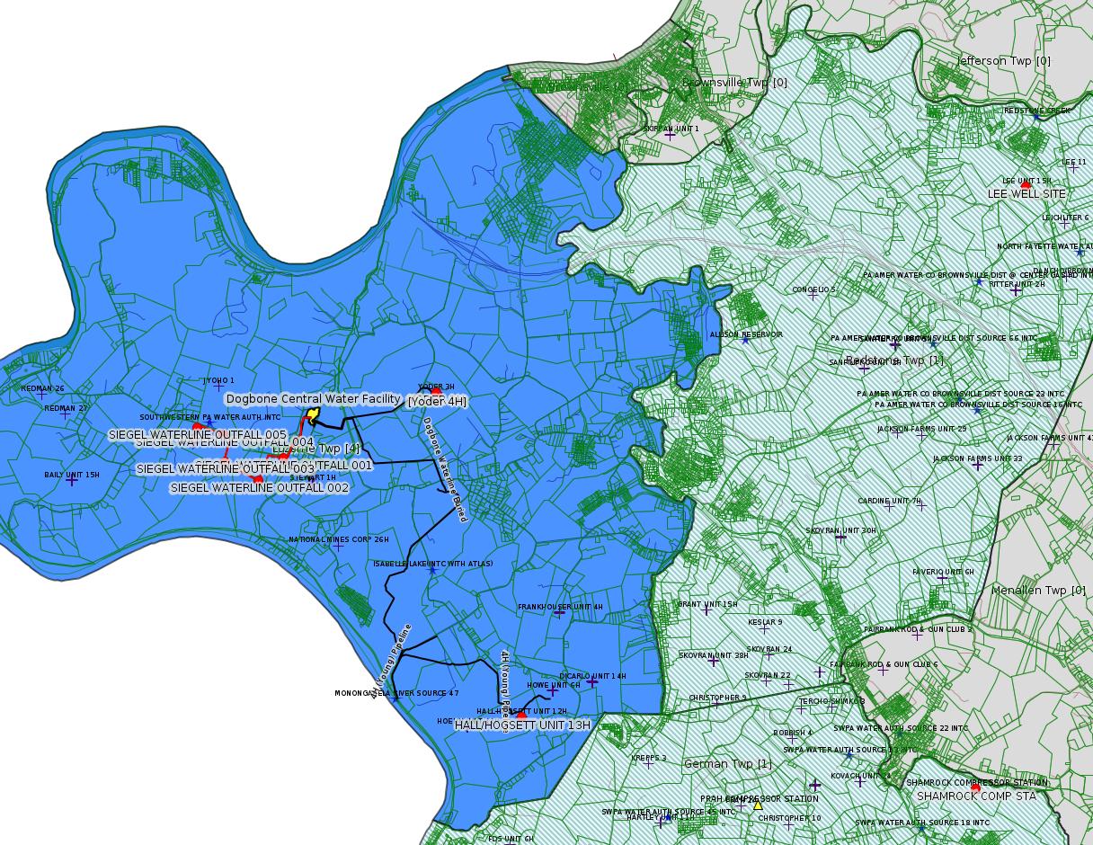
SIEGEL WATERLINE PAG-10 Discharge Resulting from Hydrostatic Testing of Tanks & Pipelines
Shamrock Compressor Station to extend the period of installation and continued temporary operation
Yoder Well Connect ESCGP-3 # ESG072619001-00
Radiation Protection Compliance & Enforcement Guidance
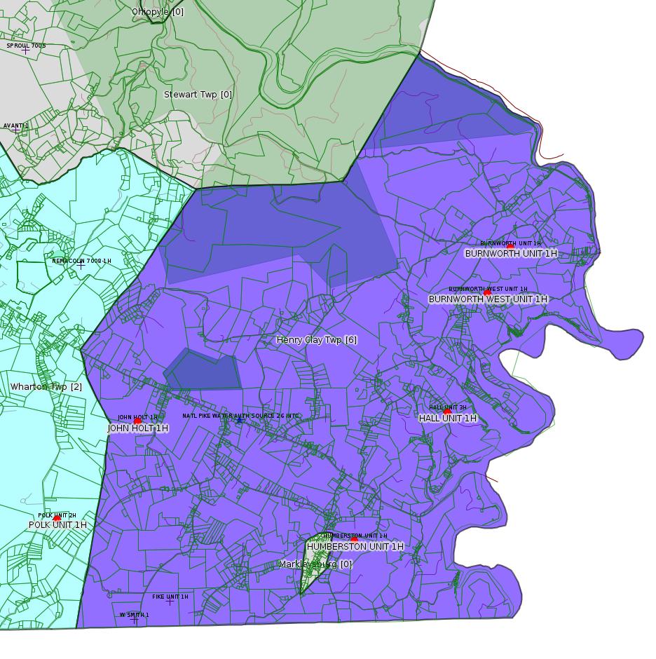
BURNWORTH UNIT 1H Drill & Operate Well Permit Inactive Status (New)
HALL UNIT 1H Drill & Operate Well Permit Inactive Status (New)
BURNWORTH WEST UNIT 1H Drill & Operate Well Permit Inactive Status (New)
HALL UNIT 3H Drill & Operate Well Permit Inactive Status (New)
JOHN HOLT 1H Drill & Operate Well Permit Inactive Status (New)
HUMBERSTON UNIT 1H Drill & Operate Well Permit Inactive Status (New)
POLK UNIT 1H Drill & Operate Well Permit Inactive Status (New)
POLK UNIT 2H Drill & Operate Well Permit Inactive Status (New)
BRAZZEN [should be BRAZZON -jr] # 15 TEMPORARY ACCESS ROAD PROJECT GP-08 Temporary Road Crossings (New)
HALL/HOGSETT UNIT 13H Well Plugging Notice Intent to Plug Single Well
LEE WELL SITE Expedited E&S Stormwater General Permit 1 [Termination? -jr] Notification Issued 12/3/2019
DOMINION ENERGY TRANS INC NORTH SUMMIT COMP STA Major Facility Operating Permit ModificationIssued 12/3/2019
Inspection
Anomalies (Oil & Gas Compliance Report)
SEC Filings
SEC Filings
Chevron writing down the value of Chevron Appalachia, to consider selling it offPrice of Natural Gas
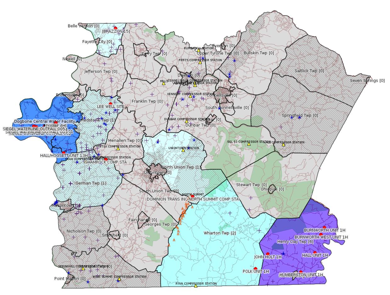
Map
Key
Red dots: items in this permit list with an exact location.
Blue stars: Marcellus Gas Well Water Sources.
Where well laterals are mapped they show in red; a 400-foot buffer surrounding the lateral shows in blue (lavender where it overlaps a mapped mineral tract).
Where mineral tracts are mapped, they show in pink. Mineral tracts can overlap; the overlap will show in red. The precise meaning of "mineral tract" is not clear.
Municipality shading: number of "facilities", with each well counting separately
(includes the red dots):
gray: 0
pale turquoise: 1
turquoise: 2
pale blue: 3
middle blue: 4
dark blue: 5
dark purple: 7
purple: 14
(Color coding may differ from one issue to the next.)
(Note if a project spans multiple municipalities -- e.g. a pipeline -- it will show in the count for each municipality.)
The number of facilities also follows the municipality name in brackets.
Municipality counts are based on the way the permit is listed by DEP; DEP has been known to get a municipality wrong.
Locations in brackets identify a precise location used to locate a surrogate for the actual site being permitted (e.g. locating a well pad or pipeline by the known location of a well.) Locations labeled beginning with "~" and ending in "[?]" are approximate and speculative based on inferences using on-line property and lease records. These are marked in the text as "[Approximate, Speculative]
Cross-hatching: Environmental Justice Areas
Yellow triangles: Compressor Stations
Orange triangles: Storage Field Wells (currently Dominion North Summit Storage Field)
Crosses: SPUD Unconventional well permits
Green: "Natural areas", e.g. state game lands, state forests
Yellow triangles: Compressor Stations
Orange triangles: Storage Field Wells (currently Dominion North Summit Storage Field)
Crosses: SPUD Unconventional well permits
Green: "Natural areas", e.g. state game lands, state forests
More Maps
 |
 |
Source: Pennsylvania Bulletin
NOTICES
DEPARTMENT OF CONSERVATION AND NATURAL RESOURCES
Execution of Oil and Gas Lease for Publicly-Owned Streambeds
[49 Pa.B. 7179]
[Saturday, December 7, 2019]
Effective February 8, 2019, a First Amendment to Oil and Gas Lease for Publicly-Owned Streambeds, Contract No. M-2102007-04, was executed by and between the Commonwealth, acting through the Department of Conservation and Natural Resources (Department) (lessor), and Chevron Appalachia, LLC (lessee), with its principal place of business located at 700 Cherrington Parkway, Coraopolis, PA 15108.
The lease is for Streambed Tract 2007 on the Monongahela River encompassing a total of 1,264.3 acres of submerged lands located in Cumberland, Luzerne, Nicholson and Monongahela Townships, Greene and Fayette Counties. The lease was recorded at the Greene County Courthouse on May 9, 2010, Instrument No. 201900002907, book 525, pages 2412—2421; Washington County Courthouse on May 9, 2019, Instrument No. 201909793; and Fayette County Courthouse on May 3, 2019, Instrument No. 201900004048, book 3401, page 292-300. The lease allows for the development of oil and natural gas below and between the ordinary low water marks of the Monongahela River solely by means of directional, including horizontal, drilling on a nondevelopment basis that will not disturb the river or its bed. Contract No. M-2102001-04 may be viewed online at https://patreasury.gov/transparency/e-library/ContractFiles/505723_M-2102007-04%20First%20Amendment%20Monongahela%20Lease%20Chevron%20Appalachia.pdf.
Questions regarding this lease should be directed to the Department's Bureau of Forestry, Minerals Division, (717) 787-2703.
CINDY ADAMS DUNN,
Secretary
<http://www.pacodeandbulletin.gov/Display/pabull?file=/secure/pabulletin/data/vol49/49-49/1809.html>
---
NOTICES
DEPARTMENT OF
ENVIRONMENTAL PROTECTION
Availability of National Pollutant Discharge Elimination System General Permit for Discharges of Stormwater Associated with Construction Activities (PAG-02)
[49 Pa.B. 7249]
[Saturday, December 7, 2019]
Under The Clean Streams Law (35 P.S. §§ 691.1—691.1001) and sections 1905-A, 1917-A and 1920-A of The Administrative Code of 1929 (71 P.S. §§ 510-5, 510-17 and 510-20), the Department of Environmental Protection (Department), by this notice, informs the public of the availability of the final National Pollution Discharge Elimination System (NPDES) General Permit for Discharges of Stormwater Associated with Construction Activities (PAG-02) for a new 5-year term. The PAG-02 General Permit will become effective on December 8, 2019, and will expire on December 7, 2024.
The PAG-02 General Permit is intended to provide NPDES permit coverage to persons proposing an earth disturbance activity (other than agricultural plowing or tilling activities, animal heavy use areas, timber harvesting activities, oil and gas activities and road maintenance activities) involving earth disturbance greater than or equal to 1 acre, or an earth disturbance on any portion, part or during any stage of a larger common plan of development or sale that involves greater than or equal to 1 acre of disturbance, in accordance with 25 Pa. Code § 102.5(a) (relating to permit requirements). The PAG-02 General Permit may not be used for discharges to waters designated for special protection under 25 Pa. Code Chapter 93 (relating to water quality standards) or other discharges that do not meet eligibility requirements of the General Permit.
Notice of the availability of a draft PAG-02 General Permit was published at 49 Pa.B. 4603 (August 17, 2019). A 30-day comment period was provided and interested parties were directed to submit comments to the Department's eComment system. The Department received comments from 12 individuals and organizations during the comment period, and a comment response document has been developed.
All permittees with existing coverage under the PAG-02 General Permit will be covered under the reissued General Permit on December 8, 2019, under the terms of their existing coverage, and will be subject to the terms and conditions of the reissued General Permit as of that date. The Department, or the delegated county conservation district (CCD) that approved PAG-02 coverage, will transmit notification to all existing PAG-02 permittees explaining the changes to the terms and conditions of General Permit coverage and what steps must be taken for continued coverage.
The fees for the PAG-02 General Permit include: (1) a $500 administrative filing fee that is payable to the appropriate delegated CCD Clean Water Fund or, if earth disturbance will occur in Beaver, Forest or Philadelphia Counties, payable to the Commonwealth of Pennsylvania Clean Water Fund; (2) a disturbed acreage fee calculated by multiplying the number of disturbed acres (rounded to the nearest whole acre) by $100, payable to the Commonwealth of Pennsylvania Clean Water Fund; and (3) any additional fees that the CCD has established for review of the Notice of Intent (NOI) for PAG-02 coverage, if applicable. The administrative filing fee and disturbed acreage fee do not apply to entities satisfying the criteria for an exemption under 25 Pa. Code § 102.6(b)(4) (relating to permit applications and fees). Where the CCD will review the NOI, a copy of the NOI must be transmitted to the Department separately, as explained on the PAG-02 NOI checklist (3800-PM-BCW0405c).
The following substantive changes were made to the final PAG-02 General Permit in comparison to the draft PAG-02 General Permit that was published at 49 Pa.B. 4603 on August 17, 2019:
• General Permit Implementation—The provision in the draft PAG-02 concerning ''required training'' was modified for the final PAG-02 to clarify the permittee's responsibility to ensure that personnel understand any requirements of this General Permit that are relevant to the work they are contracted to perform.
• Definitions—Certain definitions have been added or updated in the final PAG-02 for clarity and consistency with existing Department regulations and publications.
• Prohibition on Certain Discharges—The draft PAG-02 proposed eligibility criteria concerning discharges to surface waters impaired for siltation, suspended solids or nutrients, with or without a Total Maximum Daily Load, requiring such discharges to use a nondischarge alternative or antidegradation best available combination of technologies (ABACT) best management practices (BMP). The final PAG-02 eligibility criteria identify other, related causes of impairment—turbidity, water/flow variability and flow modifications/alterations—triggering the need for the nondischarge alternative or ABACT BMPs. The final PAG-02 also provides clarification as to the source of impairment information.
• Proof of Instrument Recording—The draft PAG-02 proposed that proof that a legal instrument was recorded for post-construction stormwater management BMPs be provided at the time a Notice of Termination is submitted. The final PAG-02 also requires that proof be provided upon submission of a Transfer Application, if a transfer of coverage is requested.
• Transfer and Co-Permittee Responsibilities—The final PAG-02 requires permittees who wish to transfer General Permit coverage to complete the Department's NPDES/WQM Permit Transfer Application (3800-PM-BCW0041b), and permittees who wish to add new operators to complete the Department's Co-Permittee Acknowledgement Form for Chapter 102 Permits (3800-FM-BCW0271a).
The General Permit package can be accessed through the Department's eLibrary web site at www.depgreenport.state.pa.us/elibrary/ (select ''Permit and Authorization Packages,'' then ''Clean Water,'' then ''PAG-02 NPDES General Permit'').
In accordance with 25 Pa. Code § 92a.84(c)(3) (relating to public notice of general permits), the Department will publish notice in the Pennsylvania Bulletin for every approval of coverage under the PAG-02 General Permit.
PATRICK McDONNELL,
Secretary
---
<http://www.pacodeandbulletin.gov/Display/pabull?file=/secure/pabulletin/data/vol49/49-49/1810b.html&continued=http://www.pacodeandbulletin.gov/Display/pabull?file=/secure/pabulletin/data/vol49/49-49/1810.html&d=reduce>
Permit No. Facility Location: Municipality & County Applicant Name & Address Receiving
Water/UseContact Office & Phone No. Luzerne Township
Fayette CountyPAG106223 Chevron Appalachia LLC
700 Cherrington Parkway
Coraopolis, PA 15108
Unnamed Tributary to Monongahela River (WWF), Kelley Run (WWF), and Unnamed Tributary of Monongahela River (WWF)—19-C DEP Southwest Regional Office
Clean Water Program
400 Waterfront Drive
Pittsburgh, PA 15222-4745
412.442.4000
Site: SIEGEL WATERLINE ESCGP ESX18-051-0005
Authorization type: PAG-10 Discharge Resulting from Hydrostatic
Testing of Tanks & Pipelines
Sub-Facilities for Authorization:
Sub-Facility ID Sub-Facility Name Description
1297035 OUTFALL 001 Discharge Point
Location: 39.966631,-79.952311
Map URL: <http://www.openstreetmap.org/?mlat=39.966631&mlon=-79.952311#map=15/39.966631/-79.952311>
1297036 OUTFALL 002 Discharge Point
Location: 39.963367,-79.956869
Map URL: <http://www.openstreetmap.org/?mlat=39.963367&mlon=-79.956869#map=15/39.963367/-79.956869>
1297037 OUTFALL 003 Discharge Point
Location: 39.966136,-79.963086
Map URL: <http://www.openstreetmap.org/?mlat=39.966136&mlon=-79.963086#map=15/39.966136/-79.963086>
1297038 OUTFALL 004 Discharge Point
Location: 39.970019,-79.963247
Map URL: <http://www.openstreetmap.org/?mlat=39.970019&mlon=-79.963247#map=15/39.970019/-79.963247>
1297039 OUTFALL 005 Discharge Point
Location: 39.971014,-79.968156
Map URL: <http://www.openstreetmap.org/?mlat=39.971014&mlon=-79.968156#map=15/39.971014/-79.968156>
---
PA-26-00588B: Laurel Mountain Midstream Operating, LLC (2000 Commerce Dr., Park Place Corporate Center 2, Pittsburgh, PA 15275) extension effective November 28, 2019, to extend the period of installation and continued temporary operation of three (3) compressor engines, two (2) gas-fired turbines, one (1) emergency generator, two (2) dehydrators, two (2) reboilers, one (1) glycol processing unit, and five (5) produced water storage tanks authorized under plan approval PA-26-00588B, until May 28, 2020, at Shamrock Compressor Station located in German Township, Fayette County.
<http://www.pacodeandbulletin.gov/Display/pabull?file=/secure/pabulletin/data/vol49/49-49/1810c.html&continued=http://www.pacodeandbulletin.gov/Display/pabull?file=/secure/pabulletin/data/vol49/49-49/1810.html&d=reduce>
Location: 39.918333,-79.825
Map URL: <http://www.openstreetmap.org/?mlat=39.918333&mlon=-79.825#map=15/39.918333/-79.825>
Parcel ID: 15140026
Map URL: <http://www.openstreetmap.org/?mlat=39.918333&mlon=-79.825#map=15/39.918333/-79.825>
Parcel ID: 15140026
---
ESCGP-3 # ESG072619001-00
Applicant Name Laurel Mountain Midstream Operating LLC
Contact Person Kristy Grigas
Address 1605 Coraopolis Heights Road, Westpointe Ctr 3
City, State, Zip Moon Township, PA 15108-4310
County Fayette County
Township(s) Luzerne Township
Receiving Stream(s) and Classification(s) UNTs to/and # 27854 Rush Run. UNTs to/and # 26726 Cox Run
<http://www.pacodeandbulletin.gov/Display/pabull?file=/secure/pabulletin/data/vol49/49-50/1856d.html&continued=http://www.pacodeandbulletin.gov/Display/pabull?file=/secure/pabulletin/data/vol49/49-50/1856.html&d=reduce>
Site: Yoder Well Connect
Public Permit Review:
<http://www.ahs.dep.pa.gov/ePermitPublicAccess/Public/PublicAuthOverview?q=IaU%2f3WrsAk6%2bDzk7TzVSzQ%3d%3d>
Project Topographic Map:
<http://www.ahs.dep.pa.gov/ePermitPublicAccess/Permit/DownloadFileFromOnBase/13039>
Project Information:
Laurel Mountain Midstream Operating LLC (Williams) is proposing the Yoder Well Connect Pipeline Project, which consists of construction of one (1) approximately 6,266-LF 16-inch steel gas line to link the existing Yoder Well Pad (ESX15-051-0007) to the existing Williams West Dogbone pipeline (ESX10-051-0041). A vegetated surface site is also proposed at the tie-in to the West Dogbone Pipeline.
---
NOTICES
DEPARTMENT OF
ENVIRONMENTAL PROTECTION
Availability of Technical Guidance
[49 Pa.B. 7363]
[Saturday, December 14, 2019]
Draft Technical Guidance: New Guidance
DEP ID: 290-4100-001. Title: Radiation Protection Compliance & Enforcement Guidance. Description: This guidance establishes standard procedures for encouraging compliance with and enforcing the regulations in 25 Pa. Code Part I, Subpart D, Article V (relating to radiological health), which the Bureau of Radiation Protection (Bureau) has the authority to administer. The Bureau's regulatory responsibilities are authorized by the Radiation Protection Act (35 P.S. §§ 7110.101—7110.703), the Radon Certification Act (63 P.S. §§ 2001—2014) and the Low-Level Radioactive Waste Disposal Act (35 P.S. §§ 7130.101—7130.905).
Written Comments: Interested persons may submit written comments on this draft TGD through Monday, January 13, 2020. Comments submitted by facsimile will not be accepted. All comments, including comments submitted by e-mail, must include the commentator's name and address. Commentators are encouraged to submit comments using the Department's online eComment tool at www.ahs.dep.pa.gov/eComment or by e-mail to ecomment@pa.gov. Written comments can be mailed to the Technical Guidance Coordinator, Department of Environmental Protection, Policy Office, Rachel Carson State Office Building, P.O. Box 2063, Harrisburg, PA 17105-2063.
Contact: Questions regarding this TGD can be directed to Kristina Hoffman at krihoffman@pa.gov or (717) 787-2480.
Effective Date: Upon publication of notice as final in the Pennsylvania Bulletin.
PATRICK McDONNELL,
Secretary
<http://www.pacodeandbulletin.gov/Display/pabull?file=/secure/pabulletin/data/vol49/49-50/1858.html>
[See Notes]
-------------------------
Source: eNOTICE
(+ PA
Oil and Gas Mapping, Well
Pad Report.) Well Details via Data
Portal Services: Oil and Gas Wells All (ID: 3).
Please see the Disclaimer below regarding Parcel Id data.
Authorization ID: 1298517
Permit number: 051-24325
Site: BURNWORTH UNIT 1H OG WELL
Client: LPR ENERGY LLC
Authorization type: Drill & Operate Well Permit Inactive Status
Application type: New
Authorization is for: FACILITY
Date received: 12/10/2019
Status: Pending
Permit Decision Guarantee Applies?: No
Sub-Facilities for Authorization:
Sub-Facility ID Sub-Facility Name Description
1008212 BURNWORTH UNIT 1H Well
Permit Review Notes:
Date Review Note
12/11/2019 The permit application package is complete, has been accepted, and is undergoing technical review.
<https://www.ahs.dep.pa.gov/eFACTSWeb/searchResults_singleAuth.aspx?AuthID=1298517>
Site Programs:
Oil & Gas
Site Municipalities:
Henry Clay Twp, Fayette County
Well Details:
Permit Number: 051-24325
Well Name: BURNWORTH UNIT 1H
Unconventional Well: Y
Well Configuration: Horizontal Well
Well Type: GAS
Well Status: Regulatory Inactive Status
Coal Association: NonCoal
Conservation Well: N
Primary Facility ID: 727542
Site ID: 730706
Site Name: BURNWORTH UNIT 1H OG WELL
Well Pad ID: 146187
Well Pad Name: BURNWORTH UNIT 1H
Storage Field:
Operator: LPR ENERGY LLC
Operator Number: OGO-68579
Permit Date: 2010-03-05
Permit Date Expires: 2011-03-05
SPUD Date: 2010-05-10
Date Plugged:
UIC ID:
UIC Type:
Surface Elevation: 1890
County: Fayette
Municipality: Henry Clay Twp
Location: 39.808139,-79.390917
Map URL: <http://www.openstreetmap.org/?mlat=39.808139&mlon=-79.390917#map=15/39.808139/-79.390917>
OG WELLS PERMIT DOCS:
2018-09-27: Other Permit Documents, Name: 1237070 (for Authorization: 1237070):
<http://www.depgis.state.pa.us/pdfHandler/pdFHandler.ashx?Doc=NjkwOTgz&ext=PDF>
---
Authorization ID: 1298515
Permit number: 051-24403
Site: HALL UNIT 1H OG WELL
Client: LPR ENERGY LLC
Authorization type: Drill & Operate Well Permit Inactive Status
Application type: New
Authorization is for: FACILITY
Date received: 12/10/2019
Status: Pending
Permit Decision Guarantee Applies?: No
Sub-Facilities for Authorization:
Sub-Facility ID Sub-Facility Name Description
1023640 HALL UNIT 1H Well
Permit Review Notes:
Date Review Note
12/11/2019 The permit application package is complete, has been accepted, and is undergoing technical review.
<https://www.ahs.dep.pa.gov/eFACTSWeb/searchResults_singleAuth.aspx?AuthID=1298515>
Site Programs:
Oil & Gas
Site Municipalities:
Henry Clay Twp, Fayette County
Well Details:
Permit Number: 051-24403
Well Name: HALL UNIT 1H
Unconventional Well: Y
Well Configuration: Horizontal Well
Well Type: GAS
Well Status: Regulatory Inactive Status
Coal Association: NonCoal
Conservation Well: N
Primary Facility ID: 735848
Site ID: 741195
Site Name: HALL UNIT 1H OG WELL
Well Pad ID: 148468
Well Pad Name: HALL UNIT 1H
Storage Field:
Operator: LPR ENERGY LLC
Operator Number: OGO-68579
Permit Date: 2010-11-24
Permit Date Expires: 2011-11-24
SPUD Date: 2011-03-21
Date Plugged:
UIC ID:
UIC Type:
Surface Elevation: 1965
County: Fayette
Municipality: Henry Clay Twp
Location: 39.769889,-79.410881
Map URL: <http://www.openstreetmap.org/?mlat=39.769889&mlon=-79.410881#map=15/39.769889/-79.410881>
OG WELLS PERMIT DOCS:
2018-10-11: Other Permit Documents, Name: 1245065 (for Authorization: 1245065):
<http://www.depgis.state.pa.us/pdfHandler/pdFHandler.ashx?Doc=NjkxMDQ5&ext=PDF>
---
Authorization ID: 1298514
Permit number: 051-24400
Site: BURNWORTH WEST UNIT 1H OG WELL
Client: LPR ENERGY LLC
Authorization type: Drill & Operate Well Permit Inactive Status
Application type: New
Authorization is for: FACILITY
Date received: 12/10/2019
Status: Pending
Permit Decision Guarantee Applies?: No
Sub-Facilities for Authorization:
Sub-Facility ID Sub-Facility Name Description
1023091 BURNWORTH WEST UNIT 1H Well
Permit Review Notes:
Date Review Note
12/11/2019 The permit application package is complete, has been accepted, and is undergoing technical review.
<https://www.ahs.dep.pa.gov/eFACTSWeb/searchResults_singleAuth.aspx?AuthID=1298514>
Site Programs:
Oil & Gas
Site Municipalities:
Henry Clay Twp, Fayette County
Well Details:
Permit Number: 051-24400
Well Name: BURNWORTH WEST UNIT 1H
Unconventional Well: Y
Well Configuration: Horizontal Well
Well Type: GAS
Well Status: Regulatory Inactive Status
Coal Association: NonCoal
Conservation Well: N
Primary Facility ID: 735586
Site ID: 740856
Site Name: BURNWORTH WEST UNIT 1H OG WELL
Well Pad ID: 147087
Well Pad Name: BURNWORTH WEST UNIT 1H
Storage Field:
Operator: LPR ENERGY LLC
Operator Number: OGO-68579
Permit Date: 2010-11-24
Permit Date Expires: 2011-11-24
SPUD Date: 2011-03-01
Date Plugged:
UIC ID:
UIC Type:
Surface Elevation: 1950
County: Fayette
Municipality: Henry Clay Twp
Location: 39.797503,-79.398014
Map URL: <http://www.openstreetmap.org/?mlat=39.797503&mlon=-79.398014#map=15/39.797503/-79.398014>
OG WELLS PERMIT DOCS:
2018-10-11: Other Permit Documents, Name: 1245063 (for Authorization: 1245063):
<http://www.depgis.state.pa.us/pdfHandler/pdFHandler.ashx?Doc=NjkxMDQ3&ext=PDF>
---
Authorization ID: 1298513
Permit number: 051-24442
Site: HALL UNIT 1H OG WELL
Client: LPR ENERGY LLC
Authorization type: Drill & Operate Well Permit Inactive Status
Application type: New
Authorization is for: FACILITY
Date received: 12/10/2019
Status: Pending
Permit Decision Guarantee Applies?: No
Sub-Facilities for Authorization:
Sub-Facility ID Sub-Facility Name Description
1041985 HALL UNIT 3H Well
Permit Review Notes:
Date Review Note
12/11/2019 The permit application package is complete, has been accepted, and is undergoing technical review.
<https://www.ahs.dep.pa.gov/eFACTSWeb/searchResults_singleAuth.aspx?AuthID=1298513>
Site Programs:
Oil & Gas
Site Municipalities:
Henry Clay Twp, Fayette County
Well Details:
Permit Number: 051-24442
Well Name: HALL UNIT 3H
Unconventional Well: Y
Well Configuration: Horizontal Well
Well Type: GAS
Well Status: Regulatory Inactive Status
Coal Association: NonCoal
Conservation Well: N
Primary Facility ID: 741446
Site ID: 741195
Site Name: HALL UNIT 1H OG WELL
Well Pad ID: 148468
Well Pad Name: HALL UNIT 1H
Storage Field:
Operator: LPR ENERGY LLC
Operator Number: OGO-68579
Permit Date: 2011-06-10
Permit Date Expires: 2012-06-10
SPUD Date: 2011-07-04
Date Plugged:
UIC ID:
UIC Type:
Surface Elevation: 1965
County: Fayette
Municipality: Henry Clay Twp
Location: 39.769969,-79.410847
Map URL: <http://www.openstreetmap.org/?mlat=39.769969&mlon=-79.410847#map=15/39.769969/-79.410847>
OG WELLS PERMIT DOCS:
2018-09-27: Other Permit Documents, Name: 1237071 (for Authorization: 1237071):
<http://www.depgis.state.pa.us/pdfHandler/pdFHandler.ashx?Doc=NjkwOTg0&ext=PDF>
---
Authorization ID: 1298511
Permit number: 051-24140
Site: JOHN HOLT 1H OG WEL
Client: LPR ENERGY LLC
Authorization type: Drill & Operate Well Permit Inactive Status
Application type: New
Authorization is for: FACILITY
Date received: 12/10/2019
Status: Pending
Permit Decision Guarantee Applies?: No
Sub-Facilities for Authorization:
Sub-Facility ID Sub-Facility Name Description
981790 JOHN HOLT 1H Well
Permit Review Notes:
Date Review Note
12/11/2019 The permit application package is complete, has been accepted, and is undergoing technical review.
<https://www.ahs.dep.pa.gov/eFACTSWeb/searchResults_singleAuth.aspx?AuthID=1298511>
Site Programs:
Oil & Gas
Site Municipalities:
Henry Clay Twp, Fayette County
Well Details:
Permit Number: 051-24140
Well Name: JOHN HOLT 1H
Unconventional Well: Y
Well Configuration: Vertical Well
Well Type: GAS
Well Status: Regulatory Inactive Status
Coal Association: NonCoal
Conservation Well: Y
Primary Facility ID: 713811
Site ID: 714731
Site Name: JOHN HOLT 1H OG WEL
Well Pad ID: 146975
Well Pad Name: JOHN HOLT 1H
Storage Field:
Operator: LPR ENERGY LLC
Operator Number: OGO-68579
Permit Date: 2008-12-24
Permit Date Expires: 2009-12-24
SPUD Date: 2009-04-02
Date Plugged:
UIC ID:
UIC Type:
Surface Elevation: 2325
County: Fayette
Municipality: Henry Clay Twp
Location: 39.768936,-79.504661
Map URL: <http://www.openstreetmap.org/?mlat=39.768936&mlon=-79.504661#map=15/39.768936/-79.504661>
OG WELLS PERMIT DOCS:
2016-06-13: Other Permit Documents, Name: PAG106153_3-1-2016_M3 APPALACHIA (for Authorization: 753980):
<http://www.depgis.state.pa.us/pdfHandler/pdFHandler.ashx?Doc=ODY1OTk4&ext=PDF>
2018-10-11: Other Permit Documents, Name: 1245068 (for Authorization: 1245068):
<http://www.depgis.state.pa.us/pdfHandler/pdFHandler.ashx?Doc=NjkxMDUx&ext=PDF>
---
Authorization ID: 1298510
Permit number: 051-24367
Site: HUMBERSTON UNIT 1H OG WELL
Client: LPR ENERGY LLC
Authorization type: Drill & Operate Well Permit Inactive Status
Application type: New
Authorization is for: FACILITY
Date received: 12/10/2019
Status: Pending
Permit Decision Guarantee Applies?: No
Sub-Facilities for Authorization:
Sub-Facility ID Sub-Facility Name Description
1015955 HUMBERSTON UNIT 1H Well
Permit Review Notes:
Date Review Note
12/11/2019 The permit application package is complete, has been accepted, and is undergoing technical review.
<https://www.ahs.dep.pa.gov/eFACTSWeb/searchResults_singleAuth.aspx?AuthID=1298510>
Site Programs:
Oil & Gas
Site Municipalities:
Henry Clay Twp, Fayette County
Well Details:
Permit Number: 051-24367
Well Name: HUMBERSTON UNIT 1H
Unconventional Well: Y
Well Configuration: Horizontal Well
Well Type: GAS
Well Status: Regulatory Inactive Status
Coal Association: Coal
Conservation Well: N
Primary Facility ID: 731775
Site ID: 735895
Site Name: HUMBERSTON UNIT 1H OG WELL
Well Pad ID: 146309
Well Pad Name: HUMBERSTON UNIT 1H
Storage Field:
Operator: LPR ENERGY LLC
Operator Number: OGO-68579
Permit Date: 2010-07-13
Permit Date Expires: 2011-07-13
SPUD Date: 2011-01-28
Date Plugged:
UIC ID:
UIC Type:
Surface Elevation: 2000
County: Fayette
Municipality: Henry Clay Twp
Location: 39.740383,-79.439622
Map URL: <http://www.openstreetmap.org/?mlat=39.740383&mlon=-79.439622#map=15/39.740383/-79.439622>
OG WELLS PERMIT DOCS:
2018-10-11: Other Permit Documents, Name: 1244257 (for Authorization: 1244257):
<http://www.depgis.state.pa.us/pdfHandler/pdFHandler.ashx?Doc=NjkxMDQ1&ext=PDF>
---
Authorization ID: 1298509
Permit number: 051-24428
Site: POLK 1H OG WELL
Client: LPR ENERGY LLC
Authorization type: Drill & Operate Well Permit Inactive Status
Application type: New
Authorization is for: FACILITY
Date received: 12/10/2019
Status: Pending
Permit Decision Guarantee Applies?: No
Sub-Facilities for Authorization:
Sub-Facility ID Sub-Facility Name Description
1035649 POLK UNIT 1H Well
1035648 POLK UNIT 1H Well
Permit Review Notes:
Date Review Note
12/11/2019 The permit application package is complete, has been accepted, and is undergoing technical review.
<https://www.ahs.dep.pa.gov/eFACTSWeb/searchResults_singleAuth.aspx?AuthID=1298509>
Site Programs:
Oil & Gas
Site Municipalities:
Wharton Twp, Fayette County
Well Details:
Permit Number: 051-24428
Well Name: POLK UNIT 1H
Unconventional Well: Y
Well Configuration: Horizontal Well
Well Type: GAS
Well Status: Regulatory Inactive Status
Coal Association: NonCoal
Conservation Well: N
Primary Facility ID: 738671
Site ID: 739411
Site Name: POLK 1H OG WELL
Well Pad ID: 149075
Well Pad Name: POLK UNIT 1H
Storage Field:
Operator: LPR ENERGY LLC
Operator Number: OGO-68579
Permit Date: 2011-02-28
Permit Date Expires: 2012-02-28
SPUD Date: 2011-03-24
Date Plugged:
UIC ID:
UIC Type:
Surface Elevation: 2310
County: Fayette
Municipality: Wharton Twp
Location: 39.746494,-79.529567
Map URL: <http://www.openstreetmap.org/?mlat=39.746494&mlon=-79.529567#map=15/39.746494/-79.529567>
OG WELLS PERMIT DOCS:
2018-10-11: Other Permit Documents, Name: 1245067 (for Authorization: 1245067):
<http://www.depgis.state.pa.us/pdfHandler/pdFHandler.ashx?Doc=NjkxMDUw&ext=PDF>
---
Authorization ID: 1298508
Permit number: 051-24429
Site: POLK 1H OG WELL
Client: LPR ENERGY LLC
Authorization type: Drill & Operate Well Permit Inactive Status
Application type: New
Authorization is for: FACILITY
Date received: 12/10/2019
Status: Pending
Permit Decision Guarantee Applies?: No
Sub-Facilities for Authorization:
Sub-Facility ID Sub-Facility Name Description
1035637 POLK UNIT 2H Well
1035636 POLK UNIT 2H Well
Permit Review Notes:
Date Review Note
12/11/2019 The permit application package is complete, has been accepted, and is undergoing technical review.
<https://www.ahs.dep.pa.gov/eFACTSWeb/searchResults_singleAuth.aspx?AuthID=1298508>
Site Programs:
Oil & Gas
Site Municipalities:
Wharton Twp, Fayette County
Well Details:
Permit Number: 051-24429
Well Name: POLK UNIT 2H
Unconventional Well: Y
Well Configuration: Horizontal Well
Well Type: GAS
Well Status: Regulatory Inactive Status
Coal Association: NonCoal
Conservation Well: N
Primary Facility ID: 738664
Site ID: 739411
Site Name: POLK 1H OG WELL
Well Pad ID: 149075
Well Pad Name: POLK UNIT 1H
Storage Field:
Operator: LPR ENERGY LLC
Operator Number: OGO-68579
Permit Date: 2011-02-28
Permit Date Expires: 2012-02-28
SPUD Date: 2011-08-26
Date Plugged:
UIC ID:
UIC Type:
Surface Elevation: 2310
County: Fayette
Municipality: Wharton Twp
Location: 39.746419,-79.529614
Map URL: <http://www.openstreetmap.org/?mlat=39.746419&mlon=-79.529614#map=15/39.746419/-79.529614>
OG WELLS PERMIT DOCS:
2017-11-30: Other Permit Documents, Name: Inactive 051-24429 (for Authorization: 1206221):
<http://www.depgis.state.pa.us/pdfHandler/pdFHandler.ashx?Doc=NTI2NDI1&ext=PDF>
2019-04-02: Other Permit Documents, Name: Inactive Well Status (for Authorization: 1267460):
<http://www.depgis.state.pa.us/pdfHandler/pdFHandler.ashx?Doc=Nzc5Nzky&ext=PDF>
---
Authorization ID: 1297385
Permit number: GP082607219-010
Site: BRAZZEN [should be BRAZZON -jr] # 15 TEMPORARY ACCESS ROAD PROJECT
Client: DIVERSIFIED OIL & GAS LLC
Authorization type: GP-08 Temporary Road Crossings
Application type: New
Authorization is for: FACILITY
Date received: 11/27/2019
Status: Pending
Permit Decision Guarantee Applies?: No
Sub-Facilities for Authorization:
Sub-Facility ID Sub-Facility Name Description
1299153 BRAZZEN [should be BRAZZON -jr] # 15 TEMP ACCESS RD PROJ GP082607219-010 Bridge
Permit Review Notes:
Date Review Note
12/6/2019 The permit application package is complete, has been accepted, and is undergoing technical review.
<https://www.ahs.dep.pa.gov/eFACTSWeb/searchResults_singleAuth.aspx?AuthID=1297385>
Site Programs:
Water Planning and Conservation
Site Municipalities:
Washington Twp, Fayette County
Authorization ID: 1292572
Permit number: 051-24580
Site: HALL/HOGSETT UNIT WELL SITES ESCGP-EXPEDITED
Client: CHEVRON APPALACHIA LLC
Authorization type: Well Plugging Notice Intent to Plug Single Well
Application type: New
Authorization is for: FACILITY
Date received: 10/18/2019
Status: Pending
Permit Decision Guarantee Applies?: No
Sub-Facilities for Authorization:
Sub-Facility ID Sub-Facility Name Description
1104887 HALL/HOGSETT UNIT 13H Well
1104886 HALL/HOGSETT UNIT 13H Well
Permit Review Notes:
Date Review Note
12/11/2019 The technical review and decision review are complete and either the permit decision and/or permit issuance are forthcoming.
10/23/2019 Applicant has been issued a deficiency letter. If applicable, this application no longer qualifies for the Permit Decision Guarantee.
10/18/2019 The permit application package is complete, has been accepted, and is undergoing technical review.
<https://www.ahs.dep.pa.gov/eFACTSWeb/searchResults_singleAuth.aspx?AuthID=1292572>
Site Programs:
Oil & Gas
Site Municipalities:
German Twp, Fayette County [Incorrect -jr]
Luzerne Twp, Fayette County
Well Details:
Permit Number: 051-24580
Well Name: HALL/HOGSETT UNIT 13H
Unconventional Well: Y
Well Configuration: Horizontal Well
Well Type: GAS
Well Status: Regulatory Inactive Status
Coal Association: Coal
Conservation Well: Y
Primary Facility ID: 764261
Site ID: 736604
Site Name: HALL/HOGSETT UNIT WELL SITES ESCGP-EXPEDITED
Well Pad ID: 145470
Well Pad Name: HALL/HOGSETT UNIT
Storage Field:
Operator: CHEVRON APPALACHIA LLC
Operator Number: OGO-39307
Permit Date: 2013-04-30
Permit Date Expires: 2014-04-30
SPUD Date: 2013-05-17
Date Plugged: 2019-11-19
UIC ID:
UIC Type:
Surface Elevation: 1006
County: Fayette
Municipality: Luzerne Twp
Location: 39.929328,-79.908822
Map URL: <http://www.openstreetmap.org/?mlat=39.929328&mlon=-79.908822#map=15/39.929328/-79.908822>
---
Authorization ID: 1290536
Permit number: ESX11-051-0031
Site: LEE WELL SITE ESCGP-EXPEDITED
Client: CHEVRON APPALACHIA LLC
Authorization type: Expedited E&S Stormwater General Permit 1
Application type: Notification
Authorization is for: SITE
Date received: 10/02/2019
Status: Issued on 12/3/2019
Permit Decision Guarantee Applies?: No
Permit Review Notes:
Date Review Note
12/3/2019 The technical review and decision review are complete and either the permit decision and/or permit issuance are forthcoming.
10/2/2019 The permit application package is complete, has been accepted, and is undergoing technical review.
<https://www.ahs.dep.pa.gov/eFACTSWeb/searchResults_singleAuth.aspx?AuthID=1290536>
Site Programs:
Site Municipalities:
Redstone Twp, Fayette County
Authorization ID: 1159078
Permit number: 26-00405
Site: DOMINION ENERGY TRANS INC NORTH SUMMIT COMP STA
Client: DOMINION ENERGY TRANS INC
Authorization type: Major Facility Operating Permit
Application type: Modification
Authorization is for: FACILITY
Date received: 10/27/2016
Status: Issued on 12/3/2019
Permit Decision Guarantee Applies?: No
Sub-Facilities for Authorization:
Sub-Facility ID Sub-Facility Name Description
234592 ENGINE 1 COOPER 3200 HP Process
Location: 39.854157,-79.675428
Map URL: <http://www.openstreetmap.org/?mlat=39.854157&mlon=-79.675428#map=15/39.854157/-79.675428>
234593 ENGINE 2 COOPER 3200 HP Process
Location: 39.854157,-79.675428
Map URL: <http://www.openstreetmap.org/?mlat=39.854157&mlon=-79.675428#map=15/39.854157/-79.675428>
490401 NATCO DEHY HEATER 3 (TWO 5.25 MMBTU/HR BURNERS) Combustion Unit
Location: 39.854157,-79.675428
Map URL: <http://www.openstreetmap.org/?mlat=39.854157&mlon=-79.675428#map=15/39.854157/-79.675428>
490402 PEERLESS BOILER (3.57 MMBTU/HR) Combustion Unit
Location: 39.854157,-79.675428
Map URL: <http://www.openstreetmap.org/?mlat=39.854157&mlon=-79.675428#map=15/39.854157/-79.675428>
889649 STORAGE TANKS SUBJECT TO 129.57 Process
Location: 39.854157,-79.675428
Map URL: <http://www.openstreetmap.org/?mlat=39.854157&mlon=-79.675428#map=15/39.854157/-79.675428>
234591 TULPRO HEATER 1 (25 MMBTU/HR) Combustion Unit
Location: 39.854157,-79.675428
Map URL: <http://www.openstreetmap.org/?mlat=39.854157&mlon=-79.675428#map=15/39.854157/-79.675428>
490400 TULPRO HEATER 2 (25 MMBTU/HR) Combustion Unit
Location: 39.854157,-79.675428
Map URL: <http://www.openstreetmap.org/?mlat=39.854157&mlon=-79.675428#map=15/39.854157/-79.675428>
490403 WAUKESHA 668 BHP AUXILIARY GENERATOR Process
Location: 39.854157,-79.675428
Map URL: <http://www.openstreetmap.org/?mlat=39.854157&mlon=-79.675428#map=15/39.854157/-79.675428>
Permit Review Notes:
Date Review Note
12/3/2019 The technical review and decision review are complete and either the permit decision and/or permit issuance are forthcoming.
11/14/2016 The permit application package is complete, has been accepted, and is undergoing technical review.
<https://www.ahs.dep.pa.gov/eFACTSWeb/searchResults_singleAuth.aspx?AuthID=1159078>
Site Programs:
Air Quality
Clean Water
Waste Management
Site Municipalities:
North Union Twp, Fayette County
Source: US Securities
and Exchange Commission
Chevron Corporation Form 8-K [excerpt]
CURRENT REPORT
Pursuant to Section 13 or 15(d) of the Securities Exchange Act of 1934
Date of Report (Date of earliest event reported): December 4, 2019
Item 2.06 Material Impairments
On December 4, 2019, the Board of Directors of Chevron Corporation (“Chevron”) completed its annual review and approval of Chevron’s business plan and capital expenditure program. As a result of Chevron’s disciplined approach to capital allocation and a downward revision in its longer-term commodity price outlook, Chevron will reduce funding to various natural gas-related upstream opportunities including Appalachia shale, Kitimat LNG, and other international projects. Chevron is evaluating its strategic alternatives for these assets, including divestment. In addition, the revised oil price outlook resulted in an impairment at Big Foot. Combined, these actions are estimated to result in non-cash, after tax impairment charges of $10 billion to $11 billion in its fourth quarter 2019 results, more than half related to the Appalachia shale. Chevron does not expect these impairments to result in any material future cash expenditures.
<https://www.sec.gov/ix?doc=/Archives/edgar/data/93410/000009341019000040/cvx12102019-8xkdocce.htm>
Chevron Press Release:
<https://www.sec.gov/Archives/edgar/data/93410/000009341019000040/exhibit991ce.htm>
-------------------------
Please see the Disclaimer below regarding Parcel Id data.
Authorization ID: 1298517
Permit number: 051-24325
Site: BURNWORTH UNIT 1H OG WELL
Client: LPR ENERGY LLC
Authorization type: Drill & Operate Well Permit Inactive Status
Application type: New
Authorization is for: FACILITY
Date received: 12/10/2019
Status: Pending
Permit Decision Guarantee Applies?: No
Sub-Facilities for Authorization:
Sub-Facility ID Sub-Facility Name Description
1008212 BURNWORTH UNIT 1H Well
Permit Review Notes:
Date Review Note
12/11/2019 The permit application package is complete, has been accepted, and is undergoing technical review.
<https://www.ahs.dep.pa.gov/eFACTSWeb/searchResults_singleAuth.aspx?AuthID=1298517>
Site Programs:
Oil & Gas
Site Municipalities:
Henry Clay Twp, Fayette County
Well Details:
Permit Number: 051-24325
Well Name: BURNWORTH UNIT 1H
Unconventional Well: Y
Well Configuration: Horizontal Well
Well Type: GAS
Well Status: Regulatory Inactive Status
Coal Association: NonCoal
Conservation Well: N
Primary Facility ID: 727542
Site ID: 730706
Site Name: BURNWORTH UNIT 1H OG WELL
Well Pad ID: 146187
Well Pad Name: BURNWORTH UNIT 1H
Storage Field:
Operator: LPR ENERGY LLC
Operator Number: OGO-68579
Permit Date: 2010-03-05
Permit Date Expires: 2011-03-05
SPUD Date: 2010-05-10
Date Plugged:
UIC ID:
UIC Type:
Surface Elevation: 1890
County: Fayette
Municipality: Henry Clay Twp
Location: 39.808139,-79.390917
Map URL: <http://www.openstreetmap.org/?mlat=39.808139&mlon=-79.390917#map=15/39.808139/-79.390917>
OG WELLS PERMIT DOCS:
2018-09-27: Other Permit Documents, Name: 1237070 (for Authorization: 1237070):
<http://www.depgis.state.pa.us/pdfHandler/pdFHandler.ashx?Doc=NjkwOTgz&ext=PDF>
---
Authorization ID: 1298515
Permit number: 051-24403
Site: HALL UNIT 1H OG WELL
Client: LPR ENERGY LLC
Authorization type: Drill & Operate Well Permit Inactive Status
Application type: New
Authorization is for: FACILITY
Date received: 12/10/2019
Status: Pending
Permit Decision Guarantee Applies?: No
Sub-Facilities for Authorization:
Sub-Facility ID Sub-Facility Name Description
1023640 HALL UNIT 1H Well
Permit Review Notes:
Date Review Note
12/11/2019 The permit application package is complete, has been accepted, and is undergoing technical review.
<https://www.ahs.dep.pa.gov/eFACTSWeb/searchResults_singleAuth.aspx?AuthID=1298515>
Site Programs:
Oil & Gas
Site Municipalities:
Henry Clay Twp, Fayette County
Well Details:
Permit Number: 051-24403
Well Name: HALL UNIT 1H
Unconventional Well: Y
Well Configuration: Horizontal Well
Well Type: GAS
Well Status: Regulatory Inactive Status
Coal Association: NonCoal
Conservation Well: N
Primary Facility ID: 735848
Site ID: 741195
Site Name: HALL UNIT 1H OG WELL
Well Pad ID: 148468
Well Pad Name: HALL UNIT 1H
Storage Field:
Operator: LPR ENERGY LLC
Operator Number: OGO-68579
Permit Date: 2010-11-24
Permit Date Expires: 2011-11-24
SPUD Date: 2011-03-21
Date Plugged:
UIC ID:
UIC Type:
Surface Elevation: 1965
County: Fayette
Municipality: Henry Clay Twp
Location: 39.769889,-79.410881
Map URL: <http://www.openstreetmap.org/?mlat=39.769889&mlon=-79.410881#map=15/39.769889/-79.410881>
OG WELLS PERMIT DOCS:
2018-10-11: Other Permit Documents, Name: 1245065 (for Authorization: 1245065):
<http://www.depgis.state.pa.us/pdfHandler/pdFHandler.ashx?Doc=NjkxMDQ5&ext=PDF>
Presumed Parcel Id: 16130134
---
Authorization ID: 1298514
Permit number: 051-24400
Site: BURNWORTH WEST UNIT 1H OG WELL
Client: LPR ENERGY LLC
Authorization type: Drill & Operate Well Permit Inactive Status
Application type: New
Authorization is for: FACILITY
Date received: 12/10/2019
Status: Pending
Permit Decision Guarantee Applies?: No
Sub-Facilities for Authorization:
Sub-Facility ID Sub-Facility Name Description
1023091 BURNWORTH WEST UNIT 1H Well
Permit Review Notes:
Date Review Note
12/11/2019 The permit application package is complete, has been accepted, and is undergoing technical review.
<https://www.ahs.dep.pa.gov/eFACTSWeb/searchResults_singleAuth.aspx?AuthID=1298514>
Site Programs:
Oil & Gas
Site Municipalities:
Henry Clay Twp, Fayette County
Well Details:
Permit Number: 051-24400
Well Name: BURNWORTH WEST UNIT 1H
Unconventional Well: Y
Well Configuration: Horizontal Well
Well Type: GAS
Well Status: Regulatory Inactive Status
Coal Association: NonCoal
Conservation Well: N
Primary Facility ID: 735586
Site ID: 740856
Site Name: BURNWORTH WEST UNIT 1H OG WELL
Well Pad ID: 147087
Well Pad Name: BURNWORTH WEST UNIT 1H
Storage Field:
Operator: LPR ENERGY LLC
Operator Number: OGO-68579
Permit Date: 2010-11-24
Permit Date Expires: 2011-11-24
SPUD Date: 2011-03-01
Date Plugged:
UIC ID:
UIC Type:
Surface Elevation: 1950
County: Fayette
Municipality: Henry Clay Twp
Location: 39.797503,-79.398014
Map URL: <http://www.openstreetmap.org/?mlat=39.797503&mlon=-79.398014#map=15/39.797503/-79.398014>
OG WELLS PERMIT DOCS:
2018-10-11: Other Permit Documents, Name: 1245063 (for Authorization: 1245063):
<http://www.depgis.state.pa.us/pdfHandler/pdFHandler.ashx?Doc=NjkxMDQ3&ext=PDF>
Presumed Parcel Id: 16090032
---
Authorization ID: 1298513
Permit number: 051-24442
Site: HALL UNIT 1H OG WELL
Client: LPR ENERGY LLC
Authorization type: Drill & Operate Well Permit Inactive Status
Application type: New
Authorization is for: FACILITY
Date received: 12/10/2019
Status: Pending
Permit Decision Guarantee Applies?: No
Sub-Facilities for Authorization:
Sub-Facility ID Sub-Facility Name Description
1041985 HALL UNIT 3H Well
Permit Review Notes:
Date Review Note
12/11/2019 The permit application package is complete, has been accepted, and is undergoing technical review.
<https://www.ahs.dep.pa.gov/eFACTSWeb/searchResults_singleAuth.aspx?AuthID=1298513>
Site Programs:
Oil & Gas
Site Municipalities:
Henry Clay Twp, Fayette County
Well Details:
Permit Number: 051-24442
Well Name: HALL UNIT 3H
Unconventional Well: Y
Well Configuration: Horizontal Well
Well Type: GAS
Well Status: Regulatory Inactive Status
Coal Association: NonCoal
Conservation Well: N
Primary Facility ID: 741446
Site ID: 741195
Site Name: HALL UNIT 1H OG WELL
Well Pad ID: 148468
Well Pad Name: HALL UNIT 1H
Storage Field:
Operator: LPR ENERGY LLC
Operator Number: OGO-68579
Permit Date: 2011-06-10
Permit Date Expires: 2012-06-10
SPUD Date: 2011-07-04
Date Plugged:
UIC ID:
UIC Type:
Surface Elevation: 1965
County: Fayette
Municipality: Henry Clay Twp
Location: 39.769969,-79.410847
Map URL: <http://www.openstreetmap.org/?mlat=39.769969&mlon=-79.410847#map=15/39.769969/-79.410847>
OG WELLS PERMIT DOCS:
2018-09-27: Other Permit Documents, Name: 1237071 (for Authorization: 1237071):
<http://www.depgis.state.pa.us/pdfHandler/pdFHandler.ashx?Doc=NjkwOTg0&ext=PDF>
---
Authorization ID: 1298511
Permit number: 051-24140
Site: JOHN HOLT 1H OG WEL
Client: LPR ENERGY LLC
Authorization type: Drill & Operate Well Permit Inactive Status
Application type: New
Authorization is for: FACILITY
Date received: 12/10/2019
Status: Pending
Permit Decision Guarantee Applies?: No
Sub-Facilities for Authorization:
Sub-Facility ID Sub-Facility Name Description
981790 JOHN HOLT 1H Well
Permit Review Notes:
Date Review Note
12/11/2019 The permit application package is complete, has been accepted, and is undergoing technical review.
<https://www.ahs.dep.pa.gov/eFACTSWeb/searchResults_singleAuth.aspx?AuthID=1298511>
Site Programs:
Oil & Gas
Site Municipalities:
Henry Clay Twp, Fayette County
Well Details:
Permit Number: 051-24140
Well Name: JOHN HOLT 1H
Unconventional Well: Y
Well Configuration: Vertical Well
Well Type: GAS
Well Status: Regulatory Inactive Status
Coal Association: NonCoal
Conservation Well: Y
Primary Facility ID: 713811
Site ID: 714731
Site Name: JOHN HOLT 1H OG WEL
Well Pad ID: 146975
Well Pad Name: JOHN HOLT 1H
Storage Field:
Operator: LPR ENERGY LLC
Operator Number: OGO-68579
Permit Date: 2008-12-24
Permit Date Expires: 2009-12-24
SPUD Date: 2009-04-02
Date Plugged:
UIC ID:
UIC Type:
Surface Elevation: 2325
County: Fayette
Municipality: Henry Clay Twp
Location: 39.768936,-79.504661
Map URL: <http://www.openstreetmap.org/?mlat=39.768936&mlon=-79.504661#map=15/39.768936/-79.504661>
OG WELLS PERMIT DOCS:
2016-06-13: Other Permit Documents, Name: PAG106153_3-1-2016_M3 APPALACHIA (for Authorization: 753980):
<http://www.depgis.state.pa.us/pdfHandler/pdFHandler.ashx?Doc=ODY1OTk4&ext=PDF>
2018-10-11: Other Permit Documents, Name: 1245068 (for Authorization: 1245068):
<http://www.depgis.state.pa.us/pdfHandler/pdFHandler.ashx?Doc=NjkxMDUx&ext=PDF>
Presumed Parcel Id: 16100009
---
Authorization ID: 1298510
Permit number: 051-24367
Site: HUMBERSTON UNIT 1H OG WELL
Client: LPR ENERGY LLC
Authorization type: Drill & Operate Well Permit Inactive Status
Application type: New
Authorization is for: FACILITY
Date received: 12/10/2019
Status: Pending
Permit Decision Guarantee Applies?: No
Sub-Facilities for Authorization:
Sub-Facility ID Sub-Facility Name Description
1015955 HUMBERSTON UNIT 1H Well
Permit Review Notes:
Date Review Note
12/11/2019 The permit application package is complete, has been accepted, and is undergoing technical review.
<https://www.ahs.dep.pa.gov/eFACTSWeb/searchResults_singleAuth.aspx?AuthID=1298510>
Site Programs:
Oil & Gas
Site Municipalities:
Henry Clay Twp, Fayette County
Well Details:
Permit Number: 051-24367
Well Name: HUMBERSTON UNIT 1H
Unconventional Well: Y
Well Configuration: Horizontal Well
Well Type: GAS
Well Status: Regulatory Inactive Status
Coal Association: Coal
Conservation Well: N
Primary Facility ID: 731775
Site ID: 735895
Site Name: HUMBERSTON UNIT 1H OG WELL
Well Pad ID: 146309
Well Pad Name: HUMBERSTON UNIT 1H
Storage Field:
Operator: LPR ENERGY LLC
Operator Number: OGO-68579
Permit Date: 2010-07-13
Permit Date Expires: 2011-07-13
SPUD Date: 2011-01-28
Date Plugged:
UIC ID:
UIC Type:
Surface Elevation: 2000
County: Fayette
Municipality: Henry Clay Twp
Location: 39.740383,-79.439622
Map URL: <http://www.openstreetmap.org/?mlat=39.740383&mlon=-79.439622#map=15/39.740383/-79.439622>
OG WELLS PERMIT DOCS:
2018-10-11: Other Permit Documents, Name: 1244257 (for Authorization: 1244257):
<http://www.depgis.state.pa.us/pdfHandler/pdFHandler.ashx?Doc=NjkxMDQ1&ext=PDF>
---
Authorization ID: 1298509
Permit number: 051-24428
Site: POLK 1H OG WELL
Client: LPR ENERGY LLC
Authorization type: Drill & Operate Well Permit Inactive Status
Application type: New
Authorization is for: FACILITY
Date received: 12/10/2019
Status: Pending
Permit Decision Guarantee Applies?: No
Sub-Facilities for Authorization:
Sub-Facility ID Sub-Facility Name Description
1035649 POLK UNIT 1H Well
1035648 POLK UNIT 1H Well
Permit Review Notes:
Date Review Note
12/11/2019 The permit application package is complete, has been accepted, and is undergoing technical review.
<https://www.ahs.dep.pa.gov/eFACTSWeb/searchResults_singleAuth.aspx?AuthID=1298509>
Site Programs:
Oil & Gas
Site Municipalities:
Wharton Twp, Fayette County
Well Details:
Permit Number: 051-24428
Well Name: POLK UNIT 1H
Unconventional Well: Y
Well Configuration: Horizontal Well
Well Type: GAS
Well Status: Regulatory Inactive Status
Coal Association: NonCoal
Conservation Well: N
Primary Facility ID: 738671
Site ID: 739411
Site Name: POLK 1H OG WELL
Well Pad ID: 149075
Well Pad Name: POLK UNIT 1H
Storage Field:
Operator: LPR ENERGY LLC
Operator Number: OGO-68579
Permit Date: 2011-02-28
Permit Date Expires: 2012-02-28
SPUD Date: 2011-03-24
Date Plugged:
UIC ID:
UIC Type:
Surface Elevation: 2310
County: Fayette
Municipality: Wharton Twp
Location: 39.746494,-79.529567
Map URL: <http://www.openstreetmap.org/?mlat=39.746494&mlon=-79.529567#map=15/39.746494/-79.529567>
OG WELLS PERMIT DOCS:
2018-10-11: Other Permit Documents, Name: 1245067 (for Authorization: 1245067):
<http://www.depgis.state.pa.us/pdfHandler/pdFHandler.ashx?Doc=NjkxMDUw&ext=PDF>
---
Authorization ID: 1298508
Permit number: 051-24429
Site: POLK 1H OG WELL
Client: LPR ENERGY LLC
Authorization type: Drill & Operate Well Permit Inactive Status
Application type: New
Authorization is for: FACILITY
Date received: 12/10/2019
Status: Pending
Permit Decision Guarantee Applies?: No
Sub-Facilities for Authorization:
Sub-Facility ID Sub-Facility Name Description
1035637 POLK UNIT 2H Well
1035636 POLK UNIT 2H Well
Permit Review Notes:
Date Review Note
12/11/2019 The permit application package is complete, has been accepted, and is undergoing technical review.
<https://www.ahs.dep.pa.gov/eFACTSWeb/searchResults_singleAuth.aspx?AuthID=1298508>
Site Programs:
Oil & Gas
Site Municipalities:
Wharton Twp, Fayette County
Well Details:
Permit Number: 051-24429
Well Name: POLK UNIT 2H
Unconventional Well: Y
Well Configuration: Horizontal Well
Well Type: GAS
Well Status: Regulatory Inactive Status
Coal Association: NonCoal
Conservation Well: N
Primary Facility ID: 738664
Site ID: 739411
Site Name: POLK 1H OG WELL
Well Pad ID: 149075
Well Pad Name: POLK UNIT 1H
Storage Field:
Operator: LPR ENERGY LLC
Operator Number: OGO-68579
Permit Date: 2011-02-28
Permit Date Expires: 2012-02-28
SPUD Date: 2011-08-26
Date Plugged:
UIC ID:
UIC Type:
Surface Elevation: 2310
County: Fayette
Municipality: Wharton Twp
Location: 39.746419,-79.529614
Map URL: <http://www.openstreetmap.org/?mlat=39.746419&mlon=-79.529614#map=15/39.746419/-79.529614>
OG WELLS PERMIT DOCS:
2017-11-30: Other Permit Documents, Name: Inactive 051-24429 (for Authorization: 1206221):
<http://www.depgis.state.pa.us/pdfHandler/pdFHandler.ashx?Doc=NTI2NDI1&ext=PDF>
2019-04-02: Other Permit Documents, Name: Inactive Well Status (for Authorization: 1267460):
<http://www.depgis.state.pa.us/pdfHandler/pdFHandler.ashx?Doc=Nzc5Nzky&ext=PDF>
---
Authorization ID: 1297385
Permit number: GP082607219-010
Site: BRAZZEN [should be BRAZZON -jr] # 15 TEMPORARY ACCESS ROAD PROJECT
Client: DIVERSIFIED OIL & GAS LLC
Authorization type: GP-08 Temporary Road Crossings
Application type: New
Authorization is for: FACILITY
Date received: 11/27/2019
Status: Pending
Permit Decision Guarantee Applies?: No
Sub-Facilities for Authorization:
Sub-Facility ID Sub-Facility Name Description
1299153 BRAZZEN [should be BRAZZON -jr] # 15 TEMP ACCESS RD PROJ GP082607219-010 Bridge
Permit Review Notes:
Date Review Note
12/6/2019 The permit application package is complete, has been accepted, and is undergoing technical review.
<https://www.ahs.dep.pa.gov/eFACTSWeb/searchResults_singleAuth.aspx?AuthID=1297385>
Site Programs:
Water Planning and Conservation
Site Municipalities:
Washington Twp, Fayette County
Well
Details [of BRAZZON 15]:
Permit Number: 051-23977
Well Name: BRAZZON 15
Unconventional Well: Y
Well Configuration: Vertical Well
Well Type: GAS
Well Status: Active
Coal Association: Coal
Conservation Well: Y
Primary Facility ID: 705611
Site ID: 704775
Site Name: BRAZZON 15 OG WELL
Well Pad ID: 147068
Well Pad Name: BRAZZON 15
Storage Field:
Operator: DIVERSIFIED OIL & GAS LLC
Operator Number: OGO-68792
Permit Date: 2008-05-09
Permit Date Expires: 2009-05-09
SPUD Date: 2008-06-02
Date Plugged:
UIC ID:
UIC Type:
Surface Elevation: 1015
County: Fayette
Municipality: Washington Twp
Location: 40.120332,-79.801974
Map URL: <http://www.openstreetmap.org/?mlat=40.120332&mlon=-79.801974#map=15/40.120332/-79.801974>
---Permit Number: 051-23977
Well Name: BRAZZON 15
Unconventional Well: Y
Well Configuration: Vertical Well
Well Type: GAS
Well Status: Active
Coal Association: Coal
Conservation Well: Y
Primary Facility ID: 705611
Site ID: 704775
Site Name: BRAZZON 15 OG WELL
Well Pad ID: 147068
Well Pad Name: BRAZZON 15
Storage Field:
Operator: DIVERSIFIED OIL & GAS LLC
Operator Number: OGO-68792
Permit Date: 2008-05-09
Permit Date Expires: 2009-05-09
SPUD Date: 2008-06-02
Date Plugged:
UIC ID:
UIC Type:
Surface Elevation: 1015
County: Fayette
Municipality: Washington Twp
Location: 40.120332,-79.801974
Map URL: <http://www.openstreetmap.org/?mlat=40.120332&mlon=-79.801974#map=15/40.120332/-79.801974>
Authorization ID: 1292572
Permit number: 051-24580
Site: HALL/HOGSETT UNIT WELL SITES ESCGP-EXPEDITED
Client: CHEVRON APPALACHIA LLC
Authorization type: Well Plugging Notice Intent to Plug Single Well
Application type: New
Authorization is for: FACILITY
Date received: 10/18/2019
Status: Pending
Permit Decision Guarantee Applies?: No
Sub-Facilities for Authorization:
Sub-Facility ID Sub-Facility Name Description
1104887 HALL/HOGSETT UNIT 13H Well
1104886 HALL/HOGSETT UNIT 13H Well
Permit Review Notes:
Date Review Note
12/11/2019 The technical review and decision review are complete and either the permit decision and/or permit issuance are forthcoming.
10/23/2019 Applicant has been issued a deficiency letter. If applicable, this application no longer qualifies for the Permit Decision Guarantee.
10/18/2019 The permit application package is complete, has been accepted, and is undergoing technical review.
<https://www.ahs.dep.pa.gov/eFACTSWeb/searchResults_singleAuth.aspx?AuthID=1292572>
Site Programs:
Oil & Gas
Site Municipalities:
German Twp, Fayette County [Incorrect -jr]
Luzerne Twp, Fayette County
Well Details:
Permit Number: 051-24580
Well Name: HALL/HOGSETT UNIT 13H
Unconventional Well: Y
Well Configuration: Horizontal Well
Well Type: GAS
Well Status: Regulatory Inactive Status
Coal Association: Coal
Conservation Well: Y
Primary Facility ID: 764261
Site ID: 736604
Site Name: HALL/HOGSETT UNIT WELL SITES ESCGP-EXPEDITED
Well Pad ID: 145470
Well Pad Name: HALL/HOGSETT UNIT
Storage Field:
Operator: CHEVRON APPALACHIA LLC
Operator Number: OGO-39307
Permit Date: 2013-04-30
Permit Date Expires: 2014-04-30
SPUD Date: 2013-05-17
Date Plugged: 2019-11-19
UIC ID:
UIC Type:
Surface Elevation: 1006
County: Fayette
Municipality: Luzerne Twp
Location: 39.929328,-79.908822
Map URL: <http://www.openstreetmap.org/?mlat=39.929328&mlon=-79.908822#map=15/39.929328/-79.908822>
Presumed Parcel Id: 19320034
---
Authorization ID: 1290536
Permit number: ESX11-051-0031
Site: LEE WELL SITE ESCGP-EXPEDITED
Client: CHEVRON APPALACHIA LLC
Authorization type: Expedited E&S Stormwater General Permit 1
Application type: Notification
Authorization is for: SITE
Date received: 10/02/2019
Status: Issued on 12/3/2019
Permit Decision Guarantee Applies?: No
Permit Review Notes:
Date Review Note
12/3/2019 The technical review and decision review are complete and either the permit decision and/or permit issuance are forthcoming.
10/2/2019 The permit application package is complete, has been accepted, and is undergoing technical review.
<https://www.ahs.dep.pa.gov/eFACTSWeb/searchResults_singleAuth.aspx?AuthID=1290536>
Site Programs:
Site Municipalities:
Redstone Twp, Fayette County
Location: 40.003908,-79.814256
Map URL: <http://www.openstreetmap.org/?mlat=40.003908&mlon=-79.814256#map=15/40.003908/-79.814256>
Wells on this pad:
051-24485 LEE UNIT 15H
051-24486 LEE UNIT 14H
---Map URL: <http://www.openstreetmap.org/?mlat=40.003908&mlon=-79.814256#map=15/40.003908/-79.814256>
Wells on this pad:
051-24485 LEE UNIT 15H
051-24486 LEE UNIT 14H
Presumed Parcel Id: 30060201
Authorization ID: 1159078
Permit number: 26-00405
Site: DOMINION ENERGY TRANS INC NORTH SUMMIT COMP STA
Client: DOMINION ENERGY TRANS INC
Authorization type: Major Facility Operating Permit
Application type: Modification
Authorization is for: FACILITY
Date received: 10/27/2016
Status: Issued on 12/3/2019
Permit Decision Guarantee Applies?: No
Sub-Facilities for Authorization:
Sub-Facility ID Sub-Facility Name Description
234592 ENGINE 1 COOPER 3200 HP Process
Location: 39.854157,-79.675428
Map URL: <http://www.openstreetmap.org/?mlat=39.854157&mlon=-79.675428#map=15/39.854157/-79.675428>
234593 ENGINE 2 COOPER 3200 HP Process
Location: 39.854157,-79.675428
Map URL: <http://www.openstreetmap.org/?mlat=39.854157&mlon=-79.675428#map=15/39.854157/-79.675428>
490401 NATCO DEHY HEATER 3 (TWO 5.25 MMBTU/HR BURNERS) Combustion Unit
Location: 39.854157,-79.675428
Map URL: <http://www.openstreetmap.org/?mlat=39.854157&mlon=-79.675428#map=15/39.854157/-79.675428>
490402 PEERLESS BOILER (3.57 MMBTU/HR) Combustion Unit
Location: 39.854157,-79.675428
Map URL: <http://www.openstreetmap.org/?mlat=39.854157&mlon=-79.675428#map=15/39.854157/-79.675428>
889649 STORAGE TANKS SUBJECT TO 129.57 Process
Location: 39.854157,-79.675428
Map URL: <http://www.openstreetmap.org/?mlat=39.854157&mlon=-79.675428#map=15/39.854157/-79.675428>
234591 TULPRO HEATER 1 (25 MMBTU/HR) Combustion Unit
Location: 39.854157,-79.675428
Map URL: <http://www.openstreetmap.org/?mlat=39.854157&mlon=-79.675428#map=15/39.854157/-79.675428>
490400 TULPRO HEATER 2 (25 MMBTU/HR) Combustion Unit
Location: 39.854157,-79.675428
Map URL: <http://www.openstreetmap.org/?mlat=39.854157&mlon=-79.675428#map=15/39.854157/-79.675428>
490403 WAUKESHA 668 BHP AUXILIARY GENERATOR Process
Location: 39.854157,-79.675428
Map URL: <http://www.openstreetmap.org/?mlat=39.854157&mlon=-79.675428#map=15/39.854157/-79.675428>
Permit Review Notes:
Date Review Note
12/3/2019 The technical review and decision review are complete and either the permit decision and/or permit issuance are forthcoming.
11/14/2016 The permit application package is complete, has been accepted, and is undergoing technical review.
<https://www.ahs.dep.pa.gov/eFACTSWeb/searchResults_singleAuth.aspx?AuthID=1159078>
Site Programs:
Air Quality
Clean Water
Waste Management
Site Municipalities:
North Union Twp, Fayette County
Location: 39.859276,-79.6526 <http://osm.org/go/ZWpnipjq--?m=>
Municipalities: North Union Twp
Parcel ID: 25550029U00
Municipalities: North Union Twp
Parcel ID: 25550029U00
-------------------------
------------------------- Source:
Oil
and Gas Compliance Report
OPERATOR: CHEVRON APPALACHIA LLC
INSPECTION_ID: 2965202
INSPECTION_DATE: 11/22/2019
INSPECTION_TYPE: Follow-up Inspection
API_PERMIT: 051-24652
FARM_NAME: YODER 1H
UNCONVENTIONAL: Yes
SITE_ID: 790607
SITE_NAME: YODER WELL PAD ESCGP-2 EXPEDITED
FACILITY_TYPE: Oil & Gas Location
INSPECTION_CATEGORY: Primary Facility
REGION: EP DOGO SWDO Dstr Off
COUNTY: Fayette
MUNICIPALITY: Luzerne Twp
INSPECTOR: EICHENLAUB, KRISTOFER
INSPECTION_SOURCE: SAIR
INSPECTION_RESULT_DESCRIPTION: No Violations Noted
INSPECTION_COMMENT: "On 11/22/19 a follow up inspection of the Yoder Well Pad was conducted in response to violations noted in multiple prior inspections. The following was noted:
>>Multiple prior inspections of the site found violations related to spills and containment issues. On 6/18/19 the following was noted ""The site remained in poor condition with multiple pipe racks, pieces of contaminated equipment, and refuse containers again found stationed throughout the site without sufficient containment. Stains and visibly spilled material remained around and under several instances.""
>>At the time of inspection general site maintenance and housekeeping was dramatically improved with a majority of equipment and materials stored on appropriate, maintained, and functional containment. The pipe rack and associated spills were removed and visibly remediated.
>>Near the pad entrance a truck holding equipment was parked on a section of containment that was holding visibly contaminated water. A fork lift was parked breaching the containment and draining the impacted water to the pad at the time of inspection. The truck was also parked crushing the wall of the containment unit causing an additional breach. This constitutes a recurring violation of 25 Pa. Code § 78a.54, and 58 Pa. C.S. § 3218.2(d) in that the operator failed to control regulated materials in a manner that prevents pollution to the ground and Waters of the Commonwealth and that the conditions of the containment do not meet the required requirement for 110% capacity."
Well Details:
Permit Number: 051-24652
Well Name: YODER 1H
Unconventional Well: Y
Well Configuration: Horizontal Well
Well Type: GAS
Well Status: Active
Coal Association: NonCoal
Conservation Well: N
Primary Facility ID: 824625
Site ID: 790607
Site Name: YODER WELL PAD ESCGP-2 EXPEDITED
Well Pad ID: 153100
Well Pad Name: YODER
Storage Field:
Operator: CHEVRON APPALACHIA LLC
Operator Number: OGO-39307
Permit Date: 2018-03-06
Permit Date Expires: 2019-03-06
SPUD Date: 2018-05-07
Date Plugged:
UIC ID:
UIC Type:
Surface Elevation: 1118
County: Fayette
Municipality: Luzerne Twp
Location: 39.975686,-79.923872
Map URL: <http://www.openstreetmap.org/?mlat=39.975686&mlon=-79.923872#map=15/39.975686/-79.923872>
OG WELLS PERMIT DOCS:
2018-03-08: Final Permit Documents, Name: 1217018 (for Authorization: 1217018):
<http://www.depgis.state.pa.us/pdfHandler/pdFHandler.ashx?Doc=NTY5Nzkw&ext=PDF>
2018-03-08: Other Permit Documents, Name: Non-Coal Determination 051-24652 (for Authorization: 1217018):
<http://www.depgis.state.pa.us/pdfHandler/pdFHandler.ashx?Doc=NTY3ODA5&ext=PDF>
Electronically Submitted Records:
2018-03-08: Submission for Authorization 1217018
Pennsylvania Natural Diversity Inventory Form: Yoder PNDI.PDF
<http://www.depgis.state.pa.us/eWellDocHandler/pdFHandler.ashx?Doc=NDgyNDk3&ext=PDF>
Location Plat: Yoder Well Plat 1H.dwg
<http://www.depgis.state.pa.us/eWellDocHandler/pdFHandler.ashx?Doc=NDgyNDk4&ext=PDF>
Justification for Non-Coal Well: Yoder Non Coal Packet.pdf
<http://www.depgis.state.pa.us/eWellDocHandler/pdFHandler.ashx?Doc=NDgyNDk5&ext=PDF>
Well Cross-Section Diagram: Yoder 1H_Page 4.pdf
<http://www.depgis.state.pa.us/eWellDocHandler/pdFHandler.ashx?Doc=NDgyNTAw&ext=PDF>
Permit Application to Drill and Operate a Well: 1679361.pdf
<http://www.depgis.state.pa.us/eWellDocHandler/pdFHandler.ashx?Doc=NDgzMjY1&ext=PDF>
Full report including photographs:
<https://www.depgreenport.state.pa.us/eWellDocs/download/DocsZipFile/?P_DER_CODE=9&P_ENTITY_TYPE=2&S=4&P_ID=2965202>
[See Notes.]
[There is a similar inspection report for each of the other wells on the Yoder Well Pad.]
Chevron Corporation Form 8-K [excerpt]
CURRENT REPORT
Pursuant to Section 13 or 15(d) of the Securities Exchange Act of 1934
Date of Report (Date of earliest event reported): December 4, 2019
Item 2.06 Material Impairments
On December 4, 2019, the Board of Directors of Chevron Corporation (“Chevron”) completed its annual review and approval of Chevron’s business plan and capital expenditure program. As a result of Chevron’s disciplined approach to capital allocation and a downward revision in its longer-term commodity price outlook, Chevron will reduce funding to various natural gas-related upstream opportunities including Appalachia shale, Kitimat LNG, and other international projects. Chevron is evaluating its strategic alternatives for these assets, including divestment. In addition, the revised oil price outlook resulted in an impairment at Big Foot. Combined, these actions are estimated to result in non-cash, after tax impairment charges of $10 billion to $11 billion in its fourth quarter 2019 results, more than half related to the Appalachia shale. Chevron does not expect these impairments to result in any material future cash expenditures.
<https://www.sec.gov/ix?doc=/Archives/edgar/data/93410/000009341019000040/cvx12102019-8xkdocce.htm>
Chevron Press Release:
<https://www.sec.gov/Archives/edgar/data/93410/000009341019000040/exhibit991ce.htm>
-------------------------
| Commodity | Exchange | Currency | Expire | Last Trade | Trade Time | Change | Open | Day's High | Day's Low |
|---|---|---|---|---|---|---|---|---|---|
| NATURAL
GAS CON1 Dec19 |
NYM | USD | 12/27 | 2.29 | 12/18 21:09 | +0.00 | 2.28 | 2.29 | 2.28 |
The Draft Technical Guidance "Radiation Protection Compliance & Enforcement Guidance" listed above has been issued by the DEP Bureau of Radiation Protection; it concerns procedures for handling violations determined by that Bureau. Based on the Authority section of this draft guidance, it is clear that the intent of the Department is that the Bureau of Radiation Protection shall not inspect Oil & Gas related facilities, notwithstanding the PA Code requirement for landfills accepting Oil & Gas waste and well pads where "waste processing" occurs to have Radiation Protection Plans. (The typical permit handled by the Bureau of Radiation is for radiological health machines, such as the X-Ray machine in a dentist's office.) Apparently the judgment of the DEP is that such equipment as radiation alarms at landfills can never fail and don't need inspecting. So it will likely be the result of comments on this document related to radiation from oil & gas waste that the DEP will consider them off-topic. However, it's important that we comment anyway.
---
The Yoder Well Pad inspection (ID 2965202) listed above is yet another case where violations are "noted" in comments, but nevertheless the inspection results field shows "No Violations Noted". That means this inspection report will not show if someone scans inspection reports just looking for violations. DEP is evading the plain meaning of the English Language in categorizing this inspection as "No Violations Noted". Which syllable of the word "No" are they failing to understand?
------------------------
DEP defines an environmental justice area as "any census tract where 20 percent or more individuals live in poverty, and/or 30 percent or more of the population is minority". (See:
<http://www.dep.pa.gov/PublicParticipation/OfficeofEnvironmentalJustice/Pages/default.aspx>). There are supposed to be enhanced public participation requirements for permits in environmental justice areas, but news of this actually ever happening is scarce. In Fayette County, the entirety of Redstone, Springhill, Nicholson, and German Townships are environmental justice areas, as well as a large part of Dunbar Township. DEP's policy document on public participation guidelines for environmental justice areas is located here:
<http://www.elibrary.dep.state.pa.us/dsweb/Get/Version-48671/012-0501-002.pdf>
eNOTICE records are likely to list the same permit multiple times, as that permit moves through the DEP process.
Oil & Gas Wells designated with a site a number and the letter H typically designate horizontal wells.
-------------------------
Resources:
Pennsylvania Bulletin: <http://www.pabulletin.com/>
eNOTICE: <http://www.ahs2.dep.state.pa.
DEP Oil and Gas Reports: <http://www.dep.pa.gov/DataandTools/Reports/Oil%20and%20Gas%20Reports/Pages/default.aspx>
DEP Permits Issued Detail Report:
<http://www.depreportingservic
DEP SPUD (drilling started) Report:
<http://www.depreportingservices.state.pa.us/ReportServer/Pages/ReportViewer.aspx?/Oil_Gas/Spud_External_Data>
DEP Oil and Gas Compliance Report:
<http://www.depreportingservices.state.pa.us/ReportServer/Pages/ReportViewer.aspx?/Oil_Gas/OG_Compliance>
DEP PA Oil & Gas Mapping:
<http://www.depgis.state.pa.us/PaOilAndGasMapping>
Data Portal Services Directory [Technical]
<http://www.depgis.state.pa.us/arcgis/rest/services>
Query: Oil and Gas Wells All (ID: 3) [Technical]:
<http://www.depgis.state.pa.us/arcgis/rest/services/OilGas/OilGasAllStrayGasEGSP/MapServer/3/query?where=&text=&objectIds=&time=&geometry=&geometryType=esriGeometryEnvelope&inSR=&spatialRel=esriSpatialRelIntersects&relationParam=&outFields=*&returnGeometry=true&returnTrueCurves=false&maxAllowableOffset=&geometryPrecision=&outSR=&returnIdsOnly=false&returnCountOnly=false&orderByFields=&groupByFieldsForStatistics=&outStatistics=&returnZ=false&returnM=false&gdbVersion=&returnDistinctValues=false&resultOffset=&resultRecordCount=&f=html>
(Be sure to enter a Where clause in SQL format. Dates are in milliseconds since midnight 1/1/1970).
DEP Oil and Gas Electronic Submissions
<http://www.ahs.dep.pa.gov/eSubmissionPublicSearch>
DEP Oil and Gas Electronic Notifications
<http://www.depreportingservices.state.pa.us/ReportServer?/Oil_Gas/OG_Notifications>
DEP Oil and Gas Well Pad Report
<http://www.depreportingservices.state.pa.us/ReportServer?/Oil_Gas/Well_Pads>
Fayette County Assessment Office Search For Tax Records:
<http://property.co.fayette.pa.us/search.aspx>
Pennsylvania Spatial Data Access:
<http://www.pasda.psu.edu/default.asp>
DEP Spatial Data Repository:
<ftp://www.pasda.psu.edu/pub/pasda/dep/>
National Response Center:
<http://www.nrc.uscg.mil/>
EPA-Echo: <http://www.epa-echo.gov/echo/
FERC citizen involvement: <http://www.ferc.gov/for-citiz
To receive E-mail notification of
all documents filed in a FERC docket, see:
<http://www.ferc.gov/docs-filing/esubscription.asp >
<http://www.ferc.gov/docs-fili
Follow the directions and enter the docket number to subscribe to.
Township Supervisors receive information regarding Erosion & Sedimentation permits, and these records may be reviewable at township municipal offices.
DEP permits are reviewable through the File Review process, for application to do file review see: <http://www.portal.state.pa.us/portal/server.pt/community/southwest_regional_office/13775/file_review/593164>
Environmental Hearing Board: <http://ehb.courtapps.com/publ
PA DEP Environmental Policy Comment System:
<http://www.ahs.dep.pa.gov/eComment/>
Federal Register Environment: <https://www.federalregister.g
Browsing of recent comment
opportunities for federal agencies, e.g. EPA. Click "sign up" to
subscribe to daily E-mails of new document listings.
SkyTruth Fayette County Drilling Alerts: <http://frack.skytruth.org/pen
U.S. Army Corps of Engineers, Pittsburgh District, Public Notices:
<http://www.lrp.usace.army.mil/Missions/Regulatory/Public-Notices/>
EPA Pennsylvania Public Notices: <http://www2.epa.gov/aboutepa/epa-pennsylvania#notice>
Marcellus Shale waste disposal
injection wells in Pennsylvania are regulated directly by EPA, not
DEP. Notice of any new permit applications will appear at the
above web address. I'm not aware of any subscription service
to be notified of such applications. I'm not aware of any
Marcellus Shale waste disposal injection wells in Fayette County
(yet ...) but we need to monitor this page for future
applications.
Energy Assurance Daily: <http://www.oe.netl.doe.gov/ead.aspx>
Daily newsletter from the US
Department of Energy about events relating to energy. The Natural
Gas section has information about pipelines.
-------------------------
Disclaimers:
This compilation from the above sources was done in part by hand using copy and paste and in part using automated methods; it may omit relevant permits.
Parcel data is provided via the tax records search web page offered by the Fayette County Assessment Office (http://property.co.fayette.pa.us/). Presumed Parcel Id links are subject to availability provided by that agency and associated web sites. Presumed Parcel Ids are determined as the mapped parcel containing a given latitude and longitude, are a best effort determination which is subject to error, and are not official. In cases where a facility is leased and there is a separate parcel id for the lease, if this parcel id is not separately mapped, the parcel id shown will be the id for the enclosing parcel. Parcel owners may be surface owners only and may or may not have any relationship to oil & gas facilities.
Does not currently include water supply permits. Does not include landfill permits even though many such are for Marcellus Shale waste. (It is not possible at this time to distinguish which landfill permits are for Marcellus Shale waste and which are not without doing File Review for each permit.)
Erosion & Sedimentation permit records do not currently include latitude and longitude. Where I am publishing latitude and longitude with E&S permits it is by inferring an associated well permit and using published latitude and longitude for the well. It is possible I may be inferring the wrong well site.
Municipalities are shown from eFACTS records on the DEP web site. The DEP has been known to list a municipality incorrectly.