The Harmed Success Stories Concepts How To What Is Commentary
Fayette County Marcellus Shale Permits 12/3/18 - 12/16/18
Contents
Pennsylvania Bulletin Listings
No ActivityeFACTS Listings
SOUTHERN PA GATHERING SYSTEM ABANDONMENT PPL 7894 PROJECTGP 08 GP-08 Temporary Road Crossings (New)Electronic Notifications
S PA GATHERING SYSTEM ABANDOMENT PPL 7655 PROJ GP08 GP11 GP-08 Temporary Road Crossings (New)
CERULLO M12H Drill & Operate Well Permit (Unconventional) (New)
CERULLO M11H Drill & Operate Well Permit (Unconventional) (New)
CERULLO M02H Drill & Operate Well Permit (Unconventional) (New)
CERULLO M04H Drill & Operate Well Permit (Unconventional) (New)
CERULLO M01H Drill & Operate Well Permit (Unconventional) (New)
CERULLO M03H Drill & Operate Well Permit (Unconventional) (New)
CERULLO M10H Drill & Operate Well Permit (Unconventional) (New)
CERULLO M09H Drill & Operate Well Permit (Unconventional) (New)
KURUTZ 10H, 11H, AND 12H Expedited E&S Stormwater [Termination?] Notification
S PA GATHERING SYSTEM ABANDONMENT PIPELINES 7648 & 7837 PROJECT GP-08 Temporary Road Crossings
JONES 1 Well Plugging Notice Intent to Plug Single Well
SOUTHERN PA GSA PPL 7652 7653 7921 PROJ GP08 GP11 BWM-GP-11 Maintenance, Testing, Repair, Rehabilitation or Replacement
SOUTHERN PA GSA PPL 7652 7653 7921 PROJ GP08 GP11 GP-08 Temporary Road Crossings
EDENBORN/RGGS B M15H Drill & Operate Well Permit (Unconventional)
EDENBORN/RGGS B M14H Drill & Operate Well Permit (Unconventional)
EDENBORN/RGGS B M11H Drill & Operate Well Permit (Unconventional)
EDENBORN/RGGS B M13H Drill & Operate Well Permit (Unconventional)
EDENBORN/RGGS B M12H Drill & Operate Well Permit (Unconventional)
EDENBORN/RGGS B M10H Drill & Operate Well Permit (Unconventional)
EDENBORN/RGGS B M07H Drill & Operate Well Permit (Unconventional)
EDENBORN/RGGS B M05H Drill & Operate Well Permit (Unconventional)
EDENBORN/RGGS B M04H Drill & Operate Well Permit (Unconventional)
EDENBORN/RGGS B M09H Drill & Operate Well Permit (Unconventional)
EDENBORN/RGGS B M06H Drill & Operate Well Permit (Unconventional)
EDENBORN/RGGS B M02H Drill & Operate Well Permit (Unconventional)
EDENBORN/RGGS B M08H Drill & Operate Well Permit (Unconventional)
EDENBORN/RGGS B M03H Drill & Operate Well Permit (Unconventional)
EDENBORN/RGGS B M01H Drill & Operate Well Permit (Unconventional)
SPROUL 7005 OG WELL Drill & Operate Well Permit Inactive Status
SOUTHERN PA GATHERING SYSTEM ABANDONMENT PPL 8605 GP8 & GP11 BWM-GP-11 Maintenance, Testing, Repair, Rehabilitation or Replacement
SOUTHERN PA GATHERING SYSTEM ABANDONMENT PPL 8605 GP8 & GP11 GP-08 Temporary Road Crossings
MAWC 7020 1H Drill & Operate Well Permit Inactive Status
YODER 4H Drilling resumption After Break of 30 days or more 12/05/2018 [(Superceded?)]Inspection Anomalies (Oil & Gas Compliance Report)
YODER 4H Casing cementing notification Surface: 12/7/2018
KOVACH B M09H Casing cementing notification Intermediate: 12/5/2018
KOVACH B M08H Drilling resumption After Break of 30 days or more 12/08/2018
KOVACH B M08H Casing cementing notification Surface: 12/9/2018
YODER 4H Casing cementing notification Coal Protected Casing 1: 12/8/2018
KOVACH B M08H Casing cementing notification Intermediate: 12/11/2018
YODER 4H Drilling resumption After Break of 30 days or more 12/09/2018
YODER 3H Drilling resumption After Break of 30 days or more 12/09/2018
YODER 3H Casing cementing notification Surface: 12/9/2018
YODER 3H Casing cementing notification Coal Protected Casing 1: 12/9/2018
YODER 2H Drilling resumption After Break of 30 days or more 12/11/2018
YODER 2H Casing cementing notification Surface: 12/13/2018
YODER 2H Casing cementing notification Coal Protected Casing 1: 12/14/2018
YODER 1H Drilling resumption After Break of 30 days or more 12/14/2018
YODER 1H Casing cementing notification Surface: 12/15/2018
YODER 1H Casing cementing notification Coal Protected Casing 1: 12/16/2018
KOVACH B M07H Drilling resumption After Break of 30 days or more 12/14/2018
KOVACH B M07H Casing cementing notification Surface: 12/16/2018
KOVACH B M07H Casing cementing notification Intermediate: 12/17/2018
KOVACH B M06H Drilling resumption After Break of 30 days or more 12/18/2018
ELIAS UNIT 7 Bubbling emanating from the ground around the well spacePrice of Natural Gas
ELIAS UNIT 7 explosive atmosphere at leak Viol(s) Noted & Immediately Corrected
GRIMES UNIT 1 Operator failed to inspect Violation(s) Noted
YASENOSKY 3 Containment system(s) does not meet 110% capacity requirement. Violation(s) Noted
R.E. STEVENS 1 Failure to plug the well upon abandoning it. Violation(s) Noted
CATHERINE MOLNAR ETAL 1 Failure to plug / report Violation(s) Noted
COUGHENOUR-DUNCAN 1A Failure to plug Violation(s) Noted
MARTIN OCONNOR 1 Failure to plug / inspect Violation(s) Noted
KERMIT M. KENNEDY, ETAL 3A Failure to plug / report Violation(s) Noted
COUGHENOUR 2 Failure to plug / report Violation(s) Noted
STANLEY TABAJ ET UX 1 no secondary containment under tank
ELIAS UNIT 3 brine water spill from a defective production fluid tank Violation(s) & Outstanding Violations
Notes
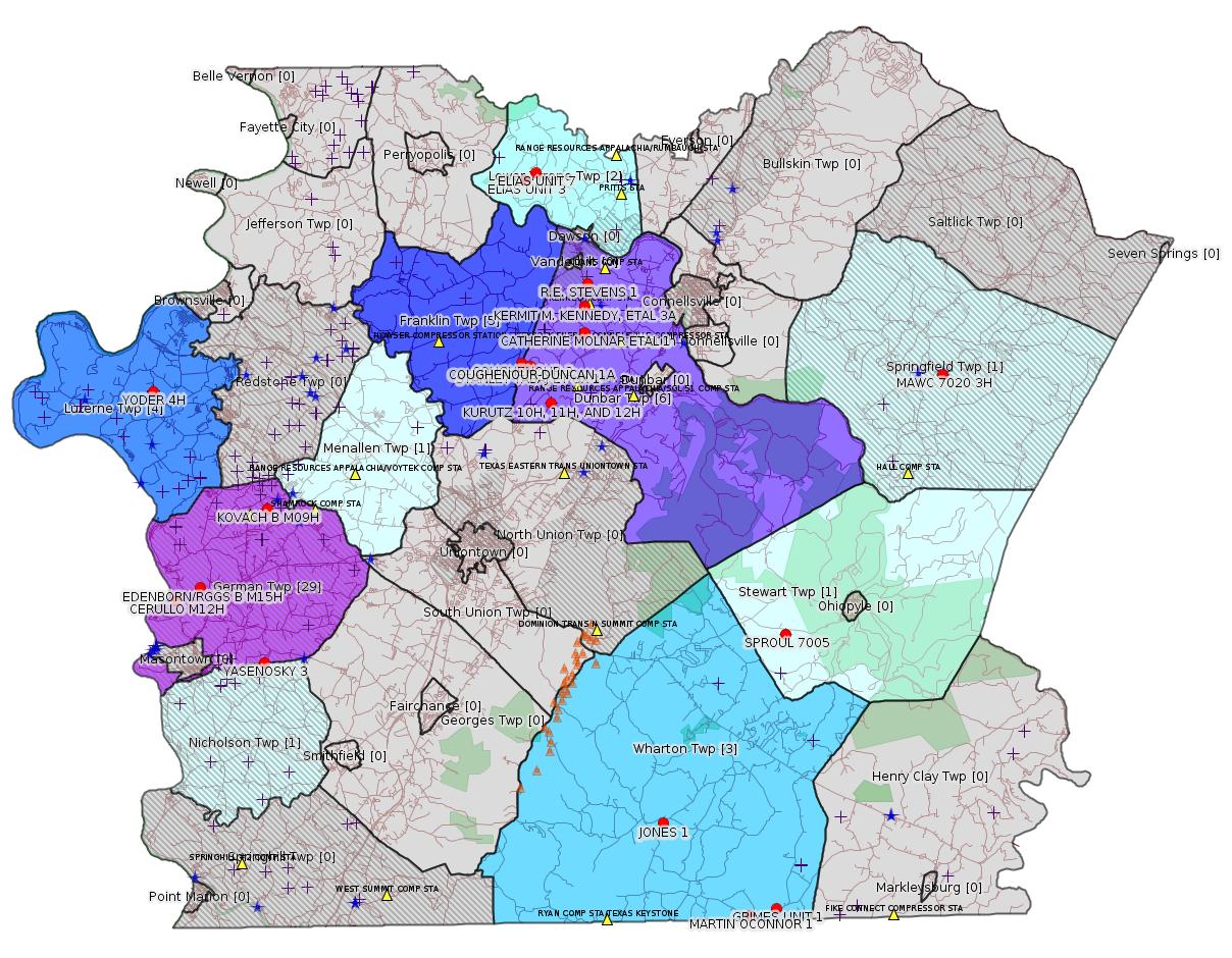
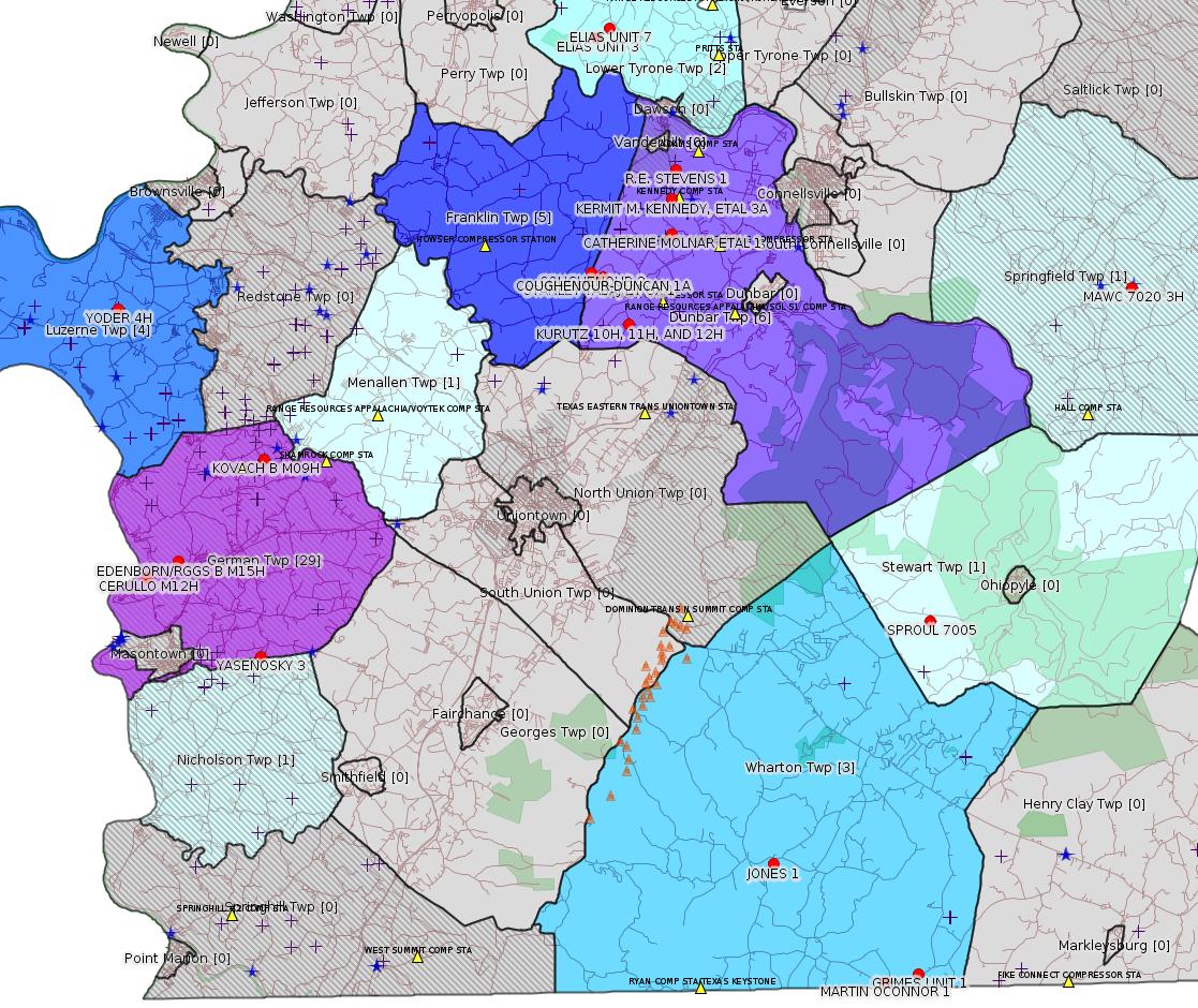
Map
Key
Red dots: items in this permit list with an exact location.
Blue stars: Marcellus Gas Well Water Sources.
Municipality shading: number of "facilities", with each well counting separately
(includes the red dots):
Red dots: items in this permit list with an exact location.
Blue stars: Marcellus Gas Well Water Sources.
Municipality shading: number of "facilities", with each well counting separately
(includes the red dots):
gray: 0
pale turquoise: 1
turquoise: 2
pale blue: 3
middle blue: 4
dark blue: 5
dark purple: 13
purple: 19
(Color coding may differ from one issue to the next.)
(Note if a project spans multiple municipalities -- e.g. a pipeline -- it will show in the count for each municipality.)
The number of facilities also follows the municipality name in brackets.
Municipality counts are based on the way the permit is listed by DEP; DEP has been known to get a municipality wrong.
Locations in brackets identify a precise location used to locate a surrogate for the actual site being permitted (e.g. locating a well pad or pipeline by the known location of a well.) Locations labeled beginning with "~" and ending in "[?]" are approximate and speculative based on inferences using on-line property and lease records. These are marked in the text as "[Approximate, Speculative]
Cross-hatching: Environmental Justice Areas
Yellow triangles: Compressor Stations
Orange triangles: Storage Field Wells (currently Dominion North Summit Storage Field)
Crosses: SPUD Unconventional well permits
Green: "Natural areas", e.g. state game lands, state forests
Yellow triangles: Compressor Stations
Orange triangles: Storage Field Wells (currently Dominion North Summit Storage Field)
Crosses: SPUD Unconventional well permits
Green: "Natural areas", e.g. state game lands, state forests
More Maps
 |
 |
Source: Pennsylvania Bulletin
[No Activity]
-------------------------
Source: eNOTICE (+ PA Oil and Gas Mapping, Well Pad Report.) Well Details via Data Portal Services: Oil and Gas Wells All (ID: 3).
Please see the Disclaimer below regarding Parcel Id data.
New:
Authorization ID: 1255021
Permit number: GP082618-505
Site: SOUTHERN PA GATHERING SYSTEM ABANDONMENT PPL 7894 PROJECTGP 08
Client: COLUMBIA GAS TRANS LLC
Authorization type: GP-08 Temporary Road Crossings
Application type: New
Authorization is for: FACILITY
Date received: 12/11/2018
Status: Pending
Permit Decision Guarantee Applies?: No
Sub-Facilities for Authorization:
Sub-Facility ID Sub-Facility Name Description
1276753 S PA GATHERING SYSTEM ABANDONMENT PPL 7894 PROJECT GP08 Bridge
<https://www.ahs.dep.pa.gov/eFACTSWeb/searchResults_singleAuth.aspx?AuthID=1255021>
Site Programs:
Water Planning and Conservation
Site Municipalities:
Menallen Twp, Fayette County
---
New:
Authorization ID: 1254127
Permit number: GP082607218-504
Site: S PA GATHERING SYSTEM ABANDOMENT PPL 7655 PROJ GP08 GP11
Client: COLUMBIA GAS TRANS LLC
Authorization type: GP-08 Temporary Road Crossings
Application type: New
Authorization is for: FACILITY
Date received: 11/26/2018
Status: Pending
Permit Decision Guarantee Applies?: No
Sub-Facilities for Authorization:
Sub-Facility ID Sub-Facility Name Description
1276299 S PA GATHERING SYSTEM ABANDOMENT PPL 7655 PROJ GP08 Bridge
Permit Review Notes:
Date Review Note
12/12/2018 Applicant has been issued a deficiency letter. If applicable, this application no longer qualifies for the Permit Decision Guarantee.
12/10/2018 The permit application package is complete, has been accepted, and is undergoing technical review.
<https://www.ahs.dep.pa.gov/eFACTSWeb/searchResults_singleAuth.aspx?AuthID=1254127>
Site Programs:
Water Planning and Conservation
Site Municipalities:
Franklin Twp, Fayette County
---
New:
Authorization ID: 1254004
Permit number: 051-24697
Site: CERULLO PAD A ESCGP ESX18-051-0004
Client: CHEVRON APPALACHIA LLC
Authorization type: Drill & Operate Well Permit (Unconventional)
Application type: New
Authorization is for: FACILITY
Date received: 12/04/2018
Status: Pending
Permit Decision Guarantee Applies?: No
Sub-Facilities for Authorization:
Sub-Facility ID Sub-Facility Name Description
1276244 WELLBORE SURFACE HOLE LOCATION Well
Permit Review Notes:
Date Review Note
12/14/2018 Applicant has been issued a deficiency letter. If applicable, this application no longer qualifies for the Permit Decision Guarantee.
12/5/2018 The permit application package is complete, has been accepted, and is undergoing technical review.
<https://www.ahs.dep.pa.gov/eFACTSWeb/searchResults_singleAuth.aspx?AuthID=1254004>
Site Programs:
Oil & Gas
Site Municipalities:
German Twp, Fayette County
Well Details:
Permit Number: 051-24697
Well Name: CERULLO M12H
Unconventional Well: Y
Well Configuration: Horizontal Well
Well Type: GAS
Well Status: Active
Coal Association: Coal
Conservation Well: N
Primary Facility ID: 830840
Site ID: 829618
Site Name: CERULLO PAD A ESCGP ESX18-051-0004
Well Pad ID: 155068
Well Pad Name: CERULLO
Storage Field:
Operator: CHEVRON APPALACHIA LLC
Operator Number: OGO-39307
Permit Date:
Permit Date Expires:
SPUD Date:
Date Plugged:
UIC ID:
UIC Type:
Surface Elevation: 1063
County: Fayette
Municipality: German Twp
Location: 39.876292,-79.9115
Map URL: <http://www.openstreetmap.org/?mlat=39.876292&mlon=-79.9115#map=15/39.876292/-79.9115>
2018-12-14: Submission for Authorization 1254004
Location Plat: CERULLO Well Plat M12H.dwg
<http://www.depgis.state.pa.us/eWellDocHandler/pdFHandler.ashx?Doc=NzAzNDg4&ext=PDF>
Pennsylvania Natural Diversity Inventory Form: Cerullo PNDI.pdf
<http://www.depgis.state.pa.us/eWellDocHandler/pdFHandler.ashx?Doc=NzAzNDg5&ext=PDF>
Well Cross-Section Diagram: Cerullo M12H Page 4.pdf
<http://www.depgis.state.pa.us/eWellDocHandler/pdFHandler.ashx?Doc=NzAzNDkw&ext=PDF>
Permit Application to Drill and Operate a Well: 1842690.pdf
<http://www.depgis.state.pa.us/eWellDocHandler/pdFHandler.ashx?Doc=NzA0ODA0&ext=PDF>
Presumed Parcel Id: 15190070
---
New:
Authorization ID: 1254003
Permit number: 051-24696
Site: CERULLO PAD A ESCGP ESX18-051-0004
Client: CHEVRON APPALACHIA LLC
Authorization type: Drill & Operate Well Permit (Unconventional)
Application type: New
Authorization is for: FACILITY
Date received: 12/04/2018
Status: Pending
Permit Decision Guarantee Applies?: No
Sub-Facilities for Authorization:
Sub-Facility ID Sub-Facility Name Description
1276243 WELLBORE SURFACE HOLE LOCATION Well
Permit Review Notes:
Date Review Note
12/14/2018 Applicant has been issued a deficiency letter. If applicable, this application no longer qualifies for the Permit Decision Guarantee.
12/5/2018 The permit application package is complete, has been accepted, and is undergoing technical review.
<https://www.ahs.dep.pa.gov/eFACTSWeb/searchResults_singleAuth.aspx?AuthID=1254003>
Site Programs:
Oil & Gas
Site Municipalities:
German Twp, Fayette County
Well Details:
Permit Number: 051-24696
Well Name: CERULLO M11H
Unconventional Well: Y
Well Configuration: Horizontal Well
Well Type: GAS
Well Status: Active
Coal Association: Coal
Conservation Well: N
Primary Facility ID: 830839
Site ID: 829618
Site Name: CERULLO PAD A ESCGP ESX18-051-0004
Well Pad ID: 155068
Well Pad Name: CERULLO
Storage Field:
Operator: CHEVRON APPALACHIA LLC
Operator Number: OGO-39307
Permit Date:
Permit Date Expires:
SPUD Date:
Date Plugged:
UIC ID:
UIC Type:
Surface Elevation: 1063
County: Fayette
Municipality: German Twp
Location: 39.876258,-79.911469
Map URL: <http://www.openstreetmap.org/?mlat=39.876258&mlon=-79.911469#map=15/39.876258/-79.911469>
Electronically Submitted Records:
2018-12-14: Submission for Authorization 1254003
Pennsylvania Natural Diversity Inventory Form: Cerullo PNDI.pdf
<http://www.depgis.state.pa.us/eWellDocHandler/pdFHandler.ashx?Doc=NzAzNDgx&ext=PDF>
Location Plat: CERULLO Well Plat M11H.dwg
<http://www.depgis.state.pa.us/eWellDocHandler/pdFHandler.ashx?Doc=NzAzNDgy&ext=PDF>
Well Cross-Section Diagram: Cerullo M11H Page 4.pdf
<http://www.depgis.state.pa.us/eWellDocHandler/pdFHandler.ashx?Doc=NzAzNDgz&ext=PDF>
Permit Application to Drill and Operate a Well: 1842688.pdf
<http://www.depgis.state.pa.us/eWellDocHandler/pdFHandler.ashx?Doc=NzA0ODAw&ext=PDF>
---
New:
Authorization ID: 1253996
Permit number: 051-24695
Site: CERULLO PAD A ESCGP ESX18-051-0004
Client: CHEVRON APPALACHIA LLC
Authorization type: Drill & Operate Well Permit (Unconventional)
Application type: New
Authorization is for: FACILITY
Date received: 12/04/2018
Status: Pending
Permit Decision Guarantee Applies?: No
Sub-Facilities for Authorization:
Sub-Facility ID Sub-Facility Name Description
1276240 WELLBORE SURFACE HOLE LOCATION Well
Permit Review Notes:
Date Review Note
12/14/2018 Applicant has been issued a deficiency letter. If applicable, this application no longer qualifies for the Permit Decision Guarantee.
12/5/2018 The permit application package is complete, has been accepted, and is undergoing technical review.
<https://www.ahs.dep.pa.gov/eFACTSWeb/searchResults_singleAuth.aspx?AuthID=1253996>
Site Programs:
Oil & Gas
Site Municipalities:
German Twp, Fayette County
Well Details:
Permit Number: 051-24695
Well Name: CERULLO M02H
Unconventional Well: Y
Well Configuration: Horizontal Well
Well Type: GAS
Well Status: Active
Coal Association: Coal
Conservation Well: N
Primary Facility ID: 830837
Site ID: 829618
Site Name: CERULLO PAD A ESCGP ESX18-051-0004
Well Pad ID: 155068
Well Pad Name: CERULLO
Storage Field:
Operator: CHEVRON APPALACHIA LLC
Operator Number: OGO-39307
Permit Date:
Permit Date Expires:
SPUD Date:
Date Plugged:
UIC ID:
UIC Type:
Surface Elevation: 1063
County: Fayette
Municipality: German Twp
Location: 39.876275,-79.91135
Map URL: <http://www.openstreetmap.org/?mlat=39.876275&mlon=-79.91135#map=15/39.876275/-79.91135>
Electronically Submitted Records:
2018-12-14: Submission for Authorization 1253996
Location Plat: CERULLO Well Plat M02H.dwg
<http://www.depgis.state.pa.us/eWellDocHandler/pdFHandler.ashx?Doc=NzAzNDIx&ext=PDF>
Pennsylvania Natural Diversity Inventory Form: Cerullo PNDI.pdf
<http://www.depgis.state.pa.us/eWellDocHandler/pdFHandler.ashx?Doc=NzAzNDIy&ext=PDF>
Well Cross-Section Diagram: Cerullo M02H Page 4.pdf
<http://www.depgis.state.pa.us/eWellDocHandler/pdFHandler.ashx?Doc=NzAzNDIz&ext=PDF>
Permit Application to Drill and Operate a Well: 1842505.pdf
<http://www.depgis.state.pa.us/eWellDocHandler/pdFHandler.ashx?Doc=NzA0NzY5&ext=PDF>
---
New:
Authorization ID: 1253995
Permit number: 051-24694
Site: CERULLO PAD A ESCGP ESX18-051-0004
Client: CHEVRON APPALACHIA LLC
Authorization type: Drill & Operate Well Permit (Unconventional)
Application type: New
Authorization is for: FACILITY
Date received: 12/04/2018
Status: Pending
Permit Decision Guarantee Applies?: No
Sub-Facilities for Authorization:
Sub-Facility ID Sub-Facility Name Description
1276239 WELLBORE SURFACE HOLE LOCATION Well
Permit Review Notes:
Date Review Note
12/14/2018 Applicant has been issued a deficiency letter. If applicable, this application no longer qualifies for the Permit Decision Guarantee.
12/5/2018 The permit application package is complete, has been accepted, and is undergoing technical review.
<https://www.ahs.dep.pa.gov/eFACTSWeb/searchResults_singleAuth.aspx?AuthID=1253995>
Site Programs:
Oil & Gas
Site Municipalities:
German Twp, Fayette County
Well Details:
Permit Number: 051-24694
Well Name: CERULLO M04H
Unconventional Well: Y
Well Configuration: Horizontal Well
Well Type: GAS
Well Status: Active
Coal Association: Coal
Conservation Well: N
Primary Facility ID: 830836
Site ID: 829618
Site Name: CERULLO PAD A ESCGP ESX18-051-0004
Well Pad ID: 155068
Well Pad Name: CERULLO
Storage Field:
Operator: CHEVRON APPALACHIA LLC
Operator Number: OGO-39307
Permit Date:
Permit Date Expires:
SPUD Date:
Date Plugged:
UIC ID:
UIC Type:
Surface Elevation: 1063
County: Fayette
Municipality: German Twp
Location: 39.876342,-79.911414
Map URL: <http://www.openstreetmap.org/?mlat=39.876342&mlon=-79.911414#map=15/39.876342/-79.911414>
Electronically Submitted Records:
2018-12-14: Submission for Authorization 1253995
Pennsylvania Natural Diversity Inventory Form: Cerullo PNDI.pdf
<http://www.depgis.state.pa.us/eWellDocHandler/pdFHandler.ashx?Doc=NzAzNDUw&ext=PDF>
Location Plat: CERULLO Well Plat M04H.dwg
<http://www.depgis.state.pa.us/eWellDocHandler/pdFHandler.ashx?Doc=NzAzNDUx&ext=PDF>
Well Cross-Section Diagram: Cerullo M04H Page 4.pdf
<http://www.depgis.state.pa.us/eWellDocHandler/pdFHandler.ashx?Doc=NzAzNDUy&ext=PDF>
Permit Application to Drill and Operate a Well: 1842531.pdf
<http://www.depgis.state.pa.us/eWellDocHandler/pdFHandler.ashx?Doc=NzA0Nzc4&ext=PDF>
---
New:
Authorization ID: 1253994
Permit number: 051-24693
Site: CERULLO PAD A ESCGP ESX18-051-0004
Client: CHEVRON APPALACHIA LLC
Authorization type: Drill & Operate Well Permit (Unconventional)
Application type: New
Authorization is for: FACILITY
Date received: 12/04/2018
Status: Pending
Permit Decision Guarantee Applies?: No
Sub-Facilities for Authorization:
Sub-Facility ID Sub-Facility Name Description
1276238 WELLBORE SURFACE HOLE LOCATION Well
Permit Review Notes:
Date Review Note
12/14/2018 Applicant has been issued a deficiency letter. If applicable, this application no longer qualifies for the Permit Decision Guarantee.
12/5/2018 The permit application package is complete, has been accepted, and is undergoing technical review.
<https://www.ahs.dep.pa.gov/eFACTSWeb/searchResults_singleAuth.aspx?AuthID=1253994>
Site Programs:
Oil & Gas
Site Municipalities:
German Twp, Fayette County
Well Details:
Permit Number: 051-24693
Well Name: CERULLO M01H
Unconventional Well: Y
Well Configuration: Horizontal Well
Well Type: GAS
Well Status: Active
Coal Association: Coal
Conservation Well: N
Primary Facility ID: 830835
Site ID: 829618
Site Name: CERULLO PAD A ESCGP ESX18-051-0004
Well Pad ID: 155068
Well Pad Name: CERULLO
Storage Field:
Operator: CHEVRON APPALACHIA LLC
Operator Number: OGO-39307
Permit Date:
Permit Date Expires:
SPUD Date:
Date Plugged:
UIC ID:
UIC Type:
Surface Elevation: 1063
County: Fayette
Municipality: German Twp
Location: 39.876242,-79.911319
Map URL: <http://www.openstreetmap.org/?mlat=39.876242&mlon=-79.911319#map=15/39.876242/-79.911319>
Electronically Submitted Records:
2018-12-14: Submission for Authorization 1253994
Pennsylvania Natural Diversity Inventory Form: Cerullo PNDI.pdf
<http://www.depgis.state.pa.us/eWellDocHandler/pdFHandler.ashx?Doc=NzAzNDEz&ext=PDF>
Location Plat: CERULLO Well Plat M01H.dwg
<http://www.depgis.state.pa.us/eWellDocHandler/pdFHandler.ashx?Doc=NzAzNDE0&ext=PDF>
Well Cross-Section Diagram: Cerullo M01H Page 4.pdf
<http://www.depgis.state.pa.us/eWellDocHandler/pdFHandler.ashx?Doc=NzAzNDE1&ext=PDF>
Permit Application to Drill and Operate a Well: 1842469.pdf
<http://www.depgis.state.pa.us/eWellDocHandler/pdFHandler.ashx?Doc=NzA0NzYz&ext=PDF>
---
New:
Authorization ID: 1253993
Permit number: 051-24692
Site: CERULLO PAD A ESCGP ESX18-051-0004
Client: CHEVRON APPALACHIA LLC
Authorization type: Drill & Operate Well Permit (Unconventional)
Application type: New
Authorization is for: FACILITY
Date received: 12/04/2018
Status: Pending
Permit Decision Guarantee Applies?: No
Sub-Facilities for Authorization:
Sub-Facility ID Sub-Facility Name Description
1276237 WELLBORE SURFACE HOLE LOCATION Well
Permit Review Notes:
Date Review Note
12/14/2018 Applicant has been issued a deficiency letter. If applicable, this application no longer qualifies for the Permit Decision Guarantee.
12/5/2018 The permit application package is complete, has been accepted, and is undergoing technical review.
<https://www.ahs.dep.pa.gov/eFACTSWeb/searchResults_singleAuth.aspx?AuthID=1253993>
Site Programs:
Oil & Gas
Site Municipalities:
German Twp, Fayette County
Well Details:
Permit Number: 051-24692
Well Name: CERULLO M03H
Unconventional Well: Y
Well Configuration: Horizontal Well
Well Type: GAS
Well Status: Active
Coal Association: Coal
Conservation Well: N
Primary Facility ID: 830834
Site ID: 829618
Site Name: CERULLO PAD A ESCGP ESX18-051-0004
Well Pad ID: 155068
Well Pad Name: CERULLO
Storage Field:
Operator: CHEVRON APPALACHIA LLC
Operator Number: OGO-39307
Permit Date:
Permit Date Expires:
SPUD Date:
Date Plugged:
UIC ID:
UIC Type:
Surface Elevation: 1063
County: Fayette
Municipality: German Twp
Location: 39.876308,-79.911383
Map URL: <http://www.openstreetmap.org/?mlat=39.876308&mlon=-79.911383#map=15/39.876308/-79.911383>
Electronically Submitted Records:
2018-12-14: Submission for Authorization 1253993
Location Plat: CERULLO Well Plat M03H.dwg
<http://www.depgis.state.pa.us/eWellDocHandler/pdFHandler.ashx?Doc=NzAzNDM4&ext=PDF>
Pennsylvania Natural Diversity Inventory Form: Cerullo PNDI.pdf
<http://www.depgis.state.pa.us/eWellDocHandler/pdFHandler.ashx?Doc=NzAzNDQw&ext=PDF>
Well Cross-Section Diagram: Cerullo M03H Page 4.pdf
<http://www.depgis.state.pa.us/eWellDocHandler/pdFHandler.ashx?Doc=NzAzNDQx&ext=PDF>
Permit Application to Drill and Operate a Well: 1842522.pdf
<http://www.depgis.state.pa.us/eWellDocHandler/pdFHandler.ashx?Doc=NzA0Nzcy&ext=PDF>
---
New:
Authorization ID: 1253992
Permit number: 051-24691
Site: CERULLO PAD A ESCGP ESX18-051-0004
Client: CHEVRON APPALACHIA LLC
Authorization type: Drill & Operate Well Permit (Unconventional)
Application type: New
Authorization is for: FACILITY
Date received: 12/04/2018
Status: Pending
Permit Decision Guarantee Applies?: No
Sub-Facilities for Authorization:
Sub-Facility ID Sub-Facility Name Description
1276236 WELLBORE SURFACE HOLE LOCATION Well
Permit Review Notes:
Date Review Note
12/14/2018 Applicant has been issued a deficiency letter. If applicable, this application no longer qualifies for the Permit Decision Guarantee.
12/5/2018 The permit application package is complete, has been accepted, and is undergoing technical review.
<https://www.ahs.dep.pa.gov/eFACTSWeb/searchResults_singleAuth.aspx?AuthID=1253992>
Site Programs:
Oil & Gas
Site Municipalities:
German Twp, Fayette County
Well Details:
Permit Number: 051-24691
Well Name: CERULLO M10H
Unconventional Well: Y
Well Configuration: Horizontal Well
Well Type: GAS
Well Status: Active
Coal Association: Coal
Conservation Well: N
Primary Facility ID: 830833
Site ID: 829618
Site Name: CERULLO PAD A ESCGP ESX18-051-0004
Well Pad ID: 155068
Well Pad Name: CERULLO
Storage Field:
Operator: CHEVRON APPALACHIA LLC
Operator Number: OGO-39307
Permit Date:
Permit Date Expires:
SPUD Date:
Date Plugged:
UIC ID:
UIC Type:
Surface Elevation: 1063
County: Fayette
Municipality: German Twp
Location: 39.876225,-79.911436
Map URL: <http://www.openstreetmap.org/?mlat=39.876225&mlon=-79.911436#map=15/39.876225/-79.911436>
Electronically Submitted Records:
2018-12-14: Submission for Authorization 1253992
Pennsylvania Natural Diversity Inventory Form: Cerullo PNDI.pdf
<http://www.depgis.state.pa.us/eWellDocHandler/pdFHandler.ashx?Doc=NzAzNDY5&ext=PDF>
Location Plat: CERULLO Well Plat M10H.dwg
<http://www.depgis.state.pa.us/eWellDocHandler/pdFHandler.ashx?Doc=NzAzNDcw&ext=PDF>
Well Cross-Section Diagram: Cerullo M10H Page 4.pdf
<http://www.depgis.state.pa.us/eWellDocHandler/pdFHandler.ashx?Doc=NzAzNDcx&ext=PDF>
Permit Application to Drill and Operate a Well: 1842680.pdf
<http://www.depgis.state.pa.us/eWellDocHandler/pdFHandler.ashx?Doc=NzA0Nzg3&ext=PDF>
---
New:
Authorization ID: 1253991
Permit number: 051-24690
Site: CERULLO PAD A ESCGP ESX18-051-0004
Client: CHEVRON APPALACHIA LLC
Authorization type: Drill & Operate Well Permit (Unconventional)
Application type: New
Authorization is for: FACILITY
Date received: 12/04/2018
Status: Pending
Permit Decision Guarantee Applies?: No
Sub-Facilities for Authorization:
Sub-Facility ID Sub-Facility Name Description
1276235 WELLBORE SURFACE HOLE LOCATION Well
Permit Review Notes:
Date Review Note
12/14/2018 Applicant has been issued a deficiency letter. If applicable, this application no longer qualifies for the Permit Decision Guarantee.
12/5/2018 The permit application package is complete, has been accepted, and is undergoing technical review.
<https://www.ahs.dep.pa.gov/eFACTSWeb/searchResults_singleAuth.aspx?AuthID=1253991>
Site Programs:
Oil & Gas
Site Municipalities:
German Twp, Fayette County
Well Details:
Permit Number: 051-24690
Well Name: CERULLO M09H
Unconventional Well: Y
Well Configuration: Horizontal Well
Well Type: GAS
Well Status: Active
Coal Association: Coal
Conservation Well: N
Primary Facility ID: 830832
Site ID: 829618
Site Name: CERULLO PAD A ESCGP ESX18-051-0004
Well Pad ID: 155068
Well Pad Name: CERULLO
Storage Field:
Operator: CHEVRON APPALACHIA LLC
Operator Number: OGO-39307
Permit Date:
Permit Date Expires:
SPUD Date:
Date Plugged:
UIC ID:
UIC Type:
Surface Elevation: 1063
County: Fayette
Municipality: German Twp
Location: 39.876192,-79.911406
Map URL: <http://www.openstreetmap.org/?mlat=39.876192&mlon=-79.911406#map=15/39.876192/-79.911406>
Electronically Submitted Records:
2018-12-14: Submission for Authorization 1253991
Pennsylvania Natural Diversity Inventory Form: Cerullo PNDI.pdf
<http://www.depgis.state.pa.us/eWellDocHandler/pdFHandler.ashx?Doc=NzAzNDU5&ext=PDF>
Location Plat: CERULLO Well Plat M09H.dwg
<http://www.depgis.state.pa.us/eWellDocHandler/pdFHandler.ashx?Doc=NzAzNDYw&ext=PDF>
Well Cross-Section Diagram: Cerullo M09H Page 4.pdf
<http://www.depgis.state.pa.us/eWellDocHandler/pdFHandler.ashx?Doc=NzAzNDYx&ext=PDF>
Permit Application to Drill and Operate a Well: 1842671.pdf
<http://www.depgis.state.pa.us/eWellDocHandler/pdFHandler.ashx?Doc=NzA0Nzg0&ext=PDF>
---
Authorization ID: 1253268
Permit number: ESX10-051-0042
Site: KURUTZ 10H, 11H, AND 12H ESCGP-EXPEDITED
Client: CHEVRON APPALACHIA LLC
Authorization type: Expedited E&S Stormwater General Permit 1
Application type: Notification
Authorization is for: SITE
Date received: 11/26/2018
Status: Issued on 12/10/2018
Permit Decision Guarantee Applies?: No
Permit Review Notes:
Date Review Note
12/10/2018 The technical review and decision review are complete and either the permit decision and/or permit issuance are forthcoming.
12/10/2018 The permit application package is complete, has been accepted, and is undergoing technical review.
<https://www.ahs.dep.pa.gov/eFACTSWeb/searchResults_singleAuth.aspx?AuthID=1253268>
Site Programs:
Site Municipalities:
Dunbar Twp, Fayette County
Well Pad Name: KURUTZ UNIT 10H
Well Pad ID: 148718
Location: 39.967339,-79.679131 <https://osm.org/go/ZWpzPebL-?m=>
Wells on this Pad:
051-24406 KURUTZ UNIT 10H
051-24407 KURUTZ UNIT 11H
051-24408 KURUTZ UNIT 12H
Presumed Parcel Id: 09280019
Well Pad ID: 148718
Location: 39.967339,-79.679131 <https://osm.org/go/ZWpzPebL-?m=>
Wells on this Pad:
051-24406 KURUTZ UNIT 10H
051-24407 KURUTZ UNIT 11H
051-24408 KURUTZ UNIT 12H
Presumed Parcel Id: 09280019
---
Authorization ID: 1252957
Permit number: GP082607218-503
Site: S PA GATHERING SYSTEM ABANDONMENT PIPELINES 7648 & 7837 PROJECT
Client: COLUMBIA GAS TRANS LLC
Authorization type: GP-08 Temporary Road Crossings
Application type: New
Authorization is for: FACILITY
Date received: 11/20/2018
Status: Pending
Permit Decision Guarantee Applies?: No
Sub-Facilities for Authorization:
Sub-Facility ID Sub-Facility Name Description
1275747 S PA GATHERING SYSTEM ABANDONMENT PIPELINES 7648 & 7837 PROJ Bridge
Permit Review Notes:
Date Review Note
12/12/2018 Applicant has been issued a deficiency letter. If applicable, this application no longer qualifies for the Permit Decision Guarantee.
12/10/2018 The permit application package is complete, has been accepted, and is undergoing technical review.
<https://www.ahs.dep.pa.gov/eFACTSWeb/searchResults_singleAuth.aspx?AuthID=1252957>
Site Programs:
Water Planning and Conservation
Site Municipalities:
Franklin Twp, Fayette County
---
Authorization ID: 1252230
Permit number: 051-21070
Site: JONES 1 OG WELL
Client: PENNECO OIL CO INC
Authorization type: Well Plugging Notice Intent to Plug Single Well
Application type: New
Authorization is for: FACILITY
Date received: 11/05/2018
Status: Pending
Permit Decision Guarantee Applies?: No
Permit Review Notes:
Date Review Note
11/15/2018 The technical review and decision review are complete and either the permit decision and/or permit issuance are forthcoming.
11/5/2018 The permit application package is complete, has been accepted, and is undergoing technical review.
<https://www.ahs.dep.pa.gov/eFACTSWeb/searchResults_singleAuth.aspx?AuthID=1252230>
Site Programs:
Oil & Gas
Site Municipalities:
Wharton Twp, Fayette County
Well Details:
Permit Number: 051-21070
Well Name: JONES 1
Unconventional Well: N
Well Configuration: Vertical Well
Well Type: GAS
Well Status: Plugged OG Well
Coal Association: Coal
Conservation Well: N
Primary Facility ID: 524652
Site ID: 500110
Site Name: JONES 1 OG WELL
Well Pad ID: 0
Well Pad Name:
Storage Field:
Operator: PENNECO OIL CO INC
Operator Number: OGO-13825
Permit Date: 1999-01-21
Permit Date Expires: 2000-01-21
SPUD Date: 1999-01-26
Date Plugged: 2018-11-14
UIC ID:
UIC Type:
Surface Elevation: 1660
County: Fayette
Municipality: Wharton Twp
Location: 39.767389,-79.61375
Map URL: <http://www.openstreetmap.org/?mlat=39.767389&mlon=-79.61375#map=15/39.767389/-79.61375>
---
Authorization ID: 1251624
Permit number: GP112607218-507
Site: SOUTHERN PA GSA PPL 7652 7653 7921 PROJ GP08 GP11
Client: COLUMBIA GAS TRANS LLC
Authorization type: BWM-GP-11 Maintenance, Testing, Repair, Rehabilitation or Replacement General Pmt
Application type: New
Authorization is for: FACILITY
Date received: 10/31/2018
Status: Pending
Permit Decision Guarantee Applies?: Yes
Permit Decision Guarantee status: VOID
Sub-Facilities for Authorization:
Sub-Facility ID Sub-Facility Name Description
1274954 SOUTHERN PA GSA PPL 7652 7653 7921 PROJ GP11 Other Activities
Permit Review Notes:
Date Review Note
12/12/2018 Applicant has been issued a deficiency letter. If applicable, this application no longer qualifies for the Permit Decision Guarantee.
11/19/2018 The permit application package is complete, has been accepted, and is undergoing technical review.
<https://www.ahs.dep.pa.gov/eFACTSWeb/searchResults_singleAuth.aspx?AuthID=1251624>
Site Programs:
Water Planning and Conservation
Site Municipalities:
Franklin Twp, Fayette County
---
Authorization ID: 1251622
Permit number: GP082607218-502
Site: SOUTHERN PA GSA PPL 7652 7653 7921 PROJ GP08 GP11
Client: COLUMBIA GAS TRANS LLC
Authorization type: GP-08 Temporary Road Crossings
Application type: New
Authorization is for: FACILITY
Date received: 10/31/2018
Status: Pending
Permit Decision Guarantee Applies?: No
Sub-Facilities for Authorization:
Sub-Facility ID Sub-Facility Name Description
1274953 SOUTHERN PA GSA PPL 7652 7653 7921 PROJ GP08 Bridge
Permit Review Notes:
Date Review Note
12/12/2018 Applicant has been issued a deficiency letter. If applicable, this application no longer qualifies for the Permit Decision Guarantee.
11/19/2018 The permit application package is complete, has been accepted, and is undergoing technical review.
<https://www.ahs.dep.pa.gov/eFACTSWeb/searchResults_singleAuth.aspx?AuthID=1251622>
Site Programs:
Water Planning and Conservation
Site Municipalities:
Franklin Twp, Fayette County
---
Authorization ID: 1251236
Permit number: 051-24689
Site: EDENBORN/RGGS B ESCGP ESX18-051-0003
Client: CHEVRON APPALACHIA LLC
Authorization type: Drill & Operate Well Permit (Unconventional)
Application type: New
Authorization is for: FACILITY
Date received: 11/06/2018
Status: Pending
Permit Decision Guarantee Applies?: No
Sub-Facilities for Authorization:
Sub-Facility ID Sub-Facility Name Description
1274762 WELLBORE SURFACE HOLE LOCATION Well
Permit Review Notes:
Date Review Note
12/5/2018 The technical review and decision review are complete and either the permit decision and/or permit issuance are forthcoming.
11/8/2018 The permit application package is complete, has been accepted, and is undergoing technical review.
<https://www.ahs.dep.pa.gov/eFACTSWeb/searchResults_singleAuth.aspx?AuthID=1251236>
Site Programs:
Oil & Gas
Site Municipalities:
German Twp, Fayette County
Well Details:
Permit Number: 051-24689
Well Name: EDENBORN/RGGS B M15H
Unconventional Well: Y
Well Configuration: Horizontal Well
Well Type: GAS
Well Status: Active
Coal Association: Coal
Conservation Well: N
Primary Facility ID: 830215
Site ID: 829418
Site Name: EDENBORN/RGGS B ESCGP ESX18-051-0003
Well Pad ID: 155083
Well Pad Name: EDENBORN/RGGS B
Storage Field:
Operator: CHEVRON APPALACHIA LLC
Operator Number: OGO-39307
Permit Date: 2018-12-13
Permit Date Expires: 2019-12-13
SPUD Date:
Date Plugged:
UIC ID:
UIC Type:
Surface Elevation: 1167
County: Fayette
Municipality: German Twp
Location: 39.882061,-79.896197
Map URL: <http://www.openstreetmap.org/?mlat=39.882061&mlon=-79.896197#map=15/39.882061/-79.896197>
OG WELLS PERMIT DOCS:
2018-12-13: Other Permit Documents, Name: E&S-C&D email (for Authorization: 1251236):
<http://www.depgis.state.pa.us/pdfHandler/pdFHandler.ashx?Doc=NzEwMTU1&ext=PDF>
2018-12-13: Other Permit Documents, Name: Povlik Deficiency Letter (for Authorization: 1251236):
<http://www.depgis.state.pa.us/pdfHandler/pdFHandler.ashx?Doc=NzEwMTE3&ext=PDF>
2018-12-13: Final Permit Documents, Name: Povlik Record of Decision (11-30-18) (for Authorization: 1251236):
<http://www.depgis.state.pa.us/pdfHandler/pdFHandler.ashx?Doc=NzEwMTEy&ext=PDF>
2018-12-13: Final Permit Documents, Name: 033-27257 Permit (11-30-18) (for Authorization: 1251236):
<http://www.depgis.state.pa.us/pdfHandler/pdFHandler.ashx?Doc=NzEwMTEw&ext=PDF>
2018-12-13: Final Permit Documents, Name: Authorization ID 1251236 (for Authorization: 1251236):
<http://www.depgis.state.pa.us/pdfHandler/pdFHandler.ashx?Doc=NzE1NDM0&ext=PDF>
2018-12-13: Initial Submitted Documents, Name: Povlik 2018 application - approved (for Authorization: 1251236):
<http://www.depgis.state.pa.us/pdfHandler/pdFHandler.ashx?Doc=NzEwMTU3&ext=PDF>
Electronically Submitted Records:
2018-12-13: Submission for Authorization 1251236
Pennsylvania Natural Diversity Inventory Form: EdenbornRGGS PNDI.pdf
<http://www.depgis.state.pa.us/eWellDocHandler/pdFHandler.ashx?Doc=NjgyMzQx&ext=PDF>
Location Plat: Edenborn Well Plat M15H.dwg
<http://www.depgis.state.pa.us/eWellDocHandler/pdFHandler.ashx?Doc=NjgyMzQy&ext=PDF>
Coordination of Well Location with Public Resources: Edenborn M15H OG-76.pdf
<http://www.depgis.state.pa.us/eWellDocHandler/pdFHandler.ashx?Doc=NjgyMzQz&ext=PDF>
Well Cross-Section Diagram: Edenborn RGGS M15H Page 4.pdf
<http://www.depgis.state.pa.us/eWellDocHandler/pdFHandler.ashx?Doc=NjgyMzQ0&ext=PDF>
Permit Application to Drill and Operate a Well: 1812304.pdf
<http://www.depgis.state.pa.us/eWellDocHandler/pdFHandler.ashx?Doc=NjgyOTI4&ext=PDF>
---
Authorization ID: 1251234
Permit number: 051-24688
Site: EDENBORN/RGGS B ESCGP ESX18-051-0003
Client: CHEVRON APPALACHIA LLC
Authorization type: Drill & Operate Well Permit (Unconventional)
Application type: New
Authorization is for: FACILITY
Date received: 11/06/2018
Status: Pending
Permit Decision Guarantee Applies?: No
Sub-Facilities for Authorization:
Sub-Facility ID Sub-Facility Name Description
1274760 WELLBORE SURFACE HOLE LOCATION Well
Permit Review Notes:
Date Review Note
12/5/2018 The technical review and decision review are complete and either the permit decision and/or permit issuance are forthcoming.
11/8/2018 The permit application package is complete, has been accepted, and is undergoing technical review.
<https://www.ahs.dep.pa.gov/eFACTSWeb/searchResults_singleAuth.aspx?AuthID=1251234>
Site Programs:
Oil & Gas
Site Municipalities:
German Twp, Fayette County
Well Details:
Permit Number: 051-24688
Well Name: EDENBORN/RGGS B M14H
Unconventional Well: Y
Well Configuration: Horizontal Well
Well Type: GAS
Well Status: Active
Coal Association: Coal
Conservation Well: N
Primary Facility ID: 830214
Site ID: 829418
Site Name: EDENBORN/RGGS B ESCGP ESX18-051-0003
Well Pad ID: 155083
Well Pad Name: EDENBORN/RGGS B
Storage Field:
Operator: CHEVRON APPALACHIA LLC
Operator Number: OGO-39307
Permit Date: 2018-12-13
Permit Date Expires: 2019-12-13
SPUD Date:
Date Plugged:
UIC ID:
UIC Type:
Surface Elevation: 1167
County: Fayette
Municipality: German Twp
Location: 39.882069,-79.896144
Map URL: <http://www.openstreetmap.org/?mlat=39.882069&mlon=-79.896144#map=15/39.882069/-79.896144>
OG WELLS PERMIT DOCS:
2018-12-13: Final Permit Documents, Name: Authorization ID 1251234 (for Authorization: 1251234):
<http://www.depgis.state.pa.us/pdfHandler/pdFHandler.ashx?Doc=NzE1NDM3&ext=PDF>
Electronically Submitted Records:
2018-12-13: Submission for Authorization 1251234
Pennsylvania Natural Diversity Inventory Form: EdenbornRGGS PNDI.pdf
<http://www.depgis.state.pa.us/eWellDocHandler/pdFHandler.ashx?Doc=NjgyMzMz&ext=PDF>
Location Plat: Edenborn Well Plat M14H.dwg
<http://www.depgis.state.pa.us/eWellDocHandler/pdFHandler.ashx?Doc=NjgyMzM0&ext=PDF>
Coordination of Well Location with Public Resources: Edenborn M14H OG-76.pdf
<http://www.depgis.state.pa.us/eWellDocHandler/pdFHandler.ashx?Doc=NjgyMzM1&ext=PDF>
Well Cross-Section Diagram: Edenborn RGGS M14H Page 4.pdf
<http://www.depgis.state.pa.us/eWellDocHandler/pdFHandler.ashx?Doc=NjgyMzM2&ext=PDF>
Permit Application to Drill and Operate a Well: 1812295.pdf
<http://www.depgis.state.pa.us/eWellDocHandler/pdFHandler.ashx?Doc=NjgyOTIz&ext=PDF>
---
Authorization ID: 1251233
Permit number: 051-24687
Site: EDENBORN/RGGS B ESCGP ESX18-051-0003
Client: CHEVRON APPALACHIA LLC
Authorization type: Drill & Operate Well Permit (Unconventional)
Application type: New
Authorization is for: FACILITY
Date received: 11/06/2018
Status: Issued on 12/10/2018
Permit Decision Guarantee Applies?: No
Sub-Facilities for Authorization:
Sub-Facility ID Sub-Facility Name Description
1274759 WELLBORE SURFACE HOLE LOCATION Well
Permit Review Notes:
Date Review Note
12/4/2018 The technical review and decision review are complete and either the permit decision and/or permit issuance are forthcoming.
11/8/2018 The permit application package is complete, has been accepted, and is undergoing technical review.
<https://www.ahs.dep.pa.gov/eFACTSWeb/searchResults_singleAuth.aspx?AuthID=1251233>
Site Programs:
Oil & Gas
Site Municipalities:
German Twp, Fayette County
Well Details:
Permit Number: 051-24687
Well Name: EDENBORN/RGGS B M11H
Unconventional Well: Y
Well Configuration: Horizontal Well
Well Type: GAS
Well Status: Active
Coal Association: Coal
Conservation Well: N
Primary Facility ID: 830213
Site ID: 829418
Site Name: EDENBORN/RGGS B ESCGP ESX18-051-0003
Well Pad ID: 155083
Well Pad Name: EDENBORN/RGGS B
Storage Field:
Operator: CHEVRON APPALACHIA LLC
Operator Number: OGO-39307
Permit Date: 2018-12-10
Permit Date Expires: 2019-12-10
SPUD Date:
Date Plugged:
UIC ID:
UIC Type:
Surface Elevation: 1167
County: Fayette
Municipality: German Twp
Location: 39.882089,-79.895986
Map URL: <http://www.openstreetmap.org/?mlat=39.882089&mlon=-79.895986#map=15/39.882089/-79.895986>
OG WELLS PERMIT DOCS:
2018-12-10: Final Permit Documents, Name: Authorization ID 1251233 (for Authorization: 1251233):
<http://www.depgis.state.pa.us/pdfHandler/pdFHandler.ashx?Doc=NzEyNDkz&ext=PDF>
Electronically Submitted Records:
2018-12-10: Submission for Authorization 1251233
Coordination of Well Location with Public Resources: Edenborn M11H OG-76.pdf
<http://www.depgis.state.pa.us/eWellDocHandler/pdFHandler.ashx?Doc=NjgyMjk5&ext=PDF>
Pennsylvania Natural Diversity Inventory Form: EdenbornRGGS PNDI.pdf
<http://www.depgis.state.pa.us/eWellDocHandler/pdFHandler.ashx?Doc=NjgyMzAw&ext=PDF>
Location Plat: Edenborn Well Plat M11H.dwg
<http://www.depgis.state.pa.us/eWellDocHandler/pdFHandler.ashx?Doc=NjgyMzAx&ext=PDF>
Well Cross-Section Diagram: Edenborn RGGS M11H Page 4.pdf
<http://www.depgis.state.pa.us/eWellDocHandler/pdFHandler.ashx?Doc=NjgyMzAy&ext=PDF>
Permit Application to Drill and Operate a Well: 1812270.pdf
<http://www.depgis.state.pa.us/eWellDocHandler/pdFHandler.ashx?Doc=NjgyOTA4&ext=PDF>
---
Authorization ID: 1251232
Permit number: 051-24686
Site: EDENBORN/RGGS B ESCGP ESX18-051-0003
Client: CHEVRON APPALACHIA LLC
Authorization type: Drill & Operate Well Permit (Unconventional)
Application type: New
Authorization is for: FACILITY
Date received: 11/06/2018
Status: Pending
Permit Decision Guarantee Applies?: No
Sub-Facilities for Authorization:
Sub-Facility ID Sub-Facility Name Description
1274758 WELLBORE SURFACE HOLE LOCATION Well
Permit Review Notes:
Date Review Note
12/5/2018 The technical review and decision review are complete and either the permit decision and/or permit issuance are forthcoming.
11/8/2018 The permit application package is complete, has been accepted, and is undergoing technical review.
<https://www.ahs.dep.pa.gov/eFACTSWeb/searchResults_singleAuth.aspx?AuthID=1251232>
Site Programs:
Oil & Gas
Site Municipalities:
German Twp, Fayette County
Well Details:
Permit Number: 051-24686
Well Name: EDENBORN/RGGS B M13H
Unconventional Well: Y
Well Configuration: Horizontal Well
Well Type: GAS
Well Status: Active
Coal Association: Coal
Conservation Well: N
Primary Facility ID: 830212
Site ID: 829418
Site Name: EDENBORN/RGGS B ESCGP ESX18-051-0003
Well Pad ID: 155083
Well Pad Name: EDENBORN/RGGS B
Storage Field:
Operator: CHEVRON APPALACHIA LLC
Operator Number: OGO-39307
Permit Date: 2018-12-13
Permit Date Expires: 2019-12-13
SPUD Date:
Date Plugged:
UIC ID:
UIC Type:
Surface Elevation: 1167
County: Fayette
Municipality: German Twp
Location: 39.882075,-79.896092
Map URL: <http://www.openstreetmap.org/?mlat=39.882075&mlon=-79.896092#map=15/39.882075/-79.896092>
OG WELLS PERMIT DOCS:
2018-12-13: Final Permit Documents, Name: Authorization ID 1251232 (for Authorization: 1251232):
<http://www.depgis.state.pa.us/pdfHandler/pdFHandler.ashx?Doc=NzE1NDQ2&ext=PDF>
Electronically Submitted Records:
2018-12-13: Submission for Authorization 1251232
Pennsylvania Natural Diversity Inventory Form: EdenbornRGGS PNDI.pdf
<http://www.depgis.state.pa.us/eWellDocHandler/pdFHandler.ashx?Doc=NjgyMzIy&ext=PDF>
Location Plat: Edenborn Well Plat M13H.dwg
<http://www.depgis.state.pa.us/eWellDocHandler/pdFHandler.ashx?Doc=NjgyMzIz&ext=PDF>
Coordination of Well Location with Public Resources: Edenborn M13H OG-76.pdf
<http://www.depgis.state.pa.us/eWellDocHandler/pdFHandler.ashx?Doc=NjgyMzI0&ext=PDF>
Well Cross-Section Diagram: Edenborn RGGS M13H Page 4.pdf
<http://www.depgis.state.pa.us/eWellDocHandler/pdFHandler.ashx?Doc=NjgyMzI1&ext=PDF>
Permit Application to Drill and Operate a Well: 1812288.pdf
<http://www.depgis.state.pa.us/eWellDocHandler/pdFHandler.ashx?Doc=NjgyOTE0&ext=PDF>
---
Authorization ID: 1251231
Permit number: 051-24685
Site: EDENBORN/RGGS B ESCGP ESX18-051-0003
Client: CHEVRON APPALACHIA LLC
Authorization type: Drill & Operate Well Permit (Unconventional)
Application type: New
Authorization is for: FACILITY
Date received: 11/06/2018
Status: Issued on 12/10/2018
Permit Decision Guarantee Applies?: No
Sub-Facilities for Authorization:
Sub-Facility ID Sub-Facility Name Description
1274757 WELLBORE SURFACE HOLE LOCATION Well
Permit Review Notes:
Date Review Note
12/4/2018 The technical review and decision review are complete and either the permit decision and/or permit issuance are forthcoming.
11/8/2018 The permit application package is complete, has been accepted, and is undergoing technical review.
<https://www.ahs.dep.pa.gov/eFACTSWeb/searchResults_singleAuth.aspx?AuthID=1251231>
Site Programs:
Oil & Gas
Site Municipalities:
German Twp, Fayette County
Well Details:
Permit Number: 051-24685
Well Name: EDENBORN/RGGS B M12H
Unconventional Well: Y
Well Configuration: Horizontal Well
Well Type: GAS
Well Status: Active
Coal Association: Coal
Conservation Well: N
Primary Facility ID: 830211
Site ID: 829418
Site Name: EDENBORN/RGGS B ESCGP ESX18-051-0003
Well Pad ID: 155083
Well Pad Name: EDENBORN/RGGS B
Storage Field:
Operator: CHEVRON APPALACHIA LLC
Operator Number: OGO-39307
Permit Date: 2018-12-10
Permit Date Expires: 2019-12-10
SPUD Date:
Date Plugged:
UIC ID:
UIC Type:
Surface Elevation: 1167
County: Fayette
Municipality: German Twp
Location: 39.882081,-79.896039
Map URL: <http://www.openstreetmap.org/?mlat=39.882081&mlon=-79.896039#map=15/39.882081/-79.896039>
OG WELLS PERMIT DOCS:
2018-12-10: Final Permit Documents, Name: Authorization ID 1251231 (for Authorization: 1251231):
<http://www.depgis.state.pa.us/pdfHandler/pdFHandler.ashx?Doc=NzEyNDg4&ext=PDF>
Electronically Submitted Records:
2018-12-10: Submission for Authorization 1251231
Coordination of Well Location with Public Resources: Edenborn M12H OG-76.pdf
<http://www.depgis.state.pa.us/eWellDocHandler/pdFHandler.ashx?Doc=NjgyMzEw&ext=PDF>
Pennsylvania Natural Diversity Inventory Form: EdenbornRGGS PNDI.pdf
<http://www.depgis.state.pa.us/eWellDocHandler/pdFHandler.ashx?Doc=NjgyMzEx&ext=PDF>
Location Plat: Edenborn Well Plat M12H.dwg
<http://www.depgis.state.pa.us/eWellDocHandler/pdFHandler.ashx?Doc=NjgyMzEy&ext=PDF>
Well Cross-Section Diagram: Edenborn RGGS M12H Page 4.pdf
<http://www.depgis.state.pa.us/eWellDocHandler/pdFHandler.ashx?Doc=NjgyMzEz&ext=PDF>
Permit Application to Drill and Operate a Well: 1812280.pdf
<http://www.depgis.state.pa.us/eWellDocHandler/pdFHandler.ashx?Doc=NjgyOTEx&ext=PDF>
---
Authorization ID: 1251227
Permit number: 051-24684
Site: EDENBORN/RGGS B ESCGP ESX18-051-0003
Client: CHEVRON APPALACHIA LLC
Authorization type: Drill & Operate Well Permit (Unconventional)
Application type: New
Authorization is for: FACILITY
Date received: 11/06/2018
Status: Issued on 12/10/2018
Permit Decision Guarantee Applies?: No
Sub-Facilities for Authorization:
Sub-Facility ID Sub-Facility Name Description
1274751 WELLBORE SURFACE HOLE LOCATION Well
Permit Review Notes:
Date Review Note
12/4/2018 The technical review and decision review are complete and either the permit decision and/or permit issuance are forthcoming.
11/8/2018 The permit application package is complete, has been accepted, and is undergoing technical review.
<https://www.ahs.dep.pa.gov/eFACTSWeb/searchResults_singleAuth.aspx?AuthID=1251227>
Site Programs:
Oil & Gas
Site Municipalities:
German Twp, Fayette County
Well Details:
Permit Number: 051-24684
Well Name: EDENBORN/RGGS B M10H
Unconventional Well: Y
Well Configuration: Horizontal Well
Well Type: GAS
Well Status: Active
Coal Association: Coal
Conservation Well: N
Primary Facility ID: 830209
Site ID: 829418
Site Name: EDENBORN/RGGS B ESCGP ESX18-051-0003
Well Pad ID: 155083
Well Pad Name: EDENBORN/RGGS B
Storage Field:
Operator: CHEVRON APPALACHIA LLC
Operator Number: OGO-39307
Permit Date: 2018-12-10
Permit Date Expires: 2019-12-10
SPUD Date:
Date Plugged:
UIC ID:
UIC Type:
Surface Elevation: 1167
County: Fayette
Municipality: German Twp
Location: 39.882094,-79.895933
Map URL: <http://www.openstreetmap.org/?mlat=39.882094&mlon=-79.895933#map=15/39.882094/-79.895933>
OG WELLS PERMIT DOCS:
2018-12-10: Final Permit Documents, Name: Authorization ID 1251227 (for Authorization: 1251227):
<http://www.depgis.state.pa.us/pdfHandler/pdFHandler.ashx?Doc=NzEyNDY3&ext=PDF>
Electronically Submitted Records:
2018-12-10: Submission for Authorization 1251227
Coordination of Well Location with Public Resources: Edenborn M10H OG-76.pdf
<http://www.depgis.state.pa.us/eWellDocHandler/pdFHandler.ashx?Doc=NjgyMjg4&ext=PDF>
Location Plat: Edenborn Well Plat M10H.dwg
<http://www.depgis.state.pa.us/eWellDocHandler/pdFHandler.ashx?Doc=NjgyMjg5&ext=PDF>
Pennsylvania Natural Diversity Inventory Form: EdenbornRGGS PNDI.pdf
<http://www.depgis.state.pa.us/eWellDocHandler/pdFHandler.ashx?Doc=NjgyMjkw&ext=PDF>
Well Cross-Section Diagram: Edenborn RGGS M10H Page 4.pdf
<http://www.depgis.state.pa.us/eWellDocHandler/pdFHandler.ashx?Doc=NjgyMjkx&ext=PDF>
Permit Application to Drill and Operate a Well: 1812040.pdf
<http://www.depgis.state.pa.us/eWellDocHandler/pdFHandler.ashx?Doc=NjgyODg5&ext=PDF>
---
Authorization ID: 1251226
Permit number: 051-24683
Site: EDENBORN/RGGS B ESCGP ESX18-051-0003
Client: CHEVRON APPALACHIA LLC
Authorization type: Drill & Operate Well Permit (Unconventional)
Application type: New
Authorization is for: FACILITY
Date received: 11/06/2018
Status: Issued on 12/10/2018
Permit Decision Guarantee Applies?: No
Sub-Facilities for Authorization:
Sub-Facility ID Sub-Facility Name Description
1274750 WELLBORE SURFACE HOLE LOCATION Well
Permit Review Notes:
Date Review Note
12/4/2018 The technical review and decision review are complete and either the permit decision and/or permit issuance are forthcoming.
11/8/2018 The permit application package is complete, has been accepted, and is undergoing technical review.
<https://www.ahs.dep.pa.gov/eFACTSWeb/searchResults_singleAuth.aspx?AuthID=1251226>
Site Programs:
Oil & Gas
Site Municipalities:
German Twp, Fayette County
Well Details:
Permit Number: 051-24683
Well Name: EDENBORN/RGGS B M07H
Unconventional Well: Y
Well Configuration: Horizontal Well
Well Type: GAS
Well Status: Active
Coal Association: Coal
Conservation Well: N
Primary Facility ID: 830208
Site ID: 829418
Site Name: EDENBORN/RGGS B ESCGP ESX18-051-0003
Well Pad ID: 155083
Well Pad Name: EDENBORN/RGGS B
Storage Field:
Operator: CHEVRON APPALACHIA LLC
Operator Number: OGO-39307
Permit Date: 2018-12-10
Permit Date Expires: 2019-12-10
SPUD Date:
Date Plugged:
UIC ID:
UIC Type:
Surface Elevation: 1167
County: Fayette
Municipality: German Twp
Location: 39.882014,-79.895914
Map URL: <http://www.openstreetmap.org/?mlat=39.882014&mlon=-79.895914#map=15/39.882014/-79.895914>
OG WELLS PERMIT DOCS:
2018-12-10: Final Permit Documents, Name: Authorization ID 1251226 (for Authorization: 1251226):
<http://www.depgis.state.pa.us/pdfHandler/pdFHandler.ashx?Doc=NzEyNDQw&ext=PDF>
Electronically Submitted Records:
2018-12-10: Submission for Authorization 1251226
Coordination of Well Location with Public Resources: Edenborn M07H OG-76.pdf
<http://www.depgis.state.pa.us/eWellDocHandler/pdFHandler.ashx?Doc=NjgyMjY4&ext=PDF>
Pennsylvania Natural Diversity Inventory Form: EdenbornRGGS PNDI.pdf
<http://www.depgis.state.pa.us/eWellDocHandler/pdFHandler.ashx?Doc=NjgyMjY5&ext=PDF>
Location Plat: Edenborn Well Plat M7H.dwg
<http://www.depgis.state.pa.us/eWellDocHandler/pdFHandler.ashx?Doc=NjgyMjcw&ext=PDF>
Well Cross-Section Diagram: Edenborn RGGS M07H Page 4.pdf
<http://www.depgis.state.pa.us/eWellDocHandler/pdFHandler.ashx?Doc=NjgyMjcx&ext=PDF>
Permit Application to Drill and Operate a Well: 1811989.pdf
<http://www.depgis.state.pa.us/eWellDocHandler/pdFHandler.ashx?Doc=NjgyODcz&ext=PDF>
---
Authorization ID: 1251225
Permit number: 051-24682
Site: EDENBORN/RGGS B ESCGP ESX18-051-0003
Client: CHEVRON APPALACHIA LLC
Authorization type: Drill & Operate Well Permit (Unconventional)
Application type: New
Authorization is for: FACILITY
Date received: 11/06/2018
Status: Issued on 12/10/2018
Permit Decision Guarantee Applies?: No
Sub-Facilities for Authorization:
Sub-Facility ID Sub-Facility Name Description
1274749 WELLBORE SURFACE HOLE LOCATION Well
Permit Review Notes:
Date Review Note
12/3/2018 The technical review and decision review are complete and either the permit decision and/or permit issuance are forthcoming.
11/8/2018 The permit application package is complete, has been accepted, and is undergoing technical review.
<https://www.ahs.dep.pa.gov/eFACTSWeb/searchResults_singleAuth.aspx?AuthID=1251225>
Site Programs:
Oil & Gas
Site Municipalities:
German Twp, Fayette County
Well Details:
Permit Number: 051-24682
Well Name: EDENBORN/RGGS B M05H
Unconventional Well: Y
Well Configuration: Horizontal Well
Well Type: GAS
Well Status: Active
Coal Association: Coal
Conservation Well: N
Primary Facility ID: 830207
Site ID: 829418
Site Name: EDENBORN/RGGS B ESCGP ESX18-051-0003
Well Pad ID: 155083
Well Pad Name: EDENBORN/RGGS B
Storage Field:
Operator: CHEVRON APPALACHIA LLC
Operator Number: OGO-39307
Permit Date: 2018-12-10
Permit Date Expires: 2019-12-10
SPUD Date:
Date Plugged:
UIC ID:
UIC Type:
Surface Elevation: 1167
County: Fayette
Municipality: German Twp
Location: 39.882,-79.896019
Map URL: <http://www.openstreetmap.org/?mlat=39.882&mlon=-79.896019#map=15/39.882/-79.896019>
OG WELLS PERMIT DOCS:
2018-12-10: Final Permit Documents, Name: Authorization ID 1251225 (for Authorization: 1251225):
<http://www.depgis.state.pa.us/pdfHandler/pdFHandler.ashx?Doc=NzEyNDM1&ext=PDF>
Electronically Submitted Records:
2018-12-10: Submission for Authorization 1251225
Pennsylvania Natural Diversity Inventory Form: EdenbornRGGS PNDI.pdf
<http://www.depgis.state.pa.us/eWellDocHandler/pdFHandler.ashx?Doc=NjgyMjM5&ext=PDF>
Location Plat: Edenborn Well Plat M5H.dwg
<http://www.depgis.state.pa.us/eWellDocHandler/pdFHandler.ashx?Doc=NjgyMjQw&ext=PDF>
Coordination of Well Location with Public Resources: Edenborn M05H OG-76.pdf
<http://www.depgis.state.pa.us/eWellDocHandler/pdFHandler.ashx?Doc=NjgyMjQx&ext=PDF>
Well Cross-Section Diagram: Edenborn RGGS M05H Page 4.pdf
<http://www.depgis.state.pa.us/eWellDocHandler/pdFHandler.ashx?Doc=NjgyMjQy&ext=PDF>
Permit Application to Drill and Operate a Well: 1811964.pdf
<http://www.depgis.state.pa.us/eWellDocHandler/pdFHandler.ashx?Doc=NjgyODY1&ext=PDF>
---
Authorization ID: 1251224
Permit number: 051-24681
Site: EDENBORN/RGGS B ESCGP ESX18-051-0003
Client: CHEVRON APPALACHIA LLC
Authorization type: Drill & Operate Well Permit (Unconventional)
Application type: New
Authorization is for: FACILITY
Date received: 11/06/2018
Status: Issued on 12/6/2018
Permit Decision Guarantee Applies?: No
Sub-Facilities for Authorization:
Sub-Facility ID Sub-Facility Name Description
1274748 WELLBORE SURFACE HOLE LOCATION Well
Permit Review Notes:
Date Review Note
12/3/2018 The technical review and decision review are complete and either the permit decision and/or permit issuance are forthcoming.
11/8/2018 The permit application package is complete, has been accepted, and is undergoing technical review.
<https://www.ahs.dep.pa.gov/eFACTSWeb/searchResults_singleAuth.aspx?AuthID=1251224>
Site Programs:
Oil & Gas
Site Municipalities:
German Twp, Fayette County
Well Details:
Permit Number: 051-24681
Well Name: EDENBORN/RGGS B M04H
Unconventional Well: Y
Well Configuration: Horizontal Well
Well Type: GAS
Well Status: Active
Coal Association: Coal
Conservation Well: N
Primary Facility ID: 830206
Site ID: 829418
Site Name: EDENBORN/RGGS B ESCGP ESX18-051-0003
Well Pad ID: 155083
Well Pad Name: EDENBORN/RGGS B
Storage Field:
Operator: CHEVRON APPALACHIA LLC
Operator Number: OGO-39307
Permit Date: 2018-12-06
Permit Date Expires: 2019-12-06
SPUD Date:
Date Plugged:
UIC ID:
UIC Type:
Surface Elevation: 1167
County: Fayette
Municipality: German Twp
Location: 39.881994,-79.896072
Map URL: <http://www.openstreetmap.org/?mlat=39.881994&mlon=-79.896072#map=15/39.881994/-79.896072>
OG WELLS PERMIT DOCS:
2018-12-06: Final Permit Documents, Name: Authorization ID 1251224 (for Authorization: 1251224):
<http://www.depgis.state.pa.us/pdfHandler/pdFHandler.ashx?Doc=NzEwNDk5&ext=PDF>
Electronically Submitted Records:
2018-12-06: Submission for Authorization 1251224
Pennsylvania Natural Diversity Inventory Form: EdenbornRGGS PNDI.pdf
<http://www.depgis.state.pa.us/eWellDocHandler/pdFHandler.ashx?Doc=NjgyMjE5&ext=PDF>
Location Plat: Edenborn Well Plat M4H.dwg
<http://www.depgis.state.pa.us/eWellDocHandler/pdFHandler.ashx?Doc=NjgyMjIw&ext=PDF>
Coordination of Well Location with Public Resources: Edenborn M04H OG-76.pdf
<http://www.depgis.state.pa.us/eWellDocHandler/pdFHandler.ashx?Doc=NjgyMjIx&ext=PDF>
Well Cross-Section Diagram: Edenborn RGGS M04H Page 4.pdf
<http://www.depgis.state.pa.us/eWellDocHandler/pdFHandler.ashx?Doc=NjgyMjIy&ext=PDF>
Permit Application to Drill and Operate a Well: 1811952.pdf
<http://www.depgis.state.pa.us/eWellDocHandler/pdFHandler.ashx?Doc=NjgyODYy&ext=PDF>
---
Authorization ID: 1251223
Permit number: 051-24680
Site: EDENBORN/RGGS B ESCGP ESX18-051-0003
Client: CHEVRON APPALACHIA LLC
Authorization type: Drill & Operate Well Permit (Unconventional)
Application type: New
Authorization is for: FACILITY
Date received: 11/06/2018
Status: Issued on 12/10/2018
Permit Decision Guarantee Applies?: No
Sub-Facilities for Authorization:
Sub-Facility ID Sub-Facility Name Description
1274747 WELLBORE SURFACE HOLE LOCATION Well
Permit Review Notes:
Date Review Note
12/4/2018 The technical review and decision review are complete and either the permit decision and/or permit issuance are forthcoming.
11/8/2018 The permit application package is complete, has been accepted, and is undergoing technical review.
<https://www.ahs.dep.pa.gov/eFACTSWeb/searchResults_singleAuth.aspx?AuthID=1251223>
Site Programs:
Oil & Gas
Site Municipalities:
German Twp, Fayette County
Well Details:
Permit Number: 051-24680
Well Name: EDENBORN/RGGS B M09H
Unconventional Well: Y
Well Configuration: Horizontal Well
Well Type: GAS
Well Status: Active
Coal Association: Coal
Conservation Well: N
Primary Facility ID: 830205
Site ID: 829418
Site Name: EDENBORN/RGGS B ESCGP ESX18-051-0003
Well Pad ID: 155083
Well Pad Name: EDENBORN/RGGS B
Storage Field:
Operator: CHEVRON APPALACHIA LLC
Operator Number: OGO-39307
Permit Date: 2018-12-10
Permit Date Expires: 2019-12-10
SPUD Date:
Date Plugged:
UIC ID:
UIC Type:
Surface Elevation: 1167
County: Fayette
Municipality: German Twp
Location: 39.882103,-79.895881
Map URL: <http://www.openstreetmap.org/?mlat=39.882103&mlon=-79.895881#map=15/39.882103/-79.895881>
OG WELLS PERMIT DOCS:
2018-12-10: Final Permit Documents, Name: Authorization ID 1251223 (for Authorization: 1251223):
<http://www.depgis.state.pa.us/pdfHandler/pdFHandler.ashx?Doc=NzEyNDMy&ext=PDF>
Electronically Submitted Records:
2018-12-10: Submission for Authorization 1251223
Pennsylvania Natural Diversity Inventory Form: EdenbornRGGS PNDI.pdf
<http://www.depgis.state.pa.us/eWellDocHandler/pdFHandler.ashx?Doc=NjMzNTAz&ext=PDF>
Coordination of Well Location with Public Resources: Edenborn M09H OG-76.pdf
<http://www.depgis.state.pa.us/eWellDocHandler/pdFHandler.ashx?Doc=NjgyMjgy&ext=PDF>
Location Plat: Edenborn Well Plat M9H.dwg
<http://www.depgis.state.pa.us/eWellDocHandler/pdFHandler.ashx?Doc=NjgyMjgz&ext=PDF>
Well Cross-Section Diagram: Edenborn RGGS M09H Page 4.pdf
<http://www.depgis.state.pa.us/eWellDocHandler/pdFHandler.ashx?Doc=NjgyMjg0&ext=PDF>
Permit Application to Drill and Operate a Well: 1812038.pdf
<http://www.depgis.state.pa.us/eWellDocHandler/pdFHandler.ashx?Doc=NjgyODg2&ext=PDF>
---
Authorization ID: 1251222
Permit number: 051-24679
Site: EDENBORN/RGGS B ESCGP ESX18-051-0003
Client: CHEVRON APPALACHIA LLC
Authorization type: Drill & Operate Well Permit (Unconventional)
Application type: New
Authorization is for: FACILITY
Date received: 11/06/2018
Status: Issued on 12/10/2018
Permit Decision Guarantee Applies?: No
Sub-Facilities for Authorization:
Sub-Facility ID Sub-Facility Name Description
1274746 WELLBORE SURFACE HOLE LOCATION Well
Permit Review Notes:
Date Review Note
12/3/2018 The technical review and decision review are complete and either the permit decision and/or permit issuance are forthcoming.
11/8/2018 The permit application package is complete, has been accepted, and is undergoing technical review.
<https://www.ahs.dep.pa.gov/eFACTSWeb/searchResults_singleAuth.aspx?AuthID=1251222>
Site Programs:
Oil & Gas
Site Municipalities:
German Twp, Fayette County
Well Details:
Permit Number: 051-24679
Well Name: EDENBORN/RGGS B M06H
Unconventional Well: Y
Well Configuration: Horizontal Well
Well Type: GAS
Well Status: Active
Coal Association: Coal
Conservation Well: N
Primary Facility ID: 830204
Site ID: 829418
Site Name: EDENBORN/RGGS B ESCGP ESX18-051-0003
Well Pad ID: 155083
Well Pad Name: EDENBORN/RGGS B
Storage Field:
Operator: CHEVRON APPALACHIA LLC
Operator Number: OGO-39307
Permit Date: 2018-12-10
Permit Date Expires: 2019-12-10
SPUD Date:
Date Plugged:
UIC ID:
UIC Type:
Surface Elevation: 1167
County: Fayette
Municipality: German Twp
Location: 39.882008,-79.895967
Map URL: <http://www.openstreetmap.org/?mlat=39.882008&mlon=-79.895967#map=15/39.882008/-79.895967>
OG WELLS PERMIT DOCS:
2018-12-10: Final Permit Documents, Name: Authorization ID 1251222 (for Authorization: 1251222):
<http://www.depgis.state.pa.us/pdfHandler/pdFHandler.ashx?Doc=NzEyNDMw&ext=PDF>
Electronically Submitted Records:
2018-12-10: Submission for Authorization 1251222
Coordination of Well Location with Public Resources: Edenborn M06H OG-76.pdf
<http://www.depgis.state.pa.us/eWellDocHandler/pdFHandler.ashx?Doc=NjgyMjU0&ext=PDF>
Pennsylvania Natural Diversity Inventory Form: EdenbornRGGS PNDI.pdf
<http://www.depgis.state.pa.us/eWellDocHandler/pdFHandler.ashx?Doc=NjgyMjU1&ext=PDF>
Location Plat: Edenborn Well Plat M6H.dwg
<http://www.depgis.state.pa.us/eWellDocHandler/pdFHandler.ashx?Doc=NjgyMjU2&ext=PDF>
Well Cross-Section Diagram: Edenborn RGGS M06H Page 4.pdf
<http://www.depgis.state.pa.us/eWellDocHandler/pdFHandler.ashx?Doc=NjgyMjU3&ext=PDF>
Permit Application to Drill and Operate a Well: 1811979.pdf
<http://www.depgis.state.pa.us/eWellDocHandler/pdFHandler.ashx?Doc=NjgyODY4&ext=PDF>
---
Authorization ID: 1251221
Permit number: 051-24678
Site: EDENBORN/RGGS B ESCGP ESX18-051-0003
Client: CHEVRON APPALACHIA LLC
Authorization type: Drill & Operate Well Permit (Unconventional)
Application type: New
Authorization is for: FACILITY
Date received: 11/06/2018
Status: Issued on 12/6/2018
Permit Decision Guarantee Applies?: No
Sub-Facilities for Authorization:
Sub-Facility ID Sub-Facility Name Description
1274745 WELLBORE SURFACE HOLE LOCATION Well
Permit Review Notes:
Date Review Note
12/3/2018 The technical review and decision review are complete and either the permit decision and/or permit issuance are forthcoming.
11/8/2018 The permit application package is complete, has been accepted, and is undergoing technical review.
<https://www.ahs.dep.pa.gov/eFACTSWeb/searchResults_singleAuth.aspx?AuthID=1251221>
Site Programs:
Oil & Gas
Site Municipalities:
German Twp, Fayette County
Well Details:
Permit Number: 051-24678
Well Name: EDENBORN/RGGS B M02H
Unconventional Well: Y
Well Configuration: Horizontal Well
Well Type: GAS
Well Status: Active
Coal Association: Coal
Conservation Well: N
Primary Facility ID: 830203
Site ID: 829418
Site Name: EDENBORN/RGGS B ESCGP ESX18-051-0003
Well Pad ID: 155083
Well Pad Name: EDENBORN/RGGS B
Storage Field:
Operator: CHEVRON APPALACHIA LLC
Operator Number: OGO-39307
Permit Date: 2018-12-06
Permit Date Expires: 2019-12-06
SPUD Date:
Date Plugged:
UIC ID:
UIC Type:
Surface Elevation: 1167
County: Fayette
Municipality: German Twp
Location: 39.881981,-79.896178
Map URL: <http://www.openstreetmap.org/?mlat=39.881981&mlon=-79.896178#map=15/39.881981/-79.896178>
OG WELLS PERMIT DOCS:
2018-12-06: Final Permit Documents, Name: Authorization ID 1251221 (for Authorization: 1251221):
<http://www.depgis.state.pa.us/pdfHandler/pdFHandler.ashx?Doc=NzEwNDc2&ext=PDF>
Electronically Submitted Records:
2018-12-06: Submission for Authorization 1251221
Coordination of Well Location with Public Resources: Edenborn M02H OG-76.pdf
<http://www.depgis.state.pa.us/eWellDocHandler/pdFHandler.ashx?Doc=NjgyMTcy&ext=PDF>
Pennsylvania Natural Diversity Inventory Form: EdenbornRGGS PNDI.pdf
<http://www.depgis.state.pa.us/eWellDocHandler/pdFHandler.ashx?Doc=NjgyMTcz&ext=PDF>
Location Plat: Edenborn Well Plat M2H.dwg
<http://www.depgis.state.pa.us/eWellDocHandler/pdFHandler.ashx?Doc=NjgyMTc0&ext=PDF>
Well Cross-Section Diagram: Edenborn RGGS M02H Page 4.pdf
<http://www.depgis.state.pa.us/eWellDocHandler/pdFHandler.ashx?Doc=NjgyMTc1&ext=PDF>
Permit Application to Drill and Operate a Well: 1811579.pdf
<http://www.depgis.state.pa.us/eWellDocHandler/pdFHandler.ashx?Doc=NjgyODUy&ext=PDF>
---
Authorization ID: 1251220
Permit number: 051-24677
Site: EDENBORN/RGGS B ESCGP ESX18-051-0003
Client: CHEVRON APPALACHIA LLC
Authorization type: Drill & Operate Well Permit (Unconventional)
Application type: New
Authorization is for: FACILITY
Date received: 11/06/2018
Status: Issued on 12/10/2018
Permit Decision Guarantee Applies?: No
Sub-Facilities for Authorization:
Sub-Facility ID Sub-Facility Name Description
1274744 WELLBORE SURFACE HOLE LOCATION Well
Permit Review Notes:
Date Review Note
12/4/2018 The technical review and decision review are complete and either the permit decision and/or permit issuance are forthcoming.
11/8/2018 The permit application package is complete, has been accepted, and is undergoing technical review.
<https://www.ahs.dep.pa.gov/eFACTSWeb/searchResults_singleAuth.aspx?AuthID=1251220>
Site Programs:
Oil & Gas
Site Municipalities:
German Twp, Fayette County
Well Details:
Permit Number: 051-24677
Well Name: EDENBORN/RGGS B M08H
Unconventional Well: Y
Well Configuration: Horizontal Well
Well Type: GAS
Well Status: Active
Coal Association: Coal
Conservation Well: N
Primary Facility ID: 830202
Site ID: 829418
Site Name: EDENBORN/RGGS B ESCGP ESX18-051-0003
Well Pad ID: 155083
Well Pad Name: EDENBORN/RGGS B
Storage Field:
Operator: CHEVRON APPALACHIA LLC
Operator Number: OGO-39307
Permit Date: 2018-12-10
Permit Date Expires: 2019-12-10
SPUD Date:
Date Plugged:
UIC ID:
UIC Type:
Surface Elevation: 1167
County: Fayette
Municipality: German Twp
Location: 39.882019,-79.895861
Map URL: <http://www.openstreetmap.org/?mlat=39.882019&mlon=-79.895861#map=15/39.882019/-79.895861>
OG WELLS PERMIT DOCS:
2018-12-13: Final Permit Documents, Name: Authorization ID 1251220 (for Authorization: 1251220):
<http://www.depgis.state.pa.us/pdfHandler/pdFHandler.ashx?Doc=NzEyNDI3&ext=PDF>
Electronically Submitted Records:
2018-12-13: Submission for Authorization 1251220
Pennsylvania Natural Diversity Inventory Form: EdenbornRGGS PNDI.pdf
<http://www.depgis.state.pa.us/eWellDocHandler/pdFHandler.ashx?Doc=NjgyMjc1&ext=PDF>
Location Plat: Edenborn Well Plat M8H.dwg
<http://www.depgis.state.pa.us/eWellDocHandler/pdFHandler.ashx?Doc=NjgyMjc2&ext=PDF>
Coordination of Well Location with Public Resources: Edenborn M08H OG-76.pdf
<http://www.depgis.state.pa.us/eWellDocHandler/pdFHandler.ashx?Doc=NjgyMjc3&ext=PDF>
Well Cross-Section Diagram: Edenborn RGGS M08H Page 4.pdf
<http://www.depgis.state.pa.us/eWellDocHandler/pdFHandler.ashx?Doc=NjgyMjc4&ext=PDF>
Permit Application to Drill and Operate a Well: 1812022.pdf
<http://www.depgis.state.pa.us/eWellDocHandler/pdFHandler.ashx?Doc=NjgyODgw&ext=PDF>
---
Authorization ID: 1251219
Permit number: 051-24676
Site: EDENBORN/RGGS B ESCGP ESX18-051-0003
Client: CHEVRON APPALACHIA LLC
Authorization type: Drill & Operate Well Permit (Unconventional)
Application type: New
Authorization is for: FACILITY
Date received: 11/06/2018
Status: Issued on 12/6/2018
Permit Decision Guarantee Applies?: No
Sub-Facilities for Authorization:
Sub-Facility ID Sub-Facility Name Description
1274743 WELLBORE SURFACE HOLE LOCATION Well
Permit Review Notes:
Date Review Note
12/3/2018 The technical review and decision review are complete and either the permit decision and/or permit issuance are forthcoming.
11/8/2018 The permit application package is complete, has been accepted, and is undergoing technical review.
<https://www.ahs.dep.pa.gov/eFACTSWeb/searchResults_singleAuth.aspx?AuthID=1251219>
Site Programs:
Oil & Gas
Site Municipalities:
German Twp, Fayette County
Well Details:
Permit Number: 051-24676
Well Name: EDENBORN/RGGS B M03H
Unconventional Well: Y
Well Configuration: Horizontal Well
Well Type: GAS
Well Status: Active
Coal Association: Coal
Conservation Well: N
Primary Facility ID: 830201
Site ID: 829418
Site Name: EDENBORN/RGGS B ESCGP ESX18-051-0003
Well Pad ID: 155083
Well Pad Name: EDENBORN/RGGS B
Storage Field:
Operator: CHEVRON APPALACHIA LLC
Operator Number: OGO-39307
Permit Date: 2018-12-06
Permit Date Expires: 2019-12-06
SPUD Date:
Date Plugged:
UIC ID:
UIC Type:
Surface Elevation: 1167
County: Fayette
Municipality: German Twp
Location: 39.881986,-79.896125
Map URL: <http://www.openstreetmap.org/?mlat=39.881986&mlon=-79.896125#map=15/39.881986/-79.896125>
OG WELLS PERMIT DOCS:
2018-12-06: Final Permit Documents, Name: Authorization ID 1251219 (for Authorization: 1251219):
<http://www.depgis.state.pa.us/pdfHandler/pdFHandler.ashx?Doc=NzEwNDc5&ext=PDF>
Electronically Submitted Records:
2018-12-06: Submission for Authorization 1251219
Coordination of Well Location with Public Resources: Edenborn M03H OG-76.pdf
<http://www.depgis.state.pa.us/eWellDocHandler/pdFHandler.ashx?Doc=NjgyMjEx&ext=PDF>
Pennsylvania Natural Diversity Inventory Form: EdenbornRGGS PNDI.pdf
<http://www.depgis.state.pa.us/eWellDocHandler/pdFHandler.ashx?Doc=NjgyMjEy&ext=PDF>
Location Plat: Edenborn Well Plat M3H.dwg
<http://www.depgis.state.pa.us/eWellDocHandler/pdFHandler.ashx?Doc=NjgyMjE0&ext=PDF>
Well Cross-Section Diagram: Edenborn RGGS M03H Page 4.pdf
<http://www.depgis.state.pa.us/eWellDocHandler/pdFHandler.ashx?Doc=NjgyMjE1&ext=PDF>
Permit Application to Drill and Operate a Well: 1811938.pdf
<http://www.depgis.state.pa.us/eWellDocHandler/pdFHandler.ashx?Doc=NjgyODU2&ext=PDF>
---
Authorization ID: 1251216
Permit number: 051-24675
Site: EDENBORN/RGGS B ESCGP ESX18-051-0003
Client: CHEVRON APPALACHIA LLC
Authorization type: Drill & Operate Well Permit (Unconventional)
Application type: New
Authorization is for: FACILITY
Date received: 11/06/2018
Status: Issued on 12/6/2018
Permit Decision Guarantee Applies?: No
Sub-Facilities for Authorization:
Sub-Facility ID Sub-Facility Name Description
1274737 WELLBORE SURFACE HOLE LOCATION Well
Permit Review Notes:
Date Review Note
11/30/2018 The technical review and decision review are complete and either the permit decision and/or permit issuance are forthcoming.
11/8/2018 The permit application package is complete, has been accepted, and is undergoing technical review.
<https://www.ahs.dep.pa.gov/eFACTSWeb/searchResults_singleAuth.aspx?AuthID=1251216>
Site Programs:
Oil & Gas
Site Municipalities:
German Twp, Fayette County
Well Details:
Permit Number: 051-24675
Well Name: EDENBORN/RGGS B M01H
Unconventional Well: Y
Well Configuration: Horizontal Well
Well Type: GAS
Well Status: Active
Coal Association: Coal
Conservation Well: N
Primary Facility ID: 830199
Site ID: 829418
Site Name: EDENBORN/RGGS B ESCGP ESX18-051-0003
Well Pad ID: 155083
Well Pad Name: EDENBORN/RGGS B
Storage Field:
Operator: CHEVRON APPALACHIA LLC
Operator Number: OGO-39307
Permit Date: 2018-12-06
Permit Date Expires: 2019-12-06
SPUD Date:
Date Plugged:
UIC ID:
UIC Type:
Surface Elevation: 1167
County: Fayette
Municipality: German Twp
Location: 39.881975,-79.896231
Map URL: <http://www.openstreetmap.org/?mlat=39.881975&mlon=-79.896231#map=15/39.881975/-79.896231>
OG WELLS PERMIT DOCS:
2018-12-06: Final Permit Documents, Name: Authorization ID 1251216 (for Authorization: 1251216):
<http://www.depgis.state.pa.us/pdfHandler/pdFHandler.ashx?Doc=NzEwNTA0&ext=PDF>
Electronically Submitted Records:
2018-12-06: Submission for Authorization 1251216
Pennsylvania Natural Diversity Inventory Form: EdenbornRGGS PNDI.pdf
<http://www.depgis.state.pa.us/eWellDocHandler/pdFHandler.ashx?Doc=Njc0NTI3&ext=PDF>
Coordination of Well Location with Public Resources: Edenborn M01H OG-76.pdf
<http://www.depgis.state.pa.us/eWellDocHandler/pdFHandler.ashx?Doc=Njc0NTI4&ext=PDF>
Location Plat: Edenborn Well Plat M1H.dwg
<http://www.depgis.state.pa.us/eWellDocHandler/pdFHandler.ashx?Doc=NjgyMTU5&ext=PDF>
Well Cross-Section Diagram: Edenborn RGGS M01H Page 4.pdf
<http://www.depgis.state.pa.us/eWellDocHandler/pdFHandler.ashx?Doc=NjgyMTYw&ext=PDF>
Permit Application to Drill and Operate a Well: 1811517.pdf
<http://www.depgis.state.pa.us/eWellDocHandler/pdFHandler.ashx?Doc=NjgyODQ4&ext=PDF>
---
Authorization ID: 1249722
Permit number: 051-24218
Site: SPROUL 7005 OG WELL
Client: TRIANA ENERGY LLC
Authorization type: Drill & Operate Well Permit Inactive Status
Application type: New
Authorization is for: FACILITY
Date received: 10/04/2018
Status: Pending
Permit Decision Guarantee Applies?: No
Sub-Facilities for Authorization:
Sub-Facility ID Sub-Facility Name Description
990150 SPROUL 7005 Well
Permit Review Notes:
Date Review Note
10/24/2018 The permit application package is complete, has been accepted, and is undergoing technical review.
<https://www.ahs.dep.pa.gov/eFACTSWeb/searchResults_singleAuth.aspx?AuthID=1249722>
Site Programs:
Oil & Gas
Site Municipalities:
Stewart Twp, Fayette County
Well Details:
Permit Number: 051-24218
Well Name: SPROUL 7005
Unconventional Well: Y
Well Configuration: Vertical Well
Well Type: GAS
Well Status: Regulatory Inactive Status
Coal Association: NonCoal
Conservation Well: Y
Primary Facility ID: 718708
Site ID: 720238
Site Name: SPROUL 7005 OG WELL
Well Pad ID: 149337
Well Pad Name: SPROUL 7005
Storage Field:
Operator: TRIANA ENERGY LLC
Operator Number: OGO-67530
Permit Date: 2009-05-27
Permit Date Expires: 2010-05-27
SPUD Date: 2009-08-15
Date Plugged:
UIC ID:
UIC Type:
Surface Elevation: 1915
County: Fayette
Municipality: Stewart Twp
Location: 39.856133,-79.53675
Map URL: <http://www.openstreetmap.org/?mlat=39.856133&mlon=-79.53675#map=15/39.856133/-79.53675>
OG WELLS PERMIT DOCS:
2018-10-11: Other Permit Documents, Name: 1245075 (for Authorization: 1245075):
<http://www.depgis.state.pa.us/pdfHandler/pdFHandler.ashx?Doc=NjkxMDU2&ext=PDF>
---
Authorization ID: 1249637
Permit number: GP11260718-001
Site: SOUTHERN PA GATHERING SYSTEM ABANDONMENT PPL 8605 GP8 & GP11
Client: COLUMBIA GAS TRANS LLC
Authorization type: BWM-GP-11 Maintenance, Testing, Repair, Rehabilitation or Replacement General Pmt
Application type: New
Authorization is for: FACILITY
Date received: 10/19/2018
Status: Pending
Permit Decision Guarantee Applies?: Yes
Permit Decision Guarantee status: VOID
Sub-Facilities for Authorization:
Sub-Facility ID Sub-Facility Name Description
1274075 SOUTHERN PA GATH SYS ABANDONMENT PPL 8605 GP11260718-001 Other Activities
Permit Review Notes:
Date Review Note
12/12/2018 Applicant has been issued a deficiency letter. If applicable, this application no longer qualifies for the Permit Decision Guarantee.
11/7/2018 The permit application package is complete, has been accepted, and is undergoing technical review.
<https://www.ahs.dep.pa.gov/eFACTSWeb/searchResults_singleAuth.aspx?AuthID=1249637>
Site Programs:
Water Planning and Conservation
Site Municipalities:
German Twp, Fayette County
---
Authorization ID: 1249636
Permit number: GP08260718-001
Site: SOUTHERN PA GATHERING SYSTEM ABANDONMENT PPL 8605 GP8 & GP11
Client: COLUMBIA GAS TRANS LLC
Authorization type: GP-08 Temporary Road Crossings
Application type: New
Authorization is for: FACILITY
Date received: 10/19/2018
Status: Pending
Permit Decision Guarantee Applies?: No
Sub-Facilities for Authorization:
Sub-Facility ID Sub-Facility Name Description
1274074 SOUTHERN PA GATH SYS ABANDONMENT PPL 8605 GP08260718-003 Bridge
Permit Review Notes:
Date Review Note
12/12/2018 Applicant has been issued a deficiency letter. If applicable, this application no longer qualifies for the Permit Decision Guarantee.
11/7/2018 The permit application package is complete, has been accepted, and is undergoing technical review.
<https://www.ahs.dep.pa.gov/eFACTSWeb/searchResults_singleAuth.aspx?AuthID=1249636>
Site Programs:
Water Planning and Conservation
Site Municipalities:
German Twp, Fayette County
---
Authorization ID: 1249627
Permit number: 051-24303
Site: FAYETTE COUNTY PROJECT ESCGP-EXPEDITED MAWC 7020 PAD
Client: TRIANA ENERGY LLC
Authorization type: Drill & Operate Well Permit Inactive Status
Application type: New
Authorization is for: FACILITY
Date received: 10/04/2018
Status: Pending
Permit Decision Guarantee Applies?: No
Sub-Facilities for Authorization:
Sub-Facility ID Sub-Facility Name Description
1005069 MAWC 7020 1H Well
1086615 MAWC 7020 1H Well
1051380 MAWC 7020 1H Well
1049302 MAWC 7020 1H Well
Permit Review Notes:
Date Review Note
10/24/2018 The permit application package is complete, has been accepted, and is undergoing technical review.
<https://www.ahs.dep.pa.gov/eFACTSWeb/searchResults_singleAuth.aspx?AuthID=1249627>
Site Programs:
Oil & Gas
Site Municipalities:
Dunbar Twp, Fayette County
North Union Twp, Fayette County
Springfield Twp, Fayette County
Stewart Twp, Fayette County
Wharton Twp, Fayette County
Well Details:
Permit Number: 051-24303
Well Name: MAWC 7020 1H
Unconventional Well: Y
Well Configuration: Horizontal Well
Well Type: GAS
Well Status: Regulatory Inactive Status
Coal Association: NonCoal
Conservation Well: N
Primary Facility ID: 725920
Site ID: 721520
Site Name: FAYETTE COUNTY PROJECT ESCGP-EXPEDITED MAWC 7020 PAD
Well Pad ID: 148846
Well Pad Name: MAWC 7020
Storage Field:
Operator: TRIANA ENERGY LLC
Operator Number: OGO-67530
Permit Date: 2009-12-24
Permit Date Expires: 2013-11-06
SPUD Date: 2010-06-25
Date Plugged:
UIC ID:
UIC Type:
Surface Elevation: 1427
County: Fayette
Municipality: Springfield Twp
Location: 39.977794,-79.437139
Map URL: <http://www.openstreetmap.org/?mlat=39.977794&mlon=-79.437139#map=15/39.977794/-79.437139>
OG WELLS PERMIT DOCS:
2018-10-11: Other Permit Documents, Name: 1245073 (for Authorization: 1245073):
<http://www.depgis.state.pa.us/pdfHandler/pdFHandler.ashx?Doc=NjkxMDU0&ext=PDF>
-------------------------
Source: DEP Oil and Gas Electronic Notifications
NOTIFICATION_ID: 44865
OGO: 39307
OPERATOR: CHEVRON APPALACHIA LLC
API_PERMIT: 051-24655
SPUD_DATE: 05/07/2018
COUNTY: Fayette
MUNICIPALITY: Luzerne
LATITUDE: 39.975564
LONGITUDE: -79.923878
SUBJECT: [NOTIFICATION]: Drilling resumption After Break of 30 days or more notification 58 Pa. C.S. 3211(f)(1) for well API 37-051-24655-00-00
QUESTION: Date and approximate time action is to occur
ANSWER: Date: 12/05/2018 Time: 5:45am
SENT_DATE: 12/4/2018 5:36:01 AM
SENT_SUCCESS: Yes
LAST_RESENT_DATE:
RESENT_SUCCESS:
Well Details:
Permit Number: 051-24655
Well Name: YODER 4H
Unconventional Well: Y
Well Configuration: Horizontal Well
Well Type: GAS
Well Status: Active
Coal Association: NonCoal
Conservation Well: N
Primary Facility ID: 824629
Site ID: 790607
Site Name: YODER WELL PAD ESCGP-2 EXPEDITED
Well Pad ID: 153100
Well Pad Name: YODER
Storage Field:
Operator: CHEVRON APPALACHIA LLC
Operator Number: OGO-39307
Permit Date: 2018-03-06
Permit Date Expires: 2019-03-06
SPUD Date: 2018-05-07
Date Plugged:
UIC ID:
UIC Type:
Surface Elevation: 1118
County: Fayette
Municipality: Luzerne Twp
Location: 39.975564,-79.923878
Map URL: <http://www.openstreetmap.org/?mlat=39.975564&mlon=-79.923878#map=15/39.975564/-79.923878>
OG WELLS PERMIT DOCS:
2018-03-08: Final Permit Documents, Name: 1217023 (for Authorization: 1217023):
<http://www.depgis.state.pa.us/pdfHandler/pdFHandler.ashx?Doc=NTY5Nzg1&ext=PDF>
2018-03-08: Other Permit Documents, Name: Non-Coal Determination 051-24655 (for Authorization: 1217023):
<http://www.depgis.state.pa.us/pdfHandler/pdFHandler.ashx?Doc=NTY3ODAw&ext=PDF>
Electronically Submitted Records:
2018-03-08: Submission for Authorization 1217023
Pennsylvania Natural Diversity Inventory Form: Yoder PNDI.PDF
<http://www.depgis.state.pa.us/eWellDocHandler/pdFHandler.ashx?Doc=NDgyNTg4&ext=PDF>
Location Plat: Yoder Well Plat 4H.dwg
<http://www.depgis.state.pa.us/eWellDocHandler/pdFHandler.ashx?Doc=NDgyNTg5&ext=PDF>
Justification for Non-Coal Well: Yoder Non Coal Packet.pdf
<http://www.depgis.state.pa.us/eWellDocHandler/pdFHandler.ashx?Doc=NDgyNTkw&ext=PDF>
Well Cross-Section Diagram: Yoder 4H_Page 4.pdf
<http://www.depgis.state.pa.us/eWellDocHandler/pdFHandler.ashx?Doc=NDgyNTkx&ext=PDF>
Permit Application to Drill and Operate a Well: 1679408.pdf
<http://www.depgis.state.pa.us/eWellDocHandler/pdFHandler.ashx?Doc=NDgzMjc3&ext=PDF>
---
NOTIFICATION_ID: 44866
OGO: 39307
OPERATOR: CHEVRON APPALACHIA LLC
API_PERMIT: 051-24655
SPUD_DATE: 05/07/2018
COUNTY: Fayette
MUNICIPALITY: Luzerne
LATITUDE: 39.975564
LONGITUDE: -79.923878
SUBJECT: [NOTIFICATION]: Casing cementing notification 58 Pa. C.S. 3211(f)(2) for well API 37-051-24655-00-00
QUESTION: Enter the Date and Time for the applicable Casing Types
ANSWER: Surface: 12/7/2018 6:00:00 PM
SENT_DATE: 12/4/2018 5:36:48 AM
SENT_SUCCESS: Yes
LAST_RESENT_DATE:
RESENT_SUCCESS:
Well Details above
Well Name: YODER 4H
---
NOTIFICATION_ID: 44867
OGO: 39307
OPERATOR: CHEVRON APPALACHIA LLC
API_PERMIT: 051-24670
SPUD_DATE: 10/23/2018
COUNTY: Fayette
MUNICIPALITY: German
LATITUDE: 39.919231
LONGITUDE: -79.854758
SUBJECT: [NOTIFICATION]: Casing cementing notification 58 Pa. C.S. 3211(f)(2) for well API 37-051-24670-00-00
QUESTION: Enter the Date and Time for the applicable Casing Types
ANSWER: Intermediate: 12/5/2018 5:45:00 AM
SENT_DATE: 12/4/2018 5:38:24 AM
SENT_SUCCESS: Yes
LAST_RESENT_DATE:
RESENT_SUCCESS:
Well Details:
Permit Number: 051-24670
Well Name: KOVACH B M09H
Unconventional Well: Y
Well Configuration: Horizontal Well
Well Type: GAS
Well Status: Active
Coal Association: Coal
Conservation Well: N
Primary Facility ID: 828036
Site ID: 826949
Site Name: KOVACH B WELL SITE AND TANK SITE ESCGP ESX17-051-0003
Well Pad ID: 155005
Well Pad Name: KOVACH B
Storage Field:
Operator: CHEVRON APPALACHIA LLC
Operator Number: OGO-39307
Permit Date: 2018-08-08
Permit Date Expires: 2019-08-08
SPUD Date: 2018-10-23
Date Plugged:
UIC ID:
UIC Type:
Surface Elevation: 1278
County: Fayette
Municipality: German Twp
Location: 39.919231,-79.854758
Map URL: <http://www.openstreetmap.org/?mlat=39.919231&mlon=-79.854758#map=15/39.919231/-79.854758>
OG WELLS PERMIT DOCS:
2018-08-08: Final Permit Documents, Name: 1237726 (for Authorization: 1237726):
<http://www.depgis.state.pa.us/pdfHandler/pdFHandler.ashx?Doc=NjQ2Nzc1&ext=PDF>
Electronically Submitted Records:
2018-08-08: Submission for Authorization 1237726
Interested Party Notification: Kovach B Affidavit of Non-Delivery Venere.pdf
<http://www.depgis.state.pa.us/eWellDocHandler/pdFHandler.ashx?Doc=NjAyNjM1&ext=PDF>
Coal and Gas Resource Coord Act - Section 7 Exception: Kovach B Horizontals Section 7 Exception.pdf
<http://www.depgis.state.pa.us/eWellDocHandler/pdFHandler.ashx?Doc=NjAyNjQw&ext=PDF>
Pennsylvania Natural Diversity Inventory Form: Kovach B PNDI.pdf
<http://www.depgis.state.pa.us/eWellDocHandler/pdFHandler.ashx?Doc=NjAyNjQx&ext=PDF>
Location Plat: Kovach B M09H Plat.dwg
<http://www.depgis.state.pa.us/eWellDocHandler/pdFHandler.ashx?Doc=NjAyNjQy&ext=PDF>
Well Cross-Section Diagram: Kovach B M09H Page 4.pdf
<http://www.depgis.state.pa.us/eWellDocHandler/pdFHandler.ashx?Doc=NjAyNjQz&ext=PDF>
Permit Application to Drill and Operate a Well: 1753557.pdf
<http://www.depgis.state.pa.us/eWellDocHandler/pdFHandler.ashx?Doc=NjAzODg3&ext=PDF>
---
NOTIFICATION_ID: 44891
OGO: 39307
OPERATOR: CHEVRON APPALACHIA LLC
API_PERMIT: 051-24669
SPUD_DATE: 10/23/2018
COUNTY: Fayette
MUNICIPALITY: German
LATITUDE: 39.919197
LONGITUDE: -79.854658
SUBJECT: [NOTIFICATION]: Drilling resumption After Break of 30 days or more notification 58 Pa. C.S. 3211(f)(1) for well API 37-051-24669-00-00
QUESTION: Date and approximate time action is to occur
ANSWER: Date: 12/08/2018 Time: 12:00am
SENT_DATE: 12/5/2018 9:48:23 AM
SENT_SUCCESS: Yes
LAST_RESENT_DATE:
RESENT_SUCCESS:
Well Details:
Permit Number: 051-24669
Well Name: KOVACH B M08H
Unconventional Well: Y
Well Configuration: Horizontal Well
Well Type: GAS
Well Status: Active
Coal Association: Coal
Conservation Well: N
Primary Facility ID: 828035
Site ID: 826949
Site Name: KOVACH B WELL SITE AND TANK SITE ESCGP ESX17-051-0003
Well Pad ID: 155005
Well Pad Name: KOVACH B
Storage Field:
Operator: CHEVRON APPALACHIA LLC
Operator Number: OGO-39307
Permit Date: 2018-08-08
Permit Date Expires: 2019-08-08
SPUD Date: 2018-10-23
Date Plugged:
UIC ID:
UIC Type:
Surface Elevation: 1278
County: Fayette
Municipality: German Twp
Location: 39.919197,-79.854658
Map URL: <http://www.openstreetmap.org/?mlat=39.919197&mlon=-79.854658#map=15/39.919197/-79.854658>
OG WELLS PERMIT DOCS:
2018-08-08: Final Permit Documents, Name: 1237725 (for Authorization: 1237725):
<http://www.depgis.state.pa.us/pdfHandler/pdFHandler.ashx?Doc=NjQ2Nzc0&ext=PDF>
Electronically Submitted Records:
2018-08-08: Submission for Authorization 1237725
Interested Party Notification: Kovach B Affidavit of Non-Delivery Venere.pdf
<http://www.depgis.state.pa.us/eWellDocHandler/pdFHandler.ashx?Doc=NjAyNjA5&ext=PDF>
Coal and Gas Resource Coord Act - Section 7 Exception: Kovach B Horizontals Section 7 Exception.pdf
<http://www.depgis.state.pa.us/eWellDocHandler/pdFHandler.ashx?Doc=NjAyNjE1&ext=PDF>
Pennsylvania Natural Diversity Inventory Form: Kovach B PNDI.pdf
<http://www.depgis.state.pa.us/eWellDocHandler/pdFHandler.ashx?Doc=NjAyNjE2&ext=PDF>
Location Plat: Kovach B M08H Plat.dwg
<http://www.depgis.state.pa.us/eWellDocHandler/pdFHandler.ashx?Doc=NjAyNjE3&ext=PDF>
Well Cross-Section Diagram: Kovach B M08H Page 4.pdf
<http://www.depgis.state.pa.us/eWellDocHandler/pdFHandler.ashx?Doc=NjAyNjE4&ext=PDF>
Permit Application to Drill and Operate a Well: 1753555.pdf
<http://www.depgis.state.pa.us/eWellDocHandler/pdFHandler.ashx?Doc=NjAzODgz&ext=PDF>
---
NOTIFICATION_ID: 44892
OGO: 39307
OPERATOR: CHEVRON APPALACHIA LLC
API_PERMIT: 051-24669
SPUD_DATE: 10/23/2018
COUNTY: Fayette
MUNICIPALITY: German
LATITUDE: 39.919197
LONGITUDE: -79.854658
SUBJECT: [NOTIFICATION]: Casing cementing notification 58 Pa. C.S. 3211(f)(2) for well API 37-051-24669-00-00
QUESTION: Enter the Date and Time for the applicable Casing Types
ANSWER: Surface: 12/9/2018 12:00:00 AM
SENT_DATE: 12/5/2018 9:49:13 AM
SENT_SUCCESS: Yes
LAST_RESENT_DATE:
RESENT_SUCCESS:
Well Details above
Well Name: KOVACH B M08H
---
NOTIFICATION_ID: 44894
OGO: 39307
OPERATOR: CHEVRON APPALACHIA LLC
API_PERMIT: 051-24655
SPUD_DATE: 05/07/2018
COUNTY: Fayette
MUNICIPALITY: Luzerne
LATITUDE: 39.975564
LONGITUDE: -79.923878
SUBJECT: [NOTIFICATION]: Casing cementing notification 58 Pa. C.S. 3211(f)(2) for well API 37-051-24655-00-00
QUESTION: Enter the Date and Time for the applicable Casing Types
ANSWER: Coal Protected Casing 1: 12/8/2018 11:00:00 PM
SENT_DATE: 12/5/2018 9:50:09 AM
SENT_SUCCESS: Yes
LAST_RESENT_DATE:
RESENT_SUCCESS:
Well Details above
Well Name: YODER 4H
---
NOTIFICATION_ID: 44917
OGO: 39307
OPERATOR: CHEVRON APPALACHIA LLC
API_PERMIT: 051-24669
SPUD_DATE: 10/23/2018
COUNTY: Fayette
MUNICIPALITY: German
LATITUDE: 39.919197
LONGITUDE: -79.854658
SUBJECT: [NOTIFICATION]: Casing cementing notification 58 Pa. C.S. 3211(f)(2) for well API 37-051-24669-00-00
QUESTION: Enter the Date and Time for the applicable Casing Types
ANSWER: Intermediate: 12/11/2018 12:00:00 AM
SENT_DATE: 12/6/2018 7:56:24 AM
SENT_SUCCESS: Yes
LAST_RESENT_DATE:
RESENT_SUCCESS:
Well Details above
Well Name: KOVACH B M08H
---
NOTIFICATION_ID: 44976
OGO: 39307
OPERATOR: CHEVRON APPALACHIA LLC
API_PERMIT: 051-24655
SPUD_DATE: 05/07/2018
COUNTY: Fayette
MUNICIPALITY: Luzerne
LATITUDE: 39.975564
LONGITUDE: -79.923878
SUBJECT: [NOTIFICATION]: Drilling resumption After Break of 30 days or more notification 58 Pa. C.S. 3211(f)(1) for well API 37-051-24655-00-00
QUESTION: Date and approximate time action is to occur
ANSWER: Date: 12/09/2018 Time: 11:15 am
SENT_DATE: 12/8/2018 11:02:06 AM
SENT_SUCCESS: Yes
LAST_RESENT_DATE:
RESENT_SUCCESS:
Well Details above
Well Name: YODER 4H
---
NOTIFICATION_ID: 44977
OGO: 39307
OPERATOR: CHEVRON APPALACHIA LLC
API_PERMIT: 051-24654
SPUD_DATE: 05/07/2018
COUNTY: Fayette
MUNICIPALITY: Luzerne
LATITUDE: 39.975606
LONGITUDE: -79.923875
SUBJECT: [NOTIFICATION]: Drilling resumption After Break of 30 days or more notification 58 Pa. C.S. 3211(f)(1) for well API 37-051-24654-00-00
QUESTION: Date and approximate time action is to occur
ANSWER: Date: 12/09/2018 Time: 11:15am
SENT_DATE: 12/8/2018 11:04:38 AM
SENT_SUCCESS: Yes
LAST_RESENT_DATE:
RESENT_SUCCESS:
Well Details:
Permit Number: 051-24654
Well Name: YODER 3H
Unconventional Well: Y
Well Configuration: Horizontal Well
Well Type: GAS
Well Status: Active
Coal Association: NonCoal
Conservation Well: N
Primary Facility ID: 824628
Site ID: 790607
Site Name: YODER WELL PAD ESCGP-2 EXPEDITED
Well Pad ID: 153100
Well Pad Name: YODER
Storage Field:
Operator: CHEVRON APPALACHIA LLC
Operator Number: OGO-39307
Permit Date: 2018-03-12
Permit Date Expires: 2019-03-12
SPUD Date: 2018-05-07
Date Plugged:
UIC ID:
UIC Type:
Surface Elevation: 1118
County: Fayette
Municipality: Luzerne Twp
Location: 39.975606,-79.923875
Map URL: <http://www.openstreetmap.org/?mlat=39.975606&mlon=-79.923875#map=15/39.975606/-79.923875>
OG WELLS PERMIT DOCS:
2018-03-13: Other Permit Documents, Name: Non-Coal Determination 051-24654 (for Authorization: 1217022):
<http://www.depgis.state.pa.us/pdfHandler/pdFHandler.ashx?Doc=NTY3Nzk5&ext=PDF>
2018-03-13: Final Permit Documents, Name: 1217022 (for Authorization: 1217022):
<http://www.depgis.state.pa.us/pdfHandler/pdFHandler.ashx?Doc=NTcyMDA5&ext=PDF>
Electronically Submitted Records:
2018-03-13: Submission for Authorization 1217022
Pennsylvania Natural Diversity Inventory Form: Yoder PNDI.PDF
<http://www.depgis.state.pa.us/eWellDocHandler/pdFHandler.ashx?Doc=NDgyNTI3&ext=PDF>
Location Plat: Yoder Well Plat 3H.dwg
<http://www.depgis.state.pa.us/eWellDocHandler/pdFHandler.ashx?Doc=NDgyNTI4&ext=PDF>
Justification for Non-Coal Well: Yoder Non Coal Packet.pdf
<http://www.depgis.state.pa.us/eWellDocHandler/pdFHandler.ashx?Doc=NDgyNTI5&ext=PDF>
Well Cross-Section Diagram: Yoder 3H_Page 4.pdf
<http://www.depgis.state.pa.us/eWellDocHandler/pdFHandler.ashx?Doc=NDgyNTMw&ext=PDF>
Permit Application to Drill and Operate a Well: 1679401.pdf
<http://www.depgis.state.pa.us/eWellDocHandler/pdFHandler.ashx?Doc=NDgzMjc0&ext=PDF>
---
NOTIFICATION_ID: 44978
OGO: 39307
OPERATOR: CHEVRON APPALACHIA LLC
API_PERMIT: 051-24654
SPUD_DATE: 05/07/2018
COUNTY: Fayette
MUNICIPALITY: Luzerne
LATITUDE: 39.975606
LONGITUDE: -79.923875
SUBJECT: [NOTIFICATION]: Casing cementing notification 58 Pa. C.S. 3211(f)(2) for well API 37-051-24654-00-00
QUESTION: Enter the Date and Time for the applicable Casing Types
ANSWER: Surface: 12/9/2018 6:00:00 PM
SENT_DATE: 12/8/2018 11:05:44 AM
SENT_SUCCESS: Yes
LAST_RESENT_DATE:
RESENT_SUCCESS:
Well Details above
Well Name: YODER 3H
---
NOTIFICATION_ID: 44979
OGO: 39307
OPERATOR: CHEVRON APPALACHIA LLC
API_PERMIT: 051-24654
SPUD_DATE: 05/07/2018
COUNTY: Fayette
MUNICIPALITY: Luzerne
LATITUDE: 39.975606
LONGITUDE: -79.923875
SUBJECT: [NOTIFICATION]: Casing cementing notification 58 Pa. C.S. 3211(f)(2) for well API 37-051-24654-00-00
QUESTION: Enter the Date and Time for the applicable Casing Types
ANSWER: Coal Protected Casing 1: 12/9/2018 11:00:00 PM
SENT_DATE: 12/8/2018 11:07:00 AM
SENT_SUCCESS: Yes
LAST_RESENT_DATE:
RESENT_SUCCESS:
Well Details above
Well Name: YODER 3H
---
NOTIFICATION_ID: 44987
OGO: 39307
OPERATOR: CHEVRON APPALACHIA LLC
API_PERMIT: 051-24653
SPUD_DATE: 05/07/2018
COUNTY: Fayette
MUNICIPALITY: Luzerne
LATITUDE: 39.975647
LONGITUDE: -79.923872
SUBJECT: [NOTIFICATION]: Drilling resumption After Break of 30 days or more notification 58 Pa. C.S. 3211(f)(1) for well API 37-051-24653-00-00
QUESTION: Date and approximate time action is to occur
ANSWER: Date: 12/11/2018 Time: 6:00pm
SENT_DATE: 12/10/2018 6:15:04 AM
SENT_SUCCESS: Yes
LAST_RESENT_DATE:
RESENT_SUCCESS:
Well Details:
Permit Number: 051-24653
Well Name: YODER 2H
Unconventional Well: Y
Well Configuration: Horizontal Well
Well Type: GAS
Well Status: Active
Coal Association: NonCoal
Conservation Well: N
Primary Facility ID: 824627
Site ID: 790607
Site Name: YODER WELL PAD ESCGP-2 EXPEDITED
Well Pad ID: 153100
Well Pad Name: YODER
Storage Field:
Operator: CHEVRON APPALACHIA LLC
Operator Number: OGO-39307
Permit Date: 2018-03-06
Permit Date Expires: 2019-03-06
SPUD Date: 2018-05-07
Date Plugged:
UIC ID:
UIC Type:
Surface Elevation: 1118
County: Fayette
Municipality: Luzerne Twp
Location: 39.975647,-79.923872
Map URL: <http://www.openstreetmap.org/?mlat=39.975647&mlon=-79.923872#map=15/39.975647/-79.923872>
OG WELLS PERMIT DOCS:
2018-03-08: Other Permit Documents, Name: Non-Coal Determination 051-24653 (for Authorization: 1217021):
<http://www.depgis.state.pa.us/pdfHandler/pdFHandler.ashx?Doc=NTY3Nzk3&ext=PDF>
2018-03-08: Final Permit Documents, Name: 1217021 (for Authorization: 1217021):
<http://www.depgis.state.pa.us/pdfHandler/pdFHandler.ashx?Doc=NTY5Nzg2&ext=PDF>
Electronically Submitted Records:
2018-03-08: Submission for Authorization 1217021
Justification for Non-Coal Well: Yoder Non Coal Packet.pdf
<http://www.depgis.state.pa.us/eWellDocHandler/pdFHandler.ashx?Doc=NDgyNTEy&ext=PDF>
Location Plat: Yoder Well Plat 2H.dwg
<http://www.depgis.state.pa.us/eWellDocHandler/pdFHandler.ashx?Doc=NDgyNTEz&ext=PDF>
Pennsylvania Natural Diversity Inventory Form: Yoder PNDI.PDF
<http://www.depgis.state.pa.us/eWellDocHandler/pdFHandler.ashx?Doc=NDgyNTE0&ext=PDF>
Well Cross-Section Diagram: Yoder 2H_Page 4.pdf
<http://www.depgis.state.pa.us/eWellDocHandler/pdFHandler.ashx?Doc=NDgyNTE1&ext=PDF>
Permit Application to Drill and Operate a Well: 1679391.pdf
<http://www.depgis.state.pa.us/eWellDocHandler/pdFHandler.ashx?Doc=NDgzMjY4&ext=PDF>
---
NOTIFICATION_ID: 44988
OGO: 39307
OPERATOR: CHEVRON APPALACHIA LLC
API_PERMIT: 051-24653
SPUD_DATE: 05/07/2018
COUNTY: Fayette
MUNICIPALITY: Luzerne
LATITUDE: 39.975647
LONGITUDE: -79.923872
SUBJECT: [NOTIFICATION]: Casing cementing notification 58 Pa. C.S. 3211(f)(2) for well API 37-051-24653-00-00
QUESTION: Enter the Date and Time for the applicable Casing Types
ANSWER: Surface: 12/13/2018 12:00:00 AM
SENT_DATE: 12/10/2018 6:15:53 AM
SENT_SUCCESS: Yes
LAST_RESENT_DATE:
RESENT_SUCCESS:
Well Details above
Well Name: YODER 2H
---
NOTIFICATION_ID: 44989
OGO: 39307
OPERATOR: CHEVRON APPALACHIA LLC
API_PERMIT: 051-24653
SPUD_DATE: 05/07/2018
COUNTY: Fayette
MUNICIPALITY: Luzerne
LATITUDE: 39.975647
LONGITUDE: -79.923872
SUBJECT: [NOTIFICATION]: Casing cementing notification 58 Pa. C.S. 3211(f)(2) for well API 37-051-24653-00-00
QUESTION: Enter the Date and Time for the applicable Casing Types
ANSWER: Coal Protected Casing 1: 12/14/2018 12:00:00 AM
SENT_DATE: 12/10/2018 6:16:41 AM
SENT_SUCCESS: Yes
LAST_RESENT_DATE:
RESENT_SUCCESS:
Well Details above
Well Name: YODER 2H
---
NOTIFICATION_ID: 45038
OGO: 39307
OPERATOR: CHEVRON APPALACHIA LLC
API_PERMIT: 051-24652
SPUD_DATE: 05/07/2018
COUNTY: Fayette
MUNICIPALITY: Luzerne
LATITUDE: 39.975686
LONGITUDE: -79.923872
SUBJECT: [NOTIFICATION]: Drilling resumption After Break of 30 days or more notification 58 Pa. C.S. 3211(f)(1) for well API 37-051-24652-00-00
QUESTION: Date and approximate time action is to occur
ANSWER: Date: 12/14/2018 Time: 12:00am
SENT_DATE: 12/12/2018 7:39:20 AM
SENT_SUCCESS: Yes
LAST_RESENT_DATE:
RESENT_SUCCESS:
Well Details:
Permit Number: 051-24652
Well Name: YODER 1H
Unconventional Well: Y
Well Configuration: Horizontal Well
Well Type: GAS
Well Status: Active
Coal Association: NonCoal
Conservation Well: N
Primary Facility ID: 824625
Site ID: 790607
Site Name: YODER WELL PAD ESCGP-2 EXPEDITED
Well Pad ID: 153100
Well Pad Name: YODER
Storage Field:
Operator: CHEVRON APPALACHIA LLC
Operator Number: OGO-39307
Permit Date: 2018-03-06
Permit Date Expires: 2019-03-06
SPUD Date: 2018-05-07
Date Plugged:
UIC ID:
UIC Type:
Surface Elevation: 1118
County: Fayette
Municipality: Luzerne Twp
Location: 39.975686,-79.923872
Map URL: <http://www.openstreetmap.org/?mlat=39.975686&mlon=-79.923872#map=15/39.975686/-79.923872>
OG WELLS PERMIT DOCS:
2018-03-08: Other Permit Documents, Name: Non-Coal Determination 051-24652 (for Authorization: 1217018):
<http://www.depgis.state.pa.us/pdfHandler/pdFHandler.ashx?Doc=NTY3ODA5&ext=PDF>
2018-03-08: Final Permit Documents, Name: 1217018 (for Authorization: 1217018):
<http://www.depgis.state.pa.us/pdfHandler/pdFHandler.ashx?Doc=NTY5Nzkw&ext=PDF>
Electronically Submitted Records:
2018-03-08: Submission for Authorization 1217018
Pennsylvania Natural Diversity Inventory Form: Yoder PNDI.PDF
<http://www.depgis.state.pa.us/eWellDocHandler/pdFHandler.ashx?Doc=NDgyNDk3&ext=PDF>
Location Plat: Yoder Well Plat 1H.dwg
<http://www.depgis.state.pa.us/eWellDocHandler/pdFHandler.ashx?Doc=NDgyNDk4&ext=PDF>
Justification for Non-Coal Well: Yoder Non Coal Packet.pdf
<http://www.depgis.state.pa.us/eWellDocHandler/pdFHandler.ashx?Doc=NDgyNDk5&ext=PDF>
Well Cross-Section Diagram: Yoder 1H_Page 4.pdf
<http://www.depgis.state.pa.us/eWellDocHandler/pdFHandler.ashx?Doc=NDgyNTAw&ext=PDF>
Permit Application to Drill and Operate a Well: 1679361.pdf
<http://www.depgis.state.pa.us/eWellDocHandler/pdFHandler.ashx?Doc=NDgzMjY1&ext=PDF>
---
NOTIFICATION_ID: 45039
OGO: 39307
OPERATOR: CHEVRON APPALACHIA LLC
API_PERMIT: 051-24652
SPUD_DATE: 05/07/2018
COUNTY: Fayette
MUNICIPALITY: Luzerne
LATITUDE: 39.975686
LONGITUDE: -79.923872
SUBJECT: [NOTIFICATION]: Casing cementing notification 58 Pa. C.S. 3211(f)(2) for well API 37-051-24652-00-00
QUESTION: Enter the Date and Time for the applicable Casing Types
ANSWER: Surface: 12/15/2018 12:00:00 AM
SENT_DATE: 12/12/2018 7:41:28 AM
SENT_SUCCESS: Yes
LAST_RESENT_DATE:
RESENT_SUCCESS:
Well Details above
Well Name: YODER 1H
---
NOTIFICATION_ID: 45040
OGO: 39307
OPERATOR: CHEVRON APPALACHIA LLC
API_PERMIT: 051-24652
SPUD_DATE: 05/07/2018
COUNTY: Fayette
MUNICIPALITY: Luzerne
LATITUDE: 39.975686
LONGITUDE: -79.923872
SUBJECT: [NOTIFICATION]: Casing cementing notification 58 Pa. C.S. 3211(f)(2) for well API 37-051-24652-00-00
QUESTION: Enter the Date and Time for the applicable Casing Types
ANSWER: Coal Protected Casing 1: 12/16/2018 12:00:00 AM
SENT_DATE: 12/12/2018 7:42:21 AM
SENT_SUCCESS: Yes
LAST_RESENT_DATE:
RESENT_SUCCESS:
Well Details above
Well Name: YODER 1H
---
NOTIFICATION_ID: 45065
OGO: 39307
OPERATOR: CHEVRON APPALACHIA LLC
API_PERMIT: 051-24668
SPUD_DATE: 10/23/2018
COUNTY: Fayette
MUNICIPALITY: German
LATITUDE: 39.919161
LONGITUDE: -79.854681
SUBJECT: [NOTIFICATION]: Drilling resumption After Break of 30 days or more notification 58 Pa. C.S. 3211(f)(1) for well API 37-051-24668-00-00
QUESTION: Date and approximate time action is to occur
ANSWER: Date: 12/14/2018 Time: 10:00am
SENT_DATE: 12/13/2018 9:42:48 AM
SENT_SUCCESS: Yes
LAST_RESENT_DATE:
RESENT_SUCCESS:
Well Details:
Permit Number: 051-24668
Well Name: KOVACH B M07H
Unconventional Well: Y
Well Configuration: Horizontal Well
Well Type: GAS
Well Status: Active
Coal Association: Coal
Conservation Well: N
Primary Facility ID: 828034
Site ID: 826949
Site Name: KOVACH B WELL SITE AND TANK SITE ESCGP ESX17-051-0003
Well Pad ID: 155005
Well Pad Name: KOVACH B
Storage Field:
Operator: CHEVRON APPALACHIA LLC
Operator Number: OGO-39307
Permit Date: 2018-08-08
Permit Date Expires: 2019-08-08
SPUD Date: 2018-10-23
Date Plugged:
UIC ID:
UIC Type:
Surface Elevation: 1278
County: Fayette
Municipality: German Twp
Location: 39.919161,-79.854681
Map URL: <http://www.openstreetmap.org/?mlat=39.919161&mlon=-79.854681#map=15/39.919161/-79.854681>
OG WELLS PERMIT DOCS:
2018-08-08: Final Permit Documents, Name: 1237724 (for Authorization: 1237724):
<http://www.depgis.state.pa.us/pdfHandler/pdFHandler.ashx?Doc=NjQ2Nzcz&ext=PDF>
Electronically Submitted Records:
2018-08-08: Submission for Authorization 1237724
Interested Party Notification: Kovach B Affidavit of Non-Delivery Venere.pdf
<http://www.depgis.state.pa.us/eWellDocHandler/pdFHandler.ashx?Doc=NjAyNTUw&ext=PDF>
Coal and Gas Resource Coord Act - Section 7 Exception: Kovach B Horizontals Section 7 Exception.pdf
<http://www.depgis.state.pa.us/eWellDocHandler/pdFHandler.ashx?Doc=NjAyNTY1&ext=PDF>
Pennsylvania Natural Diversity Inventory Form: Kovach B PNDI.pdf
<http://www.depgis.state.pa.us/eWellDocHandler/pdFHandler.ashx?Doc=NjAyNTY2&ext=PDF>
Location Plat: Kovach B M07H Plat.dwg
<http://www.depgis.state.pa.us/eWellDocHandler/pdFHandler.ashx?Doc=NjAyNTY3&ext=PDF>
Well Cross-Section Diagram: Kovach B M07H Page 4.pdf
<http://www.depgis.state.pa.us/eWellDocHandler/pdFHandler.ashx?Doc=NjAyNTY4&ext=PDF>
Permit Application to Drill and Operate a Well: 1753553.pdf
<http://www.depgis.state.pa.us/eWellDocHandler/pdFHandler.ashx?Doc=NjAzODcy&ext=PDF>
---
NOTIFICATION_ID: 45067
OGO: 39307
OPERATOR: CHEVRON APPALACHIA LLC
API_PERMIT: 051-24668
SPUD_DATE: 10/23/2018
COUNTY: Fayette
MUNICIPALITY: German
LATITUDE: 39.919161
LONGITUDE: -79.854681
SUBJECT: [NOTIFICATION]: Casing cementing notification 58 Pa. C.S. 3211(f)(2) for well API 37-051-24668-00-00
QUESTION: Enter the Date and Time for the applicable Casing Types
ANSWER: Surface: 12/16/2018 12:00:00 AM
SENT_DATE: 12/13/2018 10:09:07 AM
SENT_SUCCESS: Yes
LAST_RESENT_DATE:
RESENT_SUCCESS:
Well Details above
Well Name: KOVACH B M07H
---
NOTIFICATION_ID: 45068
OGO: 39307
OPERATOR: CHEVRON APPALACHIA LLC
API_PERMIT: 051-24668
SPUD_DATE: 10/23/2018
COUNTY: Fayette
MUNICIPALITY: German
LATITUDE: 39.919161
LONGITUDE: -79.854681
SUBJECT: [NOTIFICATION]: Casing cementing notification 58 Pa. C.S. 3211(f)(2) for well API 37-051-24668-00-00
QUESTION: Enter the Date and Time for the applicable Casing Types
ANSWER: Intermediate: 12/17/2018 12:00:00 AM
SENT_DATE: 12/13/2018 10:10:13 AM
SENT_SUCCESS: Yes
LAST_RESENT_DATE:
RESENT_SUCCESS:
Well Details above
Well Name: KOVACH B M07H
---
NOTIFICATION_ID: 45145
OGO: 39307
OPERATOR: CHEVRON APPALACHIA LLC
API_PERMIT: 051-24673
SPUD_DATE: 10/23/2018
COUNTY: Fayette
MUNICIPALITY: German
LATITUDE: 39.919122
LONGITUDE: -79.8547
SUBJECT: [NOTIFICATION]: Drilling resumption After Break of 30 days or more notification 58 Pa. C.S. 3211(f)(1) for well API 37-051-24673-00-00
QUESTION: Date and approximate time action is to occur
ANSWER: Date: 12/18/2018 Time: 12:00pm
SENT_DATE: 12/16/2018 7:07:24 PM
SENT_SUCCESS: Yes
LAST_RESENT_DATE:
RESENT_SUCCESS:
Well Details:
Permit Number: 051-24673
Well Name: KOVACH B M06H
Unconventional Well: Y
Well Configuration: Horizontal Well
Well Type: GAS
Well Status: Active
Coal Association: Coal
Conservation Well: N
Primary Facility ID: 828039
Site ID: 826949
Site Name: KOVACH B WELL SITE AND TANK SITE ESCGP ESX17-051-0003
Well Pad ID: 155005
Well Pad Name: KOVACH B
Storage Field:
Operator: CHEVRON APPALACHIA LLC
Operator Number: OGO-39307
Permit Date: 2018-08-08
Permit Date Expires: 2019-08-08
SPUD Date: 2018-10-23
Date Plugged:
UIC ID:
UIC Type:
Surface Elevation: 1278
County: Fayette
Municipality: German Twp
Location: 39.919122,-79.8547
Map URL: <http://www.openstreetmap.org/?mlat=39.919122&mlon=-79.8547#map=15/39.919122/-79.8547>
OG WELLS PERMIT DOCS:
2018-08-08: Final Permit Documents, Name: 1237729 (for Authorization: 1237729):
<http://www.depgis.state.pa.us/pdfHandler/pdFHandler.ashx?Doc=NjQ2Nzgx&ext=PDF>
Electronically Submitted Records:
2018-08-08: Submission for Authorization 1237729
Interested Party Notification: Kovach B Affidavit of Non-Delivery Venere.pdf
<http://www.depgis.state.pa.us/eWellDocHandler/pdFHandler.ashx?Doc=NjAyNTE3&ext=PDF>
Pennsylvania Natural Diversity Inventory Form: Kovach B PNDI.pdf
<http://www.depgis.state.pa.us/eWellDocHandler/pdFHandler.ashx?Doc=NjAyNTI1&ext=PDF>
Location Plat: Kovach B M06H Plat.dwg
<http://www.depgis.state.pa.us/eWellDocHandler/pdFHandler.ashx?Doc=NjAyNTI2&ext=PDF>
Coal and Gas Resource Coord Act - Section 7 Exception: Kovach B Horizontals Section 7 Exception.pdf
<http://www.depgis.state.pa.us/eWellDocHandler/pdFHandler.ashx?Doc=NjAyNTI3&ext=PDF>
Well Cross-Section Diagram: Kovach B M06H Page 4.pdf
<http://www.depgis.state.pa.us/eWellDocHandler/pdFHandler.ashx?Doc=NjAyNTI4&ext=PDF>
Permit Application to Drill and Operate a Well: 1753541.pdf
<http://www.depgis.state.pa.us/eWellDocHandler/pdFHandler.ashx?Doc=NjAzODY5&ext=PDF>
-------------------------
Source: Oil and Gas Compliance Report
OPERATOR: RANGE RESOURCES APPALACHIA LLC
INSPECTION_ID: 2812146
INSPECTION_DATE: 11/30/2018
INSPECTION_TYPE: Routine/Complete Inspection
API_PERMIT: 051-21671
FARM_NAME: ELIAS UNIT 7
UNCONVENTIONAL: No
SITE_ID: 609902
SITE_NAME: ELIAS UNIT 7 OG WELL
FACILITY_TYPE: Oil & Gas Location
INSPECTION_CATEGORY: Primary Facility
REGION: EP DOGO SWDO Dstr Off
COUNTY: Fayette
MUNICIPALITY: Lower Tyrone Twp
INSPECTOR: OFSTUN, ADAM
INSPECTION_SOURCE: SAIR
INSPECTION_RESULT_DESCRIPTION: Pending
INSPECTION_COMMENT: On 11/30/2018 at approximately 12:15, I conducted a routine inspection of the Elias Unit 7 well located in Lower Tyrone Township, Fayette County. Bubbling was observed emanating from the ground around the well space. I contacted Eric Peterson (PADEP OG Inspector) to follow up and inspect the area with a combustible gas meter.
[See below for the follow-up inspection. See Notes.]
Well Details:
Permit Number: 051-21671
Well Name: ELIAS UNIT 7
Unconventional Well: N
Well Configuration: Vertical Well
Well Type: GAS
Well Status: Active
Coal Association: NonCoal
Conservation Well: N
Primary Facility ID: 632863
Site ID: 609902
Site Name: ELIAS UNIT 7 OG WELL
Well Pad ID: 0
Well Pad Name:
Storage Field:
Operator: RANGE RESOURCES APPALACHIA LLC
Operator Number: OGO-60915
Permit Date: 2003-02-05
Permit Date Expires: 2004-02-05
SPUD Date: 2003-04-11
Date Plugged:
UIC ID:
UIC Type:
Surface Elevation: 1190
County: Fayette
Municipality: Lower Tyrone Twp
Location: 40.076663,-79.686173
Map URL: <http://www.openstreetmap.org/?mlat=40.076663&mlon=-79.686173#map=15/40.076663/-79.686173>
Presumed Parcel Id: 18040032
---
OPERATOR: RANGE RESOURCES APPALACHIA LLC
INSPECTION_ID: 2809310
INSPECTION_DATE: 11/30/2018
INSPECTION_TYPE: Routine/Complete Inspection
API_PERMIT: 051-21671
FARM_NAME: ELIAS UNIT 7
UNCONVENTIONAL: No
SITE_ID: 609902
SITE_NAME: ELIAS UNIT 7 OG WELL
FACILITY_TYPE: Oil & Gas Location
INSPECTION_CATEGORY: Primary Facility
REGION: EP DOGO SWDO Dstr Off
COUNTY: Fayette
MUNICIPALITY: Lower Tyrone Twp
INSPECTOR: PETERSON, ERIC
INSPECTION_SOURCE: SUBSAIR
INSPECTION_RESULT_DESCRIPTION: Viol(s) Noted & Immediately Corrected
INSPECTION_COMMENT: "Inspected tank with reported leak. Gas meter showed explosive atmosphere at leak, bubbling combustible gases directly to atmosphere.
Called Range hotline @ 1:30, gave information on leak. They took Dave McDermott's phone number and stated they were sending a technician and indicated they will call.
Range personnel reporting to location as we were leaving. Indicated he would shut in well to eliminate leak. Will follow up early next week.
Violation immediately corrected."
VIOLATION_ID: 834886
VIOLATION_DATE: 11/30/2018
VIOLATION_CODE: 78.74 - VENTING OF GAS - Operator vented gas to the atmosphere that produced a hazard to the public health and safety.
VIOLATION_TYPE: Environmental Health & Safety
VIOLATION_COMMENT:
RESOLVED_DATE: 12/03/2018
RESOLUTION_REASON_CODE_DESCRIPTION: CRCTD - Corrected/Abated
CONTINUING_VIOLATION:
ENFORCEMENT_ID: 369968
ENFORCEMENT_CODE_DESCRIPTION: NOV - Notice of Violation
DATE_EXECUTED: 11/30/2018
ENFORCEMENT_FINAL_DATE: 12/03/2018
ENFORCEMENT_FINAL_STATUS: Comply/Closed
PENALTY_FINAL_DATE:
PENALTY_FINAL_STATUS_CODE_DESCRIPTION:
PENALTY_AMOUNT:
TOTAL_AMOUNT_COLLECTED:
---
OPERATOR: DIVERSIFIED OIL & GAS LLC
INSPECTION_ID: 2811386
INSPECTION_DATE: 12/04/2018
INSPECTION_TYPE: Routine/Complete Inspection
API_PERMIT: 051-20035
FARM_NAME: GRIMES UNIT 1
UNCONVENTIONAL: No
SITE_ID: 40960
SITE_NAME: GRIMES UNIT 1 WELL
FACILITY_TYPE: Oil & Gas Location
INSPECTION_CATEGORY: Primary Facility
REGION: EP DOGO SWDO Dstr Off
COUNTY: Fayette
MUNICIPALITY: Wharton Twp
INSPECTOR: PETERSON, ERIC
INSPECTION_SOURCE: SUBSAIR
INSPECTION_RESULT_DESCRIPTION: Violation(s) Noted
INSPECTION_COMMENT: "Act 13
§ 3203. Definitions.
""Abandoned well.""(1) A well:
(i) that has not been used to produce, extract or inject any gas, petroleum or other liquid within the preceding 12 months;
There is no secondary containment under tank. It should be noted that any leak would potentially be cause for a violation."
VIOLATION_ID: 835405
VIOLATION_DATE: 12/04/2018
VIOLATION_CODE: 78.88(a) - OPERATING WELLS - MECHANICAL INTEGRITY OF OPERATING WELLS - Operator failed to inspect each operating well quarterly for compliance with the well construction and operating requirements.
VIOLATION_TYPE: Administrative
VIOLATION_COMMENT:
RESOLVED_DATE:
RESOLUTION_REASON_CODE_DESCRIPTION:
CONTINUING_VIOLATION:
ENFORCEMENT_ID: 370181
ENFORCEMENT_CODE_DESCRIPTION: NOV - Notice of Violation
DATE_EXECUTED: 12/07/2018
ENFORCEMENT_FINAL_DATE:
ENFORCEMENT_FINAL_STATUS:
PENALTY_FINAL_DATE:
PENALTY_FINAL_STATUS_CODE_DESCRIPTION:
PENALTY_AMOUNT:
TOTAL_AMOUNT_COLLECTED:
VIOLATION_ID 835406
VIOLATION_DATE 12/04/2018
VIOLATION_CODE OGA3220(A) - PLUGGING REQUIREMENTS - Failure to plug the well upon abandoning it.
VIOLATION_TYPE Environmental Health & Safety
VIOLATION_COMMENT
RESOLVED_DATE
RESOLUTION_REASON_CODE_DESCRIPTION
CONTINUING_VIOLATION
ENFORCEMENT_ID 370181
ENFORCEMENT_CODE_DESCRIPTION NOV - Notice of Violation
DATE_EXECUTED 12/07/2018
ENFORCEMENT_FINAL_DATE
ENFORCEMENT_FINAL_STATUS
PENALTY_FINAL_DATE
PENALTY_FINAL_STATUS_CODE_DESCRIPTION
PENALTY_AMOUNT
TOTAL_AMOUNT_COLLECTED
Well Details:
Permit Number: 051-20035
Well Name: GRIMES UNIT 1
Unconventional Well: N
Well Configuration: Vertical Well
Well Type: GAS
Well Status: Active
Coal Association: Coal
Conservation Well: Y
Primary Facility ID: 42712
Site ID: 40960
Site Name: GRIMES UNIT 1 WELL
Well Pad ID: 0
Well Pad Name:
Storage Field:
Operator: DIVERSIFIED OIL & GAS LLC
Operator Number: OGO-68792
Permit Date: 1901-01-01
Permit Date Expires:
SPUD Date: 1963-07-13
Date Plugged:
UIC ID:
UIC Type:
Surface Elevation: 2123
County: Fayette
Municipality: Wharton Twp
Location: 39.72587,-79.545064
Map URL: <http://www.openstreetmap.org/?mlat=39.72587&mlon=-79.545064#map=15/39.72587/-79.545064>
Presumed Parcel Id: 4238000601
---
OPERATOR: DIVERSIFIED OIL & GAS LLC
INSPECTION_ID: 2811412
INSPECTION_DATE: 12/04/2018
INSPECTION_TYPE: Routine/Complete Inspection
API_PERMIT: 051-23989
FARM_NAME: YASENOSKY 3
UNCONVENTIONAL: Yes
SITE_ID: 705360
SITE_NAME: YASENOSKY 3 OG WELL
FACILITY_TYPE: Oil & Gas Location
INSPECTION_CATEGORY: Primary Facility
REGION: EP DOGO SWDO Dstr Off
COUNTY: Fayette
MUNICIPALITY: Nicholson Twp
INSPECTOR: PETERSON, ERIC
INSPECTION_SOURCE: SUBSAIR
INSPECTION_RESULT_DESCRIPTION: Violation(s) Noted
INSPECTION_COMMENT:
VIOLATION_ID: 835418
VIOLATION_DATE: 12/04/2018
VIOLATION_CODE: OGA3218.2(A) - CONTAINMENT FOR UNCONVENTIONAL WELLS - SITES - Failure to design and construct unconventional well site to prevent spills to the ground surface and off well site.
VIOLATION_TYPE: Environmental Health & Safety
VIOLATION_COMMENT:
RESOLVED_DATE:
RESOLUTION_REASON_CODE_DESCRIPTION:
CONTINUING_VIOLATION:
ENFORCEMENT_ID: 370186
ENFORCEMENT_CODE_DESCRIPTION: NOV - Notice of Violation
DATE_EXECUTED: 12/07/2018
ENFORCEMENT_FINAL_DATE:
ENFORCEMENT_FINAL_STATUS:
PENALTY_FINAL_DATE:
PENALTY_FINAL_STATUS_CODE_DESCRIPTION:
PENALTY_AMOUNT:
TOTAL_AMOUNT_COLLECTED:
VIOLATION_ID: 835419
VIOLATION_DATE: 12/04/2018
VIOLATION_CODE: OGA3218.2(D) - CONTAINMENT FOR UNCONVENTIONAL WELLS - CAPACITYContainment system(s) does not meet 110% capacity requirement.
VIOLATION_TYPE: Environmental Health & Safety
VIOLATION_COMMENT:
RESOLVED_DATE:
RESOLUTION_REASON_CODE_DESCRIPTION:
CONTINUING_VIOLATION:
ENFORCEMENT_ID: 370186
ENFORCEMENT_CODE_DESCRIPTION: NOV - Notice of Violation
DATE_EXECUTED: 12/07/2018
ENFORCEMENT_FINAL_DATE:
ENFORCEMENT_FINAL_STATUS:
PENALTY_FINAL_DATE:
PENALTY_FINAL_STATUS_CODE_DESCRIPTION:
PENALTY_AMOUNT:
TOTAL_AMOUNT_COLLECTED:
Well Details:
Permit Number: 051-23989
Well Name: YASENOSKY 3
Unconventional Well: Y
Well Configuration: Horizontal Well
Well Type: GAS
Well Status: Active
Coal Association: Coal
Conservation Well: Y
Primary Facility ID: 706064
Site ID: 705360
Site Name: YASENOSKY 3 OG WELL
Well Pad ID: 146185
Well Pad Name: YASENOSKY 3
Storage Field:
Operator: DIVERSIFIED OIL & GAS LLC
Operator Number: OGO-68792
Permit Date: 2008-05-22
Permit Date Expires: 2009-05-22
SPUD Date: 2008-07-02
Date Plugged:
UIC ID:
UIC Type:
Surface Elevation: 1160
County: Fayette
Municipality: Nicholson Twp [?? See Notes -jr]
Location: 39.846313,-79.857604
Map URL: <http://www.openstreetmap.org/?mlat=39.846313&mlon=-79.857604#map=15/39.846313/-79.857604>
Presumed Parcel Id: 15390052
---
OPERATOR: DIVERSIFIED OIL & GAS LLC
INSPECTION_ID: 2811469
INSPECTION_DATE: 12/05/2018
INSPECTION_TYPE: Routine/Complete Inspection
API_PERMIT: 051-20570
FARM_NAME: R.E. STEVENS 1
UNCONVENTIONAL: No
SITE_ID: 41468
SITE_NAME: RE STEVENS 1 WELL
FACILITY_TYPE: Oil & Gas Location
INSPECTION_CATEGORY: Primary Facility
REGION: EP DOGO SWDO Dstr Off
COUNTY: Fayette
MUNICIPALITY: Dunbar Twp
INSPECTOR: PETERSON, ERIC
INSPECTION_SOURCE: SUBSAIR
INSPECTION_RESULT_DESCRIPTION: Violation(s) Noted
INSPECTION_COMMENT: "Act 13
§ 3203. Definitions.
""Abandoned well.""(1) A well:
(i) that has not been used to produce, extract or inject any gas, petroleum or other liquid within the preceding 12 months"
VIOLATION_ID: 835432
VIOLATION_DATE: 12/05/2018
VIOLATION_CODE: 78.121(A) - WELL REPORTING – PRODUCTION REPORTING – Conventional operator failed to submit annual conventional production and status report for permitted or registered well.
VIOLATION_TYPE: Administrative
VIOLATION_COMMENT:
RESOLVED_DATE:
RESOLUTION_REASON_CODE_DESCRIPTION:
CONTINUING_VIOLATION:
ENFORCEMENT_ID: 370190
ENFORCEMENT_CODE_DESCRIPTION: NOV - Notice of Violation
DATE_EXECUTED: 12/07/2018
ENFORCEMENT_FINAL_DATE:
ENFORCEMENT_FINAL_STATUS:
PENALTY_FINAL_DATE:
PENALTY_FINAL_STATUS_CODE_DESCRIPTION:
PENALTY_AMOUNT:
TOTAL_AMOUNT_COLLECTED:
VIOLATION_ID: 835433
VIOLATION_DATE: 12/05/2018
VIOLATION_CODE: OGA3220(A) - PLUGGING REQUIREMENTS - Failure to plug the well upon abandoning it.
VIOLATION_TYPE: Environmental Health & Safety
VIOLATION_COMMENT:
RESOLVED_DATE:
RESOLUTION_REASON_CODE_DESCRIPTION:
CONTINUING_VIOLATION:
ENFORCEMENT_ID: 370190
ENFORCEMENT_CODE_DESCRIPTION: NOV - Notice of Violation
DATE_EXECUTED: 12/07/2018
ENFORCEMENT_FINAL_DATE:
ENFORCEMENT_FINAL_STATUS:
PENALTY_FINAL_DATE:
PENALTY_FINAL_STATUS_CODE_DESCRIPTION:
PENALTY_AMOUNT:
TOTAL_AMOUNT_COLLECTED:
Well Details:
Permit Number: 051-20570
Well Name: R.E. STEVENS 1
Unconventional Well: N
Well Configuration: Vertical Well
Well Type: GAS
Well Status: Active
Coal Association: Coal
Conservation Well: N
Primary Facility ID: 43220
Site ID: 41468
Site Name: RE STEVENS 1 WELL
Well Pad ID: 0
Well Pad Name:
Storage Field:
Operator: DIVERSIFIED OIL & GAS LLC
Operator Number: OGO-68792
Permit Date: 1991-06-14
Permit Date Expires: 1992-06-14
SPUD Date: 1991-06-28
Date Plugged:
UIC ID:
UIC Type:
Surface Elevation: 1020
County: Fayette
Municipality: Dunbar Twp
Location: 40.02405,-79.655373 [an Environmental Justice Area]
Map URL: <http://www.openstreetmap.org/?mlat=40.02405&mlon=-79.655373#map=15/40.02405/-79.655373>
Presumed Parcel Id: 09050277
---
OPERATOR: XTO ENERGY INC
INSPECTION_ID: 2811499
INSPECTION_DATE: 12/05/2018
INSPECTION_TYPE: Routine/Complete Inspection
API_PERMIT: 051-20795
FARM_NAME: CATHERINE MOLNAR ETAL 1
UNCONVENTIONAL: No
SITE_ID: 41690
SITE_NAME: CATHERINE MOLNAR ET AL 1 WELL
FACILITY_TYPE: Oil & Gas Location
INSPECTION_CATEGORY: Primary Facility
REGION: EP DOGO SWDO Dstr Off
COUNTY: Fayette
MUNICIPALITY: Dunbar Twp
INSPECTOR: PETERSON, ERIC
INSPECTION_SOURCE: SUBSAIR
INSPECTION_RESULT_DESCRIPTION: Violation(s) Noted
INSPECTION_COMMENT: "Act 13
§ 3203. Definitions.
""Abandoned well.""(1) A well:
(i) that has not been used to produce, extract or inject any gas, petroleum or other liquid within the preceding 12 months;
There is no secondary containment under tank. It should be noted that any leak would potentially be cause for a violation."
VIOLATION_ID: 835445
VIOLATION_DATE: 12/05/2018
VIOLATION_CODE: OGA3220(A) - PLUGGING REQUIREMENTS - Failure to plug the well upon abandoning it.
VIOLATION_TYPE: Environmental Health & Safety
VIOLATION_COMMENT:
RESOLVED_DATE:
RESOLUTION_REASON_CODE_DESCRIPTION:
CONTINUING_VIOLATION:
ENFORCEMENT_ID: 370389
ENFORCEMENT_CODE_DESCRIPTION: NOV - Notice of Violation
DATE_EXECUTED: 12/14/2018
ENFORCEMENT_FINAL_DATE:
ENFORCEMENT_FINAL_STATUS:
PENALTY_FINAL_DATE:
PENALTY_FINAL_STATUS_CODE_DESCRIPTION:
PENALTY_AMOUNT:
TOTAL_AMOUNT_COLLECTED:
VIOLATION_ID: 835444
VIOLATION_DATE: 12/05/2018
VIOLATION_CODE: 78.121(A) - WELL REPORTING – PRODUCTION REPORTING – Conventional operator failed to submit annual conventional production and status report for permitted or registered well.
VIOLATION_TYPE: Administrative
VIOLATION_COMMENT:
RESOLVED_DATE:
RESOLUTION_REASON_CODE_DESCRIPTION:
CONTINUING_VIOLATION:
ENFORCEMENT_ID: 370389
ENFORCEMENT_CODE_DESCRIPTION: NOV - Notice of Violation
DATE_EXECUTED: 12/14/2018
ENFORCEMENT_FINAL_DATE:
ENFORCEMENT_FINAL_STATUS:
PENALTY_FINAL_DATE:
PENALTY_FINAL_STATUS_CODE_DESCRIPTION:
PENALTY_AMOUNT:
TOTAL_AMOUNT_COLLECTED:
Well Details:
Permit Number: 051-20795
Well Name: CATHERINE MOLNAR ETAL 1
Unconventional Well: N
Well Configuration: Vertical Well
Well Type: GAS
Well Status: Active
Coal Association: Coal
Conservation Well: N
Primary Facility ID: 43442
Site ID: 41690
Site Name: CATHERINE MOLNAR ET AL 1 WELL
Well Pad ID: 0
Well Pad Name:
Storage Field:
Operator: XTO ENERGY INC
Operator Number: OGO-38958
Permit Date: 1995-09-11
Permit Date Expires: 1996-09-11
SPUD Date: 1995-09-23
Date Plugged:
UIC ID:
UIC Type:
Surface Elevation: 1185
County: Fayette
Municipality: Dunbar Twp
Location: 40.000482,-79.657557
Map URL: <http://www.openstreetmap.org/?mlat=40.000482&mlon=-79.657557#map=15/40.000482/-79.657557>
Presumed Parcel Id: 09110016
---
OPERATOR: ALLIANCE PETROLEUM CORP
INSPECTION_ID: 2811569
INSPECTION_DATE: 12/05/2018
INSPECTION_TYPE: Routine/Complete Inspection
API_PERMIT: 051-24097
FARM_NAME: COUGHENOUR-DUNCAN 1A
UNCONVENTIONAL: Yes
SITE_ID: 711750
SITE_NAME: COUGHENOUR-DUNCAN 1A OG WELL
FACILITY_TYPE: Oil & Gas Location
INSPECTION_CATEGORY: Primary Facility
REGION: EP DOGO SWDO Dstr Off
COUNTY: Fayette
MUNICIPALITY: Dunbar Twp
INSPECTOR: PETERSON, ERIC
INSPECTION_SOURCE: SUBSAIR
INSPECTION_RESULT_DESCRIPTION: Violation(s) Noted
INSPECTION_COMMENT:
VIOLATION_ID: 835457
VIOLATION_DATE: 12/05/2018
VIOLATION_CODE: OGA3220(A) - PLUGGING REQUIREMENTS - Failure to plug the well upon abandoning it.
VIOLATION_TYPE: Environmental Health & Safety
VIOLATION_COMMENT:
RESOLVED_DATE:
RESOLUTION_REASON_CODE_DESCRIPTION:
CONTINUING_VIOLATION:
ENFORCEMENT_ID: 370390
ENFORCEMENT_CODE_DESCRIPTION: NOV - Notice of Violation
DATE_EXECUTED: 12/14/2018
ENFORCEMENT_FINAL_DATE:
ENFORCEMENT_FINAL_STATUS:
PENALTY_FINAL_DATE:
PENALTY_FINAL_STATUS_CODE_DESCRIPTION:
PENALTY_AMOUNT:
TOTAL_AMOUNT_COLLECTED:
Well Details:
Permit Number: 051-24097
Well Name: COUGHENOUR-DUNCAN 1A
Unconventional Well: Y
Well Configuration: Vertical Well
Well Type: GAS
Well Status: Active
Coal Association: Coal
Conservation Well: Y
Primary Facility ID: 711304
Site ID: 711750
Site Name: COUGHENOUR-DUNCAN 1A OG WELL
Well Pad ID: 146179
Well Pad Name: COUGHENOUR-DUNCAN 1A
Storage Field:
Operator: ALLIANCE PETROLEUM CORP
Operator Number: OGO-65675
Permit Date: 2008-09-25
Permit Date Expires: 2010-09-25
SPUD Date: 2009-09-23
Date Plugged:
UIC ID:
UIC Type:
Surface Elevation: 1290
County: Fayette
Municipality: Dunbar Twp
Location: 39.984864,-79.690961
Map URL: <http://www.openstreetmap.org/?mlat=39.984864&mlon=-79.690961#map=15/39.984864/-79.690961>
Presumed Parcel Id: 13180019
---
OPERATOR: DIVERSIFIED OIL & GAS LLC
INSPECTION_ID: 2811576
INSPECTION_DATE: 12/04/2018
INSPECTION_TYPE: Routine/Complete Inspection
API_PERMIT: 051-20110
FARM_NAME: MARTIN OCONNOR 1
UNCONVENTIONAL: No
SITE_ID: 41008
SITE_NAME: MARTIN OCONNOR 1 WELL
FACILITY_TYPE: Oil & Gas Location
INSPECTION_CATEGORY: Primary Facility
REGION: EP DOGO SWDO Dstr Off
COUNTY: Fayette
MUNICIPALITY: Wharton Twp
INSPECTOR: PETERSON, ERIC
INSPECTION_SOURCE: SUBSAIR
INSPECTION_RESULT_DESCRIPTION: Violation(s) Noted
INSPECTION_COMMENT: "There is no secondary containment under tank. It should be noted that any leak would potentially be cause for a violation.
Act 13
§ 3203. Definitions.
""Abandoned well.""(1) A well:
(i) that has not been used to produce, extract or inject any gas, petroleum or other liquid within the preceding 12 months;"
VIOLATION_ID: 835462
VIOLATION_DATE: 12/04/2018
VIOLATION_CODE: OGA3220(A) - PLUGGING REQUIREMENTS - Failure to plug the well upon abandoning it.
VIOLATION_TYPE: Environmental Health & Safety
VIOLATION_COMMENT:
RESOLVED_DATE:
RESOLUTION_REASON_CODE_DESCRIPTION:
CONTINUING_VIOLATION:
ENFORCEMENT_ID: 370192
ENFORCEMENT_CODE_DESCRIPTION: NOV - Notice of Violation
DATE_EXECUTED: 12/07/2018
ENFORCEMENT_FINAL_DATE:
ENFORCEMENT_FINAL_STATUS:
PENALTY_FINAL_DATE:
PENALTY_FINAL_STATUS_CODE_DESCRIPTION:
PENALTY_AMOUNT:
TOTAL_AMOUNT_COLLECTED:
VIOLATION_ID: 835461
VIOLATION_DATE: 12/04/2018
VIOLATION_CODE: 78.88(a) - OPERATING WELLS - MECHANICAL INTEGRITY OF OPERATING WELLS - Operator failed to inspect each operating well quarterly for compliance with the well construction and operating requirements.
VIOLATION_TYPE: Administrative
VIOLATION_COMMENT:
RESOLVED_DATE:
RESOLUTION_REASON_CODE_DESCRIPTION:
CONTINUING_VIOLATION:
ENFORCEMENT_ID: 370192
ENFORCEMENT_CODE_DESCRIPTION: NOV - Notice of Violation
DATE_EXECUTED: 12/07/2018
ENFORCEMENT_FINAL_DATE:
ENFORCEMENT_FINAL_STATUS:
PENALTY_FINAL_DATE:
PENALTY_FINAL_STATUS_CODE_DESCRIPTION:
PENALTY_AMOUNT:
TOTAL_AMOUNT_COLLECTED:
Well Details:
Permit Number: 051-20110
Well Name: MARTIN OCONNOR 1
Unconventional Well: N
Well Configuration: Vertical Well
Well Type: GAS
Well Status: Active
Coal Association: Coal
Conservation Well: N
Primary Facility ID: 42760
Site ID: 41008
Site Name: MARTIN OCONNOR 1 WELL
Well Pad ID: 0
Well Pad Name:
Storage Field:
Operator: DIVERSIFIED OIL & GAS LLC
Operator Number: OGO-68792
Permit Date: 1970-09-14
Permit Date Expires:
SPUD Date: 1800-01-01
Date Plugged:
UIC ID:
UIC Type:
Surface Elevation: 2083
County: Fayette
Municipality: Wharton Twp
Location: 39.722848,-79.561328
Map URL: <http://www.openstreetmap.org/?mlat=39.722848&mlon=-79.561328#map=15/39.722848/-79.561328>
Presumed Parcel Id: 42370020
---
OPERATOR: XTO ENERGY INC
INSPECTION_ID: 2811582
INSPECTION_DATE: 12/05/2018
INSPECTION_TYPE: Routine/Complete Inspection
API_PERMIT: 051-20643
FARM_NAME: KERMIT M. KENNEDY, ETAL 3A
UNCONVENTIONAL: No
SITE_ID: 41539
SITE_NAME: KERMIT M KENNEDY ET AL 3A WELL
FACILITY_TYPE: Oil & Gas Location
INSPECTION_CATEGORY: Primary Facility
REGION: EP DOGO SWDO Dstr Off
COUNTY: Fayette
MUNICIPALITY: Dunbar Twp
INSPECTOR: PETERSON, ERIC
INSPECTION_SOURCE: SUBSAIR
INSPECTION_RESULT_DESCRIPTION: Violation(s) Noted
INSPECTION_COMMENT: "Act 13
§ 3203. Definitions.
""Abandoned well.""(1) A well:
(i) that has not been used to produce, extract or inject any gas, petroleum or other liquid within the preceding 12 months;
No production from 2013 to 2016 with1 mcf reported 2017
There is no secondary containment under tank. It should be noted that any leak would potentially be cause for a violation."
VIOLATION_ID: 835469
VIOLATION_DATE: 12/05/2018
VIOLATION_CODE: OGA3220(A) - PLUGGING REQUIREMENTS - Failure to plug the well upon abandoning it.
VIOLATION_TYPE: Environmental Health & Safety
VIOLATION_COMMENT:
RESOLVED_DATE:
RESOLUTION_REASON_CODE_DESCRIPTION:
CONTINUING_VIOLATION:
ENFORCEMENT_ID: 370391
ENFORCEMENT_CODE_DESCRIPTION: NOV - Notice of Violation
DATE_EXECUTED: 12/14/2018
ENFORCEMENT_FINAL_DATE:
ENFORCEMENT_FINAL_STATUS:
PENALTY_FINAL_DATE:
PENALTY_FINAL_STATUS_CODE_DESCRIPTION:
PENALTY_AMOUNT:
TOTAL_AMOUNT_COLLECTED:
VIOLATION_ID: 835468
VIOLATION_DATE: 12/05/2018
VIOLATION_CODE: 78.121(A) - WELL REPORTING – PRODUCTION REPORTING – Conventional operator failed to submit annual conventional production and status report for permitted or registered well.
VIOLATION_TYPE: Administrative
VIOLATION_COMMENT:
RESOLVED_DATE:
RESOLUTION_REASON_CODE_DESCRIPTION:
CONTINUING_VIOLATION:
ENFORCEMENT_ID: 370391
ENFORCEMENT_CODE_DESCRIPTION: NOV - Notice of Violation
DATE_EXECUTED: 12/14/2018
ENFORCEMENT_FINAL_DATE:
ENFORCEMENT_FINAL_STATUS:
PENALTY_FINAL_DATE:
PENALTY_FINAL_STATUS_CODE_DESCRIPTION:
PENALTY_AMOUNT:
TOTAL_AMOUNT_COLLECTED:
Well Details:
Permit Number: 051-20643
Well Name: KERMIT M. KENNEDY, ETAL 3A
Unconventional Well: N
Well Configuration: Vertical Well
Well Type: GAS
Well Status: Active
Coal Association: Coal
Conservation Well: N
Primary Facility ID: 43291
Site ID: 41539
Site Name: KERMIT M KENNEDY ET AL 3A WELL
Well Pad ID: 0
Well Pad Name:
Storage Field:
Operator: XTO ENERGY INC
Operator Number: OGO-38958
Permit Date: 1992-06-18
Permit Date Expires:
SPUD Date: 1992-11-27
Date Plugged:
UIC ID:
UIC Type:
Surface Elevation: 1205
County: Fayette
Municipality: Dunbar Twp
Location: 40.013206,-79.65751
Map URL: <http://www.openstreetmap.org/?mlat=40.013206&mlon=-79.65751#map=15/40.013206/-79.65751>
Presumed Parcel Id: 09110006
---
OPERATOR: DIVERSIFIED OIL & GAS LLC
INSPECTION_ID: 2811584
INSPECTION_DATE: 12/05/2018
INSPECTION_TYPE: Routine/Complete Inspection
API_PERMIT: 051-21983
FARM_NAME: COUGHENOUR 2
UNCONVENTIONAL: No
SITE_ID: 626112
SITE_NAME: COUGHENOUR 2 OG WELL
FACILITY_TYPE: Oil & Gas Location
INSPECTION_CATEGORY: Primary Facility
REGION: EP DOGO SWDO Dstr Off
COUNTY: Fayette
MUNICIPALITY: Franklin Twp
INSPECTOR: PETERSON, ERIC
INSPECTION_SOURCE: SUBSAIR
INSPECTION_RESULT_DESCRIPTION: Violation(s) Noted
INSPECTION_COMMENT: "Act 13
§ 3203. Definitions.
""Abandoned well.""(1) A well:
(i) that has not been used to produce, extract or inject any gas, petroleum or other liquid within the preceding 12 months;
There is no secondary containment under tank. It should be noted that any leak would potentially be cause for a violation."
VIOLATION_ID: 835471
VIOLATION_DATE: 12/05/2018
VIOLATION_CODE: OGA3220(A) - PLUGGING REQUIREMENTS - Failure to plug the well upon abandoning it.
VIOLATION_TYPE: Environmental Health & Safety
VIOLATION_COMMENT:
RESOLVED_DATE:
RESOLUTION_REASON_CODE_DESCRIPTION:
CONTINUING_VIOLATION:
ENFORCEMENT_ID: 370388
ENFORCEMENT_CODE_DESCRIPTION: NOV - Notice of Violation
DATE_EXECUTED: 12/14/2018
ENFORCEMENT_FINAL_DATE:
ENFORCEMENT_FINAL_STATUS:
PENALTY_FINAL_DATE:
PENALTY_FINAL_STATUS_CODE_DESCRIPTION:
PENALTY_AMOUNT:
TOTAL_AMOUNT_COLLECTED:
VIOLATION_ID: 835470
VIOLATION_DATE: 12/05/2018
VIOLATION_CODE: 78.121(A) - WELL REPORTING – PRODUCTION REPORTING – Conventional operator failed to submit annual conventional production and status report for permitted or registered well.
VIOLATION_TYPE: Administrative
VIOLATION_COMMENT:
RESOLVED_DATE:
RESOLUTION_REASON_CODE_DESCRIPTION:
CONTINUING_VIOLATION:
ENFORCEMENT_ID: 370388
ENFORCEMENT_CODE_DESCRIPTION: NOV - Notice of Violation
DATE_EXECUTED: 12/14/2018
ENFORCEMENT_FINAL_DATE:
ENFORCEMENT_FINAL_STATUS:
PENALTY_FINAL_DATE:
PENALTY_FINAL_STATUS_CODE_DESCRIPTION:
PENALTY_AMOUNT:
TOTAL_AMOUNT_COLLECTED:
Well Details:
Permit Number: 051-21983
Well Name: COUGHENOUR 2
Unconventional Well: N
Well Configuration: Vertical Well
Well Type: GAS
Well Status: Active
Coal Association: NonCoal
Conservation Well: N
Primary Facility ID: 644455
Site ID: 626112
Site Name: COUGHENOUR 2 OG WELL
Well Pad ID: 0
Well Pad Name:
Storage Field:
Operator: DIVERSIFIED OIL & GAS LLC
Operator Number: OGO-68792
Permit Date: 2003-12-01
Permit Date Expires: 2004-12-01
SPUD Date: 2004-02-28
Date Plugged:
UIC ID:
UIC Type:
Surface Elevation: 1215
County: Fayette
Municipality: Franklin Twp
Location: 39.986692,-79.696563
Map URL: <http://www.openstreetmap.org/?mlat=39.986692&mlon=-79.696563#map=15/39.986692/-79.696563>
Presumed Parcel Id: 13180019
---
OPERATOR: NORTHEAST NATURAL ENERGY LLC
INSPECTION_ID: 2811600
INSPECTION_DATE: 12/05/2018
INSPECTION_TYPE: Routine/Complete Inspection
API_PERMIT: 051-20398
FARM_NAME: STANLEY TABAJ ET UX 1
UNCONVENTIONAL: No
SITE_ID: 41296
SITE_NAME: STANLEY TABAJ ET UX 1 WELL
FACILITY_TYPE: Oil & Gas Location
INSPECTION_CATEGORY: Primary Facility
REGION: EP DOGO SWDO Dstr Off
COUNTY: Fayette
MUNICIPALITY: Dunbar Twp
INSPECTOR: PETERSON, ERIC
INSPECTION_SOURCE: SUBSAIR
INSPECTION_RESULT_DESCRIPTION: No Violations Noted
INSPECTION_COMMENT: There is no secondary containment under tank. It should be noted that any leak would potentially be cause for a violation.
Well Details:
Permit Number: 051-20398
Well Name: STANLEY TABAJ ET UX 1
Unconventional Well: N
Well Configuration: Vertical Well
Well Type: GAS
Well Status: Active
Coal Association: Coal
Conservation Well: N
Primary Facility ID: 43048
Site ID: 41296
Site Name: STANLEY TABAJ ET UX 1 WELL
Well Pad ID: 0
Well Pad Name:
Storage Field:
Operator: NORTHEAST NATURAL ENERGY LLC
Operator Number: OGO-39219
Permit Date: 1983-12-05
Permit Date Expires: 1984-12-05
SPUD Date: 1984-03-14
Date Plugged:
UIC ID:
UIC Type:
Surface Elevation: 1300
County: Fayette
Municipality: Dunbar Twp
Location: 39.983689,-79.693167
Map URL: <http://www.openstreetmap.org/?mlat=39.983689&mlon=-79.693167#map=15/39.983689/-79.693167>
Presumed Parcel Id: 09200146
---
OPERATOR: RANGE RESOURCES APPALACHIA LLC
INSPECTION_ID: 2811655
INSPECTION_DATE: 11/30/2018
INSPECTION_TYPE: Follow-up Inspection
API_PERMIT: 051-20906
FARM_NAME: ELIAS UNIT 3
UNCONVENTIONAL: No
SITE_ID: 461754
SITE_NAME: ELIAS UNIT 3 OG WELL
FACILITY_TYPE: Oil & Gas Location
INSPECTION_CATEGORY: Primary Facility
REGION: EP DOGO SWDO Dstr Off
COUNTY: Fayette
MUNICIPALITY: Lower Tyrone Twp
INSPECTOR: OFSTUN, ADAM
INSPECTION_SOURCE: SAIR
INSPECTION_RESULT_DESCRIPTION: Violation(s) & Outstanding Violations
INSPECTION_COMMENT: "On 7/3/2018, I responded to a spill of approximately 35 barrels of brine water which had released from a defective production fluid tank on the Elias Unit 3 well site. On 11/30/2018 at approximately 1200, I conducted a follow up inspection of the site. I was accompanied by Dave McDermott (DEP). The following was observed:
* Site access road was in poor condition.
* Well on site was marked and appeared to be in good condition.
* Defective production fluid tank on site was placed on a liner and appeared empty.
* Area with no vegetation was observed where contaminated soil stockpile used to sit.
* The excavated area had some E&S controls in place, although they did not appear to prevent accelerated erosion and sedimentation on site.
* Sediment laden water was observed within the excavated area.
* Sediment laden water was overtopping CFS on site and discharging into an adjacent pond."
VIOLATION_ID: 835616
VIOLATION_DATE: 11/30/2018
VIOLATION_CODE: CSL 401 - PROHIBITION AGAINST OTHER POLLUTIONS - Discharged substance of any kind or character resulting in pollution of Waters of the Commonwealth.
VIOLATION_TYPE: Environmental Health & Safety
VIOLATION_COMMENT:
RESOLVED_DATE:
RESOLUTION_REASON_CODE_DESCRIPTION:
CONTINUING_VIOLATION:
ENFORCEMENT_ID: 365314
ENFORCEMENT_CODE_DESCRIPTION: NOV - Notice of Violation
DATE_EXECUTED: 07/05/2018
ENFORCEMENT_FINAL_DATE:
ENFORCEMENT_FINAL_STATUS:
PENALTY_FINAL_DATE:
PENALTY_FINAL_STATUS_CODE_DESCRIPTION:
PENALTY_AMOUNT:
TOTAL_AMOUNT_COLLECTED:
VIOLATION_ID: 835615
VIOLATION_DATE: 11/30/2018
VIOLATION_CODE: 102.22(a) - SITE STABILIZATION – PERMANENT STABILIZATION – Permitee failed to have site permanently stabilized and protected from accelerated erosion and sedimentation upon final completion of earth disturbance activity.
VIOLATION_TYPE: Environmental Health & Safety
VIOLATION_COMMENT:
RESOLVED_DATE:
RESOLUTION_REASON_CODE_DESCRIPTION:
CONTINUING_VIOLATION:
ENFORCEMENT_ID: 365314
ENFORCEMENT_CODE_DESCRIPTION: NOV - Notice of Violation
DATE_EXECUTED: 07/05/2018
ENFORCEMENT_FINAL_DATE:
ENFORCEMENT_FINAL_STATUS:
PENALTY_FINAL_DATE:
PENALTY_FINAL_STATUS_CODE_DESCRIPTION:
PENALTY_AMOUNT:
TOTAL_AMOUNT_COLLECTED:
VIOLATION_ID: 835613
VIOLATION_DATE: 11/30/2018
VIOLATION_CODE: 102.11(a)1 - GENERAL REQUIREMENTS – BMP AND DESIGN STANDARDS - Person failed to design, implement and maintain E & S BMPs to minimize the potential for accelerated erosion and sedimentation to protect, maintain, reclaim and restore water quality and existing and designated uses.
VIOLATION_TYPE: Environmental Health & Safety
VIOLATION_COMMENT:
RESOLVED_DATE:
RESOLUTION_REASON_CODE_DESCRIPTION:
CONTINUING_VIOLATION:
ENFORCEMENT_ID: 365314
ENFORCEMENT_CODE_DESCRIPTION: NOV - Notice of Violation
DATE_EXECUTED: 07/05/2018
ENFORCEMENT_FINAL_DATE:
ENFORCEMENT_FINAL_STATUS:
PENALTY_FINAL_DATE:
PENALTY_FINAL_STATUS_CODE_DESCRIPTION:
PENALTY_AMOUNT:
TOTAL_AMOUNT_COLLECTED:
VIOLATION_ID: 835614
VIOLATION_DATE: 11/30/2018
VIOLATION_CODE: 102.4(b)1 - EROSION AND SEDIMENT CONTROL REQUIREMENTS - Person conducting earth disturbance activity failed to implement and maintain E & S BMPs to minimize the potential for accelerated erosion and sedimentation.
VIOLATION_TYPE: Environmental Health & Safety
VIOLATION_COMMENT:
RESOLVED_DATE:
RESOLUTION_REASON_CODE_DESCRIPTION:
CONTINUING_VIOLATION:
ENFORCEMENT_ID: 365314
ENFORCEMENT_CODE_DESCRIPTION: NOV - Notice of Violation
DATE_EXECUTED: 07/05/2018
ENFORCEMENT_FINAL_DATE:
ENFORCEMENT_FINAL_STATUS:
PENALTY_FINAL_DATE:
PENALTY_FINAL_STATUS_CODE_DESCRIPTION:
PENALTY_AMOUNT:
TOTAL_AMOUNT_COLLECTED:
Well Details:
Permit Number: 051-20906
Well Name: ELIAS UNIT 3
Unconventional Well: N
Well Configuration: Vertical Well
Well Type: GAS
Well Status: Active
Coal Association: Coal
Conservation Well: N
Primary Facility ID: 491284
Site ID: 461754
Site Name: ELIAS UNIT 3 OG WELL
Well Pad ID: 0
Well Pad Name:
Storage Field:
Operator: RANGE RESOURCES APPALACHIA LLC
Operator Number: OGO-60915
Permit Date: 1997-03-24
Permit Date Expires: 1998-03-24
SPUD Date: 1997-05-05
Date Plugged:
UIC ID:
UIC Type:
Surface Elevation: 1295
County: Fayette
Municipality: Lower Tyrone Twp
Location: 40.073173,-79.69248
Map URL: <http://www.openstreetmap.org/?mlat=40.073173&mlon=-79.69248#map=15/40.073173/-79.69248>
Presumed Parcel Id: 18040032
------------------------
Source: Reuters Commodities: Energy
| Commodity | Exchange | Currency | Expire | Last Trade | Trade Time | Change | Open | Day's High | Day's Low |
|---|---|---|---|---|---|---|---|---|---|
| NATURAL
GAS CON1 Dec18 |
NYM | USD | 12/27 | 3.69 | 12/20 13:33 | -0.04 | 3.73 | 3.94 | 3.64 |
-------------------------
Notes:
The latitude and longitude DEP has on file for Yasenosky 3 yield a location just across the line between German Twp and Nicholson Twp.
---
Inspection 2812146 above for the ELIAS UNIT 7 well illustrates a phenomenon that illuminates many otherwise puzzling inspection reports where what should be a violation is "noted" in comments but the inspection report result says (infuriatingly!) "No violation(s) noted." To drill a Marcellus well, at least two kinds of permit are required: an Erosion & Sedimentation (E&S) permit for the well pad, and a Drill & Operate Well permit for the actual well itself. Apparently, DEP maintains separate inspectors for E&S permits vs. Oil & Gas well equipment; the E&S inspectors are evidently not allowed to write violations for well equipment, but if they see what looks to them like an equipment violation they are free to say so in comments. All too often, E&S inspectors note such anomalies in comments and there is no follow-up inspection by someone allowed to write the violation. In this particular case, it looks like things worked the way they are supposed to.
------------------------
DEP defines an environmental justice area as "any census tract where 20 percent or more individuals live in poverty, and/or 30 percent or more of the population is minority". (See:
<http://www.dep.pa.gov/PublicParticipation/OfficeofEnvironmentalJustice/Pages/default.aspx>). There are supposed to be enhanced public participation requirements for permits in environmental justice areas, but news of this actually ever happening is scarce. In Fayette County, the entirety of Redstone, Springhill, Nicholson, and German Townships are environmental justice areas, as well as a large part of Dunbar Township. DEP's policy document on public participation guidelines for environmental justice areas is located here:
<http://www.elibrary.dep.state.pa.us/dsweb/Get/Version-48671/012-0501-002.pdf>
eNOTICE records are likely to list the same permit multiple times, as that permit moves through the DEP process.
Oil & Gas Wells designated with a site a number and the letter H typically designate horizontal wells.
-------------------------
Resources:
Pennsylvania Bulletin: <http://www.pabulletin.com/>
eNOTICE: <http://www.ahs2.dep.state.pa.
DEP Oil and Gas Reports: <http://www.dep.pa.gov/DataandTools/Reports/Oil%20and%20Gas%20Reports/Pages/default.aspx>
DEP Permits Issued Detail Report:
<http://www.depreportingservic
DEP SPUD (drilling started) Report:
<http://www.depreportingservices.state.pa.us/ReportServer/Pages/ReportViewer.aspx?/Oil_Gas/Spud_External_Data>
DEP Oil and Gas Compliance Report:
<http://www.depreportingservices.state.pa.us/ReportServer/Pages/ReportViewer.aspx?/Oil_Gas/OG_Compliance>
DEP PA Oil & Gas Mapping:
<http://www.depgis.state.pa.us/PaOilAndGasMapping>
Data Portal Services Directory [Technical]
<http://www.depgis.state.pa.us/arcgis/rest/services>
Query: Oil and Gas Wells All (ID: 3) [Technical]:
<http://www.depgis.state.pa.us/arcgis/rest/services/OilGas/OilGasAllStrayGasEGSP/MapServer/3/query?where=&text=&objectIds=&time=&geometry=&geometryType=esriGeometryEnvelope&inSR=&spatialRel=esriSpatialRelIntersects&relationParam=&outFields=*&returnGeometry=true&returnTrueCurves=false&maxAllowableOffset=&geometryPrecision=&outSR=&returnIdsOnly=false&returnCountOnly=false&orderByFields=&groupByFieldsForStatistics=&outStatistics=&returnZ=false&returnM=false&gdbVersion=&returnDistinctValues=false&resultOffset=&resultRecordCount=&f=html>
(Be sure to enter a Where clause in SQL format. Dates are in milliseconds since midnight 1/1/1970).
New:
DEP Oil and Gas Electronic Submissions
<http://www.ahs.dep.pa.gov/eSubmissionPublicSearch>
DEP Oil and Gas Electronic Notifications
<http://www.depreportingservices.state.pa.us/ReportServer?/Oil_Gas/OG_Notifications>
DEP Oil and Gas Well Pad Report
<http://www.depreportingservices.state.pa.us/ReportServer?/Oil_Gas/Well_Pads>
Fayette County Assessment Office Search For Tax Records:
<http://property.co.fayette.pa.us/search.aspx>
Pennsylvania Spatial Data Access:
<http://www.pasda.psu.edu/default.asp>
DEP Spatial Data Repository:
<ftp://www.pasda.psu.edu/pub/pasda/dep/>
National Response Center:
<http://www.nrc.uscg.mil/>
EPA-Echo: <http://www.epa-echo.gov/echo/
FERC citizen involvement: <http://www.ferc.gov/for-citiz
To receive E-mail notification of
all documents filed in a FERC docket, see:
<http://www.ferc.gov/docs-filing/esubscription.asp >
<http://www.ferc.gov/docs-fili
Follow the directions and enter the docket number to subscribe to.
Township Supervisors receive information regarding Erosion & Sedimentation permits, and these records may be reviewable at township municipal offices.
DEP permits are reviewable through the File Review process, for application to do file review see: <http://www.portal.state.pa.us/portal/server.pt/community/southwest_regional_office/13775/file_review/593164>
Environmental Hearing Board: <http://ehb.courtapps.com/publ
PA DEP Environmental Policy Comment System:
<http://www.ahs.dep.pa.gov/eComment/>
Federal Register Environment: <https://www.federalregister.g
Browsing of recent comment
opportunities for federal agencies, e.g. EPA. Click "sign up" to
subscribe to daily E-mails of new document listings.
SkyTruth Fayette County Drilling Alerts: <http://frack.skytruth.org/pen
U.S. Army Corps of Engineers, Pittsburgh District, Public Notices:
<http://www.lrp.usace.army.mil/Missions/Regulatory/Public-Notices/>
EPA Pennsylvania Public Notices: <http://www2.epa.gov/aboutepa/epa-pennsylvania#notice>
Marcellus Shale waste disposal
injection wells in Pennsylvania are regulated directly by EPA, not
DEP. Notice of any new permit applications will appear at the
above web address. I'm not aware of any subscription service
to be notified of such applications. I'm not aware of any
Marcellus Shale waste disposal injection wells in Fayette County
(yet ...) but we need to monitor this page for future
applications.
Energy Assurance Daily: <http://www.oe.netl.doe.gov/ead.aspx>
Daily newsletter from the US
Department of Energy about events relating to energy. The Natural
Gas section has information about pipelines.
-------------------------
Disclaimers:
This compilation from the above sources was done in part by hand using copy and paste and in part using automated methods; it may omit relevant permits.
Parcel data is provided via the tax records search web page offered by the Fayette County Assessment Office (http://property.co.fayette.pa.us/). Presumed Parcel Id links are subject to availability provided by that agency and associated web sites. Presumed Parcel Ids are determined as the mapped parcel containing a given latitude and longitude, are a best effort determination which is subject to error, and are not official. In cases where a facility is leased and there is a separate parcel id for the lease, if this parcel id is not separately mapped, the parcel id shown will be the id for the enclosing parcel. Parcel owners may be surface owners only and may or may not have any relationship to oil & gas facilities.
Does not currently include water supply permits. Does not include landfill permits even though many such are for Marcellus Shale waste. (It is not possible at this time to distinguish which landfill permits are for Marcellus Shale waste and which are not without doing File Review for each permit.)
Erosion & Sedimentation permit records do not currently include latitude and longitude. Where I am publishing latitude and longitude with E&S permits it is by inferring an associated well permit and using published latitude and longitude for the well. It is possible I may be inferring the wrong well site.
Municipalities are shown from eFACTS records on the DEP web site. The DEP has been known to list a municipality incorrectly.