The Harmed Success Stories Concepts How To What Is Commentary
Fayette County Marcellus Shale Permits 12/14/20 - 12/27/20
Contents
Pennsylvania Bulletin Listings
Residual Waste General Permit WMGR123; Base Permit Renewal with Revisions, "Processing And Beneficial Use Of Oil And Gas Liquid Waste"eFACTS Listings
MARINE COAL 1 OG WELL Drill & Operate Well Permit Adoption (New)
CERULLO PAD A ESCGP ESX18-051-0004 Expedited E&S Stormwater General Permit 1 [Termination?] Notification (New)
Yoder Well Connect Erosion and Sediment Control General Permit 3 [Termination?] Notification
Inspection Issues
Price of Natural GasS NATALE 1 Well is leaking
MENALLEN COKE COMPANY 8 Failure to plug the well upon abandoning
HOLT 3 a nearby compressor station had gone down, causing well to vent and prevent and avoid over pressuring the field
SUMEY 2 Gas is leaking from line
HORAK 1 Well is abandoned; Production casing can be moved back and forth by hand.
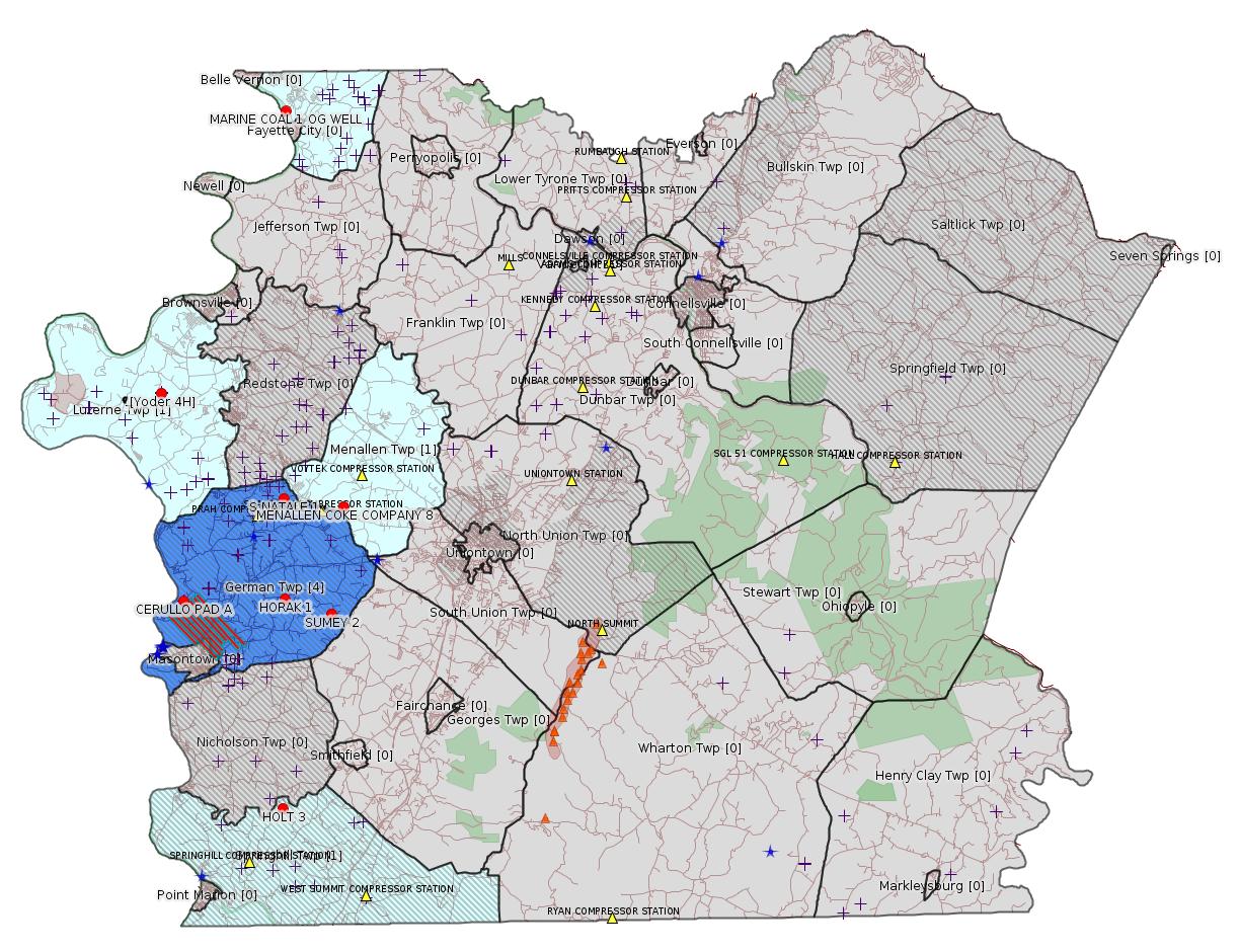
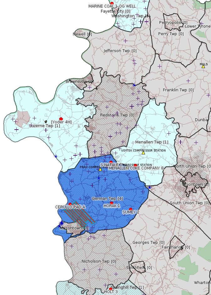
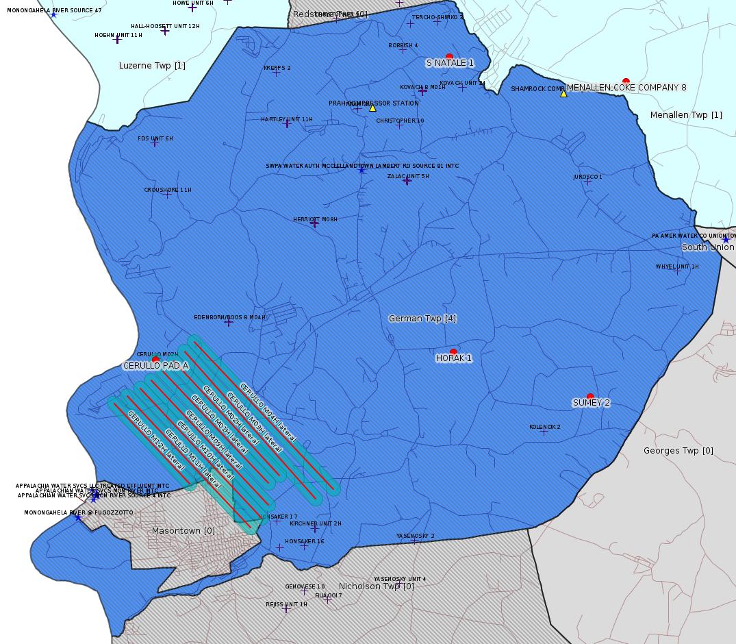
Map
Key
Red dots: items in this permit list with an exact location.
Blue stars: Marcellus Gas Well Water Sources.
Where well laterals are mapped they show in red; a 400-foot buffer surrounding the lateral shows in blue (lavender where it overlaps a mapped mineral tract).
Where mineral tracts are mapped, they show in pink. Mineral tracts can overlap; the overlap will show in red. The precise meaning of "mineral tract" is not clear.
Municipality shading: number of "facilities", with each well counting separately
(includes the red dots):
gray: 0
pale turquoise: 1
turquoise: 2
pale blue: 3
middle blue: 4
dark blue: 5
dark purple: 6
purple: 18
(Color coding may differ from one issue to the next.)
(Note if a project spans multiple municipalities -- e.g. a pipeline -- it will show in the count for each municipality.)
The number of facilities also follows the municipality name in brackets.
Municipality counts are based on the way the permit is listed by DEP; DEP has been known to get a municipality wrong.
Locations in brackets identify a precise location used to locate a surrogate for the actual site being permitted (e.g. locating a well pad or pipeline by the known location of a well.) Locations labeled beginning with "~" and ending in "[?]" are approximate and speculative based on inferences using on-line property and lease records. These are marked in the text as "[Approximate, Speculative]
Cross-hatching: Environmental Justice Areas
Yellow triangles: Compressor Stations
Orange triangles: Storage Field Wells (currently Dominion North Summit Storage Field)
Crosses: SPUD Unconventional well permits
Green: "Natural areas", e.g. state game lands, state forests
Yellow triangles: Compressor Stations
Orange triangles: Storage Field Wells (currently Dominion North Summit Storage Field)
Crosses: SPUD Unconventional well permits
Green: "Natural areas", e.g. state game lands, state forests
More Maps
 |
 |
Source: Pennsylvania Bulletin
NOTICES
DEPARTMENT OF
ENVIRONMENTAL PROTECTION
Residual Waste General Permit WMGR123; Base Permit Renewal with Revisions
[50 Pa.B. 7249]
[Saturday, December 19, 2020]
Under the authority of the Solid Waste Management Act (35 P.S. §§ 6018.101—6018.1003) and the Municipal Waste Planning, Recycling and Waste Reduction Act (53 P.S. §§ 4000.101—4000.1904), the Department of Environmental Protection (Department) is providing notice of the renewal of General Permit No. WMGR123 with revisions. This revised general permit will take effect Monday, January 4, 2021. This general permit authorizes permittees to process, transfer and beneficially use oil and gas liquid waste to develop or hydraulically fracture an oil or gas well. The revisions to WMGR123 consist of the following:
• Clarification to the proposed definitions for ''processing,'' ''transfer'' and ''oil and gas liquid waste.''
• Minor updates to clarify the difference between a ''unit'' which pertains to structures used to contain de-wasted oil and gas liquid waste, and a ''facility'' which pertains to an operation that processes or transfers oil and gas liquid waste.
• Minor updates to terminology referencing de-wasted material and oil and gas liquid waste.
• Removal of proposed conditions that allowed for WMGR123 permittees processing oil and gas liquid waste to meet Appendix A limits for de-wasting to request a reduced sampling and analysis frequency and reduced parameter list.
• Addition of standard language that would allow for clearances provided by the Pennsylvania Natural Heritage Program to be considered during a Pennsylvania Natural Diversity Inventory (PNDI) review.
• Addition of language that would allow Radiation Protection Actions Plans to be maintained in an electronic format on sites where an office or building is not located onsite, provided the plan is available at the facility at all times, and to allow for electronic copies of the plan to be provided to the Department upon request.
• Addition of language to allow all records that are required to be maintained by permittees to be maintained in either hard copy or an electronic format.
• Inclusion of minor updates to references to the Oil and Gas Act (58 Pa.C.S. 2301—3504 (relating to oil and gas).
• Inclusion of a minor clarification to Condition C.22., relating to inspection requirements for WMGR123 operations located on a well pad that are not actively processing or transferring (storing) oil and gas liquid waste.
• Addition of two conditions that would require Department notification of the beginning of construction activities and certification of equipment installation at WMGR123 operations prior to processing or transfer, as requested by regional office staff.
• Addition of Condition C.27 that states permittees are not authorized to use open-top storage tanks or any other air contamination sources under the terms of WMGR123 unless the facility demonstrates that the open top tanks or sources are in compliance with 25 Pa. Code Subpart C, Article III (relating to air resources), pertaining to air emissions.
• Addition of Condition E.3. that would require permittees to immediately notify the Department in the event that the maximum volume of processed and unprocessed oil and gas liquid waste utilized in approved bonding calculations are exceeded.
Persons interested in reviewing the general permit may contact Chris Solloway at csolloway@pa.gov, (717) 787-7381 or Environmental Group Manager, Permits Section, Division of Municipal and Residual Waste, Bureau of Waste Management, P.O. Box 69170, Harrisburg, PA 17106-9170.
Persons in need of accommodations as provided for in the Americans with Disabilities Act of 1990 should contact Chris Solloway at (717) 787-7381 or through the Pennsylvania AT&T Relay Service at (800) 654-5984 (TDD users) or (800) 654-5988 (voice users) to discuss how the Department may accommodate their needs.
PATRICK McDONNELL,
Secretary
<http://www.pacodeandbulletin.gov/Display/pabull?file=/secure/pabulletin/data/vol50/50-51/1781.html>
[See Notes.]
-------------------------
Source: eNOTICE
(+ PA
Oil and Gas Mapping, Well
Pad Report.) Well Details via Data
Portal Services: Oil and Gas Wells All (ID: 3).
Please see the Disclaimer below regarding Parcel Id data.
Authorization ID: 1336816
Permit number: 051-24723
Site: MARINE COAL 1 OG WELL
Client: WASHINGTON ENERGY CO LLC
Authorization type: Drill & Operate Well Permit Adoption
Application type: New
Authorization is for: FACILITY
Date received: 10/19/2020
Status: Pending
Permit Decision Guarantee Applies: No
Sub-Facilities for Authorization:
Sub-Facility ID Sub-Facility Name Description
1320293 MARINE COAL 1 OG WELL Well
Permit Review Notes:
Date Review Note
12/17/2020 The technical review and decision review are complete and either the permit decision and/or permit issuance are forthcoming.
12/17/2020 The permit application package is complete, has been accepted, and is undergoing technical review.
<https://www.ahs.dep.pa.gov/eFACTSWeb/searchResults_singleAuth.aspx?AuthID=1336816>
Site Programs:
Oil & Gas
Site Municipalities:
Washington Twp, Fayette County
Well Details:
Permit Number: 051-24723
Well Name: MARINE COAL 1 OG WELL
Unconventional Well: N
Well Configuration: Vertical Well
Well Type: GAS
Well Status: Active
Coal Association:
Conservation Well: N
Primary Facility ID: 846196
Site ID: 846660
Site Name: MARINE COAL 1 OG WELL
Well Pad ID: 0
Well Pad Name:
Storage Field:
Operator: WASHINGTON ENERGY CO LLC
Operator Number: OGO-36506
Permit Date:
Permit Date Expires:
SPUD Date:
Date Plugged:
UIC ID:
UIC Type:
Surface Elevation: 0
County: Fayette
Municipality: Washington Twp
Location: 40.10928,-79.84455
Map URL: <http://www.openstreetmap.org/?mlat=40.10928&mlon=-79.84455#map=15/40.10928/-79.84455>
Presumed Parcel Id: 41100059
---
Authorization ID: 1334873
Permit number: ESX18-051-0004
Site: CERULLO PAD A ESCGP ESX18-051-0004
Client: CHEVRON APPALACHIA LLC
Authorization type: Expedited E&S Stormwater General Permit 1
Application type: Notification
Authorization is for: SITE
Date received: 12/01/2020
Status: Pending
Permit Decision Guarantee Applies: No
Permit Review Notes:
Date Review Note
12/1/2020 The permit application package is complete, has been accepted, and is undergoing technical review.
<https://www.ahs.dep.pa.gov/eFACTSWeb/searchResults_singleAuth.aspx?AuthID=1334873>
Site Programs:
Oil & Gas
Site Municipalities:
German Twp, Fayette County
Wells on this pad:
051-24690 CERULLO M09H
051-24691 CERULLO M10H
051-24692 CERULLO M03H
051-24693 CERULLO M01H
051-24694 CERULLO M04H
051-24695 CERULLO M02H
051-24696 CERULLO M11H
051-24697 CERULLO M12H
Location: 39.875992,-79.911644
Map URL;
<http://www.openstreetmap.org/?mlat=39.875992&mlon=-79.911644#map=15/39.875992/-79.911644>
Presumed Parcel Id: 15190070
[See Notes.]
---
Authorization ID: 1333788
Permit number: ESG072619001-00
Site: Yoder Well Connect
Client: LAUREL MTN MIDSTREAM OPR LLC
Authorization type: Erosion and Sediment Control General Permit 3
Application type: Notification
Authorization is for: SITE
Date received: 11/16/2020
Status: Pending
Permit Decision Guarantee Applies: No
Permit Review Notes:
Date Review Note
11/16/2020 The permit application package is complete, has been accepted, and is undergoing technical review.
<https://www.ahs.dep.pa.gov/eFACTSWeb/searchResults_singleAuth.aspx?AuthID=1333788>
Site Programs:
Site Municipalities:
Luzerne Twp, Fayette County
-------------------------
OPERATOR: THE PRODUCTION CO LLC
INSPECTION_ID: 3109355
INSPECTION_DATE: 11/17/2020
INSPECTION_TYPE: Routine/Complete Inspection
API_PERMIT: 051-00119
FARM_NAME: S NATALE 1
UNCONVENTIONAL: No
SITE_ID: 40797
SITE_NAME: S NATALE 1 WELL
FACILITY_TYPE: Oil & Gas Location
INSPECTION_CATEGORY: Primary Facility
REGION: EP DOGO SWDO Dstr Off
COUNTY: Fayette
MUNICIPALITY: German Twp
INSPECTOR: WOODS, MATTHEW
INSPECTION_SOURCE: SUBSAIR
INSPECTION_RESULT_DESCRIPTION: Violation(s) Noted
INSPECTION_COMMENT: "Well is in production.
Well is leaking from the swedge and plug on top of well head. The Department request the operator submit a plan to address the leak with the NOV response.
No MIA or APR submitted to dept since 2017."
VIOLATION_ID: 902650
VIOLATION_DATE: 11/17/2020
VIOLATION_CODE: 78.73(a) - GENERAL PROVISION FOR WELL CONSTRUCTION AND OPERATION - Operator failed to construct and operate the well in accordance with 25 Pa. Code Chapter 78 and ensure that the integrity of the well is maintained and health, safety, environment and property are protected.
VIOLATION_TYPE: Environmental Health & Safety
VIOLATION_COMMENT:
RESOLVED_DATE:
RESOLUTION_REASON_CODE_DESC:
CONTINUING_VIOLATION:
ENFORCEMENT_ID:
ENFORCEMENT_CODE_DESCRIPTION:
DATE_EXECUTED:
ENFORCEMENT_FINAL_DATE:
ENFORCEMENT_FINAL_STATUS:
PENALTY_FINAL_DATE:
PENALTY_FINAL_STATUS_CODE_DESC:
PENALTY_AMOUNT:
TOTAL_AMOUNT_COLLECTED:
VIOLATION_ID: 902649
VIOLATION_DATE: 11/17/2020
VIOLATION_CODE: 78.121(B) - WELL REPORTING – PRODUCTION REPORTING – Operator failed to electronically submit production and status report to the Department through its web site.
VIOLATION_TYPE: Administrative
VIOLATION_COMMENT:
RESOLVED_DATE:
RESOLUTION_REASON_CODE_DESC:
CONTINUING_VIOLATION:
ENFORCEMENT_ID:
ENFORCEMENT_CODE_DESCRIPTION:
DATE_EXECUTED:
ENFORCEMENT_FINAL_DATE:
ENFORCEMENT_FINAL_STATUS:
PENALTY_FINAL_DATE:
PENALTY_FINAL_STATUS_CODE_DESC:
PENALTY_AMOUNT:
TOTAL_AMOUNT_COLLECTED:
VIOLATION_ID: 902648
VIOLATION_DATE: 11/17/2020
VIOLATION_CODE: 78.88(e) - OPERATING WELLS - MECHANICAL INTEGRITY OF OPERATING WELLS - Operator failed to submit an annual report to the Department identifying the compliance status of each well with the mechanical integrity requirements for structurally sound wells in compliance with 25 Pa. Code Section 78.73(c).
VIOLATION_TYPE: Administrative
VIOLATION_COMMENT:
RESOLVED_DATE:
RESOLUTION_REASON_CODE_DESC:
CONTINUING_VIOLATION:
ENFORCEMENT_ID:
ENFORCEMENT_CODE_DESCRIPTION:
DATE_EXECUTED:
ENFORCEMENT_FINAL_DATE:
ENFORCEMENT_FINAL_STATUS:
PENALTY_FINAL_DATE:
PENALTY_FINAL_STATUS_CODE_DESC:
PENALTY_AMOUNT:
TOTAL_AMOUNT_COLLECTED:
VIOLATION_ID: 902647
VIOLATION_DATE: 11/17/2020
VIOLATION_CODE: OGA3211(H) - WELL PERMITS - LABELING - Failure to install, in a permanent manner, the permit number on a completed well.
VIOLATION_TYPE: Administrative
VIOLATION_COMMENT:
RESOLVED_DATE:
RESOLUTION_REASON_CODE_DESC:
CONTINUING_VIOLATION:
ENFORCEMENT_ID:
ENFORCEMENT_CODE_DESCRIPTION:
DATE_EXECUTED:
ENFORCEMENT_FINAL_DATE:
ENFORCEMENT_FINAL_STATUS:
PENALTY_FINAL_DATE:
PENALTY_FINAL_STATUS_CODE_DESC:
PENALTY_AMOUNT:
TOTAL_AMOUNT_COLLECTED:
Well Details:
Permit Number: 051-00119
Well Name: S NATALE 1
Unconventional Well: N
Well Configuration: Vertical Well
Well Type: GAS
Well Status: Active
Coal Association: Coal
Conservation Well: N
Primary Facility ID: 42549
Site ID: 40797
Site Name: S NATALE 1 WELL
Well Pad ID: 0
Well Pad Name:
Storage Field:
Operator: THE PRODUCTION CO LLC
Operator Number: OGO-39567
Permit Date: 1986-05-14
Permit Date Expires:
SPUD Date: 1800-01-01
Date Plugged:
UIC ID:
UIC Type:
Surface Elevation: 0
County: Fayette
Municipality: German Twp
Location: 39.924399,-79.849001
Map URL: <http://www.openstreetmap.org/?mlat=39.924399&mlon=-79.849001#map=15/39.924399/-79.849001>
Presumed Parcel Id: 15010043
---
OPERATOR: THE PRODUCTION CO LLC
INSPECTION_ID: 3109356
INSPECTION_DATE: 11/17/2020
INSPECTION_TYPE: Routine/Complete Inspection
API_PERMIT: 051-23871
FARM_NAME: MENALLEN COKE COMPANY 8
UNCONVENTIONAL: No
SITE_ID: 698346
SITE_NAME: MENALLEN COKE COMPANY 8 OG WELL
FACILITY_TYPE: Oil & Gas Location
INSPECTION_CATEGORY: Primary Facility
REGION: EP DOGO SWDO Dstr Off
COUNTY: Fayette
MUNICIPALITY: Menallen Twp
INSPECTOR: WOODS, MATTHEW
INSPECTION_SOURCE: SUBSAIR
INSPECTION_RESULT_DESCRIPTION: Violation(s) Noted
INSPECTION_COMMENT: "Well is drilled but never setup for production.
Operator failed to plug well after abandonment."
VIOLATION_ID: 901409
VIOLATION_DATE: 11/17/2020
VIOLATION_CODE: OGA3220(A) - PLUGGING REQUIREMENTS - Failure to plug the well upon abandoning it.
VIOLATION_TYPE: Environmental Health & Safety
VIOLATION_COMMENT:
RESOLVED_DATE:
RESOLUTION_REASON_CODE_DESC:
CONTINUING_VIOLATION:
ENFORCEMENT_ID: 390762
ENFORCEMENT_CODE_DESCRIPTION: NOV - Notice of Violation
DATE_EXECUTED: 12/15/2020
ENFORCEMENT_FINAL_DATE:
ENFORCEMENT_FINAL_STATUS:
PENALTY_FINAL_DATE:
PENALTY_FINAL_STATUS_CODE_DESC:
PENALTY_AMOUNT:
TOTAL_AMOUNT_COLLECTED:
Well Details:
Permit Number: 051-23871
Well Name: MENALLEN COKE COMPANY 8
Unconventional Well: N
Well Configuration: Vertical Well
Well Type: GAS
Well Status: Active
Coal Association: NonCoal
Conservation Well: N
Primary Facility ID: 700451
Site ID: 698346
Site Name: MENALLEN COKE COMPANY 8 OG WELL
Well Pad ID: 0
Well Pad Name:
Storage Field:
Operator: THE PRODUCTION CO LLC
Operator Number: OGO-39567
Permit Date: 2007-12-13
Permit Date Expires: 2008-12-13
SPUD Date: 1800-01-01
Date Plugged:
UIC ID:
UIC Type:
Surface Elevation: 1101
County: Fayette
Municipality: Menallen Twp
Location: 39.920129,-79.811918
Map URL: <http://www.openstreetmap.org/?mlat=39.920129&mlon=-79.811918#map=15/39.920129/-79.811918>
Presumed Parcel Id: 22090061
---
OPERATOR: DIVERSIFIED OIL & GAS LLC
INSPECTION_ID: 3115405
INSPECTION_DATE: 12/02/2020
INSPECTION_TYPE: Incident- Response to Accident or Event
API_PERMIT: 051-23203
FARM_NAME: HOLT 3
UNCONVENTIONAL: No
SITE_ID: 669108
SITE_NAME: HOLT 3 OG WELL
FACILITY_TYPE: Oil & Gas Location
INSPECTION_CATEGORY: Primary Facility
REGION: EP DOGO SWDO Dstr Off
COUNTY: Fayette
MUNICIPALITY: Springhill Twp
INSPECTOR: VIRRUET, IVAN
INSPECTION_SOURCE: SUBSAIR
INSPECTION_RESULT_DESCRIPTION: No Violations Noted
INSPECTION_COMMENT: "On 12/2/2020 at 11:15am I arrived on location to conduct an inspection.Diversified stated a nearby compressor station had gone down, causing well to vent and prevent and avoid over pressuring the field. The compressor has since been repaired.
The well head had some rust; however, appeared to be in working order showing no obvious signs of leaking. The associated GPU was also found to be in good working order. There was some rust noted on the lines and the tank as seen in picture 3. The Altair didn't show any stray gas leaks at the well or the GPU."
Well Details:
Permit Number: 051-23203
Well Name: HOLT 3
Unconventional Well: N
Well Configuration: Vertical Well
Well Type: GAS
Well Status: Active
Coal Association: Coal
Conservation Well: N
Primary Facility ID: 678083
Site ID: 669108
Site Name: HOLT 3 OG WELL
Well Pad ID: 0
Well Pad Name:
Storage Field:
Operator: DIVERSIFIED OIL & GAS LLC
Operator Number: OGO-68792
Permit Date: 2006-03-27
Permit Date Expires: 2007-03-27
SPUD Date: 2006-06-08
Date Plugged:
UIC ID:
UIC Type:
Surface Elevation: 1045
County: Fayette
Municipality: Springhill Twp
Location: 39.776509,-79.852116
Map URL: <http://www.openstreetmap.org/?mlat=39.776509&mlon=-79.852116#map=15/39.776509/-79.852116>
Presumed Parcel Id: 36070092
[See Notes.]
---
OPERATOR: THE PRODUCTION CO LLC
INSPECTION_ID: 3118517
INSPECTION_DATE: 12/08/2020
INSPECTION_TYPE: Routine/Complete Inspection
API_PERMIT: 051-21574
FARM_NAME: SUMEY 2
UNCONVENTIONAL: No
SITE_ID: 604843
SITE_NAME: SUMEY 2 OG WELL
FACILITY_TYPE: Oil & Gas Location
INSPECTION_CATEGORY: Primary Facility
REGION: EP DOGO SWDO Dstr Off
COUNTY: Fayette
MUNICIPALITY: German Twp
INSPECTOR: WOODS, MATTHEW
INSPECTION_SOURCE: SUBSAIR
INSPECTION_RESULT_DESCRIPTION: Violation(s) Noted
INSPECTION_COMMENT: "Well is in production.
Gas is leaking from line, operator has been contacted to fix the leak. Operator told me he would send someone out To fix the leak. I determined that the leak could be a harm to public safety.
No MIA or APR submitted to dept since 2017."
VIOLATION_ID: 902646
VIOLATION_DATE: 12/08/2020
VIOLATION_CODE: 78.73(a) - GENERAL PROVISION FOR WELL CONSTRUCTION AND OPERATION - Operator failed to construct and operate the well in accordance with 25 Pa. Code Chapter 78 and ensure that the integrity of the well is maintained and health, safety, environment and property are protected.
VIOLATION_TYPE: Environmental Health & Safety
VIOLATION_COMMENT:
RESOLVED_DATE:
RESOLUTION_REASON_CODE_DESC:
CONTINUING_VIOLATION:
ENFORCEMENT_ID:
ENFORCEMENT_CODE_DESCRIPTION:
DATE_EXECUTED:
ENFORCEMENT_FINAL_DATE:
ENFORCEMENT_FINAL_STATUS:
PENALTY_FINAL_DATE:
PENALTY_FINAL_STATUS_CODE_DESC:
PENALTY_AMOUNT:
TOTAL_AMOUNT_COLLECTED:
VIOLATION_ID: 902645
VIOLATION_DATE: 12/08/2020
VIOLATION_CODE: 78.121(B) - WELL REPORTING – PRODUCTION REPORTING – Operator failed to electronically submit production and status report to the Department through its web site.
VIOLATION_TYPE: Administrative
VIOLATION_COMMENT:
RESOLVED_DATE:
RESOLUTION_REASON_CODE_DESC:
CONTINUING_VIOLATION:
ENFORCEMENT_ID:
ENFORCEMENT_CODE_DESCRIPTION:
DATE_EXECUTED:
ENFORCEMENT_FINAL_DATE:
ENFORCEMENT_FINAL_STATUS:
PENALTY_FINAL_DATE:
PENALTY_FINAL_STATUS_CODE_DESC:
PENALTY_AMOUNT:
TOTAL_AMOUNT_COLLECTED:
VIOLATION_ID: 902644
VIOLATION_DATE: 12/08/2020
VIOLATION_CODE: 78.88(e) - OPERATING WELLS - MECHANICAL INTEGRITY OF OPERATING WELLS - Operator failed to submit an annual report to the Department identifying the compliance status of each well with the mechanical integrity requirements for structurally sound wells in compliance with 25 Pa. Code Section 78.73(c).
VIOLATION_TYPE: Administrative
VIOLATION_COMMENT:
RESOLVED_DATE:
RESOLUTION_REASON_CODE_DESC:
CONTINUING_VIOLATION:
ENFORCEMENT_ID:
ENFORCEMENT_CODE_DESCRIPTION:
DATE_EXECUTED:
ENFORCEMENT_FINAL_DATE:
ENFORCEMENT_FINAL_STATUS:
PENALTY_FINAL_DATE:
PENALTY_FINAL_STATUS_CODE_DESC:
PENALTY_AMOUNT:
TOTAL_AMOUNT_COLLECTED:
Well Details:
Permit Number: 051-21574
Well Name: SUMEY 2
Unconventional Well: N
Well Configuration: Vertical Well
Well Type: GAS
Well Status: Active
Coal Association: NonCoal
Conservation Well: N
Primary Facility ID: 629301
Site ID: 604843
Site Name: SUMEY 2 OG WELL
Well Pad ID: 0
Well Pad Name:
Storage Field:
Operator: THE PRODUCTION CO LLC
Operator Number: OGO-39567
Permit Date: 2002-09-25
Permit Date Expires: 2004-09-25
SPUD Date: 2004-05-29
Date Plugged:
UIC ID:
UIC Type:
Surface Elevation: 1251
County: Fayette
Municipality: German Twp
Location: 39.869088,-79.820285
Map URL: <http://www.openstreetmap.org/?mlat=39.869088&mlon=-79.820285#map=15/39.869088/-79.820285>
Presumed Parcel Id: 15360037
---
OPERATOR: THE PRODUCTION CO LLC
INSPECTION_ID: 3120611
INSPECTION_DATE: 12/11/2020
INSPECTION_TYPE: Routine/Complete Inspection
API_PERMIT: 051-00197
FARM_NAME: HORAK 1
UNCONVENTIONAL: No
SITE_ID: 40875
SITE_NAME: HORAK 1 WELL
FACILITY_TYPE: Oil & Gas Location
INSPECTION_CATEGORY: Primary Facility
REGION: EP DOGO SWDO Dstr Off
COUNTY: Fayette
MUNICIPALITY: German Twp
INSPECTOR: WOODS, MATTHEW
INSPECTION_SOURCE: SUBSAIR
INSPECTION_RESULT_DESCRIPTION: Violation(s) Noted
INSPECTION_COMMENT: "Well is abandoned.
Production casing can be moved back and forth by hand.
Only APR on file is for 2013.
No MIAs on file with dept."
VIOLATION_ID: 902732
VIOLATION_DATE: 12/11/2020
VIOLATION_CODE: OGA3220(A) - PLUGGING REQUIREMENTS - Failure to plug the well upon abandoning it.
VIOLATION_TYPE: Environmental Health & Safety
VIOLATION_COMMENT:
RESOLVED_DATE:
RESOLUTION_REASON_CODE_DESC:
CONTINUING_VIOLATION:
ENFORCEMENT_ID:
ENFORCEMENT_CODE_DESCRIPTION:
DATE_EXECUTED:
ENFORCEMENT_FINAL_DATE:
ENFORCEMENT_FINAL_STATUS:
PENALTY_FINAL_DATE:
PENALTY_FINAL_STATUS_CODE_DESC:
PENALTY_AMOUNT:
TOTAL_AMOUNT_COLLECTED:
VIOLATION_ID: 902731
VIOLATION_DATE: 12/11/2020
VIOLATION_CODE: 78.121(B) - WELL REPORTING – PRODUCTION REPORTING – Operator failed to electronically submit production and status report to the Department through its web site.
VIOLATION_TYPE: Administrative
VIOLATION_COMMENT:
RESOLVED_DATE:
RESOLUTION_REASON_CODE_DESC:
CONTINUING_VIOLATION:
ENFORCEMENT_ID:
ENFORCEMENT_CODE_DESCRIPTION:
DATE_EXECUTED:
ENFORCEMENT_FINAL_DATE:
ENFORCEMENT_FINAL_STATUS:
PENALTY_FINAL_DATE:
PENALTY_FINAL_STATUS_CODE_DESC:
PENALTY_AMOUNT:
TOTAL_AMOUNT_COLLECTED:
VIOLATION_ID 902730
VIOLATION_DATE 12/11/2020
VIOLATION_CODE 78.88(e) - OPERATING WELLS - MECHANICAL INTEGRITY OF OPERATING WELLS - Operator failed to submit an annual report to the Department identifying the compliance status of each well with the mechanical integrity requirements for structurally sound wells in compliance with 25 Pa. Code Section 78.73(c).
VIOLATION_TYPE Administrative
VIOLATION_COMMENT
RESOLVED_DATE
RESOLUTION_REASON_CODE_DESC
CONTINUING_VIOLATION
ENFORCEMENT_ID
ENFORCEMENT_CODE_DESCRIPTION
DATE_EXECUTED
ENFORCEMENT_FINAL_DATE
ENFORCEMENT_FINAL_STATUS
PENALTY_FINAL_DATE
PENALTY_FINAL_STATUS_CODE_DESC
PENALTY_AMOUNT
TOTAL_AMOUNT_COLLECTED
VIOLATION_ID: 902729
VIOLATION_DATE: 12/11/2020
VIOLATION_CODE: OGA3211(H) - WELL PERMITS - LABELING - Failure to install, in a permanent manner, the permit number on a completed well.
VIOLATION_TYPE: Administrative
VIOLATION_COMMENT:
RESOLVED_DATE:
RESOLUTION_REASON_CODE_DESC:
CONTINUING_VIOLATION:
ENFORCEMENT_ID:
ENFORCEMENT_CODE_DESCRIPTION:
DATE_EXECUTED:
ENFORCEMENT_FINAL_DATE:
ENFORCEMENT_FINAL_STATUS:
PENALTY_FINAL_DATE:
PENALTY_FINAL_STATUS_CODE_DESC:
PENALTY_AMOUNT:
TOTAL_AMOUNT_COLLECTED:
VIOLATION_ID: 902733
VIOLATION_DATE: 12/11/2020
VIOLATION_CODE: 78.91(a) - PLUGGING - GENERAL PROVISIONS - Upon abandoning a well, the owner or operator failed to plug the well to stop the vertical flow of fluids or gas within the well bore under 25 Pa. Code §§ 78.92—78.98 or an approved alternate method.
VIOLATION_TYPE: Environmental Health & Safety
VIOLATION_COMMENT:
RESOLVED_DATE:
RESOLUTION_REASON_CODE_DESC:
CONTINUING_VIOLATION:
ENFORCEMENT_ID:
ENFORCEMENT_CODE_DESCRIPTION:
DATE_EXECUTED:
ENFORCEMENT_FINAL_DATE:
ENFORCEMENT_FINAL_STATUS:
PENALTY_FINAL_DATE:
PENALTY_FINAL_STATUS_CODE_DESC:
PENALTY_AMOUNT:
TOTAL_AMOUNT_COLLECTED:
Well Details:
Permit Number: 051-00197
Well Name: HORAK 1
Unconventional Well: N
Well Configuration: Vertical Well
Well Type: GAS
Well Status: Active
Coal Association: Coal
Conservation Well: N
Primary Facility ID: 42627
Site ID: 40875
Site Name: HORAK 1 WELL
Well Pad ID: 0
Well Pad Name:
Storage Field:
Operator: THE PRODUCTION CO LLC
Operator Number: OGO-39567
Permit Date: 1988-10-13
Permit Date Expires:
SPUD Date: 1800-01-01
Date Plugged:
UIC ID:
UIC Type:
Surface Elevation: 980
County: Fayette
Municipality: German Twp
Location: 39.876607,-79.848993
Map URL: <http://www.openstreetmap.org/?mlat=39.876607&mlon=-79.848993#map=15/39.876607/-79.848993>
Presumed Parcel Id: 15280279
-------------------------
Please see the Disclaimer below regarding Parcel Id data.
Authorization ID: 1336816
Permit number: 051-24723
Site: MARINE COAL 1 OG WELL
Client: WASHINGTON ENERGY CO LLC
Authorization type: Drill & Operate Well Permit Adoption
Application type: New
Authorization is for: FACILITY
Date received: 10/19/2020
Status: Pending
Permit Decision Guarantee Applies: No
Sub-Facilities for Authorization:
Sub-Facility ID Sub-Facility Name Description
1320293 MARINE COAL 1 OG WELL Well
Permit Review Notes:
Date Review Note
12/17/2020 The technical review and decision review are complete and either the permit decision and/or permit issuance are forthcoming.
12/17/2020 The permit application package is complete, has been accepted, and is undergoing technical review.
<https://www.ahs.dep.pa.gov/eFACTSWeb/searchResults_singleAuth.aspx?AuthID=1336816>
Site Programs:
Oil & Gas
Site Municipalities:
Washington Twp, Fayette County
Well Details:
Permit Number: 051-24723
Well Name: MARINE COAL 1 OG WELL
Unconventional Well: N
Well Configuration: Vertical Well
Well Type: GAS
Well Status: Active
Coal Association:
Conservation Well: N
Primary Facility ID: 846196
Site ID: 846660
Site Name: MARINE COAL 1 OG WELL
Well Pad ID: 0
Well Pad Name:
Storage Field:
Operator: WASHINGTON ENERGY CO LLC
Operator Number: OGO-36506
Permit Date:
Permit Date Expires:
SPUD Date:
Date Plugged:
UIC ID:
UIC Type:
Surface Elevation: 0
County: Fayette
Municipality: Washington Twp
Location: 40.10928,-79.84455
Map URL: <http://www.openstreetmap.org/?mlat=40.10928&mlon=-79.84455#map=15/40.10928/-79.84455>
Presumed Parcel Id: 41100059
---
Authorization ID: 1334873
Permit number: ESX18-051-0004
Site: CERULLO PAD A ESCGP ESX18-051-0004
Client: CHEVRON APPALACHIA LLC
Authorization type: Expedited E&S Stormwater General Permit 1
Application type: Notification
Authorization is for: SITE
Date received: 12/01/2020
Status: Pending
Permit Decision Guarantee Applies: No
Permit Review Notes:
Date Review Note
12/1/2020 The permit application package is complete, has been accepted, and is undergoing technical review.
<https://www.ahs.dep.pa.gov/eFACTSWeb/searchResults_singleAuth.aspx?AuthID=1334873>
Site Programs:
Oil & Gas
Site Municipalities:
German Twp, Fayette County
Wells on this pad:
051-24690 CERULLO M09H
051-24691 CERULLO M10H
051-24692 CERULLO M03H
051-24693 CERULLO M01H
051-24694 CERULLO M04H
051-24695 CERULLO M02H
051-24696 CERULLO M11H
051-24697 CERULLO M12H
Location: 39.875992,-79.911644
Map URL;
Presumed Parcel Id: 15190070
[See Notes.]
---
Authorization ID: 1333788
Permit number: ESG072619001-00
Site: Yoder Well Connect
Client: LAUREL MTN MIDSTREAM OPR LLC
Authorization type: Erosion and Sediment Control General Permit 3
Application type: Notification
Authorization is for: SITE
Date received: 11/16/2020
Status: Pending
Permit Decision Guarantee Applies: No
Permit Review Notes:
Date Review Note
11/16/2020 The permit application package is complete, has been accepted, and is undergoing technical review.
<https://www.ahs.dep.pa.gov/eFACTSWeb/searchResults_singleAuth.aspx?AuthID=1333788>
Site Programs:
Site Municipalities:
Luzerne Twp, Fayette County
Location [of
Yoder 4H]: 39.975564,-79.923878
Original Permit Public Permit Review:
<http://www.ahs.dep.pa.gov/ePermitPublicAccess/Public/PublicAuthOverview?q=IaU%2f3WrsAk6%2bDzk7TzVSzQ%3d%3d>
Project Topographic Map:
<http://www.ahs.dep.pa.gov/ePermitPublicAccess/Permit/DownloadFileFromOnBase/13039>
Original Permit Project Information:
Laurel Mountain Midstream Operating LLC (Williams) is proposing the Yoder Well Connect Pipeline Project, which consists of construction of one (1) approximately 6,266-LF 16-inch steel gas line to link the existing Yoder Well Pad (ESX15-051-0007) to the existing Williams West Dogbone pipeline (ESX10-051-0041). A vegetated surface site is also proposed at the tie-in to the West Dogbone Pipeline.
-------------------------
OPERATOR: THE PRODUCTION CO LLC
INSPECTION_ID: 3109355
INSPECTION_DATE: 11/17/2020
INSPECTION_TYPE: Routine/Complete Inspection
API_PERMIT: 051-00119
FARM_NAME: S NATALE 1
UNCONVENTIONAL: No
SITE_ID: 40797
SITE_NAME: S NATALE 1 WELL
FACILITY_TYPE: Oil & Gas Location
INSPECTION_CATEGORY: Primary Facility
REGION: EP DOGO SWDO Dstr Off
COUNTY: Fayette
MUNICIPALITY: German Twp
INSPECTOR: WOODS, MATTHEW
INSPECTION_SOURCE: SUBSAIR
INSPECTION_RESULT_DESCRIPTION: Violation(s) Noted
INSPECTION_COMMENT: "Well is in production.
Well is leaking from the swedge and plug on top of well head. The Department request the operator submit a plan to address the leak with the NOV response.
No MIA or APR submitted to dept since 2017."
VIOLATION_ID: 902650
VIOLATION_DATE: 11/17/2020
VIOLATION_CODE: 78.73(a) - GENERAL PROVISION FOR WELL CONSTRUCTION AND OPERATION - Operator failed to construct and operate the well in accordance with 25 Pa. Code Chapter 78 and ensure that the integrity of the well is maintained and health, safety, environment and property are protected.
VIOLATION_TYPE: Environmental Health & Safety
VIOLATION_COMMENT:
RESOLVED_DATE:
RESOLUTION_REASON_CODE_DESC:
CONTINUING_VIOLATION:
ENFORCEMENT_ID:
ENFORCEMENT_CODE_DESCRIPTION:
DATE_EXECUTED:
ENFORCEMENT_FINAL_DATE:
ENFORCEMENT_FINAL_STATUS:
PENALTY_FINAL_DATE:
PENALTY_FINAL_STATUS_CODE_DESC:
PENALTY_AMOUNT:
TOTAL_AMOUNT_COLLECTED:
VIOLATION_ID: 902649
VIOLATION_DATE: 11/17/2020
VIOLATION_CODE: 78.121(B) - WELL REPORTING – PRODUCTION REPORTING – Operator failed to electronically submit production and status report to the Department through its web site.
VIOLATION_TYPE: Administrative
VIOLATION_COMMENT:
RESOLVED_DATE:
RESOLUTION_REASON_CODE_DESC:
CONTINUING_VIOLATION:
ENFORCEMENT_ID:
ENFORCEMENT_CODE_DESCRIPTION:
DATE_EXECUTED:
ENFORCEMENT_FINAL_DATE:
ENFORCEMENT_FINAL_STATUS:
PENALTY_FINAL_DATE:
PENALTY_FINAL_STATUS_CODE_DESC:
PENALTY_AMOUNT:
TOTAL_AMOUNT_COLLECTED:
VIOLATION_ID: 902648
VIOLATION_DATE: 11/17/2020
VIOLATION_CODE: 78.88(e) - OPERATING WELLS - MECHANICAL INTEGRITY OF OPERATING WELLS - Operator failed to submit an annual report to the Department identifying the compliance status of each well with the mechanical integrity requirements for structurally sound wells in compliance with 25 Pa. Code Section 78.73(c).
VIOLATION_TYPE: Administrative
VIOLATION_COMMENT:
RESOLVED_DATE:
RESOLUTION_REASON_CODE_DESC:
CONTINUING_VIOLATION:
ENFORCEMENT_ID:
ENFORCEMENT_CODE_DESCRIPTION:
DATE_EXECUTED:
ENFORCEMENT_FINAL_DATE:
ENFORCEMENT_FINAL_STATUS:
PENALTY_FINAL_DATE:
PENALTY_FINAL_STATUS_CODE_DESC:
PENALTY_AMOUNT:
TOTAL_AMOUNT_COLLECTED:
VIOLATION_ID: 902647
VIOLATION_DATE: 11/17/2020
VIOLATION_CODE: OGA3211(H) - WELL PERMITS - LABELING - Failure to install, in a permanent manner, the permit number on a completed well.
VIOLATION_TYPE: Administrative
VIOLATION_COMMENT:
RESOLVED_DATE:
RESOLUTION_REASON_CODE_DESC:
CONTINUING_VIOLATION:
ENFORCEMENT_ID:
ENFORCEMENT_CODE_DESCRIPTION:
DATE_EXECUTED:
ENFORCEMENT_FINAL_DATE:
ENFORCEMENT_FINAL_STATUS:
PENALTY_FINAL_DATE:
PENALTY_FINAL_STATUS_CODE_DESC:
PENALTY_AMOUNT:
TOTAL_AMOUNT_COLLECTED:
Well Details:
Permit Number: 051-00119
Well Name: S NATALE 1
Unconventional Well: N
Well Configuration: Vertical Well
Well Type: GAS
Well Status: Active
Coal Association: Coal
Conservation Well: N
Primary Facility ID: 42549
Site ID: 40797
Site Name: S NATALE 1 WELL
Well Pad ID: 0
Well Pad Name:
Storage Field:
Operator: THE PRODUCTION CO LLC
Operator Number: OGO-39567
Permit Date: 1986-05-14
Permit Date Expires:
SPUD Date: 1800-01-01
Date Plugged:
UIC ID:
UIC Type:
Surface Elevation: 0
County: Fayette
Municipality: German Twp
Location: 39.924399,-79.849001
Map URL: <http://www.openstreetmap.org/?mlat=39.924399&mlon=-79.849001#map=15/39.924399/-79.849001>
Presumed Parcel Id: 15010043
---
OPERATOR: THE PRODUCTION CO LLC
INSPECTION_ID: 3109356
INSPECTION_DATE: 11/17/2020
INSPECTION_TYPE: Routine/Complete Inspection
API_PERMIT: 051-23871
FARM_NAME: MENALLEN COKE COMPANY 8
UNCONVENTIONAL: No
SITE_ID: 698346
SITE_NAME: MENALLEN COKE COMPANY 8 OG WELL
FACILITY_TYPE: Oil & Gas Location
INSPECTION_CATEGORY: Primary Facility
REGION: EP DOGO SWDO Dstr Off
COUNTY: Fayette
MUNICIPALITY: Menallen Twp
INSPECTOR: WOODS, MATTHEW
INSPECTION_SOURCE: SUBSAIR
INSPECTION_RESULT_DESCRIPTION: Violation(s) Noted
INSPECTION_COMMENT: "Well is drilled but never setup for production.
Operator failed to plug well after abandonment."
VIOLATION_ID: 901409
VIOLATION_DATE: 11/17/2020
VIOLATION_CODE: OGA3220(A) - PLUGGING REQUIREMENTS - Failure to plug the well upon abandoning it.
VIOLATION_TYPE: Environmental Health & Safety
VIOLATION_COMMENT:
RESOLVED_DATE:
RESOLUTION_REASON_CODE_DESC:
CONTINUING_VIOLATION:
ENFORCEMENT_ID: 390762
ENFORCEMENT_CODE_DESCRIPTION: NOV - Notice of Violation
DATE_EXECUTED: 12/15/2020
ENFORCEMENT_FINAL_DATE:
ENFORCEMENT_FINAL_STATUS:
PENALTY_FINAL_DATE:
PENALTY_FINAL_STATUS_CODE_DESC:
PENALTY_AMOUNT:
TOTAL_AMOUNT_COLLECTED:
Well Details:
Permit Number: 051-23871
Well Name: MENALLEN COKE COMPANY 8
Unconventional Well: N
Well Configuration: Vertical Well
Well Type: GAS
Well Status: Active
Coal Association: NonCoal
Conservation Well: N
Primary Facility ID: 700451
Site ID: 698346
Site Name: MENALLEN COKE COMPANY 8 OG WELL
Well Pad ID: 0
Well Pad Name:
Storage Field:
Operator: THE PRODUCTION CO LLC
Operator Number: OGO-39567
Permit Date: 2007-12-13
Permit Date Expires: 2008-12-13
SPUD Date: 1800-01-01
Date Plugged:
UIC ID:
UIC Type:
Surface Elevation: 1101
County: Fayette
Municipality: Menallen Twp
Location: 39.920129,-79.811918
Map URL: <http://www.openstreetmap.org/?mlat=39.920129&mlon=-79.811918#map=15/39.920129/-79.811918>
Presumed Parcel Id: 22090061
---
OPERATOR: DIVERSIFIED OIL & GAS LLC
INSPECTION_ID: 3115405
INSPECTION_DATE: 12/02/2020
INSPECTION_TYPE: Incident- Response to Accident or Event
API_PERMIT: 051-23203
FARM_NAME: HOLT 3
UNCONVENTIONAL: No
SITE_ID: 669108
SITE_NAME: HOLT 3 OG WELL
FACILITY_TYPE: Oil & Gas Location
INSPECTION_CATEGORY: Primary Facility
REGION: EP DOGO SWDO Dstr Off
COUNTY: Fayette
MUNICIPALITY: Springhill Twp
INSPECTOR: VIRRUET, IVAN
INSPECTION_SOURCE: SUBSAIR
INSPECTION_RESULT_DESCRIPTION: No Violations Noted
INSPECTION_COMMENT: "On 12/2/2020 at 11:15am I arrived on location to conduct an inspection.Diversified stated a nearby compressor station had gone down, causing well to vent and prevent and avoid over pressuring the field. The compressor has since been repaired.
The well head had some rust; however, appeared to be in working order showing no obvious signs of leaking. The associated GPU was also found to be in good working order. There was some rust noted on the lines and the tank as seen in picture 3. The Altair didn't show any stray gas leaks at the well or the GPU."
Well Details:
Permit Number: 051-23203
Well Name: HOLT 3
Unconventional Well: N
Well Configuration: Vertical Well
Well Type: GAS
Well Status: Active
Coal Association: Coal
Conservation Well: N
Primary Facility ID: 678083
Site ID: 669108
Site Name: HOLT 3 OG WELL
Well Pad ID: 0
Well Pad Name:
Storage Field:
Operator: DIVERSIFIED OIL & GAS LLC
Operator Number: OGO-68792
Permit Date: 2006-03-27
Permit Date Expires: 2007-03-27
SPUD Date: 2006-06-08
Date Plugged:
UIC ID:
UIC Type:
Surface Elevation: 1045
County: Fayette
Municipality: Springhill Twp
Location: 39.776509,-79.852116
Map URL: <http://www.openstreetmap.org/?mlat=39.776509&mlon=-79.852116#map=15/39.776509/-79.852116>
Presumed Parcel Id: 36070092
[See Notes.]
---
OPERATOR: THE PRODUCTION CO LLC
INSPECTION_ID: 3118517
INSPECTION_DATE: 12/08/2020
INSPECTION_TYPE: Routine/Complete Inspection
API_PERMIT: 051-21574
FARM_NAME: SUMEY 2
UNCONVENTIONAL: No
SITE_ID: 604843
SITE_NAME: SUMEY 2 OG WELL
FACILITY_TYPE: Oil & Gas Location
INSPECTION_CATEGORY: Primary Facility
REGION: EP DOGO SWDO Dstr Off
COUNTY: Fayette
MUNICIPALITY: German Twp
INSPECTOR: WOODS, MATTHEW
INSPECTION_SOURCE: SUBSAIR
INSPECTION_RESULT_DESCRIPTION: Violation(s) Noted
INSPECTION_COMMENT: "Well is in production.
Gas is leaking from line, operator has been contacted to fix the leak. Operator told me he would send someone out To fix the leak. I determined that the leak could be a harm to public safety.
No MIA or APR submitted to dept since 2017."
VIOLATION_ID: 902646
VIOLATION_DATE: 12/08/2020
VIOLATION_CODE: 78.73(a) - GENERAL PROVISION FOR WELL CONSTRUCTION AND OPERATION - Operator failed to construct and operate the well in accordance with 25 Pa. Code Chapter 78 and ensure that the integrity of the well is maintained and health, safety, environment and property are protected.
VIOLATION_TYPE: Environmental Health & Safety
VIOLATION_COMMENT:
RESOLVED_DATE:
RESOLUTION_REASON_CODE_DESC:
CONTINUING_VIOLATION:
ENFORCEMENT_ID:
ENFORCEMENT_CODE_DESCRIPTION:
DATE_EXECUTED:
ENFORCEMENT_FINAL_DATE:
ENFORCEMENT_FINAL_STATUS:
PENALTY_FINAL_DATE:
PENALTY_FINAL_STATUS_CODE_DESC:
PENALTY_AMOUNT:
TOTAL_AMOUNT_COLLECTED:
VIOLATION_ID: 902645
VIOLATION_DATE: 12/08/2020
VIOLATION_CODE: 78.121(B) - WELL REPORTING – PRODUCTION REPORTING – Operator failed to electronically submit production and status report to the Department through its web site.
VIOLATION_TYPE: Administrative
VIOLATION_COMMENT:
RESOLVED_DATE:
RESOLUTION_REASON_CODE_DESC:
CONTINUING_VIOLATION:
ENFORCEMENT_ID:
ENFORCEMENT_CODE_DESCRIPTION:
DATE_EXECUTED:
ENFORCEMENT_FINAL_DATE:
ENFORCEMENT_FINAL_STATUS:
PENALTY_FINAL_DATE:
PENALTY_FINAL_STATUS_CODE_DESC:
PENALTY_AMOUNT:
TOTAL_AMOUNT_COLLECTED:
VIOLATION_ID: 902644
VIOLATION_DATE: 12/08/2020
VIOLATION_CODE: 78.88(e) - OPERATING WELLS - MECHANICAL INTEGRITY OF OPERATING WELLS - Operator failed to submit an annual report to the Department identifying the compliance status of each well with the mechanical integrity requirements for structurally sound wells in compliance with 25 Pa. Code Section 78.73(c).
VIOLATION_TYPE: Administrative
VIOLATION_COMMENT:
RESOLVED_DATE:
RESOLUTION_REASON_CODE_DESC:
CONTINUING_VIOLATION:
ENFORCEMENT_ID:
ENFORCEMENT_CODE_DESCRIPTION:
DATE_EXECUTED:
ENFORCEMENT_FINAL_DATE:
ENFORCEMENT_FINAL_STATUS:
PENALTY_FINAL_DATE:
PENALTY_FINAL_STATUS_CODE_DESC:
PENALTY_AMOUNT:
TOTAL_AMOUNT_COLLECTED:
Well Details:
Permit Number: 051-21574
Well Name: SUMEY 2
Unconventional Well: N
Well Configuration: Vertical Well
Well Type: GAS
Well Status: Active
Coal Association: NonCoal
Conservation Well: N
Primary Facility ID: 629301
Site ID: 604843
Site Name: SUMEY 2 OG WELL
Well Pad ID: 0
Well Pad Name:
Storage Field:
Operator: THE PRODUCTION CO LLC
Operator Number: OGO-39567
Permit Date: 2002-09-25
Permit Date Expires: 2004-09-25
SPUD Date: 2004-05-29
Date Plugged:
UIC ID:
UIC Type:
Surface Elevation: 1251
County: Fayette
Municipality: German Twp
Location: 39.869088,-79.820285
Map URL: <http://www.openstreetmap.org/?mlat=39.869088&mlon=-79.820285#map=15/39.869088/-79.820285>
Presumed Parcel Id: 15360037
---
OPERATOR: THE PRODUCTION CO LLC
INSPECTION_ID: 3120611
INSPECTION_DATE: 12/11/2020
INSPECTION_TYPE: Routine/Complete Inspection
API_PERMIT: 051-00197
FARM_NAME: HORAK 1
UNCONVENTIONAL: No
SITE_ID: 40875
SITE_NAME: HORAK 1 WELL
FACILITY_TYPE: Oil & Gas Location
INSPECTION_CATEGORY: Primary Facility
REGION: EP DOGO SWDO Dstr Off
COUNTY: Fayette
MUNICIPALITY: German Twp
INSPECTOR: WOODS, MATTHEW
INSPECTION_SOURCE: SUBSAIR
INSPECTION_RESULT_DESCRIPTION: Violation(s) Noted
INSPECTION_COMMENT: "Well is abandoned.
Production casing can be moved back and forth by hand.
Only APR on file is for 2013.
No MIAs on file with dept."
VIOLATION_ID: 902732
VIOLATION_DATE: 12/11/2020
VIOLATION_CODE: OGA3220(A) - PLUGGING REQUIREMENTS - Failure to plug the well upon abandoning it.
VIOLATION_TYPE: Environmental Health & Safety
VIOLATION_COMMENT:
RESOLVED_DATE:
RESOLUTION_REASON_CODE_DESC:
CONTINUING_VIOLATION:
ENFORCEMENT_ID:
ENFORCEMENT_CODE_DESCRIPTION:
DATE_EXECUTED:
ENFORCEMENT_FINAL_DATE:
ENFORCEMENT_FINAL_STATUS:
PENALTY_FINAL_DATE:
PENALTY_FINAL_STATUS_CODE_DESC:
PENALTY_AMOUNT:
TOTAL_AMOUNT_COLLECTED:
VIOLATION_ID: 902731
VIOLATION_DATE: 12/11/2020
VIOLATION_CODE: 78.121(B) - WELL REPORTING – PRODUCTION REPORTING – Operator failed to electronically submit production and status report to the Department through its web site.
VIOLATION_TYPE: Administrative
VIOLATION_COMMENT:
RESOLVED_DATE:
RESOLUTION_REASON_CODE_DESC:
CONTINUING_VIOLATION:
ENFORCEMENT_ID:
ENFORCEMENT_CODE_DESCRIPTION:
DATE_EXECUTED:
ENFORCEMENT_FINAL_DATE:
ENFORCEMENT_FINAL_STATUS:
PENALTY_FINAL_DATE:
PENALTY_FINAL_STATUS_CODE_DESC:
PENALTY_AMOUNT:
TOTAL_AMOUNT_COLLECTED:
VIOLATION_ID 902730
VIOLATION_DATE 12/11/2020
VIOLATION_CODE 78.88(e) - OPERATING WELLS - MECHANICAL INTEGRITY OF OPERATING WELLS - Operator failed to submit an annual report to the Department identifying the compliance status of each well with the mechanical integrity requirements for structurally sound wells in compliance with 25 Pa. Code Section 78.73(c).
VIOLATION_TYPE Administrative
VIOLATION_COMMENT
RESOLVED_DATE
RESOLUTION_REASON_CODE_DESC
CONTINUING_VIOLATION
ENFORCEMENT_ID
ENFORCEMENT_CODE_DESCRIPTION
DATE_EXECUTED
ENFORCEMENT_FINAL_DATE
ENFORCEMENT_FINAL_STATUS
PENALTY_FINAL_DATE
PENALTY_FINAL_STATUS_CODE_DESC
PENALTY_AMOUNT
TOTAL_AMOUNT_COLLECTED
VIOLATION_ID: 902729
VIOLATION_DATE: 12/11/2020
VIOLATION_CODE: OGA3211(H) - WELL PERMITS - LABELING - Failure to install, in a permanent manner, the permit number on a completed well.
VIOLATION_TYPE: Administrative
VIOLATION_COMMENT:
RESOLVED_DATE:
RESOLUTION_REASON_CODE_DESC:
CONTINUING_VIOLATION:
ENFORCEMENT_ID:
ENFORCEMENT_CODE_DESCRIPTION:
DATE_EXECUTED:
ENFORCEMENT_FINAL_DATE:
ENFORCEMENT_FINAL_STATUS:
PENALTY_FINAL_DATE:
PENALTY_FINAL_STATUS_CODE_DESC:
PENALTY_AMOUNT:
TOTAL_AMOUNT_COLLECTED:
VIOLATION_ID: 902733
VIOLATION_DATE: 12/11/2020
VIOLATION_CODE: 78.91(a) - PLUGGING - GENERAL PROVISIONS - Upon abandoning a well, the owner or operator failed to plug the well to stop the vertical flow of fluids or gas within the well bore under 25 Pa. Code §§ 78.92—78.98 or an approved alternate method.
VIOLATION_TYPE: Environmental Health & Safety
VIOLATION_COMMENT:
RESOLVED_DATE:
RESOLUTION_REASON_CODE_DESC:
CONTINUING_VIOLATION:
ENFORCEMENT_ID:
ENFORCEMENT_CODE_DESCRIPTION:
DATE_EXECUTED:
ENFORCEMENT_FINAL_DATE:
ENFORCEMENT_FINAL_STATUS:
PENALTY_FINAL_DATE:
PENALTY_FINAL_STATUS_CODE_DESC:
PENALTY_AMOUNT:
TOTAL_AMOUNT_COLLECTED:
Well Details:
Permit Number: 051-00197
Well Name: HORAK 1
Unconventional Well: N
Well Configuration: Vertical Well
Well Type: GAS
Well Status: Active
Coal Association: Coal
Conservation Well: N
Primary Facility ID: 42627
Site ID: 40875
Site Name: HORAK 1 WELL
Well Pad ID: 0
Well Pad Name:
Storage Field:
Operator: THE PRODUCTION CO LLC
Operator Number: OGO-39567
Permit Date: 1988-10-13
Permit Date Expires:
SPUD Date: 1800-01-01
Date Plugged:
UIC ID:
UIC Type:
Surface Elevation: 980
County: Fayette
Municipality: German Twp
Location: 39.876607,-79.848993
Map URL: <http://www.openstreetmap.org/?mlat=39.876607&mlon=-79.848993#map=15/39.876607/-79.848993>
Presumed Parcel Id: 15280279
-------------------------
| Commodity | Exchange | Currency | Expire | Last Trade | Trade Time | Change | Open | Day's High | Day's Low |
|---|---|---|---|---|---|---|---|---|---|
| NATURAL
GAS CON1 Jan21 |
NYM | USD | 01/27 | 2.55 | 12/31 16:59 | +0.12 | 2.43 | 2.55 | 2.43 |
The General Permit WMGR123 referenced above in the PA Bulletin section is the type of permit issued to the Dogbone Centralized Water Facility; there is a renewal of this permit still pending. For the most recent listing of this application in this bulletin, click here:
<https://www.faymarwatch.org/happening/permits/092020.shtml#PAB_WMGR123SW025>
also:
<https://www.faymarwatch.org/happening/permits/090620.shtml#authid_1313955>
Regarding section C.27 above prohibiting open-top storage tanks with no provision of compliance with air pollution regulations, requirement to close the tops of the storage tanks at the Dogbone Centralized Water Facility was a key demand of the members of Freedom From Fracking who participated in Fayette County Zoning Hearing Board case ZHB17-41.
For the Fayette Marcellus Watch Public Comment on permit WMGR123 see:
<https://www.faymarwatch.org/documents/WMGR123_2020_comment.pdf>
---
Apologies to all, the listing for the Cerullo Pad A notification above should have run in the previous issue of this bulletin. Due to a bug in the software that hopefully will expand the coverage of this list in the near future, the Cerullo application was missed. The bug has been fixed.
---
The compressor station referred to in the comment to Inspection Report 3115405 above is likely to be the notorious Springhill #2, in which Fayette Marcellus Watch has been deeply involved since its inception. The Site Record for Springhill #2 shows Inspection Report 3122002 with the result Pending. This result code is seldom seen and means, apparently, that the result of the inspection is dependent on receiving further information. Nearby residents report hearing a sound that could have been a blowdown at this site, but can't remember the exact date. The experience of having pressure-release emissions from a well condensate tank when the compressor station is down is an experience reported by other residents with a Marcellus well connected to this compressor station on their property. Unfortunately, wells are not required to have an air quality permit.
Unfortunately, air quality inspection reports are not available on-line if they don't result in a violation, so we don't know what Inspection Report 3122002 actually says. The only information showing for it is:
| Inspection Id | Inspection Date | Inspection Type | Inspection Results |
|---|---|---|---|
| 3122002 | 2020-12-15 | Full Compliance Evaluation | Pending |
------------------------
<https://www.dep.pa.gov/PublicParticipation/OfficeofEnvironmentalJustice/Pages/default.aspx>). There are supposed to be enhanced public participation requirements for permits in environmental justice areas, but news of this actually ever happening is scarce. In Fayette County, the entirety of Redstone, Springhill, Nicholson, and German Townships are environmental justice areas, as well as a large part of Dunbar Township. DEP's policy document on public participation guidelines for environmental justice areas is located here:
<https://www.elibrary.dep.state.pa.us/dsweb/Get/Version-48671/012-0501-002.pdf>
eNOTICE records are likely to list the same permit multiple times, as that permit moves through the DEP process.
Oil & Gas Wells designated with a site a number and the letter H typically designate horizontal wells.
-------------------------
Resources:
Pennsylvania Bulletin: <https://www.pabulletin.com/>
eNOTICE: <https://www.ahs2.dep.state.pa.
DEP Oil and Gas Reports: <https://www.dep.pa.gov/DataandTools/Reports/Oil%20and%20Gas%20Reports/Pages/default.aspx>
DEP Permits Issued Detail Report:
<http://cedatareporting.pa.gov/Reportserver/Pages/ReportViewer.aspx?/Public/DEP/OG/SSRS/Permits_Issued_Detail>
DEP SPUD (drilling started) Report:
<http://cedatareporting.pa.gov/Reportserver/Pages/ReportViewer.aspx?/Public/DEP/OG/SSRS/Spud_External_Data>
DEP Oil and Gas Compliance Report:
<http://cedatareporting.pa.gov/Reportserver/Pages/ReportViewer.aspx?/Public/DEP/OG/SSRS/OG_Compliance>
DEP PA Oil & Gas Mapping:
<https://www.depgis.state.pa.us/PaOilAndGasMapping>
Data Portal Services Directory [Technical]
<https://www.depgis.state.pa.us/arcgis/rest/services>
Query: Oil and Gas Wells All (ID: 3) [Technical]:
<https://www.depgis.state.pa.us/arcgis/rest/services/OilGas/OilGasAllStrayGasEGSP/MapServer/3/query?where=&text=&objectIds=&time=&geometry=&geometryType=esriGeometryEnvelope&inSR=&spatialRel=esriSpatialRelIntersects&relationParam=&outFields=*&returnGeometry=true&returnTrueCurves=false&maxAllowableOffset=&geometryPrecision=&outSR=&returnIdsOnly=false&returnCountOnly=false&orderByFields=&groupByFieldsForStatistics=&outStatistics=&returnZ=false&returnM=false&gdbVersion=&returnDistinctValues=false&resultOffset=&resultRecordCount=&f=html>
(Be sure to enter a Where clause in SQL format. Dates are in milliseconds since midnight 1/1/1970).
DEP Oil and Gas Electronic Submissions
<https://www.ahs.dep.pa.gov/eSubmissionPublicSearch>
DEP Air Quality Air Emission Plants Facilities Report
<http://cedatareporting.pa.gov/Reportserver/Pages/ReportViewer.aspx?/Public/DEP/AQ/SSRS/AQ_AEP_Facilities>
DEP Oil and Gas Electronic Notifications
<http://cedatareporting.pa.gov/Reportserver/Pages/ReportViewer.aspx?/Public/DEP/OG/SSRS/OG_Notifications>
DEP Oil and Gas Well Pad Report
<http://cedatareporting.pa.gov/Reportserver/Pages/ReportViewer.aspx?/Public/DEP/OG/SSRS/Well_Pads>
Fayette County Assessment Office Search For Tax Records:
<http://property.co.fayette.pa.us/search.aspx>
Pennsylvania Spatial Data Access:
<https://www.pasda.psu.edu/default.asp>
DEP Spatial Data Repository:
<ftp://www.pasda.psu.edu/pub/pasda/dep/>
National Response Center:
<https://www.nrc.uscg.mil/>
EPA-Echo: <https://www.epa-echo.gov/echo/
FERC citizen involvement: <https://www.ferc.gov/for-citiz
To receive E-mail notification of
all documents filed in a FERC docket, see:
<https://www.ferc.gov/docs-filing/esubscription.asp >
<https://www.ferc.gov/docs-fili
Follow the directions and enter the docket number to subscribe to.
Township Supervisors receive information regarding Erosion & Sedimentation permits, and these records may be reviewable at township municipal offices.
DEP permits are reviewable through the File Review process, for application to do file review see: <https://www.portal.state.pa.us/portal/server.pt/community/southwest_regional_office/13775/file_review/593164>
Environmental Hearing Board: <https://ehb.courtapps.com/publ
PA DEP Environmental Policy Comment System:
<https://www.ahs.dep.pa.gov/eComment/>
Federal Register Environment: <https://www.federalregister.g
Browsing of recent comment
opportunities for federal agencies, e.g. EPA. Click "sign up" to
subscribe to daily E-mails of new document listings.
SkyTruth Fayette County Drilling Alerts: <https://frack.skytruth.org/pen
U.S. Army Corps of Engineers, Pittsburgh District, Public Notices:
<https://www.lrp.usace.army.mil/Missions/Regulatory/Public-Notices/>
EPA Pennsylvania Public Notices: <https://www2.epa.gov/aboutepa/epa-pennsylvania#notice>
Marcellus Shale waste disposal
injection wells in Pennsylvania are regulated directly by EPA, not
DEP. Notice of any new permit applications will appear at the
above web address. I'm not aware of any subscription service
to be notified of such applications. I'm not aware of any
Marcellus Shale waste disposal injection wells in Fayette County
(yet ...) but we need to monitor this page for future
applications.
Energy Assurance Daily: <https://www.oe.netl.doe.gov/ead.aspx>
Daily newsletter from the US
Department of Energy about events relating to energy. The Natural
Gas section has information about pipelines.
-------------------------
Disclaimers:
This compilation from the above sources was done in part by hand using copy and paste and in part using automated methods; it may omit relevant permits.
Parcel data is provided via the tax records search web page offered by the Fayette County Assessment Office (http://property.co.fayette.pa.us/). Presumed Parcel Id links are subject to availability provided by that agency and associated web sites. Presumed Parcel Ids are determined as the mapped parcel containing a given latitude and longitude, are a best effort determination which is subject to error, and are not official. In cases where a facility is leased and there is a separate parcel id for the lease, if this parcel id is not separately mapped, the parcel id shown will be the id for the enclosing parcel. Parcel owners may be surface owners only and may or may not have any relationship to oil & gas facilities.
Does not currently include water supply permits. Does not include landfill permits even though many such are for Marcellus Shale waste. (It is not possible at this time to distinguish which landfill permits are for Marcellus Shale waste and which are not without doing File Review for each permit.)
Erosion & Sedimentation permit records do not currently include latitude and longitude. Where I am publishing latitude and longitude with E&S permits it is by inferring an associated well permit and using published latitude and longitude for the well. It is possible I may be inferring the wrong well site.
Municipalities are shown from eFACTS records on the DEP web site. The DEP has been known to list a municipality incorrectly.