The Harmed Success Stories Concepts How To What Is Commentary
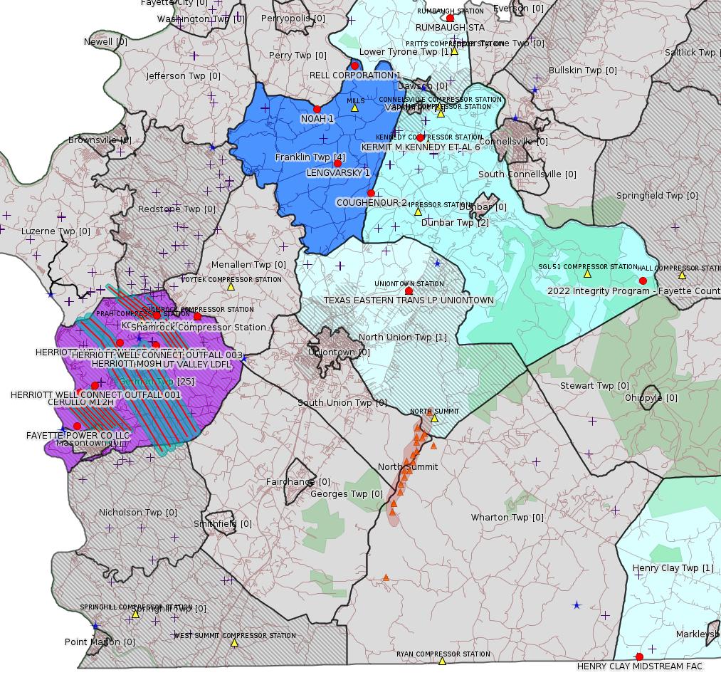
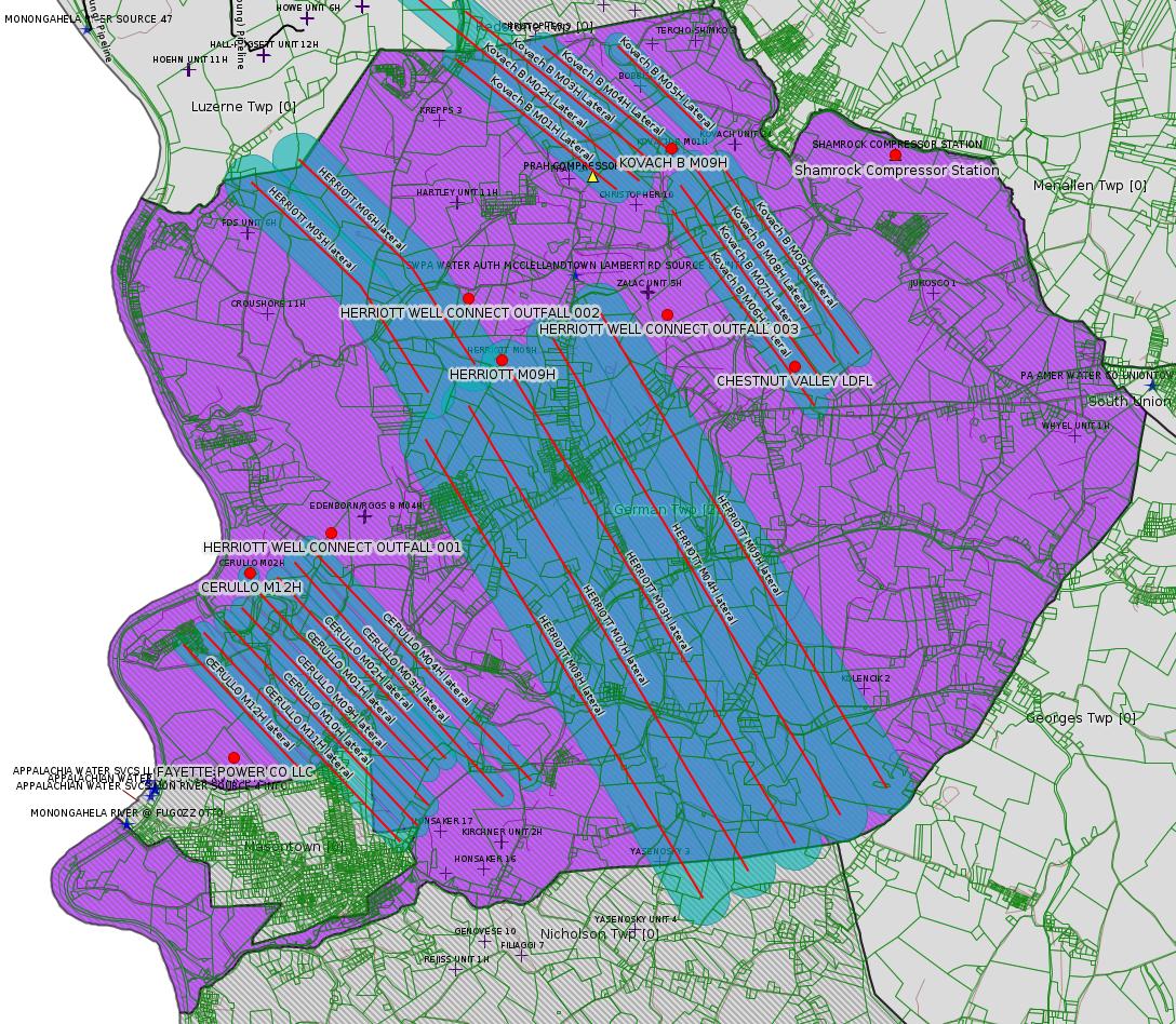
Fayette County Marcellus Shale Permits 12/27/21 - 3/20/22
Contents
Pennsylvania Bulletin Listings
Draft Base General Permit for Short Duration Processing and Beneficial Use of Oil and Gas Liquid Waste (WMGR163)eFACTS Listings
Shamrock Compressor Station Synthetic Minor Operating Permit
Chestnut Valley Landfill Permittee name change and renewal of municipal waste disposal facility permit
Environmental Justice Policy Substantive Revision
Fayette Energy Facility Title V Operating Permit renewal
APOLLO RESOURCES LLC APOLLO RESOURCES LLC/RUMBAUGH STA AQ GP 5 - Natural Gas Compression and/or Processing Facilities Issued on 3/21/2022
EQT CHAP LLC HERRIOTT M09H Drill & Operate Well Permit (Unconventional) Modification Issued on 3/28/2022
EQT CHAP LLC HERRIOTT M08H Drill & Operate Well Permit (Unconventional) Modification Issued on 3/28/2022
EQT CHAP LLC HERRIOTT M07H Drill & Operate Well Permit (Unconventional) Modification Issued on 3/28/2022
EQT CHAP LLC HERRIOTT M06H Drill & Operate Well Permit (Unconventional) Modification Issued on 3/28/2022
EQT CHAP LLC HERRIOTT M05H Drill & Operate Well Permit (Unconventional) Modification Issued on 3/28/2022
EQT CHAP LLC HERRIOTT M04H Drill & Operate Well Permit (Unconventional) Modification Issued on 3/28/2022
EQT CHAP LLC HERRIOTT M03H Drill & Operate Well Permit (Unconventional) Modification Issued on 3/28/2022
EQT CHAP LLC KOVACH B M09H Drill & Operate Well Permit Inactive Status Issued on 3/30/2022
EQT CHAP LLC KOVACH B M08H Drill & Operate Well Permit Inactive Status Issued on 3/30/2022
EQT CHAP LLC KOVACH B M07H Drill & Operate Well Permit Inactive Status Issued on 3/30/2022
EQT CHAP LLC KOVACH B M06H Drill & Operate Well Permit Inactive Status Issued on 3/30/2022
EQT CHAP LLC KOVACH B M05H Drill & Operate Well Permit Inactive Status Issued on 3/30/2022
EQT CHAP LLC KOVACH B M04H Drill & Operate Well Permit Inactive Status Issued on 3/30/2022
EQT CHAP LLC KOVACH B M03H Drill & Operate Well Permit Inactive Status Issued on 3/30/2022
TEXAS EASTERN TRANS LP TEXAS EASTERN TRANS LP UNIONTOWN Minor Significance Review
EQT CHAP LLC CERULLO M12H Well Plugging Notice Alternate Method Issued on 3/10/2022
EQT CHAP LLC CERULLO M12H Well Plugging Notice Intent to Plug Single Well Issued on 3/10/2022
EQT CHAP LLC CERULLO M11H Well Plugging Notice Alternate Method Issued on 3/10/2022
EQT CHAP LLC CERULLO M11H Well Plugging Notice Intent to Plug Single Well Issued on 3/23/2022
EQT CHAP LLC CERULLO M10H Well Plugging Notice Alternate Method Issued on 3/10/2022
EQT CHAP LLC CERULLO M10H Well Plugging Notice Intent to Plug Single Well Issued on 3/24/2022
EQT CHAP LLC CERULLO M09H Well Plugging Notice Alternate Method Issued on 3/10/2022
EQT CHAP LLC CERULLO M09H Well Plugging Notice Intent to Plug Single Well Issued on 3/10/2022
EQT CHAP LLC CERULLO M04H Well Plugging Notice Alternate Method Issued on 3/10/2022
EQT CHAP LLC CERULLO M04H Well Plugging Notice Intent to Plug Single Well Issued on 3/10/2022
EQT CHAP LLC CERULLO M03H Well Plugging Notice Alternate Method Issued on 3/10/2022
EQT CHAP LLC CERULLO M03H Well Plugging Notice Intent to Plug Single Well Issued on 3/23/2022
EQT CHAP LLC CERULLO M02H Well Plugging Notice Alternate Method Issued on 3/10/2022
EQT CHAP LLC CERULLO M02H Well Plugging Notice Intent to Plug Single Well Issued on 3/16/2022
EQT CHAP LLC CERULLO M01H Well Plugging Notice Alternate Method Issued on 3/10/2022
EQT CHAP LLC CERULLO M01H Well Plugging Notice Intent to Plug Single Well Issued on 2/24/2022
FAYETTE POWER CO LLC FAYETTE POWER CO LLC Major Facility Plan Approval New Source Performance Std Extension Withdrawn on 2/16/2022
LPR ENERGY LLC HENRY CLAY MIDSTREAM FAC AQ GP 5 - Natural Gas Compression and/or Processing Facilities
EQT CHAP LLC KOVACH B M02H Drill & Operate Well Permit Inactive Status
EQT CHAP LLC KOVACH B M01H Drill & Operate Well Permit Inactive Status
TEXAS EASTERN TRANS LP 2022 Integrity Program - Fayette County 11 GP-08 Temporary Road Crossings Issued on 3/15/2022
XTO ENERGY INC KERMIT M KENNEDY ET AL 6 Well Plugging Notice Intent to Plug Single Well Issued on 2/14/2022
TEXAS EASTERN TRANS LP TEXAS EASTERN TRANS LP UNIONTOWN Minor Source Operating Permit Amendment
LAUREL MTN MIDSTREAM OPR LLC HERRIOTT WELL CONNECT Minor IW Facility without ELG
CHESTNUT VALLEY LDFL LLC CHESTNUT VALLEY LDFL Landfill Permit Renewal Issued on 3/15/2022
FAYETTE POWER CO LLC FAYETTE POWER CO LLC Major Facility Operating Permit Renewal Issued on 2/15/2022
DIVERSIFIED PROD LLC COUGHENOUR 2 Tanks showing heavy corrosion
DIVERSIFIED PROD LLC LENGVARSKY 1 Production tank was corroded
REJISS ASSOC HOLDINGS LLC NOAH 1 Heavy rusting and spots with pitting
THE PRODUCTION CO LLC RELL CORPORATION 1 Failure to restore well site and submit a well site restoration report within 30 days Violation(s) & Outstanding Violations
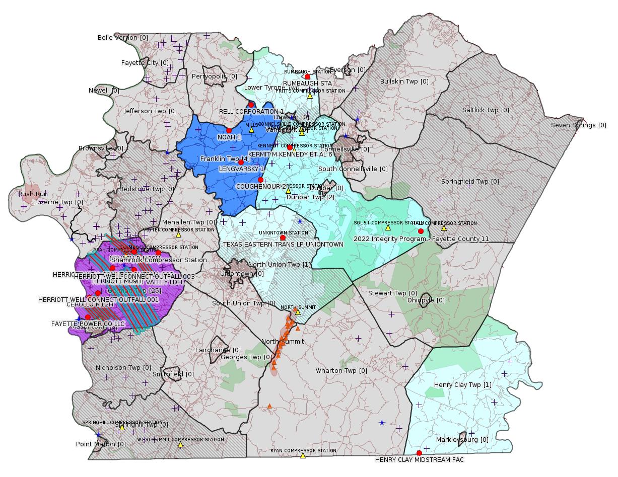
Red dots: items in this permit list with an exact location.
Blue stars: Marcellus Gas Well Water Sources.
Where well laterals are mapped they show in red; a 400-foot buffer surrounding the lateral shows in blue (lavender where it overlaps a mapped mineral tract).
Where mineral tracts are mapped, they show in pink. Mineral tracts can overlap; the overlap will show in red. The precise meaning of "mineral tract" is not clear.
Municipality shading: number of "facilities", with each well counting separately
(includes the red dots):
pale turquoise: 1
turquoise: 2
pale blue: 3
middle blue: 4
dark blue: 5
dark purple: 8
purple: 9
(Color coding may differ from one issue to the next.)
(Note if a project spans multiple municipalities -- e.g. a pipeline -- it will show in the count for each municipality.)
The number of facilities also follows the municipality name in brackets.
Municipality counts are based on the way the permit is listed by DEP; DEP has been known to get a municipality wrong.
Locations in brackets identify a precise location used to locate a surrogate for the actual site being permitted (e.g. locating a well pad or pipeline by the known location of a well.) Locations labeled beginning with "~" and ending in "[?]" are approximate and speculative based on inferences using on-line property and lease records. These are marked in the text as "[Approximate, Speculative]
Yellow triangles: Compressor Stations
Orange triangles: Storage Field Wells (currently Dominion North Summit Storage Field)
Crosses: SPUD Unconventional well permits
Green: "Natural areas", e.g. state game lands, state forests
More Maps
 |
 |
Source: Pennsylvania Bulletin
NOTICES
DEPARTMENT OF
ENVIRONMENTAL PROTECTION
Public Notice of Draft Base General Permit for Short Duration Processing and Beneficial Use of Oil and Gas Liquid Waste (WMGR163)
[52 Pa.B. 419]
[Saturday, January 15, 2022]
The Department of Environmental Protection (Department) is proposing a new base General Permit No. WMGR163 (WMGR163) under the authority of the Solid Waste Management Act (35 P.S. §§ 6018.101—6018.1003) and the Municipal Waste Planning, Recycling and Waste Reduction Act (53 P.S. §§ 4000.101—4000.1904). WMGR163 would authorize the short duration processing, transfer and beneficial use of oil and gas liquid waste to develop or hydraulically fracture an oil or gas well.
The creation of this general permit is a result of legislation (House Bill 336) that became law (Act 70) on July 9, 2021. The language in Act 70 requires the Department, by July 1, 2022, to submit to the Legislative Reference Bureau, for final publication in the Pennsylvania Bulletin, a general permit under 25 Pa. Code § 287.643 (relating to registration) for use for the transfer, storage or processing of oil and gas liquid waste at temporary facilities which will be in operation for no more than 180 consecutive days at any one time.
Written Comments
Interested persons are invited to submit written comments on this draft general permit through Tuesday, March 15, 2022. Comments submitted by facsimile will not be accepted. Comments, including comments submitted by e-mail, must include the commentator's name and address. Commentators are encouraged to submit comments using the Department's online eComment system at www.ahs.dep.pa.gov/eComment or by e-mail to ecomment@pa.gov. Written comments can be mailed to the Department of Environmental Protection, Policy Office, Rachel Carson State Office Building, P.O. Box 2063, Harrisburg, PA 17105-2063. Use ''Draft General Permit WMGR163'' as the subject line in written communication.
Questions regarding the draft general permit should be directed to Chris Solloway, Division of Municipal and Residual Waste, Bureau of Waste Management, P.O. Box 69170, Harrisburg, PA 17106-9170, csolloway@pa.gov or (717) 787-7381. Persons in need of accommodations as provided for in the Americans with Disabilities Act of 1990 should contact Chris Solloway at (717) 787-7381 or through the Pennsylvania Hamilton Relay Service at (800) 654-5984 (TDD users) or (800) 654-5988 (voice users) to discuss how the Department may accommodate their needs.
PATRICK McDONNELL,
Secretary
<http://www.pacodeandbulletin.gov/Display/pabull?file=/secure/pabulletin/data/vol52/52-3/89.html>
The actual draft permit is available here:
<http://www.depgreenport.state.pa.us/elibrary/GetDocument?docId=4101321&DocName=DRAFT - SHORT DURATION PROCESSING AND BENEFICIAL USE OF OIL AND GAS LIQUID WASTE WMGR163.PDF>
---
26-00588: Laurel Mountain Midstream Operating, LLC, Park Place Corporate Center 2, 2000 Commerce Drive, Pittsburgh, PA 15275. In accordance with 25 Pa. Code §§ 127.424, 127.425 and 127.521, the Department is providing notice that it intends to issue an initial Synthetic Minor Operating Permit for operation of the Shamrock Compressor Station located in German Township, Fayette County.
The emission sources covered by this operating permit includes one (1) Caterpillar Model G3516B natural gas-fired compressor engine rated at 1,380 bhp at 1,400 rpm controlled by oxidation catalyst and regulated by automatic air/fuel ratio controllers; one (1) Solar Mars 100-16000S natural gas-fired compressor turbine rated at 15,252 bhp equipped with SoLoNOx combustion control; one (1) Solar Titan 130-23502S natural gas-fired compressor turbine rated at 21,158 bhp equipped with SoLoNOx combustion control; one (1) Caterpillar Model G3516B natural gas-fired emergency generator engine rated at 1,818 bhp controlled by oxidation catalyst and regulated by automatic air/fuel ratio controller; two (2) tri-ethylene glycol (TEG) dehydrators rated at 200 MMscf/day each controlled by their respective reboilers; two (2) natural gas-fired reboilers rated at 1.71 MMBtu/hr each; one (1) natural gas-fired glycol processing unit engine rated at 19.5 bhp; one (1) natural gas-fired glycol processing unit heater rated at 0.5 MMBtu/hr; five (5) produced water storage tanks; pigging activities; piping and fitting plant fugitive emissions; startup/shutdown/maintenance/blowdown fugitive emissions; compressor rod packing fugitive emissions; engine crank case fugitive emissions; dry gas seal leaks fugitive emissions; and truck loadout of produced water fugitive emissions.
Potential emissions for the sources covered by this operating permit including emission restrictions have been calculated as follows: 69.93 tons per year of carbon monoxide (CO), 64.14 tons per year of nitrogen oxides (NOx), 19.09 tons per year of particulate matter less than 10-microns (PM10), 19.09 tons per year of particulate matter less than 2.5-microns (PM2.5), 18.66 tons per year of volatile organic compounds (VOC), 5.08 tons per year of formaldehyde, 7.81 tons per year of total Hazardous Air Pollutants (HAP), and 177,136 tons per year of greenhouse gases (GHGs).
The facility is subject to the applicable requirements of 25 Pa. Code Article III, Chapters 121—145. The proposed operating permit includes emission limitations, monitoring, testing, work practice standards, reporting, and recordkeeping requirements for the facility.
The application, DEP's Review Memorandum, and the proposed permit are available for public review during normal business hours at DEP's Southwest Regional Office, 400 Waterfront Drive, Pittsburgh, PA 15222. A file review can be scheduled through the DEP's website at https://www.dep.pa.gov/Citizens/PublicRecords/Pages/Informal-File-Review.aspx.
Any person may submit comments, a request for the Department to hold a public hearing, or a protest to the proposed operating permit or a condition thereof by submitting the information to Nick Waryanka, P.E., Air Quality Engineer, at the Southwest Regional Office. A 30-day comment period from the date of publication of this notice will exist for the submission of comments. Each written comment must contain the name, address and telephone number of the person submitting the comments, identification of the proposed permit (specify Operating Permit 26-00588) and concise statements regarding the relevancy of the information in the proposed permit or objections to issuance of the permit.
A public hearing may be held in accordance with 25 Pa. Code
§ 127.429, if the Department, in its discretion, decides that such
a hearing is warranted based on the information received. If a
public hearing is held, all persons who have properly filed a
protest under 25 Pa. Code § 127.426 may appear and give testimony.
The applicant, the protestant, and other participants will be
notified of the decision to hold a hearing (and the time, place
and purpose of such hearing) by publication in the newspaper or by
the Pennsylvania Bulletin, or by telephone, where the
Department determines such notification by telephone is
sufficient.
<http://www.pacodeandbulletin.gov/Display/pabull?file=/secure/pabulletin/data/vol52/52-7/238a.html&continued=http://www.pacodeandbulletin.gov/Display/pabull?file=/secure/pabulletin/data/vol52/52-7/238.html&d=>
Map URL: <http://www.openstreetmap.org/?mlat=39.918333&mlon=-79.825#map=15/39.918333/-79.825>
Parcel ID: 15140026
Permit Application No. 100419. Chestnut Valley Landfill, LLC, 1184 McClellandtown Road, McClellandtown, PA 15458, German Township, Fayette County. Permittee name change and renewal of municipal waste disposal facility permit for the operation of the Chestnut Valley Landfill located at 1184 McClellandtown Road, McClellandtown, PA 15458 in German Township, Fayette County. The application was deemed administratively complete by the Regional Office on February 15, 2022. Comments or questions concerning the application should be directed to Sharon Svitek, Program Manager, Waste Management, 400 Waterfront Drive, Pittsburgh, PA 15222-1475, 412-442-4000. TDD users may contact the Department through the Pennsylvania Hamilton Relay Service, (800) 654-5984. Public comments must be submitted within 60 days of this notice.
<http://www.pacodeandbulletin.gov/Display/pabull?file=/secure/pabulletin/data/vol52/52-10/344a.html&continued=http://www.pacodeandbulletin.gov/Display/pabull?file=/secure/pabulletin/data/vol52/52-10/344.html&d=>
---
Draft TGD: Substantive Revision
DEP ID: 012-0501-002. Title: Environmental Justice Policy. Description: This policy outlines the opportunities for engagement with individuals in Environmental Justice (EJ) areas during its permit review process. Additionally, the draft policy integrates EJ considerations into Department-wide operations including, interagency collaboration and EJ planning; EJ mapping, resource and data development; grant program practices; translation processes; and EJ training for Department staff and external partners.
Written Comments: Interested persons may submit written comments on this draft policy through Wednesday, May 11, 2022. Comments, including comments submitted by e-mail, must include the commentator's name and address. Commentators are encouraged to submit written comments using the Department's online eComment tool for Policies at www.ahs.dep.pa.gov/eComment or by e-mail to ecomment@pa.gov. Written comments can be mailed to the Technical Guidance Coordinator, Department of Environmental Protection, Policy Office, Rachel Carson State Office Building, P.O. Box 2063, Harrisburg, PA 17105-2063.
Public Hearings: The Department will hold three virtual public hearings for the purpose of accepting comments on the draft Environmental Justice Policy. Verbal testimony is limited to 5 minutes for each witness. Organizations are limited to designating one witness to present testimony on their behalf at one hearing. Witnesses may provide testimony by means of telephone or Internet connection. Video demonstrations and screen sharing by witnesses will not be permitted. The hearings will be held as follows:
Tuesday, April 5, 2022, at 5 p.m.
Tuesday, April 12, 2022, at 6 p.m.
Thursday, April 28, 2022, at 12 p.m.
Persons wishing to reserve time to present testimony at a hearing must contact Glenda Davidson at (717) 783-4759 or RA-EPOEJ@pa.gov at least 24 hours in advance of the hearing. Language interpretation services are available upon request. Persons in need of language interpretation services must contact Glenda Davidson a week in advance of each hearing.
Information on how to access the hearings will be available on the EJ webpage and found through the Public Participation tab on the Department's web site at www.dep.pa.gov (select ''Public Participation,'' then ''Environmental Justice''). Prior to each hearing, individuals should visit the EJ webpage for the most current information for accessing each hearing.
Members of the public wishing to observe the public hearing without providing testimony are also directed to access the EJ webpage. Those who have not registered with Glenda Davidson in advance as described previously will remain muted for the duration of the public hearing.
Persons in need of accommodations as provided for in the Americans with Disabilities Act of 1990 should contact (717) 783-4759 or through the Pennsylvania Hamilton Relay Service at (800) 654-5984 (TDD) or (800) 654-5988 (voice users) to discuss how the Department may accommodate their needs.
Contact: Questions regarding this policy can be directed to John Brakeall at jbrakeball@pa.gov or (717) 783-9731.
Effective Date: Upon publication of notice as final in the Pennsylvania Bulletin.
PATRICK McDONNELL,
Secretary
The EJ Policy Document is available here:
<http://www.depgreenport.state.pa.us/elibrary/GetDocument?docId=4221701&DocName=ENVIRONMENTAL%20JUSTICE%20POLICY.PDF>
---
TVOP-26-00535: Fayette Power Company, LLC, 100 Energy Drive, Masontown, PA 15461, on February 15, 2022, in accordance with 25 Pa. Code §§ 127.431, the Department issued the Title V Operating Permit renewal that includes the Phase II Acid Rain Permit application for the operation of a natural gas-fired power plant, known as the Fayette Energy Facility, located in German Township, Fayette County.
<http://www.pacodeandbulletin.gov/Display/pabull?file=/secure/pabulletin/data/vol52/52-11/384b.html&continued=http://www.pacodeandbulletin.gov/Display/pabull?file=/secure/pabulletin/data/vol52/52-11/384.html&d=reduce>
Location: 39.857408,-79.913878
Map URL: <http://www.openstreetmap.org/?mlat=39.857408&mlon=-79.913878#map=15/39.857408/-79.913878>
-------------------------
Please see the Disclaimer below regarding Parcel Id data.
Authorization ID: 1388566
Permit number: AG5-26-00001BC
Site: APOLLO RESOURCES LLC/RUMBAUGH STA
Client: APOLLO RESOURCES LLC
Authorization type: AQ GP 5 - Natural Gas Compression and/or Processing Facilities
Application type: New
Authorization is for: FACILITY
Date received: 10/08/2021
Status: Issued on 3/21/2022
Permit Decision Guarantee Applies: No
Sub-Facilities for Authorization:
Sub-Facility ID Sub-Facility Name Description
1351700 CATERPILAR G379TA NSCR Air Pollution Control Device
1191415 VENTING/BLOWDOWNS Process
1191407 HEATERS/REBOILERS Process
1191406 NATURAL GAS LINE Fuel Material Location
1191417 FUGITIVES Process
1191411 DEHYDRATOR UNIT 1 Process
1191413 PNEUMATIC DEVICES Process
1340018 CATERPILLAR G379TA ENGINE Process
1196320 PIGGING OPERATIONS Process
1191409 TANKS/VESSELS Process
Permit Review Notes:
Date Review Note
3/18/2022 The technical review and decision review are complete and either the permit decision and/or permit issuance are forthcoming.
3/18/2022 The permit application package is complete, has been accepted, and is undergoing technical review.
<https://www.ahs.dep.pa.gov/eFACTSWeb/searchResults_singleAuth.aspx?AuthID=1388566>
Site Programs:
Air Quality
Site Municipalities:
Lower Tyrone Twp, Fayette County
AQ_AEP_Details:
CLIENT_ID: 306576
CLIENT: APOLLO RESOURCES LLC
CLIENT_TYPE: NON-GOVERNMENT
CLIENT_ADDRESS1: PO BOX 423
CLIENT_ADDRESS2: 187 SECOND ST
CLIENT_CITY: VINTONDALE
CLIENT_STATE: PA
CLIENT_ZIP: 15961-0423
SITE_ID: 522629
PRIMARY_FACILITY_ID: 562423
PRIMARY_FACILITY_NAME: APOLLO RESOURCES LLC/RUMBAUGH COMP STA
NAICS_CODE: 211130
NAICS_DESCRIPTION: Natural Gas Extraction
PRIMARY_FACILITY_STATUS: Active
FACILITY_TYPE: 80% Synthetic Minor
REGION: Southwest Regional Office
COUNTY: Fayette
MUNICIPALITY: Lower Tyrone Twp
LATITUDE: 40.084722
LONGITUDE: -79.636667
LOCATION_ADDRESS1: 1177 CUNNINGHAM BRIDGE RD
LOCATION_ADDRESS2:
LOCATION_CITY: DAWSON
LOCATION_STATE: PA
LOCATION_ZIP: 15428-1198
Location: 40.084722,-79.636667
Map_URL: <http://www.openstreetmap.org/?mlat=40.084722&mlon=-79.636667#map=15/40.084722/-79.636667'>
---
Authorization ID: 1388215
Permit number: 051-24705
Site: HERRIOTT PAD A WELL AND TANK SITE ESCGP ESX18-051-0002
Client: EQT CHAP LLC
Authorization type: Drill & Operate Well Permit (Unconventional)
Application type: Modification
Authorization is for: FACILITY
Date received: 03/17/2022
Status: Issued on 3/28/2022
Public_Permit_Review:
<http://www.ahs.dep.pa.gov/ePermitPublicAccess/Public/PublicAuthOverview?q=T7EcSESNiM2Yh2x9rUZMiBoiqgGET3IBq2RuYJyb2CQ%3d>
Permit Decision Guarantee Applies: Yes
Permit Decision Guarantee status: ACTIVE
Sub-Facilities for Authorization:
Sub-Facility ID Sub-Facility Name Description
1353103 Horizontal MARCELLUS Well
Permit Review Notes:
Date Review Note
3/28/2022 The technical review and decision review are complete and either the permit decision and/or permit issuance are forthcoming.
3/23/2022 The permit application package is complete, has been accepted, and is undergoing technical review.
<https://www.ahs.dep.pa.gov/eFACTSWeb/searchResults_singleAuth.aspx?AuthID=1388215>
Site Programs:
Oil & Gas
Site Municipalities:
German Twp, Fayette County
Well Details:
Permit Number: 051-24705
Well Name: HERRIOTT M09H
Unconventional Well: Y
Well Configuration: Horizontal Well
Well Type: GAS
Well Status: Active
Coal Association: Coal
Conservation Well: N
Primary Facility ID: 832297
Site ID: 829399
Site Name: HERRIOTT PAD A WELL AND TANK SITE ESCGP ESX18-051-0002
Well Pad ID: 155082
Well Pad Name: HERRIOTT
Storage Field:
Operator: EQT CHAP LLC
Operator Number: OGO-39307
Permit Date: 2019-02-22
Permit Date Expires: 2023-03-28
SPUD Date: 2019-06-22
Date Plugged:
UIC ID:
UIC Type:
Surface Elevation: 1265
County: Fayette
Municipality: German Twp
Location: 39.89779,-79.87772
Map URL: <http://www.openstreetmap.org/?mlat=39.89779&mlon=-79.87772#map=15/39.89779/-79.87772>
OG WELLS PERMIT DOCS:
2020-02-13: Final Permit Documents, Name: auth id 1260912 (for Authorization: 1260912.0):
<http://www.depgis.state.pa.us/pdfHandler/pdFHandler.ashx?Doc=NzU0NDY4LjA=&ext=PDF>
2019-07-23: Other Permit Documents, Name: Alternate Method (for Authorization: 1275516.0):
<http://www.depgis.state.pa.us/pdfHandler/pdFHandler.ashx?Doc=ODgwOTYzLjA=&ext=PDF>
Electronically Submitted Records:
2020-02-13: Submission for Authorization 1260912.0
Location Plat: 172-319-Well Plat M09H-pages1-2-3_3702.dwg
<http://www.depgis.state.pa.us/eWellDocHandler/pdFHandler.ashx?Doc=NzYzMDg2LjA=&ext=PDF>
Pennsylvania Natural Diversity Inventory Form: Herriott PNDI.pdf
<http://www.depgis.state.pa.us/eWellDocHandler/pdFHandler.ashx?Doc=NzYzMDg3LjA=&ext=PDF>
Well Cross-Section Diagram: Herriott M09H Page 4.pdf
<http://www.depgis.state.pa.us/eWellDocHandler/pdFHandler.ashx?Doc=NzYzMDg5LjA=&ext=PDF>
Coal and Gas Resource Coord Act - Section 7 Exception: Herriott Section 7 Exception.pdf
<http://www.depgis.state.pa.us/eWellDocHandler/pdFHandler.ashx?Doc=NzY4NDg0LjA=&ext=PDF>
Permit Application to Drill and Operate a Well: 1865932.pdf
<http://www.depgis.state.pa.us/eWellDocHandler/pdFHandler.ashx?Doc=NzY4NTExLjA=&ext=PDF>
2020-03-31: Submission for Authorization 1308459.0
Pennsylvania Natural Diversity Inventory Form: project_receipt_herriott_pad_705847_FINAL_1.pdf
<http://www.depgis.state.pa.us/eWellDocHandler/pdFHandler.ashx?Doc=MTExNzIxNi4w&ext=PDF>
Permit Application to Drill and Operate a Well: Drill Permit Application_Herriott Pad A_M09H.pdf
<http://www.depgis.state.pa.us/eWellDocHandler/pdFHandler.ashx?Doc=MTExNzIxNy4w&ext=PDF>
Location Plat: 172-319-Well Plat M09H-pages1-2-3_3702.dwg
<http://www.depgis.state.pa.us/eWellDocHandler/pdFHandler.ashx?Doc=MTExNzIxOC4w&ext=PDF>
Interested Party Notification: Herriott M09H Interested Parties.pdf
<http://www.depgis.state.pa.us/eWellDocHandler/pdFHandler.ashx?Doc=MTExNzIxOS4w&ext=PDF>
Coal and Gas Resource Coord Act - Section 7 Exception: Herriott Section 7 Exception.pdf
<http://www.depgis.state.pa.us/eWellDocHandler/pdFHandler.ashx?Doc=MTExNzIyMC4w&ext=PDF>
Well Cross-Section Diagram: Herriott M09H Page 4.pdf
<http://www.depgis.state.pa.us/eWellDocHandler/pdFHandler.ashx?Doc=MTExNzIyMS4w&ext=PDF>
Well Permit Application - Coal Module: Herriott Coal Module.pdf
<http://www.depgis.state.pa.us/eWellDocHandler/pdFHandler.ashx?Doc=MTExNzIyMi4w&ext=PDF>
Electronic Submission Docket: 2099473.pdf
<http://www.depgis.state.pa.us/eWellDocHandler/pdFHandler.ashx?Doc=MTExNzQ2NC4w&ext=PDF>
[See Notes.]
---
Authorization ID: 1388203
Permit number: 051-24703
Site: HERRIOTT PAD A WELL AND TANK SITE ESCGP ESX18-051-0002
Client: EQT CHAP LLC
Authorization type: Drill & Operate Well Permit (Unconventional)
Application type: Modification
Authorization is for: FACILITY
Date received: 03/17/2022
Status: Issued on 3/28/2022
Public_Permit_Review:
<http://www.ahs.dep.pa.gov/ePermitPublicAccess/Public/PublicAuthOverview?q=zxV%2ffRxzfOhS%2f%2fBSYHqm8qW5Q7lNJaPbFb2rYXFp3f4%3d>
Permit Decision Guarantee Applies: Yes
Permit Decision Guarantee status: ACTIVE
Sub-Facilities for Authorization:
Sub-Facility ID Sub-Facility Name Description
1353102 Horizontal MARCELLUS Well
Permit Review Notes:
Date Review Note
3/28/2022 The technical review and decision review are complete and either the permit decision and/or permit issuance are forthcoming.
3/22/2022 The permit application package is complete, has been accepted, and is undergoing technical review.
<https://www.ahs.dep.pa.gov/eFACTSWeb/searchResults_singleAuth.aspx?AuthID=1388203>
Site Programs:
Oil & Gas
Site Municipalities:
German Twp, Fayette County
Well Details:
Permit Number: 051-24703
Well Name: HERRIOTT M08H
Unconventional Well: Y
Well Configuration: Horizontal Well
Well Type: GAS
Well Status: Active
Coal Association: Coal
Conservation Well: N
Primary Facility ID: 832295
Site ID: 829399
Site Name: HERRIOTT PAD A WELL AND TANK SITE ESCGP ESX18-051-0002
Well Pad ID: 155082
Well Pad Name: HERRIOTT
Storage Field:
Operator: EQT CHAP LLC
Operator Number: OGO-39307
Permit Date: 2019-02-22
Permit Date Expires: 2023-03-28
SPUD Date: 2019-06-22
Date Plugged:
UIC ID:
UIC Type:
Surface Elevation: 1265
County: Fayette
Municipality: German Twp
Location: 39.89777,-79.87782
Map URL: <http://www.openstreetmap.org/?mlat=39.89777&mlon=-79.87782#map=15/39.89777/-79.87782>
OG WELLS PERMIT DOCS:
2020-02-13: Final Permit Documents, Name: auth id 1260910 (for Authorization: 1260910.0):
<http://www.depgis.state.pa.us/pdfHandler/pdFHandler.ashx?Doc=NzU0NDcwLjA=&ext=PDF>
2019-07-23: Other Permit Documents, Name: Alternate Method (for Authorization: 1275515.0):
<http://www.depgis.state.pa.us/pdfHandler/pdFHandler.ashx?Doc=ODgwOTU5LjA=&ext=PDF>
Electronically Submitted Records:
2020-02-13: Submission for Authorization 1260910.0
Location Plat: 172-319-Well Plat M08H-pages1-2-3_3702.dwg
<http://www.depgis.state.pa.us/eWellDocHandler/pdFHandler.ashx?Doc=NzYzMDMwLjA=&ext=PDF>
Pennsylvania Natural Diversity Inventory Form: Herriott PNDI.pdf
<http://www.depgis.state.pa.us/eWellDocHandler/pdFHandler.ashx?Doc=NzYzMDMxLjA=&ext=PDF>
Well Cross-Section Diagram: Herriott M08H Page 4.pdf
<http://www.depgis.state.pa.us/eWellDocHandler/pdFHandler.ashx?Doc=NzYzMDMzLjA=&ext=PDF>
Coal and Gas Resource Coord Act - Section 7 Exception: Herriott Section 7 Exception.pdf
<http://www.depgis.state.pa.us/eWellDocHandler/pdFHandler.ashx?Doc=NzY4NDc2LjA=&ext=PDF>
Permit Application to Drill and Operate a Well: 1865928.pdf
<http://www.depgis.state.pa.us/eWellDocHandler/pdFHandler.ashx?Doc=NzY4NTAyLjA=&ext=PDF>
2020-04-03: Submission for Authorization 1308458.0
Pennsylvania Natural Diversity Inventory Form: project_receipt_herriott_pad_705847_FINAL_1.pdf
<http://www.depgis.state.pa.us/eWellDocHandler/pdFHandler.ashx?Doc=MTExNzE5NS4w&ext=PDF>
Permit Application to Drill and Operate a Well: Drill Permit Application_Herriott Pad A_M08H.pdf
<http://www.depgis.state.pa.us/eWellDocHandler/pdFHandler.ashx?Doc=MTExNzE5Ni4w&ext=PDF>
Location Plat: 172-319-Well Plat M08H-pages1-2-3_3702.dwg
<http://www.depgis.state.pa.us/eWellDocHandler/pdFHandler.ashx?Doc=MTExNzE5Ny4w&ext=PDF>
Interested Party Notification: Herriott M08H Interested Parties.pdf
<http://www.depgis.state.pa.us/eWellDocHandler/pdFHandler.ashx?Doc=MTExNzE5OC4w&ext=PDF>
Coal and Gas Resource Coord Act - Section 7 Exception: Herriott Section 7 Exception.pdf
<http://www.depgis.state.pa.us/eWellDocHandler/pdFHandler.ashx?Doc=MTExNzE5OS4w&ext=PDF>
Well Cross-Section Diagram: Herriott M08H Page 4.pdf
<http://www.depgis.state.pa.us/eWellDocHandler/pdFHandler.ashx?Doc=MTExNzIwMC4w&ext=PDF>
Well Permit Application - Coal Module: Herriott Coal Module.pdf
<http://www.depgis.state.pa.us/eWellDocHandler/pdFHandler.ashx?Doc=MTExNzIwMS4w&ext=PDF>
Electronic Submission Docket: 2099469.pdf
<http://www.depgis.state.pa.us/eWellDocHandler/pdFHandler.ashx?Doc=MTExNzQ2MS4w&ext=PDF>
---
Authorization ID: 1388196
Permit number: 051-24702
Site: HERRIOTT PAD A WELL AND TANK SITE ESCGP ESX18-051-0002
Client: EQT CHAP LLC
Authorization type: Drill & Operate Well Permit (Unconventional)
Application type: Modification
Authorization is for: FACILITY
Date received: 03/17/2022
Status: Issued on 3/28/2022
Public_Permit_Review:
<http://www.ahs.dep.pa.gov/ePermitPublicAccess/Public/PublicAuthOverview?q=6%2bmamOoe45eyCt1AD7Nw5tOhIp8rk3%2bWD3hZD%2bdS7uA%3d>
Permit Decision Guarantee Applies: Yes
Permit Decision Guarantee status: ACTIVE
Sub-Facilities for Authorization:
Sub-Facility ID Sub-Facility Name Description
1353100 Horizontal MARCELLUS Well
Permit Review Notes:
Date Review Note
3/28/2022 The technical review and decision review are complete and either the permit decision and/or permit issuance are forthcoming.
3/22/2022 The permit application package is complete, has been accepted, and is undergoing technical review.
<https://www.ahs.dep.pa.gov/eFACTSWeb/searchResults_singleAuth.aspx?AuthID=1388196>
Site Programs:
Oil & Gas
Site Municipalities:
German Twp, Fayette County
Well Details:
Permit Number: 051-24702
Well Name: HERRIOTT M07H
Unconventional Well: Y
Well Configuration: Horizontal Well
Well Type: GAS
Well Status: Active
Coal Association: Coal
Conservation Well: N
Primary Facility ID: 832294
Site ID: 829399
Site Name: HERRIOTT PAD A WELL AND TANK SITE ESCGP ESX18-051-0002
Well Pad ID: 155082
Well Pad Name: HERRIOTT
Storage Field:
Operator: EQT CHAP LLC
Operator Number: OGO-39307
Permit Date: 2019-02-22
Permit Date Expires: 2023-03-28
SPUD Date: 2019-06-21
Date Plugged:
UIC ID:
UIC Type:
Surface Elevation: 1265
County: Fayette
Municipality: German Twp
Location: 39.89781,-79.87783
Map URL: <http://www.openstreetmap.org/?mlat=39.89781&mlon=-79.87783#map=15/39.89781/-79.87783>
OG WELLS PERMIT DOCS:
2020-02-13: Final Permit Documents, Name: auth id 1260909 (for Authorization: 1260909.0):
<http://www.depgis.state.pa.us/pdfHandler/pdFHandler.ashx?Doc=NzU0NDcxLjA=&ext=PDF>
2019-07-23: Other Permit Documents, Name: Alternate Method (for Authorization: 1275511.0):
<http://www.depgis.state.pa.us/pdfHandler/pdFHandler.ashx?Doc=ODgwOTQ4LjA=&ext=PDF>
Electronically Submitted Records:
2020-02-13: Submission for Authorization 1260909.0
Pennsylvania Natural Diversity Inventory Form: Herriott PNDI.pdf
<http://www.depgis.state.pa.us/eWellDocHandler/pdFHandler.ashx?Doc=NzYzMDAzLjA=&ext=PDF>
Location Plat: 172-319-Well Plat M07H-pages1-2-3_3702.dwg
<http://www.depgis.state.pa.us/eWellDocHandler/pdFHandler.ashx?Doc=NzYzMDA0LjA=&ext=PDF>
Well Cross-Section Diagram: Herriott M07H Page 4.pdf
<http://www.depgis.state.pa.us/eWellDocHandler/pdFHandler.ashx?Doc=NzYzMDA2LjA=&ext=PDF>
Coal and Gas Resource Coord Act - Section 7 Exception: Herriott Section 7 Exception.pdf
<http://www.depgis.state.pa.us/eWellDocHandler/pdFHandler.ashx?Doc=NzY4NDc1LjA=&ext=PDF>
Permit Application to Drill and Operate a Well: 1865905.pdf
<http://www.depgis.state.pa.us/eWellDocHandler/pdFHandler.ashx?Doc=NzY4NTA1LjA=&ext=PDF>
2020-04-03: Submission for Authorization 1308457.0
Pennsylvania Natural Diversity Inventory Form: project_receipt_herriott_pad_705847_FINAL_1.pdf
<http://www.depgis.state.pa.us/eWellDocHandler/pdFHandler.ashx?Doc=MTExNzE4MS4w&ext=PDF>
Permit Application to Drill and Operate a Well: Drill Permit Application_Herriott Pad A_M07H.pdf
<http://www.depgis.state.pa.us/eWellDocHandler/pdFHandler.ashx?Doc=MTExNzE4Mi4w&ext=PDF>
Location Plat: 172-319-Well Plat M07H-pages1-2-3_3702.dwg
<http://www.depgis.state.pa.us/eWellDocHandler/pdFHandler.ashx?Doc=MTExNzE4My4w&ext=PDF>
Interested Party Notification: Herriott M07H Interested Parties.pdf
<http://www.depgis.state.pa.us/eWellDocHandler/pdFHandler.ashx?Doc=MTExNzE4NC4w&ext=PDF>
Well Cross-Section Diagram: Herriott M07H Page 4.pdf
<http://www.depgis.state.pa.us/eWellDocHandler/pdFHandler.ashx?Doc=MTExNzE4Ni4w&ext=PDF>
Well Permit Application - Coal Module: Herriott Coal Module.pdf
<http://www.depgis.state.pa.us/eWellDocHandler/pdFHandler.ashx?Doc=MTExNzE4Ny4w&ext=PDF>
Coal and Gas Resource Coord Act - Section 7 Exception: Herriott Section 7 Exception.pdf
<http://www.depgis.state.pa.us/eWellDocHandler/pdFHandler.ashx?Doc=MTExNzE4OS4w&ext=PDF>
Electronic Submission Docket: 2099465.pdf
<http://www.depgis.state.pa.us/eWellDocHandler/pdFHandler.ashx?Doc=MTExNzQ1MC4w&ext=PDF>
---
Authorization ID: 1388189
Permit number: 051-24700
Site: HERRIOTT PAD A WELL AND TANK SITE ESCGP ESX18-051-0002
Client: EQT CHAP LLC
Authorization type: Drill & Operate Well Permit (Unconventional)
Application type: Modification
Authorization is for: FACILITY
Date received: 03/17/2022
Status: Issued on 3/28/2022
Public_Permit_Review:
<http://www.ahs.dep.pa.gov/ePermitPublicAccess/Public/PublicAuthOverview?q=Ryv1BI729MiJu6AXvFQlBeq8X%2bS8js8B2gHBBQrBQZ0%3d>
Permit Decision Guarantee Applies: Yes
Permit Decision Guarantee status: ACTIVE
Sub-Facilities for Authorization:
Sub-Facility ID Sub-Facility Name Description
1353099 Horizontal MARCELLUS Well
Permit Review Notes:
Date Review Note
3/28/2022 The technical review and decision review are complete and either the permit decision and/or permit issuance are forthcoming.
3/22/2022 The permit application package is complete, has been accepted, and is undergoing technical review.
<https://www.ahs.dep.pa.gov/eFACTSWeb/searchResults_singleAuth.aspx?AuthID=1388189>
Site Programs:
Oil & Gas
Site Municipalities:
German Twp, Fayette County
Well Details:
Permit Number: 051-24700
Well Name: HERRIOTT M06H
Unconventional Well: Y
Well Configuration: Horizontal Well
Well Type: GAS
Well Status: Active
Coal Association: Coal
Conservation Well: N
Primary Facility ID: 832292
Site ID: 829399
Site Name: HERRIOTT PAD A WELL AND TANK SITE ESCGP ESX18-051-0002
Well Pad ID: 155082
Well Pad Name: HERRIOTT
Storage Field:
Operator: EQT CHAP LLC
Operator Number: OGO-39307
Permit Date: 2019-02-22
Permit Date Expires: 2023-03-28
SPUD Date: 2019-06-20
Date Plugged:
UIC ID:
UIC Type:
Surface Elevation: 1265
County: Fayette
Municipality: German Twp
Location: 39.89785,-79.87785
Map URL: <http://www.openstreetmap.org/?mlat=39.89785&mlon=-79.87785#map=15/39.89785/-79.87785>
OG WELLS PERMIT DOCS:
2020-02-13: Final Permit Documents, Name: auth id 1260907 (for Authorization: 1260907.0):
<http://www.depgis.state.pa.us/pdfHandler/pdFHandler.ashx?Doc=NzU0NDczLjA=&ext=PDF>
2019-07-23: Other Permit Documents, Name: Alternate Method (for Authorization: 1275510.0):
<http://www.depgis.state.pa.us/pdfHandler/pdFHandler.ashx?Doc=ODgwOTQ3LjA=&ext=PDF>
Electronically Submitted Records:
2020-02-13: Submission for Authorization 1260907.0
Pennsylvania Natural Diversity Inventory Form: Herriott PNDI.pdf
<http://www.depgis.state.pa.us/eWellDocHandler/pdFHandler.ashx?Doc=NzYyOTgzLjA=&ext=PDF>
Location Plat: 172-319-Well Plat M06H-pages1-2-3_3702.dwg
<http://www.depgis.state.pa.us/eWellDocHandler/pdFHandler.ashx?Doc=NzYyOTg0LjA=&ext=PDF>
Well Cross-Section Diagram: Herriott M06H Page 4.pdf
<http://www.depgis.state.pa.us/eWellDocHandler/pdFHandler.ashx?Doc=NzYyOTg2LjA=&ext=PDF>
Coal and Gas Resource Coord Act - Section 7 Exception: Herriott Section 7 Exception.pdf
<http://www.depgis.state.pa.us/eWellDocHandler/pdFHandler.ashx?Doc=NzY4MzQ0LjA=&ext=PDF>
Permit Application to Drill and Operate a Well: 1865896.pdf
<http://www.depgis.state.pa.us/eWellDocHandler/pdFHandler.ashx?Doc=NzY4NDkzLjA=&ext=PDF>
2020-04-03: Submission for Authorization 1308456.0
Pennsylvania Natural Diversity Inventory Form: project_receipt_herriott_pad_705847_FINAL_1.pdf
<http://www.depgis.state.pa.us/eWellDocHandler/pdFHandler.ashx?Doc=MTExNzE1NS4w&ext=PDF>
Permit Application to Drill and Operate a Well: Drill Permit Application_Herriott Pad A_M06H.pdf
<http://www.depgis.state.pa.us/eWellDocHandler/pdFHandler.ashx?Doc=MTExNzE1Ni4w&ext=PDF>
Location Plat: 172-319-Well Plat M06H-pages1-2-3_3702.dwg
<http://www.depgis.state.pa.us/eWellDocHandler/pdFHandler.ashx?Doc=MTExNzE1Ny4w&ext=PDF>
Interested Party Notification: Herriott M06H Interested Parties.pdf
<http://www.depgis.state.pa.us/eWellDocHandler/pdFHandler.ashx?Doc=MTExNzE1OC4w&ext=PDF>
Coal and Gas Resource Coord Act - Section 7 Exception: Herriott Section 7 Exception.pdf
<http://www.depgis.state.pa.us/eWellDocHandler/pdFHandler.ashx?Doc=MTExNzE1OS4w&ext=PDF>
Well Cross-Section Diagram: Herriott M06H Page 4.pdf
<http://www.depgis.state.pa.us/eWellDocHandler/pdFHandler.ashx?Doc=MTExNzE2MC4w&ext=PDF>
Well Permit Application - Coal Module: Herriott Coal Module.pdf
<http://www.depgis.state.pa.us/eWellDocHandler/pdFHandler.ashx?Doc=MTExNzE2MS4w&ext=PDF>
Electronic Submission Docket: 2099459.pdf
<http://www.depgis.state.pa.us/eWellDocHandler/pdFHandler.ashx?Doc=MTExNzQzNC4w&ext=PDF>
---
Authorization ID: 1388181
Permit number: 051-24699
Site: HERRIOTT PAD A WELL AND TANK SITE ESCGP ESX18-051-0002
Client: EQT CHAP LLC
Authorization type: Drill & Operate Well Permit (Unconventional)
Application type: Modification
Authorization is for: FACILITY
Date received: 03/17/2022
Status: Issued on 3/28/2022
Public_Permit_Review:
<http://www.ahs.dep.pa.gov/ePermitPublicAccess/Public/PublicAuthOverview?q=rgvofSM2WWKZsIDoJmd6uYasAbVTt3yYxr2PhnmrNEI%3d>
Permit Decision Guarantee Applies: Yes
Permit Decision Guarantee status: ACTIVE
Sub-Facilities for Authorization:
Sub-Facility ID Sub-Facility Name Description
1353098 Horizontal MARCELLUS Well
Permit Review Notes:
Date Review Note
3/28/2022 The technical review and decision review are complete and either the permit decision and/or permit issuance are forthcoming.
3/22/2022 The permit application package is complete, has been accepted, and is undergoing technical review.
<https://www.ahs.dep.pa.gov/eFACTSWeb/searchResults_singleAuth.aspx?AuthID=1388181>
Site Programs:
Oil & Gas
Site Municipalities:
German Twp, Fayette County
Well Details:
Permit Number: 051-24699
Well Name: HERRIOTT M05H
Unconventional Well: Y
Well Configuration: Horizontal Well
Well Type: GAS
Well Status: Active
Coal Association: Coal
Conservation Well: N
Primary Facility ID: 832291
Site ID: 829399
Site Name: HERRIOTT PAD A WELL AND TANK SITE ESCGP ESX18-051-0002
Well Pad ID: 155082
Well Pad Name: HERRIOTT
Storage Field:
Operator: EQT CHAP LLC
Operator Number: OGO-39307
Permit Date: 2019-02-22
Permit Date Expires: 2023-03-28
SPUD Date: 2019-06-21
Date Plugged:
UIC ID:
UIC Type:
Surface Elevation: 1265
County: Fayette
Municipality: German Twp
Location: 39.89789,-79.87787
Map URL: <http://www.openstreetmap.org/?mlat=39.89789&mlon=-79.87787#map=15/39.89789/-79.87787>
OG WELLS PERMIT DOCS:
2019-07-23: Other Permit Documents, Name: Alternate Method (for Authorization: 1275509.0):
<http://www.depgis.state.pa.us/pdfHandler/pdFHandler.ashx?Doc=ODgwOTQ2LjA=&ext=PDF>
Electronically Submitted Records:
2020-02-13: Submission for Authorization 1260905.0
Location Plat: 172-319-Well Plat M05H-pages1-2-3_3702.dwg
<http://www.depgis.state.pa.us/eWellDocHandler/pdFHandler.ashx?Doc=NzYyOTcwLjA=&ext=PDF>
Pennsylvania Natural Diversity Inventory Form: Herriott PNDI.pdf
<http://www.depgis.state.pa.us/eWellDocHandler/pdFHandler.ashx?Doc=NzYyOTcxLjA=&ext=PDF>
Well Cross-Section Diagram: Herriott M05H Page 4.pdf
<http://www.depgis.state.pa.us/eWellDocHandler/pdFHandler.ashx?Doc=NzYyOTcyLjA=&ext=PDF>
Coal and Gas Resource Coord Act - Section 7 Exception: Herriott Section 7 Exception.pdf
<http://www.depgis.state.pa.us/eWellDocHandler/pdFHandler.ashx?Doc=NzY4MzQyLjA=&ext=PDF>
Permit Application to Drill and Operate a Well: 1865638.pdf
<http://www.depgis.state.pa.us/eWellDocHandler/pdFHandler.ashx?Doc=NzY4NDkwLjA=&ext=PDF>
2020-04-03: Submission for Authorization 1308449.0
Pennsylvania Natural Diversity Inventory Form: project_receipt_herriott_pad_705847_FINAL_1.pdf
<http://www.depgis.state.pa.us/eWellDocHandler/pdFHandler.ashx?Doc=MTExNzEzOC4w&ext=PDF>
Permit Application to Drill and Operate a Well: Drill Permit Application_Herriott Pad A_M05H.pdf
<http://www.depgis.state.pa.us/eWellDocHandler/pdFHandler.ashx?Doc=MTExNzEzOS4w&ext=PDF>
Location Plat: 172-319-Well Plat M05H-pages1-2-3_3702.dwg
<http://www.depgis.state.pa.us/eWellDocHandler/pdFHandler.ashx?Doc=MTExNzE0MC4w&ext=PDF>
Interested Party Notification: Herriott M05H Interested Parties.pdf
<http://www.depgis.state.pa.us/eWellDocHandler/pdFHandler.ashx?Doc=MTExNzE0MS4w&ext=PDF>
Coal and Gas Resource Coord Act - Section 7 Exception: Herriott Section 7 Exception.pdf
<http://www.depgis.state.pa.us/eWellDocHandler/pdFHandler.ashx?Doc=MTExNzE0Mi4w&ext=PDF>
Well Cross-Section Diagram: Herriott M05H Page 4.pdf
<http://www.depgis.state.pa.us/eWellDocHandler/pdFHandler.ashx?Doc=MTExNzE0My4w&ext=PDF>
Well Permit Application - Coal Module: Herriott Coal Module.pdf
<http://www.depgis.state.pa.us/eWellDocHandler/pdFHandler.ashx?Doc=MTExNzE0NC4w&ext=PDF>
Electronic Submission Docket: 2099456.pdf
<http://www.depgis.state.pa.us/eWellDocHandler/pdFHandler.ashx?Doc=MTExNzQyOC4w&ext=PDF>
---
Authorization ID: 1388175
Permit number: 051-24698
Site: HERRIOTT PAD A WELL AND TANK SITE ESCGP ESX18-051-0002
Client: EQT CHAP LLC
Authorization type: Drill & Operate Well Permit (Unconventional)
Application type: Modification
Authorization is for: FACILITY
Date received: 03/17/2022
Status: Issued on 3/28/2022
Public_Permit_Review:
<http://www.ahs.dep.pa.gov/ePermitPublicAccess/Public/PublicAuthOverview?q=5NOK4Wi6iOEY236iiNLD2JTK%2bdfXb3uRtCX%2bpzxn4xs%3d>
Permit Decision Guarantee Applies: Yes
Permit Decision Guarantee status: ACTIVE
Sub-Facilities for Authorization:
Sub-Facility ID Sub-Facility Name Description
1353097 Horizontal MARCELLUS Well
Permit Review Notes:
Date Review Note
3/28/2022 The technical review and decision review are complete and either the permit decision and/or permit issuance are forthcoming.
3/21/2022 The permit application package is complete, has been accepted, and is undergoing technical review.
<https://www.ahs.dep.pa.gov/eFACTSWeb/searchResults_singleAuth.aspx?AuthID=1388175>
Site Programs:
Oil & Gas
Site Municipalities:
German Twp, Fayette County
Well Details:
Permit Number: 051-24698
Well Name: HERRIOTT M04H
Unconventional Well: Y
Well Configuration: Horizontal Well
Well Type: GAS
Well Status: Active
Coal Association: Coal
Conservation Well: N
Primary Facility ID: 832290
Site ID: 829399
Site Name: HERRIOTT PAD A WELL AND TANK SITE ESCGP ESX18-051-0002
Well Pad ID: 155082
Well Pad Name: HERRIOTT
Storage Field:
Operator: EQT CHAP LLC
Operator Number: OGO-39307
Permit Date: 2019-02-22
Permit Date Expires: 2023-03-28
SPUD Date: 2019-06-19
Date Plugged:
UIC ID:
UIC Type:
Surface Elevation: 1265
County: Fayette
Municipality: German Twp
Location: 39.89793,-79.87789
Map URL: <http://www.openstreetmap.org/?mlat=39.89793&mlon=-79.87789#map=15/39.89793/-79.87789>
OG WELLS PERMIT DOCS:
2020-02-13: Final Permit Documents, Name: auth id 1260904 (for Authorization: 1260904.0):
<http://www.depgis.state.pa.us/pdfHandler/pdFHandler.ashx?Doc=NzU0NDc2LjA=&ext=PDF>
2019-07-23: Other Permit Documents, Name: Alternate Method (for Authorization: 1275508.0):
<http://www.depgis.state.pa.us/pdfHandler/pdFHandler.ashx?Doc=ODgwOTcwLjA=&ext=PDF>
Electronically Submitted Records:
2020-04-03: Submission for Authorization 1308448.0
Pennsylvania Natural Diversity Inventory Form: project_receipt_herriott_pad_705847_FINAL_1.pdf
<http://www.depgis.state.pa.us/eWellDocHandler/pdFHandler.ashx?Doc=MTExNzEyMi4w&ext=PDF>
Permit Application to Drill and Operate a Well: Drill Permit Application_Herriott Pad A_M04H.pdf
<http://www.depgis.state.pa.us/eWellDocHandler/pdFHandler.ashx?Doc=MTExNzEyNC4w&ext=PDF>
Location Plat: 172-319-Well Plat M04H-pages1-2-3_3702.dwg
<http://www.depgis.state.pa.us/eWellDocHandler/pdFHandler.ashx?Doc=MTExNzEyNS4w&ext=PDF>
Interested Party Notification: Herriott M04H Interested Parties.pdf
<http://www.depgis.state.pa.us/eWellDocHandler/pdFHandler.ashx?Doc=MTExNzEyNi4w&ext=PDF>
Coal and Gas Resource Coord Act - Section 7 Exception: Herriott Section 7 Exception.pdf
<http://www.depgis.state.pa.us/eWellDocHandler/pdFHandler.ashx?Doc=MTExNzEyNy4w&ext=PDF>
Well Cross-Section Diagram: Herriott M04H Page 4.pdf
<http://www.depgis.state.pa.us/eWellDocHandler/pdFHandler.ashx?Doc=MTExNzEyOC4w&ext=PDF>
Well Permit Application - Coal Module: Herriott Coal Module.pdf
<http://www.depgis.state.pa.us/eWellDocHandler/pdFHandler.ashx?Doc=MTExNzEyOS4w&ext=PDF>
Electronic Submission Docket: 2099454.pdf
<http://www.depgis.state.pa.us/eWellDocHandler/pdFHandler.ashx?Doc=MTExNzQyMS4w&ext=PDF>
2020-02-13: Submission for Authorization 1260904.0
Pennsylvania Natural Diversity Inventory Form: Herriott PNDI.pdf
<http://www.depgis.state.pa.us/eWellDocHandler/pdFHandler.ashx?Doc=NzYyOTUwLjA=&ext=PDF>
Location Plat: 172-319-Well Plat M04H-pages1-2-3_3702.dwg
<http://www.depgis.state.pa.us/eWellDocHandler/pdFHandler.ashx?Doc=NzYyOTUxLjA=&ext=PDF>
Well Cross-Section Diagram: Herriott M04H Page 4.pdf
<http://www.depgis.state.pa.us/eWellDocHandler/pdFHandler.ashx?Doc=NzYyOTUzLjA=&ext=PDF>
Coal and Gas Resource Coord Act - Section 7 Exception: Herriott Section 7 Exception.pdf
<http://www.depgis.state.pa.us/eWellDocHandler/pdFHandler.ashx?Doc=NzY4MzUyLjA=&ext=PDF>
Permit Application to Drill and Operate a Well: 1865625.pdf
<http://www.depgis.state.pa.us/eWellDocHandler/pdFHandler.ashx?Doc=NzY4NTE0LjA=&ext=PDF>
---
Authorization ID: 1388165
Permit number: 051-24704
Site: HERRIOTT PAD A WELL AND TANK SITE ESCGP ESX18-051-0002
Client: EQT CHAP LLC
Authorization type: Drill & Operate Well Permit (Unconventional)
Application type: Modification
Authorization is for: FACILITY
Date received: 03/17/2022
Status: Issued on 3/28/2022
Public_Permit_Review:
<http://www.ahs.dep.pa.gov/ePermitPublicAccess/Public/PublicAuthOverview?q=WAQ0QeETDT6EmNvP80IaRrWz8Q84OkpAKI%2fgEx9HHfg%3d>
Permit Decision Guarantee Applies: Yes
Permit Decision Guarantee status: ACTIVE
Sub-Facilities for Authorization:
Sub-Facility ID Sub-Facility Name Description
1353095 Horizontal MARCELLUS Well
Permit Review Notes:
Date Review Note
3/28/2022 The technical review and decision review are complete and either the permit decision and/or permit issuance are forthcoming.
3/18/2022 The permit application package is complete, has been accepted, and is undergoing technical review.
<https://www.ahs.dep.pa.gov/eFACTSWeb/searchResults_singleAuth.aspx?AuthID=1388165>
Site Programs:
Oil & Gas
Site Municipalities:
German Twp, Fayette County
Well Details:
Permit Number: 051-24704
Well Name: HERRIOTT M03H
Unconventional Well: Y
Well Configuration: Horizontal Well
Well Type: GAS
Well Status: Active
Coal Association: Coal
Conservation Well: N
Primary Facility ID: 832296
Site ID: 829399
Site Name: HERRIOTT PAD A WELL AND TANK SITE ESCGP ESX18-051-0002
Well Pad ID: 155082
Well Pad Name: HERRIOTT
Storage Field:
Operator: EQT CHAP LLC
Operator Number: OGO-39307
Permit Date: 2019-02-22
Permit Date Expires: 2023-03-28
SPUD Date: 2019-06-18
Date Plugged:
UIC ID:
UIC Type:
Surface Elevation: 1265
County: Fayette
Municipality: German Twp
Location: 39.89796,-79.8779
Map URL: <http://www.openstreetmap.org/?mlat=39.89796&mlon=-79.8779#map=15/39.89796/-79.8779>
OG WELLS PERMIT DOCS:
2020-02-13: Final Permit Documents, Name: auth id 1260911 (for Authorization: 1260911.0):
<http://www.depgis.state.pa.us/pdfHandler/pdFHandler.ashx?Doc=NzU0NDY5LjA=&ext=PDF>
2019-07-23: Other Permit Documents, Name: Alternate Method (for Authorization: 1275507.0):
<http://www.depgis.state.pa.us/pdfHandler/pdFHandler.ashx?Doc=ODgwOTQzLjA=&ext=PDF>
Electronically Submitted Records:
2020-02-13: Submission for Authorization 1260911.0
Pennsylvania Natural Diversity Inventory Form: Herriott PNDI.pdf
<http://www.depgis.state.pa.us/eWellDocHandler/pdFHandler.ashx?Doc=NzYyOTM1LjA=&ext=PDF>
Location Plat: 172-319-Well Plat M03H-pages1-2-3_3702.dwg
<http://www.depgis.state.pa.us/eWellDocHandler/pdFHandler.ashx?Doc=NzYyOTM2LjA=&ext=PDF>
Well Cross-Section Diagram: Herriott M03H Page 4.pdf
<http://www.depgis.state.pa.us/eWellDocHandler/pdFHandler.ashx?Doc=NzYyOTM4LjA=&ext=PDF>
Coal and Gas Resource Coord Act - Section 7 Exception: Herriott Section 7 Exception.pdf
<http://www.depgis.state.pa.us/eWellDocHandler/pdFHandler.ashx?Doc=NzY4MzgyLjA=&ext=PDF>
Permit Application to Drill and Operate a Well: 1865616.pdf
<http://www.depgis.state.pa.us/eWellDocHandler/pdFHandler.ashx?Doc=NzY4NDk5LjA=&ext=PDF>
2020-04-03: Submission for Authorization 1308447.0
Pennsylvania Natural Diversity Inventory Form: project_receipt_herriott_pad_705847_FINAL_1.pdf
<http://www.depgis.state.pa.us/eWellDocHandler/pdFHandler.ashx?Doc=MTExNzEwNC4w&ext=PDF>
Permit Application to Drill and Operate a Well: Drill Permit Application_Herriott Pad A_M03H.pdf
<http://www.depgis.state.pa.us/eWellDocHandler/pdFHandler.ashx?Doc=MTExNzEwNS4w&ext=PDF>
Interested Party Notification: Herriott M03H Interested Parties.pdf
<http://www.depgis.state.pa.us/eWellDocHandler/pdFHandler.ashx?Doc=MTExNzEwNi4w&ext=PDF>
Coal and Gas Resource Coord Act - Section 7 Exception: Herriott Section 7 Exception.pdf
<http://www.depgis.state.pa.us/eWellDocHandler/pdFHandler.ashx?Doc=MTExNzEwNy4w&ext=PDF>
Well Cross-Section Diagram: Herriott M03H Page 4.pdf
<http://www.depgis.state.pa.us/eWellDocHandler/pdFHandler.ashx?Doc=MTExNzEwOC4w&ext=PDF>
Well Permit Application - Coal Module: Herriott Coal Module.pdf
<http://www.depgis.state.pa.us/eWellDocHandler/pdFHandler.ashx?Doc=MTExNzEwOS4w&ext=PDF>
Location Plat: 172-319-Well Plat M03H-pages1-2-3_3702.dwg
<http://www.depgis.state.pa.us/eWellDocHandler/pdFHandler.ashx?Doc=MTExNzExNC4w&ext=PDF>
Electronic Submission Docket: 2099448.pdf
<http://www.depgis.state.pa.us/eWellDocHandler/pdFHandler.ashx?Doc=MTExNzQxMS4w&ext=PDF>
---
Authorization ID: 1387782
Permit number: 051-24670
Site: KOVACH B WELL SITE AND TANK SITE ESCGP ESX17-051-0003
Client: EQT CHAP LLC
Authorization type: Drill & Operate Well Permit Inactive Status
Application type: New
Authorization is for: FACILITY
Date received: 03/04/2022
Status: Pending
Permit Decision Guarantee Applies: No
Sub-Facilities for Authorization:
Sub-Facility ID Sub-Facility Name Description
1263128 WELLBORE SURFACE HOLE LOCATION Well
Permit Review Notes:
Date Review Note
3/30/2022 The technical review and decision review are complete and either the permit decision and/or permit issuance are forthcoming.
3/15/2022 The permit application package is complete, has been accepted, and is undergoing technical review.
<https://www.ahs.dep.pa.gov/eFACTSWeb/searchResults_singleAuth.aspx?AuthID=1387782>
Site Programs:
Oil & Gas
Site Municipalities:
German Twp, Fayette County
Well Details:
Permit Number: 051-24670
Well Name: KOVACH B M09H
Unconventional Well: Y
Well Configuration: Horizontal Well
Well Type: GAS
Well Status: Active
Coal Association: Coal
Conservation Well: N
Primary Facility ID: 828036
Site ID: 826949
Site Name: KOVACH B WELL SITE AND TANK SITE ESCGP ESX17-051-0003
Well Pad ID: 155005
Well Pad Name: KOVACH B
Storage Field:
Operator: EQT CHAP LLC
Operator Number: OGO-39307
Permit Date: 2018-08-08
Permit Date Expires: 2021-02-03
SPUD Date: 2018-10-23
Date Plugged:
UIC ID:
UIC Type:
Surface Elevation: 1278
County: Fayette
Municipality: German Twp
Location: 39.919231,-79.854758
Map URL: <http://www.openstreetmap.org/?mlat=39.919231&mlon=-79.854758#map=15/39.919231/-79.854758>
OG WELLS PERMIT DOCS:
2018-08-31: Other Permit Documents, Name: 051-24670 (for Authorization: 1240755.0):
<http://www.depgis.state.pa.us/pdfHandler/pdFHandler.ashx?Doc=NzgxMTAyLjA=&ext=PDF>
2019-01-07: Other Permit Documents, Name: 051-24670 (for Authorization: 1256805.0):
<http://www.depgis.state.pa.us/pdfHandler/pdFHandler.ashx?Doc=NzI3OTkxLjA=&ext=PDF>
2019-12-31: Other Permit Documents, Name: Inactive Well Status (for Authorization: 1296540.0):
<http://www.depgis.state.pa.us/pdfHandler/pdFHandler.ashx?Doc=MTAxMDg1NC4w&ext=PDF>
2022-03-30: Final Permit Documents, Name: 051-24670 German Twp EQT Chap LLC Kovach B M09H Inactive Status 3-4-22 (for Authorization: 1387782.0):
<http://www.depgis.state.pa.us/pdfHandler/pdFHandler.ashx?Doc=MjI0MTU0NC4w&ext=PDF>
Electronically Submitted Records:
2020-02-13: Submission for Authorization 1301060.0
Pennsylvania Natural Diversity Inventory Form: Kovach B PNDI 1-7-20.pdf
<http://www.depgis.state.pa.us/eWellDocHandler/pdFHandler.ashx?Doc=MTA0NjI5Ni4w&ext=PDF>
Permit Application to Drill and Operate a Well: Kovach B M09H RePermit Application.pdf
<http://www.depgis.state.pa.us/eWellDocHandler/pdFHandler.ashx?Doc=MTA0NjI5Ny4w&ext=PDF>
Coal and Gas Resource Coord Act - Section 7 Exception: Kovach B Section 7 Exception.pdf
<http://www.depgis.state.pa.us/eWellDocHandler/pdFHandler.ashx?Doc=MTA0NjI5OS4w&ext=PDF>
Well Cross-Section Diagram: Kovach B M09H Page 4.pdf
<http://www.depgis.state.pa.us/eWellDocHandler/pdFHandler.ashx?Doc=MTA0NjMwMC4w&ext=PDF>
Well Permit Application - Coal Module: Kovach B Coal Module w Record of Notification.pdf
<http://www.depgis.state.pa.us/eWellDocHandler/pdFHandler.ashx?Doc=MTA0NjMwMS4w&ext=PDF>
Location Plat: Kovach B M09H Plat.dwg
<http://www.depgis.state.pa.us/eWellDocHandler/pdFHandler.ashx?Doc=MTA1NDI2OC4w&ext=PDF>
Interested Party Notification: Kovach B M09H Interested Parties.pdf
<http://www.depgis.state.pa.us/eWellDocHandler/pdFHandler.ashx?Doc=MTA1NDI3NC4w&ext=PDF>
Electronic Submission Docket: 2062174.pdf
<http://www.depgis.state.pa.us/eWellDocHandler/pdFHandler.ashx?Doc=MTA1NDI3Ni4w&ext=PDF>
2020-02-13: Submission for Authorization 1237726.0
Interested Party Notification: Kovach B Affidavit of Non-Delivery Venere.pdf
<http://www.depgis.state.pa.us/eWellDocHandler/pdFHandler.ashx?Doc=NjAyNjM1LjA=&ext=PDF>
Coal and Gas Resource Coord Act - Section 7 Exception: Kovach B Horizontals Section 7 Exception.pdf
<http://www.depgis.state.pa.us/eWellDocHandler/pdFHandler.ashx?Doc=NjAyNjQwLjA=&ext=PDF>
Pennsylvania Natural Diversity Inventory Form: Kovach B PNDI.pdf
<http://www.depgis.state.pa.us/eWellDocHandler/pdFHandler.ashx?Doc=NjAyNjQxLjA=&ext=PDF>
Location Plat: Kovach B M09H Plat.dwg
<http://www.depgis.state.pa.us/eWellDocHandler/pdFHandler.ashx?Doc=NjAyNjQyLjA=&ext=PDF>
Well Cross-Section Diagram: Kovach B M09H Page 4.pdf
<http://www.depgis.state.pa.us/eWellDocHandler/pdFHandler.ashx?Doc=NjAyNjQzLjA=&ext=PDF>
Permit Application to Drill and Operate a Well: 1753557.pdf
<http://www.depgis.state.pa.us/eWellDocHandler/pdFHandler.ashx?Doc=NjAzODg3LjA=&ext=PDF>
---
Authorization ID: 1387781
Permit number: 051-24669
Site: KOVACH B WELL SITE AND TANK SITE ESCGP ESX17-051-0003
Client: EQT CHAP LLC
Authorization type: Drill & Operate Well Permit Inactive Status
Application type: New
Authorization is for: FACILITY
Date received: 03/04/2022
Status: Pending
Permit Decision Guarantee Applies: No
Sub-Facilities for Authorization:
Sub-Facility ID Sub-Facility Name Description
1263127 WELLBORE SURFACE HOLE LOCATION Well
Permit Review Notes:
Date Review Note
3/30/2022 The technical review and decision review are complete and either the permit decision and/or permit issuance are forthcoming.
3/15/2022 The permit application package is complete, has been accepted, and is undergoing technical review.
<https://www.ahs.dep.pa.gov/eFACTSWeb/searchResults_singleAuth.aspx?AuthID=1387781>
Site Programs:
Oil & Gas
Site Municipalities:
German Twp, Fayette County
Well Details:
Permit Number: 051-24669
Well Name: KOVACH B M08H
Unconventional Well: Y
Well Configuration: Horizontal Well
Well Type: GAS
Well Status: Active
Coal Association: Coal
Conservation Well: N
Primary Facility ID: 828035
Site ID: 826949
Site Name: KOVACH B WELL SITE AND TANK SITE ESCGP ESX17-051-0003
Well Pad ID: 155005
Well Pad Name: KOVACH B
Storage Field:
Operator: EQT CHAP LLC
Operator Number: OGO-39307
Permit Date: 2018-08-08
Permit Date Expires: 2021-02-03
SPUD Date: 2018-10-23
Date Plugged:
UIC ID:
UIC Type:
Surface Elevation: 1278
County: Fayette
Municipality: German Twp
Location: 39.919197,-79.854658
Map URL: <http://www.openstreetmap.org/?mlat=39.919197&mlon=-79.854658#map=15/39.919197/-79.854658>
OG WELLS PERMIT DOCS:
2018-08-31: Other Permit Documents, Name: 051-24669 (for Authorization: 1240734.0):
<http://www.depgis.state.pa.us/pdfHandler/pdFHandler.ashx?Doc=NzgxMDk5LjA=&ext=PDF>
2019-01-09: Other Permit Documents, Name: 051-24669 (for Authorization: 1256801.0):
<http://www.depgis.state.pa.us/pdfHandler/pdFHandler.ashx?Doc=NzI5MDIzLjA=&ext=PDF>
2019-12-31: Other Permit Documents, Name: Inactive Well Status (for Authorization: 1296553.0):
<http://www.depgis.state.pa.us/pdfHandler/pdFHandler.ashx?Doc=MTAxMDg2MS4w&ext=PDF>
2022-03-30: Final Permit Documents, Name: 051-24669 German Twp EQT Chap LLC Kovach B M08H Inactive Status 3-4-22 (for Authorization: 1387781.0):
<http://www.depgis.state.pa.us/pdfHandler/pdFHandler.ashx?Doc=MjI0MTUzOS4w&ext=PDF>
Electronically Submitted Records:
2020-02-13: Submission for Authorization 1301059.0
Pennsylvania Natural Diversity Inventory Form: Kovach B PNDI 1-7-20.pdf
<http://www.depgis.state.pa.us/eWellDocHandler/pdFHandler.ashx?Doc=MTA0NjI4Mi4w&ext=PDF>
Permit Application to Drill and Operate a Well: Kovach B M08H RePermit Application.pdf
<http://www.depgis.state.pa.us/eWellDocHandler/pdFHandler.ashx?Doc=MTA0NjI4My4w&ext=PDF>
Coal and Gas Resource Coord Act - Section 7 Exception: Kovach B Section 7 Exception.pdf
<http://www.depgis.state.pa.us/eWellDocHandler/pdFHandler.ashx?Doc=MTA0NjI4NS4w&ext=PDF>
Well Cross-Section Diagram: Kovach B M08H Page 4.pdf
<http://www.depgis.state.pa.us/eWellDocHandler/pdFHandler.ashx?Doc=MTA0NjI4Ni4w&ext=PDF>
Well Permit Application - Coal Module: Kovach B Coal Module w Record of Notification.pdf
<http://www.depgis.state.pa.us/eWellDocHandler/pdFHandler.ashx?Doc=MTA0NjI4Ny4w&ext=PDF>
Location Plat: Kovach B M08H Plat.dwg
<http://www.depgis.state.pa.us/eWellDocHandler/pdFHandler.ashx?Doc=MTA1NDI1My4w&ext=PDF>
Interested Party Notification: Kovach B M08H Interested Parties.pdf
<http://www.depgis.state.pa.us/eWellDocHandler/pdFHandler.ashx?Doc=MTA1NDI1NC4w&ext=PDF>
Electronic Submission Docket: 2062172.pdf
<http://www.depgis.state.pa.us/eWellDocHandler/pdFHandler.ashx?Doc=MTA1NDI2MC4w&ext=PDF>
2020-02-13: Submission for Authorization 1237725.0
Interested Party Notification: Kovach B Affidavit of Non-Delivery Venere.pdf
<http://www.depgis.state.pa.us/eWellDocHandler/pdFHandler.ashx?Doc=NjAyNjA5LjA=&ext=PDF>
Coal and Gas Resource Coord Act - Section 7 Exception: Kovach B Horizontals Section 7 Exception.pdf
<http://www.depgis.state.pa.us/eWellDocHandler/pdFHandler.ashx?Doc=NjAyNjE1LjA=&ext=PDF>
Pennsylvania Natural Diversity Inventory Form: Kovach B PNDI.pdf
<http://www.depgis.state.pa.us/eWellDocHandler/pdFHandler.ashx?Doc=NjAyNjE2LjA=&ext=PDF>
Location Plat: Kovach B M08H Plat.dwg
<http://www.depgis.state.pa.us/eWellDocHandler/pdFHandler.ashx?Doc=NjAyNjE3LjA=&ext=PDF>
Well Cross-Section Diagram: Kovach B M08H Page 4.pdf
<http://www.depgis.state.pa.us/eWellDocHandler/pdFHandler.ashx?Doc=NjAyNjE4LjA=&ext=PDF>
Permit Application to Drill and Operate a Well: 1753555.pdf
<http://www.depgis.state.pa.us/eWellDocHandler/pdFHandler.ashx?Doc=NjAzODgzLjA=&ext=PDF>
---
Authorization ID: 1387780
Permit number: 051-24668
Site: KOVACH B WELL SITE AND TANK SITE ESCGP ESX17-051-0003
Client: EQT CHAP LLC
Authorization type: Drill & Operate Well Permit Inactive Status
Application type: New
Authorization is for: FACILITY
Date received: 03/04/2022
Status: Pending
Permit Decision Guarantee Applies: No
Sub-Facilities for Authorization:
Sub-Facility ID Sub-Facility Name Description
1263126 WELLBORE SURFACE HOLE LOCATION Well
Permit Review Notes:
Date Review Note
3/30/2022 The technical review and decision review are complete and either the permit decision and/or permit issuance are forthcoming.
3/15/2022 The permit application package is complete, has been accepted, and is undergoing technical review.
<https://www.ahs.dep.pa.gov/eFACTSWeb/searchResults_singleAuth.aspx?AuthID=1387780>
Site Programs:
Oil & Gas
Site Municipalities:
German Twp, Fayette County
Well Details:
Permit Number: 051-24668
Well Name: KOVACH B M07H
Unconventional Well: Y
Well Configuration: Horizontal Well
Well Type: GAS
Well Status: Active
Coal Association: Coal
Conservation Well: N
Primary Facility ID: 828034
Site ID: 826949
Site Name: KOVACH B WELL SITE AND TANK SITE ESCGP ESX17-051-0003
Well Pad ID: 155005
Well Pad Name: KOVACH B
Storage Field:
Operator: EQT CHAP LLC
Operator Number: OGO-39307
Permit Date: 2018-08-08
Permit Date Expires: 2021-02-03
SPUD Date: 2018-10-23
Date Plugged:
UIC ID:
UIC Type:
Surface Elevation: 1278
County: Fayette
Municipality: German Twp
Location: 39.919161,-79.854681
Map URL: <http://www.openstreetmap.org/?mlat=39.919161&mlon=-79.854681#map=15/39.919161/-79.854681>
OG WELLS PERMIT DOCS:
2018-08-31: Other Permit Documents, Name: 051-24668 (for Authorization: 1240732.0):
<http://www.depgis.state.pa.us/pdfHandler/pdFHandler.ashx?Doc=NzgxMDk2LjA=&ext=PDF>
2019-01-09: Other Permit Documents, Name: 051-24668 (for Authorization: 1256785.0):
<http://www.depgis.state.pa.us/pdfHandler/pdFHandler.ashx?Doc=NzI5MDgyLjA=&ext=PDF>
2019-12-31: Other Permit Documents, Name: Inactive Well Status (for Authorization: 1296550.0):
<http://www.depgis.state.pa.us/pdfHandler/pdFHandler.ashx?Doc=MTAxMDc0Ni4w&ext=PDF>
2022-03-30: Final Permit Documents, Name: 051-24668 German Twp EQT Chap LLC Kovach B M07H Inactive Status 3-4-22 (for Authorization: 1387780.0):
<http://www.depgis.state.pa.us/pdfHandler/pdFHandler.ashx?Doc=MjI0MTQ5OC4w&ext=PDF>
Electronically Submitted Records:
2020-02-13: Submission for Authorization 1237724.0
Interested Party Notification: Kovach B Affidavit of Non-Delivery Venere.pdf
<http://www.depgis.state.pa.us/eWellDocHandler/pdFHandler.ashx?Doc=NjAyNTUwLjA=&ext=PDF>
Coal and Gas Resource Coord Act - Section 7 Exception: Kovach B Horizontals Section 7 Exception.pdf
<http://www.depgis.state.pa.us/eWellDocHandler/pdFHandler.ashx?Doc=NjAyNTY1LjA=&ext=PDF>
Pennsylvania Natural Diversity Inventory Form: Kovach B PNDI.pdf
<http://www.depgis.state.pa.us/eWellDocHandler/pdFHandler.ashx?Doc=NjAyNTY2LjA=&ext=PDF>
Location Plat: Kovach B M07H Plat.dwg
<http://www.depgis.state.pa.us/eWellDocHandler/pdFHandler.ashx?Doc=NjAyNTY3LjA=&ext=PDF>
Well Cross-Section Diagram: Kovach B M07H Page 4.pdf
<http://www.depgis.state.pa.us/eWellDocHandler/pdFHandler.ashx?Doc=NjAyNTY4LjA=&ext=PDF>
Permit Application to Drill and Operate a Well: 1753553.pdf
<http://www.depgis.state.pa.us/eWellDocHandler/pdFHandler.ashx?Doc=NjAzODcyLjA=&ext=PDF>
2020-02-13: Submission for Authorization 1301058.0
Permit Application to Drill and Operate a Well: Kovach B M07H RePermit Application.pdf
<http://www.depgis.state.pa.us/eWellDocHandler/pdFHandler.ashx?Doc=MTA0NjI3Mi4w&ext=PDF>
Pennsylvania Natural Diversity Inventory Form: Kovach B PNDI 1-7-20.pdf
<http://www.depgis.state.pa.us/eWellDocHandler/pdFHandler.ashx?Doc=MTA0NjI3NC4w&ext=PDF>
Coal and Gas Resource Coord Act - Section 7 Exception: Kovach B Section 7 Exception.pdf
<http://www.depgis.state.pa.us/eWellDocHandler/pdFHandler.ashx?Doc=MTA0NjI3NS4w&ext=PDF>
Well Cross-Section Diagram: Kovach B M07H Page 4.pdf
<http://www.depgis.state.pa.us/eWellDocHandler/pdFHandler.ashx?Doc=MTA0NjI3Ni4w&ext=PDF>
Well Permit Application - Coal Module: Kovach B Coal Module w Record of Notification.pdf
<http://www.depgis.state.pa.us/eWellDocHandler/pdFHandler.ashx?Doc=MTA0NjI3Ny4w&ext=PDF>
Location Plat: Kovach B M07H Plat.dwg
<http://www.depgis.state.pa.us/eWellDocHandler/pdFHandler.ashx?Doc=MTA1NDI0Ni4w&ext=PDF>
Interested Party Notification: Kovach B M07H Interested Parties.pdf
<http://www.depgis.state.pa.us/eWellDocHandler/pdFHandler.ashx?Doc=MTA1NDI0Ny4w&ext=PDF>
Electronic Submission Docket: 2062170.pdf
<http://www.depgis.state.pa.us/eWellDocHandler/pdFHandler.ashx?Doc=MTA1NDI1MC4w&ext=PDF>
---
Authorization ID: 1387779
Permit number: 051-24673
Site: KOVACH B WELL SITE AND TANK SITE ESCGP ESX17-051-0003
Client: EQT CHAP LLC
Authorization type: Drill & Operate Well Permit Inactive Status
Application type: New
Authorization is for: FACILITY
Date received: 03/04/2022
Status: Pending
Permit Decision Guarantee Applies: No
Sub-Facilities for Authorization:
Sub-Facility ID Sub-Facility Name Description
1263131 WELLBORE SURFACE HOLE LOCATION Well
Permit Review Notes:
Date Review Note
3/30/2022 The technical review and decision review are complete and either the permit decision and/or permit issuance are forthcoming.
3/15/2022 The permit application package is complete, has been accepted, and is undergoing technical review.
<https://www.ahs.dep.pa.gov/eFACTSWeb/searchResults_singleAuth.aspx?AuthID=1387779>
Site Programs:
Oil & Gas
Site Municipalities:
German Twp, Fayette County
Well Details:
Permit Number: 051-24673
Well Name: KOVACH B M06H
Unconventional Well: Y
Well Configuration: Horizontal Well
Well Type: GAS
Well Status: Active
Coal Association: Coal
Conservation Well: N
Primary Facility ID: 828039
Site ID: 826949
Site Name: KOVACH B WELL SITE AND TANK SITE ESCGP ESX17-051-0003
Well Pad ID: 155005
Well Pad Name: KOVACH B
Storage Field:
Operator: EQT CHAP LLC
Operator Number: OGO-39307
Permit Date: 2018-08-08
Permit Date Expires: 2021-02-03
SPUD Date: 2018-10-23
Date Plugged:
UIC ID:
UIC Type:
Surface Elevation: 1278
County: Fayette
Municipality: German Twp
Location: 39.919122,-79.8547
Map URL: <http://www.openstreetmap.org/?mlat=39.919122&mlon=-79.8547#map=15/39.919122/-79.8547>
OG WELLS PERMIT DOCS:
2018-08-31: Other Permit Documents, Name: 051-24673 (for Authorization: 1240727.0):
<http://www.depgis.state.pa.us/pdfHandler/pdFHandler.ashx?Doc=NzgxMDg1LjA=&ext=PDF>
2019-01-09: Other Permit Documents, Name: 051-24673 (for Authorization: 1256831.0):
<http://www.depgis.state.pa.us/pdfHandler/pdFHandler.ashx?Doc=NzI5MDE3LjA=&ext=PDF>
2019-12-31: Other Permit Documents, Name: Inactive Well Status (for Authorization: 1296543.0):
<http://www.depgis.state.pa.us/pdfHandler/pdFHandler.ashx?Doc=MTAxMDg2My4w&ext=PDF>
2022-03-30: Final Permit Documents, Name: 051-24673 German Twp EQT Chap LLC Kovach B M06H Inactive Status 3-4-22 (for Authorization: 1387779.0):
<http://www.depgis.state.pa.us/pdfHandler/pdFHandler.ashx?Doc=MjI0MTU0OC4w&ext=PDF>
Electronically Submitted Records:
2020-02-13: Submission for Authorization 1237729.0
Interested Party Notification: Kovach B Affidavit of Non-Delivery Venere.pdf
<http://www.depgis.state.pa.us/eWellDocHandler/pdFHandler.ashx?Doc=NjAyNTE3LjA=&ext=PDF>
Pennsylvania Natural Diversity Inventory Form: Kovach B PNDI.pdf
<http://www.depgis.state.pa.us/eWellDocHandler/pdFHandler.ashx?Doc=NjAyNTI1LjA=&ext=PDF>
Location Plat: Kovach B M06H Plat.dwg
<http://www.depgis.state.pa.us/eWellDocHandler/pdFHandler.ashx?Doc=NjAyNTI2LjA=&ext=PDF>
Coal and Gas Resource Coord Act - Section 7 Exception: Kovach B Horizontals Section 7 Exception.pdf
<http://www.depgis.state.pa.us/eWellDocHandler/pdFHandler.ashx?Doc=NjAyNTI3LjA=&ext=PDF>
Well Cross-Section Diagram: Kovach B M06H Page 4.pdf
<http://www.depgis.state.pa.us/eWellDocHandler/pdFHandler.ashx?Doc=NjAyNTI4LjA=&ext=PDF>
Permit Application to Drill and Operate a Well: 1753541.pdf
<http://www.depgis.state.pa.us/eWellDocHandler/pdFHandler.ashx?Doc=NjAzODY5LjA=&ext=PDF>
2020-02-13: Submission for Authorization 1301057.0
Pennsylvania Natural Diversity Inventory Form: Kovach B PNDI 1-7-20.pdf
<http://www.depgis.state.pa.us/eWellDocHandler/pdFHandler.ashx?Doc=MTA0NjI1Ni4w&ext=PDF>
Permit Application to Drill and Operate a Well: Kovach B M06H RePermit Application.pdf
<http://www.depgis.state.pa.us/eWellDocHandler/pdFHandler.ashx?Doc=MTA0NjI1Ny4w&ext=PDF>
Coal and Gas Resource Coord Act - Section 7 Exception: Kovach B Section 7 Exception.pdf
<http://www.depgis.state.pa.us/eWellDocHandler/pdFHandler.ashx?Doc=MTA0NjI1OS4w&ext=PDF>
Well Cross-Section Diagram: Kovach B M06H Page 4.pdf
<http://www.depgis.state.pa.us/eWellDocHandler/pdFHandler.ashx?Doc=MTA0NjI2MC4w&ext=PDF>
Well Permit Application - Coal Module: Kovach B Coal Module w Record of Notification.pdf
<http://www.depgis.state.pa.us/eWellDocHandler/pdFHandler.ashx?Doc=MTA0NjI2MS4w&ext=PDF>
Location Plat: Kovach B M06H Plat.dwg
<http://www.depgis.state.pa.us/eWellDocHandler/pdFHandler.ashx?Doc=MTA1NDIzOS4w&ext=PDF>
Interested Party Notification: Kovach B M06H Interested Parties.pdf
<http://www.depgis.state.pa.us/eWellDocHandler/pdFHandler.ashx?Doc=MTA1NDI0MC4w&ext=PDF>
Electronic Submission Docket: 2062169.pdf
<http://www.depgis.state.pa.us/eWellDocHandler/pdFHandler.ashx?Doc=MTA1NDI0Mi4w&ext=PDF>
---
Authorization ID: 1387778
Permit number: 051-24667
Site: KOVACH B WELL SITE AND TANK SITE ESCGP ESX17-051-0003
Client: EQT CHAP LLC
Authorization type: Drill & Operate Well Permit Inactive Status
Application type: New
Authorization is for: FACILITY
Date received: 03/04/2022
Status: Pending
Permit Decision Guarantee Applies: No
Sub-Facilities for Authorization:
Sub-Facility ID Sub-Facility Name Description
1263125 WELLBORE SURFACE HOLE LOCATION Well
Permit Review Notes:
Date Review Note
3/30/2022 The technical review and decision review are complete and either the permit decision and/or permit issuance are forthcoming.
3/15/2022 The permit application package is complete, has been accepted, and is undergoing technical review.
<https://www.ahs.dep.pa.gov/eFACTSWeb/searchResults_singleAuth.aspx?AuthID=1387778>
Site Programs:
Oil & Gas
Site Municipalities:
German Twp, Fayette County
Well Details:
Permit Number: 051-24667
Well Name: KOVACH B M05H
Unconventional Well: Y
Well Configuration: Horizontal Well
Well Type: GAS
Well Status: Active
Coal Association: Coal
Conservation Well: N
Primary Facility ID: 828033
Site ID: 826949
Site Name: KOVACH B WELL SITE AND TANK SITE ESCGP ESX17-051-0003
Well Pad ID: 155005
Well Pad Name: KOVACH B
Storage Field:
Operator: EQT CHAP LLC
Operator Number: OGO-39307
Permit Date: 2018-08-08
Permit Date Expires: 2021-02-03
SPUD Date: 2018-10-23
Date Plugged:
UIC ID:
UIC Type:
Surface Elevation: 1278
County: Fayette
Municipality: German Twp
Location: 39.919086,-79.854722
Map URL: <http://www.openstreetmap.org/?mlat=39.919086&mlon=-79.854722#map=15/39.919086/-79.854722>
OG WELLS PERMIT DOCS:
2018-08-31: Other Permit Documents, Name: 051-24667 (for Authorization: 1240706.0):
<http://www.depgis.state.pa.us/pdfHandler/pdFHandler.ashx?Doc=NzgxMDc2LjA=&ext=PDF>
2019-01-09: Other Permit Documents, Name: 051-24667 (for Authorization: 1256748.0):
<http://www.depgis.state.pa.us/pdfHandler/pdFHandler.ashx?Doc=NzI5MDg4LjA=&ext=PDF>
2019-12-31: Other Permit Documents, Name: Inactive Well Status (for Authorization: 1296535.0):
<http://www.depgis.state.pa.us/pdfHandler/pdFHandler.ashx?Doc=MTAxMDc0NS4w&ext=PDF>
2022-03-30: Final Permit Documents, Name: 051-24667 German Twp EQT Chap LLC Kovach B M05H Inactive Status 3-4-22 (for Authorization: 1387778.0):
<http://www.depgis.state.pa.us/pdfHandler/pdFHandler.ashx?Doc=MjI0MTQ5My4w&ext=PDF>
Electronically Submitted Records:
2020-02-13: Submission for Authorization 1301053.0
Pennsylvania Natural Diversity Inventory Form: Kovach B PNDI 1-7-20.pdf
<http://www.depgis.state.pa.us/eWellDocHandler/pdFHandler.ashx?Doc=MTA0NjI0NC4w&ext=PDF>
Permit Application to Drill and Operate a Well: Kovach B M05H RePermit Application.pdf
<http://www.depgis.state.pa.us/eWellDocHandler/pdFHandler.ashx?Doc=MTA0NjI0NS4w&ext=PDF>
Coal and Gas Resource Coord Act - Section 7 Exception: Kovach B Section 7 Exception.pdf
<http://www.depgis.state.pa.us/eWellDocHandler/pdFHandler.ashx?Doc=MTA0NjI0Ny4w&ext=PDF>
Well Cross-Section Diagram: Kovach B M05H Page 4.pdf
<http://www.depgis.state.pa.us/eWellDocHandler/pdFHandler.ashx?Doc=MTA0NjI0OC4w&ext=PDF>
Well Permit Application - Coal Module: Kovach B Coal Module w Record of Notification.pdf
<http://www.depgis.state.pa.us/eWellDocHandler/pdFHandler.ashx?Doc=MTA0NjI0OS4w&ext=PDF>
Location Plat: Kovach B M05H Plat.dwg
<http://www.depgis.state.pa.us/eWellDocHandler/pdFHandler.ashx?Doc=MTA1NDIzMi4w&ext=PDF>
Interested Party Notification: Kovach B M05H Interested Parties.pdf
<http://www.depgis.state.pa.us/eWellDocHandler/pdFHandler.ashx?Doc=MTA1NDIzMy4w&ext=PDF>
Electronic Submission Docket: 2062165.pdf
<http://www.depgis.state.pa.us/eWellDocHandler/pdFHandler.ashx?Doc=MTA1NDIzNS4w&ext=PDF>
2020-02-13: Submission for Authorization 1237723.0
Interested Party Notification: Kovach B Affidavit of Non-Delivery Venere.pdf
<http://www.depgis.state.pa.us/eWellDocHandler/pdFHandler.ashx?Doc=NjAyNDYzLjA=&ext=PDF>
Pennsylvania Natural Diversity Inventory Form: Kovach B PNDI.pdf
<http://www.depgis.state.pa.us/eWellDocHandler/pdFHandler.ashx?Doc=NjAyNDY5LjA=&ext=PDF>
Location Plat: Kovach B M05H Plat.dwg
<http://www.depgis.state.pa.us/eWellDocHandler/pdFHandler.ashx?Doc=NjAyNDcwLjA=&ext=PDF>
Coal and Gas Resource Coord Act - Section 7 Exception: Kovach B Horizontals Section 7 Exception.pdf
<http://www.depgis.state.pa.us/eWellDocHandler/pdFHandler.ashx?Doc=NjAyNDcxLjA=&ext=PDF>
Well Cross-Section Diagram: Kovach B M05H Page 4.pdf
<http://www.depgis.state.pa.us/eWellDocHandler/pdFHandler.ashx?Doc=NjAyNDcyLjA=&ext=PDF>
Permit Application to Drill and Operate a Well: 1753273.pdf
<http://www.depgis.state.pa.us/eWellDocHandler/pdFHandler.ashx?Doc=NjAzODYxLjA=&ext=PDF>
---
Authorization ID: 1387777
Permit number: 051-24666
Site: KOVACH B WELL SITE AND TANK SITE ESCGP ESX17-051-0003
Client: EQT CHAP LLC
Authorization type: Drill & Operate Well Permit Inactive Status
Application type: New
Authorization is for: FACILITY
Date received: 03/04/2022
Status: Pending
Permit Decision Guarantee Applies: No
Sub-Facilities for Authorization:
Sub-Facility ID Sub-Facility Name Description
1263124 WELLBORE SURFACE HOLE LOCATION Well
Permit Review Notes:
Date Review Note
3/30/2022 The technical review and decision review are complete and either the permit decision and/or permit issuance are forthcoming.
3/15/2022 The permit application package is complete, has been accepted, and is undergoing technical review.
<https://www.ahs.dep.pa.gov/eFACTSWeb/searchResults_singleAuth.aspx?AuthID=1387777>
Site Programs:
Oil & Gas
Site Municipalities:
German Twp, Fayette County
Well Details:
Permit Number: 051-24666
Well Name: KOVACH B M04H
Unconventional Well: Y
Well Configuration: Horizontal Well
Well Type: GAS
Well Status: Active
Coal Association: Coal
Conservation Well: N
Primary Facility ID: 828032
Site ID: 826949
Site Name: KOVACH B WELL SITE AND TANK SITE ESCGP ESX17-051-0003
Well Pad ID: 155005
Well Pad Name: KOVACH B
Storage Field:
Operator: EQT CHAP LLC
Operator Number: OGO-39307
Permit Date: 2018-08-08
Permit Date Expires: 2021-02-03
SPUD Date: 2018-10-23
Date Plugged:
UIC ID:
UIC Type:
Surface Elevation: 1278
County: Fayette
Municipality: German Twp
Location: 39.919047,-79.854742
Map URL: <http://www.openstreetmap.org/?mlat=39.919047&mlon=-79.854742#map=15/39.919047/-79.854742>
OG WELLS PERMIT DOCS:
2018-08-31: Other Permit Documents, Name: 051-24666 (for Authorization: 1240701.0):
<http://www.depgis.state.pa.us/pdfHandler/pdFHandler.ashx?Doc=NzgxMDc0LjA=&ext=PDF>
2019-01-09: Other Permit Documents, Name: 051-24666 (for Authorization: 1256724.0):
<http://www.depgis.state.pa.us/pdfHandler/pdFHandler.ashx?Doc=NzI5MTE0LjA=&ext=PDF>
2019-12-31: Other Permit Documents, Name: Inactive Well Status (for Authorization: 1296539.0):
<http://www.depgis.state.pa.us/pdfHandler/pdFHandler.ashx?Doc=MTAxMDc0NC4w&ext=PDF>
2022-03-30: Final Permit Documents, Name: 051-24666 German Twp EQT Chap LLC Kovach B M04H Inactive Status 3-4-22 (for Authorization: 1387777.0):
<http://www.depgis.state.pa.us/pdfHandler/pdFHandler.ashx?Doc=MjI0MTQyOS4w&ext=PDF>
Electronically Submitted Records:
2020-02-13: Submission for Authorization 1301050.0
Pennsylvania Natural Diversity Inventory Form: Kovach B PNDI 1-7-20.pdf
<http://www.depgis.state.pa.us/eWellDocHandler/pdFHandler.ashx?Doc=MTA0NjIzMS4w&ext=PDF>
Permit Application to Drill and Operate a Well: Kovach B M04H RePermit Application.pdf
<http://www.depgis.state.pa.us/eWellDocHandler/pdFHandler.ashx?Doc=MTA0NjIzMi4w&ext=PDF>
Coal and Gas Resource Coord Act - Section 7 Exception: Kovach B Section 7 Exception.pdf
<http://www.depgis.state.pa.us/eWellDocHandler/pdFHandler.ashx?Doc=MTA0NjIzNC4w&ext=PDF>
Well Cross-Section Diagram: Kovach B M04H Page 4.pdf
<http://www.depgis.state.pa.us/eWellDocHandler/pdFHandler.ashx?Doc=MTA0NjIzNS4w&ext=PDF>
Well Permit Application - Coal Module: Kovach B Coal Module w Record of Notification.pdf
<http://www.depgis.state.pa.us/eWellDocHandler/pdFHandler.ashx?Doc=MTA0NjIzNi4w&ext=PDF>
Interested Party Notification: Kovach B M04H Interested Parties.pdf
<http://www.depgis.state.pa.us/eWellDocHandler/pdFHandler.ashx?Doc=MTA1NDIyNC4w&ext=PDF>
Location Plat: Kovach B M04H Plat.dwg
<http://www.depgis.state.pa.us/eWellDocHandler/pdFHandler.ashx?Doc=MTA1NDIyNS4w&ext=PDF>
Electronic Submission Docket: 2062163.pdf
<http://www.depgis.state.pa.us/eWellDocHandler/pdFHandler.ashx?Doc=MTA1NDIyNy4w&ext=PDF>
2020-02-13: Submission for Authorization 1237722.0
Interested Party Notification: Kovach B Affidavit of Non-Delivery Venere.pdf
<http://www.depgis.state.pa.us/eWellDocHandler/pdFHandler.ashx?Doc=NjAyMDMzLjA=&ext=PDF>
Coal and Gas Resource Coord Act - Section 7 Exception: Kovach B Horizontals Section 7 Exception.pdf
<http://www.depgis.state.pa.us/eWellDocHandler/pdFHandler.ashx?Doc=NjAyMDQxLjA=&ext=PDF>
Pennsylvania Natural Diversity Inventory Form: Kovach B PNDI.pdf
<http://www.depgis.state.pa.us/eWellDocHandler/pdFHandler.ashx?Doc=NjAyMDQyLjA=&ext=PDF>
Location Plat: Kovach B M04H Plat.dwg
<http://www.depgis.state.pa.us/eWellDocHandler/pdFHandler.ashx?Doc=NjAyMDQzLjA=&ext=PDF>
Well Cross-Section Diagram: Kovach B M04H Page 4.pdf
<http://www.depgis.state.pa.us/eWellDocHandler/pdFHandler.ashx?Doc=NjAyMDQ0LjA=&ext=PDF>
Permit Application to Drill and Operate a Well: 1753263.pdf
<http://www.depgis.state.pa.us/eWellDocHandler/pdFHandler.ashx?Doc=NjAzODU0LjA=&ext=PDF>
---
Authorization ID: 1387767
Permit number: 051-24674
Site: KOVACH B WELL SITE AND TANK SITE ESCGP ESX17-051-0003
Client: EQT CHAP LLC
Authorization type: Drill & Operate Well Permit Inactive Status
Application type: New
Authorization is for: FACILITY
Date received: 03/04/2022
Status: Pending
Permit Decision Guarantee Applies: No
Sub-Facilities for Authorization:
Sub-Facility ID Sub-Facility Name Description
1263132 WELLBORE SURFACE HOLE LOCATION Well
Permit Review Notes:
Date Review Note
3/30/2022 The technical review and decision review are complete and either the permit decision and/or permit issuance are forthcoming.
3/15/2022 The permit application package is complete, has been accepted, and is undergoing technical review.
<https://www.ahs.dep.pa.gov/eFACTSWeb/searchResults_singleAuth.aspx?AuthID=1387767>
Site Programs:
Oil & Gas
Site Municipalities:
German Twp, Fayette County
Well Details:
Permit Number: 051-24674
Well Name: KOVACH B M03H
Unconventional Well: Y
Well Configuration: Horizontal Well
Well Type: GAS
Well Status: Active
Coal Association: Coal
Conservation Well: N
Primary Facility ID: 828040
Site ID: 826949
Site Name: KOVACH B WELL SITE AND TANK SITE ESCGP ESX17-051-0003
Well Pad ID: 155005
Well Pad Name: KOVACH B
Storage Field:
Operator: EQT CHAP LLC
Operator Number: OGO-39307
Permit Date: 2018-08-08
Permit Date Expires: 2021-02-03
SPUD Date: 2018-10-23
Date Plugged:
UIC ID:
UIC Type:
Surface Elevation: 1278
County: Fayette
Municipality: German Twp
Location: 39.919008,-79.854764
Map URL: <http://www.openstreetmap.org/?mlat=39.919008&mlon=-79.854764#map=15/39.919008/-79.854764>
OG WELLS PERMIT DOCS:
2018-08-31: Other Permit Documents, Name: 051-24674 (for Authorization: 1240685.0):
<http://www.depgis.state.pa.us/pdfHandler/pdFHandler.ashx?Doc=NzgxMDY2LjA=&ext=PDF>
2019-01-07: Other Permit Documents, Name: 051-24674 (for Authorization: 1256836.0):
<http://www.depgis.state.pa.us/pdfHandler/pdFHandler.ashx?Doc=NzI3OTc0LjA=&ext=PDF>
2019-12-31: Other Permit Documents, Name: Inactive Well Status (for Authorization: 1296547.0):
<http://www.depgis.state.pa.us/pdfHandler/pdFHandler.ashx?Doc=MTAxMDc1MS4w&ext=PDF>
2022-03-30: Final Permit Documents, Name: 051-24674 German Twp EQT Chap LLC Kovach B M03H Inactive Status 3-4-22 (for Authorization: 1387767.0):
<http://www.depgis.state.pa.us/pdfHandler/pdFHandler.ashx?Doc=MjI0MTU1Mi4w&ext=PDF>
Electronically Submitted Records:
2020-02-13: Submission for Authorization 1237730.0
Interested Party Notification: Kovach B Affidavit of Non-Delivery Venere.pdf
<http://www.depgis.state.pa.us/eWellDocHandler/pdFHandler.ashx?Doc=NjAxOTgyLjA=&ext=PDF>
Pennsylvania Natural Diversity Inventory Form: Kovach B PNDI.pdf
<http://www.depgis.state.pa.us/eWellDocHandler/pdFHandler.ashx?Doc=NjAyMDAyLjA=&ext=PDF>
Location Plat: Kovach B M03H Plat.dwg
<http://www.depgis.state.pa.us/eWellDocHandler/pdFHandler.ashx?Doc=NjAyMDAzLjA=&ext=PDF>
Coal and Gas Resource Coord Act - Section 7 Exception: Kovach B Horizontals Section 7 Exception.pdf
<http://www.depgis.state.pa.us/eWellDocHandler/pdFHandler.ashx?Doc=NjAyMDA0LjA=&ext=PDF>
Well Cross-Section Diagram: Kovach B M03H Page 4.pdf
<http://www.depgis.state.pa.us/eWellDocHandler/pdFHandler.ashx?Doc=NjAyMDA1LjA=&ext=PDF>
Permit Application to Drill and Operate a Well: 1753252.pdf
<http://www.depgis.state.pa.us/eWellDocHandler/pdFHandler.ashx?Doc=NjAzODM4LjA=&ext=PDF>
2020-02-13: Submission for Authorization 1301051.0
Pennsylvania Natural Diversity Inventory Form: Kovach B PNDI 1-7-20.pdf
<http://www.depgis.state.pa.us/eWellDocHandler/pdFHandler.ashx?Doc=MTA0NjIxMS4w&ext=PDF>
Permit Application to Drill and Operate a Well: Kovach B M03H RePermit Application.pdf
<http://www.depgis.state.pa.us/eWellDocHandler/pdFHandler.ashx?Doc=MTA0NjIxMi4w&ext=PDF>
Coal and Gas Resource Coord Act - Section 7 Exception: Kovach B Section 7 Exception.pdf
<http://www.depgis.state.pa.us/eWellDocHandler/pdFHandler.ashx?Doc=MTA0NjIxNC4w&ext=PDF>
Well Cross-Section Diagram: Kovach B M03H Page 4.pdf
<http://www.depgis.state.pa.us/eWellDocHandler/pdFHandler.ashx?Doc=MTA0NjIxNS4w&ext=PDF>
Well Permit Application - Coal Module: Kovach B Coal Module w Record of Notification.pdf
<http://www.depgis.state.pa.us/eWellDocHandler/pdFHandler.ashx?Doc=MTA0NjIxNi4w&ext=PDF>
Interested Party Notification: Kovach B M03H Interested Parties.pdf
<http://www.depgis.state.pa.us/eWellDocHandler/pdFHandler.ashx?Doc=MTA1NDE2Ny4w&ext=PDF>
Location Plat: Kovach B M03H Plat.dwg
<http://www.depgis.state.pa.us/eWellDocHandler/pdFHandler.ashx?Doc=MTA1NDIxMS4w&ext=PDF>
Electronic Submission Docket: 2062158.pdf
<http://www.depgis.state.pa.us/eWellDocHandler/pdFHandler.ashx?Doc=MTA1NDIyMS4w&ext=PDF>
---
Authorization ID: 1387264
Permit number: DEM-26-00413
Site: TEXAS EASTERN TRANS LP UNIONTOWN
Client: TEXAS EASTERN TRANS LP
Authorization type: Minor Significance Review
Application type: New
Authorization is for: FACILITY
Date received: 02/25/2022
Status: Pending
Permit Decision Guarantee Applies: No
<https://www.ahs.dep.pa.gov/eFACTSWeb/searchResults_singleAuth.aspx?AuthID=1387264>
Site Programs:
Air Quality
Waste Management
Site Municipalities:
North Union Twp, Fayette County
Uniontown [Incorrect -jr], Fayette County
AQ_AEP_Details:
CLIENT_ID: 82786
CLIENT: TEXAS EASTERN TRANS LP
CLIENT_TYPE: NON-GOVERNMENT
CLIENT_ADDRESS1: 5400 WESTHEIMER CT
CLIENT_ADDRESS2:
CLIENT_CITY: HOUSTON
CLIENT_STATE: TX
CLIENT_ZIP: 77056-5353
SITE_ID: 245027
PRIMARY_FACILITY_ID: 258165
PRIMARY_FACILITY_NAME: TEXAS EASTERN TRANS LP/UNIONTOWN STA
NAICS_CODE: 486210
NAICS_DESCRIPTION: Pipeline Transportation of Natural Gas
PRIMARY_FACILITY_STATUS: Active
FACILITY_TYPE: 80% Synthetic Minor
REGION: Southwest Regional Office
COUNTY: Fayette
MUNICIPALITY: North Union Twp
LATITUDE: 39.93111
LONGITUDE: -79.67
LOCATION_ADDRESS1: 1525 CONNELLSVILLE RD
LOCATION_ADDRESS2:
LOCATION_CITY: LEMONT FURNACE
LOCATION_STATE: PA
LOCATION_ZIP: 15456-1015
CONTACT_NAME:
CONTACT_PHONE: (724)425-2116
Map URL: <https://www.openstreetmap.org/?mlat=39.93111&mlon=-79.67#map=15/39.93111/-79.67>
Presumed Parcel Id: 25120168
Authorization ID: 1385946
Permit number: 051-24697
Site: CERULLO PAD A ESCGP ESX18-051-0004
Client: EQT CHAP LLC
Authorization type: Well Plugging Notice Alternate Method
Application type: New
Authorization is for: FACILITY
Date received: 02/22/2022
Status: Issued on 3/10/2022
Permit Decision Guarantee Applies: No
Sub-Facilities for Authorization:
Sub-Facility ID Sub-Facility Name Description
1276244 WELLBORE SURFACE HOLE LOCATION Well
Permit Review Notes:
Date Review Note
3/10/2022 The technical review and decision review are complete and either the permit decision and/or permit issuance are forthcoming.
2/23/2022 The permit application package is complete, has been accepted, and is undergoing technical review.
<https://www.ahs.dep.pa.gov/eFACTSWeb/searchResults_singleAuth.aspx?AuthID=1385946>
Site Programs:
Oil & Gas
Site Municipalities:
German Twp, Fayette County
Well Details:
Permit Number: 051-24697
Well Name: CERULLO M12H
Unconventional Well: Y
Well Configuration: Horizontal Well
Well Type: GAS
Well Status: Active
Coal Association: Coal
Conservation Well: N
Primary Facility ID: 830840
Site ID: 829618
Site Name: CERULLO PAD A ESCGP ESX18-051-0004
Well Pad ID: 155068
Well Pad Name: CERULLO
Storage Field:
Operator: EQT CHAP LLC
Operator Number: OGO-39307
Permit Date: 2019-01-11
Permit Date Expires: 2021-03-19
SPUD Date: 2019-07-26
Date Plugged:
UIC ID:
UIC Type:
Surface Elevation: 1063
County: Fayette
Municipality: German Twp
Location: 39.876292,-79.9115
Map URL: <http://www.openstreetmap.org/?mlat=39.876292&mlon=-79.9115#map=15/39.876292/-79.9115>
OG WELLS PERMIT DOCS:
2019-04-17: Other Permit Documents, Name: Alternate Method (for Authorization: 1263975.0):
<http://www.depgis.state.pa.us/pdfHandler/pdFHandler.ashx?Doc=NzkwMzk3LjA=&ext=PDF>
2022-03-11: Final Permit Documents, Name: 051-24697_NOI (for Authorization: 1385945.0):
<http://www.depgis.state.pa.us/pdfHandler/pdFHandler.ashx?Doc=MjIwNzM4NS4w&ext=PDF>
2022-03-10: Final Permit Documents, Name: 051-24697 - Alt Method (for Authorization: 1385946.0):
<http://www.depgis.state.pa.us/pdfHandler/pdFHandler.ashx?Doc=MjIwNjYwMi4w&ext=PDF>
Electronically Submitted Records:
2020-03-27: Submission for Authorization 1307070.0
Pennsylvania Natural Diversity Inventory Form: project_receipt_cerullo_pad_701216_FINAL_1.pdf
<http://www.depgis.state.pa.us/eWellDocHandler/pdFHandler.ashx?Doc=MTExMjIzOC4w&ext=PDF>
Permit Application to Drill and Operate a Well: Drill Permit Application_Cerullo Pad A_M12H.pdf
<http://www.depgis.state.pa.us/eWellDocHandler/pdFHandler.ashx?Doc=MTExMjIzOS4w&ext=PDF>
Location Plat: CERULLO Well Plat M12H.dwg
<http://www.depgis.state.pa.us/eWellDocHandler/pdFHandler.ashx?Doc=MTExMjI0MC4w&ext=PDF>
Interested Party Notification: Cerullo M12H Interested Parties.pdf
<http://www.depgis.state.pa.us/eWellDocHandler/pdFHandler.ashx?Doc=MTExMjI0MS4w&ext=PDF>
Well Cross-Section Diagram: Cerullo M12H Page 4.pdf
<http://www.depgis.state.pa.us/eWellDocHandler/pdFHandler.ashx?Doc=MTExMjI0Mi4w&ext=PDF>
Well Permit Application - Coal Module: Cerullo Coal Module.pdf
<http://www.depgis.state.pa.us/eWellDocHandler/pdFHandler.ashx?Doc=MTExMjI0My4w&ext=PDF>
Electronic Submission Docket: 2091224.pdf
<http://www.depgis.state.pa.us/eWellDocHandler/pdFHandler.ashx?Doc=MTExMjQxOS4w&ext=PDF>
2020-02-13: Submission for Authorization 1254004.0
Pennsylvania Natural Diversity Inventory Form: Cerullo PNDI.pdf
<http://www.depgis.state.pa.us/eWellDocHandler/pdFHandler.ashx?Doc=NzAzNDg5LjA=&ext=PDF>
Well Cross-Section Diagram: Cerullo M12H Page 4.pdf
<http://www.depgis.state.pa.us/eWellDocHandler/pdFHandler.ashx?Doc=NzAzNDkwLjA=&ext=PDF>
Location Plat: CERULLO Well Plat M12H.dwg
<http://www.depgis.state.pa.us/eWellDocHandler/pdFHandler.ashx?Doc=NzI4MjQ0LjA=&ext=PDF>
Permit Application to Drill and Operate a Well: 1842690.pdf
<http://www.depgis.state.pa.us/eWellDocHandler/pdFHandler.ashx?Doc=NzI4NTk0LjA=&ext=PDF>
---
Authorization ID: 1385945
Permit number: 051-24697
Site: CERULLO PAD A ESCGP ESX18-051-0004
Client: EQT CHAP LLC
Authorization type: Well Plugging Notice Intent to Plug Single Well
Application type: New
Authorization is for: FACILITY
Date received: 02/22/2022
Status: Issued on 3/10/2022
Permit Decision Guarantee Applies: No
Sub-Facilities for Authorization:
Sub-Facility ID Sub-Facility Name Description
1276244 WELLBORE SURFACE HOLE LOCATION Well
Permit Review Notes:
Date Review Note
3/10/2022 The technical review and decision review are complete and either the permit decision and/or permit issuance are forthcoming.
2/23/2022 The permit application package is complete, has been accepted, and is undergoing technical review.
<https://www.ahs.dep.pa.gov/eFACTSWeb/searchResults_singleAuth.aspx?AuthID=1385945>
Site Programs:
Oil & Gas
Site Municipalities:
German Twp, Fayette County
Well Details:
Permit Number: 051-24697
Well Name: CERULLO M12H
Unconventional Well: Y
Well Configuration: Horizontal Well
Well Type: GAS
Well Status: Active
Coal Association: Coal
Conservation Well: N
Primary Facility ID: 830840
Site ID: 829618
Site Name: CERULLO PAD A ESCGP ESX18-051-0004
Well Pad ID: 155068
Well Pad Name: CERULLO
Storage Field:
Operator: EQT CHAP LLC
Operator Number: OGO-39307
Permit Date: 2019-01-11
Permit Date Expires: 2021-03-19
SPUD Date: 2019-07-26
Date Plugged:
UIC ID:
UIC Type:
Surface Elevation: 1063
County: Fayette
Municipality: German Twp
Location: 39.876292,-79.9115
Map URL: <http://www.openstreetmap.org/?mlat=39.876292&mlon=-79.9115#map=15/39.876292/-79.9115>
OG WELLS PERMIT DOCS:
2019-04-17: Other Permit Documents, Name: Alternate Method (for Authorization: 1263975.0):
<http://www.depgis.state.pa.us/pdfHandler/pdFHandler.ashx?Doc=NzkwMzk3LjA=&ext=PDF>
2022-03-11: Final Permit Documents, Name: 051-24697_NOI (for Authorization: 1385945.0):
<http://www.depgis.state.pa.us/pdfHandler/pdFHandler.ashx?Doc=MjIwNzM4NS4w&ext=PDF>
2022-03-10: Final Permit Documents, Name: 051-24697 - Alt Method (for Authorization: 1385946.0):
<http://www.depgis.state.pa.us/pdfHandler/pdFHandler.ashx?Doc=MjIwNjYwMi4w&ext=PDF>
Electronically Submitted Records:
2020-03-27: Submission for Authorization 1307070.0
Pennsylvania Natural Diversity Inventory Form: project_receipt_cerullo_pad_701216_FINAL_1.pdf
<http://www.depgis.state.pa.us/eWellDocHandler/pdFHandler.ashx?Doc=MTExMjIzOC4w&ext=PDF>
Permit Application to Drill and Operate a Well: Drill Permit Application_Cerullo Pad A_M12H.pdf
<http://www.depgis.state.pa.us/eWellDocHandler/pdFHandler.ashx?Doc=MTExMjIzOS4w&ext=PDF>
Location Plat: CERULLO Well Plat M12H.dwg
<http://www.depgis.state.pa.us/eWellDocHandler/pdFHandler.ashx?Doc=MTExMjI0MC4w&ext=PDF>
Interested Party Notification: Cerullo M12H Interested Parties.pdf
<http://www.depgis.state.pa.us/eWellDocHandler/pdFHandler.ashx?Doc=MTExMjI0MS4w&ext=PDF>
Well Cross-Section Diagram: Cerullo M12H Page 4.pdf
<http://www.depgis.state.pa.us/eWellDocHandler/pdFHandler.ashx?Doc=MTExMjI0Mi4w&ext=PDF>
Well Permit Application - Coal Module: Cerullo Coal Module.pdf
<http://www.depgis.state.pa.us/eWellDocHandler/pdFHandler.ashx?Doc=MTExMjI0My4w&ext=PDF>
Electronic Submission Docket: 2091224.pdf
<http://www.depgis.state.pa.us/eWellDocHandler/pdFHandler.ashx?Doc=MTExMjQxOS4w&ext=PDF>
2020-02-13: Submission for Authorization 1254004.0
Pennsylvania Natural Diversity Inventory Form: Cerullo PNDI.pdf
<http://www.depgis.state.pa.us/eWellDocHandler/pdFHandler.ashx?Doc=NzAzNDg5LjA=&ext=PDF>
Well Cross-Section Diagram: Cerullo M12H Page 4.pdf
<http://www.depgis.state.pa.us/eWellDocHandler/pdFHandler.ashx?Doc=NzAzNDkwLjA=&ext=PDF>
Location Plat: CERULLO Well Plat M12H.dwg
<http://www.depgis.state.pa.us/eWellDocHandler/pdFHandler.ashx?Doc=NzI4MjQ0LjA=&ext=PDF>
Permit Application to Drill and Operate a Well: 1842690.pdf
<http://www.depgis.state.pa.us/eWellDocHandler/pdFHandler.ashx?Doc=NzI4NTk0LjA=&ext=PDF>
---
Authorization ID: 1385943
Permit number: 051-24696
Site: CERULLO PAD A ESCGP ESX18-051-0004
Client: EQT CHAP LLC
Authorization type: Well Plugging Notice Alternate Method
Application type: New
Authorization is for: FACILITY
Date received: 02/22/2022
Status: Issued on 3/10/2022
Permit Decision Guarantee Applies: No
Sub-Facilities for Authorization:
Sub-Facility ID Sub-Facility Name Description
1276243 WELLBORE SURFACE HOLE LOCATION Well
Permit Review Notes:
Date Review Note
3/10/2022 The technical review and decision review are complete and either the permit decision and/or permit issuance are forthcoming.
2/23/2022 The permit application package is complete, has been accepted, and is undergoing technical review.
<https://www.ahs.dep.pa.gov/eFACTSWeb/searchResults_singleAuth.aspx?AuthID=1385943>
Site Programs:
Oil & Gas
Site Municipalities:
German Twp, Fayette County
Well Details:
Permit Number: 051-24696
Well Name: CERULLO M11H
Unconventional Well: Y
Well Configuration: Horizontal Well
Well Type: GAS
Well Status: Active
Coal Association: Coal
Conservation Well: N
Primary Facility ID: 830839
Site ID: 829618
Site Name: CERULLO PAD A ESCGP ESX18-051-0004
Well Pad ID: 155068
Well Pad Name: CERULLO
Storage Field:
Operator: EQT CHAP LLC
Operator Number: OGO-39307
Permit Date: 2019-01-11
Permit Date Expires: 2021-03-19
SPUD Date: 2019-07-29
Date Plugged:
UIC ID:
UIC Type:
Surface Elevation: 1063
County: Fayette
Municipality: German Twp
Location: 39.876258,-79.911469
Map URL: <http://www.openstreetmap.org/?mlat=39.876258&mlon=-79.911469#map=15/39.876258/-79.911469>
OG WELLS PERMIT DOCS:
2019-04-17: Other Permit Documents, Name: Alternate Method (for Authorization: 1263974.0):
<http://www.depgis.state.pa.us/pdfHandler/pdFHandler.ashx?Doc=NzkwMzkwLjA=&ext=PDF>
2022-03-24: Final Permit Documents, Name: 051-24696 NOI (for Authorization: 1385941.0):
<http://www.depgis.state.pa.us/pdfHandler/pdFHandler.ashx?Doc=MjIyODk0MC4w&ext=PDF>
2022-03-10: Final Permit Documents, Name: 051-24696 - Alt Method (for Authorization: 1385943.0):
<http://www.depgis.state.pa.us/pdfHandler/pdFHandler.ashx?Doc=MjIwNzI1My4w&ext=PDF>
Electronically Submitted Records:
2020-03-27: Submission for Authorization 1307069.0
Pennsylvania Natural Diversity Inventory Form: project_receipt_cerullo_pad_701216_FINAL_1.pdf
<http://www.depgis.state.pa.us/eWellDocHandler/pdFHandler.ashx?Doc=MTExMjIzMi4w&ext=PDF>
Permit Application to Drill and Operate a Well: Drill Permit Application_Cerullo Pad A_M11H.pdf
<http://www.depgis.state.pa.us/eWellDocHandler/pdFHandler.ashx?Doc=MTExMjIzMy4w&ext=PDF>
Location Plat: CERULLO Well Plat M11H.dwg
<http://www.depgis.state.pa.us/eWellDocHandler/pdFHandler.ashx?Doc=MTExMjIzNC4w&ext=PDF>
Interested Party Notification: Cerullo M11H Interested Parties.pdf
<http://www.depgis.state.pa.us/eWellDocHandler/pdFHandler.ashx?Doc=MTExMjIzNS4w&ext=PDF>
Well Cross-Section Diagram: Cerullo M11H Page 4.pdf
<http://www.depgis.state.pa.us/eWellDocHandler/pdFHandler.ashx?Doc=MTExMjIzNi4w&ext=PDF>
Well Permit Application - Coal Module: Cerullo Coal Module.pdf
<http://www.depgis.state.pa.us/eWellDocHandler/pdFHandler.ashx?Doc=MTExMjIzNy4w&ext=PDF>
Electronic Submission Docket: 2091222.pdf
<http://www.depgis.state.pa.us/eWellDocHandler/pdFHandler.ashx?Doc=MTExMjQxNC4w&ext=PDF>
2020-02-13: Submission for Authorization 1254003.0
Pennsylvania Natural Diversity Inventory Form: Cerullo PNDI.pdf
<http://www.depgis.state.pa.us/eWellDocHandler/pdFHandler.ashx?Doc=NzAzNDgxLjA=&ext=PDF>
Well Cross-Section Diagram: Cerullo M11H Page 4.pdf
<http://www.depgis.state.pa.us/eWellDocHandler/pdFHandler.ashx?Doc=NzAzNDgzLjA=&ext=PDF>
Location Plat: CERULLO Well Plat M11H.dwg
<http://www.depgis.state.pa.us/eWellDocHandler/pdFHandler.ashx?Doc=NzI4MjM5LjA=&ext=PDF>
Permit Application to Drill and Operate a Well: 1842688.pdf
<http://www.depgis.state.pa.us/eWellDocHandler/pdFHandler.ashx?Doc=NzI4NTkwLjA=&ext=PDF>
---
Authorization ID: 1385941
Permit number: 051-24696
Site: CERULLO PAD A ESCGP ESX18-051-0004
Client: EQT CHAP LLC
Authorization type: Well Plugging Notice Intent to Plug Single Well
Application type: New
Authorization is for: FACILITY
Date received: 02/22/2022
Status: Issued on 3/23/2022
Permit Decision Guarantee Applies: No
Sub-Facilities for Authorization:
Sub-Facility ID Sub-Facility Name Description
1276243 WELLBORE SURFACE HOLE LOCATION Well
Permit Review Notes:
Date Review Note
3/23/2022 The technical review and decision review are complete and either the permit decision and/or permit issuance are forthcoming.
2/23/2022 The permit application package is complete, has been accepted, and is undergoing technical review.
<https://www.ahs.dep.pa.gov/eFACTSWeb/searchResults_singleAuth.aspx?AuthID=1385941>
Site Programs:
Oil & Gas
Site Municipalities:
German Twp, Fayette County
Well Details:
Permit Number: 051-24696
Well Name: CERULLO M11H
Unconventional Well: Y
Well Configuration: Horizontal Well
Well Type: GAS
Well Status: Active
Coal Association: Coal
Conservation Well: N
Primary Facility ID: 830839
Site ID: 829618
Site Name: CERULLO PAD A ESCGP ESX18-051-0004
Well Pad ID: 155068
Well Pad Name: CERULLO
Storage Field:
Operator: EQT CHAP LLC
Operator Number: OGO-39307
Permit Date: 2019-01-11
Permit Date Expires: 2021-03-19
SPUD Date: 2019-07-29
Date Plugged:
UIC ID:
UIC Type:
Surface Elevation: 1063
County: Fayette
Municipality: German Twp
Location: 39.876258,-79.911469
Map URL: <http://www.openstreetmap.org/?mlat=39.876258&mlon=-79.911469#map=15/39.876258/-79.911469>
OG WELLS PERMIT DOCS:
2019-04-17: Other Permit Documents, Name: Alternate Method (for Authorization: 1263974.0):
<http://www.depgis.state.pa.us/pdfHandler/pdFHandler.ashx?Doc=NzkwMzkwLjA=&ext=PDF>
2022-03-24: Final Permit Documents, Name: 051-24696 NOI (for Authorization: 1385941.0):
<http://www.depgis.state.pa.us/pdfHandler/pdFHandler.ashx?Doc=MjIyODk0MC4w&ext=PDF>
2022-03-10: Final Permit Documents, Name: 051-24696 - Alt Method (for Authorization: 1385943.0):
<http://www.depgis.state.pa.us/pdfHandler/pdFHandler.ashx?Doc=MjIwNzI1My4w&ext=PDF>
Electronically Submitted Records:
2020-03-27: Submission for Authorization 1307069.0
Pennsylvania Natural Diversity Inventory Form: project_receipt_cerullo_pad_701216_FINAL_1.pdf
<http://www.depgis.state.pa.us/eWellDocHandler/pdFHandler.ashx?Doc=MTExMjIzMi4w&ext=PDF>
Permit Application to Drill and Operate a Well: Drill Permit Application_Cerullo Pad A_M11H.pdf
<http://www.depgis.state.pa.us/eWellDocHandler/pdFHandler.ashx?Doc=MTExMjIzMy4w&ext=PDF>
Location Plat: CERULLO Well Plat M11H.dwg
<http://www.depgis.state.pa.us/eWellDocHandler/pdFHandler.ashx?Doc=MTExMjIzNC4w&ext=PDF>
Interested Party Notification: Cerullo M11H Interested Parties.pdf
<http://www.depgis.state.pa.us/eWellDocHandler/pdFHandler.ashx?Doc=MTExMjIzNS4w&ext=PDF>
Well Cross-Section Diagram: Cerullo M11H Page 4.pdf
<http://www.depgis.state.pa.us/eWellDocHandler/pdFHandler.ashx?Doc=MTExMjIzNi4w&ext=PDF>
Well Permit Application - Coal Module: Cerullo Coal Module.pdf
<http://www.depgis.state.pa.us/eWellDocHandler/pdFHandler.ashx?Doc=MTExMjIzNy4w&ext=PDF>
Electronic Submission Docket: 2091222.pdf
<http://www.depgis.state.pa.us/eWellDocHandler/pdFHandler.ashx?Doc=MTExMjQxNC4w&ext=PDF>
2020-02-13: Submission for Authorization 1254003.0
Pennsylvania Natural Diversity Inventory Form: Cerullo PNDI.pdf
<http://www.depgis.state.pa.us/eWellDocHandler/pdFHandler.ashx?Doc=NzAzNDgxLjA=&ext=PDF>
Well Cross-Section Diagram: Cerullo M11H Page 4.pdf
<http://www.depgis.state.pa.us/eWellDocHandler/pdFHandler.ashx?Doc=NzAzNDgzLjA=&ext=PDF>
Location Plat: CERULLO Well Plat M11H.dwg
<http://www.depgis.state.pa.us/eWellDocHandler/pdFHandler.ashx?Doc=NzI4MjM5LjA=&ext=PDF>
Permit Application to Drill and Operate a Well: 1842688.pdf
<http://www.depgis.state.pa.us/eWellDocHandler/pdFHandler.ashx?Doc=NzI4NTkwLjA=&ext=PDF>
---
Authorization ID: 1385937
Permit number: 051-24691
Site: CERULLO PAD A ESCGP ESX18-051-0004
Client: EQT CHAP LLC
Authorization type: Well Plugging Notice Alternate Method
Application type: New
Authorization is for: FACILITY
Date received: 02/22/2022
Status: Issued on 3/10/2022
Permit Decision Guarantee Applies: No
Sub-Facilities for Authorization:
Sub-Facility ID Sub-Facility Name Description
1276236 WELLBORE SURFACE HOLE LOCATION Well
Permit Review Notes:
Date Review Note
3/10/2022 The technical review and decision review are complete and either the permit decision and/or permit issuance are forthcoming.
2/23/2022 The permit application package is complete, has been accepted, and is undergoing technical review.
<https://www.ahs.dep.pa.gov/eFACTSWeb/searchResults_singleAuth.aspx?AuthID=1385937>
Site Programs:
Oil & Gas
Site Municipalities:
German Twp, Fayette County
Well Details:
Permit Number: 051-24691
Well Name: CERULLO M10H
Unconventional Well: Y
Well Configuration: Horizontal Well
Well Type: GAS
Well Status: Active
Coal Association: Coal
Conservation Well: N
Primary Facility ID: 830833
Site ID: 829618
Site Name: CERULLO PAD A ESCGP ESX18-051-0004
Well Pad ID: 155068
Well Pad Name: CERULLO
Storage Field:
Operator: EQT CHAP LLC
Operator Number: OGO-39307
Permit Date: 2019-01-11
Permit Date Expires: 2021-03-19
SPUD Date: 2019-07-25
Date Plugged:
UIC ID:
UIC Type:
Surface Elevation: 1063
County: Fayette
Municipality: German Twp
Location: 39.876225,-79.911436
Map URL: <http://www.openstreetmap.org/?mlat=39.876225&mlon=-79.911436#map=15/39.876225/-79.911436>
OG WELLS PERMIT DOCS:
2019-04-17: Other Permit Documents, Name: Alternate Method (for Authorization: 1263971.0):
<http://www.depgis.state.pa.us/pdfHandler/pdFHandler.ashx?Doc=NzkwNDA2LjA=&ext=PDF>
2022-03-24: Final Permit Documents, Name: 051-24691,NOI (for Authorization: 1385935.0):
<http://www.depgis.state.pa.us/pdfHandler/pdFHandler.ashx?Doc=MjIyOTUwNS4w&ext=PDF>
2022-03-10: Final Permit Documents, Name: 051-24691 - Alt Method (for Authorization: 1385937.0):
<http://www.depgis.state.pa.us/pdfHandler/pdFHandler.ashx?Doc=MjIwNzI4NS4w&ext=PDF>
Electronically Submitted Records:
2020-02-13: Submission for Authorization 1253992.0
Pennsylvania Natural Diversity Inventory Form: Cerullo PNDI.pdf
<http://www.depgis.state.pa.us/eWellDocHandler/pdFHandler.ashx?Doc=NzAzNDY5LjA=&ext=PDF>
Well Cross-Section Diagram: Cerullo M10H Page 4.pdf
<http://www.depgis.state.pa.us/eWellDocHandler/pdFHandler.ashx?Doc=NzAzNDcxLjA=&ext=PDF>
Location Plat: CERULLO Well Plat M10H.dwg
<http://www.depgis.state.pa.us/eWellDocHandler/pdFHandler.ashx?Doc=NzI4MjM3LjA=&ext=PDF>
Permit Application to Drill and Operate a Well: 1842680.pdf
<http://www.depgis.state.pa.us/eWellDocHandler/pdFHandler.ashx?Doc=NzI4NTc4LjA=&ext=PDF>
2020-03-27: Submission for Authorization 1307066.0
Pennsylvania Natural Diversity Inventory Form: project_receipt_cerullo_pad_701216_FINAL_1.pdf
<http://www.depgis.state.pa.us/eWellDocHandler/pdFHandler.ashx?Doc=MTExMjIxNS4w&ext=PDF>
Permit Application to Drill and Operate a Well: Drill Permit Application_Cerullo Pad A_M10H.pdf
<http://www.depgis.state.pa.us/eWellDocHandler/pdFHandler.ashx?Doc=MTExMjIxNi4w&ext=PDF>
Location Plat: CERULLO Well Plat M10H.dwg
<http://www.depgis.state.pa.us/eWellDocHandler/pdFHandler.ashx?Doc=MTExMjIxNy4w&ext=PDF>
Interested Party Notification: Cerullo M10H Interested Parties.pdf
<http://www.depgis.state.pa.us/eWellDocHandler/pdFHandler.ashx?Doc=MTExMjIxOC4w&ext=PDF>
Well Cross-Section Diagram: Cerullo M10H Page 4.pdf
<http://www.depgis.state.pa.us/eWellDocHandler/pdFHandler.ashx?Doc=MTExMjIxOS4w&ext=PDF>
Well Permit Application - Coal Module: Cerullo Coal Module.pdf
<http://www.depgis.state.pa.us/eWellDocHandler/pdFHandler.ashx?Doc=MTExMjIyMC4w&ext=PDF>
Electronic Submission Docket: 2091218.pdf
<http://www.depgis.state.pa.us/eWellDocHandler/pdFHandler.ashx?Doc=MTExMjQxMS4w&ext=PDF>
---
Authorization ID: 1385935
Permit number: 051-24691
Site: CERULLO PAD A ESCGP ESX18-051-0004
Client: EQT CHAP LLC
Authorization type: Well Plugging Notice Intent to Plug Single Well
Application type: New
Authorization is for: FACILITY
Date received: 02/22/2022
Status: Issued on 3/24/2022
Permit Decision Guarantee Applies: No
Sub-Facilities for Authorization:
Sub-Facility ID Sub-Facility Name Description
1276236 WELLBORE SURFACE HOLE LOCATION Well
Permit Review Notes:
Date Review Note
3/24/2022 The technical review and decision review are complete and either the permit decision and/or permit issuance are forthcoming.
2/23/2022 The permit application package is complete, has been accepted, and is undergoing technical review.
<https://www.ahs.dep.pa.gov/eFACTSWeb/searchResults_singleAuth.aspx?AuthID=1385935>
Site Programs:
Oil & Gas
Site Municipalities:
German Twp, Fayette County
Well Details:
Permit Number: 051-24691
Well Name: CERULLO M10H
Unconventional Well: Y
Well Configuration: Horizontal Well
Well Type: GAS
Well Status: Active
Coal Association: Coal
Conservation Well: N
Primary Facility ID: 830833
Site ID: 829618
Site Name: CERULLO PAD A ESCGP ESX18-051-0004
Well Pad ID: 155068
Well Pad Name: CERULLO
Storage Field:
Operator: EQT CHAP LLC
Operator Number: OGO-39307
Permit Date: 2019-01-11
Permit Date Expires: 2021-03-19
SPUD Date: 2019-07-25
Date Plugged:
UIC ID:
UIC Type:
Surface Elevation: 1063
County: Fayette
Municipality: German Twp
Location: 39.876225,-79.911436
Map URL: <http://www.openstreetmap.org/?mlat=39.876225&mlon=-79.911436#map=15/39.876225/-79.911436>
OG WELLS PERMIT DOCS:
2019-04-17: Other Permit Documents, Name: Alternate Method (for Authorization: 1263971.0):
<http://www.depgis.state.pa.us/pdfHandler/pdFHandler.ashx?Doc=NzkwNDA2LjA=&ext=PDF>
2022-03-24: Final Permit Documents, Name: 051-24691,NOI (for Authorization: 1385935.0):
<http://www.depgis.state.pa.us/pdfHandler/pdFHandler.ashx?Doc=MjIyOTUwNS4w&ext=PDF>
2022-03-10: Final Permit Documents, Name: 051-24691 - Alt Method (for Authorization: 1385937.0):
<http://www.depgis.state.pa.us/pdfHandler/pdFHandler.ashx?Doc=MjIwNzI4NS4w&ext=PDF>
Electronically Submitted Records:
2020-02-13: Submission for Authorization 1253992.0
Pennsylvania Natural Diversity Inventory Form: Cerullo PNDI.pdf
<http://www.depgis.state.pa.us/eWellDocHandler/pdFHandler.ashx?Doc=NzAzNDY5LjA=&ext=PDF>
Well Cross-Section Diagram: Cerullo M10H Page 4.pdf
<http://www.depgis.state.pa.us/eWellDocHandler/pdFHandler.ashx?Doc=NzAzNDcxLjA=&ext=PDF>
Location Plat: CERULLO Well Plat M10H.dwg
<http://www.depgis.state.pa.us/eWellDocHandler/pdFHandler.ashx?Doc=NzI4MjM3LjA=&ext=PDF>
Permit Application to Drill and Operate a Well: 1842680.pdf
<http://www.depgis.state.pa.us/eWellDocHandler/pdFHandler.ashx?Doc=NzI4NTc4LjA=&ext=PDF>
2020-03-27: Submission for Authorization 1307066.0
Pennsylvania Natural Diversity Inventory Form: project_receipt_cerullo_pad_701216_FINAL_1.pdf
<http://www.depgis.state.pa.us/eWellDocHandler/pdFHandler.ashx?Doc=MTExMjIxNS4w&ext=PDF>
Permit Application to Drill and Operate a Well: Drill Permit Application_Cerullo Pad A_M10H.pdf
<http://www.depgis.state.pa.us/eWellDocHandler/pdFHandler.ashx?Doc=MTExMjIxNi4w&ext=PDF>
Location Plat: CERULLO Well Plat M10H.dwg
<http://www.depgis.state.pa.us/eWellDocHandler/pdFHandler.ashx?Doc=MTExMjIxNy4w&ext=PDF>
Interested Party Notification: Cerullo M10H Interested Parties.pdf
<http://www.depgis.state.pa.us/eWellDocHandler/pdFHandler.ashx?Doc=MTExMjIxOC4w&ext=PDF>
Well Cross-Section Diagram: Cerullo M10H Page 4.pdf
<http://www.depgis.state.pa.us/eWellDocHandler/pdFHandler.ashx?Doc=MTExMjIxOS4w&ext=PDF>
Well Permit Application - Coal Module: Cerullo Coal Module.pdf
<http://www.depgis.state.pa.us/eWellDocHandler/pdFHandler.ashx?Doc=MTExMjIyMC4w&ext=PDF>
Electronic Submission Docket: 2091218.pdf
<http://www.depgis.state.pa.us/eWellDocHandler/pdFHandler.ashx?Doc=MTExMjQxMS4w&ext=PDF>
---
Authorization ID: 1385931
Permit number: 051-24690
Site: CERULLO PAD A ESCGP ESX18-051-0004
Client: EQT CHAP LLC
Authorization type: Well Plugging Notice Alternate Method
Application type: New
Authorization is for: FACILITY
Date received: 02/22/2022
Status: Issued on 3/10/2022
Permit Decision Guarantee Applies: No
Permit Review Notes:
Date Review Note
3/10/2022 The technical review and decision review are complete and either the permit decision and/or permit issuance are forthcoming.
2/23/2022 The permit application package is complete, has been accepted, and is undergoing technical review.
<https://www.ahs.dep.pa.gov/eFACTSWeb/searchResults_singleAuth.aspx?AuthID=1385931>
Site Programs:
Oil & Gas
Site Municipalities:
German Twp, Fayette County
Well Details:
Permit Number: 051-24690
Well Name: CERULLO M09H
Unconventional Well: Y
Well Configuration: Horizontal Well
Well Type: GAS
Well Status: Active
Coal Association: Coal
Conservation Well: N
Primary Facility ID: 830832
Site ID: 829618
Site Name: CERULLO PAD A ESCGP ESX18-051-0004
Well Pad ID: 155068
Well Pad Name: CERULLO
Storage Field:
Operator: EQT CHAP LLC
Operator Number: OGO-39307
Permit Date: 2019-01-11
Permit Date Expires: 2021-03-19
SPUD Date: 2019-07-19
Date Plugged:
UIC ID:
UIC Type:
Surface Elevation: 1063
County: Fayette
Municipality: German Twp
Location: 39.876192,-79.911406
Map URL: <http://www.openstreetmap.org/?mlat=39.876192&mlon=-79.911406#map=15/39.876192/-79.911406>
OG WELLS PERMIT DOCS:
2019-04-17: Other Permit Documents, Name: Alternate Method (for Authorization: 1263969.0):
<http://www.depgis.state.pa.us/pdfHandler/pdFHandler.ashx?Doc=NzkwNDA0LjA=&ext=PDF>
2022-03-11: Final Permit Documents, Name: 051-24690 - German - EQT - Cerullo M09H - NOI and Alt Meth - 2-22-22 (for Authorization: 1385926.0):
<http://www.depgis.state.pa.us/pdfHandler/pdFHandler.ashx?Doc=MjIwNzQyMi4w&ext=PDF>
Electronically Submitted Records:
2020-02-13: Submission for Authorization 1253991.0
Pennsylvania Natural Diversity Inventory Form: Cerullo PNDI.pdf
<http://www.depgis.state.pa.us/eWellDocHandler/pdFHandler.ashx?Doc=NzAzNDU5LjA=&ext=PDF>
Well Cross-Section Diagram: Cerullo M09H Page 4.pdf
<http://www.depgis.state.pa.us/eWellDocHandler/pdFHandler.ashx?Doc=NzAzNDYxLjA=&ext=PDF>
Location Plat: CERULLO Well Plat M09H.dwg
<http://www.depgis.state.pa.us/eWellDocHandler/pdFHandler.ashx?Doc=NzI4MjM0LjA=&ext=PDF>
Permit Application to Drill and Operate a Well: 1842671.pdf
<http://www.depgis.state.pa.us/eWellDocHandler/pdFHandler.ashx?Doc=NzI4NTc0LjA=&ext=PDF>
2020-03-27: Submission for Authorization 1307071.0
Pennsylvania Natural Diversity Inventory Form: project_receipt_cerullo_pad_701216_FINAL_1.pdf
<http://www.depgis.state.pa.us/eWellDocHandler/pdFHandler.ashx?Doc=MTExMjIwOS4w&ext=PDF>
Permit Application to Drill and Operate a Well: Drill Permit Application_Cerullo Pad A_M09H.pdf
<http://www.depgis.state.pa.us/eWellDocHandler/pdFHandler.ashx?Doc=MTExMjIxMC4w&ext=PDF>
Location Plat: CERULLO Well Plat M09H.dwg
<http://www.depgis.state.pa.us/eWellDocHandler/pdFHandler.ashx?Doc=MTExMjIxMS4w&ext=PDF>
Interested Party Notification: Cerullo M09H Interested Parties.pdf
<http://www.depgis.state.pa.us/eWellDocHandler/pdFHandler.ashx?Doc=MTExMjIxMi4w&ext=PDF>
Well Cross-Section Diagram: Cerullo M09H Page 4.pdf
<http://www.depgis.state.pa.us/eWellDocHandler/pdFHandler.ashx?Doc=MTExMjIxMy4w&ext=PDF>
Well Permit Application - Coal Module: Cerullo Coal Module.pdf
<http://www.depgis.state.pa.us/eWellDocHandler/pdFHandler.ashx?Doc=MTExMjIxNC4w&ext=PDF>
Electronic Submission Docket: 2091217.pdf
<http://www.depgis.state.pa.us/eWellDocHandler/pdFHandler.ashx?Doc=MTExMjQwOC4w&ext=PDF>
---
Authorization ID: 1385926
Permit number: 051-24690
Site: CERULLO PAD A ESCGP ESX18-051-0004
Client: EQT CHAP LLC
Authorization type: Well Plugging Notice Intent to Plug Single Well
Application type: New
Authorization is for: FACILITY
Date received: 02/22/2022
Status: Issued on 3/10/2022
Permit Decision Guarantee Applies: No
Sub-Facilities for Authorization:
Sub-Facility ID Sub-Facility Name Description
1276235 WELLBORE SURFACE HOLE LOCATION Well
Permit Review Notes:
Date Review Note
2/24/2022 The technical review and decision review are complete and either the permit decision and/or permit issuance are forthcoming.
2/23/2022 The permit application package is complete, has been accepted, and is undergoing technical review.
<https://www.ahs.dep.pa.gov/eFACTSWeb/searchResults_singleAuth.aspx?AuthID=1385926>
Site Programs:
Oil & Gas
Site Municipalities:
German Twp, Fayette County
Well Details:
Permit Number: 051-24690
Well Name: CERULLO M09H
Unconventional Well: Y
Well Configuration: Horizontal Well
Well Type: GAS
Well Status: Active
Coal Association: Coal
Conservation Well: N
Primary Facility ID: 830832
Site ID: 829618
Site Name: CERULLO PAD A ESCGP ESX18-051-0004
Well Pad ID: 155068
Well Pad Name: CERULLO
Storage Field:
Operator: EQT CHAP LLC
Operator Number: OGO-39307
Permit Date: 2019-01-11
Permit Date Expires: 2021-03-19
SPUD Date: 2019-07-19
Date Plugged:
UIC ID:
UIC Type:
Surface Elevation: 1063
County: Fayette
Municipality: German Twp
Location: 39.876192,-79.911406
Map URL: <http://www.openstreetmap.org/?mlat=39.876192&mlon=-79.911406#map=15/39.876192/-79.911406>
OG WELLS PERMIT DOCS:
2019-04-17: Other Permit Documents, Name: Alternate Method (for Authorization: 1263969.0):
<http://www.depgis.state.pa.us/pdfHandler/pdFHandler.ashx?Doc=NzkwNDA0LjA=&ext=PDF>
2022-03-11: Final Permit Documents, Name: 051-24690 - German - EQT - Cerullo M09H - NOI and Alt Meth - 2-22-22 (for Authorization: 1385926.0):
<http://www.depgis.state.pa.us/pdfHandler/pdFHandler.ashx?Doc=MjIwNzQyMi4w&ext=PDF>
Electronically Submitted Records:
2020-02-13: Submission for Authorization 1253991.0
Pennsylvania Natural Diversity Inventory Form: Cerullo PNDI.pdf
<http://www.depgis.state.pa.us/eWellDocHandler/pdFHandler.ashx?Doc=NzAzNDU5LjA=&ext=PDF>
Well Cross-Section Diagram: Cerullo M09H Page 4.pdf
<http://www.depgis.state.pa.us/eWellDocHandler/pdFHandler.ashx?Doc=NzAzNDYxLjA=&ext=PDF>
Location Plat: CERULLO Well Plat M09H.dwg
<http://www.depgis.state.pa.us/eWellDocHandler/pdFHandler.ashx?Doc=NzI4MjM0LjA=&ext=PDF>
Permit Application to Drill and Operate a Well: 1842671.pdf
<http://www.depgis.state.pa.us/eWellDocHandler/pdFHandler.ashx?Doc=NzI4NTc0LjA=&ext=PDF>
2020-03-27: Submission for Authorization 1307071.0
Pennsylvania Natural Diversity Inventory Form: project_receipt_cerullo_pad_701216_FINAL_1.pdf
<http://www.depgis.state.pa.us/eWellDocHandler/pdFHandler.ashx?Doc=MTExMjIwOS4w&ext=PDF>
Permit Application to Drill and Operate a Well: Drill Permit Application_Cerullo Pad A_M09H.pdf
<http://www.depgis.state.pa.us/eWellDocHandler/pdFHandler.ashx?Doc=MTExMjIxMC4w&ext=PDF>
Location Plat: CERULLO Well Plat M09H.dwg
<http://www.depgis.state.pa.us/eWellDocHandler/pdFHandler.ashx?Doc=MTExMjIxMS4w&ext=PDF>
Interested Party Notification: Cerullo M09H Interested Parties.pdf
<http://www.depgis.state.pa.us/eWellDocHandler/pdFHandler.ashx?Doc=MTExMjIxMi4w&ext=PDF>
Well Cross-Section Diagram: Cerullo M09H Page 4.pdf
<http://www.depgis.state.pa.us/eWellDocHandler/pdFHandler.ashx?Doc=MTExMjIxMy4w&ext=PDF>
Well Permit Application - Coal Module: Cerullo Coal Module.pdf
<http://www.depgis.state.pa.us/eWellDocHandler/pdFHandler.ashx?Doc=MTExMjIxNC4w&ext=PDF>
Electronic Submission Docket: 2091217.pdf
<http://www.depgis.state.pa.us/eWellDocHandler/pdFHandler.ashx?Doc=MTExMjQwOC4w&ext=PDF>
---
Authorization ID: 1385924
Permit number: 051-24694
Site: CERULLO PAD A ESCGP ESX18-051-0004
Client: EQT CHAP LLC
Authorization type: Well Plugging Notice Alternate Method
Application type: New
Authorization is for: FACILITY
Date received: 02/22/2022
Status: Issued on 3/10/2022
Permit Decision Guarantee Applies: No
Sub-Facilities for Authorization:
Sub-Facility ID Sub-Facility Name Description
1276239 WELLBORE SURFACE HOLE LOCATION Well
Permit Review Notes:
Date Review Note
3/10/2022 The technical review and decision review are complete and either the permit decision and/or permit issuance are forthcoming.
2/23/2022 The permit application package is complete, has been accepted, and is undergoing technical review.
<https://www.ahs.dep.pa.gov/eFACTSWeb/searchResults_singleAuth.aspx?AuthID=1385924>
Site Programs:
Oil & Gas
Site Municipalities:
German Twp, Fayette County
Well Details:
Permit Number: 051-24694
Well Name: CERULLO M04H
Unconventional Well: Y
Well Configuration: Horizontal Well
Well Type: GAS
Well Status: Active
Coal Association: Coal
Conservation Well: N
Primary Facility ID: 830836
Site ID: 829618
Site Name: CERULLO PAD A ESCGP ESX18-051-0004
Well Pad ID: 155068
Well Pad Name: CERULLO
Storage Field:
Operator: EQT CHAP LLC
Operator Number: OGO-39307
Permit Date: 2019-01-11
Permit Date Expires: 2021-03-19
SPUD Date: 2019-07-21
Date Plugged:
UIC ID:
UIC Type:
Surface Elevation: 1063
County: Fayette
Municipality: German Twp
Location: 39.876342,-79.911414
Map URL: <http://www.openstreetmap.org/?mlat=39.876342&mlon=-79.911414#map=15/39.876342/-79.911414>
OG WELLS PERMIT DOCS:
2019-04-17: Other Permit Documents, Name: Alternate Method (for Authorization: 1263968.0):
<http://www.depgis.state.pa.us/pdfHandler/pdFHandler.ashx?Doc=NzkwMzk0LjA=&ext=PDF>
2022-03-11: Final Permit Documents, Name: 051-24694_NOI (for Authorization: 1385921.0):
<http://www.depgis.state.pa.us/pdfHandler/pdFHandler.ashx?Doc=MjIwNzQ3OC4w&ext=PDF>
2022-03-10: Final Permit Documents, Name: 051-24694 - Alt Method (for Authorization: 1385924.0):
<http://www.depgis.state.pa.us/pdfHandler/pdFHandler.ashx?Doc=MjIwNzMxNC4w&ext=PDF>
Electronically Submitted Records:
2020-02-13: Submission for Authorization 1253995.0
Pennsylvania Natural Diversity Inventory Form: Cerullo PNDI.pdf
<http://www.depgis.state.pa.us/eWellDocHandler/pdFHandler.ashx?Doc=NzAzNDUwLjA=&ext=PDF>
Well Cross-Section Diagram: Cerullo M04H Page 4.pdf
<http://www.depgis.state.pa.us/eWellDocHandler/pdFHandler.ashx?Doc=NzAzNDUyLjA=&ext=PDF>
Location Plat: CERULLO Well Plat M04H.dwg
<http://www.depgis.state.pa.us/eWellDocHandler/pdFHandler.ashx?Doc=NzI4MjMyLjA=&ext=PDF>
Permit Application to Drill and Operate a Well: 1842531.pdf
<http://www.depgis.state.pa.us/eWellDocHandler/pdFHandler.ashx?Doc=NzI4NTY4LjA=&ext=PDF>
2020-03-27: Submission for Authorization 1307068.0
Pennsylvania Natural Diversity Inventory Form: project_receipt_cerullo_pad_701216_FINAL_1.pdf
<http://www.depgis.state.pa.us/eWellDocHandler/pdFHandler.ashx?Doc=MTExMjE5NC4w&ext=PDF>
Permit Application to Drill and Operate a Well: Drill Permit Application_Cerullo Pad A_M04H.pdf
<http://www.depgis.state.pa.us/eWellDocHandler/pdFHandler.ashx?Doc=MTExMjE5NS4w&ext=PDF>
Location Plat: CERULLO Well Plat M04H.dwg
<http://www.depgis.state.pa.us/eWellDocHandler/pdFHandler.ashx?Doc=MTExMjE5Ni4w&ext=PDF>
Interested Party Notification: Cerullo M04H Interested Parties.pdf
<http://www.depgis.state.pa.us/eWellDocHandler/pdFHandler.ashx?Doc=MTExMjIwMC4w&ext=PDF>
Well Cross-Section Diagram: Cerullo M04H Page 4.pdf
<http://www.depgis.state.pa.us/eWellDocHandler/pdFHandler.ashx?Doc=MTExMjIwMS4w&ext=PDF>
Well Permit Application - Coal Module: Cerullo Coal Module.pdf
<http://www.depgis.state.pa.us/eWellDocHandler/pdFHandler.ashx?Doc=MTExMjIwMi4w&ext=PDF>
Electronic Submission Docket: 2091212.pdf
<http://www.depgis.state.pa.us/eWellDocHandler/pdFHandler.ashx?Doc=MTExMjQwNS4w&ext=PDF>
---
Authorization ID: 1385921
Permit number: 051-24694
Site: CERULLO PAD A ESCGP ESX18-051-0004
Client: EQT CHAP LLC
Authorization type: Well Plugging Notice Intent to Plug Single Well
Application type: New
Authorization is for: FACILITY
Date received: 02/22/2022
Status: Issued on 3/10/2022
Permit Decision Guarantee Applies: No
Sub-Facilities for Authorization:
Sub-Facility ID Sub-Facility Name Description
1276239 WELLBORE SURFACE HOLE LOCATION Well
Permit Review Notes:
Date Review Note
3/10/2022 The technical review and decision review are complete and either the permit decision and/or permit issuance are forthcoming.
2/22/2022 The permit application package is complete, has been accepted, and is undergoing technical review.
<https://www.ahs.dep.pa.gov/eFACTSWeb/searchResults_singleAuth.aspx?AuthID=1385921>
Site Programs:
Oil & Gas
Site Municipalities:
German Twp, Fayette County
Well Details:
Permit Number: 051-24694
Well Name: CERULLO M04H
Unconventional Well: Y
Well Configuration: Horizontal Well
Well Type: GAS
Well Status: Active
Coal Association: Coal
Conservation Well: N
Primary Facility ID: 830836
Site ID: 829618
Site Name: CERULLO PAD A ESCGP ESX18-051-0004
Well Pad ID: 155068
Well Pad Name: CERULLO
Storage Field:
Operator: EQT CHAP LLC
Operator Number: OGO-39307
Permit Date: 2019-01-11
Permit Date Expires: 2021-03-19
SPUD Date: 2019-07-21
Date Plugged:
UIC ID:
UIC Type:
Surface Elevation: 1063
County: Fayette
Municipality: German Twp
Location: 39.876342,-79.911414
Map URL: <http://www.openstreetmap.org/?mlat=39.876342&mlon=-79.911414#map=15/39.876342/-79.911414>
OG WELLS PERMIT DOCS:
2019-04-17: Other Permit Documents, Name: Alternate Method (for Authorization: 1263968.0):
<http://www.depgis.state.pa.us/pdfHandler/pdFHandler.ashx?Doc=NzkwMzk0LjA=&ext=PDF>
2022-03-11: Final Permit Documents, Name: 051-24694_NOI (for Authorization: 1385921.0):
<http://www.depgis.state.pa.us/pdfHandler/pdFHandler.ashx?Doc=MjIwNzQ3OC4w&ext=PDF>
2022-03-10: Final Permit Documents, Name: 051-24694 - Alt Method (for Authorization: 1385924.0):
<http://www.depgis.state.pa.us/pdfHandler/pdFHandler.ashx?Doc=MjIwNzMxNC4w&ext=PDF>
Electronically Submitted Records:
2020-02-13: Submission for Authorization 1253995.0
Pennsylvania Natural Diversity Inventory Form: Cerullo PNDI.pdf
<http://www.depgis.state.pa.us/eWellDocHandler/pdFHandler.ashx?Doc=NzAzNDUwLjA=&ext=PDF>
Well Cross-Section Diagram: Cerullo M04H Page 4.pdf
<http://www.depgis.state.pa.us/eWellDocHandler/pdFHandler.ashx?Doc=NzAzNDUyLjA=&ext=PDF>
Location Plat: CERULLO Well Plat M04H.dwg
<http://www.depgis.state.pa.us/eWellDocHandler/pdFHandler.ashx?Doc=NzI4MjMyLjA=&ext=PDF>
Permit Application to Drill and Operate a Well: 1842531.pdf
<http://www.depgis.state.pa.us/eWellDocHandler/pdFHandler.ashx?Doc=NzI4NTY4LjA=&ext=PDF>
2020-03-27: Submission for Authorization 1307068.0
Pennsylvania Natural Diversity Inventory Form: project_receipt_cerullo_pad_701216_FINAL_1.pdf
<http://www.depgis.state.pa.us/eWellDocHandler/pdFHandler.ashx?Doc=MTExMjE5NC4w&ext=PDF>
Permit Application to Drill and Operate a Well: Drill Permit Application_Cerullo Pad A_M04H.pdf
<http://www.depgis.state.pa.us/eWellDocHandler/pdFHandler.ashx?Doc=MTExMjE5NS4w&ext=PDF>
Location Plat: CERULLO Well Plat M04H.dwg
<http://www.depgis.state.pa.us/eWellDocHandler/pdFHandler.ashx?Doc=MTExMjE5Ni4w&ext=PDF>
Interested Party Notification: Cerullo M04H Interested Parties.pdf
<http://www.depgis.state.pa.us/eWellDocHandler/pdFHandler.ashx?Doc=MTExMjIwMC4w&ext=PDF>
Well Cross-Section Diagram: Cerullo M04H Page 4.pdf
<http://www.depgis.state.pa.us/eWellDocHandler/pdFHandler.ashx?Doc=MTExMjIwMS4w&ext=PDF>
Well Permit Application - Coal Module: Cerullo Coal Module.pdf
<http://www.depgis.state.pa.us/eWellDocHandler/pdFHandler.ashx?Doc=MTExMjIwMi4w&ext=PDF>
Electronic Submission Docket: 2091212.pdf
<http://www.depgis.state.pa.us/eWellDocHandler/pdFHandler.ashx?Doc=MTExMjQwNS4w&ext=PDF>
---
Authorization ID: 1385918
Permit number: 051-24692
Site: CERULLO PAD A ESCGP ESX18-051-0004
Client: EQT CHAP LLC
Authorization type: Well Plugging Notice Alternate Method
Application type: New
Authorization is for: FACILITY
Date received: 02/22/2022
Status: Issued on 3/10/2022
Permit Decision Guarantee Applies: No
Sub-Facilities for Authorization:
Sub-Facility ID Sub-Facility Name Description
1276237 WELLBORE SURFACE HOLE LOCATION Well
Permit Review Notes:
Date Review Note
3/10/2022 The technical review and decision review are complete and either the permit decision and/or permit issuance are forthcoming.
2/23/2022 The permit application package is complete, has been accepted, and is undergoing technical review.
<https://www.ahs.dep.pa.gov/eFACTSWeb/searchResults_singleAuth.aspx?AuthID=1385918>
Site Programs:
Oil & Gas
Site Municipalities:
German Twp, Fayette County
Well Details:
Permit Number: 051-24692
Well Name: CERULLO M03H
Unconventional Well: Y
Well Configuration: Horizontal Well
Well Type: GAS
Well Status: Active
Coal Association: Coal
Conservation Well: N
Primary Facility ID: 830834
Site ID: 829618
Site Name: CERULLO PAD A ESCGP ESX18-051-0004
Well Pad ID: 155068
Well Pad Name: CERULLO
Storage Field:
Operator: EQT CHAP LLC
Operator Number: OGO-39307
Permit Date: 2019-01-11
Permit Date Expires: 2021-03-19
SPUD Date: 2019-07-18
Date Plugged:
UIC ID:
UIC Type:
Surface Elevation: 1063
County: Fayette
Municipality: German Twp
Location: 39.876308,-79.911383
Map URL: <http://www.openstreetmap.org/?mlat=39.876308&mlon=-79.911383#map=15/39.876308/-79.911383>
OG WELLS PERMIT DOCS:
2019-04-17: Other Permit Documents, Name: Alternate Method (for Authorization: 1263967.0):
<http://www.depgis.state.pa.us/pdfHandler/pdFHandler.ashx?Doc=NzkwMzk1LjA=&ext=PDF>
2022-03-24: Final Permit Documents, Name: 051-24692 NOI (for Authorization: 1385917.0):
<http://www.depgis.state.pa.us/pdfHandler/pdFHandler.ashx?Doc=MjIyODkzMS4w&ext=PDF>
2022-03-10: Final Permit Documents, Name: 051-24692 - Alt Method (for Authorization: 1385918.0):
<http://www.depgis.state.pa.us/pdfHandler/pdFHandler.ashx?Doc=MjIwNzI5MS4w&ext=PDF>
Electronically Submitted Records:
2020-03-27: Submission for Authorization 1307067.0
Pennsylvania Natural Diversity Inventory Form: project_receipt_cerullo_pad_701216_FINAL_1.pdf
<http://www.depgis.state.pa.us/eWellDocHandler/pdFHandler.ashx?Doc=MTExMjE4NS4w&ext=PDF>
Permit Application to Drill and Operate a Well: Drill Permit Application_Cerullo Pad A_M03H.pdf
<http://www.depgis.state.pa.us/eWellDocHandler/pdFHandler.ashx?Doc=MTExMjE4Ni4w&ext=PDF>
Location Plat: CERULLO Well Plat M03H.dwg
<http://www.depgis.state.pa.us/eWellDocHandler/pdFHandler.ashx?Doc=MTExMjE4Ny4w&ext=PDF>
Interested Party Notification: Cerullo M03H Interested Parties.pdf
<http://www.depgis.state.pa.us/eWellDocHandler/pdFHandler.ashx?Doc=MTExMjE4OC4w&ext=PDF>
Well Cross-Section Diagram: Cerullo M03H Page 4.pdf
<http://www.depgis.state.pa.us/eWellDocHandler/pdFHandler.ashx?Doc=MTExMjE4OS4w&ext=PDF>
Well Permit Application - Coal Module: Cerullo Coal Module.pdf
<http://www.depgis.state.pa.us/eWellDocHandler/pdFHandler.ashx?Doc=MTExMjE5MC4w&ext=PDF>
Electronic Submission Docket: 2091210.pdf
<http://www.depgis.state.pa.us/eWellDocHandler/pdFHandler.ashx?Doc=MTExMjQwMi4w&ext=PDF>
2020-02-13: Submission for Authorization 1253993.0
Pennsylvania Natural Diversity Inventory Form: Cerullo PNDI.pdf
<http://www.depgis.state.pa.us/eWellDocHandler/pdFHandler.ashx?Doc=NzAzNDQwLjA=&ext=PDF>
Well Cross-Section Diagram: Cerullo M03H Page 4.pdf
<http://www.depgis.state.pa.us/eWellDocHandler/pdFHandler.ashx?Doc=NzAzNDQxLjA=&ext=PDF>
Location Plat: CERULLO Well Plat M03H.dwg
<http://www.depgis.state.pa.us/eWellDocHandler/pdFHandler.ashx?Doc=NzI4MjI4LjA=&ext=PDF>
Permit Application to Drill and Operate a Well: 1842522.pdf
<http://www.depgis.state.pa.us/eWellDocHandler/pdFHandler.ashx?Doc=NzI4NTYwLjA=&ext=PDF>
---
Authorization ID: 1385917
Permit number: 051-24692
Site: CERULLO PAD A ESCGP ESX18-051-0004
Client: EQT CHAP LLC
Authorization type: Well Plugging Notice Intent to Plug Single Well
Application type: New
Authorization is for: FACILITY
Date received: 02/22/2022
Status: Issued on 3/23/2022
Permit Decision Guarantee Applies: No
Sub-Facilities for Authorization:
Sub-Facility ID Sub-Facility Name Description
1276237 WELLBORE SURFACE HOLE LOCATION Well
Permit Review Notes:
Date Review Note
3/23/2022 The technical review and decision review are complete and either the permit decision and/or permit issuance are forthcoming.
2/23/2022 The permit application package is complete, has been accepted, and is undergoing technical review.
<https://www.ahs.dep.pa.gov/eFACTSWeb/searchResults_singleAuth.aspx?AuthID=1385917>
Site Programs:
Oil & Gas
Site Municipalities:
German Twp, Fayette County
Well Details:
Permit Number: 051-24692
Well Name: CERULLO M03H
Unconventional Well: Y
Well Configuration: Horizontal Well
Well Type: GAS
Well Status: Active
Coal Association: Coal
Conservation Well: N
Primary Facility ID: 830834
Site ID: 829618
Site Name: CERULLO PAD A ESCGP ESX18-051-0004
Well Pad ID: 155068
Well Pad Name: CERULLO
Storage Field:
Operator: EQT CHAP LLC
Operator Number: OGO-39307
Permit Date: 2019-01-11
Permit Date Expires: 2021-03-19
SPUD Date: 2019-07-18
Date Plugged:
UIC ID:
UIC Type:
Surface Elevation: 1063
County: Fayette
Municipality: German Twp
Location: 39.876308,-79.911383
Map URL: <http://www.openstreetmap.org/?mlat=39.876308&mlon=-79.911383#map=15/39.876308/-79.911383>
OG WELLS PERMIT DOCS:
2019-04-17: Other Permit Documents, Name: Alternate Method (for Authorization: 1263967.0):
<http://www.depgis.state.pa.us/pdfHandler/pdFHandler.ashx?Doc=NzkwMzk1LjA=&ext=PDF>
2022-03-24: Final Permit Documents, Name: 051-24692 NOI (for Authorization: 1385917.0):
<http://www.depgis.state.pa.us/pdfHandler/pdFHandler.ashx?Doc=MjIyODkzMS4w&ext=PDF>
2022-03-10: Final Permit Documents, Name: 051-24692 - Alt Method (for Authorization: 1385918.0):
<http://www.depgis.state.pa.us/pdfHandler/pdFHandler.ashx?Doc=MjIwNzI5MS4w&ext=PDF>
Electronically Submitted Records:
2020-03-27: Submission for Authorization 1307067.0
Pennsylvania Natural Diversity Inventory Form: project_receipt_cerullo_pad_701216_FINAL_1.pdf
<http://www.depgis.state.pa.us/eWellDocHandler/pdFHandler.ashx?Doc=MTExMjE4NS4w&ext=PDF>
Permit Application to Drill and Operate a Well: Drill Permit Application_Cerullo Pad A_M03H.pdf
<http://www.depgis.state.pa.us/eWellDocHandler/pdFHandler.ashx?Doc=MTExMjE4Ni4w&ext=PDF>
Location Plat: CERULLO Well Plat M03H.dwg
<http://www.depgis.state.pa.us/eWellDocHandler/pdFHandler.ashx?Doc=MTExMjE4Ny4w&ext=PDF>
Interested Party Notification: Cerullo M03H Interested Parties.pdf
<http://www.depgis.state.pa.us/eWellDocHandler/pdFHandler.ashx?Doc=MTExMjE4OC4w&ext=PDF>
Well Cross-Section Diagram: Cerullo M03H Page 4.pdf
<http://www.depgis.state.pa.us/eWellDocHandler/pdFHandler.ashx?Doc=MTExMjE4OS4w&ext=PDF>
Well Permit Application - Coal Module: Cerullo Coal Module.pdf
<http://www.depgis.state.pa.us/eWellDocHandler/pdFHandler.ashx?Doc=MTExMjE5MC4w&ext=PDF>
Electronic Submission Docket: 2091210.pdf
<http://www.depgis.state.pa.us/eWellDocHandler/pdFHandler.ashx?Doc=MTExMjQwMi4w&ext=PDF>
2020-02-13: Submission for Authorization 1253993.0
Pennsylvania Natural Diversity Inventory Form: Cerullo PNDI.pdf
<http://www.depgis.state.pa.us/eWellDocHandler/pdFHandler.ashx?Doc=NzAzNDQwLjA=&ext=PDF>
Well Cross-Section Diagram: Cerullo M03H Page 4.pdf
<http://www.depgis.state.pa.us/eWellDocHandler/pdFHandler.ashx?Doc=NzAzNDQxLjA=&ext=PDF>
Location Plat: CERULLO Well Plat M03H.dwg
<http://www.depgis.state.pa.us/eWellDocHandler/pdFHandler.ashx?Doc=NzI4MjI4LjA=&ext=PDF>
Permit Application to Drill and Operate a Well: 1842522.pdf
<http://www.depgis.state.pa.us/eWellDocHandler/pdFHandler.ashx?Doc=NzI4NTYwLjA=&ext=PDF>
---
Authorization ID: 1385916
Permit number: 051-24695
Site: CERULLO PAD A ESCGP ESX18-051-0004
Client: EQT CHAP LLC
Authorization type: Well Plugging Notice Alternate Method
Application type: New
Authorization is for: FACILITY
Date received: 02/22/2022
Status: Issued on 3/10/2022
Permit Decision Guarantee Applies: No
Sub-Facilities for Authorization:
Sub-Facility ID Sub-Facility Name Description
1276240 WELLBORE SURFACE HOLE LOCATION Well
Permit Review Notes:
Date Review Note
3/10/2022 The technical review and decision review are complete and either the permit decision and/or permit issuance are forthcoming.
2/23/2022 The permit application package is complete, has been accepted, and is undergoing technical review.
<https://www.ahs.dep.pa.gov/eFACTSWeb/searchResults_singleAuth.aspx?AuthID=1385916>
Site Programs:
Oil & Gas
Site Municipalities:
German Twp, Fayette County
Well Details:
Permit Number: 051-24695
Well Name: CERULLO M02H
Unconventional Well: Y
Well Configuration: Horizontal Well
Well Type: GAS
Well Status: Active
Coal Association: Coal
Conservation Well: N
Primary Facility ID: 830837
Site ID: 829618
Site Name: CERULLO PAD A ESCGP ESX18-051-0004
Well Pad ID: 155068
Well Pad Name: CERULLO
Storage Field:
Operator: EQT CHAP LLC
Operator Number: OGO-39307
Permit Date: 2019-01-11
Permit Date Expires: 2021-03-24
SPUD Date: 2019-07-15
Date Plugged:
UIC ID:
UIC Type:
Surface Elevation: 1063
County: Fayette
Municipality: German Twp
Location: 39.876275,-79.91135
Map URL: <http://www.openstreetmap.org/?mlat=39.876275&mlon=-79.91135#map=15/39.876275/-79.91135>
OG WELLS PERMIT DOCS:
2019-04-17: Other Permit Documents, Name: Alternate Method (for Authorization: 1263966.0):
<http://www.depgis.state.pa.us/pdfHandler/pdFHandler.ashx?Doc=NzkwMzkxLjA=&ext=PDF>
2022-03-16: Final Permit Documents, Name: 051-24695, NOI (for Authorization: 1385915.0):
<http://www.depgis.state.pa.us/pdfHandler/pdFHandler.ashx?Doc=MjIxNDY1NS4w&ext=PDF>
2022-03-10: Final Permit Documents, Name: 051-24695 - Alt Method (for Authorization: 1385916.0):
<http://www.depgis.state.pa.us/pdfHandler/pdFHandler.ashx?Doc=MjIwNzI2MC4w&ext=PDF>
Electronically Submitted Records:
2020-02-13: Submission for Authorization 1253996.0
Pennsylvania Natural Diversity Inventory Form: Cerullo PNDI.pdf
<http://www.depgis.state.pa.us/eWellDocHandler/pdFHandler.ashx?Doc=NzAzNDIyLjA=&ext=PDF>
Well Cross-Section Diagram: Cerullo M02H Page 4.pdf
<http://www.depgis.state.pa.us/eWellDocHandler/pdFHandler.ashx?Doc=NzAzNDIzLjA=&ext=PDF>
Location Plat: CERULLO Well Plat M02H.dwg
<http://www.depgis.state.pa.us/eWellDocHandler/pdFHandler.ashx?Doc=NzI4MjI3LjA=&ext=PDF>
Permit Application to Drill and Operate a Well: 1842505.pdf
<http://www.depgis.state.pa.us/eWellDocHandler/pdFHandler.ashx?Doc=NzI4NTU3LjA=&ext=PDF>
2020-03-27: Submission for Authorization 1307061.0
Pennsylvania Natural Diversity Inventory Form: project_receipt_cerullo_pad_701216_FINAL_1.pdf
<http://www.depgis.state.pa.us/eWellDocHandler/pdFHandler.ashx?Doc=MTExMjE3Ni4w&ext=PDF>
Permit Application to Drill and Operate a Well: Drill Permit Application_Cerullo Pad A_M02H.pdf
<http://www.depgis.state.pa.us/eWellDocHandler/pdFHandler.ashx?Doc=MTExMjE3Ny4w&ext=PDF>
Location Plat: CERULLO Well Plat M02H.dwg
<http://www.depgis.state.pa.us/eWellDocHandler/pdFHandler.ashx?Doc=MTExMjE3OC4w&ext=PDF>
Interested Party Notification: Cerullo M02H Interested Parties.pdf
<http://www.depgis.state.pa.us/eWellDocHandler/pdFHandler.ashx?Doc=MTExMjE3OS4w&ext=PDF>
Well Cross-Section Diagram: Cerullo M02H Page 4.pdf
<http://www.depgis.state.pa.us/eWellDocHandler/pdFHandler.ashx?Doc=MTExMjE4MC4w&ext=PDF>
Well Permit Application - Coal Module: Cerullo Coal Module.pdf
<http://www.depgis.state.pa.us/eWellDocHandler/pdFHandler.ashx?Doc=MTExMjE4MS4w&ext=PDF>
Electronic Submission Docket: 2088125.pdf
<http://www.depgis.state.pa.us/eWellDocHandler/pdFHandler.ashx?Doc=MTExMjM5OS4w&ext=PDF>
---
Authorization ID: 1385915
Permit number: 051-24695
Site: CERULLO PAD A ESCGP ESX18-051-0004
Client: EQT CHAP LLC
Authorization type: Well Plugging Notice Intent to Plug Single Well
Application type: New
Authorization is for: FACILITY
Date received: 02/22/2022
Status: Issued on 3/16/2022
Permit Decision Guarantee Applies: No
Sub-Facilities for Authorization:
Sub-Facility ID Sub-Facility Name Description
1276240 WELLBORE SURFACE HOLE LOCATION Well
Permit Review Notes:
Date Review Note
3/16/2022 The technical review and decision review are complete and either the permit decision and/or permit issuance are forthcoming.
2/23/2022 The permit application package is complete, has been accepted, and is undergoing technical review.
<https://www.ahs.dep.pa.gov/eFACTSWeb/searchResults_singleAuth.aspx?AuthID=1385915>
Site Programs:
Oil & Gas
Site Municipalities:
German Twp, Fayette County
Well Details:
Permit Number: 051-24695
Well Name: CERULLO M02H
Unconventional Well: Y
Well Configuration: Horizontal Well
Well Type: GAS
Well Status: Active
Coal Association: Coal
Conservation Well: N
Primary Facility ID: 830837
Site ID: 829618
Site Name: CERULLO PAD A ESCGP ESX18-051-0004
Well Pad ID: 155068
Well Pad Name: CERULLO
Storage Field:
Operator: EQT CHAP LLC
Operator Number: OGO-39307
Permit Date: 2019-01-11
Permit Date Expires: 2021-03-24
SPUD Date: 2019-07-15
Date Plugged:
UIC ID:
UIC Type:
Surface Elevation: 1063
County: Fayette
Municipality: German Twp
Location: 39.876275,-79.91135
Map URL: <http://www.openstreetmap.org/?mlat=39.876275&mlon=-79.91135#map=15/39.876275/-79.91135>
OG WELLS PERMIT DOCS:
2019-04-17: Other Permit Documents, Name: Alternate Method (for Authorization: 1263966.0):
<http://www.depgis.state.pa.us/pdfHandler/pdFHandler.ashx?Doc=NzkwMzkxLjA=&ext=PDF>
2022-03-16: Final Permit Documents, Name: 051-24695, NOI (for Authorization: 1385915.0):
<http://www.depgis.state.pa.us/pdfHandler/pdFHandler.ashx?Doc=MjIxNDY1NS4w&ext=PDF>
2022-03-10: Final Permit Documents, Name: 051-24695 - Alt Method (for Authorization: 1385916.0):
<http://www.depgis.state.pa.us/pdfHandler/pdFHandler.ashx?Doc=MjIwNzI2MC4w&ext=PDF>
Electronically Submitted Records:
2020-02-13: Submission for Authorization 1253996.0
Pennsylvania Natural Diversity Inventory Form: Cerullo PNDI.pdf
<http://www.depgis.state.pa.us/eWellDocHandler/pdFHandler.ashx?Doc=NzAzNDIyLjA=&ext=PDF>
Well Cross-Section Diagram: Cerullo M02H Page 4.pdf
<http://www.depgis.state.pa.us/eWellDocHandler/pdFHandler.ashx?Doc=NzAzNDIzLjA=&ext=PDF>
Location Plat: CERULLO Well Plat M02H.dwg
<http://www.depgis.state.pa.us/eWellDocHandler/pdFHandler.ashx?Doc=NzI4MjI3LjA=&ext=PDF>
Permit Application to Drill and Operate a Well: 1842505.pdf
<http://www.depgis.state.pa.us/eWellDocHandler/pdFHandler.ashx?Doc=NzI4NTU3LjA=&ext=PDF>
2020-03-27: Submission for Authorization 1307061.0
Pennsylvania Natural Diversity Inventory Form: project_receipt_cerullo_pad_701216_FINAL_1.pdf
<http://www.depgis.state.pa.us/eWellDocHandler/pdFHandler.ashx?Doc=MTExMjE3Ni4w&ext=PDF>
Permit Application to Drill and Operate a Well: Drill Permit Application_Cerullo Pad A_M02H.pdf
<http://www.depgis.state.pa.us/eWellDocHandler/pdFHandler.ashx?Doc=MTExMjE3Ny4w&ext=PDF>
Location Plat: CERULLO Well Plat M02H.dwg
<http://www.depgis.state.pa.us/eWellDocHandler/pdFHandler.ashx?Doc=MTExMjE3OC4w&ext=PDF>
Interested Party Notification: Cerullo M02H Interested Parties.pdf
<http://www.depgis.state.pa.us/eWellDocHandler/pdFHandler.ashx?Doc=MTExMjE3OS4w&ext=PDF>
Well Cross-Section Diagram: Cerullo M02H Page 4.pdf
<http://www.depgis.state.pa.us/eWellDocHandler/pdFHandler.ashx?Doc=MTExMjE4MC4w&ext=PDF>
Well Permit Application - Coal Module: Cerullo Coal Module.pdf
<http://www.depgis.state.pa.us/eWellDocHandler/pdFHandler.ashx?Doc=MTExMjE4MS4w&ext=PDF>
Electronic Submission Docket: 2088125.pdf
<http://www.depgis.state.pa.us/eWellDocHandler/pdFHandler.ashx?Doc=MTExMjM5OS4w&ext=PDF>
---
Authorization ID: 1385910
Permit number: 051-24693
Site: CERULLO PAD A ESCGP ESX18-051-0004
Client: EQT CHAP LLC
Authorization type: Well Plugging Notice Alternate Method
Application type: New
Authorization is for: FACILITY
Date received: 02/22/2022
Status: Issued on 3/10/2022
Permit Decision Guarantee Applies: No
Sub-Facilities for Authorization:
Sub-Facility ID Sub-Facility Name Description
1276238 WELLBORE SURFACE HOLE LOCATION Well
Permit Review Notes:
Date Review Note
3/10/2022 The technical review and decision review are complete and either the permit decision and/or permit issuance are forthcoming.
2/23/2022 The permit application package is complete, has been accepted, and is undergoing technical review.
<https://www.ahs.dep.pa.gov/eFACTSWeb/searchResults_singleAuth.aspx?AuthID=1385910>
Site Programs:
Oil & Gas
Site Municipalities:
German Twp, Fayette County
Well Details:
Permit Number: 051-24693
Well Name: CERULLO M01H
Unconventional Well: Y
Well Configuration: Horizontal Well
Well Type: GAS
Well Status: Active
Coal Association: Coal
Conservation Well: N
Primary Facility ID: 830835
Site ID: 829618
Site Name: CERULLO PAD A ESCGP ESX18-051-0004
Well Pad ID: 155068
Well Pad Name: CERULLO
Storage Field:
Operator: EQT CHAP LLC
Operator Number: OGO-39307
Permit Date: 2019-01-11
Permit Date Expires: 2021-03-19
SPUD Date: 2019-07-04
Date Plugged:
UIC ID:
UIC Type:
Surface Elevation: 1063
County: Fayette
Municipality: German Twp
Location: 39.876242,-79.911319
Map URL: <http://www.openstreetmap.org/?mlat=39.876242&mlon=-79.911319#map=15/39.876242/-79.911319>
OG WELLS PERMIT DOCS:
2019-04-17: Other Permit Documents, Name: Alternate Method (for Authorization: 1263965.0):
<http://www.depgis.state.pa.us/pdfHandler/pdFHandler.ashx?Doc=NzkwNDAyLjA=&ext=PDF>
2022-03-11: Final Permit Documents, Name: 051-24693 - NOI (for Authorization: 1385909.0):
<http://www.depgis.state.pa.us/pdfHandler/pdFHandler.ashx?Doc=MjIwNzQ1OS4w&ext=PDF>
2022-03-10: Final Permit Documents, Name: 051-24693 - Alt Method (for Authorization: 1385910.0):
<http://www.depgis.state.pa.us/pdfHandler/pdFHandler.ashx?Doc=MjIwNjYyMC4w&ext=PDF>
Electronically Submitted Records:
2020-02-13: Submission for Authorization 1253994.0
Pennsylvania Natural Diversity Inventory Form: Cerullo PNDI.pdf
<http://www.depgis.state.pa.us/eWellDocHandler/pdFHandler.ashx?Doc=NzAzNDEzLjA=&ext=PDF>
Well Cross-Section Diagram: Cerullo M01H Page 4.pdf
<http://www.depgis.state.pa.us/eWellDocHandler/pdFHandler.ashx?Doc=NzAzNDE1LjA=&ext=PDF>
Location Plat: CERULLO Well Plat M01H.dwg
<http://www.depgis.state.pa.us/eWellDocHandler/pdFHandler.ashx?Doc=NzI4MjI2LjA=&ext=PDF>
Permit Application to Drill and Operate a Well: 1842469.pdf
<http://www.depgis.state.pa.us/eWellDocHandler/pdFHandler.ashx?Doc=NzI4NTQ5LjA=&ext=PDF>
2020-03-30: Submission for Authorization 1307060.0
Location Plat: CERULLO Well Plat M01H.dwg
<http://www.depgis.state.pa.us/eWellDocHandler/pdFHandler.ashx?Doc=MTExMDk0NS4w&ext=PDF>
Well Cross-Section Diagram: Cerullo M01H Page 4.pdf
<http://www.depgis.state.pa.us/eWellDocHandler/pdFHandler.ashx?Doc=MTExMDk0Ni4w&ext=PDF>
Well Permit Application - Coal Module: Cerullo Coal Module.pdf
<http://www.depgis.state.pa.us/eWellDocHandler/pdFHandler.ashx?Doc=MTExMDk0Ny4w&ext=PDF>
Pennsylvania Natural Diversity Inventory Form: project_receipt_cerullo_pad_701216_FINAL_1.pdf
<http://www.depgis.state.pa.us/eWellDocHandler/pdFHandler.ashx?Doc=MTExMjE2Ny4w&ext=PDF>
Permit Application to Drill and Operate a Well: Drill Permit Application_Cerullo Pad A_M01H.pdf
<http://www.depgis.state.pa.us/eWellDocHandler/pdFHandler.ashx?Doc=MTExMjE2OC4w&ext=PDF>
Interested Party Notification: Cerullo M01H Interested Parties.pdf
<http://www.depgis.state.pa.us/eWellDocHandler/pdFHandler.ashx?Doc=MTExMjE2OS4w&ext=PDF>
Electronic Submission Docket: 2090541.pdf
<http://www.depgis.state.pa.us/eWellDocHandler/pdFHandler.ashx?Doc=MTExMjM5Ni4w&ext=PDF>
---
Authorization ID: 1385909
Permit number: 051-24693
Site: CERULLO PAD A ESCGP ESX18-051-0004
Client: EQT CHAP LLC
Authorization type: Well Plugging Notice Intent to Plug Single Well
Application type: New
Authorization is for: FACILITY
Date received: 02/22/2022
Status: Issued on 2/24/2022
Permit Decision Guarantee Applies: No
Sub-Facilities for Authorization:
Sub-Facility ID Sub-Facility Name Description
1276238 WELLBORE SURFACE HOLE LOCATION Well
Permit Review Notes:
Date Review Note
2/24/2022 The technical review and decision review are complete and either the permit decision and/or permit issuance are forthcoming.
2/23/2022 The permit application package is complete, has been accepted, and is undergoing technical review.
<https://www.ahs.dep.pa.gov/eFACTSWeb/searchResults_singleAuth.aspx?AuthID=1385909>
Site Programs:
Oil & Gas
Site Municipalities:
German Twp, Fayette County
Well Details:
Permit Number: 051-24693
Well Name: CERULLO M01H
Unconventional Well: Y
Well Configuration: Horizontal Well
Well Type: GAS
Well Status: Active
Coal Association: Coal
Conservation Well: N
Primary Facility ID: 830835
Site ID: 829618
Site Name: CERULLO PAD A ESCGP ESX18-051-0004
Well Pad ID: 155068
Well Pad Name: CERULLO
Storage Field:
Operator: EQT CHAP LLC
Operator Number: OGO-39307
Permit Date: 2019-01-11
Permit Date Expires: 2021-03-19
SPUD Date: 2019-07-04
Date Plugged:
UIC ID:
UIC Type:
Surface Elevation: 1063
County: Fayette
Municipality: German Twp
Location: 39.876242,-79.911319
Map URL: <http://www.openstreetmap.org/?mlat=39.876242&mlon=-79.911319#map=15/39.876242/-79.911319>
OG WELLS PERMIT DOCS:
2019-04-17: Other Permit Documents, Name: Alternate Method (for Authorization: 1263965.0):
<http://www.depgis.state.pa.us/pdfHandler/pdFHandler.ashx?Doc=NzkwNDAyLjA=&ext=PDF>
2022-03-11: Final Permit Documents, Name: 051-24693 - NOI (for Authorization: 1385909.0):
<http://www.depgis.state.pa.us/pdfHandler/pdFHandler.ashx?Doc=MjIwNzQ1OS4w&ext=PDF>
2022-03-10: Final Permit Documents, Name: 051-24693 - Alt Method (for Authorization: 1385910.0):
<http://www.depgis.state.pa.us/pdfHandler/pdFHandler.ashx?Doc=MjIwNjYyMC4w&ext=PDF>
Electronically Submitted Records:
2020-02-13: Submission for Authorization 1253994.0
Pennsylvania Natural Diversity Inventory Form: Cerullo PNDI.pdf
<http://www.depgis.state.pa.us/eWellDocHandler/pdFHandler.ashx?Doc=NzAzNDEzLjA=&ext=PDF>
Well Cross-Section Diagram: Cerullo M01H Page 4.pdf
<http://www.depgis.state.pa.us/eWellDocHandler/pdFHandler.ashx?Doc=NzAzNDE1LjA=&ext=PDF>
Location Plat: CERULLO Well Plat M01H.dwg
<http://www.depgis.state.pa.us/eWellDocHandler/pdFHandler.ashx?Doc=NzI4MjI2LjA=&ext=PDF>
Permit Application to Drill and Operate a Well: 1842469.pdf
<http://www.depgis.state.pa.us/eWellDocHandler/pdFHandler.ashx?Doc=NzI4NTQ5LjA=&ext=PDF>
2020-03-30: Submission for Authorization 1307060.0
Location Plat: CERULLO Well Plat M01H.dwg
<http://www.depgis.state.pa.us/eWellDocHandler/pdFHandler.ashx?Doc=MTExMDk0NS4w&ext=PDF>
Well Cross-Section Diagram: Cerullo M01H Page 4.pdf
<http://www.depgis.state.pa.us/eWellDocHandler/pdFHandler.ashx?Doc=MTExMDk0Ni4w&ext=PDF>
Well Permit Application - Coal Module: Cerullo Coal Module.pdf
<http://www.depgis.state.pa.us/eWellDocHandler/pdFHandler.ashx?Doc=MTExMDk0Ny4w&ext=PDF>
Pennsylvania Natural Diversity Inventory Form: project_receipt_cerullo_pad_701216_FINAL_1.pdf
<http://www.depgis.state.pa.us/eWellDocHandler/pdFHandler.ashx?Doc=MTExMjE2Ny4w&ext=PDF>
Permit Application to Drill and Operate a Well: Drill Permit Application_Cerullo Pad A_M01H.pdf
<http://www.depgis.state.pa.us/eWellDocHandler/pdFHandler.ashx?Doc=MTExMjE2OC4w&ext=PDF>
Interested Party Notification: Cerullo M01H Interested Parties.pdf
<http://www.depgis.state.pa.us/eWellDocHandler/pdFHandler.ashx?Doc=MTExMjE2OS4w&ext=PDF>
Electronic Submission Docket: 2090541.pdf
<http://www.depgis.state.pa.us/eWellDocHandler/pdFHandler.ashx?Doc=MTExMjM5Ni4w&ext=PDF>
---
Authorization ID: 1384764
Permit number: 26-00535B
Site: FAYETTE POWER CO LLC
Client: FAYETTE POWER CO LLC
Authorization type: Major Facility Plan Approval New Source Performance Std
Application type: Extension
Authorization is for: FACILITY
Date received: 01/26/2022
Status: Withdrawn on 2/16/2022
Permit Decision Guarantee Applies: No
Permit Review Notes:
Date Review Note
2/16/2022 The permit application package is complete, has been accepted, and is undergoing technical review.
<https://www.ahs.dep.pa.gov/eFACTSWeb/searchResults_singleAuth.aspx?AuthID=1384764>
Site Programs:
Air Quality
Waste Management
Water Planning and Conservation
Site Municipalities:
German Twp, Fayette County
Masontown Boro, Fayette County
CLIENT_ID: 287448
CLIENT: FAYETTE POWER CO LLC
CLIENT_TYPE: NON-GOVERNMENT
CLIENT_ADDRESS1: 100 ENERGY DR
CLIENT_ADDRESS2:
CLIENT_CITY: MASONTOWN
CLIENT_STATE: PA
CLIENT_ZIP: 15461-2588
SITE_ID: 545017
PRIMARY_FACILITY_ID: 563600
PRIMARY_FACILITY_NAME: FAYETTE ENERGY FACILITY/MASONTOWN
NAICS_CODE: 221112
NAICS_DESCRIPTION: Fossil Fuel Electric Power Generation
PRIMARY_FACILITY_STATUS: Active
FACILITY_TYPE: Title V Facility
REGION: Southwest Regional Office
COUNTY: Fayette
MUNICIPALITY: German Twp
LATITUDE: 39.857408
LONGITUDE: -79.913878
LOCATION_ADDRESS1: 100 ENERGY DR
LOCATION_ADDRESS2:
LOCATION_CITY: MASONTOWN
LOCATION_STATE: PA
LOCATION_ZIP: 15461-2588
Location: 39.857408,-79.913878
Map URL: <http://www.openstreetmap.org/?mlat=39.857408&mlon=-79.913878#map=15/39.857408/-79.913878>
[Note: The municipality indicated above of Masontown Borough is apparently incorrect, and should be German Twp.]
---
Authorization ID: 1384731
Permit number: GP5-26-0576A
Site: HENRY CLAY MIDSTREAM FAC
Client: LPR ENERGY LLC
Authorization type: AQ GP 5 - Natural Gas Compression and/or Processing Facilities
Application type: New
Authorization is for: FACILITY
Date received: 01/17/2022
Status: Pending
Permit Decision Guarantee Applies: No
<https://www.ahs.dep.pa.gov/eFACTSWeb/searchResults_singleAuth.aspx?AuthID=1384731>
Site Programs:
Air Quality
Site Municipalities:
Henry Clay Twp, Fayette County
AQ_AEP_Details:
CLIENT_ID: 304679Location: 39.722717,-79.505132
CLIENT: LPR ENERGY LLC
CLIENT_TYPE: NON-GOVERNMENT
CLIENT_ADDRESS1: PO BOX 192009
CLIENT_ADDRESS2:
CLIENT_CITY: DALLAS
CLIENT_STATE: TX
CLIENT_ZIP: 75219-8511
SITE_ID: 707770
PRIMARY_FACILITY_ID: 708016
PRIMARY_FACILITY_NAME: LPR ENERGY LLC/HENRY CLAY MIDSTREAM FAC
NAICS_CODE: 211130
NAICS_DESCRIPTION: Natural Gas Extraction
PRIMARY_FACILITY_STATUS: Active
FACILITY_TYPE: Natural Minor
REGION: Southwest Regional Office
COUNTY: Fayette
MUNICIPALITY: Henry Clay Twp
LATITUDE: 39.722717
LONGITUDE: -79.505132
LOCATION_ADDRESS1: 150 FLAT ROCK RD
LOCATION_ADDRESS2:
LOCATION_CITY: MARKLEYSBURG
LOCATION_STATE: PA
LOCATION_ZIP: 15459-1138
Map URL: <http://www.openstreetmap.org/?mlat=39.722717&mlon=-79.505132#map=15/39.722717/-79.505132>
---
Authorization ID: 1384697
Permit number: 051-24672
Site: KOVACH B WELL SITE AND TANK SITE ESCGP ESX17-051-0003
Client: EQT CHAP LLC
Authorization type: Drill & Operate Well Permit Inactive Status
Application type: New
Authorization is for: FACILITY
Date received: 02/10/2022
Status: Pending
Permit Decision Guarantee Applies: No
Sub-Facilities for Authorization:
Sub-Facility ID Sub-Facility Name Description
1263130 WELLBORE SURFACE HOLE LOCATION Well
Permit Review Notes:
Date Review Note
2/14/2022 The permit application package is complete, has been accepted, and is undergoing technical review.
<https://www.ahs.dep.pa.gov/eFACTSWeb/searchResults_singleAuth.aspx?AuthID=1384697>
Site Programs:
Oil & Gas
Site Municipalities:
German Twp, Fayette County
Well Details:
Permit Number: 051-24672
Well Name: KOVACH B M02H
Unconventional Well: Y
Well Configuration: Horizontal Well
Well Type: GAS
Well Status: Active
Coal Association: Coal
Conservation Well: N
Primary Facility ID: 828038
Site ID: 826949
Site Name: KOVACH B WELL SITE AND TANK SITE ESCGP ESX17-051-0003
Well Pad ID: 155005
Well Pad Name: KOVACH B
Storage Field:
Operator: EQT CHAP LLC
Operator Number: OGO-39307
Permit Date: 2018-08-08
Permit Date Expires: 2021-02-03
SPUD Date: 2018-10-23
Date Plugged:
UIC ID:
UIC Type:
Surface Elevation: 1278
County: Fayette
Municipality: German Twp
Location: 39.918972,-79.854786
Map URL: <http://www.openstreetmap.org/?mlat=39.918972&mlon=-79.854786#map=15/39.918972/-79.854786>
OG WELLS PERMIT DOCS:
2018-08-31: Other Permit Documents, Name: 051-24672 (for Authorization: 1240676.0):
<http://www.depgis.state.pa.us/pdfHandler/pdFHandler.ashx?Doc=NzgxMDU2LjA=&ext=PDF>
2019-01-07: Other Permit Documents, Name: 051-24672 (for Authorization: 1256826.0):
<http://www.depgis.state.pa.us/pdfHandler/pdFHandler.ashx?Doc=NzI3ODUzLjA=&ext=PDF>
2019-12-31: Other Permit Documents, Name: Inactive Well Status (for Authorization: 1296554.0):
<http://www.depgis.state.pa.us/pdfHandler/pdFHandler.ashx?Doc=MTAxMDc1MC4w&ext=PDF>
Electronically Submitted Records:
2020-02-13: Submission for Authorization 1237728.0
Interested Party Notification: Kovach B Affidavit of Non-Delivery Venere.pdf
<http://www.depgis.state.pa.us/eWellDocHandler/pdFHandler.ashx?Doc=NjAxODc1LjA=&ext=PDF>
Pennsylvania Natural Diversity Inventory Form: Kovach B PNDI.pdf
<http://www.depgis.state.pa.us/eWellDocHandler/pdFHandler.ashx?Doc=NjAxODc5LjA=&ext=PDF>
Location Plat: Kovach B M02H Plat.dwg
<http://www.depgis.state.pa.us/eWellDocHandler/pdFHandler.ashx?Doc=NjAxODgwLjA=&ext=PDF>
Well Cross-Section Diagram: Kovach B M02H Page 4.pdf
<http://www.depgis.state.pa.us/eWellDocHandler/pdFHandler.ashx?Doc=NjAxODgyLjA=&ext=PDF>
Coal and Gas Resource Coord Act - Section 7 Exception: Kovach B Horizontals Section 7 Exception.pdf
<http://www.depgis.state.pa.us/eWellDocHandler/pdFHandler.ashx?Doc=NjAxODkzLjA=&ext=PDF>
Permit Application to Drill and Operate a Well: 1753234.pdf
<http://www.depgis.state.pa.us/eWellDocHandler/pdFHandler.ashx?Doc=NjAzODI3LjA=&ext=PDF>
2020-02-13: Submission for Authorization 1301052.0
Permit Application to Drill and Operate a Well: Kovach B M02H RePermit Application.pdf
<http://www.depgis.state.pa.us/eWellDocHandler/pdFHandler.ashx?Doc=MTA0NjIwMi4w&ext=PDF>
Location Plat: Kovach B M02H Plat.dwg
<http://www.depgis.state.pa.us/eWellDocHandler/pdFHandler.ashx?Doc=MTA0NjIwMy4w&ext=PDF>
Pennsylvania Natural Diversity Inventory Form: Kovach B PNDI 1-7-20.pdf
<http://www.depgis.state.pa.us/eWellDocHandler/pdFHandler.ashx?Doc=MTA0NjIwNC4w&ext=PDF>
Coal and Gas Resource Coord Act - Section 7 Exception: Kovach B Section 7 Exception.pdf
<http://www.depgis.state.pa.us/eWellDocHandler/pdFHandler.ashx?Doc=MTA0NjIwNS4w&ext=PDF>
Well Cross-Section Diagram: Kovach B M02H Page 4.pdf
<http://www.depgis.state.pa.us/eWellDocHandler/pdFHandler.ashx?Doc=MTA0NjIwNi4w&ext=PDF>
Well Permit Application - Coal Module: Kovach B Coal Module w Record of Notification.pdf
<http://www.depgis.state.pa.us/eWellDocHandler/pdFHandler.ashx?Doc=MTA0NjIwNy4w&ext=PDF>
Interested Party Notification: Kovach B M02H Interested Parties.pdf
<http://www.depgis.state.pa.us/eWellDocHandler/pdFHandler.ashx?Doc=MTA0NjgxNS4w&ext=PDF>
Electronic Submission Docket: 2062149.pdf
<http://www.depgis.state.pa.us/eWellDocHandler/pdFHandler.ashx?Doc=MTA1NDE1Ni4w&ext=PDF>
---
Authorization ID: 1384696
Permit number: 051-24671
Site: KOVACH B WELL SITE AND TANK SITE ESCGP ESX17-051-0003
Client: EQT CHAP LLC
Authorization type: Drill & Operate Well Permit Inactive Status
Application type: New
Authorization is for: FACILITY
Date received: 02/10/2022
Status: Pending
Permit Decision Guarantee Applies: No
Sub-Facilities for Authorization:
Sub-Facility ID Sub-Facility Name Description
1263129 WELLBORE SURFACE HOLE LOCATION Well
Permit Review Notes:
Date Review Note
2/14/2022 The permit application package is complete, has been accepted, and is undergoing technical review.
<https://www.ahs.dep.pa.gov/eFACTSWeb/searchResults_singleAuth.aspx?AuthID=1384696>
Site Programs:
Oil & Gas
Site Municipalities:
German Twp, Fayette County
Well Details:
Permit Number: 051-24671
Well Name: KOVACH B M01H
Unconventional Well: Y
Well Configuration: Horizontal Well
Well Type: GAS
Well Status: Active
Coal Association: Coal
Conservation Well: N
Primary Facility ID: 828037
Site ID: 826949
Site Name: KOVACH B WELL SITE AND TANK SITE ESCGP ESX17-051-0003
Well Pad ID: 155005
Well Pad Name: KOVACH B
Storage Field:
Operator: EQT CHAP LLC
Operator Number: OGO-39307
Permit Date: 2018-08-08
Permit Date Expires: 2021-11-25
SPUD Date: 2018-10-23
Date Plugged:
UIC ID:
UIC Type:
Surface Elevation: 1278
County: Fayette
Municipality: German Twp
Location: 39.918933,-79.854808
Map URL: <http://www.openstreetmap.org/?mlat=39.918933&mlon=-79.854808#map=15/39.918933/-79.854808>
OG WELLS PERMIT DOCS:
2018-08-31: Other Permit Documents, Name: 051-24671 (for Authorization: 1240662.0):
<http://www.depgis.state.pa.us/pdfHandler/pdFHandler.ashx?Doc=NzgxMDI3LjA=&ext=PDF>
2019-01-07: Other Permit Documents, Name: 051-24671 (for Authorization: 1256817.0):
<http://www.depgis.state.pa.us/pdfHandler/pdFHandler.ashx?Doc=NzI3OTEyLjA=&ext=PDF>
2020-02-13: Final Permit Documents, Name: Authorization ID 1295303 (for Authorization: 1295303.0):
<http://www.depgis.state.pa.us/pdfHandler/pdFHandler.ashx?Doc=OTg4MjQ2LjA=&ext=PDF>
2020-12-01: Final Permit Documents, Name: Auth 1333580 051-24671 Mod (for Authorization: 1333580.0):
<http://www.depgis.state.pa.us/pdfHandler/pdFHandler.ashx?Doc=MTU3NDc1OC4w&ext=PDF>
Electronically Submitted Records:
2020-02-13: Submission for Authorization 1237727.0
Pennsylvania Natural Diversity Inventory Form: Kovach B PNDI.pdf
<http://www.depgis.state.pa.us/eWellDocHandler/pdFHandler.ashx?Doc=NjAxNjkyLjA=&ext=PDF>
Coal and Gas Resource Coord Act - Section 7 Exception: Kovach B Horizontals Section 7 Exception.pdf
<http://www.depgis.state.pa.us/eWellDocHandler/pdFHandler.ashx?Doc=NjAxNjkzLjA=&ext=PDF>
Well Cross-Section Diagram: Kovach B M01H Page 4.pdf
<http://www.depgis.state.pa.us/eWellDocHandler/pdFHandler.ashx?Doc=NjAxODA2LjA=&ext=PDF>
Interested Party Notification: Kovach B Affidavit of Non-Delivery Venere.pdf
<http://www.depgis.state.pa.us/eWellDocHandler/pdFHandler.ashx?Doc=NjAxODE4LjA=&ext=PDF>
Location Plat: Kovach B M01H Plat.dwg
<http://www.depgis.state.pa.us/eWellDocHandler/pdFHandler.ashx?Doc=NjAxODI5LjA=&ext=PDF>
Permit Application to Drill and Operate a Well: 1747807.pdf
<http://www.depgis.state.pa.us/eWellDocHandler/pdFHandler.ashx?Doc=NjAzODE3LjA=&ext=PDF>
2020-02-13: Submission for Authorization 1295303.0
Pennsylvania Natural Diversity Inventory Form: Kovach B PNDI.pdf
<http://www.depgis.state.pa.us/eWellDocHandler/pdFHandler.ashx?Doc=OTk1MzIyLjA=&ext=PDF>
Location Plat: Kovach B M01H Plat.dwg
<http://www.depgis.state.pa.us/eWellDocHandler/pdFHandler.ashx?Doc=OTk1MzIzLjA=&ext=PDF>
Permit Application to Drill and Operate a Well: Kovach B M01H Drill Application.pdf
<http://www.depgis.state.pa.us/eWellDocHandler/pdFHandler.ashx?Doc=OTk1NjUxLjA=&ext=PDF>
Interested Party Notification: Kovach B M01H Interested Parties.pdf
<http://www.depgis.state.pa.us/eWellDocHandler/pdFHandler.ashx?Doc=OTk1NjUyLjA=&ext=PDF>
Coal and Gas Resource Coord Act - Section 7 Exception: Kovach B Section 7 Exception.pdf
<http://www.depgis.state.pa.us/eWellDocHandler/pdFHandler.ashx?Doc=OTk1NjUzLjA=&ext=PDF>
Well Cross-Section Diagram: Kovach B M01H Page 4.pdf
<http://www.depgis.state.pa.us/eWellDocHandler/pdFHandler.ashx?Doc=OTk1NjU0LjA=&ext=PDF>
Well Permit Application - Coal Module: Kovach B Coal Module w Record of Notification.pdf
<http://www.depgis.state.pa.us/eWellDocHandler/pdFHandler.ashx?Doc=OTk1NjU1LjA=&ext=PDF>
Electronic Submission Docket: 2037232.pdf
<http://www.depgis.state.pa.us/eWellDocHandler/pdFHandler.ashx?Doc=OTk2NzE1LjA=&ext=PDF>
2020-12-01: Submission for Authorization 1333580.0
Pennsylvania Natural Diversity Inventory Form: Kovach B PNDI 1-7-20.pdf
<http://www.depgis.state.pa.us/eWellDocHandler/pdFHandler.ashx?Doc=MTMzODkzMC4w&ext=PDF>
Interested Party Notification: Kovach B M01H Interested Parties.pdf
<http://www.depgis.state.pa.us/eWellDocHandler/pdFHandler.ashx?Doc=MTMzODkzMy4w&ext=PDF>
Coal and Gas Resource Coord Act - Section 7 Exception: Kovach B Section 7 Exception.pdf
<http://www.depgis.state.pa.us/eWellDocHandler/pdFHandler.ashx?Doc=MTMzODkzNC4w&ext=PDF>
Well Cross-Section Diagram: Kovach B M01H Page 4.pdf
<http://www.depgis.state.pa.us/eWellDocHandler/pdFHandler.ashx?Doc=MTMzODkzNS4w&ext=PDF>
Well Permit Application - Coal Module: Kovach B Coal Module w Record of Notification 2020.pdf
<http://www.depgis.state.pa.us/eWellDocHandler/pdFHandler.ashx?Doc=MTMzODk3Mi4w&ext=PDF>
Permit Application to Drill and Operate a Well: Kovach B M01H RePermit Application.pdf
<http://www.depgis.state.pa.us/eWellDocHandler/pdFHandler.ashx?Doc=MTM0NDA2NS4w&ext=PDF>
Location Plat: 172-318-Well Plat 1H-pages1-2-3_3702.dwg
<http://www.depgis.state.pa.us/eWellDocHandler/pdFHandler.ashx?Doc=MTM0NDA2Ni4w&ext=PDF>
Electronic Submission Docket: 2232607.pdf
<http://www.depgis.state.pa.us/eWellDocHandler/pdFHandler.ashx?Doc=MTM0NDA4MC4w&ext=PDF>
---
Authorization ID: 1384652
Permit number: GP082683122-002
Site: 2022 Integrity Program - Fayette County 11
Client: TEXAS EASTERN TRANS LP
Authorization type: GP-08 Temporary Road Crossings
Application type: New
Authorization is for: FACILITY
Date received: 02/11/2022
Status: Issued on 3/15/2022
Public_Permit_Review:
<http://www.ahs.dep.pa.gov/ePermitPublicAccess/Public/PublicAuthOverview?q=hdK6Eti8S8hsIMo%2b2DfXEbTA7JCRIy9Wobw1vD39omM%3d>
Permit Decision Guarantee Applies: No
Sub-Facilities for Authorization:
Sub-Facility ID Sub-Facility Name Description
1350066 Temporary Wetland Crossings Temporary Wetland Impact
Location: 39.93485,-79.49825
Map URL: <http://www.openstreetmap.org/?mlat=39.93485&mlon=-79.49825#map=15/39.93485/-79.49825>
1350067 W-MRK-047 PEM Mat/Pads
Location: 39.93485,-79.49825
Map URL: <http://www.openstreetmap.org/?mlat=39.93485&mlon=-79.49825#map=15/39.93485/-79.49825>
1350068 W-MRK-048 PEM Mat/Pads
Location: 39.93485,-79.49825
Map URL: <http://www.openstreetmap.org/?mlat=39.93485&mlon=-79.49825#map=15/39.93485/-79.49825>
1350069 W-MRK-046 PEM Mat/Pads
Location: 39.93485,-79.49825
Map URL: <http://www.openstreetmap.org/?mlat=39.93485&mlon=-79.49825#map=15/39.93485/-79.49825>
Permit Review Notes:
Date Review Note
3/15/2022 The technical review and decision review are complete and either the permit decision and/or permit issuance are forthcoming.
2/15/2022 The permit application package is complete, has been accepted, and is undergoing technical review.
<https://www.ahs.dep.pa.gov/eFACTSWeb/searchResults_singleAuth.aspx?AuthID=1384652>
Site Programs:
Water Planning and Conservation
Site Municipalities:
Dunbar Twp, Fayette County
---
Authorization ID: 1384628
Permit number: 051-24244
Site: KERMIT M KENNEDY ET AL 6 OG WELL
Client: XTO ENERGY INC
Authorization type: Well Plugging Notice Intent to Plug Single Well
Application type: New
Authorization is for: FACILITY
Date received: 02/11/2022
Status: Issued on 2/14/2022
Permit Decision Guarantee Applies: No
Permit Review Notes:
Date Review Note
2/14/2022 The technical review and decision review are complete and either the permit decision and/or permit issuance are forthcoming.
2/11/2022 The permit application package is complete, has been accepted, and is undergoing technical review.
<https://www.ahs.dep.pa.gov/eFACTSWeb/searchResults_singleAuth.aspx?AuthID=1384628>
Site Programs:
Oil & Gas
Site Municipalities:
Dunbar Twp, Fayette County
Well Details:
Permit Number: 051-24244
Well Name: KERMIT M KENNEDY ET AL 6
Unconventional Well: Y
Well Configuration: Vertical Well
Well Type: GAS
Well Status: Plugged OG Well
Coal Association: NonCoal
Conservation Well: Y
Primary Facility ID: 720111
Site ID: 721794
Site Name: KERMIT M KENNEDY ET AL 6 OG WELL
Well Pad ID: 146623
Well Pad Name: KERMIT M KENNEDY ET AL 6
Storage Field:
Operator: XTO ENERGY INC
Operator Number: OGO-38958
Permit Date: 2009-07-02
Permit Date Expires: 2010-07-02
SPUD Date: 2009-09-04
Date Plugged: 2022-03-10
UIC ID:
UIC Type:
Surface Elevation: 1215
County: Fayette
Municipality: Dunbar Twp
Location: 40.017272,-79.65972
Map URL: <http://www.openstreetmap.org/?mlat=40.017272&mlon=-79.65972#map=15/40.017272/-79.65972>
OG WELLS PERMIT DOCS:
2022-02-15: Other Permit Documents, Name: 051-24244_NOI (for Authorization: 1384628.0):
<http://www.depgis.state.pa.us/pdfHandler/pdFHandler.ashx?Doc=MjE5Mzk5My4w&ext=PDF>
---
Authorization ID: 1384233
Permit number: 26-00413
Site: TEXAS EASTERN TRANS LP UNIONTOWN
Client: TEXAS EASTERN TRANS LP
Authorization type: Minor Source Operating Permit
Application type: Amendment
Authorization is for: FACILITY
Date received: 12/13/2021
Status: Pending
Permit Decision Guarantee Applies: No
<https://www.ahs.dep.pa.gov/eFACTSWeb/searchResults_singleAuth.aspx?AuthID=1384233>
Site Programs:
Air Quality
Waste Management
Site Municipalities:
North Union Twp, Fayette County
Uniontown, Fayette County
AQ_AEP_Details:
CLIENT_ID: 82786
CLIENT: TEXAS EASTERN TRANS LP
CLIENT_TYPE: NON-GOVERNMENT
CLIENT_ADDRESS1: 5400 WESTHEIMER CT
CLIENT_ADDRESS2:
CLIENT_CITY: HOUSTON
CLIENT_STATE: TX
CLIENT_ZIP: 77056-5353
SITE_ID: 245027
PRIMARY_FACILITY_ID: 258165
PRIMARY_FACILITY_NAME: TEXAS EASTERN TRANS LP/UNIONTOWN STA
NAICS_CODE: 486210
NAICS_DESCRIPTION: Pipeline Transportation of Natural Gas
PRIMARY_FACILITY_STATUS: Active
FACILITY_TYPE: 80% Synthetic Minor
REGION: Southwest Regional Office
COUNTY: Fayette
MUNICIPALITY: North Union Twp
LATITUDE: 39.93111
LONGITUDE: -79.67
LOCATION_ADDRESS1: 1525 CONNELLSVILLE RD
LOCATION_ADDRESS2:
LOCATION_CITY: LEMONT FURNACE
LOCATION_STATE: PA
LOCATION_ZIP: 15456-1015
CONTACT_NAME:
CONTACT_PHONE: (724)425-2116
Map URL: <https://www.openstreetmap.org/?mlat=39.93111&mlon=-79.67#map=15/39.93111/-79.67>
Presumed Parcel Id: 25120168
Authorization ID: 1379348
Permit number: PA0256099
Site: HERRIOTT WELL CONNECT
Client: LAUREL MTN MIDSTREAM OPR LLC
Authorization type: Minor IW Facility without ELG
Application type: New
Authorization is for: FACILITY
Date received: 12/16/2021
Status: Pending
Permit Decision Guarantee Applies: Yes
Permit Decision Guarantee status: VOID
Sub-Facilities for Authorization:
Sub-Facility ID Sub-Facility Name Description
1346184 OUTFALL 001 Discharge Point
Location: 39.880278,-79.900556
Map URL: <http://www.openstreetmap.org/?mlat=39.880278&mlon=-79.900556#map=15/39.880278/-79.900556>
1346186 OUTFALL 002 Discharge Point
Location: 39.904167,-79.881944
Map URL: <http://www.openstreetmap.org/?mlat=39.904167&mlon=-79.881944#map=15/39.904167/-79.881944>
1346187 OUTFALL 003 Discharge Point
Location: 39.902222,-79.855556
Map URL: <http://www.openstreetmap.org/?mlat=39.902222&mlon=-79.855556#map=15/39.902222/-79.855556>
Permit Review Notes:
Date Review Note
1/19/2022 Applicant has been issued a deficiency letter. If applicable, this application no longer qualifies for the Permit Decision Guarantee.
12/17/2021 The permit application package is complete, has been accepted, and is undergoing technical review.
<https://www.ahs.dep.pa.gov/eFACTSWeb/searchResults_singleAuth.aspx?AuthID=1379348>
Site Programs:
Clean Water
Water Planning and Conservation
Site Municipalities:
German Twp, Fayette County
Presumed Parcel Id (OUTFALL 002): 1511008601 (or possibly 15110086)
Presumed Parcel Id (OUTFALL 003): 15110065
---
Authorization ID: 1375249
Permit number: 100419
Site: CHESTNUT VALLEY LDFL
Client: CHESTNUT VALLEY LDFL LLC
Authorization type: Landfill Permit
Application type: Renewal
Authorization is for: FACILITY
Date received: 11/05/2021
Status: Issued on 3/15/2022
Permit Decision Guarantee Applies: No
Sub-Facilities for Authorization:
Sub-Facility ID Sub-Facility Name Description
212043 J&J LANDFILL Landfill
Location: 39.896749,-79.838809
Map URL: <http://www.openstreetmap.org/?mlat=39.896749&mlon=-79.838809#map=15/39.896749/-79.838809>
Permit Review Notes:
Date Review Note
3/15/2022 The technical review and decision review are complete and either the permit decision and/or permit issuance are forthcoming.
2/11/2022 Applicant has been issued a deficiency letter. If applicable, this application no longer qualifies for the Permit Decision Guarantee.
<https://www.ahs.dep.pa.gov/eFACTSWeb/searchResults_singleAuth.aspx?AuthID=1375249>
Site Programs:
Air Quality
Clean Water
Environmental Cleanup & Brownfields
Mining
Radiation Protection
Waste Management
Water Planning and Conservation
Site Municipalities:
German Twp, Fayette County
Map URL: <http://www.openstreetmap.org/?mlat=39.896749&mlon=-79.838809#map=15/39.896749/-79.838809>
Presumed Parcel Id: 15280012
Authorization ID: 1189714
Permit number: 26-00535
Site: FAYETTE POWER CO LLC
Client: FAYETTE POWER CO LLC
Authorization type: Major Facility Operating Permit
Application type: Renewal
Authorization is for: FACILITY
Date received: 06/19/2017
Status: Issued on 2/15/2022
Permit Decision Guarantee Applies: No
Sub-Facilities for Authorization:
Sub-Facility ID Sub-Facility Name Description
805959 CGT TRAIN 2 COMBINED CYCLE TURBINE Process
1036140 DIESEL EMERGENCY GENERATOR ENGINE (489 BHP) Process
Location: 39.857408,-79.913878
Map URL: <http://www.openstreetmap.org/?mlat=39.857408&mlon=-79.913878#map=15/39.857408/-79.913878>
1036141 CONDENSER COOLING TOWER Process
Location: 39.857408,-79.913878
Map URL: <http://www.openstreetmap.org/?mlat=39.857408&mlon=-79.913878#map=15/39.857408/-79.913878>
805954 CGT TRAIN 1 COMBINED CYCLE TURBINE Process
1095701 SCR UNIT 1 Air Pollution Control Device
Location: 39.857408,-79.913878
Map URL: <http://www.openstreetmap.org/?mlat=39.857408&mlon=-79.913878#map=15/39.857408/-79.913878>
1036139 DIESEL EMERGENCY FIREWATER PUMP ENGINE(265 BHP) Process
Location: 39.857408,-79.913878
Map URL: <http://www.openstreetmap.org/?mlat=39.857408&mlon=-79.913878#map=15/39.857408/-79.913878>
1095706 OXIDATION CATALYST UNIT 2 Air Pollution Control Device
Location: 39.857408,-79.913878
Map URL: <http://www.openstreetmap.org/?mlat=39.857408&mlon=-79.913878#map=15/39.857408/-79.913878>
1095705 OXIDATION CATALYST UNIT 1 Air Pollution Control Device
Location: 39.857408,-79.913878
Map URL: <http://www.openstreetmap.org/?mlat=39.857408&mlon=-79.913878#map=15/39.857408/-79.913878>
1095702 SCR UNIT 2 Air Pollution Control Device
Location: 39.857408,-79.913878
Map URL: <http://www.openstreetmap.org/?mlat=39.857408&mlon=-79.913878#map=15/39.857408/-79.913878>
890030 AUXILIARY BOILER Combustion Unit
Location: 39.857408,-79.913878
Map URL: <http://www.openstreetmap.org/?mlat=39.857408&mlon=-79.913878#map=15/39.857408/-79.913878>
Permit Review Notes:
Date Review Note
2/15/2022 The technical review and decision review are complete and either the permit decision and/or permit issuance are forthcoming.
8/23/2017 The permit application package is complete, has been accepted, and is undergoing technical review.
<https://www.ahs.dep.pa.gov/eFACTSWeb/searchResults_singleAuth.aspx?AuthID=1189714>
Site Programs:
Air Quality
Waste Management
Water Planning and Conservation
Site Municipalities:
German Twp, Fayette County
Masontown Boro, Fayette County
-------------------------
NOTIFICATION_ID: 59364
OGO: 38958
OPERATOR: XTO ENERGY INC
API_PERMIT: 051-24244
SPUD_DATE: 09/04/2009
COUNTY: Fayette
MUNICIPALITY: Dunbar
LATITUDE: 40.017272
LONGITUDE: -79.65972
SUBJECT: [NOTIFICATION]: Abandonment or plugging notification 58 Pa. C.S. 3211(f)(2) for well API 37-051-24244-00-00
QUESTION: Date and approximate time action is to occur
ANSWER: Date: 02/15/2022 Time: 7:00am
SENT_DATE: 02/10/22 03:25 AM
SENT_SUCCESS: Yes
LAST_RESENT_DATE:
RESENT_SUCCESS:
REGION: EP DOGO SWDO Dstr Off
-------------------------
OPERATOR: DIVERSIFIED PROD LLC
INSPECTION_ID: 3300208
INSPECTION_DATE: 12/28/21
INSPECTION_TYPE: Routine/Complete Inspection
API_PERMIT: 051-21983
FARM_NAME: COUGHENOUR 2
UNCONVENTIONAL: No
SITE_ID: 626112
SITE_NAME: COUGHENOUR 2 OG WELL
FACILITY_TYPE: Oil & Gas Location
INSPECTION_CATEGORY: Primary Facility
REGION: EP DOGO SWDO Dstr Off
COUNTY: Fayette
MUNICIPALITY: Franklin Twp
INSPECTOR: VIRRUET, IVAN
INSPECTION_SOURCE: SUBSAIR
INSPECTION_RESULT_DESCRIPTION: No Violations Noted
INSPECTION_COMMENT: On 12/28/2021 at 12:41, I arrived on location to conduct a routine inspection. The wellhead was in working order and free of leaks at this time. The production unit was also free of leaks, no corrosion was observed. There was not a production chart present at the time of this inspection. The production thank had several areas that were showing heavy corrosion. The Department recommends this production tank be seen too or replace to avoid issues in the future. The GPS coronates were updated as part of this inspection.
Well Details:
Permit Number: 051-21983
Well Name: COUGHENOUR 2
Unconventional Well: N
Well Configuration: Vertical Well
Well Type: GAS
Well Status: Active
Coal Association: NonCoal
Conservation Well: N
Primary Facility ID: 644455
Site ID: 626112
Site Name: COUGHENOUR 2 OG WELL
Well Pad ID: 0
Well Pad Name:
Storage Field:
Operator: DIVERSIFIED PROD LLC
Operator Number: OGO-65675
Permit Date: 2003-12-01
Permit Date Expires: 2004-12-01
SPUD Date: 2004-02-28
Date Plugged:
UIC ID:
UIC Type:
Surface Elevation: 1215
County: Fayette
Municipality: Franklin Twp
Location: 39.986692,-79.696563
Map URL: <http://www.openstreetmap.org/?mlat=39.986692&mlon=-79.696563#map=15/39.986692/-79.696563>
---
OPERATOR: DIVERSIFIED PROD LLC
INSPECTION_ID: 3302580
INSPECTION_DATE: 01/04/22
INSPECTION_TYPE: Routine/Complete Inspection
API_PERMIT: 051-23866
FARM_NAME: LENGVARSKY 1
UNCONVENTIONAL: No
SITE_ID: 698305
SITE_NAME: LENGVARSKY 1 OG WELL
FACILITY_TYPE: Oil & Gas Location
INSPECTION_CATEGORY: Primary Facility
REGION: EP DOGO SWDO Dstr Off
COUNTY: Fayette
MUNICIPALITY: Franklin Twp
INSPECTOR: VIRRUET, IVAN
INSPECTION_SOURCE: SUBSAIR
INSPECTION_RESULT_DESCRIPTION: No Violations Noted
INSPECTION_COMMENT: On 01/04/2022 at 13:31, I arrived on location to conduct a routine inspection. The wellhead appeared sound and was free of leaks at this time. The production unit showed no evidence of leaking. The production tank was corroded. The Department recommends this tank be removed and replaced. The GPS coordinates were updated as part of this inspection.
Well Details:
Permit Number: 051-23866
Well Name: LENGVARSKY 1
Unconventional Well: N
Well Configuration: Vertical Well
Well Type: GAS
Well Status: Active
Coal Association: Coal
Conservation Well: N
Primary Facility ID: 700417
Site ID: 698305
Site Name: LENGVARSKY 1 OG WELL
Well Pad ID: 0
Well Pad Name:
Storage Field:
Operator: DIVERSIFIED PROD LLC
Operator Number: OGO-65675
Permit Date: 2007-12-14
Permit Date Expires: 2008-12-14
SPUD Date: 2008-05-29
Date Plugged:
UIC ID:
UIC Type:
Surface Elevation: 1204
County: Fayette
Municipality: Franklin Twp
Location: 40.00355,-79.720574
Map URL: <http://www.openstreetmap.org/?mlat=40.00355&mlon=-79.720574#map=15/40.00355/-79.720574>
---
OPERATOR: REJISS ASSOC HOLDINGS LLC
INSPECTION_ID: 3325105
INSPECTION_DATE: 02/23/22
INSPECTION_TYPE: Routine/Complete Inspection
API_PERMIT: 051-23553
FARM_NAME: NOAH 1
UNCONVENTIONAL: No
SITE_ID: 682131
SITE_NAME: NOAH 1 OG WELL
FACILITY_TYPE: Oil & Gas Location
INSPECTION_CATEGORY: Primary Facility
REGION: EP DOGO SWDO Dstr Off
COUNTY: Fayette
MUNICIPALITY: Franklin Twp
INSPECTOR: VIRRUET, IVAN
INSPECTION_SOURCE: SUBSAIR
INSPECTION_RESULT_DESCRIPTION: Violation(s) Noted
INSPECTION_COMMENT: On 02/23/2022 at 12:40 , I arrived on location to conduct a routine inspection. The wellhead was free of leaks at this time. The production unit and tank were both free of leaks and in working order. The submitted MIA for this well site states that there are no corrosion issues. There was heavy rusting and spots with pitting throughout the well site. The ground at this well site is covered in rust stains. This deterioration has been occurring for some time. The Department request that your reports accurately reflect the conditions at well site The GPS coordinates were updated as part of this inspection.
VIOLATION_ID: 947379
VIOLATION_DATE: 2/23/2022
VIOLATION_CODE: 78.88(d) - OPERATING WELLS - MECHANICAL INTEGRITY OF OPERATING WELLS - Operator failed to immediately notify the Department and take corrective actions to repair or replace defective equipment or casing for wells exhibiting progressive corrosion, rusting or other signs of equipment deterioration that compromise the integrity of the well.
VIOLATION_TYPE: Environmental Health & Safety
VIOLATION_COMMENT: See pictures
RESOLVED_DATE:
RESOLUTION_REASON_CODE_DESC:
CONTINUING_VIOLATION:
ENFORCEMENT_ID:
ENFORCEMENT_CODE_DESCRIPTION:
DATE_EXECUTED:
ENFORCEMENT_FINAL_DATE:
ENFORCEMENT_FINAL_STATUS:
PENALTY_FINAL_DATE:
PENALTY_FINAL_STATUS_CODE_DESC:
PENALTY_AMOUNT:
TOTAL_AMOUNT_COLLECTED:
Well Details:
Permit Number: 051-23553
Well Name: NOAH 1
Unconventional Well: N
Well Configuration: Vertical Well
Well Type: GAS
Well Status: Active
Coal Association: NonCoal
Conservation Well: N
Primary Facility ID: 688047
Site ID: 682131
Site Name: NOAH 1 OG WELL
Well Pad ID: 0
Well Pad Name:
Storage Field:
Operator: REJISS ASSOC HOLDINGS LLC
Operator Number: OGO-39195
Permit Date: 2006-12-19
Permit Date Expires: 2007-12-19
SPUD Date: 2007-05-11
Date Plugged:
UIC ID:
UIC Type:
Surface Elevation: 1250
County: Fayette
Municipality: Franklin Twp
Location: 40.034179,-79.735203
Map URL: <http://www.openstreetmap.org/?mlat=40.034179&mlon=-79.735203#map=15/40.034179/-79.735203>
---
OPERATOR: THE PRODUCTION CO LLC
INSPECTION_ID: 3334594
INSPECTION_DATE: 03/01/22
INSPECTION_TYPE: Follow-up Inspection
API_PERMIT: 051-20128
FARM_NAME: RELL CORPORATION 1
UNCONVENTIONAL: No
SITE_ID: 41026
SITE_NAME: RELL CORPORATION 1 WELL
FACILITY_TYPE: Oil & Gas Location
INSPECTION_CATEGORY: Primary Facility
REGION: EP DOGO SWDO Dstr Off
COUNTY: Fayette
MUNICIPALITY: Franklin Twp
INSPECTOR: MARSCH, AMANDA
INSPECTION_SOURCE: SAIR
INSPECTION_RESULT_DESCRIPTION: Violation(s) & Outstanding Violations
INSPECTION_COMMENT: On March 1st, 2022, the Department conducted a follow up inspection in response to outstanding violations issued under IR 3136493 and IR 3233591, for the Rell Corporation 1 well site in Franklin Township, Fayette County. At time of inspection, the shared access road and access road to well site was impassible by vehicle. The shared access road from Sandrock Rd to the utility right of way had erosion rills and fallen trees blocking part of the road (photo 1). The shared access road to well site access road (section of right of way), appeared to have 3rd party disturbance (photo 2). The access road from the right of way to the well site had several down trees across the road(photo 3 &4) . Well site was permanently stabilized with 70% perennial vegetative growth. No erosion or sedimentation observed at well site. Production equipment was still on site as noted in IR 3136493 and IR 3233591 (photo 5/6/7/12) . Well monument was observed (photo 9). Based on todays observations, violations from IR313643 will remain outstanding. Per DEP issued order on December 29th, 2021, received by the operator via certified mail on January 13th, 2022, the Operator was to restore well site and submit a well site restoration report within 30 days of receipt of the order in accordance with OGA 3216 and 25 Pa. Code 78.65. Operator failed to restore well site within 30 days of receipt of DEP Order. Operator is not in compliance with issued Order and violations are being issued. The Department recommends removing all remaining equipment from site and restore and/or receive landowner approval for the access road to remain from the ROW to the well site.
VIOLATION_ID: 949387
VIOLATION_DATE: 3/01/2022
VIOLATION_CODE: OGA3216(D) - WELL SITE RESTORATIONS - ITEMS RELATED TO PRODUCTION OR STORAGE - Failure to remove production/storage facilities, supplies and equipment and restore the well site within 9 months of plugging a well.
VIOLATION_TYPE: Environmental Health & Safety
VIOLATION_COMMENT:
RESOLVED_DATE:
RESOLUTION_REASON_CODE_DESC:
CONTINUING_VIOLATION: Yes
ENFORCEMENT_ID: 390762
ENFORCEMENT_CODE_DESCRIPTION: NOV - Notice of Violation
DATE_EXECUTED: 12/15/2020
ENFORCEMENT_FINAL_DATE:
ENFORCEMENT_FINAL_STATUS:
PENALTY_FINAL_DATE:
PENALTY_FINAL_STATUS_CODE_DESC:
PENALTY_AMOUNT:
TOTAL_AMOUNT_COLLECTED:
VIOLATION_ID: 949388
VIOLATION_DATE: 3/01/2022
VIOLATION_CODE: OGA3259(1) - UNLAWFUL CONDUCT - Drilling, altering or operating a well without a permit. Failure to comply with rules or regulations adopted under the 2012 Oil and Gas Act, DEP order, or a term or condition of the well permit.
VIOLATION_TYPE: Environmental Health & Safety
VIOLATION_COMMENT: Out of compliance with DEP order.
RESOLVED_DATE:
RESOLUTION_REASON_CODE_DESC:
CONTINUING_VIOLATION:
ENFORCEMENT_ID: 390762
ENFORCEMENT_CODE_DESCRIPTION: NOV - Notice of Violation
DATE_EXECUTED: 12/15/2020
ENFORCEMENT_FINAL_DATE:
ENFORCEMENT_FINAL_STATUS:
PENALTY_FINAL_DATE:
PENALTY_FINAL_STATUS_CODE_DESC:
PENALTY_AMOUNT:
TOTAL_AMOUNT_COLLECTED:
Well Details:
Permit Number: 051-20128
Well Name: RELL CORPORATION 1
Unconventional Well: N
Well Configuration: Vertical Well
Well Type: GAS
Well Status: Active
Coal Association: Coal
Conservation Well: N
Primary Facility ID: 42778
Site ID: 41026
Site Name: RELL CORPORATION 1 WELL
Well Pad ID: 0
Well Pad Name:
Storage Field:
Operator: THE PRODUCTION CO LLC
Operator Number: OGO-39567
Permit Date: 1972-06-23
Permit Date Expires: 1973-06-23
SPUD Date: 1972-08-16
Date Plugged:
UIC ID:
UIC Type:
Surface Elevation: 1218
County: Fayette
Municipality: Franklin Twp
Location: 40.058498,-79.706929
Map URL: <http://www.openstreetmap.org/?mlat=40.058498&mlon=-79.706929#map=15/40.058498/-79.706929>
-------------------------
We are finally seeing something of EQT's plans for what might be called the German Twp Gas Field. Plugging of the Cerullo wells is certainly surprising, as is inactivation of Kovach B wells. The plans for modification of the Herriott wells completely dwarf what Chevron had in mind for these wells. Separation of EQT's horizontals is more than double what Chevron had applied for The maps published here show what are called buffers in GIS terminology (blue ovals surrounding the horizontals) with a radius of 1000 feet, which seems to match well with half the distance between horizontals. It is important to emphasize that a 1000 foot radius for "frack distance" is speculation and not based on concrete data from either EQT or DEP.
------------------------
<https://www.dep.pa.gov/PublicParticipation/OfficeofEnvironmentalJustice/Pages/default.aspx>). There are supposed to be enhanced public participation requirements for permits in environmental justice areas, but news of this actually ever happening is scarce. In Fayette County, the entirety of Redstone, Springhill, Nicholson, and German Townships are environmental justice areas, as well as a large part of Dunbar Township. DEP's policy document on public participation guidelines for environmental justice areas is located here:
<https://www.elibrary.dep.state.pa.us/dsweb/Get/Version-48671/012-0501-002.pdf>
eNOTICE records are likely to list the same permit multiple times, as that permit moves through the DEP process.
Oil & Gas Wells designated with a site a number and the letter H typically designate horizontal wells.
-------------------------
Resources:
Pennsylvania Bulletin: <https://www.pabulletin.com/>
eNOTICE: <https://www.ahs2.dep.state.pa.
DEP Oil and Gas Reports: <https://www.dep.pa.gov/DataandTools/Reports/Oil%20and%20Gas%20Reports/Pages/default.aspx>
DEP Permits Issued Detail Report:
<http://cedatareporting.pa.gov/Reportserver/Pages/ReportViewer.aspx?/Public/DEP/OG/SSRS/Permits_Issued_Detail>
DEP SPUD (drilling started) Report:
<http://cedatareporting.pa.gov/Reportserver/Pages/ReportViewer.aspx?/Public/DEP/OG/SSRS/Spud_External_Data>
DEP Oil and Gas Compliance Report:
<http://cedatareporting.pa.gov/Reportserver/Pages/ReportViewer.aspx?/Public/DEP/OG/SSRS/OG_Compliance>
DEP PA Oil & Gas Mapping:
<https://www.depgis.state.pa.us/PaOilAndGasMapping>
Data Portal Services Directory [Technical]
<https://www.depgis.state.pa.us/arcgis/rest/services>
Query: Oil and Gas Wells All (ID: 3) [Technical]:
<https://www.depgis.state.pa.us/arcgis/rest/services/OilGas/OilGasAllStrayGasEGSP/MapServer/3/query?where=&text=&objectIds=&time=&geometry=&geometryType=esriGeometryEnvelope&inSR=&spatialRel=esriSpatialRelIntersects&relationParam=&outFields=*&returnGeometry=true&returnTrueCurves=false&maxAllowableOffset=&geometryPrecision=&outSR=&returnIdsOnly=false&returnCountOnly=false&orderByFields=&groupByFieldsForStatistics=&outStatistics=&returnZ=false&returnM=false&gdbVersion=&returnDistinctValues=false&resultOffset=&resultRecordCount=&f=html>
(Be sure to enter a Where clause in SQL format. Dates are in milliseconds since midnight 1/1/1970).
DEP Oil and Gas Electronic Submissions
<https://www.ahs.dep.pa.gov/eSubmissionPublicSearch>
DEP Air Quality Air Emission Plants Facilities Report
<http://cedatareporting.pa.gov/Reportserver/Pages/ReportViewer.aspx?/Public/DEP/AQ/SSRS/AQ_AEP_Facilities>
DEP Oil and Gas Electronic Notifications
<http://cedatareporting.pa.gov/Reportserver/Pages/ReportViewer.aspx?/Public/DEP/OG/SSRS/OG_Notifications>
DEP Oil and Gas Well Pad Report
<http://cedatareporting.pa.gov/Reportserver/Pages/ReportViewer.aspx?/Public/DEP/OG/SSRS/Well_Pads>
Fayette County Assessment Office Search For Tax Records:
<http://property.co.fayette.pa.us/search.aspx>
Pennsylvania Spatial Data Access:
<https://www.pasda.psu.edu/default.asp>
DEP Spatial Data Repository:
<ftp://www.pasda.psu.edu/pub/pasda/dep/>
National Response Center:
<https://www.nrc.uscg.mil/>
EPA-Echo: <https://www.epa-echo.gov/echo/
FERC citizen involvement: <https://www.ferc.gov/for-citiz
<https://www.ferc.gov/docs-fili
Follow the directions and enter the docket number to subscribe to.
Township Supervisors receive information regarding Erosion & Sedimentation permits, and these records may be reviewable at township municipal offices.
DEP permits are reviewable through the File Review process, for application to do file review see: <https://www.portal.state.pa.us/portal/server.pt/community/southwest_regional_office/13775/file_review/593164>
Environmental Hearing Board: <https://ehb.courtapps.com/publ
PA DEP Environmental Policy Comment System:
<https://www.ahs.dep.pa.gov/eComment/>
Federal Register Environment: <https://www.federalregister.g
SkyTruth Fayette County Drilling Alerts: <https://frack.skytruth.org/pen
U.S. Army Corps of Engineers, Pittsburgh District, Public Notices:
<https://www.lrp.usace.army.mil/Missions/Regulatory/Public-Notices/>
EPA Pennsylvania Public Notices: <https://www2.epa.gov/aboutepa/epa-pennsylvania#notice>
Energy Assurance Daily: <https://www.oe.netl.doe.gov/ead.aspx>
-------------------------
Disclaimers:
This compilation from the above sources was done in part by hand using copy and paste and in part using automated methods; it may omit relevant permits.
Parcel data is provided via the tax records search web page offered by the Fayette County Assessment Office (http://property.co.fayette.pa.us/). Presumed Parcel Id links are subject to availability provided by that agency and associated web sites. Presumed Parcel Ids are determined as the mapped parcel containing a given latitude and longitude, are a best effort determination which is subject to error, and are not official. In cases where a facility is leased and there is a separate parcel id for the lease, if this parcel id is not separately mapped, the parcel id shown will be the id for the enclosing parcel. Parcel owners may be surface owners only and may or may not have any relationship to oil & gas facilities.
Does not currently include water supply permits. Does not include landfill permits even though many such are for Marcellus Shale waste. (It is not possible at this time to distinguish which landfill permits are for Marcellus Shale waste and which are not without doing File Review for each permit.)
Erosion & Sedimentation permit records do not currently include latitude and longitude. Where I am publishing latitude and longitude with E&S permits it is by inferring an associated well permit and using published latitude and longitude for the well. It is possible I may be inferring the wrong well site.
Municipalities are shown from eFACTS records on the DEP web site. The DEP has been known to list a municipality incorrectly.