The Harmed Success Stories Concepts How To What Is Commentary
Fayette County Marcellus Shale Permits 1/14/19 - 1/27/19
Contents
Pennsylvania Bulletin Listings
PennDOT Rush Run Rd. Water Obstruction & Encroachment PmteFACTS Listings
FAYETTE ENERGY FACILITY Major Facility Plan Approval New Source Performance Std Extension (New)Electronic Notifications
STEWART 6H Well Plugging Notice Alternate Method (New)
STEWART 6H Well Plugging Notice Intent to Plug Single Well (New) See Notes
SIEGEL 4H Drill & Operate Well Permit (Unconventional) Modification (New)
KOVACH B M06H Alt Method of Equipping, Casing, or Venting Well Issued 1/9/2019
KOVACH B M08H Alt Method of Equipping, Casing, or Venting Well Issued 1/9/2019
KOVACH B M07H Alt Method of Equipping, Casing, or Venting Well Issued 1/9/2019
KOVACH B M05H Alt Method of Equipping, Casing, or Venting Well Issued 1/9/2019
KOVACH B M04H Alt Method of Equipping, Casing, or Venting Well Issued 1/9/2019
HARTLEY UNIT WELL SITES Expedited E&S Stormwater [Termination??] Notification Issued 1/14/2019
CHRISTOFEL WELL PAD A Erosion and Sediment Control
SOUTHERN PA GATHERING SYSTEM ABANDONMENT PPL 7894 PROJECTGP 08 GP-08 Temporary Road Crossings
CERULLO M12H Drill & Operate Well Permit (Unconventional) Issued 1/11/2019
CERULLO M11H Drill & Operate Well Permit (Unconventional) Issued 1/11/2019
CERULLO M02H Drill & Operate Well Permit (Unconventional) Issued 1/11/2019
CERULLO M04H Drill & Operate Well Permit (Unconventional) Issued 1/11/2019
CERULLO M01H Drill & Operate Well Permit (Unconventional) Issued 1/11/2019
CERULLO M03H Drill & Operate Well Permit (Unconventional) Issued 1/11/2019
CERULLO M10H Drill & Operate Well Permit (Unconventional) Issued 1/11/2019
CERULLO M09H Drill & Operate Well Permit (Unconventional) Issued 1/11/2019
SOUTHERN PA GSA PPL 7652 7653 7921 PROJ GP08 GP11 GP-08 Temporary Road Crossings 12/12/2018 deficiency letter
SPROUL 7005 Drill & Operate Well Permit Inactive Status Issued 1/22/2019
MAWC 7020 3H Drill & Operate Well Permit Inactive Status Issued 1/22/2019
SOUTHERN PA GATHERING SYSTEM ABANDONMENT PPL 8605 GP8 & GP11 GP-08 Temporary Road Crossings 12/12/2018 deficiency letter
MAWC 7020 1H Drill & Operate Well Permit Inactive Status Issued 1/22/2019
CHESTNUT VALLEY LDFL Minor Modification to an Existing Fac 12/18/2018 deficiency letter
YODER 3H Drilling resumption After Break of 30 days or more 01/18/2019Price of Natural Gas
YODER 3H Casing cementing notification Intermediate: 1/20/2019
YODER 2H Drilling resumption After Break of 30 days or more 01/22/2019
KOVACH B M01H Casing cementing notification Surface: 1/23/2019
KOVACH B M02H Drilling resumption After Break of 30 days or more 01/26/2019
Notes
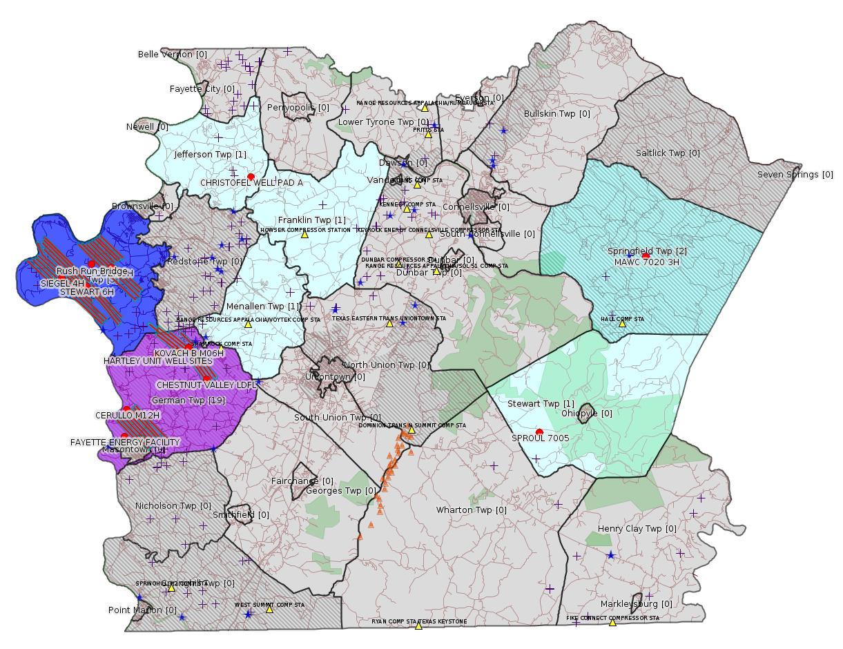
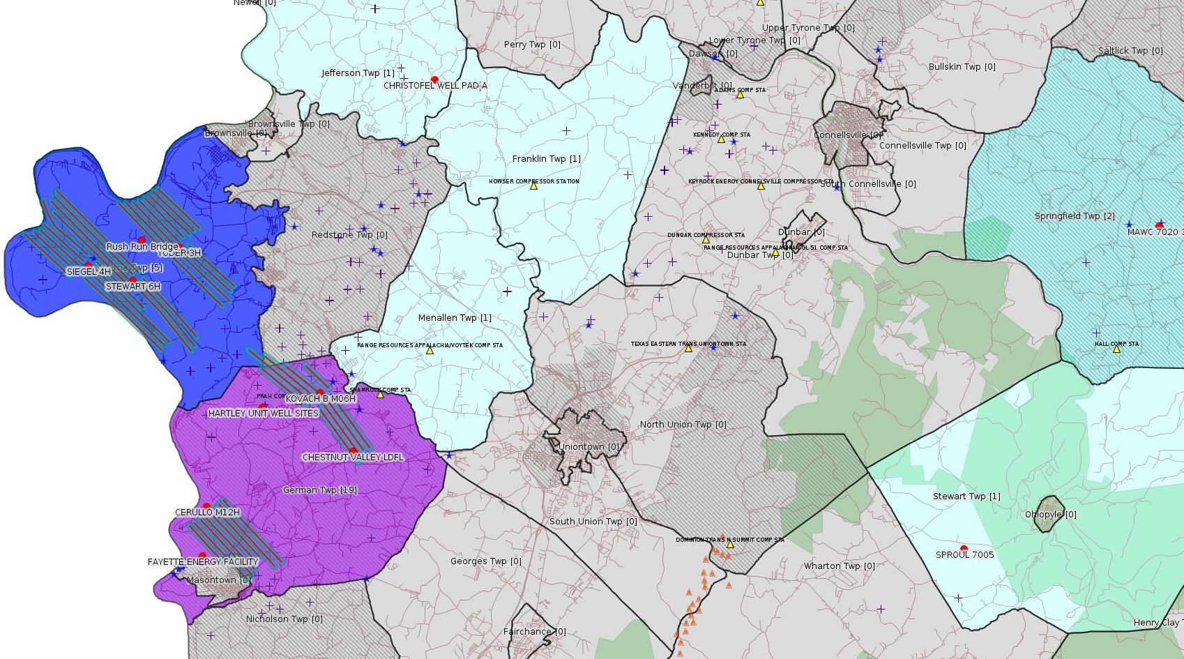
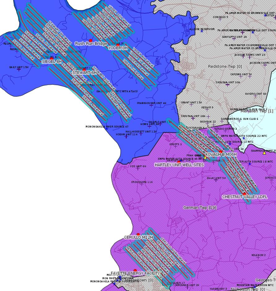
Map
Key
Red dots: items in this permit list with an exact location.
Blue stars: Marcellus Gas Well Water Sources.
Where well laterals are mapped they show in red; a 400-foot buffer surrounding the lateral shows in blue (lavender where it overlaps a mapped mineral tract).
Where mineral tracts are mapped, they show in pink. Mineral tracts can overlap; the overlap will show in red. The precise meaning of "mineral tract" is not clear.
Municipality shading: number of "facilities", with each well counting separately
(includes the red dots):
gray: 0
pale turquoise: 1
turquoise: 2
pale blue: 3
middle blue: 4
dark blue: 5
dark purple: 8
purple: 19
(Color coding may differ from one issue to the next.)
(Note if a project spans multiple municipalities -- e.g. a pipeline -- it will show in the count for each municipality.)
The number of facilities also follows the municipality name in brackets.
Municipality counts are based on the way the permit is listed by DEP; DEP has been known to get a municipality wrong.
Locations in brackets identify a precise location used to locate a surrogate for the actual site being permitted (e.g. locating a well pad or pipeline by the known location of a well.) Locations labeled beginning with "~" and ending in "[?]" are approximate and speculative based on inferences using on-line property and lease records. These are marked in the text as "[Approximate, Speculative]
Cross-hatching: Environmental Justice Areas
Yellow triangles: Compressor Stations
Orange triangles: Storage Field Wells (currently Dominion North Summit Storage Field)
Crosses: SPUD Unconventional well permits
Green: "Natural areas", e.g. state game lands, state forests
Yellow triangles: Compressor Stations
Orange triangles: Storage Field Wells (currently Dominion North Summit Storage Field)
Crosses: SPUD Unconventional well permits
Green: "Natural areas", e.g. state game lands, state forests
More Maps
 |
 |
Source: Pennsylvania Bulletin
[PROBABLY off-topic:]
E26-383, PennDOT District 12-0, 825 North Gallatin Avenue, Uniontown, PA 15401, Luzerne Township, Fayette County; Pittsburgh ACOE District.
Has been given consent to:
Remove the existing 15` long, 32.9` wide, 25 SF opening, slab bridge carrying SR 4001 over Rush Run (WWF) with a drainage area of 1.23 square mile; construct and maintain a replacement 22` long, 39.5` wide, 3.5` underclearance box culvert on existing alignment; place and maintain fill in 78` of Rush Run and construct and maintain 63` of replacement relocated channel to align with the culvert replacement and road improvement work; regrade 53` of Rush Run to maintain the hydraulic opening at the proposed culvert outlet; construct and maintain 141` of rip-rap streambank stabilization. In addition, place and maintain fill in a de minimis 0.032 acre of PEM wetlands, construct and maintain associated stormwater facilities, and temporarily impact 0.065 acre of PEM wetlands and 551` of stream for the purpose of constructing these encroachments. The project results in a total permanent stream impact of 455`. Stream impacts will be mitigated onsite via construction of a mudsill along Rush Run, and removal of two abandoned railroad abutments which are currently restricting streamflow.
The project site is located approximately one half mile south of the intersection of SR 4001 (Rush Run Road) and Telegraph Road (Carmichaels PA Quadrangle; Latitude: 39° 58` 42"; Longitude: -79° 56` 32"; Sub-basin 19C; USACE Pittsburgh District) in Luzerne Township, Fayette County.
<https://www.pabulletin.com/secure/data/vol49/49-3/76e.html>
[See Notes.]
-------------------------
Source: eNOTICE (+ PA Oil and Gas Mapping, Well Pad Report.) Well Details via Data Portal Services: Oil and Gas Wells All (ID: 3).
Please see the Disclaimer below regarding Parcel Id data.
New:
[Arguably Off-Topic:]Authorization ID: 1259239
Permit number: 26-00535B
Site: FAYETTE ENERGY FACILITY
Client: DYNEGY FAYETTE II, LLC
Authorization type: Major Facility Plan Approval New Source Performance Std
Application type: Extension
Authorization is for: FACILITY
Date received: 01/23/2019
Status: Pending
Permit Decision Guarantee Applies?: No
<https://www.ahs.dep.pa.gov/eFACTSWeb/searchResults_singleAuth.aspx?AuthID=1259239>
Site Programs:
Air Quality
Waste Management
Water Planning and Conservation
Location: 39.857408,-79.913878
Map URL: <http://www.openstreetmap.org/?mlat=39.857408&mlon=-79.913878#map=15/39.857408/-79.913878>
Site Municipalities:
German Twp [an Environmental Justice Area], Fayette County
Masontown Boro [Incorrect -jr], Fayette County
Presumed Parcel Id: 1530006703
Site Municipalities:
German Twp [an Environmental Justice Area], Fayette County
Masontown Boro [Incorrect -jr], Fayette County
Presumed Parcel Id: 1530006703
---
New:
Authorization ID: 1259066
Permit number: 051-24632
Site: STEWART WELL SITE ESCGP-2 EXPEDITED
Client: CHEVRON APPALACHIA LLC
Authorization type: Well Plugging Notice Alternate Method
Application type: New
Authorization is for: FACILITY
Date received: 01/22/2019
Status: Pending
Permit Decision Guarantee Applies?: No
Sub-Facilities for Authorization:
Sub-Facility ID Sub-Facility Name Description
1248438 STEWART 6H Well
Permit Review Notes:
Date Review Note
1/23/2019 The permit application package is complete, has been accepted, and is undergoing technical review.
<https://www.ahs.dep.pa.gov/eFACTSWeb/searchResults_singleAuth.aspx?AuthID=1259066>
Site Programs:
Environmental Cleanup & Brownfields
Oil & Gas
Site Municipalities:
Luzerne Twp, Fayette County
Well Details:
Permit Number: 051-24632
Well Name: STEWART 6H
Unconventional Well: Y
Well Configuration: Horizontal Well
Well Type: GAS
Well Status: Active
Coal Association: Coal
Conservation Well: N
Primary Facility ID: 794420
Site ID: 788124
Site Name: STEWART WELL SITE ESCGP-2 EXPEDITED
Well Pad ID: 152396
Well Pad Name: STEWART
Storage Field:
Operator: CHEVRON APPALACHIA LLC
Operator Number: OGO-39307
Permit Date: 2015-07-17
Permit Date Expires: 2019-01-26
SPUD Date: 2015-09-01
Date Plugged:
UIC ID:
UIC Type:
Surface Elevation: 1145
County: Fayette
Municipality: Luzerne Twp
Location: 39.962881,-79.946972
Map URL: <http://www.openstreetmap.org/?mlat=39.962881&mlon=-79.946972#map=15/39.962881/-79.946972>
OG WELLS PERMIT DOCS:
2015-07-17: Final Permit Documents, Name: 051-24632-00-00 1077205 (for Authorization: 1077205):
<http://www.depgis.state.pa.us/pdfHandler/pdFHandler.ashx?Doc=MjExNjEw&ext=PDF>
2018-01-26: Final Permit Documents, Name: 1203104 (for Authorization: 1203104):
<http://www.depgis.state.pa.us/pdfHandler/pdFHandler.ashx?Doc=NTUxMTMx&ext=PDF>
2018-01-26: Other Permit Documents, Name: Approval of Surface Locations by Landowners (for Authorization: 1203104):
<http://www.depgis.state.pa.us/pdfHandler/pdFHandler.ashx?Doc=NTQ5NzEy&ext=PDF>
Electronically Submitted Records:
2018-01-26: Submission for Authorization 1203104
Pennsylvania Natural Diversity Inventory Form: Stewart Pad A PNDI 8-22-17.pdf
<http://www.depgis.state.pa.us/eWellDocHandler/pdFHandler.ashx?Doc=MzkwOTUw&ext=PDF>
Permit Application to Drill and Operate a Well: Stewart 6H Mod Application 2017.pdf
<http://www.depgis.state.pa.us/eWellDocHandler/pdFHandler.ashx?Doc=MzkwOTUx&ext=PDF>
Location Plat: Stewart Well Plats 6H.dwg
<http://www.depgis.state.pa.us/eWellDocHandler/pdFHandler.ashx?Doc=MzkwOTUy&ext=PDF>
Coal and Gas Resource Coord Act - Section 7 Exception: Stewart 1H-7H Waiver Request Section 7.pdf
<http://www.depgis.state.pa.us/eWellDocHandler/pdFHandler.ashx?Doc=MzkwOTUz&ext=PDF>
Well Cross-Section Diagram: Stewart 6H Page 4.pdf
<http://www.depgis.state.pa.us/eWellDocHandler/pdFHandler.ashx?Doc=MzkwOTU0&ext=PDF>
Record of Notification to Interested Parties: Stewart 6H Notification of Interested Parties.pdf
<http://www.depgis.state.pa.us/eWellDocHandler/pdFHandler.ashx?Doc=MzkwOTU1&ext=PDF>
Well Permit Application - Coal Module: Stewart 1H-7H 2017 Coal Module.pdf
<http://www.depgis.state.pa.us/eWellDocHandler/pdFHandler.ashx?Doc=MzkwOTU2&ext=PDF>
Electronic Submission Docket: 1628616.pdf
<http://www.depgis.state.pa.us/eWellDocHandler/pdFHandler.ashx?Doc=MzkyNzk2&ext=PDF>
Presumed Parcel Id: 19250010
For Well Record see:
<http://www.ahs.dep.pa.gov/eSubmissionsDocs/DownloadESubmissionDocument.ashx?enc=MOpmV6IzBtmToVjqF07C9SRAf8AQSTbeMdYe9kUceYM%3d>
See Notes.
---
New:
Authorization ID: 1259064
Permit number: 051-24632
Site: STEWART WELL SITE ESCGP-2 EXPEDITED
Client: CHEVRON APPALACHIA LLC
Authorization type: Well Plugging Notice Intent to Plug Single Well
Application type: New
Authorization is for: FACILITY
Date received: 01/22/2019
Status: Pending
Permit Decision Guarantee Applies?: No
Sub-Facilities for Authorization:
Sub-Facility ID Sub-Facility Name Description
1248438 STEWART 6H Well
Permit Review Notes:
Date Review Note
1/23/2019 The permit application package is complete, has been accepted, and is undergoing technical review.
<https://www.ahs.dep.pa.gov/eFACTSWeb/searchResults_singleAuth.aspx?AuthID=1259064>
Site Programs:
Environmental Cleanup & Brownfields
Oil & Gas
Site Municipalities:
Luzerne Twp, Fayette County
Well Details above
Well Name: STEWART 6H
---
New:
Authorization ID: 1257928
Permit number: 051-24642
Site: [Should be SIEGEL WELL PAD ESCGP-2 EXPEDITED -jr]
Client: CHEVRON APPALACHIA LLC
Authorization type: Drill & Operate Well Permit (Unconventional)
Application type: Modification [See Notes]
Authorization is for: FACILITY
Date received: 01/11/2019
Status: Pending
Permit Decision Guarantee Applies?: No
Sub-Facilities for Authorization:
Sub-Facility ID Sub-Facility Name Description
1279705 WELLBORE SURFACE HOLE LOCATION Well
Permit Review Notes:
Date Review Note
1/22/2019 The technical review and decision review are complete and either the permit decision and/or permit issuance are forthcoming.
1/16/2019 The permit application package is complete, has been accepted, and is undergoing technical review.
<https://www.ahs.dep.pa.gov/eFACTSWeb/searchResults_singleAuth.aspx?AuthID=1257928>
Well Details:
Permit Number: 051-24642
Well Name: SIEGEL 4H
Unconventional Well: Y
Well Configuration: Horizontal Well
Well Type: GAS
Well Status: Active
Coal Association: Coal
Conservation Well: N
Primary Facility ID: 823790
Site ID: 790384
Site Name: SIEGEL WELL PAD ESCGP-2 EXPEDITED
Well Pad ID: 152926
Well Pad Name: SIEGEL 1
Storage Field:
Operator: CHEVRON APPALACHIA LLC
Operator Number: OGO-39307
Permit Date: 2018-02-15
Permit Date Expires: 2019-02-15
SPUD Date: 2018-04-02
Date Plugged:
UIC ID:
UIC Type:
Surface Elevation: 1173
County: Fayette
Municipality: Luzerne Twp
Location: 39.96885,-79.968994
Map URL: <http://www.openstreetmap.org/?mlat=39.96885&mlon=-79.968994#map=15/39.96885/-79.968994>
OG WELLS PERMIT DOCS:
2018-02-16: Final Permit Documents, Name: 1212436 (for Authorization: 1212436):
<http://www.depgis.state.pa.us/pdfHandler/pdFHandler.ashx?Doc=NTY1ODQ3&ext=PDF>
Electronically Submitted Records:
2018-02-16: Submission for Authorization 1212436
Interested Party Notification: Siegel Affidavit of Non-Delivery Foster.pdf
<http://www.depgis.state.pa.us/eWellDocHandler/pdFHandler.ashx?Doc=NDQ4OTQ4&ext=PDF>
Interested Party Notification: Siegel Affidavit of Non-Delivery Foster.pdf
<http://www.depgis.state.pa.us/eWellDocHandler/pdFHandler.ashx?Doc=NDQ4OTUz&ext=PDF>
Interested Party Notification: Siegel Affidavit of Non-Delivery Foster.pdf
<http://www.depgis.state.pa.us/eWellDocHandler/pdFHandler.ashx?Doc=NDQ4OTU0&ext=PDF>
Interested Party Notification: Siegel Affidavit of Non-Delivery Foster.pdf
<http://www.depgis.state.pa.us/eWellDocHandler/pdFHandler.ashx?Doc=NDQ4OTU1&ext=PDF>
Interested Party Notification: Siegel Affidavit of Non-Delivery Foster.pdf
<http://www.depgis.state.pa.us/eWellDocHandler/pdFHandler.ashx?Doc=NDQ4OTU2&ext=PDF>
Interested Party Notification: Siegel Affidavit of Non-Delivery Foster.pdf
<http://www.depgis.state.pa.us/eWellDocHandler/pdFHandler.ashx?Doc=NDQ4OTU3&ext=PDF>
Interested Party Notification: Siegel Affidavit of Non-Delivery Foster.pdf
<http://www.depgis.state.pa.us/eWellDocHandler/pdFHandler.ashx?Doc=NDQ4OTU4&ext=PDF>
Interested Party Notification: Siegel Affidavit of Non-Delivery Franks.pdf
<http://www.depgis.state.pa.us/eWellDocHandler/pdFHandler.ashx?Doc=NDQ4OTYz&ext=PDF>
Interested Party Notification: Siegel Affidavit of Non-Delivery Franks.pdf
<http://www.depgis.state.pa.us/eWellDocHandler/pdFHandler.ashx?Doc=NDQ4OTY3&ext=PDF>
Location Plat: 143-781-Well Plat 4H-pages1-2-3_3702.dwg
<http://www.depgis.state.pa.us/eWellDocHandler/pdFHandler.ashx?Doc=NDQ4OTc2&ext=PDF>
Pennsylvania Natural Diversity Inventory Form: Siegel PNDI.pdf
<http://www.depgis.state.pa.us/eWellDocHandler/pdFHandler.ashx?Doc=NDQ4OTc3&ext=PDF>
Coal and Gas Resource Coord Act - Section 7 Exception: Siegel 1H-9H Waiver Request Section 7.pdf
<http://www.depgis.state.pa.us/eWellDocHandler/pdFHandler.ashx?Doc=NDQ4OTc4&ext=PDF>
Well Cross-Section Diagram: Siegel 4H Page 4.pdf
<http://www.depgis.state.pa.us/eWellDocHandler/pdFHandler.ashx?Doc=NDQ4OTc5&ext=PDF>
Permit Application to Drill and Operate a Well: 1640040.pdf
<http://www.depgis.state.pa.us/eWellDocHandler/pdFHandler.ashx?Doc=NDQ5ODEy&ext=PDF>
2019-01-25: Submission for Authorization 1257928
Pennsylvania Natural Diversity Inventory Form: Siegel PNDI.pdf
<http://www.depgis.state.pa.us/eWellDocHandler/pdFHandler.ashx?Doc=NzM1NDQz&ext=PDF>
Location Plat: 143-781-Well Plat Revised 4H-pages1-2-3_3702.dwg
<http://www.depgis.state.pa.us/eWellDocHandler/pdFHandler.ashx?Doc=NzM1NDQ1&ext=PDF>
Permit Application to Drill and Operate a Well: Siegel 4H Application.pdf
<http://www.depgis.state.pa.us/eWellDocHandler/pdFHandler.ashx?Doc=NzM1NjA4&ext=PDF>
Coal and Gas Resource Coord Act - Section 7 Exception: Siegel 4H Waiver Request Section 7.pdf
<http://www.depgis.state.pa.us/eWellDocHandler/pdFHandler.ashx?Doc=NzM1NjEw&ext=PDF>
Well Cross-Section Diagram: Siegel 4H Page 4.pdf
<http://www.depgis.state.pa.us/eWellDocHandler/pdFHandler.ashx?Doc=NzM1NjEx&ext=PDF>
Interested Party Notification: Siegel 4H Interested Parties.pdf
<http://www.depgis.state.pa.us/eWellDocHandler/pdFHandler.ashx?Doc=NzM1NzE1&ext=PDF>
Well Permit Application - Coal Module: Siegel 4H Coal Module.pdf
<http://www.depgis.state.pa.us/eWellDocHandler/pdFHandler.ashx?Doc=NzM1NzE2&ext=PDF>
Electronic Submission Docket: 1870726.pdf
<http://www.depgis.state.pa.us/eWellDocHandler/pdFHandler.ashx?Doc=NzM1NzY0&ext=PDF>
Presumed Parcel Id: 19240018
---
Authorization ID: 1256831
Permit number: 051-24673
Site: KOVACH B WELL SITE AND TANK SITE ESCGP ESX17-051-0003
Client: CHEVRON APPALACHIA LLC
Authorization type: Alt Method of Equipping, Casing, or Venting Well
Application type: New
Authorization is for: FACILITY
Date received: 12/21/2018
Status: Issued on 1/9/2019
Permit Decision Guarantee Applies?: Yes
Permit Decision Guarantee status: ACTIVE
Sub-Facilities for Authorization:
Sub-Facility ID Sub-Facility Name Description
1263131 WELLBORE SURFACE HOLE LOCATION Well
Permit Review Notes:
Date Review Note
1/9/2019 The technical review and decision review are complete and either the permit decision and/or permit issuance are forthcoming.
1/2/2019 The permit application package is complete, has been accepted, and is undergoing technical review.
<https://www.ahs.dep.pa.gov/eFACTSWeb/searchResults_singleAuth.aspx?AuthID=1256831>
Site Programs:
Oil & Gas
Site Municipalities:
German Twp [an Environmental Justice Area], Fayette County
Well Details:
Permit Number: 051-24673
Well Name: KOVACH B M06H
Unconventional Well: Y
Well Configuration: Horizontal Well
Well Type: GAS
Well Status: Active
Coal Association: Coal
Conservation Well: N
Primary Facility ID: 828039
Site ID: 826949
Site Name: KOVACH B WELL SITE AND TANK SITE ESCGP ESX17-051-0003
Well Pad ID: 155005
Well Pad Name: KOVACH B
Storage Field:
Operator: CHEVRON APPALACHIA LLC
Operator Number: OGO-39307
Permit Date: 2018-08-08
Permit Date Expires: 2019-08-08
SPUD Date: 2018-10-23
Date Plugged:
UIC ID:
UIC Type:
Surface Elevation: 1278
County: Fayette
Municipality: German Twp
Location: 39.919122,-79.8547
Map URL: <http://www.openstreetmap.org/?mlat=39.919122&mlon=-79.8547#map=15/39.919122/-79.8547>
OG WELLS PERMIT DOCS:
2018-08-08: Final Permit Documents, Name: 1237729 (for Authorization: 1237729):
<http://www.depgis.state.pa.us/pdfHandler/pdFHandler.ashx?Doc=NjQ2Nzgx&ext=PDF>
2019-01-09: Other Permit Documents, Name: 051-24673 (for Authorization: 1256831):
<http://www.depgis.state.pa.us/pdfHandler/pdFHandler.ashx?Doc=NzI5MDE3&ext=PDF>
Electronically Submitted Records:
2018-08-08: Submission for Authorization 1237729
Interested Party Notification: Kovach B Affidavit of Non-Delivery Venere.pdf
<http://www.depgis.state.pa.us/eWellDocHandler/pdFHandler.ashx?Doc=NjAyNTE3&ext=PDF>
Pennsylvania Natural Diversity Inventory Form: Kovach B PNDI.pdf
<http://www.depgis.state.pa.us/eWellDocHandler/pdFHandler.ashx?Doc=NjAyNTI1&ext=PDF>
Location Plat: Kovach B M06H Plat.dwg
<http://www.depgis.state.pa.us/eWellDocHandler/pdFHandler.ashx?Doc=NjAyNTI2&ext=PDF>
Coal and Gas Resource Coord Act - Section 7 Exception: Kovach B Horizontals Section 7 Exception.pdf
<http://www.depgis.state.pa.us/eWellDocHandler/pdFHandler.ashx?Doc=NjAyNTI3&ext=PDF>
Well Cross-Section Diagram: Kovach B M06H Page 4.pdf
<http://www.depgis.state.pa.us/eWellDocHandler/pdFHandler.ashx?Doc=NjAyNTI4&ext=PDF>
Permit Application to Drill and Operate a Well: 1753541.pdf
<http://www.depgis.state.pa.us/eWellDocHandler/pdFHandler.ashx?Doc=NjAzODY5&ext=PDF>
---
Authorization ID: 1256801
Permit number: 051-24669
Site: KOVACH B WELL SITE AND TANK SITE ESCGP ESX17-051-0003
Client: CHEVRON APPALACHIA LLC
Authorization type: Alt Method of Equipping, Casing, or Venting Well
Application type: New
Authorization is for: FACILITY
Date received: 12/21/2018
Status: Issued on 1/9/2019
Permit Decision Guarantee Applies?: Yes
Permit Decision Guarantee status: ACTIVE
Sub-Facilities for Authorization:
Sub-Facility ID Sub-Facility Name Description
1263127 WELLBORE SURFACE HOLE LOCATION Well
Permit Review Notes:
Date Review Note
1/9/2019 The technical review and decision review are complete and either the permit decision and/or permit issuance are forthcoming.
1/2/2019 The permit application package is complete, has been accepted, and is undergoing technical review.
<https://www.ahs.dep.pa.gov/eFACTSWeb/searchResults_singleAuth.aspx?AuthID=1256801>
Site Programs:
Oil & Gas
Site Municipalities:
German Twp [an Environmental Justice Area], Fayette County
Well Details:
Permit Number: 051-24669
Well Name: KOVACH B M08H
Unconventional Well: Y
Well Configuration: Horizontal Well
Well Type: GAS
Well Status: Active
Coal Association: Coal
Conservation Well: N
Primary Facility ID: 828035
Site ID: 826949
Site Name: KOVACH B WELL SITE AND TANK SITE ESCGP ESX17-051-0003
Well Pad ID: 155005
Well Pad Name: KOVACH B
Storage Field:
Operator: CHEVRON APPALACHIA LLC
Operator Number: OGO-39307
Permit Date: 2018-08-08
Permit Date Expires: 2019-08-08
SPUD Date: 2018-10-23
Date Plugged:
UIC ID:
UIC Type:
Surface Elevation: 1278
County: Fayette
Municipality: German Twp
Location: 39.919197,-79.854658
Map URL: <http://www.openstreetmap.org/?mlat=39.919197&mlon=-79.854658#map=15/39.919197/-79.854658>
OG WELLS PERMIT DOCS:
2018-08-08: Final Permit Documents, Name: 1237725 (for Authorization: 1237725):
<http://www.depgis.state.pa.us/pdfHandler/pdFHandler.ashx?Doc=NjQ2Nzc0&ext=PDF>
2019-01-09: Other Permit Documents, Name: 051-24669 (for Authorization: 1256801):
<http://www.depgis.state.pa.us/pdfHandler/pdFHandler.ashx?Doc=NzI5MDIz&ext=PDF>
Electronically Submitted Records:
2018-08-08: Submission for Authorization 1237725
Interested Party Notification: Kovach B Affidavit of Non-Delivery Venere.pdf
<http://www.depgis.state.pa.us/eWellDocHandler/pdFHandler.ashx?Doc=NjAyNjA5&ext=PDF>
Coal and Gas Resource Coord Act - Section 7 Exception: Kovach B Horizontals Section 7 Exception.pdf
<http://www.depgis.state.pa.us/eWellDocHandler/pdFHandler.ashx?Doc=NjAyNjE1&ext=PDF>
Pennsylvania Natural Diversity Inventory Form: Kovach B PNDI.pdf
<http://www.depgis.state.pa.us/eWellDocHandler/pdFHandler.ashx?Doc=NjAyNjE2&ext=PDF>
Location Plat: Kovach B M08H Plat.dwg
<http://www.depgis.state.pa.us/eWellDocHandler/pdFHandler.ashx?Doc=NjAyNjE3&ext=PDF>
Well Cross-Section Diagram: Kovach B M08H Page 4.pdf
<http://www.depgis.state.pa.us/eWellDocHandler/pdFHandler.ashx?Doc=NjAyNjE4&ext=PDF>
Permit Application to Drill and Operate a Well: 1753555.pdf
<http://www.depgis.state.pa.us/eWellDocHandler/pdFHandler.ashx?Doc=NjAzODgz&ext=PDF>
---
Authorization ID: 1256785
Permit number: 051-24668
Site: KOVACH B WELL SITE AND TANK SITE ESCGP ESX17-051-0003
Client: CHEVRON APPALACHIA LLC
Authorization type: Alt Method of Equipping, Casing, or Venting Well
Application type: New
Authorization is for: FACILITY
Date received: 12/21/2018
Status: Issued on 1/9/2019
Permit Decision Guarantee Applies?: Yes
Permit Decision Guarantee status: ACTIVE
Sub-Facilities for Authorization:
Sub-Facility ID Sub-Facility Name Description
1263126 WELLBORE SURFACE HOLE LOCATION Well
Permit Review Notes:
Date Review Note
1/9/2019 The technical review and decision review are complete and either the permit decision and/or permit issuance are forthcoming.
1/2/2019 The permit application package is complete, has been accepted, and is undergoing technical review.
<https://www.ahs.dep.pa.gov/eFACTSWeb/searchResults_singleAuth.aspx?AuthID=1256785>
Site Programs:
Oil & Gas
Site Municipalities:
German Twp [an Environmental Justice Area], Fayette County
Well Details:
Permit Number: 051-24668
Well Name: KOVACH B M07H
Unconventional Well: Y
Well Configuration: Horizontal Well
Well Type: GAS
Well Status: Active
Coal Association: Coal
Conservation Well: N
Primary Facility ID: 828034
Site ID: 826949
Site Name: KOVACH B WELL SITE AND TANK SITE ESCGP ESX17-051-0003
Well Pad ID: 155005
Well Pad Name: KOVACH B
Storage Field:
Operator: CHEVRON APPALACHIA LLC
Operator Number: OGO-39307
Permit Date: 2018-08-08
Permit Date Expires: 2019-08-08
SPUD Date: 2018-10-23
Date Plugged:
UIC ID:
UIC Type:
Surface Elevation: 1278
County: Fayette
Municipality: German Twp
Location: 39.919161,-79.854681
Map URL: <http://www.openstreetmap.org/?mlat=39.919161&mlon=-79.854681#map=15/39.919161/-79.854681>
OG WELLS PERMIT DOCS:
2018-08-08: Final Permit Documents, Name: 1237724 (for Authorization: 1237724):
<http://www.depgis.state.pa.us/pdfHandler/pdFHandler.ashx?Doc=NjQ2Nzcz&ext=PDF>
2019-01-09: Other Permit Documents, Name: 051-24668 (for Authorization: 1256785):
<http://www.depgis.state.pa.us/pdfHandler/pdFHandler.ashx?Doc=NzI5MDgy&ext=PDF>
Electronically Submitted Records:
2018-08-08: Submission for Authorization 1237724
Interested Party Notification: Kovach B Affidavit of Non-Delivery Venere.pdf
<http://www.depgis.state.pa.us/eWellDocHandler/pdFHandler.ashx?Doc=NjAyNTUw&ext=PDF>
Coal and Gas Resource Coord Act - Section 7 Exception: Kovach B Horizontals Section 7 Exception.pdf
<http://www.depgis.state.pa.us/eWellDocHandler/pdFHandler.ashx?Doc=NjAyNTY1&ext=PDF>
Pennsylvania Natural Diversity Inventory Form: Kovach B PNDI.pdf
<http://www.depgis.state.pa.us/eWellDocHandler/pdFHandler.ashx?Doc=NjAyNTY2&ext=PDF>
Location Plat: Kovach B M07H Plat.dwg
<http://www.depgis.state.pa.us/eWellDocHandler/pdFHandler.ashx?Doc=NjAyNTY3&ext=PDF>
Well Cross-Section Diagram: Kovach B M07H Page 4.pdf
<http://www.depgis.state.pa.us/eWellDocHandler/pdFHandler.ashx?Doc=NjAyNTY4&ext=PDF>
Permit Application to Drill and Operate a Well: 1753553.pdf
<http://www.depgis.state.pa.us/eWellDocHandler/pdFHandler.ashx?Doc=NjAzODcy&ext=PDF>
---
Authorization ID: 1256748
Permit number: 051-24667
Site: KOVACH B WELL SITE AND TANK SITE ESCGP ESX17-051-0003
Client: CHEVRON APPALACHIA LLC
Authorization type: Alt Method of Equipping, Casing, or Venting Well
Application type: New
Authorization is for: FACILITY
Date received: 12/21/2018
Status: Issued on 1/9/2019
Permit Decision Guarantee Applies?: Yes
Permit Decision Guarantee status: ACTIVE
Sub-Facilities for Authorization:
Sub-Facility ID Sub-Facility Name Description
1263125 WELLBORE SURFACE HOLE LOCATION Well
Permit Review Notes:
Date Review Note
1/9/2019 The technical review and decision review are complete and either the permit decision and/or permit issuance are forthcoming.
1/2/2019 The permit application package is complete, has been accepted, and is undergoing technical review.
<https://www.ahs.dep.pa.gov/eFACTSWeb/searchResults_singleAuth.aspx?AuthID=1256748>
Site Programs:
Oil & Gas
Site Municipalities:
German Twp [an Environmental Justice Area], Fayette County
Well Details:
Permit Number: 051-24667
Well Name: KOVACH B M05H
Unconventional Well: Y
Well Configuration: Horizontal Well
Well Type: GAS
Well Status: Active
Coal Association: Coal
Conservation Well: N
Primary Facility ID: 828033
Site ID: 826949
Site Name: KOVACH B WELL SITE AND TANK SITE ESCGP ESX17-051-0003
Well Pad ID: 155005
Well Pad Name: KOVACH B
Storage Field:
Operator: CHEVRON APPALACHIA LLC
Operator Number: OGO-39307
Permit Date: 2018-08-08
Permit Date Expires: 2019-08-08
SPUD Date: 2018-10-23
Date Plugged:
UIC ID:
UIC Type:
Surface Elevation: 1278
County: Fayette
Municipality: German Twp
Location: 39.919086,-79.854722
Map URL: <http://www.openstreetmap.org/?mlat=39.919086&mlon=-79.854722#map=15/39.919086/-79.854722>
OG WELLS PERMIT DOCS:
2018-08-08: Final Permit Documents, Name: 1237723 (for Authorization: 1237723):
<http://www.depgis.state.pa.us/pdfHandler/pdFHandler.ashx?Doc=NjQ2Nzcw&ext=PDF>
2019-01-09: Other Permit Documents, Name: 051-24667 (for Authorization: 1256748):
<http://www.depgis.state.pa.us/pdfHandler/pdFHandler.ashx?Doc=NzI5MDg4&ext=PDF>
Electronically Submitted Records:
2018-08-08: Submission for Authorization 1237723
Interested Party Notification: Kovach B Affidavit of Non-Delivery Venere.pdf
<http://www.depgis.state.pa.us/eWellDocHandler/pdFHandler.ashx?Doc=NjAyNDYz&ext=PDF>
Pennsylvania Natural Diversity Inventory Form: Kovach B PNDI.pdf
<http://www.depgis.state.pa.us/eWellDocHandler/pdFHandler.ashx?Doc=NjAyNDY5&ext=PDF>
Location Plat: Kovach B M05H Plat.dwg
<http://www.depgis.state.pa.us/eWellDocHandler/pdFHandler.ashx?Doc=NjAyNDcw&ext=PDF>
Coal and Gas Resource Coord Act - Section 7 Exception: Kovach B Horizontals Section 7 Exception.pdf
<http://www.depgis.state.pa.us/eWellDocHandler/pdFHandler.ashx?Doc=NjAyNDcx&ext=PDF>
Well Cross-Section Diagram: Kovach B M05H Page 4.pdf
<http://www.depgis.state.pa.us/eWellDocHandler/pdFHandler.ashx?Doc=NjAyNDcy&ext=PDF>
Permit Application to Drill and Operate a Well: 1753273.pdf
<http://www.depgis.state.pa.us/eWellDocHandler/pdFHandler.ashx?Doc=NjAzODYx&ext=PDF>
---
Authorization ID: 1256724
Permit number: 051-24666
Site: KOVACH B WELL SITE AND TANK SITE ESCGP ESX17-051-0003
Client: CHEVRON APPALACHIA LLC
Authorization type: Alt Method of Equipping, Casing, or Venting Well
Application type: New
Authorization is for: FACILITY
Date received: 12/21/2018
Status: Issued on 1/9/2019
Permit Decision Guarantee Applies?: Yes
Permit Decision Guarantee status: ACTIVE
Sub-Facilities for Authorization:
Sub-Facility ID Sub-Facility Name Description
1263124 WELLBORE SURFACE HOLE LOCATION Well
Permit Review Notes:
Date Review Note
1/9/2019 The technical review and decision review are complete and either the permit decision and/or permit issuance are forthcoming.
1/2/2019 The permit application package is complete, has been accepted, and is undergoing technical review.
<https://www.ahs.dep.pa.gov/eFACTSWeb/searchResults_singleAuth.aspx?AuthID=1256724>
Site Programs:
Oil & Gas
Site Municipalities:
German Twp [an Environmental Justice Area], Fayette County
Well Details:
Permit Number: 051-24666
Well Name: KOVACH B M04H
Unconventional Well: Y
Well Configuration: Horizontal Well
Well Type: GAS
Well Status: Active
Coal Association: Coal
Conservation Well: N
Primary Facility ID: 828032
Site ID: 826949
Site Name: KOVACH B WELL SITE AND TANK SITE ESCGP ESX17-051-0003
Well Pad ID: 155005
Well Pad Name: KOVACH B
Storage Field:
Operator: CHEVRON APPALACHIA LLC
Operator Number: OGO-39307
Permit Date: 2018-08-08
Permit Date Expires: 2019-08-08
SPUD Date: 2018-10-23
Date Plugged:
UIC ID:
UIC Type:
Surface Elevation: 1278
County: Fayette
Municipality: German Twp
Location: 39.919047,-79.854742
Map URL: <http://www.openstreetmap.org/?mlat=39.919047&mlon=-79.854742#map=15/39.919047/-79.854742>
OG WELLS PERMIT DOCS:
2018-08-08: Final Permit Documents, Name: 1237722 (for Authorization: 1237722):
<http://www.depgis.state.pa.us/pdfHandler/pdFHandler.ashx?Doc=NjQ2NzY1&ext=PDF>
2019-01-09: Other Permit Documents, Name: 051-24666 (for Authorization: 1256724):
<http://www.depgis.state.pa.us/pdfHandler/pdFHandler.ashx?Doc=NzI5MTE0&ext=PDF>
Electronically Submitted Records:
2018-08-08: Submission for Authorization 1237722
Interested Party Notification: Kovach B Affidavit of Non-Delivery Venere.pdf
<http://www.depgis.state.pa.us/eWellDocHandler/pdFHandler.ashx?Doc=NjAyMDMz&ext=PDF>
Coal and Gas Resource Coord Act - Section 7 Exception: Kovach B Horizontals Section 7 Exception.pdf
<http://www.depgis.state.pa.us/eWellDocHandler/pdFHandler.ashx?Doc=NjAyMDQx&ext=PDF>
Pennsylvania Natural Diversity Inventory Form: Kovach B PNDI.pdf
<http://www.depgis.state.pa.us/eWellDocHandler/pdFHandler.ashx?Doc=NjAyMDQy&ext=PDF>
Location Plat: Kovach B M04H Plat.dwg
<http://www.depgis.state.pa.us/eWellDocHandler/pdFHandler.ashx?Doc=NjAyMDQz&ext=PDF>
Well Cross-Section Diagram: Kovach B M04H Page 4.pdf
<http://www.depgis.state.pa.us/eWellDocHandler/pdFHandler.ashx?Doc=NjAyMDQ0&ext=PDF>
Permit Application to Drill and Operate a Well: 1753263.pdf
<http://www.depgis.state.pa.us/eWellDocHandler/pdFHandler.ashx?Doc=NjAzODU0&ext=PDF>
---
Authorization ID: 1256610
Permit number: ESX10-051-0040
Site: HARTLEY UNIT WELL SITES ESCGP-EXPEDITED
Client: CHEVRON APPALACHIA LLC
Authorization type: Expedited E&S Stormwater General Permit 1
Application type: Notification
Authorization is for: SITE
Date received: 12/28/2018
Status: Issued on 1/14/2019
Permit Decision Guarantee Applies?: No
Permit Review Notes:
Date Review Note
1/14/2019 The technical review and decision review are complete and either the permit decision and/or permit issuance are forthcoming.
12/31/2018 The permit application package is complete, has been accepted, and is undergoing technical review.
<https://www.ahs.dep.pa.gov/eFACTSWeb/searchResults_singleAuth.aspx?AuthID=1256610>
Site Programs:
Site Municipalities:
German Twp [an Environmental Justice Area], Fayette County
Well Pad ID: 148486
Location: 39.914019,-79.883219 <https://osm.org/go/ZWpaEpog--?m=>
Wells on this pad:
051-24452 HARTLEY UNIT 6H
051-24453 HARTLEY UNIT 7H
051-24454 HARTLEY UNIT 8H
051-24455 HARTLEY UNIT 9H
051-24456 HARTLEY UNIT 10H
051-24457 HARTLEY UNIT 11H
Presumed Parcel Id: 15110004
Location: 39.914019,-79.883219 <https://osm.org/go/ZWpaEpog--?m=>
Wells on this pad:
051-24452 HARTLEY UNIT 6H
051-24453 HARTLEY UNIT 7H
051-24454 HARTLEY UNIT 8H
051-24455 HARTLEY UNIT 9H
051-24456 HARTLEY UNIT 10H
051-24457 HARTLEY UNIT 11H
Presumed Parcel Id: 15110004
---
Authorization ID: 1256580
Permit number: ESG30705118-001
Site: CHRISTOFEL WELL PAD A PROJECT ESG30705118-001
Client: CHEVRON APPALACHIA LLC
Authorization type: Erosion and Sediment Control General Permit 3
Application type: New
Authorization is for: SITE
Date received: 12/20/2018
Status: Pending
Permit Decision Guarantee Applies?: Yes
Permit Decision Guarantee status: VOID
<https://www.ahs.dep.pa.gov/eFACTSWeb/searchResults_singleAuth.aspx?AuthID=1256580>
Site Programs:
Site Municipalities:
Jefferson Twp, Fayette County
Location: 40.0380,-79.7956
Presumed Parcel Id: 17130025
Act 14 Notification:
<https://www.faymarwatch.org/documents/Christofel_Well_Pad_A_Act_14_NOI.pdf>
[See Notes.]
Presumed Parcel Id: 17130025
Act 14 Notification:
<https://www.faymarwatch.org/documents/Christofel_Well_Pad_A_Act_14_NOI.pdf>
[See Notes.]
---
Authorization ID: 1255021
Permit number: GP082607218505
Site: SOUTHERN PA GATHERING SYSTEM ABANDONMENT PPL 7894 PROJECTGP 08
Client: COLUMBIA GAS TRANS LLC
Authorization type: GP-08 Temporary Road Crossings
Application type: New
Authorization is for: FACILITY
Date received: 12/11/2018
Status: Pending
Permit Decision Guarantee Applies?: No
Sub-Facilities for Authorization:
Sub-Facility ID Sub-Facility Name Description
1276753 S PA GATHERING SYSTEM ABANDONMENT PPL 7894 PROJECT GP08 Bridge
<https://www.ahs.dep.pa.gov/eFACTSWeb/searchResults_singleAuth.aspx?AuthID=1255021>
Site Programs:
Water Planning and Conservation
Site Municipalities:
Menallen Twp, Fayette County
---
Authorization ID: 1254004
Permit number: 051-24697
Site: CERULLO PAD A ESCGP ESX18-051-0004
Client: CHEVRON APPALACHIA LLC
Authorization type: Drill & Operate Well Permit (Unconventional)
Application type: New
Authorization is for: FACILITY
Date received: 12/04/2018
Status: Issued on 1/11/2019
Permit Decision Guarantee Applies?: No
Sub-Facilities for Authorization:
Sub-Facility ID Sub-Facility Name Description
1276244 WELLBORE SURFACE HOLE LOCATION Well
Permit Review Notes:
Date Review Note
1/3/2019 The technical review and decision review are complete and either the permit decision and/or permit issuance are forthcoming.
12/14/2018 Applicant has been issued a deficiency letter. If applicable, this application no longer qualifies for the Permit Decision Guarantee.
12/5/2018 The permit application package is complete, has been accepted, and is undergoing technical review.
<https://www.ahs.dep.pa.gov/eFACTSWeb/searchResults_singleAuth.aspx?AuthID=1254004>
Site Programs:
Oil & Gas
Site Municipalities:
German Twp [an Environmental Justice Area], Fayette County
Well Details:
Permit Number: 051-24697
Well Name: CERULLO M12H
Unconventional Well: Y
Well Configuration: Horizontal Well
Well Type: GAS
Well Status: Active
Coal Association: Coal
Conservation Well: N
Primary Facility ID: 830840
Site ID: 829618
Site Name: CERULLO PAD A ESCGP ESX18-051-0004
Well Pad ID: 155068
Well Pad Name: CERULLO
Storage Field:
Operator: CHEVRON APPALACHIA LLC
Operator Number: OGO-39307
Permit Date: 2019-01-11
Permit Date Expires: 2020-01-11
SPUD Date:
Date Plugged:
UIC ID:
UIC Type:
Surface Elevation: 1063
County: Fayette
Municipality: German Twp
Location: 39.876292,-79.9115
Map URL: <http://www.openstreetmap.org/?mlat=39.876292&mlon=-79.9115#map=15/39.876292/-79.9115>
OG WELLS PERMIT DOCS:
2019-01-11: Other Permit Documents, Name: CerulloPad_Notification_of_unlocked_authorization_request-AuthorizationID1254004 (for Authorization: 1254004):
<http://www.depgis.state.pa.us/pdfHandler/pdFHandler.ashx?Doc=NzI2MjY1&ext=PDF>
2019-01-11: Final Permit Documents, Name: 051-24697 (for Authorization: 1254004):
<http://www.depgis.state.pa.us/pdfHandler/pdFHandler.ashx?Doc=NzMwNTYx&ext=PDF>
Electronically Submitted Records:
2019-01-11: Submission for Authorization 1254004
Pennsylvania Natural Diversity Inventory Form: Cerullo PNDI.pdf
<http://www.depgis.state.pa.us/eWellDocHandler/pdFHandler.ashx?Doc=NzAzNDg5&ext=PDF>
Well Cross-Section Diagram: Cerullo M12H Page 4.pdf
<http://www.depgis.state.pa.us/eWellDocHandler/pdFHandler.ashx?Doc=NzAzNDkw&ext=PDF>
Location Plat: CERULLO Well Plat M12H.dwg
<http://www.depgis.state.pa.us/eWellDocHandler/pdFHandler.ashx?Doc=NzI4MjQ0&ext=PDF>
Permit Application to Drill and Operate a Well: 1842690.pdf
<http://www.depgis.state.pa.us/eWellDocHandler/pdFHandler.ashx?Doc=NzI4NTk0&ext=PDF>
Presumed Parcel Id: 15190070
---
Authorization ID: 1254003
Permit number: 051-24696
Site: CERULLO PAD A ESCGP ESX18-051-0004
Client: CHEVRON APPALACHIA LLC
Authorization type: Drill & Operate Well Permit (Unconventional)
Application type: New
Authorization is for: FACILITY
Date received: 12/04/2018
Status: Issued on 1/11/2019
Permit Decision Guarantee Applies?: No
Sub-Facilities for Authorization:
Sub-Facility ID Sub-Facility Name Description
1276243 WELLBORE SURFACE HOLE LOCATION Well
Permit Review Notes:
Date Review Note
1/3/2019 The technical review and decision review are complete and either the permit decision and/or permit issuance are forthcoming.
12/14/2018 Applicant has been issued a deficiency letter. If applicable, this application no longer qualifies for the Permit Decision Guarantee.
12/5/2018 The permit application package is complete, has been accepted, and is undergoing technical review.
<https://www.ahs.dep.pa.gov/eFACTSWeb/searchResults_singleAuth.aspx?AuthID=1254003>
Site Programs:
Oil & Gas
Site Municipalities:
German Twp [an Environmental Justice Area], Fayette County
Well Details:
Permit Number: 051-24696
Well Name: CERULLO M11H
Unconventional Well: Y
Well Configuration: Horizontal Well
Well Type: GAS
Well Status: Active
Coal Association: Coal
Conservation Well: N
Primary Facility ID: 830839
Site ID: 829618
Site Name: CERULLO PAD A ESCGP ESX18-051-0004
Well Pad ID: 155068
Well Pad Name: CERULLO
Storage Field:
Operator: CHEVRON APPALACHIA LLC
Operator Number: OGO-39307
Permit Date: 2019-01-11
Permit Date Expires: 2020-01-11
SPUD Date:
Date Plugged:
UIC ID:
UIC Type:
Surface Elevation: 1063
County: Fayette
Municipality: German Twp
Location: 39.876258,-79.911469
Map URL: <http://www.openstreetmap.org/?mlat=39.876258&mlon=-79.911469#map=15/39.876258/-79.911469>
OG WELLS PERMIT DOCS:
2019-01-11: Other Permit Documents, Name: CerulloPad_Notification_of_unlocked_authorization_request-AuthorizationID1254003 (for Authorization: 1254003):
<http://www.depgis.state.pa.us/pdfHandler/pdFHandler.ashx?Doc=NzI2MjYw&ext=PDF>
2019-01-11: Final Permit Documents, Name: 051-24696 (for Authorization: 1254003):
<http://www.depgis.state.pa.us/pdfHandler/pdFHandler.ashx?Doc=NzMwNTYw&ext=PDF>
Electronically Submitted Records:
2019-01-11: Submission for Authorization 1254003
Pennsylvania Natural Diversity Inventory Form: Cerullo PNDI.pdf
<http://www.depgis.state.pa.us/eWellDocHandler/pdFHandler.ashx?Doc=NzAzNDgx&ext=PDF>
Well Cross-Section Diagram: Cerullo M11H Page 4.pdf
<http://www.depgis.state.pa.us/eWellDocHandler/pdFHandler.ashx?Doc=NzAzNDgz&ext=PDF>
Location Plat: CERULLO Well Plat M11H.dwg
<http://www.depgis.state.pa.us/eWellDocHandler/pdFHandler.ashx?Doc=NzI4MjM5&ext=PDF>
Permit Application to Drill and Operate a Well: 1842688.pdf
<http://www.depgis.state.pa.us/eWellDocHandler/pdFHandler.ashx?Doc=NzI4NTkw&ext=PDF>
---
Authorization ID: 1253996
Permit number: 051-24695
Site: CERULLO PAD A ESCGP ESX18-051-0004
Client: CHEVRON APPALACHIA LLC
Authorization type: Drill & Operate Well Permit (Unconventional)
Application type: New
Authorization is for: FACILITY
Date received: 12/04/2018
Status: Issued on 1/11/2019
Permit Decision Guarantee Applies?: No
Sub-Facilities for Authorization:
Sub-Facility ID Sub-Facility Name Description
1276240 WELLBORE SURFACE HOLE LOCATION Well
Permit Review Notes:
Date Review Note
1/3/2019 The technical review and decision review are complete and either the permit decision and/or permit issuance are forthcoming.
12/14/2018 Applicant has been issued a deficiency letter. If applicable, this application no longer qualifies for the Permit Decision Guarantee.
12/5/2018 The permit application package is complete, has been accepted, and is undergoing technical review.
<https://www.ahs.dep.pa.gov/eFACTSWeb/searchResults_singleAuth.aspx?AuthID=1253996>
Site Programs:
Oil & Gas
Site Municipalities:
German Twp [an Environmental Justice Area], Fayette County
Well Details:
Permit Number: 051-24695
Well Name: CERULLO M02H
Unconventional Well: Y
Well Configuration: Horizontal Well
Well Type: GAS
Well Status: Active
Coal Association: Coal
Conservation Well: N
Primary Facility ID: 830837
Site ID: 829618
Site Name: CERULLO PAD A ESCGP ESX18-051-0004
Well Pad ID: 155068
Well Pad Name: CERULLO
Storage Field:
Operator: CHEVRON APPALACHIA LLC
Operator Number: OGO-39307
Permit Date: 2019-01-11
Permit Date Expires: 2020-01-11
SPUD Date:
Date Plugged:
UIC ID:
UIC Type:
Surface Elevation: 1063
County: Fayette
Municipality: German Twp
Location: 39.876275,-79.91135
Map URL: <http://www.openstreetmap.org/?mlat=39.876275&mlon=-79.91135#map=15/39.876275/-79.91135>
OG WELLS PERMIT DOCS:
2019-01-11: Other Permit Documents, Name: CerulloPad_Notification_of_unlocked_authorization_request-AuthorizationID1253996 (for Authorization: 1253996):
<http://www.depgis.state.pa.us/pdfHandler/pdFHandler.ashx?Doc=NzI2MjE0&ext=PDF>
2019-01-11: Final Permit Documents, Name: 051-24695 (for Authorization: 1253996):
<http://www.depgis.state.pa.us/pdfHandler/pdFHandler.ashx?Doc=NzMwNTUw&ext=PDF>
Electronically Submitted Records:
2019-01-11: Submission for Authorization 1253996
Pennsylvania Natural Diversity Inventory Form: Cerullo PNDI.pdf
<http://www.depgis.state.pa.us/eWellDocHandler/pdFHandler.ashx?Doc=NzAzNDIy&ext=PDF>
Well Cross-Section Diagram: Cerullo M02H Page 4.pdf
<http://www.depgis.state.pa.us/eWellDocHandler/pdFHandler.ashx?Doc=NzAzNDIz&ext=PDF>
Location Plat: CERULLO Well Plat M02H.dwg
<http://www.depgis.state.pa.us/eWellDocHandler/pdFHandler.ashx?Doc=NzI4MjI3&ext=PDF>
Permit Application to Drill and Operate a Well: 1842505.pdf
<http://www.depgis.state.pa.us/eWellDocHandler/pdFHandler.ashx?Doc=NzI4NTU3&ext=PDF>
---
Authorization ID: 1253995
Permit number: 051-24694
Site: CERULLO PAD A ESCGP ESX18-051-0004
Client: CHEVRON APPALACHIA LLC
Authorization type: Drill & Operate Well Permit (Unconventional)
Application type: New
Authorization is for: FACILITY
Date received: 12/04/2018
Status: Issued on 1/11/2019
Permit Decision Guarantee Applies?: No
Sub-Facilities for Authorization:
Sub-Facility ID Sub-Facility Name Description
1276239 WELLBORE SURFACE HOLE LOCATION Well
Permit Review Notes:
Date Review Note
1/3/2019 The technical review and decision review are complete and either the permit decision and/or permit issuance are forthcoming.
12/14/2018 Applicant has been issued a deficiency letter. If applicable, this application no longer qualifies for the Permit Decision Guarantee.
12/5/2018 The permit application package is complete, has been accepted, and is undergoing technical review.
<https://www.ahs.dep.pa.gov/eFACTSWeb/searchResults_singleAuth.aspx?AuthID=1253995>
Site Programs:
Oil & Gas
Site Municipalities:
German Twp [an Environmental Justice Area], Fayette County
Well Details:
Permit Number: 051-24694
Well Name: CERULLO M04H
Unconventional Well: Y
Well Configuration: Horizontal Well
Well Type: GAS
Well Status: Active
Coal Association: Coal
Conservation Well: N
Primary Facility ID: 830836
Site ID: 829618
Site Name: CERULLO PAD A ESCGP ESX18-051-0004
Well Pad ID: 155068
Well Pad Name: CERULLO
Storage Field:
Operator: CHEVRON APPALACHIA LLC
Operator Number: OGO-39307
Permit Date: 2019-01-11
Permit Date Expires: 2020-01-11
SPUD Date:
Date Plugged:
UIC ID:
UIC Type:
Surface Elevation: 1063
County: Fayette
Municipality: German Twp
Location: 39.876342,-79.911414
Map URL: <http://www.openstreetmap.org/?mlat=39.876342&mlon=-79.911414#map=15/39.876342/-79.911414>
OG WELLS PERMIT DOCS:
2019-01-11: Final Permit Documents, Name: 051-24694 (for Authorization: 1253995):
<http://www.depgis.state.pa.us/pdfHandler/pdFHandler.ashx?Doc=NzMwNTUy&ext=PDF>
2019-01-11: Other Permit Documents, Name: CerulloPad_Notification_of_unlocked_authorization_request-AuthorizationID1253995 (for Authorization: 1253995):
<http://www.depgis.state.pa.us/pdfHandler/pdFHandler.ashx?Doc=NzI2MjQ1&ext=PDF>
Electronically Submitted Records:
2019-01-11: Submission for Authorization 1253995
Pennsylvania Natural Diversity Inventory Form: Cerullo PNDI.pdf
<http://www.depgis.state.pa.us/eWellDocHandler/pdFHandler.ashx?Doc=NzAzNDUw&ext=PDF>
Well Cross-Section Diagram: Cerullo M04H Page 4.pdf
<http://www.depgis.state.pa.us/eWellDocHandler/pdFHandler.ashx?Doc=NzAzNDUy&ext=PDF>
Location Plat: CERULLO Well Plat M04H.dwg
<http://www.depgis.state.pa.us/eWellDocHandler/pdFHandler.ashx?Doc=NzI4MjMy&ext=PDF>
Permit Application to Drill and Operate a Well: 1842531.pdf
<http://www.depgis.state.pa.us/eWellDocHandler/pdFHandler.ashx?Doc=NzI4NTY4&ext=PDF>
---
Authorization ID: 1253994
Permit number: 051-24693
Site: CERULLO PAD A ESCGP ESX18-051-0004
Client: CHEVRON APPALACHIA LLC
Authorization type: Drill & Operate Well Permit (Unconventional)
Application type: New
Authorization is for: FACILITY
Date received: 12/04/2018
Status: Issued on 1/11/2019
Permit Decision Guarantee Applies?: No
Sub-Facilities for Authorization:
Sub-Facility ID Sub-Facility Name Description
1276238 WELLBORE SURFACE HOLE LOCATION Well
Permit Review Notes:
Date Review Note
1/3/2019 The technical review and decision review are complete and either the permit decision and/or permit issuance are forthcoming.
12/14/2018 Applicant has been issued a deficiency letter. If applicable, this application no longer qualifies for the Permit Decision Guarantee.
12/5/2018 The permit application package is complete, has been accepted, and is undergoing technical review.
<https://www.ahs.dep.pa.gov/eFACTSWeb/searchResults_singleAuth.aspx?AuthID=1253994>
Site Programs:
Oil & Gas
Site Municipalities:
German Twp [an Environmental Justice Area], Fayette County
Well Details:
Permit Number: 051-24693
Well Name: CERULLO M01H
Unconventional Well: Y
Well Configuration: Horizontal Well
Well Type: GAS
Well Status: Active
Coal Association: Coal
Conservation Well: N
Primary Facility ID: 830835
Site ID: 829618
Site Name: CERULLO PAD A ESCGP ESX18-051-0004
Well Pad ID: 155068
Well Pad Name: CERULLO
Storage Field:
Operator: CHEVRON APPALACHIA LLC
Operator Number: OGO-39307
Permit Date: 2019-01-11
Permit Date Expires: 2020-01-11
SPUD Date:
Date Plugged:
UIC ID:
UIC Type:
Surface Elevation: 1063
County: Fayette
Municipality: German Twp
Location: 39.876242,-79.911319
Map URL: <http://www.openstreetmap.org/?mlat=39.876242&mlon=-79.911319#map=15/39.876242/-79.911319>
OG WELLS PERMIT DOCS:
2019-01-11: Other Permit Documents, Name: CerulloPad_Notification_of_unlocked_authorization_request-AuthorizationID1253994 (for Authorization: 1253994):
<http://www.depgis.state.pa.us/pdfHandler/pdFHandler.ashx?Doc=NzI2MjA3&ext=PDF>
2019-01-11: Final Permit Documents, Name: 051-24693 (for Authorization: 1253994):
<http://www.depgis.state.pa.us/pdfHandler/pdFHandler.ashx?Doc=NzMwNTQ3&ext=PDF>
Electronically Submitted Records:
2019-01-11: Submission for Authorization 1253994
Pennsylvania Natural Diversity Inventory Form: Cerullo PNDI.pdf
<http://www.depgis.state.pa.us/eWellDocHandler/pdFHandler.ashx?Doc=NzAzNDEz&ext=PDF>
Well Cross-Section Diagram: Cerullo M01H Page 4.pdf
<http://www.depgis.state.pa.us/eWellDocHandler/pdFHandler.ashx?Doc=NzAzNDE1&ext=PDF>
Location Plat: CERULLO Well Plat M01H.dwg
<http://www.depgis.state.pa.us/eWellDocHandler/pdFHandler.ashx?Doc=NzI4MjI2&ext=PDF>
Permit Application to Drill and Operate a Well: 1842469.pdf
<http://www.depgis.state.pa.us/eWellDocHandler/pdFHandler.ashx?Doc=NzI4NTQ5&ext=PDF>
---
Authorization ID: 1253993
Permit number: 051-24692
Site: CERULLO PAD A ESCGP ESX18-051-0004
Client: CHEVRON APPALACHIA LLC
Authorization type: Drill & Operate Well Permit (Unconventional)
Application type: New
Authorization is for: FACILITY
Date received: 12/04/2018
Status: Issued on 1/11/2019
Permit Decision Guarantee Applies?: No
Sub-Facilities for Authorization:
Sub-Facility ID Sub-Facility Name Description
1276237 WELLBORE SURFACE HOLE LOCATION Well
Permit Review Notes:
Date Review Note
1/3/2019 The technical review and decision review are complete and either the permit decision and/or permit issuance are forthcoming.
12/14/2018 Applicant has been issued a deficiency letter. If applicable, this application no longer qualifies for the Permit Decision Guarantee.
12/5/2018 The permit application package is complete, has been accepted, and is undergoing technical review.
<https://www.ahs.dep.pa.gov/eFACTSWeb/searchResults_singleAuth.aspx?AuthID=1253993>
Site Programs:
Oil & Gas
Site Municipalities:
German Twp [an Environmental Justice Area], Fayette County
Well Details:
Permit Number: 051-24692
Well Name: CERULLO M03H
Unconventional Well: Y
Well Configuration: Horizontal Well
Well Type: GAS
Well Status: Active
Coal Association: Coal
Conservation Well: N
Primary Facility ID: 830834
Site ID: 829618
Site Name: CERULLO PAD A ESCGP ESX18-051-0004
Well Pad ID: 155068
Well Pad Name: CERULLO
Storage Field:
Operator: CHEVRON APPALACHIA LLC
Operator Number: OGO-39307
Permit Date: 2019-01-11
Permit Date Expires: 2020-01-11
SPUD Date:
Date Plugged:
UIC ID:
UIC Type:
Surface Elevation: 1063
County: Fayette
Municipality: German Twp
Location: 39.876308,-79.911383
Map URL: <http://www.openstreetmap.org/?mlat=39.876308&mlon=-79.911383#map=15/39.876308/-79.911383>
OG WELLS PERMIT DOCS:
2019-01-11: Final Permit Documents, Name: 051-24692 (for Authorization: 1253993):
<http://www.depgis.state.pa.us/pdfHandler/pdFHandler.ashx?Doc=NzMwNTU4&ext=PDF>
2019-01-11: Other Permit Documents, Name: CerulloPad_Notification_of_unlocked_authorization_request-AuthorizationID1253993 (for Authorization: 1253993):
<http://www.depgis.state.pa.us/pdfHandler/pdFHandler.ashx?Doc=NzI2MjI0&ext=PDF>
Electronically Submitted Records:
2019-01-11: Submission for Authorization 1253993
Pennsylvania Natural Diversity Inventory Form: Cerullo PNDI.pdf
<http://www.depgis.state.pa.us/eWellDocHandler/pdFHandler.ashx?Doc=NzAzNDQw&ext=PDF>
Well Cross-Section Diagram: Cerullo M03H Page 4.pdf
<http://www.depgis.state.pa.us/eWellDocHandler/pdFHandler.ashx?Doc=NzAzNDQx&ext=PDF>
Location Plat: CERULLO Well Plat M03H.dwg
<http://www.depgis.state.pa.us/eWellDocHandler/pdFHandler.ashx?Doc=NzI4MjI4&ext=PDF>
Permit Application to Drill and Operate a Well: 1842522.pdf
<http://www.depgis.state.pa.us/eWellDocHandler/pdFHandler.ashx?Doc=NzI4NTYw&ext=PDF>
---
Authorization ID: 1253992
Permit number: 051-24691
Site: CERULLO PAD A ESCGP ESX18-051-0004
Client: CHEVRON APPALACHIA LLC
Authorization type: Drill & Operate Well Permit (Unconventional)
Application type: New
Authorization is for: FACILITY
Date received: 12/04/2018
Status: Issued on 1/11/2019
Permit Decision Guarantee Applies?: No
Sub-Facilities for Authorization:
Sub-Facility ID Sub-Facility Name Description
1276236 WELLBORE SURFACE HOLE LOCATION Well
Permit Review Notes:
Date Review Note
1/3/2019 The technical review and decision review are complete and either the permit decision and/or permit issuance are forthcoming.
12/14/2018 Applicant has been issued a deficiency letter. If applicable, this application no longer qualifies for the Permit Decision Guarantee.
12/5/2018 The permit application package is complete, has been accepted, and is undergoing technical review.
<https://www.ahs.dep.pa.gov/eFACTSWeb/searchResults_singleAuth.aspx?AuthID=1253992>
Site Programs:
Oil & Gas
Site Municipalities:
German Twp [an Environmental Justice Area], Fayette County
Well Details:
Permit Number: 051-24691
Well Name: CERULLO M10H
Unconventional Well: Y
Well Configuration: Horizontal Well
Well Type: GAS
Well Status: Active
Coal Association: Coal
Conservation Well: N
Primary Facility ID: 830833
Site ID: 829618
Site Name: CERULLO PAD A ESCGP ESX18-051-0004
Well Pad ID: 155068
Well Pad Name: CERULLO
Storage Field:
Operator: CHEVRON APPALACHIA LLC
Operator Number: OGO-39307
Permit Date: 2019-01-11
Permit Date Expires: 2020-01-11
SPUD Date:
Date Plugged:
UIC ID:
UIC Type:
Surface Elevation: 1063
County: Fayette
Municipality: German Twp
Location: 39.876225,-79.911436
Map URL: <http://www.openstreetmap.org/?mlat=39.876225&mlon=-79.911436#map=15/39.876225/-79.911436>
OG WELLS PERMIT DOCS:
2019-01-11: Other Permit Documents, Name: CerulloPad_Notification_of_unlocked_authorization_request-AuthorizationID1253992 (for Authorization: 1253992):
<http://www.depgis.state.pa.us/pdfHandler/pdFHandler.ashx?Doc=NzI2MjU1&ext=PDF>
2019-01-11: Final Permit Documents, Name: 051-24691 (for Authorization: 1253992):
<http://www.depgis.state.pa.us/pdfHandler/pdFHandler.ashx?Doc=NzMwNTYy&ext=PDF>
Electronically Submitted Records:
2019-01-11: Submission for Authorization 1253992
Pennsylvania Natural Diversity Inventory Form: Cerullo PNDI.pdf
<http://www.depgis.state.pa.us/eWellDocHandler/pdFHandler.ashx?Doc=NzAzNDY5&ext=PDF>
Well Cross-Section Diagram: Cerullo M10H Page 4.pdf
<http://www.depgis.state.pa.us/eWellDocHandler/pdFHandler.ashx?Doc=NzAzNDcx&ext=PDF>
Location Plat: CERULLO Well Plat M10H.dwg
<http://www.depgis.state.pa.us/eWellDocHandler/pdFHandler.ashx?Doc=NzI4MjM3&ext=PDF>
Permit Application to Drill and Operate a Well: 1842680.pdf
<http://www.depgis.state.pa.us/eWellDocHandler/pdFHandler.ashx?Doc=NzI4NTc4&ext=PDF>
---
Authorization ID: 1253991
Permit number: 051-24690
Site: CERULLO PAD A ESCGP ESX18-051-0004
Client: CHEVRON APPALACHIA LLC
Authorization type: Drill & Operate Well Permit (Unconventional)
Application type: New
Authorization is for: FACILITY
Date received: 12/04/2018
Status: Issued on 1/11/2019
Permit Decision Guarantee Applies?: No
Sub-Facilities for Authorization:
Sub-Facility ID Sub-Facility Name Description
1276235 WELLBORE SURFACE HOLE LOCATION Well
Permit Review Notes:
Date Review Note
1/3/2019 The technical review and decision review are complete and either the permit decision and/or permit issuance are forthcoming.
12/14/2018 Applicant has been issued a deficiency letter. If applicable, this application no longer qualifies for the Permit Decision Guarantee.
12/5/2018 The permit application package is complete, has been accepted, and is undergoing technical review.
<https://www.ahs.dep.pa.gov/eFACTSWeb/searchResults_singleAuth.aspx?AuthID=1253991>
Site Programs:
Oil & Gas
Site Municipalities:
German Twp [an Environmental Justice Area], Fayette County
Well Details:
Permit Number: 051-24690
Well Name: CERULLO M09H
Unconventional Well: Y
Well Configuration: Horizontal Well
Well Type: GAS
Well Status: Active
Coal Association: Coal
Conservation Well: N
Primary Facility ID: 830832
Site ID: 829618
Site Name: CERULLO PAD A ESCGP ESX18-051-0004
Well Pad ID: 155068
Well Pad Name: CERULLO
Storage Field:
Operator: CHEVRON APPALACHIA LLC
Operator Number: OGO-39307
Permit Date: 2019-01-11
Permit Date Expires: 2020-01-11
SPUD Date:
Date Plugged:
UIC ID:
UIC Type:
Surface Elevation: 1063
County: Fayette
Municipality: German Twp
Location: 39.876192,-79.911406
Map URL: <http://www.openstreetmap.org/?mlat=39.876192&mlon=-79.911406#map=15/39.876192/-79.911406>
OG WELLS PERMIT DOCS:
2019-01-11: Final Permit Documents, Name: 051-24690 (for Authorization: 1253991):
<http://www.depgis.state.pa.us/pdfHandler/pdFHandler.ashx?Doc=NzMwNTUz&ext=PDF>
2019-01-11: Other Permit Documents, Name: CerulloPad_Notification_of_unlocked_authorization_request-AuthorizationID1253991 (for Authorization: 1253991):
<http://www.depgis.state.pa.us/pdfHandler/pdFHandler.ashx?Doc=NzI2MjUy&ext=PDF>
Electronically Submitted Records:
2019-01-11: Submission for Authorization 1253991
Pennsylvania Natural Diversity Inventory Form: Cerullo PNDI.pdf
<http://www.depgis.state.pa.us/eWellDocHandler/pdFHandler.ashx?Doc=NzAzNDU5&ext=PDF>
Well Cross-Section Diagram: Cerullo M09H Page 4.pdf
<http://www.depgis.state.pa.us/eWellDocHandler/pdFHandler.ashx?Doc=NzAzNDYx&ext=PDF>
Location Plat: CERULLO Well Plat M09H.dwg
<http://www.depgis.state.pa.us/eWellDocHandler/pdFHandler.ashx?Doc=NzI4MjM0&ext=PDF>
Permit Application to Drill and Operate a Well: 1842671.pdf
<http://www.depgis.state.pa.us/eWellDocHandler/pdFHandler.ashx?Doc=NzI4NTc0&ext=PDF>
---
Authorization ID: 1251622
Permit number: GP082607218-502
Site: SOUTHERN PA GSA PPL 7652 7653 7921 PROJ GP08 GP11
Client: COLUMBIA GAS TRANS LLC
Authorization type: GP-08 Temporary Road Crossings
Application type: New
Authorization is for: FACILITY
Date received: 10/31/2018
Status: Pending
Permit Decision Guarantee Applies?: No
Sub-Facilities for Authorization:
Sub-Facility ID Sub-Facility Name Description
1274953 SOUTHERN PA GSA PPL 7652 7653 7921 PROJ GP08 Bridge
Permit Review Notes:
Date Review Note
12/12/2018 Applicant has been issued a deficiency letter. If applicable, this application no longer qualifies for the Permit Decision Guarantee.
11/19/2018 The permit application package is complete, has been accepted, and is undergoing technical review.
<https://www.ahs.dep.pa.gov/eFACTSWeb/searchResults_singleAuth.aspx?AuthID=1251622>
Site Programs:
Water Planning and Conservation
Site Municipalities:
Franklin Twp, Fayette County
---
Authorization ID: 1249722
Permit number: 051-24218
Site: SPROUL 7005 OG WELL
Client: TRIANA ENERGY LLC
Authorization type: Drill & Operate Well Permit Inactive Status
Application type: New
Authorization is for: FACILITY
Date received: 10/04/2018
Status: Issued on 1/22/2019
Permit Decision Guarantee Applies?: No
Sub-Facilities for Authorization:
Sub-Facility ID Sub-Facility Name Description
990150 SPROUL 7005 Well
Permit Review Notes:
Date Review Note
1/22/2019 The technical review and decision review are complete and either the permit decision and/or permit issuance are forthcoming.
10/24/2018 The permit application package is complete, has been accepted, and is undergoing technical review.
<https://www.ahs.dep.pa.gov/eFACTSWeb/searchResults_singleAuth.aspx?AuthID=1249722>
Site Programs:
Oil & Gas
Site Municipalities:
Stewart Twp, Fayette County
Well Details:
Permit Number: 051-24218
Well Name: SPROUL 7005
Unconventional Well: Y
Well Configuration: Vertical Well
Well Type: GAS
Well Status: Regulatory Inactive Status
Coal Association: NonCoal
Conservation Well: Y
Primary Facility ID: 718708
Site ID: 720238
Site Name: SPROUL 7005 OG WELL
Well Pad ID: 149337
Well Pad Name: SPROUL 7005
Storage Field:
Operator: TRIANA ENERGY LLC
Operator Number: OGO-67530
Permit Date: 2009-05-27
Permit Date Expires: 2010-05-27
SPUD Date: 2009-08-15
Date Plugged:
UIC ID:
UIC Type:
Surface Elevation: 1915
County: Fayette
Municipality: Stewart Twp
Location: 39.856133,-79.53675
Map URL: <http://www.openstreetmap.org/?mlat=39.856133&mlon=-79.53675#map=15/39.856133/-79.53675>
OG WELLS PERMIT DOCS:
2018-10-11: Other Permit Documents, Name: 1245075 (for Authorization: 1245075):
<http://www.depgis.state.pa.us/pdfHandler/pdFHandler.ashx?Doc=NjkxMDU2&ext=PDF>
Presumed Parcel Id: 37110072
[See Notes.]
---
Authorization ID: 1249721
Permit number: 051-24464
Site: FAYETTE COUNTY PROJECT ESCGP-EXPEDITED MAWC 7020 PAD
Client: TRIANA ENERGY LLC
Authorization type: Drill & Operate Well Permit Inactive Status
Application type: New
Authorization is for: FACILITY
Date received: 10/04/2018
Status: Issued on 1/22/2019
Permit Decision Guarantee Applies?: No
Sub-Facilities for Authorization:
Sub-Facility ID Sub-Facility Name Description
1049231 MAWC 7020 3H Well
Permit Review Notes:
Date Review Note
1/22/2019 The technical review and decision review are complete and either the permit decision and/or permit issuance are forthcoming.
11/20/2018 The permit application package is complete, has been accepted, and is undergoing technical review.
<https://www.ahs.dep.pa.gov/eFACTSWeb/searchResults_singleAuth.aspx?AuthID=1249721>
Site Programs:
Oil & Gas
Site Municipalities:
Dunbar Twp, Fayette County [Incorrect -jr]
North Union Twp, Fayette County [Incorrect -jr]
Springfield Twp, Fayette County
Stewart Twp, Fayette County [Incorrect -jr]
Wharton Twp, Fayette County [Incorrect -jr]
Well Details:
Permit Number: 051-24464
Well Name: MAWC 7020 3H
Unconventional Well: Y
Well Configuration: Horizontal Well
Well Type: GAS
Well Status: Regulatory Inactive Status
Coal Association: NonCoal
Conservation Well: N
Primary Facility ID: 744754
Site ID: 721520
Site Name: FAYETTE COUNTY PROJECT ESCGP-EXPEDITED MAWC 7020 PAD
Well Pad ID: 148846
Well Pad Name: MAWC 7020
Storage Field:
Operator: TRIANA ENERGY LLC
Operator Number: OGO-67530
Permit Date: 2011-09-23
Permit Date Expires: 2012-09-23
SPUD Date: 2011-10-03
Date Plugged:
UIC ID:
UIC Type:
Surface Elevation: 1427
County: Fayette
Municipality: Springfield Twp
Location: 39.977814,-79.437242
Map URL: <http://www.openstreetmap.org/?mlat=39.977814&mlon=-79.437242#map=15/39.977814/-79.437242>
OG WELLS PERMIT DOCS:
2018-10-11: Other Permit Documents, Name: 1245074 (for Authorization: 1245074):
<http://www.depgis.state.pa.us/pdfHandler/pdFHandler.ashx?Doc=NjkxMDU1&ext=PDF>
Presumed Parcel Id: 35130001
---
Authorization ID: 1249636
Permit number: GP08260718-001
Site: SOUTHERN PA GATHERING SYSTEM ABANDONMENT PPL 8605 GP8 & GP11
Client: COLUMBIA GAS TRANS LLC
Authorization type: GP-08 Temporary Road Crossings
Application type: New
Authorization is for: FACILITY
Date received: 10/19/2018
Status: Pending
Permit Decision Guarantee Applies?: No
Sub-Facilities for Authorization:
Sub-Facility ID Sub-Facility Name Description
1274074 SOUTHERN PA GATH SYS ABANDONMENT PPL 8605 GP08260718-003 Bridge
Permit Review Notes:
Date Review Note
12/12/2018 Applicant has been issued a deficiency letter. If applicable, this application no longer qualifies for the Permit Decision Guarantee.
11/7/2018 The permit application package is complete, has been accepted, and is undergoing technical review.
<https://www.ahs.dep.pa.gov/eFACTSWeb/searchResults_singleAuth.aspx?AuthID=1249636>
Site Programs:
Water Planning and Conservation
Site Municipalities:
German Twp [an Environmental Justice Area], Fayette County
---
Authorization ID: 1249627
Permit number: 051-24303
Site: FAYETTE COUNTY PROJECT ESCGP-EXPEDITED MAWC 7020 PAD
Client: TRIANA ENERGY LLC
Authorization type: Drill & Operate Well Permit Inactive Status
Application type: New
Authorization is for: FACILITY
Date received: 10/04/2018
Status: Issued on 1/22/2019
Permit Decision Guarantee Applies?: No
Sub-Facilities for Authorization:
Sub-Facility ID Sub-Facility Name Description
1005069 MAWC 7020 1H Well
1086615 MAWC 7020 1H Well
1051380 MAWC 7020 1H Well
1049302 MAWC 7020 1H Well
Permit Review Notes:
Date Review Note
1/22/2019 The technical review and decision review are complete and either the permit decision and/or permit issuance are forthcoming.
10/24/2018 The permit application package is complete, has been accepted, and is undergoing technical review.
<https://www.ahs.dep.pa.gov/eFACTSWeb/searchResults_singleAuth.aspx?AuthID=1249627>
Site Programs:
Oil & Gas
Site Municipalities:
Dunbar Twp, Fayette County [Incorrect -jr]
North Union Twp, Fayette County [Incorrect -jr]
Springfield Twp, Fayette County
Stewart Twp, Fayette County [Incorrect -jr]
Wharton Twp, Fayette County [Incorrect -jr]
Well Details:
Permit Number: 051-24303
Well Name: MAWC 7020 1H
Unconventional Well: Y
Well Configuration: Horizontal Well
Well Type: GAS
Well Status: Regulatory Inactive Status
Coal Association: NonCoal
Conservation Well: N
Primary Facility ID: 725920
Site ID: 721520
Site Name: FAYETTE COUNTY PROJECT ESCGP-EXPEDITED MAWC 7020 PAD
Well Pad ID: 148846
Well Pad Name: MAWC 7020
Storage Field:
Operator: TRIANA ENERGY LLC
Operator Number: OGO-67530
Permit Date: 2009-12-24
Permit Date Expires: 2013-11-06
SPUD Date: 2010-06-25
Date Plugged:
UIC ID:
UIC Type:
Surface Elevation: 1427
County: Fayette
Municipality: Springfield Twp
Location: 39.977794,-79.437139
Map URL: <http://www.openstreetmap.org/?mlat=39.977794&mlon=-79.437139#map=15/39.977794/-79.437139>
OG WELLS PERMIT DOCS:
2018-10-11: Other Permit Documents, Name: 1245073 (for Authorization: 1245073):
<http://www.depgis.state.pa.us/pdfHandler/pdFHandler.ashx?Doc=NjkxMDU0&ext=PDF>
---
[Possibly Off-Topic:]
Authorization ID: 1202153
Permit number: 100419
Site: CHESTNUT VALLEY LDFL
Client: ADVANCED DSPL SVC CHESTNUT VALLEY LDFL INC
Authorization type: Minor Modification to an Existing Fac
Application type: Modification
Authorization is for: FACILITY
Date received: 10/11/2017
Status: Pending
Permit Decision Guarantee Applies?: Yes
Permit Decision Guarantee status: VOID
Sub-Facilities for Authorization:
Sub-Facility ID Sub-Facility Name Description
212043 J&J LANDFILL Landfill
Location: 39.896749,-79.838809
Map URL: <http://www.openstreetmap.org/?mlat=39.896749&mlon=-79.838809#map=15/39.896749/-79.838809>
Permit Review Notes:
Date Review Note
12/18/2018 Applicant has been issued a deficiency letter. If applicable, this application no longer qualifies for the Permit Decision Guarantee.
11/13/2018 Response to the deficiency letter did not satisfy information request. Permit application now subject to the Elevated Review Process.
4/17/2018 Applicant has been issued a deficiency letter. If applicable, this application no longer qualifies for the Permit Decision Guarantee.
2/21/2018 Applicant has been issued a deficiency letter. If applicable, this application no longer qualifies for the Permit Decision Guarantee.
<https://www.ahs.dep.pa.gov/eFACTSWeb/searchResults_singleAuth.aspx?AuthID=1202153>
Site Programs:
Air Quality
Clean Water
Environmental Cleanup & Brownfields
Mining
Radiation Protection
Waste Management
Water Planning and Conservation
Site Municipalities:
German Twp [an Environmental Justice Area], Fayette County
Presumed Parcel Id: 15280012
-------------------------
Source: DEP Oil and Gas Electronic Notifications
NOTIFICATION_ID: 45652
OGO: 39307
OPERATOR: CHEVRON APPALACHIA LLC
API_PERMIT: 051-24654
SPUD_DATE: 05/07/2018
COUNTY: Fayette
MUNICIPALITY: Luzerne
LATITUDE: 39.975606
LONGITUDE: -79.923875
SUBJECT: [NOTIFICATION]: Drilling resumption After Break of 30 days or more notification 58 Pa. C.S. 3211(f)(1) for well API 37-051-24654-00-00
QUESTION: Date and approximate time action is to occur
ANSWER: Date: 01/18/2019 Time: 12:00pm
SENT_DATE: 1/17/2019 6:58:13 AM
SENT_SUCCESS: Yes
LAST_RESENT_DATE:
RESENT_SUCCESS:
Well Details:
Permit Number: 051-24654
Well Name: YODER 3H
Unconventional Well: Y
Well Configuration: Horizontal Well
Well Type: GAS
Well Status: Active
Coal Association: NonCoal
Conservation Well: N
Primary Facility ID: 824628
Site ID: 790607
Site Name: YODER WELL PAD ESCGP-2 EXPEDITED
Well Pad ID: 153100
Well Pad Name: YODER
Storage Field:
Operator: CHEVRON APPALACHIA LLC
Operator Number: OGO-39307
Permit Date: 2018-03-12
Permit Date Expires: 2019-03-12
SPUD Date: 2018-05-07
Date Plugged:
UIC ID:
UIC Type:
Surface Elevation: 1118
County: Fayette
Municipality: Luzerne Twp
Location: 39.975606,-79.923875
Map URL: <http://www.openstreetmap.org/?mlat=39.975606&mlon=-79.923875#map=15/39.975606/-79.923875>
OG WELLS PERMIT DOCS:
2018-03-13: Other Permit Documents, Name: Non-Coal Determination 051-24654 (for Authorization: 1217022):
<http://www.depgis.state.pa.us/pdfHandler/pdFHandler.ashx?Doc=NTY3Nzk5&ext=PDF>
2018-03-13: Final Permit Documents, Name: 1217022 (for Authorization: 1217022):
<http://www.depgis.state.pa.us/pdfHandler/pdFHandler.ashx?Doc=NTcyMDA5&ext=PDF>
Electronically Submitted Records:
2018-03-13: Submission for Authorization 1217022
Pennsylvania Natural Diversity Inventory Form: Yoder PNDI.PDF
<http://www.depgis.state.pa.us/eWellDocHandler/pdFHandler.ashx?Doc=NDgyNTI3&ext=PDF>
Location Plat: Yoder Well Plat 3H.dwg
<http://www.depgis.state.pa.us/eWellDocHandler/pdFHandler.ashx?Doc=NDgyNTI4&ext=PDF>
Justification for Non-Coal Well: Yoder Non Coal Packet.pdf
<http://www.depgis.state.pa.us/eWellDocHandler/pdFHandler.ashx?Doc=NDgyNTI5&ext=PDF>
Well Cross-Section Diagram: Yoder 3H_Page 4.pdf
<http://www.depgis.state.pa.us/eWellDocHandler/pdFHandler.ashx?Doc=NDgyNTMw&ext=PDF>
Permit Application to Drill and Operate a Well: 1679401.pdf
<http://www.depgis.state.pa.us/eWellDocHandler/pdFHandler.ashx?Doc=NDgzMjc0&ext=PDF>
Presumed Parcel Id: 19160034
---
NOTIFICATION_ID: 45653
OGO: 39307
OPERATOR: CHEVRON APPALACHIA LLC
API_PERMIT: 051-24654
SPUD_DATE: 05/07/2018
COUNTY: Fayette
MUNICIPALITY: Luzerne
LATITUDE: 39.975606
LONGITUDE: -79.923875
SUBJECT: [NOTIFICATION]: Casing cementing notification 58 Pa. C.S. 3211(f)(2) for well API 37-051-24654-00-00
QUESTION: Enter the Date and Time for the applicable Casing Types
ANSWER: Intermediate: 1/20/2019 6:00:00 AM
SENT_DATE: 1/17/2019 6:59:12 AM
SENT_SUCCESS: Yes
LAST_RESENT_DATE:
RESENT_SUCCESS:
Well Details above
Well Name: YODER 3H
---
NOTIFICATION_ID: 45717---
NOTIFICATION_ID: 45653
OGO: 39307
OPERATOR: CHEVRON APPALACHIA LLC
API_PERMIT: 051-24654
SPUD_DATE: 05/07/2018
COUNTY: Fayette
MUNICIPALITY: Luzerne
LATITUDE: 39.975606
LONGITUDE: -79.923875
SUBJECT: [NOTIFICATION]: Casing cementing notification 58 Pa. C.S. 3211(f)(2) for well API 37-051-24654-00-00
QUESTION: Enter the Date and Time for the applicable Casing Types
ANSWER: Intermediate: 1/20/2019 6:00:00 AM
SENT_DATE: 1/17/2019 6:59:12 AM
SENT_SUCCESS: Yes
LAST_RESENT_DATE:
RESENT_SUCCESS:
Well Details above
Well Name: YODER 3H
---
OGO: 39307
OPERATOR: CHEVRON APPALACHIA LLC
API_PERMIT: 051-24653
SPUD_DATE: 05/07/2018
COUNTY: Fayette
MUNICIPALITY: Luzerne
LATITUDE: 39.975647
LONGITUDE: -79.923872
SUBJECT: [NOTIFICATION]: Drilling resumption After Break of 30 days or more notification 58 Pa. C.S. 3211(f)(1) for well API 37-051-24653-00-00
QUESTION: Date and approximate time action is to occur
ANSWER: Date: 01/22/2019 Time: 12:00pm
SENT_DATE: 1/21/2019 8:54:31 AM
SENT_SUCCESS: Yes
LAST_RESENT_DATE:
RESENT_SUCCESS:
Well Details:
Permit Number: 051-24653
Well Name: YODER 2H
Unconventional Well: Y
Well Configuration: Horizontal Well
Well Type: GAS
Well Status: Active
Coal Association: NonCoal
Conservation Well: N
Primary Facility ID: 824627
Site ID: 790607
Site Name: YODER WELL PAD ESCGP-2 EXPEDITED
Well Pad ID: 153100
Well Pad Name: YODER
Storage Field:
Operator: CHEVRON APPALACHIA LLC
Operator Number: OGO-39307
Permit Date: 2018-03-06
Permit Date Expires: 2019-03-06
SPUD Date: 2018-05-07
Date Plugged:
UIC ID:
UIC Type:
Surface Elevation: 1118
County: Fayette
Municipality: Luzerne Twp
Location: 39.975647,-79.923872
Map URL: <http://www.openstreetmap.org/?mlat=39.975647&mlon=-79.923872#map=15/39.975647/-79.923872>
OG WELLS PERMIT DOCS:
2018-03-08: Other Permit Documents, Name: Non-Coal Determination 051-24653 (for Authorization: 1217021):
<http://www.depgis.state.pa.us/pdfHandler/pdFHandler.ashx?Doc=NTY3Nzk3&ext=PDF>
2018-03-08: Final Permit Documents, Name: 1217021 (for Authorization: 1217021):
<http://www.depgis.state.pa.us/pdfHandler/pdFHandler.ashx?Doc=NTY5Nzg2&ext=PDF>
Electronically Submitted Records:
2018-03-08: Submission for Authorization 1217021
Justification for Non-Coal Well: Yoder Non Coal Packet.pdf
<http://www.depgis.state.pa.us/eWellDocHandler/pdFHandler.ashx?Doc=NDgyNTEy&ext=PDF>
Location Plat: Yoder Well Plat 2H.dwg
<http://www.depgis.state.pa.us/eWellDocHandler/pdFHandler.ashx?Doc=NDgyNTEz&ext=PDF>
Pennsylvania Natural Diversity Inventory Form: Yoder PNDI.PDF
<http://www.depgis.state.pa.us/eWellDocHandler/pdFHandler.ashx?Doc=NDgyNTE0&ext=PDF>
Well Cross-Section Diagram: Yoder 2H_Page 4.pdf
<http://www.depgis.state.pa.us/eWellDocHandler/pdFHandler.ashx?Doc=NDgyNTE1&ext=PDF>
Permit Application to Drill and Operate a Well: 1679391.pdf
<http://www.depgis.state.pa.us/eWellDocHandler/pdFHandler.ashx?Doc=NDgzMjY4&ext=PDF>
---
NOTIFICATION_ID: 45727
OGO: 39307
OPERATOR: CHEVRON APPALACHIA LLC
API_PERMIT: 051-24671
SPUD_DATE: 10/23/2018
COUNTY: Fayette
MUNICIPALITY: German
LATITUDE: 39.918933
LONGITUDE: -79.854808
SUBJECT: [NOTIFICATION]: Casing cementing notification 58 Pa. C.S. 3211(f)(2) for well API 37-051-24671-00-00
QUESTION: Enter the Date and Time for the applicable Casing Types
ANSWER: Surface: 1/23/2019 9:35:00 AM
SENT_DATE: 1/22/2019 9:30:19 AM
SENT_SUCCESS: Yes
LAST_RESENT_DATE:
RESENT_SUCCESS:
Well Details:
Permit Number: 051-24671
Well Name: KOVACH B M01H
Unconventional Well: Y
Well Configuration: Horizontal Well
Well Type: GAS
Well Status: Active
Coal Association: Coal
Conservation Well: N
Primary Facility ID: 828037
Site ID: 826949
Site Name: KOVACH B WELL SITE AND TANK SITE ESCGP ESX17-051-0003
Well Pad ID: 155005
Well Pad Name: KOVACH B
Storage Field:
Operator: CHEVRON APPALACHIA LLC
Operator Number: OGO-39307
Permit Date: 2018-08-08
Permit Date Expires: 2019-08-08
SPUD Date: 2018-10-23
Date Plugged:
UIC ID:
UIC Type:
Surface Elevation: 1278
County: Fayette
Municipality: German Twp [an Environmental Justice Area]
Location: 39.918933,-79.854808
Map URL: <http://www.openstreetmap.org/?mlat=39.918933&mlon=-79.854808#map=15/39.918933/-79.854808>
OG WELLS PERMIT DOCS:
2018-08-08: Final Permit Documents, Name: 1237727 (for Authorization: 1237727):
<http://www.depgis.state.pa.us/pdfHandler/pdFHandler.ashx?Doc=NjQ2Nzc2&ext=PDF>
2019-01-07: Other Permit Documents, Name: 051-24671 (for Authorization: 1256817):
<http://www.depgis.state.pa.us/pdfHandler/pdFHandler.ashx?Doc=NzI3OTEy&ext=PDF>
Electronically Submitted Records:
2018-08-08: Submission for Authorization 1237727
Pennsylvania Natural Diversity Inventory Form: Kovach B PNDI.pdf
<http://www.depgis.state.pa.us/eWellDocHandler/pdFHandler.ashx?Doc=NjAxNjky&ext=PDF>
Coal and Gas Resource Coord Act - Section 7 Exception: Kovach B Horizontals Section 7 Exception.pdf
<http://www.depgis.state.pa.us/eWellDocHandler/pdFHandler.ashx?Doc=NjAxNjkz&ext=PDF>
Well Cross-Section Diagram: Kovach B M01H Page 4.pdf
<http://www.depgis.state.pa.us/eWellDocHandler/pdFHandler.ashx?Doc=NjAxODA2&ext=PDF>
Interested Party Notification: Kovach B Affidavit of Non-Delivery Venere.pdf
<http://www.depgis.state.pa.us/eWellDocHandler/pdFHandler.ashx?Doc=NjAxODE4&ext=PDF>
Location Plat: Kovach B M01H Plat.dwg
<http://www.depgis.state.pa.us/eWellDocHandler/pdFHandler.ashx?Doc=NjAxODI5&ext=PDF>
Permit Application to Drill and Operate a Well: 1747807.pdf
<http://www.depgis.state.pa.us/eWellDocHandler/pdFHandler.ashx?Doc=NjAzODE3&ext=PDF>
---
NOTIFICATION_ID: 45788
OGO: 39307
OPERATOR: CHEVRON APPALACHIA LLC
API_PERMIT: 051-24672
SPUD_DATE: 10/23/2018
COUNTY: Fayette
MUNICIPALITY: German
LATITUDE: 39.918972
LONGITUDE: -79.854786
SUBJECT: [NOTIFICATION]: Drilling resumption After Break of 30 days or more notification 58 Pa. C.S. 3211(f)(1) for well API 37-051-24672-00-00
QUESTION: Date and approximate time action is to occur
ANSWER: Date: 01/26/2019 Time: 6:00pm
SENT_DATE: 1/25/2019 11:23:54 AM
SENT_SUCCESS: Yes
LAST_RESENT_DATE:
RESENT_SUCCESS:
Well Details:
Permit Number: 051-24672
Well Name: KOVACH B M02H
Unconventional Well: Y
Well Configuration: Horizontal Well
Well Type: GAS
Well Status: Active
Coal Association: Coal
Conservation Well: N
Primary Facility ID: 828038
Site ID: 826949
Site Name: KOVACH B WELL SITE AND TANK SITE ESCGP ESX17-051-0003
Well Pad ID: 155005
Well Pad Name: KOVACH B
Storage Field:
Operator: CHEVRON APPALACHIA LLC
Operator Number: OGO-39307
Permit Date: 2018-08-08
Permit Date Expires: 2019-08-08
SPUD Date: 2018-10-23
Date Plugged:
UIC ID:
UIC Type:
Surface Elevation: 1278
County: Fayette
Municipality: German Twp [an Environmental Justice Area]
Location: 39.918972,-79.854786
Map URL: <http://www.openstreetmap.org/?mlat=39.918972&mlon=-79.854786#map=15/39.918972/-79.854786>
OG WELLS PERMIT DOCS:
2018-08-08: Final Permit Documents, Name: 1237728 (for Authorization: 1237728):
<http://www.depgis.state.pa.us/pdfHandler/pdFHandler.ashx?Doc=NjQ2Nzc4&ext=PDF>
2019-01-07: Other Permit Documents, Name: 051-24672 (for Authorization: 1256826):
<http://www.depgis.state.pa.us/pdfHandler/pdFHandler.ashx?Doc=NzI3ODUz&ext=PDF>
Electronically Submitted Records:
2018-08-08: Submission for Authorization 1237728
Interested Party Notification: Kovach B Affidavit of Non-Delivery Venere.pdf
<http://www.depgis.state.pa.us/eWellDocHandler/pdFHandler.ashx?Doc=NjAxODc1&ext=PDF>
Pennsylvania Natural Diversity Inventory Form: Kovach B PNDI.pdf
<http://www.depgis.state.pa.us/eWellDocHandler/pdFHandler.ashx?Doc=NjAxODc5&ext=PDF>
Location Plat: Kovach B M02H Plat.dwg
<http://www.depgis.state.pa.us/eWellDocHandler/pdFHandler.ashx?Doc=NjAxODgw&ext=PDF>
Well Cross-Section Diagram: Kovach B M02H Page 4.pdf
<http://www.depgis.state.pa.us/eWellDocHandler/pdFHandler.ashx?Doc=NjAxODgy&ext=PDF>
Coal and Gas Resource Coord Act - Section 7 Exception: Kovach B Horizontals Section 7 Exception.pdf
<http://www.depgis.state.pa.us/eWellDocHandler/pdFHandler.ashx?Doc=NjAxODkz&ext=PDF>
Permit Application to Drill and Operate a Well: 1753234.pdf
<http://www.depgis.state.pa.us/eWellDocHandler/pdFHandler.ashx?Doc=NjAzODI3&ext=PDF>
------------------------
Source: Reuters Commodities: Energy
-------------------------
Notes:
The PennDOT project on Rush Run Rd. mentioned in PA Bulletin Listings above is close to the location applied for for the Dogbone Centralized Water Facility. At the zoning hearings in that case (ZHB 17-41), Chevron testified that no truck traffic related to the facility would be traveling north on Rush Run Road. We don't know what the reason is for PennnDOT's construction project here; is it related to the Dogbone Centralized Water Facility? We don't know. If the answer to that question is yes, this places it in conflict with Chevron's testimony.
---
Something seems to have gone seriously wrong as drilling for Stewart 6H approached the Marcellus Shale. The Well Log for this well is available here:
<http://www.ahs.dep.pa.gov/eSubmissionsDocs/DownloadESubmissionDocument.ashx?enc=MOpmV6IzBtmToVjqF07C9SRAf8AQSTbeMdYe9kUceYM%3d>
It ends at 7690 feet, in a formation described as "Penn Yan". And now we see that Chevron has applied to plug this well. (The Well Cross-Section Diagram for Stewart 6H shows Marcellus Shale starting at a depth of 7893 feet.)
---
The modification sought for Siegel 4H lengthens the lateral considerably.
---
25 PA Code Section 78a.85(c) prohibits activities within the well bore during an 8 hour period in which cementing is allowed to cure -- with exceptions given providing certain conditions are met. The applications for Alt Method of Equipping, Casing, or Venting Well at Kovach B above are evidently to do BOP (Blowout Preventer) testing within the 8 hour curing period, and assert Chevron will meet the conditions for the exception. This information was provided in the application, an example of which you can find here:
<http://www.depgis.state.pa.us/pdfHandler/pdFHandler.ashx?Doc=NzI3OTc0&ext=PDF>
(This link is included under "Other Permit Documents" above.
---
The Act 14 Notification for the CHRISTOFEL WELL PAD A is the first we've seen under the new E&S (Erosion & Sedimentation) permit ESCGP 3. This notification is extremely extensive, and includes actual engineering drawings. Those drawings reveal Chevron's plans for 12 wells on this pad. The Fayette County Tax Assessment Office Property search web site shows parcel # 17130025 is currently owned by Chevron.
---
[Repeat
note from the 11/4/8 issue of this
bulletin:] An earlier authorization for SPROUL 7005 for
Regulatory Inactive Status (Authorization
ID: 1245075) was just recently issued (10/10/2018) -- see the
10/21/18 issue of this bulletin. So why was there this
second application? We've seen this before. Is this just a case of
careless duplicate data entry at DEP? The permit
for that earlier authorization states the following:
"Future use depends greatly on successful completion of planned nearby interstate pipeline takeaway capacity. Triana Energy respectfully requests time to allow these projects to proved more economic markets.
A significant length of production pipeline is required to move gas from this well to market. Final engineering and funding decisions depend on completion of proposed interstate pipelines, which would provide for more economic market opportunities."
Note that the Well Completion Log for this well shows that it was drilled through the Marcellus Shale down to the Oriskany Sandstone, which appears to be the target formation. For more information on the Oriskany Sandstone, see the 11/13/16 issue of this bulletin. (The Oriskany lies beneath the Marcellus Shale.)
------------------------
DEP defines an environmental justice area as "any census tract where 20 percent or more individuals live in poverty, and/or 30 percent or more of the population is minority". (See:
<http://www.dep.pa.gov/PublicParticipation/OfficeofEnvironmentalJustice/Pages/default.aspx>). There are supposed to be enhanced public participation requirements for permits in environmental justice areas, but news of this actually ever happening is scarce. In Fayette County, the entirety of Redstone, Springhill, Nicholson, and German Townships are environmental justice areas, as well as a large part of Dunbar Township. DEP's policy document on public participation guidelines for environmental justice areas is located here:
<http://www.elibrary.dep.state.pa.us/dsweb/Get/Version-48671/012-0501-002.pdf>
eNOTICE records are likely to list the same permit multiple times, as that permit moves through the DEP process.
Oil & Gas Wells designated with a site a number and the letter H typically designate horizontal wells.
-------------------------
Resources:
Pennsylvania Bulletin: <http://www.pabulletin.com/>
eNOTICE: <http://www.ahs2.dep.state.pa.
DEP Oil and Gas Reports: <http://www.dep.pa.gov/DataandTools/Reports/Oil%20and%20Gas%20Reports/Pages/default.aspx>
DEP Permits Issued Detail Report:
<http://www.depreportingservic
DEP SPUD (drilling started) Report:
<http://www.depreportingservices.state.pa.us/ReportServer/Pages/ReportViewer.aspx?/Oil_Gas/Spud_External_Data>
DEP Oil and Gas Compliance Report:
<http://www.depreportingservices.state.pa.us/ReportServer/Pages/ReportViewer.aspx?/Oil_Gas/OG_Compliance>
DEP PA Oil & Gas Mapping:
<http://www.depgis.state.pa.us/PaOilAndGasMapping>
Data Portal Services Directory [Technical]
<http://www.depgis.state.pa.us/arcgis/rest/services>
Query: Oil and Gas Wells All (ID: 3) [Technical]:
<http://www.depgis.state.pa.us/arcgis/rest/services/OilGas/OilGasAllStrayGasEGSP/MapServer/3/query?where=&text=&objectIds=&time=&geometry=&geometryType=esriGeometryEnvelope&inSR=&spatialRel=esriSpatialRelIntersects&relationParam=&outFields=*&returnGeometry=true&returnTrueCurves=false&maxAllowableOffset=&geometryPrecision=&outSR=&returnIdsOnly=false&returnCountOnly=false&orderByFields=&groupByFieldsForStatistics=&outStatistics=&returnZ=false&returnM=false&gdbVersion=&returnDistinctValues=false&resultOffset=&resultRecordCount=&f=html>
(Be sure to enter a Where clause in SQL format. Dates are in milliseconds since midnight 1/1/1970).
New:
DEP Oil and Gas Electronic Submissions
<http://www.ahs.dep.pa.gov/eSubmissionPublicSearch>
DEP Oil and Gas Electronic Notifications
<http://www.depreportingservices.state.pa.us/ReportServer?/Oil_Gas/OG_Notifications>
DEP Oil and Gas Well Pad Report
<http://www.depreportingservices.state.pa.us/ReportServer?/Oil_Gas/Well_Pads>
Fayette County Assessment Office Search For Tax Records:
<http://property.co.fayette.pa.us/search.aspx>
Pennsylvania Spatial Data Access:
<http://www.pasda.psu.edu/default.asp>
DEP Spatial Data Repository:
<ftp://www.pasda.psu.edu/pub/pasda/dep/>
National Response Center:
<http://www.nrc.uscg.mil/>
EPA-Echo: <http://www.epa-echo.gov/echo/
FERC citizen involvement: <http://www.ferc.gov/for-citiz
To receive E-mail notification of
all documents filed in a FERC docket, see:
<http://www.ferc.gov/docs-filing/esubscription.asp >
<http://www.ferc.gov/docs-fili
Follow the directions and enter the docket number to subscribe to.
Township Supervisors receive information regarding Erosion & Sedimentation permits, and these records may be reviewable at township municipal offices.
DEP permits are reviewable through the File Review process, for application to do file review see: <http://www.portal.state.pa.us/portal/server.pt/community/southwest_regional_office/13775/file_review/593164>
Environmental Hearing Board: <http://ehb.courtapps.com/publ
PA DEP Environmental Policy Comment System:
<http://www.ahs.dep.pa.gov/eComment/>
Federal Register Environment: <https://www.federalregister.g
Browsing of recent comment
opportunities for federal agencies, e.g. EPA. Click "sign up" to
subscribe to daily E-mails of new document listings.
SkyTruth Fayette County Drilling Alerts: <http://frack.skytruth.org/pen
U.S. Army Corps of Engineers, Pittsburgh District, Public Notices:
<http://www.lrp.usace.army.mil/Missions/Regulatory/Public-Notices/>
EPA Pennsylvania Public Notices: <http://www2.epa.gov/aboutepa/epa-pennsylvania#notice>
Marcellus Shale waste disposal
injection wells in Pennsylvania are regulated directly by EPA, not
DEP. Notice of any new permit applications will appear at the
above web address. I'm not aware of any subscription service
to be notified of such applications. I'm not aware of any
Marcellus Shale waste disposal injection wells in Fayette County
(yet ...) but we need to monitor this page for future
applications.
Energy Assurance Daily: <http://www.oe.netl.doe.gov/ead.aspx>
Daily newsletter from the US
Department of Energy about events relating to energy. The Natural
Gas section has information about pipelines.
-------------------------
Disclaimers:
This compilation from the above sources was done in part by hand using copy and paste and in part using automated methods; it may omit relevant permits.
Parcel data is provided via the tax records search web page offered by the Fayette County Assessment Office (http://property.co.fayette.pa.us/). Presumed Parcel Id links are subject to availability provided by that agency and associated web sites. Presumed Parcel Ids are determined as the mapped parcel containing a given latitude and longitude, are a best effort determination which is subject to error, and are not official. In cases where a facility is leased and there is a separate parcel id for the lease, if this parcel id is not separately mapped, the parcel id shown will be the id for the enclosing parcel. Parcel owners may be surface owners only and may or may not have any relationship to oil & gas facilities.
Does not currently include water supply permits. Does not include landfill permits even though many such are for Marcellus Shale waste. (It is not possible at this time to distinguish which landfill permits are for Marcellus Shale waste and which are not without doing File Review for each permit.)
Erosion & Sedimentation permit records do not currently include latitude and longitude. Where I am publishing latitude and longitude with E&S permits it is by inferring an associated well permit and using published latitude and longitude for the well. It is possible I may be inferring the wrong well site.
Municipalities are shown from eFACTS records on the DEP web site. The DEP has been known to list a municipality incorrectly.