The Harmed Success Stories Concepts How To What Is Commentary
Fayette County Marcellus Shale Permits 10/22/18 - 11/4/18
Contents
Pennsylvania Bulletin Listings
STEWART WELL CONNECT PIPELINE PROJECT ESCGPeFACTS Listings
IRRC EQB # 7-549: Electronic Submission of Air Quality Permit Applications regulation is approved
SPROUL 7005 Drill & Operate Well Permit Inactive Status (New)Electronic Notifications
MAWC 7020 3H Drill & Operate Well Permit Inactive Status (New)
SOUTHERN PA GATHERING SYSTEM ABANDONMENT Maintenance, Testing, Repair, Rehabilitation or Replacement (New)
SOUTHERN PA GATHERING SYSTEM ABANDONMENT Temporary Road Crossings (New)
MAWC 7020 1H Drill & Operate Well Permit Inactive Status (New)
YODER WATERLINE ESCGP (Issued 10/22/2018)
SIEGEL WATERLINE ESCGP (Issued 10/24/2018)
CERULLO PAD A ESCGP (Issued 10/23/2018)
EDENBORN/RGGS B ESCGP (Issued 10/23/2018)
STEWART 5H Casing cementing notification Production Casing: 11/1/2018Inspection Anomalies (Oil & Gas Compliance Report)
SIEGEL 6H Drilling resumption After Break of 30 days or more 11/02/2018
SIEGEL 6H Casing cementing notification Coal Protected Casing 1: 11/2/2018
SIEGEL 6H Drilling resumption After Break of 30 days or more notification Corrected11/01/2018
SIEGEL 1 Drilling mud discharge Violation(s) Noted (Includes Photographs)SPUD (drilling started) Report
NEWCOMER 1 brine was intentionally released Violation(s) Noted
KOVACH B M01H SPUD Date: 2018-10-23Price of Natural Gas
KOVACH B M02H SPUD Date: 2018-10-23
KOVACH B M03H SPUD Date: 2018-10-23
KOVACH B M04H SPUD Date: 2018-10-23
KOVACH B M05H SPUD Date: 2018-10-23
KOVACH B M06H SPUD Date: 2018-10-23
KOVACH B M07H SPUD Date: 2018-10-23
KOVACH B M08H SPUD Date: 2018-10-23
KOVACH B M09H SPUD Date: 2018-10-23
Notes
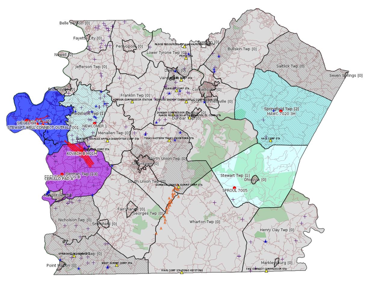
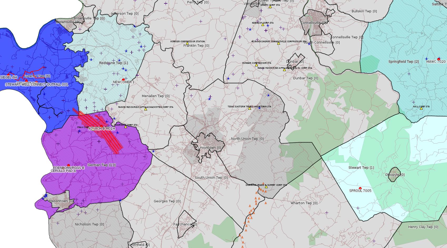
Map
Key
Red dots: items in this permit list with an exact location.
Blue stars: Marcellus Gas Well Water Sources.
Municipality shading: number of "facilities", with each well counting separately
(includes the red dots):
Red dots: items in this permit list with an exact location.
Blue stars: Marcellus Gas Well Water Sources.
Municipality shading: number of "facilities", with each well counting separately
(includes the red dots):
gray: 0
pale turquoise: 1
turquoise: 2
pale blue: 3
middle blue: 4
dark blue: 5
dark purple: 9
purple: 11
(Color coding may differ from one issue to the next.)
(Note if a project spans multiple municipalities -- e.g. a pipeline -- it will show in the count for each municipality.)
The number of facilities also follows the municipality name in brackets.
Municipality counts are based on the way the permit is listed by DEP; DEP has been known to get a municipality wrong.
Locations in brackets identify a precise location used to locate a surrogate for the actual site being permitted (e.g. locating a well pad or pipeline by the known location of a well.) Locations labeled beginning with "~" and ending in "[?]" are approximate and speculative based on inferences using on-line property and lease records. These are marked in the text as "[Approximate, Speculative]
Cross-hatching: Environmental Justice Areas
Yellow triangles: Compressor Stations
Orange triangles: Storage Field Wells (currently Dominion North Summit Storage Field)
Crosses: SPUD Unconventional well permits
Green: "Natural areas", e.g. state game lands, state forests
Yellow triangles: Compressor Stations
Orange triangles: Storage Field Wells (currently Dominion North Summit Storage Field)
Crosses: SPUD Unconventional well permits
Green: "Natural areas", e.g. state game lands, state forests
More Maps
 |
 |
 |
| Kovach B
Laterals [See Notes] |
Source: Pennsylvania Bulletin
ESCGP-2 # ESX18-051-0007
Applicant Name Laurel Mountain Midstream Operating,
LLC
Contact Person Kristy Grigas
Address Park Place Corporate Center 2; 2000 Commerce
Drive
City, State, Zip Pittsburgh, PA 15275
County Fayette County
Township(s) Luzerne Township
Receiving Stream(s) and Classification(s) Rush Run
(WWF), Unt to Meadow Run (WWF), and Meadow Run
(WWF)/Monongahela River Watershed (WWF).
Secondary Receiving Water—Monongahela River
(WWF)
<https://www.pabulletin.com/secure/data/vol48/48-43/1673c.html>
Site: STEWART WELL CONNECT PIPELINE PROJECT ESCGP ESX18-051-0007
Location [of Authorization 1238283 Hydrostatic Testing Outfall 001]: 39.961653,-79.934522
Map URL: <http://www.openstreetmap.org/?mlat=39.961653&mlon=-79.934522#map=15/39.961653/-79.934522>
---
NOTICES
INDEPENDENT REGULATORY REVIEW COMMISSION
Action Taken by the Commission
[48 Pa.B. 7085]
[Saturday, November 3, 2018]
Environmental Quality Board # 7-549: Electronic Submission of Air Quality General Plan Approval and General Operating Permit Applications (amends 25 Pa. Code Chapter 127)
Environmental Quality Board
Electronic Submission of Air Quality General Plan Approval and General Operating Permit Applications
Regulation No. 7-549 (# 3215)
On September 14, 2018, the Independent Regulatory Review Commission (Commission) received this regulation from the Environmental Quality Board (EQB). This rulemaking amends 25 Pa. Code Chapter 127. Notice of proposed rulemaking was omitted for this regulation; it will become effective upon publication in the Pennsylvania Bulletin.
This final-omitted rulemaking allows for the electronic submittal of air quality general plan approval and general operating permit applications to the Department of Environmental Protection.
We have determined this regulation is consistent with the statutory authority of EQB (35 P.S. §§ 4005(a)(1) and (8) and 4006.1(f)) and the intention of the General Assembly. Having considered all of the other criteria of the Regulatory Review Act, we find promulgation of this regulation is in the public interest.
By Order of the Commission:
This regulation is approved.
<https://www.pabulletin.com/secure/data/vol48/48-44/1717.html>
-------------------------
Source: eNOTICE (+ PA Oil and Gas Mapping, Well Pad Report.) Well Details via Data Portal Services: Oil and Gas Wells All (ID: 3).
Please see the Disclaimer below regarding Parcel Id data.
New:
Authorization ID: 1249722
Permit number: 051-24218
Site: SPROUL 7005 OG WELL
Client: TRIANA ENERGY LLC
Authorization type: Drill & Operate Well Permit Inactive Status
Application type: New
Authorization is for: FACILITY
Date received: 10/04/2018
Status: Pending
Permit Decision Guarantee Applies?: No
Sub-Facilities for Authorization:
Sub-Facility ID Sub-Facility Name Description
990150 SPROUL 7005 Well
Permit Review Notes:
Date Review Note
10/24/2018 The permit application package is complete, has been accepted, and is undergoing technical review.
<https://www.ahs.dep.pa.gov/eFACTSWeb/searchResults_singleAuth.aspx?AuthID=1249722>
Site Programs:
Oil & Gas
Site Municipalities:
Stewart Twp, Fayette County
Well Details:
Permit Number: 051-24218
Well Name: SPROUL 7005
Unconventional Well: Y
Well Configuration: Vertical Well
Well Type: GAS
Well Status: Regulatory Inactive Status
Coal Association: NonCoal
Conservation Well: Y
Primary Facility ID: 718708
Site ID: 720238
Site Name: SPROUL 7005 OG WELL
Well Pad ID: 149337
Well Pad Name: SPROUL 7005
Storage Field:
Operator: TRIANA ENERGY LLC
Operator Number: OGO-67530
Permit Date: 2009-05-27
Permit Date Expires: 2010-05-27
SPUD Date: 2009-08-15
Date Plugged:
UIC ID:
UIC Type:
Surface Elevation: 1915
County: Fayette
Municipality: Stewart Twp
Location: 39.856133,-79.53675
Map URL: <http://www.openstreetmap.org/?mlat=39.856133&mlon=-79.53675#map=15/39.856133/-79.53675>
Presumed Parcel Id: 37110072
OG WELLS PERMIT DOCS:
2018-10-11: Other Permit Documents, Name: 1245075 (for Authorization: 1245075):
<http://www.depgis.state.pa.us/pdfHandler/pdFHandler.ashx?Doc=NjkxMDU2&ext=PDF>
[See Notes.]
New:
Authorization ID: 1249721
Permit number: 051-24464
Site: FAYETTE COUNTY PROJECT ESCGP-EXPEDITED MAWC 7020 PAD
Client: TRIANA ENERGY LLC
Authorization type: Drill & Operate Well Permit Inactive Status
Application type: New
Authorization is for: FACILITY
Date received: 10/04/2018
Status: Pending
Permit Decision Guarantee Applies?: No
Sub-Facilities for Authorization:
Sub-Facility ID Sub-Facility Name Description
1049231 MAWC 7020 3H Well
<https://www.ahs.dep.pa.gov/eFACTSWeb/searchResults_singleAuth.aspx?AuthID=1249721>
Site Programs:
Oil & Gas
Site Municipalities:
Dunbar Twp, Fayette County
North Union Twp, Fayette County
Springfield Twp, Fayette County
Stewart Twp, Fayette County
Wharton Twp, Fayette County
Well Details:
Permit Number: 051-24464
Well Name: MAWC 7020 3H
Unconventional Well: Y
Well Configuration: Horizontal Well
Well Type: GAS
Well Status: Regulatory Inactive Status
Coal Association: NonCoal
Conservation Well: N
Primary Facility ID: 744754
Site ID: 721520
Site Name: FAYETTE COUNTY PROJECT ESCGP-EXPEDITED MAWC 7020 PAD
Well Pad ID: 148846
Well Pad Name: MAWC 7020
Storage Field:
Operator: TRIANA ENERGY LLC
Operator Number: OGO-67530
Permit Date: 2011-09-23
Permit Date Expires: 2012-09-23
SPUD Date: 2011-10-03
Date Plugged:
UIC ID:
UIC Type:
Surface Elevation: 1427
County: Fayette
Municipality: Springfield Twp
Location: 39.977814,-79.437242
Map URL: <http://www.openstreetmap.org/?mlat=39.977814&mlon=-79.437242#map=15/39.977814/-79.437242>
Presumed Parcel Id: 35130001
OG WELLS PERMIT DOCS:
2018-10-11: Other Permit Documents, Name: 1245074 (for Authorization: 1245074):
<http://www.depgis.state.pa.us/pdfHandler/pdFHandler.ashx?Doc=NjkxMDU1&ext=PDF>
New:
Authorization ID: 1249637
Permit number: GP112618-502
Site: SOUTHERN PA GATHERING SYSTEM ABANDONMENT PPL 8605 GP8 & GP11
Client: COLUMBIA GAS TRANS LLC
Authorization type: BWM-GP-11 Maintenance, Testing, Repair, Rehabilitation or Replacement General Pmt
Application type: New
Authorization is for: FACILITY
Date received: 10/19/2018
Status: Pending
Permit Decision Guarantee Applies?: Yes
Permit Decision Guarantee status: ACTIVE
Sub-Facilities for Authorization:
Sub-Facility ID Sub-Facility Name Description
1274075 SOUTHERN PA GATH SYS ABANDONMENT PPL 8605 GP11260718-001 Other Activities
<https://www.ahs.dep.pa.gov/eFACTSWeb/searchResults_singleAuth.aspx?AuthID=1249637>
Site Programs:
Water Planning and Conservation
Site Municipalities:
German Twp [an Environmental Justice Area], Fayette County
New:
Authorization ID: 1249636
Permit number: GP082618-501
Site: SOUTHERN PA GATHERING SYSTEM ABANDONMENT PPL 8605 GP8 & GP11
Client: COLUMBIA GAS TRANS LLC
Authorization type: GP-08 Temporary Road Crossings
Application type: New
Authorization is for: FACILITY
Date received: 10/19/2018
Status: Pending
Permit Decision Guarantee Applies?: No
Sub-Facilities for Authorization:
Sub-Facility ID Sub-Facility Name Description
1274074 SOUTHERN PA GATH SYS ABANDONMENT PPL 8605 GP08260718-003 Bridge
<https://www.ahs.dep.pa.gov/eFACTSWeb/searchResults_singleAuth.aspx?AuthID=1249636>
Site Programs:
Water Planning and Conservation
Site Municipalities:
German Twp [an Environmental Justice Area], Fayette County
New:
Authorization ID: 1249627
Permit number: 051-24303
Site: FAYETTE COUNTY PROJECT ESCGP-EXPEDITED MAWC 7020 PAD
Client: TRIANA ENERGY LLC
Authorization type: Drill & Operate Well Permit Inactive Status
Application type: New
Authorization is for: FACILITY
Date received: 10/04/2018
Status: Pending
Permit Decision Guarantee Applies?: No
Sub-Facilities for Authorization:
Sub-Facility ID Sub-Facility Name Description
1005069 MAWC 7020 1H Well
1086615 MAWC 7020 1H Well
1051380 MAWC 7020 1H Well
1049302 MAWC 7020 1H Well
Permit Review Notes:
Date Review Note
10/24/2018 The permit application package is complete, has been accepted, and is undergoing technical review.
<https://www.ahs.dep.pa.gov/eFACTSWeb/searchResults_singleAuth.aspx?AuthID=1249627>
Site Programs:
Oil & Gas
Site Municipalities:
Dunbar Twp, Fayette County
North Union Twp, Fayette County
Springfield Twp, Fayette County
Stewart Twp, Fayette County
Wharton Twp, Fayette County
Well Details:
Permit Number: 051-24303
Well Name: MAWC 7020 1H
Unconventional Well: Y
Well Configuration: Horizontal Well
Well Type: GAS
Well Status: Regulatory Inactive Status
Coal Association: NonCoal
Conservation Well: N
Primary Facility ID: 725920
Site ID: 721520
Site Name: FAYETTE COUNTY PROJECT ESCGP-EXPEDITED MAWC 7020 PAD
Well Pad ID: 148846
Well Pad Name: MAWC 7020
Storage Field:
Operator: TRIANA ENERGY LLC
Operator Number: OGO-67530
Permit Date: 2009-12-24
Permit Date Expires: 2013-11-06
SPUD Date: 2010-06-25
Date Plugged:
UIC ID:
UIC Type:
Surface Elevation: 1427
County: Fayette
Municipality: Springfield Twp
Location: 39.977794,-79.437139
Map URL: <http://www.openstreetmap.org/?mlat=39.977794&mlon=-79.437139#map=15/39.977794/-79.437139>
OG WELLS PERMIT DOCS:
2018-10-11: Other Permit Documents, Name: 1245073 (for Authorization: 1245073):
<http://www.depgis.state.pa.us/pdfHandler/pdFHandler.ashx?Doc=NjkxMDU0&ext=PDF>
Authorization ID: 1234285
Permit number: ESX18-051-0006
Site: YODER WATERLINE ESCGP ESX18-051-0006
Client: CHEVRON APPALACHIA LLC
Authorization type: Expedited E&S Stormwater General Permit 1
Application type: New
Authorization is for: SITE
Date received: 06/25/2018
Status: Issued on 10/22/2018
Permit Decision Guarantee Applies?: Yes
Permit Decision Guarantee status: VOID
Permit Review Notes:
Date Review Note
10/22/2018 The technical review and decision review are complete and either the permit decision and/or permit issuance are forthcoming.
10/3/2018 Applicant has been issued a deficiency letter. If applicable, this application no longer qualifies for the Permit Decision Guarantee.
9/4/2018 Applicant has been issued a deficiency letter. If applicable, this application no longer qualifies for the Permit Decision Guarantee.
<https://www.ahs.dep.pa.gov/eFACTSWeb/searchResults_singleAuth.aspx?AuthID=1234285>
Site Programs:
Site Municipalities:
Luzerne Twp, Fayette County
Authorization ID: 1233816
Permit number: ESX18-051-0005
Site: SIEGEL WATERLINE ESCGP ESX18-051-0005
Client: CHEVRON APPALACHIA LLC
Authorization type: Expedited E&S Stormwater General Permit 1
Application type: New
Authorization is for: SITE
Date received: 06/21/2018
Status: Issued on 10/24/2018
Permit Decision Guarantee Applies?: Yes
Permit Decision Guarantee status: VOID
Permit Review Notes:
Date Review Note
10/24/2018 The technical review and decision review are complete and either the permit decision and/or permit issuance are forthcoming.
10/4/2018 Applicant has been issued a deficiency letter. If applicable, this application no longer qualifies for the Permit Decision Guarantee.
9/4/2018 Applicant has been issued a deficiency letter. If applicable, this application no longer qualifies for the Permit Decision Guarantee.
<https://www.ahs.dep.pa.gov/eFACTSWeb/searchResults_singleAuth.aspx?AuthID=1233816>
Site Programs:
Site Municipalities:
Luzerne Twp, Fayette County
Authorization ID: 1230405
Permit number: ESX18-051-0004
Site: CERULLO PAD A ESCGP ESX18-051-0004
Client: CHEVRON APPALACHIA LLC
Authorization type: Expedited E&S Stormwater General Permit 1
Application type: New
Authorization is for: SITE
Date received: 05/24/2018
Status: Issued on 10/23/2018
Permit Decision Guarantee Applies?: Yes
Permit Decision Guarantee status: VOID
Permit Review Notes:
Date Review Note
10/23/2018 The technical review and decision review are complete and either the permit decision and/or permit issuance are forthcoming.
10/11/2018 Applicant has been issued a deficiency letter. If applicable, this application no longer qualifies for the Permit Decision Guarantee.
8/13/2018 Applicant has been issued a deficiency letter. If applicable, this application no longer qualifies for the Permit Decision Guarantee.
6/13/2018 Applicant has been issued a deficiency letter. If applicable, this application no longer qualifies for the Permit Decision Guarantee.
<https://www.ahs.dep.pa.gov/eFACTSWeb/searchResults_singleAuth.aspx?AuthID=1230405>
Site Programs:
Oil & Gas
Site Municipalities:
German Twp [an Environmental Justice Area], Fayette County
Well Pad Id: 155068
Wells on this Pad:
051-24650 CERULLO 1
Location: 39.879083,-79.902789 <https://osm.org/go/ZWpNvUhQ--?m=>
Presumed Parcel Id: 15190070
Authorization ID: 1227101
Permit number: ESX18-051-0003
Site: EDENBORN/RGGS B ESCGP ESX18-051-0003
Client: CHEVRON APPALACHIA LLC
Authorization type: Expedited E&S Stormwater General Permit 1
Application type: New
Authorization is for: SITE
Date received: 05/03/2018
Status: Issued on 10/23/2018
Permit Decision Guarantee Applies?: Yes
Permit Decision Guarantee status: VOID
Permit Review Notes:
Date Review Note
10/23/2018 The technical review and decision review are complete and either the permit decision and/or permit issuance are forthcoming.
9/20/2018 Applicant has been issued a deficiency letter. If applicable, this application no longer qualifies for the Permit Decision Guarantee.
8/6/2018 Applicant has been issued a deficiency letter. If applicable, this application no longer qualifies for the Permit Decision Guarantee.
6/6/2018 Applicant has been issued a deficiency letter. If applicable, this application no longer qualifies for the Permit Decision Guarantee.
5/14/2018 The permit application package is complete, has been accepted, and is undergoing technical review.
<https://www.ahs.dep.pa.gov/eFACTSWeb/searchResults_singleAuth.aspx?AuthID=1227101>
Site Programs:
Oil & Gas
Site Municipalities:
German Twp [an Environmental Justice Area], Fayette County
Well Pad ID: 155083
Location: 39.881931,-79.896106 <https://osm.org/go/ZWpN6mOL--?m=>
Wells on this Pad:
051-24651 EDENBORN/RGGS B 1
Presumed Parcel Id: 15220014
-------------------------
Source: DEP Oil and Gas Electronic Notifications
NOTIFICATION_ID: 44259
OGO: 39307
OPERATOR: CHEVRON APPALACHIA LLC
API_PERMIT: 051-24631
SPUD_DATE: 09/01/2015
COUNTY: Fayette
MUNICIPALITY: Luzerne
LATITUDE: 39.962867
LONGITUDE: -79.946861
SUBJECT: [NOTIFICATION]: Casing cementing notification 58 Pa. C.S. 3211(f)(2) for well API 37-051-24631-00-00
QUESTION: Enter the Date and Time for the applicable Casing Types
ANSWER: Production Casing: 11/1/2018 12:00:00 PM
SENT_DATE: 10/27/2018 1:53:12 PM
SENT_SUCCESS: Yes
LAST_RESENT_DATE:
RESENT_SUCCESS:
Well Details:
Permit Number: 051-24631
Well Name: STEWART 5H
Unconventional Well: Y
Well Configuration: Horizontal Well
Well Type: GAS
Well Status: Active
Coal Association: Coal
Conservation Well: N
Primary Facility ID: 794419
Site ID: 788124
Site Name: STEWART WELL SITE ESCGP-2 EXPEDITED
Well Pad ID: 152396
Well Pad Name: STEWART
Storage Field:
Operator: CHEVRON APPALACHIA LLC
Operator Number: OGO-39307
Permit Date: 2015-07-17
Permit Date Expires: 2019-01-26
SPUD Date: 2015-09-01
Date Plugged:
UIC ID:
UIC Type:
Surface Elevation: 1145
County: Fayette
Municipality: Luzerne Twp
Location: 39.962867,-79.946861
Map URL: <http://www.openstreetmap.org/?mlat=39.962867&mlon=-79.946861#map=15/39.962867/-79.946861>
Presumed Property Id: 19250010
OG WELLS PERMIT DOCS:
2015-07-17: Final Permit Documents, Name: 051-24631-00-00 1077201 (for Authorization: 1077201):
<http://www.depgis.state.pa.us/pdfHandler/pdFHandler.ashx?Doc=MjExNjA3&ext=PDF>
2018-01-26: Other Permit Documents, Name: Approval of Surface Locations by Landowners (for Authorization: 1203102):
<http://www.depgis.state.pa.us/pdfHandler/pdFHandler.ashx?Doc=NTQ5NzEx&ext=PDF>
2018-01-26: Final Permit Documents, Name: 1203102 (for Authorization: 1203102):
<http://www.depgis.state.pa.us/pdfHandler/pdFHandler.ashx?Doc=NTUxMTI4&ext=PDF>
Electronically Submitted Records:
2018-01-26: Submission for Authorization 1203102
Pennsylvania Natural Diversity Inventory Form: Stewart Pad A PNDI 8-22-17.pdf
<http://www.depgis.state.pa.us/eWellDocHandler/pdFHandler.ashx?Doc=MzkwOTEw&ext=PDF>
Permit Application to Drill and Operate a Well: Stewart 5H Mod Application 2017.pdf
<http://www.depgis.state.pa.us/eWellDocHandler/pdFHandler.ashx?Doc=MzkwOTEx&ext=PDF>
Location Plat: Stewart Well Plats 5H.dwg
<http://www.depgis.state.pa.us/eWellDocHandler/pdFHandler.ashx?Doc=MzkwOTEy&ext=PDF>
Coal and Gas Resource Coord Act - Section 7 Exception: Stewart 1H-7H Waiver Request Section 7.pdf
<http://www.depgis.state.pa.us/eWellDocHandler/pdFHandler.ashx?Doc=MzkwOTEz&ext=PDF>
Well Cross-Section Diagram: Stewart 5H Page 4.pdf
<http://www.depgis.state.pa.us/eWellDocHandler/pdFHandler.ashx?Doc=MzkwOTE0&ext=PDF>
Record of Notification to Interested Parties: Stewart 5H Notification of Interested Parties.pdf
<http://www.depgis.state.pa.us/eWellDocHandler/pdFHandler.ashx?Doc=MzkwOTE1&ext=PDF>
Well Permit Application - Coal Module: Stewart 1H-7H 2017 Coal Module.pdf
<http://www.depgis.state.pa.us/eWellDocHandler/pdFHandler.ashx?Doc=MzkwOTE2&ext=PDF>
Electronic Submission Docket: 1628615.pdf
<http://www.depgis.state.pa.us/eWellDocHandler/pdFHandler.ashx?Doc=MzkyNzg3&ext=PDF>
---
NOTIFICATION_ID: 44295
OGO: 39307
OPERATOR: CHEVRON APPALACHIA LLC
API_PERMIT: 051-24645
SPUD_DATE: 04/02/2018
COUNTY: Fayette
MUNICIPALITY: Luzerne
LATITUDE: 39.968914
LONGITUDE: -79.969061
SUBJECT: [NOTIFICATION]: Drilling resumption After Break of 30 days or more notification 58 Pa. C.S. 3211(f)(1) for well API 37-051-24645-00-00
QUESTION: Date and approximate time action is to occur
ANSWER: Date: 11/02/2018 Time: 12:00am
SENT_DATE: 10/30/2018 10:14:24 AM
SENT_SUCCESS: Yes
LAST_RESENT_DATE:
RESENT_SUCCESS:
Well Details:
Permit Number: 051-24645
Well Name: SIEGEL 6H
Unconventional Well: Y
Well Configuration: Horizontal Well
Well Type: GAS
Well Status: Active
Coal Association: Coal
Conservation Well: N
Primary Facility ID: 823793
Site ID: 790384
Site Name: SIEGEL WELL PAD ESCGP-2 EXPEDITED
Well Pad ID: 152926
Well Pad Name: SIEGEL 1
Storage Field:
Operator: CHEVRON APPALACHIA LLC
Operator Number: OGO-39307
Permit Date: 2018-02-20
Permit Date Expires: 2019-02-20
SPUD Date: 2018-04-02
Date Plugged:
UIC ID:
UIC Type:
Surface Elevation: 1173
County: Fayette
Municipality: Luzerne Twp
Location: 39.968914,-79.969061
Map URL: <http://www.openstreetmap.org/?mlat=39.968914&mlon=-79.969061#map=15/39.968914/-79.969061>
Presumed Parcel Id: 19240018
OG WELLS PERMIT DOCS:
2018-02-20: Final Permit Documents, Name: 1212439 (for Authorization: 1212439):
<http://www.depgis.state.pa.us/pdfHandler/pdFHandler.ashx?Doc=NTY1ODUw&ext=PDF>
Electronically Submitted Records:
2018-02-20: Submission for Authorization 1212439
Pennsylvania Natural Diversity Inventory Form: Siegel PNDI.pdf
<http://www.depgis.state.pa.us/eWellDocHandler/pdFHandler.ashx?Doc=NDQ5MDIw&ext=PDF>
Location Plat: 143-781-Well Plat 6H-pages1-2-3_3702.dwg
<http://www.depgis.state.pa.us/eWellDocHandler/pdFHandler.ashx?Doc=NDQ5MDIx&ext=PDF>
Coal and Gas Resource Coord Act - Section 7 Exception: Siegel 1H-9H Waiver Request Section 7.pdf
<http://www.depgis.state.pa.us/eWellDocHandler/pdFHandler.ashx?Doc=NDQ5MDIy&ext=PDF>
Well Cross-Section Diagram: Siegel 6H Page 4.pdf
<http://www.depgis.state.pa.us/eWellDocHandler/pdFHandler.ashx?Doc=NDQ5MDIz&ext=PDF>
Permit Application to Drill and Operate a Well: 1640174.pdf
<http://www.depgis.state.pa.us/eWellDocHandler/pdFHandler.ashx?Doc=NDQ5ODE4&ext=PDF>
---
NOTIFICATION_ID: 44296
OGO: 39307
OPERATOR: CHEVRON APPALACHIA LLC
API_PERMIT: 051-24645
SPUD_DATE: 04/02/2018
COUNTY: Fayette
MUNICIPALITY: Luzerne
LATITUDE: 39.968914
LONGITUDE: -79.969061
SUBJECT: [NOTIFICATION]: Casing cementing notification 58 Pa. C.S. 3211(f)(2) for well API 37-051-24645-00-00
QUESTION: Enter the Date and Time for the applicable Casing Types
ANSWER: Coal Protected Casing 1: 11/2/2018 12:00:00 AM
SENT_DATE: 10/30/2018 10:15:14 AM
SENT_SUCCESS: Yes
LAST_RESENT_DATE:
RESENT_SUCCESS:
Well Details Above
Well Name: SIEGEL 6H
---
NOTIFICATION_ID: 44297
OGO: 39307
OPERATOR: CHEVRON APPALACHIA LLC
API_PERMIT: 051-24645
SPUD_DATE: 04/02/2018
COUNTY: Fayette
MUNICIPALITY: Luzerne
LATITUDE: 39.968914
LONGITUDE: -79.969061
SUBJECT: [NOTIFICATION]: Drilling resumption After Break of 30 days or more notification 58 Pa. C.S. 3211(f)(1) for well API 37-051-24645-00-00
QUESTION: Date and approximate time action is to occur
ANSWER: Date: 11/01/2018 Time: 12:00am
SENT_DATE: 10/30/2018 10:16:46 AM
SENT_SUCCESS: Yes
LAST_RESENT_DATE:
RESENT_SUCCESS:
Comments: Corrected, will resume drilling on the 1st, NOT the 2nd.
Well Details Above
Well Name: SIEGEL 6H
-------------------------
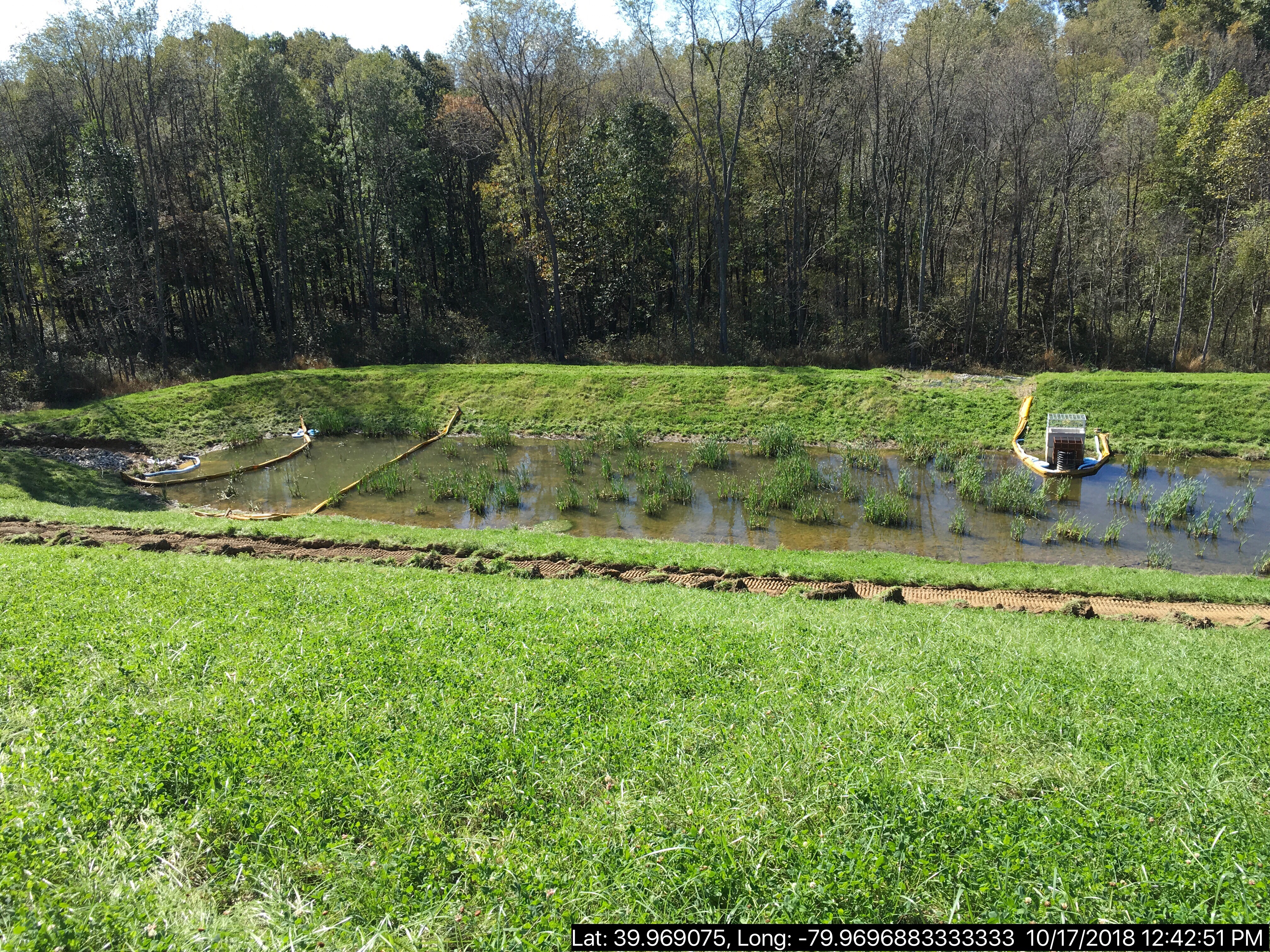
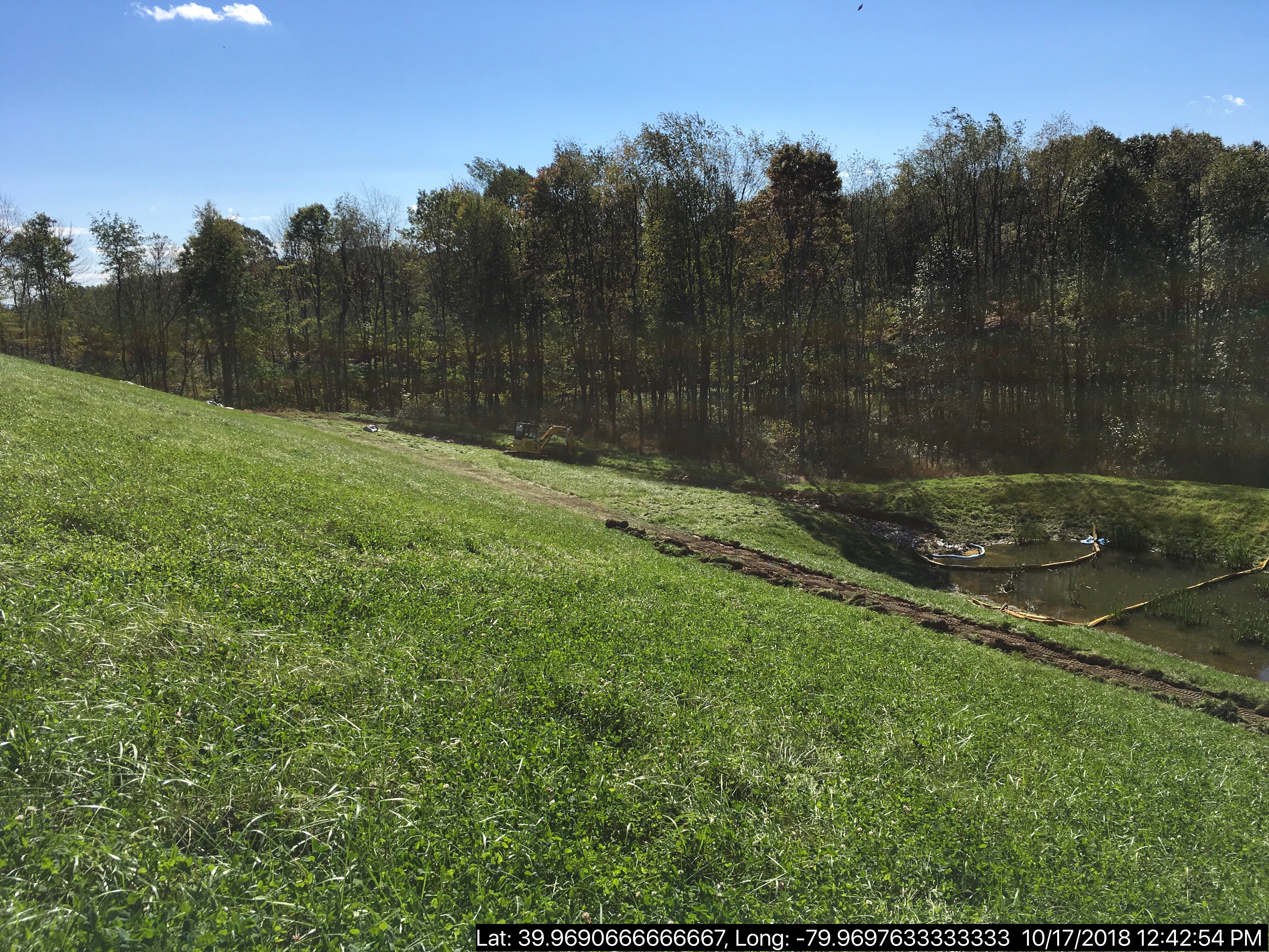
Source: Oil and Gas Compliance Report
OPERATOR: CHEVRON APPALACHIA LLC
INSPECTION_ID: 2793177
INSPECTION_DATE: 10/17/2018
INSPECTION_TYPE: Incident- Response to Accident or Event
API_PERMIT: 051-24633
FARM_NAME: SIEGEL 1
UNCONVENTIONAL: Yes
SITE_ID: 790384
SITE_NAME: SIEGEL WELL PAD ESCGP-2 EXPEDITED
FACILITY_TYPE: Oil & Gas Location
INSPECTION_CATEGORY: Primary Facility
REGION: EP DOGO SWDO Dstr Off
COUNTY: Fayette
MUNICIPALITY: Luzerne Twp
INSPECTOR: NAJEWICZ, JUSTIN
INSPECTION_SOURCE: SAIR
INSPECTION_RESULT_DESCRIPTION: Violation(s) Noted
INSPECTION_COMMENT: "On 10/13/18 at approximately 1600 hours Chevron had a synthetic based mud discharge from a flare stack in the southern corner of the well pad. The mud impacted the well pad surface, drainage channel, and storm water basin. Chevron ceased operations to prevent further fluid release. On pad material was removed and absorbent booms were placed in the basin.
On 10/17/18 I met with BA Lambie of Chevron and conducted an incident response inspection. The well pad had been excavated and sampling was being conducted. The majority of the drainage channel was excavated and the remaining portion was being completed. Chevron indicated they plan to drain and excavate the basin to prevent further impacts from oil droplets."
VIOLATION_ID: 831832
VIOLATION_DATE: 10/17/2018
VIOLATION_CODE: CSL 401 - PROHIBITION AGAINST OTHER POLLUTIONS - Discharged substance of any kind or character resulting in pollution of Waters of the Commonwealth.
VIOLATION_TYPE: Environmental Health & Safety
VIOLATION_COMMENT:
RESOLVED_DATE:
RESOLUTION_REASON_CODE_DESCRIPTION:
CONTINUING_VIOLATION:
ENFORCEMENT_ID: 368778
ENFORCEMENT_CODE_DESCRIPTION: NOV - Notice of Violation
DATE_EXECUTED: 10/29/2018
ENFORCEMENT_FINAL_DATE:
ENFORCEMENT_FINAL_STATUS:
PENALTY_FINAL_DATE:
PENALTY_FINAL_STATUS_CODE_DESCRIPTION:
PENALTY_AMOUNT:
TOTAL_AMOUNT_COLLECTED:
VIOLATION_ID: 831831
VIOLATION_DATE: 10/17/2018
VIOLATION_CODE: 78a54 - GENERAL REQUIREMENTS - Operator failed to control and dispose of fluids, residual waste and drill cuttings, including tophole water, brines, drilling fluids, drilling muds, stimulation fluids, well servicing fluids, oil, and production fluids in a manner that prevents pollution of the waters of the Commonwealth and in accordance with 25 Pa. Code §§ 78a.55 – 78a.58 and 78a.60 – 78a.63.
VIOLATION_TYPE: Environmental Health & Safety
VIOLATION_COMMENT:
RESOLVED_DATE:
RESOLUTION_REASON_CODE_DESCRIPTION:
CONTINUING_VIOLATION:
ENFORCEMENT_ID: 368778
ENFORCEMENT_CODE_DESCRIPTION: NOV - Notice of Violation
DATE_EXECUTED: 10/29/2018
ENFORCEMENT_FINAL_DATE:
ENFORCEMENT_FINAL_STATUS:
PENALTY_FINAL_DATE:
PENALTY_FINAL_STATUS_CODE_DESCRIPTION:
PENALTY_AMOUNT:
TOTAL_AMOUNT_COLLECTED:
VIOLATION_ID: 831833
VIOLATION_DATE: 10/17/2018
VIOLATION_CODE: SWMA 301 - MANAGEMENT OF RESIDUAL WASTE - Person operated a residual waste processing or disposal facility without obtaining a permit for such facility from DEP. Person stored, transported, processed, or disposed of residual waste inconsistent with or unauthorized by the rules and regulations of DEP.
VIOLATION_TYPE: Environmental Health & Safety
VIOLATION_COMMENT:
RESOLVED_DATE:
RESOLUTION_REASON_CODE_DESCRIPTION:
CONTINUING_VIOLATION:
ENFORCEMENT_ID: 368778
ENFORCEMENT_CODE_DESCRIPTION: NOV - Notice of Violation
DATE_EXECUTED: 10/29/2018
ENFORCEMENT_FINAL_DATE:
ENFORCEMENT_FINAL_STATUS:
PENALTY_FINAL_DATE:
PENALTY_FINAL_STATUS_CODE_DESCRIPTION:
PENALTY_AMOUNT:
TOTAL_AMOUNT_COLLECTED:
 |
 |
Well Details:
Permit Number: 051-24633
Well Name: SIEGEL 1
Unconventional Well: Y
Well Configuration: Horizontal Well
Well Type: GAS
Well Status: Active
Coal Association: Coal
Conservation Well: N
Primary Facility ID: 803337
Site ID: 790384
Site Name: SIEGEL WELL PAD ESCGP-2 EXPEDITED
Well Pad ID: 152926
Well Pad Name: SIEGEL 1
Storage Field:
Operator: CHEVRON APPALACHIA LLC
Operator Number: OGO-39307
Permit Date: 2015-08-12
Permit Date Expires: 2019-02-12
SPUD Date: 2018-04-02
Date Plugged:
UIC ID:
UIC Type:
Surface Elevation: 1173
County: Fayette
Municipality: Luzerne Twp
Location: 39.968972,-79.968794
Map URL: <http://www.openstreetmap.org/?mlat=39.968972&mlon=-79.968794#map=15/39.968972/-79.968794>
OG WELLS PERMIT DOCS:
2015-08-12: Final Permit Documents, Name: 051-24633-00-00 1082707 (for Authorization: 1082707):
<http://www.depgis.state.pa.us/pdfHandler/pdFHandler.ashx?Doc=MjE0NjU4&ext=PDF>
2017-07-28: Final Permit Documents, Name: Authorization ID 1170979 (for Authorization: 1170979):
<http://www.depgis.state.pa.us/pdfHandler/pdFHandler.ashx?Doc=NDc0MjUx&ext=PDF>
2018-02-12: Final Permit Documents, Name: 1212434 (for Authorization: 1212434):
<http://www.depgis.state.pa.us/pdfHandler/pdFHandler.ashx?Doc=NTU4NjY3&ext=PDF>
Electronically Submitted Records:
2017-07-28: Submission for Authorization 1170979
Record of Notification to Interested Parties: Siegel 1 Re-Permit Record of Notification.pdf
<http://www.depgis.state.pa.us/eWellDocHandler/pdFHandler.ashx?Doc=MjI5NzY2&ext=PDF>
Well Permit Application - Coal Module: Siegel Re-Permit Coal Module.pdf
<http://www.depgis.state.pa.us/eWellDocHandler/pdFHandler.ashx?Doc=MjI5NzY3&ext=PDF>
Pennsylvania Natural Diversity Inventory Form: Siegel 1 PNDI.pdf
<http://www.depgis.state.pa.us/eWellDocHandler/pdFHandler.ashx?Doc=MjI5ODMw&ext=PDF>
Permit Application to Drill and Operate a Well: Siegel 1 Re-Permit Application.pdf
<http://www.depgis.state.pa.us/eWellDocHandler/pdFHandler.ashx?Doc=MjM0NTE1&ext=PDF>
Coal and Gas Resource Coord Act - Section 7 Exception: Siegel 1 Waiver Request Section 7.pdf
<http://www.depgis.state.pa.us/eWellDocHandler/pdFHandler.ashx?Doc=MjM0NTE5&ext=PDF>
Operator Ownership and Control Information: Siegel 1 Re-Permit OG-118.pdf
<http://www.depgis.state.pa.us/eWellDocHandler/pdFHandler.ashx?Doc=MjM0NTI2&ext=PDF>
Location Plat: Siegel 1 Re-Permit Plat 7-21-17.dwg
<http://www.depgis.state.pa.us/eWellDocHandler/pdFHandler.ashx?Doc=MzM1OTky&ext=PDF>
Electronic Submission Docket: 1405595.pdf
<http://www.depgis.state.pa.us/eWellDocHandler/pdFHandler.ashx?Doc=MzM1OTk0&ext=PDF>
2018-02-12: Submission for Authorization 1212434
Location Plat: 143-781-Well Plat 1H-pages1-2-3_3702.dwg
<http://www.depgis.state.pa.us/eWellDocHandler/pdFHandler.ashx?Doc=NDQ4NTg4&ext=PDF>
Pennsylvania Natural Diversity Inventory Form: Siegel PNDI.pdf
<http://www.depgis.state.pa.us/eWellDocHandler/pdFHandler.ashx?Doc=NDQ4NTg5&ext=PDF>
Permit Application to Drill and Operate a Well: Siegel 1H Drill Permit Application.pdf
<http://www.depgis.state.pa.us/eWellDocHandler/pdFHandler.ashx?Doc=NDQ5MDk1&ext=PDF>
Coal and Gas Resource Coord Act - Section 7 Exception: Siegel 1H-9H Waiver Request Section 7.pdf
<http://www.depgis.state.pa.us/eWellDocHandler/pdFHandler.ashx?Doc=NDQ5MDk2&ext=PDF>
Well Cross-Section Diagram: Siegel 1H Page 4.pdf
<http://www.depgis.state.pa.us/eWellDocHandler/pdFHandler.ashx?Doc=NDQ5MDk3&ext=PDF>
Well Permit Application - Coal Module: Siegel 1H Coal Module.pdf
<http://www.depgis.state.pa.us/eWellDocHandler/pdFHandler.ashx?Doc=NDQ5MDk4&ext=PDF>
Interested Party Notification: Siegel 1H Interested Parties.pdf
<http://www.depgis.state.pa.us/eWellDocHandler/pdFHandler.ashx?Doc=NDQ5MTAw&ext=PDF>
Electronic Submission Docket: 1661897.pdf
<http://www.depgis.state.pa.us/eWellDocHandler/pdFHandler.ashx?Doc=NDQ5Nzk2&ext=PDF>
---
OPERATOR: DIVERSIFIED OIL & GAS LLC
INSPECTION_ID: 2792789
INSPECTION_DATE: 10/22/2018
INSPECTION_TYPE: Complaint Inspection
API_PERMIT: 051-21401
FARM_NAME: NEWCOMER 1
UNCONVENTIONAL: No
SITE_ID: 553518
SITE_NAME: NEWCOMER 1 OG WELL
FACILITY_TYPE: Oil & Gas Location
INSPECTION_CATEGORY: Primary Facility
REGION: EP DOGO SWDO Dstr Off
COUNTY: Fayette
MUNICIPALITY: Redstone Twp
INSPECTOR: NAJEWICZ, JUSTIN
INSPECTION_SOURCE: SAIR
INSPECTION_RESULT_DESCRIPTION: Violation(s) Noted
INSPECTION_COMMENT: "A complaint was received by the Department on 10/20/18 alleging a spill occurred at the Newcomer 1 gas well on 10/18/18. The complainant alleged the brine tank was removed and the brine was intentionally released onto the ground, causing grass to be killed. No spill was reported by the Operator.
On 10/22/18 at approximately 1200 hours I, along with Environmental Protection Specialist Kevin Maskol, conducted an inspection of the site. Dead vegetation and soil discoloration were immediately apparent. An odor was also observed near the impacted area. The release appeared to have occurred adjacent to the brine tank pad site and followed a tire track depression as it flowed down slope.
The location where the brine tank had been situated contained what appeared to be rain water that was impacted by brine. Field screenings for conductivity in the tank site showed conductivity levels of 12.3 mS. Upon further investigation it appeared the vegetation and a layer of soil had been removed from the release area and placed onto the gravel tank pad. Soil sample 9539-051 was taken from this material.
Additional field screenings were conducted throughout the release area. Two additional soil samples, 9539-052 and 9539-053, were collected.
A water well was observed down gradient within 150' of the release area."
VIOLATION_ID: 831329
VIOLATION_DATE: 10/22/2018
VIOLATION_CODE: 78.57(a) - CONTROL, STORAGE AND DISPOSAL OF PRODUCTION FLUIDS - Operator failed to collect the brine and other fluids produced during operation, service and plugging of the well in a tank, pit or a series of pits or tanks, or other device approved by the Department or Operator discharged brine or other fluids on or into the ground or into waters of the Commonwealth.
VIOLATION_TYPE: Environmental Health & Safety
VIOLATION_COMMENT:
RESOLVED_DATE:
RESOLUTION_REASON_CODE_DESCRIPTION:
CONTINUING_VIOLATION:
ENFORCEMENT_ID: 368673
ENFORCEMENT_CODE_DESCRIPTION: NOV - Notice of Violation
DATE_EXECUTED: 10/22/2018
ENFORCEMENT_FINAL_DATE:
ENFORCEMENT_FINAL_STATUS:
PENALTY_FINAL_DATE:
PENALTY_FINAL_STATUS_CODE_DESCRIPTION:
PENALTY_AMOUNT:
TOTAL_AMOUNT_COLLECTED:
VIOLATION_ID: 831330
VIOLATION_DATE: 10/22/2018
VIOLATION_CODE: 78.54 - GENERAL REQUIREMENTS - Operator failed to control and dispose of fluids, residual waste and drill cuttings, including tophole water, brines, drilling fluids, drilling muds, stimulation fluids, well servicing fluids, oil, and production fluids in a manner that prevents pollution of the waters of the Commonwealth.
VIOLATION_TYPE: Environmental Health & Safety
VIOLATION_COMMENT:
RESOLVED_DATE:
RESOLUTION_REASON_CODE_DESCRIPTION:
CONTINUING_VIOLATION:
ENFORCEMENT_ID: 368673
ENFORCEMENT_CODE_DESCRIPTION: NOV - Notice of Violation
DATE_EXECUTED: 10/22/2018
ENFORCEMENT_FINAL_DATE:
ENFORCEMENT_FINAL_STATUS:
PENALTY_FINAL_DATE:
PENALTY_FINAL_STATUS_CODE_DESCRIPTION:
PENALTY_AMOUNT:
TOTAL_AMOUNT_COLLECTED:
VIOLATION_ID: 831331
VIOLATION_DATE: 10/22/2018
VIOLATION_CODE: 78.66(b) - REPORTING RELEASES - Owner or operator failed to report a reportable release of brine on or into the ground at the well site within 2 hours after detecting or discovering the releases.
VIOLATION_TYPE: Environmental Health & Safety
VIOLATION_COMMENT:
RESOLVED_DATE:
RESOLUTION_REASON_CODE_DESCRIPTION:
CONTINUING_VIOLATION:
ENFORCEMENT_ID: 368673
ENFORCEMENT_CODE_DESCRIPTION: NOV - Notice of Violation
DATE_EXECUTED: 10/22/2018
ENFORCEMENT_FINAL_DATE:
ENFORCEMENT_FINAL_STATUS:
PENALTY_FINAL_DATE:
PENALTY_FINAL_STATUS_CODE_DESCRIPTION:
PENALTY_AMOUNT:
TOTAL_AMOUNT_COLLECTED:
VIOLATION_ID: 831332
VIOLATION_DATE: 10/22/2018
VIOLATION_CODE: 91.33(A) - INCIDENTS CAUSING OR THREATENING POLLUTION - Failure to notify the Department of an accident or other activity or incident, a toxic substance or another substance which would endanger downstream users of the waters, result in pollution or create a danger of pollution of the waters of this Commonwealth, or would damage property.
VIOLATION_TYPE: Environmental Health & Safety
VIOLATION_COMMENT:
RESOLVED_DATE:
RESOLUTION_REASON_CODE_DESCRIPTION:
CONTINUING_VIOLATION:
ENFORCEMENT_ID: 368673
ENFORCEMENT_CODE_DESCRIPTION: NOV - Notice of Violation
DATE_EXECUTED: 10/22/2018
ENFORCEMENT_FINAL_DATE:
ENFORCEMENT_FINAL_STATUS:
PENALTY_FINAL_DATE:
PENALTY_FINAL_STATUS_CODE_DESCRIPTION:
PENALTY_AMOUNT:
TOTAL_AMOUNT_COLLECTED:
VIOLATION_ID: 831333
VIOLATION_DATE: 10/22/2018
VIOLATION_CODE: 78.66(a) - REPORTING RELEASES - Owner or operator failed to comply with the reporting and corrective action requirements of 25 Pa. Code Section 91.33 when a release of a substance caused or threatened pollution to the Waters of the Commonwealth.
VIOLATION_TYPE: Environmental Health & Safety
VIOLATION_COMMENT:
RESOLVED_DATE:
RESOLUTION_REASON_CODE_DESCRIPTION:
CONTINUING_VIOLATION:
ENFORCEMENT_ID: 368673
ENFORCEMENT_CODE_DESCRIPTION: NOV - Notice of Violation
DATE_EXECUTED: 10/22/2018
ENFORCEMENT_FINAL_DATE:
ENFORCEMENT_FINAL_STATUS:
PENALTY_FINAL_DATE:
PENALTY_FINAL_STATUS_CODE_DESCRIPTION:
PENALTY_AMOUNT:
TOTAL_AMOUNT_COLLECTED:
VIOLATION_ID: 831334
VIOLATION_DATE: 10/22/2018
VIOLATION_CODE: SWMA 301 - MANAGEMENT OF RESIDUAL WASTE - Person operated a residual waste processing or disposal facility without obtaining a permit for such facility from DEP. Person stored, transported, processed, or disposed of residual waste inconsistent with or unauthorized by the rules and regulations of DEP.
VIOLATION_TYPE: Environmental Health & Safety
VIOLATION_COMMENT:
RESOLVED_DATE:
RESOLUTION_REASON_CODE_DESCRIPTION:
CONTINUING_VIOLATION:
ENFORCEMENT_ID: 368673
ENFORCEMENT_CODE_DESCRIPTION: NOV - Notice of Violation
DATE_EXECUTED: 10/22/2018
ENFORCEMENT_FINAL_DATE:
ENFORCEMENT_FINAL_STATUS:
PENALTY_FINAL_DATE:
PENALTY_FINAL_STATUS_CODE_DESCRIPTION:
PENALTY_AMOUNT:
TOTAL_AMOUNT_COLLECTED:
Well Details:
Permit Number: 051-21401
Well Name: NEWCOMER 1
Unconventional Well: N
Well Configuration: Vertical Well
Well Type: GAS
Well Status: Active
Coal Association: Coal
Conservation Well: N
Primary Facility ID: 569903
Site ID: 553518
Site Name: NEWCOMER 1 OG WELL
Well Pad ID: 0
Well Pad Name:
Storage Field:
Operator: DIVERSIFIED OIL & GAS LLC
Operator Number: OGO-68792
Permit Date: 2001-12-31
Permit Date Expires: 2002-12-31
SPUD Date: 2002-01-14
Date Plugged:
UIC ID:
UIC Type:
Surface Elevation: 1160
County: Fayette
Municipality: Redstone Twp
Location: 39.962887,-79.826984
Map URL: <http://www.openstreetmap.org/?mlat=39.962887&mlon=-79.826984#map=15/39.962887/-79.826984>
Presumed Parcel Id: 30310068
------------------------
Source: DEP SPUD (drilling started) Report:
Well Details:
Permit Number: 051-24671
Well Name: KOVACH B M01H
Unconventional Well: Y
Well Configuration: Horizontal Well
Well Type: GAS
Well Status: Active
Coal Association: Coal
Conservation Well: N
Primary Facility ID: 828037
Site ID: 826949
Site Name: KOVACH B WELL SITE AND TANK SITE ESCGP ESX17-051-0003
Well Pad ID: 155005
Well Pad Name: KOVACH B
Storage Field:
Operator: CHEVRON APPALACHIA LLC
Operator Number: OGO-39307
Permit Date: 2018-08-08
Permit Date Expires: 2019-08-08
SPUD Date: 2018-10-23
Date Plugged:
UIC ID:
UIC Type:
Surface Elevation: 1278
County: Fayette
Municipality: German Twp [an Environmental Justice Area]
Location: 39.918933,-79.854808
Map URL: <http://www.openstreetmap.org/?mlat=39.918933&mlon=-79.854808#map=15/39.918933/-79.854808>
Presumed Parcel Id: 1511002301
OG WELLS PERMIT DOCS:
2018-08-08: Final Permit Documents, Name: 1237727 (for Authorization: 1237727):
<http://www.depgis.state.pa.us/pdfHandler/pdFHandler.ashx?Doc=NjQ2Nzc2&ext=PDF>
Electronically Submitted Records:
2018-08-08: Submission for Authorization 1237727
Pennsylvania Natural Diversity Inventory Form: Kovach B PNDI.pdf
<http://www.depgis.state.pa.us/eWellDocHandler/pdFHandler.ashx?Doc=NjAxNjky&ext=PDF>
Coal and Gas Resource Coord Act - Section 7 Exception: Kovach B Horizontals Section 7 Exception.pdf
<http://www.depgis.state.pa.us/eWellDocHandler/pdFHandler.ashx?Doc=NjAxNjkz&ext=PDF>
Well Cross-Section Diagram: Kovach B M01H Page 4.pdf
<http://www.depgis.state.pa.us/eWellDocHandler/pdFHandler.ashx?Doc=NjAxODA2&ext=PDF>
Interested Party Notification: Kovach B Affidavit of Non-Delivery Venere.pdf
<http://www.depgis.state.pa.us/eWellDocHandler/pdFHandler.ashx?Doc=NjAxODE4&ext=PDF>
Location Plat: Kovach B M01H Plat.dwg
<http://www.depgis.state.pa.us/eWellDocHandler/pdFHandler.ashx?Doc=NjAxODI5&ext=PDF>
Permit Application to Drill and Operate a Well: 1747807.pdf
<http://www.depgis.state.pa.us/eWellDocHandler/pdFHandler.ashx?Doc=NjAzODE3&ext=PDF>
Well Details:
Permit Number: 051-24672
Well Name: KOVACH B M02H
Unconventional Well: Y
Well Configuration: Horizontal Well
Well Type: GAS
Well Status: Active
Coal Association: Coal
Conservation Well: N
Primary Facility ID: 828038
Site ID: 826949
Site Name: KOVACH B WELL SITE AND TANK SITE ESCGP ESX17-051-0003
Well Pad ID: 155005
Well Pad Name: KOVACH B
Storage Field:
Operator: CHEVRON APPALACHIA LLC
Operator Number: OGO-39307
Permit Date: 2018-08-08
Permit Date Expires: 2019-08-08
SPUD Date: 2018-10-23
Date Plugged:
UIC ID:
UIC Type:
Surface Elevation: 1278
County: Fayette
Municipality: German Twp [an Environmental Justice Area]
Location: 39.918972,-79.854786
Map URL: <http://www.openstreetmap.org/?mlat=39.918972&mlon=-79.854786#map=15/39.918972/-79.854786>
OG WELLS PERMIT DOCS:
2018-08-08: Final Permit Documents, Name: 1237728 (for Authorization: 1237728):
<http://www.depgis.state.pa.us/pdfHandler/pdFHandler.ashx?Doc=NjQ2Nzc4&ext=PDF>
Electronically Submitted Records:
2018-08-08: Submission for Authorization 1237728
Interested Party Notification: Kovach B Affidavit of Non-Delivery Venere.pdf
<http://www.depgis.state.pa.us/eWellDocHandler/pdFHandler.ashx?Doc=NjAxODc1&ext=PDF>
Pennsylvania Natural Diversity Inventory Form: Kovach B PNDI.pdf
<http://www.depgis.state.pa.us/eWellDocHandler/pdFHandler.ashx?Doc=NjAxODc5&ext=PDF>
Location Plat: Kovach B M02H Plat.dwg
<http://www.depgis.state.pa.us/eWellDocHandler/pdFHandler.ashx?Doc=NjAxODgw&ext=PDF>
Well Cross-Section Diagram: Kovach B M02H Page 4.pdf
<http://www.depgis.state.pa.us/eWellDocHandler/pdFHandler.ashx?Doc=NjAxODgy&ext=PDF>
Coal and Gas Resource Coord Act - Section 7 Exception: Kovach B Horizontals Section 7 Exception.pdf
<http://www.depgis.state.pa.us/eWellDocHandler/pdFHandler.ashx?Doc=NjAxODkz&ext=PDF>
Permit Application to Drill and Operate a Well: 1753234.pdf
<http://www.depgis.state.pa.us/eWellDocHandler/pdFHandler.ashx?Doc=NjAzODI3&ext=PDF>
Well Details:
Permit Number: 051-24674
Well Name: KOVACH B M03H
Unconventional Well: Y
Well Configuration: Horizontal Well
Well Type: GAS
Well Status: Active
Coal Association: Coal
Conservation Well: N
Primary Facility ID: 828040
Site ID: 826949
Site Name: KOVACH B WELL SITE AND TANK SITE ESCGP ESX17-051-0003
Well Pad ID: 155005
Well Pad Name: KOVACH B
Storage Field:
Operator: CHEVRON APPALACHIA LLC
Operator Number: OGO-39307
Permit Date: 2018-08-08
Permit Date Expires: 2019-08-08
SPUD Date: 2018-10-23
Date Plugged:
UIC ID:
UIC Type:
Surface Elevation: 1278
County: Fayette
Municipality: German Twp [an Environmental Justice Area]
Location: 39.919008,-79.854764
Map URL: <http://www.openstreetmap.org/?mlat=39.919008&mlon=-79.854764#map=15/39.919008/-79.854764>
OG WELLS PERMIT DOCS:
2018-08-08: Final Permit Documents, Name: 1237730 (for Authorization: 1237730):
<http://www.depgis.state.pa.us/pdfHandler/pdFHandler.ashx?Doc=NjQ2Nzgz&ext=PDF>
Electronically Submitted Records:
2018-08-08: Submission for Authorization 1237730
Interested Party Notification: Kovach B Affidavit of Non-Delivery Venere.pdf
<http://www.depgis.state.pa.us/eWellDocHandler/pdFHandler.ashx?Doc=NjAxOTgy&ext=PDF>
Pennsylvania Natural Diversity Inventory Form: Kovach B PNDI.pdf
<http://www.depgis.state.pa.us/eWellDocHandler/pdFHandler.ashx?Doc=NjAyMDAy&ext=PDF>
Location Plat: Kovach B M03H Plat.dwg
<http://www.depgis.state.pa.us/eWellDocHandler/pdFHandler.ashx?Doc=NjAyMDAz&ext=PDF>
Coal and Gas Resource Coord Act - Section 7 Exception: Kovach B Horizontals Section 7 Exception.pdf
<http://www.depgis.state.pa.us/eWellDocHandler/pdFHandler.ashx?Doc=NjAyMDA0&ext=PDF>
Well Cross-Section Diagram: Kovach B M03H Page 4.pdf
<http://www.depgis.state.pa.us/eWellDocHandler/pdFHandler.ashx?Doc=NjAyMDA1&ext=PDF>
Permit Application to Drill and Operate a Well: 1753252.pdf
<http://www.depgis.state.pa.us/eWellDocHandler/pdFHandler.ashx?Doc=NjAzODM4&ext=PDF>
Well Details:
Permit Number: 051-24666
Well Name: KOVACH B M04H
Unconventional Well: Y
Well Configuration: Horizontal Well
Well Type: GAS
Well Status: Active
Coal Association: Coal
Conservation Well: N
Primary Facility ID: 828032
Site ID: 826949
Site Name: KOVACH B WELL SITE AND TANK SITE ESCGP ESX17-051-0003
Well Pad ID: 155005
Well Pad Name: KOVACH B
Storage Field:
Operator: CHEVRON APPALACHIA LLC
Operator Number: OGO-39307
Permit Date: 2018-08-08
Permit Date Expires: 2019-08-08
SPUD Date: 2018-10-23
Date Plugged:
UIC ID:
UIC Type:
Surface Elevation: 1278
County: Fayette
Municipality: German Twp [an Environmental Justice Area]
Location: 39.919047,-79.854742
Map URL: <http://www.openstreetmap.org/?mlat=39.919047&mlon=-79.854742#map=15/39.919047/-79.854742>
OG WELLS PERMIT DOCS:
2018-08-08: Final Permit Documents, Name: 1237722 (for Authorization: 1237722):
<http://www.depgis.state.pa.us/pdfHandler/pdFHandler.ashx?Doc=NjQ2NzY1&ext=PDF>
Electronically Submitted Records:
2018-08-08: Submission for Authorization 1237722
Interested Party Notification: Kovach B Affidavit of Non-Delivery Venere.pdf
<http://www.depgis.state.pa.us/eWellDocHandler/pdFHandler.ashx?Doc=NjAyMDMz&ext=PDF>
Coal and Gas Resource Coord Act - Section 7 Exception: Kovach B Horizontals Section 7 Exception.pdf
<http://www.depgis.state.pa.us/eWellDocHandler/pdFHandler.ashx?Doc=NjAyMDQx&ext=PDF>
Pennsylvania Natural Diversity Inventory Form: Kovach B PNDI.pdf
<http://www.depgis.state.pa.us/eWellDocHandler/pdFHandler.ashx?Doc=NjAyMDQy&ext=PDF>
Location Plat: Kovach B M04H Plat.dwg
<http://www.depgis.state.pa.us/eWellDocHandler/pdFHandler.ashx?Doc=NjAyMDQz&ext=PDF>
Well Cross-Section Diagram: Kovach B M04H Page 4.pdf
<http://www.depgis.state.pa.us/eWellDocHandler/pdFHandler.ashx?Doc=NjAyMDQ0&ext=PDF>
Permit Application to Drill and Operate a Well: 1753263.pdf
<http://www.depgis.state.pa.us/eWellDocHandler/pdFHandler.ashx?Doc=NjAzODU0&ext=PDF>
Well Details:
Permit Number: 051-24667
Well Name: KOVACH B M05H
Unconventional Well: Y
Well Configuration: Horizontal Well
Well Type: GAS
Well Status: Active
Coal Association: Coal
Conservation Well: N
Primary Facility ID: 828033
Site ID: 826949
Site Name: KOVACH B WELL SITE AND TANK SITE ESCGP ESX17-051-0003
Well Pad ID: 155005
Well Pad Name: KOVACH B
Storage Field:
Operator: CHEVRON APPALACHIA LLC
Operator Number: OGO-39307
Permit Date: 2018-08-08
Permit Date Expires: 2019-08-08
SPUD Date: 2018-10-23
Date Plugged:
UIC ID:
UIC Type:
Surface Elevation: 1278
County: Fayette
Municipality: German Twp [an Environmental Justice Area]
Location: 39.919086,-79.854722
Map URL: <http://www.openstreetmap.org/?mlat=39.919086&mlon=-79.854722#map=15/39.919086/-79.854722>
OG WELLS PERMIT DOCS:
2018-08-08: Final Permit Documents, Name: 1237723 (for Authorization: 1237723):
<http://www.depgis.state.pa.us/pdfHandler/pdFHandler.ashx?Doc=NjQ2Nzcw&ext=PDF>
Electronically Submitted Records:
2018-08-08: Submission for Authorization 1237723
Interested Party Notification: Kovach B Affidavit of Non-Delivery Venere.pdf
<http://www.depgis.state.pa.us/eWellDocHandler/pdFHandler.ashx?Doc=NjAyNDYz&ext=PDF>
Pennsylvania Natural Diversity Inventory Form: Kovach B PNDI.pdf
<http://www.depgis.state.pa.us/eWellDocHandler/pdFHandler.ashx?Doc=NjAyNDY5&ext=PDF>
Location Plat: Kovach B M05H Plat.dwg
<http://www.depgis.state.pa.us/eWellDocHandler/pdFHandler.ashx?Doc=NjAyNDcw&ext=PDF>
Coal and Gas Resource Coord Act - Section 7 Exception: Kovach B Horizontals Section 7 Exception.pdf
<http://www.depgis.state.pa.us/eWellDocHandler/pdFHandler.ashx?Doc=NjAyNDcx&ext=PDF>
Well Cross-Section Diagram: Kovach B M05H Page 4.pdf
<http://www.depgis.state.pa.us/eWellDocHandler/pdFHandler.ashx?Doc=NjAyNDcy&ext=PDF>
Permit Application to Drill and Operate a Well: 1753273.pdf
<http://www.depgis.state.pa.us/eWellDocHandler/pdFHandler.ashx?Doc=NjAzODYx&ext=PDF>
Well Details:
Permit Number: 051-24673
Well Name: KOVACH B M06H
Unconventional Well: Y
Well Configuration: Horizontal Well
Well Type: GAS
Well Status: Active
Coal Association: Coal
Conservation Well: N
Primary Facility ID: 828039
Site ID: 826949
Site Name: KOVACH B WELL SITE AND TANK SITE ESCGP ESX17-051-0003
Well Pad ID: 155005
Well Pad Name: KOVACH B
Storage Field:
Operator: CHEVRON APPALACHIA LLC
Operator Number: OGO-39307
Permit Date: 2018-08-08
Permit Date Expires: 2019-08-08
SPUD Date: 2018-10-23
Date Plugged:
UIC ID:
UIC Type:
Surface Elevation: 1278
County: Fayette
Municipality: German Twp [an Environmental Justice Area]
Location: 39.919122,-79.8547
Map URL: <http://www.openstreetmap.org/?mlat=39.919122&mlon=-79.8547#map=15/39.919122/-79.8547>
OG WELLS PERMIT DOCS:
2018-08-08: Final Permit Documents, Name: 1237729 (for Authorization: 1237729):
<http://www.depgis.state.pa.us/pdfHandler/pdFHandler.ashx?Doc=NjQ2Nzgx&ext=PDF>
Electronically Submitted Records:
2018-08-08: Submission for Authorization 1237729
Interested Party Notification: Kovach B Affidavit of Non-Delivery Venere.pdf
<http://www.depgis.state.pa.us/eWellDocHandler/pdFHandler.ashx?Doc=NjAyNTE3&ext=PDF>
Pennsylvania Natural Diversity Inventory Form: Kovach B PNDI.pdf
<http://www.depgis.state.pa.us/eWellDocHandler/pdFHandler.ashx?Doc=NjAyNTI1&ext=PDF>
Location Plat: Kovach B M06H Plat.dwg
<http://www.depgis.state.pa.us/eWellDocHandler/pdFHandler.ashx?Doc=NjAyNTI2&ext=PDF>
Coal and Gas Resource Coord Act - Section 7 Exception: Kovach B Horizontals Section 7 Exception.pdf
<http://www.depgis.state.pa.us/eWellDocHandler/pdFHandler.ashx?Doc=NjAyNTI3&ext=PDF>
Well Cross-Section Diagram: Kovach B M06H Page 4.pdf
<http://www.depgis.state.pa.us/eWellDocHandler/pdFHandler.ashx?Doc=NjAyNTI4&ext=PDF>
Permit Application to Drill and Operate a Well: 1753541.pdf
<http://www.depgis.state.pa.us/eWellDocHandler/pdFHandler.ashx?Doc=NjAzODY5&ext=PDF>
Well Details:
Permit Number: 051-24668
Well Name: KOVACH B M07H
Unconventional Well: Y
Well Configuration: Horizontal Well
Well Type: GAS
Well Status: Active
Coal Association: Coal
Conservation Well: N
Primary Facility ID: 828034
Site ID: 826949
Site Name: KOVACH B WELL SITE AND TANK SITE ESCGP ESX17-051-0003
Well Pad ID: 155005
Well Pad Name: KOVACH B
Storage Field:
Operator: CHEVRON APPALACHIA LLC
Operator Number: OGO-39307
Permit Date: 2018-08-08
Permit Date Expires: 2019-08-08
SPUD Date: 2018-10-23
Date Plugged:
UIC ID:
UIC Type:
Surface Elevation: 1278
County: Fayette
Municipality: German Twp [an Environmental Justice Area]
Location: 39.919161,-79.854681
Map URL: <http://www.openstreetmap.org/?mlat=39.919161&mlon=-79.854681#map=15/39.919161/-79.854681>
OG WELLS PERMIT DOCS:
2018-08-08: Final Permit Documents, Name: 1237724 (for Authorization: 1237724):
<http://www.depgis.state.pa.us/pdfHandler/pdFHandler.ashx?Doc=NjQ2Nzcz&ext=PDF>
Electronically Submitted Records:
2018-08-08: Submission for Authorization 1237724
Interested Party Notification: Kovach B Affidavit of Non-Delivery Venere.pdf
<http://www.depgis.state.pa.us/eWellDocHandler/pdFHandler.ashx?Doc=NjAyNTUw&ext=PDF>
Coal and Gas Resource Coord Act - Section 7 Exception: Kovach B Horizontals Section 7 Exception.pdf
<http://www.depgis.state.pa.us/eWellDocHandler/pdFHandler.ashx?Doc=NjAyNTY1&ext=PDF>
Pennsylvania Natural Diversity Inventory Form: Kovach B PNDI.pdf
<http://www.depgis.state.pa.us/eWellDocHandler/pdFHandler.ashx?Doc=NjAyNTY2&ext=PDF>
Location Plat: Kovach B M07H Plat.dwg
<http://www.depgis.state.pa.us/eWellDocHandler/pdFHandler.ashx?Doc=NjAyNTY3&ext=PDF>
Well Cross-Section Diagram: Kovach B M07H Page 4.pdf
<http://www.depgis.state.pa.us/eWellDocHandler/pdFHandler.ashx?Doc=NjAyNTY4&ext=PDF>
Permit Application to Drill and Operate a Well: 1753553.pdf
<http://www.depgis.state.pa.us/eWellDocHandler/pdFHandler.ashx?Doc=NjAzODcy&ext=PDF>
Well Details:
Permit Number: 051-24669
Well Name: KOVACH B M08H
Unconventional Well: Y
Well Configuration: Horizontal Well
Well Type: GAS
Well Status: Active
Coal Association: Coal
Conservation Well: N
Primary Facility ID: 828035
Site ID: 826949
Site Name: KOVACH B WELL SITE AND TANK SITE ESCGP ESX17-051-0003
Well Pad ID: 155005
Well Pad Name: KOVACH B
Storage Field:
Operator: CHEVRON APPALACHIA LLC
Operator Number: OGO-39307
Permit Date: 2018-08-08
Permit Date Expires: 2019-08-08
SPUD Date: 2018-10-23
Date Plugged:
UIC ID:
UIC Type:
Surface Elevation: 1278
County: Fayette
Municipality: German Twp [an Environmental Justice Area]
Location: 39.919197,-79.854658
Map URL: <http://www.openstreetmap.org/?mlat=39.919197&mlon=-79.854658#map=15/39.919197/-79.854658>
OG WELLS PERMIT DOCS:
2018-08-08: Final Permit Documents, Name: 1237725 (for Authorization: 1237725):
<http://www.depgis.state.pa.us/pdfHandler/pdFHandler.ashx?Doc=NjQ2Nzc0&ext=PDF>
Electronically Submitted Records:
2018-08-08: Submission for Authorization 1237725
Interested Party Notification: Kovach B Affidavit of Non-Delivery Venere.pdf
<http://www.depgis.state.pa.us/eWellDocHandler/pdFHandler.ashx?Doc=NjAyNjA5&ext=PDF>
Coal and Gas Resource Coord Act - Section 7 Exception: Kovach B Horizontals Section 7 Exception.pdf
<http://www.depgis.state.pa.us/eWellDocHandler/pdFHandler.ashx?Doc=NjAyNjE1&ext=PDF>
Pennsylvania Natural Diversity Inventory Form: Kovach B PNDI.pdf
<http://www.depgis.state.pa.us/eWellDocHandler/pdFHandler.ashx?Doc=NjAyNjE2&ext=PDF>
Location Plat: Kovach B M08H Plat.dwg
<http://www.depgis.state.pa.us/eWellDocHandler/pdFHandler.ashx?Doc=NjAyNjE3&ext=PDF>
Well Cross-Section Diagram: Kovach B M08H Page 4.pdf
<http://www.depgis.state.pa.us/eWellDocHandler/pdFHandler.ashx?Doc=NjAyNjE4&ext=PDF>
Permit Application to Drill and Operate a Well: 1753555.pdf
<http://www.depgis.state.pa.us/eWellDocHandler/pdFHandler.ashx?Doc=NjAzODgz&ext=PDF>
Well Details:
Permit Number: 051-24670
Well Name: KOVACH B M09H
Unconventional Well: Y
Well Configuration: Horizontal Well
Well Type: GAS
Well Status: Active
Coal Association: Coal
Conservation Well: N
Primary Facility ID: 828036
Site ID: 826949
Site Name: KOVACH B WELL SITE AND TANK SITE ESCGP ESX17-051-0003
Well Pad ID: 155005
Well Pad Name: KOVACH B
Storage Field:
Operator: CHEVRON APPALACHIA LLC
Operator Number: OGO-39307
Permit Date: 2018-08-08
Permit Date Expires: 2019-08-08
SPUD Date: 2018-10-23
Date Plugged:
UIC ID:
UIC Type:
Surface Elevation: 1278
County: Fayette
Municipality: German Twp [an Environmental Justice Area]
Location: 39.919231,-79.854758
Map URL: <http://www.openstreetmap.org/?mlat=39.919231&mlon=-79.854758#map=15/39.919231/-79.854758>
OG WELLS PERMIT DOCS:
2018-08-08: Final Permit Documents, Name: 1237726 (for Authorization: 1237726):
<http://www.depgis.state.pa.us/pdfHandler/pdFHandler.ashx?Doc=NjQ2Nzc1&ext=PDF>
Electronically Submitted Records:
2018-08-08: Submission for Authorization 1237726
Interested Party Notification: Kovach B Affidavit of Non-Delivery Venere.pdf
<http://www.depgis.state.pa.us/eWellDocHandler/pdFHandler.ashx?Doc=NjAyNjM1&ext=PDF>
Coal and Gas Resource Coord Act - Section 7 Exception: Kovach B Horizontals Section 7 Exception.pdf
<http://www.depgis.state.pa.us/eWellDocHandler/pdFHandler.ashx?Doc=NjAyNjQw&ext=PDF>
Pennsylvania Natural Diversity Inventory Form: Kovach B PNDI.pdf
<http://www.depgis.state.pa.us/eWellDocHandler/pdFHandler.ashx?Doc=NjAyNjQx&ext=PDF>
Location Plat: Kovach B M09H Plat.dwg
<http://www.depgis.state.pa.us/eWellDocHandler/pdFHandler.ashx?Doc=NjAyNjQy&ext=PDF>
Well Cross-Section Diagram: Kovach B M09H Page 4.pdf
<http://www.depgis.state.pa.us/eWellDocHandler/pdFHandler.ashx?Doc=NjAyNjQz&ext=PDF>
Permit Application to Drill and Operate a Well: 1753557.pdf
<http://www.depgis.state.pa.us/eWellDocHandler/pdFHandler.ashx?Doc=NjAzODg3&ext=PDF>
------------------------
Source: Reuters Commodities: Energy
| Commodity | Exchange | Currency | Expire | Last Trade | Trade Time | Change | Open | Day's High | Day's Low |
|---|---|---|---|---|---|---|---|---|---|
| NATURAL
GAS CON1 Nov18 |
NYM | USD | 11/28 | 3.56 | 11/08 23:04 | +0.02 | 3.56 | 3.57 | 3.55 |
<http://www.reuters.com/finance/commodities/energy>
-------------------------
Notes:
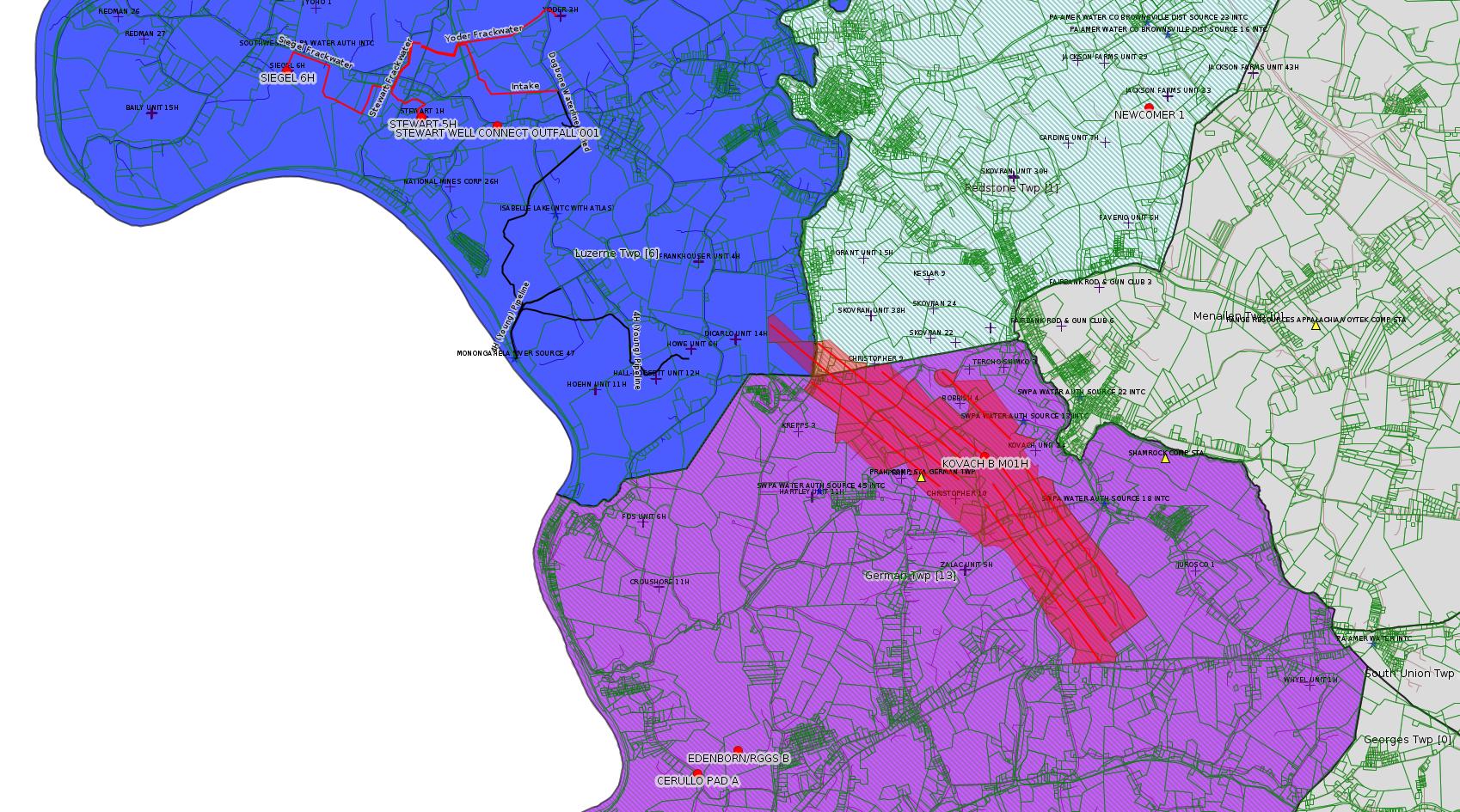
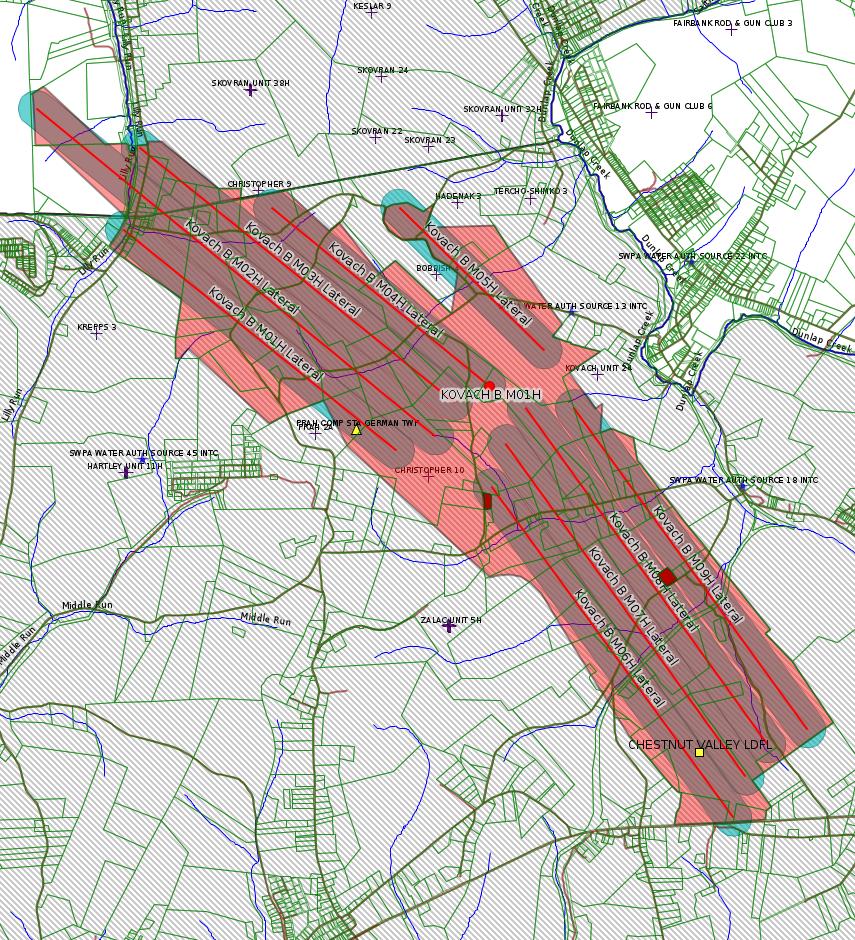
The Kovach B Laterals map shows the "Mineral Tract" in pink, and the laterals in red. The laterals are mapped from the Landing Point to the Bottom Hole. (Landing Point is the point at which the well bore arrives at production depth, in the Marcellus Shale; Bottom Hole marks the farthest end of the well bore. Surrounding each lateral is a buffer of radius 400 feet, shown in turquoise (lavender where the buffer overlays the Mineral Tract). The portion of the well bore from the Top Hole (i.e. the surface location) to the Landing Point is not shown.
The number 400 feet for the radius of the buffers is not taken from anything showing on the Kovach B plats. Rather, this number appears to be the "radius" of Mineral Tracts on plats for the adjoing Zalac Well Pad. The Kovach B plats all show the same outline for Mineral Tract for each well. This seems to imply that the area to be fracked for Kovach B all constitutes a single "Unit". The term Unit is well recognized in Oil & Gas law, and appears in leases even dating back to the conventional gas drilling boom at the beginning of the 21st century. Is "Mineral Tract" the same thing as "Unit"? Not clear. Note that on the Kovach B map, there are places where the buffer goes outside the Mineral Tract. One assumes this reflects what is actually happening underground, and in a case like this the fracker is fracking outside the leased subsurface. Is this subsurface tresspass? Possibly. In the case called Briggs vs. Southwestern Engergy, Superior Court ruled that it is subsurface tresspass. This ruling has not yet been either affirmed or reversed by the PA Supreme Court.
Of course, we don't know that a 400 foot "frack distance" is in fact what will happen 8000 or so feet underground. In a presentation a few months ago in Westmoreland County, Dr. Anthony Ingraffea answered a question about this by saying that if you are within 1000 feet of the well bore, you should assume you're being fracked. 400 feet is very likely an extremely conservative number.
How common is fracking outside the tract? It would take close examination of many plats, Well Completion Logs, and even the driller's Microseismic Data to be sure. A reasonable educated guess is: it is rampant. If Briggs vs. Southwestern Energy is upheld, this could have serious financial implications for the natural gas industry.
---
An earlier authorization for SPROUL 7005 for Regulatory Inactive Status (Authorization ID: 1245075) was just recently issued (10/10/2018) -- see the 10/21/18 issue of this bulletin. So why was there this second application? We've seen this before. Is this just a case of careless duplicate data entry at DEP? The permit for that earlier authorization states the following:
"Future use depends greatly on successful completion of planned nearby interstate pipeline takeaway capacity. Triana Energy respectfully requests time to allow these projects to proved more economic markets.
A significant length of production pipeline is required to move gas from this well to market. Final engineering and funding decisions depend on completion of proposed interstate pipelines, which would provide for more economic market opportunities."
Note that the Well Completion Log for this well shows that it was drilled through the Marcellus Shale down to the Oriskany Sandstone, which appears to be the target formation. For more information on the Oriskany Sandstone, see the 11/13/16 issue of this bulletin. (The Oriskany lies beneath the Marcellus Shale.)
------------------------
DEP defines an environmental justice area as "any census tract where 20 percent or more individuals live in poverty, and/or 30 percent or more of the population is minority". (See:
<http://www.dep.pa.gov/PublicParticipation/OfficeofEnvironmentalJustice/Pages/default.aspx>). There are supposed to be enhanced public participation requirements for permits in environmental justice areas, but news of this actually ever happening is scarce. In Fayette County, the entirety of Redstone, Springhill, Nicholson, and German Townships are environmental justice areas, as well as a large part of Dunbar Township. DEP's policy document on public participation guidelines for environmental justice areas is located here:
<http://www.elibrary.dep.state.pa.us/dsweb/Get/Version-48671/012-0501-002.pdf>
eNOTICE records are likely to list the same permit multiple times, as that permit moves through the DEP process.
Oil & Gas Wells designated with a site a number and the letter H typically designate horizontal wells.
-------------------------
Resources:
Pennsylvania Bulletin: <http://www.pabulletin.com/>
eNOTICE: <http://www.ahs2.dep.state.pa.
DEP Oil and Gas Reports: <http://www.dep.pa.gov/DataandTools/Reports/Oil%20and%20Gas%20Reports/Pages/default.aspx>
DEP Permits Issued Detail Report:
<http://www.depreportingservic
DEP SPUD (drilling started) Report:
<http://www.depreportingservices.state.pa.us/ReportServer/Pages/ReportViewer.aspx?/Oil_Gas/Spud_External_Data>
DEP Oil and Gas Compliance Report:
<http://www.depreportingservices.state.pa.us/ReportServer/Pages/ReportViewer.aspx?/Oil_Gas/OG_Compliance>
DEP PA Oil & Gas Mapping:
<http://www.depgis.state.pa.us/PaOilAndGasMapping>
Data Portal Services Directory [Technical]
<http://www.depgis.state.pa.us/arcgis/rest/services>
Query: Oil and Gas Wells All (ID: 3) [Technical]:
<http://www.depgis.state.pa.us/arcgis/rest/services/OilGas/OilGasAllStrayGasEGSP/MapServer/3/query?where=&text=&objectIds=&time=&geometry=&geometryType=esriGeometryEnvelope&inSR=&spatialRel=esriSpatialRelIntersects&relationParam=&outFields=*&returnGeometry=true&returnTrueCurves=false&maxAllowableOffset=&geometryPrecision=&outSR=&returnIdsOnly=false&returnCountOnly=false&orderByFields=&groupByFieldsForStatistics=&outStatistics=&returnZ=false&returnM=false&gdbVersion=&returnDistinctValues=false&resultOffset=&resultRecordCount=&f=html>
(Be sure to enter a Where clause in SQL format. Dates are in milliseconds since midnight 1/1/1970).
New:
DEP Oil and Gas Electronic Submissions
<http://www.ahs.dep.pa.gov/eSubmissionPublicSearch>
DEP Oil and Gas Electronic Notifications
<http://www.depreportingservices.state.pa.us/ReportServer?/Oil_Gas/OG_Notifications>
DEP Oil and Gas Well Pad Report
<http://www.depreportingservices.state.pa.us/ReportServer?/Oil_Gas/Well_Pads>
Fayette County Assessment Office Search For Tax Records:
<http://property.co.fayette.pa.us/search.aspx>
Pennsylvania Spatial Data Access:
<http://www.pasda.psu.edu/default.asp>
DEP Spatial Data Repository:
<ftp://www.pasda.psu.edu/pub/pasda/dep/>
National Response Center:
<http://www.nrc.uscg.mil/>
EPA-Echo: <http://www.epa-echo.gov/echo/
FERC citizen involvement: <http://www.ferc.gov/for-citiz
To receive E-mail notification of
all documents filed in a FERC docket, see:
<http://www.ferc.gov/docs-filing/esubscription.asp >
<http://www.ferc.gov/docs-fili
Follow the directions and enter the docket number to subscribe to.
Township Supervisors receive information regarding Erosion & Sedimentation permits, and these records may be reviewable at township municipal offices.
DEP permits are reviewable through the File Review process, for application to do file review see: <http://www.portal.state.pa.us/portal/server.pt/community/southwest_regional_office/13775/file_review/593164>
Environmental Hearing Board: <http://ehb.courtapps.com/publ
PA DEP Environmental Policy Comment System:
<http://www.ahs.dep.pa.gov/eComment/>
Federal Register Environment: <https://www.federalregister.g
Browsing of recent comment
opportunities for federal agencies, e.g. EPA. Click "sign up" to
subscribe to daily E-mails of new document listings.
SkyTruth Fayette County Drilling Alerts: <http://frack.skytruth.org/pen
U.S. Army Corps of Engineers, Pittsburgh District, Public Notices:
<http://www.lrp.usace.army.mil/Missions/Regulatory/Public-Notices/>
EPA Pennsylvania Public Notices: <http://www2.epa.gov/aboutepa/epa-pennsylvania#notice>
Marcellus Shale waste disposal
injection wells in Pennsylvania are regulated directly by EPA, not
DEP. Notice of any new permit applications will appear at the
above web address. I'm not aware of any subscription service
to be notified of such applications. I'm not aware of any
Marcellus Shale waste disposal injection wells in Fayette County
(yet ...) but we need to monitor this page for future
applications.
Energy Assurance Daily: <http://www.oe.netl.doe.gov/ead.aspx>
Daily newsletter from the US
Department of Energy about events relating to energy. The Natural
Gas section has information about pipelines.
-------------------------
Disclaimers:
This compilation from the above sources was done in part by hand using copy and paste and in part using automated methods; it may omit relevant permits.
Parcel data is provided via the tax records search web page offered by the Fayette County Assessment Office (http://property.co.fayette.pa.us/). Presumed Parcel Id links are subject to availability provided by that agency and associated web sites. Presumed Parcel Ids are determined as the mapped parcel containing a given latitude and longitude, are a best effort determination which is subject to error, and are not official. In cases where a facility is leased and there is a separate parcel id for the lease, if this parcel id is not separately mapped, the parcel id shown will be the id for the enclosing parcel. Parcel owners may be surface owners only and may or may not have any relationship to oil & gas facilities.
Does not currently include water supply permits. Does not include landfill permits even though many such are for Marcellus Shale waste. (It is not possible at this time to distinguish which landfill permits are for Marcellus Shale waste and which are not without doing File Review for each permit.)
Erosion & Sedimentation permit records do not currently include latitude and longitude. Where I am publishing latitude and longitude with E&S permits it is by inferring an associated well permit and using published latitude and longitude for the well. It is possible I may be inferring the wrong well site.
Municipalities are shown from eFACTS records on the DEP web site. The DEP has been known to list a municipality incorrectly.