The Harmed Success Stories Concepts How To What Is Commentary
Fayette County Marcellus Shale Permits 2/25/19 - 3/10/19
Contents
Pennsylvania Bulletin Listings
Gans Power Station Title V Operating Permit renewal (New)eFACTS Listings
EDENBORN/RGGS B M15H Alt Method of Equipping, Casing, or Venting Well (New)Electronic Notifications
EDENBORN/RGGS B M14H Alt Method of Equipping, Casing, or Venting Well (New)
EDENBORN/RGGS B M13H Alt Method of Equipping, Casing, or Venting Well (New)
EDENBORN/RGGS B M12H Alt Method of Equipping, Casing, or Venting Well (New)
EDENBORN/RGGS B M11H Alt Method of Equipping, Casing, or Venting Well (New)
EDENBORN/RGGS B M10H Alt Method of Equipping, Casing, or Venting Well (New)
EDENBORN/RGGS B M09H Alt Method of Equipping, Casing, or Venting Well (New)
EDENBORN/RGGS B M08H Alt Method of Equipping, Casing, or Venting Well (New)
EDENBORN/RGGS B M07H Alt Method of Equipping, Casing, or Venting Well (New)
EDENBORN/RGGS B M06H Alt Method of Equipping, Casing, or Venting Well (New)
EDENBORN/RGGS B M05H Alt Method of Equipping, Casing, or Venting Well (New)
EDENBORN/RGGS B M04H Alt Method of Equipping, Casing, or Venting Well (New)
EDENBORN/RGGS B M03H Alt Method of Equipping, Casing, or Venting Well (New)
EDENBORN/RGGS B M02H Alt Method of Equipping, Casing, or Venting Well (New)
EDENBORN/RGGS B M01H Alt Method of Equipping, Casing, or Venting Well (New)
CERULLO M12H Alt Method of Equipping, Casing, or Venting Well (New)
CERULLO M11H Alt Method of Equipping, Casing, or Venting Well (New)
CERULLO M10H Alt Method of Equipping, Casing, or Venting Well (New)
CERULLO M09H Alt Method of Equipping, Casing, or Venting Well (New)
CERULLO M04H Alt Method of Equipping, Casing, or Venting Well (New)
CERULLO M03H Alt Method of Equipping, Casing, or Venting Well (New)
CERULLO M02H Alt Method of Equipping, Casing, or Venting Well (New)
CERULLO M01H Alt Method of Equipping, Casing, or Venting Well (New)
KOVACH B Well Pad Residual Waste Processing Issued 2/28/2019 (New)
HERRIOTT M09H Drill & Operate Well Permit (Unconventional) Issued 2/22/2019
HERRIOTT M03H Drill & Operate Well Permit (Unconventional) Issued 2/22/2019
HERRIOTT M08H Drill & Operate Well Permit (Unconventional) Issued 2/22/2019
HERRIOTT M07H Drill & Operate Well Permit (Unconventional) Issued 2/22/2019
HERRIOTT M02H Drill & Operate Well Permit (Unconventional) Issued 2/22/2019
HERRIOTT M06H Drill & Operate Well Permit (Unconventional) Issued 2/22/2019
HERRIOTT M05H Drill & Operate Well Permit (Unconventional) Issued 2/22/2019
HERRIOTT M04H Drill & Operate Well Permit (Unconventional) Issued 2/22/2019
SHAMROCK COMP STA Major Facility Prevention of Significant Deterioration Extension Issued 2/22/2019
SHAMROCK COMP STA Minor Facility New Source Performance Std Issued on 2/22/2019
FAYETTE ENERGY FACILITY Major Facility New Source Performance Std Extension Issued 2/26/2019
STEWART 6H Well Plugging Notice Intent to Plug Single Well
SNAPP TESLOVICH WELL PAD A Erosion and Sediment Control General Permit 3 2/26/2019 deficiency letter
CHRISTOFEL WELL PAD A Erosion and Sediment Control General Permit 3 3/4/2019 deficiency letter
KOVACH B M05H Casing cementing notification Coal Protected Casing 2: 3/1/2019Notes
YODER 10H Casing cementing notification Coal Protected Casing 1: 3/1/2019
YODER 9H Drilling resumption After Break of 30 days or more 03/04/2019
YODER 9H Casing cementing notification Intermediate: 3/5/2019
KOVACH B M06H Drilling resumption After Break of 30 days or more 03/07/2019
KOVACH B M06H Casing cementing notification Coal Protected Casing 1 3/8/2019
KOVACH B M07H Drilling resumption After Break of 30 days or more 03/12/2019
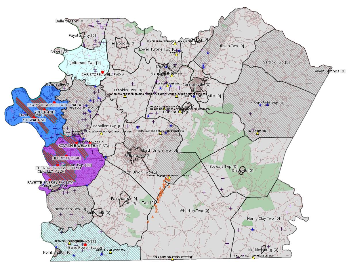
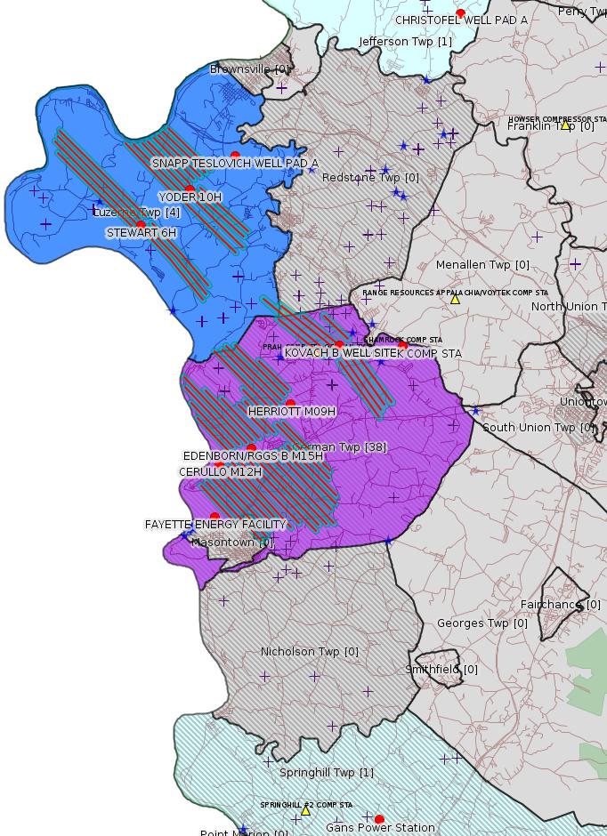
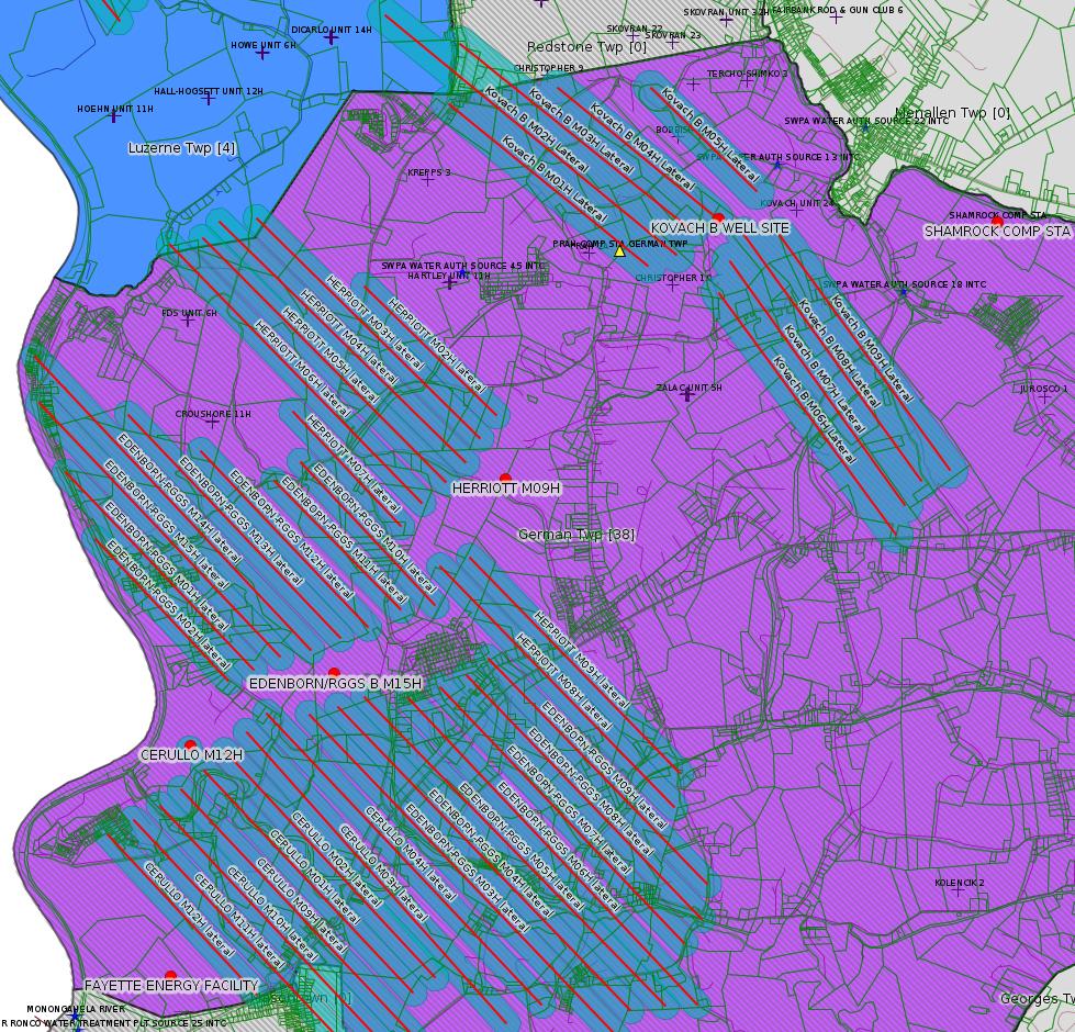
Map
Key
Red dots: items in this permit list with an exact location.
Blue stars: Marcellus Gas Well Water Sources.
Where well laterals are mapped they show in red; a 400-foot buffer surrounding the lateral shows in blue (lavender where it overlaps a mapped mineral tract).
Where mineral tracts are mapped, they show in pink. Mineral tracts can overlap; the overlap will show in red. The precise meaning of "mineral tract" is not clear.
Municipality shading: number of "facilities", with each well counting separately
(includes the red dots):
gray: 0
pale turquoise: 1
turquoise: 2
pale blue: 3
middle blue: 4
dark blue: 5
dark purple: 8
purple: 19
(Color coding may differ from one issue to the next.)
(Note if a project spans multiple municipalities -- e.g. a pipeline -- it will show in the count for each municipality.)
The number of facilities also follows the municipality name in brackets.
Municipality counts are based on the way the permit is listed by DEP; DEP has been known to get a municipality wrong.
Locations in brackets identify a precise location used to locate a surrogate for the actual site being permitted (e.g. locating a well pad or pipeline by the known location of a well.) Locations labeled beginning with "~" and ending in "[?]" are approximate and speculative based on inferences using on-line property and lease records. These are marked in the text as "[Approximate, Speculative]
Cross-hatching: Environmental Justice Areas
Yellow triangles: Compressor Stations
Orange triangles: Storage Field Wells (currently Dominion North Summit Storage Field)
Crosses: SPUD Unconventional well permits
Green: "Natural areas", e.g. state game lands, state forests
Yellow triangles: Compressor Stations
Orange triangles: Storage Field Wells (currently Dominion North Summit Storage Field)
Crosses: SPUD Unconventional well permits
Green: "Natural areas", e.g. state game lands, state forests
More Maps
 |
 |
Source: Pennsylvania Bulletin
New:
[Arguably Off-Topic:]
26-00495: Gans Energy, LLC (198 Butler Street, Springdale, PA 15144), In accordance with 25 Pa. Code §§ 127.441, 127.425 and 127.521, the Department is providing notice that they intend to issue a renewed Title V Operating Permit for the continued operation of an electrical power plant, known as the Gans Power Station, located in Springhill Township, Fayette County. The proposed renewed TVOP also incorporates the applicable requirement of a Significant Permit Modification to include the 25 Pa. Code § 121.7 in the permit.
Gans Power Station is a simple cycle, pipeline natural gas-fired, combustion gas turbine (CGT) power station. The main sources at this facility are two, NG-fired, 355 MMBtu/hr, heat input, turbine engines powering 44 MW electrical output, electrical generators and a cooling tower.
Annual potential emissions from the Gans Power Station are 136.6 tons of CO, 99.9 tons of NOx, 12.3 tons of VOC, 6.4 tons of PM10, 6.4 tons of PM2.5, and 1.5 ton of SO2. Gans also has potential annual emissions of 0.7 ton of formaldehyde and 0.9 ton of the sum of all HAPs combined, and 96,144 tons of CO2e. Sources at the Gans Power Station are subject to 40 CFR Part 60, GG—Standards of Performance for Stationary Gas Turbines, Parts 72—77—Acid Rain Program requirements, and Part 97, Subparts AAAAA, BBBBB and CCCCC—CSAPR NOx and SO2 Trading Programs and 25 Pa. Code Chapters 121—145. The permit includes emission limitations and operational, monitoring, testing, recordkeeping, workpractice and reporting requirements for the station.
Gans Energy, LLC's Title V Operating Permit renewal application, the Department's Air Quality Review Memorandum, and the proposed Air Quality Title V Operating Permit for this project are available for review by any interested party at the Department of Environmental Protection, Southwest Regional Office, 400 Waterfront Drive, Pittsburgh, PA 15222. To request a review of the Title V Operating Permit renewal application, to receive an electronic copy of the Department's Air Quality Review Memorandum, or to receive an electronic copy of the Department's proposed Air Quality Title V Operating Permit for this project, a person may contact Thomas Kaminski at thkaminski@pa.gov or 412.442.4000.
Those who wish to provide the Department with additional written information that they believe should be considered prior to the issuance of this Title V Operating Permit may submit the information to Martin L. Hochhauser, P.E., Department of Environmental Protection, 400 Waterfront Drive, Pittsburgh, PA 15222. Each written comment must contain the name, address and telephone number of the person submitting the comments, identification of the proposed Operating Permit (specify Operating Permit TVOP-26-00495) and concise statements regarding the relevancy of the information or objections to issuance of the Operating Permit.
All comments must be received prior to the close of business 30 days after the date of this publication. In accordance with 25 Pa. Code § 127.428, prior to issuing an operating permit, the Department may hold a fact-finding conference or hearing at which the petitioner, and a person who has properly filed a protest under § 127.426 (relating to filing protests) may appear and give testimony. The Department is not required to hold a conference or hearing. The applicant, the protestant and other participants will be notified of the time, place and purpose of a conference or hearing, in writing or by publication in a newspaper or the Pennsylvania Bulletin, unless the Department determines that notification by telephone will be sufficient.
<https://www.pabulletin.com/secure/data/vol49/49-10/326a.html>
Location: 39.747518,-79.838772 <https://osm.org/go/ZWpKl_YV--?m=>
Presumed Parcel Id: 36180001
-------------------------
Source: eNOTICE (+ PA Oil and Gas Mapping, Well Pad Report.) Well Details via Data Portal Services: Oil and Gas Wells All (ID: 3).
Please see the Disclaimer below regarding Parcel Id data.
New:
Authorization ID: 1264023
Permit number: 051-24689
Site: EDENBORN/RGGS B ESCGP ESX18-051-0003
Client: CHEVRON APPALACHIA LLC
Authorization type: Alt Method of Equipping, Casing, or Venting Well
Application type: New
Authorization is for: FACILITY
Date received: 03/05/2019
Status: Pending
Permit Decision Guarantee Applies?: Yes
Permit Decision Guarantee status: ACTIVE
Sub-Facilities for Authorization:
Sub-Facility ID Sub-Facility Name Description
1274762 WELLBORE SURFACE HOLE LOCATION Well
Permit Review Notes:
Date Review Note
3/6/2019 The permit application package is complete, has been accepted, and is undergoing technical review.
<https://www.ahs.dep.pa.gov/eFACTSWeb/searchResults_singleAuth.aspx?AuthID=1264023>
Site Programs:
Oil & Gas
Site Municipalities:
German Twp [an Environmental Justice Area], Fayette County
Well Details:
Permit Number: 051-24689
Well Name: EDENBORN/RGGS B M15H
Unconventional Well: Y
Well Configuration: Horizontal Well
Well Type: GAS
Well Status: Active
Coal Association: Coal
Conservation Well: N
Primary Facility ID: 830215
Site ID: 829418
Site Name: EDENBORN/RGGS B ESCGP ESX18-051-0003
Well Pad ID: 155083
Well Pad Name: EDENBORN/RGGS B
Storage Field:
Operator: CHEVRON APPALACHIA LLC
Operator Number: OGO-39307
Permit Date: 2018-12-13
Permit Date Expires: 2019-12-13
SPUD Date:
Date Plugged:
UIC ID:
UIC Type:
Surface Elevation: 1167
County: Fayette
Municipality: German Twp
Location: 39.882061,-79.896197
Map URL: <http://www.openstreetmap.org/?mlat=39.882061&mlon=-79.896197#map=15/39.882061/-79.896197>
OG WELLS PERMIT DOCS:
2018-12-13: Final Permit Documents, Name: 033-27257 Permit (11-30-18) (for Authorization: 1251236):
<http://www.depgis.state.pa.us/pdfHandler/pdFHandler.ashx?Doc=NzEwMTEw&ext=PDF>
2018-12-13: Final Permit Documents, Name: Povlik Record of Decision (11-30-18) (for Authorization: 1251236):
<http://www.depgis.state.pa.us/pdfHandler/pdFHandler.ashx?Doc=NzEwMTEy&ext=PDF>
2018-12-13: Other Permit Documents, Name: Povlik Deficiency Letter (for Authorization: 1251236):
<http://www.depgis.state.pa.us/pdfHandler/pdFHandler.ashx?Doc=NzEwMTE3&ext=PDF>
2018-12-13: Initial Submitted Documents, Name: Povlik 2018 application - approved (for Authorization: 1251236):
<http://www.depgis.state.pa.us/pdfHandler/pdFHandler.ashx?Doc=NzEwMTU3&ext=PDF>
2018-12-13: Other Permit Documents, Name: E&S-C&D email (for Authorization: 1251236):
<http://www.depgis.state.pa.us/pdfHandler/pdFHandler.ashx?Doc=NzEwMTU1&ext=PDF>
2018-12-13: Final Permit Documents, Name: Authorization ID 1251236 (for Authorization: 1251236):
<http://www.depgis.state.pa.us/pdfHandler/pdFHandler.ashx?Doc=NzE1NDM0&ext=PDF>
Electronically Submitted Records:
2018-12-13: Submission for Authorization 1251236
Pennsylvania Natural Diversity Inventory Form: EdenbornRGGS PNDI.pdf
<http://www.depgis.state.pa.us/eWellDocHandler/pdFHandler.ashx?Doc=NjgyMzQx&ext=PDF>
Location Plat: Edenborn Well Plat M15H.dwg
<http://www.depgis.state.pa.us/eWellDocHandler/pdFHandler.ashx?Doc=NjgyMzQy&ext=PDF>
Coordination of Well Location with Public Resources: Edenborn M15H OG-76.pdf
<http://www.depgis.state.pa.us/eWellDocHandler/pdFHandler.ashx?Doc=NjgyMzQz&ext=PDF>
Well Cross-Section Diagram: Edenborn RGGS M15H Page 4.pdf
<http://www.depgis.state.pa.us/eWellDocHandler/pdFHandler.ashx?Doc=NjgyMzQ0&ext=PDF>
Permit Application to Drill and Operate a Well: 1812304.pdf
<http://www.depgis.state.pa.us/eWellDocHandler/pdFHandler.ashx?Doc=NjgyOTI4&ext=PDF>
Presumed Parcel Id: 15220014
---
New:
Authorization ID: 1264019
Permit number: 051-24688
Site: EDENBORN/RGGS B ESCGP ESX18-051-0003
Client: CHEVRON APPALACHIA LLC
Authorization type: Alt Method of Equipping, Casing, or Venting Well
Application type: New
Authorization is for: FACILITY
Date received: 03/05/2019
Status: Pending
Permit Decision Guarantee Applies?: Yes
Permit Decision Guarantee status: ACTIVE
Sub-Facilities for Authorization:
Sub-Facility ID Sub-Facility Name Description
1274760 WELLBORE SURFACE HOLE LOCATION Well
Permit Review Notes:
Date Review Note
3/6/2019 The permit application package is complete, has been accepted, and is undergoing technical review.
<https://www.ahs.dep.pa.gov/eFACTSWeb/searchResults_singleAuth.aspx?AuthID=1264019>
Site Programs:
Oil & Gas
Site Municipalities:
German Twp [an Environmental Justice Area], Fayette County
Well Details:
Permit Number: 051-24688
Well Name: EDENBORN/RGGS B M14H
Unconventional Well: Y
Well Configuration: Horizontal Well
Well Type: GAS
Well Status: Active
Coal Association: Coal
Conservation Well: N
Primary Facility ID: 830214
Site ID: 829418
Site Name: EDENBORN/RGGS B ESCGP ESX18-051-0003
Well Pad ID: 155083
Well Pad Name: EDENBORN/RGGS B
Storage Field:
Operator: CHEVRON APPALACHIA LLC
Operator Number: OGO-39307
Permit Date: 2018-12-13
Permit Date Expires: 2019-12-13
SPUD Date:
Date Plugged:
UIC ID:
UIC Type:
Surface Elevation: 1167
County: Fayette
Municipality: German Twp
Location: 39.882069,-79.896144
Map URL: <http://www.openstreetmap.org/?mlat=39.882069&mlon=-79.896144#map=15/39.882069/-79.896144>
OG WELLS PERMIT DOCS:
2018-12-13: Final Permit Documents, Name: Authorization ID 1251234 (for Authorization: 1251234):
<http://www.depgis.state.pa.us/pdfHandler/pdFHandler.ashx?Doc=NzE1NDM3&ext=PDF>
Electronically Submitted Records:
2018-12-13: Submission for Authorization 1251234
Pennsylvania Natural Diversity Inventory Form: EdenbornRGGS PNDI.pdf
<http://www.depgis.state.pa.us/eWellDocHandler/pdFHandler.ashx?Doc=NjgyMzMz&ext=PDF>
Location Plat: Edenborn Well Plat M14H.dwg
<http://www.depgis.state.pa.us/eWellDocHandler/pdFHandler.ashx?Doc=NjgyMzM0&ext=PDF>
Coordination of Well Location with Public Resources: Edenborn M14H OG-76.pdf
<http://www.depgis.state.pa.us/eWellDocHandler/pdFHandler.ashx?Doc=NjgyMzM1&ext=PDF>
Well Cross-Section Diagram: Edenborn RGGS M14H Page 4.pdf
<http://www.depgis.state.pa.us/eWellDocHandler/pdFHandler.ashx?Doc=NjgyMzM2&ext=PDF>
Permit Application to Drill and Operate a Well: 1812295.pdf
<http://www.depgis.state.pa.us/eWellDocHandler/pdFHandler.ashx?Doc=NjgyOTIz&ext=PDF>
---
New:
Authorization ID: 1264017
Permit number: 051-24686
Site: EDENBORN/RGGS B ESCGP ESX18-051-0003
Client: CHEVRON APPALACHIA LLC
Authorization type: Alt Method of Equipping, Casing, or Venting Well
Application type: New
Authorization is for: FACILITY
Date received: 03/05/2019
Status: Pending
Permit Decision Guarantee Applies?: Yes
Permit Decision Guarantee status: ACTIVE
Sub-Facilities for Authorization:
Sub-Facility ID Sub-Facility Name Description
1274758 WELLBORE SURFACE HOLE LOCATION Well
Permit Review Notes:
Date Review Note
3/6/2019 The permit application package is complete, has been accepted, and is undergoing technical review.
<https://www.ahs.dep.pa.gov/eFACTSWeb/searchResults_singleAuth.aspx?AuthID=1264017>
Site Programs:
Oil & Gas
Site Municipalities:
German Twp [an Environmental Justice Area], Fayette County
Well Details:
Permit Number: 051-24686
Well Name: EDENBORN/RGGS B M13H
Unconventional Well: Y
Well Configuration: Horizontal Well
Well Type: GAS
Well Status: Active
Coal Association: Coal
Conservation Well: N
Primary Facility ID: 830212
Site ID: 829418
Site Name: EDENBORN/RGGS B ESCGP ESX18-051-0003
Well Pad ID: 155083
Well Pad Name: EDENBORN/RGGS B
Storage Field:
Operator: CHEVRON APPALACHIA LLC
Operator Number: OGO-39307
Permit Date: 2018-12-13
Permit Date Expires: 2019-12-13
SPUD Date:
Date Plugged:
UIC ID:
UIC Type:
Surface Elevation: 1167
County: Fayette
Municipality: German Twp
Location: 39.882075,-79.896092
Map URL: <http://www.openstreetmap.org/?mlat=39.882075&mlon=-79.896092#map=15/39.882075/-79.896092>
OG WELLS PERMIT DOCS:
2018-12-13: Final Permit Documents, Name: Authorization ID 1251232 (for Authorization: 1251232):
<http://www.depgis.state.pa.us/pdfHandler/pdFHandler.ashx?Doc=NzE1NDQ2&ext=PDF>
Electronically Submitted Records:
2018-12-13: Submission for Authorization 1251232
Pennsylvania Natural Diversity Inventory Form: EdenbornRGGS PNDI.pdf
<http://www.depgis.state.pa.us/eWellDocHandler/pdFHandler.ashx?Doc=NjgyMzIy&ext=PDF>
Location Plat: Edenborn Well Plat M13H.dwg
<http://www.depgis.state.pa.us/eWellDocHandler/pdFHandler.ashx?Doc=NjgyMzIz&ext=PDF>
Coordination of Well Location with Public Resources: Edenborn M13H OG-76.pdf
<http://www.depgis.state.pa.us/eWellDocHandler/pdFHandler.ashx?Doc=NjgyMzI0&ext=PDF>
Well Cross-Section Diagram: Edenborn RGGS M13H Page 4.pdf
<http://www.depgis.state.pa.us/eWellDocHandler/pdFHandler.ashx?Doc=NjgyMzI1&ext=PDF>
Permit Application to Drill and Operate a Well: 1812288.pdf
<http://www.depgis.state.pa.us/eWellDocHandler/pdFHandler.ashx?Doc=NjgyOTE0&ext=PDF>
---
New:
Authorization ID: 1264015
Permit number: 051-24685
Site: EDENBORN/RGGS B ESCGP ESX18-051-0003
Client: CHEVRON APPALACHIA LLC
Authorization type: Alt Method of Equipping, Casing, or Venting Well
Application type: New
Authorization is for: FACILITY
Date received: 03/05/2019
Status: Pending
Permit Decision Guarantee Applies?: Yes
Permit Decision Guarantee status: ACTIVE
Sub-Facilities for Authorization:
Sub-Facility ID Sub-Facility Name Description
1274757 WELLBORE SURFACE HOLE LOCATION Well
Permit Review Notes:
Date Review Note
3/6/2019 The permit application package is complete, has been accepted, and is undergoing technical review.
<https://www.ahs.dep.pa.gov/eFACTSWeb/searchResults_singleAuth.aspx?AuthID=1264015>
Site Programs:
Oil & Gas
Site Municipalities:
German Twp [an Environmental Justice Area], Fayette County
Well Details:
Permit Number: 051-24685
Well Name: EDENBORN/RGGS B M12H
Unconventional Well: Y
Well Configuration: Horizontal Well
Well Type: GAS
Well Status: Active
Coal Association: Coal
Conservation Well: N
Primary Facility ID: 830211
Site ID: 829418
Site Name: EDENBORN/RGGS B ESCGP ESX18-051-0003
Well Pad ID: 155083
Well Pad Name: EDENBORN/RGGS B
Storage Field:
Operator: CHEVRON APPALACHIA LLC
Operator Number: OGO-39307
Permit Date: 2018-12-10
Permit Date Expires: 2019-12-10
SPUD Date:
Date Plugged:
UIC ID:
UIC Type:
Surface Elevation: 1167
County: Fayette
Municipality: German Twp
Location: 39.882081,-79.896039
Map URL: <http://www.openstreetmap.org/?mlat=39.882081&mlon=-79.896039#map=15/39.882081/-79.896039>
OG WELLS PERMIT DOCS:
2018-12-10: Final Permit Documents, Name: Authorization ID 1251231 (for Authorization: 1251231):
<http://www.depgis.state.pa.us/pdfHandler/pdFHandler.ashx?Doc=NzEyNDg4&ext=PDF>
Electronically Submitted Records:
2018-12-10: Submission for Authorization 1251231
Coordination of Well Location with Public Resources: Edenborn M12H OG-76.pdf
<http://www.depgis.state.pa.us/eWellDocHandler/pdFHandler.ashx?Doc=NjgyMzEw&ext=PDF>
Pennsylvania Natural Diversity Inventory Form: EdenbornRGGS PNDI.pdf
<http://www.depgis.state.pa.us/eWellDocHandler/pdFHandler.ashx?Doc=NjgyMzEx&ext=PDF>
Location Plat: Edenborn Well Plat M12H.dwg
<http://www.depgis.state.pa.us/eWellDocHandler/pdFHandler.ashx?Doc=NjgyMzEy&ext=PDF>
Well Cross-Section Diagram: Edenborn RGGS M12H Page 4.pdf
<http://www.depgis.state.pa.us/eWellDocHandler/pdFHandler.ashx?Doc=NjgyMzEz&ext=PDF>
Permit Application to Drill and Operate a Well: 1812280.pdf
<http://www.depgis.state.pa.us/eWellDocHandler/pdFHandler.ashx?Doc=NjgyOTEx&ext=PDF>
---
New:
Authorization ID: 1264008
Permit number: 051-24687
Site: EDENBORN/RGGS B ESCGP ESX18-051-0003
Client: CHEVRON APPALACHIA LLC
Authorization type: Alt Method of Equipping, Casing, or Venting Well
Application type: New
Authorization is for: FACILITY
Date received: 03/05/2019
Status: Pending
Permit Decision Guarantee Applies?: Yes
Permit Decision Guarantee status: ACTIVE
Sub-Facilities for Authorization:
Sub-Facility ID Sub-Facility Name Description
1274759 WELLBORE SURFACE HOLE LOCATION Well
Permit Review Notes:
Date Review Note
3/6/2019 The permit application package is complete, has been accepted, and is undergoing technical review.
<https://www.ahs.dep.pa.gov/eFACTSWeb/searchResults_singleAuth.aspx?AuthID=1264008>
Site Programs:
Oil & Gas
Site Municipalities:
German Twp [an Environmental Justice Area], Fayette County
Well Details:
Permit Number: 051-24687
Well Name: EDENBORN/RGGS B M11H
Unconventional Well: Y
Well Configuration: Horizontal Well
Well Type: GAS
Well Status: Active
Coal Association: Coal
Conservation Well: N
Primary Facility ID: 830213
Site ID: 829418
Site Name: EDENBORN/RGGS B ESCGP ESX18-051-0003
Well Pad ID: 155083
Well Pad Name: EDENBORN/RGGS B
Storage Field:
Operator: CHEVRON APPALACHIA LLC
Operator Number: OGO-39307
Permit Date: 2018-12-10
Permit Date Expires: 2019-12-10
SPUD Date:
Date Plugged:
UIC ID:
UIC Type:
Surface Elevation: 1167
County: Fayette
Municipality: German Twp
Location: 39.882089,-79.895986
Map URL: <http://www.openstreetmap.org/?mlat=39.882089&mlon=-79.895986#map=15/39.882089/-79.895986>
OG WELLS PERMIT DOCS:
2018-12-10: Final Permit Documents, Name: Authorization ID 1251233 (for Authorization: 1251233):
<http://www.depgis.state.pa.us/pdfHandler/pdFHandler.ashx?Doc=NzEyNDkz&ext=PDF>
Electronically Submitted Records:
2018-12-10: Submission for Authorization 1251233
Coordination of Well Location with Public Resources: Edenborn M11H OG-76.pdf
<http://www.depgis.state.pa.us/eWellDocHandler/pdFHandler.ashx?Doc=NjgyMjk5&ext=PDF>
Pennsylvania Natural Diversity Inventory Form: EdenbornRGGS PNDI.pdf
<http://www.depgis.state.pa.us/eWellDocHandler/pdFHandler.ashx?Doc=NjgyMzAw&ext=PDF>
Location Plat: Edenborn Well Plat M11H.dwg
<http://www.depgis.state.pa.us/eWellDocHandler/pdFHandler.ashx?Doc=NjgyMzAx&ext=PDF>
Well Cross-Section Diagram: Edenborn RGGS M11H Page 4.pdf
<http://www.depgis.state.pa.us/eWellDocHandler/pdFHandler.ashx?Doc=NjgyMzAy&ext=PDF>
Permit Application to Drill and Operate a Well: 1812270.pdf
<http://www.depgis.state.pa.us/eWellDocHandler/pdFHandler.ashx?Doc=NjgyOTA4&ext=PDF>
---
New:
Authorization ID: 1264006
Permit number: 051-24684
Site: EDENBORN/RGGS B ESCGP ESX18-051-0003
Client: CHEVRON APPALACHIA LLC
Authorization type: Alt Method of Equipping, Casing, or Venting Well
Application type: New
Authorization is for: FACILITY
Date received: 03/05/2019
Status: Pending
Permit Decision Guarantee Applies?: Yes
Permit Decision Guarantee status: ACTIVE
Sub-Facilities for Authorization:
Sub-Facility ID Sub-Facility Name Description
1274751 WELLBORE SURFACE HOLE LOCATION Well
Permit Review Notes:
Date Review Note
3/6/2019 The permit application package is complete, has been accepted, and is undergoing technical review.
<https://www.ahs.dep.pa.gov/eFACTSWeb/searchResults_singleAuth.aspx?AuthID=1264006>
Site Programs:
Oil & Gas
Site Municipalities:
German Twp [an Environmental Justice Area], Fayette County
Well Details:
Permit Number: 051-24684
Well Name: EDENBORN/RGGS B M10H
Unconventional Well: Y
Well Configuration: Horizontal Well
Well Type: GAS
Well Status: Active
Coal Association: Coal
Conservation Well: N
Primary Facility ID: 830209
Site ID: 829418
Site Name: EDENBORN/RGGS B ESCGP ESX18-051-0003
Well Pad ID: 155083
Well Pad Name: EDENBORN/RGGS B
Storage Field:
Operator: CHEVRON APPALACHIA LLC
Operator Number: OGO-39307
Permit Date: 2018-12-10
Permit Date Expires: 2019-12-10
SPUD Date:
Date Plugged:
UIC ID:
UIC Type:
Surface Elevation: 1167
County: Fayette
Municipality: German Twp
Location: 39.882094,-79.895933
Map URL: <http://www.openstreetmap.org/?mlat=39.882094&mlon=-79.895933#map=15/39.882094/-79.895933>
OG WELLS PERMIT DOCS:
2018-12-10: Final Permit Documents, Name: Authorization ID 1251227 (for Authorization: 1251227):
<http://www.depgis.state.pa.us/pdfHandler/pdFHandler.ashx?Doc=NzEyNDY3&ext=PDF>
Electronically Submitted Records:
2018-12-10: Submission for Authorization 1251227
Coordination of Well Location with Public Resources: Edenborn M10H OG-76.pdf
<http://www.depgis.state.pa.us/eWellDocHandler/pdFHandler.ashx?Doc=NjgyMjg4&ext=PDF>
Location Plat: Edenborn Well Plat M10H.dwg
<http://www.depgis.state.pa.us/eWellDocHandler/pdFHandler.ashx?Doc=NjgyMjg5&ext=PDF>
Pennsylvania Natural Diversity Inventory Form: EdenbornRGGS PNDI.pdf
<http://www.depgis.state.pa.us/eWellDocHandler/pdFHandler.ashx?Doc=NjgyMjkw&ext=PDF>
Well Cross-Section Diagram: Edenborn RGGS M10H Page 4.pdf
<http://www.depgis.state.pa.us/eWellDocHandler/pdFHandler.ashx?Doc=NjgyMjkx&ext=PDF>
Permit Application to Drill and Operate a Well: 1812040.pdf
<http://www.depgis.state.pa.us/eWellDocHandler/pdFHandler.ashx?Doc=NjgyODg5&ext=PDF>
---
New:
Authorization ID: 1264002
Permit number: 051-24680
Site: EDENBORN/RGGS B ESCGP ESX18-051-0003
Client: CHEVRON APPALACHIA LLC
Authorization type: Alt Method of Equipping, Casing, or Venting Well
Application type: New
Authorization is for: FACILITY
Date received: 03/05/2016
Status: Pending
Permit Decision Guarantee Applies?: Yes
Permit Decision Guarantee status: ACTIVE
Sub-Facilities for Authorization:
Sub-Facility ID Sub-Facility Name Description
1274747 WELLBORE SURFACE HOLE LOCATION Well
Permit Review Notes:
Date Review Note
3/6/2019 The permit application package is complete, has been accepted, and is undergoing technical review.
<https://www.ahs.dep.pa.gov/eFACTSWeb/searchResults_singleAuth.aspx?AuthID=1264002>
Site Programs:
Oil & Gas
Site Municipalities:
German Twp [an Environmental Justice Area], Fayette County
Well Details:
Permit Number: 051-24680
Well Name: EDENBORN/RGGS B M09H
Unconventional Well: Y
Well Configuration: Horizontal Well
Well Type: GAS
Well Status: Active
Coal Association: Coal
Conservation Well: N
Primary Facility ID: 830205
Site ID: 829418
Site Name: EDENBORN/RGGS B ESCGP ESX18-051-0003
Well Pad ID: 155083
Well Pad Name: EDENBORN/RGGS B
Storage Field:
Operator: CHEVRON APPALACHIA LLC
Operator Number: OGO-39307
Permit Date: 2018-12-10
Permit Date Expires: 2019-12-10
SPUD Date:
Date Plugged:
UIC ID:
UIC Type:
Surface Elevation: 1167
County: Fayette
Municipality: German Twp
Location: 39.882103,-79.895881
Map URL: <http://www.openstreetmap.org/?mlat=39.882103&mlon=-79.895881#map=15/39.882103/-79.895881>
OG WELLS PERMIT DOCS:
2018-12-10: Final Permit Documents, Name: Authorization ID 1251223 (for Authorization: 1251223):
<http://www.depgis.state.pa.us/pdfHandler/pdFHandler.ashx?Doc=NzEyNDMy&ext=PDF>
Electronically Submitted Records:
2018-12-10: Submission for Authorization 1251223
Pennsylvania Natural Diversity Inventory Form: EdenbornRGGS PNDI.pdf
<http://www.depgis.state.pa.us/eWellDocHandler/pdFHandler.ashx?Doc=NjMzNTAz&ext=PDF>
Coordination of Well Location with Public Resources: Edenborn M09H OG-76.pdf
<http://www.depgis.state.pa.us/eWellDocHandler/pdFHandler.ashx?Doc=NjgyMjgy&ext=PDF>
Location Plat: Edenborn Well Plat M9H.dwg
<http://www.depgis.state.pa.us/eWellDocHandler/pdFHandler.ashx?Doc=NjgyMjgz&ext=PDF>
Well Cross-Section Diagram: Edenborn RGGS M09H Page 4.pdf
<http://www.depgis.state.pa.us/eWellDocHandler/pdFHandler.ashx?Doc=NjgyMjg0&ext=PDF>
Permit Application to Drill and Operate a Well: 1812038.pdf
<http://www.depgis.state.pa.us/eWellDocHandler/pdFHandler.ashx?Doc=NjgyODg2&ext=PDF>
---
New:
Authorization ID: 1264000
Permit number: 051-24677
Site: EDENBORN/RGGS B ESCGP ESX18-051-0003
Client: CHEVRON APPALACHIA LLC
Authorization type: Alt Method of Equipping, Casing, or Venting Well
Application type: New
Authorization is for: FACILITY
Date received: 03/05/2019
Status: Pending
Permit Decision Guarantee Applies?: Yes
Permit Decision Guarantee status: ACTIVE
Sub-Facilities for Authorization:
Sub-Facility ID Sub-Facility Name Description
1274744 WELLBORE SURFACE HOLE LOCATION Well
Permit Review Notes:
Date Review Note
3/6/2019 The permit application package is complete, has been accepted, and is undergoing technical review.
<https://www.ahs.dep.pa.gov/eFACTSWeb/searchResults_singleAuth.aspx?AuthID=1264000>
Site Programs:
Oil & Gas
Site Municipalities:
German Twp [an Environmental Justice Area], Fayette County
Well Details:
Permit Number: 051-24677
Well Name: EDENBORN/RGGS B M08H
Unconventional Well: Y
Well Configuration: Horizontal Well
Well Type: GAS
Well Status: Active
Coal Association: Coal
Conservation Well: N
Primary Facility ID: 830202
Site ID: 829418
Site Name: EDENBORN/RGGS B ESCGP ESX18-051-0003
Well Pad ID: 155083
Well Pad Name: EDENBORN/RGGS B
Storage Field:
Operator: CHEVRON APPALACHIA LLC
Operator Number: OGO-39307
Permit Date: 2018-12-10
Permit Date Expires: 2019-12-10
SPUD Date:
Date Plugged:
UIC ID:
UIC Type:
Surface Elevation: 1167
County: Fayette
Municipality: German Twp
Location: 39.882019,-79.895861
Map URL: <http://www.openstreetmap.org/?mlat=39.882019&mlon=-79.895861#map=15/39.882019/-79.895861>
OG WELLS PERMIT DOCS:
2018-12-13: Final Permit Documents, Name: Authorization ID 1251220 (for Authorization: 1251220):
<http://www.depgis.state.pa.us/pdfHandler/pdFHandler.ashx?Doc=NzEyNDI3&ext=PDF>
Electronically Submitted Records:
2018-12-13: Submission for Authorization 1251220
Pennsylvania Natural Diversity Inventory Form: EdenbornRGGS PNDI.pdf
<http://www.depgis.state.pa.us/eWellDocHandler/pdFHandler.ashx?Doc=NjgyMjc1&ext=PDF>
Location Plat: Edenborn Well Plat M8H.dwg
<http://www.depgis.state.pa.us/eWellDocHandler/pdFHandler.ashx?Doc=NjgyMjc2&ext=PDF>
Coordination of Well Location with Public Resources: Edenborn M08H OG-76.pdf
<http://www.depgis.state.pa.us/eWellDocHandler/pdFHandler.ashx?Doc=NjgyMjc3&ext=PDF>
Well Cross-Section Diagram: Edenborn RGGS M08H Page 4.pdf
<http://www.depgis.state.pa.us/eWellDocHandler/pdFHandler.ashx?Doc=NjgyMjc4&ext=PDF>
Permit Application to Drill and Operate a Well: 1812022.pdf
<http://www.depgis.state.pa.us/eWellDocHandler/pdFHandler.ashx?Doc=NjgyODgw&ext=PDF>
---
New:
Authorization ID: 1263998
Permit number: 051-24683
Site: EDENBORN/RGGS B ESCGP ESX18-051-0003
Client: CHEVRON APPALACHIA LLC
Authorization type: Alt Method of Equipping, Casing, or Venting Well
Application type: New
Authorization is for: FACILITY
Date received: 03/05/2019
Status: Pending
Permit Decision Guarantee Applies?: Yes
Permit Decision Guarantee status: ACTIVE
Sub-Facilities for Authorization:
Sub-Facility ID Sub-Facility Name Description
1274750 WELLBORE SURFACE HOLE LOCATION Well
Permit Review Notes:
Date Review Note
3/6/2019 The permit application package is complete, has been accepted, and is undergoing technical review.
<https://www.ahs.dep.pa.gov/eFACTSWeb/searchResults_singleAuth.aspx?AuthID=1263998>
Site Programs:
Oil & Gas
Site Municipalities:
German Twp [an Environmental Justice Area], Fayette County
Well Details:
Permit Number: 051-24683
Well Name: EDENBORN/RGGS B M07H
Unconventional Well: Y
Well Configuration: Horizontal Well
Well Type: GAS
Well Status: Active
Coal Association: Coal
Conservation Well: N
Primary Facility ID: 830208
Site ID: 829418
Site Name: EDENBORN/RGGS B ESCGP ESX18-051-0003
Well Pad ID: 155083
Well Pad Name: EDENBORN/RGGS B
Storage Field:
Operator: CHEVRON APPALACHIA LLC
Operator Number: OGO-39307
Permit Date: 2018-12-10
Permit Date Expires: 2019-12-10
SPUD Date:
Date Plugged:
UIC ID:
UIC Type:
Surface Elevation: 1167
County: Fayette
Municipality: German Twp
Location: 39.882014,-79.895914
Map URL: <http://www.openstreetmap.org/?mlat=39.882014&mlon=-79.895914#map=15/39.882014/-79.895914>
OG WELLS PERMIT DOCS:
2018-12-10: Final Permit Documents, Name: Authorization ID 1251226 (for Authorization: 1251226):
<http://www.depgis.state.pa.us/pdfHandler/pdFHandler.ashx?Doc=NzEyNDQw&ext=PDF>
Electronically Submitted Records:
2018-12-10: Submission for Authorization 1251226
Coordination of Well Location with Public Resources: Edenborn M07H OG-76.pdf
<http://www.depgis.state.pa.us/eWellDocHandler/pdFHandler.ashx?Doc=NjgyMjY4&ext=PDF>
Pennsylvania Natural Diversity Inventory Form: EdenbornRGGS PNDI.pdf
<http://www.depgis.state.pa.us/eWellDocHandler/pdFHandler.ashx?Doc=NjgyMjY5&ext=PDF>
Location Plat: Edenborn Well Plat M7H.dwg
<http://www.depgis.state.pa.us/eWellDocHandler/pdFHandler.ashx?Doc=NjgyMjcw&ext=PDF>
Well Cross-Section Diagram: Edenborn RGGS M07H Page 4.pdf
<http://www.depgis.state.pa.us/eWellDocHandler/pdFHandler.ashx?Doc=NjgyMjcx&ext=PDF>
Permit Application to Drill and Operate a Well: 1811989.pdf
<http://www.depgis.state.pa.us/eWellDocHandler/pdFHandler.ashx?Doc=NjgyODcz&ext=PDF>
---
New:
Authorization ID: 1263996
Permit number: 051-24679
Site: EDENBORN/RGGS B ESCGP ESX18-051-0003
Client: CHEVRON APPALACHIA LLC
Authorization type: Alt Method of Equipping, Casing, or Venting Well
Application type: New
Authorization is for: FACILITY
Date received: 03/05/2019
Status: Pending
Permit Decision Guarantee Applies?: Yes
Permit Decision Guarantee status: ACTIVE
Sub-Facilities for Authorization:
Sub-Facility ID Sub-Facility Name Description
1274746 WELLBORE SURFACE HOLE LOCATION Well
Permit Review Notes:
Date Review Note
3/6/2019 The permit application package is complete, has been accepted, and is undergoing technical review.
<https://www.ahs.dep.pa.gov/eFACTSWeb/searchResults_singleAuth.aspx?AuthID=1263996>
Site Programs:
Oil & Gas
Site Municipalities:
German Twp [an Environmental Justice Area], Fayette County
Well Details:
Permit Number: 051-24679
Well Name: EDENBORN/RGGS B M06H
Unconventional Well: Y
Well Configuration: Horizontal Well
Well Type: GAS
Well Status: Active
Coal Association: Coal
Conservation Well: N
Primary Facility ID: 830204
Site ID: 829418
Site Name: EDENBORN/RGGS B ESCGP ESX18-051-0003
Well Pad ID: 155083
Well Pad Name: EDENBORN/RGGS B
Storage Field:
Operator: CHEVRON APPALACHIA LLC
Operator Number: OGO-39307
Permit Date: 2018-12-10
Permit Date Expires: 2019-12-10
SPUD Date:
Date Plugged:
UIC ID:
UIC Type:
Surface Elevation: 1167
County: Fayette
Municipality: German Twp
Location: 39.882008,-79.895967
Map URL: <http://www.openstreetmap.org/?mlat=39.882008&mlon=-79.895967#map=15/39.882008/-79.895967>
OG WELLS PERMIT DOCS:
2018-12-10: Final Permit Documents, Name: Authorization ID 1251222 (for Authorization: 1251222):
<http://www.depgis.state.pa.us/pdfHandler/pdFHandler.ashx?Doc=NzEyNDMw&ext=PDF>
Electronically Submitted Records:
2018-12-10: Submission for Authorization 1251222
Coordination of Well Location with Public Resources: Edenborn M06H OG-76.pdf
<http://www.depgis.state.pa.us/eWellDocHandler/pdFHandler.ashx?Doc=NjgyMjU0&ext=PDF>
Pennsylvania Natural Diversity Inventory Form: EdenbornRGGS PNDI.pdf
<http://www.depgis.state.pa.us/eWellDocHandler/pdFHandler.ashx?Doc=NjgyMjU1&ext=PDF>
Location Plat: Edenborn Well Plat M6H.dwg
<http://www.depgis.state.pa.us/eWellDocHandler/pdFHandler.ashx?Doc=NjgyMjU2&ext=PDF>
Well Cross-Section Diagram: Edenborn RGGS M06H Page 4.pdf
<http://www.depgis.state.pa.us/eWellDocHandler/pdFHandler.ashx?Doc=NjgyMjU3&ext=PDF>
Permit Application to Drill and Operate a Well: 1811979.pdf
<http://www.depgis.state.pa.us/eWellDocHandler/pdFHandler.ashx?Doc=NjgyODY4&ext=PDF>
---
New:
Authorization ID: 1263993
Permit number: 051-24682
Site: EDENBORN/RGGS B ESCGP ESX18-051-0003
Client: CHEVRON APPALACHIA LLC
Authorization type: Alt Method of Equipping, Casing, or Venting Well
Application type: New
Authorization is for: FACILITY
Date received: 03/05/2019
Status: Pending
Permit Decision Guarantee Applies?: Yes
Permit Decision Guarantee status: ACTIVE
Sub-Facilities for Authorization:
Sub-Facility ID Sub-Facility Name Description
1274749 WELLBORE SURFACE HOLE LOCATION Well
Permit Review Notes:
Date Review Note
3/6/2019 The permit application package is complete, has been accepted, and is undergoing technical review.
<https://www.ahs.dep.pa.gov/eFACTSWeb/searchResults_singleAuth.aspx?AuthID=1263993>
Site Programs:
Oil & Gas
Site Municipalities:
German Twp [an Environmental Justice Area], Fayette County
Well Details:
Permit Number: 051-24682
Well Name: EDENBORN/RGGS B M05H
Unconventional Well: Y
Well Configuration: Horizontal Well
Well Type: GAS
Well Status: Active
Coal Association: Coal
Conservation Well: N
Primary Facility ID: 830207
Site ID: 829418
Site Name: EDENBORN/RGGS B ESCGP ESX18-051-0003
Well Pad ID: 155083
Well Pad Name: EDENBORN/RGGS B
Storage Field:
Operator: CHEVRON APPALACHIA LLC
Operator Number: OGO-39307
Permit Date: 2018-12-10
Permit Date Expires: 2019-12-10
SPUD Date:
Date Plugged:
UIC ID:
UIC Type:
Surface Elevation: 1167
County: Fayette
Municipality: German Twp
Location: 39.882,-79.896019
Map URL: <http://www.openstreetmap.org/?mlat=39.882&mlon=-79.896019#map=15/39.882/-79.896019>
OG WELLS PERMIT DOCS:
2018-12-10: Final Permit Documents, Name: Authorization ID 1251225 (for Authorization: 1251225):
<http://www.depgis.state.pa.us/pdfHandler/pdFHandler.ashx?Doc=NzEyNDM1&ext=PDF>
Electronically Submitted Records:
2018-12-10: Submission for Authorization 1251225
Pennsylvania Natural Diversity Inventory Form: EdenbornRGGS PNDI.pdf
<http://www.depgis.state.pa.us/eWellDocHandler/pdFHandler.ashx?Doc=NjgyMjM5&ext=PDF>
Location Plat: Edenborn Well Plat M5H.dwg
<http://www.depgis.state.pa.us/eWellDocHandler/pdFHandler.ashx?Doc=NjgyMjQw&ext=PDF>
Coordination of Well Location with Public Resources: Edenborn M05H OG-76.pdf
<http://www.depgis.state.pa.us/eWellDocHandler/pdFHandler.ashx?Doc=NjgyMjQx&ext=PDF>
Well Cross-Section Diagram: Edenborn RGGS M05H Page 4.pdf
<http://www.depgis.state.pa.us/eWellDocHandler/pdFHandler.ashx?Doc=NjgyMjQy&ext=PDF>
Permit Application to Drill and Operate a Well: 1811964.pdf
<http://www.depgis.state.pa.us/eWellDocHandler/pdFHandler.ashx?Doc=NjgyODY1&ext=PDF>
---
New:
Authorization ID: 1263992
Permit number: 051-24681
Site: EDENBORN/RGGS B ESCGP ESX18-051-0003
Client: CHEVRON APPALACHIA LLC
Authorization type: Alt Method of Equipping, Casing, or Venting Well
Application type: New
Authorization is for: FACILITY
Date received: 03/05/2019
Status: Pending
Permit Decision Guarantee Applies?: Yes
Permit Decision Guarantee status: ACTIVE
Sub-Facilities for Authorization:
Sub-Facility ID Sub-Facility Name Description
1274748 WELLBORE SURFACE HOLE LOCATION Well
Permit Review Notes:
Date Review Note
3/6/2019 The permit application package is complete, has been accepted, and is undergoing technical review.
<https://www.ahs.dep.pa.gov/eFACTSWeb/searchResults_singleAuth.aspx?AuthID=1263992>
Site Programs:
Oil & Gas
Site Municipalities:
German Twp [an Environmental Justice Area], Fayette County
Well Details:
Permit Number: 051-24681
Well Name: EDENBORN/RGGS B M04H
Unconventional Well: Y
Well Configuration: Horizontal Well
Well Type: GAS
Well Status: Active
Coal Association: Coal
Conservation Well: N
Primary Facility ID: 830206
Site ID: 829418
Site Name: EDENBORN/RGGS B ESCGP ESX18-051-0003
Well Pad ID: 155083
Well Pad Name: EDENBORN/RGGS B
Storage Field:
Operator: CHEVRON APPALACHIA LLC
Operator Number: OGO-39307
Permit Date: 2018-12-06
Permit Date Expires: 2019-12-06
SPUD Date:
Date Plugged:
UIC ID:
UIC Type:
Surface Elevation: 1167
County: Fayette
Municipality: German Twp
Location: 39.881994,-79.896072
Map URL: <http://www.openstreetmap.org/?mlat=39.881994&mlon=-79.896072#map=15/39.881994/-79.896072>
OG WELLS PERMIT DOCS:
2018-12-06: Final Permit Documents, Name: Authorization ID 1251224 (for Authorization: 1251224):
<http://www.depgis.state.pa.us/pdfHandler/pdFHandler.ashx?Doc=NzEwNDk5&ext=PDF>
Electronically Submitted Records:
2018-12-06: Submission for Authorization 1251224
Pennsylvania Natural Diversity Inventory Form: EdenbornRGGS PNDI.pdf
<http://www.depgis.state.pa.us/eWellDocHandler/pdFHandler.ashx?Doc=NjgyMjE5&ext=PDF>
Location Plat: Edenborn Well Plat M4H.dwg
<http://www.depgis.state.pa.us/eWellDocHandler/pdFHandler.ashx?Doc=NjgyMjIw&ext=PDF>
Coordination of Well Location with Public Resources: Edenborn M04H OG-76.pdf
<http://www.depgis.state.pa.us/eWellDocHandler/pdFHandler.ashx?Doc=NjgyMjIx&ext=PDF>
Well Cross-Section Diagram: Edenborn RGGS M04H Page 4.pdf
<http://www.depgis.state.pa.us/eWellDocHandler/pdFHandler.ashx?Doc=NjgyMjIy&ext=PDF>
Permit Application to Drill and Operate a Well: 1811952.pdf
<http://www.depgis.state.pa.us/eWellDocHandler/pdFHandler.ashx?Doc=NjgyODYy&ext=PDF>
---
New:
Authorization ID: 1263989
Permit number: 051-24676
Site: EDENBORN/RGGS B ESCGP ESX18-051-0003
Client: CHEVRON APPALACHIA LLC
Authorization type: Alt Method of Equipping, Casing, or Venting Well
Application type: New
Authorization is for: FACILITY
Date received: 03/05/2019
Status: Pending
Permit Decision Guarantee Applies?: Yes
Permit Decision Guarantee status: ACTIVE
Sub-Facilities for Authorization:
Sub-Facility ID Sub-Facility Name Description
1274743 WELLBORE SURFACE HOLE LOCATION Well
Permit Review Notes:
Date Review Note
3/6/2019 The permit application package is complete, has been accepted, and is undergoing technical review.
<https://www.ahs.dep.pa.gov/eFACTSWeb/searchResults_singleAuth.aspx?AuthID=1263989>
Site Programs:
Oil & Gas
Site Municipalities:
German Twp [an Environmental Justice Area], Fayette County
Well Details:
Permit Number: 051-24676
Well Name: EDENBORN/RGGS B M03H
Unconventional Well: Y
Well Configuration: Horizontal Well
Well Type: GAS
Well Status: Active
Coal Association: Coal
Conservation Well: N
Primary Facility ID: 830201
Site ID: 829418
Site Name: EDENBORN/RGGS B ESCGP ESX18-051-0003
Well Pad ID: 155083
Well Pad Name: EDENBORN/RGGS B
Storage Field:
Operator: CHEVRON APPALACHIA LLC
Operator Number: OGO-39307
Permit Date: 2018-12-06
Permit Date Expires: 2019-12-06
SPUD Date:
Date Plugged:
UIC ID:
UIC Type:
Surface Elevation: 1167
County: Fayette
Municipality: German Twp
Location: 39.881986,-79.896125
Map URL: <http://www.openstreetmap.org/?mlat=39.881986&mlon=-79.896125#map=15/39.881986/-79.896125>
OG WELLS PERMIT DOCS:
2018-12-06: Final Permit Documents, Name: Authorization ID 1251219 (for Authorization: 1251219):
<http://www.depgis.state.pa.us/pdfHandler/pdFHandler.ashx?Doc=NzEwNDc5&ext=PDF>
Electronically Submitted Records:
2018-12-06: Submission for Authorization 1251219
Coordination of Well Location with Public Resources: Edenborn M03H OG-76.pdf
<http://www.depgis.state.pa.us/eWellDocHandler/pdFHandler.ashx?Doc=NjgyMjEx&ext=PDF>
Pennsylvania Natural Diversity Inventory Form: EdenbornRGGS PNDI.pdf
<http://www.depgis.state.pa.us/eWellDocHandler/pdFHandler.ashx?Doc=NjgyMjEy&ext=PDF>
Location Plat: Edenborn Well Plat M3H.dwg
<http://www.depgis.state.pa.us/eWellDocHandler/pdFHandler.ashx?Doc=NjgyMjE0&ext=PDF>
Well Cross-Section Diagram: Edenborn RGGS M03H Page 4.pdf
<http://www.depgis.state.pa.us/eWellDocHandler/pdFHandler.ashx?Doc=NjgyMjE1&ext=PDF>
Permit Application to Drill and Operate a Well: 1811938.pdf
<http://www.depgis.state.pa.us/eWellDocHandler/pdFHandler.ashx?Doc=NjgyODU2&ext=PDF>
---
New:
Authorization ID: 1263988
Permit number: 051-24678
Site: EDENBORN/RGGS B ESCGP ESX18-051-0003
Client: CHEVRON APPALACHIA LLC
Authorization type: Alt Method of Equipping, Casing, or Venting Well
Application type: New
Authorization is for: FACILITY
Date received: 03/05/2019
Status: Pending
Permit Decision Guarantee Applies?: Yes
Permit Decision Guarantee status: ACTIVE
Sub-Facilities for Authorization:
Sub-Facility ID Sub-Facility Name Description
1274745 WELLBORE SURFACE HOLE LOCATION Well
Permit Review Notes:
Date Review Note
3/6/2019 The permit application package is complete, has been accepted, and is undergoing technical review.
<https://www.ahs.dep.pa.gov/eFACTSWeb/searchResults_singleAuth.aspx?AuthID=1263988>
Site Programs:
Oil & Gas
Site Municipalities:
German Twp [an Environmental Justice Area], Fayette County
Well Details:
Permit Number: 051-24678
Well Name: EDENBORN/RGGS B M02H
Unconventional Well: Y
Well Configuration: Horizontal Well
Well Type: GAS
Well Status: Active
Coal Association: Coal
Conservation Well: N
Primary Facility ID: 830203
Site ID: 829418
Site Name: EDENBORN/RGGS B ESCGP ESX18-051-0003
Well Pad ID: 155083
Well Pad Name: EDENBORN/RGGS B
Storage Field:
Operator: CHEVRON APPALACHIA LLC
Operator Number: OGO-39307
Permit Date: 2018-12-06
Permit Date Expires: 2019-12-06
SPUD Date:
Date Plugged:
UIC ID:
UIC Type:
Surface Elevation: 1167
County: Fayette
Municipality: German Twp
Location: 39.881981,-79.896178
Map URL: <http://www.openstreetmap.org/?mlat=39.881981&mlon=-79.896178#map=15/39.881981/-79.896178>
OG WELLS PERMIT DOCS:
2018-12-06: Final Permit Documents, Name: Authorization ID 1251221 (for Authorization: 1251221):
<http://www.depgis.state.pa.us/pdfHandler/pdFHandler.ashx?Doc=NzEwNDc2&ext=PDF>
Electronically Submitted Records:
2018-12-06: Submission for Authorization 1251221
Coordination of Well Location with Public Resources: Edenborn M02H OG-76.pdf
<http://www.depgis.state.pa.us/eWellDocHandler/pdFHandler.ashx?Doc=NjgyMTcy&ext=PDF>
Pennsylvania Natural Diversity Inventory Form: EdenbornRGGS PNDI.pdf
<http://www.depgis.state.pa.us/eWellDocHandler/pdFHandler.ashx?Doc=NjgyMTcz&ext=PDF>
Location Plat: Edenborn Well Plat M2H.dwg
<http://www.depgis.state.pa.us/eWellDocHandler/pdFHandler.ashx?Doc=NjgyMTc0&ext=PDF>
Well Cross-Section Diagram: Edenborn RGGS M02H Page 4.pdf
<http://www.depgis.state.pa.us/eWellDocHandler/pdFHandler.ashx?Doc=NjgyMTc1&ext=PDF>
Permit Application to Drill and Operate a Well: 1811579.pdf
<http://www.depgis.state.pa.us/eWellDocHandler/pdFHandler.ashx?Doc=NjgyODUy&ext=PDF>
---
New:
Authorization ID: 1263985
Permit number: 051-24675
Site: EDENBORN/RGGS B ESCGP ESX18-051-0003
Client: CHEVRON APPALACHIA LLC
Authorization type: Alt Method of Equipping, Casing, or Venting Well
Application type: New
Authorization is for: FACILITY
Date received: 03/05/2019
Status: Pending
Permit Decision Guarantee Applies?: Yes
Permit Decision Guarantee status: ACTIVE
Sub-Facilities for Authorization:
Sub-Facility ID Sub-Facility Name Description
1274737 WELLBORE SURFACE HOLE LOCATION Well
Permit Review Notes:
Date Review Note
3/6/2019 The permit application package is complete, has been accepted, and is undergoing technical review.
<https://www.ahs.dep.pa.gov/eFACTSWeb/searchResults_singleAuth.aspx?AuthID=1263985>
Site Programs:
Oil & Gas
Site Municipalities:
German Twp [an Environmental Justice Area], Fayette County
Well Details:
Permit Number: 051-24675
Well Name: EDENBORN/RGGS B M01H
Unconventional Well: Y
Well Configuration: Horizontal Well
Well Type: GAS
Well Status: Active
Coal Association: Coal
Conservation Well: N
Primary Facility ID: 830199
Site ID: 829418
Site Name: EDENBORN/RGGS B ESCGP ESX18-051-0003
Well Pad ID: 155083
Well Pad Name: EDENBORN/RGGS B
Storage Field:
Operator: CHEVRON APPALACHIA LLC
Operator Number: OGO-39307
Permit Date: 2018-12-06
Permit Date Expires: 2019-12-06
SPUD Date:
Date Plugged:
UIC ID:
UIC Type:
Surface Elevation: 1167
County: Fayette
Municipality: German Twp
Location: 39.881975,-79.896231
Map URL: <http://www.openstreetmap.org/?mlat=39.881975&mlon=-79.896231#map=15/39.881975/-79.896231>
OG WELLS PERMIT DOCS:
2018-12-06: Final Permit Documents, Name: Authorization ID 1251216 (for Authorization: 1251216):
<http://www.depgis.state.pa.us/pdfHandler/pdFHandler.ashx?Doc=NzEwNTA0&ext=PDF>
Electronically Submitted Records:
2018-12-06: Submission for Authorization 1251216
Pennsylvania Natural Diversity Inventory Form: EdenbornRGGS PNDI.pdf
<http://www.depgis.state.pa.us/eWellDocHandler/pdFHandler.ashx?Doc=Njc0NTI3&ext=PDF>
Coordination of Well Location with Public Resources: Edenborn M01H OG-76.pdf
<http://www.depgis.state.pa.us/eWellDocHandler/pdFHandler.ashx?Doc=Njc0NTI4&ext=PDF>
Location Plat: Edenborn Well Plat M1H.dwg
<http://www.depgis.state.pa.us/eWellDocHandler/pdFHandler.ashx?Doc=NjgyMTU5&ext=PDF>
Well Cross-Section Diagram: Edenborn RGGS M01H Page 4.pdf
<http://www.depgis.state.pa.us/eWellDocHandler/pdFHandler.ashx?Doc=NjgyMTYw&ext=PDF>
Permit Application to Drill and Operate a Well: 1811517.pdf
<http://www.depgis.state.pa.us/eWellDocHandler/pdFHandler.ashx?Doc=NjgyODQ4&ext=PDF>
---
New:
Authorization ID: 1263975
Permit number: 051-24697
Site: CERULLO PAD A ESCGP ESX18-051-0004
Client: CHEVRON APPALACHIA LLC
Authorization type: Alt Method of Equipping, Casing, or Venting Well
Application type: New
Authorization is for: FACILITY
Date received: 03/05/2019
Status: Pending
Permit Decision Guarantee Applies?: Yes
Permit Decision Guarantee status: ACTIVE
Sub-Facilities for Authorization:
Sub-Facility ID Sub-Facility Name Description
1276244 WELLBORE SURFACE HOLE LOCATION Well
Permit Review Notes:
Date Review Note
3/6/2019 The permit application package is complete, has been accepted, and is undergoing technical review.
<https://www.ahs.dep.pa.gov/eFACTSWeb/searchResults_singleAuth.aspx?AuthID=1263975>
Site Programs:
Oil & Gas
Site Municipalities:
German Twp [an Environmental Justice Area], Fayette County
Well Details:
Permit Number: 051-24697
Well Name: CERULLO M12H
Unconventional Well: Y
Well Configuration: Horizontal Well
Well Type: GAS
Well Status: Active
Coal Association: Coal
Conservation Well: N
Primary Facility ID: 830840
Site ID: 829618
Site Name: CERULLO PAD A ESCGP ESX18-051-0004
Well Pad ID: 155068
Well Pad Name: CERULLO
Storage Field:
Operator: CHEVRON APPALACHIA LLC
Operator Number: OGO-39307
Permit Date: 2019-01-11
Permit Date Expires: 2020-01-11
SPUD Date:
Date Plugged:
UIC ID:
UIC Type:
Surface Elevation: 1063
County: Fayette
Municipality: German Twp
Location: 39.876292,-79.9115
Map URL: <http://www.openstreetmap.org/?mlat=39.876292&mlon=-79.9115#map=15/39.876292/-79.9115>
OG WELLS PERMIT DOCS:
2019-01-11: Other Permit Documents, Name: CerulloPad_Notification_of_unlocked_authorization_request-AuthorizationID1254004 (for Authorization: 1254004):
<http://www.depgis.state.pa.us/pdfHandler/pdFHandler.ashx?Doc=NzI2MjY1&ext=PDF>
2019-01-11: Final Permit Documents, Name: 051-24697 (for Authorization: 1254004):
<http://www.depgis.state.pa.us/pdfHandler/pdFHandler.ashx?Doc=NzMwNTYx&ext=PDF>
Electronically Submitted Records:
2019-01-11: Submission for Authorization 1254004
Pennsylvania Natural Diversity Inventory Form: Cerullo PNDI.pdf
<http://www.depgis.state.pa.us/eWellDocHandler/pdFHandler.ashx?Doc=NzAzNDg5&ext=PDF>
Well Cross-Section Diagram: Cerullo M12H Page 4.pdf
<http://www.depgis.state.pa.us/eWellDocHandler/pdFHandler.ashx?Doc=NzAzNDkw&ext=PDF>
Location Plat: CERULLO Well Plat M12H.dwg
<http://www.depgis.state.pa.us/eWellDocHandler/pdFHandler.ashx?Doc=NzI4MjQ0&ext=PDF>
Permit Application to Drill and Operate a Well: 1842690.pdf
<http://www.depgis.state.pa.us/eWellDocHandler/pdFHandler.ashx?Doc=NzI4NTk0&ext=PDF>
Presumed Parcel Id: 15190070
---
New:
Authorization ID: 1263974
Permit number: 051-24696
Site: CERULLO PAD A ESCGP ESX18-051-0004
Client: CHEVRON APPALACHIA LLC
Authorization type: Alt Method of Equipping, Casing, or Venting Well
Application type: New
Authorization is for: FACILITY
Date received: 03/05/2019
Status: Pending
Permit Decision Guarantee Applies?: Yes
Permit Decision Guarantee status: ACTIVE
Sub-Facilities for Authorization:
Sub-Facility ID Sub-Facility Name Description
1276243 WELLBORE SURFACE HOLE LOCATION Well
Permit Review Notes:
Date Review Note
3/6/2019 The permit application package is complete, has been accepted, and is undergoing technical review.
<https://www.ahs.dep.pa.gov/eFACTSWeb/searchResults_singleAuth.aspx?AuthID=1263974>
Site Programs:
Oil & Gas
Site Municipalities:
German Twp [an Environmental Justice Area], Fayette County
Well Details:
Permit Number: 051-24696
Well Name: CERULLO M11H
Unconventional Well: Y
Well Configuration: Horizontal Well
Well Type: GAS
Well Status: Active
Coal Association: Coal
Conservation Well: N
Primary Facility ID: 830839
Site ID: 829618
Site Name: CERULLO PAD A ESCGP ESX18-051-0004
Well Pad ID: 155068
Well Pad Name: CERULLO
Storage Field:
Operator: CHEVRON APPALACHIA LLC
Operator Number: OGO-39307
Permit Date: 2019-01-11
Permit Date Expires: 2020-01-11
SPUD Date:
Date Plugged:
UIC ID:
UIC Type:
Surface Elevation: 1063
County: Fayette
Municipality: German Twp
Location: 39.876258,-79.911469
Map URL: <http://www.openstreetmap.org/?mlat=39.876258&mlon=-79.911469#map=15/39.876258/-79.911469>
OG WELLS PERMIT DOCS:
2019-01-11: Final Permit Documents, Name: 051-24696 (for Authorization: 1254003):
<http://www.depgis.state.pa.us/pdfHandler/pdFHandler.ashx?Doc=NzMwNTYw&ext=PDF>
2019-01-11: Other Permit Documents, Name: CerulloPad_Notification_of_unlocked_authorization_request-AuthorizationID1254003 (for Authorization: 1254003):
<http://www.depgis.state.pa.us/pdfHandler/pdFHandler.ashx?Doc=NzI2MjYw&ext=PDF>
Electronically Submitted Records:
2019-01-11: Submission for Authorization 1254003
Pennsylvania Natural Diversity Inventory Form: Cerullo PNDI.pdf
<http://www.depgis.state.pa.us/eWellDocHandler/pdFHandler.ashx?Doc=NzAzNDgx&ext=PDF>
Well Cross-Section Diagram: Cerullo M11H Page 4.pdf
<http://www.depgis.state.pa.us/eWellDocHandler/pdFHandler.ashx?Doc=NzAzNDgz&ext=PDF>
Location Plat: CERULLO Well Plat M11H.dwg
<http://www.depgis.state.pa.us/eWellDocHandler/pdFHandler.ashx?Doc=NzI4MjM5&ext=PDF>
Permit Application to Drill and Operate a Well: 1842688.pdf
<http://www.depgis.state.pa.us/eWellDocHandler/pdFHandler.ashx?Doc=NzI4NTkw&ext=PDF>
---
New:
Authorization ID: 1263971
Permit number: 051-24691
Site: CERULLO PAD A ESCGP ESX18-051-0004
Client: CHEVRON APPALACHIA LLC
Authorization type: Alt Method of Equipping, Casing, or Venting Well
Application type: New
Authorization is for: FACILITY
Date received: 03/05/2019
Status: Pending
Permit Decision Guarantee Applies?: Yes
Permit Decision Guarantee status: ACTIVE
Sub-Facilities for Authorization:
Sub-Facility ID Sub-Facility Name Description
1276236 WELLBORE SURFACE HOLE LOCATION Well
Permit Review Notes:
Date Review Note
3/6/2019 The permit application package is complete, has been accepted, and is undergoing technical review.
<https://www.ahs.dep.pa.gov/eFACTSWeb/searchResults_singleAuth.aspx?AuthID=1263971>
Site Programs:
Oil & Gas
Site Municipalities:
German Twp [an Environmental Justice Area], Fayette County
Well Details:
Permit Number: 051-24691
Well Name: CERULLO M10H
Unconventional Well: Y
Well Configuration: Horizontal Well
Well Type: GAS
Well Status: Active
Coal Association: Coal
Conservation Well: N
Primary Facility ID: 830833
Site ID: 829618
Site Name: CERULLO PAD A ESCGP ESX18-051-0004
Well Pad ID: 155068
Well Pad Name: CERULLO
Storage Field:
Operator: CHEVRON APPALACHIA LLC
Operator Number: OGO-39307
Permit Date: 2019-01-11
Permit Date Expires: 2020-01-11
SPUD Date:
Date Plugged:
UIC ID:
UIC Type:
Surface Elevation: 1063
County: Fayette
Municipality: German Twp
Location: 39.876225,-79.911436
Map URL: <http://www.openstreetmap.org/?mlat=39.876225&mlon=-79.911436#map=15/39.876225/-79.911436>
OG WELLS PERMIT DOCS:
2019-01-11: Other Permit Documents, Name: CerulloPad_Notification_of_unlocked_authorization_request-AuthorizationID1253992 (for Authorization: 1253992):
<http://www.depgis.state.pa.us/pdfHandler/pdFHandler.ashx?Doc=NzI2MjU1&ext=PDF>
2019-01-11: Final Permit Documents, Name: 051-24691 (for Authorization: 1253992):
<http://www.depgis.state.pa.us/pdfHandler/pdFHandler.ashx?Doc=NzMwNTYy&ext=PDF>
Electronically Submitted Records:
2019-01-11: Submission for Authorization 1253992
Pennsylvania Natural Diversity Inventory Form: Cerullo PNDI.pdf
<http://www.depgis.state.pa.us/eWellDocHandler/pdFHandler.ashx?Doc=NzAzNDY5&ext=PDF>
Well Cross-Section Diagram: Cerullo M10H Page 4.pdf
<http://www.depgis.state.pa.us/eWellDocHandler/pdFHandler.ashx?Doc=NzAzNDcx&ext=PDF>
Location Plat: CERULLO Well Plat M10H.dwg
<http://www.depgis.state.pa.us/eWellDocHandler/pdFHandler.ashx?Doc=NzI4MjM3&ext=PDF>
Permit Application to Drill and Operate a Well: 1842680.pdf
<http://www.depgis.state.pa.us/eWellDocHandler/pdFHandler.ashx?Doc=NzI4NTc4&ext=PDF>
---
New:
Authorization ID: 1263969
Permit number: 051-24690
Site: CERULLO PAD A ESCGP ESX18-051-0004
Client: CHEVRON APPALACHIA LLC
Authorization type: Alt Method of Equipping, Casing, or Venting Well
Application type: New
Authorization is for: FACILITY
Date received: 03/05/2019
Status: Pending
Permit Decision Guarantee Applies?: Yes
Permit Decision Guarantee status: ACTIVE
Sub-Facilities for Authorization:
Sub-Facility ID Sub-Facility Name Description
1276235 WELLBORE SURFACE HOLE LOCATION Well
Permit Review Notes:
Date Review Note
3/6/2019 The permit application package is complete, has been accepted, and is undergoing technical review.
<https://www.ahs.dep.pa.gov/eFACTSWeb/searchResults_singleAuth.aspx?AuthID=1263969>
Site Programs:
Oil & Gas
Site Municipalities:
German Twp [an Environmental Justice Area], Fayette County
Well Details:
Permit Number: 051-24690
Well Name: CERULLO M09H
Unconventional Well: Y
Well Configuration: Horizontal Well
Well Type: GAS
Well Status: Active
Coal Association: Coal
Conservation Well: N
Primary Facility ID: 830832
Site ID: 829618
Site Name: CERULLO PAD A ESCGP ESX18-051-0004
Well Pad ID: 155068
Well Pad Name: CERULLO
Storage Field:
Operator: CHEVRON APPALACHIA LLC
Operator Number: OGO-39307
Permit Date: 2019-01-11
Permit Date Expires: 2020-01-11
SPUD Date:
Date Plugged:
UIC ID:
UIC Type:
Surface Elevation: 1063
County: Fayette
Municipality: German Twp
Location: 39.876192,-79.911406
Map URL: <http://www.openstreetmap.org/?mlat=39.876192&mlon=-79.911406#map=15/39.876192/-79.911406>
OG WELLS PERMIT DOCS:
2019-01-11: Other Permit Documents, Name: CerulloPad_Notification_of_unlocked_authorization_request-AuthorizationID1253991 (for Authorization: 1253991):
<http://www.depgis.state.pa.us/pdfHandler/pdFHandler.ashx?Doc=NzI2MjUy&ext=PDF>
2019-01-11: Final Permit Documents, Name: 051-24690 (for Authorization: 1253991):
<http://www.depgis.state.pa.us/pdfHandler/pdFHandler.ashx?Doc=NzMwNTUz&ext=PDF>
Electronically Submitted Records:
2019-01-11: Submission for Authorization 1253991
Pennsylvania Natural Diversity Inventory Form: Cerullo PNDI.pdf
<http://www.depgis.state.pa.us/eWellDocHandler/pdFHandler.ashx?Doc=NzAzNDU5&ext=PDF>
Well Cross-Section Diagram: Cerullo M09H Page 4.pdf
<http://www.depgis.state.pa.us/eWellDocHandler/pdFHandler.ashx?Doc=NzAzNDYx&ext=PDF>
Location Plat: CERULLO Well Plat M09H.dwg
<http://www.depgis.state.pa.us/eWellDocHandler/pdFHandler.ashx?Doc=NzI4MjM0&ext=PDF>
Permit Application to Drill and Operate a Well: 1842671.pdf
<http://www.depgis.state.pa.us/eWellDocHandler/pdFHandler.ashx?Doc=NzI4NTc0&ext=PDF>
---
New:
Authorization ID: 1263968
Permit number: 051-24694
Site: CERULLO PAD A ESCGP ESX18-051-0004
Client: CHEVRON APPALACHIA LLC
Authorization type: Alt Method of Equipping, Casing, or Venting Well
Application type: New
Authorization is for: FACILITY
Date received: 03/05/2019
Status: Pending
Permit Decision Guarantee Applies?: Yes
Permit Decision Guarantee status: ACTIVE
Sub-Facilities for Authorization:
Sub-Facility ID Sub-Facility Name Description
1276239 WELLBORE SURFACE HOLE LOCATION Well
Permit Review Notes:
Date Review Note
3/6/2019 The permit application package is complete, has been accepted, and is undergoing technical review.
<https://www.ahs.dep.pa.gov/eFACTSWeb/searchResults_singleAuth.aspx?AuthID=1263968>
Site Programs:
Oil & Gas
Site Municipalities:
German Twp [an Environmental Justice Area], Fayette County
Well Details:
Permit Number: 051-24694
Well Name: CERULLO M04H
Unconventional Well: Y
Well Configuration: Horizontal Well
Well Type: GAS
Well Status: Active
Coal Association: Coal
Conservation Well: N
Primary Facility ID: 830836
Site ID: 829618
Site Name: CERULLO PAD A ESCGP ESX18-051-0004
Well Pad ID: 155068
Well Pad Name: CERULLO
Storage Field:
Operator: CHEVRON APPALACHIA LLC
Operator Number: OGO-39307
Permit Date: 2019-01-11
Permit Date Expires: 2020-01-11
SPUD Date:
Date Plugged:
UIC ID:
UIC Type:
Surface Elevation: 1063
County: Fayette
Municipality: German Twp
Location: 39.876342,-79.911414
Map URL: <http://www.openstreetmap.org/?mlat=39.876342&mlon=-79.911414#map=15/39.876342/-79.911414>
OG WELLS PERMIT DOCS:
2019-01-11: Other Permit Documents, Name: CerulloPad_Notification_of_unlocked_authorization_request-AuthorizationID1253995 (for Authorization: 1253995):
<http://www.depgis.state.pa.us/pdfHandler/pdFHandler.ashx?Doc=NzI2MjQ1&ext=PDF>
2019-01-11: Final Permit Documents, Name: 051-24694 (for Authorization: 1253995):
<http://www.depgis.state.pa.us/pdfHandler/pdFHandler.ashx?Doc=NzMwNTUy&ext=PDF>
Electronically Submitted Records:
2019-01-11: Submission for Authorization 1253995
Pennsylvania Natural Diversity Inventory Form: Cerullo PNDI.pdf
<http://www.depgis.state.pa.us/eWellDocHandler/pdFHandler.ashx?Doc=NzAzNDUw&ext=PDF>
Well Cross-Section Diagram: Cerullo M04H Page 4.pdf
<http://www.depgis.state.pa.us/eWellDocHandler/pdFHandler.ashx?Doc=NzAzNDUy&ext=PDF>
Location Plat: CERULLO Well Plat M04H.dwg
<http://www.depgis.state.pa.us/eWellDocHandler/pdFHandler.ashx?Doc=NzI4MjMy&ext=PDF>
Permit Application to Drill and Operate a Well: 1842531.pdf
<http://www.depgis.state.pa.us/eWellDocHandler/pdFHandler.ashx?Doc=NzI4NTY4&ext=PDF>
---
New:
Authorization ID: 1263967
Permit number: 051-24692
Site: CERULLO PAD A ESCGP ESX18-051-0004
Client: CHEVRON APPALACHIA LLC
Authorization type: Alt Method of Equipping, Casing, or Venting Well
Application type: New
Authorization is for: FACILITY
Date received: 03/05/2019
Status: Pending
Permit Decision Guarantee Applies?: Yes
Permit Decision Guarantee status: ACTIVE
Sub-Facilities for Authorization:
Sub-Facility ID Sub-Facility Name Description
1276237 WELLBORE SURFACE HOLE LOCATION Well
Permit Review Notes:
Date Review Note
3/6/2019 The permit application package is complete, has been accepted, and is undergoing technical review.
<https://www.ahs.dep.pa.gov/eFACTSWeb/searchResults_singleAuth.aspx?AuthID=1263967>
Site Programs:
Oil & Gas
Site Municipalities:
German Twp [an Environmental Justice Area], Fayette County
Well Details:
Permit Number: 051-24692
Well Name: CERULLO M03H
Unconventional Well: Y
Well Configuration: Horizontal Well
Well Type: GAS
Well Status: Active
Coal Association: Coal
Conservation Well: N
Primary Facility ID: 830834
Site ID: 829618
Site Name: CERULLO PAD A ESCGP ESX18-051-0004
Well Pad ID: 155068
Well Pad Name: CERULLO
Storage Field:
Operator: CHEVRON APPALACHIA LLC
Operator Number: OGO-39307
Permit Date: 2019-01-11
Permit Date Expires: 2020-01-11
SPUD Date:
Date Plugged:
UIC ID:
UIC Type:
Surface Elevation: 1063
County: Fayette
Municipality: German Twp
Location: 39.876308,-79.911383
Map URL: <http://www.openstreetmap.org/?mlat=39.876308&mlon=-79.911383#map=15/39.876308/-79.911383>
OG WELLS PERMIT DOCS:
2019-01-11: Final Permit Documents, Name: 051-24692 (for Authorization: 1253993):
<http://www.depgis.state.pa.us/pdfHandler/pdFHandler.ashx?Doc=NzMwNTU4&ext=PDF>
2019-01-11: Other Permit Documents, Name: CerulloPad_Notification_of_unlocked_authorization_request-AuthorizationID1253993 (for Authorization: 1253993):
<http://www.depgis.state.pa.us/pdfHandler/pdFHandler.ashx?Doc=NzI2MjI0&ext=PDF>
Electronically Submitted Records:
2019-01-11: Submission for Authorization 1253993
Pennsylvania Natural Diversity Inventory Form: Cerullo PNDI.pdf
<http://www.depgis.state.pa.us/eWellDocHandler/pdFHandler.ashx?Doc=NzAzNDQw&ext=PDF>
Well Cross-Section Diagram: Cerullo M03H Page 4.pdf
<http://www.depgis.state.pa.us/eWellDocHandler/pdFHandler.ashx?Doc=NzAzNDQx&ext=PDF>
Location Plat: CERULLO Well Plat M03H.dwg
<http://www.depgis.state.pa.us/eWellDocHandler/pdFHandler.ashx?Doc=NzI4MjI4&ext=PDF>
Permit Application to Drill and Operate a Well: 1842522.pdf
<http://www.depgis.state.pa.us/eWellDocHandler/pdFHandler.ashx?Doc=NzI4NTYw&ext=PDF>
---
New:
Authorization ID: 1263966
Permit number: 051-24695
Site: CERULLO PAD A ESCGP ESX18-051-0004
Client: CHEVRON APPALACHIA LLC
Authorization type: Alt Method of Equipping, Casing, or Venting Well
Application type: New
Authorization is for: FACILITY
Date received: 03/05/2019
Status: Pending
Permit Decision Guarantee Applies?: Yes
Permit Decision Guarantee status: ACTIVE
Sub-Facilities for Authorization:
Sub-Facility ID Sub-Facility Name Description
1276240 WELLBORE SURFACE HOLE LOCATION Well
Permit Review Notes:
Date Review Note
3/6/2019 The permit application package is complete, has been accepted, and is undergoing technical review.
<https://www.ahs.dep.pa.gov/eFACTSWeb/searchResults_singleAuth.aspx?AuthID=1263966>
Site Programs:
Oil & Gas
Site Municipalities:
German Twp [an Environmental Justice Area], Fayette County
Well Details:
Permit Number: 051-24695
Well Name: CERULLO M02H
Unconventional Well: Y
Well Configuration: Horizontal Well
Well Type: GAS
Well Status: Active
Coal Association: Coal
Conservation Well: N
Primary Facility ID: 830837
Site ID: 829618
Site Name: CERULLO PAD A ESCGP ESX18-051-0004
Well Pad ID: 155068
Well Pad Name: CERULLO
Storage Field:
Operator: CHEVRON APPALACHIA LLC
Operator Number: OGO-39307
Permit Date: 2019-01-11
Permit Date Expires: 2020-01-11
SPUD Date:
Date Plugged:
UIC ID:
UIC Type:
Surface Elevation: 1063
County: Fayette
Municipality: German Twp
Location: 39.876275,-79.91135
Map URL: <http://www.openstreetmap.org/?mlat=39.876275&mlon=-79.91135#map=15/39.876275/-79.91135>
OG WELLS PERMIT DOCS:
2019-01-11: Final Permit Documents, Name: 051-24695 (for Authorization: 1253996):
<http://www.depgis.state.pa.us/pdfHandler/pdFHandler.ashx?Doc=NzMwNTUw&ext=PDF>
2019-01-11: Other Permit Documents, Name: CerulloPad_Notification_of_unlocked_authorization_request-AuthorizationID1253996 (for Authorization: 1253996):
<http://www.depgis.state.pa.us/pdfHandler/pdFHandler.ashx?Doc=NzI2MjE0&ext=PDF>
Electronically Submitted Records:
2019-01-11: Submission for Authorization 1253996
Pennsylvania Natural Diversity Inventory Form: Cerullo PNDI.pdf
<http://www.depgis.state.pa.us/eWellDocHandler/pdFHandler.ashx?Doc=NzAzNDIy&ext=PDF>
Well Cross-Section Diagram: Cerullo M02H Page 4.pdf
<http://www.depgis.state.pa.us/eWellDocHandler/pdFHandler.ashx?Doc=NzAzNDIz&ext=PDF>
Location Plat: CERULLO Well Plat M02H.dwg
<http://www.depgis.state.pa.us/eWellDocHandler/pdFHandler.ashx?Doc=NzI4MjI3&ext=PDF>
Permit Application to Drill and Operate a Well: 1842505.pdf
<http://www.depgis.state.pa.us/eWellDocHandler/pdFHandler.ashx?Doc=NzI4NTU3&ext=PDF>
---
New:
Authorization ID: 1263965
Permit number: 051-24693
Site: CERULLO PAD A ESCGP ESX18-051-0004
Client: CHEVRON APPALACHIA LLC
Authorization type: Alt Method of Equipping, Casing, or Venting Well
Application type: New
Authorization is for: FACILITY
Date received: 03/05/2019
Status: Pending
Permit Decision Guarantee Applies?: Yes
Permit Decision Guarantee status: ACTIVE
Sub-Facilities for Authorization:
Sub-Facility ID Sub-Facility Name Description
1276238 WELLBORE SURFACE HOLE LOCATION Well
Permit Review Notes:
Date Review Note
3/6/2019 The permit application package is complete, has been accepted, and is undergoing technical review.
<https://www.ahs.dep.pa.gov/eFACTSWeb/searchResults_singleAuth.aspx?AuthID=1263965>
Site Programs:
Oil & Gas
Site Municipalities:
German Twp [an Environmental Justice Area], Fayette County
Well Details:
Permit Number: 051-24693
Well Name: CERULLO M01H
Unconventional Well: Y
Well Configuration: Horizontal Well
Well Type: GAS
Well Status: Active
Coal Association: Coal
Conservation Well: N
Primary Facility ID: 830835
Site ID: 829618
Site Name: CERULLO PAD A ESCGP ESX18-051-0004
Well Pad ID: 155068
Well Pad Name: CERULLO
Storage Field:
Operator: CHEVRON APPALACHIA LLC
Operator Number: OGO-39307
Permit Date: 2019-01-11
Permit Date Expires: 2020-01-11
SPUD Date:
Date Plugged:
UIC ID:
UIC Type:
Surface Elevation: 1063
County: Fayette
Municipality: German Twp
Location: 39.876242,-79.911319
Map URL: <http://www.openstreetmap.org/?mlat=39.876242&mlon=-79.911319#map=15/39.876242/-79.911319>
OG WELLS PERMIT DOCS:
2019-01-11: Other Permit Documents, Name: CerulloPad_Notification_of_unlocked_authorization_request-AuthorizationID1253994 (for Authorization: 1253994):
<http://www.depgis.state.pa.us/pdfHandler/pdFHandler.ashx?Doc=NzI2MjA3&ext=PDF>
2019-01-11: Final Permit Documents, Name: 051-24693 (for Authorization: 1253994):
<http://www.depgis.state.pa.us/pdfHandler/pdFHandler.ashx?Doc=NzMwNTQ3&ext=PDF>
Electronically Submitted Records:
2019-01-11: Submission for Authorization 1253994
Pennsylvania Natural Diversity Inventory Form: Cerullo PNDI.pdf
<http://www.depgis.state.pa.us/eWellDocHandler/pdFHandler.ashx?Doc=NzAzNDEz&ext=PDF>
Well Cross-Section Diagram: Cerullo M01H Page 4.pdf
<http://www.depgis.state.pa.us/eWellDocHandler/pdFHandler.ashx?Doc=NzAzNDE1&ext=PDF>
Location Plat: CERULLO Well Plat M01H.dwg
<http://www.depgis.state.pa.us/eWellDocHandler/pdFHandler.ashx?Doc=NzI4MjI2&ext=PDF>
Permit Application to Drill and Operate a Well: 1842469.pdf
<http://www.depgis.state.pa.us/eWellDocHandler/pdFHandler.ashx?Doc=NzI4NTQ5&ext=PDF>
---
New:
Authorization ID: 1263304
Permit number:
Site: KOVACH B WELL SITE AND TANK SITE ESCGP ESX17-051-0003
Client: CHEVRON APPALACHIA LLC
Authorization type: Residual Waste Processing
Application type: New
Authorization is for: FACILITY
Date received: 02/11/2019
Status: Issued on 2/28/2019
Permit Decision Guarantee Applies?: No
Sub-Facilities for Authorization:
Sub-Facility ID Sub-Facility Name Description
1282138 KOVACH B ALT RW Residual Waste Processing Locations
Permit Review Notes:
Date Review Note
2/28/2019 The technical review and decision review are complete and either the permit decision and/or permit issuance are forthcoming.
2/28/2019 The permit application package is complete, has been accepted, and is undergoing technical review.
<https://www.ahs.dep.pa.gov/eFACTSWeb/searchResults_singleAuth.aspx?AuthID=1263304>
Site Programs:
Oil & Gas
Site Municipalities:
German Twp [an Environmental Justice Area], Fayette County
---
Authorization ID: 1260912
Permit number: 051-24705
Site: HERRIOTT PAD A WELL AND TANK SITE ESCGP ESX18-051-0002
Client: CHEVRON APPALACHIA LLC
Authorization type: Drill & Operate Well Permit (Unconventional)
Application type: New
Authorization is for: FACILITY
Date received: 02/07/2019
Status: Issued on 2/22/2019
Permit Decision Guarantee Applies?: No
Sub-Facilities for Authorization:
Sub-Facility ID Sub-Facility Name Description
1280824 WELLBORE SURFACE HOLE LOCATION Well
Permit Review Notes:
Date Review Note
2/19/2019 The technical review and decision review are complete and either the permit decision and/or permit issuance are forthcoming.
2/14/2019 Applicant has been issued a deficiency letter. If applicable, this application no longer qualifies for the Permit Decision Guarantee.
2/7/2019 The permit application package is complete, has been accepted, and is undergoing technical review.
<https://www.ahs.dep.pa.gov/eFACTSWeb/searchResults_singleAuth.aspx?AuthID=1260912>
Site Programs:
Oil & Gas
Site Municipalities:
German Twp [an Environmental Justice Area], Fayette County
Well Details:
Permit Number: 051-24705
Well Name: HERRIOTT M09H
Unconventional Well: Y
Well Configuration: Horizontal Well
Well Type: GAS
Well Status: Active
Coal Association: Coal
Conservation Well: N
Primary Facility ID: 832297
Site ID: 829399
Site Name: HERRIOTT PAD A WELL AND TANK SITE ESCGP ESX18-051-0002
Well Pad ID: 155082
Well Pad Name: HERRIOTT
Storage Field:
Operator: CHEVRON APPALACHIA LLC
Operator Number: OGO-39307
Permit Date: 2019-02-22
Permit Date Expires: 2020-02-22
SPUD Date:
Date Plugged:
UIC ID:
UIC Type:
Surface Elevation: 1265
County: Fayette
Municipality: German Twp
Location: 39.897794,-79.877717
Map URL: <http://www.openstreetmap.org/?mlat=39.897794&mlon=-79.877717#map=15/39.897794/-79.877717>
OG WELLS PERMIT DOCS:
2019-02-22: Final Permit Documents, Name: auth id 1260912 (for Authorization: 1260912):
<http://www.depgis.state.pa.us/pdfHandler/pdFHandler.ashx?Doc=NzU0NDY4&ext=PDF>
Electronically Submitted Records:
2019-02-22: Submission for Authorization 1260912
Location Plat: 172-319-Well Plat M09H-pages1-2-3_3702.dwg
<http://www.depgis.state.pa.us/eWellDocHandler/pdFHandler.ashx?Doc=NzYzMDg2&ext=PDF>
Pennsylvania Natural Diversity Inventory Form: Herriott PNDI.pdf
<http://www.depgis.state.pa.us/eWellDocHandler/pdFHandler.ashx?Doc=NzYzMDg3&ext=PDF>
Well Cross-Section Diagram: Herriott M09H Page 4.pdf
<http://www.depgis.state.pa.us/eWellDocHandler/pdFHandler.ashx?Doc=NzYzMDg5&ext=PDF>
Coal and Gas Resource Coord Act - Section 7 Exception: Herriott Section 7 Exception.pdf
<http://www.depgis.state.pa.us/eWellDocHandler/pdFHandler.ashx?Doc=NzY4NDg0&ext=PDF>
Permit Application to Drill and Operate a Well: 1865932.pdf
<http://www.depgis.state.pa.us/eWellDocHandler/pdFHandler.ashx?Doc=NzY4NTEx&ext=PDF>
---
Authorization ID: 1260911
Permit number: 051-24704
Site: HERRIOTT PAD A WELL AND TANK SITE ESCGP ESX18-051-0002
Client: CHEVRON APPALACHIA LLC
Authorization type: Drill & Operate Well Permit (Unconventional)
Application type: New
Authorization is for: FACILITY
Date received: 02/07/2019
Status: Issued on 2/22/2019
Permit Decision Guarantee Applies?: No
Sub-Facilities for Authorization:
Sub-Facility ID Sub-Facility Name Description
1280823 WELLBORE SURFACE HOLE LOCATION Well
Permit Review Notes:
Date Review Note
2/19/2019 The technical review and decision review are complete and either the permit decision and/or permit issuance are forthcoming.
2/14/2019 Applicant has been issued a deficiency letter. If applicable, this application no longer qualifies for the Permit Decision Guarantee.
2/7/2019 The permit application package is complete, has been accepted, and is undergoing technical review.
<https://www.ahs.dep.pa.gov/eFACTSWeb/searchResults_singleAuth.aspx?AuthID=1260911>
Site Programs:
Oil & Gas
Site Municipalities:
German Twp [an Environmental Justice Area], Fayette County
Well Details:
Permit Number: 051-24704
Well Name: HERRIOTT M03H
Unconventional Well: Y
Well Configuration: Horizontal Well
Well Type: GAS
Well Status: Active
Coal Association: Coal
Conservation Well: N
Primary Facility ID: 832296
Site ID: 829399
Site Name: HERRIOTT PAD A WELL AND TANK SITE ESCGP ESX18-051-0002
Well Pad ID: 155082
Well Pad Name: HERRIOTT
Storage Field:
Operator: CHEVRON APPALACHIA LLC
Operator Number: OGO-39307
Permit Date: 2019-02-22
Permit Date Expires: 2020-02-22
SPUD Date:
Date Plugged:
UIC ID:
UIC Type:
Surface Elevation: 1265
County: Fayette
Municipality: German Twp
Location: 39.897964,-79.877903
Map URL: <http://www.openstreetmap.org/?mlat=39.897964&mlon=-79.877903#map=15/39.897964/-79.877903>
OG WELLS PERMIT DOCS:
2019-02-22: Final Permit Documents, Name: auth id 1260911 (for Authorization: 1260911):
<http://www.depgis.state.pa.us/pdfHandler/pdFHandler.ashx?Doc=NzU0NDY5&ext=PDF>
Electronically Submitted Records:
2019-02-22: Submission for Authorization 1260911
Pennsylvania Natural Diversity Inventory Form: Herriott PNDI.pdf
<http://www.depgis.state.pa.us/eWellDocHandler/pdFHandler.ashx?Doc=NzYyOTM1&ext=PDF>
Location Plat: 172-319-Well Plat M03H-pages1-2-3_3702.dwg
<http://www.depgis.state.pa.us/eWellDocHandler/pdFHandler.ashx?Doc=NzYyOTM2&ext=PDF>
Well Cross-Section Diagram: Herriott M03H Page 4.pdf
<http://www.depgis.state.pa.us/eWellDocHandler/pdFHandler.ashx?Doc=NzYyOTM4&ext=PDF>
Coal and Gas Resource Coord Act - Section 7 Exception: Herriott Section 7 Exception.pdf
<http://www.depgis.state.pa.us/eWellDocHandler/pdFHandler.ashx?Doc=NzY4Mzgy&ext=PDF>
Permit Application to Drill and Operate a Well: 1865616.pdf
<http://www.depgis.state.pa.us/eWellDocHandler/pdFHandler.ashx?Doc=NzY4NDk5&ext=PDF>
---
Authorization ID: 1260910
Permit number: 051-24703
Site: HERRIOTT PAD A WELL AND TANK SITE ESCGP ESX18-051-0002
Client: CHEVRON APPALACHIA LLC
Authorization type: Drill & Operate Well Permit (Unconventional)
Application type: New
Authorization is for: FACILITY
Date received: 02/07/2019
Status: Issued on 2/22/2019
Permit Decision Guarantee Applies?: No
Sub-Facilities for Authorization:
Sub-Facility ID Sub-Facility Name Description
1280822 WELLBORE SURFACE HOLE LOCATION Well
Permit Review Notes:
Date Review Note
2/19/2019 The technical review and decision review are complete and either the permit decision and/or permit issuance are forthcoming.
2/7/2019 The permit application package is complete, has been accepted, and is undergoing technical review.
<https://www.ahs.dep.pa.gov/eFACTSWeb/searchResults_singleAuth.aspx?AuthID=1260910>
Site Programs:
Oil & Gas
Site Municipalities:
German Twp [an Environmental Justice Area], Fayette County
Well Details:
Permit Number: 051-24703
Well Name: HERRIOTT M08H
Unconventional Well: Y
Well Configuration: Horizontal Well
Well Type: GAS
Well Status: Active
Coal Association: Coal
Conservation Well: N
Primary Facility ID: 832295
Site ID: 829399
Site Name: HERRIOTT PAD A WELL AND TANK SITE ESCGP ESX18-051-0002
Well Pad ID: 155082
Well Pad Name: HERRIOTT
Storage Field:
Operator: CHEVRON APPALACHIA LLC
Operator Number: OGO-39307
Permit Date: 2019-02-22
Permit Date Expires: 2020-02-22
SPUD Date:
Date Plugged:
UIC ID:
UIC Type:
Surface Elevation: 1265
County: Fayette
Municipality: German Twp
Location: 39.897769,-79.877817
Map URL: <http://www.openstreetmap.org/?mlat=39.897769&mlon=-79.877817#map=15/39.897769/-79.877817>
OG WELLS PERMIT DOCS:
2019-02-22: Final Permit Documents, Name: auth id 1260910 (for Authorization: 1260910):
<http://www.depgis.state.pa.us/pdfHandler/pdFHandler.ashx?Doc=NzU0NDcw&ext=PDF>
Electronically Submitted Records:
2019-02-22: Submission for Authorization 1260910
Location Plat: 172-319-Well Plat M08H-pages1-2-3_3702.dwg
<http://www.depgis.state.pa.us/eWellDocHandler/pdFHandler.ashx?Doc=NzYzMDMw&ext=PDF>
Pennsylvania Natural Diversity Inventory Form: Herriott PNDI.pdf
<http://www.depgis.state.pa.us/eWellDocHandler/pdFHandler.ashx?Doc=NzYzMDMx&ext=PDF>
Well Cross-Section Diagram: Herriott M08H Page 4.pdf
<http://www.depgis.state.pa.us/eWellDocHandler/pdFHandler.ashx?Doc=NzYzMDMz&ext=PDF>
Coal and Gas Resource Coord Act - Section 7 Exception: Herriott Section 7 Exception.pdf
<http://www.depgis.state.pa.us/eWellDocHandler/pdFHandler.ashx?Doc=NzY4NDc2&ext=PDF>
Permit Application to Drill and Operate a Well: 1865928.pdf
<http://www.depgis.state.pa.us/eWellDocHandler/pdFHandler.ashx?Doc=NzY4NTAy&ext=PDF>
---
Authorization ID: 1260909
Permit number: 051-24702
Site: HERRIOTT PAD A WELL AND TANK SITE ESCGP ESX18-051-0002
Client: CHEVRON APPALACHIA LLC
Authorization type: Drill & Operate Well Permit (Unconventional)
Application type: New
Authorization is for: FACILITY
Date received: 02/07/2019
Status: Issued on 2/22/2019
Permit Decision Guarantee Applies?: No
Sub-Facilities for Authorization:
Sub-Facility ID Sub-Facility Name Description
1280821 WELLBORE SURFACE HOLE LOCATION Well
Permit Review Notes:
Date Review Note
2/19/2019 The technical review and decision review are complete and either the permit decision and/or permit issuance are forthcoming.
2/14/2019 Applicant has been issued a deficiency letter. If applicable, this application no longer qualifies for the Permit Decision Guarantee.
2/7/2019 The permit application package is complete, has been accepted, and is undergoing technical review.
<https://www.ahs.dep.pa.gov/eFACTSWeb/searchResults_singleAuth.aspx?AuthID=1260909>
Site Programs:
Oil & Gas
Site Municipalities:
German Twp [an Environmental Justice Area], Fayette County
Well Details:
Permit Number: 051-24702
Well Name: HERRIOTT M07H
Unconventional Well: Y
Well Configuration: Horizontal Well
Well Type: GAS
Well Status: Active
Coal Association: Coal
Conservation Well: N
Primary Facility ID: 832294
Site ID: 829399
Site Name: HERRIOTT PAD A WELL AND TANK SITE ESCGP ESX18-051-0002
Well Pad ID: 155082
Well Pad Name: HERRIOTT
Storage Field:
Operator: CHEVRON APPALACHIA LLC
Operator Number: OGO-39307
Permit Date: 2019-02-22
Permit Date Expires: 2020-02-22
SPUD Date:
Date Plugged:
UIC ID:
UIC Type:
Surface Elevation: 1265
County: Fayette
Municipality: German Twp
Location: 39.897808,-79.877833
Map URL: <http://www.openstreetmap.org/?mlat=39.897808&mlon=-79.877833#map=15/39.897808/-79.877833>
OG WELLS PERMIT DOCS:
2019-02-22: Final Permit Documents, Name: auth id 1260909 (for Authorization: 1260909):
<http://www.depgis.state.pa.us/pdfHandler/pdFHandler.ashx?Doc=NzU0NDcx&ext=PDF>
Electronically Submitted Records:
2019-02-22: Submission for Authorization 1260909
Pennsylvania Natural Diversity Inventory Form: Herriott PNDI.pdf
<http://www.depgis.state.pa.us/eWellDocHandler/pdFHandler.ashx?Doc=NzYzMDAz&ext=PDF>
Location Plat: 172-319-Well Plat M07H-pages1-2-3_3702.dwg
<http://www.depgis.state.pa.us/eWellDocHandler/pdFHandler.ashx?Doc=NzYzMDA0&ext=PDF>
Well Cross-Section Diagram: Herriott M07H Page 4.pdf
<http://www.depgis.state.pa.us/eWellDocHandler/pdFHandler.ashx?Doc=NzYzMDA2&ext=PDF>
Coal and Gas Resource Coord Act - Section 7 Exception: Herriott Section 7 Exception.pdf
<http://www.depgis.state.pa.us/eWellDocHandler/pdFHandler.ashx?Doc=NzY4NDc1&ext=PDF>
Permit Application to Drill and Operate a Well: 1865905.pdf
<http://www.depgis.state.pa.us/eWellDocHandler/pdFHandler.ashx?Doc=NzY4NTA1&ext=PDF>
---
Authorization ID: 1260908
Permit number: 051-24701
Site: HERRIOTT PAD A WELL AND TANK SITE ESCGP ESX18-051-0002
Client: CHEVRON APPALACHIA LLC
Authorization type: Drill & Operate Well Permit (Unconventional)
Application type: New
Authorization is for: FACILITY
Date received: 02/07/2019
Status: Issued on 2/22/2019
Permit Decision Guarantee Applies?: No
Sub-Facilities for Authorization:
Sub-Facility ID Sub-Facility Name Description
1280820 WELLBORE SURFACE HOLE LOCATION Well
Permit Review Notes:
Date Review Note
2/19/2019 The technical review and decision review are complete and either the permit decision and/or permit issuance are forthcoming.
2/14/2019 Applicant has been issued a deficiency letter. If applicable, this application no longer qualifies for the Permit Decision Guarantee.
2/7/2019 The permit application package is complete, has been accepted, and is undergoing technical review.
<https://www.ahs.dep.pa.gov/eFACTSWeb/searchResults_singleAuth.aspx?AuthID=1260908>
Site Programs:
Oil & Gas
Site Municipalities:
German Twp [an Environmental Justice Area], Fayette County
Well Details:
Permit Number: 051-24701
Well Name: HERRIOTT M02H
Unconventional Well: Y
Well Configuration: Horizontal Well
Well Type: GAS
Well Status: Active
Coal Association: Coal
Conservation Well: N
Primary Facility ID: 832293
Site ID: 829399
Site Name: HERRIOTT PAD A WELL AND TANK SITE ESCGP ESX18-051-0002
Well Pad ID: 155082
Well Pad Name: HERRIOTT
Storage Field:
Operator: CHEVRON APPALACHIA LLC
Operator Number: OGO-39307
Permit Date: 2019-02-22
Permit Date Expires: 2020-02-22
SPUD Date:
Date Plugged:
UIC ID:
UIC Type:
Surface Elevation: 1265
County: Fayette
Municipality: German Twp
Location: 39.898003,-79.877919
Map URL: <http://www.openstreetmap.org/?mlat=39.898003&mlon=-79.877919#map=15/39.898003/-79.877919>
OG WELLS PERMIT DOCS:
2019-02-22: Final Permit Documents, Name: auth id 1260908 (for Authorization: 1260908):
<http://www.depgis.state.pa.us/pdfHandler/pdFHandler.ashx?Doc=NzU0NDcy&ext=PDF>
Electronically Submitted Records:
2019-02-22: Submission for Authorization 1260908
Pennsylvania Natural Diversity Inventory Form: Herriott PNDI.pdf
<http://www.depgis.state.pa.us/eWellDocHandler/pdFHandler.ashx?Doc=NzYyOTE4&ext=PDF>
Well Cross-Section Diagram: Herriott M02H Page 4.pdf
<http://www.depgis.state.pa.us/eWellDocHandler/pdFHandler.ashx?Doc=NzYyOTIw&ext=PDF>
Location Plat: 172-319-Well Plat M02H-pages1-2-3_3702.dwg
<http://www.depgis.state.pa.us/eWellDocHandler/pdFHandler.ashx?Doc=NzYyOTIx&ext=PDF>
Coal and Gas Resource Coord Act - Section 7 Exception: Herriott Section 7 Exception.pdf
<http://www.depgis.state.pa.us/eWellDocHandler/pdFHandler.ashx?Doc=NzY4MzQ1&ext=PDF>
Permit Application to Drill and Operate a Well: 1865609.pdf
<http://www.depgis.state.pa.us/eWellDocHandler/pdFHandler.ashx?Doc=NzY4NDk2&ext=PDF>
---
Authorization ID: 1260907
Permit number: 051-24700
Site: HERRIOTT PAD A WELL AND TANK SITE ESCGP ESX18-051-0002
Client: CHEVRON APPALACHIA LLC
Authorization type: Drill & Operate Well Permit (Unconventional)
Application type: New
Authorization is for: FACILITY
Date received: 02/07/2019
Status: Issued on 2/22/2019
Permit Decision Guarantee Applies?: No
Sub-Facilities for Authorization:
Sub-Facility ID Sub-Facility Name Description
1280819 WELLBORE SURFACE HOLE LOCATION Well
Permit Review Notes:
Date Review Note
2/19/2019 The technical review and decision review are complete and either the permit decision and/or permit issuance are forthcoming.
2/14/2019 Applicant has been issued a deficiency letter. If applicable, this application no longer qualifies for the Permit Decision Guarantee.
2/7/2019 The permit application package is complete, has been accepted, and is undergoing technical review.
<https://www.ahs.dep.pa.gov/eFACTSWeb/searchResults_singleAuth.aspx?AuthID=1260907>
Site Programs:
Oil & Gas
Site Municipalities:
German Twp [an Environmental Justice Area], Fayette County
Well Details:
Permit Number: 051-24700
Well Name: HERRIOTT M06H
Unconventional Well: Y
Well Configuration: Horizontal Well
Well Type: GAS
Well Status: Active
Coal Association: Coal
Conservation Well: N
Primary Facility ID: 832292
Site ID: 829399
Site Name: HERRIOTT PAD A WELL AND TANK SITE ESCGP ESX18-051-0002
Well Pad ID: 155082
Well Pad Name: HERRIOTT
Storage Field:
Operator: CHEVRON APPALACHIA LLC
Operator Number: OGO-39307
Permit Date: 2019-02-22
Permit Date Expires: 2020-02-22
SPUD Date:
Date Plugged:
UIC ID:
UIC Type:
Surface Elevation: 1265
County: Fayette
Municipality: German Twp
Location: 39.897847,-79.87785
Map URL: <http://www.openstreetmap.org/?mlat=39.897847&mlon=-79.87785#map=15/39.897847/-79.87785>
OG WELLS PERMIT DOCS:
2019-02-22: Final Permit Documents, Name: auth id 1260907 (for Authorization: 1260907):
<http://www.depgis.state.pa.us/pdfHandler/pdFHandler.ashx?Doc=NzU0NDcz&ext=PDF>
Electronically Submitted Records:
2019-02-22: Submission for Authorization 1260907
Pennsylvania Natural Diversity Inventory Form: Herriott PNDI.pdf
<http://www.depgis.state.pa.us/eWellDocHandler/pdFHandler.ashx?Doc=NzYyOTgz&ext=PDF>
Location Plat: 172-319-Well Plat M06H-pages1-2-3_3702.dwg
<http://www.depgis.state.pa.us/eWellDocHandler/pdFHandler.ashx?Doc=NzYyOTg0&ext=PDF>
Well Cross-Section Diagram: Herriott M06H Page 4.pdf
<http://www.depgis.state.pa.us/eWellDocHandler/pdFHandler.ashx?Doc=NzYyOTg2&ext=PDF>
Coal and Gas Resource Coord Act - Section 7 Exception: Herriott Section 7 Exception.pdf
<http://www.depgis.state.pa.us/eWellDocHandler/pdFHandler.ashx?Doc=NzY4MzQ0&ext=PDF>
Permit Application to Drill and Operate a Well: 1865896.pdf
<http://www.depgis.state.pa.us/eWellDocHandler/pdFHandler.ashx?Doc=NzY4NDkz&ext=PDF>
---
Authorization ID: 1260905
Permit number: 051-24699
Site: HERRIOTT PAD A WELL AND TANK SITE ESCGP ESX18-051-0002
Client: CHEVRON APPALACHIA LLC
Authorization type: Drill & Operate Well Permit (Unconventional)
Application type: New
Authorization is for: FACILITY
Date received: 02/07/2019
Status: Issued on 2/22/2019
Permit Decision Guarantee Applies?: No
Sub-Facilities for Authorization:
Sub-Facility ID Sub-Facility Name Description
1280818 WELLBORE SURFACE HOLE LOCATION Well
Permit Review Notes:
Date Review Note
2/19/2019 The technical review and decision review are complete and either the permit decision and/or permit issuance are forthcoming.
2/14/2019 Applicant has been issued a deficiency letter. If applicable, this application no longer qualifies for the Permit Decision Guarantee.
2/7/2019 The permit application package is complete, has been accepted, and is undergoing technical review.
<https://www.ahs.dep.pa.gov/eFACTSWeb/searchResults_singleAuth.aspx?AuthID=1260905>
Site Programs:
Oil & Gas
Site Municipalities:
German Twp [an Environmental Justice Area], Fayette County
Well Details:
Permit Number: 051-24699
Well Name: HERRIOTT M05H
Unconventional Well: Y
Well Configuration: Horizontal Well
Well Type: GAS
Well Status: Active
Coal Association: Coal
Conservation Well: N
Primary Facility ID: 832291
Site ID: 829399
Site Name: HERRIOTT PAD A WELL AND TANK SITE ESCGP ESX18-051-0002
Well Pad ID: 155082
Well Pad Name: HERRIOTT
Storage Field:
Operator: CHEVRON APPALACHIA LLC
Operator Number: OGO-39307
Permit Date: 2019-02-22
Permit Date Expires: 2020-02-22
SPUD Date:
Date Plugged:
UIC ID:
UIC Type:
Surface Elevation: 1265
County: Fayette
Municipality: German Twp
Location: 39.897886,-79.877869
Map URL: <http://www.openstreetmap.org/?mlat=39.897886&mlon=-79.877869#map=15/39.897886/-79.877869>
OG WELLS PERMIT DOCS:
2019-02-22: Final Permit Documents, Name: 051-24699 (for Authorization: 1260905):
<http://www.depgis.state.pa.us/pdfHandler/pdFHandler.ashx?Doc=NzU3Mzc1&ext=PDF>
Electronically Submitted Records:
2019-02-22: Submission for Authorization 1260905
Location Plat: 172-319-Well Plat M05H-pages1-2-3_3702.dwg
<http://www.depgis.state.pa.us/eWellDocHandler/pdFHandler.ashx?Doc=NzYyOTcw&ext=PDF>
Pennsylvania Natural Diversity Inventory Form: Herriott PNDI.pdf
<http://www.depgis.state.pa.us/eWellDocHandler/pdFHandler.ashx?Doc=NzYyOTcx&ext=PDF>
Well Cross-Section Diagram: Herriott M05H Page 4.pdf
<http://www.depgis.state.pa.us/eWellDocHandler/pdFHandler.ashx?Doc=NzYyOTcy&ext=PDF>
Coal and Gas Resource Coord Act - Section 7 Exception: Herriott Section 7 Exception.pdf
<http://www.depgis.state.pa.us/eWellDocHandler/pdFHandler.ashx?Doc=NzY4MzQy&ext=PDF>
Permit Application to Drill and Operate a Well: 1865638.pdf
<http://www.depgis.state.pa.us/eWellDocHandler/pdFHandler.ashx?Doc=NzY4NDkw&ext=PDF>
---
Authorization ID: 1260904
Permit number: 051-24698
Site: HERRIOTT PAD A WELL AND TANK SITE ESCGP ESX18-051-0002
Client: CHEVRON APPALACHIA LLC
Authorization type: Drill & Operate Well Permit (Unconventional)
Application type: New
Authorization is for: FACILITY
Date received: 02/07/2019
Status: Issued on 2/22/2019
Permit Decision Guarantee Applies?: No
Sub-Facilities for Authorization:
Sub-Facility ID Sub-Facility Name Description
1280817 WELLBORE SURFACE HOLE LOCATION Well
Permit Review Notes:
Date Review Note
2/19/2019 The technical review and decision review are complete and either the permit decision and/or permit issuance are forthcoming.
2/14/2019 Applicant has been issued a deficiency letter. If applicable, this application no longer qualifies for the Permit Decision Guarantee.
2/7/2019 The permit application package is complete, has been accepted, and is undergoing technical review.
<https://www.ahs.dep.pa.gov/eFACTSWeb/searchResults_singleAuth.aspx?AuthID=1260904>
Site Programs:
Oil & Gas
Site Municipalities:
German Twp [an Environmental Justice Area], Fayette County
Well Details:
Permit Number: 051-24698
Well Name: HERRIOTT M04H
Unconventional Well: Y
Well Configuration: Horizontal Well
Well Type: GAS
Well Status: Active
Coal Association: Coal
Conservation Well: N
Primary Facility ID: 832290
Site ID: 829399
Site Name: HERRIOTT PAD A WELL AND TANK SITE ESCGP ESX18-051-0002
Well Pad ID: 155082
Well Pad Name: HERRIOTT
Storage Field:
Operator: CHEVRON APPALACHIA LLC
Operator Number: OGO-39307
Permit Date: 2019-02-22
Permit Date Expires: 2020-02-22
SPUD Date:
Date Plugged:
UIC ID:
UIC Type:
Surface Elevation: 1265
County: Fayette
Municipality: German Twp
Location: 39.897925,-79.877886
Map URL: <http://www.openstreetmap.org/?mlat=39.897925&mlon=-79.877886#map=15/39.897925/-79.877886>
OG WELLS PERMIT DOCS:
2019-02-22: Final Permit Documents, Name: auth id 1260904 (for Authorization: 1260904):
<http://www.depgis.state.pa.us/pdfHandler/pdFHandler.ashx?Doc=NzU0NDc2&ext=PDF>
Electronically Submitted Records:
2019-02-22: Submission for Authorization 1260904
Pennsylvania Natural Diversity Inventory Form: Herriott PNDI.pdf
<http://www.depgis.state.pa.us/eWellDocHandler/pdFHandler.ashx?Doc=NzYyOTUw&ext=PDF>
Location Plat: 172-319-Well Plat M04H-pages1-2-3_3702.dwg
<http://www.depgis.state.pa.us/eWellDocHandler/pdFHandler.ashx?Doc=NzYyOTUx&ext=PDF>
Well Cross-Section Diagram: Herriott M04H Page 4.pdf
<http://www.depgis.state.pa.us/eWellDocHandler/pdFHandler.ashx?Doc=NzYyOTUz&ext=PDF>
Coal and Gas Resource Coord Act - Section 7 Exception: Herriott Section 7 Exception.pdf
<http://www.depgis.state.pa.us/eWellDocHandler/pdFHandler.ashx?Doc=NzY4MzUy&ext=PDF>
Permit Application to Drill and Operate a Well: 1865625.pdf
<http://www.depgis.state.pa.us/eWellDocHandler/pdFHandler.ashx?Doc=NzY4NTE0&ext=PDF>
---
Authorization ID: 1259755
Permit number: 26-00588A
Site: SHAMROCK COMP STA
Client: LAUREL MTN MIDSTREAM OPR LLC
Authorization type: Major Facility Plan Approval New Facility Review Prevention of Significant Deterioration
Application type: Extension
Authorization is for: FACILITY
Date received: 01/29/2019
Status: Issued on 2/22/2019
Permit Decision Guarantee Applies?: No
Sub-Facilities for Authorization:
Sub-Facility ID Sub-Facility Name Description
1020043 CATERPILLAR G3516B COMPRESSOR ENGINE #1 (1380 BHP) Process
1020044 CATERPILLAR G3516B COMPRESSOR ENGINE #2 (1380 BHP) Process
1020045 CATERPILLAR G3516B COMPRESSOR ENGINE #3 (1380 BHP) Process
1024425 CATERPILLAR G3516B COMPRESSOR ENGINE #4 (1380 BHP) Process
1024426 CATERPILLAR G3516B COMPRESSOR ENGINE #5 (1380 BHP) Process
1024427 CATERPILLAR G3516B COMPRESSOR ENGINE #6 (1380 BHP) Process
1087412 CATERPILLAR G3516B EMERGENCY GENERATOR (1,818 BHP) Process
1087413 CATERPILLAR G3516B EMERGENCY GENERATOR OXIDATION CATALYST Air Pollution Control Device
1024432 ENGINE #1 OXIDATION CATALYST Air Pollution Control Device
1024434 ENGINE #2 OXIDATION CATALYST Air Pollution Control Device
1024435 ENGINE #3 OXIDATION CATALYST Air Pollution Control Device
1024436 ENGINE #4 OXIDATION CATALYST Air Pollution Control Device
1024437 ENGINE #5 OXIDATION CATALYST Air Pollution Control Device
1024438 ENGINE #6 OXIDATION CATALYST Air Pollution Control Device
1024428 SOLAR MARS 100-16000S TURBINE (15,252 HP) Process
1024431 TEG DEHYDRATOR 1 (200 MMSCF/DAY) Process
1087369 TEG DEHYDRATOR 2 (200 MMSCF/DAY) Process
Permit Review Notes:
Date Review Note
2/22/2019 The technical review and decision review are complete and either the permit decision and/or permit issuance are forthcoming.
2/22/2019 The permit application package is complete, has been accepted, and is undergoing technical review.
<https://www.ahs.dep.pa.gov/eFACTSWeb/searchResults_singleAuth.aspx?AuthID=1259755>
Site Programs:
Air Quality
Site Municipalities:
German Twp [an Environmental Justice Area], Fayette County
Location: 39.918333,-79.825
Map URL: <http://www.openstreetmap.org/?mlat=39.918333&mlon=-79.825#map=15/39.918333/-79.825>
Parcel ID: 15140026
---
Authorization ID: 1259751
Permit number: 26-00588
Site: SHAMROCK COMP STA
Client: LAUREL MTN MIDSTREAM OPR LLC
Authorization type: Minor Facility Plan Approval New Source Performance Std
Application type: Extension
Authorization is for: FACILITY
Date received: 01/29/2019
Status: Issued on 2/22/2019
Permit Decision Guarantee Applies?: No
Sub-Facilities for Authorization:
Sub-Facility ID Sub-Facility Name Description
1020043 CATERPILLAR G3516B COMPRESSOR ENGINE #1 (1380 BHP) Process
1020044 CATERPILLAR G3516B COMPRESSOR ENGINE #2 (1380 BHP) Process
1020045 CATERPILLAR G3516B COMPRESSOR ENGINE #3 (1380 BHP) Process
1024425 CATERPILLAR G3516B COMPRESSOR ENGINE #4 (1380 BHP) Process
1024426 CATERPILLAR G3516B COMPRESSOR ENGINE #5 (1380 BHP) Process
1024427 CATERPILLAR G3516B COMPRESSOR ENGINE #6 (1380 BHP) Process
1024432 ENGINE #1 OXIDATION CATALYST Air Pollution Control Device
1024434 ENGINE #2 OXIDATION CATALYST Air Pollution Control Device
1024435 ENGINE #3 OXIDATION CATALYST Air Pollution Control Device
1024436 ENGINE #4 OXIDATION CATALYST Air Pollution Control Device
1024437 ENGINE #5 OXIDATION CATALYST Air Pollution Control Device
1024438 ENGINE #6 OXIDATION CATALYST Air Pollution Control Device
1024428 SOLAR MARS 100-16000S TURBINE (15,252 HP) Process
1024431 TEG DEHYDRATOR 1 (200 MMSCF/DAY) Process
Permit Review Notes:
Date Review Note
2/22/2019 The technical review and decision review are complete and either the permit decision and/or permit issuance are forthcoming.
2/22/2019 The permit application package is complete, has been accepted, and is undergoing technical review.
<https://www.ahs.dep.pa.gov/eFACTSWeb/searchResults_singleAuth.aspx?AuthID=1259751>
Site Programs:
Air Quality
Site Municipalities:
German Twp, Fayette County
---
[Arguably Off-Topic:]
Authorization ID: 1259239Permit number: 26-00535B
Site: FAYETTE ENERGY FACILITY
Client: DYNEGY FAYETTE II, LLC
Authorization type: Major Facility Plan Approval New Source Performance Std
Application type: Extension
Authorization is for: FACILITY
Date received: 01/23/2019
Status: Issued on 2/26/2019
Permit Decision Guarantee Applies?: No
Sub-Facilities for Authorization:
Sub-Facility ID Sub-Facility Name Description
805954 CGT TRAIN 1 COMBINED CYCLE TURBINE Process
805959 CGT TRAIN 2 COMBINED CYCLE TURBINE Process
1095705 OXIDATION CATALYST UNIT 1 Air Pollution Control Device
Location: 39.857408,-79.913878
Map URL: <http://www.openstreetmap.org/?mlat=39.857408&mlon=-79.913878#map=15/39.857408/-79.913878>
1095706 OXIDATION CATALYST UNIT 2 Air Pollution Control Device
Location: 39.857408,-79.913878
Map URL: <http://www.openstreetmap.org/?mlat=39.857408&mlon=-79.913878#map=15/39.857408/-79.913878>
1095701 SCR UNIT 1 Air Pollution Control Device
Location: 39.857408,-79.913878
Map URL: <http://www.openstreetmap.org/?mlat=39.857408&mlon=-79.913878#map=15/39.857408/-79.913878>
1095702 SCR UNIT 2 Air Pollution Control Device
Permit Review Notes:
Date Review Note
2/26/2019 The technical review and decision review are complete and either the permit decision and/or permit issuance are forthcoming.
2/26/2019 The permit application package is complete, has been accepted, and is undergoing technical review.
<https://www.ahs.dep.pa.gov/eFACTSWeb/searchResults_singleAuth.aspx?AuthID=1259239>
Site Programs:
Air Quality
Waste Management
Water Planning and Conservation
Site Municipalities:
German Twp [an Environmental Justice Area], Fayette County
Masontown Boro, Fayette County
Location: 39.857408,-79.913878
Map URL: <http://www.openstreetmap.org/?mlat=39.857408&mlon=-79.913878#map=15/39.857408/-79.913878>
Presumed Parcel Id: 1530006703
Map URL: <http://www.openstreetmap.org/?mlat=39.857408&mlon=-79.913878#map=15/39.857408/-79.913878>
Presumed Parcel Id: 1530006703
---
Authorization ID: 1259064
Permit number: 051-24632
Site: STEWART WELL SITE ESCGP-2 EXPEDITED
Client: CHEVRON APPALACHIA LLC
Authorization type: Well Plugging Notice Intent to Plug Single Well
Application type: New
Authorization is for: FACILITY
Date received: 01/22/2019
Status: Pending
Permit Decision Guarantee Applies?: No
Sub-Facilities for Authorization:
Sub-Facility ID Sub-Facility Name Description
1248438 STEWART 6H Well
Permit Review Notes:
Date Review Note
1/23/2019 The permit application package is complete, has been accepted, and is undergoing technical review.
<https://www.ahs.dep.pa.gov/eFACTSWeb/searchResults_singleAuth.aspx?AuthID=1259064>
Site Programs:
Environmental Cleanup & Brownfields
Oil & Gas
Site Municipalities:
Luzerne Twp, Fayette County
Well Details:
Permit Number: 051-24632
Well Name: STEWART 6H
Unconventional Well: Y
Well Configuration: Horizontal Well
Well Type: GAS
Well Status: Active
Coal Association: Coal
Conservation Well: N
Primary Facility ID: 794420
Site ID: 788124
Site Name: STEWART WELL SITE ESCGP-2 EXPEDITED
Well Pad ID: 152396
Well Pad Name: STEWART
Storage Field:
Operator: CHEVRON APPALACHIA LLC
Operator Number: OGO-39307
Permit Date: 2015-07-17
Permit Date Expires: 2019-01-26
SPUD Date: 2015-09-01
Date Plugged:
UIC ID:
UIC Type:
Surface Elevation: 1145
County: Fayette
Municipality: Luzerne Twp
Location: 39.962881,-79.946972
Map URL: <http://www.openstreetmap.org/?mlat=39.962881&mlon=-79.946972#map=15/39.962881/-79.946972>
OG WELLS PERMIT DOCS:
2015-07-17: Final Permit Documents, Name: 051-24632-00-00 1077205 (for Authorization: 1077205):
<http://www.depgis.state.pa.us/pdfHandler/pdFHandler.ashx?Doc=MjExNjEw&ext=PDF>
2018-01-26: Final Permit Documents, Name: 1203104 (for Authorization: 1203104):
<http://www.depgis.state.pa.us/pdfHandler/pdFHandler.ashx?Doc=NTUxMTMx&ext=PDF>
2018-01-26: Other Permit Documents, Name: Approval of Surface Locations by Landowners (for Authorization: 1203104):
<http://www.depgis.state.pa.us/pdfHandler/pdFHandler.ashx?Doc=NTQ5NzEy&ext=PDF>
Electronically Submitted Records:
2018-01-26: Submission for Authorization 1203104
Pennsylvania Natural Diversity Inventory Form: Stewart Pad A PNDI 8-22-17.pdf
<http://www.depgis.state.pa.us/eWellDocHandler/pdFHandler.ashx?Doc=MzkwOTUw&ext=PDF>
Permit Application to Drill and Operate a Well: Stewart 6H Mod Application 2017.pdf
<http://www.depgis.state.pa.us/eWellDocHandler/pdFHandler.ashx?Doc=MzkwOTUx&ext=PDF>
Location Plat: Stewart Well Plats 6H.dwg
<http://www.depgis.state.pa.us/eWellDocHandler/pdFHandler.ashx?Doc=MzkwOTUy&ext=PDF>
Coal and Gas Resource Coord Act - Section 7 Exception: Stewart 1H-7H Waiver Request Section 7.pdf
<http://www.depgis.state.pa.us/eWellDocHandler/pdFHandler.ashx?Doc=MzkwOTUz&ext=PDF>
Well Cross-Section Diagram: Stewart 6H Page 4.pdf
<http://www.depgis.state.pa.us/eWellDocHandler/pdFHandler.ashx?Doc=MzkwOTU0&ext=PDF>
Record of Notification to Interested Parties: Stewart 6H Notification of Interested Parties.pdf
<http://www.depgis.state.pa.us/eWellDocHandler/pdFHandler.ashx?Doc=MzkwOTU1&ext=PDF>
Well Permit Application - Coal Module: Stewart 1H-7H 2017 Coal Module.pdf
<http://www.depgis.state.pa.us/eWellDocHandler/pdFHandler.ashx?Doc=MzkwOTU2&ext=PDF>
Electronic Submission Docket: 1628616.pdf
<http://www.depgis.state.pa.us/eWellDocHandler/pdFHandler.ashx?Doc=MzkyNzk2&ext=PDF>
Presumed Parcel Id: 19250010
For Well Record see:
<http://www.ahs.dep.pa.gov/eSubmissionsDocs/DownloadESubmissionDocument.ashx?enc=MOpmV6IzBtmToVjqF07C9SRAf8AQSTbeMdYe9kUceYM%3d>
[See Notes.]For Well Record see:
<http://www.ahs.dep.pa.gov/eSubmissionsDocs/DownloadESubmissionDocument.ashx?enc=MOpmV6IzBtmToVjqF07C9SRAf8AQSTbeMdYe9kUceYM%3d>
---
Authorization ID: 1256620
Permit number: ESG30705118-002
Site: SNAPP TESLOVICH WELL PAD A ESCGP3 ESG30705118-002
Client: CHEVRON APPALACHIA LLC
Authorization type: Erosion and Sediment Control General Permit 3
Application type: New
Authorization is for: SITE
Date received: 12/20/2018
Status: Pending
Permit Decision Guarantee Applies?: Yes
Permit Decision Guarantee status: VOID
Permit Review Notes:
Date Review Note
2/26/2019 Applicant has been issued a deficiency letter. If applicable, this application no longer qualifies for the Permit Decision Guarantee.
1/28/2019 Applicant has been issued a deficiency letter. If applicable, this application no longer qualifies for the Permit Decision Guarantee.
<https://www.ahs.dep.pa.gov/eFACTSWeb/searchResults_singleAuth.aspx?AuthID=1256620>
Site Programs:
Site Municipalities:
Luzerne Twp, Fayette County
Location: 39.9877,-79.9023 <https://osm.org/go/ZWpZ~QrU--?m=>
Presumed Parcel Id: 19160028
Act 14 Notification: <https://www.faymarwatch.org/documents/SNAPP_TESLOVICH_WELL_PAD_A_NOI.pdf>
Presumed Parcel Id: 19160028
Act 14 Notification: <https://www.faymarwatch.org/documents/SNAPP_TESLOVICH_WELL_PAD_A_NOI.pdf>
---
Authorization ID: 1256580
Permit number: ESG30705118-001
Site: CHRISTOFEL WELL PAD A PROJECT ESG30705118-001
Client: CHEVRON APPALACHIA LLC
Authorization type: Erosion and Sediment Control General Permit 3
Application type: New
Authorization is for: SITE
Date received: 12/20/2018
Status: Pending
Permit Decision Guarantee Applies?: Yes
Permit Decision Guarantee status: VOID
Permit Review Notes:
Date Review Note
3/4/2019 Applicant has been issued a deficiency letter. If applicable, this application no longer qualifies for the Permit Decision Guarantee.
1/28/2019 Applicant has been issued a deficiency letter. If applicable, this application no longer qualifies for the Permit Decision Guarantee.
<https://www.ahs.dep.pa.gov/eFACTSWeb/searchResults_singleAuth.aspx?AuthID=1256580>
Site Programs:
Site Municipalities:
Jefferson Twp, Fayette County
Location: 40.0380,-79.7956 <https://osm.org/go/ZWp1A5yF--?m=>
Presumed Parcel Id: 17130025
Act 14 Notification:
<https://www.faymarwatch.org/documents/Christofel_Well_Pad_A_Act_14_NOI.pdf>
Presumed Parcel Id: 17130025
Act 14 Notification:
<https://www.faymarwatch.org/documents/Christofel_Well_Pad_A_Act_14_NOI.pdf>
-------------------------
Source: DEP Oil and Gas Electronic Notifications
NOTIFICATION_ID: 46365
OGO: 39307
OPERATOR: CHEVRON APPALACHIA LLC
API_PERMIT: 051-24667
SPUD_DATE: 10/23/2018
COUNTY: Fayette
MUNICIPALITY: German [an Environmental Justice Area]
LATITUDE: 39.919086
LONGITUDE: -79.854722
SUBJECT: [NOTIFICATION]: Casing cementing notification 58 Pa. C.S. 3211(f)(2) for well API 37-051-24667-00-00
QUESTION: Enter the Date and Time for the applicable Casing Types
ANSWER: Coal Protected Casing 2: 3/1/2019 6:00:00 AM
SENT_DATE: 2/27/2019 8:12:17 AM
SENT_SUCCESS: Yes
LAST_RESENT_DATE:
RESENT_SUCCESS:
Well Details:
Permit Number: 051-24667
Well Name: KOVACH B M05H
Unconventional Well: Y
Well Configuration: Horizontal Well
Well Type: GAS
Well Status: Active
Coal Association: Coal
Conservation Well: N
Primary Facility ID: 828033
Site ID: 826949
Site Name: KOVACH B WELL SITE AND TANK SITE ESCGP ESX17-051-0003
Well Pad ID: 155005
Well Pad Name: KOVACH B
Storage Field:
Operator: CHEVRON APPALACHIA LLC
Operator Number: OGO-39307
Permit Date: 2018-08-08
Permit Date Expires: 2019-08-08
SPUD Date: 2018-10-23
Date Plugged:
UIC ID:
UIC Type:
Surface Elevation: 1278
County: Fayette
Municipality: German Twp
Location: 39.919086,-79.854722
Map URL: <http://www.openstreetmap.org/?mlat=39.919086&mlon=-79.854722#map=15/39.919086/-79.854722>
OG WELLS PERMIT DOCS:
2018-08-08: Final Permit Documents, Name: 1237723 (for Authorization: 1237723):
<http://www.depgis.state.pa.us/pdfHandler/pdFHandler.ashx?Doc=NjQ2Nzcw&ext=PDF>
2019-01-09: Other Permit Documents, Name: 051-24667 (for Authorization: 1256748):
<http://www.depgis.state.pa.us/pdfHandler/pdFHandler.ashx?Doc=NzI5MDg4&ext=PDF>
Electronically Submitted Records:
2018-08-08: Submission for Authorization 1237723
Interested Party Notification: Kovach B Affidavit of Non-Delivery Venere.pdf
<http://www.depgis.state.pa.us/eWellDocHandler/pdFHandler.ashx?Doc=NjAyNDYz&ext=PDF>
Pennsylvania Natural Diversity Inventory Form: Kovach B PNDI.pdf
<http://www.depgis.state.pa.us/eWellDocHandler/pdFHandler.ashx?Doc=NjAyNDY5&ext=PDF>
Location Plat: Kovach B M05H Plat.dwg
<http://www.depgis.state.pa.us/eWellDocHandler/pdFHandler.ashx?Doc=NjAyNDcw&ext=PDF>
Coal and Gas Resource Coord Act - Section 7 Exception: Kovach B Horizontals Section 7 Exception.pdf
<http://www.depgis.state.pa.us/eWellDocHandler/pdFHandler.ashx?Doc=NjAyNDcx&ext=PDF>
Well Cross-Section Diagram: Kovach B M05H Page 4.pdf
<http://www.depgis.state.pa.us/eWellDocHandler/pdFHandler.ashx?Doc=NjAyNDcy&ext=PDF>
Permit Application to Drill and Operate a Well: 1753273.pdf
<http://www.depgis.state.pa.us/eWellDocHandler/pdFHandler.ashx?Doc=NjAzODYx&ext=PDF>
---
NOTIFICATION_ID: 46369
OGO: 39307
OPERATOR: CHEVRON APPALACHIA LLC
API_PERMIT: 051-24661
SPUD_DATE: 05/07/2018
COUNTY: Fayette
MUNICIPALITY: Luzerne
LATITUDE: 39.975644
LONGITUDE: -79.923767
SUBJECT: [NOTIFICATION]: Casing cementing notification 58 Pa. C.S. 3211(f)(2) for well API 37-051-24661-00-00
QUESTION: Enter the Date and Time for the applicable Casing Types
ANSWER: Coal Protected Casing 1: 3/1/2019 6:00:00 AM
SENT_DATE: 2/27/2019 9:01:38 AM
SENT_SUCCESS: Yes
LAST_RESENT_DATE:
RESENT_SUCCESS:
Well Details:
Permit Number: 051-24661
Well Name: YODER 10H
Unconventional Well: Y
Well Configuration: Horizontal Well
Well Type: GAS
Well Status: Active
Coal Association: NonCoal
Conservation Well: N
Primary Facility ID: 824635
Site ID: 790607
Site Name: YODER WELL PAD ESCGP-2 EXPEDITED
Well Pad ID: 153100
Well Pad Name: YODER
Storage Field:
Operator: CHEVRON APPALACHIA LLC
Operator Number: OGO-39307
Permit Date: 2018-03-06
Permit Date Expires: 2019-03-06
SPUD Date: 2018-05-07
Date Plugged:
UIC ID:
UIC Type:
Surface Elevation: 1118
County: Fayette
Municipality: Luzerne Twp
Location: 39.975644,-79.923767
Map URL: <http://www.openstreetmap.org/?mlat=39.975644&mlon=-79.923767#map=15/39.975644/-79.923767>
OG WELLS PERMIT DOCS:
2018-03-08: Other Permit Documents, Name: Non-Coal Determination 051-24661 (for Authorization: 1217029):
<http://www.depgis.state.pa.us/pdfHandler/pdFHandler.ashx?Doc=NTY4MTkx&ext=PDF>
2018-03-08: Final Permit Documents, Name: 1217029 (for Authorization: 1217029):
<http://www.depgis.state.pa.us/pdfHandler/pdFHandler.ashx?Doc=NTY5ODA3&ext=PDF>
Electronically Submitted Records:
2018-03-08: Submission for Authorization 1217029
Pennsylvania Natural Diversity Inventory Form: Yoder PNDI.PDF
<http://www.depgis.state.pa.us/eWellDocHandler/pdFHandler.ashx?Doc=NDgyNzI4&ext=PDF>
Location Plat: Yoder Well Plat 10H.dwg
<http://www.depgis.state.pa.us/eWellDocHandler/pdFHandler.ashx?Doc=NDgyNzI5&ext=PDF>
Justification for Non-Coal Well: Yoder Non Coal Packet.pdf
<http://www.depgis.state.pa.us/eWellDocHandler/pdFHandler.ashx?Doc=NDgyNzMw&ext=PDF>
Well Cross-Section Diagram: Yoder 10H_Page 4.pdf
<http://www.depgis.state.pa.us/eWellDocHandler/pdFHandler.ashx?Doc=NDgyNzMx&ext=PDF>
Permit Application to Drill and Operate a Well: 1679581.pdf
<http://www.depgis.state.pa.us/eWellDocHandler/pdFHandler.ashx?Doc=NDgzMjk4&ext=PDF>
---
NOTIFICATION_ID: 46423
OGO: 39307
OPERATOR: CHEVRON APPALACHIA LLC
API_PERMIT: 051-24660
SPUD_DATE: 05/07/2018
COUNTY: Fayette
MUNICIPALITY: Luzerne
LATITUDE: 39.975683
LONGITUDE: -79.923764
SUBJECT: [NOTIFICATION]: Drilling resumption After Break of 30 days or more notification 58 Pa. C.S. 3211(f)(1) for well API 37-051-24660-00-00
QUESTION: Date and approximate time action is to occur
ANSWER: Date: 03/04/2019 Time: 12:00am
SENT_DATE: 3/1/2019 7:20:46 PM
SENT_SUCCESS: Yes
LAST_RESENT_DATE:
RESENT_SUCCESS:
Well Details:
Permit Number: 051-24660
Well Name: YODER 9H
Unconventional Well: Y
Well Configuration: Horizontal Well
Well Type: GAS
Well Status: Active
Coal Association: NonCoal
Conservation Well: N
Primary Facility ID: 824634
Site ID: 790607
Site Name: YODER WELL PAD ESCGP-2 EXPEDITED
Well Pad ID: 153100
Well Pad Name: YODER
Storage Field:
Operator: CHEVRON APPALACHIA LLC
Operator Number: OGO-39307
Permit Date: 2018-03-06
Permit Date Expires: 2019-03-06
SPUD Date: 2018-05-07
Date Plugged:
UIC ID:
UIC Type:
Surface Elevation: 1118
County: Fayette
Municipality: Luzerne Twp
Location: 39.975683,-79.923764
Map URL: <http://www.openstreetmap.org/?mlat=39.975683&mlon=-79.923764#map=15/39.975683/-79.923764>
OG WELLS PERMIT DOCS:
2018-03-08: Other Permit Documents, Name: 1217028 (for Authorization: 1217028):
<http://www.depgis.state.pa.us/pdfHandler/pdFHandler.ashx?Doc=NTY5ODEy&ext=PDF>
2018-03-08: Other Permit Documents, Name: Non-Coal Determination 051-24660 (for Authorization: 1217028):
<http://www.depgis.state.pa.us/pdfHandler/pdFHandler.ashx?Doc=NTY4MTg3&ext=PDF>
Electronically Submitted Records:
2018-03-08: Submission for Authorization 1217028
Pennsylvania Natural Diversity Inventory Form: Yoder PNDI.PDF
<http://www.depgis.state.pa.us/eWellDocHandler/pdFHandler.ashx?Doc=NDgyNzAx&ext=PDF>
Location Plat: Yoder Well Plat 9H.dwg
<http://www.depgis.state.pa.us/eWellDocHandler/pdFHandler.ashx?Doc=NDgyNzAy&ext=PDF>
Justification for Non-Coal Well: Yoder Non Coal Packet.pdf
<http://www.depgis.state.pa.us/eWellDocHandler/pdFHandler.ashx?Doc=NDgyNzAz&ext=PDF>
Well Cross-Section Diagram: Yoder 9H_Page 4.pdf
<http://www.depgis.state.pa.us/eWellDocHandler/pdFHandler.ashx?Doc=NDgyNzA0&ext=PDF>
Permit Application to Drill and Operate a Well: 1679576.pdf
<http://www.depgis.state.pa.us/eWellDocHandler/pdFHandler.ashx?Doc=NDgzMjk1&ext=PDF>
---
NOTIFICATION_ID: 46438
OGO: 39307
OPERATOR: CHEVRON APPALACHIA LLC
API_PERMIT: 051-24660
SPUD_DATE: 05/07/2018
COUNTY: Fayette
MUNICIPALITY: Luzerne
LATITUDE: 39.975683
LONGITUDE: -79.923764
SUBJECT: [NOTIFICATION]: Casing cementing notification 58 Pa. C.S. 3211(f)(2) for well API 37-051-24660-00-00
QUESTION: Enter the Date and Time for the applicable Casing Types
ANSWER: Intermediate: 3/5/2019 12:00:00 PM
SENT_DATE: 3/4/2019 8:41:36 AM
SENT_SUCCESS: Yes
LAST_RESENT_DATE:
RESENT_SUCCESS:
Well Details above
Well Name: YODER 9H
---
NOTIFICATION_ID: 46472
OGO: 39307
OPERATOR: CHEVRON APPALACHIA LLC
API_PERMIT: 051-24673
SPUD_DATE: 10/23/2018
COUNTY: Fayette
MUNICIPALITY: German [an Environmental Justice Area]
LATITUDE: 39.919122
LONGITUDE: -79.8547
SUBJECT: [NOTIFICATION]: Drilling resumption After Break of 30 days or more notification 58 Pa. C.S. 3211(f)(1) for well API 37-051-24673-00-00
QUESTION: Date and approximate time action is to occur
ANSWER: Date: 03/07/2019 Time: 9:00am
SENT_DATE: 3/6/2019 6:46:58 AM
SENT_SUCCESS: Yes
LAST_RESENT_DATE:
RESENT_SUCCESS:
Well Details:
Permit Number: 051-24673
Well Name: KOVACH B M06H
Unconventional Well: Y
Well Configuration: Horizontal Well
Well Type: GAS
Well Status: Active
Coal Association: Coal
Conservation Well: N
Primary Facility ID: 828039
Site ID: 826949
Site Name: KOVACH B WELL SITE AND TANK SITE ESCGP ESX17-051-0003
Well Pad ID: 155005
Well Pad Name: KOVACH B
Storage Field:
Operator: CHEVRON APPALACHIA LLC
Operator Number: OGO-39307
Permit Date: 2018-08-08
Permit Date Expires: 2019-08-08
SPUD Date: 2018-10-23
Date Plugged:
UIC ID:
UIC Type:
Surface Elevation: 1278
County: Fayette
Municipality: German Twp
Location: 39.919122,-79.8547
Map URL: <http://www.openstreetmap.org/?mlat=39.919122&mlon=-79.8547#map=15/39.919122/-79.8547>
OG WELLS PERMIT DOCS:
2018-08-08: Final Permit Documents, Name: 1237729 (for Authorization: 1237729):
<http://www.depgis.state.pa.us/pdfHandler/pdFHandler.ashx?Doc=NjQ2Nzgx&ext=PDF>
2019-01-09: Other Permit Documents, Name: 051-24673 (for Authorization: 1256831):
<http://www.depgis.state.pa.us/pdfHandler/pdFHandler.ashx?Doc=NzI5MDE3&ext=PDF>
Electronically Submitted Records:
2018-08-08: Submission for Authorization 1237729
Interested Party Notification: Kovach B Affidavit of Non-Delivery Venere.pdf
<http://www.depgis.state.pa.us/eWellDocHandler/pdFHandler.ashx?Doc=NjAyNTE3&ext=PDF>
Pennsylvania Natural Diversity Inventory Form: Kovach B PNDI.pdf
<http://www.depgis.state.pa.us/eWellDocHandler/pdFHandler.ashx?Doc=NjAyNTI1&ext=PDF>
Location Plat: Kovach B M06H Plat.dwg
<http://www.depgis.state.pa.us/eWellDocHandler/pdFHandler.ashx?Doc=NjAyNTI2&ext=PDF>
Coal and Gas Resource Coord Act - Section 7 Exception: Kovach B Horizontals Section 7 Exception.pdf
<http://www.depgis.state.pa.us/eWellDocHandler/pdFHandler.ashx?Doc=NjAyNTI3&ext=PDF>
Well Cross-Section Diagram: Kovach B M06H Page 4.pdf
<http://www.depgis.state.pa.us/eWellDocHandler/pdFHandler.ashx?Doc=NjAyNTI4&ext=PDF>
Permit Application to Drill and Operate a Well: 1753541.pdf
<http://www.depgis.state.pa.us/eWellDocHandler/pdFHandler.ashx?Doc=NjAzODY5&ext=PDF>
---
NOTIFICATION_ID: 46473
OGO: 39307
OPERATOR: CHEVRON APPALACHIA LLC
API_PERMIT: 051-24673
SPUD_DATE: 10/23/2018
COUNTY: Fayette
MUNICIPALITY: German [an Environmental Justice Area]
LATITUDE: 39.919122
LONGITUDE: -79.8547
SUBJECT: [NOTIFICATION]: Casing cementing notification 58 Pa. C.S. 3211(f)(2) for well API 37-051-24673-00-00
QUESTION: Enter the Date and Time for the applicable Casing Types
ANSWER: Coal Protected Casing 1: 3/8/2019 12:00:00 AM
SENT_DATE: 3/6/2019 6:47:54 AM
SENT_SUCCESS: Yes
LAST_RESENT_DATE:
RESENT_SUCCESS:
Well Details above
Well Name: KOVACH B M06H
---
NOTIFICATION_ID: 46537
OGO: 39307
OPERATOR: CHEVRON APPALACHIA LLC
API_PERMIT: 051-24668
SPUD_DATE: 10/23/2018
COUNTY: Fayette
MUNICIPALITY: German [an Environmental Justice Area]
LATITUDE: 39.919161
LONGITUDE: -79.854681
SUBJECT: [NOTIFICATION]: Drilling resumption After Break of 30 days or more notification 58 Pa. C.S. 3211(f)(1) for well API 37-051-24668-00-00
QUESTION: Date and approximate time action is to occur
ANSWER: Date: 03/12/2019 Time: 12:00pm
SENT_DATE: 3/9/2019 12:15:12 PM
SENT_SUCCESS: Yes
LAST_RESENT_DATE:
RESENT_SUCCESS:
Well Details:
Permit Number: 051-24668
Well Name: KOVACH B M07H
Unconventional Well: Y
Well Configuration: Horizontal Well
Well Type: GAS
Well Status: Active
Coal Association: Coal
Conservation Well: N
Primary Facility ID: 828034
Site ID: 826949
Site Name: KOVACH B WELL SITE AND TANK SITE ESCGP ESX17-051-0003
Well Pad ID: 155005
Well Pad Name: KOVACH B
Storage Field:
Operator: CHEVRON APPALACHIA LLC
Operator Number: OGO-39307
Permit Date: 2018-08-08
Permit Date Expires: 2019-08-08
SPUD Date: 2018-10-23
Date Plugged:
UIC ID:
UIC Type:
Surface Elevation: 1278
County: Fayette
Municipality: German Twp
Location: 39.919161,-79.854681
Map URL: <http://www.openstreetmap.org/?mlat=39.919161&mlon=-79.854681#map=15/39.919161/-79.854681>
OG WELLS PERMIT DOCS:
2018-08-08: Final Permit Documents, Name: 1237724 (for Authorization: 1237724):
<http://www.depgis.state.pa.us/pdfHandler/pdFHandler.ashx?Doc=NjQ2Nzcz&ext=PDF>
2019-01-09: Other Permit Documents, Name: 051-24668 (for Authorization: 1256785):
<http://www.depgis.state.pa.us/pdfHandler/pdFHandler.ashx?Doc=NzI5MDgy&ext=PDF>
Electronically Submitted Records:
2018-08-08: Submission for Authorization 1237724
Interested Party Notification: Kovach B Affidavit of Non-Delivery Venere.pdf
<http://www.depgis.state.pa.us/eWellDocHandler/pdFHandler.ashx?Doc=NjAyNTUw&ext=PDF>
Coal and Gas Resource Coord Act - Section 7 Exception: Kovach B Horizontals Section 7 Exception.pdf
<http://www.depgis.state.pa.us/eWellDocHandler/pdFHandler.ashx?Doc=NjAyNTY1&ext=PDF>
Pennsylvania Natural Diversity Inventory Form: Kovach B PNDI.pdf
<http://www.depgis.state.pa.us/eWellDocHandler/pdFHandler.ashx?Doc=NjAyNTY2&ext=PDF>
Location Plat: Kovach B M07H Plat.dwg
<http://www.depgis.state.pa.us/eWellDocHandler/pdFHandler.ashx?Doc=NjAyNTY3&ext=PDF>
Well Cross-Section Diagram: Kovach B M07H Page 4.pdf
<http://www.depgis.state.pa.us/eWellDocHandler/pdFHandler.ashx?Doc=NjAyNTY4&ext=PDF>
Permit Application to Drill and Operate a Well: 1753553.pdf
<http://www.depgis.state.pa.us/eWellDocHandler/pdFHandler.ashx?Doc=NjAzODcy&ext=PDF>
------------------------
The application above for Residual Waste Processing regarding the Kovach B Well Pad is an application to actually use a Chevron site in Greene County called COMMONWEALTH 496, which is located here:
39.802602,-80.046728 <https://osm.org/go/ZWpDT_5V--?m=>
The application may be found here:
<http://www.ahs.dep.pa.gov/eSubmissionsDocs/DownloadESubmissionDocument.ashx?enc=MOpmV6IzBtmToVjqF07C9WKclb%2b2TQJJ4ly1SZVbm4g%3d>
Wells on the Commonwealth 496 Well Pad:
059-26768 COMMONWEALTH 496 4H
059-26914 COMMONWEALTH 496 1H
059-26920 COMMONWEALTH 496 2H
059-26921 COMMONWEALTH 496 3H
059-26922 COMMONWEALTH 496 5H
059-26923 COMMONWEALTH 496 6H
059-26924 COMMONWEALTH 496 7H
059-27538 COMMONWEALTH A 8H
059-27676 COMMONWEALTH B 1
---
[Repeat note from the 1/27/19 issue
of this bulletin:] Something seems to have gone seriously
wrong as drilling for Stewart 6H approached the Marcellus Shale.
The Well Log for this well is available here:
<http://www.ahs.dep.pa.gov/eSubmissionsDocs/DownloadESubmissionDocument.ashx?enc=MOpmV6IzBtmToVjqF07C9SRAf8AQSTbeMdYe9kUceYM%3d>
It ends at 7690 feet, in a formation described as "Penn Yan". And now we see that Chevron has applied to plug this well. (The Well Cross-Section Diagram for Stewart 6H shows Marcellus Shale starting at a depth of 7893 feet.)
------------------------
DEP defines an environmental justice area
as "any census tract where 20 percent or more individuals live in
poverty, and/or 30 percent or more of the population is minority".
(See:<http://www.ahs.dep.pa.gov/eSubmissionsDocs/DownloadESubmissionDocument.ashx?enc=MOpmV6IzBtmToVjqF07C9SRAf8AQSTbeMdYe9kUceYM%3d>
It ends at 7690 feet, in a formation described as "Penn Yan". And now we see that Chevron has applied to plug this well. (The Well Cross-Section Diagram for Stewart 6H shows Marcellus Shale starting at a depth of 7893 feet.)
------------------------
<http://www.dep.pa.gov/PublicParticipation/OfficeofEnvironmentalJustice/Pages/default.aspx>). There are supposed to be enhanced public participation requirements for permits in environmental justice areas, but news of this actually ever happening is scarce. In Fayette County, the entirety of Redstone, Springhill, Nicholson, and German Townships are environmental justice areas, as well as a large part of Dunbar Township. DEP's policy document on public participation guidelines for environmental justice areas is located here:
<http://www.elibrary.dep.state.pa.us/dsweb/Get/Version-48671/012-0501-002.pdf>
eNOTICE records are likely to list the same permit multiple times, as that permit moves through the DEP process.
Oil & Gas Wells designated with a site a number and the letter H typically designate horizontal wells.
-------------------------
Resources:
Pennsylvania Bulletin: <http://www.pabulletin.com/>
eNOTICE: <http://www.ahs2.dep.state.pa.
DEP Oil and Gas Reports: <http://www.dep.pa.gov/DataandTools/Reports/Oil%20and%20Gas%20Reports/Pages/default.aspx>
DEP Permits Issued Detail Report:
<http://www.depreportingservic
DEP SPUD (drilling started) Report:
<http://www.depreportingservices.state.pa.us/ReportServer/Pages/ReportViewer.aspx?/Oil_Gas/Spud_External_Data>
DEP Oil and Gas Compliance Report:
<http://www.depreportingservices.state.pa.us/ReportServer/Pages/ReportViewer.aspx?/Oil_Gas/OG_Compliance>
DEP PA Oil & Gas Mapping:
<http://www.depgis.state.pa.us/PaOilAndGasMapping>
Data Portal Services Directory [Technical]
<http://www.depgis.state.pa.us/arcgis/rest/services>
Query: Oil and Gas Wells All (ID: 3) [Technical]:
<http://www.depgis.state.pa.us/arcgis/rest/services/OilGas/OilGasAllStrayGasEGSP/MapServer/3/query?where=&text=&objectIds=&time=&geometry=&geometryType=esriGeometryEnvelope&inSR=&spatialRel=esriSpatialRelIntersects&relationParam=&outFields=*&returnGeometry=true&returnTrueCurves=false&maxAllowableOffset=&geometryPrecision=&outSR=&returnIdsOnly=false&returnCountOnly=false&orderByFields=&groupByFieldsForStatistics=&outStatistics=&returnZ=false&returnM=false&gdbVersion=&returnDistinctValues=false&resultOffset=&resultRecordCount=&f=html>
(Be sure to enter a Where clause in SQL format. Dates are in milliseconds since midnight 1/1/1970).
New:
DEP Oil and Gas Electronic Submissions
<http://www.ahs.dep.pa.gov/eSubmissionPublicSearch>
DEP Oil and Gas Electronic Notifications
<http://www.depreportingservices.state.pa.us/ReportServer?/Oil_Gas/OG_Notifications>
DEP Oil and Gas Well Pad Report
<http://www.depreportingservices.state.pa.us/ReportServer?/Oil_Gas/Well_Pads>
Fayette County Assessment Office Search For Tax Records:
<http://property.co.fayette.pa.us/search.aspx>
Pennsylvania Spatial Data Access:
<http://www.pasda.psu.edu/default.asp>
DEP Spatial Data Repository:
<ftp://www.pasda.psu.edu/pub/pasda/dep/>
National Response Center:
<http://www.nrc.uscg.mil/>
EPA-Echo: <http://www.epa-echo.gov/echo/
FERC citizen involvement: <http://www.ferc.gov/for-citiz
To receive E-mail notification of
all documents filed in a FERC docket, see:
<http://www.ferc.gov/docs-filing/esubscription.asp >
<http://www.ferc.gov/docs-fili
Follow the directions and enter the docket number to subscribe to.
Township Supervisors receive information regarding Erosion & Sedimentation permits, and these records may be reviewable at township municipal offices.
DEP permits are reviewable through the File Review process, for application to do file review see: <http://www.portal.state.pa.us/portal/server.pt/community/southwest_regional_office/13775/file_review/593164>
Environmental Hearing Board: <http://ehb.courtapps.com/publ
PA DEP Environmental Policy Comment System:
<http://www.ahs.dep.pa.gov/eComment/>
Federal Register Environment: <https://www.federalregister.g
Browsing of recent comment
opportunities for federal agencies, e.g. EPA. Click "sign up" to
subscribe to daily E-mails of new document listings.
SkyTruth Fayette County Drilling Alerts: <http://frack.skytruth.org/pen
U.S. Army Corps of Engineers, Pittsburgh District, Public Notices:
<http://www.lrp.usace.army.mil/Missions/Regulatory/Public-Notices/>
EPA Pennsylvania Public Notices: <http://www2.epa.gov/aboutepa/epa-pennsylvania#notice>
Marcellus Shale waste disposal
injection wells in Pennsylvania are regulated directly by EPA, not
DEP. Notice of any new permit applications will appear at the
above web address. I'm not aware of any subscription service
to be notified of such applications. I'm not aware of any
Marcellus Shale waste disposal injection wells in Fayette County
(yet ...) but we need to monitor this page for future
applications.
Energy Assurance Daily: <http://www.oe.netl.doe.gov/ead.aspx>
Daily newsletter from the US
Department of Energy about events relating to energy. The Natural
Gas section has information about pipelines.
-------------------------
Disclaimers:
This compilation from the above sources was done in part by hand using copy and paste and in part using automated methods; it may omit relevant permits.
Parcel data is provided via the tax records search web page offered by the Fayette County Assessment Office (http://property.co.fayette.pa.us/). Presumed Parcel Id links are subject to availability provided by that agency and associated web sites. Presumed Parcel Ids are determined as the mapped parcel containing a given latitude and longitude, are a best effort determination which is subject to error, and are not official. In cases where a facility is leased and there is a separate parcel id for the lease, if this parcel id is not separately mapped, the parcel id shown will be the id for the enclosing parcel. Parcel owners may be surface owners only and may or may not have any relationship to oil & gas facilities.
Does not currently include water supply permits. Does not include landfill permits even though many such are for Marcellus Shale waste. (It is not possible at this time to distinguish which landfill permits are for Marcellus Shale waste and which are not without doing File Review for each permit.)
Erosion & Sedimentation permit records do not currently include latitude and longitude. Where I am publishing latitude and longitude with E&S permits it is by inferring an associated well permit and using published latitude and longitude for the well. It is possible I may be inferring the wrong well site.
Municipalities are shown from eFACTS records on the DEP web site. The DEP has been known to list a municipality incorrectly.