The Harmed Success Stories Concepts How To What Is Commentary
Fayette County Marcellus Shale Permits 3/23/20 - 4/5/20
Contents
Pennsylvania Bulletin Listings
Prah Compressor Station continued operationeFACTS Listings
Univar Solutions USA Inc. Everson Plant natural minor operating permit
CHESTNUT VALLEY LDFL Major Facility Operating Permit (New)
SNAPP TESLOVICH M01V Drill & Operate Well Permit (Unconventional) Renewal (New)
HERRIOTT M09H Drill & Operate Well Permit (Unconventional) Modification [of Schedule] Issued 3/30/2020
HERRIOTT M08H Drill & Operate Well Permit (Unconventional) Modification [of Schedule] Issued 3/30/2020
HERRIOTT M07H Drill & Operate Well Permit (Unconventional) Modification [of Schedule] Issued 3/30/2020
HERRIOTT M06H Drill & Operate Well Permit (Unconventional) Modification [of Schedule] Issued 3/30/2020
HERRIOTT M05H Drill & Operate Well Permit (Unconventional) Modification [of Schedule] Issued 3/30/2020
HERRIOTT M04H Drill & Operate Well Permit (Unconventional) Modification [of Schedule] Issued 3/30/2020
HERRIOTT M03H Drill & Operate Well Permit (Unconventional) Modification [of Schedule] Issued 3/30/2020
HERRIOTT M02H Drill & Operate Well Permit (Unconventional) Modification [of Schedule] Issued 3/30/2020
CERULLO M09H Drill & Operate Well Permit (Unconventional) Modification [of Schedule] Issued 3/19/2020
CERULLO M12H Drill & Operate Well Permit (Unconventional) Modification [of Schedule] Issued 3/19/2020
CERULLO M11H Drill & Operate Well Permit (Unconventional) Modification [of Schedule] Issued 3/19/2020
CERULLO M04H Drill & Operate Well Permit (Unconventional) Modification [of Schedule] Issued 3/19/2020
CERULLO M03H Drill & Operate Well Permit (Unconventional) Modification [of Schedule] Issued 3/19/2020
CERULLO M10H Drill & Operate Well Permit (Unconventional) Modification [of Schedule] Issued 3/19/2020
CERULLO M02H Drill & Operate Well Permit (Unconventional) Modification [of Schedule] Issued 3/24/2020
CERULLO M01H Drill & Operate Well Permit (Unconventional) Modification [of Schedule] Issued 3/19/2020
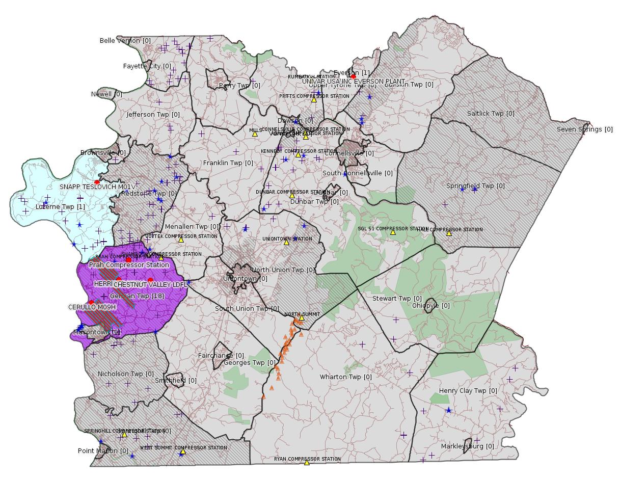
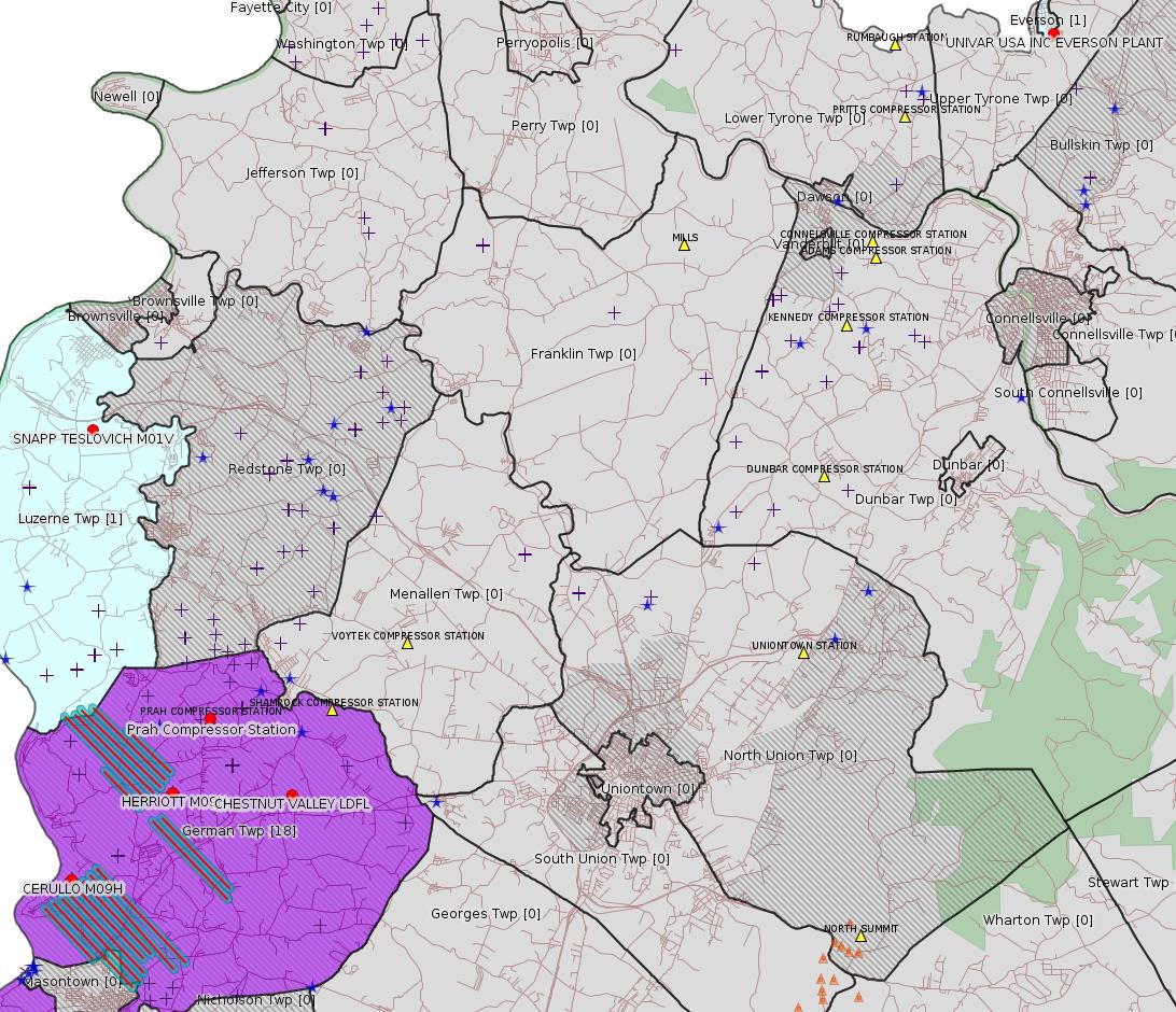
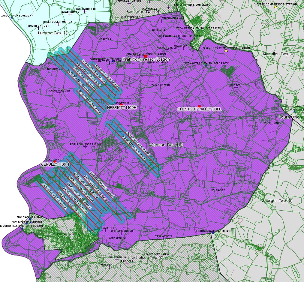
Map
Key
Red dots: items in this permit list with an exact location.
Blue stars: Marcellus Gas Well Water Sources.
Where well laterals are mapped they show in red; a 400-foot buffer surrounding the lateral shows in blue (lavender where it overlaps a mapped mineral tract).
Where mineral tracts are mapped, they show in pink. Mineral tracts can overlap; the overlap will show in red. The precise meaning of "mineral tract" is not clear.
Municipality shading: number of "facilities", with each well counting separately
(includes the red dots):
gray: 0
pale turquoise: 1
turquoise: 2
pale blue: 3
middle blue: 4
dark blue: 5
dark purple: 6
purple: 18
(Color coding may differ from one issue to the next.)
(Note if a project spans multiple municipalities -- e.g. a pipeline -- it will show in the count for each municipality.)
The number of facilities also follows the municipality name in brackets.
Municipality counts are based on the way the permit is listed by DEP; DEP has been known to get a municipality wrong.
Locations in brackets identify a precise location used to locate a surrogate for the actual site being permitted (e.g. locating a well pad or pipeline by the known location of a well.) Locations labeled beginning with "~" and ending in "[?]" are approximate and speculative based on inferences using on-line property and lease records. These are marked in the text as "[Approximate, Speculative]
Cross-hatching: Environmental Justice Areas
Yellow triangles: Compressor Stations
Orange triangles: Storage Field Wells (currently Dominion North Summit Storage Field)
Crosses: SPUD Unconventional well permits
Green: "Natural areas", e.g. state game lands, state forests
Yellow triangles: Compressor Stations
Orange triangles: Storage Field Wells (currently Dominion North Summit Storage Field)
Crosses: SPUD Unconventional well permits
Green: "Natural areas", e.g. state game lands, state forests
More Maps
 |
 |
Source: Pennsylvania Bulletin
GP5-26-00546C (AG5-26-00002A): Laurel Mountain Midstream, LLC (2000 Commerce Drive, Pittsburgh, PA 15275) on March 11, 2020, to authorize the continued operation of two (2) 1,340 bhp Caterpillar natural gas-fired engines, two (2) produced water tanks, and tanker truck load-out operations for a fixed period of 5 years at their Prah Compressor Station located at 160 Windy Hill Road in German Township, Fayette County.
<http://www.pacodeandbulletin.gov/Display/pabull?file=/secure/pabulletin/data/vol50/50-14/489b.html&continued=http://www.pacodeandbulletin.gov/Display/pabull?file=/secure/pabulletin/data/vol50/50-14/489.html&d=reduce>
Location: 39.916422,-79.865258
Map URL: <http://www.openstreetmap.org/?mlat=39.916422&mlon=-79.865258#map=15/39.916422/-79.865258>
Map URL: <http://www.openstreetmap.org/?mlat=39.916422&mlon=-79.865258#map=15/39.916422/-79.865258>
Presumed Parcel Id: 15110031
---
OP-26-00595: Univar Solutions USA Inc. (5 Steel Road East, Morrisville, PA 19067-3613) natural minor operating permit on March 16, 2020, the Department of Environmental Protection authorized an initial natural minor State-only operating permit for a facility that blends and mixes nitrogen stabilizers and guar slurry and is located in Everson Borough, Fayette County. The permit includes operating requirements, monitoring requirements, work practice standards, and recordkeeping requirements for the site.
<http://www.pacodeandbulletin.gov/Display/pabull?file=/secure/pabulletin/data/vol50/50-14/489b.html&continued=http://www.pacodeandbulletin.gov/Display/pabull?file=/secure/pabulletin/data/vol50/50-14/489.html&d=reduce>
Location: 40.08681,-79.58443
Map URL: <http://www.openstreetmap.org/?mlat=40.08681&mlon=-79.58443#map=15/40.08681/-79.58443>
Map URL: <http://www.openstreetmap.org/?mlat=40.08681&mlon=-79.58443#map=15/40.08681/-79.58443>
Presumed Parcel Id: 10040079
-------------------------
Source: eNOTICE
(+ PA
Oil and Gas Mapping, Well
Pad Report.) Well Details via Data
Portal Services: Oil and Gas Wells All (ID: 3).
Please see the Disclaimer below regarding Parcel Id data.
Authorization ID: 1309840
Permit number: 26-00402
Site: CHESTNUT VALLEY LDFL
Client: ADVANCED DSPL SVC CHESTNUT VALLEY LDFL INC
Authorization type: Major Facility Operating Permit
Application type: Amendment
Authorization is for: FACILITY
Date received: 01/27/2020
Status: Pending
Permit Decision Guarantee Applies?: No
Permit Review Notes:
Date Review Note
3/20/2020 Applicant has been issued a deficiency letter. If applicable, this application no longer qualifies for the Permit Decision Guarantee.
3/20/2020 Applicant has been issued a deficiency letter. If applicable, this application no longer qualifies for the Permit Decision Guarantee.
<https://www.ahs.dep.pa.gov/eFACTSWeb/searchResults_singleAuth.aspx?AuthID=1309840>
Site Programs:
Air Quality
Clean Water
Environmental Cleanup & Brownfields
Mining
Radiation Protection
Waste Management
Water Planning and Conservation
Site Municipalities:
German Twp, Fayette County
[See Notes.]
---
Authorization ID: 1309273
Permit number: 051-24706
Site: SNAPP TESLOVICH WELL PAD A ESCGP3 ESG30705118-002
Client: CHEVRON APPALACHIA LLC
Authorization type: Drill & Operate Well Permit (Unconventional)
Application type: Renewal
Authorization is for: FACILITY
Date received: 03/23/2020
Status: Pending
Permit Decision Guarantee Applies?: Yes
Permit Decision Guarantee status: ACTIVE
Sub-Facilities for Authorization:
Sub-Facility ID Sub-Facility Name Description
1284291 WELLBORE SURFACE HOLE LOCATION Well
Permit Review Notes:
Date Review Note
3/26/2020 The technical review and decision review are complete and either the permit decision and/or permit issuance are forthcoming.
3/25/2020 The permit application package is complete, has been accepted, and is undergoing technical review.
<https://www.ahs.dep.pa.gov/eFACTSWeb/searchResults_singleAuth.aspx?AuthID=1309273>
Site Programs:
Oil & Gas
Site Municipalities:
Luzerne Twp, Fayette County
Well Details:
Permit Number: 051-24706
Well Name: SNAPP TESLOVICH M01V
Unconventional Well: Y
Well Configuration: Vertical Well
Well Type: GAS
Well Status: Active
Coal Association: NonCoal
Conservation Well: N
Primary Facility ID: 833681
Site ID: 833740
Site Name: SNAPP TESLOVICH WELL PAD A ESCGP3 ESG30705118-002
Well Pad ID: 155747
Well Pad Name: SNAPP-TESLOVICH PAD A
Storage Field:
Operator: CHEVRON APPALACHIA LLC
Operator Number: OGO-39307
Permit Date: 2019-05-08
Permit Date Expires: 2020-05-08
SPUD Date:
Date Plugged:
UIC ID:
UIC Type:
Surface Elevation: 1100
County: Fayette
Municipality: Luzerne Twp
Location: 39.989942,-79.902631
Map URL: <http://www.openstreetmap.org/?mlat=39.989942&mlon=-79.902631#map=15/39.989942/-79.902631>
OG WELLS PERMIT DOCS:
2020-02-13: Other Permit Documents, Name: 1267676_Snapp Teslovich_M01V_Non-Coal Determination (for Authorization: 1267676):
<http://www.depgis.state.pa.us/pdfHandler/pdFHandler.ashx?Doc=NzkxNzk1&ext=PDF>
2020-02-13: Other Permit Documents, Name: 1267676_Snapp Teslovich_Explanation of Depth of Onondaga (for Authorization: 1267676):
<http://www.depgis.state.pa.us/pdfHandler/pdFHandler.ashx?Doc=ODA0MjA1&ext=PDF>
2020-02-13: Final Permit Documents, Name: Authorization ID 1267676 (for Authorization: 1267676):
<http://www.depgis.state.pa.us/pdfHandler/pdFHandler.ashx?Doc=ODA3NzY0&ext=PDF>
2019-10-31: Other Permit Documents, Name: Alternate Method (for Authorization: 1285029):
<http://www.depgis.state.pa.us/pdfHandler/pdFHandler.ashx?Doc=OTYxMTcz&ext=PDF>
2020-04-03: Other Permit Documents, Name: 051-24706_Snapp Teslovich M01V_1309273_Non-coal determination (for Authorization: 1309273):
<http://www.depgis.state.pa.us/pdfHandler/pdFHandler.ashx?Doc=MTE0OTA5OQ==&ext=PDF>
2020-04-03: Other Permit Documents, Name: RE Request to Issue Snapp Teslovich M01V Permit via Email (for Authorization: 1309273):
<http://www.depgis.state.pa.us/pdfHandler/pdFHandler.ashx?Doc=MTE0OTEyMg==&ext=PDF>
Electronically Submitted Records:
2020-04-03: Submission for Authorization 1309273
Location Plat: Snapp Teslovich - Final V Well Plat M01V - 2019.05.01.dwg
<http://www.depgis.state.pa.us/eWellDocHandler/pdFHandler.ashx?Doc=MTEyMzE0NA==&ext=PDF>
Record of Notification to Interested Parties: Snapp Teslovich Notification Receipts.pdf
<http://www.depgis.state.pa.us/eWellDocHandler/pdFHandler.ashx?Doc=MTEyMzYxOQ==&ext=PDF>
Threatened or Endangered Species Documentation: Snapp Teslovich_PNDI.pdf
<http://www.depgis.state.pa.us/eWellDocHandler/pdFHandler.ashx?Doc=MTEyNDM3Mg==&ext=PDF>
Permit Renewal Affidavit: Snapp M01V Affidavit.pdf
<http://www.depgis.state.pa.us/eWellDocHandler/pdFHandler.ashx?Doc=MTEyNTE4MA==&ext=PDF>
Electronic Submission Docket: 2103566.pdf
<http://www.depgis.state.pa.us/eWellDocHandler/pdFHandler.ashx?Doc=MTEyNjQ1Nw==&ext=PDF>
2020-02-13: Submission for Authorization 1267676
Pennsylvania Natural Diversity Inventory Support Document: PNDI Clearance.pdf
<http://www.depgis.state.pa.us/eWellDocHandler/pdFHandler.ashx?Doc=ODA4NTMw&ext=PDF>
Pennsylvania Natural Diversity Inventory Form: Snapp Teslovich_PNDI.pdf
<http://www.depgis.state.pa.us/eWellDocHandler/pdFHandler.ashx?Doc=ODA4NTMx&ext=PDF>
Coordination of Well Location with Public Resources: Snapp Teslovich For OOGM0076U.pdf
<http://www.depgis.state.pa.us/eWellDocHandler/pdFHandler.ashx?Doc=ODA4NzM1&ext=PDF>
Justification for Non-Coal Well: Snapp Teslovich Non-Coal Packet.pdf
<http://www.depgis.state.pa.us/eWellDocHandler/pdFHandler.ashx?Doc=ODMyODkz&ext=PDF>
Location Plat: Snapp Teslovich - Final V Well Plat M01V - 2019.05.01.dwg
<http://www.depgis.state.pa.us/eWellDocHandler/pdFHandler.ashx?Doc=ODMzNjUw&ext=PDF>
Interested Party Notification: Snapp Teslovich_Affidavit of Non-Delivery_M Cochrane.pdf
<http://www.depgis.state.pa.us/eWellDocHandler/pdFHandler.ashx?Doc=ODM1MDEz&ext=PDF>
Permit Application to Drill and Operate a Well: 1886282.pdf
<http://www.depgis.state.pa.us/eWellDocHandler/pdFHandler.ashx?Doc=ODM1MDE2&ext=PDF>
---
Authorization ID: 1308459
Permit number: 051-24705
Site: HERRIOTT PAD A WELL AND TANK SITE ESCGP ESX18-051-0002
Client: CHEVRON APPALACHIA LLC
Authorization type: Drill & Operate Well Permit (Unconventional)
Application type: Modification
Authorization is for: FACILITY
Date received: 03/11/2020
Status: Issued on 3/30/2020
Permit Decision Guarantee Applies?: Yes
Permit Decision Guarantee status: VOID
Sub-Facilities for Authorization:
Sub-Facility ID Sub-Facility Name Description
1280824 WELLBORE SURFACE HOLE LOCATION Well
Permit Review Notes:
Date Review Note
3/23/2020 Applicant has been issued a deficiency letter. If applicable, this application no longer qualifies for the Permit Decision Guarantee.
3/19/2020 The technical review and decision review are complete and either the permit decision and/or permit issuance are forthcoming.
3/11/2020 The permit application package is complete, has been accepted, and is undergoing technical review.
<https://www.ahs.dep.pa.gov/eFACTSWeb/searchResults_singleAuth.aspx?AuthID=1308459>
Site Programs:
Oil & Gas
Site Municipalities:
German Twp, Fayette County
Well Details:
Permit Number: 051-24705
Well Name: HERRIOTT M09H
Unconventional Well: Y
Well Configuration: Horizontal Well
Well Type: GAS
Well Status: Active
Coal Association: Coal
Conservation Well: N
Primary Facility ID: 832297
Site ID: 829399
Site Name: HERRIOTT PAD A WELL AND TANK SITE ESCGP ESX18-051-0002
Well Pad ID: 155082
Well Pad Name: HERRIOTT
Storage Field:
Operator: CHEVRON APPALACHIA LLC
Operator Number: OGO-39307
Permit Date: 2019-02-22
Permit Date Expires: 2021-03-30
SPUD Date: 2019-06-22
Date Plugged:
UIC ID:
UIC Type:
Surface Elevation: 1265
County: Fayette
Municipality: German Twp
Location: 39.897794,-79.877717
Map URL: <http://www.openstreetmap.org/?mlat=39.897794&mlon=-79.877717#map=15/39.897794/-79.877717>
OG WELLS PERMIT DOCS:
2020-02-13: Final Permit Documents, Name: auth id 1260912 (for Authorization: 1260912):
<http://www.depgis.state.pa.us/pdfHandler/pdFHandler.ashx?Doc=NzU0NDY4&ext=PDF>
2019-07-23: Other Permit Documents, Name: Alternate Method (for Authorization: 1275516):
<http://www.depgis.state.pa.us/pdfHandler/pdFHandler.ashx?Doc=ODgwOTYz&ext=PDF>
2020-03-31: Other Permit Documents, Name: External RE Chevron - Herriott Applications (for Authorization: 1308459):
<http://www.depgis.state.pa.us/pdfHandler/pdFHandler.ashx?Doc=MTE0ODYxNA==&ext=PDF>
2020-03-31: Other Permit Documents, Name: RE Chevron - Herriott Open Violations (for Authorization: 1308459):
<http://www.depgis.state.pa.us/pdfHandler/pdFHandler.ashx?Doc=MTEyNjAxMA==&ext=PDF>
2020-03-31: Other Permit Documents, Name: Herriot NOV Response _ 3-24-2020 (for Authorization: 1308459):
<http://www.depgis.state.pa.us/pdfHandler/pdFHandler.ashx?Doc=MTE0ODQzMg==&ext=PDF>
Electronically Submitted Records:
2020-02-13: Submission for Authorization 1260912
Location Plat: 172-319-Well Plat M09H-pages1-2-3_3702.dwg
<http://www.depgis.state.pa.us/eWellDocHandler/pdFHandler.ashx?Doc=NzYzMDg2&ext=PDF>
Pennsylvania Natural Diversity Inventory Form: Herriott PNDI.pdf
<http://www.depgis.state.pa.us/eWellDocHandler/pdFHandler.ashx?Doc=NzYzMDg3&ext=PDF>
Well Cross-Section Diagram: Herriott M09H Page 4.pdf
<http://www.depgis.state.pa.us/eWellDocHandler/pdFHandler.ashx?Doc=NzYzMDg5&ext=PDF>
Coal and Gas Resource Coord Act - Section 7 Exception: Herriott Section 7 Exception.pdf
<http://www.depgis.state.pa.us/eWellDocHandler/pdFHandler.ashx?Doc=NzY4NDg0&ext=PDF>
Permit Application to Drill and Operate a Well: 1865932.pdf
<http://www.depgis.state.pa.us/eWellDocHandler/pdFHandler.ashx?Doc=NzY4NTEx&ext=PDF>
2020-03-31: Submission for Authorization 1308459
Pennsylvania Natural Diversity Inventory Form: project_receipt_herriott_pad_705847_FINAL_1.pdf
<http://www.depgis.state.pa.us/eWellDocHandler/pdFHandler.ashx?Doc=MTExNzIxNg==&ext=PDF>
Permit Application to Drill and Operate a Well: Drill Permit Application_Herriott Pad A_M09H.pdf
<http://www.depgis.state.pa.us/eWellDocHandler/pdFHandler.ashx?Doc=MTExNzIxNw==&ext=PDF>
Location Plat: 172-319-Well Plat M09H-pages1-2-3_3702.dwg
<http://www.depgis.state.pa.us/eWellDocHandler/pdFHandler.ashx?Doc=MTExNzIxOA==&ext=PDF>
Interested Party Notification: Herriott M09H Interested Parties.pdf
<http://www.depgis.state.pa.us/eWellDocHandler/pdFHandler.ashx?Doc=MTExNzIxOQ==&ext=PDF>
Coal and Gas Resource Coord Act - Section 7 Exception: Herriott Section 7 Exception.pdf
<http://www.depgis.state.pa.us/eWellDocHandler/pdFHandler.ashx?Doc=MTExNzIyMA==&ext=PDF>
Well Cross-Section Diagram: Herriott M09H Page 4.pdf
<http://www.depgis.state.pa.us/eWellDocHandler/pdFHandler.ashx?Doc=MTExNzIyMQ==&ext=PDF>
Well Permit Application - Coal Module: Herriott Coal Module.pdf
<http://www.depgis.state.pa.us/eWellDocHandler/pdFHandler.ashx?Doc=MTExNzIyMg==&ext=PDF>
Electronic Submission Docket: 2099473.pdf
<http://www.depgis.state.pa.us/eWellDocHandler/pdFHandler.ashx?Doc=MTExNzQ2NA==&ext=PDF>
---
Authorization ID: 1308458
Permit number: 051-24703
Site: HERRIOTT PAD A WELL AND TANK SITE ESCGP ESX18-051-0002
Client: CHEVRON APPALACHIA LLC
Authorization type: Drill & Operate Well Permit (Unconventional)
Application type: Modification
Authorization is for: FACILITY
Date received: 03/11/2020
Status: Issued on 3/30/2020
Permit Decision Guarantee Applies?: Yes
Permit Decision Guarantee status: VOID
Sub-Facilities for Authorization:
Sub-Facility ID Sub-Facility Name Description
1280822 WELLBORE SURFACE HOLE LOCATION Well
Permit Review Notes:
Date Review Note
3/23/2020 Applicant has been issued a deficiency letter. If applicable, this application no longer qualifies for the Permit Decision Guarantee.
3/19/2020 The technical review and decision review are complete and either the permit decision and/or permit issuance are forthcoming.
3/11/2020 The permit application package is complete, has been accepted, and is undergoing technical review.
<https://www.ahs.dep.pa.gov/eFACTSWeb/searchResults_singleAuth.aspx?AuthID=1308458>
Site Programs:
Oil & Gas
Site Municipalities:
German Twp, Fayette County
Well Details:
Permit Number: 051-24703
Well Name: HERRIOTT M08H
Unconventional Well: Y
Well Configuration: Horizontal Well
Well Type: GAS
Well Status: Active
Coal Association: Coal
Conservation Well: N
Primary Facility ID: 832295
Site ID: 829399
Site Name: HERRIOTT PAD A WELL AND TANK SITE ESCGP ESX18-051-0002
Well Pad ID: 155082
Well Pad Name: HERRIOTT
Storage Field:
Operator: CHEVRON APPALACHIA LLC
Operator Number: OGO-39307
Permit Date: 2019-02-22
Permit Date Expires: 2021-03-30
SPUD Date: 2019-06-22
Date Plugged:
UIC ID:
UIC Type:
Surface Elevation: 1265
County: Fayette
Municipality: German Twp
Location: 39.897769,-79.877817
Map URL: <http://www.openstreetmap.org/?mlat=39.897769&mlon=-79.877817#map=15/39.897769/-79.877817>
OG WELLS PERMIT DOCS:
2020-02-13: Final Permit Documents, Name: auth id 1260910 (for Authorization: 1260910):
<http://www.depgis.state.pa.us/pdfHandler/pdFHandler.ashx?Doc=NzU0NDcw&ext=PDF>
2019-07-23: Other Permit Documents, Name: Alternate Method (for Authorization: 1275515):
<http://www.depgis.state.pa.us/pdfHandler/pdFHandler.ashx?Doc=ODgwOTU5&ext=PDF>
2020-04-03: Other Permit Documents, Name: External RE Chevron - Herriott Applications (for Authorization: 1308458):
<http://www.depgis.state.pa.us/pdfHandler/pdFHandler.ashx?Doc=MTE0ODYxNQ==&ext=PDF>
2020-04-03: Other Permit Documents, Name: RE Chevron - Herriott Open Violations (for Authorization: 1308458):
<http://www.depgis.state.pa.us/pdfHandler/pdFHandler.ashx?Doc=MTEyNjAxMg==&ext=PDF>
2020-04-03: Other Permit Documents, Name: Herriot NOV Response _ 3-24-2020 (for Authorization: 1308458):
<http://www.depgis.state.pa.us/pdfHandler/pdFHandler.ashx?Doc=MTE0ODQzMQ==&ext=PDF>
Electronically Submitted Records:
2020-04-03: Submission for Authorization 1308458
Pennsylvania Natural Diversity Inventory Form: project_receipt_herriott_pad_705847_FINAL_1.pdf
<http://www.depgis.state.pa.us/eWellDocHandler/pdFHandler.ashx?Doc=MTExNzE5NQ==&ext=PDF>
Permit Application to Drill and Operate a Well: Drill Permit Application_Herriott Pad A_M08H.pdf
<http://www.depgis.state.pa.us/eWellDocHandler/pdFHandler.ashx?Doc=MTExNzE5Ng==&ext=PDF>
Location Plat: 172-319-Well Plat M08H-pages1-2-3_3702.dwg
<http://www.depgis.state.pa.us/eWellDocHandler/pdFHandler.ashx?Doc=MTExNzE5Nw==&ext=PDF>
Interested Party Notification: Herriott M08H Interested Parties.pdf
<http://www.depgis.state.pa.us/eWellDocHandler/pdFHandler.ashx?Doc=MTExNzE5OA==&ext=PDF>
Coal and Gas Resource Coord Act - Section 7 Exception: Herriott Section 7 Exception.pdf
<http://www.depgis.state.pa.us/eWellDocHandler/pdFHandler.ashx?Doc=MTExNzE5OQ==&ext=PDF>
Well Cross-Section Diagram: Herriott M08H Page 4.pdf
<http://www.depgis.state.pa.us/eWellDocHandler/pdFHandler.ashx?Doc=MTExNzIwMA==&ext=PDF>
Well Permit Application - Coal Module: Herriott Coal Module.pdf
<http://www.depgis.state.pa.us/eWellDocHandler/pdFHandler.ashx?Doc=MTExNzIwMQ==&ext=PDF>
Electronic Submission Docket: 2099469.pdf
<http://www.depgis.state.pa.us/eWellDocHandler/pdFHandler.ashx?Doc=MTExNzQ2MQ==&ext=PDF>
2020-02-13: Submission for Authorization 1260910
Location Plat: 172-319-Well Plat M08H-pages1-2-3_3702.dwg
<http://www.depgis.state.pa.us/eWellDocHandler/pdFHandler.ashx?Doc=NzYzMDMw&ext=PDF>
Pennsylvania Natural Diversity Inventory Form: Herriott PNDI.pdf
<http://www.depgis.state.pa.us/eWellDocHandler/pdFHandler.ashx?Doc=NzYzMDMx&ext=PDF>
Well Cross-Section Diagram: Herriott M08H Page 4.pdf
<http://www.depgis.state.pa.us/eWellDocHandler/pdFHandler.ashx?Doc=NzYzMDMz&ext=PDF>
Coal and Gas Resource Coord Act - Section 7 Exception: Herriott Section 7 Exception.pdf
<http://www.depgis.state.pa.us/eWellDocHandler/pdFHandler.ashx?Doc=NzY4NDc2&ext=PDF>
Permit Application to Drill and Operate a Well: 1865928.pdf
<http://www.depgis.state.pa.us/eWellDocHandler/pdFHandler.ashx?Doc=NzY4NTAy&ext=PDF>
---
Authorization ID: 1308457
Permit number: 051-24702
Site: HERRIOTT PAD A WELL AND TANK SITE ESCGP ESX18-051-0002
Client: CHEVRON APPALACHIA LLC
Authorization type: Drill & Operate Well Permit (Unconventional)
Application type: Modification
Authorization is for: FACILITY
Date received: 03/11/2020
Status: Issued on 3/30/2020
Permit Decision Guarantee Applies?: Yes
Permit Decision Guarantee status: VOID
Sub-Facilities for Authorization:
Sub-Facility ID Sub-Facility Name Description
1280821 WELLBORE SURFACE HOLE LOCATION Well
Permit Review Notes:
Date Review Note
3/23/2020 Applicant has been issued a deficiency letter. If applicable, this application no longer qualifies for the Permit Decision Guarantee.
3/19/2020 The technical review and decision review are complete and either the permit decision and/or permit issuance are forthcoming.
3/11/2020 The permit application package is complete, has been accepted, and is undergoing technical review.
<https://www.ahs.dep.pa.gov/eFACTSWeb/searchResults_singleAuth.aspx?AuthID=1308457>
Site Programs:
Oil & Gas
Site Municipalities:
German Twp, Fayette County
Well Details:
Permit Number: 051-24702
Well Name: HERRIOTT M07H
Unconventional Well: Y
Well Configuration: Horizontal Well
Well Type: GAS
Well Status: Active
Coal Association: Coal
Conservation Well: N
Primary Facility ID: 832294
Site ID: 829399
Site Name: HERRIOTT PAD A WELL AND TANK SITE ESCGP ESX18-051-0002
Well Pad ID: 155082
Well Pad Name: HERRIOTT
Storage Field:
Operator: CHEVRON APPALACHIA LLC
Operator Number: OGO-39307
Permit Date: 2019-02-22
Permit Date Expires: 2021-03-30
SPUD Date: 2019-06-21
Date Plugged:
UIC ID:
UIC Type:
Surface Elevation: 1265
County: Fayette
Municipality: German Twp
Location: 39.897808,-79.877833
Map URL: <http://www.openstreetmap.org/?mlat=39.897808&mlon=-79.877833#map=15/39.897808/-79.877833>
OG WELLS PERMIT DOCS:
2020-02-13: Final Permit Documents, Name: auth id 1260909 (for Authorization: 1260909):
<http://www.depgis.state.pa.us/pdfHandler/pdFHandler.ashx?Doc=NzU0NDcx&ext=PDF>
2019-07-23: Other Permit Documents, Name: Alternate Method (for Authorization: 1275511):
<http://www.depgis.state.pa.us/pdfHandler/pdFHandler.ashx?Doc=ODgwOTQ4&ext=PDF>
2020-04-03: Other Permit Documents, Name: External RE Chevron - Herriott Applications (for Authorization: 1308457):
<http://www.depgis.state.pa.us/pdfHandler/pdFHandler.ashx?Doc=MTE0ODYxOA==&ext=PDF>
2020-04-03: Other Permit Documents, Name: RE Chevron - Herriott Open Violations (for Authorization: 1308457):
<http://www.depgis.state.pa.us/pdfHandler/pdFHandler.ashx?Doc=MTEyNjAxNA==&ext=PDF>
2020-04-03: Other Permit Documents, Name: Herriot NOV Response _ 3-24-2020 (for Authorization: 1308457):
<http://www.depgis.state.pa.us/pdfHandler/pdFHandler.ashx?Doc=MTE0ODQzMA==&ext=PDF>
Electronically Submitted Records:
2020-02-13: Submission for Authorization 1260909
Pennsylvania Natural Diversity Inventory Form: Herriott PNDI.pdf
<http://www.depgis.state.pa.us/eWellDocHandler/pdFHandler.ashx?Doc=NzYzMDAz&ext=PDF>
Location Plat: 172-319-Well Plat M07H-pages1-2-3_3702.dwg
<http://www.depgis.state.pa.us/eWellDocHandler/pdFHandler.ashx?Doc=NzYzMDA0&ext=PDF>
Well Cross-Section Diagram: Herriott M07H Page 4.pdf
<http://www.depgis.state.pa.us/eWellDocHandler/pdFHandler.ashx?Doc=NzYzMDA2&ext=PDF>
Coal and Gas Resource Coord Act - Section 7 Exception: Herriott Section 7 Exception.pdf
<http://www.depgis.state.pa.us/eWellDocHandler/pdFHandler.ashx?Doc=NzY4NDc1&ext=PDF>
Permit Application to Drill and Operate a Well: 1865905.pdf
<http://www.depgis.state.pa.us/eWellDocHandler/pdFHandler.ashx?Doc=NzY4NTA1&ext=PDF>
2020-04-03: Submission for Authorization 1308457
Pennsylvania Natural Diversity Inventory Form: project_receipt_herriott_pad_705847_FINAL_1.pdf
<http://www.depgis.state.pa.us/eWellDocHandler/pdFHandler.ashx?Doc=MTExNzE4MQ==&ext=PDF>
Permit Application to Drill and Operate a Well: Drill Permit Application_Herriott Pad A_M07H.pdf
<http://www.depgis.state.pa.us/eWellDocHandler/pdFHandler.ashx?Doc=MTExNzE4Mg==&ext=PDF>
Location Plat: 172-319-Well Plat M07H-pages1-2-3_3702.dwg
<http://www.depgis.state.pa.us/eWellDocHandler/pdFHandler.ashx?Doc=MTExNzE4Mw==&ext=PDF>
Interested Party Notification: Herriott M07H Interested Parties.pdf
<http://www.depgis.state.pa.us/eWellDocHandler/pdFHandler.ashx?Doc=MTExNzE4NA==&ext=PDF>
Well Cross-Section Diagram: Herriott M07H Page 4.pdf
<http://www.depgis.state.pa.us/eWellDocHandler/pdFHandler.ashx?Doc=MTExNzE4Ng==&ext=PDF>
Well Permit Application - Coal Module: Herriott Coal Module.pdf
<http://www.depgis.state.pa.us/eWellDocHandler/pdFHandler.ashx?Doc=MTExNzE4Nw==&ext=PDF>
Coal and Gas Resource Coord Act - Section 7 Exception: Herriott Section 7 Exception.pdf
<http://www.depgis.state.pa.us/eWellDocHandler/pdFHandler.ashx?Doc=MTExNzE4OQ==&ext=PDF>
Electronic Submission Docket: 2099465.pdf
<http://www.depgis.state.pa.us/eWellDocHandler/pdFHandler.ashx?Doc=MTExNzQ1MA==&ext=PDF>
---
Authorization ID: 1308456
Permit number: 051-24700
Site: HERRIOTT PAD A WELL AND TANK SITE ESCGP ESX18-051-0002
Client: CHEVRON APPALACHIA LLC
Authorization type: Drill & Operate Well Permit (Unconventional)
Application type: Modification
Authorization is for: FACILITY
Date received: 03/11/2020
Status: Issued on 3/30/2020
Permit Decision Guarantee Applies?: Yes
Permit Decision Guarantee status: VOID
Sub-Facilities for Authorization:
Sub-Facility ID Sub-Facility Name Description
1280819 WELLBORE SURFACE HOLE LOCATION Well
Permit Review Notes:
Date Review Note
3/23/2020 Applicant has been issued a deficiency letter. If applicable, this application no longer qualifies for the Permit Decision Guarantee.
3/16/2020 The technical review and decision review are complete and either the permit decision and/or permit issuance are forthcoming.
3/11/2020 The permit application package is complete, has been accepted, and is undergoing technical review.
<https://www.ahs.dep.pa.gov/eFACTSWeb/searchResults_singleAuth.aspx?AuthID=1308456>
Site Programs:
Oil & Gas
Site Municipalities:
German Twp, Fayette County
Well Details:
Permit Number: 051-24700
Well Name: HERRIOTT M06H
Unconventional Well: Y
Well Configuration: Horizontal Well
Well Type: GAS
Well Status: Active
Coal Association: Coal
Conservation Well: N
Primary Facility ID: 832292
Site ID: 829399
Site Name: HERRIOTT PAD A WELL AND TANK SITE ESCGP ESX18-051-0002
Well Pad ID: 155082
Well Pad Name: HERRIOTT
Storage Field:
Operator: CHEVRON APPALACHIA LLC
Operator Number: OGO-39307
Permit Date: 2019-02-22
Permit Date Expires: 2021-03-30
SPUD Date: 2019-06-20
Date Plugged:
UIC ID:
UIC Type:
Surface Elevation: 1265
County: Fayette
Municipality: German Twp
Location: 39.897847,-79.87785
Map URL: <http://www.openstreetmap.org/?mlat=39.897847&mlon=-79.87785#map=15/39.897847/-79.87785>
OG WELLS PERMIT DOCS:
2020-02-13: Final Permit Documents, Name: auth id 1260907 (for Authorization: 1260907):
<http://www.depgis.state.pa.us/pdfHandler/pdFHandler.ashx?Doc=NzU0NDcz&ext=PDF>
2019-07-23: Other Permit Documents, Name: Alternate Method (for Authorization: 1275510):
<http://www.depgis.state.pa.us/pdfHandler/pdFHandler.ashx?Doc=ODgwOTQ3&ext=PDF>
2020-04-03: Other Permit Documents, Name: External RE Chevron - Herriott Applications (for Authorization: 1308456):
<http://www.depgis.state.pa.us/pdfHandler/pdFHandler.ashx?Doc=MTE0ODYxOQ==&ext=PDF>
2020-04-03: Other Permit Documents, Name: RE Chevron - Herriott Open Violations (for Authorization: 1308456):
<http://www.depgis.state.pa.us/pdfHandler/pdFHandler.ashx?Doc=MTEyNjAxNg==&ext=PDF>
2020-04-03: Other Permit Documents, Name: Herriot NOV Response _ 3-24-2020 (for Authorization: 1308456):
<http://www.depgis.state.pa.us/pdfHandler/pdFHandler.ashx?Doc=MTE0ODQyOQ==&ext=PDF>
Electronically Submitted Records:
2020-02-13: Submission for Authorization 1260907
Pennsylvania Natural Diversity Inventory Form: Herriott PNDI.pdf
<http://www.depgis.state.pa.us/eWellDocHandler/pdFHandler.ashx?Doc=NzYyOTgz&ext=PDF>
Location Plat: 172-319-Well Plat M06H-pages1-2-3_3702.dwg
<http://www.depgis.state.pa.us/eWellDocHandler/pdFHandler.ashx?Doc=NzYyOTg0&ext=PDF>
Well Cross-Section Diagram: Herriott M06H Page 4.pdf
<http://www.depgis.state.pa.us/eWellDocHandler/pdFHandler.ashx?Doc=NzYyOTg2&ext=PDF>
Coal and Gas Resource Coord Act - Section 7 Exception: Herriott Section 7 Exception.pdf
<http://www.depgis.state.pa.us/eWellDocHandler/pdFHandler.ashx?Doc=NzY4MzQ0&ext=PDF>
Permit Application to Drill and Operate a Well: 1865896.pdf
<http://www.depgis.state.pa.us/eWellDocHandler/pdFHandler.ashx?Doc=NzY4NDkz&ext=PDF>
2020-04-03: Submission for Authorization 1308456
Pennsylvania Natural Diversity Inventory Form: project_receipt_herriott_pad_705847_FINAL_1.pdf
<http://www.depgis.state.pa.us/eWellDocHandler/pdFHandler.ashx?Doc=MTExNzE1NQ==&ext=PDF>
Permit Application to Drill and Operate a Well: Drill Permit Application_Herriott Pad A_M06H.pdf
<http://www.depgis.state.pa.us/eWellDocHandler/pdFHandler.ashx?Doc=MTExNzE1Ng==&ext=PDF>
Location Plat: 172-319-Well Plat M06H-pages1-2-3_3702.dwg
<http://www.depgis.state.pa.us/eWellDocHandler/pdFHandler.ashx?Doc=MTExNzE1Nw==&ext=PDF>
Interested Party Notification: Herriott M06H Interested Parties.pdf
<http://www.depgis.state.pa.us/eWellDocHandler/pdFHandler.ashx?Doc=MTExNzE1OA==&ext=PDF>
Coal and Gas Resource Coord Act - Section 7 Exception: Herriott Section 7 Exception.pdf
<http://www.depgis.state.pa.us/eWellDocHandler/pdFHandler.ashx?Doc=MTExNzE1OQ==&ext=PDF>
Well Cross-Section Diagram: Herriott M06H Page 4.pdf
<http://www.depgis.state.pa.us/eWellDocHandler/pdFHandler.ashx?Doc=MTExNzE2MA==&ext=PDF>
Well Permit Application - Coal Module: Herriott Coal Module.pdf
<http://www.depgis.state.pa.us/eWellDocHandler/pdFHandler.ashx?Doc=MTExNzE2MQ==&ext=PDF>
Electronic Submission Docket: 2099459.pdf
<http://www.depgis.state.pa.us/eWellDocHandler/pdFHandler.ashx?Doc=MTExNzQzNA==&ext=PDF>
---
Authorization ID: 1308449
Permit number: 051-24699
Site: HERRIOTT PAD A WELL AND TANK SITE ESCGP ESX18-051-0002
Client: CHEVRON APPALACHIA LLC
Authorization type: Drill & Operate Well Permit (Unconventional)
Application type: Modification
Authorization is for: FACILITY
Date received: 03/11/2020
Status: Issued on 3/30/2020
Permit Decision Guarantee Applies?: Yes
Permit Decision Guarantee status: VOID
Sub-Facilities for Authorization:
Sub-Facility ID Sub-Facility Name Description
1280818 WELLBORE SURFACE HOLE LOCATION Well
Permit Review Notes:
Date Review Note
3/23/2020 Applicant has been issued a deficiency letter. If applicable, this application no longer qualifies for the Permit Decision Guarantee.
3/16/2020 The technical review and decision review are complete and either the permit decision and/or permit issuance are forthcoming.
3/11/2020 The permit application package is complete, has been accepted, and is undergoing technical review.
<https://www.ahs.dep.pa.gov/eFACTSWeb/searchResults_singleAuth.aspx?AuthID=1308449>
Site Programs:
Oil & Gas
Site Municipalities:
German Twp, Fayette County
Well Details:
Permit Number: 051-24699
Well Name: HERRIOTT M05H
Unconventional Well: Y
Well Configuration: Horizontal Well
Well Type: GAS
Well Status: Active
Coal Association: Coal
Conservation Well: N
Primary Facility ID: 832291
Site ID: 829399
Site Name: HERRIOTT PAD A WELL AND TANK SITE ESCGP ESX18-051-0002
Well Pad ID: 155082
Well Pad Name: HERRIOTT
Storage Field:
Operator: CHEVRON APPALACHIA LLC
Operator Number: OGO-39307
Permit Date: 2019-02-22
Permit Date Expires: 2021-03-30
SPUD Date: 2019-06-21
Date Plugged:
UIC ID:
UIC Type:
Surface Elevation: 1265
County: Fayette
Municipality: German Twp
Location: 39.897886,-79.877869
Map URL: <http://www.openstreetmap.org/?mlat=39.897886&mlon=-79.877869#map=15/39.897886/-79.877869>
OG WELLS PERMIT DOCS:
2020-02-13: Final Permit Documents, Name: 051-24699 (for Authorization: 1260905):
<http://www.depgis.state.pa.us/pdfHandler/pdFHandler.ashx?Doc=NzU3Mzc1&ext=PDF>
2019-07-23: Other Permit Documents, Name: Alternate Method (for Authorization: 1275509):
<http://www.depgis.state.pa.us/pdfHandler/pdFHandler.ashx?Doc=ODgwOTQ2&ext=PDF>
2020-04-03: Other Permit Documents, Name: External RE Chevron - Herriott Applications (for Authorization: 1308449):
<http://www.depgis.state.pa.us/pdfHandler/pdFHandler.ashx?Doc=MTE0ODYxMQ==&ext=PDF>
2020-04-03: Other Permit Documents, Name: RE Chevron - Herriott Open Violations (for Authorization: 1308449):
<http://www.depgis.state.pa.us/pdfHandler/pdFHandler.ashx?Doc=MTEyNjAwMg==&ext=PDF>
2020-04-03: Other Permit Documents, Name: Herriot NOV Response _ 3-24-2020 (for Authorization: 1308449):
<http://www.depgis.state.pa.us/pdfHandler/pdFHandler.ashx?Doc=MTE0ODQzNQ==&ext=PDF>
Electronically Submitted Records:
2020-02-13: Submission for Authorization 1260905
Location Plat: 172-319-Well Plat M05H-pages1-2-3_3702.dwg
<http://www.depgis.state.pa.us/eWellDocHandler/pdFHandler.ashx?Doc=NzYyOTcw&ext=PDF>
Pennsylvania Natural Diversity Inventory Form: Herriott PNDI.pdf
<http://www.depgis.state.pa.us/eWellDocHandler/pdFHandler.ashx?Doc=NzYyOTcx&ext=PDF>
Well Cross-Section Diagram: Herriott M05H Page 4.pdf
<http://www.depgis.state.pa.us/eWellDocHandler/pdFHandler.ashx?Doc=NzYyOTcy&ext=PDF>
Coal and Gas Resource Coord Act - Section 7 Exception: Herriott Section 7 Exception.pdf
<http://www.depgis.state.pa.us/eWellDocHandler/pdFHandler.ashx?Doc=NzY4MzQy&ext=PDF>
Permit Application to Drill and Operate a Well: 1865638.pdf
<http://www.depgis.state.pa.us/eWellDocHandler/pdFHandler.ashx?Doc=NzY4NDkw&ext=PDF>
2020-04-03: Submission for Authorization 1308449
Pennsylvania Natural Diversity Inventory Form: project_receipt_herriott_pad_705847_FINAL_1.pdf
<http://www.depgis.state.pa.us/eWellDocHandler/pdFHandler.ashx?Doc=MTExNzEzOA==&ext=PDF>
Permit Application to Drill and Operate a Well: Drill Permit Application_Herriott Pad A_M05H.pdf
<http://www.depgis.state.pa.us/eWellDocHandler/pdFHandler.ashx?Doc=MTExNzEzOQ==&ext=PDF>
Location Plat: 172-319-Well Plat M05H-pages1-2-3_3702.dwg
<http://www.depgis.state.pa.us/eWellDocHandler/pdFHandler.ashx?Doc=MTExNzE0MA==&ext=PDF>
Interested Party Notification: Herriott M05H Interested Parties.pdf
<http://www.depgis.state.pa.us/eWellDocHandler/pdFHandler.ashx?Doc=MTExNzE0MQ==&ext=PDF>
Coal and Gas Resource Coord Act - Section 7 Exception: Herriott Section 7 Exception.pdf
<http://www.depgis.state.pa.us/eWellDocHandler/pdFHandler.ashx?Doc=MTExNzE0Mg==&ext=PDF>
Well Cross-Section Diagram: Herriott M05H Page 4.pdf
<http://www.depgis.state.pa.us/eWellDocHandler/pdFHandler.ashx?Doc=MTExNzE0Mw==&ext=PDF>
Well Permit Application - Coal Module: Herriott Coal Module.pdf
<http://www.depgis.state.pa.us/eWellDocHandler/pdFHandler.ashx?Doc=MTExNzE0NA==&ext=PDF>
Electronic Submission Docket: 2099456.pdf
<http://www.depgis.state.pa.us/eWellDocHandler/pdFHandler.ashx?Doc=MTExNzQyOA==&ext=PDF>
---
Authorization ID: 1308448
Permit number: 051-24698
Site: HERRIOTT PAD A WELL AND TANK SITE ESCGP ESX18-051-0002
Client: CHEVRON APPALACHIA LLC
Authorization type: Drill & Operate Well Permit (Unconventional)
Application type: Modification
Authorization is for: FACILITY
Date received: 03/11/2020
Status: Issued on 3/30/2020
Permit Decision Guarantee Applies?: Yes
Permit Decision Guarantee status: VOID
Sub-Facilities for Authorization:
Sub-Facility ID Sub-Facility Name Description
1280817 WELLBORE SURFACE HOLE LOCATION Well
Permit Review Notes:
Date Review Note
3/23/2020 Applicant has been issued a deficiency letter. If applicable, this application no longer qualifies for the Permit Decision Guarantee.
3/16/2020 The technical review and decision review are complete and either the permit decision and/or permit issuance are forthcoming.
3/11/2020 The permit application package is complete, has been accepted, and is undergoing technical review.
<https://www.ahs.dep.pa.gov/eFACTSWeb/searchResults_singleAuth.aspx?AuthID=1308448>
Site Programs:
Oil & Gas
Site Municipalities:
German Twp, Fayette County
Well Details:
Permit Number: 051-24698
Well Name: HERRIOTT M04H
Unconventional Well: Y
Well Configuration: Horizontal Well
Well Type: GAS
Well Status: Active
Coal Association: Coal
Conservation Well: N
Primary Facility ID: 832290
Site ID: 829399
Site Name: HERRIOTT PAD A WELL AND TANK SITE ESCGP ESX18-051-0002
Well Pad ID: 155082
Well Pad Name: HERRIOTT
Storage Field:
Operator: CHEVRON APPALACHIA LLC
Operator Number: OGO-39307
Permit Date: 2019-02-22
Permit Date Expires: 2021-03-30
SPUD Date: 2019-06-19
Date Plugged:
UIC ID:
UIC Type:
Surface Elevation: 1265
County: Fayette
Municipality: German Twp
Location: 39.897925,-79.877886
Map URL: <http://www.openstreetmap.org/?mlat=39.897925&mlon=-79.877886#map=15/39.897925/-79.877886>
OG WELLS PERMIT DOCS:
2020-02-13: Final Permit Documents, Name: auth id 1260904 (for Authorization: 1260904):
<http://www.depgis.state.pa.us/pdfHandler/pdFHandler.ashx?Doc=NzU0NDc2&ext=PDF>
2019-07-23: Other Permit Documents, Name: Alternate Method (for Authorization: 1275508):
<http://www.depgis.state.pa.us/pdfHandler/pdFHandler.ashx?Doc=ODgwOTcw&ext=PDF>
2020-04-03: Other Permit Documents, Name: External RE Chevron - Herriott Applications (for Authorization: 1308448):
<http://www.depgis.state.pa.us/pdfHandler/pdFHandler.ashx?Doc=MTE0ODYxMg==&ext=PDF>
2020-04-03: Other Permit Documents, Name: RE Chevron - Herriott Open Violations (for Authorization: 1308448):
<http://www.depgis.state.pa.us/pdfHandler/pdFHandler.ashx?Doc=MTEyNjAwNA==&ext=PDF>
2020-04-03: Other Permit Documents, Name: Herriot NOV Response _ 3-24-2020 (for Authorization: 1308448):
<http://www.depgis.state.pa.us/pdfHandler/pdFHandler.ashx?Doc=MTE0ODQzNg==&ext=PDF>
Electronically Submitted Records:
2020-02-13: Submission for Authorization 1260904
Pennsylvania Natural Diversity Inventory Form: Herriott PNDI.pdf
<http://www.depgis.state.pa.us/eWellDocHandler/pdFHandler.ashx?Doc=NzYyOTUw&ext=PDF>
Location Plat: 172-319-Well Plat M04H-pages1-2-3_3702.dwg
<http://www.depgis.state.pa.us/eWellDocHandler/pdFHandler.ashx?Doc=NzYyOTUx&ext=PDF>
Well Cross-Section Diagram: Herriott M04H Page 4.pdf
<http://www.depgis.state.pa.us/eWellDocHandler/pdFHandler.ashx?Doc=NzYyOTUz&ext=PDF>
Coal and Gas Resource Coord Act - Section 7 Exception: Herriott Section 7 Exception.pdf
<http://www.depgis.state.pa.us/eWellDocHandler/pdFHandler.ashx?Doc=NzY4MzUy&ext=PDF>
Permit Application to Drill and Operate a Well: 1865625.pdf
<http://www.depgis.state.pa.us/eWellDocHandler/pdFHandler.ashx?Doc=NzY4NTE0&ext=PDF>
2020-04-03: Submission for Authorization 1308448
Pennsylvania Natural Diversity Inventory Form: project_receipt_herriott_pad_705847_FINAL_1.pdf
<http://www.depgis.state.pa.us/eWellDocHandler/pdFHandler.ashx?Doc=MTExNzEyMg==&ext=PDF>
Permit Application to Drill and Operate a Well: Drill Permit Application_Herriott Pad A_M04H.pdf
<http://www.depgis.state.pa.us/eWellDocHandler/pdFHandler.ashx?Doc=MTExNzEyNA==&ext=PDF>
Location Plat: 172-319-Well Plat M04H-pages1-2-3_3702.dwg
<http://www.depgis.state.pa.us/eWellDocHandler/pdFHandler.ashx?Doc=MTExNzEyNQ==&ext=PDF>
Interested Party Notification: Herriott M04H Interested Parties.pdf
<http://www.depgis.state.pa.us/eWellDocHandler/pdFHandler.ashx?Doc=MTExNzEyNg==&ext=PDF>
Coal and Gas Resource Coord Act - Section 7 Exception: Herriott Section 7 Exception.pdf
<http://www.depgis.state.pa.us/eWellDocHandler/pdFHandler.ashx?Doc=MTExNzEyNw==&ext=PDF>
Well Cross-Section Diagram: Herriott M04H Page 4.pdf
<http://www.depgis.state.pa.us/eWellDocHandler/pdFHandler.ashx?Doc=MTExNzEyOA==&ext=PDF>
Well Permit Application - Coal Module: Herriott Coal Module.pdf
<http://www.depgis.state.pa.us/eWellDocHandler/pdFHandler.ashx?Doc=MTExNzEyOQ==&ext=PDF>
Electronic Submission Docket: 2099454.pdf
<http://www.depgis.state.pa.us/eWellDocHandler/pdFHandler.ashx?Doc=MTExNzQyMQ==&ext=PDF>
---
Authorization ID: 1308447
Permit number: 051-24704
Site: HERRIOTT PAD A WELL AND TANK SITE ESCGP ESX18-051-0002
Client: CHEVRON APPALACHIA LLC
Authorization type: Drill & Operate Well Permit (Unconventional)
Application type: Modification
Authorization is for: FACILITY
Date received: 03/11/2020
Status: Issued on 3/30/2020
Permit Decision Guarantee Applies?: Yes
Permit Decision Guarantee status: VOID
Sub-Facilities for Authorization:
Sub-Facility ID Sub-Facility Name Description
1280823 WELLBORE SURFACE HOLE LOCATION Well
Permit Review Notes:
Date Review Note
3/23/2020 Applicant has been issued a deficiency letter. If applicable, this application no longer qualifies for the Permit Decision Guarantee.
3/16/2020 The technical review and decision review are complete and either the permit decision and/or permit issuance are forthcoming.
3/11/2020 The permit application package is complete, has been accepted, and is undergoing technical review.
<https://www.ahs.dep.pa.gov/eFACTSWeb/searchResults_singleAuth.aspx?AuthID=1308447>
Site Programs:
Oil & Gas
Site Municipalities:
German Twp, Fayette County
Well Details:
Permit Number: 051-24704
Well Name: HERRIOTT M03H
Unconventional Well: Y
Well Configuration: Horizontal Well
Well Type: GAS
Well Status: Active
Coal Association: Coal
Conservation Well: N
Primary Facility ID: 832296
Site ID: 829399
Site Name: HERRIOTT PAD A WELL AND TANK SITE ESCGP ESX18-051-0002
Well Pad ID: 155082
Well Pad Name: HERRIOTT
Storage Field:
Operator: CHEVRON APPALACHIA LLC
Operator Number: OGO-39307
Permit Date: 2019-02-22
Permit Date Expires: 2021-03-30
SPUD Date: 2019-06-18
Date Plugged:
UIC ID:
UIC Type:
Surface Elevation: 1265
County: Fayette
Municipality: German Twp
Location: 39.897964,-79.877903
Map URL: <http://www.openstreetmap.org/?mlat=39.897964&mlon=-79.877903#map=15/39.897964/-79.877903>
OG WELLS PERMIT DOCS:
2020-02-13: Final Permit Documents, Name: auth id 1260911 (for Authorization: 1260911):
<http://www.depgis.state.pa.us/pdfHandler/pdFHandler.ashx?Doc=NzU0NDY5&ext=PDF>
2019-07-23: Other Permit Documents, Name: Alternate Method (for Authorization: 1275507):
<http://www.depgis.state.pa.us/pdfHandler/pdFHandler.ashx?Doc=ODgwOTQz&ext=PDF>
2020-04-03: Other Permit Documents, Name: External RE Chevron - Herriott Applications (for Authorization: 1308447):
<http://www.depgis.state.pa.us/pdfHandler/pdFHandler.ashx?Doc=MTE0ODYxMw==&ext=PDF>
2020-04-03: Other Permit Documents, Name: RE Chevron - Herriott Open Violations (for Authorization: 1308447):
<http://www.depgis.state.pa.us/pdfHandler/pdFHandler.ashx?Doc=MTEyNjAwNg==&ext=PDF>
2020-04-03: Other Permit Documents, Name: Herriot NOV Response _ 3-24-2020 (for Authorization: 1308447):
<http://www.depgis.state.pa.us/pdfHandler/pdFHandler.ashx?Doc=MTE0ODQzNA==&ext=PDF>
Electronically Submitted Records:
2020-02-13: Submission for Authorization 1260911
Pennsylvania Natural Diversity Inventory Form: Herriott PNDI.pdf
<http://www.depgis.state.pa.us/eWellDocHandler/pdFHandler.ashx?Doc=NzYyOTM1&ext=PDF>
Location Plat: 172-319-Well Plat M03H-pages1-2-3_3702.dwg
<http://www.depgis.state.pa.us/eWellDocHandler/pdFHandler.ashx?Doc=NzYyOTM2&ext=PDF>
Well Cross-Section Diagram: Herriott M03H Page 4.pdf
<http://www.depgis.state.pa.us/eWellDocHandler/pdFHandler.ashx?Doc=NzYyOTM4&ext=PDF>
Coal and Gas Resource Coord Act - Section 7 Exception: Herriott Section 7 Exception.pdf
<http://www.depgis.state.pa.us/eWellDocHandler/pdFHandler.ashx?Doc=NzY4Mzgy&ext=PDF>
Permit Application to Drill and Operate a Well: 1865616.pdf
<http://www.depgis.state.pa.us/eWellDocHandler/pdFHandler.ashx?Doc=NzY4NDk5&ext=PDF>
2020-04-03: Submission for Authorization 1308447
Pennsylvania Natural Diversity Inventory Form: project_receipt_herriott_pad_705847_FINAL_1.pdf
<http://www.depgis.state.pa.us/eWellDocHandler/pdFHandler.ashx?Doc=MTExNzEwNA==&ext=PDF>
Permit Application to Drill and Operate a Well: Drill Permit Application_Herriott Pad A_M03H.pdf
<http://www.depgis.state.pa.us/eWellDocHandler/pdFHandler.ashx?Doc=MTExNzEwNQ==&ext=PDF>
Interested Party Notification: Herriott M03H Interested Parties.pdf
<http://www.depgis.state.pa.us/eWellDocHandler/pdFHandler.ashx?Doc=MTExNzEwNg==&ext=PDF>
Coal and Gas Resource Coord Act - Section 7 Exception: Herriott Section 7 Exception.pdf
<http://www.depgis.state.pa.us/eWellDocHandler/pdFHandler.ashx?Doc=MTExNzEwNw==&ext=PDF>
Well Cross-Section Diagram: Herriott M03H Page 4.pdf
<http://www.depgis.state.pa.us/eWellDocHandler/pdFHandler.ashx?Doc=MTExNzEwOA==&ext=PDF>
Well Permit Application - Coal Module: Herriott Coal Module.pdf
<http://www.depgis.state.pa.us/eWellDocHandler/pdFHandler.ashx?Doc=MTExNzEwOQ==&ext=PDF>
Location Plat: 172-319-Well Plat M03H-pages1-2-3_3702.dwg
<http://www.depgis.state.pa.us/eWellDocHandler/pdFHandler.ashx?Doc=MTExNzExNA==&ext=PDF>
Electronic Submission Docket: 2099448.pdf
<http://www.depgis.state.pa.us/eWellDocHandler/pdFHandler.ashx?Doc=MTExNzQxMQ==&ext=PDF>
---
Authorization ID: 1308446
Permit number: 051-24701
Site: HERRIOTT PAD A WELL AND TANK SITE ESCGP ESX18-051-0002
Client: CHEVRON APPALACHIA LLC
Authorization type: Drill & Operate Well Permit (Unconventional)
Application type: Modification
Authorization is for: FACILITY
Date received: 03/11/2020
Status: Issued on 3/30/2020
Permit Decision Guarantee Applies?: Yes
Permit Decision Guarantee status: VOID
Sub-Facilities for Authorization:
Sub-Facility ID Sub-Facility Name Description
1280820 WELLBORE SURFACE HOLE LOCATION Well
Permit Review Notes:
Date Review Note
3/23/2020 Applicant has been issued a deficiency letter. If applicable, this application no longer qualifies for the Permit Decision Guarantee.
3/16/2020 The technical review and decision review are complete and either the permit decision and/or permit issuance are forthcoming.
3/11/2020 The permit application package is complete, has been accepted, and is undergoing technical review.
<https://www.ahs.dep.pa.gov/eFACTSWeb/searchResults_singleAuth.aspx?AuthID=1308446>
Site Programs:
Oil & Gas
Site Municipalities:
German Twp, Fayette County
Well Details:
Permit Number: 051-24701
Well Name: HERRIOTT M02H
Unconventional Well: Y
Well Configuration: Horizontal Well
Well Type: GAS
Well Status: Active
Coal Association: Coal
Conservation Well: N
Primary Facility ID: 832293
Site ID: 829399
Site Name: HERRIOTT PAD A WELL AND TANK SITE ESCGP ESX18-051-0002
Well Pad ID: 155082
Well Pad Name: HERRIOTT
Storage Field:
Operator: CHEVRON APPALACHIA LLC
Operator Number: OGO-39307
Permit Date: 2019-02-22
Permit Date Expires: 2021-03-30
SPUD Date: 2019-06-18
Date Plugged:
UIC ID:
UIC Type:
Surface Elevation: 1265
County: Fayette
Municipality: German Twp
Location: 39.898003,-79.877919
Map URL: <http://www.openstreetmap.org/?mlat=39.898003&mlon=-79.877919#map=15/39.898003/-79.877919>
OG WELLS PERMIT DOCS:
2020-02-13: Final Permit Documents, Name: auth id 1260908 (for Authorization: 1260908):
<http://www.depgis.state.pa.us/pdfHandler/pdFHandler.ashx?Doc=NzU0NDcy&ext=PDF>
2019-07-23: Other Permit Documents, Name: Alternate Method (for Authorization: 1275506):
<http://www.depgis.state.pa.us/pdfHandler/pdFHandler.ashx?Doc=ODgwOTc2&ext=PDF>
2020-04-03: Other Permit Documents, Name: External RE Chevron - Herriott Applications (for Authorization: 1308446):
<http://www.depgis.state.pa.us/pdfHandler/pdFHandler.ashx?Doc=MTE0ODYyMA==&ext=PDF>
2020-04-03: Other Permit Documents, Name: RE Chevron - Herriott Open Violations (for Authorization: 1308446):
<http://www.depgis.state.pa.us/pdfHandler/pdFHandler.ashx?Doc=MTEyNTk5Ng==&ext=PDF>
2020-04-03: Other Permit Documents, Name: Herriot NOV Response _ 3-24-2020 (for Authorization: 1308446):
<http://www.depgis.state.pa.us/pdfHandler/pdFHandler.ashx?Doc=MTE0ODQzMw==&ext=PDF>
Electronically Submitted Records:
2020-02-13: Submission for Authorization 1260908
Pennsylvania Natural Diversity Inventory Form: Herriott PNDI.pdf
<http://www.depgis.state.pa.us/eWellDocHandler/pdFHandler.ashx?Doc=NzYyOTE4&ext=PDF>
Well Cross-Section Diagram: Herriott M02H Page 4.pdf
<http://www.depgis.state.pa.us/eWellDocHandler/pdFHandler.ashx?Doc=NzYyOTIw&ext=PDF>
Location Plat: 172-319-Well Plat M02H-pages1-2-3_3702.dwg
<http://www.depgis.state.pa.us/eWellDocHandler/pdFHandler.ashx?Doc=NzYyOTIx&ext=PDF>
Coal and Gas Resource Coord Act - Section 7 Exception: Herriott Section 7 Exception.pdf
<http://www.depgis.state.pa.us/eWellDocHandler/pdFHandler.ashx?Doc=NzY4MzQ1&ext=PDF>
Permit Application to Drill and Operate a Well: 1865609.pdf
<http://www.depgis.state.pa.us/eWellDocHandler/pdFHandler.ashx?Doc=NzY4NDk2&ext=PDF>
2020-04-03: Submission for Authorization 1308446
Pennsylvania Natural Diversity Inventory Form: project_receipt_herriott_pad_705847_FINAL_1.pdf
<http://www.depgis.state.pa.us/eWellDocHandler/pdFHandler.ashx?Doc=MTExNzA4OQ==&ext=PDF>
Permit Application to Drill and Operate a Well: Drill Permit Application_Herriott Pad A_M02H.pdf
<http://www.depgis.state.pa.us/eWellDocHandler/pdFHandler.ashx?Doc=MTExNzA5MA==&ext=PDF>
Location Plat: 172-319-Well Plat M02H-pages1-2-3_3702.dwg
<http://www.depgis.state.pa.us/eWellDocHandler/pdFHandler.ashx?Doc=MTExNzA5MQ==&ext=PDF>
Interested Party Notification: Herriott M02H Interested Parties.pdf
<http://www.depgis.state.pa.us/eWellDocHandler/pdFHandler.ashx?Doc=MTExNzA5Mg==&ext=PDF>
Coal and Gas Resource Coord Act - Section 7 Exception: Herriott Section 7 Exception.pdf
<http://www.depgis.state.pa.us/eWellDocHandler/pdFHandler.ashx?Doc=MTExNzA5Mw==&ext=PDF>
Well Cross-Section Diagram: Herriott M02H Page 4.pdf
<http://www.depgis.state.pa.us/eWellDocHandler/pdFHandler.ashx?Doc=MTExNzA5NA==&ext=PDF>
Well Permit Application - Coal Module: Herriott Coal Module.pdf
<http://www.depgis.state.pa.us/eWellDocHandler/pdFHandler.ashx?Doc=MTExNzA5Nw==&ext=PDF>
Electronic Submission Docket: 2099445.pdf
<http://www.depgis.state.pa.us/eWellDocHandler/pdFHandler.ashx?Doc=MTExNzQwOA==&ext=PDF>
---
Authorization ID: 1307071
Permit number: 051-24690
Site: CERULLO PAD A ESCGP ESX18-051-0004
Client: CHEVRON APPALACHIA LLC
Authorization type: Drill & Operate Well Permit (Unconventional)
Application type: Modification
Authorization is for: FACILITY
Date received: 03/02/2020
Status: Issued on 3/19/2020
Permit Decision Guarantee Applies?: Yes
Permit Decision Guarantee status: ACTIVE
Sub-Facilities for Authorization:
Sub-Facility ID Sub-Facility Name Description
1276235 WELLBORE SURFACE HOLE LOCATION Well
Permit Review Notes:
Date Review Note
3/19/2020 The technical review and decision review are complete and either the permit decision and/or permit issuance are forthcoming.
3/3/2020 The permit application package is complete, has been accepted, and is undergoing technical review.
<https://www.ahs.dep.pa.gov/eFACTSWeb/searchResults_singleAuth.aspx?AuthID=1307071>
Site Programs:
Oil & Gas
Site Municipalities:
German Twp, Fayette County
Well Details:
Permit Number: 051-24690
Well Name: CERULLO M09H
Unconventional Well: Y
Well Configuration: Horizontal Well
Well Type: GAS
Well Status: Active
Coal Association: Coal
Conservation Well: N
Primary Facility ID: 830832
Site ID: 829618
Site Name: CERULLO PAD A ESCGP ESX18-051-0004
Well Pad ID: 155068
Well Pad Name: CERULLO
Storage Field:
Operator: CHEVRON APPALACHIA LLC
Operator Number: OGO-39307
Permit Date: 2019-01-11
Permit Date Expires: 2021-03-19
SPUD Date: 2019-07-19
Date Plugged:
UIC ID:
UIC Type:
Surface Elevation: 1063
County: Fayette
Municipality: German Twp
Location: 39.876192,-79.911406
Map URL: <http://www.openstreetmap.org/?mlat=39.876192&mlon=-79.911406#map=15/39.876192/-79.911406>
OG WELLS PERMIT DOCS:
2020-02-13: Final Permit Documents, Name: 051-24690 (for Authorization: 1253991):
<http://www.depgis.state.pa.us/pdfHandler/pdFHandler.ashx?Doc=NzMwNTUz&ext=PDF>
2020-02-13: Other Permit Documents, Name: CerulloPad_Notification_of_unlocked_authorization_request-AuthorizationID1253991 (for Authorization: 1253991):
<http://www.depgis.state.pa.us/pdfHandler/pdFHandler.ashx?Doc=NzI2MjUy&ext=PDF>
2019-04-17: Other Permit Documents, Name: Alternate Method (for Authorization: 1263969):
<http://www.depgis.state.pa.us/pdfHandler/pdFHandler.ashx?Doc=NzkwNDA0&ext=PDF>
2020-03-27: Final Permit Documents, Name: 051-24690 Auth 1307071 (for Authorization: 1307071):
<http://www.depgis.state.pa.us/pdfHandler/pdFHandler.ashx?Doc=MTE1MTE1OA==&ext=PDF>
2020-03-27: Other Permit Documents, Name: Email_Cerullo Well Pad Permit Applications (for Authorization: 1307071):
<http://www.depgis.state.pa.us/pdfHandler/pdFHandler.ashx?Doc=MTE0NzcwNQ==&ext=PDF>
2020-03-27: Other Permit Documents, Name: Email_Cerullo Well Pad Permit Applications_consent (for Authorization: 1307071):
<http://www.depgis.state.pa.us/pdfHandler/pdFHandler.ashx?Doc=MTE0NzcwNg==&ext=PDF>
Electronically Submitted Records:
2020-03-27: Submission for Authorization 1307071
Pennsylvania Natural Diversity Inventory Form: project_receipt_cerullo_pad_701216_FINAL_1.pdf
<http://www.depgis.state.pa.us/eWellDocHandler/pdFHandler.ashx?Doc=MTExMjIwOQ==&ext=PDF>
Permit Application to Drill and Operate a Well: Drill Permit Application_Cerullo Pad A_M09H.pdf
<http://www.depgis.state.pa.us/eWellDocHandler/pdFHandler.ashx?Doc=MTExMjIxMA==&ext=PDF>
Location Plat: CERULLO Well Plat M09H.dwg
<http://www.depgis.state.pa.us/eWellDocHandler/pdFHandler.ashx?Doc=MTExMjIxMQ==&ext=PDF>
Interested Party Notification: Cerullo M09H Interested Parties.pdf
<http://www.depgis.state.pa.us/eWellDocHandler/pdFHandler.ashx?Doc=MTExMjIxMg==&ext=PDF>
Well Cross-Section Diagram: Cerullo M09H Page 4.pdf
<http://www.depgis.state.pa.us/eWellDocHandler/pdFHandler.ashx?Doc=MTExMjIxMw==&ext=PDF>
Well Permit Application - Coal Module: Cerullo Coal Module.pdf
<http://www.depgis.state.pa.us/eWellDocHandler/pdFHandler.ashx?Doc=MTExMjIxNA==&ext=PDF>
Electronic Submission Docket: 2091217.pdf
<http://www.depgis.state.pa.us/eWellDocHandler/pdFHandler.ashx?Doc=MTExMjQwOA==&ext=PDF>
2020-02-13: Submission for Authorization 1253991
Pennsylvania Natural Diversity Inventory Form: Cerullo PNDI.pdf
<http://www.depgis.state.pa.us/eWellDocHandler/pdFHandler.ashx?Doc=NzAzNDU5&ext=PDF>
Well Cross-Section Diagram: Cerullo M09H Page 4.pdf
<http://www.depgis.state.pa.us/eWellDocHandler/pdFHandler.ashx?Doc=NzAzNDYx&ext=PDF>
Location Plat: CERULLO Well Plat M09H.dwg
<http://www.depgis.state.pa.us/eWellDocHandler/pdFHandler.ashx?Doc=NzI4MjM0&ext=PDF>
Permit Application to Drill and Operate a Well: 1842671.pdf
<http://www.depgis.state.pa.us/eWellDocHandler/pdFHandler.ashx?Doc=NzI4NTc0&ext=PDF>
---
Authorization ID: 1307070
Permit number: 051-24697
Site: CERULLO PAD A ESCGP ESX18-051-0004
Client: CHEVRON APPALACHIA LLC
Authorization type: Drill & Operate Well Permit (Unconventional)
Application type: Modification
Authorization is for: FACILITY
Date received: 03/02/2020
Status: Issued on 3/19/2020
Permit Decision Guarantee Applies?: Yes
Permit Decision Guarantee status: ACTIVE
Sub-Facilities for Authorization:
Sub-Facility ID Sub-Facility Name Description
1276244 WELLBORE SURFACE HOLE LOCATION Well
Permit Review Notes:
Date Review Note
3/19/2020 The technical review and decision review are complete and either the permit decision and/or permit issuance are forthcoming.
3/3/2020 The permit application package is complete, has been accepted, and is undergoing technical review.
<https://www.ahs.dep.pa.gov/eFACTSWeb/searchResults_singleAuth.aspx?AuthID=1307070>
Site Programs:
Oil & Gas
Site Municipalities:
German Twp, Fayette County
Well Details:
Permit Number: 051-24697
Well Name: CERULLO M12H
Unconventional Well: Y
Well Configuration: Horizontal Well
Well Type: GAS
Well Status: Active
Coal Association: Coal
Conservation Well: N
Primary Facility ID: 830840
Site ID: 829618
Site Name: CERULLO PAD A ESCGP ESX18-051-0004
Well Pad ID: 155068
Well Pad Name: CERULLO
Storage Field:
Operator: CHEVRON APPALACHIA LLC
Operator Number: OGO-39307
Permit Date: 2019-01-11
Permit Date Expires: 2021-03-19
SPUD Date: 2019-07-26
Date Plugged:
UIC ID:
UIC Type:
Surface Elevation: 1063
County: Fayette
Municipality: German Twp
Location: 39.876292,-79.9115
Map URL: <http://www.openstreetmap.org/?mlat=39.876292&mlon=-79.9115#map=15/39.876292/-79.9115>
OG WELLS PERMIT DOCS:
2020-02-13: Final Permit Documents, Name: 051-24697 (for Authorization: 1254004):
<http://www.depgis.state.pa.us/pdfHandler/pdFHandler.ashx?Doc=NzMwNTYx&ext=PDF>
2020-02-13: Other Permit Documents, Name: CerulloPad_Notification_of_unlocked_authorization_request-AuthorizationID1254004 (for Authorization: 1254004):
<http://www.depgis.state.pa.us/pdfHandler/pdFHandler.ashx?Doc=NzI2MjY1&ext=PDF>
2019-04-17: Other Permit Documents, Name: Alternate Method (for Authorization: 1263975):
<http://www.depgis.state.pa.us/pdfHandler/pdFHandler.ashx?Doc=NzkwMzk3&ext=PDF>
2020-03-27: Final Permit Documents, Name: 051-24697 Auth 1307070 (for Authorization: 1307070):
<http://www.depgis.state.pa.us/pdfHandler/pdFHandler.ashx?Doc=MTE1MTE1NQ==&ext=PDF>
2020-03-27: Other Permit Documents, Name: Email_Cerullo Well Pad Permit Applications (for Authorization: 1307070):
<http://www.depgis.state.pa.us/pdfHandler/pdFHandler.ashx?Doc=MTE0NzcxMw==&ext=PDF>
2020-03-27: Other Permit Documents, Name: Email_Cerullo Well Pad Permit Applications_consent (for Authorization: 1307070):
<http://www.depgis.state.pa.us/pdfHandler/pdFHandler.ashx?Doc=MTE0NzcxNA==&ext=PDF>
Electronically Submitted Records:
2020-02-13: Submission for Authorization 1254004
Pennsylvania Natural Diversity Inventory Form: Cerullo PNDI.pdf
<http://www.depgis.state.pa.us/eWellDocHandler/pdFHandler.ashx?Doc=NzAzNDg5&ext=PDF>
Well Cross-Section Diagram: Cerullo M12H Page 4.pdf
<http://www.depgis.state.pa.us/eWellDocHandler/pdFHandler.ashx?Doc=NzAzNDkw&ext=PDF>
Location Plat: CERULLO Well Plat M12H.dwg
<http://www.depgis.state.pa.us/eWellDocHandler/pdFHandler.ashx?Doc=NzI4MjQ0&ext=PDF>
Permit Application to Drill and Operate a Well: 1842690.pdf
<http://www.depgis.state.pa.us/eWellDocHandler/pdFHandler.ashx?Doc=NzI4NTk0&ext=PDF>
2020-03-27: Submission for Authorization 1307070
Pennsylvania Natural Diversity Inventory Form: project_receipt_cerullo_pad_701216_FINAL_1.pdf
<http://www.depgis.state.pa.us/eWellDocHandler/pdFHandler.ashx?Doc=MTExMjIzOA==&ext=PDF>
Permit Application to Drill and Operate a Well: Drill Permit Application_Cerullo Pad A_M12H.pdf
<http://www.depgis.state.pa.us/eWellDocHandler/pdFHandler.ashx?Doc=MTExMjIzOQ==&ext=PDF>
Location Plat: CERULLO Well Plat M12H.dwg
<http://www.depgis.state.pa.us/eWellDocHandler/pdFHandler.ashx?Doc=MTExMjI0MA==&ext=PDF>
Interested Party Notification: Cerullo M12H Interested Parties.pdf
<http://www.depgis.state.pa.us/eWellDocHandler/pdFHandler.ashx?Doc=MTExMjI0MQ==&ext=PDF>
Well Cross-Section Diagram: Cerullo M12H Page 4.pdf
<http://www.depgis.state.pa.us/eWellDocHandler/pdFHandler.ashx?Doc=MTExMjI0Mg==&ext=PDF>
Well Permit Application - Coal Module: Cerullo Coal Module.pdf
<http://www.depgis.state.pa.us/eWellDocHandler/pdFHandler.ashx?Doc=MTExMjI0Mw==&ext=PDF>
Electronic Submission Docket: 2091224.pdf
<http://www.depgis.state.pa.us/eWellDocHandler/pdFHandler.ashx?Doc=MTExMjQxOQ==&ext=PDF>
---
Authorization ID: 1307069
Permit number: 051-24696
Site: CERULLO PAD A ESCGP ESX18-051-0004
Client: CHEVRON APPALACHIA LLC
Authorization type: Drill & Operate Well Permit (Unconventional)
Application type: Modification
Authorization is for: FACILITY
Date received: 03/02/2020
Status: Issued on 3/19/2020
Permit Decision Guarantee Applies?: Yes
Permit Decision Guarantee status: ACTIVE
Sub-Facilities for Authorization:
Sub-Facility ID Sub-Facility Name Description
1276243 WELLBORE SURFACE HOLE LOCATION Well
Permit Review Notes:
Date Review Note
3/19/2020 The technical review and decision review are complete and either the permit decision and/or permit issuance are forthcoming.
3/3/2020 The permit application package is complete, has been accepted, and is undergoing technical review.
<https://www.ahs.dep.pa.gov/eFACTSWeb/searchResults_singleAuth.aspx?AuthID=1307069>
Site Programs:
Oil & Gas
Site Municipalities:
German Twp, Fayette County
Well Details:
Permit Number: 051-24696
Well Name: CERULLO M11H
Unconventional Well: Y
Well Configuration: Horizontal Well
Well Type: GAS
Well Status: Active
Coal Association: Coal
Conservation Well: N
Primary Facility ID: 830839
Site ID: 829618
Site Name: CERULLO PAD A ESCGP ESX18-051-0004
Well Pad ID: 155068
Well Pad Name: CERULLO
Storage Field:
Operator: CHEVRON APPALACHIA LLC
Operator Number: OGO-39307
Permit Date: 2019-01-11
Permit Date Expires: 2021-03-19
SPUD Date: 2019-07-29
Date Plugged:
UIC ID:
UIC Type:
Surface Elevation: 1063
County: Fayette
Municipality: German Twp
Location: 39.876258,-79.911469
Map URL: <http://www.openstreetmap.org/?mlat=39.876258&mlon=-79.911469#map=15/39.876258/-79.911469>
OG WELLS PERMIT DOCS:
2020-02-13: Final Permit Documents, Name: 051-24696 (for Authorization: 1254003):
<http://www.depgis.state.pa.us/pdfHandler/pdFHandler.ashx?Doc=NzMwNTYw&ext=PDF>
2020-02-13: Other Permit Documents, Name: CerulloPad_Notification_of_unlocked_authorization_request-AuthorizationID1254003 (for Authorization: 1254003):
<http://www.depgis.state.pa.us/pdfHandler/pdFHandler.ashx?Doc=NzI2MjYw&ext=PDF>
2019-04-17: Other Permit Documents, Name: Alternate Method (for Authorization: 1263974):
<http://www.depgis.state.pa.us/pdfHandler/pdFHandler.ashx?Doc=NzkwMzkw&ext=PDF>
2020-03-27: Final Permit Documents, Name: 051-24696 Auth 1307069 (for Authorization: 1307069):
<http://www.depgis.state.pa.us/pdfHandler/pdFHandler.ashx?Doc=MTE1MTE1Mg==&ext=PDF>
2020-03-27: Other Permit Documents, Name: Email_Cerullo Well Pad Permit Applications (for Authorization: 1307069):
<http://www.depgis.state.pa.us/pdfHandler/pdFHandler.ashx?Doc=MTE0NzcxMA==&ext=PDF>
2020-03-27: Other Permit Documents, Name: Email_Cerullo Well Pad Permit Applications_consent (for Authorization: 1307069):
<http://www.depgis.state.pa.us/pdfHandler/pdFHandler.ashx?Doc=MTE0NzcxMg==&ext=PDF>
Electronically Submitted Records:
2020-03-27: Submission for Authorization 1307069
Pennsylvania Natural Diversity Inventory Form: project_receipt_cerullo_pad_701216_FINAL_1.pdf
<http://www.depgis.state.pa.us/eWellDocHandler/pdFHandler.ashx?Doc=MTExMjIzMg==&ext=PDF>
Permit Application to Drill and Operate a Well: Drill Permit Application_Cerullo Pad A_M11H.pdf
<http://www.depgis.state.pa.us/eWellDocHandler/pdFHandler.ashx?Doc=MTExMjIzMw==&ext=PDF>
Location Plat: CERULLO Well Plat M11H.dwg
<http://www.depgis.state.pa.us/eWellDocHandler/pdFHandler.ashx?Doc=MTExMjIzNA==&ext=PDF>
Interested Party Notification: Cerullo M11H Interested Parties.pdf
<http://www.depgis.state.pa.us/eWellDocHandler/pdFHandler.ashx?Doc=MTExMjIzNQ==&ext=PDF>
Well Cross-Section Diagram: Cerullo M11H Page 4.pdf
<http://www.depgis.state.pa.us/eWellDocHandler/pdFHandler.ashx?Doc=MTExMjIzNg==&ext=PDF>
Well Permit Application - Coal Module: Cerullo Coal Module.pdf
<http://www.depgis.state.pa.us/eWellDocHandler/pdFHandler.ashx?Doc=MTExMjIzNw==&ext=PDF>
Electronic Submission Docket: 2091222.pdf
<http://www.depgis.state.pa.us/eWellDocHandler/pdFHandler.ashx?Doc=MTExMjQxNA==&ext=PDF>
2020-02-13: Submission for Authorization 1254003
Pennsylvania Natural Diversity Inventory Form: Cerullo PNDI.pdf
<http://www.depgis.state.pa.us/eWellDocHandler/pdFHandler.ashx?Doc=NzAzNDgx&ext=PDF>
Well Cross-Section Diagram: Cerullo M11H Page 4.pdf
<http://www.depgis.state.pa.us/eWellDocHandler/pdFHandler.ashx?Doc=NzAzNDgz&ext=PDF>
Location Plat: CERULLO Well Plat M11H.dwg
<http://www.depgis.state.pa.us/eWellDocHandler/pdFHandler.ashx?Doc=NzI4MjM5&ext=PDF>
Permit Application to Drill and Operate a Well: 1842688.pdf
<http://www.depgis.state.pa.us/eWellDocHandler/pdFHandler.ashx?Doc=NzI4NTkw&ext=PDF>
---
Authorization ID: 1307068
Permit number: 051-24694
Site: CERULLO PAD A ESCGP ESX18-051-0004
Client: CHEVRON APPALACHIA LLC
Authorization type: Drill & Operate Well Permit (Unconventional)
Application type: Modification
Authorization is for: FACILITY
Date received: 03/02/2020
Status: Issued on 3/19/2020
Permit Decision Guarantee Applies?: Yes
Permit Decision Guarantee status: ACTIVE
Sub-Facilities for Authorization:
Sub-Facility ID Sub-Facility Name Description
1276239 WELLBORE SURFACE HOLE LOCATION Well
Permit Review Notes:
Date Review Note
3/19/2020 The technical review and decision review are complete and either the permit decision and/or permit issuance are forthcoming.
3/3/2020 The permit application package is complete, has been accepted, and is undergoing technical review.
<https://www.ahs.dep.pa.gov/eFACTSWeb/searchResults_singleAuth.aspx?AuthID=1307068>
Site Programs:
Oil & Gas
Site Municipalities:
German Twp, Fayette County
Well Details:
Permit Number: 051-24694
Well Name: CERULLO M04H
Unconventional Well: Y
Well Configuration: Horizontal Well
Well Type: GAS
Well Status: Active
Coal Association: Coal
Conservation Well: N
Primary Facility ID: 830836
Site ID: 829618
Site Name: CERULLO PAD A ESCGP ESX18-051-0004
Well Pad ID: 155068
Well Pad Name: CERULLO
Storage Field:
Operator: CHEVRON APPALACHIA LLC
Operator Number: OGO-39307
Permit Date: 2019-01-11
Permit Date Expires: 2021-03-19
SPUD Date: 2019-07-21
Date Plugged:
UIC ID:
UIC Type:
Surface Elevation: 1063
County: Fayette
Municipality: German Twp
Location: 39.876342,-79.911414
Map URL: <http://www.openstreetmap.org/?mlat=39.876342&mlon=-79.911414#map=15/39.876342/-79.911414>
OG WELLS PERMIT DOCS:
2020-02-13: Final Permit Documents, Name: 051-24694 (for Authorization: 1253995):
<http://www.depgis.state.pa.us/pdfHandler/pdFHandler.ashx?Doc=NzMwNTUy&ext=PDF>
2020-02-13: Other Permit Documents, Name: CerulloPad_Notification_of_unlocked_authorization_request-AuthorizationID1253995 (for Authorization: 1253995):
<http://www.depgis.state.pa.us/pdfHandler/pdFHandler.ashx?Doc=NzI2MjQ1&ext=PDF>
2019-04-17: Other Permit Documents, Name: Alternate Method (for Authorization: 1263968):
<http://www.depgis.state.pa.us/pdfHandler/pdFHandler.ashx?Doc=NzkwMzk0&ext=PDF>
2020-03-27: Final Permit Documents, Name: 051-24694 Auth 1307068 (for Authorization: 1307068):
<http://www.depgis.state.pa.us/pdfHandler/pdFHandler.ashx?Doc=MTE1MTE1Ng==&ext=PDF>
2020-03-27: Other Permit Documents, Name: Email_Cerullo Well Pad Permit Applications (for Authorization: 1307068):
<http://www.depgis.state.pa.us/pdfHandler/pdFHandler.ashx?Doc=MTE0NzY5OQ==&ext=PDF>
2020-03-27: Other Permit Documents, Name: Email_Cerullo Well Pad Permit Applications_consent (for Authorization: 1307068):
<http://www.depgis.state.pa.us/pdfHandler/pdFHandler.ashx?Doc=MTE0NzcwMQ==&ext=PDF>
Electronically Submitted Records:
2020-02-13: Submission for Authorization 1253995
Pennsylvania Natural Diversity Inventory Form: Cerullo PNDI.pdf
<http://www.depgis.state.pa.us/eWellDocHandler/pdFHandler.ashx?Doc=NzAzNDUw&ext=PDF>
Well Cross-Section Diagram: Cerullo M04H Page 4.pdf
<http://www.depgis.state.pa.us/eWellDocHandler/pdFHandler.ashx?Doc=NzAzNDUy&ext=PDF>
Location Plat: CERULLO Well Plat M04H.dwg
<http://www.depgis.state.pa.us/eWellDocHandler/pdFHandler.ashx?Doc=NzI4MjMy&ext=PDF>
Permit Application to Drill and Operate a Well: 1842531.pdf
<http://www.depgis.state.pa.us/eWellDocHandler/pdFHandler.ashx?Doc=NzI4NTY4&ext=PDF>
2020-03-27: Submission for Authorization 1307068
Pennsylvania Natural Diversity Inventory Form: project_receipt_cerullo_pad_701216_FINAL_1.pdf
<http://www.depgis.state.pa.us/eWellDocHandler/pdFHandler.ashx?Doc=MTExMjE5NA==&ext=PDF>
Permit Application to Drill and Operate a Well: Drill Permit Application_Cerullo Pad A_M04H.pdf
<http://www.depgis.state.pa.us/eWellDocHandler/pdFHandler.ashx?Doc=MTExMjE5NQ==&ext=PDF>
Location Plat: CERULLO Well Plat M04H.dwg
<http://www.depgis.state.pa.us/eWellDocHandler/pdFHandler.ashx?Doc=MTExMjE5Ng==&ext=PDF>
Interested Party Notification: Cerullo M04H Interested Parties.pdf
<http://www.depgis.state.pa.us/eWellDocHandler/pdFHandler.ashx?Doc=MTExMjIwMA==&ext=PDF>
Well Cross-Section Diagram: Cerullo M04H Page 4.pdf
<http://www.depgis.state.pa.us/eWellDocHandler/pdFHandler.ashx?Doc=MTExMjIwMQ==&ext=PDF>
Well Permit Application - Coal Module: Cerullo Coal Module.pdf
<http://www.depgis.state.pa.us/eWellDocHandler/pdFHandler.ashx?Doc=MTExMjIwMg==&ext=PDF>
Electronic Submission Docket: 2091212.pdf
<http://www.depgis.state.pa.us/eWellDocHandler/pdFHandler.ashx?Doc=MTExMjQwNQ==&ext=PDF>
---
Authorization ID: 1307067
Permit number: 051-24692
Site: CERULLO PAD A ESCGP ESX18-051-0004
Client: CHEVRON APPALACHIA LLC
Authorization type: Drill & Operate Well Permit (Unconventional)
Application type: Modification
Authorization is for: FACILITY
Date received: 03/02/2020
Status: Issued on 3/19/2020
Permit Decision Guarantee Applies?: Yes
Permit Decision Guarantee status: ACTIVE
Sub-Facilities for Authorization:
Sub-Facility ID Sub-Facility Name Description
1276237 WELLBORE SURFACE HOLE LOCATION Well
Permit Review Notes:
Date Review Note
3/19/2020 The technical review and decision review are complete and either the permit decision and/or permit issuance are forthcoming.
3/3/2020 The permit application package is complete, has been accepted, and is undergoing technical review.
<https://www.ahs.dep.pa.gov/eFACTSWeb/searchResults_singleAuth.aspx?AuthID=1307067>
Site Programs:
Oil & Gas
Site Municipalities:
German Twp, Fayette County
Well Details:
Permit Number: 051-24692
Well Name: CERULLO M03H
Unconventional Well: Y
Well Configuration: Horizontal Well
Well Type: GAS
Well Status: Active
Coal Association: Coal
Conservation Well: N
Primary Facility ID: 830834
Site ID: 829618
Site Name: CERULLO PAD A ESCGP ESX18-051-0004
Well Pad ID: 155068
Well Pad Name: CERULLO
Storage Field:
Operator: CHEVRON APPALACHIA LLC
Operator Number: OGO-39307
Permit Date: 2019-01-11
Permit Date Expires: 2021-03-19
SPUD Date: 2019-07-18
Date Plugged:
UIC ID:
UIC Type:
Surface Elevation: 1063
County: Fayette
Municipality: German Twp
Location: 39.876308,-79.911383
Map URL: <http://www.openstreetmap.org/?mlat=39.876308&mlon=-79.911383#map=15/39.876308/-79.911383>
OG WELLS PERMIT DOCS:
2020-02-13: Final Permit Documents, Name: 051-24692 (for Authorization: 1253993):
<http://www.depgis.state.pa.us/pdfHandler/pdFHandler.ashx?Doc=NzMwNTU4&ext=PDF>
2020-02-13: Other Permit Documents, Name: CerulloPad_Notification_of_unlocked_authorization_request-AuthorizationID1253993 (for Authorization: 1253993):
<http://www.depgis.state.pa.us/pdfHandler/pdFHandler.ashx?Doc=NzI2MjI0&ext=PDF>
2019-04-17: Other Permit Documents, Name: Alternate Method (for Authorization: 1263967):
<http://www.depgis.state.pa.us/pdfHandler/pdFHandler.ashx?Doc=NzkwMzk1&ext=PDF>
2020-03-27: Final Permit Documents, Name: 051-24692 Auth 1307067 (for Authorization: 1307067):
<http://www.depgis.state.pa.us/pdfHandler/pdFHandler.ashx?Doc=MTE1MTE0OQ==&ext=PDF>
2020-03-27: Other Permit Documents, Name: Email_Cerullo Well Pad Permit Applications (for Authorization: 1307067):
<http://www.depgis.state.pa.us/pdfHandler/pdFHandler.ashx?Doc=MTE0NzY5MQ==&ext=PDF>
2020-03-27: Other Permit Documents, Name: Email_Cerullo Well Pad Permit Applications_consent (for Authorization: 1307067):
<http://www.depgis.state.pa.us/pdfHandler/pdFHandler.ashx?Doc=MTE0NzY5Mg==&ext=PDF>
Electronically Submitted Records:
2020-03-27: Submission for Authorization 1307067
Pennsylvania Natural Diversity Inventory Form: project_receipt_cerullo_pad_701216_FINAL_1.pdf
<http://www.depgis.state.pa.us/eWellDocHandler/pdFHandler.ashx?Doc=MTExMjE4NQ==&ext=PDF>
Permit Application to Drill and Operate a Well: Drill Permit Application_Cerullo Pad A_M03H.pdf
<http://www.depgis.state.pa.us/eWellDocHandler/pdFHandler.ashx?Doc=MTExMjE4Ng==&ext=PDF>
Location Plat: CERULLO Well Plat M03H.dwg
<http://www.depgis.state.pa.us/eWellDocHandler/pdFHandler.ashx?Doc=MTExMjE4Nw==&ext=PDF>
Interested Party Notification: Cerullo M03H Interested Parties.pdf
<http://www.depgis.state.pa.us/eWellDocHandler/pdFHandler.ashx?Doc=MTExMjE4OA==&ext=PDF>
Well Cross-Section Diagram: Cerullo M03H Page 4.pdf
<http://www.depgis.state.pa.us/eWellDocHandler/pdFHandler.ashx?Doc=MTExMjE4OQ==&ext=PDF>
Well Permit Application - Coal Module: Cerullo Coal Module.pdf
<http://www.depgis.state.pa.us/eWellDocHandler/pdFHandler.ashx?Doc=MTExMjE5MA==&ext=PDF>
Electronic Submission Docket: 2091210.pdf
<http://www.depgis.state.pa.us/eWellDocHandler/pdFHandler.ashx?Doc=MTExMjQwMg==&ext=PDF>
2020-02-13: Submission for Authorization 1253993
Pennsylvania Natural Diversity Inventory Form: Cerullo PNDI.pdf
<http://www.depgis.state.pa.us/eWellDocHandler/pdFHandler.ashx?Doc=NzAzNDQw&ext=PDF>
Well Cross-Section Diagram: Cerullo M03H Page 4.pdf
<http://www.depgis.state.pa.us/eWellDocHandler/pdFHandler.ashx?Doc=NzAzNDQx&ext=PDF>
Location Plat: CERULLO Well Plat M03H.dwg
<http://www.depgis.state.pa.us/eWellDocHandler/pdFHandler.ashx?Doc=NzI4MjI4&ext=PDF>
Permit Application to Drill and Operate a Well: 1842522.pdf
<http://www.depgis.state.pa.us/eWellDocHandler/pdFHandler.ashx?Doc=NzI4NTYw&ext=PDF>
---
Authorization ID: 1307066
Permit number: 051-24691
Site: CERULLO PAD A ESCGP ESX18-051-0004
Client: CHEVRON APPALACHIA LLC
Authorization type: Drill & Operate Well Permit (Unconventional)
Application type: Modification
Authorization is for: FACILITY
Date received: 03/02/2020
Status: Issued on 3/19/2020
Permit Decision Guarantee Applies?: Yes
Permit Decision Guarantee status: ACTIVE
Sub-Facilities for Authorization:
Sub-Facility ID Sub-Facility Name Description
1276236 WELLBORE SURFACE HOLE LOCATION Well
Permit Review Notes:
Date Review Note
3/19/2020 The technical review and decision review are complete and either the permit decision and/or permit issuance are forthcoming.
3/3/2020 The permit application package is complete, has been accepted, and is undergoing technical review.
<https://www.ahs.dep.pa.gov/eFACTSWeb/searchResults_singleAuth.aspx?AuthID=1307066>
Site Programs:
Oil & Gas
Site Municipalities:
German Twp, Fayette County
Well Details:
Permit Number: 051-24691
Well Name: CERULLO M10H
Unconventional Well: Y
Well Configuration: Horizontal Well
Well Type: GAS
Well Status: Active
Coal Association: Coal
Conservation Well: N
Primary Facility ID: 830833
Site ID: 829618
Site Name: CERULLO PAD A ESCGP ESX18-051-0004
Well Pad ID: 155068
Well Pad Name: CERULLO
Storage Field:
Operator: CHEVRON APPALACHIA LLC
Operator Number: OGO-39307
Permit Date: 2019-01-11
Permit Date Expires: 2021-03-19
SPUD Date: 2019-07-25
Date Plugged:
UIC ID:
UIC Type:
Surface Elevation: 1063
County: Fayette
Municipality: German Twp
Location: 39.876225,-79.911436
Map URL: <http://www.openstreetmap.org/?mlat=39.876225&mlon=-79.911436#map=15/39.876225/-79.911436>
OG WELLS PERMIT DOCS:
2020-02-13: Final Permit Documents, Name: 051-24691 (for Authorization: 1253992):
<http://www.depgis.state.pa.us/pdfHandler/pdFHandler.ashx?Doc=NzMwNTYy&ext=PDF>
2020-02-13: Other Permit Documents, Name: CerulloPad_Notification_of_unlocked_authorization_request-AuthorizationID1253992 (for Authorization: 1253992):
<http://www.depgis.state.pa.us/pdfHandler/pdFHandler.ashx?Doc=NzI2MjU1&ext=PDF>
2019-04-17: Other Permit Documents, Name: Alternate Method (for Authorization: 1263971):
<http://www.depgis.state.pa.us/pdfHandler/pdFHandler.ashx?Doc=NzkwNDA2&ext=PDF>
2020-03-27: Final Permit Documents, Name: 051-24691 Auth 1307066 (for Authorization: 1307066):
<http://www.depgis.state.pa.us/pdfHandler/pdFHandler.ashx?Doc=MTE1MTE1Mw==&ext=PDF>
2020-03-27: Other Permit Documents, Name: Email_Cerullo Well Pad Permit Applications (for Authorization: 1307066):
<http://www.depgis.state.pa.us/pdfHandler/pdFHandler.ashx?Doc=MTE0NzcwOA==&ext=PDF>
2020-03-27: Other Permit Documents, Name: Email_Cerullo Well Pad Permit Applications_consent (for Authorization: 1307066):
<http://www.depgis.state.pa.us/pdfHandler/pdFHandler.ashx?Doc=MTE0NzcwOQ==&ext=PDF>
Electronically Submitted Records:
2020-03-27: Submission for Authorization 1307066
Pennsylvania Natural Diversity Inventory Form: project_receipt_cerullo_pad_701216_FINAL_1.pdf
<http://www.depgis.state.pa.us/eWellDocHandler/pdFHandler.ashx?Doc=MTExMjIxNQ==&ext=PDF>
Permit Application to Drill and Operate a Well: Drill Permit Application_Cerullo Pad A_M10H.pdf
<http://www.depgis.state.pa.us/eWellDocHandler/pdFHandler.ashx?Doc=MTExMjIxNg==&ext=PDF>
Location Plat: CERULLO Well Plat M10H.dwg
<http://www.depgis.state.pa.us/eWellDocHandler/pdFHandler.ashx?Doc=MTExMjIxNw==&ext=PDF>
Interested Party Notification: Cerullo M10H Interested Parties.pdf
<http://www.depgis.state.pa.us/eWellDocHandler/pdFHandler.ashx?Doc=MTExMjIxOA==&ext=PDF>
Well Cross-Section Diagram: Cerullo M10H Page 4.pdf
<http://www.depgis.state.pa.us/eWellDocHandler/pdFHandler.ashx?Doc=MTExMjIxOQ==&ext=PDF>
Well Permit Application - Coal Module: Cerullo Coal Module.pdf
<http://www.depgis.state.pa.us/eWellDocHandler/pdFHandler.ashx?Doc=MTExMjIyMA==&ext=PDF>
Electronic Submission Docket: 2091218.pdf
<http://www.depgis.state.pa.us/eWellDocHandler/pdFHandler.ashx?Doc=MTExMjQxMQ==&ext=PDF>
2020-02-13: Submission for Authorization 1253992
Pennsylvania Natural Diversity Inventory Form: Cerullo PNDI.pdf
<http://www.depgis.state.pa.us/eWellDocHandler/pdFHandler.ashx?Doc=NzAzNDY5&ext=PDF>
Well Cross-Section Diagram: Cerullo M10H Page 4.pdf
<http://www.depgis.state.pa.us/eWellDocHandler/pdFHandler.ashx?Doc=NzAzNDcx&ext=PDF>
Location Plat: CERULLO Well Plat M10H.dwg
<http://www.depgis.state.pa.us/eWellDocHandler/pdFHandler.ashx?Doc=NzI4MjM3&ext=PDF>
Permit Application to Drill and Operate a Well: 1842680.pdf
<http://www.depgis.state.pa.us/eWellDocHandler/pdFHandler.ashx?Doc=NzI4NTc4&ext=PDF>
---
Authorization ID: 1307061
Permit number: 051-24695
Site: CERULLO PAD A ESCGP ESX18-051-0004
Client: CHEVRON APPALACHIA LLC
Authorization type: Drill & Operate Well Permit (Unconventional)
Application type: Modification
Authorization is for: FACILITY
Date received: 03/02/2020
Status: Issued on 3/24/2020
Permit Decision Guarantee Applies?: Yes
Permit Decision Guarantee status: ACTIVE
Sub-Facilities for Authorization:
Sub-Facility ID Sub-Facility Name Description
1276240 WELLBORE SURFACE HOLE LOCATION Well
Permit Review Notes:
Date Review Note
3/19/2020 The technical review and decision review are complete and either the permit decision and/or permit issuance are forthcoming.
3/3/2020 The permit application package is complete, has been accepted, and is undergoing technical review.
<https://www.ahs.dep.pa.gov/eFACTSWeb/searchResults_singleAuth.aspx?AuthID=1307061>
Site Programs:
Oil & Gas
Site Municipalities:
German Twp, Fayette County
Well Details:
Permit Number: 051-24695
Well Name: CERULLO M02H
Unconventional Well: Y
Well Configuration: Horizontal Well
Well Type: GAS
Well Status: Active
Coal Association: Coal
Conservation Well: N
Primary Facility ID: 830837
Site ID: 829618
Site Name: CERULLO PAD A ESCGP ESX18-051-0004
Well Pad ID: 155068
Well Pad Name: CERULLO
Storage Field:
Operator: CHEVRON APPALACHIA LLC
Operator Number: OGO-39307
Permit Date: 2019-01-11
Permit Date Expires: 2021-03-24
SPUD Date: 2019-07-15
Date Plugged:
UIC ID:
UIC Type:
Surface Elevation: 1063
County: Fayette
Municipality: German Twp
Location: 39.876275,-79.91135
Map URL: <http://www.openstreetmap.org/?mlat=39.876275&mlon=-79.91135#map=15/39.876275/-79.91135>
OG WELLS PERMIT DOCS:
2020-02-13: Final Permit Documents, Name: 051-24695 (for Authorization: 1253996):
<http://www.depgis.state.pa.us/pdfHandler/pdFHandler.ashx?Doc=NzMwNTUw&ext=PDF>
2020-02-13: Other Permit Documents, Name: CerulloPad_Notification_of_unlocked_authorization_request-AuthorizationID1253996 (for Authorization: 1253996):
<http://www.depgis.state.pa.us/pdfHandler/pdFHandler.ashx?Doc=NzI2MjE0&ext=PDF>
2019-04-17: Other Permit Documents, Name: Alternate Method (for Authorization: 1263966):
<http://www.depgis.state.pa.us/pdfHandler/pdFHandler.ashx?Doc=NzkwMzkx&ext=PDF>
2020-03-27: Final Permit Documents, Name: 051-24695 Auth 1307061 (for Authorization: 1307061):
<http://www.depgis.state.pa.us/pdfHandler/pdFHandler.ashx?Doc=MTE1MTE0Mw==&ext=PDF>
2020-03-27: Other Permit Documents, Name: Email_Cerullo Well Pad Permit Applications (for Authorization: 1307061):
<http://www.depgis.state.pa.us/pdfHandler/pdFHandler.ashx?Doc=MTE0NzY4OQ==&ext=PDF>
2020-03-27: Other Permit Documents, Name: Email_Cerullo Well Pad Permit Applications_consent (for Authorization: 1307061):
<http://www.depgis.state.pa.us/pdfHandler/pdFHandler.ashx?Doc=MTE0NzY5MA==&ext=PDF>
Electronically Submitted Records:
2020-03-27: Submission for Authorization 1307061
Pennsylvania Natural Diversity Inventory Form: project_receipt_cerullo_pad_701216_FINAL_1.pdf
<http://www.depgis.state.pa.us/eWellDocHandler/pdFHandler.ashx?Doc=MTExMjE3Ng==&ext=PDF>
Permit Application to Drill and Operate a Well: Drill Permit Application_Cerullo Pad A_M02H.pdf
<http://www.depgis.state.pa.us/eWellDocHandler/pdFHandler.ashx?Doc=MTExMjE3Nw==&ext=PDF>
Location Plat: CERULLO Well Plat M02H.dwg
<http://www.depgis.state.pa.us/eWellDocHandler/pdFHandler.ashx?Doc=MTExMjE3OA==&ext=PDF>
Interested Party Notification: Cerullo M02H Interested Parties.pdf
<http://www.depgis.state.pa.us/eWellDocHandler/pdFHandler.ashx?Doc=MTExMjE3OQ==&ext=PDF>
Well Cross-Section Diagram: Cerullo M02H Page 4.pdf
<http://www.depgis.state.pa.us/eWellDocHandler/pdFHandler.ashx?Doc=MTExMjE4MA==&ext=PDF>
Well Permit Application - Coal Module: Cerullo Coal Module.pdf
<http://www.depgis.state.pa.us/eWellDocHandler/pdFHandler.ashx?Doc=MTExMjE4MQ==&ext=PDF>
Electronic Submission Docket: 2088125.pdf
<http://www.depgis.state.pa.us/eWellDocHandler/pdFHandler.ashx?Doc=MTExMjM5OQ==&ext=PDF>
2020-02-13: Submission for Authorization 1253996
Pennsylvania Natural Diversity Inventory Form: Cerullo PNDI.pdf
<http://www.depgis.state.pa.us/eWellDocHandler/pdFHandler.ashx?Doc=NzAzNDIy&ext=PDF>
Well Cross-Section Diagram: Cerullo M02H Page 4.pdf
<http://www.depgis.state.pa.us/eWellDocHandler/pdFHandler.ashx?Doc=NzAzNDIz&ext=PDF>
Location Plat: CERULLO Well Plat M02H.dwg
<http://www.depgis.state.pa.us/eWellDocHandler/pdFHandler.ashx?Doc=NzI4MjI3&ext=PDF>
Permit Application to Drill and Operate a Well: 1842505.pdf
<http://www.depgis.state.pa.us/eWellDocHandler/pdFHandler.ashx?Doc=NzI4NTU3&ext=PDF>
---
Authorization ID: 1307060
Permit number: 051-24693
Site: CERULLO PAD A ESCGP ESX18-051-0004
Client: CHEVRON APPALACHIA LLC
Authorization type: Drill & Operate Well Permit (Unconventional)
Application type: Modification
Authorization is for: FACILITY
Date received: 03/02/2020
Status: Issued on 3/19/2020
Permit Decision Guarantee Applies?: Yes
Permit Decision Guarantee status: ACTIVE
Sub-Facilities for Authorization:
Sub-Facility ID Sub-Facility Name Description
1276238 WELLBORE SURFACE HOLE LOCATION Well
Permit Review Notes:
Date Review Note
3/19/2020 The technical review and decision review are complete and either the permit decision and/or permit issuance are forthcoming.
3/3/2020 The permit application package is complete, has been accepted, and is undergoing technical review.
<https://www.ahs.dep.pa.gov/eFACTSWeb/searchResults_singleAuth.aspx?AuthID=1307060>
Site Programs:
Oil & Gas
Site Municipalities:
German Twp, Fayette County
Well Details:
Permit Number: 051-24693
Well Name: CERULLO M01H
Unconventional Well: Y
Well Configuration: Horizontal Well
Well Type: GAS
Well Status: Active
Coal Association: Coal
Conservation Well: N
Primary Facility ID: 830835
Site ID: 829618
Site Name: CERULLO PAD A ESCGP ESX18-051-0004
Well Pad ID: 155068
Well Pad Name: CERULLO
Storage Field:
Operator: CHEVRON APPALACHIA LLC
Operator Number: OGO-39307
Permit Date: 2019-01-11
Permit Date Expires: 2021-03-19
SPUD Date: 2019-07-04
Date Plugged:
UIC ID:
UIC Type:
Surface Elevation: 1063
County: Fayette
Municipality: German Twp
Location: 39.876242,-79.911319
Map URL: <http://www.openstreetmap.org/?mlat=39.876242&mlon=-79.911319#map=15/39.876242/-79.911319>
OG WELLS PERMIT DOCS:
2020-02-13: Final Permit Documents, Name: 051-24693 (for Authorization: 1253994):
<http://www.depgis.state.pa.us/pdfHandler/pdFHandler.ashx?Doc=NzMwNTQ3&ext=PDF>
2020-02-13: Other Permit Documents, Name: CerulloPad_Notification_of_unlocked_authorization_request-AuthorizationID1253994 (for Authorization: 1253994):
<http://www.depgis.state.pa.us/pdfHandler/pdFHandler.ashx?Doc=NzI2MjA3&ext=PDF>
2019-04-17: Other Permit Documents, Name: Alternate Method (for Authorization: 1263965):
<http://www.depgis.state.pa.us/pdfHandler/pdFHandler.ashx?Doc=NzkwNDAy&ext=PDF>
2020-03-30: Final Permit Documents, Name: 051-24693 Auth 1307060 (for Authorization: 1307060):
<http://www.depgis.state.pa.us/pdfHandler/pdFHandler.ashx?Doc=MTE1MzA4Mg==&ext=PDF>
2020-03-30: Other Permit Documents, Name: Email_Cerullo Well Pad Permit Applications (for Authorization: 1307060):
<http://www.depgis.state.pa.us/pdfHandler/pdFHandler.ashx?Doc=MTE0NzY4Nw==&ext=PDF>
2020-03-30: Other Permit Documents, Name: Email_Cerullo Well Pad Permit Applications_consent (for Authorization: 1307060):
<http://www.depgis.state.pa.us/pdfHandler/pdFHandler.ashx?Doc=MTE0NzY4OA==&ext=PDF>
Electronically Submitted Records:
2020-03-30: Submission for Authorization 1307060
Location Plat: CERULLO Well Plat M01H.dwg
<http://www.depgis.state.pa.us/eWellDocHandler/pdFHandler.ashx?Doc=MTExMDk0NQ==&ext=PDF>
Well Cross-Section Diagram: Cerullo M01H Page 4.pdf
<http://www.depgis.state.pa.us/eWellDocHandler/pdFHandler.ashx?Doc=MTExMDk0Ng==&ext=PDF>
Well Permit Application - Coal Module: Cerullo Coal Module.pdf
<http://www.depgis.state.pa.us/eWellDocHandler/pdFHandler.ashx?Doc=MTExMDk0Nw==&ext=PDF>
Pennsylvania Natural Diversity Inventory Form: project_receipt_cerullo_pad_701216_FINAL_1.pdf
<http://www.depgis.state.pa.us/eWellDocHandler/pdFHandler.ashx?Doc=MTExMjE2Nw==&ext=PDF>
Permit Application to Drill and Operate a Well: Drill Permit Application_Cerullo Pad A_M01H.pdf
<http://www.depgis.state.pa.us/eWellDocHandler/pdFHandler.ashx?Doc=MTExMjE2OA==&ext=PDF>
Interested Party Notification: Cerullo M01H Interested Parties.pdf
<http://www.depgis.state.pa.us/eWellDocHandler/pdFHandler.ashx?Doc=MTExMjE2OQ==&ext=PDF>
Electronic Submission Docket: 2090541.pdf
<http://www.depgis.state.pa.us/eWellDocHandler/pdFHandler.ashx?Doc=MTExMjM5Ng==&ext=PDF>
2020-02-13: Submission for Authorization 1253994
Pennsylvania Natural Diversity Inventory Form: Cerullo PNDI.pdf
<http://www.depgis.state.pa.us/eWellDocHandler/pdFHandler.ashx?Doc=NzAzNDEz&ext=PDF>
Well Cross-Section Diagram: Cerullo M01H Page 4.pdf
<http://www.depgis.state.pa.us/eWellDocHandler/pdFHandler.ashx?Doc=NzAzNDE1&ext=PDF>
Location Plat: CERULLO Well Plat M01H.dwg
<http://www.depgis.state.pa.us/eWellDocHandler/pdFHandler.ashx?Doc=NzI4MjI2&ext=PDF>
Permit Application to Drill and Operate a Well: 1842469.pdf
<http://www.depgis.state.pa.us/eWellDocHandler/pdFHandler.ashx?Doc=NzI4NTQ5&ext=PDF>
-------------------------
Please see the Disclaimer below regarding Parcel Id data.
Authorization ID: 1309840
Permit number: 26-00402
Site: CHESTNUT VALLEY LDFL
Client: ADVANCED DSPL SVC CHESTNUT VALLEY LDFL INC
Authorization type: Major Facility Operating Permit
Application type: Amendment
Authorization is for: FACILITY
Date received: 01/27/2020
Status: Pending
Permit Decision Guarantee Applies?: No
Permit Review Notes:
Date Review Note
3/20/2020 Applicant has been issued a deficiency letter. If applicable, this application no longer qualifies for the Permit Decision Guarantee.
3/20/2020 Applicant has been issued a deficiency letter. If applicable, this application no longer qualifies for the Permit Decision Guarantee.
<https://www.ahs.dep.pa.gov/eFACTSWeb/searchResults_singleAuth.aspx?AuthID=1309840>
Site Programs:
Air Quality
Clean Water
Environmental Cleanup & Brownfields
Mining
Radiation Protection
Waste Management
Water Planning and Conservation
Site Municipalities:
German Twp, Fayette County
Location: 39.896765,-79.838766 <http://osm.org/go/ZWpP0~XK--?m=>
Presumed Parcel Id: 15280012[See Notes.]
---
Authorization ID: 1309273
Permit number: 051-24706
Site: SNAPP TESLOVICH WELL PAD A ESCGP3 ESG30705118-002
Client: CHEVRON APPALACHIA LLC
Authorization type: Drill & Operate Well Permit (Unconventional)
Application type: Renewal
Authorization is for: FACILITY
Date received: 03/23/2020
Status: Pending
Permit Decision Guarantee Applies?: Yes
Permit Decision Guarantee status: ACTIVE
Sub-Facilities for Authorization:
Sub-Facility ID Sub-Facility Name Description
1284291 WELLBORE SURFACE HOLE LOCATION Well
Permit Review Notes:
Date Review Note
3/26/2020 The technical review and decision review are complete and either the permit decision and/or permit issuance are forthcoming.
3/25/2020 The permit application package is complete, has been accepted, and is undergoing technical review.
<https://www.ahs.dep.pa.gov/eFACTSWeb/searchResults_singleAuth.aspx?AuthID=1309273>
Site Programs:
Oil & Gas
Site Municipalities:
Luzerne Twp, Fayette County
Well Details:
Permit Number: 051-24706
Well Name: SNAPP TESLOVICH M01V
Unconventional Well: Y
Well Configuration: Vertical Well
Well Type: GAS
Well Status: Active
Coal Association: NonCoal
Conservation Well: N
Primary Facility ID: 833681
Site ID: 833740
Site Name: SNAPP TESLOVICH WELL PAD A ESCGP3 ESG30705118-002
Well Pad ID: 155747
Well Pad Name: SNAPP-TESLOVICH PAD A
Storage Field:
Operator: CHEVRON APPALACHIA LLC
Operator Number: OGO-39307
Permit Date: 2019-05-08
Permit Date Expires: 2020-05-08
SPUD Date:
Date Plugged:
UIC ID:
UIC Type:
Surface Elevation: 1100
County: Fayette
Municipality: Luzerne Twp
Location: 39.989942,-79.902631
Map URL: <http://www.openstreetmap.org/?mlat=39.989942&mlon=-79.902631#map=15/39.989942/-79.902631>
OG WELLS PERMIT DOCS:
2020-02-13: Other Permit Documents, Name: 1267676_Snapp Teslovich_M01V_Non-Coal Determination (for Authorization: 1267676):
<http://www.depgis.state.pa.us/pdfHandler/pdFHandler.ashx?Doc=NzkxNzk1&ext=PDF>
2020-02-13: Other Permit Documents, Name: 1267676_Snapp Teslovich_Explanation of Depth of Onondaga (for Authorization: 1267676):
<http://www.depgis.state.pa.us/pdfHandler/pdFHandler.ashx?Doc=ODA0MjA1&ext=PDF>
2020-02-13: Final Permit Documents, Name: Authorization ID 1267676 (for Authorization: 1267676):
<http://www.depgis.state.pa.us/pdfHandler/pdFHandler.ashx?Doc=ODA3NzY0&ext=PDF>
2019-10-31: Other Permit Documents, Name: Alternate Method (for Authorization: 1285029):
<http://www.depgis.state.pa.us/pdfHandler/pdFHandler.ashx?Doc=OTYxMTcz&ext=PDF>
2020-04-03: Other Permit Documents, Name: 051-24706_Snapp Teslovich M01V_1309273_Non-coal determination (for Authorization: 1309273):
<http://www.depgis.state.pa.us/pdfHandler/pdFHandler.ashx?Doc=MTE0OTA5OQ==&ext=PDF>
2020-04-03: Other Permit Documents, Name: RE Request to Issue Snapp Teslovich M01V Permit via Email (for Authorization: 1309273):
<http://www.depgis.state.pa.us/pdfHandler/pdFHandler.ashx?Doc=MTE0OTEyMg==&ext=PDF>
Electronically Submitted Records:
2020-04-03: Submission for Authorization 1309273
Location Plat: Snapp Teslovich - Final V Well Plat M01V - 2019.05.01.dwg
<http://www.depgis.state.pa.us/eWellDocHandler/pdFHandler.ashx?Doc=MTEyMzE0NA==&ext=PDF>
Record of Notification to Interested Parties: Snapp Teslovich Notification Receipts.pdf
<http://www.depgis.state.pa.us/eWellDocHandler/pdFHandler.ashx?Doc=MTEyMzYxOQ==&ext=PDF>
Threatened or Endangered Species Documentation: Snapp Teslovich_PNDI.pdf
<http://www.depgis.state.pa.us/eWellDocHandler/pdFHandler.ashx?Doc=MTEyNDM3Mg==&ext=PDF>
Permit Renewal Affidavit: Snapp M01V Affidavit.pdf
<http://www.depgis.state.pa.us/eWellDocHandler/pdFHandler.ashx?Doc=MTEyNTE4MA==&ext=PDF>
Electronic Submission Docket: 2103566.pdf
<http://www.depgis.state.pa.us/eWellDocHandler/pdFHandler.ashx?Doc=MTEyNjQ1Nw==&ext=PDF>
2020-02-13: Submission for Authorization 1267676
Pennsylvania Natural Diversity Inventory Support Document: PNDI Clearance.pdf
<http://www.depgis.state.pa.us/eWellDocHandler/pdFHandler.ashx?Doc=ODA4NTMw&ext=PDF>
Pennsylvania Natural Diversity Inventory Form: Snapp Teslovich_PNDI.pdf
<http://www.depgis.state.pa.us/eWellDocHandler/pdFHandler.ashx?Doc=ODA4NTMx&ext=PDF>
Coordination of Well Location with Public Resources: Snapp Teslovich For OOGM0076U.pdf
<http://www.depgis.state.pa.us/eWellDocHandler/pdFHandler.ashx?Doc=ODA4NzM1&ext=PDF>
Justification for Non-Coal Well: Snapp Teslovich Non-Coal Packet.pdf
<http://www.depgis.state.pa.us/eWellDocHandler/pdFHandler.ashx?Doc=ODMyODkz&ext=PDF>
Location Plat: Snapp Teslovich - Final V Well Plat M01V - 2019.05.01.dwg
<http://www.depgis.state.pa.us/eWellDocHandler/pdFHandler.ashx?Doc=ODMzNjUw&ext=PDF>
Interested Party Notification: Snapp Teslovich_Affidavit of Non-Delivery_M Cochrane.pdf
<http://www.depgis.state.pa.us/eWellDocHandler/pdFHandler.ashx?Doc=ODM1MDEz&ext=PDF>
Permit Application to Drill and Operate a Well: 1886282.pdf
<http://www.depgis.state.pa.us/eWellDocHandler/pdFHandler.ashx?Doc=ODM1MDE2&ext=PDF>
Presumed Parcel Id: 19160028
[See Notes.]---
Authorization ID: 1308459
Permit number: 051-24705
Site: HERRIOTT PAD A WELL AND TANK SITE ESCGP ESX18-051-0002
Client: CHEVRON APPALACHIA LLC
Authorization type: Drill & Operate Well Permit (Unconventional)
Application type: Modification
Authorization is for: FACILITY
Date received: 03/11/2020
Status: Issued on 3/30/2020
Permit Decision Guarantee Applies?: Yes
Permit Decision Guarantee status: VOID
Sub-Facilities for Authorization:
Sub-Facility ID Sub-Facility Name Description
1280824 WELLBORE SURFACE HOLE LOCATION Well
Permit Review Notes:
Date Review Note
3/23/2020 Applicant has been issued a deficiency letter. If applicable, this application no longer qualifies for the Permit Decision Guarantee.
3/19/2020 The technical review and decision review are complete and either the permit decision and/or permit issuance are forthcoming.
3/11/2020 The permit application package is complete, has been accepted, and is undergoing technical review.
<https://www.ahs.dep.pa.gov/eFACTSWeb/searchResults_singleAuth.aspx?AuthID=1308459>
Site Programs:
Oil & Gas
Site Municipalities:
German Twp, Fayette County
Well Details:
Permit Number: 051-24705
Well Name: HERRIOTT M09H
Unconventional Well: Y
Well Configuration: Horizontal Well
Well Type: GAS
Well Status: Active
Coal Association: Coal
Conservation Well: N
Primary Facility ID: 832297
Site ID: 829399
Site Name: HERRIOTT PAD A WELL AND TANK SITE ESCGP ESX18-051-0002
Well Pad ID: 155082
Well Pad Name: HERRIOTT
Storage Field:
Operator: CHEVRON APPALACHIA LLC
Operator Number: OGO-39307
Permit Date: 2019-02-22
Permit Date Expires: 2021-03-30
SPUD Date: 2019-06-22
Date Plugged:
UIC ID:
UIC Type:
Surface Elevation: 1265
County: Fayette
Municipality: German Twp
Location: 39.897794,-79.877717
Map URL: <http://www.openstreetmap.org/?mlat=39.897794&mlon=-79.877717#map=15/39.897794/-79.877717>
OG WELLS PERMIT DOCS:
2020-02-13: Final Permit Documents, Name: auth id 1260912 (for Authorization: 1260912):
<http://www.depgis.state.pa.us/pdfHandler/pdFHandler.ashx?Doc=NzU0NDY4&ext=PDF>
2019-07-23: Other Permit Documents, Name: Alternate Method (for Authorization: 1275516):
<http://www.depgis.state.pa.us/pdfHandler/pdFHandler.ashx?Doc=ODgwOTYz&ext=PDF>
2020-03-31: Other Permit Documents, Name: External RE Chevron - Herriott Applications (for Authorization: 1308459):
<http://www.depgis.state.pa.us/pdfHandler/pdFHandler.ashx?Doc=MTE0ODYxNA==&ext=PDF>
2020-03-31: Other Permit Documents, Name: RE Chevron - Herriott Open Violations (for Authorization: 1308459):
<http://www.depgis.state.pa.us/pdfHandler/pdFHandler.ashx?Doc=MTEyNjAxMA==&ext=PDF>
2020-03-31: Other Permit Documents, Name: Herriot NOV Response _ 3-24-2020 (for Authorization: 1308459):
<http://www.depgis.state.pa.us/pdfHandler/pdFHandler.ashx?Doc=MTE0ODQzMg==&ext=PDF>
Electronically Submitted Records:
2020-02-13: Submission for Authorization 1260912
Location Plat: 172-319-Well Plat M09H-pages1-2-3_3702.dwg
<http://www.depgis.state.pa.us/eWellDocHandler/pdFHandler.ashx?Doc=NzYzMDg2&ext=PDF>
Pennsylvania Natural Diversity Inventory Form: Herriott PNDI.pdf
<http://www.depgis.state.pa.us/eWellDocHandler/pdFHandler.ashx?Doc=NzYzMDg3&ext=PDF>
Well Cross-Section Diagram: Herriott M09H Page 4.pdf
<http://www.depgis.state.pa.us/eWellDocHandler/pdFHandler.ashx?Doc=NzYzMDg5&ext=PDF>
Coal and Gas Resource Coord Act - Section 7 Exception: Herriott Section 7 Exception.pdf
<http://www.depgis.state.pa.us/eWellDocHandler/pdFHandler.ashx?Doc=NzY4NDg0&ext=PDF>
Permit Application to Drill and Operate a Well: 1865932.pdf
<http://www.depgis.state.pa.us/eWellDocHandler/pdFHandler.ashx?Doc=NzY4NTEx&ext=PDF>
2020-03-31: Submission for Authorization 1308459
Pennsylvania Natural Diversity Inventory Form: project_receipt_herriott_pad_705847_FINAL_1.pdf
<http://www.depgis.state.pa.us/eWellDocHandler/pdFHandler.ashx?Doc=MTExNzIxNg==&ext=PDF>
Permit Application to Drill and Operate a Well: Drill Permit Application_Herriott Pad A_M09H.pdf
<http://www.depgis.state.pa.us/eWellDocHandler/pdFHandler.ashx?Doc=MTExNzIxNw==&ext=PDF>
Location Plat: 172-319-Well Plat M09H-pages1-2-3_3702.dwg
<http://www.depgis.state.pa.us/eWellDocHandler/pdFHandler.ashx?Doc=MTExNzIxOA==&ext=PDF>
Interested Party Notification: Herriott M09H Interested Parties.pdf
<http://www.depgis.state.pa.us/eWellDocHandler/pdFHandler.ashx?Doc=MTExNzIxOQ==&ext=PDF>
Coal and Gas Resource Coord Act - Section 7 Exception: Herriott Section 7 Exception.pdf
<http://www.depgis.state.pa.us/eWellDocHandler/pdFHandler.ashx?Doc=MTExNzIyMA==&ext=PDF>
Well Cross-Section Diagram: Herriott M09H Page 4.pdf
<http://www.depgis.state.pa.us/eWellDocHandler/pdFHandler.ashx?Doc=MTExNzIyMQ==&ext=PDF>
Well Permit Application - Coal Module: Herriott Coal Module.pdf
<http://www.depgis.state.pa.us/eWellDocHandler/pdFHandler.ashx?Doc=MTExNzIyMg==&ext=PDF>
Electronic Submission Docket: 2099473.pdf
<http://www.depgis.state.pa.us/eWellDocHandler/pdFHandler.ashx?Doc=MTExNzQ2NA==&ext=PDF>
---
Authorization ID: 1308458
Permit number: 051-24703
Site: HERRIOTT PAD A WELL AND TANK SITE ESCGP ESX18-051-0002
Client: CHEVRON APPALACHIA LLC
Authorization type: Drill & Operate Well Permit (Unconventional)
Application type: Modification
Authorization is for: FACILITY
Date received: 03/11/2020
Status: Issued on 3/30/2020
Permit Decision Guarantee Applies?: Yes
Permit Decision Guarantee status: VOID
Sub-Facilities for Authorization:
Sub-Facility ID Sub-Facility Name Description
1280822 WELLBORE SURFACE HOLE LOCATION Well
Permit Review Notes:
Date Review Note
3/23/2020 Applicant has been issued a deficiency letter. If applicable, this application no longer qualifies for the Permit Decision Guarantee.
3/19/2020 The technical review and decision review are complete and either the permit decision and/or permit issuance are forthcoming.
3/11/2020 The permit application package is complete, has been accepted, and is undergoing technical review.
<https://www.ahs.dep.pa.gov/eFACTSWeb/searchResults_singleAuth.aspx?AuthID=1308458>
Site Programs:
Oil & Gas
Site Municipalities:
German Twp, Fayette County
Well Details:
Permit Number: 051-24703
Well Name: HERRIOTT M08H
Unconventional Well: Y
Well Configuration: Horizontal Well
Well Type: GAS
Well Status: Active
Coal Association: Coal
Conservation Well: N
Primary Facility ID: 832295
Site ID: 829399
Site Name: HERRIOTT PAD A WELL AND TANK SITE ESCGP ESX18-051-0002
Well Pad ID: 155082
Well Pad Name: HERRIOTT
Storage Field:
Operator: CHEVRON APPALACHIA LLC
Operator Number: OGO-39307
Permit Date: 2019-02-22
Permit Date Expires: 2021-03-30
SPUD Date: 2019-06-22
Date Plugged:
UIC ID:
UIC Type:
Surface Elevation: 1265
County: Fayette
Municipality: German Twp
Location: 39.897769,-79.877817
Map URL: <http://www.openstreetmap.org/?mlat=39.897769&mlon=-79.877817#map=15/39.897769/-79.877817>
OG WELLS PERMIT DOCS:
2020-02-13: Final Permit Documents, Name: auth id 1260910 (for Authorization: 1260910):
<http://www.depgis.state.pa.us/pdfHandler/pdFHandler.ashx?Doc=NzU0NDcw&ext=PDF>
2019-07-23: Other Permit Documents, Name: Alternate Method (for Authorization: 1275515):
<http://www.depgis.state.pa.us/pdfHandler/pdFHandler.ashx?Doc=ODgwOTU5&ext=PDF>
2020-04-03: Other Permit Documents, Name: External RE Chevron - Herriott Applications (for Authorization: 1308458):
<http://www.depgis.state.pa.us/pdfHandler/pdFHandler.ashx?Doc=MTE0ODYxNQ==&ext=PDF>
2020-04-03: Other Permit Documents, Name: RE Chevron - Herriott Open Violations (for Authorization: 1308458):
<http://www.depgis.state.pa.us/pdfHandler/pdFHandler.ashx?Doc=MTEyNjAxMg==&ext=PDF>
2020-04-03: Other Permit Documents, Name: Herriot NOV Response _ 3-24-2020 (for Authorization: 1308458):
<http://www.depgis.state.pa.us/pdfHandler/pdFHandler.ashx?Doc=MTE0ODQzMQ==&ext=PDF>
Electronically Submitted Records:
2020-04-03: Submission for Authorization 1308458
Pennsylvania Natural Diversity Inventory Form: project_receipt_herriott_pad_705847_FINAL_1.pdf
<http://www.depgis.state.pa.us/eWellDocHandler/pdFHandler.ashx?Doc=MTExNzE5NQ==&ext=PDF>
Permit Application to Drill and Operate a Well: Drill Permit Application_Herriott Pad A_M08H.pdf
<http://www.depgis.state.pa.us/eWellDocHandler/pdFHandler.ashx?Doc=MTExNzE5Ng==&ext=PDF>
Location Plat: 172-319-Well Plat M08H-pages1-2-3_3702.dwg
<http://www.depgis.state.pa.us/eWellDocHandler/pdFHandler.ashx?Doc=MTExNzE5Nw==&ext=PDF>
Interested Party Notification: Herriott M08H Interested Parties.pdf
<http://www.depgis.state.pa.us/eWellDocHandler/pdFHandler.ashx?Doc=MTExNzE5OA==&ext=PDF>
Coal and Gas Resource Coord Act - Section 7 Exception: Herriott Section 7 Exception.pdf
<http://www.depgis.state.pa.us/eWellDocHandler/pdFHandler.ashx?Doc=MTExNzE5OQ==&ext=PDF>
Well Cross-Section Diagram: Herriott M08H Page 4.pdf
<http://www.depgis.state.pa.us/eWellDocHandler/pdFHandler.ashx?Doc=MTExNzIwMA==&ext=PDF>
Well Permit Application - Coal Module: Herriott Coal Module.pdf
<http://www.depgis.state.pa.us/eWellDocHandler/pdFHandler.ashx?Doc=MTExNzIwMQ==&ext=PDF>
Electronic Submission Docket: 2099469.pdf
<http://www.depgis.state.pa.us/eWellDocHandler/pdFHandler.ashx?Doc=MTExNzQ2MQ==&ext=PDF>
2020-02-13: Submission for Authorization 1260910
Location Plat: 172-319-Well Plat M08H-pages1-2-3_3702.dwg
<http://www.depgis.state.pa.us/eWellDocHandler/pdFHandler.ashx?Doc=NzYzMDMw&ext=PDF>
Pennsylvania Natural Diversity Inventory Form: Herriott PNDI.pdf
<http://www.depgis.state.pa.us/eWellDocHandler/pdFHandler.ashx?Doc=NzYzMDMx&ext=PDF>
Well Cross-Section Diagram: Herriott M08H Page 4.pdf
<http://www.depgis.state.pa.us/eWellDocHandler/pdFHandler.ashx?Doc=NzYzMDMz&ext=PDF>
Coal and Gas Resource Coord Act - Section 7 Exception: Herriott Section 7 Exception.pdf
<http://www.depgis.state.pa.us/eWellDocHandler/pdFHandler.ashx?Doc=NzY4NDc2&ext=PDF>
Permit Application to Drill and Operate a Well: 1865928.pdf
<http://www.depgis.state.pa.us/eWellDocHandler/pdFHandler.ashx?Doc=NzY4NTAy&ext=PDF>
---
Authorization ID: 1308457
Permit number: 051-24702
Site: HERRIOTT PAD A WELL AND TANK SITE ESCGP ESX18-051-0002
Client: CHEVRON APPALACHIA LLC
Authorization type: Drill & Operate Well Permit (Unconventional)
Application type: Modification
Authorization is for: FACILITY
Date received: 03/11/2020
Status: Issued on 3/30/2020
Permit Decision Guarantee Applies?: Yes
Permit Decision Guarantee status: VOID
Sub-Facilities for Authorization:
Sub-Facility ID Sub-Facility Name Description
1280821 WELLBORE SURFACE HOLE LOCATION Well
Permit Review Notes:
Date Review Note
3/23/2020 Applicant has been issued a deficiency letter. If applicable, this application no longer qualifies for the Permit Decision Guarantee.
3/19/2020 The technical review and decision review are complete and either the permit decision and/or permit issuance are forthcoming.
3/11/2020 The permit application package is complete, has been accepted, and is undergoing technical review.
<https://www.ahs.dep.pa.gov/eFACTSWeb/searchResults_singleAuth.aspx?AuthID=1308457>
Site Programs:
Oil & Gas
Site Municipalities:
German Twp, Fayette County
Well Details:
Permit Number: 051-24702
Well Name: HERRIOTT M07H
Unconventional Well: Y
Well Configuration: Horizontal Well
Well Type: GAS
Well Status: Active
Coal Association: Coal
Conservation Well: N
Primary Facility ID: 832294
Site ID: 829399
Site Name: HERRIOTT PAD A WELL AND TANK SITE ESCGP ESX18-051-0002
Well Pad ID: 155082
Well Pad Name: HERRIOTT
Storage Field:
Operator: CHEVRON APPALACHIA LLC
Operator Number: OGO-39307
Permit Date: 2019-02-22
Permit Date Expires: 2021-03-30
SPUD Date: 2019-06-21
Date Plugged:
UIC ID:
UIC Type:
Surface Elevation: 1265
County: Fayette
Municipality: German Twp
Location: 39.897808,-79.877833
Map URL: <http://www.openstreetmap.org/?mlat=39.897808&mlon=-79.877833#map=15/39.897808/-79.877833>
OG WELLS PERMIT DOCS:
2020-02-13: Final Permit Documents, Name: auth id 1260909 (for Authorization: 1260909):
<http://www.depgis.state.pa.us/pdfHandler/pdFHandler.ashx?Doc=NzU0NDcx&ext=PDF>
2019-07-23: Other Permit Documents, Name: Alternate Method (for Authorization: 1275511):
<http://www.depgis.state.pa.us/pdfHandler/pdFHandler.ashx?Doc=ODgwOTQ4&ext=PDF>
2020-04-03: Other Permit Documents, Name: External RE Chevron - Herriott Applications (for Authorization: 1308457):
<http://www.depgis.state.pa.us/pdfHandler/pdFHandler.ashx?Doc=MTE0ODYxOA==&ext=PDF>
2020-04-03: Other Permit Documents, Name: RE Chevron - Herriott Open Violations (for Authorization: 1308457):
<http://www.depgis.state.pa.us/pdfHandler/pdFHandler.ashx?Doc=MTEyNjAxNA==&ext=PDF>
2020-04-03: Other Permit Documents, Name: Herriot NOV Response _ 3-24-2020 (for Authorization: 1308457):
<http://www.depgis.state.pa.us/pdfHandler/pdFHandler.ashx?Doc=MTE0ODQzMA==&ext=PDF>
Electronically Submitted Records:
2020-02-13: Submission for Authorization 1260909
Pennsylvania Natural Diversity Inventory Form: Herriott PNDI.pdf
<http://www.depgis.state.pa.us/eWellDocHandler/pdFHandler.ashx?Doc=NzYzMDAz&ext=PDF>
Location Plat: 172-319-Well Plat M07H-pages1-2-3_3702.dwg
<http://www.depgis.state.pa.us/eWellDocHandler/pdFHandler.ashx?Doc=NzYzMDA0&ext=PDF>
Well Cross-Section Diagram: Herriott M07H Page 4.pdf
<http://www.depgis.state.pa.us/eWellDocHandler/pdFHandler.ashx?Doc=NzYzMDA2&ext=PDF>
Coal and Gas Resource Coord Act - Section 7 Exception: Herriott Section 7 Exception.pdf
<http://www.depgis.state.pa.us/eWellDocHandler/pdFHandler.ashx?Doc=NzY4NDc1&ext=PDF>
Permit Application to Drill and Operate a Well: 1865905.pdf
<http://www.depgis.state.pa.us/eWellDocHandler/pdFHandler.ashx?Doc=NzY4NTA1&ext=PDF>
2020-04-03: Submission for Authorization 1308457
Pennsylvania Natural Diversity Inventory Form: project_receipt_herriott_pad_705847_FINAL_1.pdf
<http://www.depgis.state.pa.us/eWellDocHandler/pdFHandler.ashx?Doc=MTExNzE4MQ==&ext=PDF>
Permit Application to Drill and Operate a Well: Drill Permit Application_Herriott Pad A_M07H.pdf
<http://www.depgis.state.pa.us/eWellDocHandler/pdFHandler.ashx?Doc=MTExNzE4Mg==&ext=PDF>
Location Plat: 172-319-Well Plat M07H-pages1-2-3_3702.dwg
<http://www.depgis.state.pa.us/eWellDocHandler/pdFHandler.ashx?Doc=MTExNzE4Mw==&ext=PDF>
Interested Party Notification: Herriott M07H Interested Parties.pdf
<http://www.depgis.state.pa.us/eWellDocHandler/pdFHandler.ashx?Doc=MTExNzE4NA==&ext=PDF>
Well Cross-Section Diagram: Herriott M07H Page 4.pdf
<http://www.depgis.state.pa.us/eWellDocHandler/pdFHandler.ashx?Doc=MTExNzE4Ng==&ext=PDF>
Well Permit Application - Coal Module: Herriott Coal Module.pdf
<http://www.depgis.state.pa.us/eWellDocHandler/pdFHandler.ashx?Doc=MTExNzE4Nw==&ext=PDF>
Coal and Gas Resource Coord Act - Section 7 Exception: Herriott Section 7 Exception.pdf
<http://www.depgis.state.pa.us/eWellDocHandler/pdFHandler.ashx?Doc=MTExNzE4OQ==&ext=PDF>
Electronic Submission Docket: 2099465.pdf
<http://www.depgis.state.pa.us/eWellDocHandler/pdFHandler.ashx?Doc=MTExNzQ1MA==&ext=PDF>
---
Authorization ID: 1308456
Permit number: 051-24700
Site: HERRIOTT PAD A WELL AND TANK SITE ESCGP ESX18-051-0002
Client: CHEVRON APPALACHIA LLC
Authorization type: Drill & Operate Well Permit (Unconventional)
Application type: Modification
Authorization is for: FACILITY
Date received: 03/11/2020
Status: Issued on 3/30/2020
Permit Decision Guarantee Applies?: Yes
Permit Decision Guarantee status: VOID
Sub-Facilities for Authorization:
Sub-Facility ID Sub-Facility Name Description
1280819 WELLBORE SURFACE HOLE LOCATION Well
Permit Review Notes:
Date Review Note
3/23/2020 Applicant has been issued a deficiency letter. If applicable, this application no longer qualifies for the Permit Decision Guarantee.
3/16/2020 The technical review and decision review are complete and either the permit decision and/or permit issuance are forthcoming.
3/11/2020 The permit application package is complete, has been accepted, and is undergoing technical review.
<https://www.ahs.dep.pa.gov/eFACTSWeb/searchResults_singleAuth.aspx?AuthID=1308456>
Site Programs:
Oil & Gas
Site Municipalities:
German Twp, Fayette County
Well Details:
Permit Number: 051-24700
Well Name: HERRIOTT M06H
Unconventional Well: Y
Well Configuration: Horizontal Well
Well Type: GAS
Well Status: Active
Coal Association: Coal
Conservation Well: N
Primary Facility ID: 832292
Site ID: 829399
Site Name: HERRIOTT PAD A WELL AND TANK SITE ESCGP ESX18-051-0002
Well Pad ID: 155082
Well Pad Name: HERRIOTT
Storage Field:
Operator: CHEVRON APPALACHIA LLC
Operator Number: OGO-39307
Permit Date: 2019-02-22
Permit Date Expires: 2021-03-30
SPUD Date: 2019-06-20
Date Plugged:
UIC ID:
UIC Type:
Surface Elevation: 1265
County: Fayette
Municipality: German Twp
Location: 39.897847,-79.87785
Map URL: <http://www.openstreetmap.org/?mlat=39.897847&mlon=-79.87785#map=15/39.897847/-79.87785>
OG WELLS PERMIT DOCS:
2020-02-13: Final Permit Documents, Name: auth id 1260907 (for Authorization: 1260907):
<http://www.depgis.state.pa.us/pdfHandler/pdFHandler.ashx?Doc=NzU0NDcz&ext=PDF>
2019-07-23: Other Permit Documents, Name: Alternate Method (for Authorization: 1275510):
<http://www.depgis.state.pa.us/pdfHandler/pdFHandler.ashx?Doc=ODgwOTQ3&ext=PDF>
2020-04-03: Other Permit Documents, Name: External RE Chevron - Herriott Applications (for Authorization: 1308456):
<http://www.depgis.state.pa.us/pdfHandler/pdFHandler.ashx?Doc=MTE0ODYxOQ==&ext=PDF>
2020-04-03: Other Permit Documents, Name: RE Chevron - Herriott Open Violations (for Authorization: 1308456):
<http://www.depgis.state.pa.us/pdfHandler/pdFHandler.ashx?Doc=MTEyNjAxNg==&ext=PDF>
2020-04-03: Other Permit Documents, Name: Herriot NOV Response _ 3-24-2020 (for Authorization: 1308456):
<http://www.depgis.state.pa.us/pdfHandler/pdFHandler.ashx?Doc=MTE0ODQyOQ==&ext=PDF>
Electronically Submitted Records:
2020-02-13: Submission for Authorization 1260907
Pennsylvania Natural Diversity Inventory Form: Herriott PNDI.pdf
<http://www.depgis.state.pa.us/eWellDocHandler/pdFHandler.ashx?Doc=NzYyOTgz&ext=PDF>
Location Plat: 172-319-Well Plat M06H-pages1-2-3_3702.dwg
<http://www.depgis.state.pa.us/eWellDocHandler/pdFHandler.ashx?Doc=NzYyOTg0&ext=PDF>
Well Cross-Section Diagram: Herriott M06H Page 4.pdf
<http://www.depgis.state.pa.us/eWellDocHandler/pdFHandler.ashx?Doc=NzYyOTg2&ext=PDF>
Coal and Gas Resource Coord Act - Section 7 Exception: Herriott Section 7 Exception.pdf
<http://www.depgis.state.pa.us/eWellDocHandler/pdFHandler.ashx?Doc=NzY4MzQ0&ext=PDF>
Permit Application to Drill and Operate a Well: 1865896.pdf
<http://www.depgis.state.pa.us/eWellDocHandler/pdFHandler.ashx?Doc=NzY4NDkz&ext=PDF>
2020-04-03: Submission for Authorization 1308456
Pennsylvania Natural Diversity Inventory Form: project_receipt_herriott_pad_705847_FINAL_1.pdf
<http://www.depgis.state.pa.us/eWellDocHandler/pdFHandler.ashx?Doc=MTExNzE1NQ==&ext=PDF>
Permit Application to Drill and Operate a Well: Drill Permit Application_Herriott Pad A_M06H.pdf
<http://www.depgis.state.pa.us/eWellDocHandler/pdFHandler.ashx?Doc=MTExNzE1Ng==&ext=PDF>
Location Plat: 172-319-Well Plat M06H-pages1-2-3_3702.dwg
<http://www.depgis.state.pa.us/eWellDocHandler/pdFHandler.ashx?Doc=MTExNzE1Nw==&ext=PDF>
Interested Party Notification: Herriott M06H Interested Parties.pdf
<http://www.depgis.state.pa.us/eWellDocHandler/pdFHandler.ashx?Doc=MTExNzE1OA==&ext=PDF>
Coal and Gas Resource Coord Act - Section 7 Exception: Herriott Section 7 Exception.pdf
<http://www.depgis.state.pa.us/eWellDocHandler/pdFHandler.ashx?Doc=MTExNzE1OQ==&ext=PDF>
Well Cross-Section Diagram: Herriott M06H Page 4.pdf
<http://www.depgis.state.pa.us/eWellDocHandler/pdFHandler.ashx?Doc=MTExNzE2MA==&ext=PDF>
Well Permit Application - Coal Module: Herriott Coal Module.pdf
<http://www.depgis.state.pa.us/eWellDocHandler/pdFHandler.ashx?Doc=MTExNzE2MQ==&ext=PDF>
Electronic Submission Docket: 2099459.pdf
<http://www.depgis.state.pa.us/eWellDocHandler/pdFHandler.ashx?Doc=MTExNzQzNA==&ext=PDF>
---
Authorization ID: 1308449
Permit number: 051-24699
Site: HERRIOTT PAD A WELL AND TANK SITE ESCGP ESX18-051-0002
Client: CHEVRON APPALACHIA LLC
Authorization type: Drill & Operate Well Permit (Unconventional)
Application type: Modification
Authorization is for: FACILITY
Date received: 03/11/2020
Status: Issued on 3/30/2020
Permit Decision Guarantee Applies?: Yes
Permit Decision Guarantee status: VOID
Sub-Facilities for Authorization:
Sub-Facility ID Sub-Facility Name Description
1280818 WELLBORE SURFACE HOLE LOCATION Well
Permit Review Notes:
Date Review Note
3/23/2020 Applicant has been issued a deficiency letter. If applicable, this application no longer qualifies for the Permit Decision Guarantee.
3/16/2020 The technical review and decision review are complete and either the permit decision and/or permit issuance are forthcoming.
3/11/2020 The permit application package is complete, has been accepted, and is undergoing technical review.
<https://www.ahs.dep.pa.gov/eFACTSWeb/searchResults_singleAuth.aspx?AuthID=1308449>
Site Programs:
Oil & Gas
Site Municipalities:
German Twp, Fayette County
Well Details:
Permit Number: 051-24699
Well Name: HERRIOTT M05H
Unconventional Well: Y
Well Configuration: Horizontal Well
Well Type: GAS
Well Status: Active
Coal Association: Coal
Conservation Well: N
Primary Facility ID: 832291
Site ID: 829399
Site Name: HERRIOTT PAD A WELL AND TANK SITE ESCGP ESX18-051-0002
Well Pad ID: 155082
Well Pad Name: HERRIOTT
Storage Field:
Operator: CHEVRON APPALACHIA LLC
Operator Number: OGO-39307
Permit Date: 2019-02-22
Permit Date Expires: 2021-03-30
SPUD Date: 2019-06-21
Date Plugged:
UIC ID:
UIC Type:
Surface Elevation: 1265
County: Fayette
Municipality: German Twp
Location: 39.897886,-79.877869
Map URL: <http://www.openstreetmap.org/?mlat=39.897886&mlon=-79.877869#map=15/39.897886/-79.877869>
OG WELLS PERMIT DOCS:
2020-02-13: Final Permit Documents, Name: 051-24699 (for Authorization: 1260905):
<http://www.depgis.state.pa.us/pdfHandler/pdFHandler.ashx?Doc=NzU3Mzc1&ext=PDF>
2019-07-23: Other Permit Documents, Name: Alternate Method (for Authorization: 1275509):
<http://www.depgis.state.pa.us/pdfHandler/pdFHandler.ashx?Doc=ODgwOTQ2&ext=PDF>
2020-04-03: Other Permit Documents, Name: External RE Chevron - Herriott Applications (for Authorization: 1308449):
<http://www.depgis.state.pa.us/pdfHandler/pdFHandler.ashx?Doc=MTE0ODYxMQ==&ext=PDF>
2020-04-03: Other Permit Documents, Name: RE Chevron - Herriott Open Violations (for Authorization: 1308449):
<http://www.depgis.state.pa.us/pdfHandler/pdFHandler.ashx?Doc=MTEyNjAwMg==&ext=PDF>
2020-04-03: Other Permit Documents, Name: Herriot NOV Response _ 3-24-2020 (for Authorization: 1308449):
<http://www.depgis.state.pa.us/pdfHandler/pdFHandler.ashx?Doc=MTE0ODQzNQ==&ext=PDF>
Electronically Submitted Records:
2020-02-13: Submission for Authorization 1260905
Location Plat: 172-319-Well Plat M05H-pages1-2-3_3702.dwg
<http://www.depgis.state.pa.us/eWellDocHandler/pdFHandler.ashx?Doc=NzYyOTcw&ext=PDF>
Pennsylvania Natural Diversity Inventory Form: Herriott PNDI.pdf
<http://www.depgis.state.pa.us/eWellDocHandler/pdFHandler.ashx?Doc=NzYyOTcx&ext=PDF>
Well Cross-Section Diagram: Herriott M05H Page 4.pdf
<http://www.depgis.state.pa.us/eWellDocHandler/pdFHandler.ashx?Doc=NzYyOTcy&ext=PDF>
Coal and Gas Resource Coord Act - Section 7 Exception: Herriott Section 7 Exception.pdf
<http://www.depgis.state.pa.us/eWellDocHandler/pdFHandler.ashx?Doc=NzY4MzQy&ext=PDF>
Permit Application to Drill and Operate a Well: 1865638.pdf
<http://www.depgis.state.pa.us/eWellDocHandler/pdFHandler.ashx?Doc=NzY4NDkw&ext=PDF>
2020-04-03: Submission for Authorization 1308449
Pennsylvania Natural Diversity Inventory Form: project_receipt_herriott_pad_705847_FINAL_1.pdf
<http://www.depgis.state.pa.us/eWellDocHandler/pdFHandler.ashx?Doc=MTExNzEzOA==&ext=PDF>
Permit Application to Drill and Operate a Well: Drill Permit Application_Herriott Pad A_M05H.pdf
<http://www.depgis.state.pa.us/eWellDocHandler/pdFHandler.ashx?Doc=MTExNzEzOQ==&ext=PDF>
Location Plat: 172-319-Well Plat M05H-pages1-2-3_3702.dwg
<http://www.depgis.state.pa.us/eWellDocHandler/pdFHandler.ashx?Doc=MTExNzE0MA==&ext=PDF>
Interested Party Notification: Herriott M05H Interested Parties.pdf
<http://www.depgis.state.pa.us/eWellDocHandler/pdFHandler.ashx?Doc=MTExNzE0MQ==&ext=PDF>
Coal and Gas Resource Coord Act - Section 7 Exception: Herriott Section 7 Exception.pdf
<http://www.depgis.state.pa.us/eWellDocHandler/pdFHandler.ashx?Doc=MTExNzE0Mg==&ext=PDF>
Well Cross-Section Diagram: Herriott M05H Page 4.pdf
<http://www.depgis.state.pa.us/eWellDocHandler/pdFHandler.ashx?Doc=MTExNzE0Mw==&ext=PDF>
Well Permit Application - Coal Module: Herriott Coal Module.pdf
<http://www.depgis.state.pa.us/eWellDocHandler/pdFHandler.ashx?Doc=MTExNzE0NA==&ext=PDF>
Electronic Submission Docket: 2099456.pdf
<http://www.depgis.state.pa.us/eWellDocHandler/pdFHandler.ashx?Doc=MTExNzQyOA==&ext=PDF>
---
Authorization ID: 1308448
Permit number: 051-24698
Site: HERRIOTT PAD A WELL AND TANK SITE ESCGP ESX18-051-0002
Client: CHEVRON APPALACHIA LLC
Authorization type: Drill & Operate Well Permit (Unconventional)
Application type: Modification
Authorization is for: FACILITY
Date received: 03/11/2020
Status: Issued on 3/30/2020
Permit Decision Guarantee Applies?: Yes
Permit Decision Guarantee status: VOID
Sub-Facilities for Authorization:
Sub-Facility ID Sub-Facility Name Description
1280817 WELLBORE SURFACE HOLE LOCATION Well
Permit Review Notes:
Date Review Note
3/23/2020 Applicant has been issued a deficiency letter. If applicable, this application no longer qualifies for the Permit Decision Guarantee.
3/16/2020 The technical review and decision review are complete and either the permit decision and/or permit issuance are forthcoming.
3/11/2020 The permit application package is complete, has been accepted, and is undergoing technical review.
<https://www.ahs.dep.pa.gov/eFACTSWeb/searchResults_singleAuth.aspx?AuthID=1308448>
Site Programs:
Oil & Gas
Site Municipalities:
German Twp, Fayette County
Well Details:
Permit Number: 051-24698
Well Name: HERRIOTT M04H
Unconventional Well: Y
Well Configuration: Horizontal Well
Well Type: GAS
Well Status: Active
Coal Association: Coal
Conservation Well: N
Primary Facility ID: 832290
Site ID: 829399
Site Name: HERRIOTT PAD A WELL AND TANK SITE ESCGP ESX18-051-0002
Well Pad ID: 155082
Well Pad Name: HERRIOTT
Storage Field:
Operator: CHEVRON APPALACHIA LLC
Operator Number: OGO-39307
Permit Date: 2019-02-22
Permit Date Expires: 2021-03-30
SPUD Date: 2019-06-19
Date Plugged:
UIC ID:
UIC Type:
Surface Elevation: 1265
County: Fayette
Municipality: German Twp
Location: 39.897925,-79.877886
Map URL: <http://www.openstreetmap.org/?mlat=39.897925&mlon=-79.877886#map=15/39.897925/-79.877886>
OG WELLS PERMIT DOCS:
2020-02-13: Final Permit Documents, Name: auth id 1260904 (for Authorization: 1260904):
<http://www.depgis.state.pa.us/pdfHandler/pdFHandler.ashx?Doc=NzU0NDc2&ext=PDF>
2019-07-23: Other Permit Documents, Name: Alternate Method (for Authorization: 1275508):
<http://www.depgis.state.pa.us/pdfHandler/pdFHandler.ashx?Doc=ODgwOTcw&ext=PDF>
2020-04-03: Other Permit Documents, Name: External RE Chevron - Herriott Applications (for Authorization: 1308448):
<http://www.depgis.state.pa.us/pdfHandler/pdFHandler.ashx?Doc=MTE0ODYxMg==&ext=PDF>
2020-04-03: Other Permit Documents, Name: RE Chevron - Herriott Open Violations (for Authorization: 1308448):
<http://www.depgis.state.pa.us/pdfHandler/pdFHandler.ashx?Doc=MTEyNjAwNA==&ext=PDF>
2020-04-03: Other Permit Documents, Name: Herriot NOV Response _ 3-24-2020 (for Authorization: 1308448):
<http://www.depgis.state.pa.us/pdfHandler/pdFHandler.ashx?Doc=MTE0ODQzNg==&ext=PDF>
Electronically Submitted Records:
2020-02-13: Submission for Authorization 1260904
Pennsylvania Natural Diversity Inventory Form: Herriott PNDI.pdf
<http://www.depgis.state.pa.us/eWellDocHandler/pdFHandler.ashx?Doc=NzYyOTUw&ext=PDF>
Location Plat: 172-319-Well Plat M04H-pages1-2-3_3702.dwg
<http://www.depgis.state.pa.us/eWellDocHandler/pdFHandler.ashx?Doc=NzYyOTUx&ext=PDF>
Well Cross-Section Diagram: Herriott M04H Page 4.pdf
<http://www.depgis.state.pa.us/eWellDocHandler/pdFHandler.ashx?Doc=NzYyOTUz&ext=PDF>
Coal and Gas Resource Coord Act - Section 7 Exception: Herriott Section 7 Exception.pdf
<http://www.depgis.state.pa.us/eWellDocHandler/pdFHandler.ashx?Doc=NzY4MzUy&ext=PDF>
Permit Application to Drill and Operate a Well: 1865625.pdf
<http://www.depgis.state.pa.us/eWellDocHandler/pdFHandler.ashx?Doc=NzY4NTE0&ext=PDF>
2020-04-03: Submission for Authorization 1308448
Pennsylvania Natural Diversity Inventory Form: project_receipt_herriott_pad_705847_FINAL_1.pdf
<http://www.depgis.state.pa.us/eWellDocHandler/pdFHandler.ashx?Doc=MTExNzEyMg==&ext=PDF>
Permit Application to Drill and Operate a Well: Drill Permit Application_Herriott Pad A_M04H.pdf
<http://www.depgis.state.pa.us/eWellDocHandler/pdFHandler.ashx?Doc=MTExNzEyNA==&ext=PDF>
Location Plat: 172-319-Well Plat M04H-pages1-2-3_3702.dwg
<http://www.depgis.state.pa.us/eWellDocHandler/pdFHandler.ashx?Doc=MTExNzEyNQ==&ext=PDF>
Interested Party Notification: Herriott M04H Interested Parties.pdf
<http://www.depgis.state.pa.us/eWellDocHandler/pdFHandler.ashx?Doc=MTExNzEyNg==&ext=PDF>
Coal and Gas Resource Coord Act - Section 7 Exception: Herriott Section 7 Exception.pdf
<http://www.depgis.state.pa.us/eWellDocHandler/pdFHandler.ashx?Doc=MTExNzEyNw==&ext=PDF>
Well Cross-Section Diagram: Herriott M04H Page 4.pdf
<http://www.depgis.state.pa.us/eWellDocHandler/pdFHandler.ashx?Doc=MTExNzEyOA==&ext=PDF>
Well Permit Application - Coal Module: Herriott Coal Module.pdf
<http://www.depgis.state.pa.us/eWellDocHandler/pdFHandler.ashx?Doc=MTExNzEyOQ==&ext=PDF>
Electronic Submission Docket: 2099454.pdf
<http://www.depgis.state.pa.us/eWellDocHandler/pdFHandler.ashx?Doc=MTExNzQyMQ==&ext=PDF>
---
Authorization ID: 1308447
Permit number: 051-24704
Site: HERRIOTT PAD A WELL AND TANK SITE ESCGP ESX18-051-0002
Client: CHEVRON APPALACHIA LLC
Authorization type: Drill & Operate Well Permit (Unconventional)
Application type: Modification
Authorization is for: FACILITY
Date received: 03/11/2020
Status: Issued on 3/30/2020
Permit Decision Guarantee Applies?: Yes
Permit Decision Guarantee status: VOID
Sub-Facilities for Authorization:
Sub-Facility ID Sub-Facility Name Description
1280823 WELLBORE SURFACE HOLE LOCATION Well
Permit Review Notes:
Date Review Note
3/23/2020 Applicant has been issued a deficiency letter. If applicable, this application no longer qualifies for the Permit Decision Guarantee.
3/16/2020 The technical review and decision review are complete and either the permit decision and/or permit issuance are forthcoming.
3/11/2020 The permit application package is complete, has been accepted, and is undergoing technical review.
<https://www.ahs.dep.pa.gov/eFACTSWeb/searchResults_singleAuth.aspx?AuthID=1308447>
Site Programs:
Oil & Gas
Site Municipalities:
German Twp, Fayette County
Well Details:
Permit Number: 051-24704
Well Name: HERRIOTT M03H
Unconventional Well: Y
Well Configuration: Horizontal Well
Well Type: GAS
Well Status: Active
Coal Association: Coal
Conservation Well: N
Primary Facility ID: 832296
Site ID: 829399
Site Name: HERRIOTT PAD A WELL AND TANK SITE ESCGP ESX18-051-0002
Well Pad ID: 155082
Well Pad Name: HERRIOTT
Storage Field:
Operator: CHEVRON APPALACHIA LLC
Operator Number: OGO-39307
Permit Date: 2019-02-22
Permit Date Expires: 2021-03-30
SPUD Date: 2019-06-18
Date Plugged:
UIC ID:
UIC Type:
Surface Elevation: 1265
County: Fayette
Municipality: German Twp
Location: 39.897964,-79.877903
Map URL: <http://www.openstreetmap.org/?mlat=39.897964&mlon=-79.877903#map=15/39.897964/-79.877903>
OG WELLS PERMIT DOCS:
2020-02-13: Final Permit Documents, Name: auth id 1260911 (for Authorization: 1260911):
<http://www.depgis.state.pa.us/pdfHandler/pdFHandler.ashx?Doc=NzU0NDY5&ext=PDF>
2019-07-23: Other Permit Documents, Name: Alternate Method (for Authorization: 1275507):
<http://www.depgis.state.pa.us/pdfHandler/pdFHandler.ashx?Doc=ODgwOTQz&ext=PDF>
2020-04-03: Other Permit Documents, Name: External RE Chevron - Herriott Applications (for Authorization: 1308447):
<http://www.depgis.state.pa.us/pdfHandler/pdFHandler.ashx?Doc=MTE0ODYxMw==&ext=PDF>
2020-04-03: Other Permit Documents, Name: RE Chevron - Herriott Open Violations (for Authorization: 1308447):
<http://www.depgis.state.pa.us/pdfHandler/pdFHandler.ashx?Doc=MTEyNjAwNg==&ext=PDF>
2020-04-03: Other Permit Documents, Name: Herriot NOV Response _ 3-24-2020 (for Authorization: 1308447):
<http://www.depgis.state.pa.us/pdfHandler/pdFHandler.ashx?Doc=MTE0ODQzNA==&ext=PDF>
Electronically Submitted Records:
2020-02-13: Submission for Authorization 1260911
Pennsylvania Natural Diversity Inventory Form: Herriott PNDI.pdf
<http://www.depgis.state.pa.us/eWellDocHandler/pdFHandler.ashx?Doc=NzYyOTM1&ext=PDF>
Location Plat: 172-319-Well Plat M03H-pages1-2-3_3702.dwg
<http://www.depgis.state.pa.us/eWellDocHandler/pdFHandler.ashx?Doc=NzYyOTM2&ext=PDF>
Well Cross-Section Diagram: Herriott M03H Page 4.pdf
<http://www.depgis.state.pa.us/eWellDocHandler/pdFHandler.ashx?Doc=NzYyOTM4&ext=PDF>
Coal and Gas Resource Coord Act - Section 7 Exception: Herriott Section 7 Exception.pdf
<http://www.depgis.state.pa.us/eWellDocHandler/pdFHandler.ashx?Doc=NzY4Mzgy&ext=PDF>
Permit Application to Drill and Operate a Well: 1865616.pdf
<http://www.depgis.state.pa.us/eWellDocHandler/pdFHandler.ashx?Doc=NzY4NDk5&ext=PDF>
2020-04-03: Submission for Authorization 1308447
Pennsylvania Natural Diversity Inventory Form: project_receipt_herriott_pad_705847_FINAL_1.pdf
<http://www.depgis.state.pa.us/eWellDocHandler/pdFHandler.ashx?Doc=MTExNzEwNA==&ext=PDF>
Permit Application to Drill and Operate a Well: Drill Permit Application_Herriott Pad A_M03H.pdf
<http://www.depgis.state.pa.us/eWellDocHandler/pdFHandler.ashx?Doc=MTExNzEwNQ==&ext=PDF>
Interested Party Notification: Herriott M03H Interested Parties.pdf
<http://www.depgis.state.pa.us/eWellDocHandler/pdFHandler.ashx?Doc=MTExNzEwNg==&ext=PDF>
Coal and Gas Resource Coord Act - Section 7 Exception: Herriott Section 7 Exception.pdf
<http://www.depgis.state.pa.us/eWellDocHandler/pdFHandler.ashx?Doc=MTExNzEwNw==&ext=PDF>
Well Cross-Section Diagram: Herriott M03H Page 4.pdf
<http://www.depgis.state.pa.us/eWellDocHandler/pdFHandler.ashx?Doc=MTExNzEwOA==&ext=PDF>
Well Permit Application - Coal Module: Herriott Coal Module.pdf
<http://www.depgis.state.pa.us/eWellDocHandler/pdFHandler.ashx?Doc=MTExNzEwOQ==&ext=PDF>
Location Plat: 172-319-Well Plat M03H-pages1-2-3_3702.dwg
<http://www.depgis.state.pa.us/eWellDocHandler/pdFHandler.ashx?Doc=MTExNzExNA==&ext=PDF>
Electronic Submission Docket: 2099448.pdf
<http://www.depgis.state.pa.us/eWellDocHandler/pdFHandler.ashx?Doc=MTExNzQxMQ==&ext=PDF>
---
Authorization ID: 1308446
Permit number: 051-24701
Site: HERRIOTT PAD A WELL AND TANK SITE ESCGP ESX18-051-0002
Client: CHEVRON APPALACHIA LLC
Authorization type: Drill & Operate Well Permit (Unconventional)
Application type: Modification
Authorization is for: FACILITY
Date received: 03/11/2020
Status: Issued on 3/30/2020
Permit Decision Guarantee Applies?: Yes
Permit Decision Guarantee status: VOID
Sub-Facilities for Authorization:
Sub-Facility ID Sub-Facility Name Description
1280820 WELLBORE SURFACE HOLE LOCATION Well
Permit Review Notes:
Date Review Note
3/23/2020 Applicant has been issued a deficiency letter. If applicable, this application no longer qualifies for the Permit Decision Guarantee.
3/16/2020 The technical review and decision review are complete and either the permit decision and/or permit issuance are forthcoming.
3/11/2020 The permit application package is complete, has been accepted, and is undergoing technical review.
<https://www.ahs.dep.pa.gov/eFACTSWeb/searchResults_singleAuth.aspx?AuthID=1308446>
Site Programs:
Oil & Gas
Site Municipalities:
German Twp, Fayette County
Well Details:
Permit Number: 051-24701
Well Name: HERRIOTT M02H
Unconventional Well: Y
Well Configuration: Horizontal Well
Well Type: GAS
Well Status: Active
Coal Association: Coal
Conservation Well: N
Primary Facility ID: 832293
Site ID: 829399
Site Name: HERRIOTT PAD A WELL AND TANK SITE ESCGP ESX18-051-0002
Well Pad ID: 155082
Well Pad Name: HERRIOTT
Storage Field:
Operator: CHEVRON APPALACHIA LLC
Operator Number: OGO-39307
Permit Date: 2019-02-22
Permit Date Expires: 2021-03-30
SPUD Date: 2019-06-18
Date Plugged:
UIC ID:
UIC Type:
Surface Elevation: 1265
County: Fayette
Municipality: German Twp
Location: 39.898003,-79.877919
Map URL: <http://www.openstreetmap.org/?mlat=39.898003&mlon=-79.877919#map=15/39.898003/-79.877919>
OG WELLS PERMIT DOCS:
2020-02-13: Final Permit Documents, Name: auth id 1260908 (for Authorization: 1260908):
<http://www.depgis.state.pa.us/pdfHandler/pdFHandler.ashx?Doc=NzU0NDcy&ext=PDF>
2019-07-23: Other Permit Documents, Name: Alternate Method (for Authorization: 1275506):
<http://www.depgis.state.pa.us/pdfHandler/pdFHandler.ashx?Doc=ODgwOTc2&ext=PDF>
2020-04-03: Other Permit Documents, Name: External RE Chevron - Herriott Applications (for Authorization: 1308446):
<http://www.depgis.state.pa.us/pdfHandler/pdFHandler.ashx?Doc=MTE0ODYyMA==&ext=PDF>
2020-04-03: Other Permit Documents, Name: RE Chevron - Herriott Open Violations (for Authorization: 1308446):
<http://www.depgis.state.pa.us/pdfHandler/pdFHandler.ashx?Doc=MTEyNTk5Ng==&ext=PDF>
2020-04-03: Other Permit Documents, Name: Herriot NOV Response _ 3-24-2020 (for Authorization: 1308446):
<http://www.depgis.state.pa.us/pdfHandler/pdFHandler.ashx?Doc=MTE0ODQzMw==&ext=PDF>
Electronically Submitted Records:
2020-02-13: Submission for Authorization 1260908
Pennsylvania Natural Diversity Inventory Form: Herriott PNDI.pdf
<http://www.depgis.state.pa.us/eWellDocHandler/pdFHandler.ashx?Doc=NzYyOTE4&ext=PDF>
Well Cross-Section Diagram: Herriott M02H Page 4.pdf
<http://www.depgis.state.pa.us/eWellDocHandler/pdFHandler.ashx?Doc=NzYyOTIw&ext=PDF>
Location Plat: 172-319-Well Plat M02H-pages1-2-3_3702.dwg
<http://www.depgis.state.pa.us/eWellDocHandler/pdFHandler.ashx?Doc=NzYyOTIx&ext=PDF>
Coal and Gas Resource Coord Act - Section 7 Exception: Herriott Section 7 Exception.pdf
<http://www.depgis.state.pa.us/eWellDocHandler/pdFHandler.ashx?Doc=NzY4MzQ1&ext=PDF>
Permit Application to Drill and Operate a Well: 1865609.pdf
<http://www.depgis.state.pa.us/eWellDocHandler/pdFHandler.ashx?Doc=NzY4NDk2&ext=PDF>
2020-04-03: Submission for Authorization 1308446
Pennsylvania Natural Diversity Inventory Form: project_receipt_herriott_pad_705847_FINAL_1.pdf
<http://www.depgis.state.pa.us/eWellDocHandler/pdFHandler.ashx?Doc=MTExNzA4OQ==&ext=PDF>
Permit Application to Drill and Operate a Well: Drill Permit Application_Herriott Pad A_M02H.pdf
<http://www.depgis.state.pa.us/eWellDocHandler/pdFHandler.ashx?Doc=MTExNzA5MA==&ext=PDF>
Location Plat: 172-319-Well Plat M02H-pages1-2-3_3702.dwg
<http://www.depgis.state.pa.us/eWellDocHandler/pdFHandler.ashx?Doc=MTExNzA5MQ==&ext=PDF>
Interested Party Notification: Herriott M02H Interested Parties.pdf
<http://www.depgis.state.pa.us/eWellDocHandler/pdFHandler.ashx?Doc=MTExNzA5Mg==&ext=PDF>
Coal and Gas Resource Coord Act - Section 7 Exception: Herriott Section 7 Exception.pdf
<http://www.depgis.state.pa.us/eWellDocHandler/pdFHandler.ashx?Doc=MTExNzA5Mw==&ext=PDF>
Well Cross-Section Diagram: Herriott M02H Page 4.pdf
<http://www.depgis.state.pa.us/eWellDocHandler/pdFHandler.ashx?Doc=MTExNzA5NA==&ext=PDF>
Well Permit Application - Coal Module: Herriott Coal Module.pdf
<http://www.depgis.state.pa.us/eWellDocHandler/pdFHandler.ashx?Doc=MTExNzA5Nw==&ext=PDF>
Electronic Submission Docket: 2099445.pdf
<http://www.depgis.state.pa.us/eWellDocHandler/pdFHandler.ashx?Doc=MTExNzQwOA==&ext=PDF>
---
Authorization ID: 1307071
Permit number: 051-24690
Site: CERULLO PAD A ESCGP ESX18-051-0004
Client: CHEVRON APPALACHIA LLC
Authorization type: Drill & Operate Well Permit (Unconventional)
Application type: Modification
Authorization is for: FACILITY
Date received: 03/02/2020
Status: Issued on 3/19/2020
Permit Decision Guarantee Applies?: Yes
Permit Decision Guarantee status: ACTIVE
Sub-Facilities for Authorization:
Sub-Facility ID Sub-Facility Name Description
1276235 WELLBORE SURFACE HOLE LOCATION Well
Permit Review Notes:
Date Review Note
3/19/2020 The technical review and decision review are complete and either the permit decision and/or permit issuance are forthcoming.
3/3/2020 The permit application package is complete, has been accepted, and is undergoing technical review.
<https://www.ahs.dep.pa.gov/eFACTSWeb/searchResults_singleAuth.aspx?AuthID=1307071>
Site Programs:
Oil & Gas
Site Municipalities:
German Twp, Fayette County
Well Details:
Permit Number: 051-24690
Well Name: CERULLO M09H
Unconventional Well: Y
Well Configuration: Horizontal Well
Well Type: GAS
Well Status: Active
Coal Association: Coal
Conservation Well: N
Primary Facility ID: 830832
Site ID: 829618
Site Name: CERULLO PAD A ESCGP ESX18-051-0004
Well Pad ID: 155068
Well Pad Name: CERULLO
Storage Field:
Operator: CHEVRON APPALACHIA LLC
Operator Number: OGO-39307
Permit Date: 2019-01-11
Permit Date Expires: 2021-03-19
SPUD Date: 2019-07-19
Date Plugged:
UIC ID:
UIC Type:
Surface Elevation: 1063
County: Fayette
Municipality: German Twp
Location: 39.876192,-79.911406
Map URL: <http://www.openstreetmap.org/?mlat=39.876192&mlon=-79.911406#map=15/39.876192/-79.911406>
OG WELLS PERMIT DOCS:
2020-02-13: Final Permit Documents, Name: 051-24690 (for Authorization: 1253991):
<http://www.depgis.state.pa.us/pdfHandler/pdFHandler.ashx?Doc=NzMwNTUz&ext=PDF>
2020-02-13: Other Permit Documents, Name: CerulloPad_Notification_of_unlocked_authorization_request-AuthorizationID1253991 (for Authorization: 1253991):
<http://www.depgis.state.pa.us/pdfHandler/pdFHandler.ashx?Doc=NzI2MjUy&ext=PDF>
2019-04-17: Other Permit Documents, Name: Alternate Method (for Authorization: 1263969):
<http://www.depgis.state.pa.us/pdfHandler/pdFHandler.ashx?Doc=NzkwNDA0&ext=PDF>
2020-03-27: Final Permit Documents, Name: 051-24690 Auth 1307071 (for Authorization: 1307071):
<http://www.depgis.state.pa.us/pdfHandler/pdFHandler.ashx?Doc=MTE1MTE1OA==&ext=PDF>
2020-03-27: Other Permit Documents, Name: Email_Cerullo Well Pad Permit Applications (for Authorization: 1307071):
<http://www.depgis.state.pa.us/pdfHandler/pdFHandler.ashx?Doc=MTE0NzcwNQ==&ext=PDF>
2020-03-27: Other Permit Documents, Name: Email_Cerullo Well Pad Permit Applications_consent (for Authorization: 1307071):
<http://www.depgis.state.pa.us/pdfHandler/pdFHandler.ashx?Doc=MTE0NzcwNg==&ext=PDF>
Electronically Submitted Records:
2020-03-27: Submission for Authorization 1307071
Pennsylvania Natural Diversity Inventory Form: project_receipt_cerullo_pad_701216_FINAL_1.pdf
<http://www.depgis.state.pa.us/eWellDocHandler/pdFHandler.ashx?Doc=MTExMjIwOQ==&ext=PDF>
Permit Application to Drill and Operate a Well: Drill Permit Application_Cerullo Pad A_M09H.pdf
<http://www.depgis.state.pa.us/eWellDocHandler/pdFHandler.ashx?Doc=MTExMjIxMA==&ext=PDF>
Location Plat: CERULLO Well Plat M09H.dwg
<http://www.depgis.state.pa.us/eWellDocHandler/pdFHandler.ashx?Doc=MTExMjIxMQ==&ext=PDF>
Interested Party Notification: Cerullo M09H Interested Parties.pdf
<http://www.depgis.state.pa.us/eWellDocHandler/pdFHandler.ashx?Doc=MTExMjIxMg==&ext=PDF>
Well Cross-Section Diagram: Cerullo M09H Page 4.pdf
<http://www.depgis.state.pa.us/eWellDocHandler/pdFHandler.ashx?Doc=MTExMjIxMw==&ext=PDF>
Well Permit Application - Coal Module: Cerullo Coal Module.pdf
<http://www.depgis.state.pa.us/eWellDocHandler/pdFHandler.ashx?Doc=MTExMjIxNA==&ext=PDF>
Electronic Submission Docket: 2091217.pdf
<http://www.depgis.state.pa.us/eWellDocHandler/pdFHandler.ashx?Doc=MTExMjQwOA==&ext=PDF>
2020-02-13: Submission for Authorization 1253991
Pennsylvania Natural Diversity Inventory Form: Cerullo PNDI.pdf
<http://www.depgis.state.pa.us/eWellDocHandler/pdFHandler.ashx?Doc=NzAzNDU5&ext=PDF>
Well Cross-Section Diagram: Cerullo M09H Page 4.pdf
<http://www.depgis.state.pa.us/eWellDocHandler/pdFHandler.ashx?Doc=NzAzNDYx&ext=PDF>
Location Plat: CERULLO Well Plat M09H.dwg
<http://www.depgis.state.pa.us/eWellDocHandler/pdFHandler.ashx?Doc=NzI4MjM0&ext=PDF>
Permit Application to Drill and Operate a Well: 1842671.pdf
<http://www.depgis.state.pa.us/eWellDocHandler/pdFHandler.ashx?Doc=NzI4NTc0&ext=PDF>
Presumed Parcel Id: 15190070
---
Authorization ID: 1307070
Permit number: 051-24697
Site: CERULLO PAD A ESCGP ESX18-051-0004
Client: CHEVRON APPALACHIA LLC
Authorization type: Drill & Operate Well Permit (Unconventional)
Application type: Modification
Authorization is for: FACILITY
Date received: 03/02/2020
Status: Issued on 3/19/2020
Permit Decision Guarantee Applies?: Yes
Permit Decision Guarantee status: ACTIVE
Sub-Facilities for Authorization:
Sub-Facility ID Sub-Facility Name Description
1276244 WELLBORE SURFACE HOLE LOCATION Well
Permit Review Notes:
Date Review Note
3/19/2020 The technical review and decision review are complete and either the permit decision and/or permit issuance are forthcoming.
3/3/2020 The permit application package is complete, has been accepted, and is undergoing technical review.
<https://www.ahs.dep.pa.gov/eFACTSWeb/searchResults_singleAuth.aspx?AuthID=1307070>
Site Programs:
Oil & Gas
Site Municipalities:
German Twp, Fayette County
Well Details:
Permit Number: 051-24697
Well Name: CERULLO M12H
Unconventional Well: Y
Well Configuration: Horizontal Well
Well Type: GAS
Well Status: Active
Coal Association: Coal
Conservation Well: N
Primary Facility ID: 830840
Site ID: 829618
Site Name: CERULLO PAD A ESCGP ESX18-051-0004
Well Pad ID: 155068
Well Pad Name: CERULLO
Storage Field:
Operator: CHEVRON APPALACHIA LLC
Operator Number: OGO-39307
Permit Date: 2019-01-11
Permit Date Expires: 2021-03-19
SPUD Date: 2019-07-26
Date Plugged:
UIC ID:
UIC Type:
Surface Elevation: 1063
County: Fayette
Municipality: German Twp
Location: 39.876292,-79.9115
Map URL: <http://www.openstreetmap.org/?mlat=39.876292&mlon=-79.9115#map=15/39.876292/-79.9115>
OG WELLS PERMIT DOCS:
2020-02-13: Final Permit Documents, Name: 051-24697 (for Authorization: 1254004):
<http://www.depgis.state.pa.us/pdfHandler/pdFHandler.ashx?Doc=NzMwNTYx&ext=PDF>
2020-02-13: Other Permit Documents, Name: CerulloPad_Notification_of_unlocked_authorization_request-AuthorizationID1254004 (for Authorization: 1254004):
<http://www.depgis.state.pa.us/pdfHandler/pdFHandler.ashx?Doc=NzI2MjY1&ext=PDF>
2019-04-17: Other Permit Documents, Name: Alternate Method (for Authorization: 1263975):
<http://www.depgis.state.pa.us/pdfHandler/pdFHandler.ashx?Doc=NzkwMzk3&ext=PDF>
2020-03-27: Final Permit Documents, Name: 051-24697 Auth 1307070 (for Authorization: 1307070):
<http://www.depgis.state.pa.us/pdfHandler/pdFHandler.ashx?Doc=MTE1MTE1NQ==&ext=PDF>
2020-03-27: Other Permit Documents, Name: Email_Cerullo Well Pad Permit Applications (for Authorization: 1307070):
<http://www.depgis.state.pa.us/pdfHandler/pdFHandler.ashx?Doc=MTE0NzcxMw==&ext=PDF>
2020-03-27: Other Permit Documents, Name: Email_Cerullo Well Pad Permit Applications_consent (for Authorization: 1307070):
<http://www.depgis.state.pa.us/pdfHandler/pdFHandler.ashx?Doc=MTE0NzcxNA==&ext=PDF>
Electronically Submitted Records:
2020-02-13: Submission for Authorization 1254004
Pennsylvania Natural Diversity Inventory Form: Cerullo PNDI.pdf
<http://www.depgis.state.pa.us/eWellDocHandler/pdFHandler.ashx?Doc=NzAzNDg5&ext=PDF>
Well Cross-Section Diagram: Cerullo M12H Page 4.pdf
<http://www.depgis.state.pa.us/eWellDocHandler/pdFHandler.ashx?Doc=NzAzNDkw&ext=PDF>
Location Plat: CERULLO Well Plat M12H.dwg
<http://www.depgis.state.pa.us/eWellDocHandler/pdFHandler.ashx?Doc=NzI4MjQ0&ext=PDF>
Permit Application to Drill and Operate a Well: 1842690.pdf
<http://www.depgis.state.pa.us/eWellDocHandler/pdFHandler.ashx?Doc=NzI4NTk0&ext=PDF>
2020-03-27: Submission for Authorization 1307070
Pennsylvania Natural Diversity Inventory Form: project_receipt_cerullo_pad_701216_FINAL_1.pdf
<http://www.depgis.state.pa.us/eWellDocHandler/pdFHandler.ashx?Doc=MTExMjIzOA==&ext=PDF>
Permit Application to Drill and Operate a Well: Drill Permit Application_Cerullo Pad A_M12H.pdf
<http://www.depgis.state.pa.us/eWellDocHandler/pdFHandler.ashx?Doc=MTExMjIzOQ==&ext=PDF>
Location Plat: CERULLO Well Plat M12H.dwg
<http://www.depgis.state.pa.us/eWellDocHandler/pdFHandler.ashx?Doc=MTExMjI0MA==&ext=PDF>
Interested Party Notification: Cerullo M12H Interested Parties.pdf
<http://www.depgis.state.pa.us/eWellDocHandler/pdFHandler.ashx?Doc=MTExMjI0MQ==&ext=PDF>
Well Cross-Section Diagram: Cerullo M12H Page 4.pdf
<http://www.depgis.state.pa.us/eWellDocHandler/pdFHandler.ashx?Doc=MTExMjI0Mg==&ext=PDF>
Well Permit Application - Coal Module: Cerullo Coal Module.pdf
<http://www.depgis.state.pa.us/eWellDocHandler/pdFHandler.ashx?Doc=MTExMjI0Mw==&ext=PDF>
Electronic Submission Docket: 2091224.pdf
<http://www.depgis.state.pa.us/eWellDocHandler/pdFHandler.ashx?Doc=MTExMjQxOQ==&ext=PDF>
---
Authorization ID: 1307069
Permit number: 051-24696
Site: CERULLO PAD A ESCGP ESX18-051-0004
Client: CHEVRON APPALACHIA LLC
Authorization type: Drill & Operate Well Permit (Unconventional)
Application type: Modification
Authorization is for: FACILITY
Date received: 03/02/2020
Status: Issued on 3/19/2020
Permit Decision Guarantee Applies?: Yes
Permit Decision Guarantee status: ACTIVE
Sub-Facilities for Authorization:
Sub-Facility ID Sub-Facility Name Description
1276243 WELLBORE SURFACE HOLE LOCATION Well
Permit Review Notes:
Date Review Note
3/19/2020 The technical review and decision review are complete and either the permit decision and/or permit issuance are forthcoming.
3/3/2020 The permit application package is complete, has been accepted, and is undergoing technical review.
<https://www.ahs.dep.pa.gov/eFACTSWeb/searchResults_singleAuth.aspx?AuthID=1307069>
Site Programs:
Oil & Gas
Site Municipalities:
German Twp, Fayette County
Well Details:
Permit Number: 051-24696
Well Name: CERULLO M11H
Unconventional Well: Y
Well Configuration: Horizontal Well
Well Type: GAS
Well Status: Active
Coal Association: Coal
Conservation Well: N
Primary Facility ID: 830839
Site ID: 829618
Site Name: CERULLO PAD A ESCGP ESX18-051-0004
Well Pad ID: 155068
Well Pad Name: CERULLO
Storage Field:
Operator: CHEVRON APPALACHIA LLC
Operator Number: OGO-39307
Permit Date: 2019-01-11
Permit Date Expires: 2021-03-19
SPUD Date: 2019-07-29
Date Plugged:
UIC ID:
UIC Type:
Surface Elevation: 1063
County: Fayette
Municipality: German Twp
Location: 39.876258,-79.911469
Map URL: <http://www.openstreetmap.org/?mlat=39.876258&mlon=-79.911469#map=15/39.876258/-79.911469>
OG WELLS PERMIT DOCS:
2020-02-13: Final Permit Documents, Name: 051-24696 (for Authorization: 1254003):
<http://www.depgis.state.pa.us/pdfHandler/pdFHandler.ashx?Doc=NzMwNTYw&ext=PDF>
2020-02-13: Other Permit Documents, Name: CerulloPad_Notification_of_unlocked_authorization_request-AuthorizationID1254003 (for Authorization: 1254003):
<http://www.depgis.state.pa.us/pdfHandler/pdFHandler.ashx?Doc=NzI2MjYw&ext=PDF>
2019-04-17: Other Permit Documents, Name: Alternate Method (for Authorization: 1263974):
<http://www.depgis.state.pa.us/pdfHandler/pdFHandler.ashx?Doc=NzkwMzkw&ext=PDF>
2020-03-27: Final Permit Documents, Name: 051-24696 Auth 1307069 (for Authorization: 1307069):
<http://www.depgis.state.pa.us/pdfHandler/pdFHandler.ashx?Doc=MTE1MTE1Mg==&ext=PDF>
2020-03-27: Other Permit Documents, Name: Email_Cerullo Well Pad Permit Applications (for Authorization: 1307069):
<http://www.depgis.state.pa.us/pdfHandler/pdFHandler.ashx?Doc=MTE0NzcxMA==&ext=PDF>
2020-03-27: Other Permit Documents, Name: Email_Cerullo Well Pad Permit Applications_consent (for Authorization: 1307069):
<http://www.depgis.state.pa.us/pdfHandler/pdFHandler.ashx?Doc=MTE0NzcxMg==&ext=PDF>
Electronically Submitted Records:
2020-03-27: Submission for Authorization 1307069
Pennsylvania Natural Diversity Inventory Form: project_receipt_cerullo_pad_701216_FINAL_1.pdf
<http://www.depgis.state.pa.us/eWellDocHandler/pdFHandler.ashx?Doc=MTExMjIzMg==&ext=PDF>
Permit Application to Drill and Operate a Well: Drill Permit Application_Cerullo Pad A_M11H.pdf
<http://www.depgis.state.pa.us/eWellDocHandler/pdFHandler.ashx?Doc=MTExMjIzMw==&ext=PDF>
Location Plat: CERULLO Well Plat M11H.dwg
<http://www.depgis.state.pa.us/eWellDocHandler/pdFHandler.ashx?Doc=MTExMjIzNA==&ext=PDF>
Interested Party Notification: Cerullo M11H Interested Parties.pdf
<http://www.depgis.state.pa.us/eWellDocHandler/pdFHandler.ashx?Doc=MTExMjIzNQ==&ext=PDF>
Well Cross-Section Diagram: Cerullo M11H Page 4.pdf
<http://www.depgis.state.pa.us/eWellDocHandler/pdFHandler.ashx?Doc=MTExMjIzNg==&ext=PDF>
Well Permit Application - Coal Module: Cerullo Coal Module.pdf
<http://www.depgis.state.pa.us/eWellDocHandler/pdFHandler.ashx?Doc=MTExMjIzNw==&ext=PDF>
Electronic Submission Docket: 2091222.pdf
<http://www.depgis.state.pa.us/eWellDocHandler/pdFHandler.ashx?Doc=MTExMjQxNA==&ext=PDF>
2020-02-13: Submission for Authorization 1254003
Pennsylvania Natural Diversity Inventory Form: Cerullo PNDI.pdf
<http://www.depgis.state.pa.us/eWellDocHandler/pdFHandler.ashx?Doc=NzAzNDgx&ext=PDF>
Well Cross-Section Diagram: Cerullo M11H Page 4.pdf
<http://www.depgis.state.pa.us/eWellDocHandler/pdFHandler.ashx?Doc=NzAzNDgz&ext=PDF>
Location Plat: CERULLO Well Plat M11H.dwg
<http://www.depgis.state.pa.us/eWellDocHandler/pdFHandler.ashx?Doc=NzI4MjM5&ext=PDF>
Permit Application to Drill and Operate a Well: 1842688.pdf
<http://www.depgis.state.pa.us/eWellDocHandler/pdFHandler.ashx?Doc=NzI4NTkw&ext=PDF>
---
Authorization ID: 1307068
Permit number: 051-24694
Site: CERULLO PAD A ESCGP ESX18-051-0004
Client: CHEVRON APPALACHIA LLC
Authorization type: Drill & Operate Well Permit (Unconventional)
Application type: Modification
Authorization is for: FACILITY
Date received: 03/02/2020
Status: Issued on 3/19/2020
Permit Decision Guarantee Applies?: Yes
Permit Decision Guarantee status: ACTIVE
Sub-Facilities for Authorization:
Sub-Facility ID Sub-Facility Name Description
1276239 WELLBORE SURFACE HOLE LOCATION Well
Permit Review Notes:
Date Review Note
3/19/2020 The technical review and decision review are complete and either the permit decision and/or permit issuance are forthcoming.
3/3/2020 The permit application package is complete, has been accepted, and is undergoing technical review.
<https://www.ahs.dep.pa.gov/eFACTSWeb/searchResults_singleAuth.aspx?AuthID=1307068>
Site Programs:
Oil & Gas
Site Municipalities:
German Twp, Fayette County
Well Details:
Permit Number: 051-24694
Well Name: CERULLO M04H
Unconventional Well: Y
Well Configuration: Horizontal Well
Well Type: GAS
Well Status: Active
Coal Association: Coal
Conservation Well: N
Primary Facility ID: 830836
Site ID: 829618
Site Name: CERULLO PAD A ESCGP ESX18-051-0004
Well Pad ID: 155068
Well Pad Name: CERULLO
Storage Field:
Operator: CHEVRON APPALACHIA LLC
Operator Number: OGO-39307
Permit Date: 2019-01-11
Permit Date Expires: 2021-03-19
SPUD Date: 2019-07-21
Date Plugged:
UIC ID:
UIC Type:
Surface Elevation: 1063
County: Fayette
Municipality: German Twp
Location: 39.876342,-79.911414
Map URL: <http://www.openstreetmap.org/?mlat=39.876342&mlon=-79.911414#map=15/39.876342/-79.911414>
OG WELLS PERMIT DOCS:
2020-02-13: Final Permit Documents, Name: 051-24694 (for Authorization: 1253995):
<http://www.depgis.state.pa.us/pdfHandler/pdFHandler.ashx?Doc=NzMwNTUy&ext=PDF>
2020-02-13: Other Permit Documents, Name: CerulloPad_Notification_of_unlocked_authorization_request-AuthorizationID1253995 (for Authorization: 1253995):
<http://www.depgis.state.pa.us/pdfHandler/pdFHandler.ashx?Doc=NzI2MjQ1&ext=PDF>
2019-04-17: Other Permit Documents, Name: Alternate Method (for Authorization: 1263968):
<http://www.depgis.state.pa.us/pdfHandler/pdFHandler.ashx?Doc=NzkwMzk0&ext=PDF>
2020-03-27: Final Permit Documents, Name: 051-24694 Auth 1307068 (for Authorization: 1307068):
<http://www.depgis.state.pa.us/pdfHandler/pdFHandler.ashx?Doc=MTE1MTE1Ng==&ext=PDF>
2020-03-27: Other Permit Documents, Name: Email_Cerullo Well Pad Permit Applications (for Authorization: 1307068):
<http://www.depgis.state.pa.us/pdfHandler/pdFHandler.ashx?Doc=MTE0NzY5OQ==&ext=PDF>
2020-03-27: Other Permit Documents, Name: Email_Cerullo Well Pad Permit Applications_consent (for Authorization: 1307068):
<http://www.depgis.state.pa.us/pdfHandler/pdFHandler.ashx?Doc=MTE0NzcwMQ==&ext=PDF>
Electronically Submitted Records:
2020-02-13: Submission for Authorization 1253995
Pennsylvania Natural Diversity Inventory Form: Cerullo PNDI.pdf
<http://www.depgis.state.pa.us/eWellDocHandler/pdFHandler.ashx?Doc=NzAzNDUw&ext=PDF>
Well Cross-Section Diagram: Cerullo M04H Page 4.pdf
<http://www.depgis.state.pa.us/eWellDocHandler/pdFHandler.ashx?Doc=NzAzNDUy&ext=PDF>
Location Plat: CERULLO Well Plat M04H.dwg
<http://www.depgis.state.pa.us/eWellDocHandler/pdFHandler.ashx?Doc=NzI4MjMy&ext=PDF>
Permit Application to Drill and Operate a Well: 1842531.pdf
<http://www.depgis.state.pa.us/eWellDocHandler/pdFHandler.ashx?Doc=NzI4NTY4&ext=PDF>
2020-03-27: Submission for Authorization 1307068
Pennsylvania Natural Diversity Inventory Form: project_receipt_cerullo_pad_701216_FINAL_1.pdf
<http://www.depgis.state.pa.us/eWellDocHandler/pdFHandler.ashx?Doc=MTExMjE5NA==&ext=PDF>
Permit Application to Drill and Operate a Well: Drill Permit Application_Cerullo Pad A_M04H.pdf
<http://www.depgis.state.pa.us/eWellDocHandler/pdFHandler.ashx?Doc=MTExMjE5NQ==&ext=PDF>
Location Plat: CERULLO Well Plat M04H.dwg
<http://www.depgis.state.pa.us/eWellDocHandler/pdFHandler.ashx?Doc=MTExMjE5Ng==&ext=PDF>
Interested Party Notification: Cerullo M04H Interested Parties.pdf
<http://www.depgis.state.pa.us/eWellDocHandler/pdFHandler.ashx?Doc=MTExMjIwMA==&ext=PDF>
Well Cross-Section Diagram: Cerullo M04H Page 4.pdf
<http://www.depgis.state.pa.us/eWellDocHandler/pdFHandler.ashx?Doc=MTExMjIwMQ==&ext=PDF>
Well Permit Application - Coal Module: Cerullo Coal Module.pdf
<http://www.depgis.state.pa.us/eWellDocHandler/pdFHandler.ashx?Doc=MTExMjIwMg==&ext=PDF>
Electronic Submission Docket: 2091212.pdf
<http://www.depgis.state.pa.us/eWellDocHandler/pdFHandler.ashx?Doc=MTExMjQwNQ==&ext=PDF>
---
Authorization ID: 1307067
Permit number: 051-24692
Site: CERULLO PAD A ESCGP ESX18-051-0004
Client: CHEVRON APPALACHIA LLC
Authorization type: Drill & Operate Well Permit (Unconventional)
Application type: Modification
Authorization is for: FACILITY
Date received: 03/02/2020
Status: Issued on 3/19/2020
Permit Decision Guarantee Applies?: Yes
Permit Decision Guarantee status: ACTIVE
Sub-Facilities for Authorization:
Sub-Facility ID Sub-Facility Name Description
1276237 WELLBORE SURFACE HOLE LOCATION Well
Permit Review Notes:
Date Review Note
3/19/2020 The technical review and decision review are complete and either the permit decision and/or permit issuance are forthcoming.
3/3/2020 The permit application package is complete, has been accepted, and is undergoing technical review.
<https://www.ahs.dep.pa.gov/eFACTSWeb/searchResults_singleAuth.aspx?AuthID=1307067>
Site Programs:
Oil & Gas
Site Municipalities:
German Twp, Fayette County
Well Details:
Permit Number: 051-24692
Well Name: CERULLO M03H
Unconventional Well: Y
Well Configuration: Horizontal Well
Well Type: GAS
Well Status: Active
Coal Association: Coal
Conservation Well: N
Primary Facility ID: 830834
Site ID: 829618
Site Name: CERULLO PAD A ESCGP ESX18-051-0004
Well Pad ID: 155068
Well Pad Name: CERULLO
Storage Field:
Operator: CHEVRON APPALACHIA LLC
Operator Number: OGO-39307
Permit Date: 2019-01-11
Permit Date Expires: 2021-03-19
SPUD Date: 2019-07-18
Date Plugged:
UIC ID:
UIC Type:
Surface Elevation: 1063
County: Fayette
Municipality: German Twp
Location: 39.876308,-79.911383
Map URL: <http://www.openstreetmap.org/?mlat=39.876308&mlon=-79.911383#map=15/39.876308/-79.911383>
OG WELLS PERMIT DOCS:
2020-02-13: Final Permit Documents, Name: 051-24692 (for Authorization: 1253993):
<http://www.depgis.state.pa.us/pdfHandler/pdFHandler.ashx?Doc=NzMwNTU4&ext=PDF>
2020-02-13: Other Permit Documents, Name: CerulloPad_Notification_of_unlocked_authorization_request-AuthorizationID1253993 (for Authorization: 1253993):
<http://www.depgis.state.pa.us/pdfHandler/pdFHandler.ashx?Doc=NzI2MjI0&ext=PDF>
2019-04-17: Other Permit Documents, Name: Alternate Method (for Authorization: 1263967):
<http://www.depgis.state.pa.us/pdfHandler/pdFHandler.ashx?Doc=NzkwMzk1&ext=PDF>
2020-03-27: Final Permit Documents, Name: 051-24692 Auth 1307067 (for Authorization: 1307067):
<http://www.depgis.state.pa.us/pdfHandler/pdFHandler.ashx?Doc=MTE1MTE0OQ==&ext=PDF>
2020-03-27: Other Permit Documents, Name: Email_Cerullo Well Pad Permit Applications (for Authorization: 1307067):
<http://www.depgis.state.pa.us/pdfHandler/pdFHandler.ashx?Doc=MTE0NzY5MQ==&ext=PDF>
2020-03-27: Other Permit Documents, Name: Email_Cerullo Well Pad Permit Applications_consent (for Authorization: 1307067):
<http://www.depgis.state.pa.us/pdfHandler/pdFHandler.ashx?Doc=MTE0NzY5Mg==&ext=PDF>
Electronically Submitted Records:
2020-03-27: Submission for Authorization 1307067
Pennsylvania Natural Diversity Inventory Form: project_receipt_cerullo_pad_701216_FINAL_1.pdf
<http://www.depgis.state.pa.us/eWellDocHandler/pdFHandler.ashx?Doc=MTExMjE4NQ==&ext=PDF>
Permit Application to Drill and Operate a Well: Drill Permit Application_Cerullo Pad A_M03H.pdf
<http://www.depgis.state.pa.us/eWellDocHandler/pdFHandler.ashx?Doc=MTExMjE4Ng==&ext=PDF>
Location Plat: CERULLO Well Plat M03H.dwg
<http://www.depgis.state.pa.us/eWellDocHandler/pdFHandler.ashx?Doc=MTExMjE4Nw==&ext=PDF>
Interested Party Notification: Cerullo M03H Interested Parties.pdf
<http://www.depgis.state.pa.us/eWellDocHandler/pdFHandler.ashx?Doc=MTExMjE4OA==&ext=PDF>
Well Cross-Section Diagram: Cerullo M03H Page 4.pdf
<http://www.depgis.state.pa.us/eWellDocHandler/pdFHandler.ashx?Doc=MTExMjE4OQ==&ext=PDF>
Well Permit Application - Coal Module: Cerullo Coal Module.pdf
<http://www.depgis.state.pa.us/eWellDocHandler/pdFHandler.ashx?Doc=MTExMjE5MA==&ext=PDF>
Electronic Submission Docket: 2091210.pdf
<http://www.depgis.state.pa.us/eWellDocHandler/pdFHandler.ashx?Doc=MTExMjQwMg==&ext=PDF>
2020-02-13: Submission for Authorization 1253993
Pennsylvania Natural Diversity Inventory Form: Cerullo PNDI.pdf
<http://www.depgis.state.pa.us/eWellDocHandler/pdFHandler.ashx?Doc=NzAzNDQw&ext=PDF>
Well Cross-Section Diagram: Cerullo M03H Page 4.pdf
<http://www.depgis.state.pa.us/eWellDocHandler/pdFHandler.ashx?Doc=NzAzNDQx&ext=PDF>
Location Plat: CERULLO Well Plat M03H.dwg
<http://www.depgis.state.pa.us/eWellDocHandler/pdFHandler.ashx?Doc=NzI4MjI4&ext=PDF>
Permit Application to Drill and Operate a Well: 1842522.pdf
<http://www.depgis.state.pa.us/eWellDocHandler/pdFHandler.ashx?Doc=NzI4NTYw&ext=PDF>
---
Authorization ID: 1307066
Permit number: 051-24691
Site: CERULLO PAD A ESCGP ESX18-051-0004
Client: CHEVRON APPALACHIA LLC
Authorization type: Drill & Operate Well Permit (Unconventional)
Application type: Modification
Authorization is for: FACILITY
Date received: 03/02/2020
Status: Issued on 3/19/2020
Permit Decision Guarantee Applies?: Yes
Permit Decision Guarantee status: ACTIVE
Sub-Facilities for Authorization:
Sub-Facility ID Sub-Facility Name Description
1276236 WELLBORE SURFACE HOLE LOCATION Well
Permit Review Notes:
Date Review Note
3/19/2020 The technical review and decision review are complete and either the permit decision and/or permit issuance are forthcoming.
3/3/2020 The permit application package is complete, has been accepted, and is undergoing technical review.
<https://www.ahs.dep.pa.gov/eFACTSWeb/searchResults_singleAuth.aspx?AuthID=1307066>
Site Programs:
Oil & Gas
Site Municipalities:
German Twp, Fayette County
Well Details:
Permit Number: 051-24691
Well Name: CERULLO M10H
Unconventional Well: Y
Well Configuration: Horizontal Well
Well Type: GAS
Well Status: Active
Coal Association: Coal
Conservation Well: N
Primary Facility ID: 830833
Site ID: 829618
Site Name: CERULLO PAD A ESCGP ESX18-051-0004
Well Pad ID: 155068
Well Pad Name: CERULLO
Storage Field:
Operator: CHEVRON APPALACHIA LLC
Operator Number: OGO-39307
Permit Date: 2019-01-11
Permit Date Expires: 2021-03-19
SPUD Date: 2019-07-25
Date Plugged:
UIC ID:
UIC Type:
Surface Elevation: 1063
County: Fayette
Municipality: German Twp
Location: 39.876225,-79.911436
Map URL: <http://www.openstreetmap.org/?mlat=39.876225&mlon=-79.911436#map=15/39.876225/-79.911436>
OG WELLS PERMIT DOCS:
2020-02-13: Final Permit Documents, Name: 051-24691 (for Authorization: 1253992):
<http://www.depgis.state.pa.us/pdfHandler/pdFHandler.ashx?Doc=NzMwNTYy&ext=PDF>
2020-02-13: Other Permit Documents, Name: CerulloPad_Notification_of_unlocked_authorization_request-AuthorizationID1253992 (for Authorization: 1253992):
<http://www.depgis.state.pa.us/pdfHandler/pdFHandler.ashx?Doc=NzI2MjU1&ext=PDF>
2019-04-17: Other Permit Documents, Name: Alternate Method (for Authorization: 1263971):
<http://www.depgis.state.pa.us/pdfHandler/pdFHandler.ashx?Doc=NzkwNDA2&ext=PDF>
2020-03-27: Final Permit Documents, Name: 051-24691 Auth 1307066 (for Authorization: 1307066):
<http://www.depgis.state.pa.us/pdfHandler/pdFHandler.ashx?Doc=MTE1MTE1Mw==&ext=PDF>
2020-03-27: Other Permit Documents, Name: Email_Cerullo Well Pad Permit Applications (for Authorization: 1307066):
<http://www.depgis.state.pa.us/pdfHandler/pdFHandler.ashx?Doc=MTE0NzcwOA==&ext=PDF>
2020-03-27: Other Permit Documents, Name: Email_Cerullo Well Pad Permit Applications_consent (for Authorization: 1307066):
<http://www.depgis.state.pa.us/pdfHandler/pdFHandler.ashx?Doc=MTE0NzcwOQ==&ext=PDF>
Electronically Submitted Records:
2020-03-27: Submission for Authorization 1307066
Pennsylvania Natural Diversity Inventory Form: project_receipt_cerullo_pad_701216_FINAL_1.pdf
<http://www.depgis.state.pa.us/eWellDocHandler/pdFHandler.ashx?Doc=MTExMjIxNQ==&ext=PDF>
Permit Application to Drill and Operate a Well: Drill Permit Application_Cerullo Pad A_M10H.pdf
<http://www.depgis.state.pa.us/eWellDocHandler/pdFHandler.ashx?Doc=MTExMjIxNg==&ext=PDF>
Location Plat: CERULLO Well Plat M10H.dwg
<http://www.depgis.state.pa.us/eWellDocHandler/pdFHandler.ashx?Doc=MTExMjIxNw==&ext=PDF>
Interested Party Notification: Cerullo M10H Interested Parties.pdf
<http://www.depgis.state.pa.us/eWellDocHandler/pdFHandler.ashx?Doc=MTExMjIxOA==&ext=PDF>
Well Cross-Section Diagram: Cerullo M10H Page 4.pdf
<http://www.depgis.state.pa.us/eWellDocHandler/pdFHandler.ashx?Doc=MTExMjIxOQ==&ext=PDF>
Well Permit Application - Coal Module: Cerullo Coal Module.pdf
<http://www.depgis.state.pa.us/eWellDocHandler/pdFHandler.ashx?Doc=MTExMjIyMA==&ext=PDF>
Electronic Submission Docket: 2091218.pdf
<http://www.depgis.state.pa.us/eWellDocHandler/pdFHandler.ashx?Doc=MTExMjQxMQ==&ext=PDF>
2020-02-13: Submission for Authorization 1253992
Pennsylvania Natural Diversity Inventory Form: Cerullo PNDI.pdf
<http://www.depgis.state.pa.us/eWellDocHandler/pdFHandler.ashx?Doc=NzAzNDY5&ext=PDF>
Well Cross-Section Diagram: Cerullo M10H Page 4.pdf
<http://www.depgis.state.pa.us/eWellDocHandler/pdFHandler.ashx?Doc=NzAzNDcx&ext=PDF>
Location Plat: CERULLO Well Plat M10H.dwg
<http://www.depgis.state.pa.us/eWellDocHandler/pdFHandler.ashx?Doc=NzI4MjM3&ext=PDF>
Permit Application to Drill and Operate a Well: 1842680.pdf
<http://www.depgis.state.pa.us/eWellDocHandler/pdFHandler.ashx?Doc=NzI4NTc4&ext=PDF>
---
Authorization ID: 1307061
Permit number: 051-24695
Site: CERULLO PAD A ESCGP ESX18-051-0004
Client: CHEVRON APPALACHIA LLC
Authorization type: Drill & Operate Well Permit (Unconventional)
Application type: Modification
Authorization is for: FACILITY
Date received: 03/02/2020
Status: Issued on 3/24/2020
Permit Decision Guarantee Applies?: Yes
Permit Decision Guarantee status: ACTIVE
Sub-Facilities for Authorization:
Sub-Facility ID Sub-Facility Name Description
1276240 WELLBORE SURFACE HOLE LOCATION Well
Permit Review Notes:
Date Review Note
3/19/2020 The technical review and decision review are complete and either the permit decision and/or permit issuance are forthcoming.
3/3/2020 The permit application package is complete, has been accepted, and is undergoing technical review.
<https://www.ahs.dep.pa.gov/eFACTSWeb/searchResults_singleAuth.aspx?AuthID=1307061>
Site Programs:
Oil & Gas
Site Municipalities:
German Twp, Fayette County
Well Details:
Permit Number: 051-24695
Well Name: CERULLO M02H
Unconventional Well: Y
Well Configuration: Horizontal Well
Well Type: GAS
Well Status: Active
Coal Association: Coal
Conservation Well: N
Primary Facility ID: 830837
Site ID: 829618
Site Name: CERULLO PAD A ESCGP ESX18-051-0004
Well Pad ID: 155068
Well Pad Name: CERULLO
Storage Field:
Operator: CHEVRON APPALACHIA LLC
Operator Number: OGO-39307
Permit Date: 2019-01-11
Permit Date Expires: 2021-03-24
SPUD Date: 2019-07-15
Date Plugged:
UIC ID:
UIC Type:
Surface Elevation: 1063
County: Fayette
Municipality: German Twp
Location: 39.876275,-79.91135
Map URL: <http://www.openstreetmap.org/?mlat=39.876275&mlon=-79.91135#map=15/39.876275/-79.91135>
OG WELLS PERMIT DOCS:
2020-02-13: Final Permit Documents, Name: 051-24695 (for Authorization: 1253996):
<http://www.depgis.state.pa.us/pdfHandler/pdFHandler.ashx?Doc=NzMwNTUw&ext=PDF>
2020-02-13: Other Permit Documents, Name: CerulloPad_Notification_of_unlocked_authorization_request-AuthorizationID1253996 (for Authorization: 1253996):
<http://www.depgis.state.pa.us/pdfHandler/pdFHandler.ashx?Doc=NzI2MjE0&ext=PDF>
2019-04-17: Other Permit Documents, Name: Alternate Method (for Authorization: 1263966):
<http://www.depgis.state.pa.us/pdfHandler/pdFHandler.ashx?Doc=NzkwMzkx&ext=PDF>
2020-03-27: Final Permit Documents, Name: 051-24695 Auth 1307061 (for Authorization: 1307061):
<http://www.depgis.state.pa.us/pdfHandler/pdFHandler.ashx?Doc=MTE1MTE0Mw==&ext=PDF>
2020-03-27: Other Permit Documents, Name: Email_Cerullo Well Pad Permit Applications (for Authorization: 1307061):
<http://www.depgis.state.pa.us/pdfHandler/pdFHandler.ashx?Doc=MTE0NzY4OQ==&ext=PDF>
2020-03-27: Other Permit Documents, Name: Email_Cerullo Well Pad Permit Applications_consent (for Authorization: 1307061):
<http://www.depgis.state.pa.us/pdfHandler/pdFHandler.ashx?Doc=MTE0NzY5MA==&ext=PDF>
Electronically Submitted Records:
2020-03-27: Submission for Authorization 1307061
Pennsylvania Natural Diversity Inventory Form: project_receipt_cerullo_pad_701216_FINAL_1.pdf
<http://www.depgis.state.pa.us/eWellDocHandler/pdFHandler.ashx?Doc=MTExMjE3Ng==&ext=PDF>
Permit Application to Drill and Operate a Well: Drill Permit Application_Cerullo Pad A_M02H.pdf
<http://www.depgis.state.pa.us/eWellDocHandler/pdFHandler.ashx?Doc=MTExMjE3Nw==&ext=PDF>
Location Plat: CERULLO Well Plat M02H.dwg
<http://www.depgis.state.pa.us/eWellDocHandler/pdFHandler.ashx?Doc=MTExMjE3OA==&ext=PDF>
Interested Party Notification: Cerullo M02H Interested Parties.pdf
<http://www.depgis.state.pa.us/eWellDocHandler/pdFHandler.ashx?Doc=MTExMjE3OQ==&ext=PDF>
Well Cross-Section Diagram: Cerullo M02H Page 4.pdf
<http://www.depgis.state.pa.us/eWellDocHandler/pdFHandler.ashx?Doc=MTExMjE4MA==&ext=PDF>
Well Permit Application - Coal Module: Cerullo Coal Module.pdf
<http://www.depgis.state.pa.us/eWellDocHandler/pdFHandler.ashx?Doc=MTExMjE4MQ==&ext=PDF>
Electronic Submission Docket: 2088125.pdf
<http://www.depgis.state.pa.us/eWellDocHandler/pdFHandler.ashx?Doc=MTExMjM5OQ==&ext=PDF>
2020-02-13: Submission for Authorization 1253996
Pennsylvania Natural Diversity Inventory Form: Cerullo PNDI.pdf
<http://www.depgis.state.pa.us/eWellDocHandler/pdFHandler.ashx?Doc=NzAzNDIy&ext=PDF>
Well Cross-Section Diagram: Cerullo M02H Page 4.pdf
<http://www.depgis.state.pa.us/eWellDocHandler/pdFHandler.ashx?Doc=NzAzNDIz&ext=PDF>
Location Plat: CERULLO Well Plat M02H.dwg
<http://www.depgis.state.pa.us/eWellDocHandler/pdFHandler.ashx?Doc=NzI4MjI3&ext=PDF>
Permit Application to Drill and Operate a Well: 1842505.pdf
<http://www.depgis.state.pa.us/eWellDocHandler/pdFHandler.ashx?Doc=NzI4NTU3&ext=PDF>
---
Authorization ID: 1307060
Permit number: 051-24693
Site: CERULLO PAD A ESCGP ESX18-051-0004
Client: CHEVRON APPALACHIA LLC
Authorization type: Drill & Operate Well Permit (Unconventional)
Application type: Modification
Authorization is for: FACILITY
Date received: 03/02/2020
Status: Issued on 3/19/2020
Permit Decision Guarantee Applies?: Yes
Permit Decision Guarantee status: ACTIVE
Sub-Facilities for Authorization:
Sub-Facility ID Sub-Facility Name Description
1276238 WELLBORE SURFACE HOLE LOCATION Well
Permit Review Notes:
Date Review Note
3/19/2020 The technical review and decision review are complete and either the permit decision and/or permit issuance are forthcoming.
3/3/2020 The permit application package is complete, has been accepted, and is undergoing technical review.
<https://www.ahs.dep.pa.gov/eFACTSWeb/searchResults_singleAuth.aspx?AuthID=1307060>
Site Programs:
Oil & Gas
Site Municipalities:
German Twp, Fayette County
Well Details:
Permit Number: 051-24693
Well Name: CERULLO M01H
Unconventional Well: Y
Well Configuration: Horizontal Well
Well Type: GAS
Well Status: Active
Coal Association: Coal
Conservation Well: N
Primary Facility ID: 830835
Site ID: 829618
Site Name: CERULLO PAD A ESCGP ESX18-051-0004
Well Pad ID: 155068
Well Pad Name: CERULLO
Storage Field:
Operator: CHEVRON APPALACHIA LLC
Operator Number: OGO-39307
Permit Date: 2019-01-11
Permit Date Expires: 2021-03-19
SPUD Date: 2019-07-04
Date Plugged:
UIC ID:
UIC Type:
Surface Elevation: 1063
County: Fayette
Municipality: German Twp
Location: 39.876242,-79.911319
Map URL: <http://www.openstreetmap.org/?mlat=39.876242&mlon=-79.911319#map=15/39.876242/-79.911319>
OG WELLS PERMIT DOCS:
2020-02-13: Final Permit Documents, Name: 051-24693 (for Authorization: 1253994):
<http://www.depgis.state.pa.us/pdfHandler/pdFHandler.ashx?Doc=NzMwNTQ3&ext=PDF>
2020-02-13: Other Permit Documents, Name: CerulloPad_Notification_of_unlocked_authorization_request-AuthorizationID1253994 (for Authorization: 1253994):
<http://www.depgis.state.pa.us/pdfHandler/pdFHandler.ashx?Doc=NzI2MjA3&ext=PDF>
2019-04-17: Other Permit Documents, Name: Alternate Method (for Authorization: 1263965):
<http://www.depgis.state.pa.us/pdfHandler/pdFHandler.ashx?Doc=NzkwNDAy&ext=PDF>
2020-03-30: Final Permit Documents, Name: 051-24693 Auth 1307060 (for Authorization: 1307060):
<http://www.depgis.state.pa.us/pdfHandler/pdFHandler.ashx?Doc=MTE1MzA4Mg==&ext=PDF>
2020-03-30: Other Permit Documents, Name: Email_Cerullo Well Pad Permit Applications (for Authorization: 1307060):
<http://www.depgis.state.pa.us/pdfHandler/pdFHandler.ashx?Doc=MTE0NzY4Nw==&ext=PDF>
2020-03-30: Other Permit Documents, Name: Email_Cerullo Well Pad Permit Applications_consent (for Authorization: 1307060):
<http://www.depgis.state.pa.us/pdfHandler/pdFHandler.ashx?Doc=MTE0NzY4OA==&ext=PDF>
Electronically Submitted Records:
2020-03-30: Submission for Authorization 1307060
Location Plat: CERULLO Well Plat M01H.dwg
<http://www.depgis.state.pa.us/eWellDocHandler/pdFHandler.ashx?Doc=MTExMDk0NQ==&ext=PDF>
Well Cross-Section Diagram: Cerullo M01H Page 4.pdf
<http://www.depgis.state.pa.us/eWellDocHandler/pdFHandler.ashx?Doc=MTExMDk0Ng==&ext=PDF>
Well Permit Application - Coal Module: Cerullo Coal Module.pdf
<http://www.depgis.state.pa.us/eWellDocHandler/pdFHandler.ashx?Doc=MTExMDk0Nw==&ext=PDF>
Pennsylvania Natural Diversity Inventory Form: project_receipt_cerullo_pad_701216_FINAL_1.pdf
<http://www.depgis.state.pa.us/eWellDocHandler/pdFHandler.ashx?Doc=MTExMjE2Nw==&ext=PDF>
Permit Application to Drill and Operate a Well: Drill Permit Application_Cerullo Pad A_M01H.pdf
<http://www.depgis.state.pa.us/eWellDocHandler/pdFHandler.ashx?Doc=MTExMjE2OA==&ext=PDF>
Interested Party Notification: Cerullo M01H Interested Parties.pdf
<http://www.depgis.state.pa.us/eWellDocHandler/pdFHandler.ashx?Doc=MTExMjE2OQ==&ext=PDF>
Electronic Submission Docket: 2090541.pdf
<http://www.depgis.state.pa.us/eWellDocHandler/pdFHandler.ashx?Doc=MTExMjM5Ng==&ext=PDF>
2020-02-13: Submission for Authorization 1253994
Pennsylvania Natural Diversity Inventory Form: Cerullo PNDI.pdf
<http://www.depgis.state.pa.us/eWellDocHandler/pdFHandler.ashx?Doc=NzAzNDEz&ext=PDF>
Well Cross-Section Diagram: Cerullo M01H Page 4.pdf
<http://www.depgis.state.pa.us/eWellDocHandler/pdFHandler.ashx?Doc=NzAzNDE1&ext=PDF>
Location Plat: CERULLO Well Plat M01H.dwg
<http://www.depgis.state.pa.us/eWellDocHandler/pdFHandler.ashx?Doc=NzI4MjI2&ext=PDF>
Permit Application to Drill and Operate a Well: 1842469.pdf
<http://www.depgis.state.pa.us/eWellDocHandler/pdFHandler.ashx?Doc=NzI4NTQ5&ext=PDF>
-------------------------
The air pollution permit 26-00402 for the Chestnut Valley Landfill in German Twp was last renewed on 9/19/2016; the eFACTS record for that authorization, Authorization ID 1105322, shows the following sub-facilities:
Sub-Facility ID Sub-Facility
Name Description
1026060 CANDLESTICK FLARE -LEACHATE TREATMENT SYSTEM Air Pollution Control Device
1003945 CANDLESTICK FLARE LEACHATE TREATMENT SYSTEM Process
1003942 CANDLESTICK FLARES (2) Air Pollution Control Device
1003947 DUST SUPPRESSION SYSTEM Air Pollution Control Device
1215567 EMERGENCY DIESEL GENERATOR, JOHN DEERE, RATED AT 240 BHP Process
482493 ENCLOSED FLARE Air Pollution Control Device
482492 LANDFILL FUGITIVE DUST EMISSIONS Process
482491 LANDFILL WASTE GAS Process
1026061 LFG MIGRATION CONTROL SYSTEM CANDLESTICK FLARE Air Pollution Control Device
1003958 PAVED & UNPAVED ROADWAYS Process
1003944 TIRE SHREDDER RUN BY PERKIN ENGLAND DIESEL ENGINE 200 BHP Process
A copy of the DEP Bureau of Air Quality's Review Memo on that permit application may be found here:
<https://www.faymarwatch.org/documents/Chestnut-Valley-Landfill-review-memo.pdf>
This facility does receive Marcellus Shale waste; the review memo above documents that:
"The leachate is stored in 1.9 million gallon glass-lined steel tanks equipped with secondary containment prior to being pre-treated and pumped to the Publicly Owned Treatment Works (POTW) in South Union Township."
This is a major source facility in an
Environmental Justice Area, which means it qualifies as a
so-called Trigger Permit under the DEP Office of Environmental
Justice, which means it should be given a Public Comment
opportunity and assistance obtaining documents. Stay tuned.
There is reason to question the permit number. Standard practice in the Bureau of Air Quality when a permit is amended is to append a suffix letter the first time the permit is amended, which is then incremented for subsequent amendments. Why is the permit number here not 26-00402A?
There is reason to question the permit number. Standard practice in the Bureau of Air Quality when a permit is amended is to append a suffix letter the first time the permit is amended, which is then incremented for subsequent amendments. Why is the permit number here not 26-00402A?
---
In addition to Snapp Teslovich M01V (which is a vertical well), Chevron has permitted 10 other wells at the Snapp Teslovich Well Pad. (Two of these wells -- M02H and M03H -- are named like horizontal wells but applied for as vertical wells; they are so close to M01V as to not make any sense. The others are horizontal Marcellus wells.) These permits do not expire until 2020-09-18. This is presumably why Chevron has applied to renew only the one vertical well on this pad. For details on these other wells (including mapping), see the 10/6/19 issue of this bulletin.
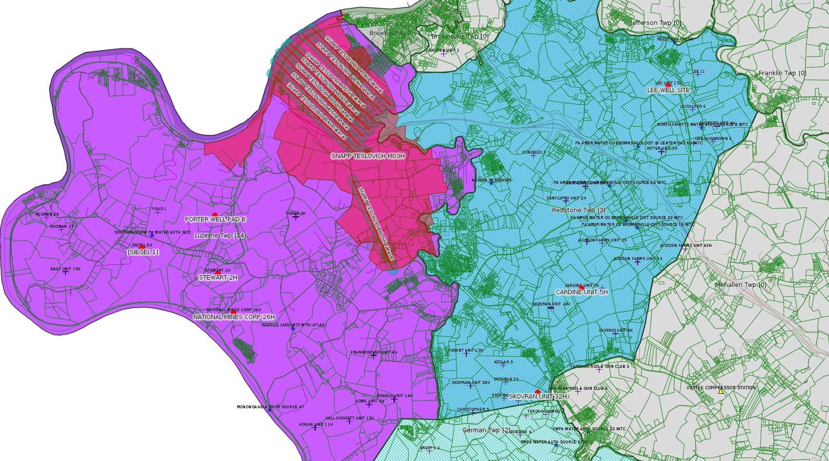
A Drill and Operate Well permit expires one year after the issue date if the well is not SPUD (drilling started). The permit can be renewed for another year; the renewal application is basically an affidavit stating that circumstances have not changed. Evidently, Chevron's publicly stated decision to put the entire assets of Chevron Appalachia up for sale does not count as a "circumstance".
------------------------
DEP defines an environmental justice area as "any census tract where 20 percent or more individuals live in poverty, and/or 30 percent or more of the population is minority". (See:
<https://www.dep.pa.gov/PublicParticipation/OfficeofEnvironmentalJustice/Pages/default.aspx>). There are supposed to be enhanced public participation requirements for permits in environmental justice areas, but news of this actually ever happening is scarce. In Fayette County, the entirety of Redstone, Springhill, Nicholson, and German Townships are environmental justice areas, as well as a large part of Dunbar Township. DEP's policy document on public participation guidelines for environmental justice areas is located here:
<https://www.elibrary.dep.state.pa.us/dsweb/Get/Version-48671/012-0501-002.pdf>
eNOTICE records are likely to list the same permit multiple times, as that permit moves through the DEP process.
Oil & Gas Wells designated with a site a number and the letter H typically designate horizontal wells.
-------------------------
Resources:
Pennsylvania Bulletin: <https://www.pabulletin.com/>
eNOTICE: <https://www.ahs2.dep.state.pa.
DEP Oil and Gas Reports: <https://www.dep.pa.gov/DataandTools/Reports/Oil%20and%20Gas%20Reports/Pages/default.aspx>
DEP Permits Issued Detail Report:
<https://www.depreportingservic
DEP SPUD (drilling started) Report:
<https://www.depreportingservices.state.pa.us/ReportServer/Pages/ReportViewer.aspx?/Oil_Gas/Spud_External_Data>
DEP Oil and Gas Compliance Report:
<https://www.depreportingservices.state.pa.us/ReportServer/Pages/ReportViewer.aspx?/Oil_Gas/OG_Compliance>
DEP PA Oil & Gas Mapping:
<https://www.depgis.state.pa.us/PaOilAndGasMapping>
Data Portal Services Directory [Technical]
<https://www.depgis.state.pa.us/arcgis/rest/services>
Query: Oil and Gas Wells All (ID: 3) [Technical]:
<https://www.depgis.state.pa.us/arcgis/rest/services/OilGas/OilGasAllStrayGasEGSP/MapServer/3/query?where=&text=&objectIds=&time=&geometry=&geometryType=esriGeometryEnvelope&inSR=&spatialRel=esriSpatialRelIntersects&relationParam=&outFields=*&returnGeometry=true&returnTrueCurves=false&maxAllowableOffset=&geometryPrecision=&outSR=&returnIdsOnly=false&returnCountOnly=false&orderByFields=&groupByFieldsForStatistics=&outStatistics=&returnZ=false&returnM=false&gdbVersion=&returnDistinctValues=false&resultOffset=&resultRecordCount=&f=html>
(Be sure to enter a Where clause in SQL format. Dates are in milliseconds since midnight 1/1/1970).
DEP Oil and Gas Electronic Submissions
<https://www.ahs.dep.pa.gov/eSubmissionPublicSearch>
DEP Oil and Gas Electronic Notifications
<https://www.depreportingservices.state.pa.us/ReportServer?/Oil_Gas/OG_Notifications>
DEP Oil and Gas Well Pad Report
<https://www.depreportingservices.state.pa.us/ReportServer?/Oil_Gas/Well_Pads>
Fayette County Assessment Office Search For Tax Records:
<http://property.co.fayette.pa.us/search.aspx>
Pennsylvania Spatial Data Access:
<https://www.pasda.psu.edu/default.asp>
DEP Spatial Data Repository:
<ftp://www.pasda.psu.edu/pub/pasda/dep/>
National Response Center:
<https://www.nrc.uscg.mil/>
EPA-Echo: <https://www.epa-echo.gov/echo/
FERC citizen involvement: <https://www.ferc.gov/for-citiz
To receive E-mail notification of
all documents filed in a FERC docket, see:
<https://www.ferc.gov/docs-filing/esubscription.asp >
<https://www.ferc.gov/docs-fili
Follow the directions and enter the docket number to subscribe to.
Township Supervisors receive information regarding Erosion & Sedimentation permits, and these records may be reviewable at township municipal offices.
DEP permits are reviewable through the File Review process, for application to do file review see: <https://www.portal.state.pa.us/portal/server.pt/community/southwest_regional_office/13775/file_review/593164>
Environmental Hearing Board: <https://ehb.courtapps.com/publ
PA DEP Environmental Policy Comment System:
<https://www.ahs.dep.pa.gov/eComment/>
Federal Register Environment: <https://www.federalregister.g
Browsing of recent comment
opportunities for federal agencies, e.g. EPA. Click "sign up" to
subscribe to daily E-mails of new document listings.
SkyTruth Fayette County Drilling Alerts: <https://frack.skytruth.org/pen
U.S. Army Corps of Engineers, Pittsburgh District, Public Notices:
<https://www.lrp.usace.army.mil/Missions/Regulatory/Public-Notices/>
EPA Pennsylvania Public Notices: <https://www2.epa.gov/aboutepa/epa-pennsylvania#notice>
Marcellus Shale waste disposal
injection wells in Pennsylvania are regulated directly by EPA, not
DEP. Notice of any new permit applications will appear at the
above web address. I'm not aware of any subscription service
to be notified of such applications. I'm not aware of any
Marcellus Shale waste disposal injection wells in Fayette County
(yet ...) but we need to monitor this page for future
applications.
Energy Assurance Daily: <https://www.oe.netl.doe.gov/ead.aspx>
Daily newsletter from the US
Department of Energy about events relating to energy. The Natural
Gas section has information about pipelines.
-------------------------
Disclaimers:
This compilation from the above sources was done in part by hand using copy and paste and in part using automated methods; it may omit relevant permits.
Parcel data is provided via the tax records search web page offered by the Fayette County Assessment Office (http://property.co.fayette.pa.us/). Presumed Parcel Id links are subject to availability provided by that agency and associated web sites. Presumed Parcel Ids are determined as the mapped parcel containing a given latitude and longitude, are a best effort determination which is subject to error, and are not official. In cases where a facility is leased and there is a separate parcel id for the lease, if this parcel id is not separately mapped, the parcel id shown will be the id for the enclosing parcel. Parcel owners may be surface owners only and may or may not have any relationship to oil & gas facilities.
Does not currently include water supply permits. Does not include landfill permits even though many such are for Marcellus Shale waste. (It is not possible at this time to distinguish which landfill permits are for Marcellus Shale waste and which are not without doing File Review for each permit.)
Erosion & Sedimentation permit records do not currently include latitude and longitude. Where I am publishing latitude and longitude with E&S permits it is by inferring an associated well permit and using published latitude and longitude for the well. It is possible I may be inferring the wrong well site.
Municipalities are shown from eFACTS records on the DEP web site. The DEP has been known to list a municipality incorrectly.