The Harmed Success Stories Concepts How To What Is Commentary
Fayette County Marcellus Shale Permits 3/25/19 - 4/7/19
Contents
Pennsylvania Bulletin Listings
[No Activity]eFACTS Listings
SNAPP TESLOVICH M01V Drill & Operate Well Permit (Unconventional) (New)Electronic Notifications
POLK UNIT 2H Drill & Operate Well Permit Inactive Status Issued 4/2/2019 (New)
GANS GENERATING FAC Water Quality Mgmt Part II, Industrial Wastewater Fac Treatment Plant
GANS GENERATING FAC Minor IW Facility without ELG
GANS GENERATING FAC Major Facility Operating Permit Replaced 4/4/2019
KOVACH B M08H Drilling resumption After Break of 30 days or more 03/29/2019Notes
KOVACH B M08H Casing cementing notification Coal Protected Casing 1: 3/30/2019
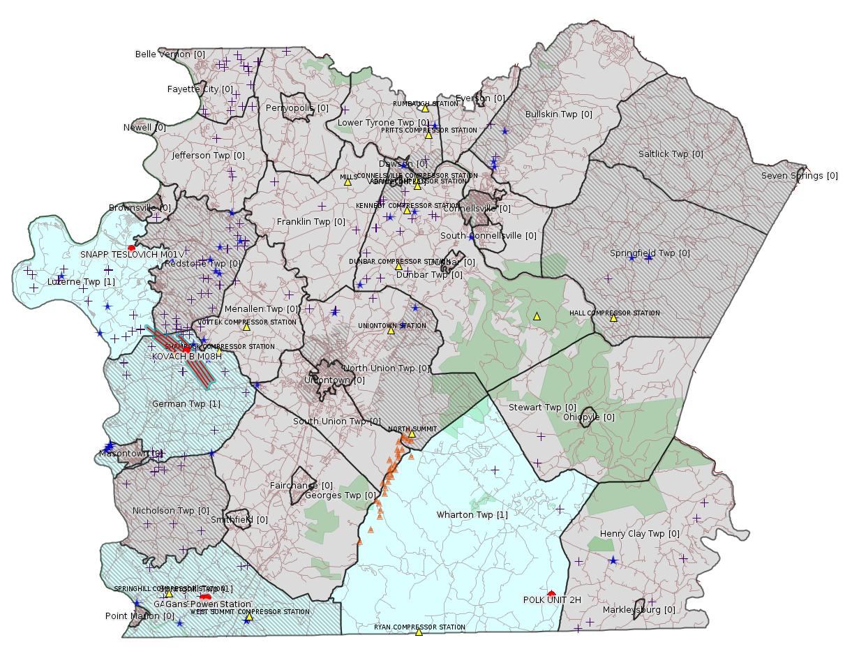
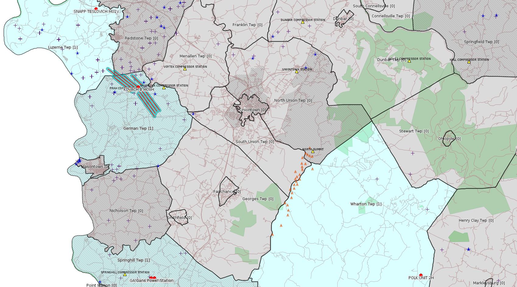
Map
Key
Red dots: items in this permit list with an exact location.
Blue stars: Marcellus Gas Well Water Sources.
Where well laterals are mapped they show in red; a 400-foot buffer surrounding the lateral shows in blue (lavender where it overlaps a mapped mineral tract).
Where mineral tracts are mapped, they show in pink. Mineral tracts can overlap; the overlap will show in red. The precise meaning of "mineral tract" is not clear.
Municipality shading: number of "facilities", with each well counting separately
(includes the red dots):
gray: 0
pale turquoise: 1
turquoise: 2
pale blue: 3
middle blue: 4
dark blue: 5
dark purple: 8
purple: 19
(Color coding may differ from one issue to the next.)
(Note if a project spans multiple municipalities -- e.g. a pipeline -- it will show in the count for each municipality.)
The number of facilities also follows the municipality name in brackets.
Municipality counts are based on the way the permit is listed by DEP; DEP has been known to get a municipality wrong.
Locations in brackets identify a precise location used to locate a surrogate for the actual site being permitted (e.g. locating a well pad or pipeline by the known location of a well.) Locations labeled beginning with "~" and ending in "[?]" are approximate and speculative based on inferences using on-line property and lease records. These are marked in the text as "[Approximate, Speculative]
Cross-hatching: Environmental Justice Areas
Yellow triangles: Compressor Stations
Orange triangles: Storage Field Wells (currently Dominion North Summit Storage Field)
Crosses: SPUD Unconventional well permits
Green: "Natural areas", e.g. state game lands, state forests
Yellow triangles: Compressor Stations
Orange triangles: Storage Field Wells (currently Dominion North Summit Storage Field)
Crosses: SPUD Unconventional well permits
Green: "Natural areas", e.g. state game lands, state forests
More Maps
 |
 |
Source: Pennsylvania Bulletin
[No Activity]
-------------------------
Source: eNOTICE (+ PA Oil and Gas Mapping, Well Pad Report.) Well Details via Data Portal Services: Oil and Gas Wells All (ID: 3).
Please see the Disclaimer below regarding Parcel Id data.
Authorization ID: 1267676
Permit number: 051-24706
Site: SNAPP-TESLOVICH PAD A
Client: CHEVRON APPALACHIA LLC
Authorization type: Drill & Operate Well Permit (Unconventional)
Application type: New
Authorization is for: FACILITY
Date received: 04/03/2019
Status: Pending
Permit Decision Guarantee Applies?: No
Sub-Facilities for Authorization:
Sub-Facility ID Sub-Facility Name Description
1284291 WELLBORE SURFACE HOLE LOCATION Well
Permit Review Notes:
Date Review Note
4/4/2019 The permit application package is complete, has been accepted, and is undergoing technical review.
<https://www.ahs.dep.pa.gov/eFACTSWeb/searchResults_singleAuth.aspx?AuthID=1267676>
Site Programs:
Oil & Gas
Site Municipalities:
Luzerne Twp, Fayette County
Well Details:
Permit Number: 051-24706
Well Name: SNAPP TESLOVICH M01V
Unconventional Well: Y
Well Configuration: Vertical Well
Well Type: GAS
Well Status: Active
Coal Association: NonCoal
Conservation Well: N
Primary Facility ID: 833681
Site ID: 834533
Site Name: SNAPP-TESLOVICH PAD A
Well Pad ID: 155747
Well Pad Name: SNAPP-TESLOVICH PAD A
Storage Field:
Operator: CHEVRON APPALACHIA LLC
Operator Number: OGO-39307
Permit Date:
Permit Date Expires:
SPUD Date:
Date Plugged:
UIC ID:
UIC Type:
Surface Elevation: 1100
County: Fayette
Municipality: Luzerne Twp
Location: 39.989942,-79.902631
Map URL: <http://www.openstreetmap.org/?mlat=39.989942&mlon=-79.902631#map=15/39.989942/-79.902631>
Electronically Submitted Records:
2019-04-05: Submission for Authorization 1267676
Justification for Non-Coal Well: Snapp Teslovich Non-Coal Packet.pdf
<http://www.depgis.state.pa.us/eWellDocHandler/pdFHandler.ashx?Doc=ODA1MDM2&ext=PDF>
Location Plat: Snapp Teslovich - Final V Well Plat M01V - 2019.02.20.dwg
<http://www.depgis.state.pa.us/eWellDocHandler/pdFHandler.ashx?Doc=ODA1MDY0&ext=PDF>
Pennsylvania Natural Diversity Inventory Support Document: PNDI Clearance.pdf
<http://www.depgis.state.pa.us/eWellDocHandler/pdFHandler.ashx?Doc=ODA4NTMw&ext=PDF>
Pennsylvania Natural Diversity Inventory Form: Snapp Teslovich_PNDI.pdf
<http://www.depgis.state.pa.us/eWellDocHandler/pdFHandler.ashx?Doc=ODA4NTMx&ext=PDF>
Interested Party Notification: Snapp Teslovich_Affidavit of Non-Delivery_M Cochrane.pdf
<http://www.depgis.state.pa.us/eWellDocHandler/pdFHandler.ashx?Doc=ODA4NTM2&ext=PDF>
Coordination of Well Location with Public Resources: Snapp Teslovich For OOGM0076U.pdf
<http://www.depgis.state.pa.us/eWellDocHandler/pdFHandler.ashx?Doc=ODA4NzM1&ext=PDF>
Permit Application to Drill and Operate a Well: 1886282.pdf
<http://www.depgis.state.pa.us/eWellDocHandler/pdFHandler.ashx?Doc=ODA4NzY2&ext=PDF>
---
Authorization ID: 1267460
Permit number: 051-24429
Site: POLK 1H OG WELL
Client: LPR ENERGY LLC
Authorization type: Drill & Operate Well Permit Inactive Status
Application type: New
Authorization is for: FACILITY
Date received: 04/02/2019
Status: Issued on 4/2/2019
Permit Decision Guarantee Applies?: No
Sub-Facilities for Authorization:
Sub-Facility ID Sub-Facility Name Description
1035637 POLK UNIT 2H Well
1035636 POLK UNIT 2H Well
Permit Review Notes:
Date Review Note
4/2/2019 The technical review and decision review are complete and either the permit decision and/or permit issuance are forthcoming.
4/2/2019 The permit application package is complete, has been accepted, and is undergoing technical review.
<https://www.ahs.dep.pa.gov/eFACTSWeb/searchResults_singleAuth.aspx?AuthID=1267460>
Site Programs:
Oil & Gas
Site Municipalities:
Wharton Twp, Fayette County
Well Details:
Permit Number: 051-24429
Well Name: POLK UNIT 2H
Unconventional Well: Y
Well Configuration: Horizontal Well
Well Type: GAS
Well Status: Regulatory Inactive Status
Coal Association: NonCoal
Conservation Well: N
Primary Facility ID: 738664
Site ID: 739411
Site Name: POLK 1H OG WELL
Well Pad ID: 149075
Well Pad Name: POLK UNIT 1H
Storage Field:
Operator: LPR ENERGY LLC
Operator Number: OGO-68579
Permit Date: 2011-02-28
Permit Date Expires: 2012-02-28
SPUD Date: 2011-08-26
Date Plugged:
UIC ID:
UIC Type:
Surface Elevation: 2310
County: Fayette
Municipality: Wharton Twp
Location: 39.746419,-79.529614
Map URL: <http://www.openstreetmap.org/?mlat=39.746419&mlon=-79.529614#map=15/39.746419/-79.529614>
OG WELLS PERMIT DOCS:
2017-11-30: Other Permit Documents, Name: Inactive 051-24429 (for Authorization: 1206221):
<http://www.depgis.state.pa.us/pdfHandler/pdFHandler.ashx?Doc=NTI2NDI1&ext=PDF>
2019-04-02: Other Permit Documents, Name: Inactive Well Status (for Authorization: 1267460):
<http://www.depgis.state.pa.us/pdfHandler/pdFHandler.ashx?Doc=Nzc5Nzky&ext=PDF>
Presumed Parcel Id: 4233000106
---
Authorization ID: 1215249
Permit number: 2600201
Site: GANS GENERATING FAC
Client: GANS ENERGY LLC
Authorization type: Water Quality Mgmt Part II, Industrial Wastewater Fac
Application type: Transfer
Authorization is for: FACILITY
Date received: 11/14/2017
Status: Pending
Permit Decision Guarantee Applies?: No
Sub-Facilities for Authorization:
Sub-Facility ID Sub-Facility Name Description
512930 TRTMT PLT Treatment Plant
Location: 39.7475,-79.8425
Map URL: <http://www.openstreetmap.org/?mlat=39.7475&mlon=-79.8425#map=15/39.7475/-79.8425>
Permit Review Notes:
Date Review Note
3/20/2019 The permit application package is complete, has been accepted, and is undergoing technical review.
<https://www.ahs.dep.pa.gov/eFACTSWeb/searchResults_singleAuth.aspx?AuthID=1215249>
Site Programs:
Air Quality
Clean Water
Site Municipalities:
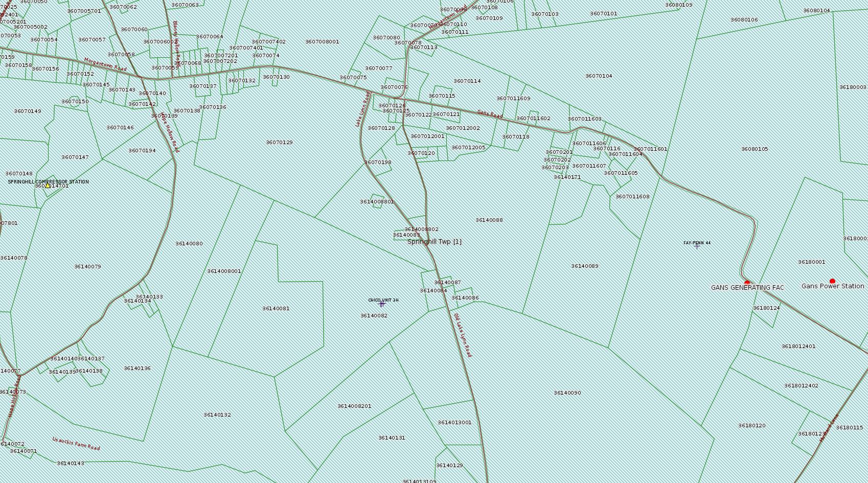
Springhill Twp [an Environmental Justice Area], Fayette County
Presumed Parcel Id: 36080105 (or possibly 36180001)
---
Authorization ID: 1215248
Permit number: PA0218464
Site: GANS GENERATING FAC
Client: GANS ENERGY LLC
Authorization type: Minor IW Facility without ELG
Application type: Transfer
Authorization is for: FACILITY
Date received: 11/14/2017
Status: Pending
Permit Decision Guarantee Applies?: No
Sub-Facilities for Authorization:
Sub-Facility ID Sub-Facility Name Description
512929 OUTFALL 001 Discharge Point
Location: 39.7475,-79.8425
Map URL: <http://www.openstreetmap.org/?mlat=39.7475&mlon=-79.8425#map=15/39.7475/-79.8425>
1061519 OUTFALL 101 Internal Monitoring Point
1061526 OUTFALL 201 Internal Monitoring Point
Permit Review Notes:
Date Review Note
3/20/2019 The permit application package is complete, has been accepted, and is undergoing technical review.
<https://www.ahs.dep.pa.gov/eFACTSWeb/searchResults_singleAuth.aspx?AuthID=1215248>
Site Programs:
Air Quality
Clean Water
Site Municipalities:
Springhill Twp [an Environmental Justice Area], Fayette County
---
Authorization ID: 802336
Permit number: 26-00495
Site: GANS GENERATING FAC
Client: ALLEGHENY ENERGY SUPPLY CO LLC
Authorization type: Major Facility Operating Permit
Application type: Renewal
Authorization is for: FACILITY
Date received: 07/27/2009
Status: Replaced on 4/4/2019
Permit Decision Guarantee Applies?: No
Sub-Facilities for Authorization:
Sub-Facility ID Sub-Facility Name Description
571256 COMBUSTION GAS TURBINE UNIT 8(355 MMBTU/HR,NG,SIMPLE CYCLE) Process
Location: 39.747518,-79.838772
Map URL: <http://www.openstreetmap.org/?mlat=39.747518&mlon=-79.838772#map=15/39.747518/-79.838772>
571257 COMBUSTION GAS TURBINE UNIT 9(355 MMBTU/HR,NG,SIMPLE CYCLE) Process
Location: 39.747518,-79.838772
Map URL: <http://www.openstreetmap.org/?mlat=39.747518&mlon=-79.838772#map=15/39.747518/-79.838772>
1280758 COOLING TOWERS Process
Location: 39.747518,-79.838772
Map URL: <http://www.openstreetmap.org/?mlat=39.747518&mlon=-79.838772#map=15/39.747518/-79.838772>
802896 UNIT 8 WATER INJECTION SYSTEM Air Pollution Control Device
Location: 39.747518,-79.838772
Map URL: <http://www.openstreetmap.org/?mlat=39.747518&mlon=-79.838772#map=15/39.747518/-79.838772>
802897 UNIT 9 WATER INJECTION SYSTEM Air Pollution Control Device
Location: 39.747518,-79.838772
Map URL: <http://www.openstreetmap.org/?mlat=39.747518&mlon=-79.838772#map=15/39.747518/-79.838772>
<https://www.ahs.dep.pa.gov/eFACTSWeb/searchResults_singleAuth.aspx?AuthID=802336>
Site Programs:
Air Quality
Clean Water
Site Municipalities:
Springhill Twp [an Environmental Justice Area], Fayette County
[See Notes.]
-------------------------
Source: DEP Oil and Gas Electronic Notifications
NOTIFICATION_ID: 46901
OGO: 39307
OPERATOR: CHEVRON APPALACHIA LLC
API_PERMIT: 051-24669
SPUD_DATE: 10/23/2018
COUNTY: Fayette
MUNICIPALITY: German [an Environmental Justice Area]
LATITUDE: 39.919197
LONGITUDE: -79.854658
SUBJECT: [NOTIFICATION]: Drilling resumption After Break of 30 days or more notification 58 Pa. C.S. 3211(f)(1) for well API 37-051-24669-00-00
QUESTION: Date and approximate time action is to occur
ANSWER: Date: 03/29/2019 Time: 12:00am
SENT_DATE: 3/27/2019 9:21:07 AM
SENT_SUCCESS: Yes
LAST_RESENT_DATE:
RESENT_SUCCESS:
Well Details:
Permit Number: 051-24669
Well Name: KOVACH B M08H
Unconventional Well: Y
Well Configuration: Horizontal Well
Well Type: GAS
Well Status: Active
Coal Association: Coal
Conservation Well: N
Primary Facility ID: 828035
Site ID: 826949
Site Name: KOVACH B WELL SITE AND TANK SITE ESCGP ESX17-051-0003
Well Pad ID: 155005
Well Pad Name: KOVACH B
Storage Field:
Operator: CHEVRON APPALACHIA LLC
Operator Number: OGO-39307
Permit Date: 2018-08-08
Permit Date Expires: 2019-08-08
SPUD Date: 2018-10-23
Date Plugged:
UIC ID:
UIC Type:
Surface Elevation: 1278
County: Fayette
Municipality: German Twp
Location: 39.919197,-79.854658
Map URL: <http://www.openstreetmap.org/?mlat=39.919197&mlon=-79.854658#map=15/39.919197/-79.854658>
OG WELLS PERMIT DOCS:
2018-08-08: Final Permit Documents, Name: 1237725 (for Authorization: 1237725):
<http://www.depgis.state.pa.us/pdfHandler/pdFHandler.ashx?Doc=NjQ2Nzc0&ext=PDF>
2018-08-31: Other Permit Documents, Name: 051-24669 (for Authorization: 1240734):
<http://www.depgis.state.pa.us/pdfHandler/pdFHandler.ashx?Doc=NzgxMDk5&ext=PDF>
2019-01-09: Other Permit Documents, Name: 051-24669 (for Authorization: 1256801):
<http://www.depgis.state.pa.us/pdfHandler/pdFHandler.ashx?Doc=NzI5MDIz&ext=PDF>
Electronically Submitted Records:
2018-08-08: Submission for Authorization 1237725
Interested Party Notification: Kovach B Affidavit of Non-Delivery Venere.pdf
<http://www.depgis.state.pa.us/eWellDocHandler/pdFHandler.ashx?Doc=NjAyNjA5&ext=PDF>
Coal and Gas Resource Coord Act - Section 7 Exception: Kovach B Horizontals Section 7 Exception.pdf
<http://www.depgis.state.pa.us/eWellDocHandler/pdFHandler.ashx?Doc=NjAyNjE1&ext=PDF>
Pennsylvania Natural Diversity Inventory Form: Kovach B PNDI.pdf
<http://www.depgis.state.pa.us/eWellDocHandler/pdFHandler.ashx?Doc=NjAyNjE2&ext=PDF>
Location Plat: Kovach B M08H Plat.dwg
<http://www.depgis.state.pa.us/eWellDocHandler/pdFHandler.ashx?Doc=NjAyNjE3&ext=PDF>
Well Cross-Section Diagram: Kovach B M08H Page 4.pdf
<http://www.depgis.state.pa.us/eWellDocHandler/pdFHandler.ashx?Doc=NjAyNjE4&ext=PDF>
Permit Application to Drill and Operate a Well: 1753555.pdf
<http://www.depgis.state.pa.us/eWellDocHandler/pdFHandler.ashx?Doc=NjAzODgz&ext=PDF>
Presumed Parcel Id: 1511002301
---
NOTIFICATION_ID: 46936
OGO: 39307
OPERATOR: CHEVRON APPALACHIA LLC
API_PERMIT: 051-24669
SPUD_DATE: 10/23/2018
COUNTY: Fayette
MUNICIPALITY: German [an Environmental Justice Area]
LATITUDE: 39.919197
LONGITUDE: -79.854658
SUBJECT: [NOTIFICATION]: Casing cementing notification 58 Pa. C.S. 3211(f)(2) for well API 37-051-24669-00-00
QUESTION: Enter the Date and Time for the applicable Casing Types
ANSWER: Coal Protected Casing 1: 3/30/2019 12:00:00 AM
SENT_DATE: 3/28/2019 9:01:11 AM
SENT_SUCCESS: Yes
LAST_RESENT_DATE:
RESENT_SUCCESS:
Well Details above
Well Name: KOVACH B M08H
------------------------
The unconventional vertical well SNAPP TESLOVICH M01V continues a pattern we have seen with several recent Chevron well pads where they apply for the Drill & Operate Well Permit for a single vertical well shortly after applying for the well pad Erosion & Sedimentation (E&S) permit but significantly before applying for Drill & Operate Well permits for the horizontal wells.
---
Authorization 802336 for the Gans Generating Facility is presumably replaced by Authorization 1264863. That authorization -- while having a recent authorization number -- shows a received date from nearly 10 years ago! How does a permit renewal get lost for nearly 10 years?!!
------------------------
DEP defines an environmental justice area as "any census tract where 20 percent or more individuals live in poverty, and/or 30 percent or more of the population is minority". (See:
<http://www.dep.pa.gov/PublicParticipation/OfficeofEnvironmentalJustice/Pages/default.aspx>). There are supposed to be enhanced public participation requirements for permits in environmental justice areas, but news of this actually ever happening is scarce. In Fayette County, the entirety of Redstone, Springhill, Nicholson, and German Townships are environmental justice areas, as well as a large part of Dunbar Township. DEP's policy document on public participation guidelines for environmental justice areas is located here:
<http://www.elibrary.dep.state.pa.us/dsweb/Get/Version-48671/012-0501-002.pdf>
eNOTICE records are likely to list the same permit multiple times, as that permit moves through the DEP process.
Oil & Gas Wells designated with a site a number and the letter H typically designate horizontal wells.
-------------------------
Resources:
Pennsylvania Bulletin: <http://www.pabulletin.com/>
eNOTICE: <http://www.ahs2.dep.state.pa.
DEP Oil and Gas Reports: <http://www.dep.pa.gov/DataandTools/Reports/Oil%20and%20Gas%20Reports/Pages/default.aspx>
DEP Permits Issued Detail Report:
<http://www.depreportingservic
DEP SPUD (drilling started) Report:
<http://www.depreportingservices.state.pa.us/ReportServer/Pages/ReportViewer.aspx?/Oil_Gas/Spud_External_Data>
DEP Oil and Gas Compliance Report:
<http://www.depreportingservices.state.pa.us/ReportServer/Pages/ReportViewer.aspx?/Oil_Gas/OG_Compliance>
DEP PA Oil & Gas Mapping:
<http://www.depgis.state.pa.us/PaOilAndGasMapping>
Data Portal Services Directory [Technical]
<http://www.depgis.state.pa.us/arcgis/rest/services>
Query: Oil and Gas Wells All (ID: 3) [Technical]:
<http://www.depgis.state.pa.us/arcgis/rest/services/OilGas/OilGasAllStrayGasEGSP/MapServer/3/query?where=&text=&objectIds=&time=&geometry=&geometryType=esriGeometryEnvelope&inSR=&spatialRel=esriSpatialRelIntersects&relationParam=&outFields=*&returnGeometry=true&returnTrueCurves=false&maxAllowableOffset=&geometryPrecision=&outSR=&returnIdsOnly=false&returnCountOnly=false&orderByFields=&groupByFieldsForStatistics=&outStatistics=&returnZ=false&returnM=false&gdbVersion=&returnDistinctValues=false&resultOffset=&resultRecordCount=&f=html>
(Be sure to enter a Where clause in SQL format. Dates are in milliseconds since midnight 1/1/1970).
New:
DEP Oil and Gas Electronic Submissions
<http://www.ahs.dep.pa.gov/eSubmissionPublicSearch>
DEP Oil and Gas Electronic Notifications
<http://www.depreportingservices.state.pa.us/ReportServer?/Oil_Gas/OG_Notifications>
DEP Oil and Gas Well Pad Report
<http://www.depreportingservices.state.pa.us/ReportServer?/Oil_Gas/Well_Pads>
Fayette County Assessment Office Search For Tax Records:
<http://property.co.fayette.pa.us/search.aspx>
Pennsylvania Spatial Data Access:
<http://www.pasda.psu.edu/default.asp>
DEP Spatial Data Repository:
<ftp://www.pasda.psu.edu/pub/pasda/dep/>
National Response Center:
<http://www.nrc.uscg.mil/>
EPA-Echo: <http://www.epa-echo.gov/echo/
FERC citizen involvement: <http://www.ferc.gov/for-citiz
To receive E-mail notification of
all documents filed in a FERC docket, see:
<http://www.ferc.gov/docs-filing/esubscription.asp >
<http://www.ferc.gov/docs-fili
Follow the directions and enter the docket number to subscribe to.
Township Supervisors receive information regarding Erosion & Sedimentation permits, and these records may be reviewable at township municipal offices.
DEP permits are reviewable through the File Review process, for application to do file review see: <http://www.portal.state.pa.us/portal/server.pt/community/southwest_regional_office/13775/file_review/593164>
Environmental Hearing Board: <http://ehb.courtapps.com/publ
PA DEP Environmental Policy Comment System:
<http://www.ahs.dep.pa.gov/eComment/>
Federal Register Environment: <https://www.federalregister.g
Browsing of recent comment
opportunities for federal agencies, e.g. EPA. Click "sign up" to
subscribe to daily E-mails of new document listings.
SkyTruth Fayette County Drilling Alerts: <http://frack.skytruth.org/pen
U.S. Army Corps of Engineers, Pittsburgh District, Public Notices:
<http://www.lrp.usace.army.mil/Missions/Regulatory/Public-Notices/>
EPA Pennsylvania Public Notices: <http://www2.epa.gov/aboutepa/epa-pennsylvania#notice>
Marcellus Shale waste disposal
injection wells in Pennsylvania are regulated directly by EPA, not
DEP. Notice of any new permit applications will appear at the
above web address. I'm not aware of any subscription service
to be notified of such applications. I'm not aware of any
Marcellus Shale waste disposal injection wells in Fayette County
(yet ...) but we need to monitor this page for future
applications.
Energy Assurance Daily: <http://www.oe.netl.doe.gov/ead.aspx>
Daily newsletter from the US
Department of Energy about events relating to energy. The Natural
Gas section has information about pipelines.
-------------------------
Disclaimers:
This compilation from the above sources was done in part by hand using copy and paste and in part using automated methods; it may omit relevant permits.
Parcel data is provided via the tax records search web page offered by the Fayette County Assessment Office (http://property.co.fayette.pa.us/). Presumed Parcel Id links are subject to availability provided by that agency and associated web sites. Presumed Parcel Ids are determined as the mapped parcel containing a given latitude and longitude, are a best effort determination which is subject to error, and are not official. In cases where a facility is leased and there is a separate parcel id for the lease, if this parcel id is not separately mapped, the parcel id shown will be the id for the enclosing parcel. Parcel owners may be surface owners only and may or may not have any relationship to oil & gas facilities.
Does not currently include water supply permits. Does not include landfill permits even though many such are for Marcellus Shale waste. (It is not possible at this time to distinguish which landfill permits are for Marcellus Shale waste and which are not without doing File Review for each permit.)
Erosion & Sedimentation permit records do not currently include latitude and longitude. Where I am publishing latitude and longitude with E&S permits it is by inferring an associated well permit and using published latitude and longitude for the well. It is possible I may be inferring the wrong well site.
Municipalities are shown from eFACTS records on the DEP web site. The DEP has been known to list a municipality incorrectly.