The Harmed Success Stories Concepts How To What Is Commentary
Fayette County Marcellus Shale Permits 5/7/18 - 5/20/18
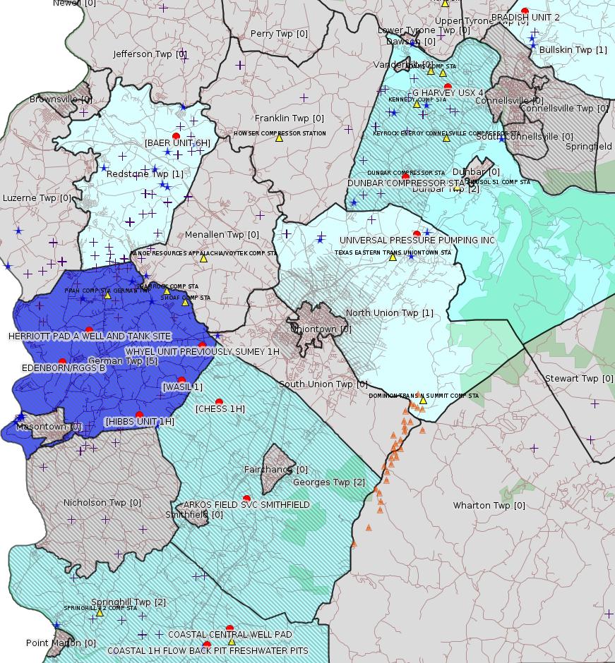
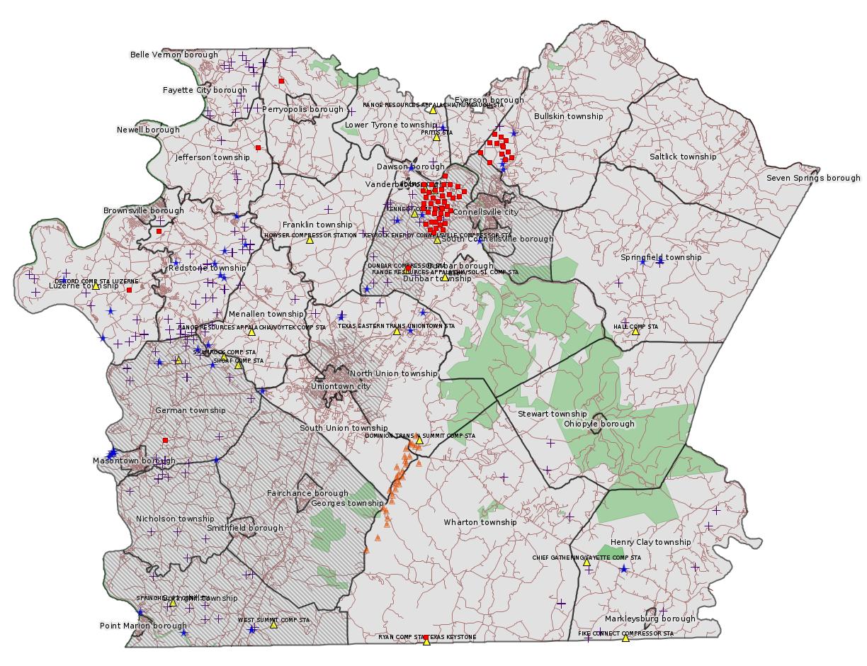
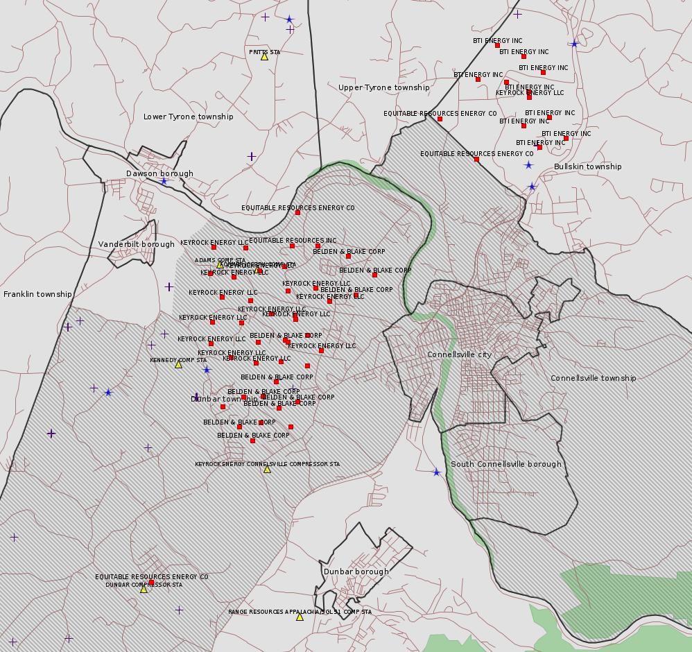
Click the map to enlarge
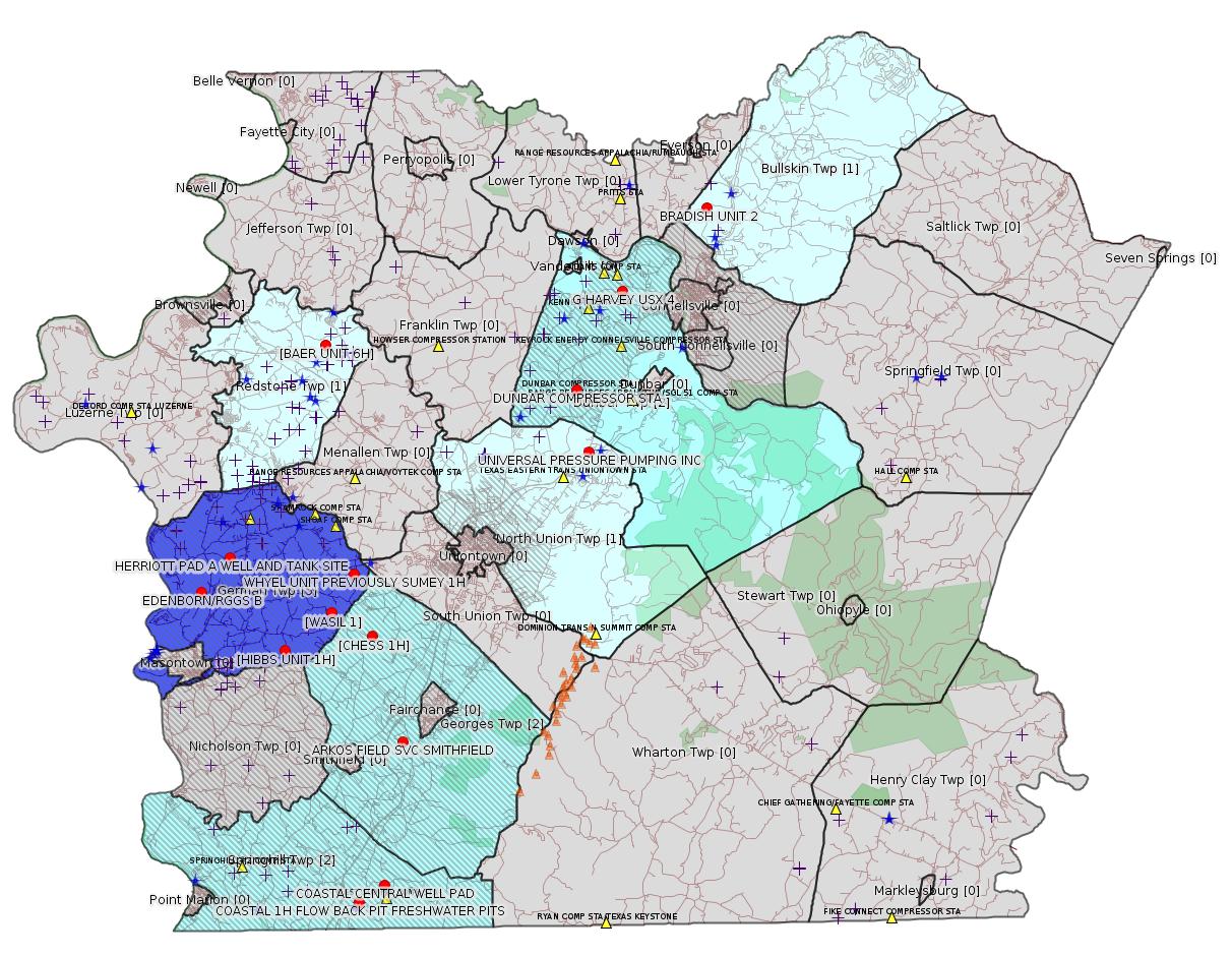
Map
Key
Red dots: items in this permit list with an exact location.
Blue stars: Marcellus Gas Well Water Sources.
Municipality shading: number of "facilities", with each well counting separately
(includes the red dots):
Red dots: items in this permit list with an exact location.
Blue stars: Marcellus Gas Well Water Sources.
Municipality shading: number of "facilities", with each well counting separately
(includes the red dots):
gray: 0
pale turquoise: 1
turquoise: 2
pale blue: 3
middle blue: 4
dark blue: 5
dark purple: 11
purple: 14
(Color coding may differ from one issue to the next.)
(Note if a project spans multiple municipalities -- e.g. a pipeline -- it will show in the count for each municipality.)
The number of facilities also follows the municipality name in brackets.
Municipality counts are based on the way the permit is listed by DEP; DEP has been known to get a municipality wrong.
Locations in brackets identify a precise location used to locate a surrogate for the actual site being permitted (e.g. locating a well pad or pipeline by the known location of a well.) Locations labeled beginning with "~" and ending in "[?]" are approximate and speculative based on inferences using on-line property and lease records. These are marked in the text as "[Approximate, Speculative]
Cross-hatching: Environmental Justice Areas
Yellow triangles: Compressor Stations
Orange triangles: Storage Field Wells (currently Dominion North Summit Storage Field)
Crosses: SPUD Unconventional well permits
Green: "Natural areas", e.g. state game lands, state forests
Yellow triangles: Compressor Stations
Orange triangles: Storage Field Wells (currently Dominion North Summit Storage Field)
Crosses: SPUD Unconventional well permits
Green: "Natural areas", e.g. state game lands, state forests
More Maps
 |
 |
 |
| Red Squares are Fayette County Coalbed Methane Wells |
Dunbar, Bullskin Twps Coalbed Methane Wells Labeled by Operator |
Source: Pennsylvania Bulletin
[Neighboring County:]
NOTICES
DEPARTMENT OF CONSERVATION AND NATURAL RESOURCES
Execution of Oil and Gas Lease for Publicly-Owned Streambeds
[48 Pa.B. 2954]
[Saturday, May 19, 2018]
Effective December 13, 2017, an Oil and Gas Lease for Publicly-Owned Streambeds, Contract No. M-2102001-04, was executed by and between the Commonwealth, acting through the Department of Conservation and Natural Resources (Department) (lessor), and Chevron Appalachia, LLC (lessee), with its principal place of business located at 700 Cherrington Parkway, Coraopolis, PA 15108.
The lease is for Streambed Tract 2001 on the Dunkard Creek encompassing a total of 124 acres of submerged lands located in Dunkard and Monongahela Townships, Greene County. The lease was recorded at the Greene County Courthouse on March 16, 2018, document No. 201800001850, book 512, page 1543-1574. The lease allows for the development of oil and natural gas below and between the ordinary low water marks of the Dunkard Creek solely by means of directional, including horizontal, drilling on a nondevelopment basis that will not disturb the river or its bed. Contract No. M-2102001-04 may be viewed online at http://contracts.patreasury.gov/Admin/Upload/439441_M-2102001-04%20Dunkard%20Creek%20Lease%20Chevron%20Appalachia%2012_13_2017.pdf.
Questions regarding this lease should be directed to the Department's Bureau of Forestry, Minerals Division, (717) 787-2703.
CINDY ADAMS DUNN,
Secretary
<https://www.pabulletin.com/secure/data/vol48/48-20/784.html>
---
NOTICES
DEPARTMENT OF CONSERVATION AND NATURAL RESOURCES
Execution of Oil and Gas Lease for Publicly-Owned Streambeds
[48 Pa.B. 2954]
[Saturday, May 19, 2018]
Effective January 4, 2018, an Oil and Gas Lease for Publicly-Owned Streambeds, Contract No. M-2102007-04, was executed by and between the Commonwealth, acting through the Department of Conservation and Natural Resources (Department) (lessor), and Chevron Appalachia, LLC (lessee), with its principal place of business located at 700 Cherrington Parkway, Coraopolis, PA 15108.
The lease is for Streambed Tract 2007 on the Monongahela River encompassing a total of 1,028.4 acres of submerged lands located in Cumberland, Luzerne, Nicholson and Monongahela Townships, Greene and Fayette Counties. The lease was recorded at the Greene County Courthouse on March 16, 2018, document No. 201800001877, book 512, page 1729-1760; and Fayette County Courthouse on March 16, 2018, book 3366, page 2072-2102. The lease allows for the development of oil and natural gas below and between the ordinary low water marks of the Monongahela River solely by means of directional, including horizontal, drilling on a nondevelopment basis that will not disturb the river or its bed. Contract No. M-2102001-04 may be viewed online at http://contracts.patreasury.gov/Admin/Upload/439443_M-2102007-04%20Monongahela%20River%20Lease%20Chevron%20Appalachia%2001_04_2018.pdf.
Questions regarding this lease should be directed to the Department's Bureau of Forestry, Minerals Division, (717) 787-2703.
CINDY ADAMS DUNN,
Secretary
<https://www.pabulletin.com/secure/data/vol48/48-20/785.html>
-------------------------
Source: eNOTICE (+ PA Oil and Gas Mapping, Well Pad Report.) Well Details via Data Portal Services: Oil and Gas Wells All (ID: 3).
Please see the Disclaimer below regarding Parcel Id data.
New:
Authorization ID: 1228846
Permit number: ESX11-051-0023
Site: BAER WELL SITES ESCGP-EXPEDITED
Client: CHEVRON APPALACHIA LLC
Authorization type: Expedited E&S Stormwater General Permit 1
Application type: Notification
Authorization is for: SITE
Date received: 05/10/2018
Status: Pending
Permit Decision Guarantee Applies?: No
Permit Review Notes:
Date Review Note
5/14/2018 The permit application package is complete, has been accepted, and is undergoing technical review.
<http://www.ahs.dep.pa.gov/eFACTSWeb/searchResults_singleAuth.aspx?AuthID=1228846>
Site Programs:
Oil & Gas
Municipalities:
Redstone Twp, Fayette County
Location [of BAER UNIT 6H]: 39.998708,-79.817186 <https://osm.org/go/ZWpep4uT--?m=>
Presumed Parcel Id: 30060203
[See Notes.]
New:
Authorization ID: 1227845
Permit number: 051-20677
Site: BRADISH UNIT 2 WELL
Client: KEYROCK ENERGY LLC
Authorization type: Well Plugging Notice Intent to Plug Single Well
Application type: New
Authorization is for: FACILITY
Date received: 05/07/2018
Status: Issued on 5/9/2018
Permit Decision Guarantee Applies?: No
Sub-Facilities for Authorization:
Sub-Facility ID Sub-Facility Name Description
56855 BRADISH UNIT 2 Well
Permit Review Notes:
Date Review Note
5/9/2018 The technical review and decision review are complete and either the permit decision and/or permit issuance are forthcoming.
5/9/2018 The permit application package is complete, has been accepted, and is undergoing technical review.
<http://www.ahs.dep.pa.gov/eFACTSWeb/searchResults_singleAuth.aspx?AuthID=1227845>
Site Programs:
Oil & Gas
Municipalities:
Bullskin Twp, Fayette County
Well Details:
Permit Number: 051-20677
Well Name: BRADISH UNIT 2
Unconventional Well: N
Well Configuration: Vertical Well
Well Type: COALBED METHANE
Well Status: Regulatory Inactive Status
Coal Association: Coal
Conservation Well: N
Primary Facility ID: 43325
Site ID: 41573
Site Name: BRADISH UNIT 2 WELL
Well Pad ID: 0
Well Pad Name:
Storage Field:
Operator: KEYROCK ENERGY LLC
Operator Number: OGO-39111
Permit Date: 1992-12-18
Permit Date Expires: 1993-12-18
SPUD Date: 1992-12-28
Date Plugged:
UIC ID:
UIC Type:
Surface Elevation: 1138
County: Fayette
Municipality: Bullskin Twp
Location: 40.061167,-79.58
Map URL: <http://www.openstreetmap.org/?mlat=40.061167&mlon=-79.58#map=15/40.061167/-79.58>
Presumed Parcel Id: 04280114
[See Notes.]
Authorization ID: 1066128
Permit number: 051-20677
Site: BRADISH UNIT 2 WELL
Client: KEYROCK ENERGY LLC
Authorization type: Drill & Operate Well Permit Inactive Status
Application type: New
Authorization is for: FACILITY
Date received: 01/13/2015
Status: Denied on 5/7/2018
Permit Decision Guarantee Applies?: No
Sub-Facilities for Authorization:
Sub-Facility ID Sub-Facility Name Description
56855 BRADISH UNIT 2 Well
Permit Review Notes:
Date Review Note
5/7/2018 Application has been deemed to be technically deficient and has been denied.
5/7/2018 Application has been deemed to be technically deficient and has been denied.
3/23/2015 The permit application package is complete, has been accepted, and is undergoing technical review.
<http://www.ahs.dep.pa.gov/eFACTSWeb/searchResults_singleAuth.aspx?AuthID=1066128>
Site Programs:
Oil & Gas
Municipalities:
Bullskin Twp, Fayette County
[Well Details above]
Authorization ID: 1227101
Permit number: ESX18-051-0003
Site: EDENBORN/RGGS B ESCGP ESX18-051-0003
Client: CHEVRON APPALACHIA LLC
Authorization type: Expedited E&S Stormwater General Permit 1
Application type: New
Authorization is for: SITE
Date received: 05/03/2018
Status: Pending
Permit Decision Guarantee Applies?: Yes
Permit Decision Guarantee status: ACTIVE
Permit Review Notes:
Date Review Note
5/14/2018 The permit application package is complete, has been accepted, and is undergoing technical review.
<http://www.ahs.dep.pa.gov/eFACTSWeb/searchResults_singleAuth.aspx?AuthID=1227101>
Site Programs:
Municipalities:
German Twp [an Environmental Justice Area], Fayette County
Well Pad ID: 155083
Location: 39.881931,-79.896106 <https://osm.org/go/ZWpN6mOL--?m=>
Wells on this Pad:
051-24651 EDENBORN/RGGS B 1
Presumed Parcel Id: 15220014
Authorization ID: 1226967
Permit number: ESX18-051-0002
Site: HERRIOTT PAD A WELL AND TANK SITE ESCGP ESX18-051-0002
Client: CHEVRON APPALACHIA LLC
Authorization type: Expedited E&S Stormwater General Permit 1
Application type: New
Authorization is for: SITE
Date received: 05/01/2018
Status: Pending
Permit Decision Guarantee Applies?: Yes
Permit Decision Guarantee status: VOID
<http://www.ahs.dep.pa.gov/eFACTSWeb/searchResults_singleAuth.aspx?AuthID=1226967>
Site Programs:
Municipalities:
German Twp [an Environmental Justice Area], Fayette County
Well Pad ID: 155082
Location: 39.897981,-79.878003 <https://osm.org/go/ZWpPXJxr--?m=>
Wells on this Pad:
051-24649 HERRIOTT 1
Presumed Parcel Id: 15220125
Authorization ID: 1225814
Permit number: ESX11-051-0017
Site: WHYEL UNIT PREVIOUSLY SUMEY 1H ESCGP-EXPEDITED
Client: INR OPERATING LLC
Authorization type: Expedited E&S Stormwater General Permit 1
Application type: Transfer
Authorization is for: SITE
Date received: 04/18/2018
Status: Issued on 5/15/2018
Permit Decision Guarantee Applies?: Yes
Permit Decision Guarantee status: ACTIVE
Permit Review Notes:
Date Review Note
5/15/2018 The technical review and decision review are complete and either the permit decision and/or permit issuance are forthcoming.
4/18/2018 The permit application package is complete, has been accepted, and is undergoing technical review.
<http://www.ahs.dep.pa.gov/eFACTSWeb/searchResults_singleAuth.aspx?AuthID=1225814>
Site Programs:
Oil & Gas
Municipalities:
German Twp [an Environmental Justice Area], Fayette County
Well Pad ID: 147078
Location: 39.889444,-79.801667 <https://osm.org/go/ZWplRZDx--?m=>
Wells on this Pad:
051-24449 WHYEL UNIT 1H
Presumed Parcel Id: 15290036
Authorization ID: 1225811
Permit number: ESX11-051-0025
Site: WASIL 1 WELL PAD ESCGP-EXPEDITED
Client: INR OPERATING LLC
Authorization type: Expedited E&S Stormwater General Permit 1
Application type: Transfer
Authorization is for: SITE
Date received: 04/18/2018
Status: Issued on 5/15/2018
Permit Decision Guarantee Applies?: Yes
Permit Decision Guarantee status: ACTIVE
Permit Review Notes:
Date Review Note
5/15/2018 The technical review and decision review are complete and either the permit decision and/or permit issuance are forthcoming.
4/18/2018 The permit application package is complete, has been accepted, and is undergoing technical review.
<http://www.ahs.dep.pa.gov/eFACTSWeb/searchResults_singleAuth.aspx?AuthID=1225811>
Site Programs:
Oil & Gas
Municipalities:
German Twp [an Environmental Justice Area], Fayette County
Location [of WASIL 1]: 39.871472,-79.815522 <http://osm.org/go/ZWpPuFAu--?m=>
Presumed Parcel Id: 1536004304
Authorization ID: 1225809
Permit number: ESX10-051-0026
Site: HIBBS 1H ESCGP-EXPEDITED
Client: INR OPERATING LLC
Authorization type: Expedited E&S Stormwater General Permit 1
Application type: Transfer
Authorization is for: SITE
Date received: 04/18/2018
Status: Issued on 5/15/2018
Permit Decision Guarantee Applies?: Yes
Permit Decision Guarantee status: ACTIVE
Permit Review Notes:
Date Review Note
5/15/2018 The technical review and decision review are complete and either the permit decision and/or permit issuance are forthcoming.
4/18/2018 The permit application package is complete, has been accepted, and is undergoing technical review.
<http://www.ahs.dep.pa.gov/eFACTSWeb/searchResults_singleAuth.aspx?AuthID=1225809>
Site Programs:
Oil & Gas
Municipalities:
German Twp [an Environmental Justice Area], Fayette County
Nicholson Twp, Fayette County [likely incorrect -jr]
Location [of HIBBS UNIT 1H]: 39.853611,-79.844861 <https://osm.org/go/ZWpO1Jir--?m=>
Presumed Parcel Id: 1536010401
[See Notes.]
Authorization ID: 1225805
Permit number: ESX15-051-0012
Site: COASTAL CENTRAL WELL PAD ESCGP-2 EXPEDITED
Client: INR OPERATING LLC
Authorization type: Expedited E&S Stormwater General Permit 1
Application type: Transfer
Authorization is for: SITE
Date received: 04/18/2018
Status: Issued on 5/15/2018
Permit Decision Guarantee Applies?: Yes
Permit Decision Guarantee status: ACTIVE
Permit Review Notes:
Date Review Note
5/15/2018 The technical review and decision review are complete and either the permit decision and/or permit issuance are forthcoming.
4/18/2018 The permit application package is complete, has been accepted, and is undergoing technical review.
<http://www.ahs.dep.pa.gov/eFACTSWeb/searchResults_singleAuth.aspx?AuthID=1225805>
Site Programs:
Municipalities:
Springhill Twp [an Environmental Justice Area], Fayette County
Location: 39.7415,-79.7854 <http://osm.org/go/ZWpKm56R--?m=>
Presumed Parcel Id: 36210048
Authorization ID: 1225804
Permit number: ESX10-051-0035
Site: COASTAL 1H FLOW BACK PIT FRESHWATER PITS ESCGP-EXPEDITED
Client: INR OPERATING LLC
Authorization type: Expedited E&S Stormwater General Permit 1
Application type: Transfer
Authorization is for: SITE
Date received: 04/18/2018
Status: Issued on 5/15/2018
Permit Decision Guarantee Applies?: Yes
Permit Decision Guarantee status: ACTIVE
Permit Review Notes:
Date Review Note
5/15/2018 The technical review and decision review are complete and either the permit decision and/or permit issuance are forthcoming.
4/18/2018 The permit application package is complete, has been accepted, and is undergoing technical review.
<http://www.ahs.dep.pa.gov/eFACTSWeb/searchResults_singleAuth.aspx?AuthID=1225804>
Site Programs:
Oil & Gas
Municipalities:
Springhill Twp [an Environmental Justice Area], Fayette County
Location: 39.733294,-79.801028 <https://osm.org/go/ZWpgBJ2N--?m=>
Presumed Parcel Id: 36210048
Well Pad Id: 147971
Wells on this pad:
051-24318 COASTAL 1H
051-24382 COASTAL/SMITH UNIT 1H
Authorization ID: 1225792
Permit number: ESX10-051-0017
Site: CHESS 1H ESCGP-EXPEDITED
Client: INR OPERATING LLC
Authorization type: Expedited E&S Stormwater General Permit 1
Application type: Transfer
Authorization is for: SITE
Date received: 04/18/2018
Status: Issued on 5/15/2018
Permit Decision Guarantee Applies?: Yes
Permit Decision Guarantee status: ACTIVE
Permit Review Notes:
Date Review Note
5/15/2018 The technical review and decision review are complete and either the permit decision and/or permit issuance are forthcoming.
4/25/2018 The permit application package is complete, has been accepted, and is undergoing technical review.
<http://www.ahs.dep.pa.gov/eFACTSWeb/searchResults_singleAuth.aspx?AuthID=1225792>
Site Programs:
Oil & Gas
Municipalities:
Georges Twp [an Environmental Justice Area], Fayette County
Location [of CHESS 1H]: 39.859833,-79.790694 <http://osm.org/go/ZWplCMCx--?m=>
Presumed Parcel Id: 14060098
Authorization ID: 1225317
Permit number: 26-00585
Site: UNIVERSAL PRESSURE PUMPING INC
Client: UNIVERSAL PRESSURE PUMPING INC
Authorization type: Minor Source Operating Permit
Application type: Amendment
Authorization is for: FACILITY
Date received: 07/06/2017
Status: Issued on 5/14/2018
Permit Decision Guarantee Applies?: No
Sub-Facilities for Authorization:
Sub-Facility ID Sub-Facility Name Description
1103853 CEMENT & FLY ASH MIXING Process
1103745 CEMENT/FLY ASH SILOS (3) Process
1103856 DIESEL STORAGE TANK Process
1103858 HCL STORAGE TANKS (2) Process
1103863 HCL STORAGE TANKS SCRUBBER Air Pollution Control Device
1103867 HCL TRANSLOADING SCRUBBER Air Pollution Control Device
1103864 HCL TRANSLOADING SYSTEM Process
1103955 PLANT PAVED & UNPAVED ROADS & SURFACES Process
1103736 SAND TIPPLE #1 Process
1103740 SAND TIPPLE #1 DUST COLLECTOR Air Pollution Control Device
1103741 SAND TIPPLE #2 Process
1103744 SAND TIPPLE #2 DUST SCRUBBER Air Pollution Control Device
1103855 SILOS & MIXING DUST COLLECTOR Air Pollution Control Device
1103868 WASTE OIL SPACE HEATER Process
Permit Review Notes:
Date Review Note
5/11/2018 The technical review and decision review are complete and either the permit decision and/or permit issuance are forthcoming.
5/4/2018 The permit application package is complete, has been accepted, and is undergoing technical review.
<http://www.ahs.dep.pa.gov/eFACTSWeb/searchResults_singleAuth.aspx?AuthID=1225317>
Site Programs:
Air Quality
Clean Water
Environmental Cleanup & Brownfields
Waste Management
Municipalities:
North Union Twp, Fayette County
Location 39.94585,-79.655403 <http://osm.org/go/ZWpy31m3--?m=>
Municipalities: North Union Twp
Presumed Parcel Id: 2516000702
Authorization ID: 1202319
Permit number: 051-20829
Site: SHIROCKY UNIT 1 WELL
Client: RANGE RESOURCES APPALACHIA LLC
Authorization type: Drill & Operate Well Permit Inactive Status
Application type: New
Authorization is for: FACILITY
Date received: 10/11/2017
Status: Denied on 5/10/2018
Permit Decision Guarantee Applies?: No
Sub-Facilities for Authorization:
Sub-Facility ID Sub-Facility Name Description
259041 SHIROCKY UNIT 1 Well
Permit Review Notes:
Date Review Note
5/10/2018 Application has been deemed to be technically deficient and has been denied.
5/10/2018 Application has been deemed to be technically deficient and has been denied.
10/11/2017 The permit application package is complete, has been accepted, and is undergoing technical review.
<http://www.ahs.dep.pa.gov/eFACTSWeb/searchResults_singleAuth.aspx?AuthID=1202319>
Site Programs:
Oil & Gas
Municipalities:
Lower Tyrone Twp, Fayette County
Well Details:
Permit Number: 051-20829
Well Name: SHIROCKY UNIT 1
Unconventional Well: N
Well Configuration: Vertical Well
Well Type: GAS
Well Status: Active
Coal Association: Coal
Conservation Well: N
Primary Facility ID: 264326
Site ID: 253816
Site Name: SHIROCKY UNIT 1 WELL
Well Pad ID: 0
Well Pad Name:
Storage Field:
Operator: RANGE RESOURCES APPALACHIA LLC
Operator Number: OGO-60915
Permit Date: 1996-06-28
Permit Date Expires: 1997-06-28
SPUD Date: 1997-06-16
Date Plugged:
UIC ID:
UIC Type:
Surface Elevation: 1059
County: Fayette
Municipality: Lower Tyrone Twp
Location: 40.063551,-79.668781
Map URL: <http://www.openstreetmap.org/?mlat=40.063551&mlon=-79.668781#map=15/40.063551/-79.668781>
Presumed Parcel Id: 18070019
Authorization ID: 1173963
Permit number: GP5-26-00584E
Site: DUNBAR COMPRESSOR STA
Client: LAUREL MTN MIDSTREAM OPR LLC
Authorization type: AQ GP 5 - Natural Gas Compression and/or Processing Facilities
Application type: New
Authorization is for: FACILITY
Date received: 03/07/2017
Status: Issued on 5/15/2018
Permit Decision Guarantee Applies?: No
Sub-Facilities for Authorization:
Sub-Facility ID Sub-Facility Name Description
1043045 #1 DEHYDRATOR HANOVER (500,000 BTU/HR) Process
1065186 DEHYDRATOR FLARE Air Pollution Control Device
1043043 ENGINE 1 CATERPILLAR G3516LE (1340 HP) Process
1043044 ENGINE 2 CATERPILLAR G3516LE (1340 HP) Process
1048030 ENGINE 3 CATERPILLAR 3516 (1340HP) Process
1185077 FUGITIVES Process
1048416 HEATERS/REBOILERS Process
1185068 NATURAL GAS LINE Fuel Material Location
1195968 PIGGING OPERATIONS Process
1185073 PNEUMATIC DEVICES Process
1185070 TANKS/VESSELS Process
1185075 VENTING/BLOWDOWNS Process
Permit Review Notes:
Date Review Note
5/15/2018 The technical review and decision review are complete and either the permit decision and/or permit issuance are forthcoming.
3/21/2017 The permit application package is complete, has been accepted, and is undergoing technical review.
<http://www.ahs.dep.pa.gov/eFACTSWeb/searchResults_singleAuth.aspx?AuthID=1173963>
Site Programs:
Air Quality
Municipalities:
Dunbar Twp, Fayette County
Location: 39.975576,-79.662295 <http://osm.org/go/ZWpzxuzL--?m=> [an Environmental Justice Area]
Presumed Parcel Id: 0920019903
Fayette County Act 14 Notification: <http://faymarwatch.org/documents/SKM_554e17041316430.pdf>
[See Notes.]
Authorization ID: 1109304
Permit number: PAG036154
Site: ARKOS FIELD SVC SMITHFIELD
Client: ARKOS FIELD SVC LP
Authorization type: PAG-03 Discharge of Stormwater Assoc w Industrial Activities
Application type: New
Authorization is for: FACILITY
Date received: 02/23/2016
Status: Issued on 5/15/2018
Permit Decision Guarantee Applies?: Yes
Permit Decision Guarantee status: VOID
Sub-Facilities for Authorization:
Sub-Facility ID Sub-Facility Name Description
1206640 OUTFALL 001 Discharge Point
1258866 OUTFALL 002 Discharge Point
Permit Review Notes:
Date Review Note
5/14/2018 The technical review and decision review are complete and either the permit decision and/or permit issuance are forthcoming.
5/11/2018 Applicant has been issued a deficiency letter. If applicable, this application no longer qualifies for the Permit Decision Guarantee.
<http://www.ahs.dep.pa.gov/eFACTSWeb/searchResults_singleAuth.aspx?AuthID=1109304>
Site Programs:
Clean Water
Municipalities:
Smithfield Boro [Incorrect! Should be Georges Twp [an Environmental Justice Area] -jr], Fayette County
Location: 39.809265,-79.772891 <http://osm.org/go/ZWphdqHS--?m=>
Presumed Parcel Id: 1425020722
-------------------------
Source: DEP SPUD (drilling started) Report
[The Yoder wells SPUD on 5/7/18 were listed in the previous issue of this bulletin.]
-------------------------
Source: DEP Oil and Gas Compliance Report
[Conventional Well:]
OPERATOR: KEYROCK ENERGY LLC
INSPECTION_ID: 2731555
INSPECTION_DATE: 05/04/2018
INSPECTION_TYPE: Complaint Inspection
API_PERMIT: 051-21013
FARM_NAME: G HARVEY USX 4
UNCONVENTIONAL: No
SITE_ID: 489985
SITE_NAME: G HARVEY USX 4 OG WELL
FACILITY_TYPE: Oil & Gas Location
INSPECTION_CATEGORY: Primary Facility
REGION: EP DOGO SWDO Dstr Off
COUNTY: Fayette
MUNICIPALITY: Dunbar Twp
INSPECTOR: WITHAM, CYNTHIA
INSPECTION_SOURCE: SAIR
INSPECTION_RESULT_DESCRIPTION: No Violations Noted
INSPECTION_COMMENT: "Well appears equipped for production. Well head surrounded by security fence.
At time of inspection Department observed a 10'X10' area lacking vegetation (photo #1). This area is approximately 688' from the well head. This area surrounds an approximately 16"" deep hole (photo #2). It appears that air/gas is escaping from this hole. Department contacted operator by phone from site. Operator rep Mark arrived and stated their brine collection line runs through this area. Mark also stated a water line and another gas line are located near this area. Department contacted Diversified Oil and Gas Co due to their ownership of a well on this property. Diversified Rep arrived on site and shut in their well. This did not cause the air/gas to stop escaping from the hole.
DEP WQS Cindy Witham contacted DEP OGI Rick Lewis. Mr. Lewis arrived on site and recorded a reading of 100% natural gas with a 62s meter.
Department requests operator ensure area is safe, replace/repair line, and remediate area per current regulations. Mark stated Keyrock Energy rep Doug Wadsworth is on the way with a sniffer and maps of the buried lines.
15:34: Operator rep Doug Wadsworth contacted Department by phone. Mr. Wadsworth stated the line is owned by Keyrock Energy and that the line was isolated and the leak stopped. Mr. Wadsworth also stated he is awaiting a call back from PA 1Call before digging up the line and repairing it. Department recommends operator continue to update Department in regards to this matter.
An inspection will be conducted at a later date to ensure line is replaced and area is remediated. Violation(s) may be forthcoming pending future inspections."
Well Details:
Permit Number: 051-21013
Well Name: G HARVEY USX 4
Unconventional Well: N
Well Configuration: Vertical Well
Well Type: COALBED METHANE
Well Status: Active
Coal Association: Coal
Conservation Well: N
Primary Facility ID: 518408
Site ID: 489985
Site Name: G HARVEY USX 4 OG WELL
Well Pad ID: 0
Well Pad Name:
Storage Field:
Operator: KEYROCK ENERGY LLC
Operator Number: OGO-39111
Permit Date: 1998-07-24
Permit Date Expires: 1999-07-24
SPUD Date: 1998-09-28
Date Plugged:
UIC ID:
UIC Type:
Surface Elevation: 1118
County: Fayette
Municipality: Dunbar Twp
Location: 40.022269,-79.633041 [an Environmental Justice Area]
Map URL: <http://www.openstreetmap.org/?mlat=40.022269&mlon=-79.633041#map=15/40.022269/-79.633041>
Presumed Parcel Id: 09110262
[For a copy of the SAIR (Surface Activity Inspection Report) -- including photographs -- see:
<https://www.depgreenport.state.pa.us/eWellDocs/download/DocsZipFile/?P_DER_CODE=9&P_ENTITY_TYPE=2&S=4&P_ID=2731555>
Accessed via DEP Oil and Gas Inspection Reports Viewer.]
OPERATOR: KEYROCK ENERGY LLC
INSPECTION_ID: 2731584
INSPECTION_DATE: 05/08/2018
INSPECTION_TYPE: Administrative/File Review
API_PERMIT: 051-21013
FARM_NAME: G HARVEY USX 4
UNCONVENTIONAL: No
SITE_ID: 489985
SITE_NAME: G HARVEY USX 4 OG WELL
FACILITY_TYPE: Oil & Gas Location
INSPECTION_CATEGORY: Primary Facility
REGION: EP DOGO SWDO Dstr Off
COUNTY: Fayette
MUNICIPALITY: Dunbar Twp
INSPECTOR: WITHAM, CYNTHIA
INSPECTION_SOURCE: SAIR
INSPECTION_RESULT_DESCRIPTION: No Violations Noted
INSPECTION_COMMENT: "ADMIN inspection to inspection record #2731555.
Operator rep Doug Wadsworth contacted Department by phone, left message. Department returned Mr. Wadsworth's call later that morning. Mr. Wadsworth stated the leaking line was fixed yesterday (5-7-18). Mr. Wadsworth stated he feels water company struck line when they were working in the area. Mr. Wadsworth stated the excavated area is backfilled, seeded, and mulched.
A follow up inspection will be conducted at a later date.
Violation(s) may be forthcoming pending future inspections."
-------------------------
Source: Reuters Commodities: Energy
Natural Gas
| Commodity | Exchange | Currency | Expire | Last Trade | Trade Time | Change | Open | Day's High | Day's Low |
|---|---|---|---|---|---|---|---|---|---|
| NATURAL
GAS CON1 May18 |
NYM | USD | 05/29 | 2.82 | 05/21 23:40 | +0.01 | 2.83 | 2.83 | 2.82 |
<http://www.reuters.com/finance/commodities/energy>
-------------------------
Notes:
The site BAER WELL SITES was the subject of a prior Notification application, which was denied on 3/20/2018. (See the 03/25/18 issue of this bulletin.) We can't really tell without having the actual application documents, but it is likely this is a "termination notice" for the well pad Erosion & Sedimentation permit. This site was the subject of successful litigation against Chevron by the split-estate surface owner, and became famous when a surface owner placed her ancestor's ashes at the property entrance, as required by her religion, and Chevron went to court to have the ashes taken down.
---
The well Bradish Unit 2 noted above is a Coalbed Methane Well. Fayette County's Coalbed Methane Wells are heavily clustered in Dunbar and Bullskin Twps. There are two maps under "More Maps" above that show the Coalbed Methane Wells as red squares.
---
Hibbs 1H was apparently never drilled:
Well Details:
Permit Number: 051-24387
Well Name: HIBBS UNIT 1H
Unconventional Well: Y
Well Configuration: Horizontal Well
Well Type: GAS
Well Status: Operator Reported Not Drilled
Coal Association: NonCoal
Conservation Well: N
Primary Facility ID: 734097
Site ID: 738858
Site Name: HIBBS UNIT 1H OG WELL
Well Pad ID: 0
Well Pad Name:
Storage Field:
Operator: BURNETT OIL CO INC
Operator Number: OGO-39119
Permit Date: 2010-11-03
Permit Date Expires: 2011-11-03
SPUD Date:
Date Plugged:
UIC ID:
UIC Type:
Surface Elevation: 1253
County: Fayette
Municipality: German Twp
Location: 39.853611,-79.844861
Map URL: <http://www.openstreetmap.org/?mlat=39.853611&mlon=-79.844861#map=15/39.853611/-79.844861>
---
The location of the Dunbar Compressor Station, both in DEP records and as notified to Fayette County by Laurel Mountain Midstream, appears to be incorrect. The location shown above has been determined using property records, and we believe it is correct. For details see the Notes in the 4/16/17 issue of this bulletin. The "sub-facility" records shown above seem include ones for equipment which LMM claims in its Act 14 notification have been removed.
------------------------
DEP defines an environmental justice area as "any census tract where 20 percent or more individuals live in poverty, and/or 30 percent or more of the population is minority". (See:
<http://www.dep.pa.gov/PublicParticipation/OfficeofEnvironmentalJustice/Pages/default.aspx>). There are supposed to be enhanced public participation requirements for permits in environmental justice areas, but news of this actually ever happening is scarce. In Fayette County, the entirety of Springhill, Nicholson, German, and Georges Townships are environmental justice areas, as well as a large part of Dunbar Township. DEP's policy document on public participation guidelines for environmental justice areas is located here:
<http://www.elibrary.dep.state.pa.us/dsweb/Get/Version-48671/012-0501-002.pdf>
eNOTICE records are likely to list the same permit multiple times, as that permit moves through the DEP process.
Oil & Gas Wells designated with a site a number and the letter H typically designate horizontal wells.
-------------------------
Resources:
Pennsylvania Bulletin: <http://www.pabulletin.com/>
eNOTICE: <http://www.ahs2.dep.state.pa.
DEP Oil and Gas Reports: <http://www.dep.pa.gov/DataandTools/Reports/Oil%20and%20Gas%20Reports/Pages/default.aspx>
DEP Permits Issued Detail Report:
<http://www.depreportingservic
DEP SPUD (drilling started) Report:
<http://www.depreportingservices.state.pa.us/ReportServer/Pages/ReportViewer.aspx?/Oil_Gas/Spud_External_Data>
DEP Oil and Gas Compliance Report:
<http://www.depreportingservices.state.pa.us/ReportServer/Pages/ReportViewer.aspx?/Oil_Gas/OG_Compliance>
DEP PA Oil & Gas Mapping:
<http://www.depgis.state.pa.us/PaOilAndGasMapping>
Data Portal Services Directory [Technical]
<http://www.depgis.state.pa.us/arcgis/rest/services>
Query: Oil and Gas Wells All (ID: 3) [Technical]:
<http://www.depgis.state.pa.us/arcgis/rest/services/OilGas/OilGasAllStrayGas/MapServer/3/query?where=&text=&objectIds=&time=&geometry=&geometryType=esriGeometryEnvelope&inSR=&spatialRel=esriSpatialRelIntersects&relationParam=&outFields=*&returnGeometry=true&returnTrueCurves=false&maxAllowableOffset=&geometryPrecision=&outSR=&returnIdsOnly=false&returnCountOnly=false&orderByFields=&groupByFieldsForStatistics=&outStatistics=&returnZ=false&returnM=false&gdbVersion=&returnDistinctValues=false&resultOffset=&resultRecordCount=&f=html>
(Be sure to enter a Where clause in SQL format. Dates are in milliseconds since midnight 1/1/1970).
New:
DEP Oil and Gas Electronic Submissions
<http://www.ahs.dep.pa.gov/eSubmissionPublicSearch>
DEP Oil and Gas Electronic Notifications
<http://www.depreportingservices.state.pa.us/ReportServer?/Oil_Gas/OG_Notifications>
DEP Oil and Gas Well Pad Report
<http://www.depreportingservices.state.pa.us/ReportServer?/Oil_Gas/Well_Pads>
Fayette County Assessment Office Search For Tax Records:
<http://property.co.fayette.pa.us/search.aspx>
Pennsylvania Spatial Data Access:
<http://www.pasda.psu.edu/default.asp>
DEP Spatial Data Repository:
<ftp://www.pasda.psu.edu/pub/pasda/dep/>
National Response Center:
<http://www.nrc.uscg.mil/>
EPA-Echo: <http://www.epa-echo.gov/echo/
FERC citizen involvement: <http://www.ferc.gov/for-citiz
To receive E-mail notification of
all documents filed in a FERC docket, see:
<http://www.ferc.gov/docs-filing/esubscription.asp >
<http://www.ferc.gov/docs-fili
Follow the directions and enter the docket number to subscribe to.
Township Supervisors receive information regarding Erosion & Sedimentation permits, and these records may be reviewable at township municipal offices.
DEP permits are reviewable through the File Review process, for application to do file review see: <http://www.portal.state.pa.us/portal/server.pt/community/southwest_regional_office/13775/file_review/593164>
Environmental Hearing Board: <http://ehb.courtapps.com/publ
PA DEP Environmental Policy Comment System:
<http://www.ahs.dep.pa.gov/eComment/>
Federal Register Environment: <https://www.federalregister.g
Browsing of recent comment
opportunities for federal agencies, e.g. EPA. Click "sign up" to
subscribe to daily E-mails of new document listings.
SkyTruth Fayette County Drilling Alerts: <http://frack.skytruth.org/pen
U.S. Army Corps of Engineers, Pittsburgh District, Public Notices:
<http://www.lrp.usace.army.mil/Missions/Regulatory/Public-Notices/>
EPA Pennsylvania Public Notices: <http://www2.epa.gov/aboutepa/epa-pennsylvania#notice>
Marcellus Shale waste disposal
injection wells in Pennsylvania are regulated directly by EPA, not
DEP. Notice of any new permit applications will appear at the
above web address. I'm not aware of any subscription service
to be notified of such applications. I'm not aware of any
Marcellus Shale waste disposal injection wells in Fayette County
(yet ...) but we need to monitor this page for future
applications.
Energy Assurance Daily: <http://www.oe.netl.doe.gov/ead.aspx>
Daily newsletter from the US
Department of Energy about events relating to energy. The Natural
Gas section has information about pipelines.
-------------------------
Disclaimers:
This compilation from the above sources was done in part by hand using copy and paste and in part using automated methods; it may omit relevant permits.
Parcel data is provided via the tax records search web page offered by the Fayette County Assessment Office (http://property.co.fayette.pa.us/). Presumed Parcel Id links are subject to availability provided by that agency and associated web sites. Presumed Parcel Ids are determined as the mapped parcel containing a given latitude and longitude, are a best effort determination which is subject to error, and are not official. In cases where a facility is leased and there is a separate parcel id for the lease, if this parcel id is not separately mapped, the parcel id shown will be the id for the enclosing parcel. Parcel owners may be surface owners only and may or may not have any relationship to oil & gas facilities.
Does not currently include water supply permits. Does not include landfill permits even though many such are for Marcellus Shale waste. (It is not possible at this time to distinguish which landfill permits are for Marcellus Shale waste and which are not without doing File Review for each permit.)
Erosion & Sedimentation permit records do not currently include latitude and longitude. Where I am publishing latitude and longitude with E&S permits it is by inferring an associated well permit and using published latitude and longitude for the well. It is possible I may be inferring the wrong well site.
Municipalities are shown from eFACTS records on the DEP web site. The DEP has been known to list a municipality incorrectly.