The Harmed Success Stories Concepts How To What Is Commentary
Fayette County Marcellus Shale Permits 5/17/21 - 5/30/21
Contents
Pennsylvania Bulletin Listings
United States, et al. v. Chesapeake Appalachia, LLC Consent DecreeeFACTS Listings
Universal Pressure Pumping Natural Minor State Only Operating Permit Intent to issue renewal
WEST SUMMIT COMP STA AQ GP 5A - Unconventional Natural Gas Well Site Operations (New)
TEXAS EASTERN TRANS FAYETTE CNTY GP-08 Temporary Road Crossings Issued 5/13/2021
TEXAS EASTERN TRANS FAYETTE CNTY GP-08 Temporary Road Crossings Issued 5/18/2021
SHAMROCK COMP STA Minor Facility Plan Approval New Source Performance Std Extension Issued 5/19/2021
TEXAS EASTERN TRANS FAYETTE CNTY BWM-GP-11 Maintenance, Testing, Repair, Rehabilitation or Replacement General Pmt Issued 5/13/2021
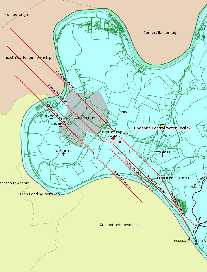
SIEGEL 8H Casing cementing notification Production Casing: 5/27/2021
SIEGEL 8H Casing cementing notification Production Casing: 5/27/2021 [Apparent duplication -jr]
SIEGEL 4H Drilling resumption After Break of 30 days or more 05/27/2021
SIEGEL 4H Drilling resumption After Break of 30 days or more 05/27/2021 [Apparent duplication -jr]
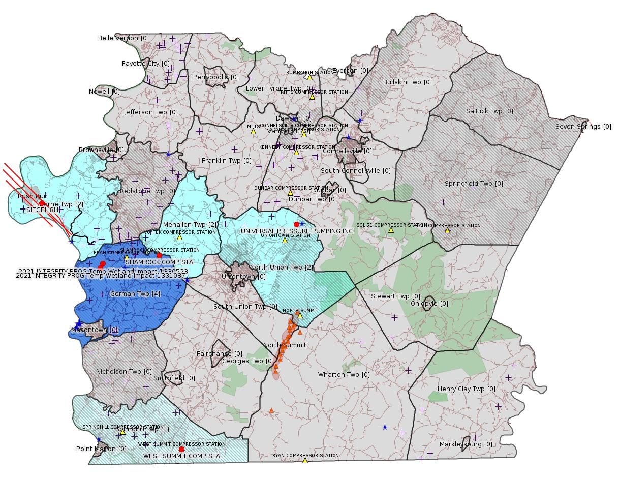
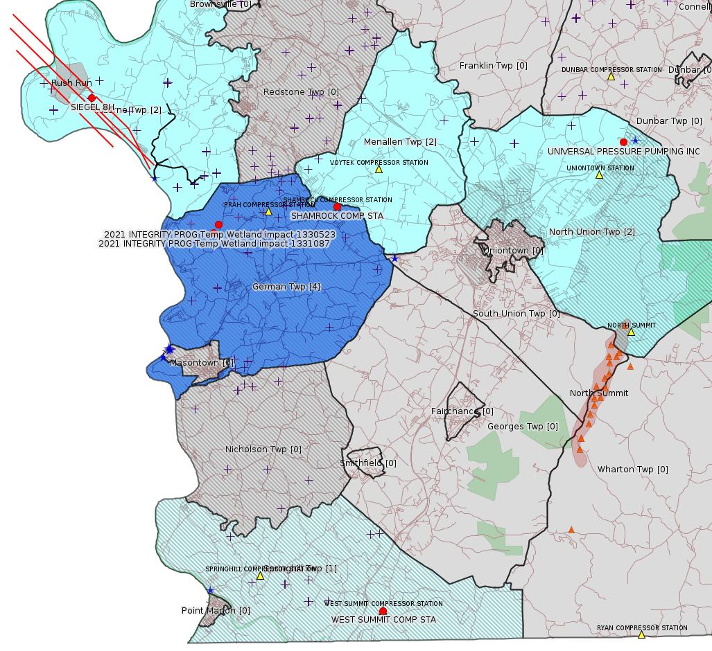
Map
Key
Red dots: items in this permit list with an exact location.
Blue stars: Marcellus Gas Well Water Sources.
Where well laterals are mapped they show in red; a 400-foot buffer surrounding the lateral shows in blue (lavender where it overlaps a mapped mineral tract).
Where mineral tracts are mapped, they show in pink. Mineral tracts can overlap; the overlap will show in red. The precise meaning of "mineral tract" is not clear.
Municipality shading: number of "facilities", with each well counting separately
(includes the red dots):
gray: 0
pale turquoise: 1
turquoise: 2
pale blue: 3
middle blue: 4
dark blue: 5
dark purple: 7
purple: 9
(Color coding may differ from one issue to the next.)
(Note if a project spans multiple municipalities -- e.g. a pipeline -- it will show in the count for each municipality.)
The number of facilities also follows the municipality name in brackets.
Municipality counts are based on the way the permit is listed by DEP; DEP has been known to get a municipality wrong.
Locations in brackets identify a precise location used to locate a surrogate for the actual site being permitted (e.g. locating a well pad or pipeline by the known location of a well.) Locations labeled beginning with "~" and ending in "[?]" are approximate and speculative based on inferences using on-line property and lease records. These are marked in the text as "[Approximate, Speculative]
Cross-hatching: Environmental Justice Areas
Yellow triangles: Compressor Stations
Orange triangles: Storage Field Wells (currently Dominion North Summit Storage Field)
Crosses: SPUD Unconventional well permits
Green: "Natural areas", e.g. state game lands, state forests
Yellow triangles: Compressor Stations
Orange triangles: Storage Field Wells (currently Dominion North Summit Storage Field)
Crosses: SPUD Unconventional well permits
Green: "Natural areas", e.g. state game lands, state forests
More Maps
 |
 |
Source: Pennsylvania Bulletin
NOTICES
DEPARTMENT OF
ENVIRONMENTAL PROTECTION
PA Clean Streams Law, the Dam Safety and Encroachments Act, and the Oil and Gas Act Public Notice of Settlement via Federal Consent Decree
[51 Pa.B. 2881]
[Saturday, May 22, 2021]
The Department of Environmental Protection (Department), under the authority of the PA Clean Streams Law (CSL), the Dam Safety and Encroachments Act (DSEA) and the Oil and Gas Act (OGA), has entered into a federal Consent Decree (CD) along with the United States Department of Justice (DOJ) on behalf of the United States Environmental Protection Agency (EPA) (Plaintiffs collectively ''the Agencies'') with Defendant Chesapeake Appalachia, LLC (CALLC).
The Department is providing notice of this settlement as a courtesy to inform the public. The CD was lodged in Federal court in Williamsport for court approval on March 24, 2021 and was subject to a 30-day public comment period from the date of notice in the Federal Register. The CD was noticed in the Federal Register on March 30, 2021 and can be found at 86 FR 16641 (March 30, 2021). The CD is available at www.justice.gov/enrd/Consent_Decrees.html.
A press release about this settlement can be found on the Department's web site at www.ahs.dep.pa.gov/NewsRoomPublic/articleviewer.aspx?id=21935&typeid=1.
This CD serves to resolve violations caused by the construction and operation of oil and gas activities, including unauthorized encroachments, water obstructions, earth disturbance and stormwater management activities in violation of Sections 401, 402 and 611 of the CSL, 35 P.S. §§ 691.401, 691.402 and 691.611, Sections 6, 13 and 18 of the DSEA, 32 P.S. §§ 693.6, 693.13 and 693.18, and Section 3259 of the OGA, 58 Pa.C.S. §§ 3259(2)(i) and (ii) and the rules and regulations thereunder. The 76 sites are located in Beaver, Bradford, Sullivan, Susquehanna and Wyoming Counties. The total disclosure of unauthorized impacts to waters of this Commonwealth include 2,326 linear feet of streams and 25.778 acres of wetlands. The CD includes a civil penalty payment of $1.9 million dollars, of which Pennsylvania will receive 50%. The CD also provides a path for returning the sites to compliance under Pennsylvania law by addressing impacts through restoration where permits would not have been authorized and proper permitting of allowable impacts, and will include additional mitigation through stream restoration and enhancement as well as wetland replacement, restoration and enhancement. The CD requires CALLC to submit permit applications for certain unauthorized water obstructions and encroachments and earth disturbance activities.
PATRICK McDONNELL,
Secretary
<http://www.pacodeandbulletin.gov/Display/pabull?file=/secure/pabulletin/data/vol51/51-21/810.html>
Federal Register Notice:
<https://www.justice.gov/enrd/consent-decree/file/1381286/download>
Consent Decree:
<https://www.law360.com/articles/1368432/attachments/0> (Sign-up required)
Consent Decree (Unofficial Copy):
<https://www.faymarwatch.org/documents/1368000-1368432-https-ecf-pamd-uscourts-gov-doc1-15517584245.pdf>
---
26-00585: Universal Pressure Pumping (18360 Technology Dr., Box 4, Meadville, PA 16335-8333). In accordance with 25 Pa. Code §§ 127.424, 127.425, and 127.521, the Department is providing notice that they intend to issue a renewal Natural Minor State Only Operating Permit (SOOP) to authorize the operation of the Mt. Braddock District Plant located in North Union Township, Fayette County.
Equipment at this facility includes two (2) sand storage tipples (Sand Tipples # 1 and # 3) equipped with dust collectors, five (5) cement storage silos equipped with dust collectors, two (2) fly ash storage silos equipped with dust collectors, a cement and fly ash mixing operation equipped with a dust collector, cement truck loading operations, four (4) cement and fly ash batch tanks, two (2) hydrochloric acid storage tanks equipped with an acid scrubber, an HCl transloading operation equipped with an acid scrubber, a waste oil space heater, a 66 Bhp diesel engine at Sand Tipple # 3, a diesel storage tank, and paved and unpaved roads and surfaces. The potential emissions from the facility are estimated to be: 2.31 tpy NOx, 2.38 tpy CO, 0.59 tpy SOx, 22.78 tpy PM, 22.16 tpy PM10, 0.01 tpy VOC, 0.05 tpy HCl, and 332 tpy GHG. This facility is subject to the applicable requirements of 25 Pa. Code Chapters 121—145. The proposed SOOP renewal includes conditions relating to applicable emissions restrictions, testing, monitoring, recordkeeping, reporting, and work practice standards requirements.
The application, DEP's Review Memorandum, and the proposed permit are available for public review during normal business hours at DEP's Southwest Regional Office, 400 Waterfront Drive, Pittsburgh, PA 15222. A file review can be scheduled through the DEP's website at https://www.dep.pa.gov/Citizens/PublicRecords/Pages/Informal-File-Review.aspx.
Any person may submit comments, a request for the Department to hold a public hearing, or a protest to the proposed operating permit or a condition thereof by submitting the information to Nick Waryanka, P.E., Air Quality Engineer, at the Southwest Regional Office. A 30-day comment period from the date of publication of this notice will exist for the submission of comments. Each written comment must contain the name, address and telephone number of the person submitting the comments, identification of the proposed permit (specify Operating Permit 26-00585) and concise statements regarding the relevancy of the information in the proposed permit or objections to issuance of the permit.
A public hearing may be held in accordance with 25 Pa. Code § 127.429, if the Department, in its discretion, decides that such a hearing is warranted based on the information received. If a public hearing is held, all persons who have properly filed a protest under 25 Pa. Code § 127.426 may appear and give testimony. The applicant, the protestant, and other participants will be notified of the decision to hold a hearing (and the time, place and purpose of such hearing) by publication in the newspaper or by the Pennsylvania Bulletin, or by telephone, where the Department determines such notification by telephone is sufficient.
<http://www.pacodeandbulletin.gov/Display/pabull?file=/secure/pabulletin/data/vol51/51-22/857a.html&continued=http://www.pacodeandbulletin.gov/Display/pabull?file=/secure/pabulletin/data/vol51/51-22/857.html&d=>
Location 39.94585,-79.655403 <http://osm.org/go/ZWpy31m3--?m=>
Municipalities: North Union Twp
Presumed Parcel Id: 2516000702
[See Notes.]Municipalities: North Union Twp
Presumed Parcel Id: 2516000702
-------------------------
Please see the Disclaimer below regarding Parcel Id data.
Authorization ID: 1354909
Permit number: AG5A-26-00001A
Site: WEST SUMMIT COMP STA
Client: INR OPR LLC
Authorization type: AQ GP 5A - Unconventional Natural Gas Well Site Operations
Application type: New
Authorization is for: FACILITY
Date received: 03/27/2021
Status: Pending
Permit Decision Guarantee Applies: No
Sub-Facilities for Authorization:
Sub-Facility ID Sub-Facility Name Description
1049057 GLYCOL DEHYS UNIT 2 Process
1186826 VENTING/BLOWDOWNS Process
1186820 TANKS/VESSELS Process
1025060 CATERPILLAR G3516B NATURAL GAS-FIRED COMPRESSOR ENGINE #6 Process
1186822 GLYCOL DEHYS UNIT 1 Process
1253786 WAUKESHA COMPRESSOR ENGINE #1 Process
1049059 FUGITIVES Process
1025054 CATERPILLAR G3516B NATURAL GAS-FIRED COMPRESSOR ENGINE #1 Process
1025055 CATERPILLAR G3516B NATURAL GAS-FIRED COMPRESSOR ENGINE #2 Process
1025056 CATERPILLAR G3516B NATURAL GAS-FIRED COMPRESSOR ENGINE #3 Process
1195514 PIGGING OPERATIONS Process
1186824 PNEUMATIC DEVICES Process
1186818 HEATERS/REBOILERS Process
1025058 CATERPILLAR G3516B NATURAL GAS-FIRED COMPRESSOR ENGINE #4 Process
1025059 CATERPILLAR G3516B NATURAL GAS-FIRED COMPRESSOR ENGINE #5 Process
1186817 NATURAL GAS LINE Fuel Material Location
Permit Review Notes:
Date Review Note
5/20/2021 The permit application package is complete, has been accepted, and is undergoing technical review.
<https://www.ahs.dep.pa.gov/eFACTSWeb/searchResults_singleAuth.aspx?AuthID=1354909>
Site Programs:
Air Quality
Site Municipalities:
Springhill Twp, Fayette County
AQ AEP Details:
CLIENT_ID: 360521
CLIENT: INR MIDSTREAM LLC
CLIENT_TYPE: NON-GOVERNMENT
CLIENT_ADDRESS1: 2605 CRANBERRY SQUARE
CLIENT_ADDRESS2:
CLIENT_CITY: MORGANTOWN
CLIENT_STATE: WV
CLIENT_ZIP: 26508-9201
SITE_ID: 739878
PRIMARY_FACILITY_ID: 734851
PRIMARY_FACILITY_NAME: INR MIDSTREAM LLC/WEST SUMMIT COMP STA
NAICS_CODE: 211130
NAICS_DESCRIPTION: Natural Gas Extraction
PRIMARY_FACILITY_STATUS: Active
FACILITY_TYPE: Other
REGION: Southwest Regional Office
COUNTY: Fayette
MUNICIPALITY: Springhill Twp
LATITUDE: 39.73437
LONGITUDE: -79.80091
LOCATION_ADDRESS1: GANS RD
LOCATION_ADDRESS2: SPRINGHILL FURNACE RD
LOCATION_CITY: LAKE LYNN
LOCATION_STATE: PA
LOCATION_ZIP: 15451
Presumed Parcel Id: 36210048
[See Notes.]
---
Authorization ID: 1354021
Permit number: GP082605221-002
Site: TEXAS EASTERN TRANS FAYETTE CNTY
Client: TEXAS EASTERN TRANS LP
Authorization type: GP-08 Temporary Road Crossings
Application type: New
Authorization is for: FACILITY
Date received: 05/11/2021
Status: Issued on 5/13/2021
Permit Decision Guarantee Applies: No
Permit Review Notes:
Date Review Note
5/13/2021 The technical review and decision review are complete and either the permit decision and/or permit issuance are forthcoming.
5/13/2021 The permit application package is complete, has been accepted, and is undergoing technical review.
<https://www.ahs.dep.pa.gov/eFACTSWeb/searchResults_singleAuth.aspx?AuthID=1354021>
Site Programs:
Water Planning and Conservation
Site Municipalities:
German Twp, Fayette County
Menallen Twp, Fayette County
North Union Twp, Fayette County
---
Authorization ID: 1353475
Permit number: GP082605221-001
Site: TEXAS EASTERN TRANS FAYETTE CNTY
Client: TEXAS EASTERN TRANS LP
Authorization type: GP-08 Temporary Road Crossings
Application type: New
Authorization is for: FACILITY
Date received: 04/28/2021
Status: Issued on 5/18/2021
Permit Decision Guarantee Applies: No
Sub-Facilities for Authorization:
Sub-Facility ID Sub-Facility Name Description
1331087 2021 INTEGRITY PROG FAYETTE CNTY 6 Temporary Wetland Impact
Location: 39.906909,-79.897965
Map URL: <http://www.openstreetmap.org/?mlat=39.906909&mlon=-79.897965#map=15/39.906909/-79.897965>
1330523 2021 INTEGRITY PROG FAYETTE CNTY 6 Temporary Wetland Impact
Location: 39.910914,-79.894815
Map URL: <http://www.openstreetmap.org/?mlat=39.910914&mlon=-79.894815#map=15/39.910914/-79.894815>
Permit Review Notes:
Date Review Note
5/18/2021 The technical review and decision review are complete and either the permit decision and/or permit issuance are forthcoming.
5/17/2021 The permit application package is complete, has been accepted, and is undergoing technical review.
<https://www.ahs.dep.pa.gov/eFACTSWeb/searchResults_singleAuth.aspx?AuthID=1353475>
Site Programs:
Water Planning and Conservation
Site Municipalities:
German Twp, Fayette County
Menallen Twp, Fayette County
North Union Twp, Fayette County
Presumed Parcel Id: 15110084
---
Authorization ID: 1353231
Permit number: 26-00588B
Site: SHAMROCK COMP STA
Client: LAUREL MTN MIDSTREAM OPR LLC
Authorization type: Minor Facility Plan Approval New Source Performance Std
Application type: Extension
Authorization is for: FACILITY
Date received: 04/22/2021
Status: Issued on 5/19/2021
Permit Decision Guarantee Applies: No
Sub-Facilities for Authorization:
Sub-Facility ID Sub-Facility Name Description
1045809 TANKS/VESSELS Process
Location: 39.918333,-79.825
Map URL: <http://www.openstreetmap.org/?mlat=39.918333&mlon=-79.825#map=15/39.918333/-79.825>
1024431 TEG DEHYDRATOR 1 (200 MMSCF/DAY) (DHY-01) Process
Location: 39.918333,-79.825
Map URL: <http://www.openstreetmap.org/?mlat=39.918333&mlon=-79.825#map=15/39.918333/-79.825>
1185234 HEATERS/REBOILERS Process
Location: 39.918333,-79.825
Map URL: <http://www.openstreetmap.org/?mlat=39.918333&mlon=-79.825#map=15/39.918333/-79.825>
1024438 ENGINE #6 OXIDATION CATALYST Air Pollution Control Device
Location: 39.918333,-79.825
Map URL: <http://www.openstreetmap.org/?mlat=39.918333&mlon=-79.825#map=15/39.918333/-79.825>
1284700 SOLAR TITAN SOLONOX COMBUSTION CONTROL Air Pollution Control Device
Location: 39.918333,-79.825
Map URL: <http://www.openstreetmap.org/?mlat=39.918333&mlon=-79.825#map=15/39.918333/-79.825>
1284687 CAT G3516J COMPRESSOR ENGINE (CE-04) (1380 HP) Process
Location: 39.918333,-79.825
Map URL: <http://www.openstreetmap.org/?mlat=39.918333&mlon=-79.825#map=15/39.918333/-79.825>
1284685 CAT G3516J COMPRESSOR ENGINE (CE-03) (1380 HP) Process
Location: 39.918333,-79.825
Map URL: <http://www.openstreetmap.org/?mlat=39.918333&mlon=-79.825#map=15/39.918333/-79.825>
1185240 FUG SITE COMPONENT FUGITIVE EMISSIONS Process
Location: 39.918333,-79.825
Map URL: <http://www.openstreetmap.org/?mlat=39.918333&mlon=-79.825#map=15/39.918333/-79.825>
1288255 TLO - TRUCK LOADOUT Process
Location: 39.918333,-79.825
Map URL: <http://www.openstreetmap.org/?mlat=39.918333&mlon=-79.825#map=15/39.918333/-79.825>
1087369 TEG DEHYDRATOR 2 (200 MMSCF/DAY)(DHY-02) Process
Location: 39.918333,-79.825
Map URL: <http://www.openstreetmap.org/?mlat=39.918333&mlon=-79.825#map=15/39.918333/-79.825>
1288250 ESU - ENGINE START UP Process
Location: 39.918333,-79.825
Map URL: <http://www.openstreetmap.org/?mlat=39.918333&mlon=-79.825#map=15/39.918333/-79.825>
1087412 CATERPILLAR G3516B EMERGENCY GENERATOR (1,818 BHP)(EG-01) Process
Location: 39.918333,-79.825
Map URL: <http://www.openstreetmap.org/?mlat=39.918333&mlon=-79.825#map=15/39.918333/-79.825>
1087413 CATERPILLAR G3516B EMERGENCY GENERATOR OXIDATION CATALYST Air Pollution Control Device
Location: 39.918333,-79.825
Map URL: <http://www.openstreetmap.org/?mlat=39.918333&mlon=-79.825#map=15/39.918333/-79.825>
1195984 PIG - PIGGING OPERATIONS Process
Location: 39.918333,-79.825
Map URL: <http://www.openstreetmap.org/?mlat=39.918333&mlon=-79.825#map=15/39.918333/-79.825>
1185238 CBD - COMPRESSOR /FACILITY VENTING/BLOWDOWNS Process
Location: 39.918333,-79.825
Map URL: <http://www.openstreetmap.org/?mlat=39.918333&mlon=-79.825#map=15/39.918333/-79.825>
1024428 SOLAR MARS 100-16000S TURBINE (15,252 HP) (CT-01) Process
Location: 39.918333,-79.825
Map URL: <http://www.openstreetmap.org/?mlat=39.918333&mlon=-79.825#map=15/39.918333/-79.825>
1024427 CATERPILLAR G3516B COMPRESSOR ENGINE (CE-06) (1380 BHP) Process
Location: 39.918333,-79.825
Map URL: <http://www.openstreetmap.org/?mlat=39.918333&mlon=-79.825#map=15/39.918333/-79.825>
1284691 CAT 3516J CE-03 CAT OX Air Pollution Control Device
Location: 39.918333,-79.825
Map URL: <http://www.openstreetmap.org/?mlat=39.918333&mlon=-79.825#map=15/39.918333/-79.825>
1284695 SOLAR TITAN 130 -23502S (21,158 HP)(CT-02) Process
Location: 39.918333,-79.825
Map URL: <http://www.openstreetmap.org/?mlat=39.918333&mlon=-79.825#map=15/39.918333/-79.825>
1284697 GLYCOL PURIFICATION UNIT (GPU-ENG, GPU-HTR) Process
Location: 39.918333,-79.825
Map URL: <http://www.openstreetmap.org/?mlat=39.918333&mlon=-79.825#map=15/39.918333/-79.825>
1284699 CAT 3516J CE-04 CAT OX Air Pollution Control Device
Location: 39.918333,-79.825
Map URL: <http://www.openstreetmap.org/?mlat=39.918333&mlon=-79.825#map=15/39.918333/-79.825>
1288248 CRP - COMPRESSOR ROD PACKING EMISSIONS Process
Location: 39.918333,-79.825
Map URL: <http://www.openstreetmap.org/?mlat=39.918333&mlon=-79.825#map=15/39.918333/-79.825>
1288253 TSS - TURBINE SSM Process
Location: 39.918333,-79.825
Map URL: <http://www.openstreetmap.org/?mlat=39.918333&mlon=-79.825#map=15/39.918333/-79.825>
1288242 ECC - ENGINE CRANK CASE EMISSIONS Process
Location: 39.918333,-79.825
Map URL: <http://www.openstreetmap.org/?mlat=39.918333&mlon=-79.825#map=15/39.918333/-79.825>
1288244 DGS - COMPRESSOR DRY GAS SEAL LEAKS Process
Location: 39.918333,-79.825
Map URL: <http://www.openstreetmap.org/?mlat=39.918333&mlon=-79.825#map=15/39.918333/-79.825>
Permit Review Notes:
Date Review Note
5/19/2021 The technical review and decision review are complete and either the permit decision and/or permit issuance are forthcoming.
5/18/2021 Applicant has been issued a deficiency letter. If applicable, this application no longer qualifies for the Permit Decision Guarantee.
<https://www.ahs.dep.pa.gov/eFACTSWeb/searchResults_singleAuth.aspx?AuthID=1353231>
Site Programs:
Air Quality
Site Municipalities:
German Twp, Fayette County
Parcel
ID: 15140026
---
Authorization ID: 1349958
Permit number: GP112605221-010
Site: TEXAS EASTERN TRANS FAYETTE CNTY
Client: TEXAS EASTERN TRANS LP
Authorization type: BWM-GP-11 Maintenance, Testing, Repair, Rehabilitation or Replacement General Pmt
Application type: New
Authorization is for: FACILITY
Date received: 04/08/2021
Status: Issued on 5/13/2021
Permit Decision Guarantee Applies: Yes
Permit Decision Guarantee status: VOID
Permit Review Notes:
Date Review Note
5/13/2021 The technical review and decision review are complete and either the permit decision and/or permit issuance are forthcoming.
5/11/2021 Applicant has been issued a deficiency letter. If applicable, this application no longer qualifies for the Permit Decision Guarantee.
5/5/2021 Applicant has been issued a deficiency letter. If applicable, this application no longer qualifies for the Permit Decision Guarantee.
<https://www.ahs.dep.pa.gov/eFACTSWeb/searchResults_singleAuth.aspx?AuthID=1349958>
Site Programs:
Water Planning and Conservation
Site Municipalities:
German Twp, Fayette County
Menallen Twp, Fayette County
North Union Twp, Fayette County
-------------------------
Source: DEP Electronic Notifications
NOTIFICATION_ID: 56456
OGO: 39307
OPERATOR: EQT CHAP LLC
API_PERMIT: 051-24647
SPUD_DATE: 04/02/2018
COUNTY: Fayette
MUNICIPALITY: Luzerne
LATITUDE: 39.969
LONGITUDE: -79.96893
SUBJECT: [NOTIFICATION]: Casing cementing notification 58 Pa. C.S. 3211(f)(2) for well API 37-051-24647-00-00
QUESTION: Enter the Date and Time for the applicable Casing Types
ANSWER: Production Casing: 5/27/2021 6:00:00 AM
SENT_DATE: 5/24/2021 6:01:39 AM
SENT_SUCCESS: Yes
LAST_RESENT_DATE:
RESENT_SUCCESS:
REGION: EP DOGO SWDO Dstr Off
Comments: Patterson 294. Estimated 5.5" Cement Job on 5/27 @ approximately 6:00 a.m.
Well Details:
Permit Number: 051-24647
Well Name: SIEGEL 8H
Unconventional Well: Y
Well Configuration: Horizontal Well
Well Type: GAS
Well Status: Active
Coal Association: Coal
Conservation Well: N
Primary Facility ID: 823795
Site ID: 790384
Site Name: SIEGEL WELL PAD ESCGP-2 EXPEDITED
Well Pad ID: 152926
Well Pad Name: SIEGEL 1
Storage Field:
Operator: EQT CHAP LLC
Operator Number: OGO-39307
Permit Date: 2018-02-23
Permit Date Expires: 2022-04-09
SPUD Date: 2018-04-02
Date Plugged:
UIC ID:
UIC Type:
Surface Elevation: 1173
County: Fayette
Municipality: Luzerne Twp
Location: 39.969,-79.96893
Map URL: <http://www.openstreetmap.org/?mlat=39.969&mlon=-79.96893#map=15/39.969/-79.96893>
Public Permit Review:
http://www.ahs.dep.pa.gov/ePermitPublicAccess/Public/PublicAuthOverview?q=KvXDkwMvCZH8wSNp3iwn5roUrh3Tppr7Cx804lbXXy0%3d
Presumed Parcel Id: 19240018
---
NOTIFICATION_ID: 56457
OGO: 39307
OPERATOR: EQT CHAP LLC
API_PERMIT: 051-24647
SPUD_DATE: 04/02/2018
COUNTY: Fayette
MUNICIPALITY: Luzerne
LATITUDE: 39.969
LONGITUDE: -79.96893
SUBJECT: [NOTIFICATION]: Casing cementing notification 58 Pa. C.S. 3211(f)(2) for well API 37-051-24647-00-00
QUESTION: Enter the Date and Time for the applicable Casing Types
ANSWER: Production Casing: 5/27/2021 6:00:00 AM
SENT_DATE: 5/24/2021 6:01:40 AM
SENT_SUCCESS: Yes
LAST_RESENT_DATE:
RESENT_SUCCESS:
REGION: EP DOGO SWDO Dstr Off
Comments: Patterson 294. Estimated 5.5" Cement Job on 5/27 @ approximately 6:00 a.m.
Well Details above
Well Name: SIEGEL 8H
---
NOTIFICATION_ID: 56458
OGO: 39307
OPERATOR: EQT CHAP LLC
API_PERMIT: 051-24642
SPUD_DATE: 04/02/2018
COUNTY: Fayette
MUNICIPALITY: Luzerne
LATITUDE: 39.96885
LONGITUDE: -79.96899
SUBJECT: [NOTIFICATION]: Drilling resumption After Break of 30 days or more notification 58 Pa. C.S. 3211(f)(1) for well API 37-051-24642-00-00
QUESTION: Date and approximate time action is to occur
ANSWER: Date: 05/27/2021 Time: 6:00 PM
SENT_DATE: 5/24/2021 6:03:00 AM
SENT_SUCCESS: Yes
LAST_RESENT_DATE:
RESENT_SUCCESS:
REGION: EP DOGO SWDO Dstr Off
Comments: Patterson 294. Estimated Re-Entry on 5/27 @ approximately 6:00 p.m.
Well Details:
Permit Number: 051-24642
Well Name: SIEGEL 4H
Unconventional Well: Y
Well Configuration: Horizontal Well
Well Type: GAS
Well Status: Active
Coal Association: Coal
Conservation Well: N
Primary Facility ID: 823790
Site ID: 790384
Site Name: SIEGEL WELL PAD ESCGP-2 EXPEDITED
Well Pad ID: 152926
Well Pad Name: SIEGEL 1
Storage Field:
Operator: EQT CHAP LLC
Operator Number: OGO-39307
Permit Date: 2018-02-15
Permit Date Expires: 2022-04-09
SPUD Date: 2018-04-02
Date Plugged:
UIC ID:
UIC Type:
Surface Elevation: 1173
County: Fayette
Municipality: Luzerne Twp
Location: 39.96885,-79.96899
Map URL: <http://www.openstreetmap.org/?mlat=39.96885&mlon=-79.96899#map=15/39.96885/-79.96899>
---
NOTIFICATION_ID: 56459
OGO: 39307
OPERATOR: EQT CHAP LLC
API_PERMIT: 051-24642
SPUD_DATE: 04/02/2018
COUNTY: Fayette
MUNICIPALITY: Luzerne
LATITUDE: 39.96885
LONGITUDE: -79.96899
SUBJECT: [NOTIFICATION]: Drilling resumption After Break of 30 days or more notification 58 Pa. C.S. 3211(f)(1) for well API 37-051-24642-00-00
QUESTION: Date and approximate time action is to occur
ANSWER: Date: 05/27/2021 Time: 6:00 PM
SENT_DATE: 5/24/2021 6:03:01 AM
SENT_SUCCESS: Yes
LAST_RESENT_DATE:
RESENT_SUCCESS:
REGION: EP DOGO SWDO Dstr Off
Comments: Patterson 294. Estimated Re-Entry on 5/27 @ approximately 6:00 p.m.
Well Details above
Well Name: SIEGEL 4H
-------------------------NOTIFICATION_ID: 56456
OGO: 39307
OPERATOR: EQT CHAP LLC
API_PERMIT: 051-24647
SPUD_DATE: 04/02/2018
COUNTY: Fayette
MUNICIPALITY: Luzerne
LATITUDE: 39.969
LONGITUDE: -79.96893
SUBJECT: [NOTIFICATION]: Casing cementing notification 58 Pa. C.S. 3211(f)(2) for well API 37-051-24647-00-00
QUESTION: Enter the Date and Time for the applicable Casing Types
ANSWER: Production Casing: 5/27/2021 6:00:00 AM
SENT_DATE: 5/24/2021 6:01:39 AM
SENT_SUCCESS: Yes
LAST_RESENT_DATE:
RESENT_SUCCESS:
REGION: EP DOGO SWDO Dstr Off
Comments: Patterson 294. Estimated 5.5" Cement Job on 5/27 @ approximately 6:00 a.m.
Well Details:
Permit Number: 051-24647
Well Name: SIEGEL 8H
Unconventional Well: Y
Well Configuration: Horizontal Well
Well Type: GAS
Well Status: Active
Coal Association: Coal
Conservation Well: N
Primary Facility ID: 823795
Site ID: 790384
Site Name: SIEGEL WELL PAD ESCGP-2 EXPEDITED
Well Pad ID: 152926
Well Pad Name: SIEGEL 1
Storage Field:
Operator: EQT CHAP LLC
Operator Number: OGO-39307
Permit Date: 2018-02-23
Permit Date Expires: 2022-04-09
SPUD Date: 2018-04-02
Date Plugged:
UIC ID:
UIC Type:
Surface Elevation: 1173
County: Fayette
Municipality: Luzerne Twp
Location: 39.969,-79.96893
Map URL: <http://www.openstreetmap.org/?mlat=39.969&mlon=-79.96893#map=15/39.969/-79.96893>
Public Permit Review:
http://www.ahs.dep.pa.gov/ePermitPublicAccess/Public/PublicAuthOverview?q=KvXDkwMvCZH8wSNp3iwn5roUrh3Tppr7Cx804lbXXy0%3d
Presumed Parcel Id: 19240018
---
NOTIFICATION_ID: 56457
OGO: 39307
OPERATOR: EQT CHAP LLC
API_PERMIT: 051-24647
SPUD_DATE: 04/02/2018
COUNTY: Fayette
MUNICIPALITY: Luzerne
LATITUDE: 39.969
LONGITUDE: -79.96893
SUBJECT: [NOTIFICATION]: Casing cementing notification 58 Pa. C.S. 3211(f)(2) for well API 37-051-24647-00-00
QUESTION: Enter the Date and Time for the applicable Casing Types
ANSWER: Production Casing: 5/27/2021 6:00:00 AM
SENT_DATE: 5/24/2021 6:01:40 AM
SENT_SUCCESS: Yes
LAST_RESENT_DATE:
RESENT_SUCCESS:
REGION: EP DOGO SWDO Dstr Off
Comments: Patterson 294. Estimated 5.5" Cement Job on 5/27 @ approximately 6:00 a.m.
Well Details above
Well Name: SIEGEL 8H
---
NOTIFICATION_ID: 56458
OGO: 39307
OPERATOR: EQT CHAP LLC
API_PERMIT: 051-24642
SPUD_DATE: 04/02/2018
COUNTY: Fayette
MUNICIPALITY: Luzerne
LATITUDE: 39.96885
LONGITUDE: -79.96899
SUBJECT: [NOTIFICATION]: Drilling resumption After Break of 30 days or more notification 58 Pa. C.S. 3211(f)(1) for well API 37-051-24642-00-00
QUESTION: Date and approximate time action is to occur
ANSWER: Date: 05/27/2021 Time: 6:00 PM
SENT_DATE: 5/24/2021 6:03:00 AM
SENT_SUCCESS: Yes
LAST_RESENT_DATE:
RESENT_SUCCESS:
REGION: EP DOGO SWDO Dstr Off
Comments: Patterson 294. Estimated Re-Entry on 5/27 @ approximately 6:00 p.m.
Well Details:
Permit Number: 051-24642
Well Name: SIEGEL 4H
Unconventional Well: Y
Well Configuration: Horizontal Well
Well Type: GAS
Well Status: Active
Coal Association: Coal
Conservation Well: N
Primary Facility ID: 823790
Site ID: 790384
Site Name: SIEGEL WELL PAD ESCGP-2 EXPEDITED
Well Pad ID: 152926
Well Pad Name: SIEGEL 1
Storage Field:
Operator: EQT CHAP LLC
Operator Number: OGO-39307
Permit Date: 2018-02-15
Permit Date Expires: 2022-04-09
SPUD Date: 2018-04-02
Date Plugged:
UIC ID:
UIC Type:
Surface Elevation: 1173
County: Fayette
Municipality: Luzerne Twp
Location: 39.96885,-79.96899
Map URL: <http://www.openstreetmap.org/?mlat=39.96885&mlon=-79.96899#map=15/39.96885/-79.96899>
---
NOTIFICATION_ID: 56459
OGO: 39307
OPERATOR: EQT CHAP LLC
API_PERMIT: 051-24642
SPUD_DATE: 04/02/2018
COUNTY: Fayette
MUNICIPALITY: Luzerne
LATITUDE: 39.96885
LONGITUDE: -79.96899
SUBJECT: [NOTIFICATION]: Drilling resumption After Break of 30 days or more notification 58 Pa. C.S. 3211(f)(1) for well API 37-051-24642-00-00
QUESTION: Date and approximate time action is to occur
ANSWER: Date: 05/27/2021 Time: 6:00 PM
SENT_DATE: 5/24/2021 6:03:01 AM
SENT_SUCCESS: Yes
LAST_RESENT_DATE:
RESENT_SUCCESS:
REGION: EP DOGO SWDO Dstr Off
Comments: Patterson 294. Estimated Re-Entry on 5/27 @ approximately 6:00 p.m.
Well Details above
Well Name: SIEGEL 4H
[Repeat note from the 6/30/19
Issue of this Bulletin:] Sub-Facilities for the UNIVERSAL
PRESSURE PUMPING site were listed in the
5/20/18 issue of this bulletin as:
The Pennsylvania Bulletin listing for this permit from the June 22, 2013 Issue of PA Bulletin states:
26-00585: Universal Well Services—Connellsville Camp Facility (730 Braddock View Dr., P. O. Box 130, Mount Braddock, PA 15465-0130) for the operation of a sand, cement, fly ash, and HCl storage and loading facility for the oil and gas industry located in North Union Township, Fayette County. In accordance with 25 Pa Code §§ 127.424 and 127.425 the Department of Environmental Protection (DEP) has received an application and intends to issue an Air Quality Operating Permit for the above mentioned facility. The permit includes monitoring, recordkeeping, reporting, testing, and work practice requirements designed to keep the facility operating within all applicable air quality requirements.
(The original owner was listed as Universal Well Services, Inc.)
---
The previous permit for the West Summit Compressor Station was GP5-26-00589A. The [notorious] General Permit GP-5 from the Bureau of Air Quality apparently caused confusion in naming with the stream crossing permit GP-05, so apparently the BAQ has changed its naming scheme for these permits, and the new permit number for West Summit is AG5A-26-00001A. Having the permit number change with each revision is a longstanding BAQ Data Horror, which thankfully the other fiefdoms at DEP don't share.
The list of sub-facilities for this compressor station shows 5 compression engines and no oxidation catalysts. If that is correct, that would make it an extremely dirty compressor station. An oxidation catalyst is known to cut the emissions of NOx substantially; for the years 2012 - 2014, the top compressor station emitter of NOx in Fayette County was the West Summit Compressor Station at 55.63 tons per year for 2014, exceeding even Shamrock. (Data for this comes from the DEP Marcellus Shale Air Emissions Inventory, which is entirely industry self-reported.)
Sub-Facilities for Authorization:
Sub-Facility ID Sub-Facility Name Description
1103853 CEMENT & FLY ASH MIXING Process
1103745 CEMENT/FLY ASH SILOS (3) Process
1103856 DIESEL STORAGE TANK Process
1103858 HCL STORAGE TANKS (2) Process
1103863 HCL STORAGE TANKS SCRUBBER Air Pollution Control Device
1103867 HCL TRANSLOADING SCRUBBER Air Pollution Control Device
1103864 HCL TRANSLOADING SYSTEM Process
1103955 PLANT PAVED & UNPAVED ROADS & SURFACES Process
1103736 SAND TIPPLE #1 Process
1103740 SAND TIPPLE #1 DUST COLLECTOR Air Pollution Control Device
1103741 SAND TIPPLE #2 Process
1103744 SAND TIPPLE #2 DUST SCRUBBER Air Pollution Control Device
1103855 SILOS & MIXING DUST COLLECTOR Air Pollution Control Device
1103868 WASTE OIL SPACE HEATER Process
The Pennsylvania Bulletin listing for this permit from the June 22, 2013 Issue of PA Bulletin states:
26-00585: Universal Well Services—Connellsville Camp Facility (730 Braddock View Dr., P. O. Box 130, Mount Braddock, PA 15465-0130) for the operation of a sand, cement, fly ash, and HCl storage and loading facility for the oil and gas industry located in North Union Township, Fayette County. In accordance with 25 Pa Code §§ 127.424 and 127.425 the Department of Environmental Protection (DEP) has received an application and intends to issue an Air Quality Operating Permit for the above mentioned facility. The permit includes monitoring, recordkeeping, reporting, testing, and work practice requirements designed to keep the facility operating within all applicable air quality requirements.
(The original owner was listed as Universal Well Services, Inc.)
---
The previous permit for the West Summit Compressor Station was GP5-26-00589A. The [notorious] General Permit GP-5 from the Bureau of Air Quality apparently caused confusion in naming with the stream crossing permit GP-05, so apparently the BAQ has changed its naming scheme for these permits, and the new permit number for West Summit is AG5A-26-00001A. Having the permit number change with each revision is a longstanding BAQ Data Horror, which thankfully the other fiefdoms at DEP don't share.
The list of sub-facilities for this compressor station shows 5 compression engines and no oxidation catalysts. If that is correct, that would make it an extremely dirty compressor station. An oxidation catalyst is known to cut the emissions of NOx substantially; for the years 2012 - 2014, the top compressor station emitter of NOx in Fayette County was the West Summit Compressor Station at 55.63 tons per year for 2014, exceeding even Shamrock. (Data for this comes from the DEP Marcellus Shale Air Emissions Inventory, which is entirely industry self-reported.)
------------------------
<https://www.dep.pa.gov/PublicParticipation/OfficeofEnvironmentalJustice/Pages/default.aspx>). There are supposed to be enhanced public participation requirements for permits in environmental justice areas, but news of this actually ever happening is scarce. In Fayette County, the entirety of Redstone, Springhill, Nicholson, and German Townships are environmental justice areas, as well as a large part of Dunbar Township. DEP's policy document on public participation guidelines for environmental justice areas is located here:
<https://www.elibrary.dep.state.pa.us/dsweb/Get/Version-48671/012-0501-002.pdf>
eNOTICE records are likely to list the same permit multiple times, as that permit moves through the DEP process.
Oil & Gas Wells designated with a site a number and the letter H typically designate horizontal wells.
-------------------------
Resources:
Pennsylvania Bulletin: <https://www.pabulletin.com/>
eNOTICE: <https://www.ahs2.dep.state.pa.
DEP Oil and Gas Reports: <https://www.dep.pa.gov/DataandTools/Reports/Oil%20and%20Gas%20Reports/Pages/default.aspx>
DEP Permits Issued Detail Report:
<http://cedatareporting.pa.gov/Reportserver/Pages/ReportViewer.aspx?/Public/DEP/OG/SSRS/Permits_Issued_Detail>
DEP SPUD (drilling started) Report:
<http://cedatareporting.pa.gov/Reportserver/Pages/ReportViewer.aspx?/Public/DEP/OG/SSRS/Spud_External_Data>
DEP Oil and Gas Compliance Report:
<http://cedatareporting.pa.gov/Reportserver/Pages/ReportViewer.aspx?/Public/DEP/OG/SSRS/OG_Compliance>
DEP PA Oil & Gas Mapping:
<https://www.depgis.state.pa.us/PaOilAndGasMapping>
Data Portal Services Directory [Technical]
<https://www.depgis.state.pa.us/arcgis/rest/services>
Query: Oil and Gas Wells All (ID: 3) [Technical]:
<https://www.depgis.state.pa.us/arcgis/rest/services/OilGas/OilGasAllStrayGasEGSP/MapServer/3/query?where=&text=&objectIds=&time=&geometry=&geometryType=esriGeometryEnvelope&inSR=&spatialRel=esriSpatialRelIntersects&relationParam=&outFields=*&returnGeometry=true&returnTrueCurves=false&maxAllowableOffset=&geometryPrecision=&outSR=&returnIdsOnly=false&returnCountOnly=false&orderByFields=&groupByFieldsForStatistics=&outStatistics=&returnZ=false&returnM=false&gdbVersion=&returnDistinctValues=false&resultOffset=&resultRecordCount=&f=html>
(Be sure to enter a Where clause in SQL format. Dates are in milliseconds since midnight 1/1/1970).
DEP Oil and Gas Electronic Submissions
<https://www.ahs.dep.pa.gov/eSubmissionPublicSearch>
DEP Air Quality Air Emission Plants Facilities Report
<http://cedatareporting.pa.gov/Reportserver/Pages/ReportViewer.aspx?/Public/DEP/AQ/SSRS/AQ_AEP_Facilities>
DEP Oil and Gas Electronic Notifications
<http://cedatareporting.pa.gov/Reportserver/Pages/ReportViewer.aspx?/Public/DEP/OG/SSRS/OG_Notifications>
DEP Oil and Gas Well Pad Report
<http://cedatareporting.pa.gov/Reportserver/Pages/ReportViewer.aspx?/Public/DEP/OG/SSRS/Well_Pads>
Fayette County Assessment Office Search For Tax Records:
<http://property.co.fayette.pa.us/search.aspx>
Pennsylvania Spatial Data Access:
<https://www.pasda.psu.edu/default.asp>
DEP Spatial Data Repository:
<ftp://www.pasda.psu.edu/pub/pasda/dep/>
National Response Center:
<https://www.nrc.uscg.mil/>
EPA-Echo: <https://www.epa-echo.gov/echo/
FERC citizen involvement: <https://www.ferc.gov/for-citiz
To receive E-mail notification of
all documents filed in a FERC docket, see:
<https://www.ferc.gov/docs-filing/esubscription.asp >
<https://www.ferc.gov/docs-fili
Follow the directions and enter the docket number to subscribe to.
Township Supervisors receive information regarding Erosion & Sedimentation permits, and these records may be reviewable at township municipal offices.
DEP permits are reviewable through the File Review process, for application to do file review see: <https://www.portal.state.pa.us/portal/server.pt/community/southwest_regional_office/13775/file_review/593164>
Environmental Hearing Board: <https://ehb.courtapps.com/publ
PA DEP Environmental Policy Comment System:
<https://www.ahs.dep.pa.gov/eComment/>
Federal Register Environment: <https://www.federalregister.g
Browsing of recent comment
opportunities for federal agencies, e.g. EPA. Click "sign up" to
subscribe to daily E-mails of new document listings.
SkyTruth Fayette County Drilling Alerts: <https://frack.skytruth.org/pen
U.S. Army Corps of Engineers, Pittsburgh District, Public Notices:
<https://www.lrp.usace.army.mil/Missions/Regulatory/Public-Notices/>
EPA Pennsylvania Public Notices: <https://www2.epa.gov/aboutepa/epa-pennsylvania#notice>
Marcellus Shale waste disposal
injection wells in Pennsylvania are regulated directly by EPA, not
DEP. Notice of any new permit applications will appear at the
above web address. I'm not aware of any subscription service
to be notified of such applications. I'm not aware of any
Marcellus Shale waste disposal injection wells in Fayette County
(yet ...) but we need to monitor this page for future
applications.
Energy Assurance Daily: <https://www.oe.netl.doe.gov/ead.aspx>
Daily newsletter from the US
Department of Energy about events relating to energy. The Natural
Gas section has information about pipelines.
-------------------------
Disclaimers:
This compilation from the above sources was done in part by hand using copy and paste and in part using automated methods; it may omit relevant permits.
Parcel data is provided via the tax records search web page offered by the Fayette County Assessment Office (http://property.co.fayette.pa.us/). Presumed Parcel Id links are subject to availability provided by that agency and associated web sites. Presumed Parcel Ids are determined as the mapped parcel containing a given latitude and longitude, are a best effort determination which is subject to error, and are not official. In cases where a facility is leased and there is a separate parcel id for the lease, if this parcel id is not separately mapped, the parcel id shown will be the id for the enclosing parcel. Parcel owners may be surface owners only and may or may not have any relationship to oil & gas facilities.
Does not currently include water supply permits. Does not include landfill permits even though many such are for Marcellus Shale waste. (It is not possible at this time to distinguish which landfill permits are for Marcellus Shale waste and which are not without doing File Review for each permit.)
Erosion & Sedimentation permit records do not currently include latitude and longitude. Where I am publishing latitude and longitude with E&S permits it is by inferring an associated well permit and using published latitude and longitude for the well. It is possible I may be inferring the wrong well site.
Municipalities are shown from eFACTS records on the DEP web site. The DEP has been known to list a municipality incorrectly.