The Harmed Success Stories Concepts How To What Is Commentary
Fayette County Marcellus Shale Permits 6/17/19 - 6/30/19
Contents
Pennsylvania Bulletin Listings
ENVIRONMENTAL QUALITY BOARD PROPOSED RULEMAKING Acceptance of Rulemaking Petitions for Study amendment of an existing regulatory exclusion from hazardous waste listingeFACTS Listings
PENNSYLVANIA PUBLIC UTILITY COMMISSION PROPOSED RULEMAKING Hazardous Liquid Public Utility Safety Standards; Advanced Notice of Proposed Rulemaking
Advanced Disposal Service Chestnut Valley Landfill Inc. PAG-03 Discharge of Stormwater Assoc w Industrial Activities
Shamrock Compressor Station Minor Facility Plan Approval New Source Performance Std
CHRISTOFEL WELL PAD A Erosion and Sediment Control General Permit 3
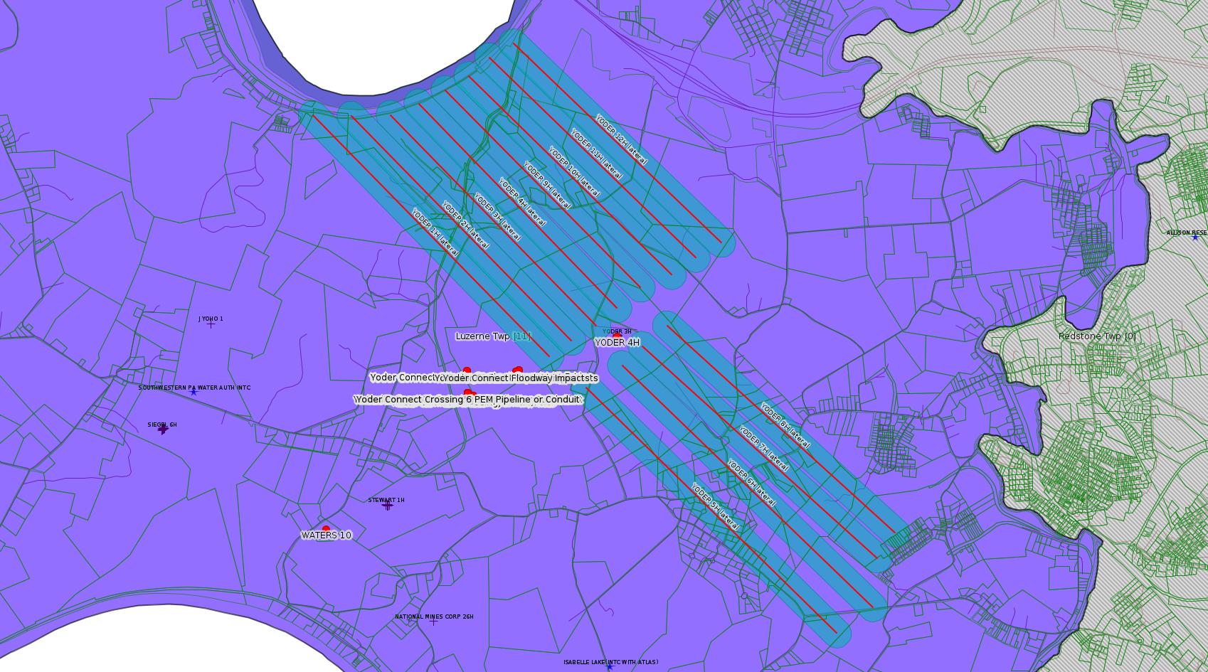
Yoder Well Connect Pipeline Project GP-05 Utility Line Stream Crossings (New)
Yoder Well Connect Pipeline Project GP-08 Temporary Road Crossings (New)
KEYROCK ENERGY CONNELSVILLE COMPRESSOR STA AQ GP 5 - Natural Gas Compression and/or Processing Facilities (New)
DOMINION ENERGY TRANS INC NORTH SUMMIT COMP STA Major Facility Operating Permit Modification
CHESTNUT VALLEY LDFL Minor IW Facility with ELG
COASTAL 2V Drill & Operate Well Permit (Conventional)
CHESTNUT VALLEY LDFL Landfill Pmt Final Construction Certification Form 37
LPR MIDSTREAM PARTNERS LLC POLK PIPELINE Erosion and Sediment Control GP-2 Transfer
CHESTNUT VALLEY LDFL PAG-03 Discharge of Stormwater Assoc w Industrial Activities Issued 6/12/2019
CHESTNUT VALLEY LDFL Landfill Pmt Final Construction Certification Form 37
GANS GENERATING FAC Major Facility Operating Permit Renewal Issued 6/19/2019
CHRISTOFEL WELL PAD A Erosion and Sediment Control General Permit 3 Issued 6/14/2019
WASHITA VALLEY ENTERPRISES INC HOPWOOD PAG-03 Discharge of Stormwater Assoc w Industrial Activities Issued 6/24/2019
UNIVERSAL PRESSURE PUMPING INC Minor Source Operating Permit Renewal
GANS GENERATING FAC Major Facility Operating Permit AmendmentIssued 6/19/2019
Wells SPUD
Electronic NotificationsHERRIOTT M02H 2019-06-18
HERRIOTT M03H 2019-06-18
HERRIOTT M04H 2019-06-19
HERRIOTT M05H 2019-06-19
HERRIOTT M06H 2019-06-20
HERRIOTT M07H 2019-06-20
HERRIOTT M08H 2019-06-21
HERRIOTT M09H 2019-06-21
EDENBORN/RGGS B M04H Casing cementing notification Coal Protected Casing 1: 6/21/2019
EDENBORN/RGGS B M03H Drilling resumption After Break of 30 days or more 06/21/2019
EDENBORN/RGGS B M03H Casing cementing notification Surface: 6/22/2019
YODER 4H Casing cementing notification Production Casing: 6/22/2019
EDENBORN/RGGS B M03H Casing cementing notification Coal Protected Casing 1: 6/23/2019
EDENBORN/RGGS B M02H Drilling resumption After Break of 30 days or more 06/24/2019
EDENBORN/RGGS B M02H Casing cementing notification Surface: 6/25/2019
EDENBORN/RGGS B M02H Casing cementing notification Coal Protected Casing 1: 6/26/2019
YODER 3H Drilling resumption After Break of 30 days or more 06/23/2019
EDENBORN/RGGS B M01H Drilling resumption After Break of 30 days or more 06/27/2019
EDENBORN/RGGS B M01H Casing cementing notification Surface: 6/28/2019
EDENBORN/RGGS B M01H Casing cementing notification Coal Protected Casing 1: 6/29/2019
HERRIOTT M02H Drilling resumption After Break of 30 days or more 07/01/2019
EDENBORN/RGGS B M14H Drilling resumption After Break of 30 days or more 06/30/2019
EDENBORN/RGGS B M14H Casing cementing notification Surface: 7/1/2019
EDENBORN/RGGS B M14H Casing cementing notification Coal Protected Casing 1: 7/2/2019
YODER 3H Casing cementing notification Production Casing: 6/29/2019
YODER 2H Drilling resumption After Break of 30 days or more 06/29/2019
EDENBORN/RGGS B M15H Drilling resumption After Break of 30 days or more 6/30/2019
EDENBORN/RGGS B M15H Casing cementing notification Surface: 7/3/2019
Inspection Anomalies (Oil & Gas
Compliance Report)
DEP Oil and Gas Electronic
NotificationsWATERS 10 visible seepage from rust holes; ground plume of contamination; Gravel and other debris remained sloughed onto the public roadway; [added] Violation(s) Noted [from previous inspection]
YODER 1H contaminated equipment, and refuse containers being stored without secondary containment; visibly spilled material; constitutes new and recurring violations of 25 Pa. Code § 78a.54, 25 Pa. Code § 78a.57(a), and 58 Pa. C.S. § 3218.2(d)
Yoder 1H, 2H, 3H, 5H, 6H, 7H, 8H, 11H Due diligence extension requestsPrice of Natural Gas
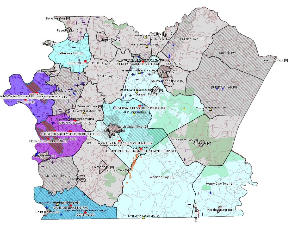
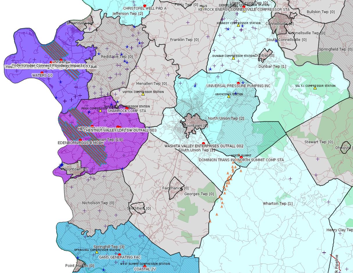
Map
Key
Red dots: items in this permit list with an exact location.
Blue stars: Marcellus Gas Well Water Sources.
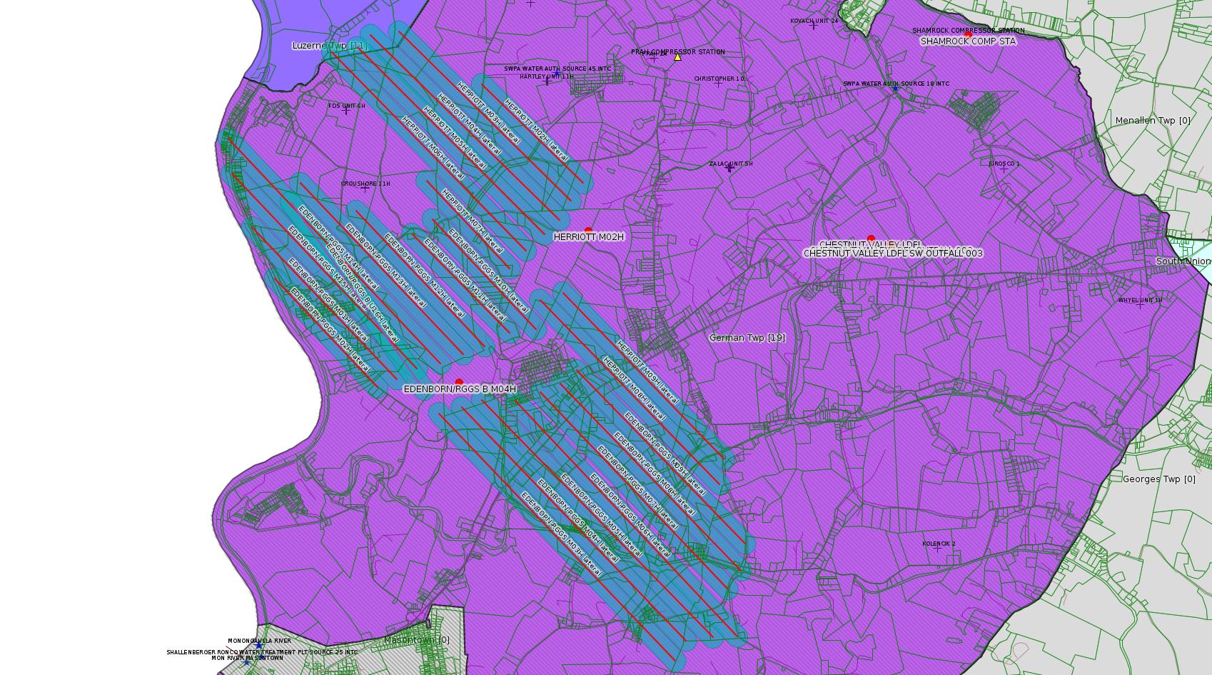
Where well laterals are mapped they show in red; a 400-foot buffer surrounding the lateral shows in blue (lavender where it overlaps a mapped mineral tract).
Where mineral tracts are mapped, they show in pink. Mineral tracts can overlap; the overlap will show in red. The precise meaning of "mineral tract" is not clear.
Municipality shading: number of "facilities", with each well counting separately
(includes the red dots):
Red dots: items in this permit list with an exact location.
Blue stars: Marcellus Gas Well Water Sources.
Where well laterals are mapped they show in red; a 400-foot buffer surrounding the lateral shows in blue (lavender where it overlaps a mapped mineral tract).
Where mineral tracts are mapped, they show in pink. Mineral tracts can overlap; the overlap will show in red. The precise meaning of "mineral tract" is not clear.
Municipality shading: number of "facilities", with each well counting separately
(includes the red dots):
gray: 0
pale turquoise: 1
turquoise: 2
pale blue: 3
middle blue: 4
dark blue: 5
dark purple: 11
purple: 19
(Color coding may differ from one issue to the next.)
(Note if a project spans multiple municipalities -- e.g. a pipeline -- it will show in the count for each municipality.)
The number of facilities also follows the municipality name in brackets.
Municipality counts are based on the way the permit is listed by DEP; DEP has been known to get a municipality wrong.
Locations in brackets identify a precise location used to locate a surrogate for the actual site being permitted (e.g. locating a well pad or pipeline by the known location of a well.) Locations labeled beginning with "~" and ending in "[?]" are approximate and speculative based on inferences using on-line property and lease records. These are marked in the text as "[Approximate, Speculative]
Cross-hatching: Environmental Justice Areas
Yellow triangles: Compressor Stations
Orange triangles: Storage Field Wells (currently Dominion North Summit Storage Field)
Crosses: SPUD Unconventional well permits
Green: "Natural areas", e.g. state game lands, state forests
Yellow triangles: Compressor Stations
Orange triangles: Storage Field Wells (currently Dominion North Summit Storage Field)
Crosses: SPUD Unconventional well permits
Green: "Natural areas", e.g. state game lands, state forests
More Maps
 |
 |
 |
Source: Pennsylvania Bulletin
PROPOSED RULEMAKING
ENVIRONMENTAL QUALITY BOARD
Acceptance of Rulemaking Petitions for Study
[49 Pa.B. 3316]
[Saturday, June 29, 2019]
On June 18, 2019, the Environmental Quality Board (Board) accepted two rulemaking petitions for study under 25 Pa. Code Chapter 23 (relating to Environmental Quality Board Policy for Processing Petitions—Statement of Policy). These petitions, submitted by Keystone Environmental, Inc. on behalf of MAX Environmental Technologies, Inc. (MAX), request the amendment of an existing regulatory exclusion from hazardous waste listing for wastewater sludge generated from the treatment disposal impoundment and landfill leachate and contact stormwater at the MAX Bulger and the MAX Yukon facilities.
Under the Board's acceptance of the petitions, the Department of Environmental Protection (Department) will prepare a report evaluating the petitions. This report will include a recommendation on whether the Board should proceed with a proposed rulemaking and, if so, the process that the Department would need to undertake to develop a proposed rulemaking.
The previously-referenced petitions are available to the public by contacting the Environment Quality Board, P.O. Box 8477, Harrisburg, PA 17105-8477, (717) 783-8727, and are available on the Department's web site at www.dep.pa.gov (select ''Public Participation,'' then ''Environmental Quality Board,'' then ''2019 Meetings,'' then ''Meeting Agendas/Minutes/Handouts; June 18, 2019'').
PATRICK McDONNELL,
Chairperson
<https://www.pabulletin.com/secure/data/vol49/49-26/961.html>
---
PROPOSED RULEMAKING
PENNSYLVANIA PUBLIC UTILITY COMMISSION
[ 52 PA. CODE CH. 59 ]
[ L-2019-3010267 ]
Hazardous Liquid Public Utility Safety Standards; Advanced Notice of Proposed Rulemaking
[49 Pa.B. 3316]
[Saturday, June 29, 2019]
Public Meeting held
June 13, 2019
Commissioners Present: Gladys Brown Dutrieuille, Chairperson; David W. Sweet, Vice Chairperson; Norman J. Kennard; Andrew G. Place; John F. Coleman, Jr.
Hazardous Liquid Public Utility Safety Standards at
52 Pa. Code Chapter 59; L-2019-3010267
Advance Notice of Proposed Rulemaking Order
By the Commission:
At present, Chapter 59 of the Public Utility Commission's (Commission) regulations is titled ''Gas Service'' with its primary focus on the regulation of natural gas distribution service, safety and facilities. See 52 Pa. Code Ch. 59. The Commission seeks comments from interested persons regarding the amendment and enhancement of Chapter 59 to enable the Commission to more comprehensively regulate public utilities that transport petroleum products and other hazardous liquids in intrastate commerce.
<https://www.pabulletin.com/secure/data/vol49/49-26/962.html>
[The full notice is quite lengthy. Please use the link above to read the full notice.]
---
| Facility Location Municipality & County |
Permit No. | Applicant Name & Address | Receiving Water/Use |
Contact Office & Phone No. |
|---|---|---|---|---|
| German Township [an Environmental
Justice Area] Fayette County |
PAG036257 | Advanced Disposal Service Chestnut Valley Landfill Inc. 1184 McClellandtown Road McClellandtown, PA 15458 |
Unnamed Tributary of Dunlap Creek (WWF)—19-C |
DEP Southwest Regional Office Clean Water Program 400 Waterfront Drive Pittsburgh, PA 15222-4745 412.442.4000 |
Sub-Facilities for Authorization:
Sub-Facility ID Sub-Facility Name Description
568839 OUTFALL 002 Discharge Point
Location: 39.896111,-79.836111
Map URL: <http://www.openstreetmap.org/?mlat=39.896111&mlon=-79.836111#map=15/39.896111/-79.836111>
568840 SW OUTFALL 003 Discharge Point
Location: 39.895833,-79.835833
Map URL: <http://www.openstreetmap.org/?mlat=39.895833&mlon=-79.835833#map=15/39.895833/-79.835833>
---
[Out of Fayette County:]
| Facility Location: Municipality & County |
Permit No. | Applicant Name & Address | Receiving Water/Use |
Contact Office & Phone No. |
|---|---|---|---|---|
| East Huntingdon Township Westmoreland County |
PAG036252 | Keane Frac, LP 1245 Old Route 119 Mount Pleasant, PA 15666 |
Unnamed Tributary of Buffalo Run (WWF)—19-D |
DEP Southwest Regional Office Clean Water Program 400 Waterfront Drive Pittsburgh, PA 15222-4745 412.442.4000 |
---
26-00588B: Laurel Mountain Midstream, LLC (Park Place 2, 2000 Commerce Drive, Pittsburgh, PA 15275) on June 11, 2019, to authorize installation, temporary and/or continued operation at the Shamrock Compressor Station located in German Township [an Environmental Justice Area], Fayette County under Plan Approval 26-00588B for the new and existing sources listed, as follows:
Source ID
Source Name and Description
116 Caterpillar G3516J 1,380 bhp, Compressor Engine
117 Caterpillar G3516J 1,380 bhp, Compressor Engine
109 Caterpillar G3516B 1,380 bhp, Compressor Engine
110 Solar Mars 100-16000S, 15,252 bhp
118 Solar Titan 130 Turbine, 21,158 bhp
115 Emergency Generator, CAT G3516B, 1,818 bhp
401 Dehydrator 01, 200MMscfd
201 Reboiler 01, 1.17 MMBtu/hr
402 Dehydrator 02, 200 MMscfd
201 Reboiler 01, 1.17 MMBtu/hr
119 Glycol Processing Unit engine, 19.5 bhp
119 Glycol Processing Unit-heater, 0.5 MMBtu/hr
301 Storage Tank 1—476 bbl, Produced Water
301 Storage Tank 2—476 bbl, Produced Water
301 Storage Tank 3—476 bbl, Produced Water
301 Storage Tank 4—140 bbl, Produced water
301 Storage Tank 5—300 bbl Produced water
706 Truck Loadout
801 Pigging Operations
703 Compressor Dry Gas Seal Leaks
704 Compressor Rod Packing
707 Turbine SSM
601 Compressor Blowdown
705 Engine Start up
702 Engine Crank Case
701 Site Component Fugitive Emissions
<https://www.pabulletin.com/secure/data/vol49/49-26/965c.html>
Location: 39.918333,-79.825
Map URL: <http://www.openstreetmap.org/?mlat=39.918333&mlon=-79.825#map=15/39.918333/-79.825>
Parcel ID: 15140026
---
ESCGP-3 # ESG072618001-00
Applicant Name Chevron Appalachia, LLC
Contact Person Branden Weimer
Address 700 Cherrington Parkway
City, State, Zip Coraopolis, PA 15108
County Fayette
Township(s) Jefferson Township
Receiving Stream(s) and Classification(s) UNTs to Little Redstone Creek (WWF), UNTs to Crabapple Run (WWF)/Monongahela River (WWF)
<https://www.pabulletin.com/secure/data/vol49/49-26/965c.html>
Site: CHRISTOFEL WELL PAD A PROJECT ESG30705118-001
Location: 40.037761,-79.795497
Source: eNOTICE
(+ PA
Oil and Gas Mapping, Well
Pad Report.) Well Details via Data
Portal Services: Oil and Gas Wells All (ID: 3).
Please see the Disclaimer below regarding Parcel Id data.
Authorization ID: 1278429
Permit number: GP052619-011
Site: Yoder Well Connect Pipeline Project
Client: LAUREL MTN MIDSTREAM OPR LLC
Authorization type: GP-05 Utility Line Stream Crossings
Application type: New
Authorization is for: FACILITY
Date received: 06/27/2019
Status: Pending
Permit Decision Guarantee Applies?: Yes
Permit Decision Guarantee status: ACTIVE
Sub-Facilities for Authorization:
Sub-Facility ID Sub-Facility Name Description
1289612 Crossing 1 Pipeline or Conduit
Location: 39.9714,-79.9387
Map URL: <http://www.openstreetmap.org/?mlat=39.9714&mlon=-79.9387#map=15/39.9714/-79.9387>
1289611 Crossing 11 PEM Pipeline or Conduit
Location: 39.9714,-79.9387
Map URL: <http://www.openstreetmap.org/?mlat=39.9714&mlon=-79.9387#map=15/39.9714/-79.9387>
1289610 Crossing 11 PSS Pipeline or Conduit
Location: 39.9714,-79.9387
Map URL: <http://www.openstreetmap.org/?mlat=39.9714&mlon=-79.9387#map=15/39.9714/-79.9387>
1289605 Crossing 2 Pipeline or Conduit
Location: 39.9714,-79.9387
Map URL: <http://www.openstreetmap.org/?mlat=39.9714&mlon=-79.9387#map=15/39.9714/-79.9387>
1289619 Crossing 2 Floodway Activity
Location: 39.9731,-79.9388
Map URL: <http://www.openstreetmap.org/?mlat=39.9731&mlon=-79.9388#map=15/39.9731/-79.9388>
1289615 Crossing 3 Floodway Activity
Location: 39.9731,-79.9388
Map URL: <http://www.openstreetmap.org/?mlat=39.9731&mlon=-79.9388#map=15/39.9731/-79.9388>
1289609 Crossing 3 Pipeline or Conduit
Location: 39.9714,-79.9387
Map URL: <http://www.openstreetmap.org/?mlat=39.9714&mlon=-79.9387#map=15/39.9714/-79.9387>
1289604 Crossing 4 Pipeline or Conduit
Location: 39.9714,-79.9387
Map URL: <http://www.openstreetmap.org/?mlat=39.9714&mlon=-79.9387#map=15/39.9714/-79.9387>
1289618 Crossing 4 Floodway Activity
Location: 39.9731,-79.9388
Map URL: <http://www.openstreetmap.org/?mlat=39.9731&mlon=-79.9388#map=15/39.9731/-79.9388>
1289606 Crossing 5 Pipeline or Conduit
Location: 39.9714,-79.9387
Map URL: <http://www.openstreetmap.org/?mlat=39.9714&mlon=-79.9387#map=15/39.9714/-79.9387>
1289616 Crossing 5 Floodway Activity
Location: 39.9731,-79.9388
Map URL: <http://www.openstreetmap.org/?mlat=39.9731&mlon=-79.9388#map=15/39.9731/-79.9388>
1289614 Crossing 6 PEM Pipeline or Conduit
Location: 39.9714,-79.9387
Map URL: <http://www.openstreetmap.org/?mlat=39.9714&mlon=-79.9387#map=15/39.9714/-79.9387>
1289613 Crossing 6 PFO Pipeline or Conduit
Location: 39.9714,-79.9387
Map URL: <http://www.openstreetmap.org/?mlat=39.9714&mlon=-79.9387#map=15/39.9714/-79.9387>
1289617 Crossing 8 Floodway Activity
Location: 39.9731,-79.9388
Map URL: <http://www.openstreetmap.org/?mlat=39.9731&mlon=-79.9388#map=15/39.9731/-79.9388>
1289608 Crossing 8 Pipeline or Conduit
Location: 39.9714,-79.9387
Map URL: <http://www.openstreetmap.org/?mlat=39.9714&mlon=-79.9387#map=15/39.9714/-79.9387>
1289607 Crossing 9 Pipeline or Conduit
Location: 39.9714,-79.9387
Map URL: <http://www.openstreetmap.org/?mlat=39.9714&mlon=-79.9387#map=15/39.9714/-79.9387>
1289624 Floodway Impacts Summed Floodway Direct Impact
Location: 39.973,-79.9339
Map URL: <http://www.openstreetmap.org/?mlat=39.973&mlon=-79.9339#map=15/39.973/-79.9339>
1289622 PEM Wetland Impacts Summed Wetland Direct Impact
Location: 39.973,-79.9339
Map URL: <http://www.openstreetmap.org/?mlat=39.973&mlon=-79.9339#map=15/39.973/-79.9339>
1289621 PFO Wetland Impacts Summed Wetland Direct Impact
Location: 39.973,-79.9339
Map URL: <http://www.openstreetmap.org/?mlat=39.973&mlon=-79.9339#map=15/39.973/-79.9339>
1289620 PSS Wetland Impacts Summed Wetland Direct Impact
Location: 39.973,-79.9339
Map URL: <http://www.openstreetmap.org/?mlat=39.973&mlon=-79.9339#map=15/39.973/-79.9339>
1289623 Stream Impacts Summed Stream Direct Impact
Location: 39.973,-79.9339
Map URL: <http://www.openstreetmap.org/?mlat=39.973&mlon=-79.9339#map=15/39.973/-79.9339>
<https://www.ahs.dep.pa.gov/eFACTSWeb/searchResults_singleAuth.aspx?AuthID=1278429>
Site Programs:
Water Planning and Conservation
Site Municipalities:
Luzerne Twp, Fayette County
Presumed Parcel Ids [for this and the following authorization]: 19160037, 19160040
---
Authorization ID: 1278428
Permit number: GP082619-008
Site: Yoder Well Connect Pipeline Project
Client: LAUREL MTN MIDSTREAM OPR LLC
Authorization type: GP-08 Temporary Road Crossings
Application type: New
Authorization is for: FACILITY
Date received: 06/27/2019
Status: Pending
Permit Decision Guarantee Applies?: No
Sub-Facilities for Authorization:
Sub-Facility ID Sub-Facility Name Description
1289598 Crossing 1 Mat/Pads
Location: 39.9712,-79.9382
Map URL: <http://www.openstreetmap.org/?mlat=39.9712&mlon=-79.9382#map=15/39.9712/-79.9382>
1289602 Crossing 10 Mat/Pads
Location: 39.9712,-79.9382
Map URL: <http://www.openstreetmap.org/?mlat=39.9712&mlon=-79.9382#map=15/39.9712/-79.9382>
1289601 Crossing 11 Mat/Pads
Location: 39.9712,-79.9382
Map URL: <http://www.openstreetmap.org/?mlat=39.9712&mlon=-79.9382#map=15/39.9712/-79.9382>
1289596 Crossing 2 Bridge
Location: 39.9731,-79.9336
Map URL: <http://www.openstreetmap.org/?mlat=39.9731&mlon=-79.9336#map=15/39.9731/-79.9336>
1289592 Crossing 3 Bridge
Location: 39.9731,-79.9336
Map URL: <http://www.openstreetmap.org/?mlat=39.9731&mlon=-79.9336#map=15/39.9731/-79.9336>
1289593 Crossing 4 Bridge
Location: 39.9731,-79.9336
Map URL: <http://www.openstreetmap.org/?mlat=39.9731&mlon=-79.9336#map=15/39.9731/-79.9336>
1289594 Crossing 5 Bridge
Location: 39.9731,-79.9336
Map URL: <http://www.openstreetmap.org/?mlat=39.9731&mlon=-79.9336#map=15/39.9731/-79.9336>
1289599 Crossing 7 Mat/Pads
Location: 39.9712,-79.9382
Map URL: <http://www.openstreetmap.org/?mlat=39.9712&mlon=-79.9382#map=15/39.9712/-79.9382>
1289595 Crossing 8 Bridge
Location: 39.9731,-79.9336
Map URL: <http://www.openstreetmap.org/?mlat=39.9731&mlon=-79.9336#map=15/39.9731/-79.9336>
1289600 Crossing 9 Mat/Pads
Location: 39.9712,-79.9382
Map URL: <http://www.openstreetmap.org/?mlat=39.9712&mlon=-79.9382#map=15/39.9712/-79.9382>
1289603 Floodway Impacts Summed Temporary Floodway Impact
Location: 39.973,-79.9339
Map URL: <http://www.openstreetmap.org/?mlat=39.973&mlon=-79.9339#map=15/39.973/-79.9339>
1289597 Wetland Impacts Summed Temporary Wetland Impact
Location: 39.973,-79.9339
Map URL: <http://www.openstreetmap.org/?mlat=39.973&mlon=-79.9339#map=15/39.973/-79.9339>
<https://www.ahs.dep.pa.gov/eFACTSWeb/searchResults_singleAuth.aspx?AuthID=1278428>
Site Programs:
Water Planning and Conservation
Site Municipalities:
Luzerne Twp, Fayette County
---
Authorization ID: 1277911
Permit number: GP5-26-00544C
Site: KEYROCK ENERGY CONNELSVILLE COMPRESSOR STA
Client: KEYROCK ENERGY LLC
Authorization type: AQ GP 5 - Natural Gas Compression and/or Processing Facilities
Application type: New
Authorization is for: FACILITY
Date received: 06/21/2019
Status: Pending
Permit Decision Guarantee Applies?: No
Permit Review Notes:
Date Review Note
6/24/2019 The permit application package is complete, has been accepted, and is undergoing technical review.
<https://www.ahs.dep.pa.gov/eFACTSWeb/searchResults_singleAuth.aspx?AuthID=1277911>
Site Programs:
Air Quality
Site Municipalities:
Dunbar Twp, Fayette County
Location: 40.03491,-79.64521
Map URL: <https://www.openstreetmap.org/?mlat=40.03491&mlon=-79.64521#map=15/40.03491/-79.64521>
Presumed Parcel Id: 0905001404
---
Authorization ID: 1277843
Permit number: 26-00405
Site: DOMINION ENERGY TRANS INC NORTH SUMMIT COMP STA
Client: DOMINION ENERGY TRANS INC
Authorization type: Major Facility Operating Permit
Application type: Modification
Authorization is for: FACILITY
Date received: 10/24/2016
Status: Pending
Permit Decision Guarantee Applies?: No
Permit Review Notes:
Date Review Note
6/24/2019 The permit application package is complete, has been accepted, and is undergoing technical review.
<https://www.ahs.dep.pa.gov/eFACTSWeb/searchResults_singleAuth.aspx?AuthID=1277843>
Site Programs:
Air Quality
Clean Water
Waste Management
Site Municipalities:
North Union Twp, Fayette County
---
Authorization ID: 1276694
Permit number: PA0090948
Site: CHESTNUT VALLEY LDFL
Client: ADVANCED DSPL SVC CHESTNUT VALLEY LDFL INC
Authorization type: Minor IW Facility with ELG
Application type: Rescission
Authorization is for: FACILITY
Date received: 06/12/2019
Status: Replaced on 6/13/2019
Permit Decision Guarantee Applies?: No
Sub-Facilities for Authorization:
Sub-Facility ID Sub-Facility Name Description
568839 OUTFALL 002 Discharge Point
Location: 39.896111,-79.836111
Map URL: <http://www.openstreetmap.org/?mlat=39.896111&mlon=-79.836111#map=15/39.896111/-79.836111>
568840 SW OUTFALL 003 Discharge Point
Location: 39.895833,-79.835833
Map URL: <http://www.openstreetmap.org/?mlat=39.895833&mlon=-79.835833#map=15/39.895833/-79.835833>
<https://www.ahs.dep.pa.gov/eFACTSWeb/searchResults_singleAuth.aspx?AuthID=1276694>
Site Programs:
Air Quality
Clean Water
Environmental Cleanup & Brownfields
Mining
Radiation Protection
Waste Management
Water Planning and Conservation
Site Municipalities:
German Twp [an Environmental Justice Area], Fayette County
---
Authorization ID: 1276361
Permit number: 051-24664
Site: COASTAL 1H FLOW BACK PIT FRESHWATER PITS ESCGP-EXPEDITED
Client: INR OPR LLC
Authorization type: Drill & Operate Well Permit (Conventional)
Application type: Renewal
Authorization is for: FACILITY
Date received: 06/11/2019
Status: Issued on 6/17/2019
Permit Decision Guarantee Applies?: No
Sub-Facilities for Authorization:
Sub-Facility ID Sub-Facility Name Description
1259713 WELLBORE SURFACE HOLE LOCATION Well
Permit Review Notes:
Date Review Note
6/17/2019 "Application under review but awaiting financial documentation from the applicant"
6/17/2019 The technical review and decision review are complete and either the permit decision and/or permit issuance are forthcoming.
6/17/2019 The permit application package is complete, has been accepted, and is undergoing technical review.
<https://www.ahs.dep.pa.gov/eFACTSWeb/searchResults_singleAuth.aspx?AuthID=1276361>
Site Programs:
Oil & Gas
Site Municipalities:
Springhill Twp, Fayette County
Well Details:
Permit Number: 051-24664
Well Name: COASTAL 2V
Unconventional Well: N
Well Configuration: Vertical Well
Well Type: GAS
Well Status: Active
Coal Association: Coal
Conservation Well: Y
Primary Facility ID: 826848
Site ID: 739525
Site Name: COASTAL 1H FLOW BACK PIT FRESHWATER PITS ESCGP-EXPEDITED
Well Pad ID: 147971
Well Pad Name: COASTAL WELL PAD
Storage Field:
Operator: INR OPR LLC
Operator Number: OGO-51036
Permit Date: 2018-06-26
Permit Date Expires: 2020-06-26
SPUD Date:
Date Plugged:
UIC ID:
UIC Type:
Surface Elevation: 1130
County: Fayette
Municipality: Springhill Twp
Location: 39.733336,-79.800886
Map URL: <http://www.openstreetmap.org/?mlat=39.733336&mlon=-79.800886#map=15/39.733336/-79.800886>
OG WELLS PERMIT DOCS:
2018-06-27: Final Permit Documents, Name: 1231002 (for Authorization: 1231002):
<http://www.depgis.state.pa.us/pdfHandler/pdFHandler.ashx?Doc=NjI1MTYz&ext=PDF>
2019-06-17: Initial Submitted Documents, Name: 051-24664 Renewal Application (for Authorization: 1276361):
<http://www.depgis.state.pa.us/pdfHandler/pdFHandler.ashx?Doc=ODQ1MTQ1&ext=PDF>
2019-06-17: Final Permit Documents, Name: Auth No. 1276361 (for Authorization: 1276361):
<http://www.depgis.state.pa.us/pdfHandler/pdFHandler.ashx?Doc=ODQ0NTMy&ext=PDF>
Electronically Submitted Records:
2018-06-27: Submission for Authorization 1231002
Pennsylvania Natural Diversity Inventory Form: project_receipt_infinity_natural_resource_655114_FINAL_1 signed.pdf
<http://www.depgis.state.pa.us/eWellDocHandler/pdFHandler.ashx?Doc=NTU5Mzk4&ext=PDF>
Pennsylvania Natural Diversity Inventory Support Document: PNDI SUPPORT DOCUMENT_UPLOAD.pdf
<http://www.depgis.state.pa.us/eWellDocHandler/pdFHandler.ashx?Doc=NTU5Mzk5&ext=PDF>
Coordination of Well Location with Public Resources: COORDINATION_OF_A_WELL_LOCATION_WITH_PUBLIC_RESOURCES_FORM.DOCX_.pdf
<http://www.depgis.state.pa.us/eWellDocHandler/pdFHandler.ashx?Doc=NTYyNTM1&ext=PDF>
Operator Ownership and Control Information: INR Operating 8000-FM-OOGM0118 - Signed.pdf
<http://www.depgis.state.pa.us/eWellDocHandler/pdFHandler.ashx?Doc=NTYyNTgz&ext=PDF>
Well Permit Application - Coal Module: Coal Status Report_2018-04-27.pdf
<http://www.depgis.state.pa.us/eWellDocHandler/pdFHandler.ashx?Doc=NTYyNjA4&ext=PDF>
Location Plat: COASTAL 2V_3702.dwg
<http://www.depgis.state.pa.us/eWellDocHandler/pdFHandler.ashx?Doc=NTcxMTgz&ext=PDF>
Permit Application to Drill and Operate a Well: 1729017.pdf
<http://www.depgis.state.pa.us/eWellDocHandler/pdFHandler.ashx?Doc=NTcxMTg1&ext=PDF>
---
Authorization ID: 1274624
Permit number: 100419
Site: CHESTNUT VALLEY LDFL
Client: ADVANCED DSPL SVC CHESTNUT VALLEY LDFL INC
Authorization type: Landfill Pmt Final Construction Certification Form 37
Application type: Modification
Authorization is for: FACILITY
Date received: 05/28/2019
Status: Pending
Permit Decision Guarantee Applies?: Yes
Permit Decision Guarantee status: ACTIVE
Permit Review Notes:
Date Review Note
6/7/2019 The technical review and decision review are complete and either the permit decision and/or permit issuance are forthcoming.
5/28/2019 The permit application package is complete, has been accepted, and is undergoing technical review.
<https://www.ahs.dep.pa.gov/eFACTSWeb/searchResults_singleAuth.aspx?AuthID=1274624>
Site Programs:
Air Quality
Clean Water
Environmental Cleanup & Brownfields
Mining
Radiation Protection
Waste Management
Water Planning and Conservation
Site Municipalities:
German Twp [an Environmental Justice Area], Fayette County
---
Authorization ID: 1274496
Permit number: ESG17-051-0001
Site: LPR MIDSTREAM PARTNERS LLC POLK PIPELINE ESCGP ESG17-051-0001 & GP05 GP08
Client: LPR ENERGY LLC
Authorization type: Erosion and Sediment Control GP-2
Application type: Transfer
Authorization is for: SITE
Date received: 04/12/2019
Status: Issued on 6/17/2019
Permit Decision Guarantee Applies?: Yes
Permit Decision Guarantee status: ACTIVE
Permit Review Notes:
Date Review Note
6/17/2019 The technical review and decision review are complete and either the permit decision and/or permit issuance are forthcoming.
5/24/2019 The permit application package is complete, has been accepted, and is undergoing technical review.
<https://www.ahs.dep.pa.gov/eFACTSWeb/searchResults_singleAuth.aspx?AuthID=1274496>
Site Programs:
Water Planning and Conservation
Site Municipalities:
Henry Clay Twp, Fayette County
Wharton Twp, Fayette County
---
Authorization ID: 1273634
Permit number: PAG036257
Site: CHESTNUT VALLEY LDFL
Client: ADVANCED DSPL SVC CHESTNUT VALLEY LDFL INC
Authorization type: PAG-03 Discharge of Stormwater Assoc w Industrial Activities
Application type: New
Authorization is for: FACILITY
Date received: 05/17/2019
Status: Issued on 6/12/2019
Permit Decision Guarantee Applies?: Yes
Permit Decision Guarantee status: ACTIVE
Sub-Facilities for Authorization:
Sub-Facility ID Sub-Facility Name Description
568839 OUTFALL 002 Discharge Point
Location: 39.896111,-79.836111
Map URL: <http://www.openstreetmap.org/?mlat=39.896111&mlon=-79.836111#map=15/39.896111/-79.836111>
568840 SW OUTFALL 003 Discharge Point
Location: 39.895833,-79.835833
Map URL: <http://www.openstreetmap.org/?mlat=39.895833&mlon=-79.835833#map=15/39.895833/-79.835833>
Permit Review Notes:
Date Review Note
6/11/2019 The technical review and decision review are complete and either the permit decision and/or permit issuance are forthcoming.
5/17/2019 The permit application package is complete, has been accepted, and is undergoing technical review.
<https://www.ahs.dep.pa.gov/eFACTSWeb/searchResults_singleAuth.aspx?AuthID=1273634>
Site Programs:
Air Quality
Clean Water
Environmental Cleanup & Brownfields
Mining
Radiation Protection
Waste Management
Water Planning and Conservation
Site Municipalities:
German Twp [an Environmental Justice Area], Fayette County
---
Authorization ID: 1270691
Permit number: 100419
Site: CHESTNUT VALLEY LDFL
Client: ADVANCED DSPL SVC CHESTNUT VALLEY LDFL INC
Authorization type: Landfill Pmt Final Construction Certification Form 37
Application type: Modification
Authorization is for: FACILITY
Date received: 04/17/2019
Status: Pending
Permit Decision Guarantee Applies?: Yes
Permit Decision Guarantee status: VOID
Permit Review Notes:
Date Review Note
5/8/2019 The technical review and decision review are complete and either the permit decision and/or permit issuance are forthcoming.
4/26/2019 Applicant has been issued a deficiency letter. If applicable, this application no longer qualifies for the Permit Decision Guarantee.
4/25/2019 The permit application package is complete, has been accepted, and is undergoing technical review.
<https://www.ahs.dep.pa.gov/eFACTSWeb/searchResults_singleAuth.aspx?AuthID=1270691>
Site Programs:
Air Quality
Clean Water
Environmental Cleanup & Brownfields
Mining
Radiation Protection
Waste Management
Water Planning and Conservation
Site Municipalities:
German Twp [an Environmental Justice Area], Fayette County
---
Authorization ID: 1264863
Permit number: 26-00495
Site: GANS GENERATING FAC
Client: GANS ENERGY LLC
Authorization type: Major Facility Operating Permit
Application type: Renewal
Authorization is for: FACILITY
Date received: 07/27/2009
Status: Issued on 6/19/2019
Permit Decision Guarantee Applies?: No
Sub-Facilities for Authorization:
Sub-Facility ID Sub-Facility Name Description
571256 COMB. GAS TURBINE UNIT 8(424.6 MMBTU/HR,NG,SIMPLE CYC,44 MW) Process
Location: 39.747518,-79.838772
Map URL: <http://www.openstreetmap.org/?mlat=39.747518&mlon=-79.838772#map=15/39.747518/-79.838772>
571257 COMB. GAS TURBINE UNIT 9(424.6 MMBTU/HR,NG,SIMPLE CYC,44 MW) Process
Location: 39.747518,-79.838772
Map URL: <http://www.openstreetmap.org/?mlat=39.747518&mlon=-79.838772#map=15/39.747518/-79.838772>
1280758 COOLING TOWERS Process
Location: 39.747518,-79.838772
Map URL: <http://www.openstreetmap.org/?mlat=39.747518&mlon=-79.838772#map=15/39.747518/-79.838772>
802896 UNIT 8 WATER INJECTION SYSTEM Air Pollution Control Device
Location: 39.747518,-79.838772
Map URL: <http://www.openstreetmap.org/?mlat=39.747518&mlon=-79.838772#map=15/39.747518/-79.838772>
802897 UNIT 9 WATER INJECTION SYSTEM Air Pollution Control Device
Location: 39.747518,-79.838772
Map URL: <http://www.openstreetmap.org/?mlat=39.747518&mlon=-79.838772#map=15/39.747518/-79.838772>
<https://www.ahs.dep.pa.gov/eFACTSWeb/searchResults_singleAuth.aspx?AuthID=1264863>
Site Programs:
Air Quality
Clean Water
Site Municipalities:
Springhill Twp, Fayette County
---
Authorization ID: 1256580
Permit number: ESG072618001-00
Site: CHRISTOFEL WELL PAD A PROJECT ESG30705118-001
Client: CHEVRON APPALACHIA LLC
Authorization type: Erosion and Sediment Control General Permit 3
Application type: New
Authorization is for: SITE
Date received: 12/20/2018
Status: Issued on 6/14/2019
Permit Decision Guarantee Applies?: Yes
Permit Decision Guarantee status: VOID
Permit Review Notes:
Date Review Note
6/14/2019 The technical review and decision review are complete and either the permit decision and/or permit issuance are forthcoming.
6/11/2019 Applicant has been issued a deficiency letter. If applicable, this application no longer qualifies for the Permit Decision Guarantee.
5/3/2019 Applicant has been issued a deficiency letter. If applicable, this application no longer qualifies for the Permit Decision Guarantee.
3/4/2019 Applicant has been issued a deficiency letter. If applicable, this application no longer qualifies for the Permit Decision Guarantee.
1/28/2019 Applicant has been issued a deficiency letter. If applicable, this application no longer qualifies for the Permit Decision Guarantee.
<https://www.ahs.dep.pa.gov/eFACTSWeb/searchResults_singleAuth.aspx?AuthID=1256580>
Site Programs:
Oil & Gas
Site Municipalities:
Jefferson Twp, Fayette County
Location: 40.037761,-79.795497
Presumed Parcel Id: 17130025
---
Authorization ID: 1251841
Permit number: PAG036239
Site: WASHITA VALLEY ENTERPRISES INC HOPWOOD
Client: WASHITA VALLEY ENTERPRISES
Authorization type: PAG-03 Discharge of Stormwater Assoc w Industrial Activities
Application type: New
Authorization is for: FACILITY
Date received: 11/08/2018
Status: Issued on 6/24/2019
Permit Decision Guarantee Applies?: Yes
Permit Decision Guarantee status: ACTIVE
Sub-Facilities for Authorization:
Sub-Facility ID Sub-Facility Name Description
1275056 OUTFALL 001 Discharge Point
Location: 39.875758,-79.7094
Map URL: <http://www.openstreetmap.org/?mlat=39.875758&mlon=-79.7094#map=15/39.875758/-79.7094>
1275057 OUTFALL 002 Discharge Point
Location: 39.876061,-79.70925
Map URL: <http://www.openstreetmap.org/?mlat=39.876061&mlon=-79.70925#map=15/39.876061/-79.70925>
Permit Review Notes:
Date Review Note
6/21/2019 The technical review and decision review are complete and either the permit decision and/or permit issuance are forthcoming.
4/10/2019 The permit application package is complete, has been accepted, and is undergoing technical review.
<https://www.ahs.dep.pa.gov/eFACTSWeb/searchResults_singleAuth.aspx?AuthID=1251841>
Site Programs:
Clean Water
Site Municipalities:
South Union Twp, Fayette County
Presumed Parcel Id: 3427011601
[See Notes.]
---
Authorization ID: 1230777
Permit number: 26-00585
Site: UNIVERSAL PRESSURE PUMPING INC
Client: UNIVERSAL PRESSURE PUMPING INC
Authorization type: Minor Source Operating Permit
Application type: Renewal
Authorization is for: FACILITY
Date received: 05/24/2018
Status: Pending
Permit Decision Guarantee Applies?: No
Permit Review Notes:
Date Review Note
5/30/2018 The permit application package is complete, has been accepted, and is undergoing technical review.
<https://www.ahs.dep.pa.gov/eFACTSWeb/searchResults_singleAuth.aspx?AuthID=1230777>
Site Programs:
Air Quality
Clean Water
Environmental Cleanup & Brownfields
Waste Management
Site Municipalities:
North Union Twp, Fayette County
---
Authorization ID: 1217104
Permit number: 26-00495
Site: GANS GENERATING FAC
Client: GANS ENERGY LLC
Authorization type: Major Facility Operating Permit
Application type: Amendment
Authorization is for: FACILITY
Date received: 04/28/2017
Status: Issued on 6/19/2019
Permit Decision Guarantee Applies?: No
Sub-Facilities for Authorization:
Sub-Facility ID Sub-Facility Name Description
571256 COMB. GAS TURBINE UNIT 8(424.6 MMBTU/HR,NG,SIMPLE CYC,44 MW) Process
Location: 39.747518,-79.838772
Map URL: <http://www.openstreetmap.org/?mlat=39.747518&mlon=-79.838772#map=15/39.747518/-79.838772>
571257 COMB. GAS TURBINE UNIT 9(424.6 MMBTU/HR,NG,SIMPLE CYC,44 MW) Process
Location: 39.747518,-79.838772
Map URL: <http://www.openstreetmap.org/?mlat=39.747518&mlon=-79.838772#map=15/39.747518/-79.838772>
1280758 COOLING TOWERS Process
Location: 39.747518,-79.838772
Map URL: <http://www.openstreetmap.org/?mlat=39.747518&mlon=-79.838772#map=15/39.747518/-79.838772>
802896 UNIT 8 WATER INJECTION SYSTEM Air Pollution Control Device
Location: 39.747518,-79.838772
Map URL: <http://www.openstreetmap.org/?mlat=39.747518&mlon=-79.838772#map=15/39.747518/-79.838772>
802897 UNIT 9 WATER INJECTION SYSTEM Air Pollution Control Device
Location: 39.747518,-79.838772
Map URL: <http://www.openstreetmap.org/?mlat=39.747518&mlon=-79.838772#map=15/39.747518/-79.838772>
Permit Review Notes:
Date Review Note
6/19/2019 The technical review and decision review are complete and either the permit decision and/or permit issuance are forthcoming.
2/15/2018 The permit application package is complete, has been accepted, and is undergoing technical review.
<https://www.ahs.dep.pa.gov/eFACTSWeb/searchResults_singleAuth.aspx?AuthID=1217104>
Site Programs:
Air Quality
Clean Water
Site Municipalities:
Springhill Twp, Fayette County
-------------------------
Well Details:
Permit Number: 051-24701
Well Name: HERRIOTT M02H
Unconventional Well: Y
Well Configuration: Horizontal Well
Well Type: GAS
Well Status: Active
Coal Association: Coal
Conservation Well: N
Primary Facility ID: 832293
Site ID: 829399
Site Name: HERRIOTT PAD A WELL AND TANK SITE ESCGP ESX18-051-0002
Well Pad ID: 155082
Well Pad Name: HERRIOTT
Storage Field:
Operator: CHEVRON APPALACHIA LLC
Operator Number: OGO-39307
Permit Date: 2019-02-22
Permit Date Expires: 2020-02-22
SPUD Date: 2019-06-18
Date Plugged:
UIC ID:
UIC Type:
Surface Elevation: 1265
County: Fayette
Municipality: German Twp [an Environmental Justice Area]
Location: 39.898003,-79.877919
Map URL: <http://www.openstreetmap.org/?mlat=39.898003&mlon=-79.877919#map=15/39.898003/-79.877919>
OG WELLS PERMIT DOCS:
2019-02-22: Final Permit Documents, Name: auth id 1260908 (for Authorization: 1260908):
<http://www.depgis.state.pa.us/pdfHandler/pdFHandler.ashx?Doc=NzU0NDcy&ext=PDF>
Electronically Submitted Records:
2019-02-22: Submission for Authorization 1260908
Pennsylvania Natural Diversity Inventory Form: Herriott PNDI.pdf
<http://www.depgis.state.pa.us/eWellDocHandler/pdFHandler.ashx?Doc=NzYyOTE4&ext=PDF>
Well Cross-Section Diagram: Herriott M02H Page 4.pdf
<http://www.depgis.state.pa.us/eWellDocHandler/pdFHandler.ashx?Doc=NzYyOTIw&ext=PDF>
Location Plat: 172-319-Well Plat M02H-pages1-2-3_3702.dwg
<http://www.depgis.state.pa.us/eWellDocHandler/pdFHandler.ashx?Doc=NzYyOTIx&ext=PDF>
Coal and Gas Resource Coord Act - Section 7 Exception: Herriott Section 7 Exception.pdf
<http://www.depgis.state.pa.us/eWellDocHandler/pdFHandler.ashx?Doc=NzY4MzQ1&ext=PDF>
Permit Application to Drill and Operate a Well: 1865609.pdf
<http://www.depgis.state.pa.us/eWellDocHandler/pdFHandler.ashx?Doc=NzY4NDk2&ext=PDF>
---
Well Details:
Permit Number: 051-24704
Well Name: HERRIOTT M03H
Unconventional Well: Y
Well Configuration: Horizontal Well
Well Type: GAS
Well Status: Active
Coal Association: Coal
Conservation Well: N
Primary Facility ID: 832296
Site ID: 829399
Site Name: HERRIOTT PAD A WELL AND TANK SITE ESCGP ESX18-051-0002
Well Pad ID: 155082
Well Pad Name: HERRIOTT
Storage Field:
Operator: CHEVRON APPALACHIA LLC
Operator Number: OGO-39307
Permit Date: 2019-02-22
Permit Date Expires: 2020-02-22
SPUD Date: 2019-06-18
Date Plugged:
UIC ID:
UIC Type:
Surface Elevation: 1265
County: Fayette
Municipality: German Twp [an Environmental Justice Area]
Location: 39.897964,-79.877903
Map URL: <http://www.openstreetmap.org/?mlat=39.897964&mlon=-79.877903#map=15/39.897964/-79.877903>
OG WELLS PERMIT DOCS:
2019-02-22: Final Permit Documents, Name: auth id 1260911 (for Authorization: 1260911):
<http://www.depgis.state.pa.us/pdfHandler/pdFHandler.ashx?Doc=NzU0NDY5&ext=PDF>
Electronically Submitted Records:
2019-02-22: Submission for Authorization 1260911
Pennsylvania Natural Diversity Inventory Form: Herriott PNDI.pdf
<http://www.depgis.state.pa.us/eWellDocHandler/pdFHandler.ashx?Doc=NzYyOTM1&ext=PDF>
Location Plat: 172-319-Well Plat M03H-pages1-2-3_3702.dwg
<http://www.depgis.state.pa.us/eWellDocHandler/pdFHandler.ashx?Doc=NzYyOTM2&ext=PDF>
Well Cross-Section Diagram: Herriott M03H Page 4.pdf
<http://www.depgis.state.pa.us/eWellDocHandler/pdFHandler.ashx?Doc=NzYyOTM4&ext=PDF>
Coal and Gas Resource Coord Act - Section 7 Exception: Herriott Section 7 Exception.pdf
<http://www.depgis.state.pa.us/eWellDocHandler/pdFHandler.ashx?Doc=NzY4Mzgy&ext=PDF>
Permit Application to Drill and Operate a Well: 1865616.pdf
<http://www.depgis.state.pa.us/eWellDocHandler/pdFHandler.ashx?Doc=NzY4NDk5&ext=PDF>
---
Well Details:
Permit Number: 051-24698
Well Name: HERRIOTT M04H
Unconventional Well: Y
Well Configuration: Horizontal Well
Well Type: GAS
Well Status: Active
Coal Association: Coal
Conservation Well: N
Primary Facility ID: 832290
Site ID: 829399
Site Name: HERRIOTT PAD A WELL AND TANK SITE ESCGP ESX18-051-0002
Well Pad ID: 155082
Well Pad Name: HERRIOTT
Storage Field:
Operator: CHEVRON APPALACHIA LLC
Operator Number: OGO-39307
Permit Date: 2019-02-22
Permit Date Expires: 2020-02-22
SPUD Date: 2019-06-19
Date Plugged:
UIC ID:
UIC Type:
Surface Elevation: 1265
County: Fayette
Municipality: German Twp [an Environmental Justice Area]
Location: 39.897925,-79.877886
Map URL: <http://www.openstreetmap.org/?mlat=39.897925&mlon=-79.877886#map=15/39.897925/-79.877886>
OG WELLS PERMIT DOCS:
2019-02-22: Final Permit Documents, Name: auth id 1260904 (for Authorization: 1260904):
<http://www.depgis.state.pa.us/pdfHandler/pdFHandler.ashx?Doc=NzU0NDc2&ext=PDF>
Electronically Submitted Records:
2019-02-22: Submission for Authorization 1260904
Pennsylvania Natural Diversity Inventory Form: Herriott PNDI.pdf
<http://www.depgis.state.pa.us/eWellDocHandler/pdFHandler.ashx?Doc=NzYyOTUw&ext=PDF>
Location Plat: 172-319-Well Plat M04H-pages1-2-3_3702.dwg
<http://www.depgis.state.pa.us/eWellDocHandler/pdFHandler.ashx?Doc=NzYyOTUx&ext=PDF>
Well Cross-Section Diagram: Herriott M04H Page 4.pdf
<http://www.depgis.state.pa.us/eWellDocHandler/pdFHandler.ashx?Doc=NzYyOTUz&ext=PDF>
Coal and Gas Resource Coord Act - Section 7 Exception: Herriott Section 7 Exception.pdf
<http://www.depgis.state.pa.us/eWellDocHandler/pdFHandler.ashx?Doc=NzY4MzUy&ext=PDF>
Permit Application to Drill and Operate a Well: 1865625.pdf
<http://www.depgis.state.pa.us/eWellDocHandler/pdFHandler.ashx?Doc=NzY4NTE0&ext=PDF>
---
Well Details:
Permit Number: 051-24699
Well Name: HERRIOTT M05H
Unconventional Well: Y
Well Configuration: Horizontal Well
Well Type: GAS
Well Status: Active
Coal Association: Coal
Conservation Well: N
Primary Facility ID: 832291
Site ID: 829399
Site Name: HERRIOTT PAD A WELL AND TANK SITE ESCGP ESX18-051-0002
Well Pad ID: 155082
Well Pad Name: HERRIOTT
Storage Field:
Operator: CHEVRON APPALACHIA LLC
Operator Number: OGO-39307
Permit Date: 2019-02-22
Permit Date Expires: 2020-02-22
SPUD Date: 2019-06-19
Date Plugged:
UIC ID:
UIC Type:
Surface Elevation: 1265
County: Fayette
Municipality: German Twp [an Environmental Justice Area]
Location: 39.897886,-79.877869
Map URL: <http://www.openstreetmap.org/?mlat=39.897886&mlon=-79.877869#map=15/39.897886/-79.877869>
OG WELLS PERMIT DOCS:
2019-02-22: Final Permit Documents, Name: 051-24699 (for Authorization: 1260905):
<http://www.depgis.state.pa.us/pdfHandler/pdFHandler.ashx?Doc=NzU3Mzc1&ext=PDF>
Electronically Submitted Records:
2019-02-22: Submission for Authorization 1260905
Location Plat: 172-319-Well Plat M05H-pages1-2-3_3702.dwg
<http://www.depgis.state.pa.us/eWellDocHandler/pdFHandler.ashx?Doc=NzYyOTcw&ext=PDF>
Pennsylvania Natural Diversity Inventory Form: Herriott PNDI.pdf
<http://www.depgis.state.pa.us/eWellDocHandler/pdFHandler.ashx?Doc=NzYyOTcx&ext=PDF>
Well Cross-Section Diagram: Herriott M05H Page 4.pdf
<http://www.depgis.state.pa.us/eWellDocHandler/pdFHandler.ashx?Doc=NzYyOTcy&ext=PDF>
Coal and Gas Resource Coord Act - Section 7 Exception: Herriott Section 7 Exception.pdf
<http://www.depgis.state.pa.us/eWellDocHandler/pdFHandler.ashx?Doc=NzY4MzQy&ext=PDF>
Permit Application to Drill and Operate a Well: 1865638.pdf
<http://www.depgis.state.pa.us/eWellDocHandler/pdFHandler.ashx?Doc=NzY4NDkw&ext=PDF>
---
Well Details:
Permit Number: 051-24700
Well Name: HERRIOTT M06H
Unconventional Well: Y
Well Configuration: Horizontal Well
Well Type: GAS
Well Status: Active
Coal Association: Coal
Conservation Well: N
Primary Facility ID: 832292
Site ID: 829399
Site Name: HERRIOTT PAD A WELL AND TANK SITE ESCGP ESX18-051-0002
Well Pad ID: 155082
Well Pad Name: HERRIOTT
Storage Field:
Operator: CHEVRON APPALACHIA LLC
Operator Number: OGO-39307
Permit Date: 2019-02-22
Permit Date Expires: 2020-02-22
SPUD Date: 2019-06-20
Date Plugged:
UIC ID:
UIC Type:
Surface Elevation: 1265
County: Fayette
Municipality: German Twp [an Environmental Justice Area]
Location: 39.897847,-79.87785
Map URL: <http://www.openstreetmap.org/?mlat=39.897847&mlon=-79.87785#map=15/39.897847/-79.87785>
OG WELLS PERMIT DOCS:
2019-02-22: Final Permit Documents, Name: auth id 1260907 (for Authorization: 1260907):
<http://www.depgis.state.pa.us/pdfHandler/pdFHandler.ashx?Doc=NzU0NDcz&ext=PDF>
Electronically Submitted Records:
2019-02-22: Submission for Authorization 1260907
Pennsylvania Natural Diversity Inventory Form: Herriott PNDI.pdf
<http://www.depgis.state.pa.us/eWellDocHandler/pdFHandler.ashx?Doc=NzYyOTgz&ext=PDF>
Location Plat: 172-319-Well Plat M06H-pages1-2-3_3702.dwg
<http://www.depgis.state.pa.us/eWellDocHandler/pdFHandler.ashx?Doc=NzYyOTg0&ext=PDF>
Well Cross-Section Diagram: Herriott M06H Page 4.pdf
<http://www.depgis.state.pa.us/eWellDocHandler/pdFHandler.ashx?Doc=NzYyOTg2&ext=PDF>
Coal and Gas Resource Coord Act - Section 7 Exception: Herriott Section 7 Exception.pdf
<http://www.depgis.state.pa.us/eWellDocHandler/pdFHandler.ashx?Doc=NzY4MzQ0&ext=PDF>
Permit Application to Drill and Operate a Well: 1865896.pdf
<http://www.depgis.state.pa.us/eWellDocHandler/pdFHandler.ashx?Doc=NzY4NDkz&ext=PDF>
---
Well Details:
Permit Number: 051-24702
Well Name: HERRIOTT M07H
Unconventional Well: Y
Well Configuration: Horizontal Well
Well Type: GAS
Well Status: Active
Coal Association: Coal
Conservation Well: N
Primary Facility ID: 832294
Site ID: 829399
Site Name: HERRIOTT PAD A WELL AND TANK SITE ESCGP ESX18-051-0002
Well Pad ID: 155082
Well Pad Name: HERRIOTT
Storage Field:
Operator: CHEVRON APPALACHIA LLC
Operator Number: OGO-39307
Permit Date: 2019-02-22
Permit Date Expires: 2020-02-22
SPUD Date: 2019-06-20
Date Plugged:
UIC ID:
UIC Type:
Surface Elevation: 1265
County: Fayette
Municipality: German Twp [an Environmental Justice Area]
Location: 39.897808,-79.877833
Map URL: <http://www.openstreetmap.org/?mlat=39.897808&mlon=-79.877833#map=15/39.897808/-79.877833>
OG WELLS PERMIT DOCS:
2019-02-22: Final Permit Documents, Name: auth id 1260909 (for Authorization: 1260909):
<http://www.depgis.state.pa.us/pdfHandler/pdFHandler.ashx?Doc=NzU0NDcx&ext=PDF>
Electronically Submitted Records:
2019-02-22: Submission for Authorization 1260909
Pennsylvania Natural Diversity Inventory Form: Herriott PNDI.pdf
<http://www.depgis.state.pa.us/eWellDocHandler/pdFHandler.ashx?Doc=NzYzMDAz&ext=PDF>
Location Plat: 172-319-Well Plat M07H-pages1-2-3_3702.dwg
<http://www.depgis.state.pa.us/eWellDocHandler/pdFHandler.ashx?Doc=NzYzMDA0&ext=PDF>
Well Cross-Section Diagram: Herriott M07H Page 4.pdf
<http://www.depgis.state.pa.us/eWellDocHandler/pdFHandler.ashx?Doc=NzYzMDA2&ext=PDF>
Coal and Gas Resource Coord Act - Section 7 Exception: Herriott Section 7 Exception.pdf
<http://www.depgis.state.pa.us/eWellDocHandler/pdFHandler.ashx?Doc=NzY4NDc1&ext=PDF>
Permit Application to Drill and Operate a Well: 1865905.pdf
<http://www.depgis.state.pa.us/eWellDocHandler/pdFHandler.ashx?Doc=NzY4NTA1&ext=PDF>
---
Well Details:
Permit Number: 051-24703
Well Name: HERRIOTT M08H
Unconventional Well: Y
Well Configuration: Horizontal Well
Well Type: GAS
Well Status: Active
Coal Association: Coal
Conservation Well: N
Primary Facility ID: 832295
Site ID: 829399
Site Name: HERRIOTT PAD A WELL AND TANK SITE ESCGP ESX18-051-0002
Well Pad ID: 155082
Well Pad Name: HERRIOTT
Storage Field:
Operator: CHEVRON APPALACHIA LLC
Operator Number: OGO-39307
Permit Date: 2019-02-22
Permit Date Expires: 2020-02-22
SPUD Date: 2019-06-21
Date Plugged:
UIC ID:
UIC Type:
Surface Elevation: 1265
County: Fayette
Municipality: German Twp [an Environmental Justice Area]
Location: 39.897769,-79.877817
Map URL: <http://www.openstreetmap.org/?mlat=39.897769&mlon=-79.877817#map=15/39.897769/-79.877817>
OG WELLS PERMIT DOCS:
2019-02-22: Final Permit Documents, Name: auth id 1260910 (for Authorization: 1260910):
<http://www.depgis.state.pa.us/pdfHandler/pdFHandler.ashx?Doc=NzU0NDcw&ext=PDF>
Electronically Submitted Records:
2019-02-22: Submission for Authorization 1260910
Location Plat: 172-319-Well Plat M08H-pages1-2-3_3702.dwg
<http://www.depgis.state.pa.us/eWellDocHandler/pdFHandler.ashx?Doc=NzYzMDMw&ext=PDF>
Pennsylvania Natural Diversity Inventory Form: Herriott PNDI.pdf
<http://www.depgis.state.pa.us/eWellDocHandler/pdFHandler.ashx?Doc=NzYzMDMx&ext=PDF>
Well Cross-Section Diagram: Herriott M08H Page 4.pdf
<http://www.depgis.state.pa.us/eWellDocHandler/pdFHandler.ashx?Doc=NzYzMDMz&ext=PDF>
Coal and Gas Resource Coord Act - Section 7 Exception: Herriott Section 7 Exception.pdf
<http://www.depgis.state.pa.us/eWellDocHandler/pdFHandler.ashx?Doc=NzY4NDc2&ext=PDF>
Permit Application to Drill and Operate a Well: 1865928.pdf
<http://www.depgis.state.pa.us/eWellDocHandler/pdFHandler.ashx?Doc=NzY4NTAy&ext=PDF>
---
Well Details:
Permit Number: 051-24705
Well Name: HERRIOTT M09H
Unconventional Well: Y
Well Configuration: Horizontal Well
Well Type: GAS
Well Status: Active
Coal Association: Coal
Conservation Well: N
Primary Facility ID: 832297
Site ID: 829399
Site Name: HERRIOTT PAD A WELL AND TANK SITE ESCGP ESX18-051-0002
Well Pad ID: 155082
Well Pad Name: HERRIOTT
Storage Field:
Operator: CHEVRON APPALACHIA LLC
Operator Number: OGO-39307
Permit Date: 2019-02-22
Permit Date Expires: 2020-02-22
SPUD Date: 2019-06-21
Date Plugged:
UIC ID:
UIC Type:
Surface Elevation: 1265
County: Fayette
Municipality: German Twp [an Environmental Justice Area]
Location: 39.897794,-79.877717
Map URL: <http://www.openstreetmap.org/?mlat=39.897794&mlon=-79.877717#map=15/39.897794/-79.877717>
OG WELLS PERMIT DOCS:
2019-02-22: Final Permit Documents, Name: auth id 1260912 (for Authorization: 1260912):
<http://www.depgis.state.pa.us/pdfHandler/pdFHandler.ashx?Doc=NzU0NDY4&ext=PDF>
Electronically Submitted Records:
2019-02-22: Submission for Authorization 1260912
Location Plat: 172-319-Well Plat M09H-pages1-2-3_3702.dwg
<http://www.depgis.state.pa.us/eWellDocHandler/pdFHandler.ashx?Doc=NzYzMDg2&ext=PDF>
Pennsylvania Natural Diversity Inventory Form: Herriott PNDI.pdf
<http://www.depgis.state.pa.us/eWellDocHandler/pdFHandler.ashx?Doc=NzYzMDg3&ext=PDF>
Well Cross-Section Diagram: Herriott M09H Page 4.pdf
<http://www.depgis.state.pa.us/eWellDocHandler/pdFHandler.ashx?Doc=NzYzMDg5&ext=PDF>
Coal and Gas Resource Coord Act - Section 7 Exception: Herriott Section 7 Exception.pdf
<http://www.depgis.state.pa.us/eWellDocHandler/pdFHandler.ashx?Doc=NzY4NDg0&ext=PDF>
Permit Application to Drill and Operate a Well: 1865932.pdf
<http://www.depgis.state.pa.us/eWellDocHandler/pdFHandler.ashx?Doc=NzY4NTEx&ext=PDF>
-------------------------
Source: DEP
Oil and Gas Electronic NotificationsPlease see the Disclaimer below regarding Parcel Id data.
Authorization ID: 1278429
Permit number: GP052619-011
Site: Yoder Well Connect Pipeline Project
Client: LAUREL MTN MIDSTREAM OPR LLC
Authorization type: GP-05 Utility Line Stream Crossings
Application type: New
Authorization is for: FACILITY
Date received: 06/27/2019
Status: Pending
Permit Decision Guarantee Applies?: Yes
Permit Decision Guarantee status: ACTIVE
Sub-Facilities for Authorization:
Sub-Facility ID Sub-Facility Name Description
1289612 Crossing 1 Pipeline or Conduit
Location: 39.9714,-79.9387
Map URL: <http://www.openstreetmap.org/?mlat=39.9714&mlon=-79.9387#map=15/39.9714/-79.9387>
1289611 Crossing 11 PEM Pipeline or Conduit
Location: 39.9714,-79.9387
Map URL: <http://www.openstreetmap.org/?mlat=39.9714&mlon=-79.9387#map=15/39.9714/-79.9387>
1289610 Crossing 11 PSS Pipeline or Conduit
Location: 39.9714,-79.9387
Map URL: <http://www.openstreetmap.org/?mlat=39.9714&mlon=-79.9387#map=15/39.9714/-79.9387>
1289605 Crossing 2 Pipeline or Conduit
Location: 39.9714,-79.9387
Map URL: <http://www.openstreetmap.org/?mlat=39.9714&mlon=-79.9387#map=15/39.9714/-79.9387>
1289619 Crossing 2 Floodway Activity
Location: 39.9731,-79.9388
Map URL: <http://www.openstreetmap.org/?mlat=39.9731&mlon=-79.9388#map=15/39.9731/-79.9388>
1289615 Crossing 3 Floodway Activity
Location: 39.9731,-79.9388
Map URL: <http://www.openstreetmap.org/?mlat=39.9731&mlon=-79.9388#map=15/39.9731/-79.9388>
1289609 Crossing 3 Pipeline or Conduit
Location: 39.9714,-79.9387
Map URL: <http://www.openstreetmap.org/?mlat=39.9714&mlon=-79.9387#map=15/39.9714/-79.9387>
1289604 Crossing 4 Pipeline or Conduit
Location: 39.9714,-79.9387
Map URL: <http://www.openstreetmap.org/?mlat=39.9714&mlon=-79.9387#map=15/39.9714/-79.9387>
1289618 Crossing 4 Floodway Activity
Location: 39.9731,-79.9388
Map URL: <http://www.openstreetmap.org/?mlat=39.9731&mlon=-79.9388#map=15/39.9731/-79.9388>
1289606 Crossing 5 Pipeline or Conduit
Location: 39.9714,-79.9387
Map URL: <http://www.openstreetmap.org/?mlat=39.9714&mlon=-79.9387#map=15/39.9714/-79.9387>
1289616 Crossing 5 Floodway Activity
Location: 39.9731,-79.9388
Map URL: <http://www.openstreetmap.org/?mlat=39.9731&mlon=-79.9388#map=15/39.9731/-79.9388>
1289614 Crossing 6 PEM Pipeline or Conduit
Location: 39.9714,-79.9387
Map URL: <http://www.openstreetmap.org/?mlat=39.9714&mlon=-79.9387#map=15/39.9714/-79.9387>
1289613 Crossing 6 PFO Pipeline or Conduit
Location: 39.9714,-79.9387
Map URL: <http://www.openstreetmap.org/?mlat=39.9714&mlon=-79.9387#map=15/39.9714/-79.9387>
1289617 Crossing 8 Floodway Activity
Location: 39.9731,-79.9388
Map URL: <http://www.openstreetmap.org/?mlat=39.9731&mlon=-79.9388#map=15/39.9731/-79.9388>
1289608 Crossing 8 Pipeline or Conduit
Location: 39.9714,-79.9387
Map URL: <http://www.openstreetmap.org/?mlat=39.9714&mlon=-79.9387#map=15/39.9714/-79.9387>
1289607 Crossing 9 Pipeline or Conduit
Location: 39.9714,-79.9387
Map URL: <http://www.openstreetmap.org/?mlat=39.9714&mlon=-79.9387#map=15/39.9714/-79.9387>
1289624 Floodway Impacts Summed Floodway Direct Impact
Location: 39.973,-79.9339
Map URL: <http://www.openstreetmap.org/?mlat=39.973&mlon=-79.9339#map=15/39.973/-79.9339>
1289622 PEM Wetland Impacts Summed Wetland Direct Impact
Location: 39.973,-79.9339
Map URL: <http://www.openstreetmap.org/?mlat=39.973&mlon=-79.9339#map=15/39.973/-79.9339>
1289621 PFO Wetland Impacts Summed Wetland Direct Impact
Location: 39.973,-79.9339
Map URL: <http://www.openstreetmap.org/?mlat=39.973&mlon=-79.9339#map=15/39.973/-79.9339>
1289620 PSS Wetland Impacts Summed Wetland Direct Impact
Location: 39.973,-79.9339
Map URL: <http://www.openstreetmap.org/?mlat=39.973&mlon=-79.9339#map=15/39.973/-79.9339>
1289623 Stream Impacts Summed Stream Direct Impact
Location: 39.973,-79.9339
Map URL: <http://www.openstreetmap.org/?mlat=39.973&mlon=-79.9339#map=15/39.973/-79.9339>
<https://www.ahs.dep.pa.gov/eFACTSWeb/searchResults_singleAuth.aspx?AuthID=1278429>
Site Programs:
Water Planning and Conservation
Site Municipalities:
Luzerne Twp, Fayette County
Presumed Parcel Ids [for this and the following authorization]: 19160037, 19160040
---
Authorization ID: 1278428
Permit number: GP082619-008
Site: Yoder Well Connect Pipeline Project
Client: LAUREL MTN MIDSTREAM OPR LLC
Authorization type: GP-08 Temporary Road Crossings
Application type: New
Authorization is for: FACILITY
Date received: 06/27/2019
Status: Pending
Permit Decision Guarantee Applies?: No
Sub-Facilities for Authorization:
Sub-Facility ID Sub-Facility Name Description
1289598 Crossing 1 Mat/Pads
Location: 39.9712,-79.9382
Map URL: <http://www.openstreetmap.org/?mlat=39.9712&mlon=-79.9382#map=15/39.9712/-79.9382>
1289602 Crossing 10 Mat/Pads
Location: 39.9712,-79.9382
Map URL: <http://www.openstreetmap.org/?mlat=39.9712&mlon=-79.9382#map=15/39.9712/-79.9382>
1289601 Crossing 11 Mat/Pads
Location: 39.9712,-79.9382
Map URL: <http://www.openstreetmap.org/?mlat=39.9712&mlon=-79.9382#map=15/39.9712/-79.9382>
1289596 Crossing 2 Bridge
Location: 39.9731,-79.9336
Map URL: <http://www.openstreetmap.org/?mlat=39.9731&mlon=-79.9336#map=15/39.9731/-79.9336>
1289592 Crossing 3 Bridge
Location: 39.9731,-79.9336
Map URL: <http://www.openstreetmap.org/?mlat=39.9731&mlon=-79.9336#map=15/39.9731/-79.9336>
1289593 Crossing 4 Bridge
Location: 39.9731,-79.9336
Map URL: <http://www.openstreetmap.org/?mlat=39.9731&mlon=-79.9336#map=15/39.9731/-79.9336>
1289594 Crossing 5 Bridge
Location: 39.9731,-79.9336
Map URL: <http://www.openstreetmap.org/?mlat=39.9731&mlon=-79.9336#map=15/39.9731/-79.9336>
1289599 Crossing 7 Mat/Pads
Location: 39.9712,-79.9382
Map URL: <http://www.openstreetmap.org/?mlat=39.9712&mlon=-79.9382#map=15/39.9712/-79.9382>
1289595 Crossing 8 Bridge
Location: 39.9731,-79.9336
Map URL: <http://www.openstreetmap.org/?mlat=39.9731&mlon=-79.9336#map=15/39.9731/-79.9336>
1289600 Crossing 9 Mat/Pads
Location: 39.9712,-79.9382
Map URL: <http://www.openstreetmap.org/?mlat=39.9712&mlon=-79.9382#map=15/39.9712/-79.9382>
1289603 Floodway Impacts Summed Temporary Floodway Impact
Location: 39.973,-79.9339
Map URL: <http://www.openstreetmap.org/?mlat=39.973&mlon=-79.9339#map=15/39.973/-79.9339>
1289597 Wetland Impacts Summed Temporary Wetland Impact
Location: 39.973,-79.9339
Map URL: <http://www.openstreetmap.org/?mlat=39.973&mlon=-79.9339#map=15/39.973/-79.9339>
<https://www.ahs.dep.pa.gov/eFACTSWeb/searchResults_singleAuth.aspx?AuthID=1278428>
Site Programs:
Water Planning and Conservation
Site Municipalities:
Luzerne Twp, Fayette County
---
Authorization ID: 1277911
Permit number: GP5-26-00544C
Site: KEYROCK ENERGY CONNELSVILLE COMPRESSOR STA
Client: KEYROCK ENERGY LLC
Authorization type: AQ GP 5 - Natural Gas Compression and/or Processing Facilities
Application type: New
Authorization is for: FACILITY
Date received: 06/21/2019
Status: Pending
Permit Decision Guarantee Applies?: No
Permit Review Notes:
Date Review Note
6/24/2019 The permit application package is complete, has been accepted, and is undergoing technical review.
<https://www.ahs.dep.pa.gov/eFACTSWeb/searchResults_singleAuth.aspx?AuthID=1277911>
Site Programs:
Air Quality
Site Municipalities:
Dunbar Twp, Fayette County
Location: 40.03491,-79.64521
Map URL: <https://www.openstreetmap.org/?mlat=40.03491&mlon=-79.64521#map=15/40.03491/-79.64521>
Presumed Parcel Id: 0905001404
---
Authorization ID: 1277843
Permit number: 26-00405
Site: DOMINION ENERGY TRANS INC NORTH SUMMIT COMP STA
Client: DOMINION ENERGY TRANS INC
Authorization type: Major Facility Operating Permit
Application type: Modification
Authorization is for: FACILITY
Date received: 10/24/2016
Status: Pending
Permit Decision Guarantee Applies?: No
Permit Review Notes:
Date Review Note
6/24/2019 The permit application package is complete, has been accepted, and is undergoing technical review.
<https://www.ahs.dep.pa.gov/eFACTSWeb/searchResults_singleAuth.aspx?AuthID=1277843>
Site Programs:
Air Quality
Clean Water
Waste Management
Site Municipalities:
North Union Twp, Fayette County
Location: 39.859276,-79.6526 <http://osm.org/go/ZWpnipjq--?m=>
Municipalities: North Union Twp
Parcel ID: 25550029U00
[See Notes.]
Municipalities: North Union Twp
Parcel ID: 25550029U00
[See Notes.]
---
Authorization ID: 1276694
Permit number: PA0090948
Site: CHESTNUT VALLEY LDFL
Client: ADVANCED DSPL SVC CHESTNUT VALLEY LDFL INC
Authorization type: Minor IW Facility with ELG
Application type: Rescission
Authorization is for: FACILITY
Date received: 06/12/2019
Status: Replaced on 6/13/2019
Permit Decision Guarantee Applies?: No
Sub-Facilities for Authorization:
Sub-Facility ID Sub-Facility Name Description
568839 OUTFALL 002 Discharge Point
Location: 39.896111,-79.836111
Map URL: <http://www.openstreetmap.org/?mlat=39.896111&mlon=-79.836111#map=15/39.896111/-79.836111>
568840 SW OUTFALL 003 Discharge Point
Location: 39.895833,-79.835833
Map URL: <http://www.openstreetmap.org/?mlat=39.895833&mlon=-79.835833#map=15/39.895833/-79.835833>
<https://www.ahs.dep.pa.gov/eFACTSWeb/searchResults_singleAuth.aspx?AuthID=1276694>
Site Programs:
Air Quality
Clean Water
Environmental Cleanup & Brownfields
Mining
Radiation Protection
Waste Management
Water Planning and Conservation
Site Municipalities:
German Twp [an Environmental Justice Area], Fayette County
Presumed Parcel Id: 15280012
---
Authorization ID: 1276361
Permit number: 051-24664
Site: COASTAL 1H FLOW BACK PIT FRESHWATER PITS ESCGP-EXPEDITED
Client: INR OPR LLC
Authorization type: Drill & Operate Well Permit (Conventional)
Application type: Renewal
Authorization is for: FACILITY
Date received: 06/11/2019
Status: Issued on 6/17/2019
Permit Decision Guarantee Applies?: No
Sub-Facilities for Authorization:
Sub-Facility ID Sub-Facility Name Description
1259713 WELLBORE SURFACE HOLE LOCATION Well
Permit Review Notes:
Date Review Note
6/17/2019 "Application under review but awaiting financial documentation from the applicant"
6/17/2019 The technical review and decision review are complete and either the permit decision and/or permit issuance are forthcoming.
6/17/2019 The permit application package is complete, has been accepted, and is undergoing technical review.
<https://www.ahs.dep.pa.gov/eFACTSWeb/searchResults_singleAuth.aspx?AuthID=1276361>
Site Programs:
Oil & Gas
Site Municipalities:
Springhill Twp, Fayette County
Well Details:
Permit Number: 051-24664
Well Name: COASTAL 2V
Unconventional Well: N
Well Configuration: Vertical Well
Well Type: GAS
Well Status: Active
Coal Association: Coal
Conservation Well: Y
Primary Facility ID: 826848
Site ID: 739525
Site Name: COASTAL 1H FLOW BACK PIT FRESHWATER PITS ESCGP-EXPEDITED
Well Pad ID: 147971
Well Pad Name: COASTAL WELL PAD
Storage Field:
Operator: INR OPR LLC
Operator Number: OGO-51036
Permit Date: 2018-06-26
Permit Date Expires: 2020-06-26
SPUD Date:
Date Plugged:
UIC ID:
UIC Type:
Surface Elevation: 1130
County: Fayette
Municipality: Springhill Twp
Location: 39.733336,-79.800886
Map URL: <http://www.openstreetmap.org/?mlat=39.733336&mlon=-79.800886#map=15/39.733336/-79.800886>
OG WELLS PERMIT DOCS:
2018-06-27: Final Permit Documents, Name: 1231002 (for Authorization: 1231002):
<http://www.depgis.state.pa.us/pdfHandler/pdFHandler.ashx?Doc=NjI1MTYz&ext=PDF>
2019-06-17: Initial Submitted Documents, Name: 051-24664 Renewal Application (for Authorization: 1276361):
<http://www.depgis.state.pa.us/pdfHandler/pdFHandler.ashx?Doc=ODQ1MTQ1&ext=PDF>
2019-06-17: Final Permit Documents, Name: Auth No. 1276361 (for Authorization: 1276361):
<http://www.depgis.state.pa.us/pdfHandler/pdFHandler.ashx?Doc=ODQ0NTMy&ext=PDF>
Electronically Submitted Records:
2018-06-27: Submission for Authorization 1231002
Pennsylvania Natural Diversity Inventory Form: project_receipt_infinity_natural_resource_655114_FINAL_1 signed.pdf
<http://www.depgis.state.pa.us/eWellDocHandler/pdFHandler.ashx?Doc=NTU5Mzk4&ext=PDF>
Pennsylvania Natural Diversity Inventory Support Document: PNDI SUPPORT DOCUMENT_UPLOAD.pdf
<http://www.depgis.state.pa.us/eWellDocHandler/pdFHandler.ashx?Doc=NTU5Mzk5&ext=PDF>
Coordination of Well Location with Public Resources: COORDINATION_OF_A_WELL_LOCATION_WITH_PUBLIC_RESOURCES_FORM.DOCX_.pdf
<http://www.depgis.state.pa.us/eWellDocHandler/pdFHandler.ashx?Doc=NTYyNTM1&ext=PDF>
Operator Ownership and Control Information: INR Operating 8000-FM-OOGM0118 - Signed.pdf
<http://www.depgis.state.pa.us/eWellDocHandler/pdFHandler.ashx?Doc=NTYyNTgz&ext=PDF>
Well Permit Application - Coal Module: Coal Status Report_2018-04-27.pdf
<http://www.depgis.state.pa.us/eWellDocHandler/pdFHandler.ashx?Doc=NTYyNjA4&ext=PDF>
Location Plat: COASTAL 2V_3702.dwg
<http://www.depgis.state.pa.us/eWellDocHandler/pdFHandler.ashx?Doc=NTcxMTgz&ext=PDF>
Permit Application to Drill and Operate a Well: 1729017.pdf
<http://www.depgis.state.pa.us/eWellDocHandler/pdFHandler.ashx?Doc=NTcxMTg1&ext=PDF>
---
Authorization ID: 1274624
Permit number: 100419
Site: CHESTNUT VALLEY LDFL
Client: ADVANCED DSPL SVC CHESTNUT VALLEY LDFL INC
Authorization type: Landfill Pmt Final Construction Certification Form 37
Application type: Modification
Authorization is for: FACILITY
Date received: 05/28/2019
Status: Pending
Permit Decision Guarantee Applies?: Yes
Permit Decision Guarantee status: ACTIVE
Permit Review Notes:
Date Review Note
6/7/2019 The technical review and decision review are complete and either the permit decision and/or permit issuance are forthcoming.
5/28/2019 The permit application package is complete, has been accepted, and is undergoing technical review.
<https://www.ahs.dep.pa.gov/eFACTSWeb/searchResults_singleAuth.aspx?AuthID=1274624>
Site Programs:
Air Quality
Clean Water
Environmental Cleanup & Brownfields
Mining
Radiation Protection
Waste Management
Water Planning and Conservation
Site Municipalities:
German Twp [an Environmental Justice Area], Fayette County
Location: 39.896749,-79.838809
Map URL: <http://www.openstreetmap.org/?mlat=39.896749&mlon=-79.838809#map=15/39.896749/-79.838809>
Presumed Parcel Id: 15280012
Map URL: <http://www.openstreetmap.org/?mlat=39.896749&mlon=-79.838809#map=15/39.896749/-79.838809>
Presumed Parcel Id: 15280012
---
Authorization ID: 1274496
Permit number: ESG17-051-0001
Site: LPR MIDSTREAM PARTNERS LLC POLK PIPELINE ESCGP ESG17-051-0001 & GP05 GP08
Client: LPR ENERGY LLC
Authorization type: Erosion and Sediment Control GP-2
Application type: Transfer
Authorization is for: SITE
Date received: 04/12/2019
Status: Issued on 6/17/2019
Permit Decision Guarantee Applies?: Yes
Permit Decision Guarantee status: ACTIVE
Permit Review Notes:
Date Review Note
6/17/2019 The technical review and decision review are complete and either the permit decision and/or permit issuance are forthcoming.
5/24/2019 The permit application package is complete, has been accepted, and is undergoing technical review.
<https://www.ahs.dep.pa.gov/eFACTSWeb/searchResults_singleAuth.aspx?AuthID=1274496>
Site Programs:
Water Planning and Conservation
Site Municipalities:
Henry Clay Twp, Fayette County
Wharton Twp, Fayette County
---
Authorization ID: 1273634
Permit number: PAG036257
Site: CHESTNUT VALLEY LDFL
Client: ADVANCED DSPL SVC CHESTNUT VALLEY LDFL INC
Authorization type: PAG-03 Discharge of Stormwater Assoc w Industrial Activities
Application type: New
Authorization is for: FACILITY
Date received: 05/17/2019
Status: Issued on 6/12/2019
Permit Decision Guarantee Applies?: Yes
Permit Decision Guarantee status: ACTIVE
Sub-Facilities for Authorization:
Sub-Facility ID Sub-Facility Name Description
568839 OUTFALL 002 Discharge Point
Location: 39.896111,-79.836111
Map URL: <http://www.openstreetmap.org/?mlat=39.896111&mlon=-79.836111#map=15/39.896111/-79.836111>
568840 SW OUTFALL 003 Discharge Point
Location: 39.895833,-79.835833
Map URL: <http://www.openstreetmap.org/?mlat=39.895833&mlon=-79.835833#map=15/39.895833/-79.835833>
Permit Review Notes:
Date Review Note
6/11/2019 The technical review and decision review are complete and either the permit decision and/or permit issuance are forthcoming.
5/17/2019 The permit application package is complete, has been accepted, and is undergoing technical review.
<https://www.ahs.dep.pa.gov/eFACTSWeb/searchResults_singleAuth.aspx?AuthID=1273634>
Site Programs:
Air Quality
Clean Water
Environmental Cleanup & Brownfields
Mining
Radiation Protection
Waste Management
Water Planning and Conservation
Site Municipalities:
German Twp [an Environmental Justice Area], Fayette County
---
Authorization ID: 1270691
Permit number: 100419
Site: CHESTNUT VALLEY LDFL
Client: ADVANCED DSPL SVC CHESTNUT VALLEY LDFL INC
Authorization type: Landfill Pmt Final Construction Certification Form 37
Application type: Modification
Authorization is for: FACILITY
Date received: 04/17/2019
Status: Pending
Permit Decision Guarantee Applies?: Yes
Permit Decision Guarantee status: VOID
Permit Review Notes:
Date Review Note
5/8/2019 The technical review and decision review are complete and either the permit decision and/or permit issuance are forthcoming.
4/26/2019 Applicant has been issued a deficiency letter. If applicable, this application no longer qualifies for the Permit Decision Guarantee.
4/25/2019 The permit application package is complete, has been accepted, and is undergoing technical review.
<https://www.ahs.dep.pa.gov/eFACTSWeb/searchResults_singleAuth.aspx?AuthID=1270691>
Site Programs:
Air Quality
Clean Water
Environmental Cleanup & Brownfields
Mining
Radiation Protection
Waste Management
Water Planning and Conservation
Site Municipalities:
German Twp [an Environmental Justice Area], Fayette County
---
Authorization ID: 1264863
Permit number: 26-00495
Site: GANS GENERATING FAC
Client: GANS ENERGY LLC
Authorization type: Major Facility Operating Permit
Application type: Renewal
Authorization is for: FACILITY
Date received: 07/27/2009
Status: Issued on 6/19/2019
Permit Decision Guarantee Applies?: No
Sub-Facilities for Authorization:
Sub-Facility ID Sub-Facility Name Description
571256 COMB. GAS TURBINE UNIT 8(424.6 MMBTU/HR,NG,SIMPLE CYC,44 MW) Process
Location: 39.747518,-79.838772
Map URL: <http://www.openstreetmap.org/?mlat=39.747518&mlon=-79.838772#map=15/39.747518/-79.838772>
571257 COMB. GAS TURBINE UNIT 9(424.6 MMBTU/HR,NG,SIMPLE CYC,44 MW) Process
Location: 39.747518,-79.838772
Map URL: <http://www.openstreetmap.org/?mlat=39.747518&mlon=-79.838772#map=15/39.747518/-79.838772>
1280758 COOLING TOWERS Process
Location: 39.747518,-79.838772
Map URL: <http://www.openstreetmap.org/?mlat=39.747518&mlon=-79.838772#map=15/39.747518/-79.838772>
802896 UNIT 8 WATER INJECTION SYSTEM Air Pollution Control Device
Location: 39.747518,-79.838772
Map URL: <http://www.openstreetmap.org/?mlat=39.747518&mlon=-79.838772#map=15/39.747518/-79.838772>
802897 UNIT 9 WATER INJECTION SYSTEM Air Pollution Control Device
Location: 39.747518,-79.838772
Map URL: <http://www.openstreetmap.org/?mlat=39.747518&mlon=-79.838772#map=15/39.747518/-79.838772>
<https://www.ahs.dep.pa.gov/eFACTSWeb/searchResults_singleAuth.aspx?AuthID=1264863>
Site Programs:
Air Quality
Clean Water
Site Municipalities:
Springhill Twp, Fayette County
---
Authorization ID: 1256580
Permit number: ESG072618001-00
Site: CHRISTOFEL WELL PAD A PROJECT ESG30705118-001
Client: CHEVRON APPALACHIA LLC
Authorization type: Erosion and Sediment Control General Permit 3
Application type: New
Authorization is for: SITE
Date received: 12/20/2018
Status: Issued on 6/14/2019
Permit Decision Guarantee Applies?: Yes
Permit Decision Guarantee status: VOID
Permit Review Notes:
Date Review Note
6/14/2019 The technical review and decision review are complete and either the permit decision and/or permit issuance are forthcoming.
6/11/2019 Applicant has been issued a deficiency letter. If applicable, this application no longer qualifies for the Permit Decision Guarantee.
5/3/2019 Applicant has been issued a deficiency letter. If applicable, this application no longer qualifies for the Permit Decision Guarantee.
3/4/2019 Applicant has been issued a deficiency letter. If applicable, this application no longer qualifies for the Permit Decision Guarantee.
1/28/2019 Applicant has been issued a deficiency letter. If applicable, this application no longer qualifies for the Permit Decision Guarantee.
<https://www.ahs.dep.pa.gov/eFACTSWeb/searchResults_singleAuth.aspx?AuthID=1256580>
Site Programs:
Oil & Gas
Site Municipalities:
Jefferson Twp, Fayette County
Location: 40.037761,-79.795497
Presumed Parcel Id: 17130025
---
Authorization ID: 1251841
Permit number: PAG036239
Site: WASHITA VALLEY ENTERPRISES INC HOPWOOD
Client: WASHITA VALLEY ENTERPRISES
Authorization type: PAG-03 Discharge of Stormwater Assoc w Industrial Activities
Application type: New
Authorization is for: FACILITY
Date received: 11/08/2018
Status: Issued on 6/24/2019
Permit Decision Guarantee Applies?: Yes
Permit Decision Guarantee status: ACTIVE
Sub-Facilities for Authorization:
Sub-Facility ID Sub-Facility Name Description
1275056 OUTFALL 001 Discharge Point
Location: 39.875758,-79.7094
Map URL: <http://www.openstreetmap.org/?mlat=39.875758&mlon=-79.7094#map=15/39.875758/-79.7094>
1275057 OUTFALL 002 Discharge Point
Location: 39.876061,-79.70925
Map URL: <http://www.openstreetmap.org/?mlat=39.876061&mlon=-79.70925#map=15/39.876061/-79.70925>
Permit Review Notes:
Date Review Note
6/21/2019 The technical review and decision review are complete and either the permit decision and/or permit issuance are forthcoming.
4/10/2019 The permit application package is complete, has been accepted, and is undergoing technical review.
<https://www.ahs.dep.pa.gov/eFACTSWeb/searchResults_singleAuth.aspx?AuthID=1251841>
Site Programs:
Clean Water
Site Municipalities:
South Union Twp, Fayette County
Presumed Parcel Id: 3427011601
[See Notes.]
---
Authorization ID: 1230777
Permit number: 26-00585
Site: UNIVERSAL PRESSURE PUMPING INC
Client: UNIVERSAL PRESSURE PUMPING INC
Authorization type: Minor Source Operating Permit
Application type: Renewal
Authorization is for: FACILITY
Date received: 05/24/2018
Status: Pending
Permit Decision Guarantee Applies?: No
Permit Review Notes:
Date Review Note
5/30/2018 The permit application package is complete, has been accepted, and is undergoing technical review.
<https://www.ahs.dep.pa.gov/eFACTSWeb/searchResults_singleAuth.aspx?AuthID=1230777>
Site Programs:
Air Quality
Clean Water
Environmental Cleanup & Brownfields
Waste Management
Site Municipalities:
North Union Twp, Fayette County
Location 39.94585,-79.655403 <http://osm.org/go/ZWpy31m3--?m=>
Municipalities: North Union Twp
Presumed Parcel Id: 2516000702
[See Notes.]Municipalities: North Union Twp
Presumed Parcel Id: 2516000702
---
Authorization ID: 1217104
Permit number: 26-00495
Site: GANS GENERATING FAC
Client: GANS ENERGY LLC
Authorization type: Major Facility Operating Permit
Application type: Amendment
Authorization is for: FACILITY
Date received: 04/28/2017
Status: Issued on 6/19/2019
Permit Decision Guarantee Applies?: No
Sub-Facilities for Authorization:
Sub-Facility ID Sub-Facility Name Description
571256 COMB. GAS TURBINE UNIT 8(424.6 MMBTU/HR,NG,SIMPLE CYC,44 MW) Process
Location: 39.747518,-79.838772
Map URL: <http://www.openstreetmap.org/?mlat=39.747518&mlon=-79.838772#map=15/39.747518/-79.838772>
571257 COMB. GAS TURBINE UNIT 9(424.6 MMBTU/HR,NG,SIMPLE CYC,44 MW) Process
Location: 39.747518,-79.838772
Map URL: <http://www.openstreetmap.org/?mlat=39.747518&mlon=-79.838772#map=15/39.747518/-79.838772>
1280758 COOLING TOWERS Process
Location: 39.747518,-79.838772
Map URL: <http://www.openstreetmap.org/?mlat=39.747518&mlon=-79.838772#map=15/39.747518/-79.838772>
802896 UNIT 8 WATER INJECTION SYSTEM Air Pollution Control Device
Location: 39.747518,-79.838772
Map URL: <http://www.openstreetmap.org/?mlat=39.747518&mlon=-79.838772#map=15/39.747518/-79.838772>
802897 UNIT 9 WATER INJECTION SYSTEM Air Pollution Control Device
Location: 39.747518,-79.838772
Map URL: <http://www.openstreetmap.org/?mlat=39.747518&mlon=-79.838772#map=15/39.747518/-79.838772>
Permit Review Notes:
Date Review Note
6/19/2019 The technical review and decision review are complete and either the permit decision and/or permit issuance are forthcoming.
2/15/2018 The permit application package is complete, has been accepted, and is undergoing technical review.
<https://www.ahs.dep.pa.gov/eFACTSWeb/searchResults_singleAuth.aspx?AuthID=1217104>
Site Programs:
Air Quality
Clean Water
Site Municipalities:
Springhill Twp, Fayette County
-------------------------
Well Details:
Permit Number: 051-24701
Well Name: HERRIOTT M02H
Unconventional Well: Y
Well Configuration: Horizontal Well
Well Type: GAS
Well Status: Active
Coal Association: Coal
Conservation Well: N
Primary Facility ID: 832293
Site ID: 829399
Site Name: HERRIOTT PAD A WELL AND TANK SITE ESCGP ESX18-051-0002
Well Pad ID: 155082
Well Pad Name: HERRIOTT
Storage Field:
Operator: CHEVRON APPALACHIA LLC
Operator Number: OGO-39307
Permit Date: 2019-02-22
Permit Date Expires: 2020-02-22
SPUD Date: 2019-06-18
Date Plugged:
UIC ID:
UIC Type:
Surface Elevation: 1265
County: Fayette
Municipality: German Twp [an Environmental Justice Area]
Location: 39.898003,-79.877919
Map URL: <http://www.openstreetmap.org/?mlat=39.898003&mlon=-79.877919#map=15/39.898003/-79.877919>
OG WELLS PERMIT DOCS:
2019-02-22: Final Permit Documents, Name: auth id 1260908 (for Authorization: 1260908):
<http://www.depgis.state.pa.us/pdfHandler/pdFHandler.ashx?Doc=NzU0NDcy&ext=PDF>
Electronically Submitted Records:
2019-02-22: Submission for Authorization 1260908
Pennsylvania Natural Diversity Inventory Form: Herriott PNDI.pdf
<http://www.depgis.state.pa.us/eWellDocHandler/pdFHandler.ashx?Doc=NzYyOTE4&ext=PDF>
Well Cross-Section Diagram: Herriott M02H Page 4.pdf
<http://www.depgis.state.pa.us/eWellDocHandler/pdFHandler.ashx?Doc=NzYyOTIw&ext=PDF>
Location Plat: 172-319-Well Plat M02H-pages1-2-3_3702.dwg
<http://www.depgis.state.pa.us/eWellDocHandler/pdFHandler.ashx?Doc=NzYyOTIx&ext=PDF>
Coal and Gas Resource Coord Act - Section 7 Exception: Herriott Section 7 Exception.pdf
<http://www.depgis.state.pa.us/eWellDocHandler/pdFHandler.ashx?Doc=NzY4MzQ1&ext=PDF>
Permit Application to Drill and Operate a Well: 1865609.pdf
<http://www.depgis.state.pa.us/eWellDocHandler/pdFHandler.ashx?Doc=NzY4NDk2&ext=PDF>
---
Well Details:
Permit Number: 051-24704
Well Name: HERRIOTT M03H
Unconventional Well: Y
Well Configuration: Horizontal Well
Well Type: GAS
Well Status: Active
Coal Association: Coal
Conservation Well: N
Primary Facility ID: 832296
Site ID: 829399
Site Name: HERRIOTT PAD A WELL AND TANK SITE ESCGP ESX18-051-0002
Well Pad ID: 155082
Well Pad Name: HERRIOTT
Storage Field:
Operator: CHEVRON APPALACHIA LLC
Operator Number: OGO-39307
Permit Date: 2019-02-22
Permit Date Expires: 2020-02-22
SPUD Date: 2019-06-18
Date Plugged:
UIC ID:
UIC Type:
Surface Elevation: 1265
County: Fayette
Municipality: German Twp [an Environmental Justice Area]
Location: 39.897964,-79.877903
Map URL: <http://www.openstreetmap.org/?mlat=39.897964&mlon=-79.877903#map=15/39.897964/-79.877903>
OG WELLS PERMIT DOCS:
2019-02-22: Final Permit Documents, Name: auth id 1260911 (for Authorization: 1260911):
<http://www.depgis.state.pa.us/pdfHandler/pdFHandler.ashx?Doc=NzU0NDY5&ext=PDF>
Electronically Submitted Records:
2019-02-22: Submission for Authorization 1260911
Pennsylvania Natural Diversity Inventory Form: Herriott PNDI.pdf
<http://www.depgis.state.pa.us/eWellDocHandler/pdFHandler.ashx?Doc=NzYyOTM1&ext=PDF>
Location Plat: 172-319-Well Plat M03H-pages1-2-3_3702.dwg
<http://www.depgis.state.pa.us/eWellDocHandler/pdFHandler.ashx?Doc=NzYyOTM2&ext=PDF>
Well Cross-Section Diagram: Herriott M03H Page 4.pdf
<http://www.depgis.state.pa.us/eWellDocHandler/pdFHandler.ashx?Doc=NzYyOTM4&ext=PDF>
Coal and Gas Resource Coord Act - Section 7 Exception: Herriott Section 7 Exception.pdf
<http://www.depgis.state.pa.us/eWellDocHandler/pdFHandler.ashx?Doc=NzY4Mzgy&ext=PDF>
Permit Application to Drill and Operate a Well: 1865616.pdf
<http://www.depgis.state.pa.us/eWellDocHandler/pdFHandler.ashx?Doc=NzY4NDk5&ext=PDF>
---
Well Details:
Permit Number: 051-24698
Well Name: HERRIOTT M04H
Unconventional Well: Y
Well Configuration: Horizontal Well
Well Type: GAS
Well Status: Active
Coal Association: Coal
Conservation Well: N
Primary Facility ID: 832290
Site ID: 829399
Site Name: HERRIOTT PAD A WELL AND TANK SITE ESCGP ESX18-051-0002
Well Pad ID: 155082
Well Pad Name: HERRIOTT
Storage Field:
Operator: CHEVRON APPALACHIA LLC
Operator Number: OGO-39307
Permit Date: 2019-02-22
Permit Date Expires: 2020-02-22
SPUD Date: 2019-06-19
Date Plugged:
UIC ID:
UIC Type:
Surface Elevation: 1265
County: Fayette
Municipality: German Twp [an Environmental Justice Area]
Location: 39.897925,-79.877886
Map URL: <http://www.openstreetmap.org/?mlat=39.897925&mlon=-79.877886#map=15/39.897925/-79.877886>
OG WELLS PERMIT DOCS:
2019-02-22: Final Permit Documents, Name: auth id 1260904 (for Authorization: 1260904):
<http://www.depgis.state.pa.us/pdfHandler/pdFHandler.ashx?Doc=NzU0NDc2&ext=PDF>
Electronically Submitted Records:
2019-02-22: Submission for Authorization 1260904
Pennsylvania Natural Diversity Inventory Form: Herriott PNDI.pdf
<http://www.depgis.state.pa.us/eWellDocHandler/pdFHandler.ashx?Doc=NzYyOTUw&ext=PDF>
Location Plat: 172-319-Well Plat M04H-pages1-2-3_3702.dwg
<http://www.depgis.state.pa.us/eWellDocHandler/pdFHandler.ashx?Doc=NzYyOTUx&ext=PDF>
Well Cross-Section Diagram: Herriott M04H Page 4.pdf
<http://www.depgis.state.pa.us/eWellDocHandler/pdFHandler.ashx?Doc=NzYyOTUz&ext=PDF>
Coal and Gas Resource Coord Act - Section 7 Exception: Herriott Section 7 Exception.pdf
<http://www.depgis.state.pa.us/eWellDocHandler/pdFHandler.ashx?Doc=NzY4MzUy&ext=PDF>
Permit Application to Drill and Operate a Well: 1865625.pdf
<http://www.depgis.state.pa.us/eWellDocHandler/pdFHandler.ashx?Doc=NzY4NTE0&ext=PDF>
---
Well Details:
Permit Number: 051-24699
Well Name: HERRIOTT M05H
Unconventional Well: Y
Well Configuration: Horizontal Well
Well Type: GAS
Well Status: Active
Coal Association: Coal
Conservation Well: N
Primary Facility ID: 832291
Site ID: 829399
Site Name: HERRIOTT PAD A WELL AND TANK SITE ESCGP ESX18-051-0002
Well Pad ID: 155082
Well Pad Name: HERRIOTT
Storage Field:
Operator: CHEVRON APPALACHIA LLC
Operator Number: OGO-39307
Permit Date: 2019-02-22
Permit Date Expires: 2020-02-22
SPUD Date: 2019-06-19
Date Plugged:
UIC ID:
UIC Type:
Surface Elevation: 1265
County: Fayette
Municipality: German Twp [an Environmental Justice Area]
Location: 39.897886,-79.877869
Map URL: <http://www.openstreetmap.org/?mlat=39.897886&mlon=-79.877869#map=15/39.897886/-79.877869>
OG WELLS PERMIT DOCS:
2019-02-22: Final Permit Documents, Name: 051-24699 (for Authorization: 1260905):
<http://www.depgis.state.pa.us/pdfHandler/pdFHandler.ashx?Doc=NzU3Mzc1&ext=PDF>
Electronically Submitted Records:
2019-02-22: Submission for Authorization 1260905
Location Plat: 172-319-Well Plat M05H-pages1-2-3_3702.dwg
<http://www.depgis.state.pa.us/eWellDocHandler/pdFHandler.ashx?Doc=NzYyOTcw&ext=PDF>
Pennsylvania Natural Diversity Inventory Form: Herriott PNDI.pdf
<http://www.depgis.state.pa.us/eWellDocHandler/pdFHandler.ashx?Doc=NzYyOTcx&ext=PDF>
Well Cross-Section Diagram: Herriott M05H Page 4.pdf
<http://www.depgis.state.pa.us/eWellDocHandler/pdFHandler.ashx?Doc=NzYyOTcy&ext=PDF>
Coal and Gas Resource Coord Act - Section 7 Exception: Herriott Section 7 Exception.pdf
<http://www.depgis.state.pa.us/eWellDocHandler/pdFHandler.ashx?Doc=NzY4MzQy&ext=PDF>
Permit Application to Drill and Operate a Well: 1865638.pdf
<http://www.depgis.state.pa.us/eWellDocHandler/pdFHandler.ashx?Doc=NzY4NDkw&ext=PDF>
---
Well Details:
Permit Number: 051-24700
Well Name: HERRIOTT M06H
Unconventional Well: Y
Well Configuration: Horizontal Well
Well Type: GAS
Well Status: Active
Coal Association: Coal
Conservation Well: N
Primary Facility ID: 832292
Site ID: 829399
Site Name: HERRIOTT PAD A WELL AND TANK SITE ESCGP ESX18-051-0002
Well Pad ID: 155082
Well Pad Name: HERRIOTT
Storage Field:
Operator: CHEVRON APPALACHIA LLC
Operator Number: OGO-39307
Permit Date: 2019-02-22
Permit Date Expires: 2020-02-22
SPUD Date: 2019-06-20
Date Plugged:
UIC ID:
UIC Type:
Surface Elevation: 1265
County: Fayette
Municipality: German Twp [an Environmental Justice Area]
Location: 39.897847,-79.87785
Map URL: <http://www.openstreetmap.org/?mlat=39.897847&mlon=-79.87785#map=15/39.897847/-79.87785>
OG WELLS PERMIT DOCS:
2019-02-22: Final Permit Documents, Name: auth id 1260907 (for Authorization: 1260907):
<http://www.depgis.state.pa.us/pdfHandler/pdFHandler.ashx?Doc=NzU0NDcz&ext=PDF>
Electronically Submitted Records:
2019-02-22: Submission for Authorization 1260907
Pennsylvania Natural Diversity Inventory Form: Herriott PNDI.pdf
<http://www.depgis.state.pa.us/eWellDocHandler/pdFHandler.ashx?Doc=NzYyOTgz&ext=PDF>
Location Plat: 172-319-Well Plat M06H-pages1-2-3_3702.dwg
<http://www.depgis.state.pa.us/eWellDocHandler/pdFHandler.ashx?Doc=NzYyOTg0&ext=PDF>
Well Cross-Section Diagram: Herriott M06H Page 4.pdf
<http://www.depgis.state.pa.us/eWellDocHandler/pdFHandler.ashx?Doc=NzYyOTg2&ext=PDF>
Coal and Gas Resource Coord Act - Section 7 Exception: Herriott Section 7 Exception.pdf
<http://www.depgis.state.pa.us/eWellDocHandler/pdFHandler.ashx?Doc=NzY4MzQ0&ext=PDF>
Permit Application to Drill and Operate a Well: 1865896.pdf
<http://www.depgis.state.pa.us/eWellDocHandler/pdFHandler.ashx?Doc=NzY4NDkz&ext=PDF>
---
Well Details:
Permit Number: 051-24702
Well Name: HERRIOTT M07H
Unconventional Well: Y
Well Configuration: Horizontal Well
Well Type: GAS
Well Status: Active
Coal Association: Coal
Conservation Well: N
Primary Facility ID: 832294
Site ID: 829399
Site Name: HERRIOTT PAD A WELL AND TANK SITE ESCGP ESX18-051-0002
Well Pad ID: 155082
Well Pad Name: HERRIOTT
Storage Field:
Operator: CHEVRON APPALACHIA LLC
Operator Number: OGO-39307
Permit Date: 2019-02-22
Permit Date Expires: 2020-02-22
SPUD Date: 2019-06-20
Date Plugged:
UIC ID:
UIC Type:
Surface Elevation: 1265
County: Fayette
Municipality: German Twp [an Environmental Justice Area]
Location: 39.897808,-79.877833
Map URL: <http://www.openstreetmap.org/?mlat=39.897808&mlon=-79.877833#map=15/39.897808/-79.877833>
OG WELLS PERMIT DOCS:
2019-02-22: Final Permit Documents, Name: auth id 1260909 (for Authorization: 1260909):
<http://www.depgis.state.pa.us/pdfHandler/pdFHandler.ashx?Doc=NzU0NDcx&ext=PDF>
Electronically Submitted Records:
2019-02-22: Submission for Authorization 1260909
Pennsylvania Natural Diversity Inventory Form: Herriott PNDI.pdf
<http://www.depgis.state.pa.us/eWellDocHandler/pdFHandler.ashx?Doc=NzYzMDAz&ext=PDF>
Location Plat: 172-319-Well Plat M07H-pages1-2-3_3702.dwg
<http://www.depgis.state.pa.us/eWellDocHandler/pdFHandler.ashx?Doc=NzYzMDA0&ext=PDF>
Well Cross-Section Diagram: Herriott M07H Page 4.pdf
<http://www.depgis.state.pa.us/eWellDocHandler/pdFHandler.ashx?Doc=NzYzMDA2&ext=PDF>
Coal and Gas Resource Coord Act - Section 7 Exception: Herriott Section 7 Exception.pdf
<http://www.depgis.state.pa.us/eWellDocHandler/pdFHandler.ashx?Doc=NzY4NDc1&ext=PDF>
Permit Application to Drill and Operate a Well: 1865905.pdf
<http://www.depgis.state.pa.us/eWellDocHandler/pdFHandler.ashx?Doc=NzY4NTA1&ext=PDF>
---
Well Details:
Permit Number: 051-24703
Well Name: HERRIOTT M08H
Unconventional Well: Y
Well Configuration: Horizontal Well
Well Type: GAS
Well Status: Active
Coal Association: Coal
Conservation Well: N
Primary Facility ID: 832295
Site ID: 829399
Site Name: HERRIOTT PAD A WELL AND TANK SITE ESCGP ESX18-051-0002
Well Pad ID: 155082
Well Pad Name: HERRIOTT
Storage Field:
Operator: CHEVRON APPALACHIA LLC
Operator Number: OGO-39307
Permit Date: 2019-02-22
Permit Date Expires: 2020-02-22
SPUD Date: 2019-06-21
Date Plugged:
UIC ID:
UIC Type:
Surface Elevation: 1265
County: Fayette
Municipality: German Twp [an Environmental Justice Area]
Location: 39.897769,-79.877817
Map URL: <http://www.openstreetmap.org/?mlat=39.897769&mlon=-79.877817#map=15/39.897769/-79.877817>
OG WELLS PERMIT DOCS:
2019-02-22: Final Permit Documents, Name: auth id 1260910 (for Authorization: 1260910):
<http://www.depgis.state.pa.us/pdfHandler/pdFHandler.ashx?Doc=NzU0NDcw&ext=PDF>
Electronically Submitted Records:
2019-02-22: Submission for Authorization 1260910
Location Plat: 172-319-Well Plat M08H-pages1-2-3_3702.dwg
<http://www.depgis.state.pa.us/eWellDocHandler/pdFHandler.ashx?Doc=NzYzMDMw&ext=PDF>
Pennsylvania Natural Diversity Inventory Form: Herriott PNDI.pdf
<http://www.depgis.state.pa.us/eWellDocHandler/pdFHandler.ashx?Doc=NzYzMDMx&ext=PDF>
Well Cross-Section Diagram: Herriott M08H Page 4.pdf
<http://www.depgis.state.pa.us/eWellDocHandler/pdFHandler.ashx?Doc=NzYzMDMz&ext=PDF>
Coal and Gas Resource Coord Act - Section 7 Exception: Herriott Section 7 Exception.pdf
<http://www.depgis.state.pa.us/eWellDocHandler/pdFHandler.ashx?Doc=NzY4NDc2&ext=PDF>
Permit Application to Drill and Operate a Well: 1865928.pdf
<http://www.depgis.state.pa.us/eWellDocHandler/pdFHandler.ashx?Doc=NzY4NTAy&ext=PDF>
---
Well Details:
Permit Number: 051-24705
Well Name: HERRIOTT M09H
Unconventional Well: Y
Well Configuration: Horizontal Well
Well Type: GAS
Well Status: Active
Coal Association: Coal
Conservation Well: N
Primary Facility ID: 832297
Site ID: 829399
Site Name: HERRIOTT PAD A WELL AND TANK SITE ESCGP ESX18-051-0002
Well Pad ID: 155082
Well Pad Name: HERRIOTT
Storage Field:
Operator: CHEVRON APPALACHIA LLC
Operator Number: OGO-39307
Permit Date: 2019-02-22
Permit Date Expires: 2020-02-22
SPUD Date: 2019-06-21
Date Plugged:
UIC ID:
UIC Type:
Surface Elevation: 1265
County: Fayette
Municipality: German Twp [an Environmental Justice Area]
Location: 39.897794,-79.877717
Map URL: <http://www.openstreetmap.org/?mlat=39.897794&mlon=-79.877717#map=15/39.897794/-79.877717>
OG WELLS PERMIT DOCS:
2019-02-22: Final Permit Documents, Name: auth id 1260912 (for Authorization: 1260912):
<http://www.depgis.state.pa.us/pdfHandler/pdFHandler.ashx?Doc=NzU0NDY4&ext=PDF>
Electronically Submitted Records:
2019-02-22: Submission for Authorization 1260912
Location Plat: 172-319-Well Plat M09H-pages1-2-3_3702.dwg
<http://www.depgis.state.pa.us/eWellDocHandler/pdFHandler.ashx?Doc=NzYzMDg2&ext=PDF>
Pennsylvania Natural Diversity Inventory Form: Herriott PNDI.pdf
<http://www.depgis.state.pa.us/eWellDocHandler/pdFHandler.ashx?Doc=NzYzMDg3&ext=PDF>
Well Cross-Section Diagram: Herriott M09H Page 4.pdf
<http://www.depgis.state.pa.us/eWellDocHandler/pdFHandler.ashx?Doc=NzYzMDg5&ext=PDF>
Coal and Gas Resource Coord Act - Section 7 Exception: Herriott Section 7 Exception.pdf
<http://www.depgis.state.pa.us/eWellDocHandler/pdFHandler.ashx?Doc=NzY4NDg0&ext=PDF>
Permit Application to Drill and Operate a Well: 1865932.pdf
<http://www.depgis.state.pa.us/eWellDocHandler/pdFHandler.ashx?Doc=NzY4NTEx&ext=PDF>
-------------------------
NOTIFICATION_ID: 48529
OGO: 39307
OPERATOR: CHEVRON APPALACHIA LLC
API_PERMIT: 051-24681
SPUD_DATE: 05/09/2019
COUNTY: Fayette
MUNICIPALITY: German [an Environmental Justice Area]
LATITUDE: 39.881994
LONGITUDE: -79.896072
SUBJECT: [NOTIFICATION]: Casing cementing notification 58 Pa. C.S. 3211(f)(2) for well API 37-051-24681-00-00
QUESTION: Enter the Date and Time for the applicable Casing Types
ANSWER: Coal Protected Casing 1: 6/21/2019 8:00:00 PM
SENT_DATE: 6/18/2019 2:32:59 PM
SENT_SUCCESS: Yes
LAST_RESENT_DATE:
RESENT_SUCCESS:
Well Details:
Permit Number: 051-24681
Well Name: EDENBORN/RGGS B M04H
Unconventional Well: Y
Well Configuration: Horizontal Well
Well Type: GAS
Well Status: Active
Coal Association: Coal
Conservation Well: N
Primary Facility ID: 830206
Site ID: 829418
Site Name: EDENBORN/RGGS B ESCGP ESX18-051-0003
Well Pad ID: 155083
Well Pad Name: EDENBORN/RGGS B
Storage Field:
Operator: CHEVRON APPALACHIA LLC
Operator Number: OGO-39307
Permit Date: 2018-12-06
Permit Date Expires: 2019-12-06
SPUD Date: 2019-05-09
Date Plugged:
UIC ID:
UIC Type:
Surface Elevation: 1167
County: Fayette
Municipality: German Twp
Location: 39.881994,-79.896072
Map URL: <http://www.openstreetmap.org/?mlat=39.881994&mlon=-79.896072#map=15/39.881994/-79.896072>
OG WELLS PERMIT DOCS:
2018-12-06: Final Permit Documents, Name: Authorization ID 1251224 (for Authorization: 1251224):
<http://www.depgis.state.pa.us/pdfHandler/pdFHandler.ashx?Doc=NzEwNDk5&ext=PDF>
2019-04-16: Other Permit Documents, Name: Alternate Method (for Authorization: 1263992):
<http://www.depgis.state.pa.us/pdfHandler/pdFHandler.ashx?Doc=Nzg5NDU0&ext=PDF>
Electronically Submitted Records:
2018-12-06: Submission for Authorization 1251224
Pennsylvania Natural Diversity Inventory Form: EdenbornRGGS PNDI.pdf
<http://www.depgis.state.pa.us/eWellDocHandler/pdFHandler.ashx?Doc=NjgyMjE5&ext=PDF>
Location Plat: Edenborn Well Plat M4H.dwg
<http://www.depgis.state.pa.us/eWellDocHandler/pdFHandler.ashx?Doc=NjgyMjIw&ext=PDF>
Coordination of Well Location with Public Resources: Edenborn M04H OG-76.pdf
<http://www.depgis.state.pa.us/eWellDocHandler/pdFHandler.ashx?Doc=NjgyMjIx&ext=PDF>
Well Cross-Section Diagram: Edenborn RGGS M04H Page 4.pdf
<http://www.depgis.state.pa.us/eWellDocHandler/pdFHandler.ashx?Doc=NjgyMjIy&ext=PDF>
Permit Application to Drill and Operate a Well: 1811952.pdf
<http://www.depgis.state.pa.us/eWellDocHandler/pdFHandler.ashx?Doc=NjgyODYy&ext=PDF>
Presumed Parcel Id: 15220014
---
NOTIFICATION_ID: 48540
OGO: 39307
OPERATOR: CHEVRON APPALACHIA LLC
API_PERMIT: 051-24676
SPUD_DATE: 05/09/2019
COUNTY: Fayette
MUNICIPALITY: German [an Environmental Justice Area]
LATITUDE: 39.881986
LONGITUDE: -79.896125
SUBJECT: [NOTIFICATION]: Drilling resumption After Break of 30 days or more notification 58 Pa. C.S. 3211(f)(1) for well API 37-051-24676-00-00
QUESTION: Date and approximate time action is to occur
ANSWER: Date: 06/21/2019 Time: 6:00am
SENT_DATE: 6/19/2019 5:48:17 AM
SENT_SUCCESS: Yes
LAST_RESENT_DATE:
RESENT_SUCCESS:
Well Details:
Permit Number: 051-24676
Well Name: EDENBORN/RGGS B M03H
Unconventional Well: Y
Well Configuration: Horizontal Well
Well Type: GAS
Well Status: Active
Coal Association: Coal
Conservation Well: N
Primary Facility ID: 830201
Site ID: 829418
Site Name: EDENBORN/RGGS B ESCGP ESX18-051-0003
Well Pad ID: 155083
Well Pad Name: EDENBORN/RGGS B
Storage Field:
Operator: CHEVRON APPALACHIA LLC
Operator Number: OGO-39307
Permit Date: 2018-12-06
Permit Date Expires: 2019-12-06
SPUD Date: 2019-05-09
Date Plugged:
UIC ID:
UIC Type:
Surface Elevation: 1167
County: Fayette
Municipality: German Twp
Location: 39.881986,-79.896125
Map URL: <http://www.openstreetmap.org/?mlat=39.881986&mlon=-79.896125#map=15/39.881986/-79.896125>
OG WELLS PERMIT DOCS:
2018-12-06: Final Permit Documents, Name: Authorization ID 1251219 (for Authorization: 1251219):
<http://www.depgis.state.pa.us/pdfHandler/pdFHandler.ashx?Doc=NzEwNDc5&ext=PDF>
2019-04-16: Other Permit Documents, Name: Alternate Method (for Authorization: 1263989):
<http://www.depgis.state.pa.us/pdfHandler/pdFHandler.ashx?Doc=Nzg5NDM4&ext=PDF>
Electronically Submitted Records:
2018-12-06: Submission for Authorization 1251219
Coordination of Well Location with Public Resources: Edenborn M03H OG-76.pdf
<http://www.depgis.state.pa.us/eWellDocHandler/pdFHandler.ashx?Doc=NjgyMjEx&ext=PDF>
Pennsylvania Natural Diversity Inventory Form: EdenbornRGGS PNDI.pdf
<http://www.depgis.state.pa.us/eWellDocHandler/pdFHandler.ashx?Doc=NjgyMjEy&ext=PDF>
Location Plat: Edenborn Well Plat M3H.dwg
<http://www.depgis.state.pa.us/eWellDocHandler/pdFHandler.ashx?Doc=NjgyMjE0&ext=PDF>
Well Cross-Section Diagram: Edenborn RGGS M03H Page 4.pdf
<http://www.depgis.state.pa.us/eWellDocHandler/pdFHandler.ashx?Doc=NjgyMjE1&ext=PDF>
Permit Application to Drill and Operate a Well: 1811938.pdf
<http://www.depgis.state.pa.us/eWellDocHandler/pdFHandler.ashx?Doc=NjgyODU2&ext=PDF>
---
NOTIFICATION_ID: 48541
OGO: 39307
OPERATOR: CHEVRON APPALACHIA LLC
API_PERMIT: 051-24676
SPUD_DATE: 05/09/2019
COUNTY: Fayette
MUNICIPALITY: German [an Environmental Justice Area]
LATITUDE: 39.881986
LONGITUDE: -79.896125
SUBJECT: [NOTIFICATION]: Casing cementing notification 58 Pa. C.S. 3211(f)(2) for well API 37-051-24676-00-00
QUESTION: Enter the Date and Time for the applicable Casing Types
ANSWER: Surface: 6/22/2019 6:00:00 AM
SENT_DATE: 6/19/2019 5:49:05 AM
SENT_SUCCESS: Yes
LAST_RESENT_DATE:
RESENT_SUCCESS:
Well Details above
Well Name: EDENBORN/RGGS B M03H
---
NOTIFICATION_ID: 48567
OGO: 39307
OPERATOR: CHEVRON APPALACHIA LLC
API_PERMIT: 051-24655
SPUD_DATE: 05/07/2018
COUNTY: Fayette
MUNICIPALITY: Luzerne
LATITUDE: 39.975564
LONGITUDE: -79.923878
SUBJECT: [NOTIFICATION]: Casing cementing notification 58 Pa. C.S. 3211(f)(2) for well API 37-051-24655-00-00
QUESTION: Enter the Date and Time for the applicable Casing Types
ANSWER: Production Casing: 6/22/2019 6:00:00 AM
SENT_DATE: 6/20/2019 9:14:24 AM
SENT_SUCCESS: Yes
LAST_RESENT_DATE:
RESENT_SUCCESS:
Well Details:
Permit Number: 051-24655
Well Name: YODER 4H
Unconventional Well: Y
Well Configuration: Horizontal Well
Well Type: GAS
Well Status: Active
Coal Association: NonCoal
Conservation Well: N
Primary Facility ID: 824629
Site ID: 790607
Site Name: YODER WELL PAD ESCGP-2 EXPEDITED
Well Pad ID: 153100
Well Pad Name: YODER
Storage Field:
Operator: CHEVRON APPALACHIA LLC
Operator Number: OGO-39307
Permit Date: 2018-03-06
Permit Date Expires: 2019-03-06
SPUD Date: 2018-05-07
Date Plugged:
UIC ID:
UIC Type:
Surface Elevation: 1118
County: Fayette
Municipality: Luzerne Twp
Location: 39.975564,-79.923878
Map URL: <http://www.openstreetmap.org/?mlat=39.975564&mlon=-79.923878#map=15/39.975564/-79.923878>
OG WELLS PERMIT DOCS:
2018-03-08: Final Permit Documents, Name: 1217023 (for Authorization: 1217023):
<http://www.depgis.state.pa.us/pdfHandler/pdFHandler.ashx?Doc=NTY5Nzg1&ext=PDF>
2018-03-08: Other Permit Documents, Name: Non-Coal Determination 051-24655 (for Authorization: 1217023):
<http://www.depgis.state.pa.us/pdfHandler/pdFHandler.ashx?Doc=NTY3ODAw&ext=PDF>
Electronically Submitted Records:
2018-03-08: Submission for Authorization 1217023
Pennsylvania Natural Diversity Inventory Form: Yoder PNDI.PDF
<http://www.depgis.state.pa.us/eWellDocHandler/pdFHandler.ashx?Doc=NDgyNTg4&ext=PDF>
Location Plat: Yoder Well Plat 4H.dwg
<http://www.depgis.state.pa.us/eWellDocHandler/pdFHandler.ashx?Doc=NDgyNTg5&ext=PDF>
Justification for Non-Coal Well: Yoder Non Coal Packet.pdf
<http://www.depgis.state.pa.us/eWellDocHandler/pdFHandler.ashx?Doc=NDgyNTkw&ext=PDF>
Well Cross-Section Diagram: Yoder 4H_Page 4.pdf
<http://www.depgis.state.pa.us/eWellDocHandler/pdFHandler.ashx?Doc=NDgyNTkx&ext=PDF>
Permit Application to Drill and Operate a Well: 1679408.pdf
<http://www.depgis.state.pa.us/eWellDocHandler/pdFHandler.ashx?Doc=NDgzMjc3&ext=PDF>
Presumed Parcel Id:
19160034
---
NOTIFICATION_ID: 48568
OGO: 39307
OPERATOR: CHEVRON APPALACHIA LLC
API_PERMIT: 051-24676
SPUD_DATE: 05/09/2019
COUNTY: Fayette
MUNICIPALITY: German [an Environmental Justice Area]
LATITUDE: 39.881986
LONGITUDE: -79.896125
SUBJECT: [NOTIFICATION]: Casing cementing notification 58 Pa. C.S. 3211(f)(2) for well API 37-051-24676-00-00
QUESTION: Enter the Date and Time for the applicable Casing Types
ANSWER: Coal Protected Casing 1: 6/23/2019 6:00:00 AM
SENT_DATE: 6/20/2019 9:15:31 AM
SENT_SUCCESS: Yes
LAST_RESENT_DATE:
RESENT_SUCCESS:
Well Details above
Well Name: EDENBORN/RGGS B M03H
---
NOTIFICATION_ID: 48585
OGO: 39307
OPERATOR: CHEVRON APPALACHIA LLC
API_PERMIT: 051-24678
SPUD_DATE: 05/09/2019
COUNTY: Fayette
MUNICIPALITY: German [an Environmental Justice Area]
LATITUDE: 39.881981
LONGITUDE: -79.896178
SUBJECT: [NOTIFICATION]: Drilling resumption After Break of 30 days or more notification 58 Pa. C.S. 3211(f)(1) for well API 37-051-24678-00-00
QUESTION: Date and approximate time action is to occur
ANSWER: Date: 06/24/2019 Time: 6:00am
SENT_DATE: 6/21/2019 7:58:47 AM
SENT_SUCCESS: Yes
LAST_RESENT_DATE:
RESENT_SUCCESS:
Well Details:
Permit Number: 051-24678
Well Name: EDENBORN/RGGS B M02H
Unconventional Well: Y
Well Configuration: Horizontal Well
Well Type: GAS
Well Status: Active
Coal Association: Coal
Conservation Well: N
Primary Facility ID: 830203
Site ID: 829418
Site Name: EDENBORN/RGGS B ESCGP ESX18-051-0003
Well Pad ID: 155083
Well Pad Name: EDENBORN/RGGS B
Storage Field:
Operator: CHEVRON APPALACHIA LLC
Operator Number: OGO-39307
Permit Date: 2018-12-06
Permit Date Expires: 2019-12-06
SPUD Date: 2019-05-09
Date Plugged:
UIC ID:
UIC Type:
Surface Elevation: 1167
County: Fayette
Municipality: German Twp
Location: 39.881981,-79.896178
Map URL: <http://www.openstreetmap.org/?mlat=39.881981&mlon=-79.896178#map=15/39.881981/-79.896178>
OG WELLS PERMIT DOCS:
2018-12-06: Final Permit Documents, Name: Authorization ID 1251221 (for Authorization: 1251221):
<http://www.depgis.state.pa.us/pdfHandler/pdFHandler.ashx?Doc=NzEwNDc2&ext=PDF>
2019-04-16: Other Permit Documents, Name: Alternate Method (for Authorization: 1263988):
<http://www.depgis.state.pa.us/pdfHandler/pdFHandler.ashx?Doc=Nzg5NDQ2&ext=PDF>
Electronically Submitted Records:
2018-12-06: Submission for Authorization 1251221
Coordination of Well Location with Public Resources: Edenborn M02H OG-76.pdf
<http://www.depgis.state.pa.us/eWellDocHandler/pdFHandler.ashx?Doc=NjgyMTcy&ext=PDF>
Pennsylvania Natural Diversity Inventory Form: EdenbornRGGS PNDI.pdf
<http://www.depgis.state.pa.us/eWellDocHandler/pdFHandler.ashx?Doc=NjgyMTcz&ext=PDF>
Location Plat: Edenborn Well Plat M2H.dwg
<http://www.depgis.state.pa.us/eWellDocHandler/pdFHandler.ashx?Doc=NjgyMTc0&ext=PDF>
Well Cross-Section Diagram: Edenborn RGGS M02H Page 4.pdf
<http://www.depgis.state.pa.us/eWellDocHandler/pdFHandler.ashx?Doc=NjgyMTc1&ext=PDF>
Permit Application to Drill and Operate a Well: 1811579.pdf
<http://www.depgis.state.pa.us/eWellDocHandler/pdFHandler.ashx?Doc=NjgyODUy&ext=PDF>
---
NOTIFICATION_ID: 48586
OGO: 39307
OPERATOR: CHEVRON APPALACHIA LLC
API_PERMIT: 051-24678
SPUD_DATE: 05/09/2019
COUNTY: Fayette
MUNICIPALITY: German [an Environmental Justice Area]
LATITUDE: 39.881981
LONGITUDE: -79.896178
SUBJECT: [NOTIFICATION]: Casing cementing notification 58 Pa. C.S. 3211(f)(2) for well API 37-051-24678-00-00
QUESTION: Enter the Date and Time for the applicable Casing Types
ANSWER: Surface: 6/25/2019 6:00:00 AM
SENT_DATE: 6/21/2019 7:59:43 AM
SENT_SUCCESS: Yes
LAST_RESENT_DATE:
RESENT_SUCCESS:
Well Details above
Well Name: EDENBORN/RGGS B M02H
---
NOTIFICATION_ID: 48588
OGO: 39307
OPERATOR: CHEVRON APPALACHIA LLC
API_PERMIT: 051-24678
SPUD_DATE: 05/09/2019
COUNTY: Fayette
MUNICIPALITY: German [an Environmental Justice Area]
LATITUDE: 39.881981
LONGITUDE: -79.896178
SUBJECT: [NOTIFICATION]: Casing cementing notification 58 Pa. C.S. 3211(f)(2) for well API 37-051-24678-00-00
QUESTION: Enter the Date and Time for the applicable Casing Types
ANSWER: Coal Protected Casing 1: 6/26/2019 6:00:00 AM
SENT_DATE: 6/21/2019 8:00:57 AM
SENT_SUCCESS: Yes
LAST_RESENT_DATE:
RESENT_SUCCESS:
Well Details above
Well Name: EDENBORN/RGGS B M02H
---
NOTIFICATION_ID: 48608
OGO: 39307
OPERATOR: CHEVRON APPALACHIA LLC
API_PERMIT: 051-24654
SPUD_DATE: 05/07/2018
COUNTY: Fayette
MUNICIPALITY: Luzerne
LATITUDE: 39.975606
LONGITUDE: -79.923875
SUBJECT: [NOTIFICATION]: Drilling resumption After Break of 30 days or more notification 58 Pa. C.S. 3211(f)(1) for well API 37-051-24654-00-00
QUESTION: Date and approximate time action is to occur
ANSWER: Date: 06/23/2019 Time: 11:00am
SENT_DATE: 6/22/2019 8:27:33 AM
SENT_SUCCESS: Yes
LAST_RESENT_DATE:
RESENT_SUCCESS:
Well Details:
Permit Number: 051-24654
Well Name: YODER 3H
Unconventional Well: Y
Well Configuration: Horizontal Well
Well Type: GAS
Well Status: Active
Coal Association: NonCoal
Conservation Well: N
Primary Facility ID: 824628
Site ID: 790607
Site Name: YODER WELL PAD ESCGP-2 EXPEDITED
Well Pad ID: 153100
Well Pad Name: YODER
Storage Field:
Operator: CHEVRON APPALACHIA LLC
Operator Number: OGO-39307
Permit Date: 2018-03-12
Permit Date Expires: 2019-03-12
SPUD Date: 2018-05-07
Date Plugged:
UIC ID:
UIC Type:
Surface Elevation: 1118
County: Fayette
Municipality: Luzerne Twp
Location: 39.975606,-79.923875
Map URL: <http://www.openstreetmap.org/?mlat=39.975606&mlon=-79.923875#map=15/39.975606/-79.923875>
OG WELLS PERMIT DOCS:
2018-03-13: Final Permit Documents, Name: 1217022 (for Authorization: 1217022):
<http://www.depgis.state.pa.us/pdfHandler/pdFHandler.ashx?Doc=NTcyMDA5&ext=PDF>
2018-03-13: Other Permit Documents, Name: Non-Coal Determination 051-24654 (for Authorization: 1217022):
<http://www.depgis.state.pa.us/pdfHandler/pdFHandler.ashx?Doc=NTY3Nzk5&ext=PDF>
Electronically Submitted Records:
2018-03-13: Submission for Authorization 1217022
Pennsylvania Natural Diversity Inventory Form: Yoder PNDI.PDF
<http://www.depgis.state.pa.us/eWellDocHandler/pdFHandler.ashx?Doc=NDgyNTI3&ext=PDF>
Location Plat: Yoder Well Plat 3H.dwg
<http://www.depgis.state.pa.us/eWellDocHandler/pdFHandler.ashx?Doc=NDgyNTI4&ext=PDF>
Justification for Non-Coal Well: Yoder Non Coal Packet.pdf
<http://www.depgis.state.pa.us/eWellDocHandler/pdFHandler.ashx?Doc=NDgyNTI5&ext=PDF>
Well Cross-Section Diagram: Yoder 3H_Page 4.pdf
<http://www.depgis.state.pa.us/eWellDocHandler/pdFHandler.ashx?Doc=NDgyNTMw&ext=PDF>
Permit Application to Drill and Operate a Well: 1679401.pdf
<http://www.depgis.state.pa.us/eWellDocHandler/pdFHandler.ashx?Doc=NDgzMjc0&ext=PDF>
---
NOTIFICATION_ID: 48629
OGO: 39307
OPERATOR: CHEVRON APPALACHIA LLC
API_PERMIT: 051-24675
SPUD_DATE: 05/09/2019
COUNTY: Fayette
MUNICIPALITY: German [an Environmental Justice Area]
LATITUDE: 39.881975
LONGITUDE: -79.896231
SUBJECT: [NOTIFICATION]: Drilling resumption After Break of 30 days or more notification 58 Pa. C.S. 3211(f)(1) for well API 37-051-24675-00-00
QUESTION: Date and approximate time action is to occur
ANSWER: Date: 06/27/2019 Time: 6:00am
SENT_DATE: 6/24/2019 10:58:36 AM
SENT_SUCCESS: Yes
LAST_RESENT_DATE:
RESENT_SUCCESS:
Well Details:
Permit Number: 051-24675
Well Name: EDENBORN/RGGS B M01H
Unconventional Well: Y
Well Configuration: Horizontal Well
Well Type: GAS
Well Status: Active
Coal Association: Coal
Conservation Well: N
Primary Facility ID: 830199
Site ID: 829418
Site Name: EDENBORN/RGGS B ESCGP ESX18-051-0003
Well Pad ID: 155083
Well Pad Name: EDENBORN/RGGS B
Storage Field:
Operator: CHEVRON APPALACHIA LLC
Operator Number: OGO-39307
Permit Date: 2018-12-06
Permit Date Expires: 2019-12-06
SPUD Date: 2019-05-09
Date Plugged:
UIC ID:
UIC Type:
Surface Elevation: 1167
County: Fayette
Municipality: German Twp
Location: 39.881975,-79.896231
Map URL: <http://www.openstreetmap.org/?mlat=39.881975&mlon=-79.896231#map=15/39.881975/-79.896231>
OG WELLS PERMIT DOCS:
2018-12-06: Final Permit Documents, Name: Authorization ID 1251216 (for Authorization: 1251216):
<http://www.depgis.state.pa.us/pdfHandler/pdFHandler.ashx?Doc=NzEwNTA0&ext=PDF>
2019-04-16: Other Permit Documents, Name: Alternate Method (for Authorization: 1263985):
<http://www.depgis.state.pa.us/pdfHandler/pdFHandler.ashx?Doc=Nzg5NDM1&ext=PDF>
Electronically Submitted Records:
2018-12-06: Submission for Authorization 1251216
Pennsylvania Natural Diversity Inventory Form: EdenbornRGGS PNDI.pdf
<http://www.depgis.state.pa.us/eWellDocHandler/pdFHandler.ashx?Doc=Njc0NTI3&ext=PDF>
Coordination of Well Location with Public Resources: Edenborn M01H OG-76.pdf
<http://www.depgis.state.pa.us/eWellDocHandler/pdFHandler.ashx?Doc=Njc0NTI4&ext=PDF>
Location Plat: Edenborn Well Plat M1H.dwg
<http://www.depgis.state.pa.us/eWellDocHandler/pdFHandler.ashx?Doc=NjgyMTU5&ext=PDF>
Well Cross-Section Diagram: Edenborn RGGS M01H Page 4.pdf
<http://www.depgis.state.pa.us/eWellDocHandler/pdFHandler.ashx?Doc=NjgyMTYw&ext=PDF>
Permit Application to Drill and Operate a Well: 1811517.pdf
<http://www.depgis.state.pa.us/eWellDocHandler/pdFHandler.ashx?Doc=NjgyODQ4&ext=PDF>
---
NOTIFICATION_ID: 48677
OGO: 39307
OPERATOR: CHEVRON APPALACHIA LLC
API_PERMIT: 051-24675
SPUD_DATE: 05/09/2019
COUNTY: Fayette
MUNICIPALITY: German [an Environmental Justice Area]
LATITUDE: 39.881975
LONGITUDE: -79.896231
SUBJECT: [NOTIFICATION]: Casing cementing notification 58 Pa. C.S. 3211(f)(2) for well API 37-051-24675-00-00
QUESTION: Enter the Date and Time for the applicable Casing Types
ANSWER: Surface: 6/28/2019 6:00:00 AM
SENT_DATE: 6/26/2019 6:32:13 AM
SENT_SUCCESS: Yes
LAST_RESENT_DATE:
RESENT_SUCCESS:
Well Details above
Well Name: EDENBORN/RGGS B M01H
---
NOTIFICATION_ID: 48678
OGO: 39307
OPERATOR: CHEVRON APPALACHIA LLC
API_PERMIT: 051-24675
SPUD_DATE: 05/09/2019
COUNTY: Fayette
MUNICIPALITY: German [an Environmental Justice Area]
LATITUDE: 39.881975
LONGITUDE: -79.896231
SUBJECT: [NOTIFICATION]: Casing cementing notification 58 Pa. C.S. 3211(f)(2) for well API 37-051-24675-00-00
QUESTION: Enter the Date and Time for the applicable Casing Types
ANSWER: Coal Protected Casing 1: 6/29/2019 6:00:00 AM
SENT_DATE: 6/26/2019 6:32:49 AM
SENT_SUCCESS: Yes
LAST_RESENT_DATE:
RESENT_SUCCESS:
Well Details above
Well Name: EDENBORN/RGGS B M01H
---
NOTIFICATION_ID: 48682
OGO: 39307
OPERATOR: CHEVRON APPALACHIA LLC
API_PERMIT: 051-24701
SPUD_DATE: 06/18/2019
COUNTY: Fayette
MUNICIPALITY: German [an Environmental Justice Area]
LATITUDE: 39.898003
LONGITUDE: -79.877919
SUBJECT: [NOTIFICATION]: Drilling resumption After Break of 30 days or more notification 58 Pa. C.S. 3211(f)(1) for well API 37-051-24701-00-00
QUESTION: Date and approximate time action is to occur
ANSWER: Date: 07/01/2019 Time: 12:00am
SENT_DATE: 6/26/2019 6:36:28 AM
SENT_SUCCESS: Yes
LAST_RESENT_DATE:
RESENT_SUCCESS:
Well Details above
Well Name: HERRIOTT M02H
---
NOTIFICATION_ID: 48695
OGO: 39307
OPERATOR: CHEVRON APPALACHIA LLC
API_PERMIT: 051-24688
SPUD_DATE: 05/09/2019
COUNTY: Fayette
MUNICIPALITY: German [an Environmental Justice Area]
LATITUDE: 39.882069
LONGITUDE: -79.896144
SUBJECT: [NOTIFICATION]: Drilling resumption After Break of 30 days or more notification 58 Pa. C.S. 3211(f)(1) for well API 37-051-24688-00-00
QUESTION: Date and approximate time action is to occur
ANSWER: Date: 06/30/2019 Time: 1:00am
SENT_DATE: 6/27/2019 5:57:38 AM
SENT_SUCCESS: Yes
LAST_RESENT_DATE:
RESENT_SUCCESS:
Well Details:
Permit Number: 051-24688
Well Name: EDENBORN/RGGS B M14H
Unconventional Well: Y
Well Configuration: Horizontal Well
Well Type: GAS
Well Status: Active
Coal Association: Coal
Conservation Well: N
Primary Facility ID: 830214
Site ID: 829418
Site Name: EDENBORN/RGGS B ESCGP ESX18-051-0003
Well Pad ID: 155083
Well Pad Name: EDENBORN/RGGS B
Storage Field:
Operator: CHEVRON APPALACHIA LLC
Operator Number: OGO-39307
Permit Date: 2018-12-13
Permit Date Expires: 2019-12-13
SPUD Date: 2019-05-09
Date Plugged:
UIC ID:
UIC Type:
Surface Elevation: 1167
County: Fayette
Municipality: German Twp
Location: 39.882069,-79.896144
Map URL: <http://www.openstreetmap.org/?mlat=39.882069&mlon=-79.896144#map=15/39.882069/-79.896144>
OG WELLS PERMIT DOCS:
2018-12-13: Final Permit Documents, Name: Authorization ID 1251234 (for Authorization: 1251234):
<http://www.depgis.state.pa.us/pdfHandler/pdFHandler.ashx?Doc=NzE1NDM3&ext=PDF>
2019-04-16: Other Permit Documents, Name: Alternate Method (for Authorization: 1264019):
<http://www.depgis.state.pa.us/pdfHandler/pdFHandler.ashx?Doc=Nzg5NDk5&ext=PDF>
Electronically Submitted Records:
2018-12-13: Submission for Authorization 1251234
Pennsylvania Natural Diversity Inventory Form: EdenbornRGGS PNDI.pdf
<http://www.depgis.state.pa.us/eWellDocHandler/pdFHandler.ashx?Doc=NjgyMzMz&ext=PDF>
Location Plat: Edenborn Well Plat M14H.dwg
<http://www.depgis.state.pa.us/eWellDocHandler/pdFHandler.ashx?Doc=NjgyMzM0&ext=PDF>
Coordination of Well Location with Public Resources: Edenborn M14H OG-76.pdf
<http://www.depgis.state.pa.us/eWellDocHandler/pdFHandler.ashx?Doc=NjgyMzM1&ext=PDF>
Well Cross-Section Diagram: Edenborn RGGS M14H Page 4.pdf
<http://www.depgis.state.pa.us/eWellDocHandler/pdFHandler.ashx?Doc=NjgyMzM2&ext=PDF>
Permit Application to Drill and Operate a Well: 1812295.pdf
<http://www.depgis.state.pa.us/eWellDocHandler/pdFHandler.ashx?Doc=NjgyOTIz&ext=PDF>
---
NOTIFICATION_ID: 48701
OGO: 39307
OPERATOR: CHEVRON APPALACHIA LLC
API_PERMIT: 051-24688
SPUD_DATE: 05/09/2019
COUNTY: Fayette
MUNICIPALITY: German [an Environmental Justice Area]
LATITUDE: 39.882069
LONGITUDE: -79.896144
SUBJECT: [NOTIFICATION]: Casing cementing notification 58 Pa. C.S. 3211(f)(2) for well API 37-051-24688-00-00
QUESTION: Enter the Date and Time for the applicable Casing Types
ANSWER: Surface: 7/1/2019 6:00:00 AM
SENT_DATE: 6/27/2019 12:46:03 PM
SENT_SUCCESS: Yes
LAST_RESENT_DATE:
RESENT_SUCCESS:
Well Details above
Well Name: EDENBORN/RGGS B M14H
---
NOTIFICATION_ID: 48702
OGO: 39307
OPERATOR: CHEVRON APPALACHIA LLC
API_PERMIT: 051-24688
SPUD_DATE: 05/09/2019
COUNTY: Fayette
MUNICIPALITY: German [an Environmental Justice Area]
LATITUDE: 39.882069
LONGITUDE: -79.896144
SUBJECT: [NOTIFICATION]: Casing cementing notification 58 Pa. C.S. 3211(f)(2) for well API 37-051-24688-00-00
QUESTION: Enter the Date and Time for the applicable Casing Types
ANSWER: Coal Protected Casing 1: 7/2/2019 6:00:00 AM
SENT_DATE: 6/27/2019 12:46:47 PM
SENT_SUCCESS: Yes
LAST_RESENT_DATE:
RESENT_SUCCESS:
Well Details above
Well Name: EDENBORN/RGGS B M14H
---
NOTIFICATION_ID: 48704
OGO: 39307
OPERATOR: CHEVRON APPALACHIA LLC
API_PERMIT: 051-24654
SPUD_DATE: 05/07/2018
COUNTY: Fayette
MUNICIPALITY: Luzerne
LATITUDE: 39.975606
LONGITUDE: -79.923875
SUBJECT: [NOTIFICATION]: Casing cementing notification 58 Pa. C.S. 3211(f)(2) for well API 37-051-24654-00-00
QUESTION: Enter the Date and Time for the applicable Casing Types
ANSWER: Production Casing: 6/29/2019 12:00:00 AM
SENT_DATE: 6/27/2019 6:06:10 PM
SENT_SUCCESS: Yes
LAST_RESENT_DATE:
RESENT_SUCCESS:
Well Details above
Well Name: YODER 3H
---
NOTIFICATION_ID: 48705
OGO: 39307
OPERATOR: CHEVRON APPALACHIA LLC
API_PERMIT: 051-24653
SPUD_DATE: 05/07/2018
COUNTY: Fayette
MUNICIPALITY: Luzerne
LATITUDE: 39.975647
LONGITUDE: -79.923872
SUBJECT: [NOTIFICATION]: Drilling resumption After Break of 30 days or more notification 58 Pa. C.S. 3211(f)(1) for well API 37-051-24653-00-00
QUESTION: Date and approximate time action is to occur
ANSWER: Date: 06/29/2019 Time: 12:00am
SENT_DATE: 6/27/2019 6:07:23 PM
SENT_SUCCESS: Yes
LAST_RESENT_DATE:
RESENT_SUCCESS:
Well Details:
Permit Number: 051-24653
Well Name: YODER 2H
Unconventional Well: Y
Well Configuration: Horizontal Well
Well Type: GAS
Well Status: Active
Coal Association: NonCoal
Conservation Well: N
Primary Facility ID: 824627
Site ID: 790607
Site Name: YODER WELL PAD ESCGP-2 EXPEDITED
Well Pad ID: 153100
Well Pad Name: YODER
Storage Field:
Operator: CHEVRON APPALACHIA LLC
Operator Number: OGO-39307
Permit Date: 2018-03-06
Permit Date Expires: 2019-03-06
SPUD Date: 2018-05-07
Date Plugged:
UIC ID:
UIC Type:
Surface Elevation: 1118
County: Fayette
Municipality: Luzerne Twp
Location: 39.975647,-79.923872
Map URL: <http://www.openstreetmap.org/?mlat=39.975647&mlon=-79.923872#map=15/39.975647/-79.923872>
OG WELLS PERMIT DOCS:
2018-03-08: Final Permit Documents, Name: 1217021 (for Authorization: 1217021):
<http://www.depgis.state.pa.us/pdfHandler/pdFHandler.ashx?Doc=NTY5Nzg2&ext=PDF>
2018-03-08: Other Permit Documents, Name: Non-Coal Determination 051-24653 (for Authorization: 1217021):
<http://www.depgis.state.pa.us/pdfHandler/pdFHandler.ashx?Doc=NTY3Nzk3&ext=PDF>
Electronically Submitted Records:
2018-03-08: Submission for Authorization 1217021
Justification for Non-Coal Well: Yoder Non Coal Packet.pdf
<http://www.depgis.state.pa.us/eWellDocHandler/pdFHandler.ashx?Doc=NDgyNTEy&ext=PDF>
Location Plat: Yoder Well Plat 2H.dwg
<http://www.depgis.state.pa.us/eWellDocHandler/pdFHandler.ashx?Doc=NDgyNTEz&ext=PDF>
Pennsylvania Natural Diversity Inventory Form: Yoder PNDI.PDF
<http://www.depgis.state.pa.us/eWellDocHandler/pdFHandler.ashx?Doc=NDgyNTE0&ext=PDF>
Well Cross-Section Diagram: Yoder 2H_Page 4.pdf
<http://www.depgis.state.pa.us/eWellDocHandler/pdFHandler.ashx?Doc=NDgyNTE1&ext=PDF>
Permit Application to Drill and Operate a Well: 1679391.pdf
<http://www.depgis.state.pa.us/eWellDocHandler/pdFHandler.ashx?Doc=NDgzMjY4&ext=PDF>
---
NOTIFICATION_ID: 48750
OGO: 39307
OPERATOR: CHEVRON APPALACHIA LLC
API_PERMIT: 051-24689
SPUD_DATE: 05/09/2019
COUNTY: Fayette
MUNICIPALITY: German [an Environmental Justice Area]
LATITUDE: 39.882061
LONGITUDE: -79.896197
SUBJECT: [NOTIFICATION]: Drilling resumption After Break of 30 days or more notification 58 Pa. C.S. 3211(f)(1) for well API 37-051-24689-00-00
QUESTION: Date and approximate time action is to occur
ANSWER: Date: 07/02/2019 Time: 6:00am
SENT_DATE: 6/30/2019 2:07:42 PM
SENT_SUCCESS: Yes
LAST_RESENT_DATE:
RESENT_SUCCESS:
Well Details:
Permit Number: 051-24689
Well Name: EDENBORN/RGGS B M15H
Unconventional Well: Y
Well Configuration: Horizontal Well
Well Type: GAS
Well Status: Active
Coal Association: Coal
Conservation Well: N
Primary Facility ID: 830215
Site ID: 829418
Site Name: EDENBORN/RGGS B ESCGP ESX18-051-0003
Well Pad ID: 155083
Well Pad Name: EDENBORN/RGGS B
Storage Field:
Operator: CHEVRON APPALACHIA LLC
Operator Number: OGO-39307
Permit Date: 2018-12-13
Permit Date Expires: 2019-12-13
SPUD Date: 2019-05-09
Date Plugged:
UIC ID:
UIC Type:
Surface Elevation: 1167
County: Fayette
Municipality: German Twp
Location: 39.882061,-79.896197
Map URL: <http://www.openstreetmap.org/?mlat=39.882061&mlon=-79.896197#map=15/39.882061/-79.896197>
OG WELLS PERMIT DOCS:
2018-12-13: Other Permit Documents, Name: Povlik Deficiency Letter (for Authorization: 1251236):
<http://www.depgis.state.pa.us/pdfHandler/pdFHandler.ashx?Doc=NzEwMTE3&ext=PDF>
2018-12-13: Final Permit Documents, Name: 033-27257 Permit (11-30-18) (for Authorization: 1251236):
<http://www.depgis.state.pa.us/pdfHandler/pdFHandler.ashx?Doc=NzEwMTEw&ext=PDF>
2018-12-13: Final Permit Documents, Name: Povlik Record of Decision (11-30-18) (for Authorization: 1251236):
<http://www.depgis.state.pa.us/pdfHandler/pdFHandler.ashx?Doc=NzEwMTEy&ext=PDF>
2018-12-13: Final Permit Documents, Name: Authorization ID 1251236 (for Authorization: 1251236):
<http://www.depgis.state.pa.us/pdfHandler/pdFHandler.ashx?Doc=NzE1NDM0&ext=PDF>
2018-12-13: Other Permit Documents, Name: E&S-C&D email (for Authorization: 1251236):
<http://www.depgis.state.pa.us/pdfHandler/pdFHandler.ashx?Doc=NzEwMTU1&ext=PDF>
2018-12-13: Initial Submitted Documents, Name: Povlik 2018 application - approved (for Authorization: 1251236):
<http://www.depgis.state.pa.us/pdfHandler/pdFHandler.ashx?Doc=NzEwMTU3&ext=PDF>
2019-04-16: Other Permit Documents, Name: Alternate Method (for Authorization: 1264023):
<http://www.depgis.state.pa.us/pdfHandler/pdFHandler.ashx?Doc=Nzg5NTA0&ext=PDF>
Electronically Submitted Records:
2018-12-13: Submission for Authorization 1251236
Pennsylvania Natural Diversity Inventory Form: EdenbornRGGS PNDI.pdf
<http://www.depgis.state.pa.us/eWellDocHandler/pdFHandler.ashx?Doc=NjgyMzQx&ext=PDF>
Location Plat: Edenborn Well Plat M15H.dwg
<http://www.depgis.state.pa.us/eWellDocHandler/pdFHandler.ashx?Doc=NjgyMzQy&ext=PDF>
Coordination of Well Location with Public Resources: Edenborn M15H OG-76.pdf
<http://www.depgis.state.pa.us/eWellDocHandler/pdFHandler.ashx?Doc=NjgyMzQz&ext=PDF>
Well Cross-Section Diagram: Edenborn RGGS M15H Page 4.pdf
<http://www.depgis.state.pa.us/eWellDocHandler/pdFHandler.ashx?Doc=NjgyMzQ0&ext=PDF>
Permit Application to Drill and Operate a Well: 1812304.pdf
<http://www.depgis.state.pa.us/eWellDocHandler/pdFHandler.ashx?Doc=NjgyOTI4&ext=PDF>
---
NOTIFICATION_ID: 48751
OGO: 39307
OPERATOR: CHEVRON APPALACHIA LLC
API_PERMIT: 051-24689
SPUD_DATE: 05/09/2019
COUNTY: Fayette
MUNICIPALITY: German [an Environmental Justice Area]
LATITUDE: 39.882061
LONGITUDE: -79.896197
SUBJECT: [NOTIFICATION]: Casing cementing notification 58 Pa. C.S. 3211(f)(2) for well API 37-051-24689-00-00
QUESTION: Enter the Date and Time for the applicable Casing Types
ANSWER: Surface: 7/3/2019 6:00:00 AM
SENT_DATE: 6/30/2019 2:08:46 PM
SENT_SUCCESS: Yes
LAST_RESENT_DATE:
RESENT_SUCCESS:
Well Details above
Well Name: EDENBORN/RGGS B M15H
-------------------------
OPERATOR: DIVERSIFIED OIL & GAS LLC
INSPECTION_ID: 2894195
INSPECTION_DATE: 06/14/2019
INSPECTION_TYPE: Administrative/File Review
API_PERMIT: 051-23818
FARM_NAME: WATERS 10
UNCONVENTIONAL: No
SITE_ID: 696614
SITE_NAME: WATERS 10 OG WELL
FACILITY_TYPE: Oil & Gas Location
INSPECTION_CATEGORY: Primary Facility
REGION: EP DOGO SWDO Dstr Off
COUNTY: Fayette
MUNICIPALITY: Luzerne Twp
INSPECTOR: EICHENLAUB, KRISTOFER
INSPECTION_SOURCE: SAIR
INSPECTION_RESULT_DESCRIPTION: Violation(s) Noted
INSPECTION_COMMENT: "On 6/14/19 an administrative review related to a prior inspection of the Waters 10 Well was conducted to correct deficiencies in the NOV associated with inspection 2887401. The original inspection and NOV identify a violation of 25 Pa. Code 102.11(a)(1) but the violation was not included in the citation, the missing violation is attached to this report. The text of the initial inspection is included below:
""On 5/31/19 a follow up inspection of the Waters 10 Well Site was conducted accompanied by WQS Supervisor John Carson in response to issues noted in a prior inspection. The following was observed:
>>The well equipment and site appeared unchanged from the previous inspection.
>>The production/brine tank remained in poor condition with visible seepage from the rust holes in the tanks lower end. In response to the initial inspection the operator stated that the tank had not been used and that the well produced no brine. At the time of the inspection the tank held roughly 10-20"" of cloudy fluid and dead vegetation on the earth work around it indicated a ground plume of contamination. This piece of equipment can no longer serve as a tank or appropriate storage device for production fluids. Immediate replacement of failed equipment and removal of impacted materials recommended. This constitutes a violation of SWMA 401(A), 610(4), 25 Pa. Code § 78.54, and 25 Pa. Code § 78.57(a) in that the operator failed to store hazardous waste in accordance with the rules and regulations of the DEP resulting in conditions hazardous to public health and safety and a failure to control regulated materials in a manner that prevents pollution to the ground and Waters of the Commonwealth. A site characterization is necessary to assess the extent of impact and appropriate action to remedy contamination.
>>Gravel and other debris remained sloughed onto the public roadway and continue to indicate substantial runoff from the site during rain events. This constitutes a violation of 25 Pa. Code 102.11(a)(1) in that the operator failed to successfully design, implement, and maintain site BMPs."""
VIOLATION_ID: 852697
VIOLATION_DATE: 05/31/2019
VIOLATION_CODE: 102.11(a)1 - GENERAL REQUIREMENTS – BMP AND DESIGN STANDARDS - Person failed to design, implement and maintain E & S BMPs to minimize the potential for accelerated erosion and sedimentation to protect, maintain, reclaim and restore water quality and existing and designated uses.
VIOLATION_TYPE: Environmental Health & Safety
VIOLATION_COMMENT:
RESOLVED_DATE:
RESOLUTION_REASON_CODE_DESCRIPTION:
CONTINUING_VIOLATION:
ENFORCEMENT_ID: 375877
ENFORCEMENT_CODE_DESCRIPTION: NOV - Notice of Violation
DATE_EXECUTED: 06/10/2019
ENFORCEMENT_FINAL_DATE:
ENFORCEMENT_FINAL_STATUS:
PENALTY_FINAL_DATE:
PENALTY_FINAL_STATUS_CODE_DESCRIPTION:
PENALTY_AMOUNT:
TOTAL_AMOUNT_COLLECTED:
---
OPERATOR: CHEVRON APPALACHIA LLC
INSPECTION_ID: 2899036
INSPECTION_DATE: 06/18/2019
INSPECTION_TYPE: Follow-up Inspection
API_PERMIT: 051-24652
FARM_NAME: YODER 1H
UNCONVENTIONAL: Yes
SITE_ID: 790607
SITE_NAME: YODER WELL PAD ESCGP-2 EXPEDITED
FACILITY_TYPE: Oil & Gas Location
INSPECTION_CATEGORY: Primary Facility
REGION: EP DOGO SWDO Dstr Off
COUNTY: Fayette
MUNICIPALITY: Luzerne Twp
INSPECTOR: EICHENLAUB, KRISTOFER
INSPECTION_SOURCE: SAIR
INSPECTION_RESULT_DESCRIPTION: No Violations Noted
INSPECTION_COMMENT: "On 6/18/19 a follow up inspection of the Yoder Well Pad was completed in response to a prior inspection on 6/6/19 in which multiple violations were found. The following was observed:
>>The site remained in poor condition with multiple pipe racks, pieces of contaminated equipment, and refuse containers again found stationed throughout the site without sufficient containment. Stains and visibly spilled material remained around and under several instances. This constitutes new and recurring violations of 25 Pa. Code § 78a.54, 25 Pa. Code § 78a.57(a), and 58 Pa. C.S. § 3218.2(d) in that the operator failed to control regulated materials in a manner that prevents pollution to the ground and Waters of the Commonwealth and that the conditions of the containment do not meet the required requirement for 110% capacity.
>>A triangular area of visibly impacted gravel roughly ten feet to a side was noted on the east side of the pad under the end of one of the pipe racks stored there without containment. The gravel showed a hydrophobic coating during a rain event that occurred during the inspection and subsequently appeared somewhat darker than the surrounding gravel. The apparent spill originated under the rack and ran to the edge of the pad where it appeared to cross over the unprotected edge of the pad and into the vegetation along the side of the pad. Greasy reddish residue was found in a depression along the pad edge. This constitutes an additional violation of 25 Pa. Code § 78a.54, 25 Pa. Code § 78a.57(a), 35 P.S. § 6018.301, and 58 Pa. C.S. § 3218.2(d) in that the operator failed to control and store regulated materials in a manner that prevents pollution to the ground and Waters of the Commonwealth."
[For pictures see
<https://www.depgreenport.state.pa.us/eWellDocs/download/DocsZipFile/?P_DER_CODE=9&P_ENTITY_TYPE=2&S=4&P_ID=2899036>
]
Source: DEP Oil and Gas Electronic Submissions
Yoder 3H Due Diligence Ext Request.pdf
Yoder 2H Due Diligence Ext Request.pdf
Yoder 6H Due Diligence Ext Request.pdf
Yoder 5H Due Diligence Ext Request.pdf
Yoder 1H Due Diligence Ext Request.pdf
Yoder 11H Due Diligence Ext Request.pdf
Yoder 8H Due Diligence Ext Request.pdf
Yoder 7H Due Diligence Ext Request.pdf
Sample Extract:
"Please let this letter serve as Chevron Appalachia LLC’s formal request to extend our due diligence drilling period for the Yoder 3H well permit. The drill permit was issued on 3/12/18. The 16-month due diligence period for this well expires on 7/12/19. The reason for the drilling extension request is due to encountering unforeseen issues downhole on a few wells on the pad. The drilling rig will remain on site until all wells reach total depth. Chevron Appalachia LLC requests an extension of the due diligence period to 9/1/19."
-------------------------
| Commodity | Exchange | Currency | Expire | Last Trade | Trade Time | Change | Open | Day's High | Day's Low |
|---|---|---|---|---|---|---|---|---|---|
| NATURAL
GAS CON1 Jul19 |
NYM | USD | 07/29 | 2.29 | 07/05 02:24 | +0.00 | 2.29 | 2.30 | 2.26 |
There is something really confusing going on regarding Authorization numbers for the Dominion North Summit Compressor Station. Authorization 1277843 above has a very recent authorization number, but shows as having been received back on 10/24/2016. Data entry error???
---
According to the application, the well COASTAL 2V listed above is targeting / producing from a formation listed as ORISKANY GROUP. For more information on this site see Notes in the 6/17/18 issue of this bulletin.
---
Washita Valley Enterprises is headquartered in Oklahoma City, and describes itself on its web site as follows:
"Washita Valley Enterprises, Inc. has been a provider for oilfield inspection services for over 40 years, providing field inspections, transportation and yard reclamation services."
Apologies to all, this permit should have been listed here earlier in the cycle.
---
Sub-Facilities for
the UNIVERSAL PRESSURE PUMPING site were listed in the
5/20/18 issue of this bulletin as:
The Pennsylvania Bulletin listing for this permit from the June 22, 2013 Issue of PA Bulletin states:
26-00585: Universal Well Services—Connellsville Camp Facility (730 Braddock View Dr., P. O. Box 130, Mount Braddock, PA 15465-0130) for the operation of a sand, cement, fly ash, and HCl storage and loading facility for the oil and gas industry located in North Union Township, Fayette County. In accordance with 25 Pa Code §§ 127.424 and 127.425 the Department of Environmental Protection (DEP) has received an application and intends to issue an Air Quality Operating Permit for the above mentioned facility. The permit includes monitoring, recordkeeping, reporting, testing, and work practice requirements designed to keep the facility operating within all applicable air quality requirements.
(The original owner was listed as Universal Well Services, Inc.)
------------------------
DEP defines an environmental justice area
as "any census tract where 20 percent or more individuals live in
poverty, and/or 30 percent or more of the population is minority".
(See: Sub-Facilities for Authorization:
Sub-Facility ID Sub-Facility Name Description
1103853 CEMENT & FLY ASH MIXING Process
1103745 CEMENT/FLY ASH SILOS (3) Process
1103856 DIESEL STORAGE TANK Process
1103858 HCL STORAGE TANKS (2) Process
1103863 HCL STORAGE TANKS SCRUBBER Air Pollution Control Device
1103867 HCL TRANSLOADING SCRUBBER Air Pollution Control Device
1103864 HCL TRANSLOADING SYSTEM Process
1103955 PLANT PAVED & UNPAVED ROADS & SURFACES Process
1103736 SAND TIPPLE #1 Process
1103740 SAND TIPPLE #1 DUST COLLECTOR Air Pollution Control Device
1103741 SAND TIPPLE #2 Process
1103744 SAND TIPPLE #2 DUST SCRUBBER Air Pollution Control Device
1103855 SILOS & MIXING DUST COLLECTOR Air Pollution Control Device
1103868 WASTE OIL SPACE HEATER Process
The Pennsylvania Bulletin listing for this permit from the June 22, 2013 Issue of PA Bulletin states:
26-00585: Universal Well Services—Connellsville Camp Facility (730 Braddock View Dr., P. O. Box 130, Mount Braddock, PA 15465-0130) for the operation of a sand, cement, fly ash, and HCl storage and loading facility for the oil and gas industry located in North Union Township, Fayette County. In accordance with 25 Pa Code §§ 127.424 and 127.425 the Department of Environmental Protection (DEP) has received an application and intends to issue an Air Quality Operating Permit for the above mentioned facility. The permit includes monitoring, recordkeeping, reporting, testing, and work practice requirements designed to keep the facility operating within all applicable air quality requirements.
(The original owner was listed as Universal Well Services, Inc.)
------------------------
<http://www.dep.pa.gov/PublicParticipation/OfficeofEnvironmentalJustice/Pages/default.aspx>). There are supposed to be enhanced public participation requirements for permits in environmental justice areas, but news of this actually ever happening is scarce. In Fayette County, the entirety of Redstone, Springhill, Nicholson, and German Townships are environmental justice areas, as well as a large part of Dunbar Township. DEP's policy document on public participation guidelines for environmental justice areas is located here:
<http://www.elibrary.dep.state.pa.us/dsweb/Get/Version-48671/012-0501-002.pdf>
eNOTICE records are likely to list the same permit multiple times, as that permit moves through the DEP process.
Oil & Gas Wells designated with a site a number and the letter H typically designate horizontal wells.
-------------------------
Resources:
Pennsylvania Bulletin: <http://www.pabulletin.com/>
eNOTICE: <http://www.ahs2.dep.state.pa.
DEP Oil and Gas Reports: <http://www.dep.pa.gov/DataandTools/Reports/Oil%20and%20Gas%20Reports/Pages/default.aspx>
DEP Permits Issued Detail Report:
<http://www.depreportingservic
DEP SPUD (drilling started) Report:
<http://www.depreportingservices.state.pa.us/ReportServer/Pages/ReportViewer.aspx?/Oil_Gas/Spud_External_Data>
DEP Oil and Gas Compliance Report:
<http://www.depreportingservices.state.pa.us/ReportServer/Pages/ReportViewer.aspx?/Oil_Gas/OG_Compliance>
DEP PA Oil & Gas Mapping:
<http://www.depgis.state.pa.us/PaOilAndGasMapping>
Data Portal Services Directory [Technical]
<http://www.depgis.state.pa.us/arcgis/rest/services>
Query: Oil and Gas Wells All (ID: 3) [Technical]:
<http://www.depgis.state.pa.us/arcgis/rest/services/OilGas/OilGasAllStrayGasEGSP/MapServer/3/query?where=&text=&objectIds=&time=&geometry=&geometryType=esriGeometryEnvelope&inSR=&spatialRel=esriSpatialRelIntersects&relationParam=&outFields=*&returnGeometry=true&returnTrueCurves=false&maxAllowableOffset=&geometryPrecision=&outSR=&returnIdsOnly=false&returnCountOnly=false&orderByFields=&groupByFieldsForStatistics=&outStatistics=&returnZ=false&returnM=false&gdbVersion=&returnDistinctValues=false&resultOffset=&resultRecordCount=&f=html>
(Be sure to enter a Where clause in SQL format. Dates are in milliseconds since midnight 1/1/1970).
New:
DEP Oil and Gas Electronic Submissions
<http://www.ahs.dep.pa.gov/eSubmissionPublicSearch>
DEP Oil and Gas Electronic Notifications
<http://www.depreportingservices.state.pa.us/ReportServer?/Oil_Gas/OG_Notifications>
DEP Oil and Gas Well Pad Report
<http://www.depreportingservices.state.pa.us/ReportServer?/Oil_Gas/Well_Pads>
Fayette County Assessment Office Search For Tax Records:
<http://property.co.fayette.pa.us/search.aspx>
Pennsylvania Spatial Data Access:
<http://www.pasda.psu.edu/default.asp>
DEP Spatial Data Repository:
<ftp://www.pasda.psu.edu/pub/pasda/dep/>
National Response Center:
<http://www.nrc.uscg.mil/>
EPA-Echo: <http://www.epa-echo.gov/echo/
FERC citizen involvement: <http://www.ferc.gov/for-citiz
To receive E-mail notification of
all documents filed in a FERC docket, see:
<http://www.ferc.gov/docs-filing/esubscription.asp >
<http://www.ferc.gov/docs-fili
Follow the directions and enter the docket number to subscribe to.
Township Supervisors receive information regarding Erosion & Sedimentation permits, and these records may be reviewable at township municipal offices.
DEP permits are reviewable through the File Review process, for application to do file review see: <http://www.portal.state.pa.us/portal/server.pt/community/southwest_regional_office/13775/file_review/593164>
Environmental Hearing Board: <http://ehb.courtapps.com/publ
PA DEP Environmental Policy Comment System:
<http://www.ahs.dep.pa.gov/eComment/>
Federal Register Environment: <https://www.federalregister.g
Browsing of recent comment
opportunities for federal agencies, e.g. EPA. Click "sign up" to
subscribe to daily E-mails of new document listings.
SkyTruth Fayette County Drilling Alerts: <http://frack.skytruth.org/pen
U.S. Army Corps of Engineers, Pittsburgh District, Public Notices:
<http://www.lrp.usace.army.mil/Missions/Regulatory/Public-Notices/>
EPA Pennsylvania Public Notices: <http://www2.epa.gov/aboutepa/epa-pennsylvania#notice>
Marcellus Shale waste disposal
injection wells in Pennsylvania are regulated directly by EPA, not
DEP. Notice of any new permit applications will appear at the
above web address. I'm not aware of any subscription service
to be notified of such applications. I'm not aware of any
Marcellus Shale waste disposal injection wells in Fayette County
(yet ...) but we need to monitor this page for future
applications.
Energy Assurance Daily: <http://www.oe.netl.doe.gov/ead.aspx>
Daily newsletter from the US
Department of Energy about events relating to energy. The Natural
Gas section has information about pipelines.
-------------------------
Disclaimers:
This compilation from the above sources was done in part by hand using copy and paste and in part using automated methods; it may omit relevant permits.
Parcel data is provided via the tax records search web page offered by the Fayette County Assessment Office (http://property.co.fayette.pa.us/). Presumed Parcel Id links are subject to availability provided by that agency and associated web sites. Presumed Parcel Ids are determined as the mapped parcel containing a given latitude and longitude, are a best effort determination which is subject to error, and are not official. In cases where a facility is leased and there is a separate parcel id for the lease, if this parcel id is not separately mapped, the parcel id shown will be the id for the enclosing parcel. Parcel owners may be surface owners only and may or may not have any relationship to oil & gas facilities.
Does not currently include water supply permits. Does not include landfill permits even though many such are for Marcellus Shale waste. (It is not possible at this time to distinguish which landfill permits are for Marcellus Shale waste and which are not without doing File Review for each permit.)
Erosion & Sedimentation permit records do not currently include latitude and longitude. Where I am publishing latitude and longitude with E&S permits it is by inferring an associated well permit and using published latitude and longitude for the well. It is possible I may be inferring the wrong well site.
Municipalities are shown from eFACTS records on the DEP web site. The DEP has been known to list a municipality incorrectly.